Garmin A3AVGD01 Low Power Transmitter (2400-2483.5 MHz) User Manual 1
Garmin International Inc Low Power Transmitter (2400-2483.5 MHz) Users Manual 1
Garmin >
Contents
- 1. Users Manual 1
- 2. Users Manual 2
Users Manual 1

$$9*'
Owner’s Manual
March 2014 190-01707-00_0A Printed in Taiwan
DRAFT
All rights reserved. Under the copyright laws, this manual may not be copied, in whole or in part, without the written consent of Garmin. Garmin reserves the
right to change or improve its products and to make changes in the content of this manual without obligation to notify any person or organization of such
changes or improvements. Go to www.garmin.com for current updates and supplemental information concerning the use of this product.
Garmin®, nüvi®, and the Garmin logo are trademarks of Garmin Ltd. or its subsidiaries, registered in the USA and other countries. These trademarks may not
be used without the express permission of Garmin.
BaseCamp™, Garmin Express™, HomePort™, MapSource®, myGarmin™, ecoRoute™, myTrends™, trafficTrends™, nüMaps Guarantee™, and nüMaps
Lifetime™ are trademarks of Garmin Ltd. or its subsidiaries. These trademarks may not be used without the express permission of Garmin.
The Bluetooth® word mark and logos are owned by the Bluetooth SIG, Inc., and any use of such word mark or logo by Garmin is under license. Foursquare®
is a trademark of Foursquare Labs, Inc. in the U.S. and in other countries. microSD™ and the microSDHC logo are trademarks of SD-3C, LLC. Windows®,
Windows Vista®, and Windows XP® are registered trademarks of Microsoft Corporation in the United States and other countries. Mac® is a trademark of
Apple Inc. HD Radio™ and the HD logo are trademarks of iBiquity Digital Corporation. HD Radio Technology manufactured under license from iBiquity Digital
Corporation. U.S. and foreign patents.
DRAFT
Getting Started
WARNING
See the Important Safety and Product Information guide in the
product box for product warnings and other important
information.
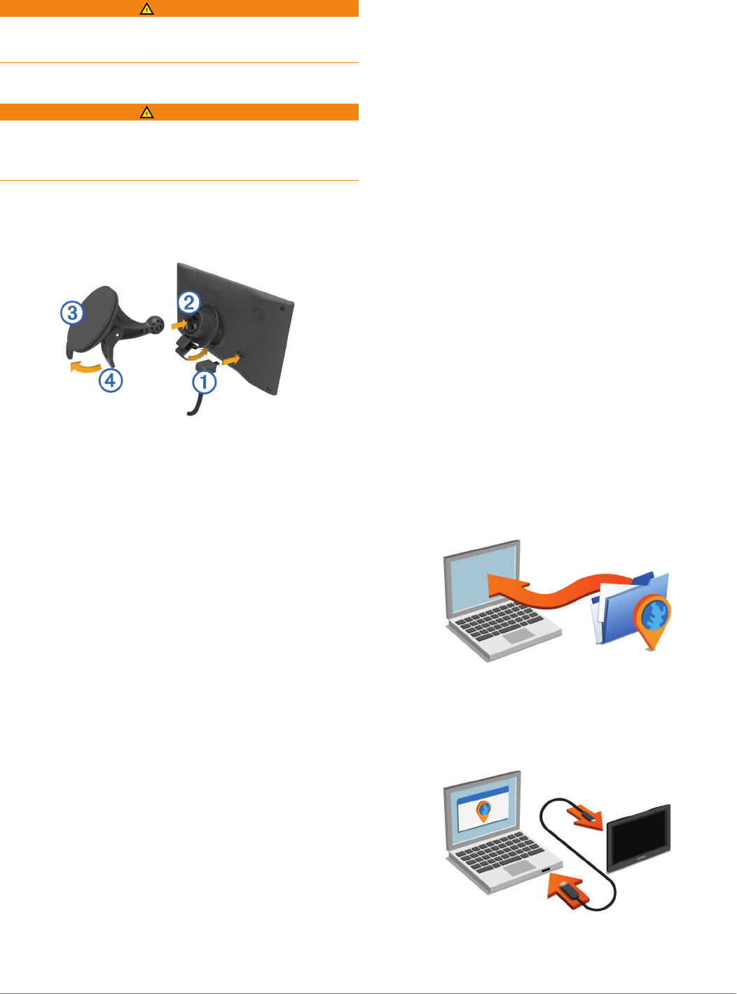
Connecting the Device to Vehicle Power
WARNING
This product contains a lithium-ion battery. To prevent the
possibility of personal injury or product damage caused by
battery exposure to extreme heat, store the device out of direct
sunlight.
Before you use your device on battery power, you should
charge it.
1Plug the vehicle power cable À into the USB port on the
device.
2Press the mount Á onto the suction cup  until it snaps into
place.
3Press the suction cup to the windshield, and flip the lever Ã
back toward the windshield.
4Fit the tab on the top of the mount into the slot on the back of
the device.
5Press the bottom of the mount into the device until it clicks.
6Plug the other end of the vehicle power cable into a power
outlet in your vehicle.
Support and Updates
Garmin Express™ provides easy access to these services for
Garmin® devices. Some services may not be available for your
device.
• Product registration
• Product manuals
• Software updates
• Map updates
• Vehicles, voices, and other extras
Setting Up Garmin Express
1Connect the device to your computer using a USB cable.
2Go to www.garmin.com/express.
3Follow the on-screen instructions.
nüMaps Guarantee™
Your device may be eligible for a free map update within 90
days of first acquiring satellites while driving. Go to
www.garmin.com/numaps for terms and conditions.
Lifetime Subscriptions
Some models include subscriptions to lifetime features. For
more information, go to www.garmin.com/lmt.
LT: This model includes a lifetime traffic subscription and a
traffic receiver.
LM: This model includes a nüMaps Lifetime™ subscription,
which provides quarterly map updates for the useful life of
your device. For terms and conditions go to
www.garmin.com/us/maps/numaps_lifetime.
LMT: This model includes a nüMaps Lifetime subscription,
lifetime traffic subscription, and a traffic receiver.
LMTHD or LMT-D: This model includes a nüMaps Lifetime
subscription, lifetime digital traffic subscription, and a digital
traffic receiver.
Activating Lifetime Maps
NOTE: Lifetime Maps are not applicable to products that do not
have pre-loaded maps.
NOTE: Lifetime Maps entitle you to receive map updates when
and as such updates are made available by Garmin during the
useful life of one compatible Garmin product or as long as
Garmin receives map data from a third party supplier, whichever
is shorter. For the meaning of a product’s “useful life” and for
other important terms and conditions, go to www.garmin.com
/numapslifetime.
1Go to www.garmin.com/express.
2Follow the on-screen instructions.
NOTE: If you register the device, you can receive e-mail
notifications when a map update is available.
Updating Maps and Software with Garmin Express
You can use Garmin Express software to download and install
the latest map and software updates for your device. Map
updates provide the latest available mapping data to ensure
your device continues to calculate accurate and efficient routes
to your destinations. Garmin Express is available for Windows®
and Mac® computers.
1On your computer, go to www.garmin.com/express.
2Select an option:
• To install on a Windows computer, select Download for
Windows.
• To install on a Mac computer, select Mac Version.
3Open the downloaded file, and follow the on-screen
instructions to complete the installation.
4Start Garmin Express.
5Connect your Garmin device to your computer using a USB
cable.
The Garmin Express software detects your device.
6Enter an email address for product registration (optional).
7Click save device.
Getting Started 1
DRAFT
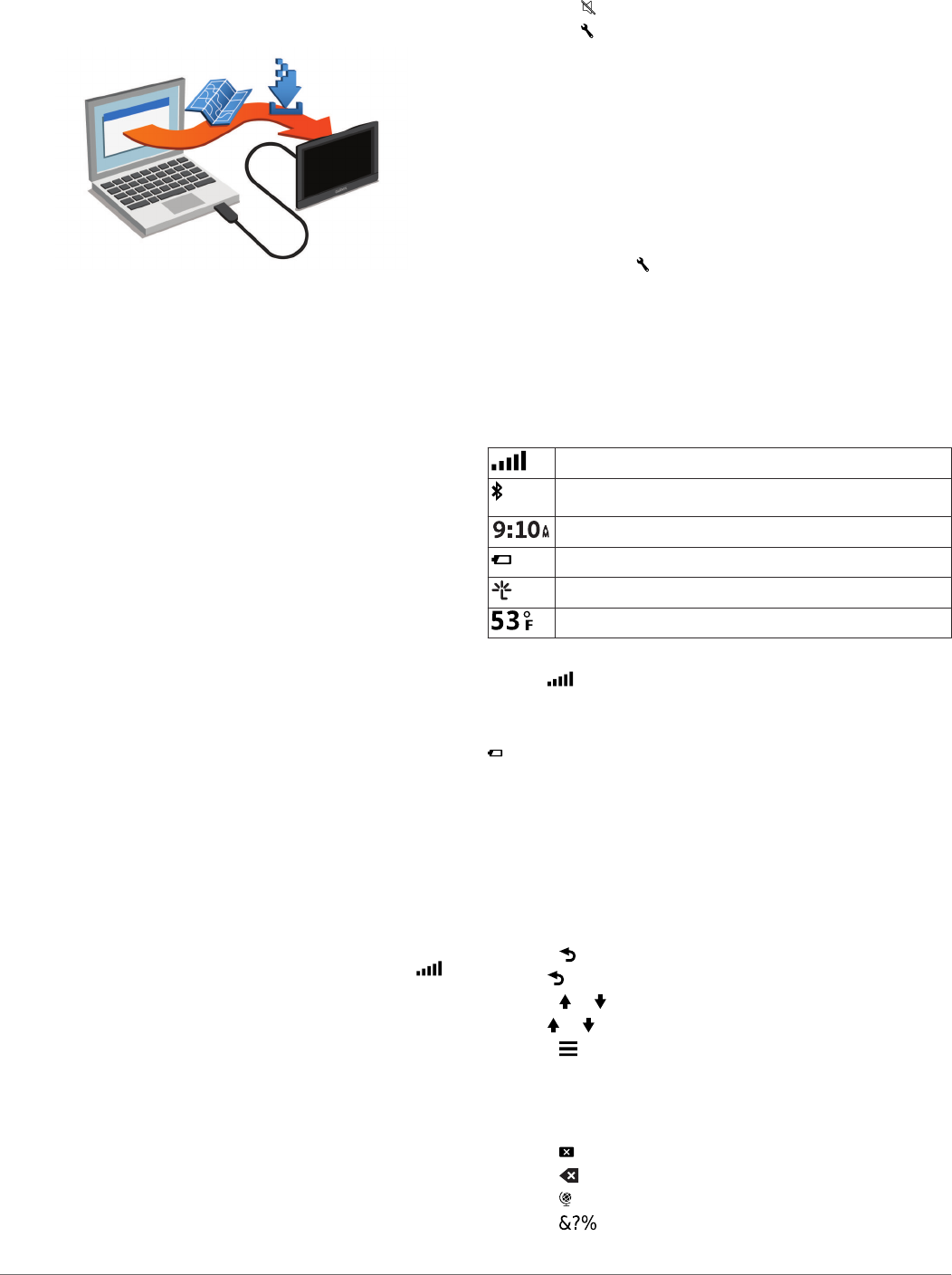
8Click check for updates.
A list of available map and software updates appears.
9Select the updates to install.
10Click Install Now.
The Garmin Express software downloads and installs the
updates onto your device. Map updates are very large, and this
process may take a long time on slower Internet connections.
Entering and Exiting Sleep Mode
You can use sleep mode to conserve battery power when your
device is not in use. While in sleep mode, your device uses very
little power and can wake instantly for use.
TIP: You can charge your device faster by putting it in sleep
mode while charging the battery.
Press the power key À.
Turning Off the Device
1Hold the power key until a prompt appears on the screen.
The prompt appears after five seconds. If you release the
power key before the prompt appears, the device enters
sleep mode.
2Select Off.
Resetting the Device
You can reset your device if it stops functioning.
Hold the power key for 12 seconds.
Acquiring GPS Signals
To navigate with your device, you must acquire satellites. in
the status bar indicates the satellite signal strength. Acquiring
satellites can take several minutes.
1Turn on the device.
2Wait while the device locates satellites.
3If necessary, go outdoors to an open area, away from tall
buildings and trees.
Adjusting the Screen Brightness
1Select Settings > Display > Brightness.
2Use the slider bar to adjust the brightness.
Adjusting the Volume
1Select Volume.
2Select an option:
• Use the slider bar to adjust the volume.
• Select to mute the device.
• Select for additional options.
About Automatic Volume
On devices with hands-free calling, automatic volume allows the
device to adjust the volume level based on the background
noise in the vehicle (Hands-Free Phone Calls).
Automatic volume control lowers the volume of the device when
background noise is low and raises the volume level when
background noise increases.
Enabling Automatic Volume
Your device can increase or decrease the volume automatically
based on the level of background noise.
1Select Volume > .
2If necessary, select Automatic Volume.
3Select Enabled.
Status Bar Icons
The status bar is located at the top of the main menu. The
status bar icons display information about features on the
device. You can select some icons to change settings or view
additional information.
GPS signal status
Bluetooth® technology status (appears when Bluetooth is
enabled)
Current time
Battery status
Connected to Smartphone Link
Temperature
Viewing GPS Signal Status
Hold for three seconds.
Battery Information
After the device is connected to power, it begins to charge.
in the status bar indicates the status of the internal battery.
Setting the Time
1From the main menu, select the time.
2Select an option:
• To set the time automatically using GPS information,
select Automatic.
• To set the time manually, drag the numbers up or down.
Using the On-Screen Buttons
• Select to return to the previous menu screen.
• Hold to quickly return to the main menu.
• Select or to see more choices.
• Hold or to scroll faster.
• Select to see a menu of options for the current screen.
Using the On-Screen Keyboard
See "Language and Keyboard Settings" to change the keyboard
layout (Language and Keyboard Settings).
• Select to delete a search entry.
• Select to delete a character.
• Select to change the keyboard language mode.
• Select to enter special characters, such as punctuation
marks.
2 Getting Started
DRAFT

• Select to change character capitalization.
Locations
The detailed maps loaded in your device contain locations, such
as restaurants, hotels, auto services, and detailed street
information. You can use categories to browse for nearby
businesses and attractions. You can also search for addresses,
coordinates, cities, and intersections.
Finding Locations
Finding a Location by Category
1Select Where To?.
2Select a category, or select Categories.
3If necessary, select a subcategory.
4Select a location.
Searching Within a Category
After you have performed a search for a point of interest, certain
categories may display a Quick Search list that shows the last
three destinations you selected.
1Select Where To?.
2Select a category, or select Categories.
3Select a category.
4If applicable, select a destination from the Quick Search list.
5If necessary, select the appropriate destination.
Finding a Location Using the Search Bar
You can use the search bar to search for locations by entering a
category, brand name, address, or city name.
1Select Where To?.
2Select Enter Search in the search bar.
3Enter all or part of the search term.
Suggested search terms appear below the search bar.
4Select an option:
• To search for a type of business, enter a category name
(for example, "movie theaters").
• To search for a business name, enter all or part of the
name.
• To search for an address near you, enter the house
number and street name.
• To search for an address in another city, enter the house
number, street name, city, and state.
• To search for a city, enter the city and state.
• To search for coordinates, enter latitude and longitude
coordinates.
5Select an option:
• To search using a suggested search term, select the
term.
• To search using the text you entered, select .
6If necessary, select a location.
Changing the Search Area
1From the main menu, select Where To?.
2Select Searching Near.
3Select an option.
Finding a Location by Browsing the Map
Before you can find places included in the map data, such as
restaurants, hospitals, and fuel stations, you must enable the
map layer for places along the road (Customizing the Map
Layers).
1Select View Map.
2Drag and zoom the map to display the area to search.
3If necessary, select , and select a category icon to view
only a specific category of places.
Location markers ( or a blue dot) appear on the map.
4Select an option:
• Select a location marker.
• Select a point, such as a street, intersection, or address
location.
5If necessary, select the location description to view additional
information.
Finding an Address
NOTE: The order of the steps may change depending on the
map data loaded on your device.
1Select Where To? > Address.
2Enter the address number, and select Done.
3Enter the street name, and select Next.
4If necessary, select Searching Near to change the city,
state, or province.
5If necessary, select the city, the state, or the province.
6If necessary, select the address.
Finding Recently Found Destinations
Your device stores the last 50 destinations you have found.
1Select Where To? > Recent.
2Select a location.
Clearing the List of Recently Found Locations
Select Where To? > Recent > > Clear > Yes.
Finding Parking
1Select Where To? > Categories > Parking.
2Select a parking location.
Finding Your Last Parking Spot
When you disconnect the device from vehicle power while the
device is on, your current location is saved as a parking spot.
Select Apps > Last Spot.
Search Tools
Search tools allow you to search for specific types of locations
by responding to on-screen prompts.
Finding an Intersection
1Select Where To? > Categories > Intersections.
2Select an option:
• Select a state or province.
• To change the country, state, or province, select State or
Country, and enter a name.
3Enter the first street name, and select Next.
4If necessary, select the street.
5Enter the second street name, and select Next.
6If necessary, select the street.
7If necessary, select the intersection.
Finding a City
1Select Where To? > Categories > Cities.
Locations 3
DRAFT

2Select Enter Search.
3Enter a city name, and select .
4Select a city.
Finding a Location Using Coordinates
You can find a location using latitude and longitude coordinates.
This can be helpful when geocaching.
1Select Where To? > Categories > Coordinates.
2If necessary, select , and change the coordinate format or
datum.
3Select the latitude coordinate.
4Enter the new coordinate, and select Done.
5Select the longitude coordinate.
6Enter the new coordinate, and select Done.
7Select View on Map.
Saving Locations
Saving a Location
1Search for a location (Finding a Location by Category).
2From the search results, select a location.
3Select .
4Select Save.
5If necessary, enter a name, and select Done.
Saving Your Current Location
1From the map, select the vehicle icon.
2Select Save.
3Enter a name, and select Done.
4Select OK.
Saving a Home Location
You can set your home location for the location you return to
most often.
1Select Where To? > > Set Home Location.
2Select Enter My Address, Use Current Location, or
Recently Found.
The location is saved as "Home" in the Saved menu.
Going Home
Select Where To? > Go Home.
Editing Your Home Location Information
1Select Where To? > Saved > Home.
2Select .
3Select > Edit.
4Enter your changes.
5Select Done.
Editing a Saved Location
1Select Where To? > Saved.
2If necessary, select a category.
3Select a location.
4Select .
5Select > Edit.
6Select an option:
• Select Name.
• Select Phone Number.
• Select Categories to assign categories to the saved
location.
• Select Change Map Symbol to change the symbol used
to mark the saved location on a map.
7Edit the information.
8Select Done.
Assigning Categories to a Saved Location
You can add custom categories to organize your saved
locations.
NOTE: Categories appear in the saved locations menu after
you have saved at least 12 locations.
1Select Where To? > Saved.
2Select a location.
3Select .
4Select > Edit > Categories.
5Enter one or more category names, separated by commas.
6If necessary, select a suggested category.
7Select Done.
Deleting a Saved Location
NOTE: Deleted locations cannot be recovered.
1Select Where To? > Saved.
2Select > Delete Saved Places.
3Select the box next to the saved locations to delete, and
select Delete.
Setting a Simulated Location
If you are indoors or not receiving satellite signals, you can use
the GPS to set a simulated location.
1Select Settings > Navigation > GPS Simulator.
2From the main menu, select View Map.
3Tap the map twice to select an area.
The address of the location appears at the bottom of the
screen.
4Select the location description.
5Select Set Location.
Adding a Shortcut
You can add shortcuts to the Where To? menu. A shortcut can
point to a location, a category, or a search tool.
The Where To? menu can contain up to 36 shortcut icons.
1Select Where To? > Add Shortcut.
2Select an item.
Removing a Shortcut
1Select Where To? > > Remove Shortcut(s).
2Select the shortcut to remove.
3Select the shortcut again to confirm.
4Select Save.
Custom Points of Interest
Custom POIs are customized points on the map. They can
contain alerts that let you know if you are near a designated
point or if you are traveling faster than a specified speed.
Installing POI Loader
You can create or download custom POI lists on your computer
and install them on your device using POI Loader software.
1Go to www.garmin.com/poiloader.
2Follow the on-screen instructions.
Using the POI Loader Help Files
For more information on the POI loader, refer to the Help file.
With the POI loader open, click Help.
4 Locations
DRAFT

Finding Custom POIs
Before you can find custom POIs, you must load custom POIs
on your device using the POI Loader software (Installing POI
Loader).
1Select Where To? > Categories.
2Scroll to the Other Categories section, and select a category.
Navigation
Starting a Route
1Search for a location (Locations).
2Select a location.
3Select Go!.
Previewing Multiple Routes
1Search for a location (Finding a Location by Category).
2From the search results, select a location.
3Select Routes.
4Select a route.
Changing the Route Calculation Mode
The route calculation is based on road speeds and vehicle
acceleration data for a given route. The calculation mode affects
only automobile routes.
1Select Settings > Navigation > Calculation Mode.
2Select an option:
• Select Faster Time to calculate routes that are faster to
drive but can be longer in distance.
• Select Shorter Distance to calculate routes that are
shorter in distance but can take more time to drive.
• Select Off Road to calculate point-to-point routes (without
roads).
• Select Less Fuel to calculate routes that are more fuel-
efficient.
Navigating Off Road
If you are not following roadways as you navigate, you can use
Off Road mode.
1Select Settings > Navigation.
2Select Calculation Mode > Off Road > Save.
The next route will be calculated as a straight line to the
location.
Starting a Route to a Saved Location
1Select Where To? > Saved.
2If necessary, select a category, or select All Saved Places.
3Select a location.
4Select Go!.
Navigating to Locations Within a Venue
When navigating to a venue that contains more than one point
of interest, the device lists additional points of interest located
within the venue.
1Search for a venue, such as a mall or airport.
2Select the venue.
A list of categories appears below the venue.
3Select a category.
4Select a point of interest, and select Go!.
Exploring a Venue
You can view a list of all points of interest located within each
venue.
1Select a venue.
2Select > Explore this Venue.
3Select a category.
4Select a point of interest.
5Select Go!.
Your Route on the Map
NOTICE
The speed limit feature is for information only and does not
replace your responsibility to abide by all posted speed limit
signs and to use safe driving judgment at all times. Garmin will
not be responsible for any traffic fines or citations you receive
for failing to follow all applicable traffic laws and signs.
The route is marked with a magenta line. A checkered flag
marks your destination.
As you travel, the device guides you to the destination with
voice prompts, arrows on the map, and directions at the top of
the map. If you depart from the original route, the device
recalculates the route and provides new directions.
A data field displaying the current speed limit may appear as
you travel on major roadways.
Using the Map
1Select View Map.
2Select anywhere on the map.
3Select an option:
• To zoom in or out, select or .
• To switch between North Up and 3-D views, select .
• To view specific categories, select .
Adding a Point to a Route
Before you can add a point, you must be navigating a route.
1From the map, select > Where To?.
2Search for a location.
3Select a location.
4Select Go!.
5Select Add to Active Route.
Taking a Detour
Before you can take a detour, you must be navigating a route
and you must add the change route tool to the map tools menu
(Customizing the Map Tools).
You can take a detour for a specified distance along your route
or detour around specific roads. This is useful if you encounter
construction zones, closed roads, or poor road conditions.
1From the map, select > Change Route.
2Select an option:
• To detour your route for a specific distance, select Detour
by Distance.
• To detour around a specific road on the route, select
Detour by Road.
Stopping the Route
From the map, select > .
Navigation 5
DRAFT
Proximity Alerts Settings
NOTE: You must have custom points of interest (POIs) loaded
for proximity points alerts to display.
Select Settings > Proximity Alerts.
Audio: Sets the style of alert that plays when you approach
proximity points.
Alerts: Sets the type of proximity points for which alerts are
played.
Restoring Settings
You can restore a category of settings or all settings to the
factory default values.
1Select Settings.
2If necessary, select a settings category.
3Select > Restore.
Device Information
Specifications
Operating temperature
range
-4° to 131°F (-20° to 55°C)
Charging temperature
range
32° to 113°F (0° to 45°C)
Power input Vehicle power using the included vehicle
power cable or AC power using an optional
accessory
Battery life Up to 2.5 hours depending on usage and
settings
Battery type Rechargeable Lithium-ion
Appendix
Power Cables
Your device can be powered various ways.
• Vehicle power cable
• USB cable
• AC adapter (optional accessory)
Charging the Device
NOTE: This Class III product shall be powered by an LPS
power supply.
You can charge the battery in the device using any of these
methods.
• Connect the device to the vehicle power cable.
• Connect the device to a computer using a USB cable.
The device may charge slowly when connected to a
computer. Some portable computers may not charge the
device.
• Connect the device to an optional power adapter accessory,
such as a wall power adapter.
You can purchase an approved Garmin AC-DC adapter
suitable for home or office use from a Garmin dealer or
www.garmin.com.
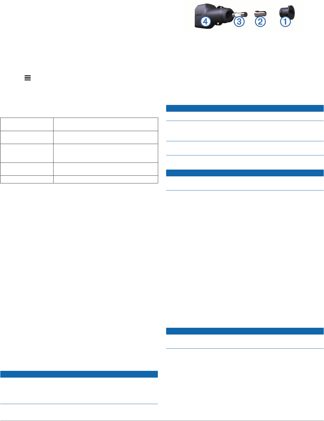
Changing the Fuse in the Vehicle Power Cable
NOTICE
When replacing the fuse, do not lose any of the small pieces
and make sure they are put back in the proper position. The
vehicle power cable does not work unless it is assembled
correctly.
If your device does not charge in your vehicle, you may need to
replace the fuse located at the tip of the vehicle adapter.
1Rotate the end piece À 90 degrees counter clockwise to
unlock it.
TIP: You may need to use a coin to remove the end piece.
2Remove the end piece, the silver tip Á, and the fuse Â.
3Insert a new fast-blow fuse that has the same current, such
as 1 A or 2 A.
4Place the silver tip in the end piece.
5Push in the end piece and rotate it 90 degrees clockwise to
lock it back into the vehicle power cable Ã.
Device Care
NOTICE
Avoid dropping your device.
Do not store the device where prolonged exposure to extreme
temperatures can occur, because it can cause permanent
damage.
Never use a hard or sharp object to operate the touchscreen, or
damage may result.
Cleaning the Outer Casing
NOTICE
Avoid chemical cleaners and solvents that can damage plastic
components.
1Clean the outer casing of the device (not the touchscreen)
using a cloth dampened with a mild detergent solution.
2Wipe the device dry.
Cleaning the Touchscreen
1Use a soft, clean, lint-free cloth.
2If necessary, lightly dampen the cloth with water.
3If using a dampened cloth, turn off the device and disconnect
the device from power.
4Gently wipe the screen with the cloth.
Avoiding Theft
• Remove the device and mount from sight when not in use.
• Remove the residue left on the windshield by the suction
cup.
• Do not keep your unit in the glove compartment.
• Register your device at http://my.garmin.com.
Mounting on Your Dashboard
NOTICE
The permanent mounting adhesive is extremely difficult to
remove after it is installed.
You can use an optional mounting disk to mount your device to
the dashboard and comply with certain state regulations. See
www.garmin.com for more information.
1Clean and dry the dashboard where you are placing the disk.
2Remove the backing from the adhesive on the bottom of the
disk.
3Place the disk on the dashboard.
4Remove the clear plastic cover from the top of the disk.
Device Information 15
DRAFT

5Place the suction cup mount on top of the disk.
6Flip the lever down (toward the disk).
Removing the Device, Mount, and Suction
Cup
Removing the Device from the Mount
1Press the release tab or button on the mount.
2Tilt the device forward.
Removing the Mount from the Suction Cup
1Turn the device mount to the right or left.
2Apply pressure until the socket on the mount releases the
ball on the suction cup.
Removing the Suction Cup from the Windshield
1Flip the lever on the suction cup toward you.
2Pull the tab on the suction cup toward you.
Purchasing Additional Maps
1Go to your device product page at (www.garmin.com).
2Click the Maps tab.
3Follow the on-screen instructions.
Purchasing Accessories
Go to http://buy.garmin.com.
Troubleshooting
The suction cup will not stay on my
windshield
1Clean the suction cup and windshield with rubbing alcohol.
2Dry with a clean, dry cloth.
3Mount the suction cup (Connecting the Device to Vehicle
Power).
My device is not acquiring satellite signals
• Verify the GPS simulator is turned off (Navigation Settings).
• Take your device out of parking garages and away from tall
buildings and trees.
• Remain stationary for several minutes.
The device does not charge in my vehicle
• Check the fuse in the vehicle power cable (Changing the
Fuse in the Vehicle Power Cable).
• Verify the vehicle is turned on and is supplying power to the
power outlet.
• Verify the interior temperature of the vehicle is between 32°
and 113°F (between 0° and 45°C).
• Verify that the fuse is not broken in the vehicle power outlet.
My battery does not stay charged for very
long
• Decrease the screen brightness (Display Settings).
• Shorten the display timeout (Display Settings).
• Decrease the volume (Adjusting the Volume).
• Disable Bluetooth wireless technology (Disabling Bluetooth).
• Put the device in sleep mode when not in use (Entering and
Exiting Sleep Mode).
• Keep your device away from extreme temperatures.
• Do not leave your device in direct sunlight.
The battery gauge does not seem accurate
1Allow the device to fully discharge.
2Fully charge the device without interrupting the charge cycle.
My device does not appear as a removable
drive on my computer
On most Windows computers, the device connects using Media
Transfer Protocol (MTP). In MTP mode, the device appears as
a portable device and not as a removable drive. MTP mode is
supported by Windows 7, Windows Vista®, and Windows XP
Service Pack 3 with Windows Media Player 10.
My device does not appear as a portable
device on my computer
On Mac computers and some Windows computers, the device
connects using USB mass storage mode. In USB mass storage
mode, the device appears as a removable drive or volume, and
not as a portable device. Windows versions prior to Windows
XP Service Pack 3 use USB mass storage mode.
My device does not appear as either a
portable device or a removable drive or
volume on my computer
1Disconnect the USB cable from your computer.
2Turn off the device.
3Plug the USB cable into a USB port on your computer and
into your device.
TIP: Your device should be connected directly to a USB port
on your computer and not to a USB hub.
The device automatically turns on and goes into MTP mode or
USB mass storage mode. A picture of the device connected to a
computer appears on the device screen.
.
16 Troubleshooting
DRAFT