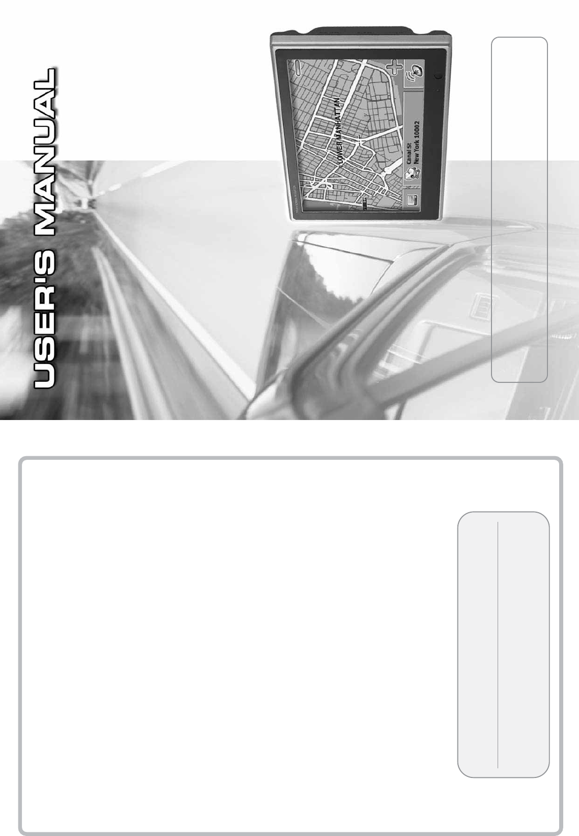
DVS Korea VXA-2100 7 Inch Wide Touch Screen Navigation User Manual VXA 3000 fr en 061010 Page 1
DVS Korea Co., Ltd. 7 Inch Wide Touch Screen Navigation VXA 3000 fr en 061010 Page 1
Users Manual
žPlease, be sure to read the ŒSafety Precautionsœcarefully before using this product.
žLimited warranty is included in this Userœs Manual.
žSpecifications and design are subject to change without notice.
ҟ
Navigation function
ҟ
Audio player function
ҟ
Game function
ҟ
Aux function
ҟ
Video Player function
ҟ
Image Viewer function
Userœs Manual
Please write your phurchasing date down here, which is needed
for custom service and registration at our web site.
Thank you for purchasing our product.
Navigation System Userœs Manual is designed to support convenient usage of the navigation system
and safe driving. Please read the manual carefully before using the product for safe usage.
The content of this manual can vary according to the navigation system version, and function or
performance of the navigation system and this manual are subject to change without prior notice for
userœs convenience.
Make sure to read this manual for safe driving.
Please comply with the following instructions to prevent the property loss of the driver and user.
1
Warning Do not set or search for a destination while youœre driving. Make sure to park
at a safe place before operating this device.
Warning
Warning
Voice guide and map route can be different from actual road conditions.
Ensure to comply with the actual road signal system and traffic regulations for
safe driving.
Navigation System
It is very dangerous to operate the navigation system or look at the screen
while youœre driving. Be careful of surrounding traffic conditions or
pedestrians if you have to operate the system while youœre driving.
Basic Operation
About Navigation System
1. Directions before using this product
2. Components
3. Description on product appearance
4. Installing product
Using Navigation System
1. Basic functions of Navigation System
2. Learning basic remote controller functions
3. Main menu
4. Starting the Application
5. Detailed Description
6. Optional Features
7. Frequently Asked Questions
8. Audio player
9. Video Player
10. Image Viewer
11. Game
12. Aux
13. Setup
2Navigation System
Table of Contents
Upgrading Navigation System
Map Upload
1. Installing V-Up Pro 3000 Program
2. Running V-Up Pro 3000 Program
3. Closing V-Up Pro 3000 Program
4. System Upgrade
5. What is V-Up Pro 3000
Multimedia Management
1. Music Management
2. Bitmap Management
Specification
Customer support and Product
Enquiry
Customer support and Product Enquiry
Customer Service Center
54
54
54
56
58
59
64
65
65
71
76
77
77
77
3
3
3
6
7
9
11
11
12
14
14
15
36
37
38
41
44
46
47
50
1. Directions before using this product
Read this ŔUserœs Manualŕwithout fail before using this product to use this product safely.
1-1. Usage directions
3
About Navigation System
Navigation System
Warning Refrain from operating the product in motion. Please park the car at a safe location
when operating the product, because there is danger of a traffic accident.
Voice guide and map route can be different from the actual road condition. Ensure to
comply with the actual road signal system and traffic regulation for safe driving.
Warning If you modify the car to install this system, safe driving can be endangered.
Caution Do not use this product for a long time after stopping the engine. The car battery can be
discharged completely.
Caution
Do not use other cables than those provided. Turn off the power when connecting the
external cable like A/V input, stereo output, and indoor TV antenna. If you connect
the cable while the power is on, the product can be damaged.
Caution Do not disassemble or apply shock to this product.
Warning
Caution Touch the touch panel with a round edge object or fingertip softly. If you press the touch
screen strongly with a sharp and hard object, it can damage the product.
Caution Turn off the power and use the clean and dry cloth when cleaning the screen. Keep
the screen away from water or chemical substance like detergent or solvent.
Basic Operation
Warning
Navigation system will not be liable for any damages arising out of any use of this product.
The user will bear the sole responsibility.
Warning
Applied windshield suction cup mount(suction cup) can be remove from the front windshield
by vibration, sudden temperature changes, unexpected shock and etc. If suction cup is drops
suddenly by unexpected reason the navigator and/or your car can be damaged.
Caution
While Audio player, Video player or Navigation is operating, if you remove the
SD Card memory, system will be get into unstable situation. Please donœt remove
SD Card memory during playback. If system is unstable because SD Card memory
is removed, turn off the system and reboot.
1-2. Installation directions
4
About Navigation System
Navigation System
Warning Connect the wires properly by referring to ŔInstalling productŕsection. Otherwise,
malfunction or accident may occur.
Caution Use only the connection cable for vehicle that was provided at the time of product
purchase to ensure stable system operation.
Warning Do not install the product in a position where driving can be interfered or driverœs
field of vision can be blocked.
Caution This product must be used with 12V car power only. Do not use 24V power.
Caution
Some functions of this system are disabled for driverœs safety when the car is in
motion. Remove the test jack installed in the safety terminal and connect the hand
brake cable to the car hand brake. If this cable is not connected, only Ŕaudioŕwill
be supported in Aux mode and Video Player mode.
Caution Connect the Aux cable such as line out or A/V in after turning the power off. If the
power is on while connecting the cable, the product can be damaged.
Caution Do not install the product in a place with water, humidity, vapor, dust, oil, or smoke.
Warning Install the product in a position that does not interfere with driving or safety devices
like an air bag.
Caution If you donœt use the product for a long time after purchasing this product, car position
sensing time can be prolonged, since the GPS antenna backup battery can be discharged.
Caution
Do not put objects that interfere with GPS signal reception around the GPS receiver. Radio
interference may occur.
Caution
Do not install electronic products that generates heavy electromagnetic waves like a radio
transmitter around the GPS antenna.
Caution
GPS reception can be blocked if the car windshield is specially tinted.
1-3. Upgrade directions
1-4. Troubleshooting
1) Touchscreen does not work
If you cannot set up the touchscreen in the Setup menu due to wrong setting, use the remote
controller instead.
ȘPress the [Initial Screen] button on the remote controller to open the main menu
screen.
ȘPress the [F2] Ɗ[F3] Ɗ[F2] Ɗ[Full Screen] button sequentially to open the Touch
Setting screen
ȘPress the 5 cross marks using the test jack or touch adjustment rod, according to the
instructions displayed on the screen.
ȘPress the screen once to close the Touch Setting screen.
2) The LED turns on or flashes in red during self-diagnostic:
In addition, when the temperature inside the car is too high or low, the red LED flashes. In this
case, follow the steps below.
ȘTurn the product power off and ventilate the car to get normal temperature.
ȘTurn the power on after a little while and observe the LED color.
ȘIf the red LED still flashes in normal temperature, contact customer service.
5
About Navigation System
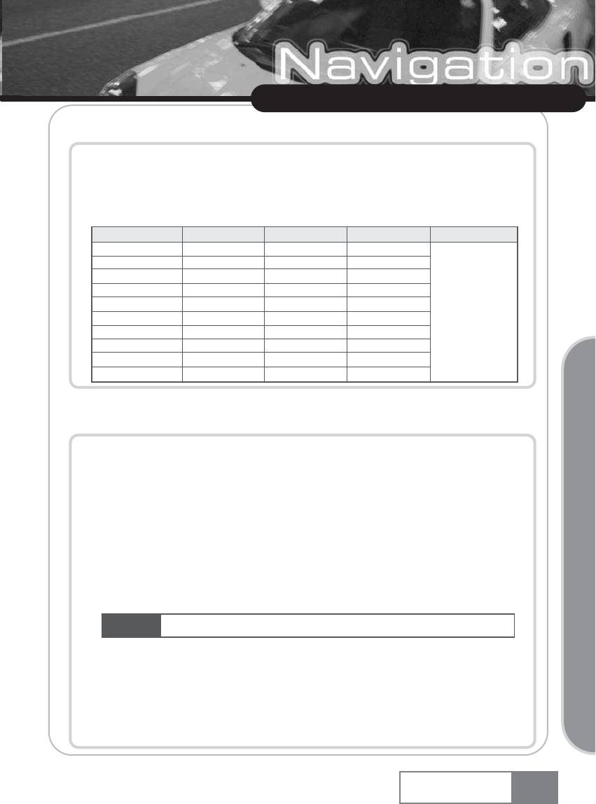
ȘDepending on the SD Card memory product, the SD Card memory sensing time may vary
or sensing may fail.
ȘBelow list is recommended SD card.
ȘSome SD cards work better than others. Please contact customer support (page 77) if you
need further assistance.
Navigation System
Park the car in a safe place for touchscreen setting.
Basic Operation
Caution
8:7,=+<;
<ZMV[MVL
891
4/
;IU[]VO
0IVJQ\
8ZM\MK
BaZ][
1UI\QWV
0IOQ_IZI
<_QV57;
5
AM[
6W
AM[
AM[
6W
6W
6W
6W
6W
6W
5
AM[
AM[
AM[
AM[
AM[
6W
AM[
AM[
AM[
AM[
/
AM[
AM[
6W
6W
AM[
AM[
6W
6W
6W
AM[
;8--,
[XMMLIVL
TM[[
6
About Navigation System
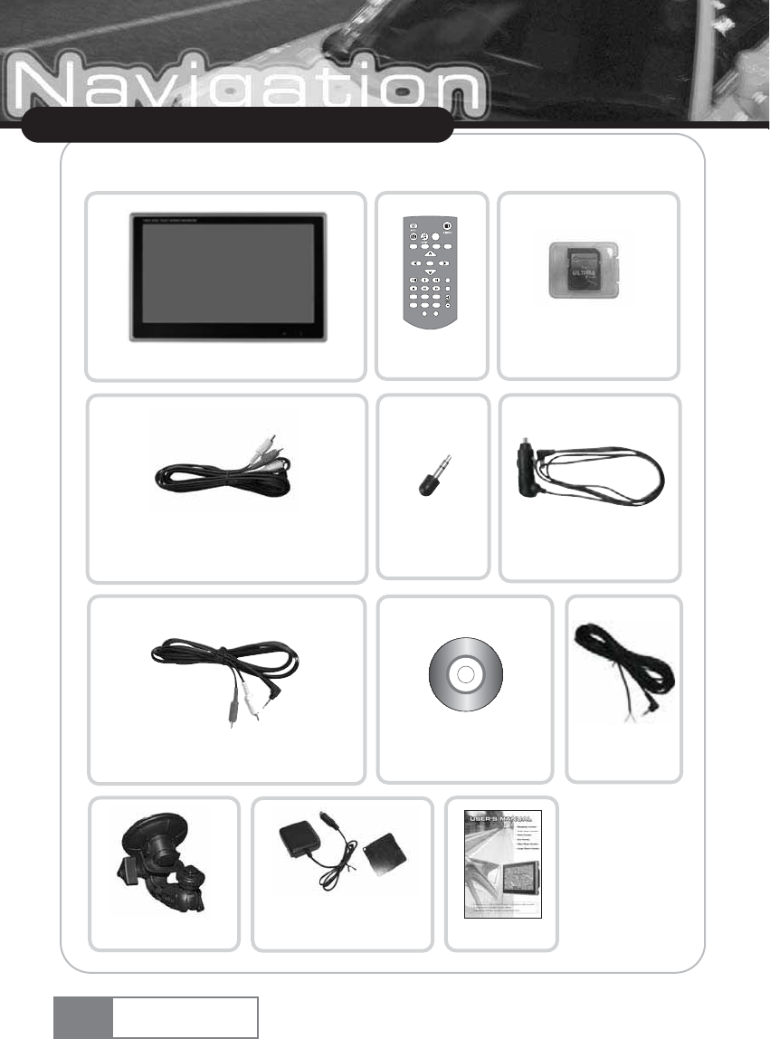
2. Components
Navigation System
Remote
controller (option)
Test jack
Navigation System unit
SD Card memory
Aux cable [AV In terminal]
(option) Cigar jack cable
NAVI
GAME AUX VIDEO
MAIN
IMAGE
OK
F4
F1 F2 F3
F5
FILE LIST PLAY TYPEFULL SCREEN
SCREEN OFF SETUP
žSpecifications and
design are subject to
change without notice.
Hand brake
connection cable
Red : + : Blue
-
Stereo output cable (option)
Suction cap Userœs manual
DVD-ROM
GPS antenna/
mount plate
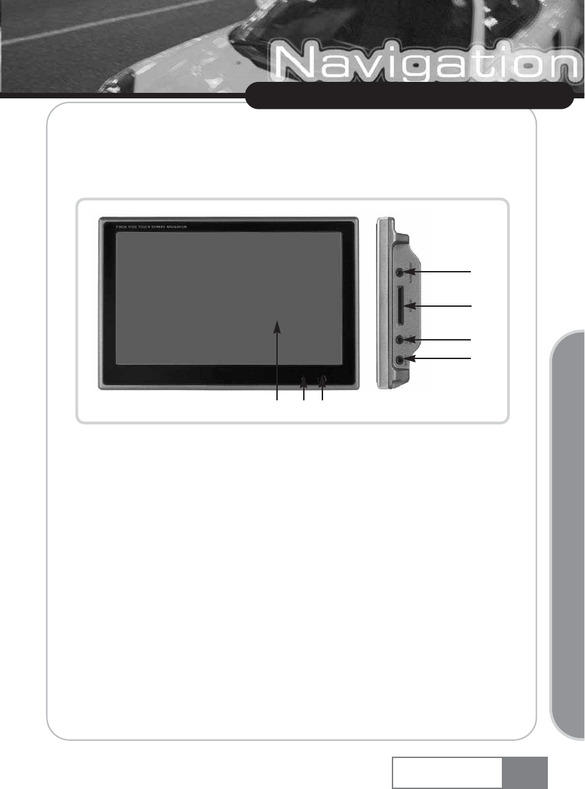
3. Description of external features
3-1. Front/Right side
ڡTOUCH SCREEN : Handles user touch input.
ڢLED : Displays the product status.
(Blue: Normal operation, Red: Malfunction/diagnostic)
ڣREMOTE IR WINDOW : Receives the remote control signal.
ڤAUDIO/VIDEO IN : Receives the A/V input from the external device like a DVD player gaming device.
ڥSD Card memory slot.
ڦAUDIO OUT : Output the audio signal to the external device.
ڧSAFETY : Connects to the car hand brake after removing the test jack, which is installed in
advance for safety.
7
About Navigation System
Navigation System
Basic Operation
ڤ
ڥ
ڦ
ڧ
ڡڢڣ
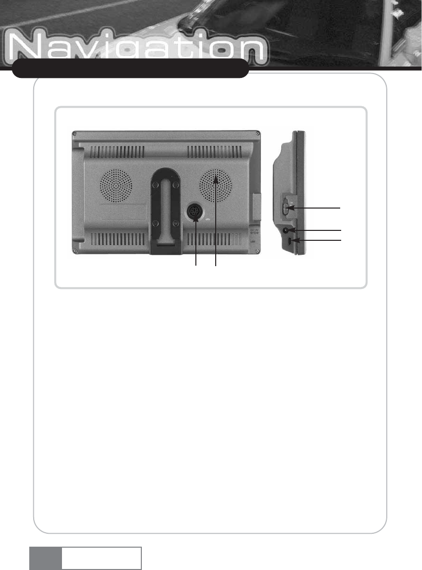
3-2. Rear/Left side
ڡGPS : Connects to the GPS antenna cable.
ڢSPEAKER : Outputs 1 watt audio.
ڣPOWER SWITCH : Turns the power on/off.
ڤDC 12V : Connects to the provided cigar jack.
ڥUSB SLAVE PORT : Not is use. [Connector for A/s]
8
About Navigation System
Navigation System
ڤ
ڡڢ
ڣ
ڥ
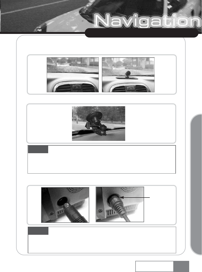
4. Installing the product
1) Fix the suction cup on the car windshield window where the driver feels comfortable.
GPS sensitivity will increase if you use the GPS pedestal. Use the GPS pedestal in any case.
2) Connect the GPS cable to the product.
9
About Navigation System
Caution Remove any dust or foreign object from the windshield window so that the bracket can be
attached firmly. Then, fix it with lever to prevent falling down due to shock.
Do not install the navigation set in a position that hampers driverœs vision or driving. Be careful not to interfere
with driving or safety devices like an air bag.
Navigation System
Basic Operation
Caution Plug in the GPS cable as described above.
Install the GPS mount plate in the position that can be exposed to the sky as much as possible for better
GPS reception, and fix the GPS antenna on the GPS mount plate by setting the GPS logo to face upward.
GPS sensitivity will increase if you use the GPS mount plate.
Connect here
(GPS)
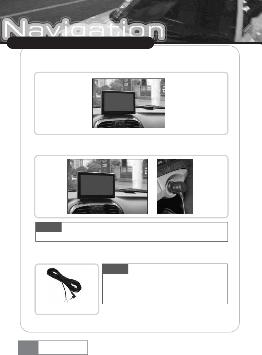
3) Adjust the position to fit into the driverœs field of vision after fixing the product on the
suction cup.
4) Connect the power cable to DC 12V terminal located at the left side of the product.
5) Remove the test jack from the Safety terminal and then, connect the cable to the hand brake.
10
About Navigation System
Navigation System
Caution Use the car cigar jack that is included in the product package. If you use other cigar
jack, the product may not work properly.
Caution Make sure connect the cable to the car hand
brake to prevent operation while in driving. If the hand brake
connection cable is not connected, only Ŕaudioŕexternal input will
be supported.
Red : + : Blue
-
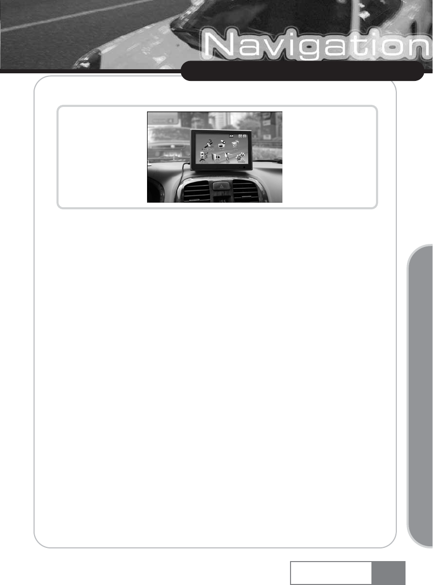
6) Flip the power switch ON that is located at the left side of the product.
1. Basic functions of Navigation System
1) Navigation function : Helps car navigation using GPS (Global Positioning System) engine and
antenna, and electronic precision map.
2) Audio player function : Plays back MP3, WMA, WAV and OGG music files.
3) Video Player function : Plays back video files.
4) Image Viewer : GIF, JPEG and BITMAP image files.
5) Game function : Provides enjoyable games.
6) Aux function : Displays external A/V sources such as DVD players or gaming devices. When connected
to a VXM or VXD series DVD player, touch screen controls can be wired to control the DVD player.
7) Setup setting function : Various functions can be configured such as slide show, main theme,
touchscreen setting, volume control, Dimmer control, OS upgrade, A/V input, and FM
transmitter.
11
Using Navigation System
Navigation System
Basic Operation
Using Navigation System
12 Navigation System
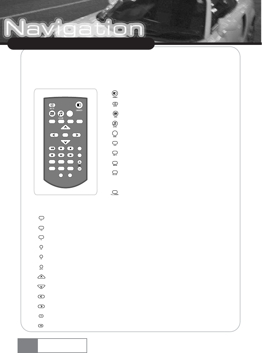
2. Learning basic remote controller functions
You can access frequently used function using the remote controller, in addition to the touch screen for
more convenient usage of Navigation System.
ȯ
: See additional function.
ȯ
: See additional function.
ȯ
: Reserved.
ȯ
: Reserved.
ȯ
: Reserved.
ȯ
: Directly switches to the Setup function.
ȯ
: Moves the cursor upward.
ȯ
: Moves the cursor downward.
ȯ
: Moves the cursor left.
ȯ
: Moves the cursor right.
ȯ
: Selects the cursor that was moved by the direction key.
ȯ
: Play back/Pause Audio or Video playback and show selected image in Image viewer mode.
ȯ: Controls screen brightness by 5 steps.
ȯ: Mutes the sound temporarily.
ȯ: Directly switches to the Navigation function.
ȯ: Directly switches to the audio player function.
ȯ: Directly switches to the initial screen.
ȯ: Directly switches to the Aux function.
ȯ: Directly switches to the Video player function.
ȯ: Directly switches to the image function.
ȯ: Display the file list of Video/Audio player and Image
viewer.
ȯ: Enlarge the Image or Video screen size to full LCD size, during
Video player and Image viewer function is operating.
NAVI
GAME AUX VIDEO
MAIN
IMAGE
OK
F4
F1 F2 F3
F5
FILE LIST PLAY TYPEFULL SCREEN
SCREEN OFF SETUP
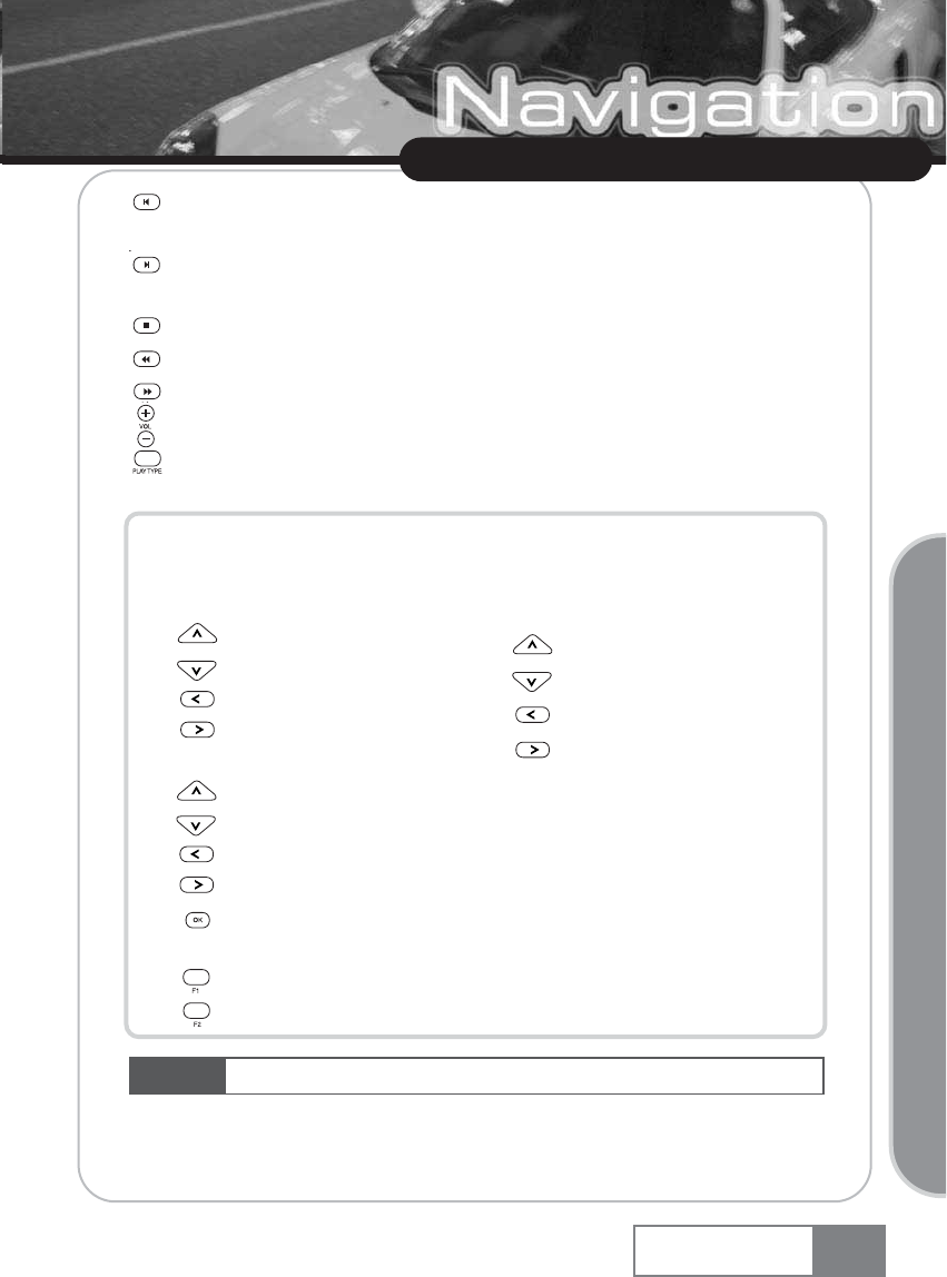
Ș: Moves audio or DVD playback section backward in Audio player/Aux mode. In Image viewer
mode, shows previous image.
Ș: Moves audio or DVD playback section forward in Audio player/Aux mode. In Image viewer
mode, shows next image.
Ș: Stop Audio , Video or DVD playback.
Ș: Rewinds MP3 or DVD playback in the audio player/Aux mode.
Ș: Fast forwards MP3 or DVD playback in the audio player/Aux mode.
Ș: Sets volume up or down.
Ș: Sets Repeat All/Repeat Start when playing back DVD, or Repeat All/Repeat Selected/Random
Selection when playing back MP3.
[Additional Remote controller function : Below buttons are redefined when File list
function is enabled in Video player, Audio player or Image viewer mode.]
ƃBasic screen at the Image viewer
Ș: Zoom in function.
Ș: Rotate to left.
Ș: Zoom out function.
Ș: Rotate to right.
ƃDuring file list is enabled
Ș: Moves cursor up.
Ș: Close file list.
Ș: Moves cursor down.
Ș: Enable the folder tap when file tap is enabled.
Ș: Enable the file tap, when folder tap is enabled. And playbacks/shows selected file
when file tap is enabled.
Ș: Moves page of file list up.
Ș: Moves page of file list down.
13
Using Navigation System
Caution Navigation and game functions are not accessible using the remote controller.
Navigation System
Basic Operation
ƃFull screen at the Image viewer
Ș: Moves center of image up.
Ș: Moves center of image left.
Ș: Moves center of image down.
Ș: Moves center of image right.
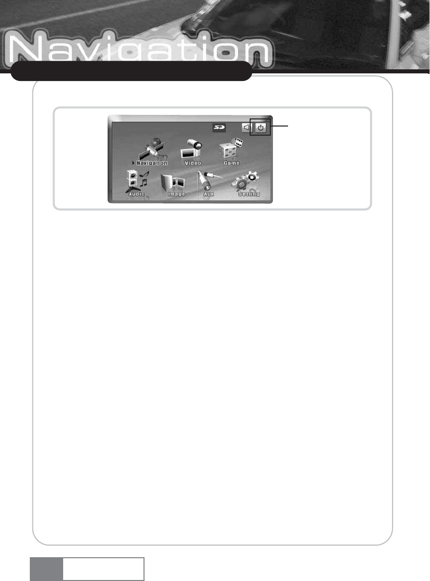
3. Main menu
The main menu is composed of Navigation, Audio Player, Video Player, Image Viewer, Game,
AUX, Setting, Screen On/Off button.
4. Starting the application
Charge your device, take it outside, and place it in a position with an unobstructed view to the sky
to create your first satellite connection. In the car this will usually be on the dashboard. It may take
up to 5 minutes to establish the first connection. Subsequent connections will be faster (30 seconds
to 1 minute), but if you have not used the unit for several days or are very far away from the last
location you used it, it may take up to 5 minutes again to find a strong signal
ҟSwitch on the unit and tap on NAVI or NAVIGATION in the first screen.
ҟIf more than one language is available on your device, you are prompted to choose your
language.
After the application loads, a screen with safety precautions will be shown. Please read them
carefully. Afterwards, you can choose to hide these notes for future start-ups.
14
Using Navigation System
Screen on/off
Navigation System
5. Detailed description
This chapter describes the functions of your Personal Navigation Device in detail. On the following
pages you will learn how to
- Use the map (see page 15)
- Find and choose locations (see page 16)
- Navigate to your destination (see page 28)
- Use the route planner (see page 31)
- Configure the application (see page 33)
5-1. Using the map
The map is the core component of your Personal Navigation Device. It will be centered on your
current location by default, provided you have a GPS connection. You can browse the map, display
information about the different locations shown on it and e.g. choose them for routing and
navigating.
Tracking mode and selection mode
The map knows two basic states, the tracking and the selection mode.
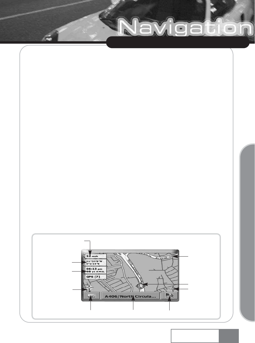
In the tracking mode, the map follows your actual position (GPS position), displaying information
about your geographic position, your speed, etc:
15
Using Navigation System
Navigation System
Basic Operation
Zoom in
Speed
Geographic
coordinates
Time Elevation
above mean sea
level GPS status
Compass rose
Menu Info box Exit application
GPS position
Zoom out
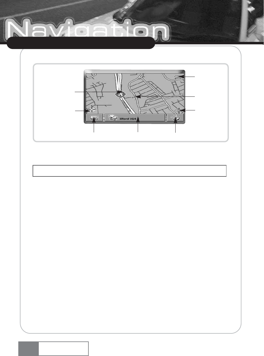
As soon as you browse the map, you enter the selection mode:
ҟUse a pen or your finger to browse the map. The actual position will be identified by a cursor.
ҟTo zoom in or out, press the + or - icons. As soon as you press one of the icons, the zoom
slider will be shown, which can be used for smooth zooming.
ҟWith the compass icon (in the bottom left hand corner) you may adjust the orientation.
ҟIf you want to return to the tracking mode, press the tracking icon. To exit the application,
press this button again.
4-3. Choosing and finding locations
This section describes the different ways of finding and choosing locations. You may choose
locations on the map, search for an address, choose a favorite (like home and work address, your
bookmarks and recently visited locations), and browse POI directories and guides.
Choosing a location on the map
ҟPoint the cursor at any place on the map. The name of a selected location/street will be shown
in the info box.
ҟPress that info box to open a screen with details:
16
Using Navigation System
Navigation System
Clicking on an icon on the map opens an overlay window with information about the selected item.
Zoom in
Current (GPS)
position
Compass rose
Menu Info box Tracking icon
Cursor
Zoom out
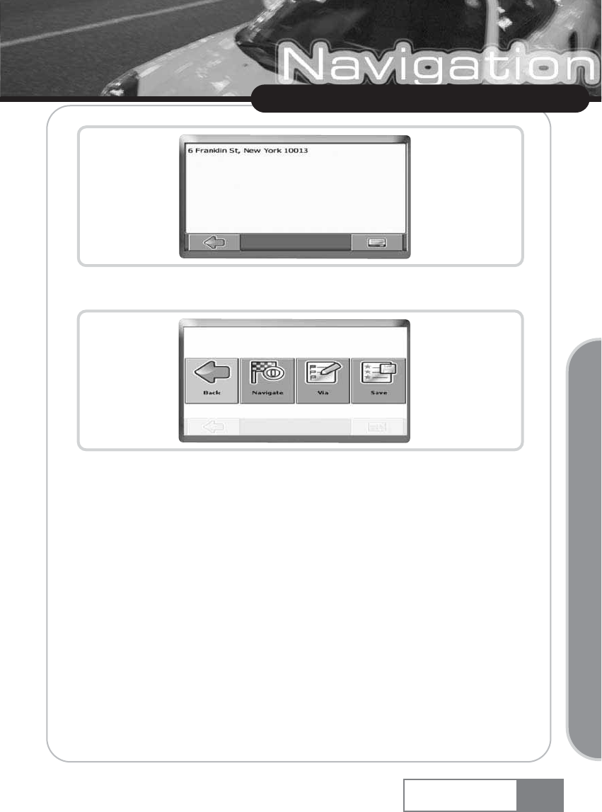
By pressing the menu icon you can access further options:
ҟPress Navigate to navigate to the location (see Navigating on page 28).
ҟPress Via to use the location for routing (see Planning a route on page 31).
ҟPress Save to save the location as a bookmark (see Favourites on page 24).
Search for an address
Through the address search you can find an address by entering information about the desired
target (street and town/city). You may then select a hit from the result list and use the address found
for different purposes, like pinpointing it on a map, planning your route, and navigating.
ҟOn the map, select the menu icon.
17
Using Navigation System
Navigation System
Basic Operation
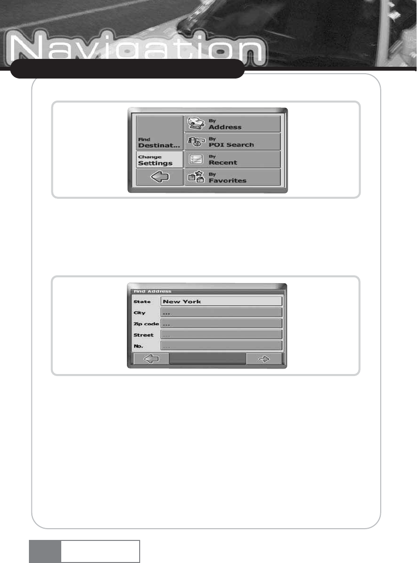
The main menu will be opened:
ҟSelect Find Destination.
ҟSelect By Address Search.
The Find Address window will be displayed:
Enter the appropriate data to find your address.
How to search
Your Personal Navigation Device offers a convenient interactive look-ahead search function to
prevent misspelling. Only keys that lead to a search result can be pressed — all others are grayed out!
ҟEnter the first character.
18
Using Navigation System
Navigation System
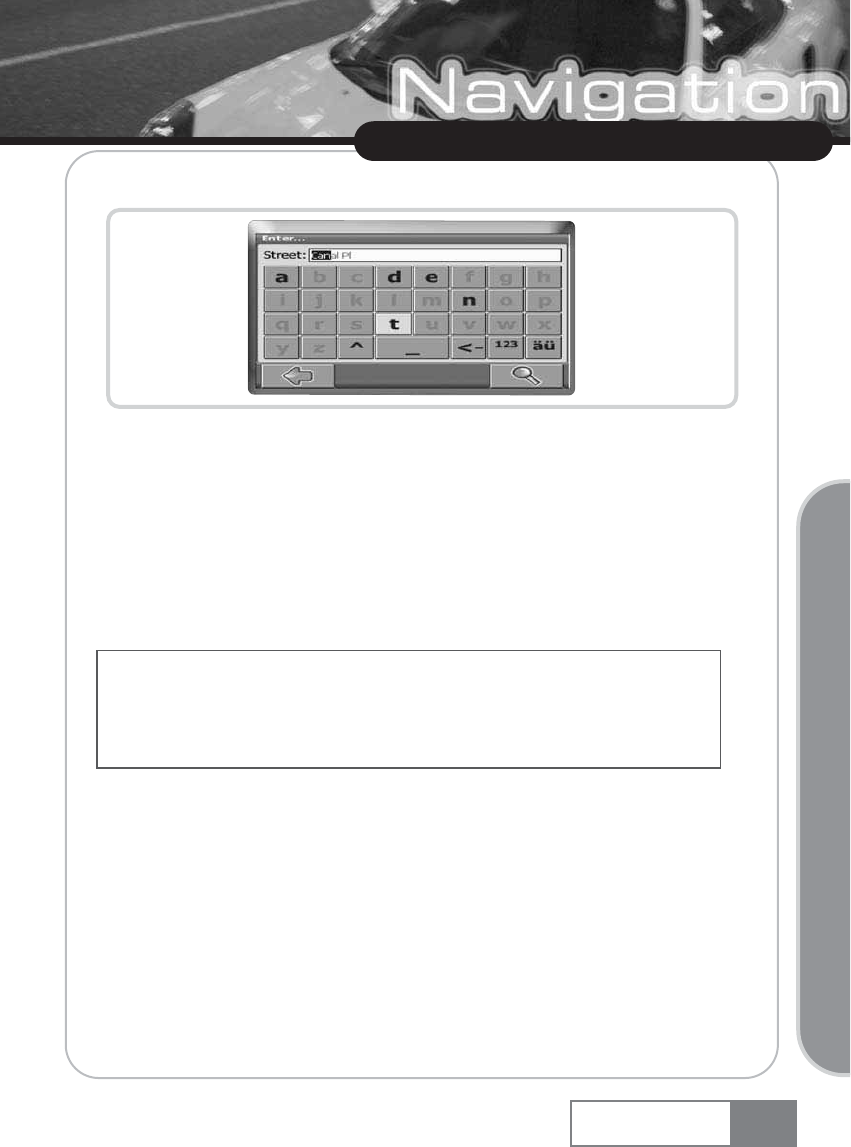
You will see that the some keys on the keypad turn grey. You can only choose black keys:
ҟEnter the second character.
Again, some keys will turn grey, others will turn black, depending on your choice.
ҟKeep on entering characters until you have narrowed down the search to only one result.
OR
ҟPress the search icon (magnifying glass).
A result list will be displayed.
ҟChoose the appropriate entry from the list.
Set the state
ҟPress State to select your state.
ҟChoose your state from the list.
The State field will be populated with the name of the chosen state.
Enter a zip code
Instead of a city you may enter a zip code.
ҟPress Zip code to enter a zip code.
19
Using Navigation System
Navigation System
Basic Operation
Switch between letter and number mode by pressing 123 or ABC. Switch between upper case and lower
case by pressing ^.
If at any point you want to backspace and delete characters, press the backspace button <- on screen. To
add a space, press the space bar _. If you need to enter an apostrophe ( ) use the space key instead
ҟEnter the zip code of the town/city you are looking for.
ҟPress the search icon (magnifying glass).
A hit list will be displayed.
ҟChoose the appropriate town/city from the list.
You will return to the Find Address screen. The City and Zip code fields will be populated with the
chosen city/zip code.
Search for the city
ҟPress City to select a city.
Search for the city, as described above.
A result list will be displayed.
ҟChoose the appropriate town/city from the list.
You will return to the Find Address screen. The City field will be populated with the name of the
chosen town/city.
Search for the street
ҟPress Street to select a street.
Search for the street, as described above.
A result list will be displayed.
ҟChoose the appropriate street from the list.
You will return to the Find Address screen. It will be filled with the previously found data.
Navigate to the address found
Once you have narrowed down your search to a unique address, you can start navigation.
ҟPress the forward arrow.
The address will be displayed in the navigation map. Here you can choose to be guided to the
address, use it for route planning, etc. (see Navigating on page 28).
20
Using Navigation System
Navigation System
Additionally you may enter the number.
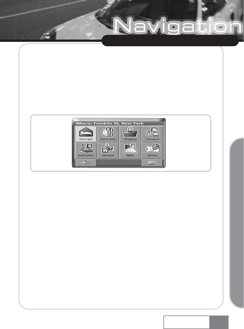
Searching for and choosing POIs
With the POI finder you can quickly find points of interest like gas stations and restaurants that are
chosen from a database of millions of POI, either nearby or at a remote location.
ҟOn the map, select the menu icon.
ҟOn the following screen, select Find Destination.
ҟSelect By POI Search.
A menu of POI categories will be shown:
In the title bar of this screen, you might see an address. You will be presented POIs that are close to
this location. Through the menu icon you open a set of options:
ҟPress Open to open a guide (see Browse or search a guide on page 22).
ҟPress Text search to search for a POI (see Searching for a POI on page 22.
ҟPress Current location to select POIs near your current location.
ҟPress Other location to select another address as a starting point for the POI selection (see
Search for an address on page 17).
The starting point will be shown in the title bar of the POI categories screen.
Choosing a POI
ҟChoose the desired POI category.
A menu with subcategories will be shown.
ҟChoose a subcategory.
A list of POIs will be shown.
ҟSelect a POI by clicking on it.
21
Using Navigation System
Navigation System
Basic Operation
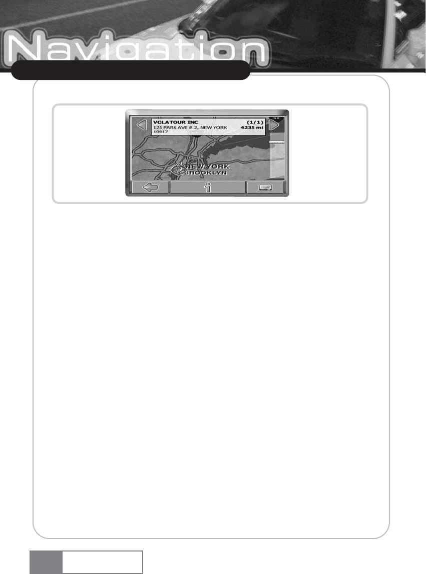
The location will be shown on the map:
ҟPress the arrows next to the location s name to switch between results.
ҟPress i to open a screen with details about the location.
By pressing the menu icon you access to a set of actions:
ҟPress Navigate to navigate to the location (see Navigating on page 28).
ҟPress Via to use the location for routing (see Planning a route on page 31).
ҟPress Save to save the location as a bookmark (see Favourites on page 24).
ҟPress On Map to show the location on the main map.
Searching for a POI
Press the menu icon, then select Text search.
ҟIn the search window, enter a search term (at least three characters), and start searching by
pressing the right arrow.
A list of POIs will be shown.
ҟSelect a POI by clicking on it.
The POI will be shown on the map, as described above.
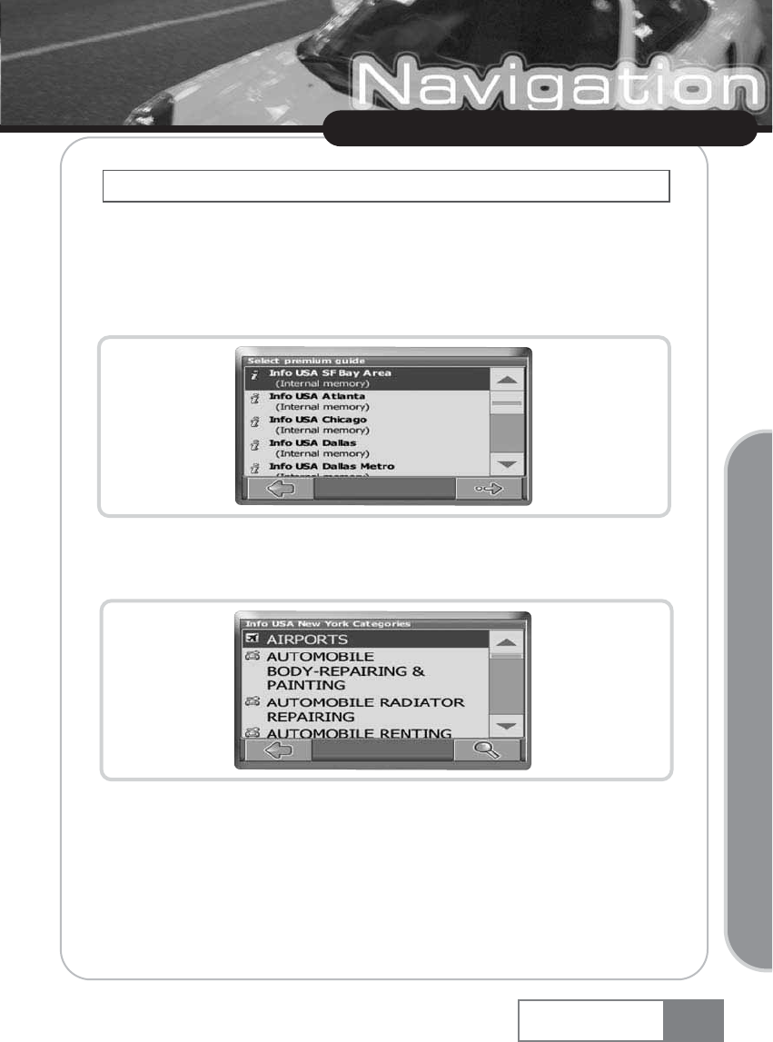
Browse or search a guide
Within the POI menu you may see guides, an optional feature. Branded travel/city guides will help
you to find out what is nearby and will give you valuable information about attractions, restaurants,
hotels, etc. with detailed descriptions. You may use the items contained in the guides for navigation
or save them as bookmarks.
22
Using Navigation System
Navigation System
23
Using Navigation System
Navigation System
ҟOn the map, select the menu icon.
ҟOn the following screen, select Find Destination.
ҟSelect By Location Service.
The guide list will be shown:
ҟSelect the guide you wish to use by clicking on it.
The categories page of the chosen guide will be displayed:
You can now browse the guide by categories or search the guide.
Search the guide
ҟPress the search icon (magnifying glass).
ҟIn the search window, enter a search term (at least three characters), and start searching by
Basic Operation
Guides are an optional feature and may be purchased at www.navi-plugins.com
pressing the search icon (magnifying glass).
The hit list will be displayed.
ҟSelect a location by clicking on it.
The location will be shown on the map.
ҟPress the arrows next to the location name to switch between results.
ҟPress i to open a screen with details about the location.
By pressing the menu icon you access to a set of actions:
ҟPress Navigate to navigate to the location (see Navigating on page 28).
ҟPress Via to use the location for routing (see Planning a route on page 31).
ҟPress Save to save the location as a bookmark (see Favourites on page 24).
ҟPress On Map to show the location on the main map.
Browse the guide by categories
On the categories page you may select from the different categories of the Guide (e.g. restaurants,
hotels, bars, museums etc.).
ҟUse the up and down arrows to scroll in the list.
ҟClick on a category or subcategory to search for relevant items.
The search results will be shown in the hit list, sorted by distance.
ҟSelect an entry by tapping on it.
ҟThe location will be shown on the map, as described above.
Favourites
Use your frequently used or favorite destinations for guidance. You can choose among your home,
your work place, a set of personal bookmarks, and recently visited locations.
ҟOn the map, select the menu icon.
ҟOn the following screen, select Find Destination.
ҟSelect by Favorites.
24
Using Navigation System
Navigation System
Some guides also offer subcategories.
25
Using Navigation System
Navigation System
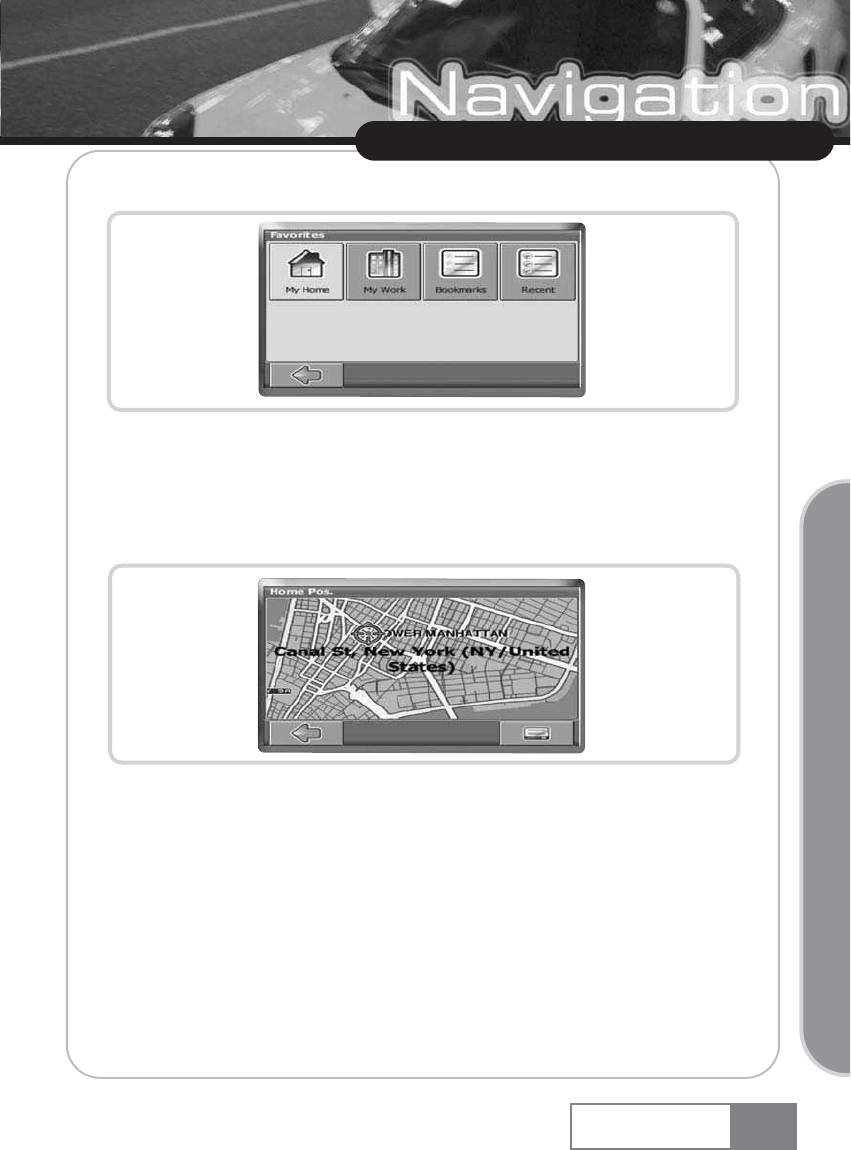
The Favorites menu will show on the screen:
My Home
ҟPress My Home.
Your home address will be displayed on a map:
ҟSelect the menu icon.
ҟOn the following screen, choose Navigate to be guided to your home address (press Change
or Delete if you want to change/delete your home address).
Basic Operation
Navigation will start immediately.
My Work
ҟBy pressing My Work, your work address will be displayed on a map.
ҟSelect the menu icon.
ҟOn the following screen, choose Navigate to be guided to your work address (press Change
or Delete if you want to change/delete your work address).
Navigation will start immediately.
Bookmarks
The bookmarks list contains the destinations you have saved as favorites (from the guides, by
choosing it on a map, etc.). This means that you do not need to perform repeated searches for those
destinations.
ҟPress Bookmarks.
26
Using Navigation System
Navigation System
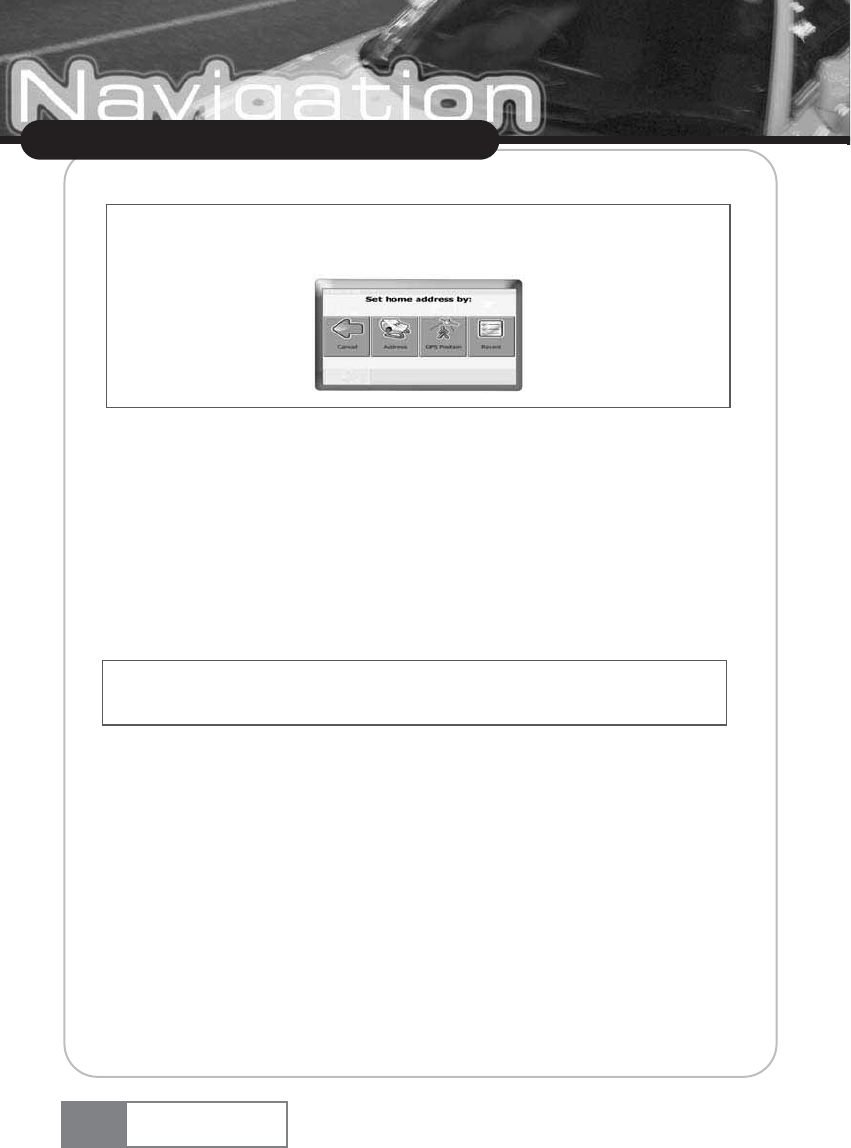
If no home address has been set, you are prompted to do so. You can choose it by searching for an
address, through your current GPS position or by choosing a recently visited location.
If no work address has been set, you are prompted to do so. You can choose it by searching for an
address, through your current GPS position or by choosing a recently visited location.
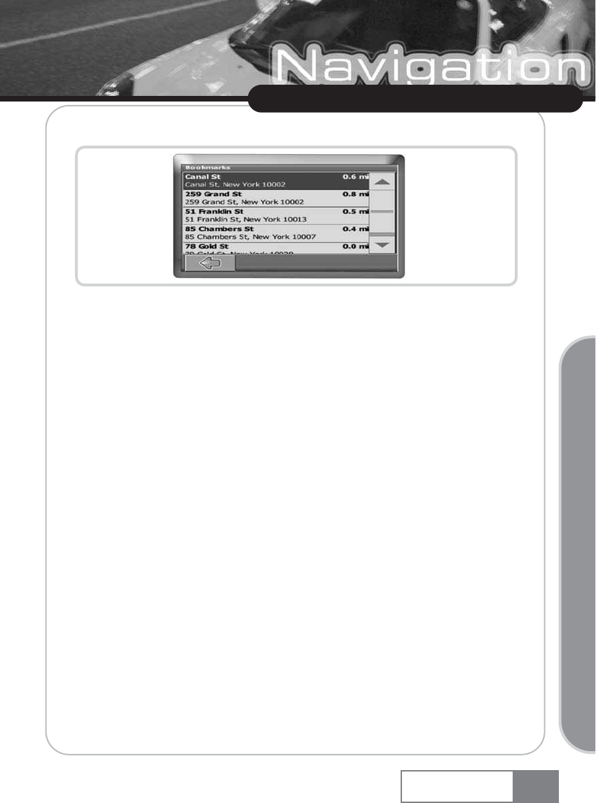
The bookmark list will show on the screen:
Use the up and down arrows to scroll up and down in the list.
ҟSelect an item by clicking on it.
The location will be shown on the map.
ҟPress the arrows next to the location s name to switch between results.
ҟPress i to open a screen with details about the location.
By pressing the menu icon you access to a set of actions:
ҟPress Navigate to navigate to the location (see Navigating on page 28).
ҟPress Via to use the location for routing (see Planning a route on page 31).
ҟPress On Map to show the location on the main map.
Recent
By pressing Recent a list of recently visited or looked-up destinations will be opened.
ҟPress Recent.
The list of recent items will show on the screen.
Use the up and down arrows to scroll up and down in the list.
ҟSelect an item by clicking on it.
The location will be shown on the map.
ҟPress the arrows next to the location s name to switch between results.
ҟPress i to open a screen with details about the location.
By pressing the menu icon you access to a set of actions:
27
Using Navigation System
Navigation System
Basic Operation
ҟPress Navigate to navigate to the location (see Navigating on page 28).
ҟPress Via to use the location for routing (see Planning a route on page 31).
ҟPress Save to save the location as a bookmark (see Favourites on page 24).
ҟPress On Map to show the location on the main map.
5-3. Navigating
The powerful navigation capabilities of smart2go“ guide you along the shortest or quickest route
from A to B — with voice commands and in 3D.
This section describes the navigation feature.
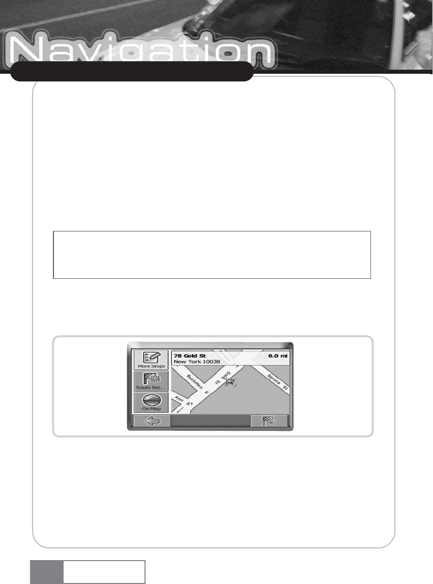
ҟChoose a location on the map or through Find Destination, and press Navigate in the
respective menu.
The location will be shown in the navigation map:
ҟPress the navigation icon to be guided to the location.
ҟPress More Stopovers to use the location for routing (see Planning a route on page 31).
ҟPress Route Settings to alter the guidance settings (see Route options on page 33).
ҟPress On Map to show the location on the map.
Your route will be calculated. The navigation screen will be displayed.
28
Using Navigation System
Navigation System
See Choosing a location on the map on page 15 for information about choosing elements on the map.
See Choosing and finding locations on page 16 for information about finding and choosing addresses,
POIs, and locations inside a guide.
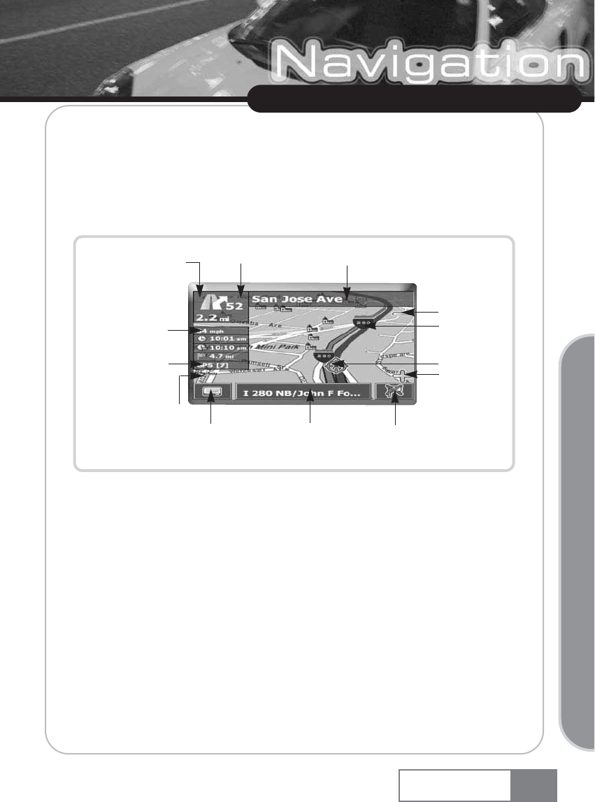
Navigation screen
On the navigation screen, the route will be shown in blue. The red arrow will indicate the direction
of your next manoeuvre. Crosshairs identify your current position. When you come up to a turn or
other manoeuvre, you will hear a voice command at the appropriate time.
For one-way streets, the transit direction is indicated with a red arrow.
Options during navigation
You can browse the map even while navigating. This way you can easily choose a new destination
if you change your mind. However, navigation will not be interrupted — you will be still guided
through voice commands. Press the back icon to follow the route on screen again.
29
Using Navigation System
Navigation System
Basic Operation
Zoom in
Manoeuvre icon
Distance to next
maneuver
Speed
Current time
Arrival time
Distance to
destination
GPS info
Compass rose
Menu icon Info box Stop navigation
OR
Follow route again
Current
position
Zoom out
Exit no. Next turn/junction.
Route
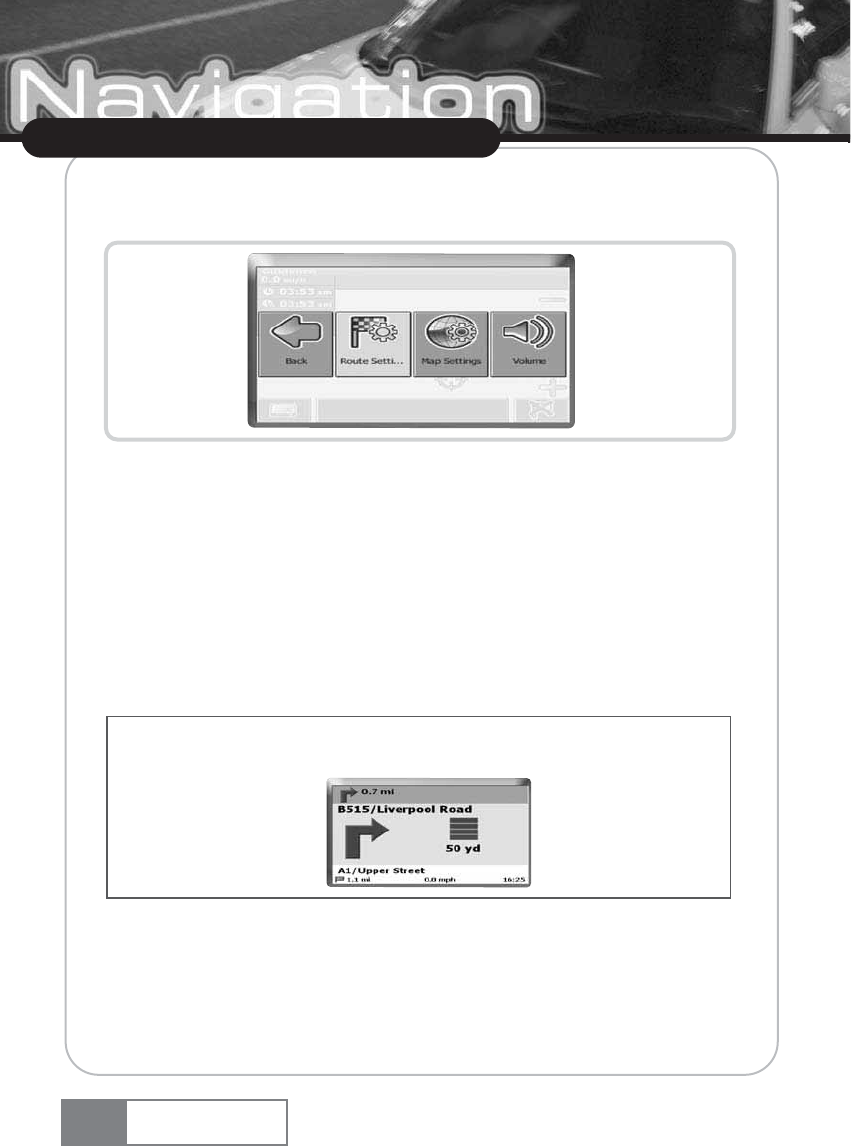
Menu options
ҟSelect the menu icon while navigating to open a set of navigation options:
Here you will find the following items:
Route Settings
Change the guidance options, as described in Route options on page 33.
Map Settings
Open a menu with map settings, as described in Map settings on page 35.
Here you can also toggle between map and arrow mode for guidance.
Volume
Alter the volume of the voice commands.
Info box options
ҟSelect the info box while navigating to open a set of navigation options:
30
Using Navigation System
Navigation System
When you change to the arrow mode, the navigation screen will not show the map but only an arrow
indicating the upcoming manoeuvre.
Alt. route :
With this option, you can choose to block the calculated route for a given distance (e. g. 0.5 mi)
and force an alternative route. Simply tap on the icon which shows the desired distance. Your route
will be recalculated, and the previous route will be discarded for the given distance.
Search
You can redirect your route by choosing a point of interest (POI), like a gas station.
List of waypoints
Opens a list of the waypoints on your itinerary.
Save
Save your actual position as a bookmark.
5-4. Planning a route
This section describes the route planning feature. This feature allows you to plan your route in
advance, choosing multiple stopovers along your journey.
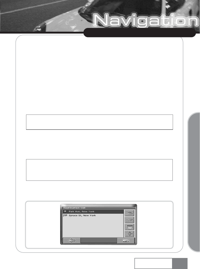
ҟChoose a location on the map or through Find Destination, and press Via in the respective menu.
ҟThe Destination List will be displayed:
31
Using Navigation System
Navigation System
Basic Operation
All user information like e.g. settings, bookmarks and recently visited locations will be stored on the
memory card and not on the device.
See Choosing a location on the map on page 15 for information about choosing elements on the map.
See Choosing and finding locations on page 16 for information about finding and choosing addresses,
POIs, and locations inside a guide.
The location will be added to the Destination List.
ҟPress the + icon to add another stopover.
You will switch to the Choose stopover screen. You may choose stopovers like your home or work
addresses, a bookmark, a point of interest, a recent location or by searching for an address or
pinpointing a destination on the map.
Once you have added stopovers (with the + icon) and returned to the Destination List, you have
several options:
ҟWith the + icon you can choose additional stopovers.
ҟTo change the order of the stopovers, select a stopover and then use the up and down arrows
to move it up/down in the list.
ҟWith the trash icon you can delete a selected stopover.
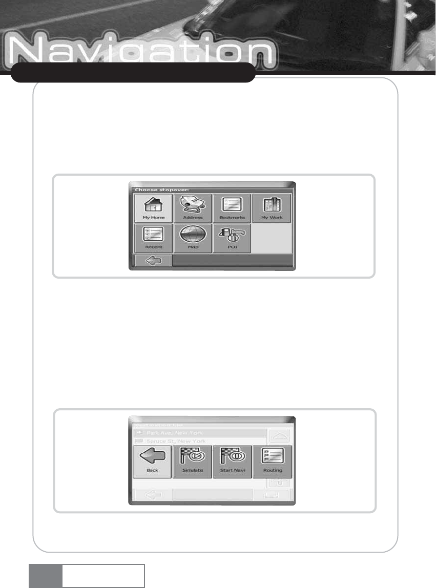
Once you have chosen your route, you have several options. You reach those options by pressing
the menu icon (bottom right-hand corner of the screen).
ҟPress Simulate to simulate the route to come.
ҟPress Start Navi to start guidance. The display will switch to the navigation map.
32
Using Navigation System
Navigation System
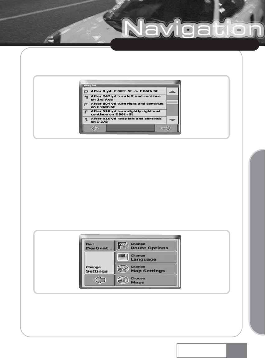
ҟWith Routing, the system will calculate your route. The Route Summary will be displayed. Tap
on one of the items in the Route Summary to display the Waylist. Tap again to show the map view.
5-5. Settings
You can configure your Personal Navigation Device to suit your needs. When it comes to
navigating, you can, for example, choose to avoid or allow toll roads or ferries or select your mode
of transportation, like a fast or slow car, a scooter or even your own feet. You can also edit several
display settings, like 2D or 3D mode, day or night mode, map complexity, etc.
ҟOn the map, select the menu icon.
ҟSelect Change Settings.
The main menu will be opened:
Route options
ҟChoose Change Route Options to change the route options.
33
Using Navigation System
Navigation System
Basic Operation
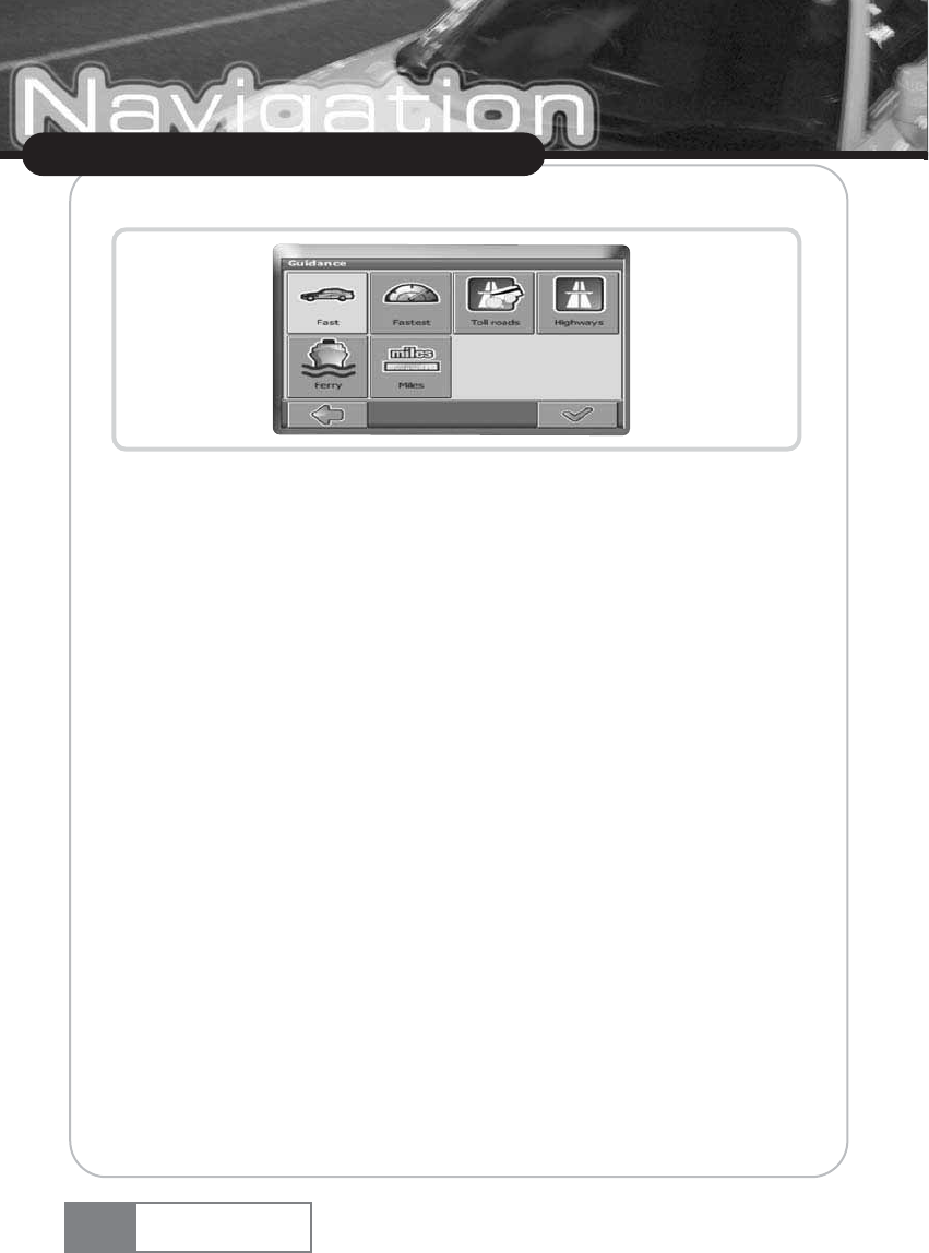
The window with the route settings will be displayed:
ҟTo switch between the modes just touch the icons. These will toggle so you can quickly see the
activated settings.
You can choose among the following options: Mode of transportation (fast car, slow car, motorbike,
pedestrian, etc.), fastest or shortest route, allow or avoid toll roads, highways, and ferries. You can
also choose the distance unit (miles/kilometers).
Once you have chosen your settings, press the confirmation icon to return to the main menu.
Mode of transportation — overview
Fast
— assumes fast driving on highways. Choosing this option will slightly favor highways in the
routing choice
Slow
— assumes slower driving on highways. Choosing this option will reduce the preference for
highways in the routing choice
Bike
— takes into account bike paths and blocks highways where bikes are prohibited.
Motorbike
— takes into account motorbike restrictions, where applicable.
Scooter
— takes into account scooter restrictions, where applicable.
Van
— takes into account van restrictions, where applicable.
Pedestrian — provides true pedestrian routing including full access to one-way streets and pedestrian
zones, where possible.
34
Using Navigation System
Navigation System
Language
ҟChoose Change Language to select the language of your navigation system.
Map settings
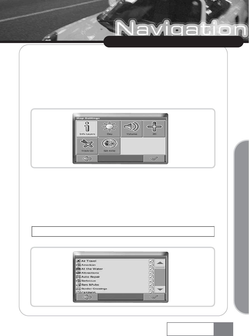
ҟChoose Change Map Settings to change the map settings.
The window with the map settings will be shown:
ҟToggle between night and day mode by pressing the corresponding icon.
ҟToggle between 2D and 3D mode by pressing the corresponding icon. By selecting
Automatic, the mode will be chosen depending on the actual time.
ҟChoose Track Up to optimize the map orientation during navigation. Choose North up to keep
the map oriented to the north.
ҟChoose Set time to choose your time zone.
ҟChoose Info Layers to choose which kinds of elements are to be shown on the map:
35
Using Navigation System
Navigation System
Basic Operation
The time itself is set automatically through GPS.
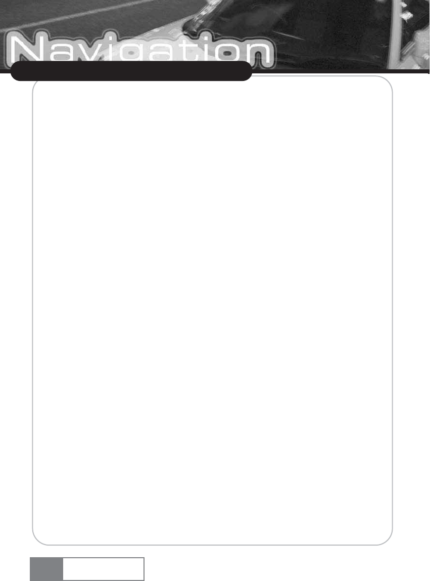
ҟCheck the boxes of any category you want to have displayed on the map. Uncheck those that
should be hidden.
ҟPress the confirmation icon to apply your settings.
ҟPress the arrow icon to return.
Map
ҟSelect Choose Maps to select a map.
If you have map data for different regions/cities on your memory card, tap on the name of the
current region (e. g. London). All available maps on the memory card will be listed. You can choose
the desired region by simply tapping on its name.
6. Optional Features
You can further enhance your Personal Navigation Device through a set of optional features. The
following features are available as options for your navigation system:
6-1. Guides
At www.navi-plugins.com you can find lots of valuable information services, including directory
services, WiFi hotspot locators, and city guides. City guides contain detailed information about
locations, such as descriptions, contact information, prices, opening times, etc.
To purchase the guides and to learn how to download them, please go to www.navi-plugins.com.
To learn how to use the guides, see Searching for and choosing POIs on page 21.
about traffic jams and ask you if you would like to switch to an alternate route.
36
Using Navigation System
Navigation System
7. Frequently asked questions
I can t find an address.
Please make sure you have correctly spelled your entry. If you do not know how an address is
spelled correctly, simply enter the parts of the address, you know for sure (e.g. New York ,
Times for Times Square in New York City). Then browse in the result list and look for the address.
Also make sure that the city in which you are looking for an address is correct. Sometimes the
official postal address differs from the address you are looking for. In that case, search for an
address nearby that you know of and browse on the map.
If you find the address on the map but you can not find it while searching for it, please let us know
via pnd@support.gate5.net.
There is a failure in the map / POIs are missing.
If you detect an error in the map data (e.g. a street is missing completely), we would like to inform
our map data provider. Please let us know via customer support located on page 77.
I have problems to get a GPS fix.
If you have problems getting a satellite fix with the GPS (you can see how many satellites are being
received on the main menu at the bottom left) please make sure, that you are outside and the GPS
antenna has a good visibility to the open sky. Some models also do support an additional external
active antenna. Please also consult with the hardware manual of your device to get further
information of how to obtain a GPS fix.
Where can I get technical support and updates ?
Please, contact your retail store or the customer sevice center in page 77.
37
Using Navigation System
Navigation System
Basic Operation
8. Audio player
You can play back music by selecting Audio player in the main menu. Basic functions include Play,
Pause, Stop, Select Next, and Select Previous. Playback functions include Repeat, Repeat Selected,
and Random.
The supported music file formats are MP3, WMA, and WAV.
You can save music files in the SD Card memory. The Audio player manages the music files by the
unit of a folder.
To play back music using the SD Card memory.
(If the icon appears at the right upper side, the device detects the SD Card memory.)
1. Navigation System find all playable music files in the SD Card memory and makes a list of music files.
2. You can see all music files regardless folder in the Total folder.
3. If you select a specific folder, Audio player shows list of music files in selected folder. Now, you
can listen to music by selecting music file you want to play.
38
Using Navigation System
Navigation System
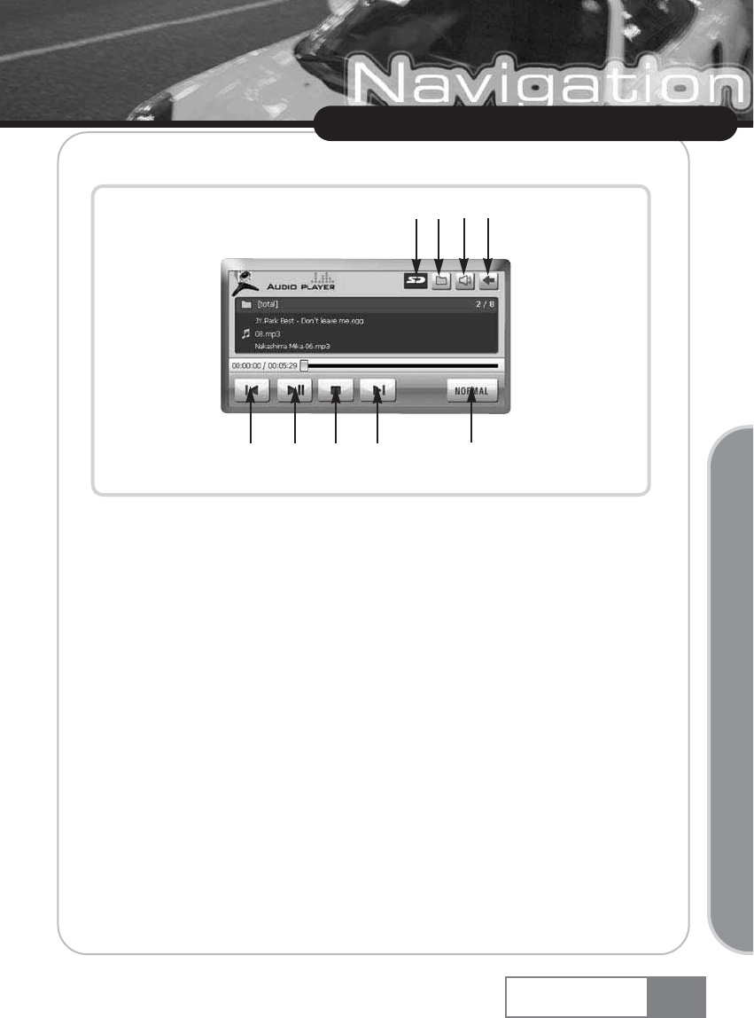
8-1. Basic screen
ڡSD Card indication icon : If SD Card is inserted, icon changes to blue color.
ڢFile list : Show folders and files that Audio player can playback.
ڣVolume control : Increase or decrease volume.
ڤExit : Close Audio player and returns to Main menu.
ڥPrevious file playback : Playback previous music file.
ڦPlay/Pause : Playback and Pause music.
ڧStop : Stop the music playback.
ڨNext file playback : Playback next music file.
کPlayback mode : You can select playback mode, ŔNormalŕ, ŔRandomŕand ŔOneŕ.
39
Using Navigation System
Navigation System
Basic Operation
ڥڦڧڨک
ڡڢڣ ڤ
Using Navigation System
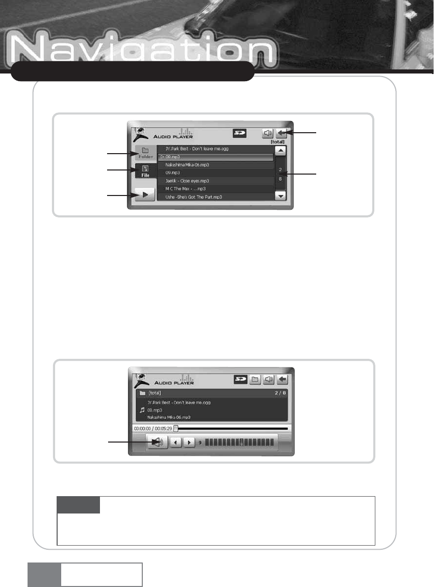
8-2. File list screen
By touching folder tab(ڡ), Audio player shows folders which playable music files are in. At the
folder list view, you can see the list of files by selecting File tab(ڢ). You can listen to music file,
highlighted by cursor, using Playback button(ڣ). Touching Back button(ڤ), you can return to
basic screen of Audio player. You can select another file to play by using scroll bar(ڥ). Numbers
on scroll bar represent current cursor position/total number of files.
8-3. Volume control
You can increase or decrease volume. By touching Mute button(ڡ), you can mute audio sound.
Navigation System
40
ڡ
ڢ
ڣ
ڤ
ڥ
ڡ
Caution While Audio player is operating, if you remove the SD Card memory, system will be get into
unstable situation. Please donœt remove SD Card memory during playback. If system is unstable because SD
Card memory is removed, turn off the system and rebooting.
Using Navigation System
9. Video Player
You can play back movie by selecting Video Player in the main menu. Basic functions include Play,
Pause and Stop. The supported movie file formats are ŔAVI, MPG, MPEG, WMV, MP4, ASF, Divx, TSŕ.
You can save video files in the SD Card memory. The Video player manages the movie files by the
unit of folder.
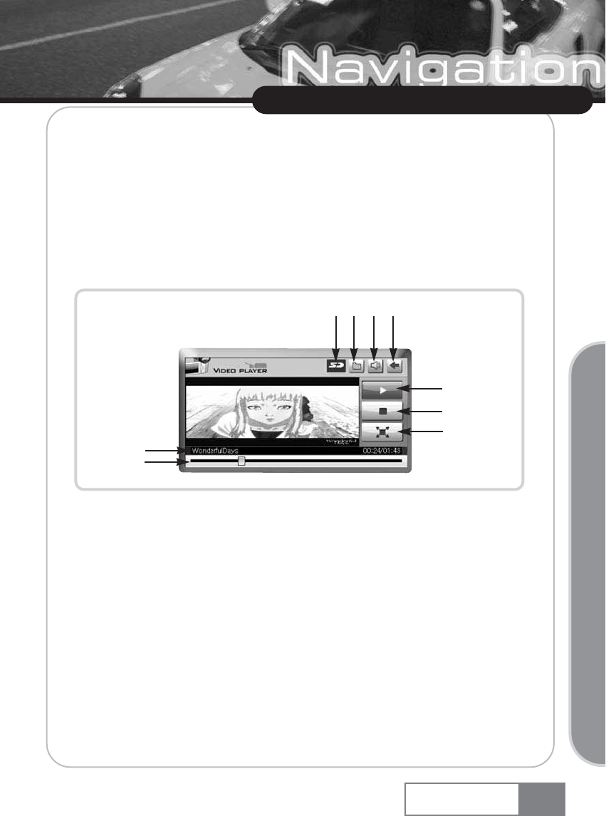
9-1. Basic Screen
ڡSD Card indication icon : If SD Card memory is inserted, icon changes to Blue color.
ڢFile list : You can see playable movie files by selecting this button.
ڣExit/Back : Close movie player and return to main menu.
ڤPlay/Pause : Plays back the movie. While movie is playing, button keep the Blue color.
If you retouch this button, movie will be paused.
ڥStop : Stops playback.
ڦFull Screen : Plays back the movie as full screen.
ڧFile name/time : Displays the current file name and Elapsed time/Total time.
ڨProgress status bar : Displays the progress status of play. This bar is used for
seeking specific scene in the movie.
کVolume control : Increase or decrease sound volume.
Navigation System 41
Basic Operation
ڥ
ڦ
ڧ
ڨ
ڡڢک ڣ
ڤ
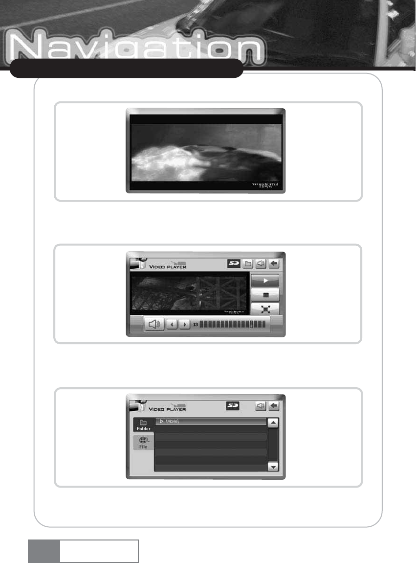
9-2. Full Screen
9-3. Volume Control Screen
9-4. Volume Control Screen
Movie player scan all playable movie files stored in the SD Card memory and shows its result.
Using Navigation System
Navigation System
42
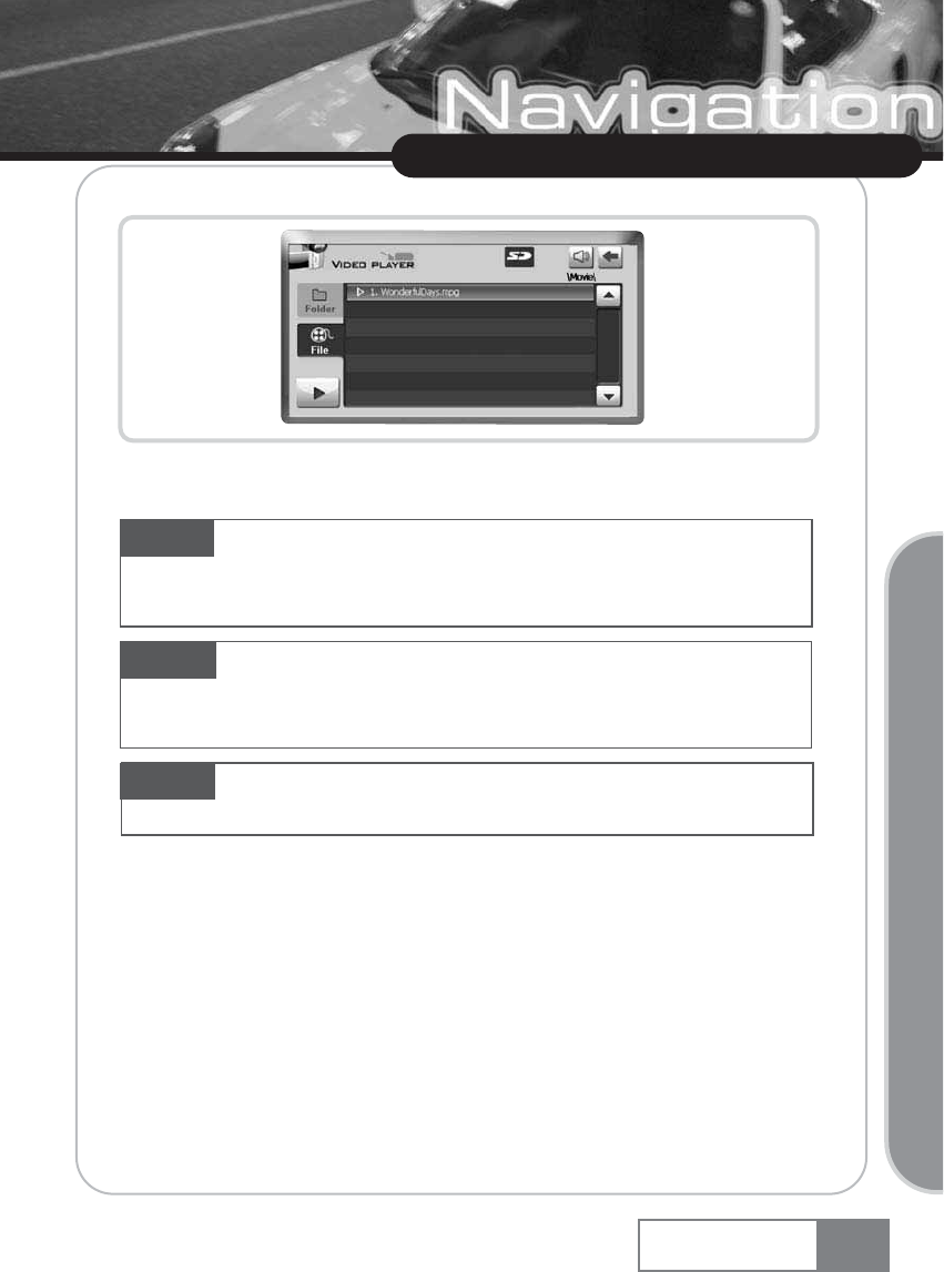
After selecting folder, if you touch File tab, you can see all playable movie files.
Using Navigation System
Basic Operation
Navigation System 43
Caution While movie player is operating, if you remove the SD Card memory, system will be
get into unstable situation. Please donœt remove SD Card memory during playback. If system is
unstable because SD Card memory is removed, turn off the system and rebooting.
Caution During navigator is operating, if you wan to operate video player, you have to close
the navigator for stable video playing. If you donœt close the navigator, system will close it when
video player begins.
Caution If you play the high resolution video file, system will be in unstable condition.
For stable operation of the system, recommended file resolution is less than 320 x 240.
10. Image Viewer
You can view images by selecting Image Viewer in the main menu. Basic functions include Previous
view, Next view, Set image to original size, Fit image to viewer, Zoon in, Zoom out, Rotate left,
Rotate right, Full screen, and list of image files. The supported image file formats are ŔWAV, WMA,
MP3 and OGGŕ.
You can save image files in the SD Card memory. The Image viewer manages the image file.
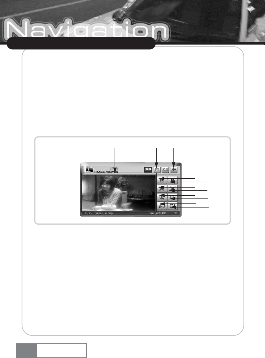
10-1. Image Viewer main screen.
ڡView previous image.
ڢView next image.
ڣSet image to original size.
ڤFit image to viewer : If you touch ڤbutton, you can fit image to viewer.
ڥZoom in : Zoom in steps (150% ؋200% ؋250% ؋300%)
ڦZoom out : Zoom out steps (66% ؋50% ؋33% ؋25%)
ڧRotate 90 degrees to left : Rotate 90Ňto left by touching rotate button. (90Ň؋ 180Ň؋
270Ň؋ 360Ň)
ڨRotate 90 degrees to right : Rotate 90Ňto right by touching rotate button. (90Ň؋ 180Ň
؋270Ň؋ 360Ň)
کFull screen : If you touch the کarea, you can see full screen image.
ڪDisplays the list of image files.
ګReturns to the main menu.
Using Navigation System
Navigation System
44
ڥڦ
ڧڨ
ڪګ
ڡڢ
ڣڤ
ک
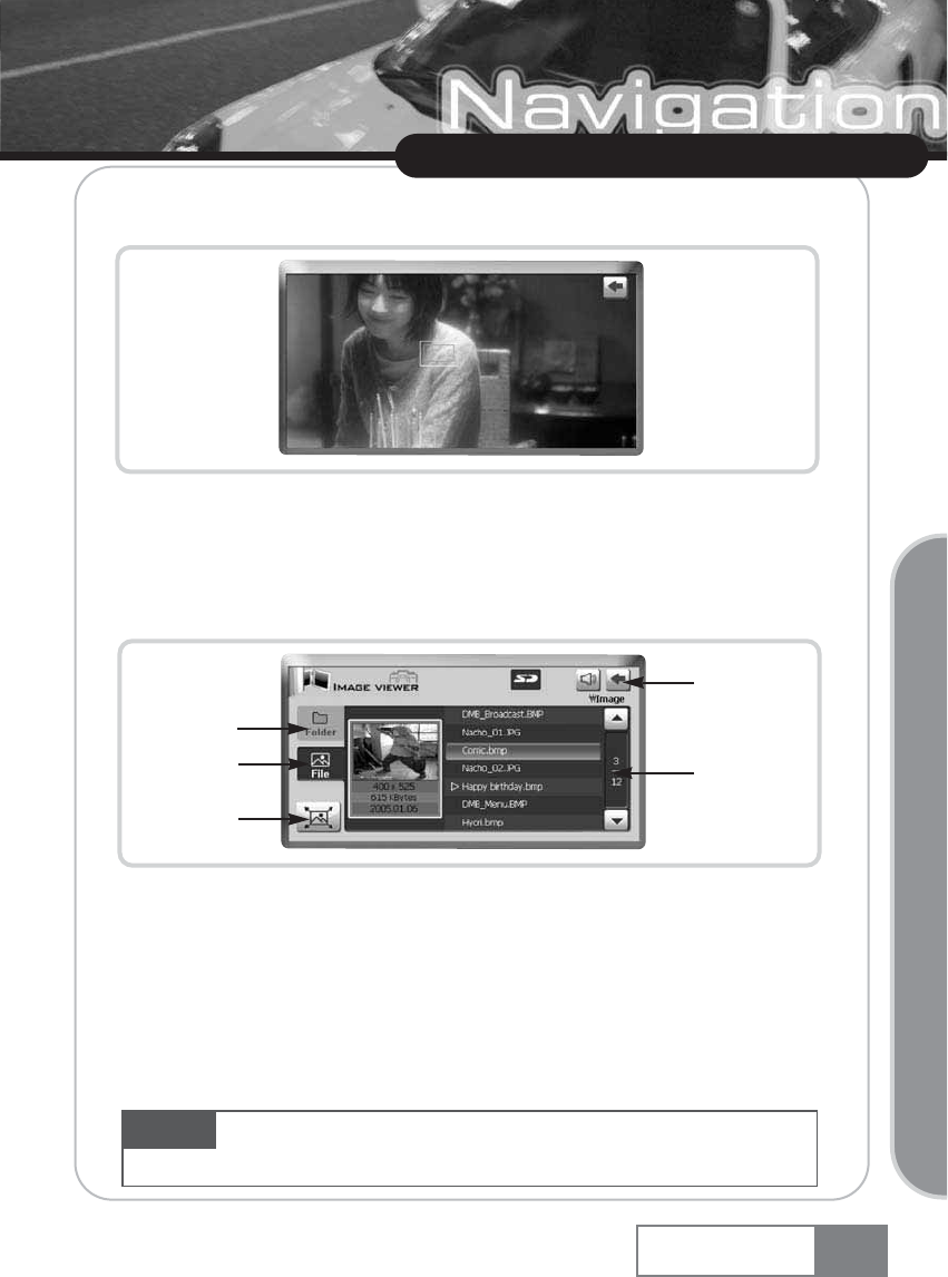
10-2. Full Screen
You can see the full screen image by selecting Full screen button.
10-3. File list screen
You can see file list screen by touching the File list button. Touching the Folder tab(ڡ), image
viewer show all folders which have supported image files in SD Card memory. When Folder tab is
enabled, you can see image files of selected folder by touching File tab(ڢ). By touching the Image
view button(ڣ), you can see the highlighted image file by using cursor. Selecting back button(ڤ),
you can return to basic screen of image viewer. You can select another file using scroll bar(ڥ).
Numbers on scroll bar represent current cursor position/total number of files.
Using Navigation System
Basic Operation
Navigation System 45
ڡ
ڢ
ڣ
ڤ
ڥ
Caution For stable operation of system, image size is limited by 2048 x 2048 or 1.8Mbyte file size.
If you select image file over the limitation, Image viewer will show the warning message.
11. Game
Select the Game in the main menu.
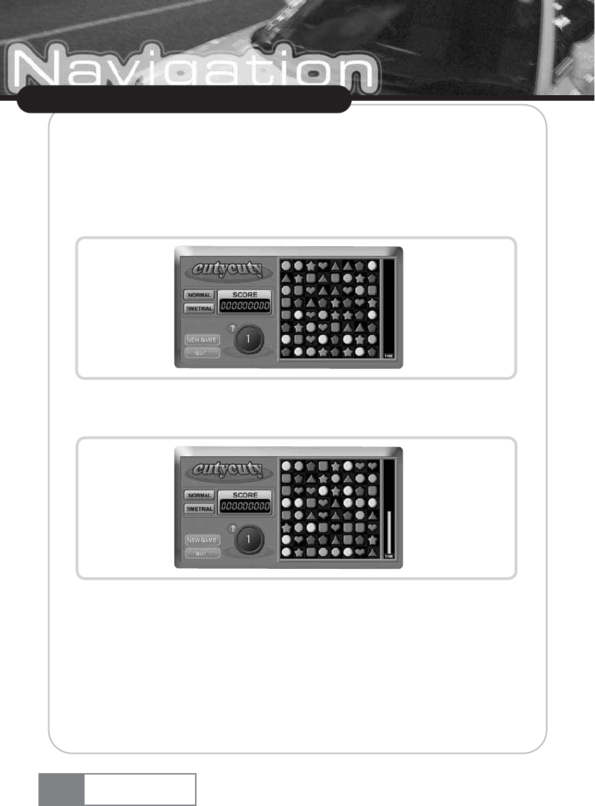
How to play : If you place more than three of the same items in a row vertically or horizontally,
these items will disappear.
To get higher score, remove as many items as possible at shortest time.
Normal mode : The game will be over if no further moves are possible.
If the bar on the right side is filled, the next level will start.
ҟ
Time trial mode : The game will be over if the time bar on the right side runs down. If
the bar on the right side is filled, the next level will start.
ҟ
’?’ : This button gives you a hint at the expense of losing some score. This button will be
disabled if the score is not sufficient.
ҟ
New Game : Stops the current game and starts a new one.
ҟ
Quit : Exits the game.
Using Navigation System
Navigation System
46
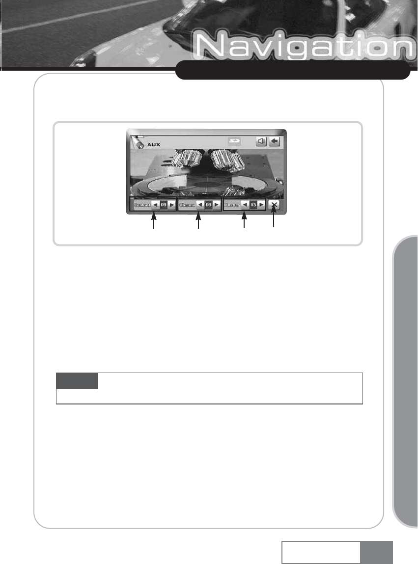
12. Aux
You can use the simple Aux function if you set A/V input as ŔOthersŕin the settings section.
As shown by the above figure, only volume control and screen setting are supported in ŒOthersœ
mode. DVD player control is not supported.
ڡContrast : Controls contrast within the range of 0 ~ 16 stages.
ڢChroma : Controls chroma within the range of 0 ~ 16 stages.
ڣDimmer : Controls brightness within the range of 1 ~ 5 stages.
ڤHide UI : Hides the UI from the screen.
Using Navigation System
Navigation System 47
Basic Operation
ڡڢڣڤ
Option The following functions are available when connected to a DVD player manufactured
by Plenio.
Using Navigation System
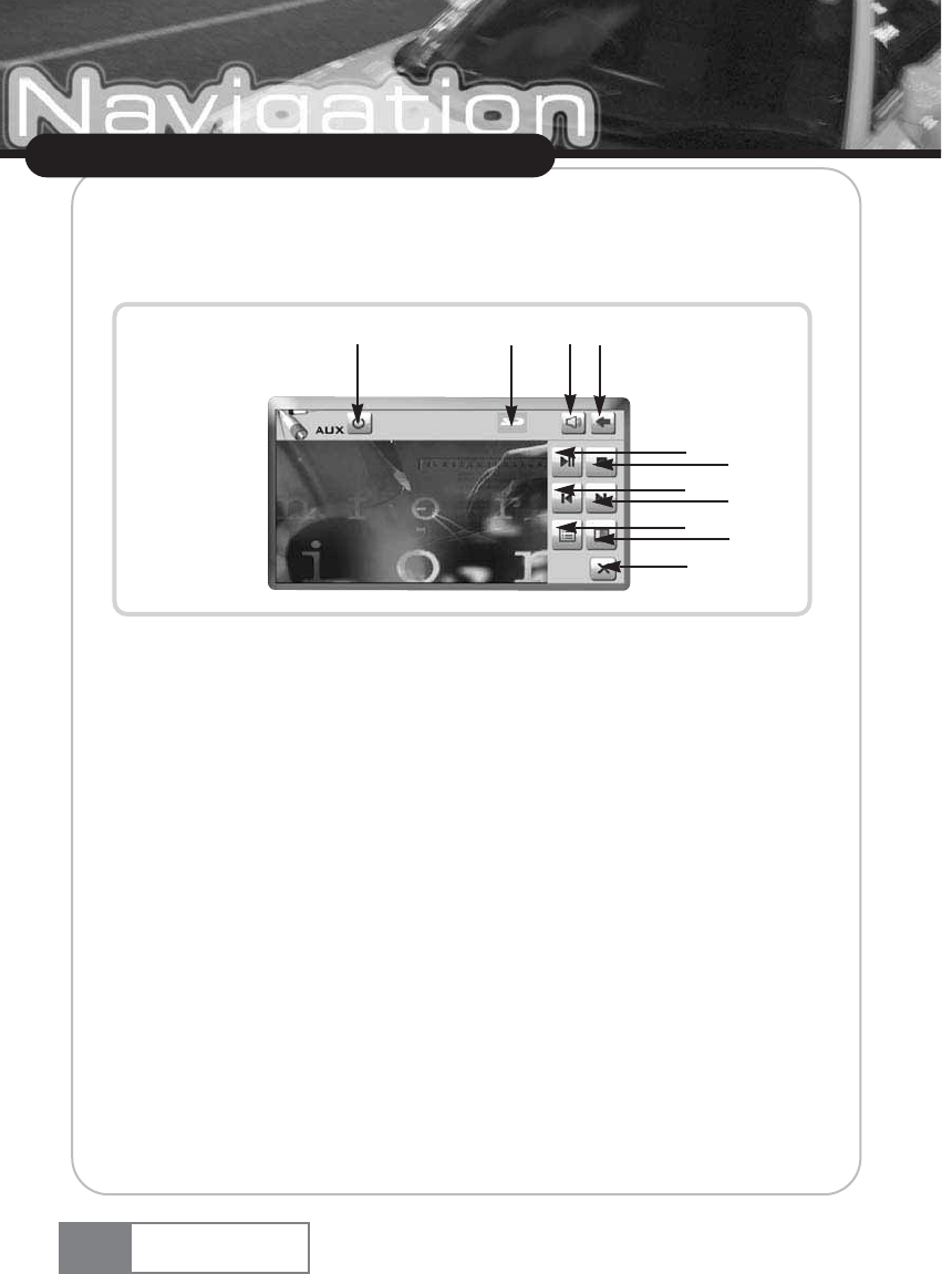
If you have DVD player connected and select VXM or VXD as A/V input in Setup menu
accordingly, you can access the DVD player function via the touchscreen controls. You can also use
the remote controller to use the following functions.
ڡPower : Power on or off the DVD player.
ڢSD : If the icon appears, the device detects the SD memory.
ڣVolume : Controls sound volume of the DVD player.
ڤPlay/Pause : Starts or pauses the DVD player.
ڥStop : Stops the DVD player.
ڦPrev : Starts the DVD player and moves to previous screen.
ڧNext : Starts the DVD player and moves to next screen.
ڨDVD Title: Switches to the DVD title menu and displays the direction key menu, which makes
cursor movement easier in the DVD title.
کSetting : Changes to screen setting.
ڪHide UI : Hides the UI from the screen.
ګReturns to the previous menu or the main menu.
48 Navigation System
ڨک
ڪ
ڢڣ
ڤڥ
ڦڧ
ڡګ
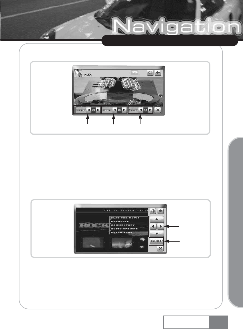
The following screen will appear if you press the setting icon.
ڡContrast: Controls contrast within the range of 0 ~ 16 stages.
ڢChroma : Controls chroma within the range of 0 ~ 16 stages.
ڣDimmer : Controls brightness in 5 discrete levels.
The below figure shows the screen when you press the DVD title icon. You can move the DVD Title
cursor using the direction key either via the remote control or the touchscreen controls.
ڡDirection key: Moves the DVD Title cursor.
ڢENTER: Selects the moved cursor.
49
Using Navigation System
Navigation System
Basic Operation
ڡڢڣ
ڡ
ڢ
13. Setup
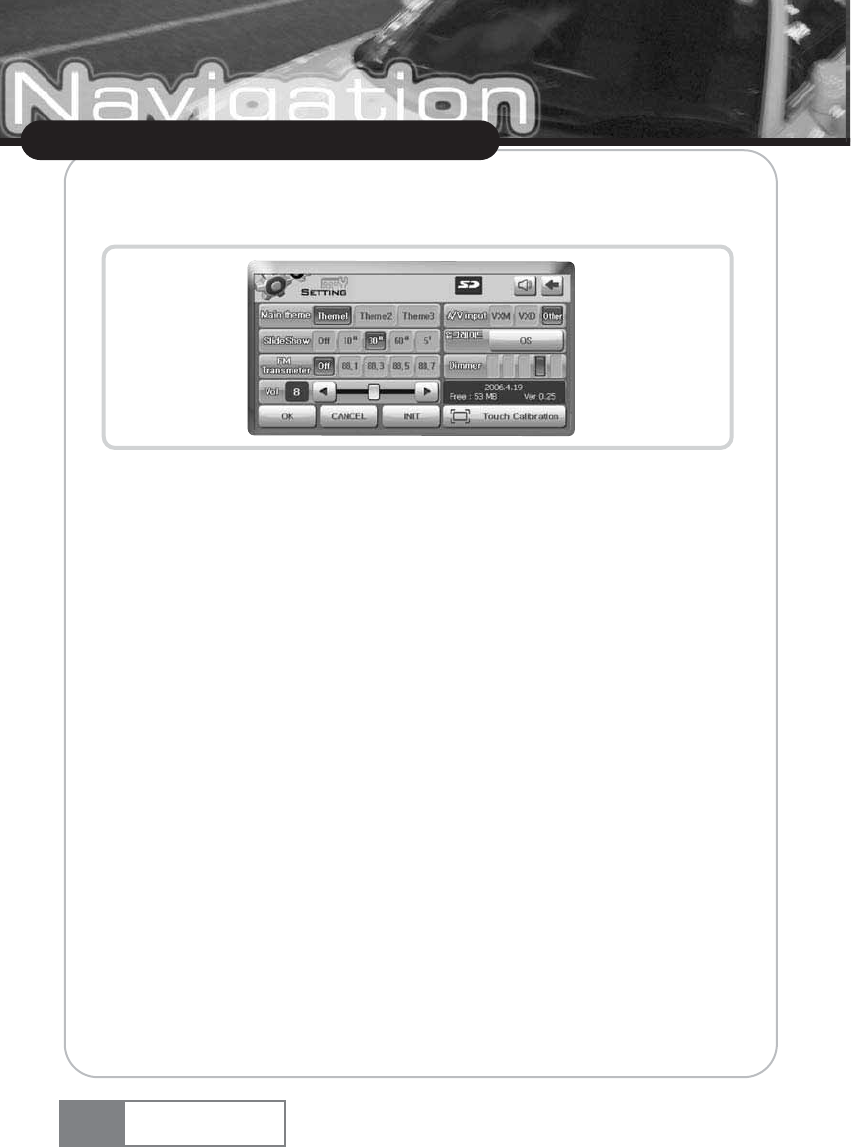
You can change many settings if you select Setup in the main menu.
13-1. Main Theme
Change main theme of GUI (Graphic User Interface)
13-2. Slide show
If no input is made for more than one minute in the main menu, specified images will be displayed
sequentially in a slide show. You can select Off, 10 seconds, 30 seconds, 60 seconds, and 5
minutes for the time interval of image display when slide show is started.
žTo use Slide show function, you have to resize image file to 480 X 234. V-up Pro 3000
supports image resizing function and save resized image in the SD Card memory automatically.
13-3. FM transmitter
You can select 88.1, 88.3, 88.5, 88.7 MHz or off. If you set the car radio frequency to the
selected frequency, you can listen to the sound using the car speaker.
13-4. Volume
You can select from 16 levels of seound volume.
50
Using Navigation System
Navigation System
13-5. A/V Input
If you select the VXM or VXD, DVD player manutatured by this company, you can control the DVD
player using this device. To connect other manufacturerœs product, set to ŔOthersŕ. Default is
ŔOthersŕ.
13-6. Upgrade or download
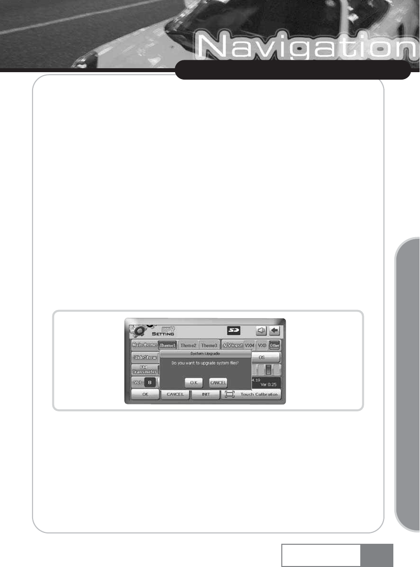
Upgrade using SD Card memory - You can upgrade the OS using SD Card memory. To download
OS from the customer service web site in page 77 down to SD Card memory using V-up pro 3000,
you have to register in the web site. See the web site to see how to use V-Up Pro 3000.
ƃOS Upgrade
1) Download the OS upgrade file to SD Card memory using V-Up Pro 3000.
2) Connect the SD Card memory to the device. When the SD Card memory icon appears, select
OS upgrade.
3) Press the [OK] button.
51
Using Navigation System
Navigation System
Basic Operation
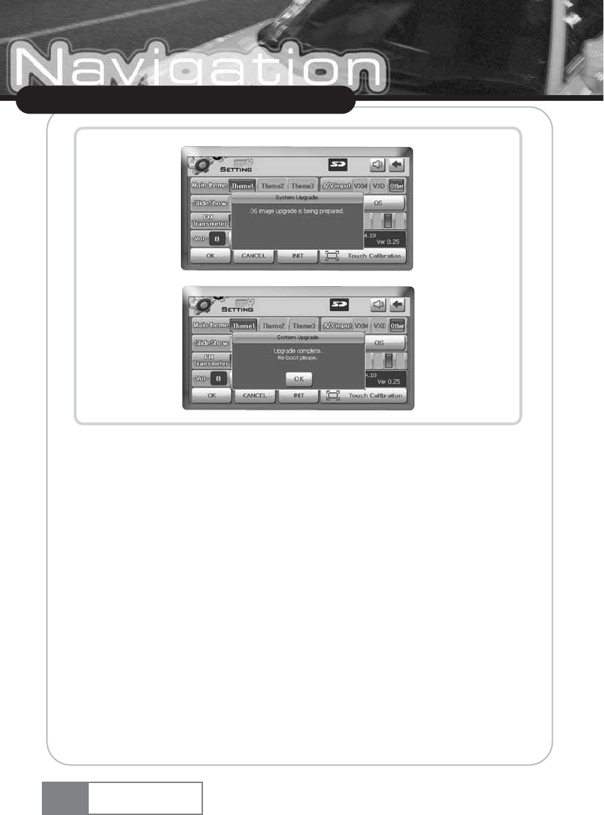
4) When upgrade is complete, turn the power off and on.
13-7. Dimmer
You can select from 5 levels of screen brightness.
52
Using Navigation System
Navigation System
13-8. Touch Calibration
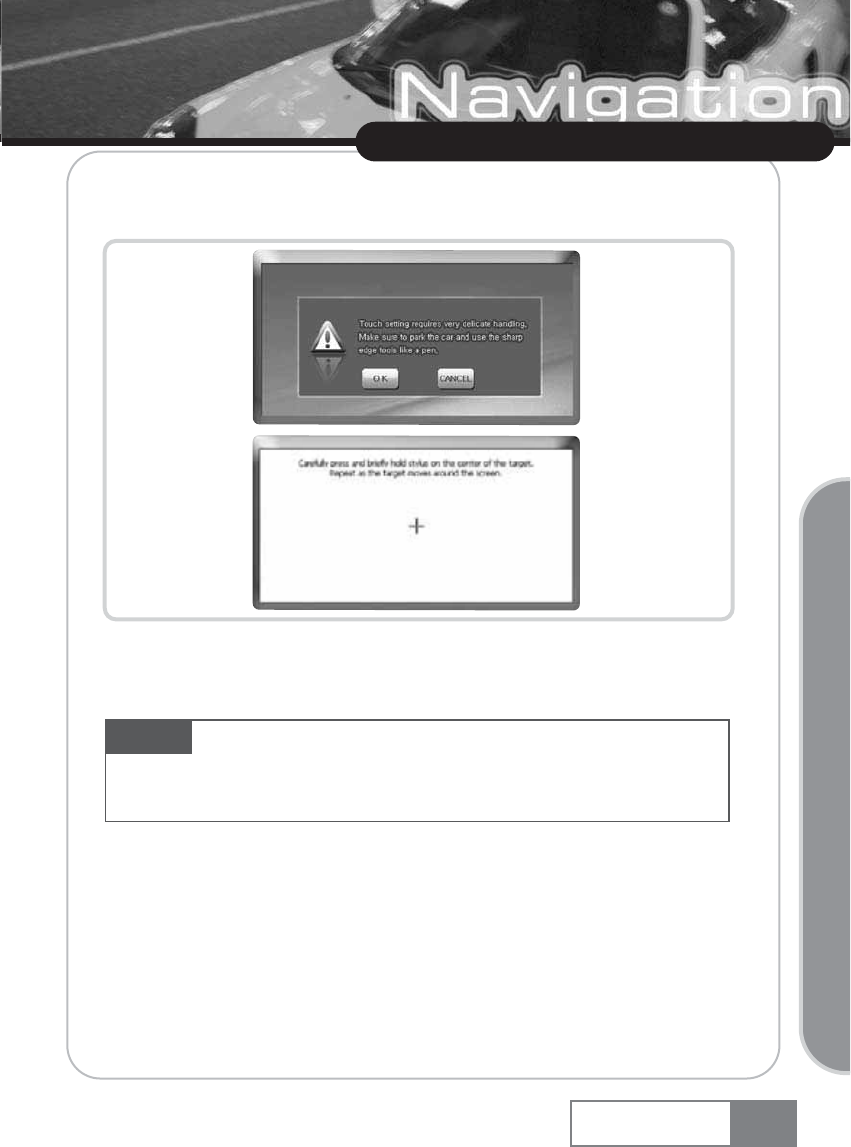
Selecting this menu to increase accuracy of the touch screen.
For touch screen setting, press and briefly hold the center of the cross symbol. Then, the cross symbol
will appear at the left upper side, left bottom side, right bottom side, and right upper side one by
one. To complete touchscreen setting, press the center of the cross symbol for 5 times in total.
13-9. OK
You can save all settings by pressing this button
13-10. Cancel
You can cancel all settings you made by pressing this button.
13-11. INIT
The factory default setting will be stored, if you press this button.
53
Using Navigation System
Navigation System
Basic Operation
Caution If you press the point that is far away from the cross symbol during touchscreen setting,
the cross symbol will appear indefinitely. Therefore, always stop the car before setting up the
touchscreen setting. Do not use a tool with too sharp tip, since it can damage the touch panel.
Instead, use a round edge object like the test jack for setting.
Map Upload
Navigation System
54
1. Installing V-Up Pro 3000 Program
A. Download the latest V-Up Pro 3000 installation file from the dvssales web site
(www.dvssales.com).
B. Execute the downloaded V-Up Pro 3000 installation file and carry out the following
installation procedure.
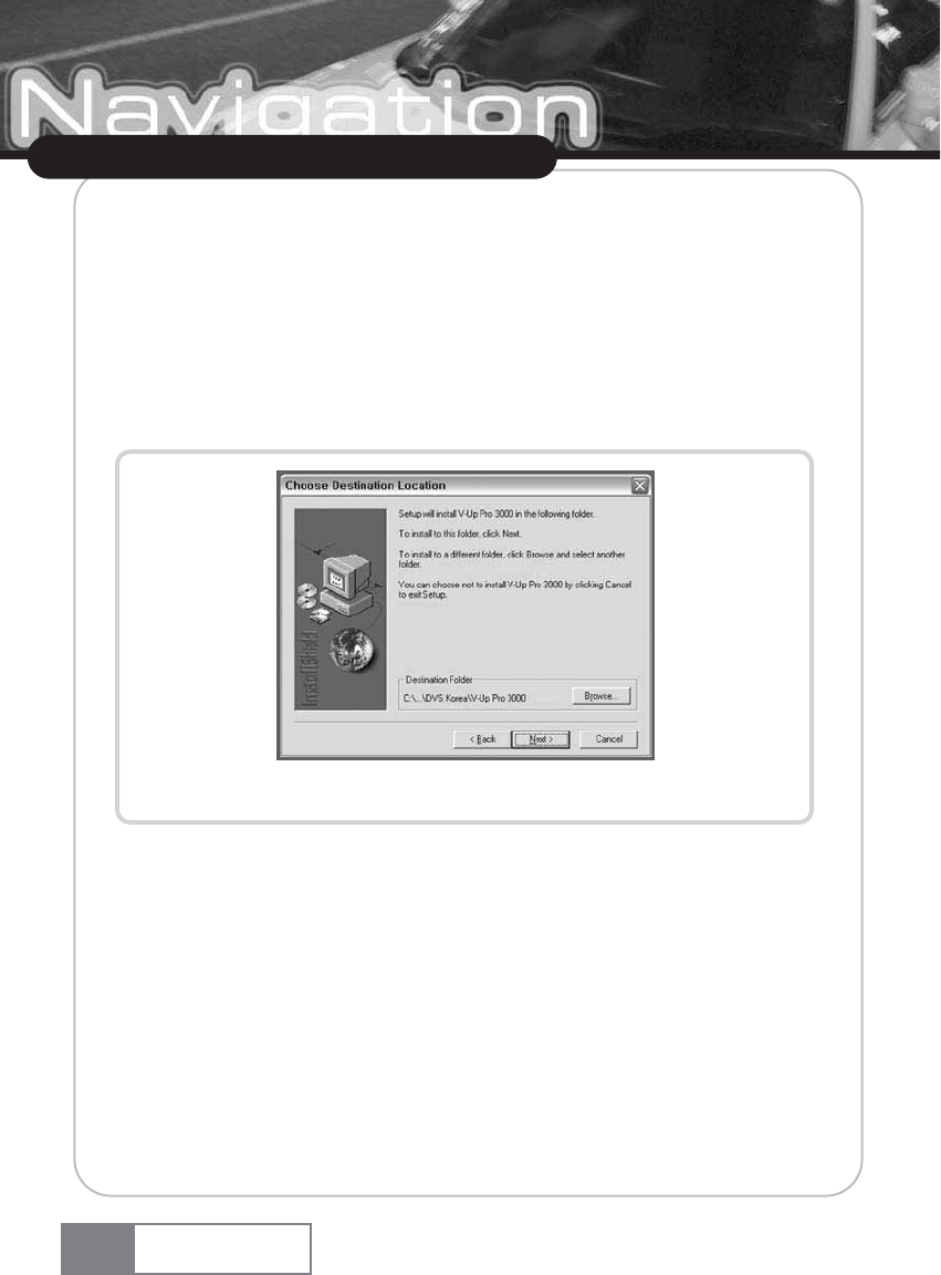
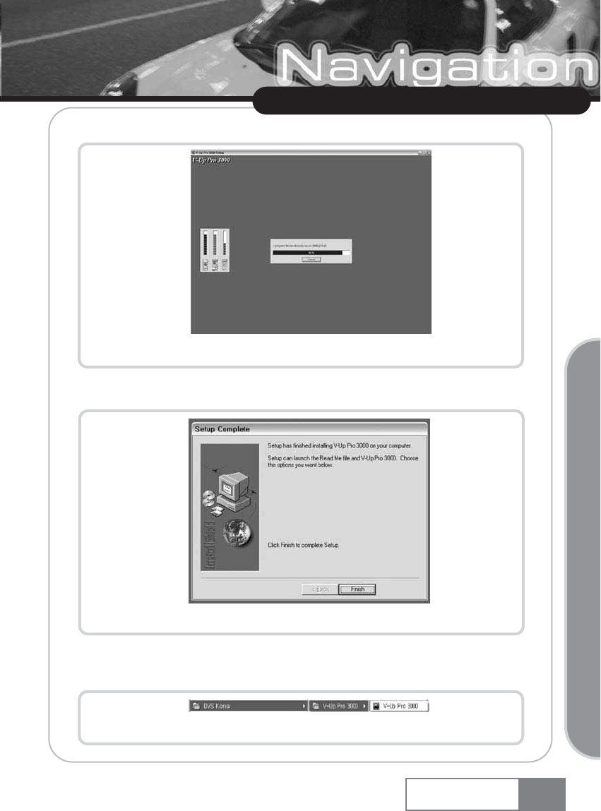
C. Specify the installation folder. See Figure 1-1.
Figure 1-1. Specifying V-Up Pro 3000 installation folder
Map Upload
Navigation System 55
Upgrading Navigation System
D. Program installation will be started. See Figure 1-2.
Figure 1-2. V-Up Pro 3000 Installation Progress
E. If successfully installed, the ŔSetup Completeŕmessage will be displayed. See Figure 1-3.
Figure 1-3. Completion of V-Up Pro 3000 installation
F. The following program group and the shortcut icon will be created in Programs menu as
shown in Figure 1-4.
Figure 1-4. V-Up Pro 3000 shortcut icon
2. Running V-Up Pro 3000 Program
A. Select Start ƊPrograms ƊPlenio ƊV-Up Pro 3000 ƊV-Up Pro 3000 shortcut icon.
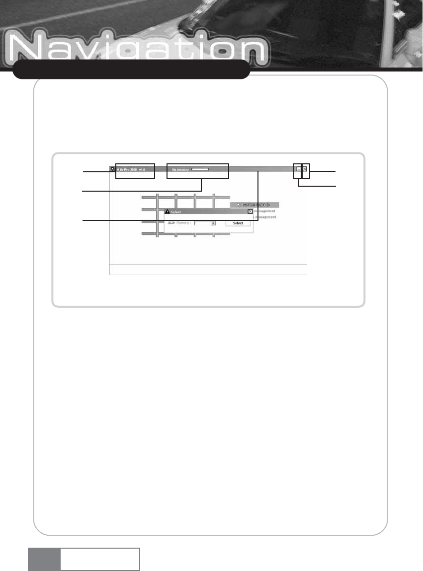
B. V-Up Pro 3000 will be started. See Figure 2-1.
Figure 2-1. V-Up Pro 3000 main screen
ڡV-Up Pro 3000 program version.
ڢSD memory connection status and remaining memory capacity.
ڣMinimize window button.
ڤClose window button.
ڥTitle Bar : You can move the V-Up Pro 3000 program window.
Map Upload
Navigation System
56
ڡ
ڢ
ڥ
ڣ
ڤ
C. Select SD memory drive
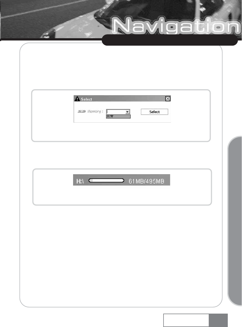
C-1) When you start V-Up Pro 3000, SD memory drive selecting window will apprear as
shown in Figure 2-2.
C-2) Select SD memory drive using ŒSD MemoryœCombo box.
Figure 2-2. V-Up Pro 3000 SD memory drive selecting window
C-3) If you select SD memory drive correctly, free space will display as shown in Figure 2-3.
Figure 2-3. Free space of SD memory
Map Upload
Navigation System 57
Upgrading Navigation System
3. Closing V-Up Pro 3000 Program
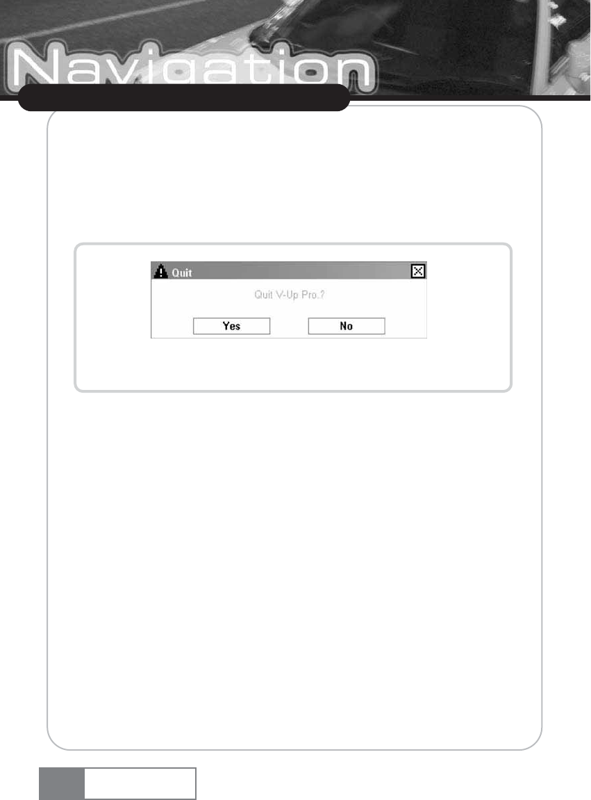
A. When you click the [Close] button, the program closing confirmation window will appear as
shown in Figure 3-1.
B. Click [Yes] to exit from V-Up Pro 3000 program.
Figure 3-1. V-Up Pro 3000 closing confirmation window
Map Upload
Navigation System
58
4. System Upgrade
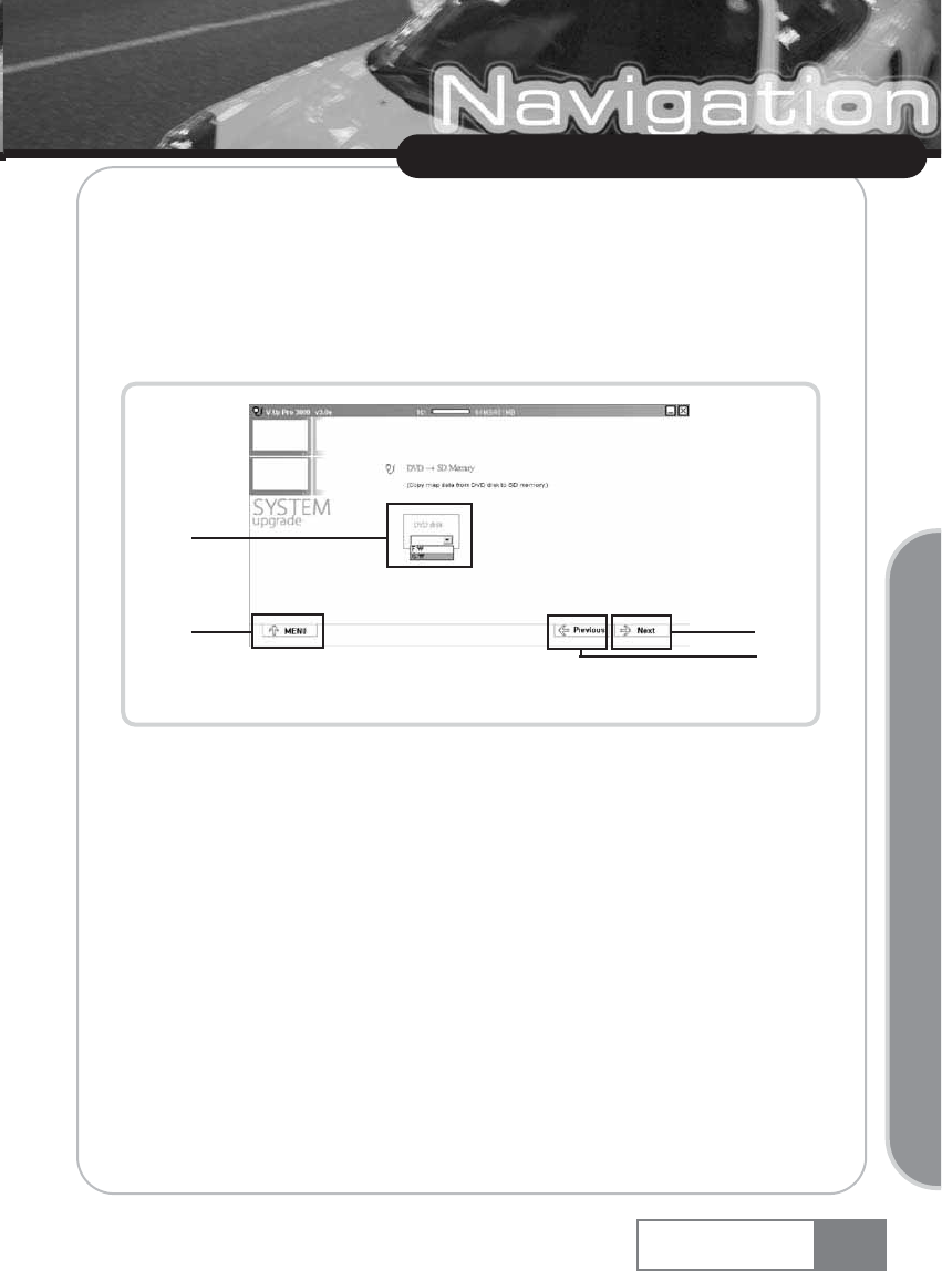
A. Execution
A-1) Click the ŔSystem Upgradeŕicon in the V-Up Pro 3000 main screen.
A-2) Then, the screen shown in Figure 4-1 will appear.
Figure 4-1. System upgrade running screen
ڡLocal drive and DVD-ROM disc selection combo box.
ڢ[Move Previous] button.
ڣ[Move Next] button.
ڤ[Move to V-Up Pro 3000 Main Menu] button.
Map Upload
Navigation System 59
Upgrading Navigation System
ڡ
ڢ
ڣ
ڤ
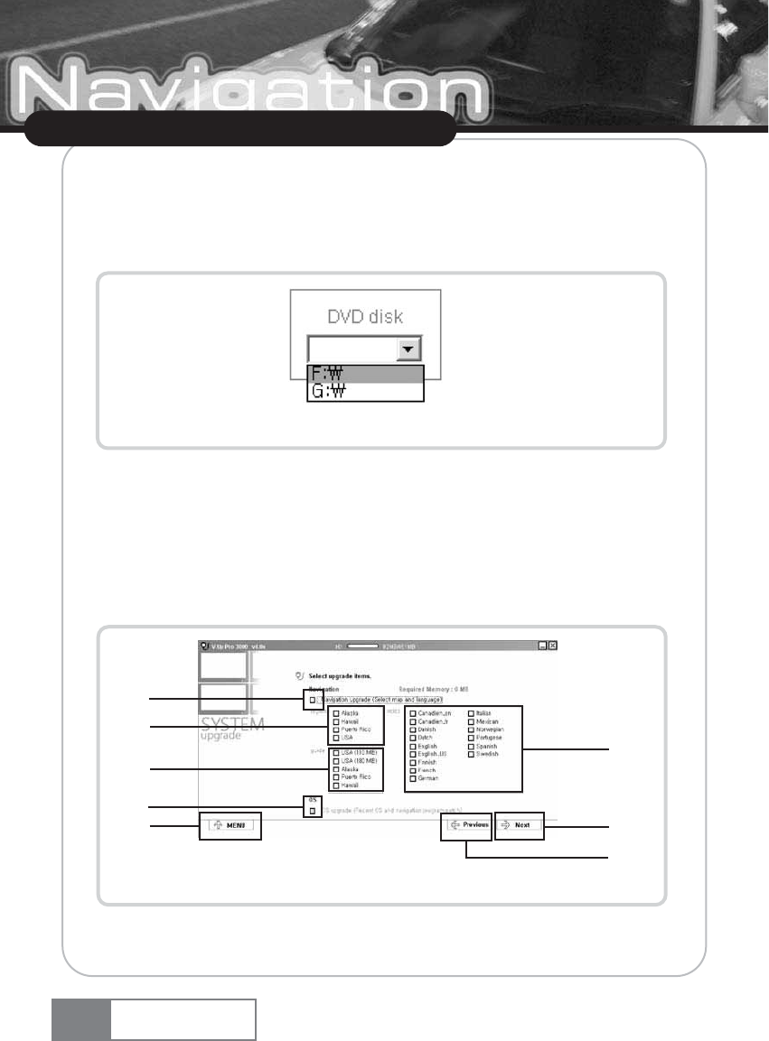
A-3) Select DVD-ROM disk using combo box shown in Figure 4-1.
Reads upgrade files from the user-specified DVD-ROM disc and transfers them to SD memory.
(See Figure 4-2 for DVD-ROM disc.)
Figure 4-2. Specifying DVD-ROM disc
A-4) Move to the next step by clicking the [Next] button (Figure 4-1 ڤ) after selecting the
upgrade type.
B. Selecting upgrade items
B-1) Select the item to upgrade using the ŔSelect upgrade itemsŕcheck box (Figure 4-3 ڡ).
(Navigation, OS)
Figure 4-3. Upgrade items selection window
Map Upload
Navigation System
60
ڡ
ڣ
ڨڧ
ڤ
ڢ
ڦ
ڥ
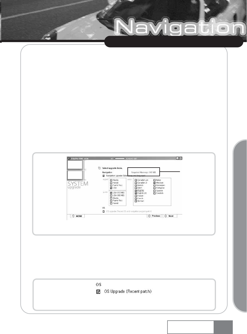
ڡNavigation selection check box.
ڢOS selection check box.
ڣMap region selection check box.
ڤMap guide selection check box.
ڥVoice Language selection check box.
ڦ[Move Previous] button.
ڧ[Move Next] button.
ڨ[Move to V-Up Pro 3000 Main Menu] button.
B-2) To upgrade the navigation, select the navigation selection checkbox (Figure 4-3 ڸ) and
select the target area using the map region, map guide and voice language check box
(Figure 4-3 ں~ڼ).
Figure 4-4. Navigation data selection screen
ڡCalculate and display checked componentsœmemory.
B-3) To upgrade to the latest OS, select the OS selection check box (Figure 4-5) and click the
[Next] button (Figure 4-3 ھ).
Figure 4-5. OS upgrade selection screen
Map Upload
Navigation System 61
Upgrading Navigation System
ڡ
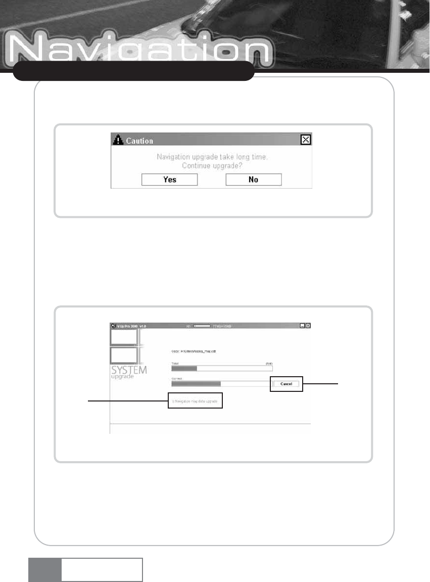
žThe alarm message window appears when navigation upgrade is selected (Figure 4-6).
Select the [Yes] button to continue upgrade.
Figure 4-6. Navigation upgrade alarm window
C. Upgrading
C-1) If the upgrade type and item are properly selected, the upgrade progress screen will
appear as shown in Figure 4-7.
žThe selected upgrade item list will appear at the Figure 4-7 ڢposition.
Figure 4-7. Upgrade progress screen
ڡUpgrade cancellation button.
ڢUpgrade list display section.
C-2) Click the [Cancel] button (Figure 4-7 ڡ) to stop upgrading and return to the previous step.
Map Upload
Navigation System
62
ڢ
ڡ
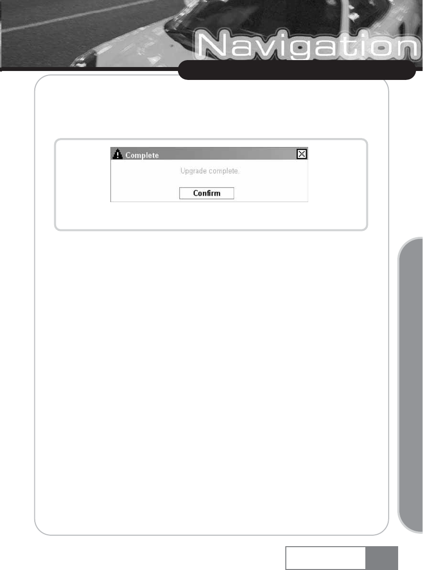
D. Upgrade completion
D-1) When upgrade is complete successfully, the Complete message window shown in Figure
4-8 will appear.
Figure 4-8. Upgrade complete message window
Map Upload
Navigation System 63
Upgrading Navigation System
5. What is V-up Pro 3000
V-up Pro 3000 is the Navigation System management program and performs the following
function.
ȘYou can download navigation data and OS using V-up Pro 3000.
ȘV-up Pro 3000 supports image resizing function and save resized image in the SD Card
memory automatically.
ȘSupport management function of music files.
ȘYou can download the latest version of V-up Pro 3000 from dvssales web site.
Map Upload
Navigation System
64
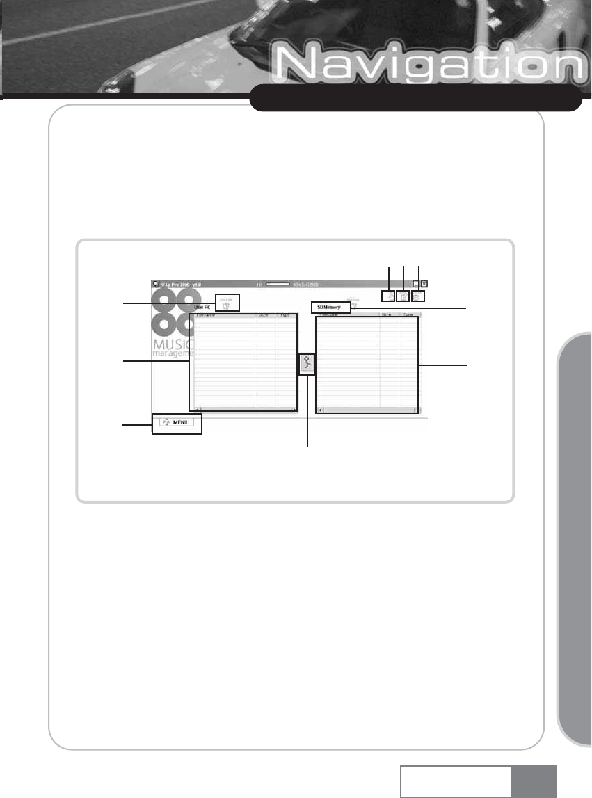
1. Music Management
A. Execution
A-1) Click the ŔMusic Managementŕicon in the V-Up Pro 3000 main screen.
A-2) The screen shown in Figure 1-1 will appear.
Figure 1-1. Music Management execution screen
ڡOpens the music folder from the user PC.
ڢCreates a music album in SD memory.
ڣEdits a music album in SD memory.
ڤDeletes a music album, and music file selection in SD memory.
ڥOpens the music folder from SD memory.
ڦCopies the music file.
ڧDisplays the music file in the user PC.
ڨDisplays the music file in SD memory.
کMoves back to the V-Up Pro 3000 main menu.
Multimedia Management
Navigation System 65
Upgrading Navigation System
ک
ڨ
ڧ
ڡ
ڦ
ڥ
ڢڣڤ
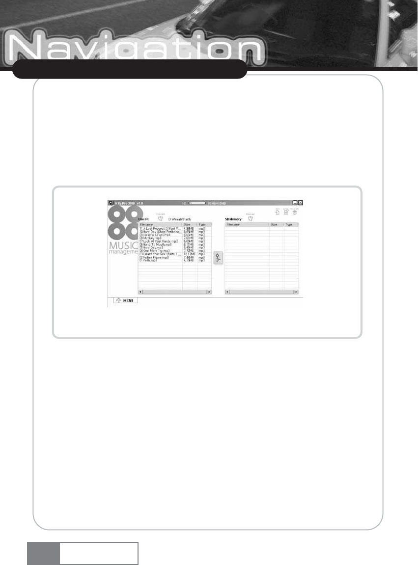
B. Opening music file from user PC
B-1) Click the ŔOpen Music Fileŕbutton (Figure 1-1 ڡ) and select the music file folder in the
user PC.
B-2) If any music file is available in the selected folder, it will be displayed in the music file list
window. See Figure 1-2.
žSupported music file type : MP3, WMA,WAV.
Figure 1-2. Displaying the music file in the user PC
Multimedia Management
Navigation System
66
C. Selecting music album in SD memory
C-1) Click the ŔOpens the music folder from SD memoryŕbutton (Figure 1-1 ڥ) and selct
target folder.
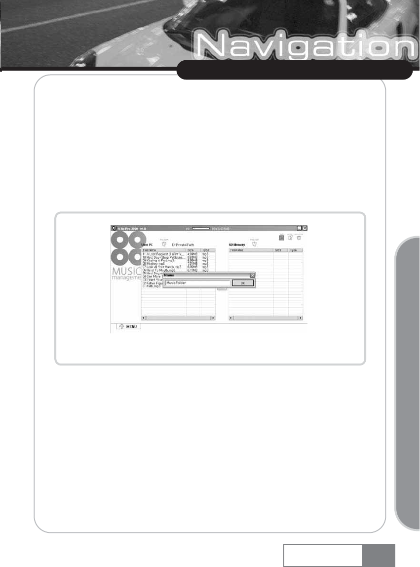
D. Creating music album in SD memory
D-1) Click the ŔCreate music albumŕbutton (Figure 1-1 ڢ) and input the name of the album to
create in the ŔNameŕinput window. (See Figure 1-3.)
D-2) Then, new music folder will create under selected folder.
Figurer 1-3. Music album name input window
Multimedia Management
Navigation System 67
Upgrading Navigation System
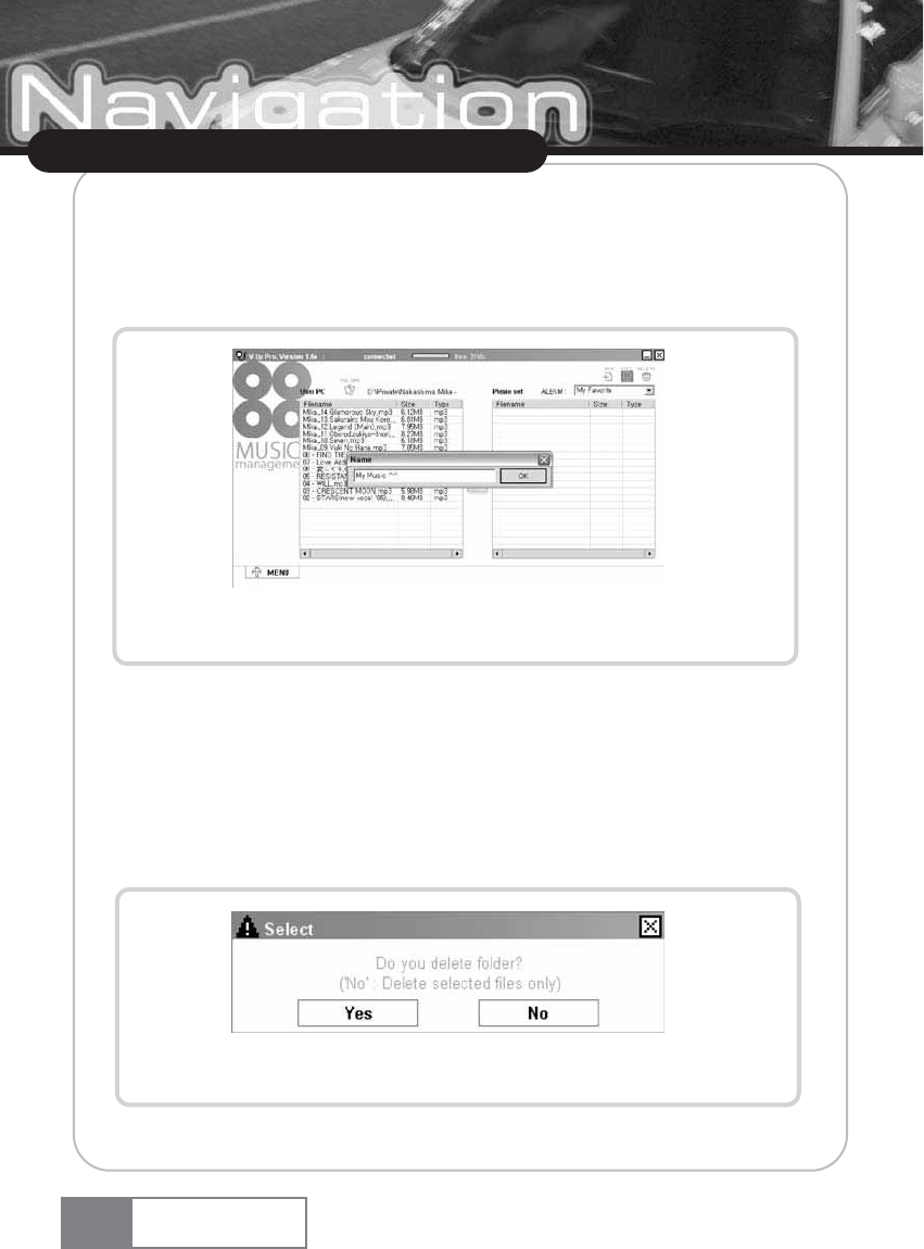
E. Editing music album in SD memory
E-1) Select the music album to change its name from the music album selection combo box.
E-2) Click the ŔEdit music albumŕbutton (Figure 1-1 ڣ) and input the album name to
change. See Figure 1-4.
Figure 1-4. Music album name edit window
E-3) Click the [OK] button to replace music folder name.
F. Deleting music album from SD memory
F-1) Select the music album to delete from the music album selection combo box.
F-2) Click the ŔDelete music albumŕbutton (Figure 1-1 ڤ).
F-3) Select delete mode. See Figure 1-5. (files or folder)
Figure 1-5. Select delete mode
Multimedia Management
Navigation System
68
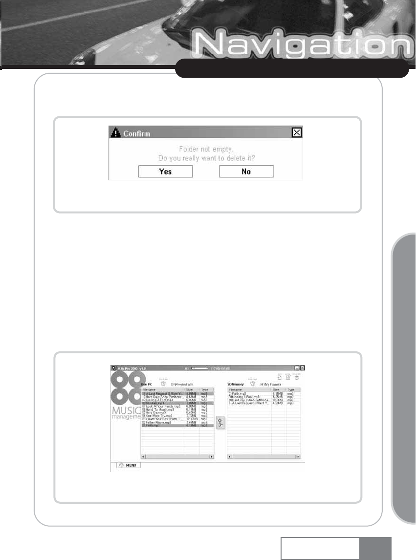
F-4) If any music file is available in the selected music album, the Confirmation window will
appear. See Figure 1-6.
Figure 1-6. Music album deletion confirmation window
F-5) Click the [Yes] button to delete the selected music album.
G. Copying music file to SD memory
G-1) Select the music album to copy from the music album selection combo box. If no music
album is available, the new music album must be created in advance.
G-2) Open the music file in the user PC. (See ŔOpening music file from the user PC.ŕ)
G-3) Select the music file to copy from the ŔMusic file in the user PCŕlist window. (Multiple
selections are supported. See Figure 1-7.)
Figure 1-7. Selecting music file in the user PC
Multimedia Management
Navigation System 69
Upgrading Navigation System
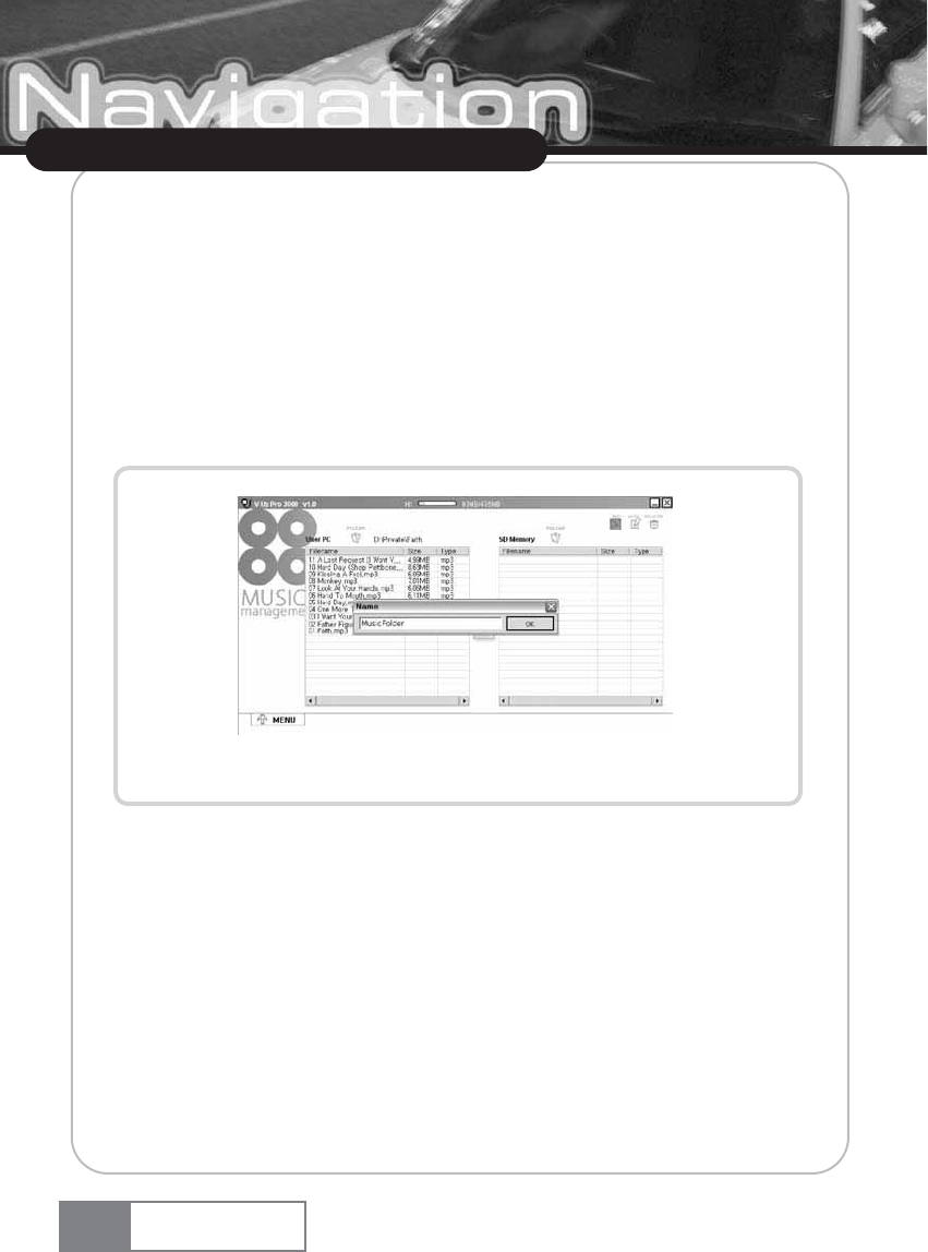
G-4) Click the ŔCopy music fileŕbutton (Figure 1-1 ڦ) button.
G-5) While the file(s) is being copied, the file copy progress bar (Figure 1-8 ڡ) will be
displayed.
G-6) When file copying is complete, the copied music file will be displayed in ŔMusic file in SD
memoryŕlist window.
H. Cancelling music file copy
H-1) To stop file copy while in progress, click the [Cancel] button (Figure 1-8 ڢ).
Figure 1-8. Music file copy
I. Deleting music file from SD memory
1-1) Select the music file to delete from the ŔMusic file in SD memoryŕlist window. (Multiple
selections are supported.)
1-2) Click the ŔDelete music fileŕbutton (Figure 1-1 ڤ).
1-3) The selected music file will be deleted.
Multimedia Management
Navigation System
70
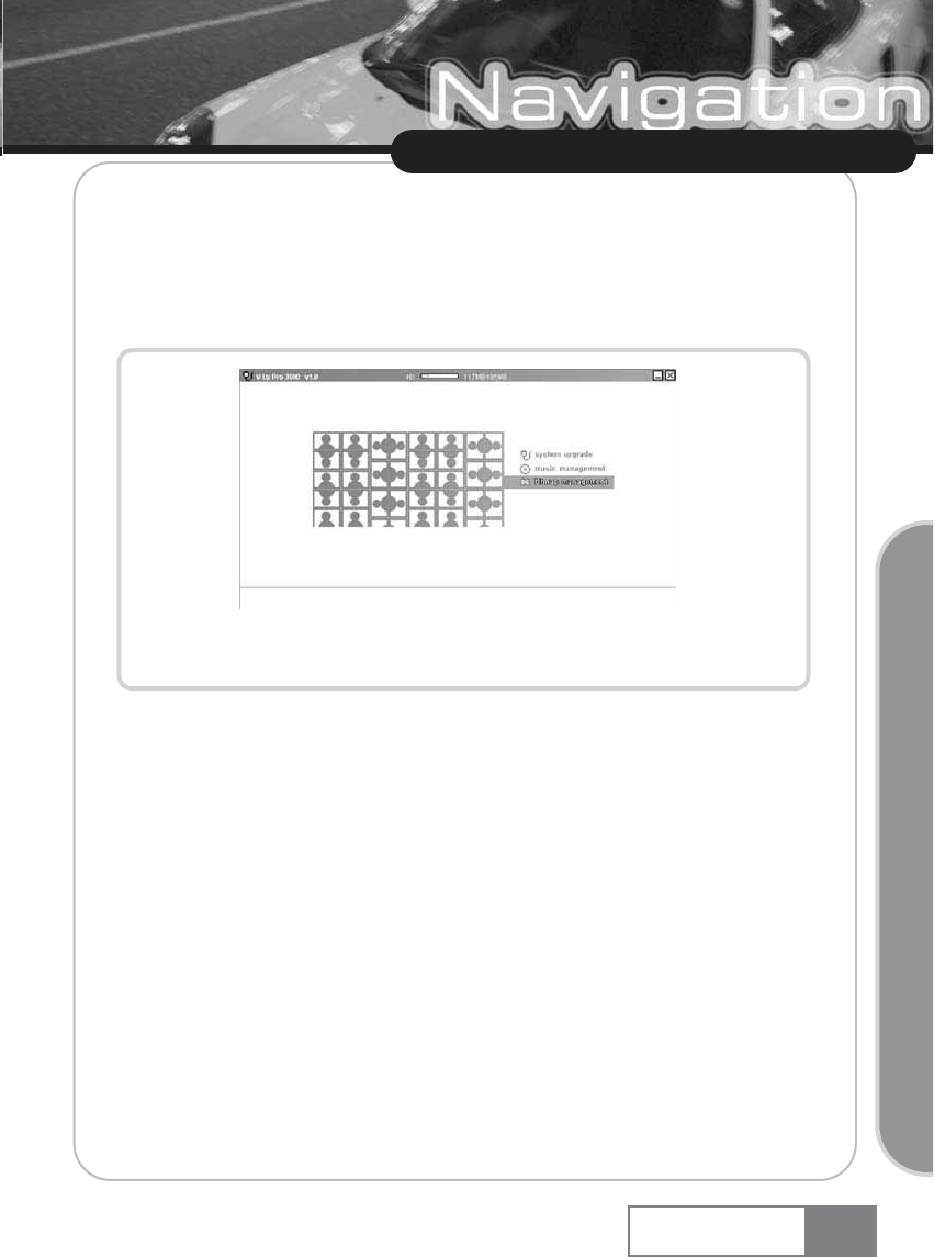
2. Bitmap Management
A. Execution
A-1) Click the ŔBitmap Managementŕicon in the V-Up Pro 3000 main window. (See Figure 2-1.)
Figure 2-1. Selecting “Bitmap Management”
Multimedia Management
Navigation System 71
Upgrading Navigation System
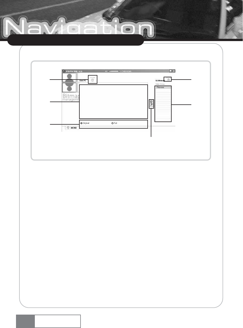
A-2) The screen shown in Figure 2-2 will appear.
Figure 2-2. Bitmap Management execution screen
ڡOpens the image file from the user PC.
ڢDisplays the slideshow image file.
ڣDeletes the slideshow image file from SD memory.
ڤList of the slideshow image file(s) in the selected folder.
ڥImage file copy button.
ڦRadio button to select the Image file output type.
Multimedia Management
Navigation System
72
ڦ
ڤ
ڢ
ڡ
ڥ
ڣ
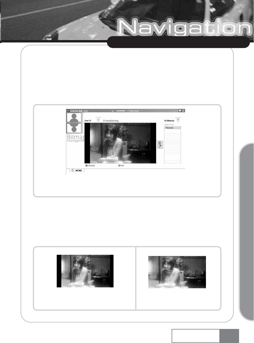
B. Opening image file from user PC
B-1) Click the ŔOpen image fileŕbutton and select the image file to open.
B-2) Image will be resized to fit into the SD memory display resolution. See Figure 2-3.
žSupported image file format : bmp, jpg
žSD memory supporting resolution : 480x234
Figure 2-3. Displaying the selected image file.
C. Resizing image
C-1) You can select 1) Keep aspect ratio, or 2) Full screen image before saving it.
C-2) Use the radio button that set the image file output format (Figure 2-2 ڧ) to change the
display type.
Example 1. Image with aspect ratio Example 2. Full screen image
Multimedia Management
Navigation System 73
Upgrading Navigation System
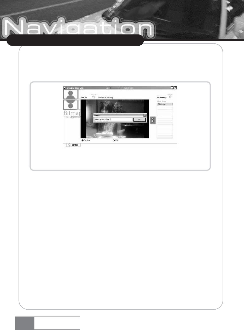
D. Copying image file to SD memory
D-1) When you click the ŔCopy image fileŕbutton (Figure 2-2 ڦ), the image file name input
window will appear. See Figurer 2-4.
Figure 2-4. Image file name input window
D-2) The image file displayed in the output window (Figure 2-2 ڢ) will be saved in the
slideshow folder with the entered name.
Multimedia Management
Navigation System
74
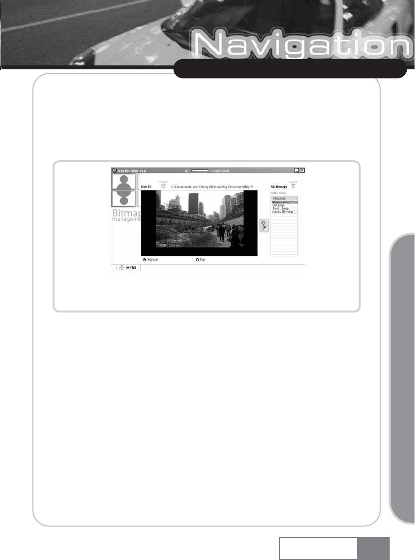
E. Previewing bit map in SD memory
E-1) The image file list window (Figure 2-2 ڥ) displays the list of slideshow image files, as well
as provides the image file preview function.
E-2) Select one image in the image file list window (Figure 2-2 ڥ).
E-3) The selected image file will be displayed in the image file display window.
Figure 2-5. Image file opened from SD memory
F. Deleting image file from SD memory
F-1) Select the image file to delete from the Ŕimage file in the selected folderŕwindow. (Multiple
selections are supported.)
F-2) Click the ŔDelete image fileŕbutton (Figure 2-2 ڣ).
F-3) The selected image file will be deleted.
Multimedia Management
Navigation System 75
Upgrading Navigation System
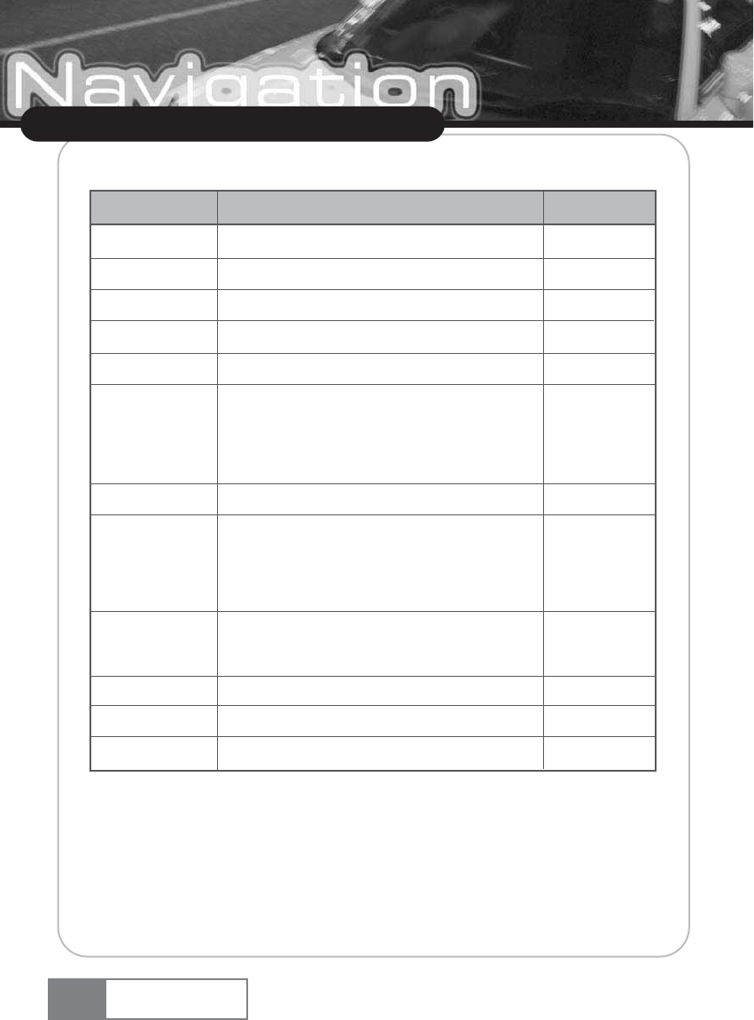
Specification
Specification
Navigation System
76
Item
OS
CPU
RAM
FLASH
DISPLAY
AUDIO
GPS Module
GPS sensitivity
Input power
Temperature
Size
Weight
MS WINDOWS CE.NET 4.2
ARM9 Core
64M Bytes
64M Bytes
7ŕTFT LCD (Touch Screen)
Internal Speaker(1W)
Lineout output
Connect to the car audio using FM Transmitter
SiRFstar III GPS engine, internal type
First start sensitivity : -135dBm
Restart sensitivity : -153Bm
Sensitivity in motion : -156dBm
12V, 1A
In storage : -35 ~ 75 ŭ
In running : -10 ~ 60 ŭ
190mm x 125mm x 33mm
600g
Details Remark
Customer support and Product Enquiry
The product warranty period is calculated from the date of product purchase. Therefore, make sure
to write down the purchase data and keep your sales receipt for proper service.
[If the product purchase date cannot be known, the product warranty period will start 3 months
from the manufacturing date or import customs clearance date.]
Customer Service Center
Customer service and complaint reporting
You can make an enquiry or ask advice about the product through a phone call or in the web site.
DVS SALES,INC 2398 Walsh Ave, Santa Clara, CA 95051
TEL : 408 970 3387
FAX : 408 970 3390
EMAIL : cs.dvs@dvs.co.kr
CUSTOMER SERVICE HOME PAGE : www.dvssales.com/support
Customer support and Product Enquiry
Navigation System 77
Customer support and Product Enquiry
U.S.A.
U.S.FEDERAL COMMUNICATIONS COMMISSION RADIO
FREQUENCY INTERFERENCE STATEMENT INFORMATION
TO THE USER
NOTE : This equipment has been tested and found to comply with the limits for a Class B digital
device pursuant to Part 15 of the FCC Rules.
These limits are designed to provide reasonable protection against harmful Interference in a
residential installation.
This equipment generates, uses, and can radiate radio frequency energy and, if Not installed and
used un accordance with the instructions, may cause harmful Interference to radio communications.
However, there is no guarantee that interference will not occur in a particular Installation.
If this equipment does cause harmful interference to radio or television reception, which can be
determined by turning the equipment off and on, the user is encouraged to try to correct the
interference by one or more of the following measures :
ҟReorient or relocate the receiving antenna.
ҟIncrease the separation between the equipment and receiver.
ҟConnect the equipment into an outlet of a circuit different from that to which the receiver is
connected.
ҟConsult the dealer or an experienced radio/TV technician for assistance.
Change or modification not expressly approved by the party responsible for Compliance could void
the userœs authority to operate the equipment.
Connecting of peripherals requires the use of grounded shielded signal cables.
78 Navigation System
DECLARATION OF CONFORMITY
?-
Declare under our sole responsibility that the product :
Kind of equipment : Navigation System
Type-Designation :
to which this declaration relates is in conformity with the following standard(s) or other normative
document(s)
Safety : EN 60950 : 1992 + A1, A2, A3, A4, A11
EMC : EN 55022 : 1998, EN 55024 : 1998
EN 61000-3-2 : 1995+A1 : 1998+A2 : 1998
EN 61000-3-3 : 1995
following the provisions of the Low Voltage Directive 73/23/EEC, 93/68/EEC and the EMC
Directive 89/336/EEC.
Accredited test laboratory :
TUV Rheinland
Am Grauen Stein
51105 Koln
KOREA / April. 27, 2006
--------------------------------- -------------------------------------------------------
(Place and date of issue) (Name and signature of authorized person)
79
Navigation System
COMPANY NAME
DVS KOREA
7th & 8th Fl. KPS Bldg 196 Kumgok-dong, Boondang-ku Sungnam City, Kyungki-do, Korea
..
..
80
MEMO
Navigation System
81
MEMO
Navigation System
