Extended Season 2015 Big Game Regs 052 070
User Manual: Extended Season
Open the PDF directly: View PDF ![]() .
.
Page Count: 19
Oregon Department of Fish and Wildlife
52
ELK CENTERFIRE FIREARM SEASONS
GENERAL ROCKY MT BULL ELK:
1st Season: Oct. 28 - Nov. 1 (General
Centerfire Firearm Season)
2nd Season: Nov. 7 - Nov. 15 (General
Centerfire Firearm Season)
GENERAL ROCKY MT BULL ELK:
Columbia Basin Extended Season:
Oct. 28 - Dec. 4 (General Centerfire
Firearm Season)
PUBLIC ACCESS IS EXTREMELY
LIMITED IN THIS AREA; OBTAIN
PERMISSION BEFORE HUNTING. That
part of Biggs Unit east of John Day Rvr
and Columbia Basin Unit are open with
a one elk bag limit FOR FIRST SEASON
GENERAL ROCKY MT ELK TAG
HOLDERS ONLY.
GENERAL ROCKY MT BULL ELK:
1st Season: Controlled Elk Hunting
only. See hunt tables pages 54-58.
2nd Season: Nov. 7 - Nov. 15
(General Centerfire Firearm
Season)
CONTROLLED ELK HUNTING
ONLY. NO GENERAL SEASON.
See pages 54-58 for controlled hunt
opportunities.
There are no hunting
opportunities on NP lands, or
allotted and/or Tribal lands in these
areas.
You may only hunt one of the elk seasons listed on this page. Make sure you purchase or redeem the correct tag for the
season you want to hunt prior to the earliest hunt date.
NOTE: Coast bull elk 2nd Season tags are valid in all coast general season units Nov. 21-27, including Wilson, Trask and Siuslaw
units; however, the bag limit in Wilson, Trask and Siuslaw is SPIKE ONLY.
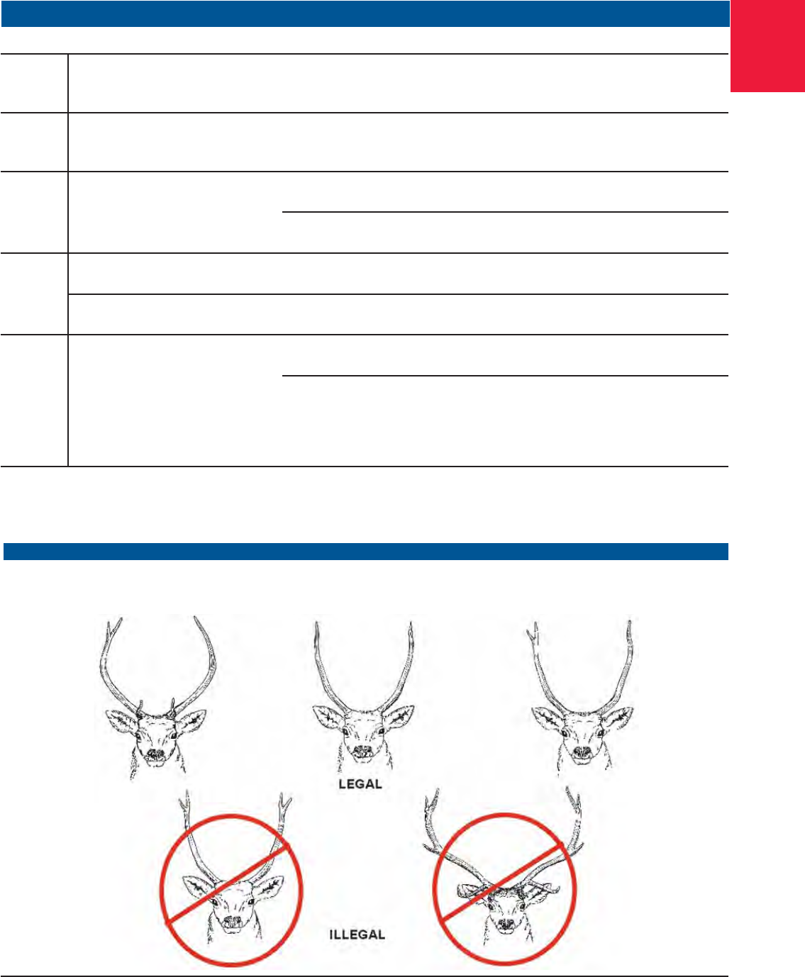
ELK BAG LIMIT DEFINITIONS: See pages 71-72, also refer to spike antler sketches on page 53.
3 pt. + = Bull elk having three points or more on one antler including the brow tine.
Antlerless = Cow or calf elk.
Bull elk = Bull elk with at least one visible antler.
One elk = Either sex elk.
Spike only = Bull elk with at least one visible unbranched antler (a brow tine is not considered an antler branch under
spike only regulations). Refer to sketches on page 53.
GENERAL CASCADE BULL ELK:
Oct. 17 - Oct. 23 (General
Centerfire Firearm Season)
GENERAL COAST BULL ELK:
1st Season: Nov. 14 - Nov. 17
(General Centerfire Firearm
Season)
2nd Season: Nov. 21 - Nov. 27
(General Centerfire Firearm Season)
SPIKE ONLY ELK bag limit in Wilson,
Trask and Siuslaw units.
SANTIAM
16
WHITEHORSE
68
JUNIPER
71
BEULAH
65
OWYHEE
67
ALSEA
18
INDIGO
21
PAULINA
35
MCKENZIE
19
WAGONTIRE
73
TIOGA
24
DIXON
22
SILVIES
72
GRIZZLY
38
CHETCO
27
ROGUE
30 KENO
31
INTERSTATE
75
OCHOCO
37
MALHEUR RIVER
66
BEATYS BUTTE
70
SIUSLAW
20
SIXES
25
SUMPTER
51
MAURY
36
FORT ROCK
77
APPLEGATE
28
WARNER
74
NORTHSIDE
47
SPRAGUE
33
SILVER LAKE
76
EVANS CREEK
29
METOLIUS
39
MURDERERS CR
46
BIGGS
43
WILLAMETTE
15
FOSSIL
45
TRASK
14
COLUMBIA BASIN
44
HEPPNER
48
UKIAH
49
STEENS
MTN
69
MELROSE
23
POWERS
26
STARKEY
52
MINAM
60
KLAMATH FALLS
32
WILSON
12
WHITE
RIVER
41
UPPER
DESCHUTES
34
KEATING
63
MAUPIN
40
HOOD
42
SLED
SPRINGS
57
SCAPPOOSE
11
MT
EMILY
54
IMNAHA
61
DESOLATION
50
CHESNIMNUS
58
SADDLE MTN
10 WENAHA
56
WARM
SPRINGS
INDIAN
RES.
CATHERINE CR
53
SNAKE
RIVER
59
PINE
CREEK
62
STOTT MTN
17
LOOKOUT
MTN
64
WALLA
WALLA
55
CRATER
LAKE
N.P.
UMATILLA INDIAN
RESERVATION
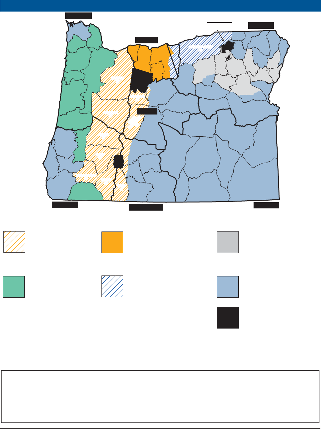
SOUTHEAST
NORTHEAST
NORTHWEST
SOUTHWEST
CENTRAL
SOUTH CENTRAL
COLUMBIA
“AVOID THE FEE” MANDATORY REPORTING REQUIRED SEE PAGE 23
Oregon Department of Fish and Wildlife 53
ELK CENTERFIRE FIREARM GENERAL SEASONS
ILLUSTRATIONS FOR SPIKE ELK HUNTS
A “spike only” bag limit applies in some hunts. The sketches below show some antler configurations you may encounter in the field.
Please use caution and judgement when selecting your target.
Note: Tag sale deadline is the day before the earliest opening day for a season.
1Refer to page 71-72 for BAG LIMIT DEFINITIONS.
2See page 83 under units 14 & 17 for weapon restrictions in parts of Stott Mt and Trask units referred to as the Cascade Head - Lincoln City Area.
Note: It is unlawful to hunt with a centerfire or muzzleloading rifle without a valid elk tag for that time period and area during: Cascade
bull elk centerfire firearm season, Coast bull elk centerfire firearm seasons, or Rocky Mt bull elk. or either-sex centerfire firearm
seasons or the standard Rocky Mt antlerless elk centerfire firearm seasons (Nov. 21 -29). See page 22 for exceptions.
ELK
Pages 52-70
“AVOID THE FEE” MANDATORY REPORTING REQUIRED SEE PAGE 23
OPEN SEASON TAG REQUIRED BAG LIMIT1
OPEN AREA (See pages 80-85 for refuge and area regulations.)
GENERAL
CASCADE Oct. 17 - Oct. 23 Cascade Elk One bull elk with
visible antler Dixon, Evans Cr, Indigo, Keno, McKenzie, Metolius, Rogue,
Santiam and Upper Deschutes units, those parts of Fort
Rock and Sprague units west of Hwy 97 and that part of
Grizzly Unit west of Hwy 97 and south of Hwy 26.
GENERAL
COAST
1ST
SEASON
Nov. 14 - Nov. 17 Coast Elk
1st Season One bull elk with
visible antler Alsea, Applegate, Melrose, Scappoose, Siuslaw, Stott Mt
2
,
Trask
2
, Willamette and Wilson units.
GENERAL
COAST
2ND
SEASON
Nov. 21 - Nov. 27 Coast Elk
2nd Season One bull elk with
visible antler Alsea, Applegate, Melrose, Scappoose, Stott Mt
2
and
Willamette units.
One spike elk with
at least one visible
unbranched antler
Wilson, Trask
2
and Siuslaw units.
GENERAL
ROCKY
MT 1ST
SEASON
Oct. 28 - Nov. 1 Rocky Mt Elk
1st Season One bull elk with
visible antler Hood, Maupin and White Rvr units and that part of Biggs unit
west of John Day Rvr.
Oct. 28 - Dec. 4
Columbia Basin
Extended Season
Rocky Mt Elk
1st Season One elk Columbia Basin unit and that part of Biggs unit east of John
Day Rvr.
GENERAL
ROCKY
MT 2ND
SEASON
Nov. 7 - Nov. 15 Rocky Mt Elk
2nd Season One bull elk with
visible antler Hood, Maupin and White Rvr units and that part of Biggs unit
west of John Day Rvr.
One spike elk with
at least one visible
unbranched antler
Catherine Cr, Desolation, Imnaha, Keating, Pine Cr, Starkey
(except approximately 40 sq mi. of the Starkey Experimental
Forest within the Starkey Unit shall be closed to all elk hunting
unless the hunter has a valid controlled elk hunt tag for the
Experimental Forest), Ukiah units, Heppner unit north and west
of N Fork John Day Rvr and Sumpter Unit north of State Hwy
245 and Burnt Rvr Canyon Rd between Unity and Durkee.
LEGAL LEGAL
Oregon Department of Fish and Wildlife
54
CONTROLLED 200 SERIES ELK CENTERFIRE FIREARM
TAG SALE DEADLINE: The day before the hunt begins.
CONTROLLED HUNT Application procedures: Please read pages 10-12. Hunters should apply for more
than one hunt choice. If your first choice hunt is cancelled, you will receive a postcard describing your hunt
choice options. See page 12 for further information. You may submit only 1 application for elk (200 series)
hunts. This may include bull, either-sex, or antlerless elk (200 series) hunts.
CAUTION TO HUNTERS: Obtaining a tag does not guarantee a place to hunt! Some hunts in these
regulations are comprised mostly or entirely of private lands and are printed in red. ODFW tries to design
hunts to provide public access; however, in areas where this is not possible, it is the hunter’s responsibility
to obtain access to hunt on private property. Refer to pages 80-85 for Rd closure information.
NOTE: The “2014 1st Choice Applicants” column is not influenced by preference points; it only indicates
the number of first choice applicants for each hunt.
REGULATIONS: It is unlawful to hunt with a centerfire or muzzleloading rifle without a valid elk tag for that
time period and area during: Cascade bull elk centerfire firearm season, Coast bull elk centerfire firearm
seasons, or Rocky Mt bull elk or either-sex centerfire firearm seasons or standard Rocky Mt antlerlass elk
centerfire firearm seasons (Nov. 21 - Nov. 29). See page 22 for exceptions.
The Fish and Wildlife Com mis sion will not set actual tag numbers for hunts listed here until June 2015. Tag numbers currently shown,
for your reference, were those allocated for 2014 or estimated for new 2015 hunts. Actual tag numbers for 2015 may be higher or
lower than those listed based on population conditions. NOTE: As a hunter it is your responsibility to ensure the hunts you apply for
(all choices in all series) are hunts you want to participate in. It is your responsibility to monitor your preference points, tags allocated
to specific hunts, odds of drawing a tag and to ensure the actual area you are interested in hunting is within the hunt boundary and is
open for hunting access. ODFW strives to make all information available to all hunters and ODFW will not reinstate preference points or
change tags because the tag you drew is not the one you wanted or expected.
HUNT AREA: Entire wildlife management unit unless indicated by an asterisk(*). A map will be sent if indicated in hunt description by
[MAP]. Landowner preference tags available, see page 13. Please note additional closure areas listed on pages 80-85 that may affect
your hunt area.
Private lands will limit access for hunts printed in red. Do not apply unless you have access to a place to hunt.
STOP
Application
Deadline Date:
May 15, 2015
Applicants may apply
singly or as a party of no
more than 18.
“AVOID THE FEE” MANDATORY REPORTING REQUIRED SEE PAGE 23
NORTHWEST AREA HUNTS
HUNT # HUNT NAME BAG LIMIT OPEN SEASON 2014 TAGS 2014 1ST CHOICE
APPLICANTS
210 Saddle Mt Unit
One antlerless elk
Dec. 1- Mar. 15, 2016
10 735
210A1 Onion Peak No. 1* One antlerless elk Dec. 5-6, 12-13, 19-20, 26-27
11 183
210A2 Onion Peak No. 2* One antlerless elk
Jan. 2-3, 9-10, 16-17, 23-24,
30-31, 2016
11 118
210B1 Lewis & Clark No. 1* One antlerless elk Dec. 5-6, 12-13, 19-20, 26-27
11 186
210B2 Lewis & Clark No. 2* One antlerless elk
Jan. 2-3, 9-10, 16-17, 23-24,
30-31, 2016
11 143
210C Upper Nehalem* One antlerless elk Dec. 1- Mar. 15, 2016
22 268
210D Lower Columbia* One antlerless elk Dec. 1- Mar. 15, 2016
11 42
Master Hunter only. Must have completed Master Hunter Program to apply. See page 87.
210E Young's Rvr* One antlerless elk Dec. 1- Mar. 15, 2016
11 94
210F1 Camp McGregor No. 1* One antlerless elk Dec. 5-6, 12-13, 19-20, 26-27
11 130
210F2 Camp McGregor No. 2* One antlerless elk
Jan. 2-3, 9-10, 16-17, 23-24,
30-31, 2016
11 76
210X Saddle Mt Unit No. 1 One 3 pt. + Nov. 14 - Nov. 17
1,320 1,405
210Y Saddle Mt Unit No. 2 One 3 pt. + Nov. 21 - Nov. 27
1,320 1,390
211 Scappoose Unit One antlerless elk Jan. 1 - Mar. 31, 2016
16 393
211A1 S Scappoose No. 1*
One antlerless elk
Jan. 1 - Mar. 31, 2016
17 162
211A2 S Scappoose No. 2*
One antlerless elk
Jan. 1 - Jan. 31, 2016
11 39
211A3 S Scappoose No. 3*
One antlerless elk
Feb. 1 - Mar. 31, 2016
28 146
211B N Central Scappoose*
One antlerless elk
Jan. 1 - Mar. 31, 2016
11 232
212 Wilson Unit
One antlerless elk
Dec. 1 - Mar. 15, 2016
11 459
212A1 Miami-Nehalem No. 1*
One antlerless elk
Dec. 1 - Mar. 15, 2016
11 85
212A2 Miami-Nehalem No. 2*
One antlerless elk
Dec. 15 - Jan. 31, 2016
22 118
212A3 Miami-Nehalem No. 3* One antlerless elk Feb. 1 - Mar. 15, 2016
22 53
Master Hunter only. Must have completed Master Hunter Program to apply. See page 87.
212B Buick Canyon*
One antlerless elk
Dec. 15 - Mar. 15, 2016
11 94
214 Trask Unit*
One antlerless elk
Dec. 1 - Mar. 15, 2016
11 731
214A W Trask*
One antlerless elk
Dec. 1 - Mar. 15, 2016
44 368
214B1 Central Trask No. 1
One antlerless elk
Jan. 1 - Feb. 15, 2016
est.15 in 2016 NEW
214B2 Central Trask No. 2
One antlerless elk
Feb. 15 - Mar. 31, 2016
est.15 in 2016 NEW
214C Wind Rvr*
One antlerless elk
Dec. 1 - Mar. 31, 2016
11 107
Oregon Department of Fish and Wildlife 55
NORTHWEST AREA HUNTS (CONTINUED)
HUNT # HUNT NAME BAG LIMIT OPEN SEASON 2014 TAGS 2014 1ST CHOICE
APPLICANTS
214D Beaver Cr*
One antlerless elk
Dec. 1 - Mar. 31, 2016
11 107
214E Pike*
One antlerless elk
Dec. 1 - Mar. 31, 2016
22 70
214F1 NE Trask No. 1* One antlerless elk Jan. 1 - Mar. 31, 2016
11 121
214F2 NE Trask No. 2* One antlerless elk Feb. 1 - Mar. 31, 2016
11 63
214G Panther Cr* One antlerless elk Jan. 1 - Jan. 31, 2016
11 48
215A1 Willamette Plus No. 1* One elk Aug. 1 - Mar. 31, 2016
79
308
Antlerless only Aug. 1 - Oct 31 in the Finley Subunit
215A2 Willamette Plus No. 2* One antlerless elk Aug. 1 - Mar. 31, 2016
220 102
216B SW Santiam* One antlerless elk Jan. 1 - Jan. 31, 2016
11 213
216C1 Molalla No. 1* One antlerless elk Jan. 1 - Mar. 31, 2016
11 183
216C2 Molalla No. 2* One antlerless elk Jan. 1 - Jan. 31, 2016
11 5
216C3 Molalla No. 3* One antlerless elk Feb. 1 - Mar. 31, 2016
11 45
216D Sandy* One antlerless elk Jan. 1 - Mar. 31, 2016
11 113
216E Green Mt* One antlerless elk Jan. 1 - Mar. 31, 2016
11 29
216F NW Santiam* One antlerless elk Jan. 1 - Mar. 31, 2016
22 130
217A Lower Siletz Rvr* One antlerless elk Jan. 1 - Jan. 31, 2016
10 164
217B Upper Siletz Rvr* One antlerless elk Jan. 1 - Feb. 29, 2016
11 119
217C Dallas* One antlerless elk Jan. 1 - Feb. 29, 2016
11 85
218A NE Alsea* One antlerless elk Jan. 1 - Jan. 31, 2016
11 196
218B SW Alsea* One antlerless elk Dec. 19 - Dec. 31
11 261
218C SE Alsea* One antlerless elk Jan. 1 - Jan. 31, 2016
11 111
218D SW Alsea Private Lands* One antlerless elk Jan. 1 - Feb. 29, 2016
11 63
218E Central Alsea Private* One antlerless elk Jan. 1 - Feb. 29, 2016
11 119
218F NW Alsea* One antlerless elk Jan. 1 - Feb. 29, 2016
11 170
219A S Central McKenzie* One antlerless elk Jan. 1 - Jan. 31, 2016
22 185
219B NW McKenzie* One antlerless elk Jan. 1 - Feb. 29, 2016
11 134
219C Horse Rock* One antlerless elk Jan. 1 - Feb. 29, 2016
11 30
219D Scott Mt* One antlerless elk Jan. 1 - Mar. 31, 2016
17 47
219E Pengra* One antlerless elk Aug. 1 - Mar. 31, 2016
22 17
219F Oakridge Private Lands* One antlerless elk Jan. 1 - Feb. 29, 2016
22 44
220A Noti-Saginaw* One antlerless elk Jan. 1 - Feb. 29, 2016
22 51
220B W Siuslaw* One antlerless elk Dec. 1 - Dec. 31
50 292
220C E Siuslaw* One antlerless elk Dec. 1 - Dec. 31
10 70
SOUTHWEST AREA HUNTS
HUNT # HUNT NAME BAG LIMIT OPEN SEASON 2014 TAGS 2014 1ST CHOICE
APPLICANTS
220D Elkton* One antlerless elk Aug. 1 - Mar. 31, 2016
40 313
221A NW Indigo* One antlerless elk Dec. 19 - Dec. 27
55 148
221B Cougar Mt - Taylor Bt* One antlerless elk Jan. 1 - Feb. 29, 2016
11 33
221C Sutherlin* One antlerless elk Feb. 1 - Feb. 29, 2016
22 125
221D S Indigo Private Lands* One antlerless elk Dec 1 - Feb. 29, 2016
11 32
221E Mosby* One antlerless elk Feb 6-7, 13-14, 20-21, 27-28, 2016
est. 10 in 2016 NEW
222A Dixon Private Lands* One antlerless elk Nov. 15 - Mar. 31, 2016
11 41
223A1 Melrose Unit No. 1* One antlerless elk Aug. 1 - Mar. 31, 2016
208 340
223A2 Melrose Unit No. 2* One elk Aug. 1 - Mar. 31, 2016
10 418
224A Callahan* One antlerless elk Jan. 23-24, 30-31, Feb. 6-7, 2016
33 124
224B Old Blue* One antlerless elk Jan. 23-24, 30-31, Feb. 6-7, 2016
33 201
224C Tioga Private* One antlerless elk Dec. 1 - Feb. 29, 2016
109 247
224X Tioga Unit No. 1 One 3 pt. + Nov. 14 - Nov. 18
1,900 707
224Y Tioga Unit No. 2 One 3 pt. + Nov. 21 - Nov. 29
1,900 949
225A N Sixes* One antlerless elk Dec. 1 - Feb. 29, 2016
150 483
225B Curry Private* One antlerless elk Dec. 1 - Jan. 31, 2016
20 104
225X Sixes Unit No. 1 One bull elk Nov. 14 - Nov. 18
100 411
225Y Sixes Unit No. 2 One bull elk Nov. 21 - Nov. 29
100 317
226A Powers Unit Private* One antlerless elk Dec. 1 - Feb. 29, 2016
22 195
226X Powers Unit No. 1 One spike only elk Nov. 14 - Nov. 18
400 128
226Y Powers Unit No. 2 One bull elk Nov. 21 - Nov. 29
110 691
227X Chetco Unit No. 1 One bull elk Nov. 14 - Nov. 18
72 158
227Y Chetco Unit No. 2 One bull elk Nov. 21 - Nov. 29
72 146
228A Applegate-Evans Cr* One antlerless elk Nov. 15 - Mar. 31, 2016
20 161
230A W Rogue* One antlerless elk Nov. 15 - Mar. 31, 2016
25 347
“AVOID THE FEE” MANDATORY REPORTING REQUIRED SEE PAGE 23
ELK
Pages 52-70

Oregon Department of Fish and Wildlife
56
“AVOID THE FEE” MANDATORY REPORTING REQUIRED SEE PAGE 23
SOUTH CENTRAL AREA HUNTS
HUNT # HUNT NAME BAG LIMIT OPEN SEASON 2014 TAGS 2014 1ST CHOICE
APPLICANTS
232X Klamath Falls Unit No. 1 One bull elk Oct. 28 - Nov. 1
77 12
232Y Klamath Falls Unit No. 2 One bull elk Nov. 7 - Nov. 15
55 25
233X Sprague No. 1* One bull elk Oct. 28 - Nov. 1
220 32
233Y Sprague No. 2* One bull elk Nov. 7 - Nov. 15
110 96
235X Paulina-E Fort Rock No. 1* One bull elk Oct. 28 - Nov. 1
770 608
235Y Paulina-E Fort Rock No. 2* One bull elk Nov. 7 - Nov. 15
550 718
275X Interstate Unit No. 1 One bull elk Oct. 28 - Nov. 1
330 148
275Y Interstate Unit No. 2 One bull elk Nov. 7 - Nov. 15
165 260
276X Silver Lake Unit No. 1 One bull elk Oct. 28 - Nov. 1
350 87
276Y Silver Lake Unit No. 2 One bull elk Nov. 7 - Nov. 15
200 220
277A Connley Hills* One antlerless elk Sept. 1 - Mar. 31, 2016
55 187
CENTRAL AREA HUNTS
HUNT # HUNT NAME BAG LIMIT OPEN SEASON 2014 TAGS 2014 1ST CHOICE
APPLICANTS
234A Little Rvr* One antlerless elk Aug. 1 - 21 &
Nov. 16 - 30
11 186
234B Tumalo* One antlerless elk Dec. 1 - Dec. 31
11 106
235A Badlands* One antlerless elk Aug. 15 - Oct. 15
32 201
236A Maury-Hampton Butte* One antlerless elk Aug. 15 - Nov. 15
55 86
236X Maury Unit No. 1 One bull elk Oct. 28 - Nov. 1
66 314
236Y Maury Unit No. 2 One bull elk Nov. 7 - Nov. 15
65 247
237A N Ochoco* One antlerless elk Aug. 15 - Nov. 30
83 121
237B Crooked Rvr* One antlerless elk Aug. 15 - Nov. 30
193 182
237C1 Ochoco Private No. 1* One elk Oct. 28 - Nov. 1
50 40
237C2 Ochoco Private No. 2* One elk Nov. 7 - Nov. 15
50 91
237X Ochoco Unit No. 1 One bull elk Oct. 28 - Nov. 1
259 2,099
237Y Ochoco Unit No. 2 One bull elk Nov. 7 - Nov. 15
259 1,931
238A SW Grizzly* One antlerless elk Aug. 15 - Nov. 30
270 372
238B N Grizzly Private* One antlerless elk Aug. 15 - Nov. 30
110 103
238C1 Grizzly Private No. 1* One elk Oct. 28 - Nov. 1
138 69
238C2 Grizzly Private No. 2* One elk Nov. 7 - Nov. 15
165 126
238X Grizzly Unit No. 1 One bull elk Oct. 28 - Nov. 1
72 420
238Y Grizzly Unit No. 2 One bull elk Nov. 7 - Nov. 15
72 296
COLUMBIA AREA HUNTS
HUNT # HUNT NAME BAG LIMIT OPEN SEASON 2014 TAGS 2014 1ST CHOICE
APPLICANTS
240A Maupin-W Biggs* One antlerless elk Oct. 17 - Nov. 30
660 177
241A The Dalles Watershed* One elk Oct. 28 - Nov. 1
33 116
241B White Rvr-Hood* One antlerless elk Nov. 21 - Nov. 29
44 286
241C1 N White Rvr-Hood No. 1* One antlerless elk Dec. 1 - Jan. 15, 2016
28 133
241C2 N White Rvr-Hood No. 2* One antlerless elk Jan. 16 - Feb. 29, 2016
28 75
241D Larch Cr* One antlerless elk Dec. 1 - Feb. 29, 2016
39 60
NORTHEAST AREA HUNTS
HUNT # HUNT NAME BAG LIMIT OPEN SEASON 2014 TAGS 2014 1ST CHOICE
APPLICANTS
244A Columbia Basin* One antlerless elk Aug. 1 - Dec. 31
54 30
245A1 N Fossil Private No. 1* One bull elk Oct. 28 - Nov. 1
330 67
245A2 N Fossil Private No. 2* One elk Nov. 7 - Nov. 15
330 160
245B1 S. Fossil Private No. 1* One bull elk Oct. 28 - Nov. 1
770 50
245B2 S. Fossil Private No. 2* One elk Nov. 7 - Nov. 15
770 144
245C N Fossil* One antlerless elk Nov. 21 - Nov. 29
22 57
245D1 S Fossil No. 1* One antlerless elk Nov. 21 - Nov. 29
165 37
245D2 S Fossil No. 2* One antlerless elk Dec. 5 - Dec. 13
121 33
245D3 S Fossil No. 3* One antlerless elk Dec. 19 - Dec. 27
66 22
245E Fossil - E Biggs Agri* One antlerless elk Aug. 1 - Mar. 31, 2016
648 534
245X Fossil Unit No. 1 One bull elk Oct. 28 - Nov. 1
330 189
245Y Fossil Unit No. 2 One bull elk Nov. 7 - Nov. 15
330 126

Oregon Department of Fish and Wildlife 57
ELK
Pages 52-70
“AVOID THE FEE” MANDATORY REPORTING REQUIRED SEE PAGE 23
NORTHEAST AREA HUNTS (CONTINUED)
HUNT # HUNT NAME BAG LIMIT OPEN SEASON 2014 TAGS 2014 1ST CHOICE
APPLICANTS
246A W Murderers Cr * One elk Nov. 7 - Nov. 15
495 1,928
246B E Murderers Cr* One elk Nov. 7 - Nov. 15
330 642
246C Flagtail* One antlerless elk Nov. 21 - Nov. 29
440 577
246D Up John Day Rvr* One antlerless elk Dec. 1 - Dec. 31
110 43
246E1 Murderers Cr Private Lands Plus No.1* One antlerless elk Aug. 1 - Sept. 30
136 26
Must be listed on Landowner Permission Form to apply for this hunt (See hunt desc.)
246E2 Murderers Cr Private Lands Plus No. 2* One antlerless elk Dec. 1 - Jan. 31, 2016
55 24
Must be listed on Landowner Permission Form to apply for this hunt (See hunt desc.)
246X Murderers Cr Unit One bull elk Oct. 28 - Nov. 1
468 1,354
247 Northside Unit One antlerless elk Nov. 21 - Nov. 29
550 712
247A1 Northside Private Lands Plus No.1* One elk Oct. 28 - Nov. 1
165 82
Must be listed on Landowner Permission Form to apply for this hunt (See hunt desc.)
247A2 Northside Private Lands Plus No. 2* One elk Nov. 7 - Nov. 15
165 122
Must be listed on Landowner Permission Form to apply for this hunt (See hunt desc.)
247B W Northside* One elk Nov. 7 - Nov. 15
275 531
247C E Northside* One elk Nov. 7 - Nov. 15
413 1,541
247D1 W Grant Private No.1* One antlerless elk Aug. 1 - Sept. 30
200 78
Must be listed on Landowner Permission Form to apply for this hunt (See hunt desc.)
247D2 W Grant Private No.2* One antlerless elk Oct. 1 - Dec. 31
250 152
Must be listed on Landowner Permission Form to apply for this hunt (See hunt desc.)
247D3 W Grant Private No. 3* One antlerless elk Jan. 1 - Mar. 31, 2016
100 43
Must be listed on Landowner Permission Form to apply for this hunt (See hunt desc.)
247E1 E Northside Private No. 1* One antlerless elk Aug. 1 - Sept. 30
138 34
Must be listed on Landowner Permission Form to apply for this hunt (See hunt desc.)
247E2 E Northside Private No. 2* One antlerless elk Aug. 1 - Mar. 31, 2016
40 67
Must be listed on Landowner Permission Form to apply for this hunt (See hunt desc.)
247E3 E Northside Private No. 3* One antlerless elk Dec. 1 - Jan. 31, 2016
55 1
Must be listed on Landowner Permission Form to apply for this hunt (See hunt desc.)
247X Northside Unit One bull elk Oct. 28 - Nov. 1
413 1,025
248A1 Heppner No. 1* One bull elk Oct. 28 - Nov. 1
743 3,543
248A2 Heppner No. 2 * One spike only elk Oct. 28 - Nov. 1
935 292
248B1 Ritter No. 1* One elk Oct. 28 - Nov. 1
138 86
248B2 Ritter No. 2* One elk Nov. 7 - Nov. 15
220 89
248C Monument* One antlerless elk Aug. 1 - Dec. 31
33 59
248D Heppner* One antlerless elk Nov. 21 - Nov. 29
55 500
248E Willow Creek* One antlerless elk Aug. 1 - Dec. 31
32 47
249A1 Ukiah Unit No. 1 One bull elk Oct. 28 - Nov. 1
440 2,426
249A2 Ukiah Unit No. 2 One spike only elk Oct. 28 - Nov. 1
990 191
249B McKay Cr* One antlerless elk Dec. 5 - Dec. 13
66 105
249C Central Ukiah* One antlerless elk Nov. 21 - Nov. 29
11 116
249D South Ukiah* One antlerless elk Nov. 21 - Nov. 29
11 120
250A Desolation Unit One antlerless elk Nov. 21 - Nov. 29
11 250
250X Desolation Unit One bull elk Oct. 28 - Nov. 1
1,100 2,103
251A N Sumpter* One bull elk Oct. 28 - Nov. 1
770 1,277
251B1 S Sumpter No. 1* One elk Oct. 28 - Nov. 1
138 162
251B2 S Sumpter No. 2* One elk Nov. 7 - Nov. 15
138 130
251C N Sumpter* One antlerless elk Oct. 17 - Oct. 25
11 223
251D S Sumpter* One antlerless elk Oct. 17 - Oct. 31
189 183
251E1 Elkhorn Mt No. 1* One antlerless elk Oct. 17 - Oct. 25
22 84
251E2 Elkhorn Mt No. 2* One antlerless elk Nov. 21 - Nov. 29
22 75
252A1 Starkey Unit No. 1* One bull elk Oct. 28 - Nov. 1
413 2,664
252A2 Starkey Unit No. 2* One spike only elk Oct. 28 - Nov. 1
2,530 65
252B S Starkey* One antlerless elk Nov. 21 - Nov. 29
11 199
252C S Starkey Private* One antlerless elk Nov. 21 - Nov. 29
110 40
252D Starkey Experimental Forest* One bull elk Oct. 28 - Nov. 1
25 801
252E1 Shaw Mt No. 1* One antlerless elk Oct. 10 - Nov. 1
81 95
252E2 Shaw Mt No. 2* One antlerless elk Nov. 7 - Nov. 29
81 85
252F N Starkey* One antlerless elk Dec. 5 - Dec. 13
10 70
253A1 S Catherine Cr Private No. 1* One antlerless elk Sept. 1 - Oct. 31
324 240
253A2 S Catherine Cr Private No.2* One antlerless elk Nov. 1 - Dec. 31
est. 200 in 2015 NEW

Oregon Department of Fish and Wildlife
58
“AVOID THE FEE” MANDATORY REPORTING REQUIRED SEE PAGE 23
NORTHEAST AREA HUNTS (CONTINUED)
HUNT # HUNT NAME BAG LIMIT OPEN SEASON 2014 TAGS 2014 1ST CHOICE
APPLICANTS
253B S Catherine Cr* One antlerless elk Nov. 21 - Nov. 29
28 58
253C1 Mt Harris No. 1* One antlerless elk Nov. 21 - Nov. 29
165 101
253C2 Mt Harris No. 2* One antlerless elk Dec. 21 - Dec. 31
165 39
253X Catherine Cr Unit One bull elk Oct. 28 - Nov. 1
275 567
254A Pumpkin Ridge* One antlerless elk Aug. 15 - Sept. 27 &
Nov. 21 - Dec. 31
125 223
254X Mt Emily Unit No. 1 One spike only elk Oct. 28 - Nov. 1
660 191
254Y1 Mt Emily Unit No. 2 One bull elk Nov. 7 - Nov. 15
60 2,839
254Y2 Mt Emily Unit No. 3 One spike only elk Nov. 7 - Nov. 15
330 198
255A Mill Cr Watershed* One antlerless or 3pt+ bull elk Oct. 31 - Nov. 8
20 338
255B Walla Walla Private* One antlerless elk Aug. 1 - Dec. 31
11 86
255X Walla Walla No. 1* One spike only elk Oct. 28 - Nov. 1
330 39
255Y1 Walla Walla No. 2* One bull elk Oct. 28 - Nov. 15
27 953
255Y2 Walla Walla No. 3* One spike only elk Nov. 7 - Nov. 15
193 35
256A Bartlett Bench* One antlerless elk Aug. 1 - 9 & Oct. 17 - 23
22 16
256B Troy* One antlerless elk Dec. 1 - Dec. 15
20 44
256X Wenaha Unit No. 1 One spike only elk Oct. 28 - Nov. 1
385 164
256Y1 Wenaha Unit No. 2 One bull elk Nov. 7 - Nov. 15
35 3,281
256Y2 Wenaha Unit No. 3 One spike only elk Nov. 7 - Nov. 15
220 118
257A Elk Cr* One antlerless elk Aug. 1 - 9 & Nov. 21 - 29
16 47
257B1 Flora No. 1* One antlerless elk Aug. 1-9, Oct. 28 -
Nov. 1, & 7 - 15
31 65
257B2 Flora No. 2* One antlerless elk Oct. 28 - Nov. 1 & Nov. 7-15
33 41
257C Whisky Cr* One antlerless elk Aug. 1 - 15 &
Nov. 28 - Dec. 13
32 71
257D E Sled Springs* One antlerless elk Nov. 21 - Nov. 27
50 141
257E W Sled Springs* One antlerless elk Nov. 21 - Nov. 27
83 254
257F Cricket Flat* One antlerless elk Nov. 7 - Nov. 29
55 42
257X Sled Springs Unit No. 1 One bull elk Oct. 28 - Nov. 1
550 1,802
257Y Sled Springs Unit No. 2 One spike only elk Nov. 7 - Nov. 15
440 159
258A1 Zumwalt No. 1* One antlerless elk Aug. 29 - Sept. 30
74 106
258A2 Zumwalt No. 2* One antlerless elk Nov. 16 - Dec. 4
165 179
258A3 Zumwalt No. 3* One antlerless elk Dec. 5 - Dec. 25
164 80
258A4 Zumwalt No. 4* One antlerless elk Dec. 26 - Jan 15, 2016
165 25
258X Chesnimnus Unit One bull elk Nov. 7 - Nov. 15
770 1,843
259 Snake River Unit One antlerless elk Dec. 1 - 31
81 53
259X Snake Rvr Unit No. 1* One spike only elk Oct. 28 - Nov. 1
330 91
259Y Snake Rvr Unit No. 2* One bull elk Nov. 7 - Nov. 15
275 1,345
260A Alder Slope* One antlerless elk Oct. 17 - 25 &
Dec. 1 - 31
81 100
Centerfire Rifles/Handguns prohibited for hunting
in part of this hunt. See hunt description.
260X Minam Unit No. 1 One bull elk Oct. 28 - Nov. 1
550 258
260Y Minam Unit No. 2 One bull elk Nov. 7 - Nov. 15
550 222
261 Imnaha Unit One antlerless elk Nov. 21 - Nov. 29
330 302
261A1 Clear Lake - Deadhorse No. 1* One antlerless elk Nov. 16 - Nov. 20
22 4
261A2 Clear Lake - Deadhorse No. 2* One antlerless elk Dec. 1 - Dec. 31
54 16
261X Imnaha Unit One bull elk Oct. 28 - Nov. 1
330 1,026
262 Pine Cr Unit No. 1 One antlerless elk Nov. 21 - Nov. 29
165 220
262X Pine Cr Unit No. 2 One bull elk Oct. 28 - Nov. 1
303 860
263 Keating Unit One antlerless elk Nov. 21 - Nov. 29
66 234
263A1 SW Keating Private No. 1* One antlerless elk Aug. 1 - Oct. 31
32 42
263A2 SW Keating Private No. 2* One antlerless elk Nov. 1 - Jan 31, 2016
32 53
263X Keating Unit One bull elk Oct. 28 - Nov. 1
248 527
264A1 Lookout Mt Unit No. 1 One antlerless elk Oct. 17 - Nov. 30
275 212
264A2 Lookout Mt Unit No. 2 One antlerless elk Dec. 1 - Jan. 31, 2016
est. 175 in 2015 NEW
264X Lookout Mt Unit No. 1 One elk Oct. 28 - Nov. 1
165 175
264Y Lookout Mt Unit No. 2 One elk Nov. 7 - Nov. 15
165 126
265A1 W Beulah No. 1* One bull elk Oct. 28 - Nov. 1
385 722
265A2 W Beulah No. 2* One elk Nov. 7 - Nov. 15
220 1,111
Oregon Department of Fish and Wildlife 59
“AVOID THE FEE” MANDATORY REPORTING REQUIRED SEE PAGE 23
ELK
Pages 52-70
*HUNT DESCRIPTIONS
For those hunt descriptions with [MAP]
following the description, maps can be
found on our website at www.odfw.com/
resources/hunting/big_game/units.
HUNTS 210A1 and 210A2: Onion Peak -
6% public lands. Those parts of units 10 and
12 beginning at mouth of Nehalem Bay; north
on coast line to Hwy 101 at Seaside; south on
Hwy 101 to Hwy 26; east on Hwy 26 to Hwy
53 at Necanicum Junction; south on Hwy 53
to Hwy 101; south on Hwy 101 to mouth of
Nehalem Bay, point of beginning. [MAP]
HUNTS 210B1 and 210B2: Lewis & Clark
- 0% public lands. That part of Unit 10
beginning at Seaside; north on Hwy 101
to Hwy 202; southeast on Hwy 202 to
Fishhawk Falls Hwy; south on Fishhawk
Falls Hwy to Hwy 26; west on Hwy 26 to
Hwy 101, north on Hwy 101 to Seaside,
point of beginning. [MAP]
HUNT 210C: Upper Nehalem - 18% public
lands. 184 sq mi in units 10 and 11 within
the first 2 mi either side of the following Rds:
Starting at Timber Junction on Hwy 26; north
on Timber Rd to Hwy 47; north on Hwy 47
to Hwy 202; west on Hwy 202 to Jewell;
southwest on Fishhawk Falls Hwy to Hwy 26.
Jewell WA lands are closed to hunting. [MAP]
HUNT 210D: Lower Columbia - 28% public
lands. Hunters must complete the Master
Hunter Program prior to applying for this
hunt. 81 sq mi in Unit 10 beginning at the
mouth of Clatskanie Rvr; south on Clatskanie
Rvr to State Hwy 47 at Clatskanie; south on
Hwy 47 to BPA transmission line, west on
BPA transmission line to Knappa-Svensen
R.F.P.D. boundary; west on Knappa-
Svensen R.F.P.D. boundary to Akerstadt
Rd; north on Akerstadt Rd to Hillcrest Rd;
northwest on Hillcrest Rd to Old Hwy 30;
west on Old Hwy 30 to Market Rd; south on
Market Rd to George Hill Rd; southeast on
George Hill Rd to Knappa-Svensen R.F.P.D.
boundary, west on Knappa-Svensen
R.F.P.D. boundary to John Day-Fernhill
R.F.P.D. boundary; west on John Day-
Fernhill R.F.P.D. to BPA transmission line;
west on BPA transmission line to Pipeline
Rd; southeast on Pipeline Rd to Walluski
Way; southwest on Walluski Way to Labiski
Rd; west on Labiski Rd to Walluski Lp Rd;
west on Walluski Lp Rd to Hwy 202; north on
Hwy 202 to BPA transmission line; west on
BPA transmission line to Youngs Bay; north
on east shore of Youngs Bay to Columbia
Rvr; east on Columbia Rvr to Clatskanie Rvr,
point of beginning. [MAP]
HUNT 210E: Young’s Rvr - 3% public
lands. 40 sq mi in Unit 10 within 1 mi west
of Hwy 202 from Astoria District ODF Office
to southern junction of Walluski Lp Rd and
within 1 mi of the following Rds: Hwy 202
from southern junction of Walluski Lp Rd
to Klaskanine Fish Hatchery; Lewis and
Clark Rd from Miles Crossing to junction
with Lewis and Clark Mainline just north of
CZ Camp; Fort Clatsop Rd south of Fort
Clatsop parking lot; Tucker Cr Rd and
Logan Rd from Hwy 101 Alternate to Lewis
and Clark Rd; Young’s Rvr Lp Rd from
Miles Crossing to junction with Olney Ln;
Olney Ln to junction with Hwy 202. [MAP]
HUNTS 210F1 and 210F2: Camp
McGregor - 16% public lands. That part
of Unit 10 within the following boundary:
Beginning at Sunset Rest Area on Hwy 26
at MP 29; east along Hwy 26 to McGregor
Rd; east and north along McGregor Rd to
NoFo Rd; south along NoFo Rd to the ODF/
Private land boundary at section 36; east
to the Clatsop/Columbia county line; north
along the county line and including NW 1/4
of section 30 to the southern boundary of
section 18; east to the southeastern corner
of section 17; north to Eastside Grade Rd;
north on Eastside Grade Rd to Rock Cr; east
along Rock Cr to the Columbia Rvr Mainline;
north on the Columbia Rvr Mainline to
Deep Cr; west and south along Deep Cr
to the NE corner of section 19; west to the
Clatsop/Columbia co line; south along the
co line to the T4N/5N boundary; west along
the T4N/5N line to the NW corner of S1 of
T4N, R7W; southwest to Hwy 26 at MP 24;
southeast along Hwy 26 to Sunset Rest
Area, point of beginning. [MAP]
HUNTS 211A1, 211A2, and 211A3: S
Scappoose - 10% public lands. That
part of Unit 11 beginning at Hwy 26 and
Cornelius Pass Rd junction; west on Hwy
26 to Hwy 6; west and north on Hwy 6 to
Timber Rd; north on Timber Rd to Timber-
Vernonia Rd; north and east on Timber-
Vernonia Rd to Hwy 47; north on Hwy 47
to Scappoose-Vernonia Hwy; south and
east on Scappoose-Vernonia Hwy to Hwy
30; south and east on Hwy 30 to Cornelius
Pass Rd; south and west on Cornelius
Pass Rd to Hwy 26, point of beginning.
NORTHEAST AREA HUNTS (CONTINUED)
HUNT # HUNT NAME BAG LIMIT OPEN SEASON 2014 TAGS 2014 1ST CHOICE
APPLICANTS
265B1 E Beulah No. 1* One elk Oct. 28 - Nov. 1
440 178
265B2 E Beulah No. 2* One elk Nov. 7 - Nov. 15
440 190
265B3 E Beulah No. 3* One antlerless elk Nov. 21 - Dec. 31
385 251
265C Bully Cr* One antlerless elk Aug. 1 - Feb. 29, 2016
102 431
265D E Grant* One antlerless elk Nov. 21 - Nov. 29
220 196
SOUTHEAST AREA HUNTS
HUNT # HUNT NAME BAG LIMIT OPEN SEASON 2014 TAGS 2014 1ST CHOICE
APPLICANTS
266A1 Drewsey Valley No. 1* One antlerless elk Aug. 15 - Sept. 30
77 45
266A2 Drewsey Valley No. 2* One antlerless elk Nov. 1 - Nov. 30
33 39
266B N Malheur Rvr* One antlerless elk Nov. 21 - Nov. 29
303 582
266C S Malheur Rvr* One antlerless elk Aug. 15 - Sept. 30
110 170
266X N Malheur Rvr No. 1* One bull elk Oct. 28 - Nov. 1
440 820
266Y N Malheur Rvr No. 2* One bull elk Nov. 7 - Nov. 15
440 782
267 Owyhee Unit One antlerless elk Oct. 17 - Jan 31, 2016
55 163
268A E Whitehorse* One antlerless elk Oct. 17 - Jan 31, 2016
28 31
271A1 Silvies - N Juniper No. 1* One antlerless elk Aug. 15 - Sept. 30
165 184
271A2 Silvies - N Juniper No. 2* One antlerless elk Nov. 1 - Nov. 30
138 179
271B1 N Juniper No. 1* One antlerless elk Dec. 1 - Dec. 31
32 29
271B2 N Juniper No. 2* One antlerless elk Jan. 1 - Jan. 31, 2016
32 12
272A Silvies Unit One antlerless elk Nov. 21 - Nov. 29
715 1,114
272B W Silvies* One antlerless elk Dec. 5 - Dec. 13
110 83
272X Silvies Unit No. 1 One bull elk Oct. 28 - Nov. 1
550 1,380
272Y Silvies Unit No. 2 One bull elk Nov. 7 - Nov. 15
550 1,287
274X Warner No. 1 One bull elk Oct. 28 - Nov. 1
55 37
274Y Warner No. 2 One bull elk Nov. 7 - Nov. 15
55 21
278A1 High Desert No. 1* One elk Oct. 28 - Nov. 3
330 893
278A2 High Desert No. 2* One elk Nov. 7 - Nov. 15
330 892

Oregon Department of Fish and Wildlife
60
HUNT 211B: N Central Scappoose - 5%
public lands. That part of Unit 11 beginning
at Scappoose, northwest on the Scappoose-
Vernonia Hwy to Hwy 47; north on Hwy 47 to
Clatskanie; north on Clatskanie Rvr to state
line in Columbia Rvr; southeast on state line
to Willamette Rvr; southwest on Willamette
Rvr to Multnomah Channel; northwest on
Multnomah Channel to Hwy 30 at Sauvie
Island bridge; northwest on Hwy 30 to
Scappoose, point of beginning.
HUNTS 212A1, 212A2, and 212A3:
Miami-Nehalem - 15% public lands. 80 sq
mi in units 10 and 12 within 1 mi either side
of the following Rds: Hwy 53 from Nehalem
Hatchery to Hwy 101; N Fork Rd from Hwy
53 to Hwy 101; Foss Rd from Hwy 53 to
the mouth of Cook Cr; Miami Foley Rd from
Foss Rd to the mouth of Miami River and
that part of Unit 12 east of Hwy 101 and
west of Miami Foley Rd. [MAP]
HUNT 212B: Buick Canyon - 60% public
lands. 15 sq mi in Unit 12 beginning at the
Foss Rd junction with Sibley Rd; east on
Sibley Rd to Buck Mtn Rd; southeast on
Buck Mtn Rd to North Side Rd; east on
North Side Rd to Clay Cr Rd junction; due
south of the junction approximately 3/4 mi
to S Fk Sakmonberry Rvr; northeast along
S Fk Salmonberry to Salmonberry Rvr;
northwest on Salmonberry Rvr to Foss Rd;
west on Foss Rd to Sibley Rd junction, point
of beginning. [MAP]
HUNT 214: Trask - 42% public lands.
All of Unit 14. There are specific weapon
restrictions in the Cascade Head - Lincoln
City area of the Trask Unit. See page 83.
HUNT 214A: W Trask - 42% public lands.
That part of Unit 14 beginning at Tillamook;
west on Netarts Hwy to Bayocean Rd
(Three Capes Scenic Loop); north and west
on Bayocean Rd to Cape Meares Loop
Rd; south on Cape Meares Loop Rd. to
the coast at Oceanside; south on coast to
Proposal Rock; east from Proposal Rock
to Hwy 101; southeast on Hwy 101 to the
T5S/6S boundary; due east on the T5S/6S
boundary to the corner of S34 and 35;
northeast in a straight line to Castle Rock
campground; north in a straight line to Hebo
Lk campground; northeast in a straight line to
Square Top Mt; northwest in a straight line to
High Peak; north in a straight line to Edwards
Butte; northeast in a straight line to Gold
Peak; northwest in a straight line through
Peninsula Co Park to Hwy 6; west on Hwy 6
to Tillamook, point of beginning. [MAP]
HUNT 214B1 and 214B2: Central Trask-
95% public land. That part of Unit 14
begonning at Beaver Dam Rd near the summit
of Hwy 6; west on Hwy 6 to MP8 (Sylvan Cr);
southeast in a straight line to TraskRvr Rd at
Peninsula Park; west on Trask Rvr Rd to the
mouth of Gold Cr; upstream on Gold Cr to
Gold Cr Rd; east and south on Gold Cr Rd to
Edwards Butte Rd; south on Edwards Butte
Rd to Simmons Ridge Rd; east on Simmons
Ridge Rd to BSM Rd south on BSM Rd to
3-7-7.1 (Grindstone Mtn); east on 3-7-7.1 to
Boundray Rd to Headquarters Grade;north
on Headquarters Grade to Murphys Camp;
north and east on 2-6-3 Rd (Flora Mainline) to
N Fork Trask Rvr Rd at Neverstill; north and
west on N Fork Trask Rvr Rd to Williams Rd;
north on WIlliams Rd to 2500 Line Rd; north
and west on 2500 Line Rd to Seven Cedars
cross-over; north and east on Seven Cedars
cross-over to C-Line Rd; north and east on
C-Line Rd to Beaver Dam Rd; north on Bever
Dam Rd to Hwy 6, point of beginning. [MAP]
HUNT 214C: Wind Rvr - 28% public lands.
109 sq mi. That part of Unit 14 beginning
at Willamina Cr Rd in Willamina; north on
Willamina Cr Rd to Coast Cr Rd; west on
Coast Cr Rd to Gilbert Cr Rd; north on Gilbert
Cr Rd to Bald Mt Access Rd; north on Bald
Mt Access Rd to Bible Cr Rd; west on Bible
Cr Rd to Siuslaw NF FR 14; west on Siuslaw
NF FR 14 to FR 2210; southwest on FR 2210
to FR 2282; south on FR 2282 to Hwy 22;
southwest on Hwy 22 to powerline crossing
at T5S, R9W, Sec 36; southeast on powerline
to 9A Rd; south on 9A Rd to 9 Rd; south
on 9 Rd to Hwy 18; east on Hwy 18 to Hwy
18 Business Route; northeast on Hwy 18
Business Route to Willimina Cr Rd; point of
beginning. [MAP]
HUNT 214D: Beaver Cr - 8% public lands.
100 sq mi. That part of Unit 14 : Beginning
at Willamina Cr Rd in Willamina; north on
Willamina Cr Rd to Coast Cr Rd; west on
Coast Cr Rd to Gilbert Cr Rd; north on Gilbert
Cr Rd to Bald Mt Access Rd; north on Bald Mt
Access Rd to Homestead Tie Rd; southeast
on Homestead Tie Rd to Willamina Cr Rd;
northeast on Willamina Cr Rd to East Cr Rd;
southeast on East Cr Rd to Green Top Rd;
east on Green Top Rd to Gopher Valley Rd;
north on Gopher Valley Rd to Peavine Rd;
east on Peavine Rd to SW Old Sheridan Rd;
north on SW Old Sheridan Rd to Hwy 99W;
south on Hwy 99W to Hwy 18; south and
west on Hwy 18 to Hwy 18 Business Route;
west on Hwy 18 Business Route to Willamina
Cr Rd, point of beginning. [MAP]
HUNT 214E: Pike - 5% public lands. 80
sq mi. That part of Unit 14 : Beginning
at McMinnville; southwest on Hwy 99W
to SW Old Sheridan Rd; west on SW
Old Sheridan Rd to Peavine Rd; west
on Peavine Rd to White Rd; north on
White Rd to Wanless Rd; northeast on
Wanless Rd to High Heaven Rd; east on
High Heaven Rd to Von Rd; northeast on
Von Rd to Panther Cr Rd; northwest on
Panther Cr Rd to Meadowlake Rd; east on
Meadowlake Rd to Haskins Cr Rd; west
on Haskins Cr Rd to Haskins Cr Guard
Station; northwest on 100 line to Rd 121 in
T3S, R6W Section 12; north on 121 to Rd
122; north on 122 to Rd 3-6-12.2; north on
3-6-12.2 to Kutch Cr Rd; north on Kutch
Cr Rd to Upper Kutch Rd (in T3S,R6W
section 1); north and east on Upper
Kutch Rd to Boise Cascade’s N Fairdale
Rd; east and north on N Fairdale Rd to
Fairdale Rd; north on Fairdale Rd to Old
Railroad Grade Rd; east on Old Railroad
to Rockyford Rd; north on Rockyford Rd to
Pike Rd; southeast on Pike Rd to Hwy 47
at Yamhill; south on Hwy 47 to Hwy 99W;
southwest on Hwy 99W to McMinnville,
point of beginning. [MAP]
HUNTS 214F1 and 214F2: NE Trask
- 15% public lands. That part of Unit 14
beginning at the junction of Hwy 8 and
Hwy 47 (Forest Grove); south on Hwy
47 to Pike Rd (Yamhill); north and west
on Pike Rd to Rockyford Rd; south on
Rockyford Rd to Old Railroad Grade; west
on Old Railroad Grade to 2-5-29.0 Rd (CCC
Rd and Toll Rd); west and north on 2-5-29.0
Rd to 2-6-3 Rd at Murphy Camp; north and
east on 2-6-3 Rd (Flora Mainline) to N Fork
Trask Rvr Rd at Neverstill; north and west
on N Fork Trask Rvr Rd to Williams Rd;
north on Williams Rd to 2500 Line Rd; north
and west on 2500 Line Rd to Seven Cedars
Rd cross-over; north and east on Seven
Cedars cross-over to C-Line Rd; north and
east on C-line Rd to Beaver Dam Rd; north
on Beaver Dam Rd to Hwy 6; east on Hwy
6 to junction with Hwy 8; south and east on
Hwy 8 to Hwy 47, point of beginning. [MAP]
HUNT 214G: Panther Cr - 50% public
lands. 16 sq mi. That part of Unit 14
beginning at intersection of Alder Brook and
Hwy 18 one mi east of Rose Lodge; north
up Alder Brook to Widow Cr Ridge Rd; north
on Widow Cr Ridge Rd to FR 115, south
on 115 to Cascade Head Experimental FR
(FR 1861), north and west on 1861 to US
Hwy 101; south on Hwy 101 to Three Rocks
Rd; east on Three Rocks Rd to Old Scenic
Hwy 101; south on Old Scenic Hwy 101 to
N Bank Rd; east on N Bank Rd to Hwy 18 at
Rose Lodge; east on Hwy 18 to Alder Brook,
point of beginning. [MAP]
HUNT 215A1: Willamette Plus No. 1- 1%
public lands. All of Unit 15 and that part of
Unit 18 as follows: 11 square mi east of
Bellfountian Rd and north of Coon Rd.
Special Restriction Finley Subunit: Bag
limit restricted to antlerless elk only from
Aug. 1 - Oct. 31. 58 sq miles. Inside the
following area within the WIllamette Unit;
beginning at the intersection of Llewellyn
and Bellfountain Roads; east on Lewellyn
Rd to Hwy 99; south on Hwy 99 to Smith
Loop Rd; southeast on Smith Loop Rd to
Hurlburt Rd; southeast on Hurlburt Rd to
the Willamette River; south along the west
bank of the Willamette River to Goracke
Rd; west on Goracke Rd to Stow Pit Rd,
west on Stow Pit Rd to Hwy 99 W; north on
99 W to Dawson Rd.; west on Dawson Rd.
to Bellfountain; north on Bellfountain Rd to
Llewellyn Rd: point of beginning.
215A2: Willamette Plus No. 2 - 1% public
lands. All of Unit 15 and that part of Unit 18
as follows: 11 sq mi east of Bellfountain Rd
and north of Coon Rd.
HUNTS 216B: SW Santiam - 30% public
lands. That part of Unit 16 beginning at
Lebanon, north on Brewster Rd. to Lacomb
Rd.; east on Lacomb Rd to Kowitz Rd; north
on Kowitz Rd to Baptist Church Dr; west
on Baptist Church Dr to Richardson Gap
Rd; north on Richardson Gap Rd to State
Hwy 226; northeast on Hwy 226 to State
Hwy 22; east on Hwy 22 to the western
exterior boundary of the Willamette NF; south
along the westernexterior boundary of the
Willamette NF to Hwy 20; west on Hwy 20 to
Lebanon, point of beginning.
HUNTS 216C1, 216C2, and 216C3: Molalla
- 25% public lands. That part of Unit 16
west of the western exterior boundary of
Mt Hood and Willamette NF: Beginning at
the junction of Hwy 211 and the Molalla
FR; south and east on Molalla FR to N
Fork Main Line; east on N Fork Main Line
to Lukens Cr Rd; east on Lukens Cr Rd to
NF boundary; south on the NF boundary to
the north bank of the N Santiam Rvr; west

Oregon Department of Fish and Wildlife 61
ELK
Pages 52-70
on the north bank of the N Santiam Rvr to
Stayton-Scio Rd; north on Stayton-Scio Rd
and Cascade Hwy to Hwy 213 at Silverton;
north on Hwy 213 to Hwy 211; east on Hwy
211 to Molalla FR, point of beginning.
HUNT 216D: Sandy - 10% public lands.
Those portions of unit 16 west of the
western exterior boundary of the Mt Hood
NF: Beginning at Interstate 84 at Benson
State Park; west on Interstate 84 to Sandy
River; southeast on the Sandy River to
Teneyck Rd; south on Teneyck Rd to Hwy
211; southwest on Hwy 211 to Hwy 224;
southeast on Hwy 224 to western exterior
boundary of Mt Hood NF; north on western
exterior boundary of Mt. Hood NF to
Interstate 84; point of beginning.
HUNT 216E: Green Mt. - 18% public
lands. 114 sq mi. That part of Unit 16
west of the western exterior boundary of
Mt Hood NF. Beginning at Hwy 224 and
Hwy 211 Junction in Estacada; south on
Hwy 211 to Molalla FR; south and east on
Molalla FR to N Fork Main Line; east on N
Fork Main Line to Lukens Cr Rd; east on
Lukens Cr Rd to Mt. Hood NF boundary;
north on western exterior boundary of Mt
Hood NF to Hwy 224; west on Hwy 224 to
Hwy 211 junction; point of beginning.
HUNT 216F: NW Santiam - 22% public
lands. That part of Unit 16 outside of the
western exterior boundary of the Mt. Hood
NF and Willamette NF beginning at the
junction of Hwy 22 and Hwy 226; west on
Hwy 22 to Cascade Hwy; north on Cascade
Hwy to State Hwy 213 at Silverton;
northeast on Hwy 213 to State Hwy 211;
northeast on Hwy 211 to Hwy 26 at Sandy;
east on Hwy 26 to Teneyck Rd; north on
Teneyck Rd to Sandy River; northwest
down Sandy River to I-84; northeast on
I-84 to Benson State Park and Mt. Hood
NF boundary; south along the western
exterior boundary of the Mt. Hood NF and
Willamette NF to Hwy 22; west on Hwy 22
to Hwy 226; point of beginning[MAP]
HUNT 217A: Lower Siletz Rvr - 25%
public lands. 106 sq mi. That part of Unit
17 as follows: Beginning at the intersection
of Hwy 101and Hwy 18; east on Hwy 18 to
Murphy Rd; south on Murphy Rd to 100 Rd;
south on 100 to BLM Rd 6-8-35; east on
6-8-35 to 300 Rd; south and west on 300
to 100 Rd; south on 100 to 800 Rd; west
on 800 to BLM Rd 7-9-20 (Box Canyon);
west on 7-9-20 to 200 Rd (Gravel Cr Rd);
southeast on 200 to 300 Rd; southwest
on 300 to 4000 Rd (Werner Rd); west on
4000 to Siletz Rvr at Ichwhit County Park;
downstream on Siletz Rvr to the Hwy 101
bridge; north on Hwy 101 to East Devils
Lake Rd east and north on E. Devils Lake
Rd to Hwy 101, then north on Hwy 101 to
Hwy 18; point of begining. [MAP]
HUNT 217B: Upper Siletz Rvr - 10%
public lands. 128 sq mi. Beginning at the
bridge over the Siletz Rvr, on the south side
of Siletz upstream along the north side of
the Siletz Rvr to the confluence of the north
and south forks of the Siletz Rvr; upstream
along the S Fork to the Old Valsetz-Falls
City bridge; east on Old Valsetz-Falls City
Rd to 1300 Rd; northwest on the 1300
to Fanno Ridge Rd; northwest on Fanno
Ridge Rd to BLM Rd 8-8-23; northwest on
8-8-23 to BLM Rd 8-8-11; north on 8-8-11
to BLM Rd 8-8-12; northeast on 8-8-12
to BLM Rd 8-7-23 (M4 and Blackrock
mainline); north and west on 8-7-23 to 300
Rd; west on 300 to 100 Rd; south on 100
to 800 Rd; west on 800 to BLM Rd 7-9-20
(Box Canyon); west on 7-9-20 to 200 Rd;
southeast on 200 (Gravel Cr Rd) to 300
Rd; southwest on 300 to 4000 Rd (Werner
Rd); southwest on 4000 to the Siletz Rvr at
Ichwhit Co Park; upstream along the Siletz
Rvr to the bridge on the south side of Siletz,
point of beginning. [MAP]
HUNT 217C: Dallas - 17% public lands.
That part of Unit 17 beginning at Dallas;
northeast on State Hwy 223 to State Hwy
22; Northwest on Hwy 22 to State Hwy
18; west on Hwy 18 to Murphy Rd; south
on Murphy Rd to 100 Rd; south on Rd
100 Rd to BLM Rd 6-8-35; east on 6-8-35
to 300 Rd; south on 300 Rd to BLM Rd
8-7-23 (M4 and Blackrock mainline); east
on Blackrock mainline to S-line; southwest
on S-line to Fanno Ridge Rd; southeast
on Fanno Ridge to 1300 Rd; southeast
on 1300 Rd to old Valsetz-Fall City Co
Rd; east on old Valsetz-Fall City Co Rd to
Fall City; southeast on Bridgeport Rd (No
864) and Gardner Rd (No 865) to Hwy
223; north on Hwy 223 to Dallas, point of
beginning. [MAP]
HUNT 218A: NE Alsea - 15% public
lands. That part of Unit 18 beginning at
the intersection of Hwys 99 and 20/34 in
Corvallis; west on Hwy 34 to Philomath;
west on Hwy 20 to Blodgett; north west
on the Summit-Nashville Rd (Co Rd 180)
to the Logsdon Rd in Nashville; north on
Logsdon Rd to the Green Mt Rd; north
on Green Mt Rd to the 1420 Rd; north on
1420 to 1400 Rd; west on 1400 Rd to the
old Valsetz-Fall City main Co Rd; east on
the old Valsetz-Fall City main Co Rd to
Fall City, southeast on Bridgeport Rd (No
864), Gardner Rd (No. 865), Airlie Rd ( No
7) to State Hwy 99; south on Hwy 99 to
Corvallis, point of beginning. [MAP]
HUNT 218B: SW Alsea - 84% public
lands. 468 sq mi. That part of Unit 18
south and west of the following line:
Beginning at Waldport; east on State Hwy
34 to FR 3415; south on FRs 3415, 3412
and 3310 to Lobster Cr Rd; south and east
on Lobster Cr Rd to Preacher Cr Rd; south
on Preacher Cr Rd to FR 35; south on 35
to Panther Cr Rd; south on Panther Cr Rd
to Deadwood Cr Rd; south on Deadwood
Cr Rd to State Hwy 36, south to the north
shoreline of Lake Cr. [MAP]
HUNT 218C: SE Alsea - 42% public
lands. 381 sq mi. That part of Unit 18
south and east of the following line:
Beginning at the intersection of Decker Rd
and Bellfountain Rd; west on Decker Rd
to State Hwy 34; southwest on Hwy 34 to
FR 3415; south on FRs 3415, 3412 and
3310 to Lobster Cr Rd; south and east on
Lobster Cr Rd to Preacher Cr Rd; south
on Preacher Cr Rd to FR 35; south on 35
to Panther Cr Rd; south on Panther Cr Rd
to Deadwood Cr Rd; south on Deadwood
Cr Rd to State Hwy 36, south to the north
shoreline of Lake Cr. [MAP]
HUNT 218D: SW Alsea Private Lands:
- 0% public lands. PRIVATE LANDS
ONLY within that part of Unit 18 south
and west of the following line: Beginning
at Waldport; east on State Hwy 34 to
FR 3415; south on FRs 3415, 3412 and
3310 to Lobster Cr Rd; south and east on
Lobster Cr Rd to Preacher Cr Rd; south
on Preacher Cr Rd to FR 35; south on 35
to Panther Cr Rd; south on Panther Cr Rd
to Deadwood Cr Rd; south on Deadwood
Cr Rd to State Hwy 36, south to the north
shoreline of Lake Cr. [MAP]
HUNT 218E: Central Alsea Private - 0%
public lands. PRIVATE LANDS ONLY.
Within that part of Unit 18 beginning at
Newport; east on Hwy 20 to state Hwy
34 in Philomath; southwest on Hwy 34 to
Waldport; north on Hwy 101 to Newport,
point of beginning.
HUNT 218F: NW Alsea - 5% public lands.
263 sq mi Beginning at the intersection of
US Hwy 101 and US Hwy 20 in Newport;
east on Hwy 20 to Co Rd 180 (Nashville
Summit Rd) in Blodgett; northwest on Co
Rd 180 to the Logsden Rd intersection at
Nashville; north on Logsden Rd to Green
Mt Rd (BLM Rd 10-8-23.1); north on Green
Mt Rd to the 1420 Rd; north on 1420 Rd
to the 1400 Rd (Luckiamute Rd); west and
north on the 1400 Rd to Old Valsetz-Fall
City Rd; west on the Old Valsetz- Fall
City Rd to the bridge over the S Fork of
the Siletz Rvr; downstream along the
south side of the Siletz Rvr to US Hwy
101in Kernville; then south on Hwy 101 to
Newport, point of beginning. [MAP]
HUNT 219A: S Central McKenzie - 22%
public lands. Most elk in this area are on
Weyerhaeuser lands that are open to
hunters only on weekends. 803 sq mi. That
part of Unit 19 beginning in Springfield;
south on I-5 to Hwy 58; east on Hwy 58 to
Lowell; east on N Shore Rd to Willamette
NF boundary; north on NF boundary to
FR 1806 (Little Fall Cr); northeast on FR
1806 to Willamette NF boundary; east
on Willamette NF boundary to FR 1985;
northeast on FR 1985 to FR 19; north on
FR 19 to Hwy 126; west on Hwy 126 to FR
15; north on FR 15 to FR 1509; northwest
on FRs 1509 and 1510 to the Lane Co
Line/Calapooia divide; west along the Lane
Co Line/Calapooia divide to Brush Cr Rd;
north on Brush Cr Rd to Hwy 228; west on
Hwy 228 to 1-5; south on I-5 to Springfield,
point of beginning. [MAP]
HUNTS 219B: NW McKenzie - 5% public
lands. That part of Unit 19 beginning at the
junction of I-5 and Hwy 34; south on I-5
to Hwy 228; east on Hwy 228 to Brush Cr
Rd; south on Brush Cr Rd to the Lane Co
Line/Calapooia Divide; east on the Lane
Co Line/Calapooia Divide to the western
exterior boundary of Willamette NF;
north along the exterior boundary of the
Willamette NF to Hwy 20, near Cascadia;
west and north on Hwy 20 to Hwy 34; west
on Hwy 34 to I-5, point of beginning. [MAP]
HUNT 219C: Horse Rock - 20% public
lands. 210 sq mi. That part of Unit 19
beginning at Hwy 228 at I-5; east on Hwy
228 to Brush Cr Rd; south on Brush Cr
Rd to Marcola Rd; south on Marcola Rd to
I-105; west on I-105 to I-5; north on I-5 to
Hwy 228, point of beginning. [MAP]
HUNT 219D: Scott Mt - 0% public lands.
103 sq mi. That part of Unit 19 beginning at

Oregon Department of Fish and Wildlife
62
junction of Hwys 228 and 20; west and north
on Hwy 20 to Hwy 34; west on Hwy 34 to
Steckly Rd; south on Steckly Rd, Sand Ridge
Rd and Brownsville Rd to Hwy 228; east on
Hwy 228 to Hwy 20 point of beginning. [MAP]
HUNT 219E: Pengra - 1% public lands.
Approximately 14 sq. mi. That part of Unit
19 beginning at the junction of Hwy 58 and
Parkway Rd; east on Hwy 58 to Jasper –
Lowell Rd; north and west on Jasper-Lowell
Rd to Parkway Rd; south on Parkway Rd
to Hwy 58, point of beginning. State and
Co parks within this hunt boundary are not
open to big game hunting. Do not apply
unless you have access to a place to hunt.
HUNT 219F: Oakridge Private Lands - 0%
public lands. Shotgun or muzzleloader only.
Private lands only in the following townships
of Unit 19: T20S R3E, T21S R2E, and T21S
R3E. Hunters should not apply unless they
have access to a place to hunt.
HUNT 220A: Noti-Saginaw - 10% public
lands. 308 sq mi. That part of Unit 20
beginning at Eugene; west on Hwy 126 to
Poodle Cr Rd; north on Poodle Cr Rd to Hwy
36; west on Hwy 36 to BLM Rd 16-7-12.1;
south on BLM Rds 16-7-12.1, 16-7-12,
16-7-23, 17-7-14 and 17-7-22.3 to Hwy 126;
southwest on Hwy 126 to Penn Rd; east on
Penn Rd and Co Rd 4335 to Crow; south
from Crow on Territorial Hwy to I-5; north on
I-5 to Eugene, point of beginning. [MAP]
HUNT 220B: W Siuslaw - 50% public
lands. That part of Unit 20 west of the
following line: From the intersection of
State Hwy 38 and Weatherly Cr Rd (BLM
Rd 22-9-14) east of Scottsburg; north on
Weatherly and Big Cr Rds to Upper Smith
Rvr Access Rd (BLM Rd 20-11-36); north
on BLM Rd 20-11-36 to Twin Sisters; east
from Twin Sisters on BLM Rds 20-8-17 and
20-7-8.2 (South Sister Cr Rd) to BLM Rd
19-7-25.1 (Oxbow Access Rd); east on 19-
7-25.1 to Siuslaw Rvr Rd (BLM Rd 19-7-25)
at Alma; west on BLM Rd 19-7-25 and BLM
Rd 18-8-34 to State Hwy 126; west on Hwy
126 to the Siuslaw Rvr at Mapleton. [MAP]
HUNT 220C: E Siuslaw - 50% public
lands. That part of Unit 20 east of the
following line: From the intersection of Hwy
38 and Weatherly Cr Rd (BLM Rd 22-9-14)
east of Scottsburg; north on Weatherly and
Big Cr. Rds to Upper Smith Rvr Access
Rd (BLM Rd 20-11-36); north on 20-11-36
to Twin Sisters; east from Twin Sisters on
BLM Rds 20-8-17 and 20-7-8.2 (South
Sister Cr Rd) to BLM Rd 19-7-25.1 (Oxbow
Access Rd); east on 19-7-25.1 to Siuslaw
Rvr Rd (BLM Rd 19-7-25) at Alma; west on
19-7-25 and BLM Rd 18-8-34 to State Hwy
126; west on Hwy 126 to the Siuslaw Rvr
at Mapleton. [MAP]
HUNT 220D: Elkton - 35% public lands.
Southeast corner of Unit 20 in Umpqua
Rvr drainage above Scottsburg. [MAP]
HUNT 221A: NW Indigo - 23% public
lands. 415 sq mi in northwest corner of
Unit 21 beginning at Cottage Grove; north
on I-5 to State Hwy 58; southeast on Hwy
58 to Willamette NF boundary; west then
south on Forest boundary to BLM Rd 23-
1-13; west on 23-1-13 to 23-3-5.4 (Big Rvr
Rd); northwest on Big Rvr Rd, London Rd,
and S 6th St to I-5; north on I-5 to Cottage
Grove, point of beginning. [MAP]
HUNT 221B: Cougar Mt Taylor Bt - 5%
public lands. 65 sq mi. That part of Unit 21
beginning at intersection of I-5 and Hwy 58;
south on I-5 to S 6th St, south on S 6th St
and London Rd to BLM Rd 21-3-28; east
and north on 21-3-28 and BLM Rd 21-3-12
to Mosby Cr Rd; northwest on Mosby Cr Rd
to Garoutte Rd; northeast on Garoutte Rd to
Government Rd; northwest on Government
Rd to Row Rvr Rd; east on Row Rvr Rd
to BLM Rd 20-2-32 (Cerro Gordo Rd);
north on 20-2-32 and BLM Rd 20-2-29
to Weyerhaeuser Rd 1500; northwest on
1500 to Rd 1000; northeast on 1000 to Rd
20-2-23 (Castle Rock Mainline); northeast
on 20-2-23 for 1 mi; north (cross country)
from 20-2-23 to BLM Rd 19-2-34; north on
Rds 19-2-34, 19-2 33.1, 19-2-33 and 19-
2-20.1 to Bear Cr Rd; east on Bear Creek
Rd to Rodgers Rd, north on Rodgers Rd to
Enterprise Rd, north on Enterprise and N
Enterprise Rd to Hwy 58, west on Hwy 58
to I-5, point of beginning. [MAP]
HUNT 221C: Sutherlin - 25% public
lands. That part of unit 21 east of Sutherlin
starting at junction of Nonpareil Rd (Co Rd
19) and Gassy Cr (BLM 25-4-2.0); proceed
east and south on 2.0 to junction with Rd
25-4-12.1; proceed east and south on 12.1
and it becomes 25-3W-36.0; continue on
36.0 to Rock Creek Rd (26-3-1.0); north
and east on Rock Cr Rd to 23-3-5.4; north
and west on 23-3-5.4 to London and
London Hill (Co Rd 8A); west on London
Hill Rd to the powerline crossing in section
30 (Unit boundary line); follow powerline
south and west to Romie Howard Rd (Co
Rd 69); south and east on Romie Howard
Rd to BLM Rd 23-4-34; south on 23-4-34
to 24-4-14; south on 24-4-14 to 24-4-22;
north and east on 24-4-22 to 24-3-20;
east on 24- 3-20 to Nonpareil Rd (Co Rd
19); south and west on Co Rd 19, to point
of beginning. Roseburg Forest Products
lands in the Hinkle Cr drainage will be
open to hunting on weekends only. [MAP]
HUNT 221D: S Indigo Private Lands - 0%
public lands. PRIVATE LANDS ONLY within
that portion of Unit 21 in Douglas Co.
HUNT 221E: Mosby - 35% public lands.
That part of Unit 21 beginning at the
intersection of London Rd and Reservior
Rd; east on Reservior Rd to BLM Rd 21-
3-28; east and north on 21-3-28 and BLM
Rd 21-3-12 to Mosby Cr Rd; northwest on
Mosby Cr Rd to Garoutte Rd; northeast on
Garoutte Rd to Government Rd; northwest
on Government Rd to Row Rvr Rd; east on
Row Rvr Rd to Sharp Cr Rd; south on Sharp
Crk Rd to BLM Rd 23-1-12; southwest on
BLM Rd 23-1-12 and 23-1-13 to Big Rvr Rd
(BLM Rd 23-3-5.4); northwest on Big Rvr
Rd to Lindon Rd; north on London Rd to
Reservoit Rd, point of beginning. [MAP]
HUNT 222A: Dixon Private Lands -0%
public lands. PRIVATE LANDS ONLY in
Unit 22.
HUNT 223A1 and 223A2: Melrose Unit
- 14% public lands. All of Unit 23. Note:
The majority of elk during this hunt are
concentrated on private lands. Do not apply
unless you have access to a place to hunt.
HUNT 224A: Callahan - 11% public lands.
111 sq. mi. In Unit 24, west of Roseburg,
at the junction of Callahan Rd (Co Rd
174) and BLM Rd 27-7-4.0 (Rd 5340);
southwest on 27-7-4.0 to Reston Rim Rd
(Weyerhaeuser 9540 & 28-8-3.0); south
and west on 28-8-3.0 to 28-8-9.1; west to
Burnt Mt Rd (28-8-16.0); north and west on
28-8-16.0 to Burnt Ridge Rd (27-9-24.0);
north on 27-9-24.0 to 26-9-8.0; north and
west on 26-9-8.0 to Rd 5000 (Williams
Rvr Rd); east on Rd 5000 to 7000 (Bottom
Cr Rd); north and east on Rd 7000 to
Rd 2550; Rd 2550 north to Rd 2000
(Bateman Rd); east on Rd 2000 to 8420
Rd; southeast on 8420 to 8800; south and
east on 8800 (25-8-1.0); to 8500; east and
south on 8500 to 5340; southeast on 5340
to junction of Co Rd 174 and 27-7-4.0,
point of beginning. [MAP]
HUNTS 224B: Old Blue -10% public lands.
156 sq mi. That part of Unit 24 southwest of
Elkton starting at junction of Loon Lake Rd
(Co Rd 3) and Soup Cr (Co Rd 72 & BLM
23-9-19.0); east on 23-9-19.0 to 23-9-4.0;
south and east on 23-9-4.0 to 23-9-28.0,
south & east on 23-9-28.0 to Section 4 (1
mi east of Old Blue); south & east 1/2 mi to
24-8-20 becoming 3606 Rd (Bateman Rd);
south and west on 3606 becoming Rd 2000
(still Bateman Rd); south and west on Rd
2000 to 2550; south on 2550 to 7000 Rd
(Bottom Cr Rd); southwest on Rd 7000 to
5000 Rd (Williams Rvr Rd); northwest on Rd
5000 to 4000 Rd (E Millicoma Rvr Rd); west
on 4000 to 1000 Rd (Matson Cr Rd); north
and east on 1000 to Loon Lake Rd (Co Rd
3); east and north on Co Rd 3 to junction of
Soup Cr, point of beginning. [MAP]
HUNT 224C: Tioga Private - 0% public
lands. PRIVATE LANDS ONLY in Unit 24.
HUNT 225A: N Sixes - 8% public lands.
That portion of Unit 25 north of the
following line: From the mouth of Sixes
Rvr upstream following Sixes Rvr and
Middle Fork Sixes Rvr to NF boundary in
Section 13, T32S, R13W; east and north
on NF boundary to Salmon Cr; northeast
on Salmon Cr to Powers Hwy. Note:
The majority of elk during this hunt are
concentrated on private lands. Do not apply
unless you have access to a place to hunt.
HUNT 225B: Curry Private - 0% public
lands. Private lands in that part of Unit 25
south of the following line: From the mouth
of the Sixes Rvr upstream following Sixes
Rvr and Middle Fork Sixes Rvr to the NF
boundary in Section 13, T32S, R13W; east
and north on Forest boundary to Salmon
Cr; northeast on Salmon Cr to Powers
Hwy; and private lands in that portion of
Unit 27 in Curry Co.
HUNT 226A: Powers Unit Private - 0%
public lands. PRIVATE LANDS ONLY in
Unit 26.
HUNT 228A: Applegate-Evans Cr - 35%
public lands. All of Units 28 and 29. Note:
The majority of elk during this hunt are
concentrated on private lands. Do not apply
unless you have access to a place to hunt.
HUNT 230A: W Rogue - 35% public lands.
That part of Unit 30 west of the following line:
Beginning at State Hwy 62 and Butte Falls-
Prospect Rd; south on Butte Falls-Prospect
Rd to Butte Falls Fish Lk Rd southeast of
Butte Falls; southeast on Butte Falls Fish Lk
Rd to State Hwy 140; east on Hwy 140 to
boundary of Unit 30; south on Unit boundary

Oregon Department of Fish and Wildlife 63
ELK
Pages 52-70
to Oregon-California State line; and that part
of Unit 22 in Jackson Co south of the NF
exterior boundary. [MAP] Note: The majority
of elk during this hunt are concentrated on
private lands. Do not apply unless you have
access to a place to hunt.
HUNTS 233X and 233Y: Sprague - 75%
public lands. That part of Unit 33 east of
US Hwy 97.
HUNT 234A: Little Rvr - 50% public lands.
Those parts of units 34 and 35 beginning at
Burgess Rd and US Hwy 97; west on Burgess
Rd to Ponderosa; west on Ponderosa to FR
4320; south on FR 4320 to Masten Rd; south
and west on Masten Rd to FR 6203; west on
6203 to FR 6224; west on 6224 to FR 6220;
south on 6220 to FR 62; south on 62 to US
Hwy 97; south on Hwy 97 to USFS Rd 9775;
east on 9775 to FR 9775-770; north on 9775-
770 to Hwy 31; northwest on Hwy 31 to Hwy
97, point of beginning. [MAP]
HUNT 234B: Tumalo - 47% public lands.
415 sq mi in northeast part of Unit 34
and southeast part of Unit 39. Beginning
at Deschutes Rvr at Tumalo; north on
Deschutes Rvr to confluence with Whychus
Cr; southwest on Whychus Cr to intersection
with USFS 16 road in Sisters. South on
USFS 16 road to junction of USFS 16x46-
370. South on USFS 370 to jct with USFS 46
road (Century Drive), east and north on USFS
46 to Bend. From Bend, north on US Hwy
97 to jct with Hwy 20 west. Northwest on
Hwy 20 west to Deschutes River in Tumalo,
point of beginning. [MAP]. Please note: The
Tumalo winter range road closure is in effect
in portions of the hunt area. Motor vehicles
are not allowed on closed roads within the
closure area.
HUNT 235A: Badlands - 65% public lands.
405 sq mi. That part of Unit 35 beginning at
Bend southeast on Hwy 20 to junction with
Millican Rd; north on Millican Rd to Bear Cr
Rd; east on Bear Cr Rd to Hwy 27; north on
Hwy 27 to Prineville and Hwy 126; west on
Hwy 126 to Redmond and Hwy 97; south on
Hwy 97 to Bend, point of beginning. [MAP]
HUNTS 235X and 235Y: Paulina - E Fort
Rock - 75% public lands. All of Unit 35 and
that part of Unit 77 east of US Hwy 97.
HUNT 236A: Maury-Hampton Butte
- 53% public lands. That part of Unit 36
outside exterior boundary of Ochoco NF.
HUNT 237A: N Ochoco - 12% public lands.
235 sq mi of the northern part of Unit 37.
Beginning at Mitchell east on Hwy 26 to
Dayville; south on the South Fork John Day
River to Tunnel Cr to Ochoco NF (ONF);
west along exterior boundary of the ONF to
Hwy 26; east on Hwy 26 to Mitchell, point of
beginning. [MAP]
HUNT 237B: Crooked Rvr - 12% public
land. 461 sq mi in the southern part of Unit
37. Beginning at the town of Prineville east
on Hwy 26 to Ochoco NF (ONF) boundary;
east along exterior boundary of the ONF
and selected BLM lands (BLM lands
adjoining the ONF and along the NF
Crooked Rvr) to where Forest Rd 58 exits
the east side of the ONF; east on Forest
Rd 58 to the South Fork John Day Rvr
(SFJDR); south on SFJDR to Grant Co
Rd 67; west on Grant Co Rd 67, Crook Co
Rd 112 and State Hwy 380 to the Crooked
River; west on Crooked Rvr, Prineville Res
to Hwy 27 at Bowman Dam; northwest on
Hwy 27 to Prineville and Hwy 26, point of
beginning. [MAP]
HUNTS 237C1 and 237C2: Ochoco
Private - 16% public land, 893 sq mi
That part of Unit 37 outside the exterior
boundary of the Ochoco NF. Private “in-
holdings” within the Ochoco NF are closed
to hunting with this tag.
HUNT 238A: SW Grizzly - 17% public
lands. 450 sq mi of Unit 38 in portions of
T10, 11, 12, 13, 14S and R13, 14, 15, 16,
17 and 18E. [MAP]
HUNT 238B: N Grizzly Private - 0% public
lands. PRIVATE LANDS ONLY. 326 sq mi of
units 38, 40 and 43 in parts of T6, 7, 8, 9 and
10S, R14, 15, 16, 17, 18, 19 and 20E. [MAP]
HUNTS 238C1 and 238C2: Grizzly Private
Lands - 0% public lands. PRIVATE LANDS
ONLY in Unit 38.
HUNT 240A: Maupin-W Biggs - 7%
public lands. All of Unit 40 and that part of
Unit 43 west of John Day Rvr.
HUNT 241A: The Dalles Watershed -
100% public lands. That part of Unit 41 as
follows: 22 sq mi in Unit 41 southwest of
The Dalles within the boundaries of The
Dalles Watershed. This area is closed
to motor vehicles. Entry is allowed only
by City of The Dalles permit, only for
the duration of the hunt. Any entry into
watershed at other times or by persons
other than tag holders is prohibited. The
City of The Dalles entry permits are limited
to persons with a valid ODFW controlled
hunt tag. After a tag holder harvests an
animal, one person may accompany the
permit holder to help remove the animal.
Persons unable to hunt alone should apply
as a party or not apply for this hunt. [MAP]
HUNT 241B: White Rvr-Hood - 50%
public lands. All of units 41 and 42.
HUNTS 241C1 and 241C2: N White Rvr
-Hood - 50% public lands. All of Unit 42
and that part of Unit 41 north of Dufur Mill
Rd (FR 44).
HUNT 241D: Larch Cr - 20% public lands.
That part of Unit 41 beginning at Dufur;
south on Hwy 197 approximately 12 mi
to Tooter Cr Big Game Fence; northwest
on Big Game Fence to Friend Rd; west
on Friend Rd to FR 2730; west on 2730
to Forest trail 457; northeast on 457 to
Fifteenmile Cr; east on Fifteenmile Cr to
NF boundary; north on Forest boundary
to FR 44; east on 44 to Dufur, point of
beginning. [MAP]
HUNT 244A: Columbia Basin - 5%
public land. All of unit 44.
HUNTS 245A1 and 245A2: N Fossil
Private Lands - Private lands only within
that part of Unit 45 north of State Hwy 19.
HUNTS 245B1 and 245B2: S Fossil
Private Lands - Private lands only within
that part of Unit 45 south of State Hwy 19.
HUNT 245C: N Fossil - 14% public lands.
That part of Unit 45 north of State Hwy 19.
HUNTS 245D1, 245D2, and 245D3: S
Fossil - 10% public lands. That part of Unit
45 south of State Hwy 19.
HUNT 245E: Fossil-E Biggs Agri -
8% public lands. That part of Unit 45 that
is on or within one mi of agricultural lands
and that portion of Unit 43 that is east of
the John Day Rvr that is on or within one
mi of agricultural lands and that portion of
Unit 44 west of Rock Cr that is on or within
one mi of agricultural lands or active CRP
lands. Agricultural lands are defined on the
definitions page.
HUNT 246A: W Murderers Cr - 65%
public lands. That part of Unit 46 west of
US Hwy 395.
HUNT 246B: E Murderers Cr - 65% public
lands. That part of Unit 46 east of US Hwy 395.
HUNT 246C: Flagtail - 65% public lands.
That part of Unit 46 west of US Hwy 395.
HUNT 246D: Upper John Day Rvr - 7%
public lands. Those parts of units 46, 47
and 65 as follows: In Unit 46: from US Hwy
26 Dog Cr intersection; south on Dog Cr to
a line 1/2 mi south of exterior NF boundary
from Dog Cr to John Day Rvr. In Unit 65:
west of a line 1/2 mi east of the exterior
boundary of NF from Rail Cr to Hwy 26 at
Dixie Summit. In Unit 47 south from Dixie
Summit, west on FS Rd 096 to Ella Gulch;
downstream on Ella Gulch to Dixie Cr;
downstream on Dixie Cr to the junction
of Dixie Cr and the north edge of Section
26; west on sections 26, 27, 28 and 29 to
exterior boundary on NF; west on exterior
boundary to US Hwy 395. South on US Hwy
395 to 395/26 intersection; east on Hwy 26
to Dog Cr, point of beginning. [MAP]
HUNTS 246E1 and 246E2: Murderers
Cr Private Lands Plus - 0% public lands.
PRIVATE LANDS ONLY in Unit 46 and
that part of Unit 65 starting at the junction
of Co Rd 62 and the Malheur NF boundary;
north on the exterior forest boundary to the
junction of Hwy 26; southwest on Hwy 26 to
the junction of Co Rd 62, point of beginning.
ALL applicants for this hunts must be
listed on a Landowner Permission Form
of a qualified landowner within the hunt
area. You are still eligible to hunt on other
private lands within the entire hunt area, but
must have permission to hunt at least one
property via the form.
HUNTS 247A1 and 247A2: Northside
Private Lands - 0% public lands. OPEN
AREA: Private lands only in Unit 47;
by per mis sion from landowner. ALL
applicants for these hunts must be listed
on a Landowner Permission Form of a
qualified landowner within the hunt area.
You are still eligible to hunt on other
private lands within the hunt area, but
must have permission to hunt at least one
property via the form.
HUNT 247B: W Northside - 30% public
lands. That part of Unit 47 west of US Hwy
395.
HUNT 247C: E Northside - 90% public lands.
That part of Unit 47 east of US Hwy 395.
HUNTS 247D1, 247D2, and 247D3:
W Grant Private - 0% public lands.
PRIVATE LANDS ONLY in that part of Unit
48 south and east of N Fork John Day Rvr
and that part of Unit 47 west of US Hwy
395. ALL applicants for these hunts must
be listed on a Landowner Permission Form
of a qualified landowner within the hunt
area. You are still eligible to hunt on other
private lands within the hunt area, but
must have permission to hunt at least one
property via the form.

Oregon Department of Fish and Wildlife
64
HUNT 247E1, 247E2, and 247E3: E
Northside Private - 0% public lands.
PRIVATE LANDS ONLY in that part of Unit
47 east of US Hwy 395. ALL applicants for
these hunts must be listed on a Landowner
Permission Form of a qualified landowner
within the hunt area. You are still eligible
to hunt on other private lands within the
entire hunt area, but must have permission
to hunt at least one property via the form.
HUNTS 248A1 and 248A2: Heppner
- 38% public lands. That part of Unit 48
north and west of N Fork John Day Rvr.
HUNTS 248B1 and 248B2: Ritter - 8%
public lands. That part of Unit 48 south and
east of N Fork John Day Rvr.
HUNT 248C: Monument - 0% public
lands. Private lands only in that part of Unit
48 located south of exterior boundary of
Umatilla NF and north of mainstem and N
Fork John Day Rvr.
HUNT 248D: Heppner - 38% public lands.
That part of Unit 48 north of mainstem and
N Fork John Day Rvr.
HUNT 248E: Willow Creek - 0% public
lands. Private lands only in that portion of
Unit 48 north of the exterior boundary of
the Umatilla NF and FR 53.
HUNT 249B: McKay Cr - 5% public lands.
That part of Unit 49 north of East Birch Cr
Co Rd (including Indian Lk Rd).
HUNT 249C: Central Ukiah - 35% public
lands. That part of Unit 49 south of East Birch
Cr Co Rd, Indian Lake Rd and FR 21, and
north of Hwy 244.
HUNT 249D: S Ukiah - 70% public lands.
That part of Unit 49 south of Hwy 244.
HUNT 251A: N Sumpter - 40% public
lands. That part of Unit 51 north of Burnt
Rvr Canyon Rd from Durkee to junction
State Hwy 245 and Hwy 245 from junction
Burnt Rvr Canyon Rd to Unity.
HUNTS 251B1 and 251B2: S Sumpter -
25% public lands. That part of Unit 51 south
of Burnt Rvr Canyon Rd from Durkee to
junction State Hwy 245 and Hwy 245 from
junction Burnt Rvr Canyon Rd to Unity.
HUNT 251C: N Sumpter - 40% public
lands. That part of Unit 51 north of Burnt
Rvr Canyon Rd from Durkee to junction
State Hwy 245 and Hwy 245 from junction
Burnt Rvr Canyon Rd to Unity.
HUNT 251D: S Sumpter - 25% public
lands. That part of Unit 51 south of Burnt
Rvr Canyon Rd from Durkee to junction
State Hwy 245 and Hwy 245 from junction
Burnt Rvr Canyon Rd to Unity.
HUNTS 251E1 and 251E2: Elkhorn Mt -
70% public lands. This hunt area is mostly
rugged terrain with few Rds; hunters should
be prepared. That part of Unit 51 beginning
at Baker City, south on Hwy 7 to FR 6550
(near McEwen); north on 6550 to FR
6530; east and north on 6530 to FR 6510;
east and north on 6510 to Elkhorn Ridge;
northwest on Elkhorn Ridge to Anthony Lks
Rd; east on Anthony Lks Rd to Foothill Rd;
south on Foothill Rd to Muddy Cr Rd; east
on Muddy Cr Rd to Pocahontas Rd; south
and east on Pocahontas Rd to Baker City,
point of beginning. [MAP]
HUNTS 252A1 and 252A2: Starkey -
67% public lands. All of Unit 52 excluding
the Starkey Experimental Forest and
Range fenced enclosure and a 1/4-mi
buffer outside the exterior 8-ft fence.
HUNT 252B: S Starkey - 60% public lands.
All of Unit 52 south of State Hwy 244.
HUNT 252C: S Starkey Private - 0%
public lands. PRIVATE LANDS ONLY in
that part of Unit 52 south of State Hwy
244, excluding Elkhorn WA.
HUNT 252D: Starkey Experimental
Forest - 100% public lands. That part of
Unit 52 as follows: approximately 30 sq
mi of Starkey Experimental Forest and
Range enclosure located within Unit 52. A
1/4-mi buffer along all 8-ft high fences, the
900-acre feed area, 1,500-acre Campbell
Flat and 3,600-acre intensive timber
management area are closed to all hunting,
except as permitted by ODFW research
personnel prior to any hunt. Hunters shall
agree to participate in research collections
and activities, which will include a general
questionnaire about the hunting experience.
See page 19 for ATV research that will
affect this hunt. [MAP]
HUNT 252E1 and 252E2: Shaw Mtn-
23% public lands. That part of Unit 52
as follows: Beginning 7 mi. south of La
Grande at junction of I-84 and FR 43; west
and south on FR 43 to FR 4315; south and
east on FR 4315 to Wolf Creek Ln to I-84
and north to point of beginning.
HUNT 252F: North Starkey - 77% public
lands. All of Unit 52 north of Hwy 244,
excluding the Starkey Experimental Forest
and Range fenced enclosure and 1/4 mile
buffer outside the exterior 8 ft. fence.
HUNT 253A1 and 253A2: S Catherine
Cr Private - 0% public land. Private
lands only in that part of Unit 53 south
of Hwy 237 from Island City to Cove and
Mill Cr Rd from Cove to Moss Springs
Campground and that portion of unit 63
north of Hwy 203.
HUNT 253B: S Catherine Cr - 40% public
lands. That part of Unit 53 south of Hwy
237 from Island City to Cove and Mill Cr Rd
from Cove to Moss Springs Campground.
HUNTS 253C1 and 253C2: Mt Harris
- 20% public lands. That part of Unit 53
north of Hwy 237 from Island City to Cove
and Mill Cr Rd from Cove to Moss Springs
Campground. [MAP]
HUNT 254A: Pumpkin Ridge - 25% public
lands. That part of Unit 54 beginning at Elgin;
south on State Hwy 82 approximately 4-1/4
mi to Courtney Ln; west on Courtney Ln to
Summerville Rd; north on Summerville Rd
to Dry Cr Ln; west on Dry Cr Ln to Craig
Lp; northwest on Craig Lp to Ruckel Rd;
northwest on Ruckel Rd (FR 32) to FR 31;
north on 31 to FR 3738 (Phillips Cr Rd);
southeast on 3738 to State Hwy 204; east on
Hwy 204 to Elgin, point of beginning. [MAP]
HUNT 255A: Mill Cr Watershed - 100%
public lands. That part of Unit 55 beginning
at Mill Cr Watershed intake at Mill Cr; north
on Intake Ridge trail to Oregon-Washington
state line in T6N, R38E, Section 15;
east on state line to FR 64 (Skyline Rd);
southwest on 64 to FR 65 (Tiger Canyon
Rd); southwest on FR 65 to Indian Ridge
trail; north west on Indian Ridge trail to Tiger
Cr Bridge on Mill Cr; east on Mill Cr to Mill
Cr Watershed intake, point of beginning.
See page 85 for specific regulations prior to
applying for hunt. [MAP]
HUNT 255B: Walla Walla Private - 0%
public lands. PRIVATE LANDS ONLY in
that part of Unit 55 outside the exterior
boundary of the NF.
HUNTS 255X, 255Y1, and 255Y2: Walla
Walla - 33% public lands. All of Unit 55
except for the Mill Cr Watershed. See 255A
for Mill Cr. Watershed hunt description.
HUNT 256A: Bartlett Bench - 10% public
lands. That part of Unit 56 beginning at
Troy; west on Wenaha Rvr to Crooked Cr;
north on Crooked Cr to Washington state
line; east on state line to Grande Ronde
Rvr; southwest on Grande Ronde Rvr to
Troy, point of beginning. [MAP]
HUNT 256B: Troy - 70% public lands.
That part of Unit 56 north of Wenaha Rvr
and east of N Fork Wenaha Rvr. [MAP]
HUNT 257A: Elk Cr - 20% public lands.
That part of Unit 57 south and east of
following line: Beginning on Unit 57
boundary at Enterprise; north on Hwy
3 to Charlois Rd (FR 46); southeast on
Charlois Rd to FR 4605; north on 4605 to
FR 4605-200; north on 4605-200 to FR
4615; north on 4615 to north boundary
of Section 9 (T3N, R45W); east on north
boundary of section 9 and 10 to Unit 57
boundary at Joseph Cr. [MAP]
HUNTS 257B1 and 257B2: Flora - 5%
public lands. That part of Unit 57 beginning
at Day Ridge Rd; west on Day Ridge Rd to
the line between Sections 28 and 29 (T4N,
R44E); north on section line to Shamrock
Cr; northwest on Shamrock Cr to Courtney
Cr; northwest on Courtney Cr to Grande
Ronde Rvr; northeast on Grande Ronde
Rvr to Oregon-Washington state line; east
on state line to Joseph Cr; southwest on
Joseph Cr to Wallowa-Whitman Forest
boundary; southwest on Forest boundary
to Hwy 3; south on Hwy 3 to Day Ridge
Rd, point of beginning. [MAP]
HUNT 257C: Whisky Cr - 0% public lands.
That part of Unit 57 beginning at Enterprise;
northwest on Hwy 82 to Promise Rd; north
on Promise Rd to Dry Cr; east on Dry Cr
to Troy Rd; north on Troy Rd to Tope Cr
Lookout Rd; southeast on Tope Cr Lookout
Rd to Whisky Cr Rd; south on Whisky
Cr Rd to Middle Fork Whisky Cr; east on
Middle Fork Whisky Cr to Hick Springs
Rd, northeast on Hick Springs Rd to Hwy
3; south on Hwy 3 to Enterprise, point of
beginning.
HUNT 257D: E Sled Springs - 10%
public lands. That part of Unit 57 east of
Powwatka Ridge Rd.
HUNT 257E: W Sled Springs - 25%
public lands. That part of Unit 57 west of
Powwatka Ridge Rd.
HUNT 257F: Cricket Flat - 0% public lands.
That part of Unit 57 west of Wallowa Rvr.
HUNTS 258A1, 258A2, 258A3 and
258A4: Zumwalt - 5% public lands. That
part of Unit 57 south and east of the
following line: Beginning at Enterprise;
north on Hwy 3 to Co Rd 646 (Swamp Cr
Ln); southeast on Swamp Cr Ln to Co Rd
797 (Elk Mt Rd); north on Co Rd 797 to Co
Rd 749 (Beaver Cr Rd); northeast on Co

Oregon Department of Fish and Wildlife 65
ELK
Pages 52-70
Rd 749 to FR 80; northwest on FR 80 to
FR 46; northeast on FR 46 to Crow Cr and
that part of Unit 58 south of the following
line: Beginning where Crow Cr Rd crosses
Chesnimnus Cr; east on Chesnimnus Cr
to Pine Cr; southeast on Pine Cr to Alder
Cr; southeast on Alder Cr to FR 990;
east on 990 to FR 46; north on FR 46 to
township line separating T2 and 3N; east
on township line to Imnaha Rvr. [MAP]
HUNTS 259X and 259Y: Snake Rvr Unit
- 92% public lands. All of Unit 59. NOTE:
Private lands on Imnaha Rvr may limit
access to west portion of Unit 59. Hunters
are required to obtain permission from
landowners before accessing private lands.
HUNT 260A: Alder Slope - 40% public
lands. That part of Unit 60 beginning at
Enterprise; south and east on Hwy 82 to BC
Cr; up BC Cr through BC Saddle to Twin
Cr; down Twin Cr to Hurricane Cr; north on
Hurricane Cr to Little Granite Cr; up Little
Granite Cr to summit of Lostine-Hurricane
Divide; north on Lostine-Hurricane Divide
through Ruby Peak and Murray Saddle
to Eagle Cap Wil der ness boundary; north
and west on wilderness boundary to Silver
Cr; down Silver Cr to Lostine Rvr; north on
Lostine Rvr to Rd 8250; northwest on Rd
8250 to Co Rd 515; north on 515 to Hwy 82;
southeast on Hwy 82 to Enterprise, point of
beginning. [MAP] Special restriction: Within
the following portion of the Alder Slope Hunt
boundary, centerfire rifles and handguns
are prohibited for hunting: Beginning at
Enterprise, south and east on Hwy 82 to W
Wallowa Ave in Joseph; west on W Wallowa
Ave to Airport Ln; west on Airport Ln to
Hurricane Cr Rd; north on Hurricane Cr Rd
to Pine Tree Rd; west and north on Pine
Tree Rd to Century Ln; west on Century Ln
to Alder Slope Rd; north on Alder Slope Rd
to Black Marble Ln; west on Black Marble Ln
to Lime Quarry Rd; north on Lime Quarry Rd
to Reavis Ln; west on Reavis Ln to Sunrise
Rd; north on Sunrise Rd to Homan Rd;
east on Homan Rd to Powers Rd; north on
Powers Rd to Hwy 82; east on Hwy 82 to
Enterprise, point of beginning. [MAP]
HUNT 261A1 and 261A2: Clear Lake
- Deadhorse - 55% public lands. That
part of unit 61 beginning at the junction
of Hwy 350 (Imnaha Hwy) and county Rd
674 (Rail Canyon); south and east on Rd
674 to Co Rd 805; east on Rd 805 to Big
Sheep Cr.; north on Big Sheep Cr. to Hwy
350; southwest on Hwy 350 to junction
of Hwy 350 and Co. Rd. 674, point of
beginning.
Hunt 263A1 and 263A2: SW Keating
Private - 30% public lands. That part of
Unit 63 beginning at N Powder; northeast
and southeast on Powder Rvr to State
Hwy 203; northeast on state Hwy 203 to
Medical Springs; southeast on Big Cr Rd
71 to FR 70 (Collins Rd); south on FR 70
to NF boundary; southeast along the NF
boundary to FR 70 (near Forshey Cr);
south on FR 70 to Sparta Rd; south and
west along Sparta Rd to Hwy 86; west
on Hwy 86 to I-84 to N. Powder; point of
beginning. [MAP]
HUNTS 265A1 and 265A2: W Beulah
- 80% public lands. That part of Unit 65
west of the following line: Beginning at the
junction of Hwy 20 and N Fork of Malheur
Rvr at Juntura; north on N Fork Malheur
Rvr to Little Malheur Rvr; then northerly on
Little Malheur Rvr to FR 16; north and east
on 16 to Hwy 26 east of Unity.
HUNTS 265B1, 265B2, and 265B3: E
Beulah - 50% public lands. This hunt occurs
in an elk de-emphasis zone with liberal
hunting seasons designed to control elk
populations. It is not intended to be a quality
hunting opportunity. That part of Unit 65 east
of the following line: Beginning at the junction
of Hwy 20 and N Fork of Malheur Rvr at
Juntura; north on N Fork Malheur Rvr to
Little Malheur Rvr; northerly on Little Malheur
Rvr to FR 16; north and east on 16 to Hwy
26 near Murray Reservoir.
HUNT 265C: Bully Cr - 60% public lands.
This hunt occurs in an elk de-emphasis
zone with liberal hunting seasons designed
to control elk populations. It is not intended
to be a quality hunting opportunity. That
part of Unit 65 east of the following line:
Beginning at junction of Hwy 20 and N
Fork Malheur Rvr at Juntura; north on
N Fork Malheur Rvr to Bear Cr; north
on Bear Cr to FR 416; east on 416 to
Lockhart Crossing on the Little Malheur
Rvr; north on Little Malheur Rvr to FR 16;
north and east on FR 16 to Hwy 26.
HUNT 265D: E Grant - 85% public lands.
That part of Unit 65 that drains into John
Day Rvr system and that part of Unit 46
east of US Hwy 395. [MAP]
HUNTS 266A1 and 266A2: Drewsey Valley
- 60% public lands. Those parts of units 65
and 66 as follows: In Unit 65 beginning at the
junction of the Drewsey-Prairie City Rd and
US Hwy 20; north on the Drewsey-Prairie City
Rd (FR 1663) to the Malheur NF boundary;
east and north along the Malheur NF exterior
boundary to the N Fork Malheur Rvr; south
on the N Fork Malheur Rvr to US Hwy 20;
west on US Hwy 20 to the Drewsey-Prairie
City Rd In Unit 66 beginning at the junction
of US Hwy 20 and Pine Cr Rd; north on Pine
Cr Rd to the confluence of Little Pine Cr and
Pine Cr; upstream to the west on Pine Cr to
the Malheur NF boundary; north and east
on the Malheur NF exterior boundary to FR
1663; south on FR 1663 and the Drewsey-
Prairie City Rd through Drewsey to US Hwy
20; west on Hwy 20 to Pine Cr Rd, the point
of beginning. National Forest land as well
as state, private and other lands within the
exterior boundary of the NF are excluded
from the hunt area.
HUNTS 266B, 266X and 266Y: N
Malheur Rvr - 80% public lands. That part
of Unit 66 north of US Hwy 20.
HUNT 266C: S Malheur Rvr - 70% public
lands. That part of Unit 66 south of US Hwy 20.
HUNT 268A: E Whitehorse - 95% public
lands. That part of Unit 68 lying south and
east of State Hwy 95. Most elk found in
this area migrate from Idaho and cannot
consistently be found in Oregon. Elk will be
scattered.
HUNTS 271A1 and 271A2: Silvies-N
Juniper - 45% public lands. Those parts
of Units 71, 72 and 73 as follows: In Unit
71 north of the following line: Beginning
on US Hwy 395 near MP 17, east on Iron
Mt Rd to Double O Rd; east on Double O
Rd to State Hwy 205 (excluding Malheur
NWR). That part of Unit 72 outside the
exterior boundary of the Ochoco and
Malheur NF (National Forest land as well
as state, private and other lands within the
exterior boundary of the NF are excluded
from the hunt area). That part of Unit 73
north and east of Placidea Butte Rd.[MAP]
HUNT 271B1 and 271B2: N Juniper -
50% public lands. Those parts of units 71
and 73 as follows: That part of Unit 71 north
of the following line: Beginning on US Hwy
395 near MP 17; east on Iron Mt Rd to
Double O Rd; east on Double O Rd to State
Hwy 205. Excluding Malheur NWR. That
part of Unit 73 north and east of Placidea
Butte Rd.
HUNT 272B: West Silvies - 60% public
lands. That part of Unit 72 west of the
following roads: Beginning at junction of
US Hwy 20 and Silver Creek Rd (Harney
Co Rd 138); north on Co Rd 138 and
USFS Rd 45 to USFS Rd 41 north of
Delintment Lake; north on USFS Rd 41
to 125Grant Co Rd 69; north on Co 69 to
Crook Co Rd 318; north on Co Rd 318 to
junction with Paulina-Suplee Rd. [MAP]
HUNT 277A: Connley Hills - 55% public
lands. That part of Unit 76 north and east
of FR 2901, 3036, 2914, 2916, 2917 and
2804 and that part of Unit 77 east of FR
2516. [MAP]
HUNT 278A1 and 278A2: High Desert -
80% public lands. That part of Unit 66 south
of US Hwy 20; and all of units 67, 68, 69,
70, 71 and 73, hunt excludes Malheur NWR
and Hart Mt NAR.

Oregon Department of Fish and Wildlife
66
CONTROLLED 200 SERIES ELK MUZZLELOADER HUNTS
TAG SALE DEADLINE: The day before the hunt begins.
HUNT AREA: Entire wildlife management unit unless indicated by an asterisk(*). Landowner preference tags available, see page 13.
Private lands will limit access for hunts printed in red. Do not apply unless you have access to a place to hunt.
STOP
*HUNT DESCRIPTIONS
For those hunt descriptions with [MAP]
following the description, maps can be found
on our website at www.odfw.com/resources/
hunting/big_game/units.HUNT 200M1:
NW Cascades - All of units 16 and 19
and that part of Unit 21 in the Willamette
Rvr Drainage north of the following line:
Beginning along the eastern edge of Unit
21 at the Pacific Crest Trail; south on the
Pacific Crest Trail to Trail 3641; westerly
on Trails 3641, 3643 and 1407 to FS Rd
770; westerly on FRs 770, 2154, 236,
436 to FR 3810; northwest on 3810 to
junction of FR 3810 and 5851; north on
5851 to trail 1407; north on 1407 to FR
5850; north and west on 5850 to 745;
westerly along FRs 745, 2213, 767,
2212 (Champion Saddle) and Co Rd
2460 (Sharps Cr Rd) to BLM Rd 23-1-
12; southwest on BLM Rds 23-1-12 and
23-1-13 to BLM Rd 23-3-5.4 (Big Rvr Rd);
northwest on BLM Rd 23-3-5.4 to the unit
boundary at London Rd. [MAPS: USFS
Umpqua NF, Willamette NF, Umpqua NF-
Diamond Lake Ranger District]
HUNT 200M2: SW Cascades - All of units
22, 29, 30 and that part of Unit 21 south
of the following line: Beginning along the
eastern edge of Unit 21 at the Pacific Crest
Trail; south on the Pacific Crest Trail to
Trail 3641; westerly on Trails 3641, 3643
and 1407 to FS Rd 770; westerly on FRs
770, 2154, 236, 436 to FR 3810; northwest
on 3810 to junction of FR 3810 and 5851;
north on 5851 to Trail 1407; north on 1407
to FR 5850; north and west on 5850 to 745;
westerly along FRs 745, 2213, 767, 2212
(Champion Saddle) and Co Rd 2460 (Sharps
Cr Rd) to BLM Rd 23-1-12; southwest on
BLM Rds 23-1-12 and 23-1-13 to BLM Rd
23-3-5.4 (Big Rvr Rd); northwest on BLM Rd
23-3-5.4 to the unit boundary at London Rd.
[MAPS: USFS Umpqua NF, Umpqua NF-
Diamond Lake Ranger District].
HUNT 214M: NE Trask - 15% public
lands. That part of Unit 14 beginning at
the junction of Hwy 8 and Hwy 47 (Forest
Grove); south on Hwy 47 to Pike Rd
(Yamhill); north and west on Pike Rd to
Rockyford Rd; south on Rockyford Rd to
Old Railroad Grade; west on Old Railroad
Grade to 2-5-29.0 Rd (CCC Rd and Toll
Rd); west and north on 2-5-29.0 Rd to 2-6-
3 Rd at Murphy Camp; north and east on
2-6-3 Rd (Flora Mainline) to N Fork Trask
Rvr Rd at Neverstill; north and west on N
Fork Trask Rvr Rd to Williams Rd; north
on Williams Rd to 2500 Line Rd; north and
west on 2500 Line Rd to Seven Cedars
Rd cross-over; north and east on Seven
Cedars cross-over to C-Line Rd; north and
east on C-line Rd to Beaver Dam Rd; north
on Beaver Dam Rd to Hwy 6; east on Hwy
6 to junction with Hwy 8; south and east on
Hwy 8 to Hwy 47, point of beginning. [MAP]
HUNT 234M: E Cascade - 70% public
lands. All of units 34 and 39; that part of Unit
38 west of US Hwy 97 and south of US Hwy
26; and that part of Unit 77 west of Hwy 97.
HUNT 235M: Paulina - E Ft Rock - 75%
public lands. All of Unit 35 and that part of
Unit 77 east of Hwy 97.
HUNT 248M: Pole Cr - 100% public
lands. All public lands within the Unit 48.
HUNTS 251M1 and 251M2: Elkhorn All
private lands in Unit 51 and the Auburn
and Muddy Creek tracts of the Elkhorn
Wildlife Area. Elkhorn Wildlife Area is
closed to public access Dec. 1 - April 10.
HUNT 253M: Mt Harris - 20% public
lands. That part of Unit 53 north of
Hwy 237 from Island City to Cove and
Mill Cr Rd from Cove to Moss Springs
Campground. [MAP]
HUNTS 254M1 and 254M2: Union Agri
- 5% public lands. On or within 1 mi of
agricultural lands in Unit 52 and those
portions of units 53, 54, 56, and 57 on or
within 1 mi of agricultural lands in Union
Co, excluding Elkhorn WA from Dec. 1 -
Jan. 31. Agricultural lands are described
on definitions page 71.
HUNT 260M: Eagle Cap 100% Public
land. That portion of the Minam Unit within
the Eagle Cap Wilderness boundary.
HUNT 265M: E Grant - 85% public lands.
That part of Unit 65 that drains into John
Day Rvr system and that part of Unit 46
east of US Hwy 395. [MAP]
HUNT 278M: High Desert - 80% public
lands. That part of Unit 66 south of US
Hwy 20; and all of units 67, 68, 69, 70, 71
and 73 excluding Malheur NWR and Hart
Mt NAR.
“AVOID THE FEE” MANDATORY REPORTING REQUIRED SEE PAGE 23
HUNT # HUNT NAME BAG LIMIT OPEN SEASON 2014 TAGS 2014 1ST CHOICE
APPLICANTS
200M1 NW Cascades*
One elk** outside all USFS lands
**One bull inside all USFS lands
Nov. 14 - Nov. 20
500 477
200M2 SW Cascade*
One elk** outside all USFS lands
**One bull inside all USFS lands
Nov. 14 - Nov. 20
400 680
214M NE Trask*
One elk
Dec. 18 - Dec. 31
44 136
224M Tioga*
One 3 pt+
Dec. 12 - Dec. 27
428 151
234M E Cascade*
One elk
Nov. 7 - Nov. 15
165 616
235M Paulina - E Fort Rock*
One bull elk
Oct. 17 - Oct. 23
55 91
248M Pole Cr*
One bull elk
Oct. 17 - Oct. 25
27 250
251M1 Elkhorn No. 1*
One antlerless elk
Aug. 1 - Oct. 15
55 34
251M2 Elkhorn No. 2*
One antlerless elk
Oct. 16 - Dec. 31
55 27
253M Mt Harris*
One antlerless elk
Dec. 5 - Dec. 20
83 5
254M1 Union Agri No. 1*
One antlerless elk
Aug. 1 - Oct. 14
161 181
254M2 Union Agri No. 2*
One antlerless elk
Oct. 15 - Jan 31, 2016
270 233
260M Eagle Cap*
One bull elk
Oct. 17 - Oct. 25
est. 40 in 2015 NEW
265M E Grant*
One elk
Oct. 17 - Oct. 23
193 250
278M High Desert*
One elk
Oct. 17 - Oct. 25
138 190
T R W V C --- @..

Oregon Department of Fish and Wildlife 67
YOUTHCONTROLLED ELK HUNTS
APPLICATION DEADLINE: MAY 15, 2015. Use complete hunt numbers when applying.
TAG SALE DEADLINE is day before the hunt begins. For hunts with more than one hunt period, the tag sale deadline is day before the
earliest opening date.
The elk hunts listed below and the deer hunts listed on page 49, are part of a program to encourage youth participation in big game hunting.
These hunts are designed to provide young hunters with a safe, well supervised, low-stress setting where they can enjoy the hunt while building
fun da men tal skills. Youths must be ac com pa nied by an adult at least 21 years of age. Adults may not accompany more than two youths.
To apply, hunters must be 12-17 years old at the time they hunt, have completed a hunter safety class by the time they hunt (see www.dfw.state.
or.us/education/hunter/ for Hunter Education Requirement) and have a hunting license. Youths selected for these hunts will be provided with ad di-
tional in for ma tion and rec om men da tions about preparing for the hunt. See pages 10-12 for application procedures. Hunters should apply for more
than one hunt area.
HUNT AREA: Entire wildlife management unit unless indicated by an asterisk(*). A map will be sent if indicated in hunt description by [MAP].
Landowner preference tags available, see page 13. Please note additional closure areas listed on pages 80-85 that may affect your hunt area.
Private lands will limit access for hunts printed in red. Do not apply unless you have access to a place to hunt.
STOP
ELK
Pages 52-70
“AVOID THE FEE” MANDATORY REPORTING REQUIRED SEE PAGE 23
HUNT # HUNT NAME BAG LIMIT OPEN SEASON 2014 TAGS 2014 1ST CHOICE
APPLICANTS
210T Saddle Mt Unit
One antlerless elk
Aug. 1 - Dec. 31
10 158
211T Scappoose Unit
One antlerless elk
Aug. 1 - Dec. 31
20 140
212T1 Wilson Unit No. 1
One antlerless elk
Aug. 1 - Dec. 31
10 92
212T2 Wilson Unit No. 2
One antlerless elk
Dec. 19 - Dec. 27
22 35
212T3 Wilson Unit No. 3
One antlerless elk
Dec. 26 - Jan. 3, 2016
22 69
214T Trask Unit*
One antlerless elk
Aug. 1 - Dec. 31
10 141
216T Santiam Unit*
One antlerless elk
Aug. 1 - Dec. 31
20 155
217T Stott Mt Unit
One antlerless elk
Aug. 1 - Dec. 31
10 54
218T Alsea Unit
One antlerless elk
Aug. 1 - Dec. 31
10 92
219T McKenzie Unit
One antlerless elk
Aug. 1 - Dec. 31
10 98
220T Siuslaw Unit
One antlerless elk
Aug. 1 - Dec. 31
10 60
221T1 Indigo Unit
One antlerless elk
Aug. 1 - Dec. 31
10 80
221T2 Sutherlin*
One antlerless elk
Jan. 1 - Jan. 31, 2016
22 27
222T Dixon Unit One antlerless elk Aug. 1 - Dec. 31
10 54
223T Melrose Unit* One antlerless elk Aug. 1 - Mar. 31, 2016
10 27
224T1 Tioga Unit One antlerless elk Aug. 1 - Dec. 31
20 134
224T2 Callahan* One antlerless elk Jan. 2-3, 9-10, 16-17, 2016
33 31
224T3 Old Blue* One antlerless elk Jan. 2-3, 9-10, 16-17, 2016
32 26
225T1 Sixes Unit No. 1 One antlerless elk Aug. 1 - Dec. 31
21 64
225T2 Sixes Unit No. 2 One antlerless elk Jan. 1 - Mar. 31, 2016
28 40
226T1 Powers Unit One antlerless elk Aug. 1 - Dec. 31
15 97
226T2 Bone Mt* One antlerless elk Dec. 5-6, 12-13, 19-20
10 53
227T Chetco Unit One antlerless elk Aug. 1 - Dec. 31
10 31
228T Applegate-Evans Cr* One antlerless elk Aug. 1 - Dec. 31
10 34
230T1 Rogue Unit One antlerless elk Aug. 1 - Dec. 31
45 205
230T2 W Rogue* One antlerless elk Aug. 1 - Mar. 31, 2016
25 65
231T Keno Unit One antlerless elk Aug. 1 - Dec. 31
10 116
233T Sprague Unit One antlerless elk Aug. 1 - Dec. 31
10 29
234T E Cascade* One antlerless elk Aug. 1 - Dec. 31
20 138
235T Paulina-E Ft Rock* One antlerless elk Aug. 1 - Dec. 31
10 66
236T Maury Unit One antlerless elk Aug. 1 - Dec. 31
10 36
237T1 Ochoco Unit No. 1 One antlerless elk Aug. 1 - Dec. 31
10 114
237T2 Ochoco Unit No. 2 One antlerless elk Oct. 17 - Oct. 25
100 113
238T Grizzly Unit One antlerless elk Aug. 1 - Dec. 31
10 40
240T Maupin-W Biggs* One antlerless elk Aug. 1 - Dec. 31
10 25
241T White Rvr-Hood* One antlerless elk Aug. 1 - Dec. 31
10 49
244T Umatilla* One antlerless elk Aug. 1 - Dec. 31
40 168
245T Fossil Unit One antlerless elk Aug. 1 - Dec. 31
50 27
246T1 Murderers Cr - Northside* One antlerless elk Aug. 1 - Dec. 31
50 159
246T2 Flat Cr* One antlerless elk Aug. 1 - Aug. 28
33 2
248T Heppner Unit One antlerless elk Aug. 1 - Dec. 31
75 273
250T Desolation Unit One antlerless elk Aug. 1 - Dec. 31
11 64
251T Sumpter Unit One antlerless elk Aug. 1 - Dec. 31
20 44
252T1 Starkey Unit* One antlerless elk Aug. 1 - Dec. 31
20 60
252T2 Glass Hill* One elk Nov. 21 - Dec. 31
3 141
253T Catherine Cr Unit One antlerless elk Aug. 1 - Dec. 31
20 39
257T Sled Springs Unit One antlerless elk Aug. 1 - Dec. 31
10 66
258T Chesnimnus Unit One antlerless elk Aug. 1 - Dec. 31
10 45
259T Snake Rvr Unit One antlerless elk Aug. 1 - Dec. 31
10 31

Oregon Department of Fish and Wildlife
68
*HUNT DESCRIPTIONS
For those hunt descriptions with [MAP]
following the description, maps can be
found on our website at www.odfw.com/
resources/hunting/big_game/units.
HUNT 214T: Trask Unit - 42% public
lands. All of Unit 14. There are spacific
weapon restrictions in the Cascade Head
- Lincoln City area of the Trask Unit. See
page 83.
HUNT 216T: Santiam Unit -All of Unit 16,
excluding the Willamette National Forest.
HUNT 221T2: Sutherlin - 25% public
lands. That part of unit 21 east of Sutherlin
starting at junction of Nonpareil Road
(Co Rd 19) and Gassy Cr (BLM 25-4-2.0)
proceed east and south on 2.0 to jct with
road 25-4-12.1; proceed east and south
on 12.1 and it becomes 25-3W-36.0, and
continue on 36.0 to Rock Creek Road
(26-3-1.0); north and east on Rock Cr Rd
to 23-3-5.4; north and west on 23-3-5.4
to London and London Hill (Co Rd 8A);
west on London Hill Rd to the powerline
crossing in section 30 ( Unit boundary
line); follow powerline south and west to
Romie Howard Rd (Co Rd 69); south and
east on Romie Howard Rd to BLM Rd 23-
4-34; south on 23-4-34 to 24-4-14; south
on 24-4-14 to 24-4-22; north and east
on 24-4-22 to 24-3-20; east on 24- 3-20
to Nonpareil Rd (Co Rd 19); south and
west on Co Rd 19 to point of beginning.
Roseburg Forest Products lands in the
Hinkle Cr drainage will be open to hunting
on weekends only.[MAP]
HUNT 223T: Melrose Unit - 14% public
land. All of Unit 23. Note: The majority of
elk during this hunt are concentrated on
private lands. Do not apply unless you
have access to a place to hunt.
HUNT 224T2: Callahan - 11% public
lands. 111 sq. mi. In Unit 24, west of
Roseburg, at the junction of Callahan Rd
(Co Rd 174) and BLM Rd 27-7-4.0 (Rd
5340); southwest on 27-7-4.0 to Reston
Rim Rd (Weyerhaeuser 9540 & 28-8-3.0);
south and west on 28-8-3.0 to 28-8-9.1;
west to Burnt Mt Rd (28-8-16.0); north
and west on 28-8-16.0 to Burnt Ridge Rd
(27-9-24.0); north on 27-9-24.0 to 26-9-8.0;
north and west on 26-9-8.0 to Rd 5000
(Williams Rvr Rd); east on Rd 5000 to 7000
(Bottom Cr Rd); north and east on Rd 7000
to Rd 2550; Rd 2550 north to Rd 2000
(Bateman Rd); east on Rd 2000 to 8420
Rd; southeast on 8420 to 8800; south and
east on 8800 (25-8-1.0); to 8500; east and
south on 8500 to 5340; southeast on 5340
to junction of Co Rd 174 and 27-7-4.0, point
of beginning. [MAP]
HUNT 224T3: Old Blue - 10% public
lands. 156 sq mi. That part of Unit 24
southwest of Elkton starting at junction of
Loon Lake Rd (Co Rd 3) and Soup Cr (Co
Rd 72 and BLM 23-9-19.0); east on 23-9-
19.0 to 23-9-4.0; south and east on 23-9-
4.0 to 23-9-28.0, south and east on 23-9-
28.0 to Section 4 (1 mi east of Old Blue);
south and east 1/2 mi to 24-8-20 becoming
3606 Rd (Bateman Rd); south and west
on 3606 becoming Rd 2000 (still Bateman
Rd); south and west on Rd 2000 to 2550;
south on 2550 to 7000 Rd (Bottom Cr Rd);
southwest on Rd 7000 to 5000 Rd (Williams
Rvr Rd); northwest on Rd 5000 to 4000 Rd
(E Millicoma Rvr Rd); west on 4000 to 1000
Rd (Matson Cr Rd); north and east on 1000
to Loon Lake Rd (Co Rd 3); east and north
on Co Rd 3 to junction of Soup Cr, point of
beginning. [MAP]
HUNT 226T2: Bone Mt - 15% public
lands. 175 sq mi. Beginning at junction
of Hwy 42 and Powers Hwy; south on
Powers Hwy to Coal Cr Rd (2000); east on
Coal Cr Rd to 1300; northeast on 1300 to
1000; east on 1000 to 1200; east on 1200
to 1201 (Slater Cr Rd); north on 1201 to
Hwy 42; west on Hwy 42 to Powers Hwy,
point of beginning. [MAP]
HUNT 228T: Applegate-Evans Cr - 35%
public lands. All of Units 28 and 29. Note:
The majority of elk during this hunt are
concentrated on private lands. Do not apply
unless you have access to a place to hunt.
HUNT 230T2: W Rogue - 35% public
lands. That part of Unit 30 west of the
following line: Beginning at State Hwy 62
and Butte Falls-Prospect Rd; south on
Butte Falls-Prospect Rd to Butte Falls Fish
Lk Rd southeast of Butte Falls; southeast
on Butte Falls Fish Lk Rd to State Hwy
140; east on Hwy 140 to boundary of Unit
30; south on Unit boundary to Oregon-
California State line; and that part of Unit
22 in Jackson Co south of the NF exterior
boundary. Note: The majority of elk during
this hunt are concentrated on private
lands. Do not apply unless you have
access to a place to hunt. [MAP]
HUNT 234T: E Cascade - All of units 34,
39 and 77 west of Hwy 97.
HUNT 235T: Paulina-E Fort Rock - 75%
public lands. All of Unit 35 and that part of
Unit 77 east of Hwy 97.
HUNT 240T: Maupin-W Biggs - 7% public
lands. All of Unit 40 and that part of Unit 43
west of the John Day Rvr.
HUNT 241T: White Rvr-Hood - 50%
public lands. All of units 41 and 42. White
River WA closed to elk hunting Dec. 1-31.
HUNT 244T: Umatilla - All of units 44, 49,
54, 55 and that part of Unit 43 east of the
John Day Rvr.
HUNT 246T1: Murderers Cr - Northside -
All of units 46 and 47.
HUNT 246T2: Flat Cr - 70% public land.
That part of Unit 46 beginning at Dayville;
east on Hwy 26 to NF Rd 21; south on
NF Rd 21 to the exterior boundary of the
NF; west on the exterior boundary of the
NF to the exterior boundary of the Phillip
W. Schneider WA (PWSWA); follow the
PWSWA boundary west; continue south
to the southern boundary neer Deer Cr;
west to the S Fork John Day, continue to
follow the west boundary of the PWSWA
north to the point where the most norhtern
boundary of the PWSWA crosses the
S Fork John Day Rvr; from this point,
travel north on the S Fork John Day Rvr
to Dayville; point of beginning. Contact
information for cooperating surrounding
private landowners will be provided. [MAP]
HUNT 252T1: Starkey Unit - 67% public
lands. All of Unit 52 excluding the Starkey
Experimental Forest and Range fenced
enclosure and a 1/4-mi buffer outside the
exterior 8-ft fence.
HUNT 252T2: Glass Hill - Beginning at La
Grande; west on Morgan Lake Rd to Glass
Hill Rd; south on Glass Hill Rd to FR 4305,
south and east on FR 4305 to FR 43 (Ladd
Creek Rd); east on the 43 road to I-84;
I-84 north to Foothill Rd to La Grande.
HUNT 266T: N Malheur Rvr - 80% public
lands. That part of Unit 66 north of Hwy 20.
HUNT 278T: High Desert - 80% public
lands. that part of Unit 66 south of Hwy 20
and all of units 67, 68, 69, 70, 71 and 73
excluding Malheur NWR and Hart Mt NAR.
YOUTH CONTROLLED ELK HUNTS (CONTINUED)
HUNT # HUNT NAME BAG LIMIT OPEN SEASON 2014 TAGS 2014 1ST CHOICE
APPLICANTS
260T Minam Unit One antlerless elk Aug. 1 - Dec. 31
10 37
261T Imnaha Unit One antlerless elk Aug. 1 - Dec. 31
45 71
262T Pine Creek Unit One antlerless elk Aug. 1 - Dec. 31
22 57
263T Keating Unit One antlerless elk Aug. 1 - Dec. 31
22 26
264T Lookout Mt Unit One antlerless elk Aug. 1 - Dec. 31
40 30
265T Beulah Unit One antlerless elk Aug. 1 - Dec. 31
10 44
266T N Malheur Rvr* One antlerless elk Aug. 1 - Dec. 31
10 56
272T Silvies Unit One antlerless elk Aug. 1 - Dec. 31
10 77
276T Silver Lake Unit One antlerless elk Aug. 1 - Dec. 31
10 26
278T High Desert* One antlerless elk Aug. 1 - Dec. 31
10 41
“AVOID THE FEE” MANDATORY REPORTING REQUIRED SEE PAGE 23
Oregon Department of Fish and Wildlife 69
GENERAL ELK BOW SEASONS
ELK BAG LIMIT DEFINITIONS:
3 pt. + = Bull elk having three points or more on one antler including the brow tine.
Antlerless = Cow or calf elk.
Bull elk = Bull elk with at least one visible antler.
One elk = Either sex elk.
Spike only = Bull elk with at least one visible unbranched antler (a brow tine is not considered
an antler branch under spike only regulations). Refer to sketches on page 53.
■
For Controlled Elk Bow Hunts, see page 70.
■
Refer to page 20 for bowhunting equipment restrictions under Legal Hunting Methods.
■
Only traditional archery equipment (long or recurve) may be used to hunt in the Canyon Cr archery area of the Murderers Cr Unit
between Aug. 29 - Sept. 4.
Please be aware that there are big game firearm hunts and upland game bird hunts occurring during archery season. This includes
some pronghorn antelope hunts, W High Cascade and Hood-White Rvr deer hunts, most youth elk hunts, general black bear
season, general cougar season, most bighorn sheep hunts, all Rocky Mt goat and all Access and Habitat auction and raffle hunts.
CONSULT HUNT TABLES FOR HUNTS SCHEDULED DURING ARCHERY SEASONS.
BIG GAME FIREARMS HUNTS SCHED ULED DURING GEN ER AL BOW SEASONS
“AVOID THE FEE” MANDATORY REPORTING REQUIRED SEE PAGE 23
ELK
Pages 52-70
OPEN SEASON BAG LIMIT OPEN AREA
(See pages 80-85 for refuge and area regulations.)
WESTERN
OREGON Aug. 29 - Sept. 27 One antlerless elk Special Restriction Finley Subunit- Inside the following area within
the Willamette Unit; beginning at the intersection of Llewellyn and
Bellfountain Rds; east on Lewellyn Rd to Hwy 99; south on Hwy 99 to
Smith Loop Rd; southeast on Smith Loop Rd to Hurlburt Rd; southeast
on Hurlburt Rd to the Willamette River; south along the west bank of the
Willamette River to Goracke Rd; west on Goracke Rd to Stow Pit Rd,
west on Stow Pit Rd to Hwy 99 W; north on 99 W to Dawson Rd.; west
on Dawson Rd. to Bellfountain; north on Bellfountain Rd to Llewellyn Rd:
point of beginning.
Aug. 29 - Sept. 27 One elk Applegate, Melrose, Scappoose, Siuslaw, Sixes, (Willamette except
for the Special Restriction Finley Subunit, *see discription above), and
Wilson units; and outside USFS (NF) Lands in the Dixon, Evans Creek,
Indigo, McKenzie, Rogue, and Santiam units.
One bull elk Alsea, Chetco, Stott Mt, and Trask Units; and within USFS (NF) Lands
in the Dixon, Evans Creek, Indigo, McKenzie, Rogue, and Santiam.
One bull 3 pt. + Tioga unit
One bull 3 pt. + or
antlerless Saddle Mt Unit
One spike only elk Powers Unit
EASTERN
OREGON Aug. 29 - Sept. 27 One elk Beatys Butte, Beulah, Biggs, Catherine Creek, Columbia Basin, E
Fort Rock (that portion east of Hwy 97), Fossil, Grizzly, Hood, Imnaha,
Juniper, Keating, Lookout Mt, Malheur Rvr, Maupin, Murderers Cr,
Northside, Owhyee, Paulina, Pine Cr, Ritter portion of the Heppner Unit
(that part of 48 south and east of N Fork John Day Rvr.), Silvies, Steens
Mt, S Sumpter (see page 64), Wagontire, White Rvr, and Whitehorse
units
EXCEPTIONS:
■
Ochoco unit is closed to deer and elk bowhunting unless the hunter
has a controlled elk bow tag for the respective unit.
■
Columbia Basin Unit is closed to all bowhunting beginning at Vinson
at the intersection of Hwy 74 and Butter Creek Rd, west on Hwy 74
to Sandhollow Rd, north on Sandhollow Rd to Baseline Rd, west half
mile to Sandhollow Rd, north on Sandhollow Rd to Hwy 207, north
and east on Hwy 207 to Butter Creek Junction, south on Butter Creek
Rd to Hwy 74 at Vinson.
One bull elk Desolation, W Fort Rock (that portion west of Hwy 97), Heppner north
and west of N John Day Rvr, Interstate, Keno, Klamath Falls, Metolius,
Minam, Upper Deschutes, Silver Lake, Snake Rvr, Sprague, Starkey, N
Sumpter (see page 64), and Ukiah units.
EXCEPTIONS:
■
Starkey Experimental Forest except by controlled elk bow tag.
Aug. 29 - Sept. 4** One elk Canyon Cr - 100% public lands. Approximately 35.5 sq mi in Unit 46
beginning at the junction of FR 15 and FR 651; north and east on 651
to Table Mt trail head (trail 217); north on 217 to trail 211; north and
east on 211 to trail 218; west on 218 to trail 219; west on 219 to Berry
Cr; west on Berry Cr to Malheur NF boundary; south and east on forest
boundary to FR 15; south and east on 15 to point of beginning. Please
visit our website at www.odfw.com for map. **Weapons Restriction:
Traditional archery equipment only (long or recurve bows).
Sept. 5 - Sept. 27 One elk
Oregon Department of Fish and Wildlife
70
CONTROLLED 200 SERIES ELK BOW HUNTS
TAG SALE DEADLINE is Aug. 29 FOR ALL HUNTS IN TABLE BELOW.
NOTE: Successful applicants for controlled hunts on this page will receive one tag valid for both the general elk bowhunting season and a controlled
bow season. Do not purchase a general season bow tag if you are successful in the controlled hunt draw. Tags must be purchased by the day before
the earliest hunt begins. Hunters who harvest an elk during the general bowhunting season may not hunt in the controlled bow season. You can harvest
only one elk per year.
HUNT AREA: Entire wildlife management unit unless indicated by an asterisk(*). A map will be sent if indicated in hunt description by [MAP]. Landowner
preference tags available, see page 13.
Private lands will limit access for hunts printed in red. Do not apply unless you have access to a place to hunt.
STOP
*HUNT DESCRIPTIONS
HUNT 216R: Santiam Bow- Those
portions of Unit 16 in Linn and Marion Cos
excluding Mt. Hood NF and Willamette NF
lands.
HUNT 219R: McKenzie Unit Bow- All of
Unit 19 excluding Willamette NF Land.
HUNT 221R: N Indigo Bow - 23% public
lands. 415 sq mi in northwest corner of
Unit 21 beginning at Cottage Grove; north
on I-5 to State Hwy 58; southeast on Hwy
58 to Willamette NF boundary; south on
Forest boundary to BLM Rd 23-1-13;
west on 23-1-13 to 23-3-5.4 (Big Rvr Rd);
northwest on Big Rvr Rd, London Rd, and
S 6th St to I-5; north on I-5 to Cottage
Grove, point of beginning. [MAP]
HUNT 230R: W Rogue Bow- 35% public
lands. That part of Unit 30 west of the
following line: Beginning at State Hwy 62
and Butte Falls –Prospect Rd; south on
Butte Falls-Prospect Rd to Butte Falls Fish
Lk Rd southeast of Butte Falls; southeast
on Butte Falls Fish Lk Rd to State Hwy
140; east on Hwy 140 to boundary of Unit
30; south on Unit boundary to Oregon-
California State line; and that part of Unit
22 in Jackson Co south of the NF exterior
boundary. [MAP] Note: The majority of
elk during this hunt are concentrated on
private lands. Do not apply unless you
have access to a place to hunt.
HUNT 248R: Heppner Bow - 38% public
lands. That part of Unit 48 north and west
of N Fork John Day Rvr.
HUNT 252R: Starkey Exp Forest Bow
- 100% public lands. That part of Unit
52 as follows: approximately 30 sq mi
of the Starkey Experimental Forest and
Range enclosure located within Unit
52. A 50-yard buffer along all 8-ft high
fences, the 900-acre feed area, 1,500-
acre Campbell Flat and the 3,600-acre
intensive timber management area are
closed to all hunting, except as permitted
by ODFW research personnel prior to any
hunt. Hunters shall agree to participate in
research collections and activities, which
will include a general questionnaire about
the hunting experience. See page 19 for
ATV research that will affect this hunt.
[MAP]
HUNTS 255R1 and 255R2: Walla Walla
Bow - 33% public lands. All of Unit 55
except for the Mill Cr Watershed. See
255A (page 64) for hunt description.
“AVOID THE FEE” MANDATORY REPORTING REQUIRED SEE PAGE 23
HUNT # HUNT NAME BAG LIMIT OPEN SEASON 2014 TAGS 2014 1ST CHOICE
APPLICANTS
216R Santiam Bow*
One antlerless elk
Nov. 28 - Dec. 13
880 158
217R Stott Mt Unit Bow
One antlerless elk
Nov. 28 - Dec. 13
275 115
218R Alsea Unit Bow
One antlerless elk
Nov. 28 - Dec. 13
550 253
219R McKenzie Unit Bow*
One antlerless elk
Nov. 28 - Dec. 13
880 181
221R N Indigo Bow*
One antlerless elk
Nov. 28 - Dec. 13
660 50
224R Tioga Unit Bow
One 3 pt. +
Jan. 2 - Jan. 17, 2016
214 171
226R Powers Unit Bow
One elk
Aug. 29 - Sept. 27
62 287
230R W Rogue Bow*
One antlerless elk
Jan 1 - Feb 29, 2016
55 94
236R Maury Unit Bow
One bull elk
Aug. 29 - Sept. 27
est. 100 in 2015 NEW
237R1 Ochoco Unit Bow No. 1
One elk
Aug. 29 - Sept. 27
218 868
Deer bowhunter must also have a controlled Ochoco Unit elk bow tag (used or unused) to hunt deer in the Ochoco Unit.
237R2 Ochoco Unit Bow No. 2
One bull elk
Aug. 29 - Sept. 27
642 729
Deer bowhunters must also have a controlled Ochoco Unit elk bow tag (used or unused) to hunt deer in the Ochoco Unit.
248R Heppner Bow*
One elk
Aug. 29 - Sept. 27
75 245
249R Ukiah Unit Bow
One elk
Aug. 29 - Sept. 27
107 161
252R Starkey Exp Forest Bow* One bull elk Aug. 29 - Sept. 2
25 117
254R1 Mt Emily Unit Bow No. 1
One bull elk
Aug. 29 - Sept. 27
56 1,519
254R2 Mt Emily Unit Bow No. 2
One spike only elk
Aug. 29 - Sept. 27
165 28
255R1 Walla Walla Unit Bow No. 1*
One bull elk
Aug. 29 - Sept. 27
25 518
255R2 Walla Walla Unit Bow No. 2*
One spike only elk
Aug. 29 - Sept. 27
55 11
256R1 Wenaha Unit Bow No. 1
One bull elk
Aug. 29 - Sept. 27
35 2,491
256R2 Wenaha Unit Bow No. 2
One spike only elk
Aug. 29 - Sept. 27
165 23
257R1 Sled Springs Unit Bow No. 1
One elk
Aug. 29 - Sept. 27
214 826
257R2 Sled Springs Unit Bow No. 2
One antlerless or spike elk
Aug. 29 - Sept. 27
165 118
258R1 Chesnimnus Unit Bow No. 1
One elk
Aug. 29 - Sept. 27
330 758
258R2 Chesnimnus Unit Bow No. 2
One antlerless or spike elk
Aug. 29 - Sept. 27
80 10
259R Snake River Unit Bow One elk Aug. 29 - Sept. 27
80 24
274R Warner Unit Bow One bull elk Aug. 29 - Sept. 27
est. 50 in 2015 24 NEW
T R W V C --- @..
