Microsoft 28_MAY_2008_for_public_ SR1800 28 MAY 2008 For Public
User Manual: SR1800
Open the PDF directly: View PDF ![]() .
.
Page Count: 33

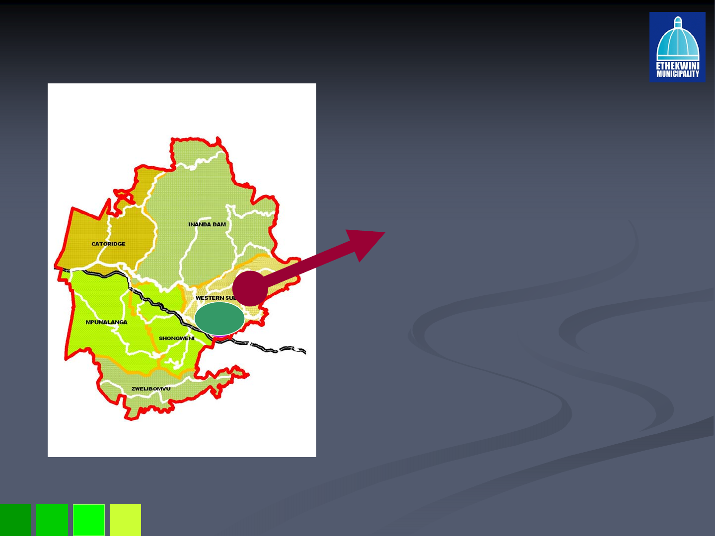
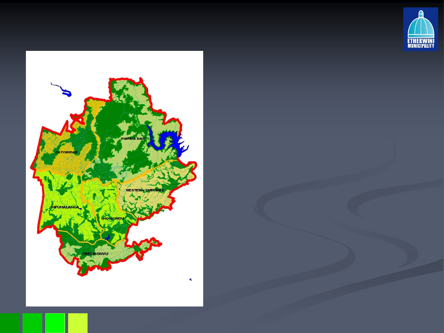
Giba Gorge & Surrounding
Giba Gorge & Surrounding
Scheme Amendment, Phase 1
Scheme Amendment, Phase 1
28 May 2008
28 May 2008
Venue: Hillcrest Library
Venue: Hillcrest Library

28 May 2008
Purpose of the Presentation
Purpose of the Presentation
To explain the planning rationale behind the proposed
To explain the planning rationale behind the proposed
rezoning from SR1800 to a split zoning of SR3600 and
rezoning from SR1800 to a split zoning of SR3600 and
Environmental Conservation Reserve for Mpiti and
Environmental Conservation Reserve for Mpiti and
Springside Nature Reserves and the broader Winston
Springside Nature Reserves and the broader Winston
Park area, as well as the extension of the
Park area, as well as the extension of the
Environmental Conservation Reserve in the Stockville
Environmental Conservation Reserve in the Stockville
and Kloof areas .
and Kloof areas .

28 May 2008
Background
Background
Significant residential growth in the Outer West has necessitat
Significant residential growth in the Outer West has necessitated
ed
appropriate land use and environmental planning for the Giba Gor
appropriate land use and environmental planning for the Giba Gorge
ge
planning area.
planning area.
Existing zoning designations in terms of the COWTPS adjacent to
Existing zoning designations in terms of the COWTPS adjacent to key
key
environmental assets are inappropriate in places and require ame
environmental assets are inappropriate in places and require amendment to
ndment to
ensure that negative impacts are not accrued on the environment.
ensure that negative impacts are not accrued on the environment.
POLICY DIRECTION
POLICY DIRECTION
Plan 1 of the eThekwini Integrated Development Plan (IDP) to sus
Plan 1 of the eThekwini Integrated Development Plan (IDP) to sustain our
tain our
natural and built environment is focused on access to resources
natural and built environment is focused on access to resources to meet
to meet
needs without compromising the resource base of the city.
needs without compromising the resource base of the city.
The Spatial Development Framework, 2008, indicates the sustainab
The Spatial Development Framework, 2008, indicates the sustainable
le
growth path that the eThekwini Municipality is committed to.
growth path that the eThekwini Municipality is committed to.
The Outer West SDP 2005 is the key strategic policy that guides
The Outer West SDP 2005 is the key strategic policy that guides
development in the Outer West Region. The plan is currently unde
development in the Outer West Region. The plan is currently under review.
r review.
In 2005 FutureWorks! was appointed to prepare a Precinct Plan fo
In 2005 FutureWorks! was appointed to prepare a Precinct Plan for the
r the
broader Giba Gorge area to ensure protection of the strategic en
broader Giba Gorge area to ensure protection of the strategic environmental
vironmental
asset.
asset.

28 May 2008
General Areas of Concern
General Areas of Concern
Rapid and high levels of development and high number of applicat
Rapid and high levels of development and high number of applications
ions
for sub
for sub-
-divisions in the Outer West are resulting in:
divisions in the Outer West are resulting in:
Inappropriate development in places and encroachment is
Inappropriate development in places and encroachment is
threatening the environmental quality of strategic environmental
threatening the environmental quality of strategic environmental
assets such as the Giba Gorge.
assets such as the Giba Gorge.
Very high levels of traffic congestion on main roads such as Ina
Very high levels of traffic congestion on main roads such as Inanda
nda
Road, Old Main Road and the M13 on Fields Hill.
Road, Old Main Road and the M13 on Fields Hill.
Proliferation of package plants across the Outer West without
Proliferation of package plants across the Outer West without
adequate research to guide this practice is unsustainable.
adequate research to guide this practice is unsustainable.
Overflows at treatment plants and pump stations during power
Overflows at treatment plants and pump stations during power
outages or load shedding can be hazardous to human health.
outages or load shedding can be hazardous to human health.
DFA approvals on development that is in conflict with the Outer
DFA approvals on development that is in conflict with the Outer
West SDP places further burden on the city’s infrastructure
West SDP places further burden on the city’s infrastructure
particularly the main roads.
particularly the main roads.
Hasty conversion of agriculture land to accommodate higher
Hasty conversion of agriculture land to accommodate higher
intensity development may impact on future food security.
intensity development may impact on future food security.
28 May 2008
OW SDP Development Context
OW SDP Development Context
The Giba Gorge Area forms part of the
The Giba Gorge Area forms part of the
Western Suburbs local planning area of
Western Suburbs local planning area of
the SDP.
the SDP.
A key role of the Western Suburbs is to
A key role of the Western Suburbs is to
maintain low density residential infill and
maintain low density residential infill and
expansion with minimum site sizes of
expansion with minimum site sizes of
2000m2 with on
2000m2 with on-
-site sanitation.
site sanitation.
Ensure sustainable and safe living
Ensure sustainable and safe living
environments but discouraging
environments but discouraging
development that is beyond the carrying
development that is beyond the carrying
capacity of the city’s infrastructure.
capacity of the city’s infrastructure.
Investigate the extension of the
Investigate the extension of the
Hillcrest/Gillitts Activity Corridor and then
Hillcrest/Gillitts Activity Corridor and then
discourage non
discourage non-
-residential uses beyond
residential uses beyond
this point.
this point.
Protect existing country lifestyles options
Protect existing country lifestyles options
in areas where this settlement form
in areas where this settlement form
predominates.
predominates.
Manage land
Manage land-
-uses adjacent to strategic
uses adjacent to strategic
environmental assets such as Giba
environmental assets such as Giba
Gorge.
Gorge.
Expand, integrate and link the open
Expand, integrate and link the open
space system around river corridors such
space system around river corridors such
as the lower Molweni and Mhlatuzana
as the lower Molweni and Mhlatuzana
Rivers.
Rivers.
28 May 2008
Open Space as a Structuring Element
Open Space as a Structuring Element
The Outer West SDP recognises that:
The Outer West SDP recognises that:
50% of the metropolitan open
50% of the metropolitan open
space system is in the Outer West
space system is in the Outer West
Region making it a high priority
Region making it a high priority
environmental management area.
environmental management area.
The Outer West also includes key
The Outer West also includes key
environmental assets, e.g. the
environmental assets, e.g. the
Giba Gorge, Krantzkloof Nature
Giba Gorge, Krantzkloof Nature
Reserve, Shongweni Dam, Inanda
Reserve, Shongweni Dam, Inanda
Dam, etc, all of which have
Dam, etc, all of which have
significant environmental value.
significant environmental value.
The Outer West has a unique
The Outer West has a unique
sense of place due to extreme
sense of place due to extreme
topography and dramatic
topography and dramatic
landscape making it a desirable
landscape making it a desirable
place to live.
place to live.
28 May 2008
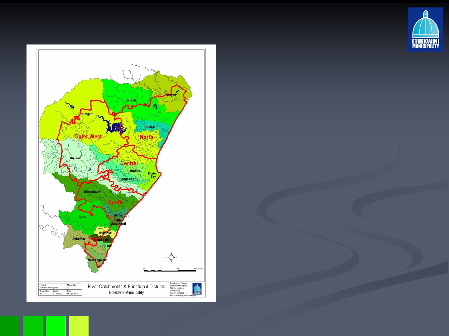
Open Space as a Structuring Element
Open Space as a Structuring Element
A number of major rivers flow in and
A number of major rivers flow in and
through the Outer West, e.g. Mgeni,
through the Outer West, e.g. Mgeni,
Mlazi and Mhlatuzana Rivers which
Mlazi and Mhlatuzana Rivers which
form three important river catchments.
form three important river catchments.
These need to be protected to ensure
These need to be protected to ensure
ecological viability of the open space
ecological viability of the open space
system.
system.
Open spaces act as buffers to the
Open spaces act as buffers to the
environmentally depleted coastal plain
environmentally depleted coastal plain
through the provision of numerous
through the provision of numerous
environmental services such as storm
environmental services such as storm
water attenuation, protection of water
water attenuation, protection of water
supply, flood attenuation, regional bio
supply, flood attenuation, regional bio-
-
diversity, soil erosion etc.
diversity, soil erosion etc.
These ecosystem services were
These ecosystem services were
conservatively estimated to be worth R
conservatively estimated to be worth R
3.1 billion in 2003
3.1 billion in 2003 vs
vs capital budget at
capital budget at
time
time –
–R2.8 billion and operational
R2.8 billion and operational
budget
budget –
–R6.5 billion.
R6.5 billion.
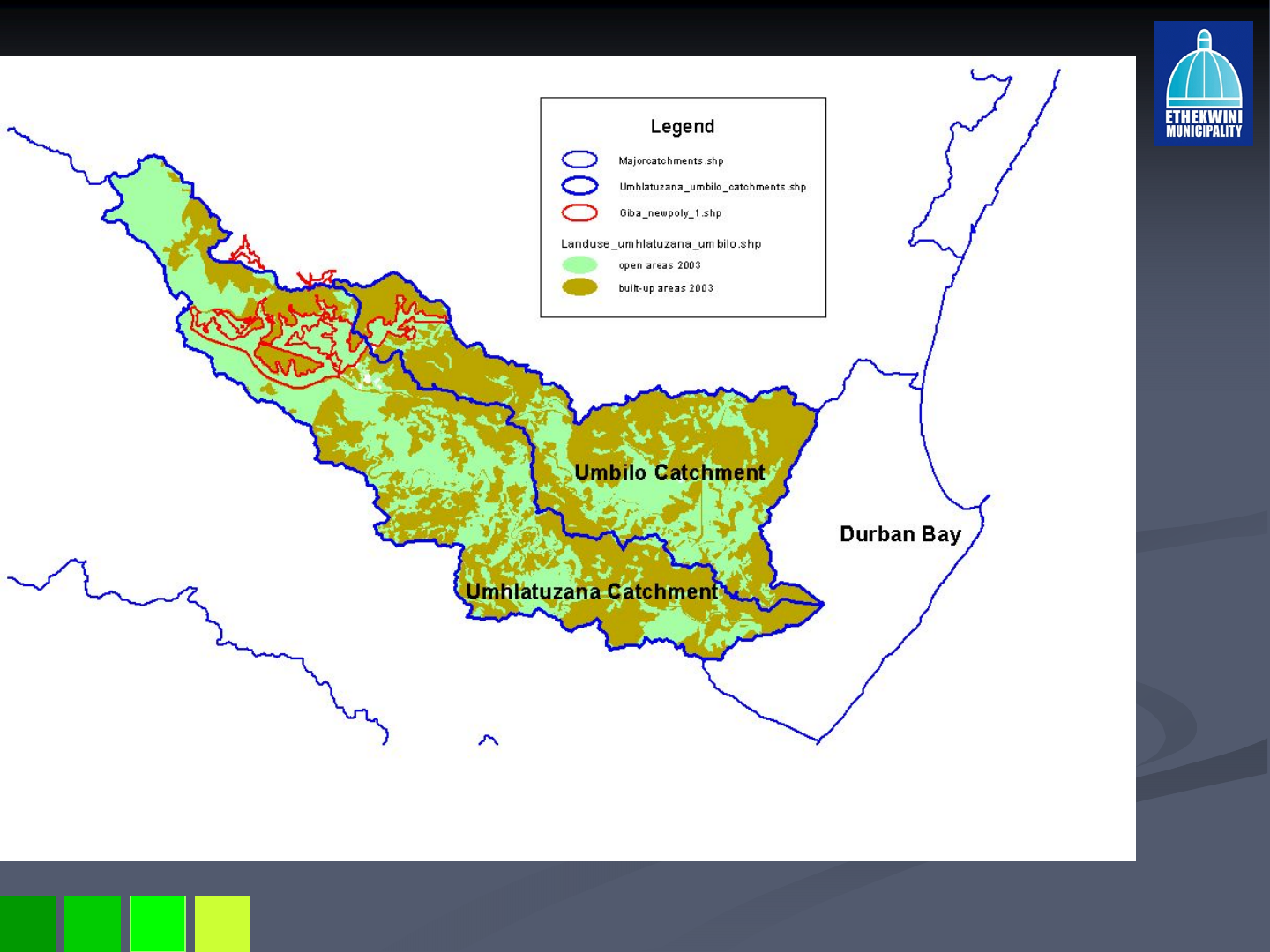
The Mbilo and Mhlatuzana catchments
The Mbilo and Mhlatuzana catchments
are entirely within the EMA and
are entirely within the EMA and
significant portions of their upper
significant portions of their upper
reaches exist within the proposed
reaches exist within the proposed
area.
area.

28 May 2008
Further environmental considerations in
Further environmental considerations in
conducting municipal business
conducting municipal business
National Environmental Management Act (1998) & its principles
National Environmental Management Act (1998) & its principles
National Environmental Management: Biodiversity Act (2004)
National Environmental Management: Biodiversity Act (2004)
National Spatial Biodiversity Assessment (2004), SANBI
National Spatial Biodiversity Assessment (2004), SANBI
Ezemvelo KZN Wildlife’s Systematic Conservation Plan
Ezemvelo KZN Wildlife’s Systematic Conservation Plan
IDP
IDP –
–in particular its value filters, including sustainability, and
in particular its value filters, including sustainability, and Plan
Plan
1: Sustaining our natural and built environment
1: Sustaining our natural and built environment
Durban Metropolitan Open Space Plan (D’MOSS) which forms part
Durban Metropolitan Open Space Plan (D’MOSS) which forms part
of the Spatial Development Framework
of the Spatial Development Framework
Extensive and rapid land transformation
Extensive and rapid land transformation –
–local data and data from
local data and data from
the Vegetation of SA
the Vegetation of SA
Additional indirect impacts due to increased density
Additional indirect impacts due to increased density
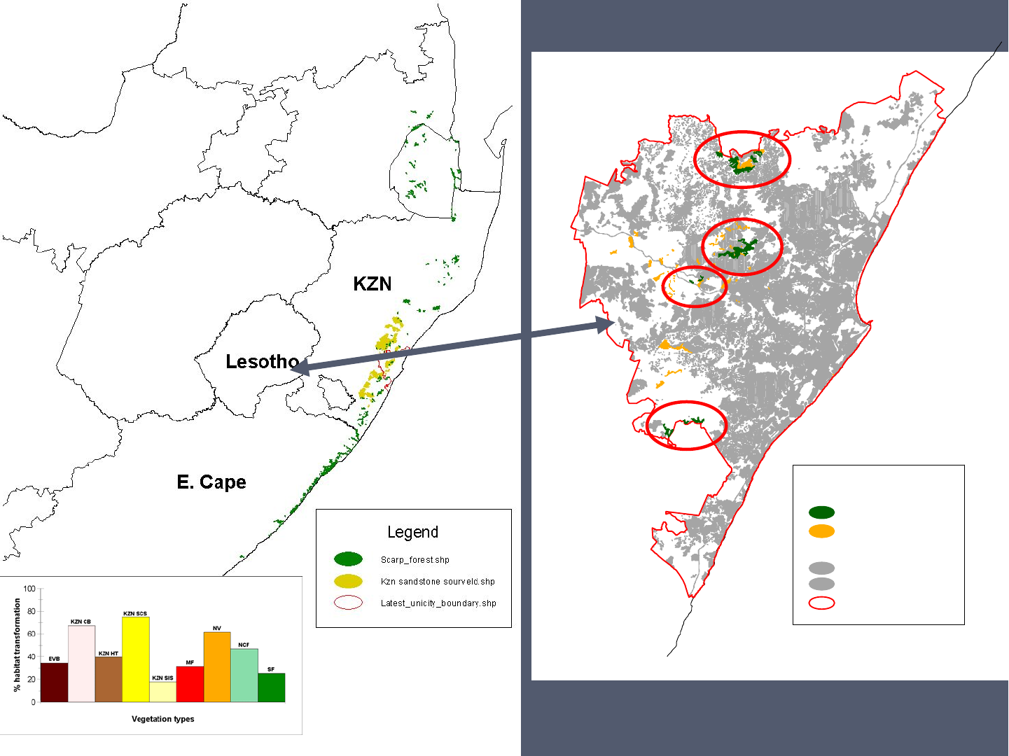
Sanbi_scarpforest_ema.shp
Moss_primarygrassland.shp
landuse_EMA_built-up.shp
Built-up
Built-up2
Latest_unicity_boundary.shp
Legend
Nanda
Mountain
Krantzkloof
N.R.
Giba Gorge
Nungwane
Falls
eThekwini
28 May 2008
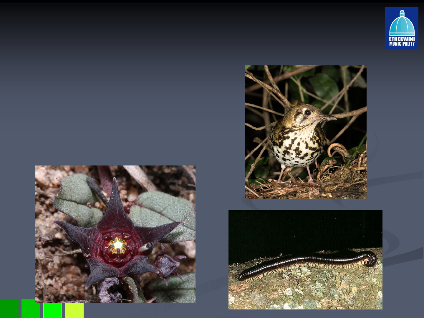
Red Data species
Red Data species
Plants
Plants –
–21 species
21 species
Mammals
Mammals –
–14 species
14 species
Birds
Birds –
–4 species
4 species
Amphibians
Amphibians –
–4 species
4 species
Invertebrates
Invertebrates –
–2 species
2 species
28 May 2008

28 May 2008
Environmental Goods & Services
Environmental Goods & Services
Disturbance regulation (floods and others)
Disturbance regulation (floods and others)
Water filtration (purification)
Water filtration (purification)
Soil erosion prevention
Soil erosion prevention
Recreation & aesthetics
Recreation & aesthetics
Climate control (urban heat islands &
Climate control (urban heat islands &
carbon sequestration)
carbon sequestration)
Nutrient cycling (e.g. nitrogen)
Nutrient cycling (e.g. nitrogen)
Genetic resources
Genetic resources
28 May 2008
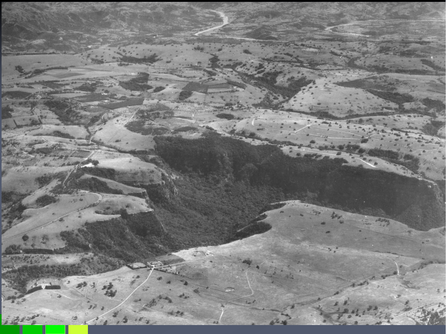
Kloof, Forest Hills & Waterfall – 1954
28 May 2008
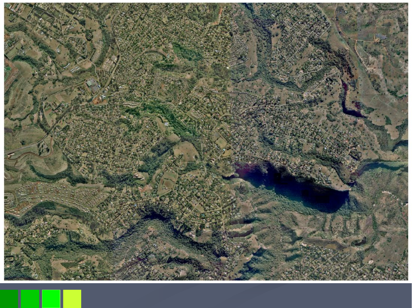
Kloof, Forest Hills & Waterfall – 2007

28 May 2008
Purpose of the Rezoning
Purpose of the Rezoning
To maintain the low density character of the area and protect an
To maintain the low density character of the area and protect and conserve
d conserve
the environmental assets thereby ensuring that development is i
the environmental assets thereby ensuring that development is in harmony
n harmony
with the natural resource base upon which human well being and t
with the natural resource base upon which human well being and the
he
economy depends, (IDP, 2008.2)
economy depends, (IDP, 2008.2)
To highlight the necessity to amend the COWTPS in areas where
To highlight the necessity to amend the COWTPS in areas where
densification will result in encroachment on the environmental a
densification will result in encroachment on the environmental assets.
ssets.
To initiate a process to ensure that present human activity must
To initiate a process to ensure that present human activity must be limited
be limited
by the environments carrying capacity as natural resources and t
by the environments carrying capacity as natural resources and their
heir
renewal cannot be easily substituted.
renewal cannot be easily substituted.
28 May 2008
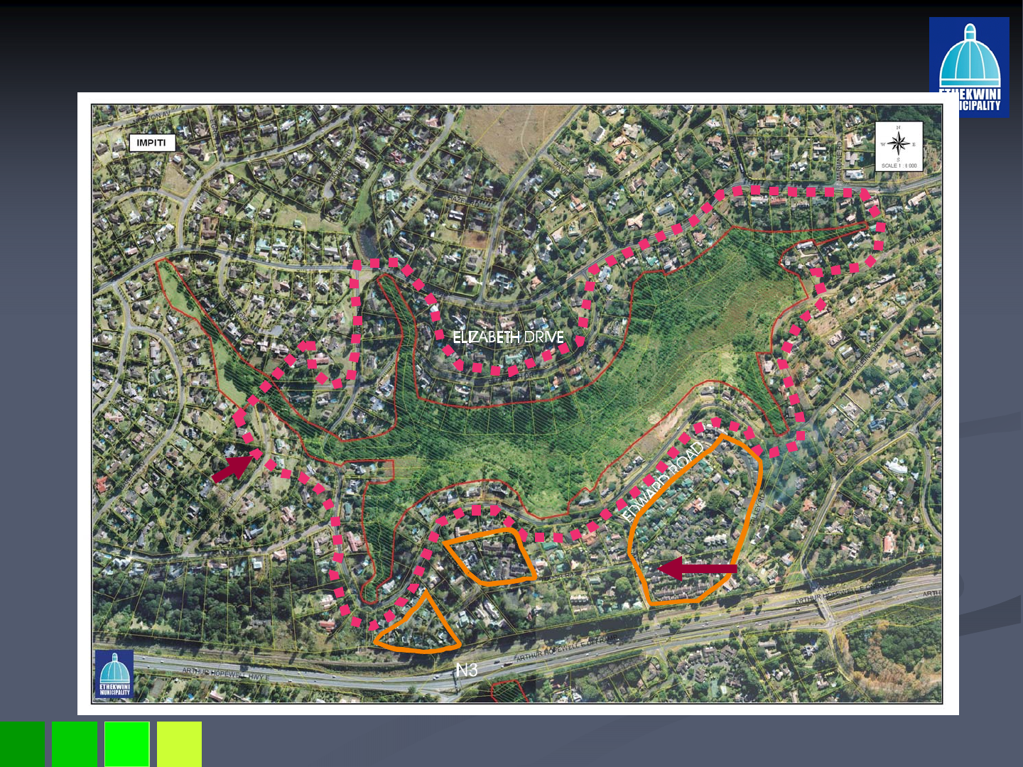
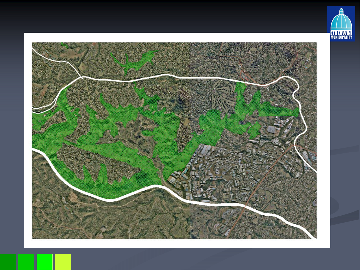
Areas Affected by the Proposed Rezoning
Areas Affected by the Proposed Rezoning
Mpiti Nature Reserve
Higher Intensity
Residential
Development
Edge affected by
The rezoning
28 May 2008
Areas Affected by the Proposed Rezoning
Areas Affected by the Proposed Rezoning
Springside Nature Reserve
Higher Intensity
Residential
Development
Railway line hampers
Integration to Hillcrest
Node.
Edge
affected
by the
rezoning
28 May 2008
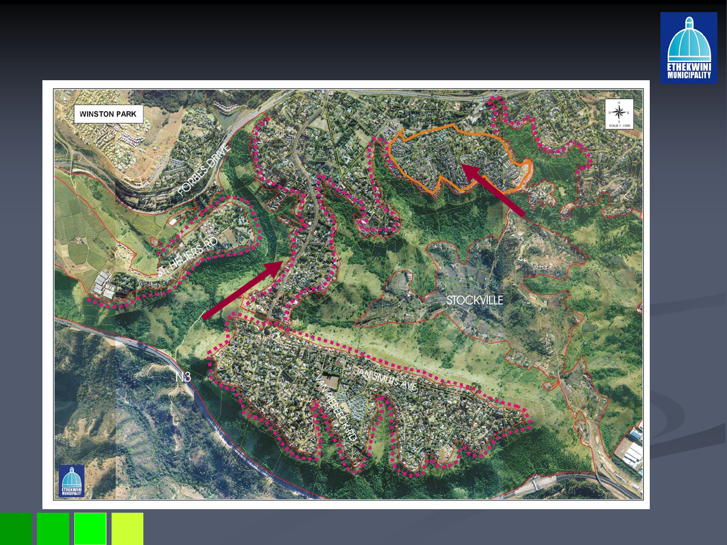
Areas Affected by the Proposed Rezoning
Areas Affected by the Proposed Rezoning
Winston Park, St Helier, Stockville and Kloof Escarpment
Higher Intensity
Residential
Development
Edge affected by
the rezoning
28 May 2008
Areas Affected by the Proposed Rezoning
Areas Affected by the Proposed Rezoning
Proposed Environmental
Conservation Reserve extension
Into Stockville Valley
Existing Conservation
Reserve
Kloof
Phase 1
STOCKVILLE
Land owned by South African
National Road Agency and State
owned
28 May 2008
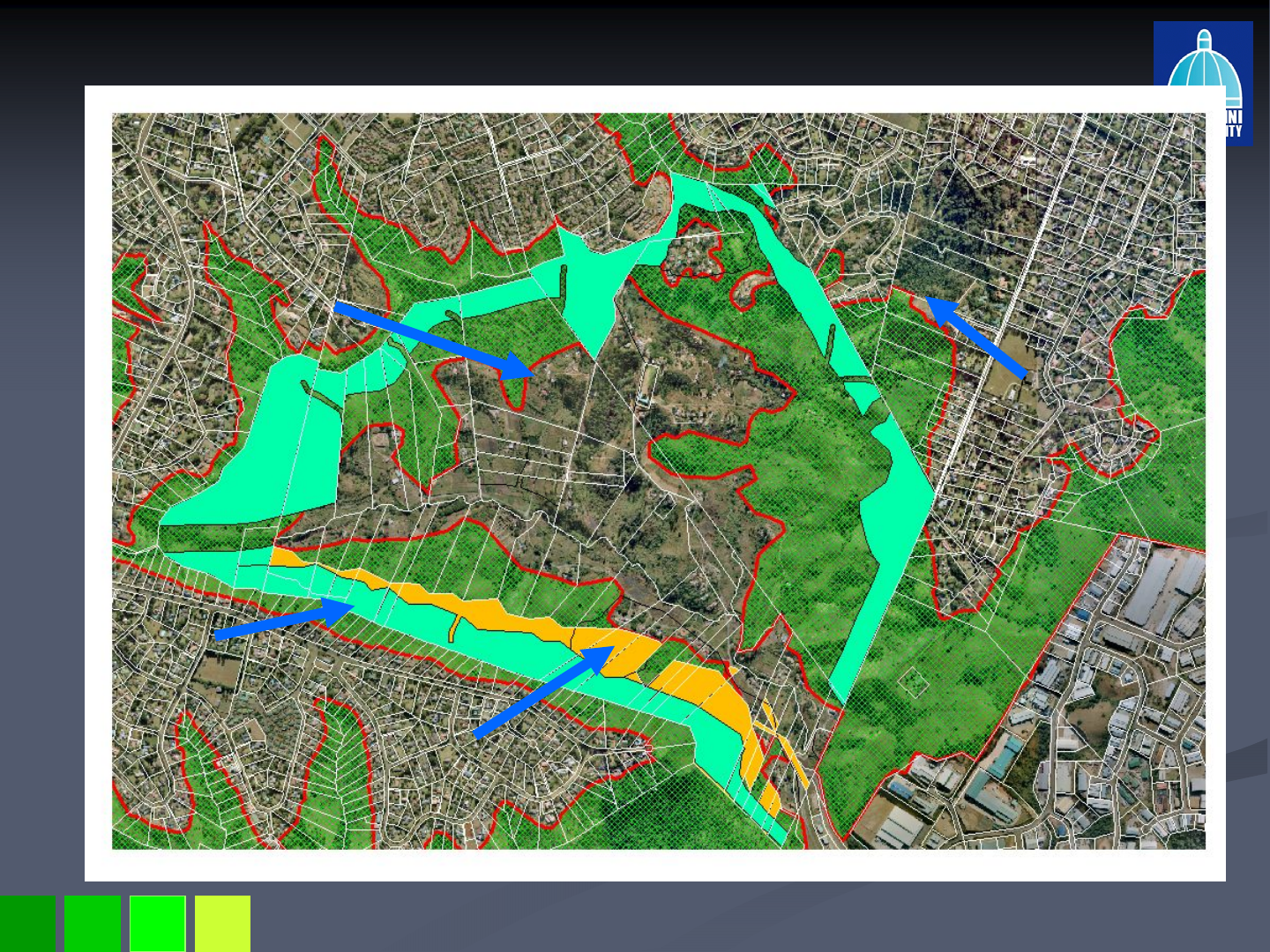
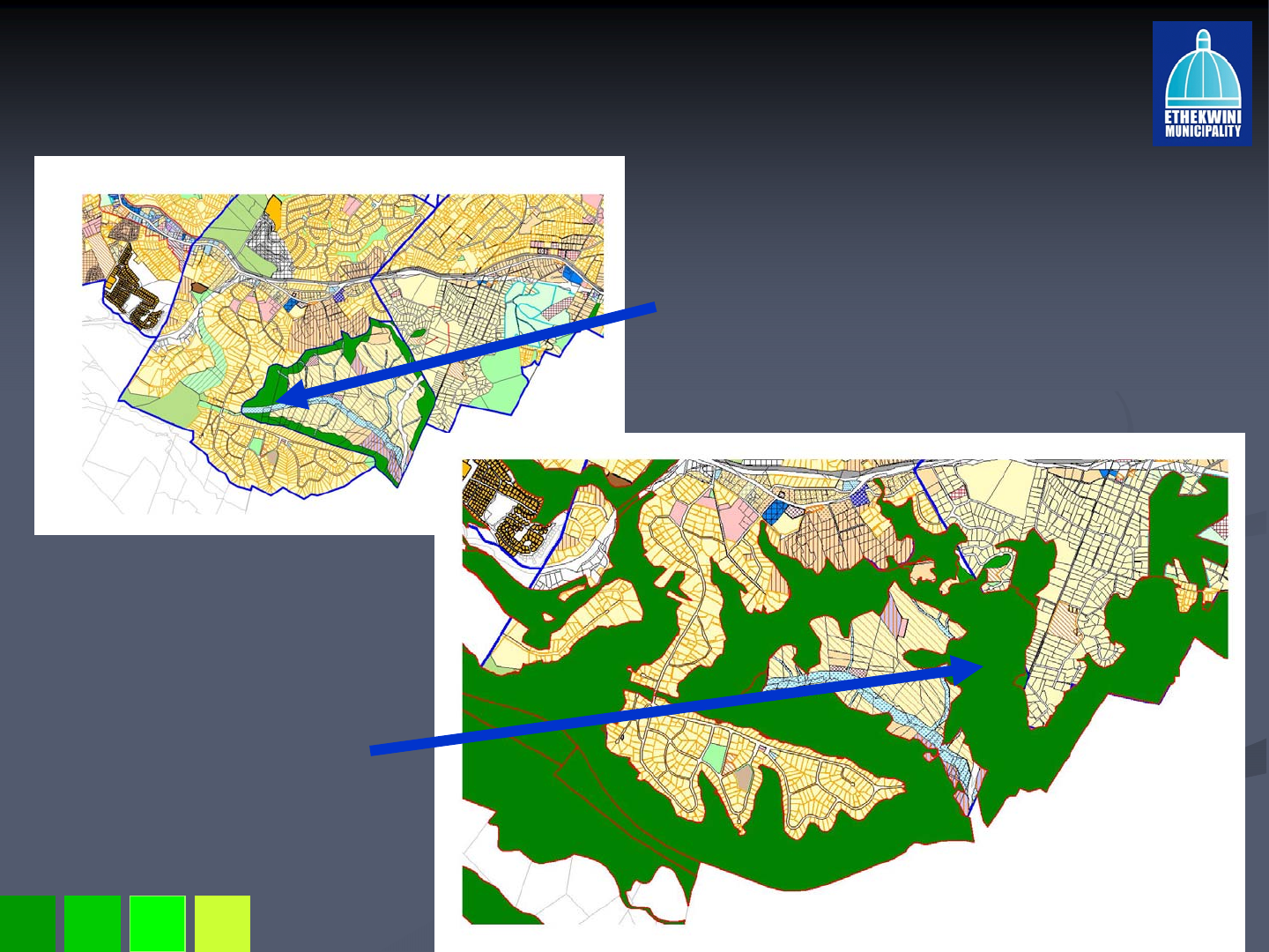
Total Extent of the Environmental Conservation
Total Extent of the Environmental Conservation
Reserve
Reserve
M13
N3
Winston Park
Kloof
Stockville
Phase2
28 May 2008
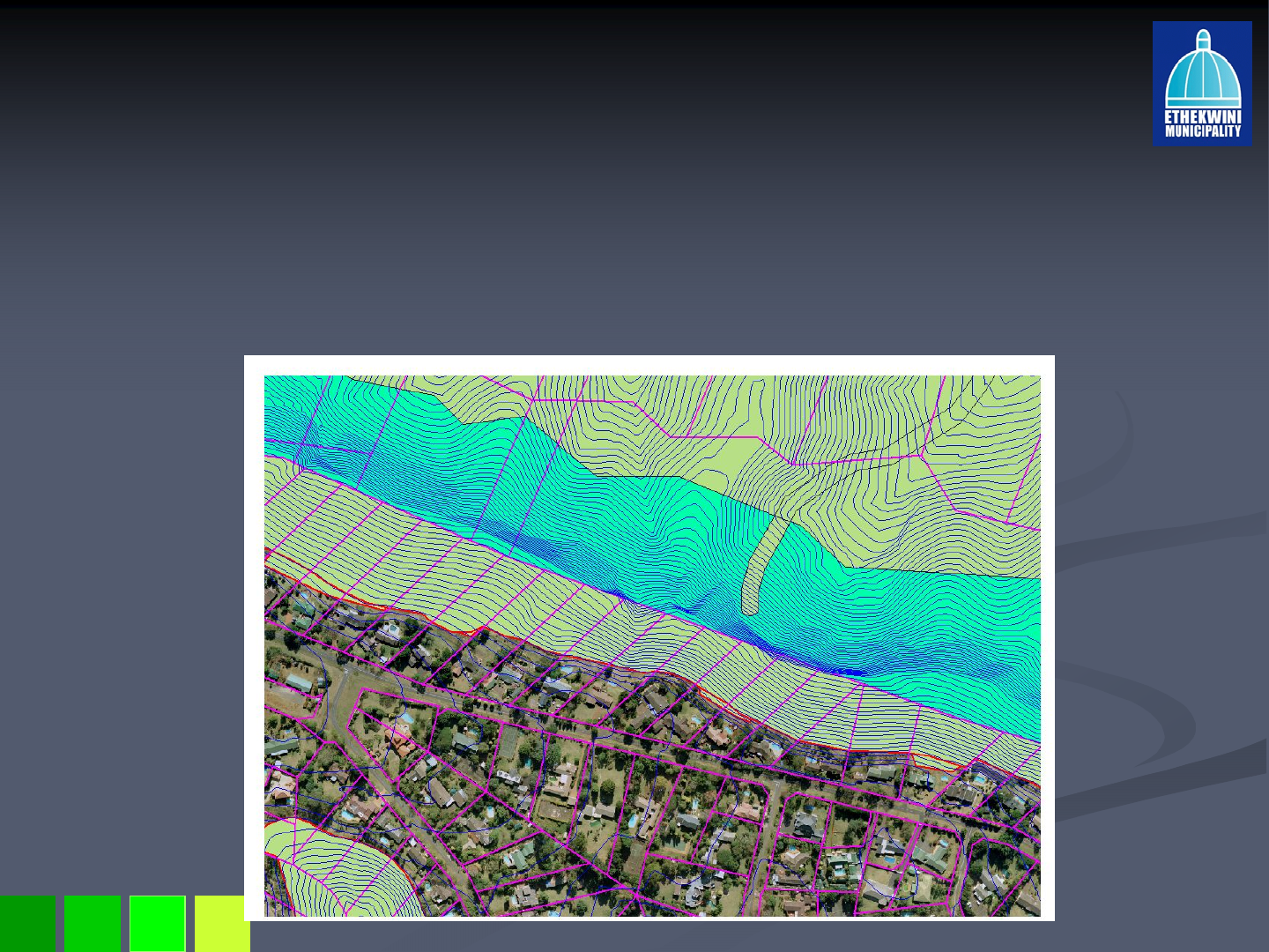
Basic Site Investigation
Basic Site Investigation
Location of the site and the dwelling unit relative to the envir
Location of the site and the dwelling unit relative to the environmental asset.
onmental asset.
The size of the site in accommodating further sub
The size of the site in accommodating further sub-
-divisions in accordance with
divisions in accordance with
SR1800 and SR3600 zoning.
SR1800 and SR3600 zoning.
The extent of steep slopes on the site to guide the extension of
The extent of steep slopes on the site to guide the extension of the environmental
the environmental
conservation reserve.
conservation reserve.
The level of encroachment that has already taken place.
The level of encroachment that has already taken place.
Existing public open
space zoned area
Proposed environmental
Conservation reserve
28 May 2008
Sub
Sub-
-Division Analysis
Division Analysis –
–Winston Park
Winston Park
-
-314 sites are affected in Winston Park.
314 sites are affected in Winston Park.
-
-Sites are large and irregular in shape and have existing residen
Sites are large and irregular in shape and have existing residential
tial
developments on the flatter portions.
developments on the flatter portions.
-
-37% of the sites are larger than 7200sqm. (depicted in pink)
37% of the sites are larger than 7200sqm. (depicted in pink)
-
-Undeveloped portions of sites are steep and partly covered by DM
Undeveloped portions of sites are steep and partly covered by DMOSS.
OSS.
-
-With the extended environmental conservation reserve, 42 sites w
With the extended environmental conservation reserve, 42 sites will
ill
accommodate further sub
accommodate further sub-
-divisions in accordance will the SR3600 zoning
divisions in accordance will the SR3600 zoning
and 53 in accordance with SR1800.
and 53 in accordance with SR1800.
0
100
200
300
400
NO. OF SITES 316 116 200 52 42
PERCENTAGE 37 63 16 13
TOTAL
SITES
SITES >
7200sqm
SITES <
7200sqm
FURTHER
SR1800
FURTHER
SR3600
28 May 2008
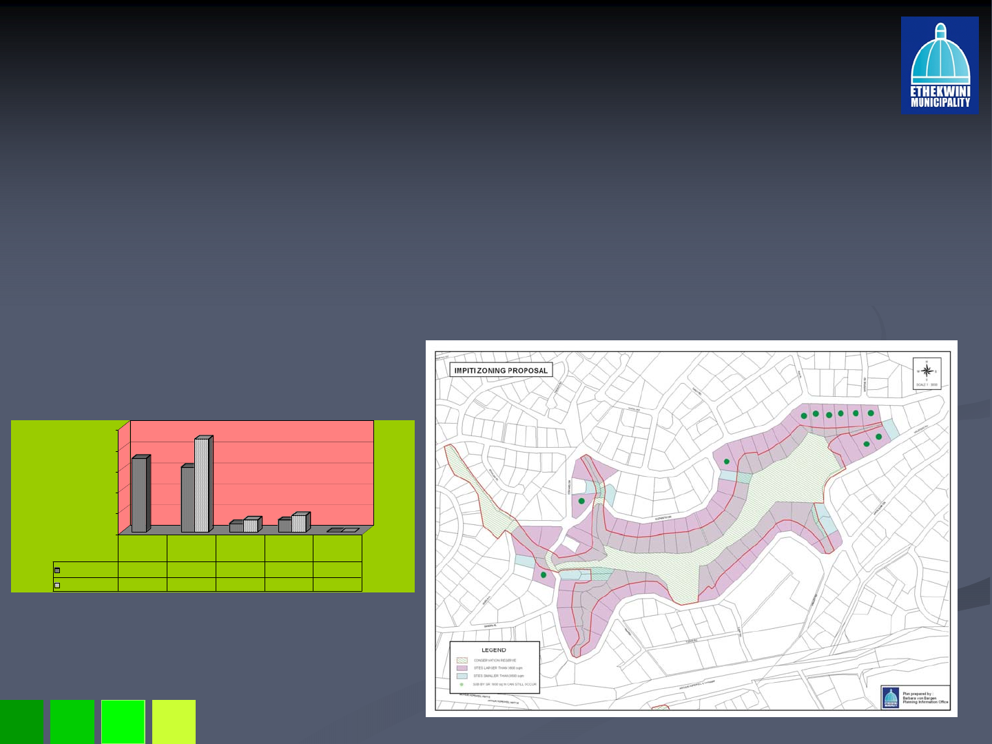
Sub
Sub-
-Division Analysis
Division Analysis –
–Mpiti Nature Reserve
Mpiti Nature Reserve
-
-70 sites affected in the Mpiti Nature Reserve
70 sites affected in the Mpiti Nature Reserve
-
-89% of the sites are larger than 3600sqm and can accommodate fur
89% of the sites are larger than 3600sqm and can accommodate further
ther
sub
sub-
-divisions in accordance with the SR1800 zoning in terms of the c
divisions in accordance with the SR1800 zoning in terms of the current
urrent
public open space zoning.
public open space zoning.
-
-With the extended environmental conservation reserve only 11 sit
With the extended environmental conservation reserve only 11 sites will
es will
accommodate further sub
accommodate further sub-
-divisions in accordance with the SR1800 zone.
divisions in accordance with the SR1800 zone.
-
-With the extended environmental conservation reserve no sites wi
With the extended environmental conservation reserve no sites will
ll
accommodate further sub
accommodate further sub-
-divisions in accordance with the SR3600.
divisions in accordance with the SR3600.
0
20
40
60
80
100
NO. OF SITES 70 62 8 11 0
PERCENTAGE 89 11 16 0
TOTAL
SITES
SITES >
3600sqm
SITES <
3600sqm
FURTHER
SR1800
FURTHER
SR3600
28 May 2008
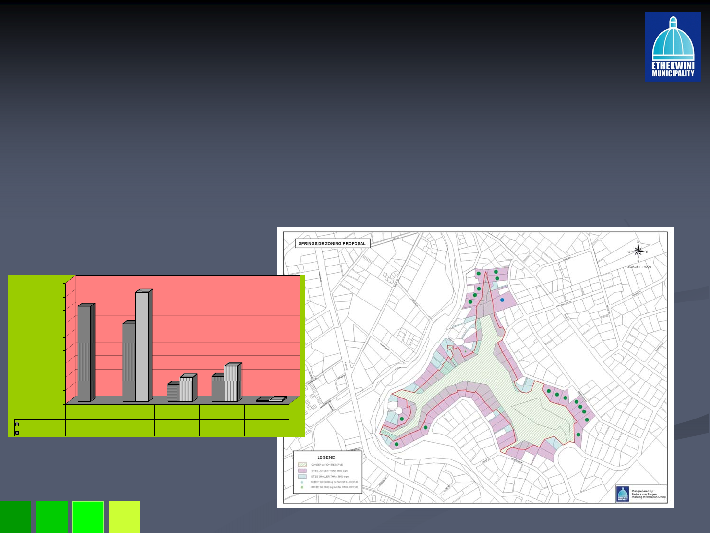
Sub
Sub-
-Division Analysis
Division Analysis –
–Springside Nature
Springside Nature
Reserve
Reserve
-
-71 sites affected in Springside Nature Reserve
71 sites affected in Springside Nature Reserve
-
-82% of the sites are larger than 3600sqm and can accommodate fur
82% of the sites are larger than 3600sqm and can accommodate further sub
ther sub-
-
divisions in accordance with the SR1800 zoning in terms of the c
divisions in accordance with the SR1800 zoning in terms of the current zoning.
urrent zoning.
-
-With the extended environmental conservation reserve only 19 sit
With the extended environmental conservation reserve only 19 sites will
es will
accommodate further sub
accommodate further sub-
-divisions in accordance with the SR1800 zone.
divisions in accordance with the SR1800 zone.
-
-With the extended environmental conservation reserve 1 site will
With the extended environmental conservation reserve 1 site will accommodate
accommodate
further sub
further sub-
-divisions in accordance with the SR3600.
divisions in accordance with the SR3600.
0
10
20
30
40
50
60
70
80
90
NO. OF SITES 71 58 13 19 1
PERCENTAGE 82 18 27 1
TOTAL SITES SITES >
3600sqm
SITES <
3600sqm
FURTHER
SR1800 SUBS
FURTHER
SR3600 SUBS
28 May 2008
Extended Environmental Conservation Reserve
Extended Environmental Conservation Reserve
Mpiti Nature Reserve
Mpiti Nature Reserve
Existing Town Planning Scheme
Extended Environmental Conservation Reserve
Current Public Open
Space Zoning
Environmental Conservation
Reserve Zoning
28 May 2008
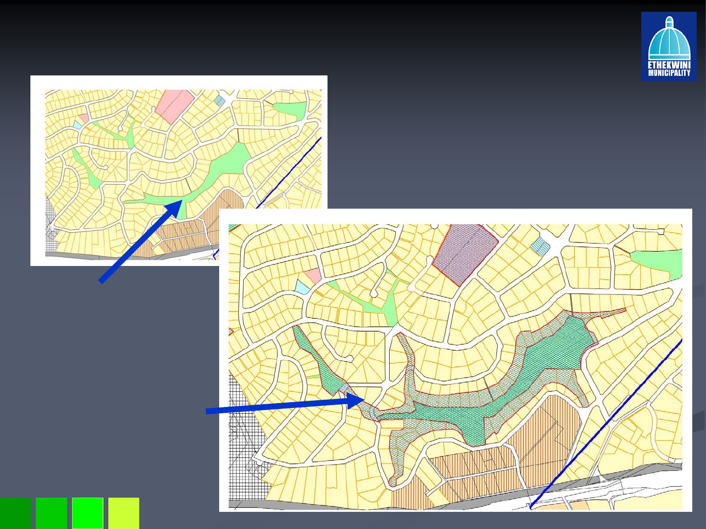
Extended Environmental Conservation Reserve
Extended Environmental Conservation Reserve
Springside Nature Reserve
Springside Nature Reserve
Existing Town Planning Scheme
Extended Environmental Conservation Reserve
Current Public Open
Space Zoning
Proposed Environmental
Conservation Reserve
Zoning
This expansion of the reserve
Will form part of phase 2
28 May 2008
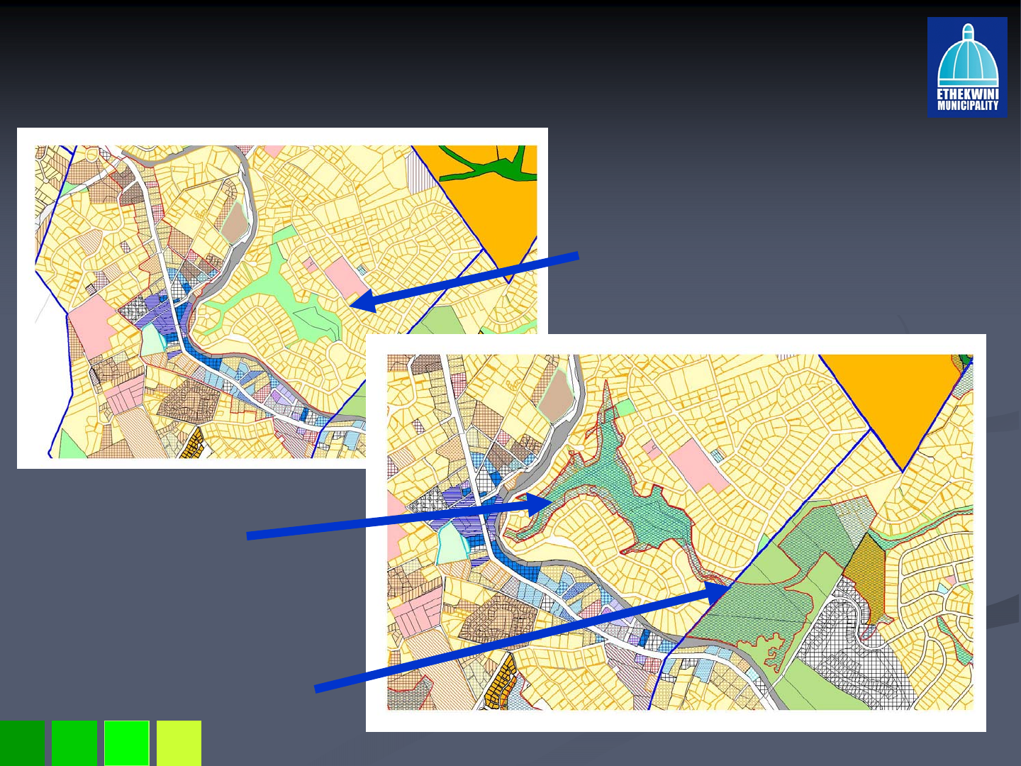
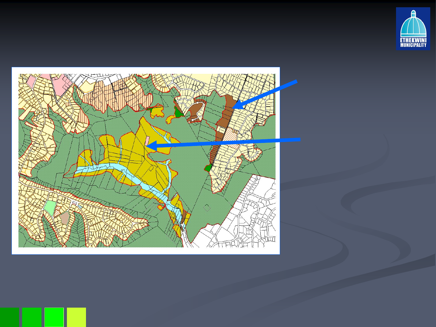
Extended Environmental Conservation Reserve
Extended Environmental Conservation Reserve
Winston Park, Stockville & Kloof Escarpment
Winston Park, Stockville & Kloof Escarpment
Existing Town Planning Scheme
Extended Environmental Conservation Reserve
Disconnected Current Conservation
Reserve Zoning
Connected and integrated
Proposed Environmental
Conservation Reserve
28 May 2008
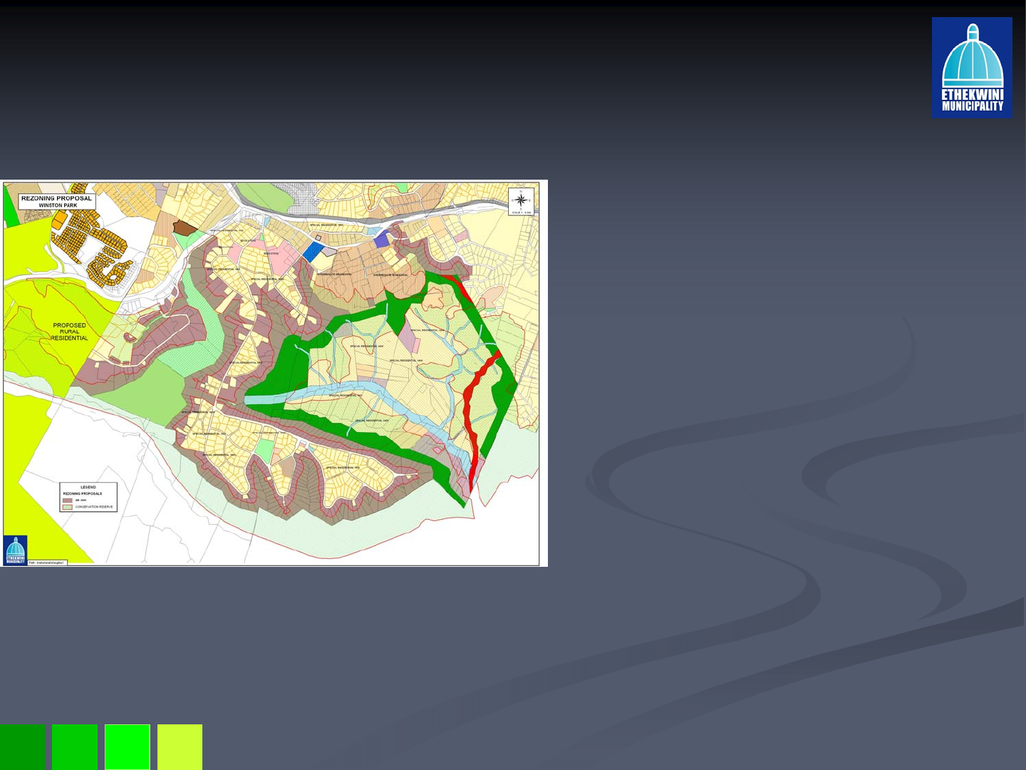
Proposed Scheme Amendment
Proposed Scheme Amendment –
–Winston Park and St.
Winston Park and St.
Hiliers Area
Hiliers Area
314 sites proposed to be rezoned
314 sites proposed to be rezoned
from SR1800 to a split zone of
from SR1800 to a split zone of
SR3600 and Environmental
SR3600 and Environmental
Conservation Reserve.
Conservation Reserve.
The rezoning will firstly limit further
The rezoning will firstly limit further
sub
sub-
-divisions and secondly the
divisions and secondly the
extended environmental
extended environmental
conservation reserve will limit the
conservation reserve will limit the
extent of development thereby
extent of development thereby
lowering the development impact
lowering the development impact
on the Stockville Edge, Giba
on the Stockville Edge, Giba
Gorge and Mhlatuzana Edge.
Gorge and Mhlatuzana Edge.
The current Public Open Space
The current Public Open Space
and amenity reserve designation
and amenity reserve designation
is proposed to be rezoned to
is proposed to be rezoned to
Environmental Conservation
Environmental Conservation
Reserve
Reserve
N.B. MR 360 shown in red not
N.B. MR 360 shown in red not
currentl
y
so zoned!
currentl
y
so zoned!
28 May 2008
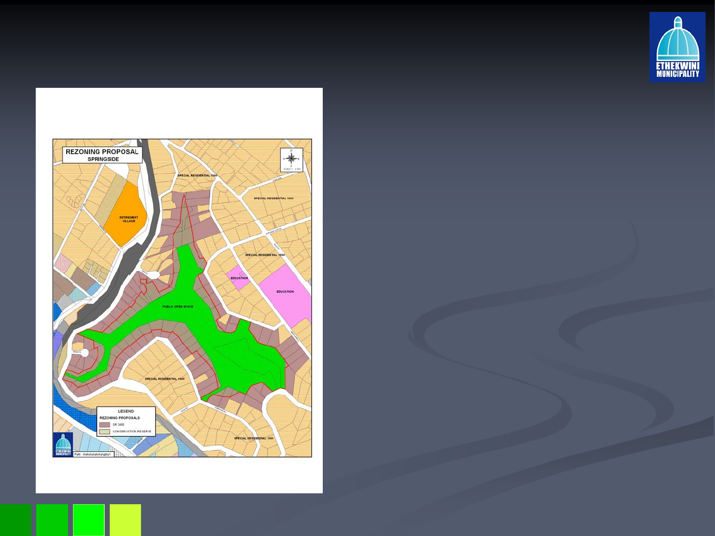
Proposed Scheme Amendment for Springside Nature
Proposed Scheme Amendment for Springside Nature
Reserve
Reserve
70 sites proposed to be
70 sites proposed to be
rezoned from SR1800 to a split
rezoned from SR1800 to a split
zone of SR3600 and
zone of SR3600 and
Environmental Conservation
Environmental Conservation
Reserve
Reserve
Similarly the rezoning will
Similarly the rezoning will
firstly stop further sub
firstly stop further sub-
-divisions
divisions
and secondly the extended
and secondly the extended
environmental conservation
environmental conservation
reserve will limit the extent of
reserve will limit the extent of
development thereby lowering
development thereby lowering
the development impact on the
the development impact on the
nature reserve.
nature reserve.
The current Public Open
The current Public Open
Space designation is proposed
Space designation is proposed
to be rezoned to
to be rezoned to
Environmental Conservation
Environmental Conservation
Reserve
Reserve
28 May 2008
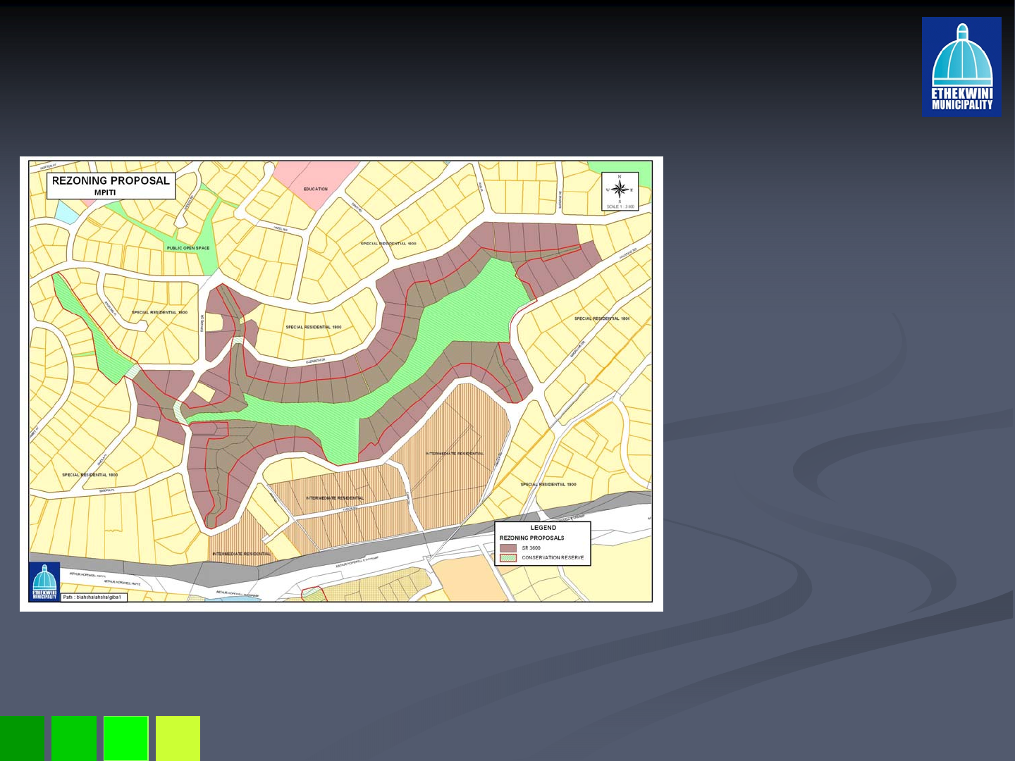
Proposed Scheme Amendment for Mpithi Nature
Proposed Scheme Amendment for Mpithi Nature
Reserve
Reserve
71 sites proposed to be
71 sites proposed to be
rezoned from SR1800 to
rezoned from SR1800 to
a split zone of SR3600
a split zone of SR3600
and Conservation
and Conservation
Reserve
Reserve
Likewise the rezoning
Likewise the rezoning
will firstly stop further
will firstly stop further
sub
sub-
-divisions and
divisions and
secondly the extended
secondly the extended
environmental
environmental
conservation reserve will
conservation reserve will
limit the extent of
limit the extent of
development thereby
development thereby
lowering the
lowering the
development impact on
development impact on
the reserve.
the reserve.
The current Public Open
The current Public Open
Space designation is
Space designation is
proposed to be rezoned
proposed to be rezoned
to Environmental
to Environmental
Conservation Reserve
Conservation Reserve
28 May 2008
Scheme Amendment Stockville and Kloof Escarpment
Scheme Amendment Stockville and Kloof Escarpment
Further 28 sites in Kloof are
Further 28 sites in Kloof are
proposed to be rezoned from
proposed to be rezoned from
SR3600 to split zoning of
SR3600 to split zoning of
SR3600 and Environmental
SR3600 and Environmental
Conservation Reserve.
Conservation Reserve.
Environmental Conservation
Environmental Conservation
Reserve has been
Reserve has been
substantially extended and
substantially extended and
requires a split zoning of
requires a split zoning of
SR1400 and Environmental
SR1400 and Environmental
Conservation Reserve for
Conservation Reserve for
affected sites.
affected sites.
The Kloof escarpment has
The Kloof escarpment has
been extended and a
been extended and a
rezoning from Public Open
rezoning from Public Open
Space to Environmental
Space to Environmental
Conservation Reserve is
Conservation Reserve is
required.
required.

28 May 2008
Way Forward
Way Forward
Advertisement Sect. 47
Advertisement Sect. 47bis
bis A(2)
A(2) –
–30 May 2008
30 May 2008
Open Days 5
Open Days 5-
-7 June + normal display
7 June + normal display
Close of Objections
Close of Objections –
–27 June 2008
27 June 2008
Report compiled for TP Committee
Report compiled for TP Committee
Council adopts Sect. 47
Council adopts Sect. 47bis
bis A(4)
A(4) –
–end Aug
end Aug
Notice of outcome & S47
Notice of outcome & S47bis
bis C appeal advice to objectors
C appeal advice to objectors
–
–early Sept
early Sept
Zoning effective after 28 days or appeal conclusion.
Zoning effective after 28 days or appeal conclusion.
Revaluation
Revaluation –
–(by Real Estate)
(by Real Estate)
Rates Rebate on Conservation land MAY be possible
Rates Rebate on Conservation land MAY be possible
with EMD Certificate & approved EMP
with EMD Certificate & approved EMP

28 May 2008
THANK YOU!
THANK YOU!
Together we can hold our ground!
Together we can hold our ground!
