In Brief A Beginners Guide To UK Geography 2017 V1.3
User Manual:
Open the PDF directly: View PDF ![]() .
.
Page Count: 115 [warning: Documents this large are best viewed by clicking the View PDF Link!]

2017 v1.3
A Beginner's
Guide to UK
Geography
Edition:
2017 v1.3
Editor:
ONS Geography
Office for National Statistics

A Beginner's Guide to UK Geography
2017 v1.3
Office for National Statistics
2
A National Statistics Publication
National Statistics are produced to high professional standards
set out in the Code of Practice for Official Statistics. They are
produced free from political influence.
About Us
Office for National Statistics
The Office for National Statistics (ONS) is the executive office of
the UK Statistics Authority, a non-ministerial department which
reports directly to Parliament. ONS is the UK government's
single largest statistical producer. It compiles information about
the UK's society and economy, and provides the evidence-base
for policy and decision-making, the allocation of resources, and
public accountability. The Directors General of ONS report
directly to the National Statistician who is the Authority's Chief
Executive and the Head of the Government Statistical Service.
Government Statistical Service
The Government Statistical Service (GSS) is a network of
professional statisticians and their staff operating both within
the ONS and across more than 30 other government
departments and agencies.
Contacts
This publication
For information about the content of this publication, contact
ONS Geography Customer Services
Tel: 01329 444971
Email: ons.geography@ons.gov.uk
Other customer enquiries
ONS Customer Contact Centre
Tel: 0845 601 3034
International: +44 (0)845 601 3034
Minicom: 01633 815044
Email: info@statistics.gov.uk
Fax: 01633 652747
Post: Room 1.101, Government Buildings,
Cardiff Road, Newport, South Wales NP10 8XG
www.ons.gov.uk
Media enquiries
Tel: 0845 604 1858
Email: press.office@ons.gov.uk
Copyright and Reproduction
Please refer to our Licences page for the terms applicable to our
products.
TRADEMARKS
PAF® is a registered trademark of Royal Mail Group Ltd.
Gridlink is a registered trademark of the Gridlink Consortium
and may not be used without the written consent of the Gridlink
Programme Board.
The Gridlink logo is a registered trademark.
Boundary-Line is a trademark of OS, the national mapping
agency of Great Britain.

A Beginner's Guide to UK Geography
2017 v1.3
Office for National Statistics
3
Contents
1. Introduction ................................................................................................................................................................................. 6
2. Administrative Geography ..................................................................................................................................................... 6
2.1 The Countries of the UK .......................................................................................................................................................... 6
2.2 Our Changing Geography ...................................................................................................................................................... 7
2.2.1 Boundary Changes .................................................................................................................................................................... 7
2.2.1.1 Lower Level (Electoral Ward/Division) Changes ............................................................................................................ 7
2.2.1.2 Higher Level Changes .............................................................................................................................................................. 8
2.2.2 Local Government Restructuring ......................................................................................................................................... 9
2.3 England ........................................................................................................................................................................................ 11
2.3.1 Regions (former GORs) .......................................................................................................................................................... 11
2.3.2 The former Standard Statistical Regions (SSR) ............................................................................................................ 12
2.3.3 Greater London and the London Boroughs .................................................................................................................. 12
2.3.4 Metropolitan Counties and Districts ................................................................................................................................ 12
2.3.5 Counties, Non-metropolitan Districts and Unitary Authorities ............................................................................. 13
2.3.6 Electoral Wards/Divisions ..................................................................................................................................................... 13
2.3.6.1 County Electoral Divisions .................................................................................................................................................... 14
2.3.6.2 Statistical Wards ....................................................................................................................................................................... 14
2.3.6.3 Census Area Statistics (CAS) Wards .................................................................................................................................. 14
2.3.6.4 Standard Table (ST) Wards ................................................................................................................................................... 15
2.3.7 Parishes and Communities ................................................................................................................................................... 15
2.3.7.1 English Parishes ........................................................................................................................................................................ 15
2.3.7.2 English Non-civil Parish Areas ............................................................................................................................................ 16
2.3.7.3 Welsh Communities ................................................................................................................................................................ 16
2.3.7.4 Scottish Communities ............................................................................................................................................................ 16
2.4 Scotland ....................................................................................................................................................................................... 17
2.4.1 Council Areas ............................................................................................................................................................................. 17
2.4.2 Electoral Wards ......................................................................................................................................................................... 17
2.4.3 Communities .............................................................................................................................................................................. 17
2.5 Wales ............................................................................................................................................................................................ 17
2.5.1 Unitary Authorities (UA) ........................................................................................................................................................ 18
2.5.2 Electoral Wards ......................................................................................................................................................................... 18
2.5.3 Communities .............................................................................................................................................................................. 18
2.6 Northern Ireland ....................................................................................................................................................................... 18
2.6.1 Local Government Districts (LGD) ..................................................................................................................................... 19

A Beginner's Guide to UK Geography
2017 v1.3
Office for National Statistics
4
2.6.2 Electoral Wards ......................................................................................................................................................................... 19
3. Census Geography .................................................................................................................................................................. 19
3.1 The UK Censuses ...................................................................................................................................................................... 19
3.2 Built-up Areas (BUA) and Built-up Area Sub-divisions (BUASD) ........................................................................... 19
3.3 Enumeration Districts (ED) ................................................................................................................................................... 20
3.3.1 2011 EDs ...................................................................................................................................................................................... 20
3.3.2 2001 EDs ...................................................................................................................................................................................... 20
3.3.3 1991 EDs ...................................................................................................................................................................................... 20
3.4 Output Areas (OA) ................................................................................................................................................................... 21
3.4.1 2001 OAs ..................................................................................................................................................................................... 21
3.4.2 2011 OAs ..................................................................................................................................................................................... 21
3.4.3 Modification of OAs in England and Wales .................................................................................................................. 22
3.4.3.1 Thresholds used in Modification (England and Wales) ............................................................................................ 22
3.5 Statistical Wards, CAS Wards and ST Wards ................................................................................................................. 23
3.5.1 Statistical Wards ....................................................................................................................................................................... 23
3.5.2 Census Area Statistics (CAS) Wards .................................................................................................................................. 23
3.5.3 Standard Table (ST) Wards ................................................................................................................................................... 23
3.6 Super Output Areas (SOA) ................................................................................................................................................... 23
3.6.1 2011 SOAs .................................................................................................................................................................................. 23
3.6.2 2001 SOAs .................................................................................................................................................................................. 24
3.7 Workplace Zones (WZ) .......................................................................................................................................................... 25
3.8 Census Merged Areas ............................................................................................................................................................ 26
3.8.1 Census Merged Counties and Local Authority Districts (LAD) ............................................................................... 26
3.8.2 Census Merged Wards ........................................................................................................................................................... 26
3.9 Travel to Work Areas (TTWA) .............................................................................................................................................. 26
3.9.1 2011 TTWAs ............................................................................................................................................................................... 26
3.9.2 2001 TTWAs ............................................................................................................................................................................... 27
4. Electoral Geography ............................................................................................................................................................... 27
4.1 European Electoral Regions (EER) ..................................................................................................................................... 28
4.2 Westminster Parliamentary Constituencies ................................................................................................................... 28
4.2.1 Boundary Changes and Geographic Constitution ...................................................................................................... 28
4.2.2 County and Borough Constituencies ............................................................................................................................... 29
4.3 Devolved Parliaments ............................................................................................................................................................. 29
4.3.1 Scottish Parliament ................................................................................................................................................................. 29
4.3.2 National Assembly for Wales .............................................................................................................................................. 30

A Beginner's Guide to UK Geography
2017 v1.3
Office for National Statistics
5
4.3.3 Northern Ireland Assembly .................................................................................................................................................. 30
4.3.4 London Assembly .................................................................................................................................................................... 30
4.4 Regional Government ............................................................................................................................................................ 31
4.5 Local Authorities and Smaller Units ................................................................................................................................. 31
5. Health Geography ................................................................................................................................................................... 31
5.1 English Health Geography .................................................................................................................................................... 31
5.2 Welsh Health Geography ...................................................................................................................................................... 33
5.3 Scottish Health Geography .................................................................................................................................................. 33
5.4 Northern Ireland Health Geography ................................................................................................................................ 33
6. Postal Geography .................................................................................................................................................................... 34
6.1 Postcode Structure .................................................................................................................................................................. 34
6.2 Unit Postcodes .......................................................................................................................................................................... 34
6.3 Using Postcodes as a Geographic Reference ............................................................................................................... 35
6.4 Information on Postcode Recoding ................................................................................................................................. 35
7. Eurostat Geography ................................................................................................................................................................ 35
7.1 Nomenclature of Territorial Units for Statistics (NUTS) and Local Administrative Units (LAU) ................ 35
7.1.1 Relationship of NUTS Areas to UK Administrative Geographies .......................................................................... 36
7.1.2 Listings of Subdivisions of NUTS and LAU Areas ........................................................................................................ 36
8. Address-level Geography ..................................................................................................................................................... 36
8.1 UPRN Structure ......................................................................................................................................................................... 37
8.2 Using Addresses as a Geographic Reference ............................................................................................................... 37
9. Other Geographies .................................................................................................................................................................. 37
9.1 Local Education Authorities (LEA) and Education Authorities (EA) ...................................................................... 37
9.2 National Parks ........................................................................................................................................................................... 38
9.3 Training and Enterprise Councils (TEC), Local Enterprise Companies (LEC) and Enterprise Regions (ER)
......................................................................................................................................................................................................... 38
9.4 Local Learning and Skills Councils (LLSC), Education and Learning Wales (ELWa) and Department for
Children, Education, Lifelong Learning and Skills (DCELLS) .................................................................................... 39
9.5 Registration Districts............................................................................................................................................................... 39
9.6 Local Enterprise Partnerships (LEP) ................................................................................................................................... 39
Annex A - Useful Downloads and Links ........................................................................................................................................... 41
Annex B - A Glossary of Terms ............................................................................................................................................................ 43
Annex C - NUTS Hierarchical Breakdown ....................................................................................................................................... 98

A Beginner's Guide to UK Geography
2017 v1.3
Office for National Statistics
6
1. Introduction
This guide is a simple tour of the UK geographical areas used in National Statistics work. You can
use it to get basic facts on each type of area as well as more specialist information on topics such as
boundary change.
Many sections provide access to area names and codes listings, and there is also a separate
downloads Annex.
Whether you want to know the difference between a ward and a parish, how many Westminster
constituencies there are in the UK, or simply the name of the longest river in Wales, 'A Beginner's
Guide to UK Geography' is your ideal reference source. This version includes the latest health
geographies.
A comprehensive range of products is available to download from the Open Geography portal.
2. Administrative Geography
Administrative geography is concerned with the hierarchy of areas relating to national and local
government in the UK, and this multi-layered hierarchy is complicated by the differing structure in
each constituent country of the UK. In addition, the boundaries of many of the layers in the
hierarchy are subject to either periodic or occasional change.
2.1 The Countries of the UK
The top-level division of administrative geography in the UK is the four countries – England,
Scotland, Wales and Northern Ireland.
As well as the national government at Westminster, there are devolved administrations in Edinburgh,
Cardiff and Belfast.
The UK and its countries: facts and figures
UK
England
Scotland
Wales
Northern
Ireland
Area* (km2)
248,531.98
132,947.76
80,226.36
21,224.48
14,133.38
Population**
(millions)
64.5
54.3
5.3ˆ
3.1
1.8ˆ
Population**
(percentage)
100
84
8
5
3
Highest
Mountain
(metres)
Ben Nevis
(1,346)
Scafell Pike
(978)
Ben Nevis
(1,346)
Snowdon
(1,085)
Slieve Donard
(850)
Longest River
(km)
Severn†
(354)
Thames††
(346)
Tay
(188)
Towy††
(120)
Bann
(129)
Largest Lake
(km2)
Lough Neagh
(381.8)
Windermere
(14.7)
Loch Lomond
(71.3)
Lake Vyrnwy
(4.5)
Lough Neagh
(381.8)
* Extent of the Realm measurements.
** Mid-2014 population estimates.
ˆ Please note that the Scotland population figures are sourced from National Records of Scotland (NRS) and the Northern
Ireland population figures are sourced from the Northern Ireland Statistics and Research Agency (NISRA).

A Beginner's Guide to UK Geography
2017 v1.3
Office for National Statistics
7
† The Severn rises in Wales and flows through England to its estuary in the Bristol Channel.
††The Thames and the Towy are the longest rivers entirely in England and Wales respectively.
2.2 Our Changing Geography
The UK has numerous administrative boundary changes every year. This section explains why and
how boundary changes occur and also reviews the major reorganisations of local government.
2.2.1 Boundary Changes
An explanation of the need for boundary changes for electoral wards/divisions.
2.2.1.1 Lower Level (Electoral Ward/Division) Changes
Electoral wards/divisions are the building blocks of both administrative and electoral geography, as
well as a basis for other geographies. However, their boundaries change frequently – in some years
several hundred electoral wards or divisions are affected, and in the extreme case of 2002 no fewer
than 1,549 were changed. This potential for change can have serious implications when trying to
keep track of statistics over time, so it is essential that all those who collect and manipulate data are
familiar with its occurrence.
Rationale for boundary change
The fundamental principle of ward/division organisation is electoral equality, meaning that within a
higher administrative area, each elector's vote bears a similar weight. As population sizes should be
approximately equal and because people are constantly moving, the boundaries need frequent
review and alteration.
Process of boundary change
The review and definition of ward/division boundaries is carried out by different bodies in each
country:
England
On 1 April 2010 the Local Government Boundary Commission for England (LGBCE) took over the role
of conducting reviews of local authority electoral arrangements from the Boundary Committee for
England. Changes can occur every year, usually on the first Thursday in May when local government
elections take place. Wards and divisions may also be affected by parish boundary changes, which
can occur throughout the year. The LGBCE works together with each local authority district (LAD) to
make recommendations for change, which are finally specified in a Statutory Instrument (SI).
As well as boundary changes, recommendations may also include new wards/divisions, changes to
the total number of councillors in a LAD, changes to the number of councillors representing each
ward/division (multi-member wards are common in some administrations) and changes to the
names of electoral areas. Although population is the primary determinant, boundaries should be
easily identifiable on the ground and thus often follow features such as rivers, major roads and
railways. Community identities should be taken into account, meaning that a smaller road may run
through rather than delineate a ward/division. In addition the boundaries of parishes must be
considered.

A Beginner's Guide to UK Geography
2017 v1.3
Office for National Statistics
8
These factors mean that, although electoral equality is the primary aim, in practice there can still be
substantial variation of ward/division population size within a LAD.
Wales
The equivalent body in Wales is the Local Government Boundary Commission for Wales (LGBCW).
This has a similar remit to the LGBCE, but the National Assembly for Wales has responsibility for
approving any recommendations. Wales has electoral wards and communities (the Welsh equivalent
of English parishes). Electoral wards must, however, be based on community boundaries (or, where
they exist, the community council electoral subdivisions known as community wards). This means
that if community boundaries change (as a result of a review by the relevant unitary authority), so
must electoral ward boundaries. In practice, however, community boundary change is infrequent,
thereby limiting the number of electoral ward changes occurring between statutory reviews.
Scotland
The responsible body in Scotland is the Local Government Boundary Commission for Scotland
(LGBCS), which reports to the Scottish Government. The LGBCS is also a permanent body, but, as in
Wales, it is rare for changes to occur between statutory reviews. Accordingly the last nationwide
changes were implemented in 1999, with only minor modifications since. Unlike in England and
Wales, multi-member wards are not permitted. In addition, Scottish communities (which in any case
are not defined by statute) have no influence on ward boundaries.
Northern Ireland
The responsible body in Northern Ireland is the Boundary Commission for Northern Ireland. Note
though that this commission undertakes one review every ten years or so and is disbanded during
the intervening period.
2.2.1.2 Higher Level Changes
As well as ward/division changes, the external boundaries of higher administrative areas can also be
moved.
In Wales and Scotland changes are proposed by the LGBCW and LGBCS respectively. In England the
LGBCE will undertake reviews of higher administrative areas at the request of the Department of
Communities and Local Government (DCLG), individual LADs and individual counties or on their own
initiative. Formal recommendations for change are made and presented to the Secretary of State.
The only exception to the above is for structural changes – that is, when an area changes from being
a two-tier local authority district to a single-tier unitary authority. In this case the Secretary of State
will ask the LGBCE to carry out a review.
The boundaries of the four constituent countries of the UK may not be changed.
From time to time much more substantial reviews of the whole local government structure are
undertaken. These can lead to major boundary changes, the creation of new administrative areas,
and the splitting, merging or abolition of others.

A Beginner's Guide to UK Geography
2017 v1.3
Office for National Statistics
9
2.2.2 Local Government Restructuring
Reviews of major changes to local government structure since the 1960s. This includes information
on the Local Government Reorganisation (LGR) in the 1990s and 2009 as well as details of possible
future changes.
A recent history of UK local government restructuring
As a result of attempts to introduce the most efficient system of local government for different areas,
several major structural changes have been made since the 1960s. In the early 1960s the UK was
covered by two-tier administrations, based on administrative counties and a mixture of sub-
administrations including municipal boroughs, county boroughs, rural districts and urban districts.
The Isles of Scilly had their own single-tier administration.
In 1965 a new structure was introduced to London whereby Greater London was formed from
segments of the surrounding administrative counties, with the boroughs being the lower tier of the
system.
In 1974 a similar two-tier structure was introduced to the rest of England and Wales whereby revised
(and in many cases larger) counties provided the top tier of local government and districts the lower
tier. In heavily urbanised areas in England six of these counties were known as metropolitan counties,
with the subdivisions called metropolitan districts. The Isles of Scilly retained their single-tier
administration. The counties in the remainder of England and in Wales were called non-metropolitan
counties (or commonly shire counties, although this is not an official term).
Scotland had the same structure introduced in 1975 except that the upper-tier units were known as
regions.
In Northern Ireland, in 1973, they replaced their two-tier system with a single-tier district council
system.
In 1986 the Greater London Council (GLC) and the six metropolitan county councils (but not the
counties) were abolished, leaving the boroughs and districts to operate as single-tier units, although
the abolished larger areas are still recognised for some purposes such as statistical presentation.
Then, in the 1990s and again in 2009, it was decided that the two-tier system might not be the most
efficient in many cases.
Scotland and Wales replaced their two-tier systems in 1996, Scotland with a single-tier system of
council areas and Wales with a similar system of unitary authorities (UA).
In England the situation became rather more complex, as described below:
Local government reorganisation (LGR) in England
The Local Government Boundary Commission for England (LGBCE) reviewed the administrative
structure of non-metropolitan areas and, following considerable research and consultation,
recommended that some areas retain the existing two-tier structure and others be set up as single-
tier unitary authorities (UA). Parliament approved reorganisation in 25 counties and the subsequent
process of restructuring occurred in phases between 1995 and 1998. In 2009 there was further local

A Beginner's Guide to UK Geography
2017 v1.3
Office for National Statistics
10
government reorganisation, in which 10 new UAs were created. Plans to create two new UAs in 2011
were revoked by Parliament:
1995 – The two districts of the Isle of Wight were merged and the county became a UA.
1996 – The counties of Avon, Cleveland and Humberside were abolished and divided into UAs. The
city of York was separated from North Yorkshire and became a UA.
1997 – A number of other large towns and cities were detached from their counties and became UAs.
The historic county of Rutland was detached from Leicestershire and converted to a UA.
1998 – Several more urban UAs were created. The county of Hereford and Worcester was divided
into the two-tier Worcestershire and the UA, County of Herefordshire. Also the county council of
Berkshire was abolished and the county divided into six UAs.
2009 – Ten new UAs were created. These involved the county of Bedfordshire being abolished and
split into two UAs and the county of Cheshire also being abolished and split into two UAs. In
addition, five complete counties were abolished and created as five separate UAs – Cornwall, County
Durham, Northumberland, Shropshire and Wiltshire. Due to the changes in Cornwall, the Isles of
Scilly are considered as a UA for coding purposes.
2011 – Plans to create two new UAs in Exeter and Suffolk were revoked by Parliament.
Prior to the LGR there were 39 shire counties, split into 294 districts. The current structure consists of
27 shire counties split into 201 districts, and 56 unitary authorities. Only 13 pre-1995 shire counties
were unaffected by the changes. Metropolitan districts were not included in the LGR and have
retained their post-1986 status, and in 2000 the London boroughs became subject to the London-
wide authority.
The Isles of Scilly have retained their own administration throughout.
Our product 'Gazetteer of the Old and New Geographies of the United Kingdom' (1999) provides a
comprehensive and illustrated guide to the 1990s changes. This is available on request – please
contact ONS Geography Customer Services.
Regional government
In 2004 legislation was passed to allow referendums on regional government in the English
Government Office Regions (GORs). On 4 November 2004 a referendum was held in the North East
which produced a major 'no' vote (78%). Consequently, the plans for referendums elsewhere were
dropped, with plans for regional assemblies shelved. However, should regional assemblies be
introduced at a later date, this will almost certainly lead to a major reorganisation of local
government structures.

A Beginner's Guide to UK Geography
2017 v1.3
Office for National Statistics
11
2.3 England
England does not have its own devolved parliament and so is entirely subject to the administration
of the UK Government in Westminster. The subdivisions of England are shown in the diagram above.
Note however that the diagram shows the geographic structure rather than the administrative
reporting structure. In practice, neither metropolitan counties nor regions are truly part of the
administrative hierarchy, and electoral wards/divisions are simply the 'building blocks' from which
higher units are constituted. Parishes, on the other hand, can have their own council but have been
isolated from the geographic structure, as, unlike electoral wards/divisions, they are not found across
the whole of England.
2.3.1 Regions (former GORs)
Government offices for the regions (GOR) were established across England in 1994. Reflecting a
number of government departments, their aim was to work in partnership with local people and
organisations in order to maximise prosperity and the quality of life within their area. In 1996 the
GORs became the primary classification for the presentation of regional statistics. There were
originally 10 GORs, but in 1998 Merseyside was merged with the rest of the North West. GORs were
built up of complete counties/unitary authorities, so although they were subject to change, they
always reflected administrative boundaries as at the end of the previous year.
Scotland, Wales and Northern Ireland were not subdivided into GORs but are listed with them as
regions in UK-wide statistical comparisons. After the Comprehensive Spending Review, it was
confirmed that the GORs would close on 31 March 2011, shifting focus away from regions to local
areas. However, there is still a requirement to maintain a region-level geography for statistical
purposes. The GSS Regional and Geography Committee (GSS RGC) agreed that from 1 April 2011,

A Beginner's Guide to UK Geography
2017 v1.3
Office for National Statistics
12
the former GORs should be simply referred to as 'regions'. These areas retain the names, codes and
boundaries of the former GORs.
2.3.2 The former S tandard Statistical Regions (SSR)
The eight SSRs were the primary classification for English regional statistics prior to the adoption of
GORs, but are now very rarely used. They were based on whole administrative units, but did not have
any administrative function. Most of them had the same names and boundaries as the GORs, but
with the following differences:
The North SSR consisted of the North East GOR together with Cumbria (which was part of the North
West GOR).
London did not exist as an SSR in its own right; instead it was part of the South East SSR.
The East of England GOR did not exist as an SSR. Norfolk, Suffolk, Cambridgeshire and Peterborough
formed the East Anglia SSR; the rest of the GOR was part of the South East SSR.
The Yorkshire and The Humber GOR covered the same area as the Yorkshire and Humberside SSR.
Note that between 1996 and 1999 there were several changes to the GORs. Region boundaries for
use in GIS, names and codes, lookup files and pdf maps are available on the Open Geography portal.
From 2011 the region names and codes listing has included the 9-character codes (operative from 1
January 2011). For more information, please see the Code History Database (CHD) on the Open
Geography portal.
2.3.3 Greater London and the London Boroughs
Greater London was established in 1965 as an administrative unit covering the London metropolis. It
was not defined as a county but had a two-tier structure, with the lower tier being the London
boroughs. Following the abolition of the Greater London Council (GLC) in 1986 the London boroughs
became single-tier authorities, but Greater London was still widely recognised, especially for
statistical and mapping purposes. In 2000, however, a two-tier structure was re-established when the
new Greater London Authority (GLA) adopted responsibility for a range of citywide policy areas.
There are 32 London boroughs with a status similar to metropolitan districts, and also the City of
London, which is a City Corporation and has a number of additional roles. London boroughs are
subdivided into electoral wards. You can find a full listing of London borough names and codes on
the Open Geography portal. The names and codes are in the UK LAD downloadable file. Within this
file the London boroughs have codes beginning with 'E09'. For more information on the coding,
please refer to the CHD on the Open Geography portal.
The London borough 9-character GSS code begins with 'E09' and a full listing can be found in the
LAD names and codes, lookup files and the CHD. Boundaries for the London boroughs can be found
in the LAD boundary files, for use in GIS. There is also a pdf map showing the London boroughs.
These files are all available to download free of charge from the Open Geography portal.
2.3.4 Metropolitan Counties and Districts
In 1974 a new two-tier system of counties and districts was established across England and Wales.
Six of the upper-tier units, all in England and representing heavily built-up areas (other than Greater
London), were designated 'metropolitan counties' and were subdivided into metropolitan districts. As
with non-metropolitan areas the respective authorities covered all areas of local government, but the
distribution of responsibilities was different to that of the county/local authority district structure.

A Beginner's Guide to UK Geography
2017 v1.3
Office for National Statistics
13
In 1986 the metropolitan county councils were abolished, although the county areas are still
recognised, especially for statistical purposes. The 36 metropolitan district councils were left as
single-tier authorities – a status retained to date – and accordingly they have more powers than their
non-metropolitan LAD equivalents. Metropolitan districts are subdivided into electoral wards and
from 2011 the names and codes listing has included the 9-character codes (operative from 1 January
2011). For more information, please see the CHD on the Open Geography portal.
2.3.5 Counties, Non-metropolitan Districts and Unitary Authorities
In 1974 a two-tier administrative structure of (shire and metropolitan) counties and non-
metropolitan districts was set up across England and Wales, except for the Isles of Scilly and Greater
London. Council functions were divided according to the level at which they could be practised most
efficiently. As a consequence, counties took on functions including education, transport, strategic
planning, fire services, consumer protection, refuse disposal, smallholdings, social services and
libraries, whereas each LAD had responsibility for local planning, housing, local highways, building,
environmental health, refuse collection and cemeteries. Responsibility for recreation and cultural
matters was divided between the two tiers.
Following the Local Government Reorganisation in the 1990s, major changes were implemented to
create administrations most appropriate to the needs of the area concerned. The key feature of this
change was the introduction of unitary authorities: single-tier administrations with responsibility for
all areas of local government. Between 1995 and 1998 these were established in a number of areas
across the country, especially in medium-sized urban areas, whilst other areas retained a two-tier
structure. Further local government reorganisation occurred in 2009 and there are currently 56
unitary authorities (UA) in England, and 27 shire counties split into 201 (non-metropolitan) districts.
Note that due to the changes in Cornwall, the Isles of Scilly are considered a UA for coding purposes.
Counties, LADs and UAs are subdivided into electoral wards/divisions.
From 2011 the region names and codes listing has included the 9-character codes (operative from 1
January 2011). For more information, please see the CHD on the Open Geography portal.
2.3.6 Electoral Wards/Divisions
Electoral wards (and electoral divisions) are the key building blocks of UK administrative geography.
They are the spatial units used to elect local government councillors in metropolitan and non-
metropolitan districts, UAs and the London boroughs in England; UAs in Wales; council areas in
Scotland; and local government districts (LGD) in Northern Ireland. Electoral wards are found in
Scotland, Wales, Northern Ireland and most of England. In the Isle of Wight and several of the UAs
created as part of the Local Government Reorganisation in 2009, the equivalent areas are legally
termed 'electoral divisions', although they are frequently referred to as wards. Wales changed to
using the term 'electoral wards' instead of 'electoral divisions' in August 2013.
The only part of the UK without electoral wards/divisions is the Isles of Scilly, which has its own
council but no electoral zoning. For statistical purposes, however, ONS treats the islands' five
parishes as electoral wards. Electoral wards/divisions (and the Scilly parishes) cover the whole of the
UK; in addition, all higher administrative units are built from whole electoral wards/divisions. They are
also used to constitute a range of other geographies such as the Eurostat Nomenclature of Territorial
Units for Statistics (NUTS) geographies, health geographies and Westminster parliamentary
constituencies. English LADs (both metropolitan and non-metropolitan), London boroughs and UAs

A Beginner's Guide to UK Geography
2017 v1.3
Office for National Statistics
14
average around 23 electoral wards/divisions each, Northern Irish LGDs around 42, Scottish council
areas around 11 and Welsh UAs about 40. Population counts can vary substantially, even within a
single LAD, but the national average is about 5,500. More populous electoral wards/divisions tend to
occur in large urban areas. Electoral ward/division boundary changes are usually enacted on the first
Thursday in May each year, to coincide with the local government elections.
As of May 2017, the UK has 9,131 electoral wards/divisions.
2.3.6.1 County Electoral Divisions
Apart from the special cases of the Isles of Scilly and the Greater London Authority (GLA), the English
county councils are the only type of local authority in the UK which does not use standard electoral
wards/divisions for electing councillors. Instead they use their own larger units, which are confusingly
also termed electoral divisions.
These county electoral divisions must be confined within LAD boundaries, but need not be based on
whole electoral wards. Like electoral wards/divisions, county electoral divisions are defined by the
Local Government Boundary Commission for England (LGBCE). We do not maintain lists of names
and codes for county electoral divisions.
2.3.6.2 Statistical Wards
In 2003, a National Statistics policy was introduced to minimise the statistical impact of frequent
electoral ward boundary changes, particularly in England. Under this policy any changes to English or
Welsh electoral ward boundaries promulgated (laid down in statute) by the end of a calendar year,
were implemented for statistical purposes on 1 April of the following year, irrespective of the year
the actual change came into operation. The wards resulting from this policy were known as 'statistical
wards'. So, for example, 2003 statistical wards were those that were promulgated by 31 December
2002. In general they reflected actual electoral wards as at May 2003, but for 28 local authority
districts (LAD) they also included boundary changes that were not operational until June 2004.
Therefore, for any given year statistical wards in some LADs were different to the statutory electoral
wards because of the varying time lags between the promulgation and operation dates of boundary
changes.
In 2006, a change to the policy was agreed by the National Statistics Geography Group (NSGG). The
1 April implementation date is retained, but it now relates to those administrative and electoral areas
that are statutorily operative on 31 December of the previous calendar year (that is, statutory
electoral wards). The last set of statistical wards was produced in 2005.
Names and codes of statistical wards (E&W)
2.3.6.3 Census Area Statistics (CAS) Wards
CAS wards were created for 2001 Census outputs, including those available on the Neighbourhood
Statistics website. In England and Wales they were identical to the 2003 statistical wards, except that
25 of the smallest (sub-threshold) wards were merged into 7 'receiving' wards to avoid the
confidentiality risks of releasing data for very small areas. This happened to those wards with fewer
than 100 residents or 40 households (as at the 2001 Census). There were a total of 8,850 CAS wards
in England and Wales, 18 fewer than the total number of 2003 statistical wards.

A Beginner's Guide to UK Geography
2017 v1.3
Office for National Statistics
15
Scotland also had CAS wards but these were created from best-fit 2001 Census Output Area (OA)
aggregations to 2001 electoral wards. There were 1,222 Scottish CAS wards, with a minimum size of
50 residents and 20 households. Please note also that Scottish Census outputs used different ward
codes to the ONS standard.
In Northern Ireland 2001 Census outputs used the 582 electoral wards in existence at Census
Day. There was no requirement to introduce specific CAS wards, as all electoral wards exceeded the
100 residents/40 households threshold.
Names and codes of CAS wards (UK)
2.3.6.4 Standard Table (ST) Wards
ST wards were those for which the 2001 Census Standard Tables were available. They were a further
subset of the statistical wards such that those with fewer than 1,000 residents or 400 households
were merged. This was required to ensure the confidentiality of data in the Standard Tables.
In England and Wales a total of 113 of the 2003 statistical wards were involved in mergers to create
the ST ward set. Of the smallest (sub-threshold) wards, 81 were merged into 45 receiving wards, of
which 13 were sub-threshold in their own right. There were a total of 8,800 ST wards in England and
Wales, 68 fewer than the total number of 2003 statistical wards.
Scotland's 1,176 ST wards had the same minimum-size thresholds but did not always correspond
exactly with Scottish CAS ward boundaries – the NRS website provides more explanation.
In Northern Ireland it was decided that ward-level statistics would also be released for the nine sub-
threshold wards on the basis that the risk of disclosure would not be increased by doing
so. Accordingly there are no ST wards in Northern Ireland.
Names and codes of ST wards (E&W)
Note about Names of CAS and ST Wards
When two or more wards were merged to create CAS or ST wards in England and Wales, the name
given to the new (enlarged) ward was that of the largest of its constituent wards (in terms of
population). For example, Cwm-y-Glo statistical ward (Gwynedd) was merged with the larger Bethel
statistical ward to create the Bethel ST ward. You must therefore be aware of which ward set you are
using – in this case Bethel ST ward covers a much larger area and population than Bethel statistical
ward.
2.3.7 Parishes and Communities
The smallest type of administrative area in England is the civil parish (commonly called parish); the
equivalent unit in Wales is the community. Scotland also has communities but their councils are
generally a channel of opinion to other authorities rather than an administration in their own right.
Northern Ireland does not have any similar units.
2.3.7.1 English Parishes
English parishes are a very old form of spatial unit which originally represented areas of both civil
and ecclesiastical administration. They used to be significant local government areas but now have

A Beginner's Guide to UK Geography
2017 v1.3
Office for National Statistics
16
very limited functions. Modern parish councils (which may choose to call themselves a town council)
can provide facilities such as village halls, war memorials, cemeteries, leisure facilities and
playgrounds. They have duties such as maintenance of public footpaths and may also spend money
on cultural projects, community transport initiatives and crime-prevention equipment. In addition
they must be notified of all planning applications and consulted on the making of certain by-laws.
However, not all parishes have a council – if there are fewer than 200 parishioners, or if the
parishioners do not want one, decisions can instead be taken at parish meetings. The geography is
further complicated by the fact that several smaller parishes may come together to elect a joint
council. Parishes are confined within local authority district boundaries but are not contiguous with
electoral wards. In some smaller urban areas, successor parishes have been created, but this is not
universal. Consequently some areas of the country have parishes and others don't, making them an
unsatisfactory unit for producing National Statistics.
Many parishes are a similar size to wards, but some can contain several wards, and ward boundaries
need not be followed. As at 31 December 2015 there were 10,449 parishes in England.
2.3.7.2 English Non-civil Parish Areas
Non-civil parish areas (NCP) refer to the area in a local authority not comprised of parishes, i.e.
unparished areas.
2.3.7.3 Welsh Communi ties
The Welsh equivalents of parishes are communities, which fit into and change with UAs. Their
councils have similar powers to English parish councils and may also choose to call themselves town
councils. Unlike parishes in England, communities cover the whole of Wales, and this gives them
greater potential as a statistical unit. There are 870 communities in Wales, over 730 of which
currently have a council. Prior to 1974 Wales also had parishes, but these were technically abolished
when communities were introduced, despite the new communities initially being aligned to the old
parish boundaries.
2.3.7.4 Scottish Communities
All of Scotland has had communities delineated, which fit into and change with council areas.
However, community councils (CC) are not statutory and only exist if volunteers are willing to run
them. In consequence there are approximately 1,200 such councils, which can represent either single
delineated communities or groups of them. There are also nearly 200 communities, mostly in the
larger cities, which have no council.
The principal role of CCs is to act as a channel for the views of local communities. They have a legal
right to be notified of and respond to planning applications and can be involved in a range of
activities, mostly related to local infrastructure and community events (e.g. playgrounds, bus shelters,
village halls, footpaths, flower beds, Christmas celebrations). Not all CCs participate, however, and
those that do have to rely on voluntary work and fund-raising; many receive council area funding for
running costs only. CCs can however obtain grants for specific schemes.
In fact, although some are supportive, many council areas tend to disregard their CCs and do not
consider them to be a tier of government, even though they legally can have that role. It is only in Na
h-Eileanan Siar (formerly known as Eilean Siar / Western Isles), Orkney and especially in Shetland that
CCs are viewed as an important tier in the administrative structure and have a correspondingly larger
budget. Scotland's network of parishes was abolished for administrative purposes in 1930, when CCs

A Beginner's Guide to UK Geography
2017 v1.3
Office for National Statistics
17
were initiated. Unlike in Wales, these new CCs were not necessarily based on old parish areas. As
indicated, CCs fit inside council area boundaries, whereas the old parish geography no longer
corresponds with any modern administrative pattern.
We do not hold a list of Scottish communities.
2.4 Scotland
Scotland is subject to the administration of both the UK Government in Westminster and the Scottish
Government in Edinburgh. The UK Government has responsibility for issues such as constitutional
matters, foreign policy and defence, whereas the remit of the Scottish Government includes matters
such as health, education and law. Scotland is divided into 32 council areas, which in turn are
subdivided into electoral wards and communities.
2.4.1 Council Areas
Council areas are the upper tier of Scottish administrative geography. The 1994 Local Government
(Scotland) Act led to the abolition of the existing structure of nine regions and 53 districts, although
the three island councils remained. Since April 1996, Scotland has been divided into 32 council areas,
whose councils are unitary administrations with responsibility for all areas of local government.
Council areas are built from electoral wards and are also divided into communities.
2.4.2 Electoral Wards
See 2.3.6 Electoral Wards/Divisions
2.4.3 Communities
See 2.3.7 Parishes and Communities
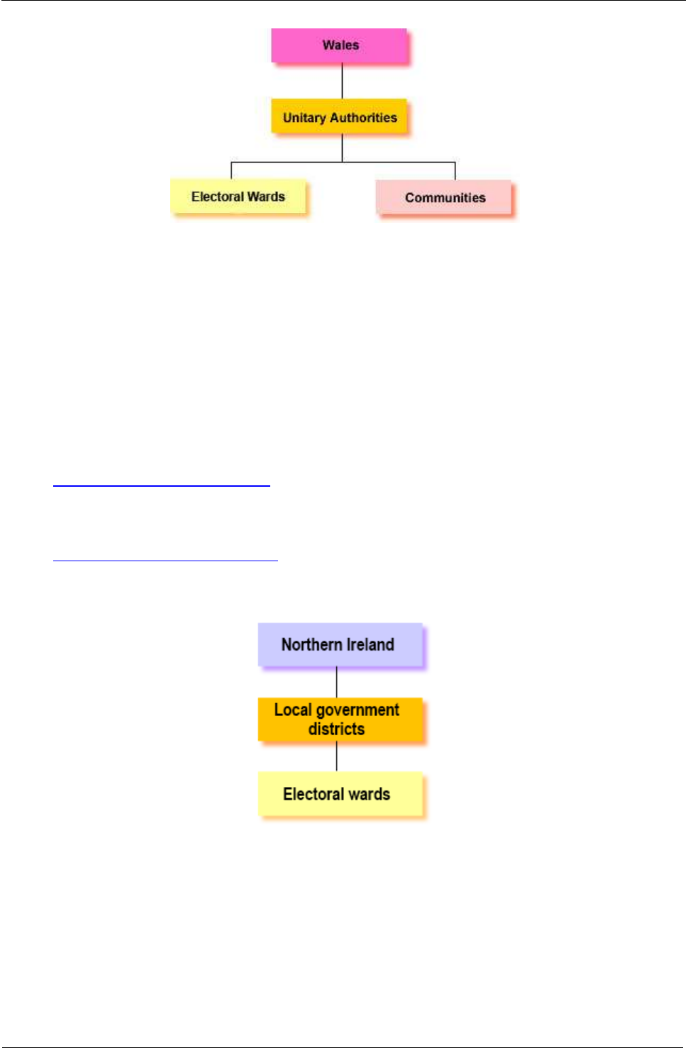
2.5 Wales
Wales is subject to the administration of both the UK Government in Westminster and also the
National Assembly for Wales in Cardiff. The UK Government retains responsibility for non-devolved
topics, but the National Assembly has powers to make legislation in devolved topics such as health,
education, agriculture, local government, environment, and culture. Wales is subdivided into 22
unitary authorities (UA), which in turn are divided into electoral wards and communities.
A Beginner's Guide to UK Geography
2017 v1.3
Office for National Statistics
18
2.5.1 Unitary Authorities (UA)
Following the 1994 Local Government (Wales) Act, the 8 counties and 37 districts of Wales were
replaced in April 1996 by 22 UAs with responsibilities for all aspects of local government. Eight of the
UAs (Bridgend, Cardiff, Merthyr Tydfil, Neath Port Talbot, Newport, Torfaen, Wrexham and Rhondda
Cynon Taf) have county borough status (reflecting their existence as large population centres), whilst
the other 14 have county status (reflecting at least some aspect of rurality). These definitions do not,
however, affect authority structures. UAs are built from electoral wards. They are also divided into
communities.
2.5.2 Electoral Wards
See 2.3.6 Electoral Wards/Divisions
2.5.3 Communities
See 2.3.7 Parishes and Communities
2.6 Northern Ireland
Northern Ireland is subject to the administration of both the UK Government in Westminster and the
Northern Ireland Executive in Belfast. The UK Government retains responsibility for a number of
issues, such as international relations, policing, and justice. The Northern Ireland Executive, however,
has powers in a number of areas, such as health, education, industry, agriculture, environment, and
culture. Northern Ireland is divided into 11 local government districts (LGD) – formerly district council
areas (DCA). Each LGD is subdivided into electoral wards.

A Beginner's Guide to UK Geography
2017 v1.3
Office for National Statistics
19
2.6.1 Local Government Districts (LGD)
At the last reorganisation in April 2015, Northern Ireland's 26 single-tier district council areas (DCA)
were replaced by 11 LGDs. The LGDs are unitary administrations responsible for all areas of local
government, but their remit is more limited than that of LADs in the rest of the UK. The six historic
counties (Antrim, Armagh, Down, Fermanagh, Londonderry and Tyrone) are still referred to generally
but do not constitute a level of administration. LGDs are built from electoral wards.
2.6.2 Electoral Wards
See 2.3.6 Electoral Wards/Divisions
3. Census Geography
The UK Census is undertaken every 10 years, with the most recent being on 27 March 2011. The main
geographies directly associated with the Census are Output Areas (OA) – the base unit for Census
data releases – and Super Output Areas (SOA).
3.1 The UK Censuses
The Censuses collect population and other statistics essential to those who have to plan and allocate
resources. Major customers include departments of national and local government, and providers of
services such as health and education. Although the Census occurs simultaneously in all parts of the
UK, the responsible body in England and Wales is the Office for National Statistics (ONS), in Scotland
the National Records of Scotland (NRS) and in Northern Ireland the Northern Ireland Statistics and
Research Agency (NISRA). Census data can be produced for most geographies by best-fitting from
OA to the required output geography current on 31 December 2011.
Further Information and Census Geography Products
England – Information on the Census
We offer a range of 2011 Census geography products for England and Wales on the Open
Geography portal including:
Digital boundaries and centroids, for OAs and SOAs, which you can use in your own geographical
information systems to carry out spatial analysis or web mapping.
Lookup tables showing OA aggregation to higher geographies and comparison between 2001 and
2011 statistical geographies.
Reference (outline) PDF maps showing the areas used to present Census statistics.
For information regarding the Census products for Scotland and Northern Ireland, please refer to the
relevant organisation:
Scotland – Information on 2011 Census
Census in Northern Ireland
3.2 Built-up Areas (BUA) and Built-up Area S ub-divisions (BUASD)
BUAs and BUASDs were created as part of the 2011 Census outputs. This data provides information
on the villages, towns and cities where people live, and allows comparisons between people living in

A Beginner's Guide to UK Geography
2017 v1.3
Office for National Statistics
20
built-up areas and those living elsewhere. Census data for these areas (previously called urban areas)
has been produced every 10 years since 1981. A new methodology to capture the areas was used in
the 2011 version, but it still follows the rules used in previous versions so that results are broadly
comparable. BUAs are defined as land with a minimum area of 20 hectares (200,000 square metres),
while settlements within 200 metres of each other are linked. The BUAs and BUASDs are available as
boundary sets, name and codes and lookup files, which can be downloaded from the Open
Geography portal, along with the BUA User Guide.
You will need to be aware that there are areas included in the boundary datasets but not in the
Census tables. These BUAs and BUASDs have been identified as areas that have not been allocated a
population. In most cases, this is because they do not have any residential buildings – for example,
industrial estates, airports, theme parks, etc. There are 337 BUAs where population has not been
allocated (305 in England and 32 in Wales) and 133 BUASDs where population has not been
allocated (123 in England and 10 in Wales). The names and codes of these areas have been included
in documentation that accompanies the files.
3.3 Enumeration Districts (ED)
EDs were used for data collection for the 2001 Census and for both data collection and outputs for
the 1991 Census. There was no requirement to produce a set of 2011 EDs as households in England
and Wales received their 2011 Census questionnaire through the post and returned them by post or
online. Only communal establishments (for example, care homes) and special groups (such as
travellers) had their Census questionnaires hand-delivered. Individuals within communal
establishments also had the option of completing their questionnaire online following the same
process as that used by households.
3.3.1 2011 EDs
There were no official EDs created for the 2011 Census. Households in England and Wales received
their census questionnaire through the post and returned them by post or online. Only communal
establishments (for example, care homes), and special groups (such as travellers) had their census
questionnaires hand-delivered. Individuals within communal establishments also had the option of
completing their questionnaire online following the same process as that used by households.
3.3.2 2001 EDs
EDs were used for data collection for the 2001 Census. England and Wales had 116,895 EDs, the
majority of which were different from their 1991 equivalents, with an average size close to 200
households (450 people). Scotland had 6,987 EDs with an average size of 328 households (730
people). Northern Ireland had 2,591 EDs with an average size of 260 households (650 people). In
addition, there were special enumeration districts (SED) for communal establishments with the
capacity to house over 100 people. SEDs included prisons, hospitals, nursing homes, halls of
residence, large hotels and military bases. EDs sometimes straddled 2001 administrative boundaries
and were deemed unsuitable for data output and were used for data collection only. Output Areas
(OA) were introduced for data output.
3.3.3 1991 EDs
1991 EDs were used for both data collection and output. Their size and shape was primarily
determined by the requirements of data collection, but they fitted the administrative boundaries
current at the time.

A Beginner's Guide to UK Geography
2017 v1.3
Office for National Statistics
21
3.4 Output Areas (OA)
OAs have been used for data collection and output of Census data since the 2001 Census. OAs were
created for Census data, specifically for the output of census estimates. The OA is the lowest
geographical level at which census estimates are provided. They were introduced in Scotland at the
1981 Census and in all the countries of the UK at the 2001 Census.
3.4.1 2001 OAs
2001 Census OAs were built from clusters of adjacent unit postcodes but as they reflected the
characteristics of the actual census data, they could not be generated until after data processing.
They were designed to have similar population sizes and be as socially homogenous as possible
based on tenure of household and dwelling type (homogeneity was not used as a factor in Scotland).
Urban/rural mixes were avoided where possible; OAs preferably consisted entirely of urban
postcodes or entirely of rural postcodes. They had approximately regular shapes and tended to be
constrained by obvious boundaries such as major roads. OAs were required to have a specified
minimum size to ensure the confidentiality of data.
In England and Wales, 2001 Census OAs were based on postcodes as at Census Day and fit within
the boundaries of 2003 statistical wards and parishes. If a postcode straddled an electoral
ward/division or parish boundary, it was split between two or more OAs. The minimum OA size was
40 resident households and 100 resident people, but the recommended size was rather larger at 125
households. These size thresholds meant that unusually small wards and parishes were incorporated
into larger OAs. There were 165,665 OAs in England and 9,769 OAs in Wales.
OAs for Northern Ireland had the same minimum size, as for England and Wales, but were based on
postcodes as at January 2000. The OAs fit within the 2001 electoral ward boundaries. There were
5,022 OAs in Northern Ireland.
In Scotland, OAs were based on postcodes as at December 2000 and related to 2001 wards.
However, the OAs did not necessarily fit inside ward boundaries where confidentiality issues made it
more appropriate to straddle boundaries. The minimum OA size was 20 resident households and 50
resident people, but the target size was 50 households. There were 42,604 OAs in Scotland.
3.4.2 2011 OAs
England and Wales:
Maintaining stability as far as possible was key for the 2011 Census. Some modification of the
previous OAs and Super Output Areas (SOA) was necessary where a significant need had occurred
since 2001 (see 'Modification of OAs' below). The total number of 2011 OAs was 171,372 for England
and 10,036 for Wales. This means that 2.6% of the 2001 OAs were changed as a result of the 2011
Census. Significant points of interest for the 2011 Census were that OAs and SOAs aligned to local
authority district (LAD) boundaries, including those that changed between 2003 and 2011, and also
at the border between Scotland and England. 161 OAs and SOAs were modified because they were
considered unsuitable for reporting statistics. The average population in an OA increased from 297 in
2001 to 309 in 2011. Boundaries are available clipped to the coastline, for mapping, as well as to
extent of the realm, for geographic information systems and analysis. All OAs have unique 9-
character codes, in line with all statistical geographies.
Boundaries are freely available under the terms of the Open Government Licence.

A Beginner's Guide to UK Geography
2017 v1.3
Office for National Statistics
22
Scotland:
2011 OAs for Scotland were released in September 2013 and there are 46,351 of them.
Northern Ireland:
In Northern Ireland, the 2001 OAs were merged to produce new 2011 'small areas' that fit within
SOAs. There are 4,537 small areas.
3.4.3 Modification of OAs in England and Wales
Changes in OA and SOA boundaries for the 2011 Census took place when:
significant population change had occurred since the 2001 Census
LAD boundaries had changed between 2003 and 2011
OA boundaries had been realigned to the England/Scotland border, as should have happened for
2001
areas were independently assessed as lacking social homogeneity when they were created for 2001
Redesigned OAs and SOAs:
do not align to ward and parish boundaries that changed after 2003
do not necessarily align to real-world features
contain more than 100 persons and 40 households, even if they contain one or more communal
establishments
A number of geography reference data products are available from the Open Geography portal.
These include:
digital boundaries of the modified OAs, LSOAs, MSOAs and Workplace Zones (WZ)
lookups between the 2001 and 2011 OAs, where they have changed
lookups between OAs, postcodes and a number of census output geographies
3.4.3.1 Thresholds used in Modification (England and Wales)
We ran a process to automatically modify those OAs and SOAs whose 2011 Census populations had
significantly grown or declined since 2001. If OAs breached a specified upper population threshold
(their populations became too large), they were split into two or more OAs using postcodes as
building blocks.
Splits were applied where:
an OA population exceeded 625 people or 250 households
an LSOA population exceeded 3,000 people or 1,200 households
an MSOA population exceeded 15,000 people or 6,000 households
There may be exceptions where an area that was above the population threshold could not be split.
Where splits occur, building blocks of postcodes were used to create two or more new OAs
(constrained to the boundary of the original OAs from which they were created). The use of postcode
building blocks is consistent with the methodology applied in 2001, and enabled production of
postcode to OA lookups. Where OAs or SOAs breached a specified lower population threshold (their

A Beginner's Guide to UK Geography
2017 v1.3
Office for National Statistics
23
population became too small and is therefore potentially disclosive), they were merged with an
adjacent OA or SOA.
Merges were applied where:
an OA population fell below 100 people or 40 households
an LSOA population fell below 1,000 people or 400 households
an MSOA population fell below 5,000 people or 2,000 households
Using splits and merges of the existing OA and SOA hierarchy, rather than a total redesign, allows
better linkage and comparison between statistical outputs for the 2001 Census and 2011 Census.
3.5 Statistical Wards, CAS Wards and ST Wards
3.5.1 Statis tical Wards
See 2.3.6.2 Statistical Wards
3.5.2 Census Area S tatistics (CAS) Wards
See 2.3.6.3 Census Area Statistics (CAS) Wards
3.5.3 Standard Table (ST) Wards
See 2.3.6.4 Standard Table (ST) Wards
3.6 Super Output Areas (SOA)
SOAs were designed to improve the reporting of small area statistics and are built up from groups of
OAs. Statistics for Lower Layer SOAs (LSOA) and Middle Layer SOAs (MSOA) were originally released
in 2004 for England and Wales. Scotland also released statistics for Data Zones (DZ) - the equivalent
to LSOAs - in 2004 and Intermediate Geographies (IG) – the equivalent to MSOAs - in 2005. Northern
Ireland introduced LSOAs in 2005 but do not have MSOAs.
3.6.1 2011 SOAs
Maintaining stability as far as possible was key for the 2011 Census. LSOAs and MSOAs that were
created following the 2001 Census continue to exist unless a significant population change occurred
between 2001 and 2011, and household minimum and maximum thresholds were breached.
Simplistically, where populations became too big, the LSOAs/MSOAs were split into two or more
areas; where populations became too small, the LSOAs/MSOAs were merged with an adjacent one.
Responses to the Output Geography Consultation from December 2009 to March 2010 were also
considered in the redesign of OAs and SOAs. Consequently, the total changes across the OA
hierarchy were no more than 5% overall.
Population and household minimum and maximum thresholds for SOAs in England and Wales:
Geography
Minimum
population
Maximum
population
Minimum number
of households
Maximum number of
households
LSOA
1,000
3,000
400
1,200

A Beginner's Guide to UK Geography
2017 v1.3
Office for National Statistics
24
Geography
Minimum
population
Maximum
population
Minimum number
of households
Maximum number of
households
MSOA
5,000
15,000
2,000
6,000
The total of 2011 LSOAs and MSOAs for the UK:
Geography
England
Wales
Scotland
Northern Ireland
LSOA
32,844
1,909
6,976
890
MSOA
6,791
410
1,279
N/A
DZs and IGs in Scotland were reviewed following the 2011 Census and minor changes were
implemented, similar to those in England and Wales.
You can download this information, along with the names and codes, from the Open Geography
portal; the boundaries are available from the National Records of Scotland (NRS) or the Scottish
Neighbourhood Statistics website.
SOAs in Northern Ireland have had minimal changes in three areas, but the total number of SOAs has
not changed since the 2001 Census. Further details of Northern Ireland SOAs can be found on the
NISRA website.
SOAs align to local authority district (LAD) boundaries including those that changed between 2003
and 2011, and also align at the border between Scotland and England. The boundaries are available
clipped to the coastline, for mapping, as well as to the extent of the realm, for geographic
information systems and analysis. All SOAs have unique 9-character codes, in line with all statistical
geographies.
As part of the 2011 Census OA hierarchy, there are 94 Upper Layer SOAs (USOA) in Wales but none
in England.
Boundaries remain freely available under the Open Government Licensing terms.
3.6.2 2001 SOAs
The total of 2001 LSOAs and MSOAs for the UK:
Geography
England
Wales
Scotland
Northern Ireland
LSOA
32,482
1,896
6,505*
890
MSOA
6,781
413
1,235**
N/A
* Data Zone (DZ)
** Intermediate Geography (IG)
2001 SOAs were initially introduced for use on the now-defunct Neighbourhood Statistics website,
but later became the standard units for presenting local statistical information across National
Statistics. Local statistics were produced at electoral ward/division level before OAs and SOAs were
introduced. This had drawbacks because electoral wards/divisions vary greatly in size, from fewer
than 100 residents to more than 30,000. This was not ideal for nationwide comparisons, and also

A Beginner's Guide to UK Geography
2017 v1.3
Office for National Statistics
25
meant that some data could not be released for smaller wards due to disclosure issues and the need
to protect the confidentiality of individuals.
DZs and IGs in Scotland were smaller in population size than their LSOA and MSOA counterparts in
England and Wales. DZs had a minimum population of 500 and IGs had a minimum population of
2,500.
In Northern Ireland, LSOAs had a population threshold of between 1,300 and 2,800.
Further Information and Census Geography Products
We offer a range of 2011 Census geography products for England and Wales including:
digital boundaries and centroids, for OAs and SOAs, which users can use in their own geographical
information systems to carry out spatial analysis or web mapping
lookup tables showing OA aggregation to higher geographies and comparison between 2001 and
2011 statistical geographies
reference (outline) PDF maps showing the areas used to present census statistics
For further information, please contact ONS Geography Customer Services.
For information regarding the census products for Scotland and Northern Ireland, please refer to the
relevant organisation:
NISRA: Census Products
National Records of Scotland (NRS): Census Products
3.7 Workplace Zones (WZ)
WZs are an output geography for England and Wales that has been produced using workplace data
from the 2011 Census. It was extended to Scotland and Northern Ireland in late 2015. They are
designed to supplement the Output Area (OA) and Super Output Area (LSOA and MSOA)
geographies that were introduced with the 2001 Census. OAs were originally created for the analysis
of population statistics using residential population and household data. As a result, they are of
limited use for workplace statistics as there is no consistency in the number of workers or businesses
contained within an OA. OAs are designed to contain consistent numbers of persons, based on
where they live, WZs are designed to contain consistent numbers of workers, based on where people
work. This means that WZs are more suitable for disseminating workplace-based statistics and
outputs. WZs have been created by splitting and merging the 2011 OAs to produce a workplace
geography that contains consistent numbers of workers. The WZs align to the existing OA hierarchy.
They have been constrained to MSOA boundaries to provide consistency between the OA and WZ
geographies, and to allow comparison of the 2001 and 2011 Census workplace outputs at the MSOA
level. There are 50,868 WZs in England and 2,710 in Wales.
More information on their purpose, origin, development and production can be found in the
document 'Workplace Zones: A new geography for workplace statistics', which is available on the
Open Geography portal along with boundaries and lookup files.
The research on creating algorithms for the creation of the WZs was carried out by the University of
Southampton, in collaboration with ONS.

A Beginner's Guide to UK Geography
2017 v1.3
Office for National Statistics
26
For further information on Scottish WZs, please contact NRS Geography Customer Services.
3.8 Census Merged Areas
Some 2011 Census areas were merged for disclosure reasons.
3.8.1 Census Merged Counties and Local Authority Districts (LAD)
Due to the number of variables included, some 2011 Census tables were disclosive at LAD level if the
LAD had a relatively small population. The two affected LADs were Isles of Scilly Unitary Authority
(UA) and the City of London. To prevent disclosure these were amalgamated with Cornwall UA and
the London borough of Westminster respectively. As these Census tables also included county/UA
information and Isles of Scilly appeared in both the LAD and county/UA layers, it was necessary to
amalgamate it with Cornwall at the county/UA level as well.
3.8.2 Census Merged Wards
Census merged wards are a frozen geography created specifically for 2011 Census Detailed
Characteristics (DC) tables. DC tables have a higher minimum population threshold than other tables
as the more detailed information carries an increased risk of identifying persons or households using
the lower population threshold applied to other tables. If the Census estimate for a ward falls below
1,000 persons or 400 households, the ward is merged with a neighbouring ward, or wards, until the
aggregated Census estimate for the merged wards is above both the minimum person (1,000) and
household (400) threshold.
3.9 Travel to Work Areas (TTWA)
For those involved in labour market analysis and planning, it is useful to be able to use data for
labour market areas. To meet this need, labour market areas are defined to reflect areas where the
bulk of the resident population also work within the same area.
Defining these areas requires the analysis of commuting patterns; we have worked with Newcastle
University to apply a complex allocation process in order to define a set of travel to work areas
(TTWA) for the whole of the UK. The current criteria for defining TTWAs is that generally at least 75%
of an area's resident workforce work in the area and at least 75% of the people who work in the area
also live in the area. The area must also have a working population of at least 3,500. However, for
areas with a working population in excess of 25,000, self-containment rates as low as 66.7% are
accepted. TTWA boundaries are non-overlapping, are contiguous and cover the whole of the UK.
TTWAs do cross national boundaries, although no account is taken of commuting between Northern
Ireland and the Republic of Ireland. The resulting pattern is that although the definitive minimum
working population in a TTWA is 3,500, many areas are much larger – indeed, the whole of London
and the surrounding area forms one TTWA.
3.9.1 2011 TTWAs
The 228 TTWAs forming the 2011 TTWAs, covering the whole of the UK, were defined in 2015 using
2011 Census commuting flow data, indicating home and workplace address. The TTWAs are based
on aggregations of Lower Layer Super Output Areas (LSOA) in England and Wales, Data Zones (DZ)
in Scotland, and Super Output Areas (SOA) in Northern Ireland and in some cases span country
borders. There are six cross-border TTWAs, 149 in England, 18 in Wales, 45 in Scotland and 10 in
Northern Ireland.

A Beginner's Guide to UK Geography
2017 v1.3
Office for National Statistics
27
Further Information
Please note that following the release of the 2011 TTWAs on 19 August 2015, a small number of
TTWA geography codes have been revised. All the published documentation has been updated
where applicable to reflect these changes.
Travel to Work Areas Guidance and Information
Map of 2011 Travel to Work Areas
Article outlining the changes between the 2001 and 2011 TTWAs
2011 TTWA boundaries for use in GIS, names and codes and lookup files are available to download
from the Open Geography portal.
3.9.2 2001 TTWAs
The 243 2001 TTWAs (8 cross-border, 158 in England, 20 in Wales, 46 in Scotland and 11 in Northern
Ireland) were defined in 2007 using 2001 Census commuting flow data, indicating home and
workplace address. The TTWAs are based on aggregations of LSOAs in England and Wales, DZs in
Scotland, and SOAs in Northern Ireland, and in some cases span country borders.
Further Information
Map of 2001 Travel to Work Areas
Travel to Work Areas Guidance and Information
2001 TTWA boundaries for use in GIS, names and codes and lookup files are available to download
from the Open Geography portal.
4. Electoral Geography
Electoral geography in the UK is complex due to the different electoral systems and different areas
used to elect members to various levels of administration. The hierarchy of electoral wards/divisions,
Westminster parliamentary constituencies and European Electoral Regions (EER) is the only electoral
structure that covers the whole of the UK.

A Beginner's Guide to UK Geography
2017 v1.3
Office for National Statistics
28
4.1 European Electoral Regi ons (EER)
EERs are used to elect Members of the European Parliament (MEP) to the European Parliament in
Strasbourg. Prior to 1999, the UK operated a ‘first-past-the-post’ system based on groupings of
Westminster constituencies (excepting Northern Ireland, which already had a proportional system). In
the 1999 election, a proportional representation system of multi-member electoral regions was
introduced to the rest of the UK. It was used in 2004, 2009 and 2014. The number of MEPs in each
region varies with population size, resulting in the following national distribution:
Country
Number of EERs
Number of MEPs (2014 election)
England
9
60
Scotland
1
6
Wales
1
4
Northern Ireland
1
3
United Kingdom Total
12
73
Notes:
1. England’s electoral regions are based on the boundaries of the regions (former government office
regions (GOR)) at the start of the year of an election.
2. The next Euro-election is due in 2019.
4.2 Westminster Parliamentary Constituencies
Westminster parliamentary constituencies are the areas used to elect Members of Parliament (MP) to
the House of Commons - the primary legislative chamber of the UK, located in Westminster, London.
At the latest General Election, there were 650 constituencies. The number of MPs in each constituent
country of the UK is: 533 in England, 59 in Scotland, 40 in Wales and 18 in Northern Ireland.
4.2.1 Boundary Changes and Geographic Constitution
Constituency boundaries are determined by the Boundary Commissions (one each for England,
Scotland, Wales and Northern Ireland). The commissions are required to undertake a general review
every 8 to 12 years to ensure electoral equality – that is, that the sizes of the electorates in each
constituency are as similar as possible (currently about 70,000 electors, typically reflecting a total
population of 90,000). General reviews normally lead to large-scale changes, but the commissions
may also carry out localised interim reviews. These can occur at any time, but usually only lead to
minor changes. Constituencies are generally based on whole or part local authority districts (LAD)
unless there is a strong case to straddle boundaries – each case is decided on its merits;
constituencies may not, however, split electoral wards/divisions.
Although constituencies are defined to reflect wards at the time of review, the changes are not
implemented until the subsequent general election. Accordingly the constituencies used in the 1997
general election were mostly based on the April 1994 ward boundaries used for the fourth general
review. However, a small number of constituencies used April 1995 boundaries, and some were
affected by subsequent interim reviews. The 1997 constituencies were used again in 2001, except for
some mostly minor boundary changes in London and south-east England resulting from interim
reviews. In 2005, the boundaries were retained, with the exception of the Scottish Westminster
parliamentary constituencies. These were reduced in number from 72 to 59.

A Beginner's Guide to UK Geography
2017 v1.3
Office for National Statistics
29
The fifth general review was completed in 2007. It led to major change in England and Wales; the
majority of constituency boundaries used at the May 2005 general election were changed. The
Westminster parliamentary constituencies boundaries are based on the fifth Periodical Parliamentary
Review that was promulgated in July 2007 (defined in terms of wards as at 12 April 2005). An
amending order in July 2008 affected the Welsh Westminster parliamentary constituency boundaries
and a further amendment order (operative 18 March 2009) realigning the boundaries for Daventry,
South Northamptonshire, Somerton and Frome and Wells has also been applied. There were no
changes for the May 2015 and June 2017 general elections.
In Northern Ireland, the Commission's Fifth Periodical Report on Parliamentary Constituencies
outlined changes to and the composition of constituencies. In practice, the new parliamentary
constituencies are not very different to their predecessors. As before, there are 18 constituencies, all
retaining the same name. In the main, the boundary amendment process has involved the
reassigning of existing electoral wards from one constituency into a neighbouring constituency. The
only exception concerns Derryiaghy ward within Lisburn City Local Government District (LGD), which
previously resided entirely within Lagan Valley county constituency. It has now been split into 2
separate wards – Derryiaghy (North) and Derryaghy (South), the former is now included in Belfast
West borough constituency, the latter remaining where it was.
4.2.2 County and Borough Constituencies
Sometimes constituencies are referred to as either borough (burgh in Scotland) or county
constituencies. Borough constituencies are predominantly urban whereas county constituencies are
partly or mostly rural. Definitions are allocated by the Boundary Commissions and affect candidates’
election expenses and also who can be the constituency's returning officer. If used, the designation is
suffixed to the constituency name and is generally abbreviated: 'BC' for borough constituency, 'CC'
for county constituency.
Further Information
You can download several products including names and codes, lookups, boundaries and maps from
the Open Geography portal.
Find your MP
4.3 Devolved Parliaments
Referendums held in 1997 led to the creation of devolved administrations for Scotland and Wales,
and in 1998 for London. These administrations had been established by 2000. Also in 1998, the
Northern Ireland Good Friday Agreement referendum led to the creation of a new Northern Ireland
Assembly. All four administrations have their own parliaments and electoral systems as described
below. Some of them use the same constituencies as the UK (Westminster) Parliament whilst others
use their own. Please note that we do not maintain constituency listings specific to the devolved
parliaments.
4.3.1 Scottish Parliament
The Scottish Parliament, founded in 1999 and sitting in Edinburgh, has a total of 129 MSPs (Members
of the Scottish Parliament). Of these MSPs, 73 are elected directly from single-member
constituencies. The remaining 56 are elected via a proportional system using 8 electoral regions that
coincide with the 8 pre-1999 European Parliament seats. The Scottish Parliament appoints a First

A Beginner's Guide to UK Geography
2017 v1.3
Office for National Statistics
30
Minister, who in turn appoints other ministers to form the devolved government known as the
Scottish Government. The Government is accountable to the Parliament.
Members of Scottish Parliament
4.3.2 National Assembly for Wales
This was also founded in 1999 and sits in Cardiff with a total of 60 AMs (Assembly Members). Of
these, 40 AMs are elected directly from single-member constituencies. The remaining 20 are elected
via a proportional system using five electoral regions that coincide with the five pre-1999 European
Parliament seats (as with the Scottish system). The National Assembly for Wales appoints a Presiding
Officer, who in turn appoints other Assembly ministers to form the Assembly Cabinet. The Cabinet is
the main decision-making body of the Assembly and is accountable to it. Changes were made to the
boundaries of the Assembly constituencies and electoral regions in May 2007.
National Assembly for Wales Constituencies
4.3.3 Northern Ireland Assembly
From 1921 to 1972, Northern Ireland had its own Parliament, but as a result of the Troubles, direct
rule from Westminster was implemented in 1972. The 1998 Good Friday Agreement re-established
the principle of home rule, with a new 108-member Assembly that was elected via a proportional
system in each of the existing 18 Westminster constituencies. After an initial delay caused by
disputes over the appointment of ministers, the Assembly first sat in 1999, in Stormont Castle,
Belfast. Assembly members are known as MLAs (Members of the Legislative Assembly) and the
government of Northern Ireland is known as the Northern Ireland Executive. The Assembly appoints
the First Minister and Deputy First Minister. Each political party in Northern Ireland is allocated a
number of government departments, reflecting the size of that party's representation in the
Assembly, and the respective Executive ministers are selected by that party. The Executive is
accountable to the whole Assembly.
Northern Ireland Assembly Constituencies
4.3.4 London Assembly
Prior to its abolition in 1986, the administrative area of Greater London was controlled by the Greater
London Council (GLC). Thereafter, the 32 boroughs and the City of London Corporation became
single-tier administrations. However, in 1998 a referendum revealed a large majority in favour of
recreating a single authority to deal with London-wide issues. Consequently the new Greater London
Authority (GLA) was established in 2000. The elected components of the GLA are the Mayor of
London and the London Assembly. The Mayor is elected directly, and London Assembly elections
occur at the same time. The Assembly has 25 members, 14 of whom are elected directly from
constituencies formed from groupings of either two or three London boroughs, and 11 of whom are
elected using a city-wide proportional system. The Assembly works together with the Mayor and also
has the role of regulating and scrutinising the Mayor's decisions.
London Assembly Members

A Beginner's Guide to UK Geography
2017 v1.3
Office for National Statistics
31
4.4 Regional Government
In 2004 legislation was passed to allow referenda on regional government in the English Government
Office Regions (GOR). On 4 November 2004, a referendum was held in the north east, which
produced a major 'no' vote. In consequence, the plans for referenda elsewhere were dropped.
4.5 Local Authorities and Smaller Units
Councillors in UK districts and unitary administrations are elected to represent the same electoral
wards/divisions that are used to constitute Westminster parliamentary constituencies. County
councillors, however, represent larger 'county electoral divisions', which are not necessarily based on
the electoral wards used at district level. Parish, town or community councils may also use their own
small-scale electoral areas; however we do not maintain information on these.
5. Health Geography
The organisation of the NHS is different in each of the four countries of the UK.
5.1 English Health Geography
Health structure after 1 April 2015
On 1 April 2015 the 25 NHS area teams (NHSAT) merged and were renamed to form 13 regions
(geography) (NHSRG). On 1 April 2016 the number of NHSRGs increased to 14 and in May 2017 they
were renamed to NHS England (Region, Local Offices) (NHSRLO). At the same time, the four NHS
commissioning regions (NHSCR) were renamed to NHS England (Regions) (NHSER). Cancer Alliances
and National Cancer Vanguards (CALNCV), between them covering all of England were also
introduced from 2015. In 2016, 44 Sustainability and Transformation Partnerships also covering all of
England were introduced.
April 2013 – 1 April 2015
On 1 April 2013, a new structure of health geographies in England came into force. The new structure
consisted of clinical commissioning groups (CCG), NHSATs and NHSCRs.
There were four NHSCRs in England.
There were 25 NHSATs in England, responsible for GP and dental services, pharmacy services and
certain aspects of optical services. Ten of the teams lead on specialised commissioning across
England and a smaller number of NHSATs carry out the direct commissioning of prison and military
health.
The 209 CCGs are NHS organisations set up by the Health and Social Care Act 2012 to organise the
delivery of NHS services in England. They are clinically led groups that include all of the general
practice groups in their geographical area. The aim of this is to give GPs and other clinicians the
power to influence commissioning decisions for their patients. CCGs are overseen by NHS England
(including its regional offices and area teams). These structures manage primary care commissioning,
including holding the NHS contracts for GP practices. CCGs have boundaries that are coterminous
with those of Lower Layer Super Output Areas (LSOA).
This structure replaced the strategic health authorities (SHA) and primary care organisations (PCO)
that were in operation between July 2006 and April 2013.

A Beginner's Guide to UK Geography
2017 v1.3
Office for National Statistics
32
July 2006 – March 2013
Health administration in England was significantly restructured in 2006. On 1 July 2006 the number
of SHAs was reduced from 28 to 10. The boundaries of the new SHAs were coterminous with regions
(former GORs), with the exception of the South East region, which comprises two SHAs that were
constituted from groups of local authority districts (LAD). SHAs reported to the Department of
Health. On 1 October 2006 the number of PCOs was reduced from 303 to 152. The PCOs were made
up of 148 primary care trusts (PCT) and 4 care trusts (CT). CTs had similar duties to PCTs, except that
the former had responsibilities for social care as well as health care. The majority of the new PCOs
were defined in terms of LADs.
Of the 152 PCOs:
130 comprised of one or more whole LADs.
16 comprised of one or more whole LADs plus whole wards.
3 comprised of only whole wards within a single LAD.
2 comprised of one or more whole LADs and part wards (that is, whole parishes).
1 comprised of whole and part wards (that is, whole parishes) within a single LAD.
As at 15 April 2011 there were 146 PCTs and five CTs in England, after Solihull CT reverted to a PCT.
There were also minimal changes on 1 April 2010, when two PCTs were merged into one and another
PCT converted to a CT. PCOs reported to the SHAs.
July 2003 – June 2006
As at 1 July 2003, there were 28 SHAs, which were constituted by groups of LADs and managed the
performance of the PCOs. As at 1 October 2005 there were 303 PCOs, including 299 PCTs and four
CTs based on the PCT model (this meant that they fulfilled all PCT functions and also delivered the
health services usually provided by local authorities). The PCOs were (mostly) aligned with the
administrative boundaries existing at the time of the last major health reorganisation on 1 May 2002.
April 2002 – June 2003
During this period the directorates of health and social care (DHSC) formed an additional top layer to
the structure. There were four DHSCs, each covering 1 or more GORs. DHSCs were part of the
Department of Health rather than the NHS.
April 1999 – March 2002
A major reorganisation of English health geography occurred on 1 April 2002. Before this there were
eight health regional offices (HRO), which were part of the Department of Health, divided into
approximately 100 health authorities (HA), which in turn were split into PCOs. When PCOs were first
established in 1999, there were 481 primary care groups (PCG). However, by 2002, a significant
number had converted to PCTs. The numbers of both HAs and PCOs varied slightly through this
period.
Further Information
You can download several products including names and codes, lookups, boundaries and maps from
the Open Geography portal

A Beginner's Guide to UK Geography
2017 v1.3
Office for National Statistics
33
5.2 Welsh Health Geography
The structure after 1 October 2009
The current structure of health administration in Wales came into effect on 1 October 2009. A total of
22 local health boards (LHB) merged to form seven, with each LHB covering one or more Welsh
unitary authority (UA). These LHBs report to the three regional offices within the NHS Wales
Department of the National Assembly. LHB names and codes, and health area maps are available
from the Open Geography portal, although ONS does not hold names and codes for the regional
offices.
April 2003 – 1 October 2009
On 1 April 2003 there were 22 LHBs, one in each of the Welsh UAs. These LHBs reported to three
new regional offices (North Wales, Mid and West Wales, and South East Wales) within the NHS Wales
Department of the National Assembly.
The structure prior to 1 April 2003
Before 1 April 2003 Wales had five health authorities (HA), which reported to the NHS Wales
Department of the National Assembly. The HAs were divided into a total of 22 local health groups
(LHG), one in each of the Welsh UAs.
5.3 Scottish Health Geography
Scotland has 14 health boards (HB), which form the upper tier of the Scottish health care system and
report directly to the Scottish Government. The 34 community health partnerships (CHP) formed the
lower tier of the Scottish health administration until they were abolished on 31 March 2015. The HBs
were introduced in 1974 and are constituted by groups of the local government districts that existed
in Scotland between 1975 and 1996. There were originally 15 HBs. However, in April 2006 the Argyll
& Clyde HB was abolished and the area was absorbed by two existing HBs. In 2006 Scotland
introduced a second tier of health administration with the creation of 41 CHPs. Working with local
communities and other statutory and voluntary sector providers, CHPs played a key role in improving
health and reducing inequalities. They reported to the Scottish HBs. In April 2007, two Edinburgh
CHPs were merged, thereby reducing the total number of CHPs from 41 to 40. From March 2011
there was a reduction again in CHP numbers, with five Glasgow CHPs merging to form one CHP. In
April 2012, there was another reduction in the number of CHPs from 36 to 34. CHPs were abolished
on 31 March 2015 and were replaced on 1 April 2016 by 31 health and social care partnerships,
known as Integration Authorities (IA).
Further Information
You can download several products including names and codes, lookups, boundaries and maps from
the Open Geography portal.
5.4 Northern Ireland Health Geography
The structure after 1 April 2009
The current structure of health administration in Northern Ireland came into effect on 1 April 2009. A
single health and social care board (HSCB) replaced the four former health and social services boards

A Beginner's Guide to UK Geography
2017 v1.3
Office for National Statistics
34
(HSSB). The board focuses on commissioning, resource management, performance management and
improvement. It identifies and meets the needs of the local population through its five local
commissioning groups (LCG). LCGs are sub-committees of the HSCB. HSCB and LCG names and
codes files, along with health area maps are available on the Open Geography portal, but please note
that we do not hold names and codes for the health and social care trusts (HSCT).
The structure prior to 1 April 2009
Northern Ireland had four HSSBs, which reported to the Department of Health, Social Services and
Public Safety (DHSSPS) of the Northern Ireland Executive. HSSBs were introduced in 1973 and were
constituted from groups of local government districts (LGD). The HSSBs were named Northern,
Southern, Eastern and Western. In 2002 the HSSBs were subdivided into a total of 15 local health and
social care groups (LHSCG), responsible for the planning and delivery of primary and community care
in Northern Ireland. Each LHSCG covered one or more LGD, with the exceptions of the Belfast and
Strabane LGDs, which were each split between two LHSCGs.
6. Postal Geography
Royal Mail maintains a UK-wide system of postcodes to identify postal delivery areas. Most people
know their postcode, so we are able to use this as a geographic reference when collecting data. This
reference can then be related to any geographic unit used for statistical production, such as a local
authority district (LAD) or electoral ward.
6.1 Postcode Structure
Postcodes are alphanumeric references comprising an outward code of 2–4 characters and an inward
code of three characters. For example:
Outward Code
Inward Code
PO15
5RR
The postcode is structured hierarchically, supporting four levels of geographic unit:
Example
Geographic Unit
Number in UK
PO
Postcode Area
124
PO15
Postcode District
3,114
PO15 5
Postcode Sector
12,401
PO15 5RR
Unit Postcode
Approximately 1.75 million (live)
As at May 2017, these 1.75 million postcodes comprise approximately 1.6 million small user and 0.1
million large user postcodes (see below), including the Channel Islands and the Isle of Man.
6.2 Unit Postcodes
Unit postcodes are the base unit of postal geography and fall into two types:
Large user postcodes: allocated to single addresses receiving at least 500 mail items per day (e.g.
business addresses).

A Beginner's Guide to UK Geography
2017 v1.3
Office for National Statistics
35
Small user postcodes: collections of (usually) adjacent addresses. A single small user postcode may
contain up to 100 addresses, but 15 is a more typical number.
Note: it is possible for large buildings with many separate delivery points (for example, a tower block)
to have more than one unit postcode within the building.
6.3 Using Postcodes as a Geographic Reference
Postcodes form a compact geographic reference that the public and businesses are familiar with.
However, linking postal geographies to other geographic units is not always straightforward, as:
Postcode boundaries do not align with other geographic boundaries. If a unit postcode straddles a
ward (or other) boundary, you have to decide which ward to allocate the data to. Our postcode
directories take the grid reference of the postcode centroid and match this up to digital boundaries.
However, some addresses (and therefore data) will still inevitably be allocated to the 'other' area.
Postcode boundaries are subject to continuous change due to new addresses, single addresses
acquiring 'large user' status as mail volume increases, and the need to restrict the number of
addresses per unit to less than 100. Areas can also be recoded and postcodes can be re-used in a
different place after just two years. Continuous monitoring is therefore required to avoid data
misallocation.
6.4 Information on Postcode Recoding
Details of these larger reorganisations are provided in the Royal Mail's 'postcode update' series. The
most recent postcode updates, together with summary information on major postcode changes
since 1990, are available on the Royal Mail website.
Further Information
You can download a range of postcode products and lookups from the Open Geography portal.
7. Euros tat Geography
Eurostat is a Directorate-General of the European Commission and its main responsibilities are to
provide statistical information for the European Union (EU) and to promote the harmonisation of
statistical methods across its member states. The Eurostat geographies are designed to be consistent
across the EU for comparison purposes.
7.1 Nomenclature of Territorial Units for Statistics (NUTS) and Local
Administrative Units (LAU)
NUTS was created by the European Office for Statistics (Eurostat) as a single hierarchical classification
of spatial units used for the production of statistics across the European Union (EU). At the top of the
hierarchy are the individual member states of the EU; below that are NUTS levels 1 to 3, then LAU
levels 1 and 2. Note that LAUs were only introduced in July 2003; before this there had been five
NUTS levels.

A Beginner's Guide to UK Geography
2017 v1.3
Office for National Statistics
36
7.1.1 Relationship of NUTS Areas to UK Administrati ve Geographies
Within the UK, NUTS areas and LAUs are determined as shown in the tables below. NUTS areas are
stable and are only amended periodically. LAUs are amended annually to reflect administrative
boundary changes.
NUTS Level
1
2
3
England
regions (former GORs)
counties/groups of counties
counties/groups of
unitary authorities
(UA)
Scotland
Scotland
combinations of council areas (CA),
LECs and parts thereof
combinations of CAs,
LECs and parts thereof
Wales
Wales
groups of UAs
groups of UAs
Northern
Ireland
Northern Ireland
Northern Ireland
groups of local
government districts
(LGD)
Total in UK
12
37
139
LAU Level
1
2
England
local authority districts (LAD)/UAs
electoral wards/divisions
Scotland
combinations of CAs, LECs and parts thereof
electoral wards or, rarely, parts
thereof
Wales
UAs
electoral wards
Northern
Ireland
LGDs
electoral wards
Total in UK
415
c 10,000
7.1.2 Listings of Subdivisions of NUTS and LAU Areas
Please see Annex C for listings of the NUTS 2, 3 and LAU 1 subdivisions of the 12 NUTS 1 areas in the
UK.
Further Information
You can download several products including names and codes, lookups, boundaries and maps from
the Open Geography portal.
Link to Eurostat NUTS information
8. Address-level Geography
Each property in Great Britain is assigned a Unique Property Reference Number (UPRN). The UPRN is
the unique identifier for every spatial address in Great Britain. It provides a comprehensive, complete,
consistent identifier throughout a property's life cycle – from planning permission through to
demolition. Most people know their address, so we are able to use this as a geographic reference
when collecting data. This reference can then be related to any geographic unit used for statistical
production, such as a local authority district or electoral ward.

A Beginner's Guide to UK Geography
2017 v1.3
Office for National Statistics
37
8.1 UPRN Structure
The UPRN is numeric and can be up to 12 digits. As at January 2017, there are 37.3 million GB
UPRNs.
8.2 Using Addresses as a Geographi c Reference
The UPRN provides a fixed, non-moving point for the life of a property which makes geography
allocations stable and unchanging (subject to boundary changes).
Further Information
You can download a range of address products and lookups from the Open Geography portal.
9. Other Geographies
There are a number of other area units for which statistics are produced and for which we keep
listings of names and codes.
9.1 Local Education Authorities (LEA) and Education Authorities (EA)
Prior to 1 April 2009, LEAs were the bodies responsible for the local administration of state sector
education services in England and Wales. In those parts of England that still had counties, there was a
single LEA for each county, for example Cumbria LEA and Devon LEA. Otherwise there was one LEA in
each unitary authority (UA), metropolitan district or London borough. The Isles of Scilly also had their
own LEA. The statutory duties of LEAs are now undertaken by the director of children's services
within each local authority district (LAD). The director’s responsibilities also include Children's Social
Services (CSS).
The Children Act 2004 required every London borough, metropolitan district, top-tier local authority
(county) or UA in England to appoint a director of children's services. Additionally the Education and
Inspections Act 2006 includes a clause that allows for the future renaming of LEAs as local authorities
in all legislation, removing the anomaly of one LAD being known as a LAD, an LEA and a children's
services authority. Following on from this legislation, during the last round of local government
restructuring the then-current Department for Children, Schools and Families (DCSF) reviewed the
alignment of LEA and CSS codes. The outcome of the review was that CSS codes were replaced by
LEA codes (with effect from 1 April 2009). Although LEAs no longer exist, the coding structure has
been retained by the DCSF, which became the Department for Education (DfE) on 12 May 2010. For
more information, please contact DfE directly.
In Scotland education administration is the responsibility of local government (i.e. the councils in
each council area).
In Northern Ireland, local education is the responsibility of a single Education Authority (EA) that, on
1 April 2015, replaced the five education and library boards (Belfast, North Eastern, South Eastern,
Southern and Western) with five regional offices covering the same areas - one or more complete
local government districts.
Further Information
Department for Education

A Beginner's Guide to UK Geography
2017 v1.3
Office for National Statistics
38
9.2 National Parks
National parks are designated to conserve the natural beauty and cultural heritage of areas of
outstanding landscape value and also to promote opportunities for public understanding and
enjoyment of their special qualities. Although they are also subject to the usual structure of local
government, each one has its own National Park Authority (NPA) with responsibility for conservation,
planning, recreation management and fostering the social and economic wellbeing of local
communities.
The Broads is not a designated national park but is included in our products and statistics because it
is widely considered to be part of the national parks family. The Broads has its own special authority,
the Broads Authority, which is similar to the NPAs but with extra powers in relation to navigation.
There are currently 13 national parks in England and Wales, including the Broads. A total of 10 were
designated in the 1950s following the National Parks and Access to the Countryside Act 1949; the
Broads was created in 1989; and the New Forest in 2005. The South Downs National Park became
fully operational in April 2011, which also included becoming a statutory Planning and Access
Authority.
In Scotland the National Parks (Scotland) Act was passed in July 2000. The first Scottish national park,
Loch Lomond and the Trossachs, was established in July 2002, and Cairngorms National Park was
established in March 2003.
National parks cover approximately 10% of the total land area of England and Wales: 9% of England
and 20% of Wales. The two Scottish National Parks cover 7% of the land area of Scotland. They
attract around 100 million visitors a year.
Northern Ireland has no national parks at present.
Further Information
National Parks
Campaign for National Parks
Natural England
You can download a wide range of maps, including National Parks from the Open Geography portal.
9.3 Training and Enterprise Councils (TEC) , Local Enterprise Companies (LEC) and
Enterprise Regions (ER)
TECs, which existed across England and Wales, were government-funded bodies that aimed to foster
local economic growth and development and to encourage investment. They helped businesses set
up, grow and evolve; provided training and support for the unemployed; and funded vocational
qualifications. They also tried to co-ordinate educational provision to the future needs of local
industry.
In April 2001, however, the 72 English and four Welsh TECs were disbanded. A large part of their
remit was transferred to Local Learning and Skills Councils (LLSC) in England and to the regional
offices of Education and Learning Wales (ELWa) in Wales (see below). In April 2007 the ELWa regions

A Beginner's Guide to UK Geography
2017 v1.3
Office for National Statistics
39
were replaced by the Department for Children, Education, Lifelong Learning and Skills (DCELLS) (see
below). On 31 March 2010 the LLSCs were abolished in England and as yet have no replacement.
In Scotland, the equivalent of TECs were LECs, but these were abolished in September 2007 and
replaced with ERs. These are government-funded bodies that aim to foster local economic growth
and development in Scotland. There are six ERs covering the whole of Scotland.
No similar bodies exist in Northern Ireland.
9.4 Local Learning and Skills Councils (LLSC) , Education and Learning Wales
(ELWa) and Department for Children, Education, Lifelong Learning and Skills
(DCELLS)
In April 2001, the Learning and Skills Council (LSC) was responsible for funding and planning post-16
education and training in England; the equivalent bodies in Wales being the ELWa regions. These
organisations were established as a replacement for the Training and Enterprise Councils (TEC)
(although they also took on other responsibilities), and their aim was to increase the standards and
range of learning opportunities for businesses, communities and individuals. The LSC had 47 local
offices (LLSCs); the ELWa regions had four regional offices. LLSCs were based on local authority
district (LAD) boundaries. In practice this resulted in a variety of constitutions, including single
counties; county/unitary authority groupings; and groupings of unitary authorities, metropolitan
districts or London boroughs. The ELWa regions had the same boundaries as the former TECs; they
matched the National Assembly economic regions (NAER).
In April 2007 the Department for children, education, lifelong learning and skills (DCELLS) replaced
the ELWa regions. On 31 March 2010 the LLSCs were abolished in England and there are currently no
replacements.
9.5 Registration Districts
Registration districts are the areas for which records of births, deaths and marriages are kept. As at
31 December 2016, there are 175 registration districts in England and Wales (152 in England and 23
in Wales).
Further Information
The General Register Office (GRO) for England and Wales
You can download registration district names and codes and boundaries from the Open Geography
portal.
9.6 Local Enterprise Partnerships (LEP)
LEPs are voluntary partnerships between local authorities and businesses in England set up in 2011
by the Department for Business, Innovation and Skills to help determine local economic priorities
and lead economic growth and job creation within the local area. They carry out some of the
functions previously carried out by the regional development agencies which were abolished in
March 2012. To date there are 38 LEPs in operation.


A Beginner's Guide to UK Geography
2017 v1.3
Office for National Statistics
41
Annex A
Useful Downloads and Links
Open Geography portal
ONS Geography Customer Services
GSS Geography Policy
Open Government Licence
Boundary Commission for England
Boundary Commission for Northern Ireland
Boundary Commission for Scotland
Boundary Commission for Wales
Built-up Area (BUA) User Guide
CAS wards (UK) names and codes
Code History Database (CHD)
Department for Business Innovation & Skills
Department for Education: contact us
England - Information on the Census
Eurostat: NUTS information
General Register Office (GRO)
Guide to Presenting Statistics – General Principles
Guide to Presenting Statistics – Administrative Geographies
Guide to Presenting Statistics – Built Up Area Geographies
Guide to Presenting Statistics – Electoral Geographies
Guide to Presenting Statistics – Health Geographies
Guide to Presenting Statistics – Local Enterprise Partnerships
Guide to Presenting Statistics – Police Force Areas
Guide to Presenting Statistics – Super Output Areas
Guide to Presenting Statistics – 2011 Travel to Work Areas
Local Enterprise Partnerships website
Local Government Boundary Commission for England
Local Government Boundary Commission for Wales
Local Government Boundary Commission for Scotland
Local Government Boundary Commission for Northern Ireland
London Assembly Members
Members of Scottish Parliament
National Assembly for Wales Constituencies
National Parks
o Campaign for National Parks
National Records of Scotland (NRS): Census Products
National Records of Scotland (NRS): Home
Natural England
NISRA: Census Products
NISRA: SOAs
Northern Ireland Assembly Constituencies
Northern Ireland: Census
Office for National Statistics (ONS)
Regions: Map
Regions and their Constituent Counties and LADs: Map
Royal Mail website
Scotland: Information on 2011 Census

A Beginner's Guide to UK Geography
2017 v1.3
Office for National Statistics
42
Scottish Neighbourhood Statistics
Standard Table wards (E&W) names and codes
Statistical wards (E&W) names and codes
Travel to Work Areas Guidance and Information
o Article outlining the changes between the 2001 and 2011 TTWAs
o Map of 2001 Travel to Work Areas
o Map of 2011 Travel to Work Areas
Westminster Parliamentary Constituencies: Map
o Find Your MP
Workplace Zones: a new geography for workplace statistics

A Beginner's Guide to UK Geography
2017 v1.3
Office for National Statistics
43
Annex B
A Glossary of Terms
A B C D E F G H I J K L M N O P Q R S T U V W X Y Z
The geography glossary is a collection of over 180 terms relating to:
different types of geographic area
geographic products
geographic information systems (GIS) and mapping
organisations and initiatives involved with geographic information
Many of the entries also contain links to further information on our website’s geography pages or to
relevant external websites.
To navigate the glossary, simply click on the appropriate letter from the A–Z at the top of each
section.
We hope you find this resource useful; if you have any queries or feedback, or if you can think of any
terms we should be including, please feel free to contact us.

A Beginner's Guide to UK Geography
2017 v1.3
Office for National Statistics
44
Glossary A
A B C D E F G H I J K L M N O P Q R S T U V W X Y Z
ACORN Neighbourhood Classification
ACORN stands for ‘A Classification of Residential Neighbourhoods’ and is a geodemographic
classification system that uses census and other data to classify postcodes into neighbourhood
categories. The classification system has been developed by the marketing-data firm CACI.
You can find more information about ACORN here.
All Fields Postcode Directory (AFPD)
Our AFPD was replaced by the National Statistics Postcode Directory (NSPD) in March 2006, which
was itself superseded by the ONSPD (ONS Postcode Directory) in February 2011. The ONSPD lists all
postcodes in the UK and assigns them to a range of administrative, health, electoral and other
geographies. It is a key product for anyone needing to relate postcodes to statutory areas.
Full product information
Area of Outstanding Natural Beauty (AONB)
A total of 46 AONBs have been established in the UK to conserve and enhance the landscape in
areas that have distinctive character and natural beauty but that have not been designated as
national parks.
Further information on the AONBs
Area Team (NHS)
See NHS Area Team
Assisted Area
Assisted Areas are those areas of Great Britain where regional aid may be granted under European
Community law. Assisted areas are categorised into three levels (Tier 1, Tier 2 and Tier 3) depending
on the form of aid that may be given.
Further information on Assisted Areas
The Association for Geographic Information (AGI)
The AGI is a non-commercial organisation representing users and vendors of Geographic
Information (GI) and Geographic Information Systems (GIS). It aims to encourage the use of GI and
GIS in both public and private sectors. As well as its annual conference and trade exhibition, The AGI
does this by producing various publications and by arranging meetings and seminars across the
country. It also plays a key role in developing and implementing GI standards and is involved in
many important UK geographic initiatives. Further information on the AGI

A Beginner's Guide to UK Geography
2017 v1.3
Office for National Statistics
45
Glossary B
A B C D E F G H I J K L M N O P Q R S T U V W X Y Z
BIS (Department for Business, Innovation and Skills)
See Department for Business, Innovation and Skills (BIS)
Borough
The term ‘borough’ occurs in several contexts. Many English districts are described as ‘boroughs’;
there are also county boroughs in Wales, borough constituencies and the London boroughs. The
unifying factor is that ‘borough’ always refers to an area that is substantially urbanised.
Boundary Commission for England (BCE)
The BCE is responsible for reviewing English parliamentary constituency boundaries.
Further information on the BCE
Boundary Commission for Northern Ireland
The Boundary Commission for Northern Ireland is responsible for reviewing Northern Irish
parliamentary constituency boundaries.
Further information on the Boundary Commission for Northern Ireland
Boundary Commission for Scotland
The Boundary Commission for Scotland is responsible for reviewing Scottish parliamentary
constituency boundaries.
Further information on the Boundary Commission for Scotland
Boundary Commission for Wales
The Boundary Commission for Wales is responsible for reviewing Welsh parliamentary constituency
boundaries.
Further information on the Boundary Commission for Wales
Boundary File
A boundary file is a polygon representation of a specific geography. For example, it may consist of
administrative boundaries such as local authority districts (LAD) or electoral wards. Boundary files are
available at different resolutions and coverage.
Further information on boundary files

A Beginner's Guide to UK Geography
2017 v1.3
Office for National Statistics
46
Boundary-Line
Boundary-Line is an Ordnance Survey (OS) product containing digital boundaries for administrative
and electoral areas.
Further information on Boundary-Line
British Isles
The British Isles are the islands of North-Western Europe comprising all of the UK, the Irish Republic,
the Isle of Man and the Channel Islands.
British National Grid
The British National Grid is a common referencing format for all geographic data in Great Britain. The
result is that any location can be described in terms of its distance from the origin (0, 0), which lies to
the west of the Scilly Isles. Grid references are always presented in terms of eastings (distance east
from the origin) and northings (distance north from the origin). Within a Geographic Information
System (GIS), British National Grid references are usually stored at 1-metre resolution. For example,
271384, 096572 indicates a point 271km, 384m east and 96km, 572m north of the origin.
Please note: British National Grid references are not used in Northern Ireland, which, along with Eire
(the Irish Republic), is covered by the Irish National Grid.
See also Irish National Grid
Buffering
‘Buffering’ is a Geographic Information Systems (GIS) term describing the creation of a zone of
specified width around any feature, such as a zone of 1km radius around a GP practice.
Built-up Area (BUA)
BUAs and built-up area sub-divisions (BUASD) were created as part of the 2011 Census outputs.
They provide information on the villages, towns and cities where people live, and allow comparisons
between people living in built-up areas and those living elsewhere. Census data for these areas
(previously called urban areas) has been produced every ten years since 1981.
Further information on built-up areas
See also urban areas
Built-up Area Sub-division (BUASD)
BUASDs fit within built-up areas (BUA) and were created as part of the 2011 Census outputs.
They provide information on the villages, towns and cities where people live, and allow comparisons
between people living in built-up areas and those living elsewhere.
Further information on built-up area sub-divisions

A Beginner's Guide to UK Geography
2017 v1.3
Office for National Statistics
47
Glossary C
A B C D E F G H I J K L M N O P Q R S T U V W X Y Z
Cancer Alliance
Cancer Alliances bring together key partners at a sub-regional level, including commissioners,
providers and patients. These 16 Alliances drive and support improvement and integrate care
pathways. Together with three National Cancer Vanguards, they cover all of England.
See also National Cancer Vanguard
Cancer Network
Cancer Networks were the organisational model for delivering improvements in cancer services. They
were developed to bring together networks of cancer care from health service providers and
commissioners through all levels in the health service including strategic health authorities, acute
and primary care and the voluntary sector. Cancer Networks in England were abolished on 31 March
2013, being replaced by NHS Strategic Clinical Networks (NHSSCN). Wales has two similar
organisations, which were retained.
See NHSSCN
Cancer Registry
There are currently eight regional cancer registries in England and three national registries - one for
each of Wales, Scotland and Northern Ireland. Cancer registries collect and quality assure detailed
population-based data on cancer incidence and survival to provide a time series database.
Information is collated from various sources including hospitals, cancer centres, treatment centres
and hospices.
Further information on cancer registration
Care Trust (CT)
CTs were a form of statutory health body in England established to provide integrated services. For
the purposes of this glossary, we are only interested in those CTs that were based on the primary
care trust (PCT) model and which, like PCTs, reported to the strategic health authorities (SHA). As of
April 2011, there were five such CTs, with the rest of the country being covered by PCTs. However,
whereas PCTs had a health remit only, CTs also delivered the health services usually provided by local
authorities. CTs (and PCTs) were replaced by clinical commissioning groups (CCG) from April 2013.
Further information on English health geographies
Census Area Statistics (CAS) Ward
CAS wards were used for 2001 Census outputs. Unlike actual electoral wards/divisions they were
required to meet certain minimum size thresholds in order to prevent disclosure of Census data.
Further information on CAS wards

A Beginner's Guide to UK Geography
2017 v1.3
Office for National Statistics
48
Census Enumeration District (ED)
Census EDs are used across the UK for the purposes of census data collection. They were formerly
also the base unit of census output, but Output Areas (OA) were introduced for this purpose in 1991
(Scotland) and 2001 (rest of the UK).
Further information on the UK Census and Census geographies
Census Merged County / LAD
Some 2011 Census tables, due to the number of variables included, were disclosive at local authority
district (LAD) level if the LAD had a relatively small population. The two affected LADs were Isles of
Scilly unitary authority (UA) and the City of London. To prevent disclosure these were amalgamated
with Cornwall UA and the London borough of Westminster respectively. As these Census tables also
included county/UA information and Isles of Scilly appeared in both the LAD and county/UA layers, it
was necessary to amalgamate it with Cornwall at the county/UA level as well.
Further information on the UK Census and Census geographies
Census Merged Ward
Census merged wards are a frozen geography created specifically for 2011 Census Detailed
Characteristics (DC) tables. DC tables have a higher minimum population threshold than other tables
as the more detailed information carries an increased risk of identifying persons or households using
the lower population threshold applied to other tables. If the Census estimate for a ward falls below
1,000 persons or 400 households, the ward is merged with a neighbouring ward, or wards, until the
aggregated Census estimate for the merged wards is above both the minimum person (1,000) and
household (400) threshold.
Further information on the UK Census and Census geographies
Choropleth Map
Choropleth maps compare the characteristics of different areas by means of shading; areas with
similar characteristics are shaded the same colour.
City
There is no single definition of a city. A settlement can be granted ‘city status’ by the Monarch under
Royal Prerogative, acting on the advice of Ministers. This most often occurs to commemorate
important Royal anniversaries or prestigious occasions, such as the Millennium. In a few instances
places have held city status for time immemorial, for example Norwich and Winchester. Cities can
vary considerably in size, both geographically and in terms of population.
See also Major Towns and Cities
City of London
The City of London is a local authority district (LAD) in central London but is unique in that it is
administered by the Corporation of London, rather than by a standard district council. It is, however,
considered as a London borough for many statistical purposes.

A Beginner's Guide to UK Geography
2017 v1.3
Office for National Statistics
49
Further information on London and the London Boroughs
Civil Parish
See parish
Clinical Commissioning Group (CCG)
CCGs are groups of GPs that are responsible for designing local health services in England by
commissioning or buying health and care services, and all GP practices have to belong to a CCG.
They came into effect on 1 April 2013 and are built from 2011 Lower Layer Super Output Areas
(LSOA).
Further information on English health geographies
Code History Database (CHD)
The CHD provides details of the 9-character codes that were introduced as part of the GSS Coding
and Naming Policy on 1 January 2011. This includes look-ups between the 9-character codes and the
old-style codes, as well as individual name and code listings, their hierarchical relationships and
archived geographies.
Download the CHD
Combined Authority (CAUTH)
CAUTHs were introduced under in the Local Democracy, Economic Development and Construction
Act 2009 to enable councils to integrate economic development and transport functions across a
functional economic area. CAUTHs operate as public bodies with their own legal personality. They
can impose a levy on constituent authorities and borrow for transport purposes.
Further information about CAUTHs
Commissioning Region (NHSCR)
See NHS Commissioning Region
Community
‘Community’ is a very general term referring to the people living in a locality or to the locality itself.
In Wales and Scotland, however, specific communities have been defined:
Welsh communities are sub-divisions of unitary authorities, and their councils are the most local
level of government in Wales. They are the equivalent of (civil) parishes in England but, unlike
English parishes, communities cover the whole of Wales.
Scottish communities are subdivisions of council areas, but community councils have a limited
role and are not generally regarded as a tier of local government. Communities cover the whole
of Scotland. We do not supply the names and codes for the Scottish communities.
Further information on parishes and communities

A Beginner's Guide to UK Geography
2017 v1.3
Office for National Statistics
50
Community Health Partnership (CHP)
CHPs were introduced in 2006 as a second tier of health administration in Scotland. They played a
key role in improving health and reducing inequalities, working with local communities and other
statutory and voluntary sector providers. They reported to the Scottish Health Boards and were
terminated on 31 March 2015 and replaced by Health and Social Care Partnerships (HSCP).
Further information on HSCPs
Community Safety Partnership (CSP)
Crime and Disorder Reduction Partnerships were renamed to CSPs in March 2010 as a result of the
Safe and Confident Neighbourhoods Strategy. CSPs bring agencies and communities together to
tackle crime within communities. Traditionally each local authority district (LAD) had its own CSP;
however, due to economies of scale, there have been several mergers in recent years.
Further information on Community Safety Partnerships
Constituency
Constituencies are used to elect members to legislatures. The different constituencies in the UK
include:
London Assembly constituencies
Northern Ireland Assembly constituencies
Scottish parliamentary constituencies
Welsh Assembly constituencies
Westminster parliamentary constituencies
For further information, see the sections on devolved parliaments and Westminster Parliamentary
constituencies
Council Area
A total of 32 council areas were established across the whole of Scotland in 1996. These councils
form the single tier of local government in Scotland.
Further information on Scottish administrative geography
Country
In the context of the UK, each of the four main subdivisions (England, Scotland, Wales and Northern
Ireland) is referred to as a country.
County
Counties were formerly administrative units across the whole of the UK. Due to various administrative
restructurings, however, the only administrative areas still referred to as ‘counties’ are the non-
metropolitan (shire) counties of England. The English metropolitan counties, although no longer
administrative units, are also used for statistical purposes.

A Beginner's Guide to UK Geography
2017 v1.3
Office for National Statistics
51
Further information on non-metropolitan (shire) counties and metropolitan counties
County Electoral Division
County electoral divisions are the areas used to elect members to county councils in England. They
should not be confused with the unitary authority electoral divisions found in the Isle of Wight and
six of the unitary authorities created as part of the Local Government Reorganisation (LGR) in 2009.

A Beginner's Guide to UK Geography
2017 v1.3
Office for National Statistics
52
Glossary D
A B C D E F G H I J K L M N O P Q R S T U V W X Y Z
Data Zone (DZ)
DZs are a geographic unit used for small-area reporting in Scotland. They are built from Output
Areas (OA) and are subdivisions of the Intermediate Zones (IZ). Each DZ contains at least 500
residents. As with their Super Output Area (SOA) counterparts in the rest of the UK, DZs are intended
to be a stable geography.
Further information on DZs
Department for Business, Innovation and Skills (BIS)
BIS is the department for economic growth. They invest in skills and education to promote trade,
boost innovation and help people to start and grow a business. BIS also protects consumers and
reduces the impact of regulation.
Further information on BIS
Department for Children, Education, Lifelong Learning and Skills (DCELLS)
DCELLS replaced the Education and Learning Wales regions (ELWa) in April 2007. The department
aims to improve children’s services, education and training provision to secure better outcomes for
learners, businesses and employers. It helps empower children, young people and adults through
education and training to enjoy a better quality of life.
Further information on DCELLS
Department for Communities and Local Government (DCLG)
DCLG was founded in May 2006 and is the successor to the Office of the Deputy Prime Minister
(ODPM). It sets policy on supporting local government; communities and neighbourhoods;
regeneration; housing; planning, building and the environment; and fire. There are also
corresponding departments in the Welsh Assembly, Scottish Government and Northern Ireland
Executive.
Further information on the DCLG
Digital Boundary
Digital boundaries are electronic (as opposed to paper) records of geographic boundaries. Digital
boundary sets can be used in Geographic Information Systems (GIS) to create maps or to facilitate
data analysis.
Further information on digital boundaries

A Beginner's Guide to UK Geography
2017 v1.3
Office for National Statistics
53
Digital National Framework (DNF)
The DNF is a nationally consistent geographic referencing system for Great Britain. All geographic
features that have been surveyed and captured by Ordnance Survey (OS) are included, such as
buildings, roads, fields, rivers, woods, etc. Each feature in the DNF has a unique topographic identifier
(TOID), to which any data item can be referenced.
Further information on the DNF
Directorate of Health and Social Care (DHSC)
The four DHSCs that covered one or more regions (former Government Office Regions (GOR)),
provided a top layer to the health structure between April 2002 and June 2003. They were part of
the Department of Health (DH) rather than the NHS.
Further information on English health geographies
Disclosure
Disclosure in statistical terms refers to the release of data that could be traced to a particular
individual. As it is critical that data supplied in confidence remains so, disclosure control is
fundamental to National Statistics outputs. This explains, for example, why Output Areas (OA) must
have a certain minimum size.
District
Districts are local administrative units and have at various times been used in all four countries of the
UK. The only current references to districts however, are found in metropolitan and non-metropolitan
districts in England and in local government districts (LGD) in Northern Ireland.
Further information on metropolitan districts, non-metropolitan (local authority) districts (LAD) and
local government districts (LGD)
District Council Area
See Local Government District (LGD)
District Electoral Area (DEA)
There are 12 DEAs covering all of Northern Ireland. They consist of groups of wards within each local
government district (LGD) for the purpose of local government elections in each of those districts.
We do not hold details of DEAs.
District Health Authority (DHA)
DHAs were the lower tier of NHS administration in England between 1982 and 1996. In 1996 they
were replaced by health authorities (HA).
Further information on English health geographies


A Beginner's Guide to UK Geography
2017 v1.3
Office for National Statistics
55
Glossary E
A B C D E F G H I J K L M N O P Q R S T U V W X Y Z
Education and Learning Wales (ELWa) Region
ELWa regions were responsible for funding and planning post-16 education and training in Wales.
ELWa had four regional offices, corresponding with the National Assembly Economic Regions
(NAER). In April 2007 the Department for Children, Education, Lifelong Learning and Skills (DCELLS)
replaced the ELWa regions.
Further information on DCELLS
Education and Library Board (ELB)
ELBs were responsible for the local administration of state education services in Northern Ireland.
There were five ELBs, each covering one or more complete local government districts (LGD). ELBs
were replaced on 1 April 2015 by a single Education Authority (EA).
Electoral Division
See electoral ward / electoral division (below).
Electoral Region
Electoral regions are large areas from which multiple members are elected to legislatures on a
proportional basis. The electoral regions in the UK include European electoral regions (EER) – see
EER, below.
Electoral Ward / Electoral Division
Electoral wards/divisions are the base unit of UK administrative geography: all higher administrative
units are built from them. They are also used as a base unit for other geographies, such as
parliamentary constituencies. Electoral wards are found across Wales, Scotland, Northern Ireland and
most of England, whereas the equivalents in the Isle of Wight and six of the unitary authorities (UA)
created in 2009 are known as electoral divisions.
Further information on electoral wards/divisions
Enterprise Region (ER)
ERs are government-funded bodies that aim to foster local economic growth and development in
Scotland. There are six ERs and these cover the whole of Scotland. ERs replaced Local Enterprise
Companies (LEC) in September 2007.
Further information on enterprise regions
Enumeration District (ED)
See Census ED

A Beginner's Guide to UK Geography
2017 v1.3
Office for National Statistics
56
Environment Agency Area
The Environment Agency is the leading public body for protecting the environment in England and
Wales. It is divided into 17 areas (16 in England, 1 in Wales). Prior to 1 April 2014, it was divided into
seven regions.
Further information on Environment Agency areas
Environment Agency Region
The Environment Agency is the leading public body for protecting the environment in England and
Wales. Prior to 1 April 2014, it was divided into seven regions (six in England, one in Wales) that were
defined by a combination of administrative and physical geography. Each region was subdivided into
two, three or four Area Offices, of which there were 22 in total.
Further information on Environment Agency regions
European Electoral Region (EER)
EERs are used to elect members to the European Parliament in Strasbourg. There are 12 EERs in the
UK, one in each of the nine regions (former GORs) in England, and one in each of Scotland, Wales
and Northern Ireland.
European Regional Development Fund (ERDF) Area
The ERDF is provided by the European Union and is co-ordinated in England by the Department for
Communities and Local Government (DCLG). It is considered to be an area-based initiative (ABI) and
aims to promote economic development and regeneration in deprived regions.
Further information on the European Regional Development Fund
European Structural Fund Area
Structural and investment funds are the European Union's (EU) means of supporting social and
economic restructuring across a region.
Further information on European Structural and Investment Funds
European Office for Statistics (Eurostat)
Eurostat is the statistical office of the European Union (EU). Its task is to provide the EU with statistics
at European level that enable comparisons between countries and regions. Eurostat was established
in 1953 to meet the requirements of the Coal and Steel Community. Over the years its remit has
broadened and when the European Community was founded in 1958 it became a Directorate-
General (DG) of the European Commission. A key role is to supply the Commission and other
European Institutions with data and statistics so they can define, implement and analyse Community
policies.
Further information on Eurostat

A Beginner's Guide to UK Geography
2017 v1.3
Office for National Statistics
57
Glossary F
A B C D E F G H I J K L M N O P Q R S T U V W X Y Z
Fire and Rescue Authority (FRA)
In England and Wales, each Fire and Rescue Service (see below) is distinct from and governed by an
FRA.
In both Scotland and Northern Ireland there is a single Fire and Rescue Service.
Fire and Rescue Service (FRS)
In England there is a single FRS in each of the former metropolitan counties and in Greater London.
There is also one in each of the non-metropolitan counties that existed before the local government
reorganisations (LGR) of the mid-1990s and 2009. In Wales there are three FRSs (North, Mid and
West, and South), each covering a number of unitary authorities (UA).
In both Scotland and Northern Ireland there is a single FRS.
Further information on the UK Fire and Rescue Service
Foreshore
The foreshore is the area of land between the Mean High Water Mark (MHWM) and the Mean Low
Water Mark (MLWM) which is removed from extent of the realm boundaries to produce clipped to
the coastline boundaries.

A Beginner's Guide to UK Geography
2017 v1.3
Office for National Statistics
58
Glossary G
A B C D E F G H I J K L M N O P Q R S T U V W X Y Z
Gazetteer of the Old and New Geographies of the United Kingdom
Our Gazetteer of the Old and New Geographies of the United Kingdom is a comprehensive and
illustrated guide to the changes resulting from the local government reorganisation (LGR) in the
1990s.
Further information about the Gazetteer
General Register Office for Scotland (GROS)
On 1 April 2011, GROS merged with the National Archives of Scotland to become the National
Records of Scotland (NRS). This organisation is responsible for the registration of births, marriages,
deaths, divorces and adoptions in Scotland, as well as the Scottish Censuses.
Further information about NRS
Geocoding
Geocoding is the process of converting address or postcode data into geographic coordinates (e.g.
easting and northing), which you can use to place markers on a map.
Geo-Enabling
The term 'geo-enabling' comes from a hybrid of 'geographic' or 'geospatial' and 'enablement'.
Similar to the terms 'web-enabled' or 'GPS-enabled', 'geo-enable' suggests the application of
location or geospatial information as part of business processes.
Geographic Coverage
With regard to boundary files, this describes the area covered e.g. England, England and Wales, GB,
UK etc.
Geographic Extent
With regard to boundary files, there may be variations in the coverage of the boundaries. Boundary
sets can be prepared to “extent of the realm” and “clipped to the coastline”. Extent of the realm
boundary sets typically extend to Mean Low Water, although they can extend to islands off the coast.
Clipped to the coastline boundary sets, derived from the extent of realm boundaries, show
boundaries to Mean High Water. Usually prepared for visualisation of data such boundaries more
closely represent map users expectations of how a coastal boundary should look. Whereas extent of
the realm boundaries adjacent to an inlet or estuary may join at a point midway across the water,
clipped to coastline boundaries permit the more precise identification of the waterside.
Further information on geographic extent

A Beginner's Guide to UK Geography
2017 v1.3
Office for National Statistics
59
Geographic Information System (GIS)
GIS is a computer-based system for managing, analysing and presenting geographically referenced
data.
Geographic Referencing
Most data events can be referenced to a known location, and this means that most statistics can be
output using a geographic classification. Geographic referencing (or "geo-referencing") involves
referencing events to a specific and fixed point, usually a grid reference.
Geo-Referencing
See Geographic Referencing, above.
Government Office Region (GOR)
After the Comprehensive Spending Review, it was confirmed that the GORs would close at 31 March
2011, shifting focus away from regions to local areas. From 1 April 2011, the areas covered by the
GORs are referred to as 'regions' for statistical purposes only. Further information on the regions
Great Britain (GB)
Strictly speaking, Great Britain is just the largest island in the British Isles. However, it is generally
taken to refer to the whole of England, Scotland and Wales, including offshore islands. It does not
include Northern Ireland, the Channel Islands or the Isle of Man.
Greater London
Greater London is a collective term for the area covered by the 32 London boroughs and the City of
London. It is also the area subject to the Greater London Authority (GLA) – see below. It is often
considered as a county for statistical purposes but does not have legal status as such.
Further information on Greater London
Greater London Authority (GLA)
The GLA is the body responsible for strategic citywide government for London and consists of the
Mayor of London and the London Assembly. The remit of the GLA covers the Greater London area.
Greater London Authority (GLA) Assembly Constituency
The above constituencies, also termed 'London Assembly constituencies' (LAC), were created in May
2000. There are currently 14 LACs, each consisting of groupings of either two or three London
boroughs. They are used to elect members to the London Assembly, which is part of the GLA.
Gridlink®
'Gridlink®' is the brand name for the 'Joint Venture on Postcode Location' and its outputs. The Joint
Venture involves a coordinated, cross-organisational approach to the creation of postcode location
products, such as our postcode directories. The Gridlink Consortium consists of Royal Mail Group

A Beginner's Guide to UK Geography
2017 v1.3
Office for National Statistics
60
plc, OS (GB), National Records of Scotland (NRS), Northern Ireland Land and Property Services (LPS)
and ONS.
Grid Reference
See British National Grid
Guides to Presenting Statistics
We create and maintain a series of guides that set out the recommended standard presentation of
statistics for a range of geographies at regional and sub-regional levels in the UK. The general
principle is that whenever entities are presented in groupings (for example, wards within local
authority district) the order of presentation at each level of the grouping hierarchy is alphabetical,
regions are broadly north/south and countries are: England, Wales, Scotland, Northern Ireland.
You can download the guides from the Open Geography portal.

A Beginner's Guide to UK Geography
2017 v1.3
Office for National Statistics
61
Glossary H
A B C D E F G H I J K L M N O P Q R S T U V W X Y Z
Health and Social Care Board (HSCB)
A single HSCB replaced the former four Health and Social Services Boards (HSSB) in Northern Ireland
on 1 April 2009. It focuses on commissioning, resource management, performance management and
improvement. It identifies and meets the needs of the local population through its five local
commissioning groups (LCG).
Further information on Northern Ireland health geography
Health and Social Care Trust (HSCT)
HSCTs are sub-committees of the Health and Social Care Board (HSCB) in Northern Ireland and are
the same as local commissioning groups (LCG), although the codes are different. The HSCTs provide
health and social services at the primary care level. Please note that we don’t hold names and codes
for the HSCTs.
Further information on Northern Ireland health geography
Health and Social Services Board (HSSB)
A total of four HSSBs were responsible for local health and social services in Northern Ireland. They
reported to the Northern Ireland Executive and were built from groups of district council areas (DCA).
On 1 April 2009 a single HSCB replaced the former HSSBs.
Further information on Northern Ireland health geography
Health Authority (HA)
HAs were the intermediate level of health administration in England prior to the NHS restructuring in
April 2002. There were 95 HAs at the time of abolition, and they reported to the eight NHS regional
offices. They generally covered groups of one or more complete local authority districts (LAD), but
there were cases where LADs were split.
In addition there were five HAs in Wales, reporting to the National Assembly. The HAs were built
from groups of unitary authorities (UA), each of which had its own local health group (LHG). These
HAs and LHGs were abolished when the Welsh NHS was restructured in April 2003.
Further information on English and Welsh health geographies
Health Board (HB)
The 14 HBs are responsible for local health care in Scotland. They report to the Scottish Executive
and are based on groups of the local government districts that existed before the introduction of
council areas in 1996. This means that although most HBs cover one or more complete council areas,
there are cases where council areas are split. There were originally 15 HBs, but in April 2006 the


A Beginner's Guide to UK Geography
2017 v1.3
Office for National Statistics
63
Glossary I
A B C D E F G H I J K L M N O P Q R S T U V W X Y Z
Imputation
Imputation is the process of using an algorithm to estimate an unknown value. Our postcode
directories contain imputed grid references for those postcodes that are yet to have a definitive grid
reference supplied by Ordnance Survey (OS).
Index of Place Names (IPN)
Our IPN relates over 70,000 named places in England and Wales to their respective local government
areas and other geographies. Grid references are also provided for entries with legally-defined
boundaries. The product from 2010 onwards includes the new 9-character codes, in line with the GSS
Coding and Naming Policy.
Further information on the IPN and download it from the Open Geography portal.
Infrastructure for Spatial Information in Europe (INSPIRE)
INSPIRE is an initiative of the European Commission to develop the availability of spatial information
for the formulation, implementation and evaluation of EU policies. INSPIRE encompasses a wide
range of subject matter, including technical standards and protocols, organisational issues, and data
policy. It will coordinate the creation and maintenance of geographic information for a wide range of
themes, of which environmental information is the first.
Further information on INSPIRE
Inner London
Inner London refers to that part of Greater London which falls within the boundaries of the former
London County, which existed from 1889 to 1965. The Inner London area includes the City of London
and 13 of the London boroughs.
Intermediate Geography (IG)
See Intermediate Zone, below.
Intermediate Zone (IZ)
The IZ is a geography used for small-area reporting in Scotland. IZs were called intermediate
geographies (IG) until the 2011 Census. They are built from clusters of Data Zones (DZ) and fit within
council area boundaries. Each IZ contains at least 2,500 residents. As with the Super Output Area
(SOA) geographies in the rest of the UK, the IZs are intended to be a stable geography.
Further information on the IZs

A Beginner's Guide to UK Geography
2017 v1.3
Office for National Statistics
64
Intra-governmental Group on Geographic Information (IGGI)
IGGI is a group of representatives from around 80 different government bodies with an interest in
geographic information (GI). The IGGI's aim is to promote the effective use of government GI;
benefitting member organisations by enabling them to operate more efficiently and better fulfil their
duties as GI providers.
Further information on the IGGI
Irish National Grid
The Irish National Grid is a common referencing format for geographic data in Ireland. It covers both
Northern Ireland and Eire (the Irish Republic). The result is that any location in Ireland can be
described in terms of its distance from the origin (0, 0), which lies off the southwest coast.
IT Cluster
IT clusters were a level of geography within in the National Health Service (NHS) prior to April 2007,
when they were replaced by pan-strategic health authorities (pan SHA). They consisted of groups of
strategic health authorities (SHA) working together to implement the NHS's technology and
information systems.
Further information on English health geographies


A Beginner's Guide to UK Geography
2017 v1.3
Office for National Statistics
67
Glossary L
A B C D E F G H I J K L M N O P Q R S T U V W X Y Z
Land and Property Services (LPS)
LPS in Northern Ireland has incorporated Ordnance Survey of Northern Ireland (OSNI) into its
organisation and produces mapping for Northern Ireland with the OSNI branding.
Further information on the LPS
Learning Partnership
104 Learning Partnerships (originally 101) were set up across England in 1999 to promote lifelong
learning opportunities and maximise the contribution of learning to local regeneration. The Learning
Partnerships each cover one or more local education authorities (LEA), with the exception of the
Essex, Lancashire and Nottinghamshire LEAs, which have each been divided into two Learning
Partnerships.
Line
In terms of Geographic Information Systems (GIS), a line is a feature whose general shape is defined
by a set of coordinates in sequence, for example, a street or river.
Line-in-Polygon
Line-in-polygon is an overlay operation used in Geographic Information Systems (GIS). It is used to
determine whether a given line crosses or lies inside a given polygon (area). For example, it could be
used to determine whether a major road crosses a particular electoral ward.
Linked Data
Linked data describes the recommended best practice for exposing, sharing, and connecting pieces
of data, information, and knowledge on the Semantic Web using URIs and RDF. The Semantic Web is
an extension of the Web through standards by the World Wide Web Consortium (W3C). The
standards promote common data formats and exchange protocols on the web.
Further information on linked data
Local Administrative Unit (LAU)
LAU level 1 and level 2 are the European Union statistical units that replaced the former
Nomenclature of Territorial Units for Statistics (NUTS) levels 4 and 5 areas on 11 July 2003.
Further information on NUTS and LAUs
Local Authority (LA)
LA is a generic term for any level of local government in the UK. In geographic terms, LAs include
English counties, non-metropolitan districts, metropolitan districts, unitary authorities (UA) and

A Beginner's Guide to UK Geography
2017 v1.3
Office for National Statistics
68
London boroughs; Welsh UAs; Scottish council areas and Northern Ireland local government districts
(LGD).
Local Authority District (LAD)
LAD is a generic term used to cover non-metropolitan districts, metropolitan districts, unitary
authorities (UA) and London boroughs in England; Welsh UAs; Scottish council areas and Northern
Ireland local government districts.
Further information on London boroughs, metropolitan and non-metropolitan districts, council areas,
local government districts and UAs
Local Commissioning Group (LCG)
LCGs were initially sub-committees of the Health and Social Care Board (HSCB) in Northern Ireland.
They are coterminous with the five Health and Social Care Trusts (HSCT) that provide health and
social services at the primary care level. The two share the same names, but the codes are different.
Further information on English health geographies
Local Education Authority (LEA)
Prior to 1 April 2009, LEAs were the bodies responsible for the local administration of state-sector
education services in England and Wales. In those parts of England that still had counties, there was
one LEA for each county - for example Cumbria LEA and Devon LEA. Otherwise there was one LEA in
each unitary authority (UA), metropolitan district or London borough. The Isles of Scilly also had their
own LEA. The statutory duties of LEAs are now undertaken by the director of children's services,
whose responsibilities also include Children's Social Services (CSS). The Children Act 2004 required
every London borough, metropolitan district, top-tier local authority (county) or UA in England to
appoint a director of children's services. Additionally the Education and Inspections Act 2006 includes
a clause that allows for the future renaming of LEAs as local authorities in all legislation, removing
the anomaly of one local authority being known as an LEA and a children's services authority.
Local Enterprise Company (LEC)
LECs were government-funded bodies that aimed to foster local economic growth and development
in Scotland. There were 22 LECs that covered the whole of Scotland. They were abolished in
September 2007 and replaced with enterprise regions (ER).
Local Enterprise Partnership (LEP)
LEPs in England are partnerships between local authorities and businesses. They decide what the
priorities should be for investment in roads, buildings and facilities in the area. LEPs were given the
chance to apply to have an enterprise zone and 24 were awarded. These zones can take advantage
of tax incentives and simplified local planning regulations.
Further information on LEPs

A Beginner's Guide to UK Geography
2017 v1.3
Office for National Statistics
69
Local Government Boundary Commission for England (LGBCE)
The LGBCE was established on 1 April 2010 and replaced the Boundary Committee for England (BCE).
It is responsible for conducting reviews of the structure of local government, the external boundaries
of local authorities and the local authority electoral arrangements in England.
Further information on the LGBCE
Local Government Boundary Commission for Scotland (LGBCS)
The LGBCS is responsible for reviewing the local government boundaries and electoral arrangements
in Scotland.
Further information on the LGBCS
Local Government Boundary Commission for Wales (LGBCW)
The LGBCW is responsible for reviewing the local government boundaries and electoral
arrangements in Wales.
Further information on the LGBCW
Local Government Boundary Commission for Northern Ireland (LGBC-NI)
The LGBC-NI is responsible for reviewing local government boundaries and electoral arrangements in
Northern Ireland.
Further information on the LGBC-NI
Local Government District (LGD)
In Northern Ireland, a total of 26 LGDs were established in 1996. This number was reduced to 11
from 1 April 2015. These districts form the single tier of local government in Northern Ireland. Local
government districts were formerly known as district council areas (DCA).
Further information LGDs
Local Government Reorganisation (LGR)
This is the collective term describing the extensive changes to local government structure that
occurred in England, Scotland and Wales between 1995 and 1998. In 2009 there was another LGR in
England, which abolished 7 non-metropolitan counties and created 10 new unitary authorities (UA).
In 2010, 2 new UAs that were to be created in 2011 (Exeter and Norwich) were revoked by
parliament.
Further information on LGR and other recent local government changes in the UK
Local Health Board (LHB)
The LHBs in Wales were reorganised on 1 October 2009 - the existing 22 LHBs were merged into
seven. Each one covers one or more unitary authority (UA). They are responsible for local health

A Beginner's Guide to UK Geography
2017 v1.3
Office for National Statistics
70
administration in Wales and were originally established as part of the restructuring of NHS Wales in
April 2003. Each LHB reports to the appropriate Regional Office of the NHS Wales Department of the
National Assembly.
Further information on Welsh health geographies
Local Health Group (LHG)
LHGs were responsible for local health administration in Wales prior to their replacement by local
health boards (LHB) in April 2003. There was one LHG in each of the 22 unitary authorities (UA); the
LHGs reported to health authorities (HA).
Further information on Welsh health geographies
Local Health and Social Care Group (LHSCG)
The 15 LHSCGs in Northern Ireland were abolished on 30 September 2006. They were responsible for
the planning and delivery of primary and community care in Northern Ireland and reported to the
health and social services boards (HSSB).
Further information on Northern Ireland health geographies
Local Land and Property Gazetteer (LLPG)
The LLPG is a land and property database maintained by a local authority.
See also National Land and Property Gazetteer
Local Learning and Skills Council (LLSC)
The Learning and Skills Council (LSC) was abolished on 31 March 2010. It was responsible for funding
and planning post-16 education and training in England. The LSC had 47 local offices (LLSCs). LLSC
areas had a variety of local-authority-based constitutions and covered the whole of England.
Local Resilience Forum (LRF)
LRFs are formed in each police area of the UK by key emergency responders and specific supporting
agencies, as a requirement of the Civil Contingencies Act 2004.
Further information on LRFs
Locality
Localities are intended to be representative of the towns and cities in Scotland.
Further information on localities
London Assembly Constituency (LAC)
See Greater London Authority (GLA) Assembly constituencies

A Beginner's Guide to UK Geography
2017 v1.3
Office for National Statistics
71
London Borough
The London boroughs are the local government areas within Greater London. The borough councils
are unitary administrations with a status similar to metropolitan districts, but are also affected by any
policies implemented by the Greater London Authority (GLA). There are 32 London boroughs, but the
City of London (which has a different legal status) is often considered as a borough for statistical
purposes. The London boroughs and the City of London together cover the whole Greater London
area.
Further information on Greater London and the London boroughs
Lower Layer Super Output Area (LSOA)
See Super Output Area (SOA)

A Beginner's Guide to UK Geography
2017 v1.3
Office for National Statistics
72
Glossary M
A B C D E F G H I J K L M N O P Q R S T U V W X Y Z
Major Towns and Cities
The 'major towns and cities' statistical geography has been created based on population size and the
extent of the built environment. It contains 112 towns and cities in England and Wales, where the
residential and/or workday population was greater than 75,000 people at the 2011 Census. It has
been constructed using the existing Built-up Area boundary set produced by Ordnance Survey (OS)
in 2013 in conjunction with ONS. Boundaries are available to download from the Open Geography
portal.
Map Projection
A wide range of map projections have been developed in an attempt to portray the curved surface of
the Earth on a flat piece of paper. This cannot be done accurately, so any map will contain some
distortion, but different projections have different advantages. For example, some of them portray
relative distances accurately, whereas others display relative areas better. Note that the distortion will
be greater the larger the area of the Earth's surface that is portrayed.
Map Scale
Map scale refers to the extent to which reality is reduced to display it on a map – for example, a scale
of 1:25,000 means that 1 centimetre on the map represents 25,000 cm (250 metres) on the ground.
Large-scale maps (for example 1:1,250 or 1:2,500) show a small area of the Earth's surface in a lot of
detail. Small-scale maps (for example, 1:1,000,000) show large areas in very little detail.
MasterMap®
OS MasterMap® is Ordnance Survey's intelligent digital map of Great Britain. It contains a wide range
of different layers of mapping data and is designed for use with Geographic Information Systems
(GIS) and database systems. OS MasterMap® is the branded product of the Digital National
Framework (DNF).
Further information about OS MasterMap
Metropolitan County
The six metropolitan counties were administrative areas in England from 1974 to 1986, forming the
upper tier of a two-tier local government structure. They were subdivided into metropolitan districts.
When the metropolitan county councils were abolished in 1986, the district councils became unitary
administrations. The metropolitan county areas are still used for statistical purposes.
Further information on metropolitan counties and districts
Metropolitan District
The 36 metropolitan districts are subdivisions of the six metropolitan county areas of England. Since
the abolition of the metropolitan county councils in 1986, the metropolitan district councils have
been unitary administrations.


A Beginner's Guide to UK Geography
2017 v1.3
Office for National Statistics
74
Glossary N
A B C D E F G H I J K L M N O P Q R S T U V W X Y Z
Names and Codes
The descriptive term for data files (usually in both TXT and XLSX formats) containing 9-character GSS
codes for each of the geographies supported by us, and the associated names. These file are
available to download from the Open Geography portal, both in their own right and as supporting
files for other ONSG products (e.g. postcode products).
Names and codes on the Open Geography portal
National Assembly Economic Region (NAER)
The four NAERs in Wales (North Wales, Mid Wales, South West Wales and South East Wales) are
made up of groups of whole unitary authorities (UA) with the exception of the Gwynedd UA, which is
split into pre-reorganisation (1996) boundaries.
National Assembly for Wales Constituency (NAWC)
NAWCs are used to elect members to the National Assembly for Wales (NAW). The 40 NAWCs were
reorganised in May 2007 and were no longer identical to the Westminster parliamentary
constituencies in Wales; they realigned with them at the 2010 general election.
National Assembly for Wales Electoral Region (NAWER)
NAWERs are used for the proportional component of the elections to the National Assembly for
Wales (NAW). The five NAWERs are made up of groups of NAW constituencies. The NAWERs were
reorganised in May 2007.
National Assembly Regional Committee Area (NARCA)
NARCAs were abolished following the Government of Wales Act 2006. Prior to this, the National
Assembly for Wales (NAW) had five regional committees to advise on regional affairs. NARCAs used
to share the same boundaries as the four NAERs. However, in April 2005 the NAW decided that the
boundaries would share the same boundaries as the five NAWERs, which themselves are made up of
groups of NAW constituencies.
National Cancer Vanguard
The aim of the cancer vanguard is to address gaps in health and wellbeing, care, quality and funding,
through testing new models that can be rapidly adopted and scaled across the NHS. There are two in
London and one in Greater Manchester. Together with 16 Cancer Alliances, they cover all of England.
See also Cancer Alliance
National Land & Property Gazetteer (NLPG)
The NLPG is a national database and is one of the sources of GB address data. The NLPG is an
aggregation of the Local Land and Property Gazetteers (LLPG) produced by local authorities.

A Beginner's Guide to UK Geography
2017 v1.3
Office for National Statistics
75
Further information on NLPG
National Park
National parks are designed to conserve the natural beauty and cultural heritage of areas of
outstanding landscape value and to promote public understanding and enjoyment of these areas.
They exist in England, Scotland and Wales, and their boundaries are not constrained by any other
geography.
Further information on national parks
National Records of Scotland (NRS)
From 1 April 2011 the General Register Office for Scotland (GROS) officially became the NRS when it
merged with the National Archives of Scotland. The organisation is still responsible for the
registration of births, marriages, deaths, divorces and adoptions in Scotland, as well as the Scottish
Censuses.
Further information about NRS
National Statistics UPRN Lookup (NSUL)
The NSUL relates the Unique Property Reference Number (UPRN) for each GB address to a range of
current statutory administrative, electoral, health and other statistical geographies via 'best-fit'
allocation from 2011 Census Output Areas (OA). The NSUL is issued every six weeks.
Further information on the address products
National Statistics Postcode Directory (NSPD)
Our NSPD replaced the All Fields Postcode Directory (AFPD) in March 2006 and was itself succeeded
by the ONS Postcode Directory (ONSPD) in February 2011. The NSPD listed all postcodes in the UK
and assigned them to a range of administrative, health, electoral and other geographies. It was a key
product for anyone that needed to relate postcodes to statutory areas, as is the ONSPD.
Further information on the postcode products
National Statistics Postcode Lookup (NSPL)
The NSPL was first released in February 2011. It relates both current and terminated postcodes to a
range of statutory administrative, electoral, health and other geographies in the UK. The relationship
between the postcodes and geographies is created via a best-fit allocation from Output Areas (OA).
The NSPL is issued quarterly.
Further information on the NSPL
Neighbourhood Statistics
Neighbourhood Statistics was our online service providing socio-economic statistics (including 2001
Census data) for small areas. The primary rationale was to provide detailed data to support the
National Strategy for Neighbourhood Renewal, which involved all levels of authority working

A Beginner's Guide to UK Geography
2017 v1.3
Office for National Statistics
76
together to tackle problems such as deprivation, crime and community breakdown. As of May 2017,
Neighbourhood Statistics is no longer available.
NHS
NHS is the acronym for the UK's National Health Service and is often used in preference to the full
name. The NHS is a public-sector organisation providing a wide range of health services and
infrastructure across the whole country.
Further information about the NHS
NHS Area Team (NHSAT)
NHS Area Teams (NHSAT) were sub-divisions of the NHS Commissioning Board. There were 25 NHS
ATs in England, which were formed on 1 April 2013. They were merged and renamed, becoming 13
Regions (Geography) on 1 April 2015. In May 2017 they became NHS England (Region, Local Offices)
(NHSRLO). They are responsible for commissioning primary care services and also managing local
partnerships and stakeholder relationships.
Further information on English health geographies
NHS Commissioning Region (NHSCR)
NHSCRs were sub-divisions of the NHS Commissioning Board. There were four NHSCRs in England
and they were formed on 1 April 2013, replacing Pan SHAs. In May 2017 they became NHS England
(Regions) (NHSER), and are responsible for providing clinical and professional leadership at sub-
national level. They are also responsible for the co-ordination of planning, operational management
and emergency preparedness at sub-national level and undertaking direct commissioning functions
and processes.
Further information on English health geographies
NHS England (Region) (NHS ER)
NHSERs (formerly NHS Commissioning Regions - NHSCR) are sub-divisions of the NHS
commissioning board. There are four NHS ERs in England and they were renamed from NHS CRs in
May 2017. The NHS CRs were formed on 1 April 2013, replacing pan SHAs, and are responsible for
providing clinical and professional leadership at sub-national level. They are also responsible for the
co-ordination of planning, operational management and emergency preparedness at sub-national
level and undertaking direct commissioning functions and processes.
Further information about NHSERs
NHS England (Region, Local Office) (NHSRLO)
NHSRLOs (formerly NHS Regions (Geography) - NHS RG, formerly NHS Area Teams – NHS AT) are
sub-divisions of the NHS commissioning board. There were 25 NHS ATs in England which were
formed on 1 April 2013, becoming 13 NHS RGs on 1 April 2015 and increasing to 14 NHS RGs on 1
April 2016 before becoming RLOs in May 2017. They are responsible for commissioning primary care
services and also managing local partnerships and stakeholder relationships.

A Beginner's Guide to UK Geography
2017 v1.3
Office for National Statistics
77
Further information about NHSRLOs
NHS Postcode Directory (NHSPD)
The NHSPD is produced by us for the NHS and is a specially tailored dataset based on the ONS
Postcode Directory (ONSPD).
NHS Regional Office
A total of 3 regional offices were introduced in April 2003 as subdivisions of the NHS Wales
Department of the National Assembly. The regional offices were responsible for managing the
performance of the local health boards (LHB), one of which was found in each Welsh unitary
authority (UA).
NHS regional offices were also the top level of the NHS in England prior to April 2002, when they
were replaced by four directorates of health and social care (DHSC). The regional offices covered
groups of health authorities (HA) and did not fit into the region (former GOR) structure.
Further information about English and Welsh health geographies
NHS Region (Geography) (NHSRG)
NHS Regions (Geography) (NHSRG), formerly NHS Area Teams (NHSAT), were sub-divisions of the
NHS Commissioning Board. The 13 Regions (Geography) were formed on 1 April 2015 from the 25
NHSATs in England which were themselves formed on 1 April 2013. They were responsible for
commissioning primary care services and also managing local partnerships and stakeholder
relationships. In May 2017 they were renamed to NHS England (Region, Local Offices) (NHSRLO).
NHS Strategic Clinical Network (SCN)
SCNs were formed on 1 April 2013. There are 13 SCNs covering England, with former Cancer
Networks covering Wales and the Isle of Man.
Further information about SCNs
Nomenclature of Territorial Units for Statistics (NUTS)
NUTS is a hierarchical system for the classification of spatial units. It provides a breakdown of the
European Union's territory for the purposes of producing comparable regional statistics. There were
originally five different NUTS levels. However, from 11 July 2003, NUTS levels 4 and 5 became local
administrative units (LAU) 1 and 2 respectively. The remaining NUTS levels (1–3) are fixed for several
years, but the LAUs are not. NUTS and LAUs are generally based on different levels of administrative
geography, meaning that in the UK the levels vary from regions (with Scotland, Wales and Northern
Ireland counting as equivalents) down to electoral wards/divisions.
Further information on NUTS and LAUs
Non-civil Parished Area (NCP)
NCP areas describe the area in a local authority which is not covered by parishes, i.e. unparished
areas.

A Beginner's Guide to UK Geography
2017 v1.3
Office for National Statistics
78
Further information about NCPs
Non-metropolitan (Shire) County
The 27 non-metropolitan (shire) counties form the upper tier of the two-tier local government
structure found in many parts of England. The lower tier of the structure is the non-metropolitan
districts.
Further information about non-metropolitan counties
Non-metropolitan (Local Authority) District
The 201 non-metropolitan districts (also known as local authority districts (LAD)) form the lower tier
of the two-tier local government structure found in many parts of England. They are subdivisions of
the 27 non-metropolitan (shire) counties.
Further information about non-metropolitan districts
Northern Ireland Assembly Constituency
The 18 Northern Ireland Assembly constituencies are used to elect members to the Northern Ireland
Assembly. The constituencies are identical to the 18 Westminster parliamentary constituencies in
Northern Ireland.

A Beginner's Guide to UK Geography
2017 v1.3
Office for National Statistics
79
Glossary O
A B C D E F G H I J K L M N O P Q R S T U V W X Y Z
ONS UPRN Directory (ONSUD)
The ONSUD relates the Unique Property Reference Number (UPRN) for each GB address to a range
of current statutory administrative, electoral, health and other geographies using the UPRN grid
reference and 'point-in-polygon' methodology. The ONSUD is issued every six weeks.
Further information on the address products
ONS Geography
We are the geographic support service of the Office for National Statistics (ONS).
Contact us
ONS Postcode Directory (ONSPD)
The ONSPD replaced the National Statistics Postcode Directory (NSPD) from February 2011. It relates
both current and terminated postcodes to a wide range of current statutory administrative, electoral,
health and other geographies, as well as to some abolished and frozen geographies in the UK. The
ONSPD is released quarterly.
Further information about the ONSPD
Ordnance Survey (OS)
OS is the national mapping agency for Great Britain.
Further information about OS
Ordnance Survey of Northern Ireland (OSNI)
The Land & Property Services (LPS) in Northern Ireland has incorporated OSNI into its organisation
and produces mapping with the OSNI branding.
Further information on the LPS
Organisational Data Service (ODS)
ODS supplies the codes for health geographies and organisation sites, such as hospitals and GP
practices, in the UK. It provides codes that are distributed to the wider NHS and loaded onto its IT
systems, which in turn means that locations can be identified quickly and correctly.
Further information about the ODS

A Beginner's Guide to UK Geography
2017 v1.3
Office for National Statistics
80
OS MasterMap®
See MasterMap
Outer London
Outer London refers to the part of Greater London falling outside the boundaries of the former
London county, which existed from 1889 to 1965. The Outer London area includes 19 of the London
boroughs.
Further information on London boroughs
Output Area (OA)
OAs are used across the UK as the base unit of census output. They were introduced in Scotland in
1991 and the rest of the UK in 2001. They superseded Census enumeration districts (ED), although
EDs are still used for census data collection.
Further information on the UK Census and census geographies

A Beginner's Guide to UK Geography
2017 v1.3
Office for National Statistics
81
Glossary P
A B C D E F G H I J K L M N O P Q R S T U V W X Y Z
Pan Strategic Health Authority (Pan SHA)
Pan SHAs were based on the NHS's National Programme for IT (NPfIT). There were three NPfITs in
England, each made up of an individual strategic health authority (SHA) (in the case of London) or
groups of whole SHAs. Pan SHAs were not legal entities but were confederations of SHAs. They
replaced IT clusters as a health geography in April 2007 and were abolished on 31 March 2013. Pan
SHAs were replaced by NHS Commissioning Regions (NHSCR).
Further information on NHSCRs
Parish
Parishes are subdivisions of local authorities in many parts of England, and their councils are the
most local level of government. Unlike electoral wards/divisions, however, parishes are not found in
all parts of England. The Welsh and Scottish equivalents are communities. Note that the full term for
administrative parishes is “civil parish”, to distinguish them from the ecclesiastical parishes that are
found in all parts of the UK.
Further information about parishes and non-civil parished areas (NCP)
Parliamentary Constituency
See constituency
PO Box
If individuals or organisations prefer for their mail to be delivered to a non-identifiable postal
address, they may opt to set up a PO Box. PO Box addresses do not have a specific geographic
location; instead the mail is sent to a local delivery office, from where it can be forwarded to the real
address or collected by the addressee.
Point
In terms of Geographic Information Systems (GIS), a point is a feature that can be defined by a single
(x,y) co-ordinate pair.
Point-in-Polygon (PIP)
PIP is an overlay operation used in Geographic Information Systems (GIS). It is used to determine
whether a given point lies inside a given polygon (area). For example, it might be used to establish
whether a particular postcode (identified by a grid reference) falls within a particular electoral ward.
Police Force Area
There are 43 police force areas (PFA) in England and Wales, each covering one or more complete
local authority. Scotland and Northern Ireland are each covered by a single police force.

A Beginner's Guide to UK Geography
2017 v1.3
Office for National Statistics
82
Further information about PFAs
Polygon
In terms of Geographic Information Systems (GIS), a polygon is a feature defined by a series of
sequential co-ordinates that join up to make a closed shape. Examples of polygons include buildings,
tracts of water and any geographic units (electoral wards, districts, health authorities etc).
Polygon-in-Polygon
Polygon-in-polygon is an overlay operation used in Geographic Information Systems (GIS). It is used
to determine whether a given polygon lies inside (or overlaps) another polygon. For example, it
might be used to establish which OAs fall within a particular electoral ward.
Postcode
Postcodes are assigned by Royal Mail to identify postal delivery areas across the UK. They are also a
key means of providing locational references for statistical data.
Further information on postcodes, including postcode structure, large and small user postcodes, and
the use of postcodes for referencing data.
Postcode: Non-geographic
Non-geographic postcodes can either be special postcodes assigned to some large users of the
postal service or PO Boxes that lie within a (pseudo) postcode district that does not form a discrete
part of a postcode area.
Postcode: Terminated
Terminated postcodes are postcodes that are no longer used for mail delivery. The most frequent
reasons for terminations are postcode reorganisations or the demolition/redevelopment of buildings.
Terminated postcodes are occasionally re-used by Royal Mail but not before an elapsed period of
two years. Terminated postcodes are retained in our postcode directories until or unless they are re-
used.
Postcode Address File (PAF®)
PAF® is a database of all UK addresses and postcodes. It is produced by Royal Mail and is
continuously updated.
Further information about PAF®
Presentation Order Guidance
See Guide to Presenting Statistics
Primary Care Group (PCG)
PCGs were a local unit of health administration in England between 1999 and 2002, although by the
end of this period many of them had converted to primary care trusts (PCT). Until the reorganisation

A Beginner's Guide to UK Geography
2017 v1.3
Office for National Statistics
83
of English health geography on 1 April 2002, PCGs/PCTs reported to health authorities (HA).
Unfortunately they were defined in different ways in different parts of the country, thus providing a
very inconsistent geography.
Further information about English health geographies
Primary Care Organisation (PCO)
PCOs were a generic term including English primary care trusts (PCT) and care trusts (CT) based on
the PCT model, as well as the Welsh local health boards (LHB). It previously incorporated the former
English primary care groups (PCG) and the Welsh local health groups (LHG). PCOs were abolished on
31 March 2013 and replaced by clinical commissioning groups (CCG).
Further information about English health geographies
Primary Care Trust (PCT)
PCTs were a local unit of health administration in England. After the reorganisation of English health
geography on 1 April 2002, PCTs reported to the strategic health authorities (SHA). Further
restructuring of health administration in 2006 reduced the number of PCTs significantly. The majority
of them were defined in terms of local authority districts (LAD), but there were some exceptions.
Although most of England fell within a PCT, some areas had care trusts (CT) instead. PCTs did exist
before 1 April 2002 and, together with primary care groups (PCG), reported to health authorities
(HA). PCTs were abolished on 31 March 2013 and replaced by clinical commissioning groups (CCG).
Further information about English health geographies
Prison Service Area
Prison service areas cover England and Wales. There are 10 in England and one in Wales. The English
prison service areas correspond with the regions (former GORs), with the exception of the South East
Region, which has been split into two prison service areas.
Further information about prison service areas
Proportional Symbol Map
Proportional symbol maps display data by using symbols that vary in size in proportion to the data
values.
Public Health England Centre (PHEC)
PHE was established on 1 April 2013 to bring together public health specialists from more than 70
organisations into a single public health service. They have 15 centres across four regions and these
centres are the front door for most of PHE’s local services across health improvement, healthcare
public health and health protection.
Further information about PHE

A Beginner's Guide to UK Geography
2017 v1.3
Office for National Statistics
84
Public Health England Region (PHEREG)
PHE was established on 1 April 2013 to bring together public health specialists from more than 70
organisations into a single public health service. They have four regions (North of England, South of
England, Midlands and East of England, and London). They work closely with public health
professionals in the rest of the UK, and internationally.
Further information about PHE
Public Sector Mapping Agreement (PSMA)
The PSMA is a partnership between the Department for Business, Innovation and Skills (BIS) and
Ordnance Survey (OS). It gives public sector organisations in England and Wales access to a selection
of high quality digital map products from OS.
Further information about the PSMA


A Beginner's Guide to UK Geography
2017 v1.3
Office for National Statistics
86
Glossary R
A B C D E F G H I J K L M N O P Q R S T U V W X Y Z
Region
In geography terms, 'region' is frequently used to describe any of the nine regions (former
Government Office Regions (GOR)) of England.
Further information about regions
Region (Geography) (NHS)
See NHS Region (Geography) (NHSRG)
Region (Scottish Local Government)
A total of nine local government regions existed in Scotland between 1975 and 1996, which were
each split into a number of districts, thus forming a two-tier local government structure. During this
period Scotland also had three single-tier island authorities (Orkney Islands, Shetland Islands and
Western Isles). On 1 April 1996 the existing Scottish administrative structure was abolished and
replaced by 32 unitary council areas.
Further information on Scottish administrative geographies
Regional Development Agency (RDA)
The nine RDAs in England were responsible for promoting sustainable economic development and
economic and social regeneration within their regions. The areas covered by the RDAs coincided with
the regions (former GORs). RDAs closed at the end of March 2012.
Regional Health Authority (RHA)
RHAs were the upper tier of NHS administration in England between the 1970s and 1996, when they
were replaced by NHS regional offices.
Further information on English health geographies
Regional Office (NHS)
See NHS Regional Office
Registration District
Registration districts are the areas in England and Wales used for recording births, marriages and
deaths and responsibility for them is held by the relevant county council, unitary authority (UA),
metropolitan district, or London borough.
Further information about registration districts

A Beginner's Guide to UK Geography
2017 v1.3
Office for National Statistics
87
Royal Mail
Royal Mail Group is a part-publicly owned and part-government owned company. The company is
responsible for the main UK postal service.
Further information about Royal Mail
Rural Area
There is no single definition of a rural area, as there are many different approaches to classifying
what is 'rural' (or 'non-urban'). These include approaches based on population, population density,
land use and socio-economic characteristics, all of which have different advantages and
disadvantages depending on the purpose of the classification. However, 2011 rural-urban area
classification is now available as a National Statistics standard. This classifies Output Areas (OA) and
wards as either urban or rural depending on whether the bulk of their population falls in a settlement
of greater than 10,000 residents. It also offers sub-classifications of urban and rural areas, based on
population density.
Further information about area classifications

A Beginner's Guide to UK Geography
2017 v1.3
Office for National Statistics
88
Glossary S
A B C D E F G H I J K L M N O P Q R S T U V W X Y Z
Scottish Parliamentary Constituency
The 73 Scottish parliamentary constituencies are used to elect members to the Scottish Parliament.
They do not align with Westminster parliamentary constituencies.
Scottish Parliamentary Electoral Region
The eight Scottish parliamentary electoral regions are used for the proportional component of the
elections to the Scottish Parliament. They are made up of groups of Scottish parliamentary
constituencies.
Settlement
Built-up areas of Scotland, where the population is 500 or more, are defined as 'settlements'.
Further information on settlements
Shire County
See non-metropolitan (shire) county
Small Area
In Northern Ireland, Small Areas are the equivalent to 2011 Census Output Areas (OA) and are used
as the base unit of census output.
Further information on the UK Census and census geographies
Standard Area Measurements (SAM)
SAM is a definitive list of measurements for administrative and electoral areas in the UK. The
measurements provided are defined by topographic boundaries (coastline and inland water) where
available.
Further information about SAM
Standard Statistical Region (SSR)
The eight SSRs were the primary statistical subdivisions of England before the Government Office
Regions (GOR) were adopted for this purpose in 1996. They are now rarely used.
Further information about SSRs

A Beginner's Guide to UK Geography
2017 v1.3
Office for National Statistics
89
Standard Table Ward (ST)
ST wards are those for which the 2001 Census Standard Tables are available. They are a subset of the
Census Area Statistics (CAS) wards, with the smaller CAS wards merged to prevent data disclosure.
Further information on ST wards
Statistical Ward
Statistical wards are a variation on electoral wards/divisions; they were introduced across National
Statistics in order to minimise the statistical impact of frequent electoral ward/division boundary
changes. The policy was amended in 2006, and statistical wards are no longer produced.
Further information about statistical wards
Statutory Ward
"Statutory ward" is another term used to describe the standard electoral wards/divisions that are
defined by Statutory Instrument (SI) and used for local government elections across the UK. There
are a number of other types of ward (statistical ward, CAS ward and ST ward), but these are used for
statistical purposes only and are not statutory.
Further information about statutory wards
Straddling
Straddling refers to the phenomenon of postcodes overlapping administrative (or other geographic)
boundaries. This is due to the fact that postcodes are defined for mail delivery only and take no
account of other geographies. However, postcodes are frequently used for referencing data so
straddling can create problems when we want to relate postcode-referenced data to any of these
other geographies (e.g. electoral wards).
Strategic Clinical Network (SCN)
See NHS Strategic Clinical Network (SCN)
Strategic Health Authority (SHA)
The 10 SHAs in England were created in July 2006, following restructuring of the 28 SHAs originally
established in April 2002. Their boundaries were coterminous with regions (former GORs), with the
exception of the South East Region, which comprised two SHAs (which were constituted from groups
of local authority districts). SHAs were responsible for managing the performance of their respective
primary care organisations (PCOs). They were abolished on 31 March 2013.
Further information on English health geographies
Super Output Area (SOA)
SOAs are a geography hierarchy designed to improve the reporting of small-area statistics. In
England and Wales Lower Layer SOAs (LSOA) with a minimum population of 1,000 and Middle Layer
SOAs (MSOA) with a minimum population of 5,000 were introduced in 2004. Unlike electoral wards,

A Beginner's Guide to UK Geography
2017 v1.3
Office for National Statistics
90
LSOAs and MSOAs are of consistent size across the country and won't be subject to regular
boundary change. A decision was made not to create an Upper Layer in England, while in Wales an
Upper Layer (USOA) was created. In Northern Ireland there is a single layer of SOAs, with a minimum
population of 1,300. The Scottish equivalents of SOAs are Data Zones (DZ) with a minimum
population of 500 and Intermediate Zones (IZ) with a minimum population of 2,500.
Further information on SOAs
Sustainability and Transformation Partnership (STP)
In March 2016 NHS England organised the geographical division of England into 44 STPs with
populations between 300,000 and 3 million. These areas were locally agreed between NHS Trusts,
local authorities and Clinical Commissioning Groups (CCG). A leader was appointed for each area, to
be responsible for the implementation of the plans agreed by the component organisations. They
work across organisational boundaries to help build a consensus for transformation and the practical
steps to deliver it.
Further information on English health geographies

A Beginner's Guide to UK Geography
2017 v1.3
Office for National Statistics
91
Glossary T
A B C D E F G H I J K L M N O P Q R S T U V W X Y Z
Thematic Map
Thematic maps use graphical styles (e.g. colours or fill patterns) to display information relating to a
specific statistical theme - (e.g. birth rates) by district. Thematic maps are mostly choropleth maps or
proportional symbol maps.
Town
There is no single definition of a town. According to the Ordnance Survey Gazetteer of Place Names,
a town is a centre of business and population with an area in excess of 2.5 square kilometres. Some
places may be smaller but were historically considered towns, for example market or former county
towns.
See also Major Towns and Cities
Towns and Cities
See Major Towns and Cities
Topographic Identifier (TOID)
TOIDs are the 16-digit numbers that uniquely identify every feature in the Digital National
Framework (DNF) and the associated OS MasterMap® product. TOIDs are a stable geographic
reference because they are assigned to a feature throughout its life and are not reassigned when a
feature disappears.
Further information about OS MasterMap®
Training and Enterprise Council (TEC)
TECs were government-funded bodies that aimed to foster local economic growth and development.
They existed across England and Wales but were replaced in 2001 by the Local Learning and Skills
Councils (LLSCs) in England and by the regional offices of Education and Learning Wales (ELWa) in
Wales. In April 2007 the ELWa regions were replaced by the Department for Children, Education,
Lifelong Learning and Skills (DCELLS).
Further information on TECs
Travel to Work Area (TTWA)
TTWAs are used in labour market analysis and reflect reasonably self-contained zones in which
people both live and work. The current TTWAs were constructed using 2011 Census data, and are
formed from aggregations of Lower Layer Super Output Areas (LSOA) in England and Wales, data
zones (DZ) in Scotland and Super Output Areas (SOA) in Northern Ireland.
Further information about TTWAs

A Beginner's Guide to UK Geography
2017 v1.3
Office for National Statistics
92
Glossary U
A B C D E F G H I J K L M N O P Q R S T U V W X Y Z
Unique Delivery Point Reference Number (UDPRN)
The UDPRN uniquely identifies each postal address on the Royal Mail PAF® database. A UDPRN is
assigned to each delivery point to give a specific designation to a delivery address. The UDPRN is
assigned to the delivery point until that delivery point is deleted. At that point the UDPRN is also
deleted from PAF, assuring that each number remains uniquely correlated to a delivery point.
Unique Property Reference Number (UPRN)
UPRNs are the unique GB geographic identifiers used in the National Land and Property Gazetteer
(NLPG), the National Statistics UPRN Lookup (NSUL) and the ONS UPRN Directory (ONSUD).
Unitary Administration
The term ‘unitary administration’ is used in this context to describe all local authority districts (LAD)
that form a single tier of local government (i.e. all UK local authority districts except for English
counties and non-metropolitan districts). The term therefore covers unitary authorities (UA),
metropolitan districts and London boroughs in England; UAs in Wales; council areas in Scotland; and
local government districts (LGD) in Northern Ireland. Note though that the term is not in common
use and that it is a generic term, rather than one that reflects a specific geographic type.
Unitary Authority (UA)
UAs are areas with a single tier of local government (as opposed to the two-tier county: district
structure). In practice the term is only applied to the 22 UAs established across the whole of Wales in
1996 and to the 56 UAs established in parts of England between 1995 and 2009. However London
boroughs and metropolitan districts in England, council areas in Scotland and local government
districts (LGD) in Northern Ireland are all served by single-tier (unitary) administrations.
Further information about unitary authorities
United Kingdom (UK)
The UK is the nation state consisting of England, Scotland, Wales and Northern Ireland.
Urban Area
There is no single definition of an urban area as there are many different approaches to classifying
what is "urban". These include approaches based on population, population density and land use, all
of which have different advantages and disadvantages depending on the purpose of the
classification. However, the 2011 rural-urban area classification is available as a National Statistics
standard. This classifies Output Areas (OA) and wards as either urban or rural depending on whether
the bulk of their population falls in a settlement of greater than 10,000 residents. It also offers sub-
classifications of urban and rural areas, based on population density.
Further information about the rural-urban classification


A Beginner's Guide to UK Geography
2017 v1.3
Office for National Statistics
94
Glossary W
A B C D E F G H I J K L M N O P Q R S T U V W X Y Z
Ward
Electoral wards/divisions are the base unit of UK administrative geography: all higher administrative
units are built from them. They are also used as a base unit for other geographies, such as
parliamentary constituencies. Electoral wards are found across Wales, Scotland, Northern Ireland and
most of England, whereas the equivalents in the Isle of Wight and six of the unitary authorities (UA)
created in 2009 are known as electoral divisions.
Further information on electoral wards/divisions
Ward History Database (WHD)
Our WHD provided details of changes to electoral wards/divisions in England between 1991 and
2010. The WHD was replaced in 2010 by the Code History Database (CHD) and is no longer available.
Further information about the CHD
Welsh Assembly Constituency
The 40 Welsh Assembly constituencies (National Assembly for Wales constituencies (NAWC)) are
used to elect members to the National Assembly for Wales (NAW).
Welsh Assembly Electoral Region
The five Welsh Assembly electoral regions (National Assembly for Wales electoral regions (NAWER))
are used to elect members to the National Assembly for Wales (NAW).
Westminster Parliamentary Constituency
Westminster parliamentary constituencies are used to elect members to the UK Parliament in
Westminster. There are currently 650 such constituencies covering the UK. Constituencies may
straddle local authority district (LAD) boundaries but are always based on whole electoral
wards/divisions at the time of definition.
Further information about the Westminster parliamentary constituencies
Workplace Zone (WZ)
WZs are a UK output geography that has been produced using workplace data from the 2011
Census. WZs are designed to contain consistent numbers of workers, based on where people work,
meaning that they are suitable for disseminating workplace-based statistics and outputs. They have
been created by splitting and merging the 2011 OAs to produce a workplace geography that
contains consistent numbers of workers.
Further information about WZs


A Beginner's Guide to UK Geography
2017 v1.3
Office for National Statistics
98
Annex C
NUTS Hierarchical Breakdown
The listings below show the breakdown into NUTS 2 and 3 and LAU (local administrative units) 1 areas for
each of the 12 NUTS 1 areas in the UK.
North East (England) back to NUTS
NUTS 2 areas within North East (England):
Tees Valley and Durham
Northumberland and Tyne and Wear
These two NUTS 2 areas are divided into the following NUTS 3 areas:
Tees Valley and Durham
Hartlepool and Stockton-on-Tees
South Teesside
Darlington
Durham CC
Northumberland and Tyne and Wear
Northumberland
Tyneside
Sunderland
These seven NUTS 3 areas are divided into the following LAU 1 areas:
Hartlepool and Stockton-on-Tees
Hartlepool
Stockton-on-Tees
South Teesside
Middlesbrough
Redcar and Cleveland
Darlington
Darlington
Durham CC
County Durham
Northumberland
Northumberland
Tyneside
Gateshead
Newcastle upon Tyne
North Tyneside
South Tyneside
Sunderland
Sunderland
North West (England) back to NUTS
NUTS 2 areas in North West (England):
Cumbria
Cheshire
Greater Manchester
Lancashire
Merseyside
These five NUTS 2 areas are divided into the following NUTS 3 areas:

A Beginner's Guide to UK Geography
2017 v1.3
Office for National Statistics
99
Cumbria
West Cumbria
East Cumbria
Cheshire
Warrington
Cheshire East
Cheshire West and Chester
Greater Manchester
Greater Manchester South East
Greater Manchester South West
Greater Manchester North East
Greater Manchester North West
Manchester
Lancashire
Blackburn with Darwen
Blackpool
Chorley and West Lancashire
East Lancashire
Mid Lancashire
Lancaster and Wyre
Merseyside
East Merseyside
Liverpool
Sefton
Wirral
These NUTS 3 areas are divided into the following LAU 1 areas:
West Cumbria
Allerdale
Barrow-in-Furness
Copeland
East Cumbria
Carlisle
Eden
South Lakeland
Warrington
Warrington
Cheshire East
Cheshire East
Cheshire West and Chester
Cheshire West and Chester
Greater Manchester South East
Stockport
Tameside
Greater Manchester South West
Salford
Trafford
Greater Manchester North East
Rochdale
Oldham
Bury
Greater Manchester North West
Bolton
Wigan
Manchester
Manchester
Blackburn with Darwen
Blackburn with Darwen

A Beginner's Guide to UK Geography
2017 v1.3
Office for National Statistics
100
Blackpool
Blackpool
Chorley and West Lancashire
Chorley
West Lancashire
East Lancashire
Burnley
Hyndburn
Pendle
Rossendale
Mid Lancashire
Fylde
Preston
Ribble Valley
South Ribble
Lancaster and Wyre
Lancaster
Wyre
East Merseyside
Knowsley
St Helens
Halton
Liverpool
Liverpool
Sefton
Sefton
The Wirral
Wirral
Yorkshire and The Humber back to NUTS
NUTS 2 areas in Yorkshire and The Humber:
East Yorkshire and Northern Lincolnshire
North Yorkshire
South Yorkshire
West Yorkshire
These four NUTS 2 areas are subdivided into the following NUTS 3 areas:
East Yorkshire and Northern Lincolnshire
Kingston upon Hull, City of
East Riding of Yorkshire
North and North East Lincolnshire
North Yorkshire
York
North Yorkshire CC
South Yorkshire
Barnsley, Doncaster and Rotherham
Sheffield
West Yorkshire
Bradford
Leeds
Calderdale and Kirklees
Wakefield
These 11 NUTS 3 areas are divided into the following LAU 1 areas:

A Beginner's Guide to UK Geography
2017 v1.3
Office for National Statistics
101
Kingston upon Hull, City of
Kingston upon Hull, City of
East Riding of Yorkshire
East Riding of Yorkshire
North and North East Lincolnshire
North East Lincolnshire
North Lincolnshire
York
York
North Yorkshire CC
Craven
Hambleton
Harrogate
Richmondshire
Ryedale
Scarborough
Selby
Barnsley, Doncaster and Rotherham
Barnsley
Doncaster
Rotherham
Sheffield
Sheffield
Bradford
Bradford
Leeds
Leeds
Calderdale and Kirklees
Calderdale
Kirklees
Wakefield
Wakefield
East Midlands (England) back to NUTS
NUTS 2 areas within East Midlands (England):
Derbyshire and Nottinghamshire
Leicestershire, Rutland and Northamptonshire
Lincolnshire
These three NUTS 2 areas are divided into the following NUTS 3 areas:
Derbyshire and Nottinghamshire
Derby
East Derbyshire
South and West Derbyshire
Nottingham
North Nottinghamshire
South Nottinghamshire
Leicestershire, Rutland and Northamptonshire
Leicester
Leicestershire CC and Rutland
West Northamptonshire
North Northamptonshire
Lincolnshire
Lincolnshire
These 11 NUTS 3 areas are divided into the following LAU 1 areas:
Derby
Derby

A Beginner's Guide to UK Geography
2017 v1.3
Office for National Statistics
102
East Derbyshire
Bolsover
Chesterfield
North East Derbyshire
South and West Derbyshire
Amber Valley
Derbyshire Dales
Erewash
High Peak
South Derbyshire
Nottinghamshire
Nottingham
North Nottinghamshire
Ashfield
Bassetlaw
Mansfield
Newark and Sherwood
South Nottinghamshire
Broxtowe
Gedling
Rushcliffe
Leicester
Leicester
Leicestershire CC and Rutland
Blaby
Charnwood
Harborough
Hinckley and Bosworth
Melton
North West Leicestershire
Oadby and Wigston
Rutland
West Northamptonshire
Daventry
Northampton
South Northamptonshire
North Northamptonshire
Corby
East Northamptonshire
Kettering
Wellingborough
Lincolnshire
Boston
East Lindsey
Lincoln
North Kesteven
South Holland
South Kesteven
West Lindsey
West Midlands (England) back to NUTS
NUTS 2 areas in West Midlands (England):
Herefordshire, Worcestershire and Warwickshire
Shropshire and Staffordshire

A Beginner's Guide to UK Geography
2017 v1.3
Office for National Statistics
103
West Midlands
These three NUTS 2 areas are divided into the following NUTS 3 areas:
Herefordshire, Worcestershire and Warwickshire
Herefordshire, County of
Worcestershire
Warwickshire
Shropshire and Staffordshire
Telford and Wrekin
Shropshire CC
Stoke-on-Trent
Staffordshire CC
West Midlands
Birmingham
Solihull
Coventry
Dudley
Walsall
Sandwell
Wolverhampton
These 14 NUTS 3 areas are divided into the following LAU 1 areas:
Herefordshire, County of
Herefordshire, County of
Worcestershire
Bromsgrove
Malvern Hills
Redditch
Worcester
Wychavon
Wyre Forest
Warwickshire
North Warwickshire
Nuneaton and Bedworth
Rugby
Stratford-on-Avon
Warwick
Telford and Wrekin
Telford and Wrekin
Shropshire CC
Shropshire
Stoke-on-Trent
Stoke-on-Trent
Staffordshire CC
Cannock Chase
East Staffordshire
Lichfield
Newcastle-under-Lyme
South Staffordshire
Stafford
Staffordshire Moorlands
Tamworth
Birmingham
Birmingham
Solihull
Solihull
Coventry
Coventry

A Beginner's Guide to UK Geography
2017 v1.3
Office for National Statistics
104
Sandwell
Sandwell
Walsall
Walsall
Wolverhampton
Wolverhampton
Dudley
Dudley
East of England back to NUTS
NUTS 2 areas within East of England:
East Anglia
Bedfordshire and Hertfordshire
Essex
These three NUTS 2 areas are divided into the following NUTS 3 areas:
East Anglia
Peterborough
Cambridgeshire CC
Norfolk
Suffolk
Bedfordshire and Hertfordshire
Luton
Bedford
Central Bedfordshire
Hertfordshire
Essex
Southend-on-Sea
Thurrock
Essex CC
These 11 NUTS 3 areas are divided into the following LAU 1 areas:
Peterborough
Peterborough
Cambridgeshire CC
Cambridge
East Cambridgeshire
Fenland
Huntingdonshire
South Cambridgeshire
Breckland and South Norfolk
Breckland
South Norfolk
Norwich and East Norfolk
Broadland
Norwich
Great Yarmouth
North and West Norfolk
North Norfolk
King's Lynn and West Norfolk
Suffolk
Babergh
Forest Heath
Ipswich
Mid Suffolk
St. Edmundsbury
Suffolk Coastal

A Beginner's Guide to UK Geography
2017 v1.3
Office for National Statistics
105
Waveney
Luton
Luton
Bedford
Bedford
Central Bedfordshire
Central Bedfordshire
Hertfordshire
Broxbourne
Dacorum
East Hertfordshire
Hertsmere
North Hertfordshire
St Albans
Stevenage
Three Rivers
Watford
Welwyn Hatfield
Southend-on-Sea
Southend-on-Sea
Thurrock
Thurrock
Essex Thames Gateway
Basildon
Castle Point
Rochford
Essex Haven Gateway
Braintree
Colchester
Tendring
Heart of Essex
Brentwood
Chelmsford
Maldon
West Essex
Epping Forest
Harlow
Uttlesford
London back to NUTS
NUTS 2 areas within London:
Inner London – West
Inner London - East
Outer London – East and North East
Outer London – South
Outer London – West and North West
These NUTS 2 areas are divided into the following NUTS 3 areas:
Inner London - West
Camden and City of London
Kensington & Chelsea and Hammersmith &
Fulham
Wandsworth

A Beginner's Guide to UK Geography
2017 v1.3
Office for National Statistics
106
Westminster
Inner London - East
Haringey and Islington
Hackney and Newham
Lambeth
Lewisham and Southwark
Tower Hamlets
Outer London – East and North East
Barking & Dagenham and Havering
Bexley and Greenwich
Enfield
Redbridge and Waltham Forest
Outer London – South
Bromley
Croydon
Merton , Kingston upon Thames and Sutton
Outer London – West and North West
Barnet
Brent
Ealing
Harrow
Hillingdon
Hounslow
Richmond upon Thames
These NUTS 3 areas are divided into the following LAU 1 areas:
Haringey and Islington
Islington
Haringey
Hackney and Newham
Hackney
Newham
Lambeth
Lambeth
Lewisham and Southwark
Lewisham
Southwark
Tower Hamlets
Tower Hamlets
Camden and City of London
Camden
City of London
Kensington & Chelsea and Hammersmith &
Fulham
Hammersmith and Fulham
Kensington and Chelsea
Wandsworth
Wandsworth
Westminster
Westminster
Barking & Dagenham and Havering
Barking and Dagenham
Havering
Bexley and Greenwich
Bexley
Greenwich
Enfield
Enfield
Redbridge and Waltham Forest
Redbridge
Waltham Forest
Bromley
Bromley
Croydon
Croydon
Merton, Kingston upon Thames and Sutton
Kingston upon Thames
Merton
Sutton

A Beginner's Guide to UK Geography
2017 v1.3
Office for National Statistics
107
Barnet
Barnet
Brent
Brent
Ealing
Ealing
Harrow and Hillingdon
Harrow
Hillingdon
Hounslow and Richmond upon Thames
Hounslow
Richmond upon Thames
South East (England) back to NUTS
NUTS 2 areas in South East (England):
Berkshire, Buckinghamshire and Oxfordshire
Surrey, East and West Sussex
Hampshire and Isle of Wight
Kent
These four NUTS 2 areas are divided into the following NUTS 3 areas:
Berkshire, Buckinghamshire and Oxfordshire
Berkshire
Milton Keynes
Buckinghamshire CC
Oxfordshire
Surrey, East and West Sussex
Brighton and Hove
East Surrey
East Sussex CC
West Surrey
West Sussex (North East)
West Sussex (North West)
Hampshire and Isle of Wight
Portsmouth
Southampton
Isle of Wight
Central Hampshire
South Hampshire
North Hampshire
Kent
Kent Thames Gateway
Mid Kent
West Kent
East Kent
Medway
These 21 NUTS 3 areas are divided into the following LAU 1 areas:
Berkshire
Bracknell Forest
Reading
Slough
West Berkshire
Windsor and Maidenhead

A Beginner's Guide to UK Geography
2017 v1.3
Office for National Statistics
108
Wokingham
Milton Keynes
Milton Keynes
Buckinghamshire CC
Aylesbury Vale
Chiltern
South Bucks
Wycombe
Oxfordshire
Cherwell
Oxford
South Oxfordshire
Vale of White Horse
West Oxfordshire
Brighton and Hove
Brighton and Hove
East Surrey
Epsom and Ewell
Mole Valley
Reigate and Banstead
Tandridge
East Sussex CC
Eastbourne
Hastings
Lewes
Rother
Wealden
West Surrey
Elmbridge
Guildford
Runnymede
Spelthorne
Surrey Heath
Waverley
Woking
West Sussex (North East)
Crawley
Horsham
Mid Sussex
West Sussex (South West)
Adur
Arun
Chichester
Worthing
Portsmouth
Portsmouth
Southampton
Southampton
Central Hampshire
East Hampshire
New Forest
Test Valley
Winchester
North Hampshire
Basingstoke and Deane
Hart

A Beginner's Guide to UK Geography
2017 v1.3
Office for National Statistics
109
Rushmoor
South Hampshire
Eastleigh
Fareham
Gosport
Havant
Isle of Wight
Isle of Wight
Medway
Medway
East Kent
Canterbury
Dover
Shepway
Thanet
Mid Kent
Ashford
Maidstone
West Kent
Sevenoaks
Tonbridge and Malling
Tunbridge Wells
Kent Thames Gateway
Dartford
Gravesham
Swale
South West (England) back to NUTS
NUTS 2 areas in South West (England):
Gloucestershire, Wiltshire and Bristol/Bath area
Dorset and Somerset
Cornwall and Isles of Scilly
Devon
These four NUTS 2 areas are divided into the following NUTS 3 areas:
Gloucestershire, Wiltshire and Bristol/Bath area
Bristol, City of
Bath and North East Somerset, North Somerset
and South Gloucestershire
Gloucestershire
Swindon
Wiltshire CC
Dorset and Somerset
Bournemouth and Poole
Dorset CC
Somerset
Cornwall and Isles of Scilly
Cornwall and Isles of Scilly
Devon
Plymouth
Torbay
Devon CC
These 12 NUTS 3 areas are divided into the following LAU 1 areas:
Bristol, City of
Bristol, City of

A Beginner's Guide to UK Geography
2017 v1.3
Office for National Statistics
110
Bath and North East Somerset, North Somerset
and South Gloucestershire
Bath and North East Somerset
North Somerset
South Gloucestershire
Gloucestershire
Cheltenham
Cotswold
Forest of Dean
Gloucester
Stroud
Tewkesbury
Swindon
Swindon
Wiltshire CC
Wiltshire
Bournemouth and Poole
Bournemouth
Poole
Dorset CC
Christchurch
East Dorset
North Dorset
Purbeck
West Dorset
Weymouth and Portland
Somerset
Mendip
Sedgemoor
South Somerset
Taunton Deane
West Somerset
Cornwall and Isles of Scilly
Cornwall
Isles of Scilly
Plymouth
Plymouth
Torbay
Torbay
Devon CC
East Devon
Exeter
Mid Devon
North Devon
South Hams
Teignbridge
Torridge
West Devon
Scotland back to NUTS
NUTS 2 areas in Scotland:
Eastern Scotland
Highlands and Islands
North Eastern Scotland
South Western Scotland

A Beginner's Guide to UK Geography
2017 v1.3
Office for National Statistics
111
These four NUTS 2 areas are divided into the following NUTS 3 areas:
Eastern Scotland
Angus and Dundee City
Clackmannanshire and Fife
East Lothian and Midlothian
Scottish Borders
City of Edinburgh
Falkirk
Perth & Kinross and Stirling
West Lothian
Highlands and Islands
Caithness & Sutherland and Ross & Cromarty
Inverness & Nairn and Moray, Badenoch &
Strathspey
Lochaber, Skye & Lochalsh, Arran & Cumbrae
and Argyll & Bute
Na h-Eileanan Siar (Western Isles)
Orkney Islands
Shetland Islands
North Eastern Scotland
Aberdeen City and Aberdeenshire
South Western Scotland
Dumfries & Galloway
East Dunbartonshire, West Dunbartonshire
and Helensburgh & Lomond
East Ayrshire and North Ayrshire mainland
Glasgow City
Inverclyde, East Renfrewshire and Renfrewshire
North Lanarkshire
South Ayrshire
South Lanarkshire
The 23 NUTS 3 areas are divided into the following LAU 1 areas:
Angus and Dundee City
Angus
Dundee City
Caithness & Sutherland and Ross & Cromarty
Caithness & Sutherland
Ross & Cromarty
City of Edinburgh
City of Edinburgh
Clackmannanshire and Fife
Clackmannanshire
Fife
Dumfries & Galloway
Dumfries & Galloway
East Ayrshire and North Ayrshire Mainland
East Ayrshire
North Ayrshire Mainland
East Dunbartonshire, West Dunbartonshire and
Helensburgh & Lomond
East Dunbartonshire
Helensburgh & Lomond
West Dunbartonshire
East Lothian and Midlothian
East Lothian
Midlothian

A Beginner's Guide to UK Geography
2017 v1.3
Office for National Statistics
112
Na h-Eileanan Siar (Western Isles)
Na h-Eileanan Siar (Western Isles)
Falkirk
Falkirk
Glasgow City
Glasgow City
Inverclyde, East Renfrewshire and Renfrewshire
East Renfrewshire
Inverclyde
Renfrewshire
Inverness & Nairn and Moray, Badenoch &
Strathspey
Badenoch & Strathspey
Inverness & Nairn
North East Moray
West Moray
South Ayrshire
South Ayrshire
South Lanarkshire
South Lanarkshire
Aberdeen City and Aberdeenshire
Aberdeen City
Aberdeenshire
Scottish Borders
Scottish Borders
West Lothian
West Lothian
Lochaber, Skye & Lochalsh, Arran & Cumbrae and
Argyll & Bute
Arran & Cumbrae
Argyll & Bute Islands
Argyll & Bute Mainland
Lochaber
Skye & Lochalsh
North Lanarkshire
North Lanarkshire
Orkney Islands
Orkney Islands
Shetland Islands
Shetland Islands
Perth & Kinross and Sterling
Perth & Kinross
Sterling
Wales back to NUTS
NUTS 2 areas in Wales:
East Wales
West Wales
These two NUTS 2 areas are divided into the following NUTS 3 areas:
West Wales
Isle of Anglesey
Gwynedd
Conwy and Denbighshire
South West Wales
Central Valleys
Gwent Valleys
Bridgend and Neath Port Talbot

A Beginner's Guide to UK Geography
2017 v1.3
Office for National Statistics
113
Swansea
East Wales
Monmouthshire and Newport
Cardiff and Vale of Glamorgan
Flintshire and Wrexham
Powys
These 12 NUTS 3 areas are divided into the following LAU 1 areas:
Isle of Anglesey
Isle of Anglesey
Gwynedd
Gwynedd
Conwy and Denbighshire
Conwy
Denbighshire
South West Wales
Carmarthenshire
Ceredigion
Pembrokeshire
Central Valleys
Merthyr Tydfil
Rhondda Cynon Taf
Gwent Valleys
Blaenau Gwent
Caerphilly
Torfaen
Bridgend and Neath Port Talbot
Bridgend
Neath Port Talbot
Swansea
Swansea
Monmouthshire and Newport
Monmouthshire
Newport
Cardiff and Vale of Glamorgan
Cardiff
Vale of Glamorgan
Flintshire and Wrexham
Flintshire
Wrexham
Powys
Powys
Northern Ireland back to NUTS
As well as being a NUTS 1 area, Northern Ireland also has the status of a NUTS 2 area. Thereafter, it
is divided into the following NUTS 3 areas:
Belfast
East of Northern Ireland
North of Northern Ireland
West and South of Northern Ireland
Outer Belfast
These five NUTS 3 areas are divided into the following LAU 1 areas:
Belfast
Belfast
Outer Belfast
Carrickfergus
Castlereagh

A Beginner's Guide to UK Geography
2017 v1.3
Office for National Statistics
114
Lisburn
Newtownabbey
North Down
East of Northern Ireland
Antrim
Ards
Ballymena
Banbridge
Craigavon
Down
Larne
North of Northern Ireland
Ballymoney
Coleraine
Derry
Limavady
Moyle
Strabane
West and South of Northern Ireland
Armagh
Cookstown
Dungannon
Fermanagh
Magherafelt
Newry and Mourne
Omagh

A Beginner's Guide to UK Geography
2017 v1.3
Office for National Statistics
115
