Palm Springs Pocket Mouse PV6111W CVMSHCP Plan Appendix I Major Amendment Revisions 3 2014
User Manual: PV6111W
Open the PDF directly: View PDF ![]() .
.
Page Count: 232 [warning: Documents this large are best viewed by clicking the View PDF Link!]
- Purpose of Appendix I
- 1.0 Background, Purpose, Scope, Process, and Regulatory Context
- 2.0 Plan Area Profile
- 3.0 Plan Development
- Background
- Science-Based Adaptive Management
- Elements of SBAMP
- Inventory, Research, and Monitoring
- Definitions
- Inventory
- Monitoring
- “Short cuts” in monitoring
- The Role of Research
- 3.4 Field Surveys Completed during Plan Preparation
- 3.5 Natural Communities Mapping
- 3.6 Species Habitat Distribution Modeling
- 3.7 Site Identification Process
- 3.7.1 Iterative Site Identification Process
- 3.7.1.1 First Iteration of Site Identification Mapping: Quantitative GIS Analysis
- 3.7.1.2 First Iteration Site Identification Alternatives
- 3.7.1.3 Second Iteration of Site Identification Mapping: Incorporation of Ecosystem Processes, Endemic Species, and Conservation Status
- 3.7.1.4 Third Iteration of Site Identification Mapping: Identification of Highest Conservation Value Areas
- 3.7.2 Development of Initial Conservation Alternatives
- 3.7.3 Evaluation of Initial Conservation Alternatives
- 3.7.4 Development of Draft Preferred Alternative
- 3.7.1 Iterative Site Identification Process
- 3.8 Species Considered but Not Included in the Plan
- 3.9 Natural Communities Not Included in the Plan
- 3.10 Sources of Biological Data
- SPECIES
- SPECIES
- SPECIES
- SPECIES
- SPECIES
- SPECIES
- 4.0 Establishment of the MSHCP Reserve System
- 4.1 Analysis of Other Conserved Habitat for Covered Species and Broadly Distributed Natural Communities Conserved through Other Conservation Objectives
- 4.2 Acquisitions since the Planning Agreement
- 4.3 Model MOU
- 4.4 Dimensions of Culverts and Bridges that Function as Biological Corridors
- 4.4.1 Stubbe Canyon Wash Biological Corridor under I-10
- 4.4.2 Whitewater River and San Gorgonio River Biological Corridors under Highway 111
- 4.4.3 Whitewater River Biological Corridor under the I-10
- 4.4.4 Mission Creek Biological Corridors under Hwy 62
- 4.4.5 Mission Creek and Willow Wash Biological Corridors under I-10
- 4.4.6 Biological Corridors under the I-10 Freeway in the Desert Tortoise and Linkage Conservation Area
- 5.0 Costs of and Funding for Plan Implementation
- 6.0 Plan Implementation
- 7.0 Take Authorization for Covered Activities and Term of Permit
- 8.0 MSHCP Reserve System Management & Monitoring Program

Proposed Major Amendment to the Coachella Valley MSHCP – March 2014
ToC-i
TABLE OF CONTENTS
Section Page No.
PURPOSE OF APPENDIX I ........................................................................................................................ 1
1.0 BACKGROUND, PURPOSE, SCOPE, PROCESS, AND REGULATORY CONTEXT ....................... 2
1.1 Public Meetings Held ........................................................................................................................ 2
2.0 PLAN AREA PROFILE ............................................................................................................................... 8
3.0 PLAN DEVELOPMENT .............................................................................................................................. 9
3.1 Composition and Role of the Scientific Advisory Committee (SAC) ............................................... 9
3.2 Conservation Planning Methodology .............................................................................................. 16
3.2.1 Best Available Science Standard ...................................................................................... 16
3.2.2 Planning Objectives and Key Concepts ............................................................................ 18
3.2.2.1 Planning at Species, Community, and Ecosystem Levels .................................. 18
3.2.2.2 Coarse Filter and Fine Filter Approach .............................................................. 19
3.2.2.3 Key Concepts ..................................................................................................... 19
3.3 Independent Science Advisors ........................................................................................................ 32
3.4 Field Surveys Completed during Plan Preparation ......................................................................... 89
3.5 Natural Communities Mapping ....................................................................................................... 91
3.5.1 Natural Communities Map ................................................................................................ 91
3.5.2 Accuracy Assessment ....................................................................................................... 93
3.5.3 Historical Natural Communities Map ............................................................................... 93
3.6 Species Habitat Distribution Modeling ........................................................................................... 98
3.6.1 Overview of the Modeling Process ................................................................................... 98
3.6.2 Parameters for Each Species Distribution Model ........................................................... 101
3.6.3 Species for Which No Model Was Developed ............................................................... 102
3.6.4 Review and Validation of Species Distribution Models ................................................. 102
3.7 Site Identification Process ............................................................................................................. 103
3.7.1 Iterative Site Identification Process ................................................................................ 103
3.7.1.1 First Iteration of Site Identification Mapping: Quantitative GIS Analysis ....... 103
3.7.1.2 First Iteration Site Identification Alternatives .................................................. 106
3.7.1.3 Second Iteration of Site Identification Mapping:
Incorporation of Ecosystem Processes, Endemic Species,
and Conservation Status ................................................................................... 107
3.7.1.4 Third Iteration of Site Identification Mapping: Identification of
Highest Conservation Value Areas ................................................................... 108
3.7.2 Development of Initial Conservation Alternatives ......................................................... 110
3.7.2.1 Initial Conservation Alternative 1 .................................................................... 110
3.7.2.2 Initial Conservation Alternative 2 .................................................................... 117
3.7.2.3 Initial Conservation Alternative 3 .................................................................... 119
3.7.3 Evaluation of Initial Conservation Alternatives ............................................................. 122
3.7.3.1 Statistical Analysis of Alternatives ................................................................... 123
3.7.3.2 Administrative Review Draft............................................................................ 123
3.7.3.3 SITES Model .................................................................................................... 123
3.7.4 Development of Draft Preferred Alternative .................................................................. 124
3.8 Species Considered but Not Included in the Plan ......................................................................... 125
3.8.1 Review of Species Identified in the Original MOU ........................................................ 125
3.9 Natural Communities Not Included in the Plan ............................................................................ 132

Proposed Major Amendment to the Coachella Valley MSHCP – March 2014
ToC-ii
TABLE OF CONTENTS (cont.)
Section Page No.
3.10 Sources of Biological Data............................................................................................................ 137
3.10.1 List of Reports Consulted for Species Distribution Information .................................... 138
3.10.2 Museums Contacted for Specimens from Target Species List ....................................... 150
4.0 ESTABLISHMENT OF THE MSHCP RESERVE SYSTEM .............................................................. 152
4.1 Analysis of Other Conserved Habitat for Covered Species and
Broadly Distributed Natural Communities Conserved through
Other Conservation Objectives ..................................................................................................... 152
4.2 Acquisitions since the Planning Agreement .................................................................................. 159
4.3 Model MOU .......................................................................................................................... 161
4.4 Dimensions of Culverts and Bridges That function as Biological Corridors ................................ 164
4.4.1 Stubbe Canyon Wash Biological Corridor under I-10 .................................................... 164
4.4.2 Whitewater River and San Gorgonio River Biological Corridors under Highway 111 .. 164
4.4.3 Whitewater River Biological Corridor under the I-10 .................................................... 165
4.4.4 Mission Creek Biological Corridors under Hwy 62 ....................................................... 165
4.4.5 Mission Creek and Willow Wash Biological Corridors under I-10 ................................ 165
4.4.6 Biological Corridors under the I-10 Freeway in the Desert Tortoise and
Linkage Conservation Area ............................................................................................ 166
5.0 COSTS OF AND FUNDING FOR PLAN IMPLEMENTATION ........................................................ 167
5.1 Land Costs .......................................................................................................................... 167
5.2 Land Improvement Costs .............................................................................................................. 169
5.3 CVCC Administrative Costs ......................................................................................................... 169
6.0 PLAN IMPLEMENTATION ................................................................................................................... 171
6.1 Conservation Areas Conservation Objectives for Use in Rough Step Analysis ........................... 171
6.2 Mitigation Matrix for I-10 Interchange and Related Arterial Projects .......................................... 195
7.0 TAKE AUTHORIZATION FOR COVERED ACTIVITIES AND TERM OF PERMIT ................. 197
7.1 Information on IID’s Overhead Power Line “N50” Circuit Relocation
in the Thousand Palms Conservation Area ................................................................................... 197
8.0 MSHCP RESERVE SYSTEM MANAGEMENT & MONITORING PROGRAM ............................ 199
8.1 Background Information on Development of Niche Models ........................................................ 199
8.2 Various Approaches to Sampling .................................................................................................. 206
8.2.1 Community Classification Index .................................................................................... 206
8.2.2 Conceptual Framework for Sampling by Species ........................................................... 207
8.2.3 Conceptual Framework for Habitat Monitoring ............................................................. 212
8.3 Background on Monitoring: Aeolian Sand Community ............................................................... 214
GLOSSARY ............................................................................................................................................................. 216

Proposed Major Amendment to the Coachella Valley MSHCP – March 2014
ToC-iii
TABLE OF CONTENTS (cont.)
LIST OF TABLES Page No.
Table A3-1 Workshops Held as Part of Trails Planning Process ......................................................................... 5
Table A3-2 Participants in the Bighorn Sheep and Trails Working Group .......................................................... 6
Table A3-3 Participants in the Scientific Advisory Committee ......................................................................... 10
Table A3-4 Workshops Held as Part of Planning Process ................................................................................. 15
Table A3-5 MSHCP Biological Surveys ............................................................................................................ 89
Table A3-6 Comparison of Historical and Current Distribution of Conserved Natural Communities1............. 97
Table A3-7 Conservation of Species, Initial Alternative 1............................................................................... 112
Table A3-8 Conservation of Natural Communities, Initial Alternative 1 ........................................................ 114
Table A3-9 Conservation of Natural Communities, Initial Alternative 2 ........................................................ 115
Table A3-10 Conservation of Natural Communities, Initial Alternative 2 ........................................................ 118
Table A3-11 Conservation of Species, Initial Alternative 3............................................................................... 119
Table A3-12 Conservation of Natural Communities, Initial Alternative 3 ........................................................ 121
Table A3-13 Species Not Proposed for Coverage under the Plan ...................................................................... 126
Table A3-14 Natural Communities Not Included in the Plan ............................................................................ 133
Table A4-1 Identification of Conservation Objectives That Cover 100% of Other
Conserved Habitat and Broadly Distributed Natural Communities in the Conservation Areas .... 153
Table A4-2 Acres Covered by Other Conservation Objectives Upper Mission Creek/
Big Morongo Canyon Conservation Area ..................................................................................... 154
Table A4-3 Analysis of Certain Conserved Natural Communities Covered by Other
Conservation Objectives East Indio Hills Conservation Area ...................................................... 154
Table A4-4 Analysis of Certain Conserved Natural Communities Covered by Other
Conservation Objectives Joshua Tree National Park Conservation Area ..................................... 155
Table A4-5a Analysis of Other Conserved Habitat Covered by Other Conservation Objectives
Dos Palmas Conservation Area ..................................................................................................... 155
Table A4-5b Analysis of Certain Conserved Natural Communities Covered by Other
Conservation Objectives Dos Palmas Conservation Area............................................................. 156
Table A4-6a Analysis of Other Conserved Habitat for Covered Species Covered by Other
Conservation Objectives Coachella Valley Stormwater Channel and
Delta Conservation Area ............................................................................................................... 157
Table A4-6b Analysis of Certain Conserved Natural Communities Covered by Other
Conservation Objectives - Coachella Valley Stormwater Channel and
Delta Conservation Area ............................................................................................................... 157
Table A4-7a Analysis of Other Conserved Habitat for Covered Species Covered by Other
Conservation Objectives Santa Rosa and San Jacinto Mountains Conservation Area .................. 158
Table A4-7b Analysis of Certain Conserved Natural Communities Covered by Other
Conservation Objectives Santa Rosa and San Jacinto Mountains Conservation Area .................. 159
Table A4-8 Acquisitions and Credit Since 1996 .............................................................................................. 160
Table A5-1 Projected Acquisition Costs in Conservation Areas ...................................................................... 168
Table A5-2 CVCC Administrative Cost Projections ........................................................................................ 169
Table A6-1 Mitigation Matrix for Interchange and Associated Arterials Projects ........................................... 196
LIST OF FIGURES
Figure A8-1 Detail of Habitat Analysis with Buffer Areas around a Point ....................................................... 203
Figure A8-2a Sample of Grid Points across the Plan Area ................................................................................ 203
Figure A8-2b Smaller Area of Detail with Grid of Points for Modeling ............................................................. 204
Figure A8-3 Predictive Occurrence Map for Riparian Bird Species ................................................................. 205
Proposed Major Amendment to the Coachella Valley MSHCP – March 2014
ToC-iv
INTENTIONALLY LEFT BLANK
Proposed Major Amendment to the Coachella Valley MSHCP – March 2014
A1-1
Purpose of Appendix I
The purpose of this appendix is to provide documentation and/or elaboration of information
presented in the MSHCP Plan document. For the reader’s convenience, the content of the
appendix follows the same number system as the Plan. Thus, appendix items referenced in
Section 1 of the Plan are found in Section 1 of the appendix, and so on.
Data in this appendix are circa 2003 and have not been updated as part of the Recirculated
Plan. This appendix provides background information for certain Plan discussions, but the
Recirculated Plan should be relied upon for quantitative information.
[The remainder of this page is intentionally blank.]
Proposed Major Amendment to the Coachella Valley MSHCP – March 2014
A1-2
1.0 Background, Purpose, Scope,
Process, and Regulatory Context
Section 1 of the Plan document describes the background, purpose, scope, and planning process
of the Coachella Valley Multiple Species Habitat Conservation Plan/Natural Community
Conservation Plan (Plan).
1.1 Public Meetings Held
Development of the Plan has been discussed at a variety of public meetings since 1995. These
include Project Advisory Group meetings, CVAG Energy and Environment Committee
meetings, CVAG Technical Advisory Committee meetings, CVAG Executive Committee
meetings, public forums, Scoping meetings for the EIR/EIS, presentations to individual
jurisdictions and entities at public meetings, and public meetings related to trails planning. The
Plan, at its various stages of preparation, was discussed at the meetings listed below.
[The remainder of this page is intentionally blank.]

Proposed Major Amendment to the Coachella Valley MSHCP – March 2014
A1-3
Project Advisory Group
1997
11-12-97
1998
1-21-98
2-25-98
3-18-98
4-29-98
5-27-98
6-24-98
7-29-98
9-03-98
9-30-98
10-30-98
1999
2-04-99
3-04-99
4-01-99
5-06-99
6-24-99
8-19-99
9-23-99
11-22-99
12-16-99
2000
1-27-00
2-24-00
5-25-00
6-22-00
8-17-00
10-26-00
2001
1-25-01
2-22-01
3-22-01
4-26-01
5-24-01
6-28-01
7-26-01
9-27-01
10-25-01
12-06-01
2002
1-24-02
2-28-02
3-28-02
4-25-02
5-23-02
6-27-02
7-08-02
7-25-02
9-26-02
10-24-02
2003
1-23-03
2-27-03
3-27-03
4-24-03
5-22-03
6-26-03
7-24-03
CVAG Energy and
Environment Committee
Presentations
1997
12-11-97
1998
2-12-98
3-12-98
5-14-98
7-16-98
9-10-98
11-19-98
12-10-98
1999
1-14-99
3-11-99
9-9-99
2000
1-11-00
1-20-00
2-10-00
3-23-00
5-11-00
6-8-00
7-13-00
9-14-00
11-9-00
12-14-00
2001
1-11-01
2-8-01
3-8-01
4-12-01
6-10-01
2002
3-14-02
9-12-02
2003
1-7-03
7-10-03
CVAG Technical
Advisory Committee
1998
5-8-98
1999
1-8-99
3-12-99
4-9-99
9-10-99
11-12-99
12-3-99

Proposed Major Amendment to the Coachella Valley MSHCP – March 2014
A1-4
2000
1-14-00
1-11-00
4-14-00
5-12-00
6-9-00
7-21-00
10-13-00
11-17-00
12-8-00
2001
3-9-01
4-13-01
5-11-01
6-8-01
9-14-01
2002
2-8-02
5-10-02
6-14-02
9-13-02
2003
1-10-03
4-11-03
6-13-03
7-11-03
CVAG Executive Committee Presentations
1998
9-28-98
10-26-98
1999
1-25-99
9-27-99
12-6-99
2000
1-31-00
2-28-00
4-24-00
6-26-00
7-31-00
9-25-00
10-30-00
12-04-00
2001
3-26-01
4-40-01
9-24-01
2002
2-25-02
7-29-02
9-30-02
1-27-03
2003
2-24-03
6-30-03
EIR/EIS Public Scoping Meetings
7-10-2000 Cathedral City Hall
7-12-2000 La Quinta City Hall
Other Public Meetings
2-20-01 Desert Hot Springs City Council
8-8-01 County of Riverside Planning
Commission
9-7-01 BLM Desert Advisory Group
9-26-01 Cathedral City Council
12-01 Riverside County General Plan
Advisory Committee
12-01 Santa Rosa San Jacinto National
Monument Advisory Committee
4-01-02 Desert Hot Springs City Council
10-10-01 Riverside County Planning
Commission
1-16-03 California Resources Agency

Proposed Major Amendment to the Coachella Valley MSHCP – March 2014
A1 - 5
Table A3-1: Workshops Held as Part of Trails Planning Process
Public Meetings/Workshops
Date
Trails, Bighorn Sheep and You, Session I
Living Desert
January 16, 1997
Trails, Bighorn Sheep & You, Session II
Living Desert
June 24, 1999
An Informational Forum: Trails and Bighorn Sheep
Palm Springs City Hall
October 26, 1999
Public Scoping Meeting, Notice of Preparation
Cathedral City Hall
July 11, 2000
Trails and Bighorn Sheep
Working Group Meetings
Date
Trails & Bighorn Sheep Working Group August 19, 1999
Trails & Bighorn Sheep Working Group September 30, 1999
Trails & Bighorn Sheep Working Group November 4, 1999
Trails & Bighorn Sheep Working Group November 23, 1999
Trails & Bighorn Sheep Working Group December 16, 1999
Trails & Bighorn Sheep Working Group January 13, 2000
Working Group - New /Perimeter Trails Subcommittee January 18, 2000
Trails & Bighorn Sheep Working Group February 10, 2000
Trails & Bighorn Sheep Working Group March 9, 2000
Working Group - New/Perimeter Trails Subcommittee March 30, 2000
Trails & Bighorn Sheep Working Group March 30, 2000
Trails & Bighorn Sheep Working Group April 20, 2000
Trails & Bighorn Sheep Working Group October 5, 2000
Trails & Bighorn Sheep Working Group July 19, 2001
Working Group - New/Perimeter Trails Subcommittee July 25, 2001
Trails & Bighorn Sheep Working Group November 8, 2001

Proposed Major Amendment to the Coachella Valley MSHCP – March 2014
A1 - 6
The following is a list of experts and participants in the working group and public meetings.
Table A3-2: Participants in the Bighorn Sheep and Trails Working Group
Name
Title
Affiliation
Katie Barrows
Working Group
Co-Leader,
Associate Director
Coachella Valley Mountains Conservancy
Jim Foote
Working Group
Co-Leader,
Recreation Specialist
Bureau of Land Management –
Palm Springs
Fred Baker
Planning Department
City of La Quinta
Ray Barmore
Coachella Valley Trails Council
Eric Baecht, Ken Church
Coachella Valley Hiking Club
Tom Burks, Nguyen T. Quynh
Van
Nellie Coffman School Bicycle Club;
Desert Bicycle Club
Paul Campbell
Coachella Valley Trails Council
Kim Clinton
Planning Department
City of Rancho Mirage
Joe Cook
Attendee
Personal use of mountains
John Criste
Terra Nova Planning and Research, Inc.
Melissa Davis
Agua Caliente Band of Cahuilla Indians
David Dawson
City of Palm Springs
Phil Drell
Planning Director
City of Palm Desert
Doug Evans
Planning Director
City of Palm Springs
Diane Freeman
Wildlife Biologist
U.S. Forest Service - Idyllwild
Curtis Galvez
Bureau of Land Management
Carol Gans
Equestrian/Desert Riders
Danella George
Associate Field Manager
Bureau of Land Management –
Palm Springs
Wayne Hancock
Building Industry Association – Desert
Chapter; KSL Development Corp.
Tom Harney
Member
Riverside County Trails Committee
Jerry Herman
Community
Development Director
City of La Quinta
Bill Hillman
Equestrian/Desert Riders
Michael Kellner
Agua Caliente Band of
Cahuilla Indians
Jim Kenna
Field Manager
Bureau of Land Management –
Palm Springs
Ed Kibbey
Executive Director
Building Industry Association –
Desert Chapter
Cynthia Kinser
Planning Director
City of Cathedral City
Bob Leo, Jodi Madigan,
Tim Jones
Palm Springs Aerial Tramway
Morgan Levine
Ecotourism/Desert Adventures
Paul Maag
President
Coachella Valley Cycling Association
Matt McDonald
Biologist
U.S. Fish and Wildlife Service –
Carlsbad

Proposed Major Amendment to the Coachella Valley MSHCP – March 2014
A1 - 7
Table A3-2: Participants in the Bighorn Sheep and Trails Working Group
Name
Title
Affiliation
Steve Nagle
Director of Environ-
mental Resources
Coachella Valley Association of
Governments
Dan Nove
Riverside County Park and Open
Space District
Bruce Poynter
Ecotourism/Desert Adventures
Doug Pumphrey
District Ranger
U.S. Forest Service - Idyllwild
Joel Schultz
Wildlife Biologist
Bureau of Land Management
Joan Taylor
Conservation Chair
Sierra Club
Jeff Winklepleck
Parks Director
City of Palm Desert
Gavin Wright
Wildlife Biologist
Bureau of Land Management –
Palm Springs
Michael Young
President
Coachella Valley Hiking Club
Dr. Tim Vail
Attendee
Interested in wildlife and trails
Wildlife Agency Biologists
Kevin Barry Brennan
Wildlife Biologist
California Department of Fish and Game
Ken Corey
Desert Branch Chief
U.S. Fish and Wildlife Service
Scott McCarthy
Wildlife Biologist
U.S. Fish and Wildlife Service
INVITED EXPERTS PRESENT AT OCTOBER 26, 1999 WORKSHOP
Dr. Walter Boyce
Faculty member
Department of Veterinary Pathology,
Microbiology, and Immunology at
University of California, Davis
Tom Davis
Director of Planning
Agua Caliente Band of Cahuilla Indians
Jim DeForge
Executive Director
Bighorn Institute
Mark Jorgensen
Resource Ecologist
California State Parks – Anza Borrego
Desert State Park and Mt. San Jacinto State
Wilderness
Ray Lee
Wildlife Biologist
Arizona Department of Game and Fish
Stacey Ostermann
Research Biologist
Bighorn Institute
Esther Rubin
PhD candidate
University of California, Davis
Oliver Ryder
Kleberg Chair in Genetics
Center for Reproduction of Endangered
Species, San Diego Zoo
Steve Torres
Bighorn Sheep and
Mountain Lion Program
Coordinator
California Department of Fish and Game
Proposed Major Amendment to the Coachella Valley MSHCP – March 2014
A1 - 8
2.0 Plan Area Profile
There is no information in this Appendix relevant to Section 2 of the Plan.
[The remainder of this page is intentionally blank.]
Proposed Major Amendment to the Coachella Valley MSHCP – March 2014
A1 - 9
3.0 Plan Development
This section of the Plan document describes the development of the Plan, including the
conservation planning methodology, the species and natural communities addressed in the Plan,
the mapping process used to identify areas of high conservation value, the review by a group of
independent scientists, and the alternatives considered. The resulting conservation plan is
described in Section 4 of the Plan document.
3.1 Composition and Role of the Scientific
Advisory Committee (SAC)
As noted in Section 3.1.1 of the Plan, the development of this Plan placed major emphasis on the
integration of defensible science throughout all phases of the planning process. Indeed,
recommendations on how to improve the HCP process by various reviewers focus on
incorporating state-of-the-art, independent biological expertise (Thomas 2001, Kareiva et al.
1999; Defenders of Wildlife 1998; Anderson and Yaffee 1998). Biological expertise was
incorporated in this Plan primarily through the establishment of a Scientific Advisory Committee
(SAC) and through continuous liaison with knowledgeable experts. The SAC was established as
a subcommittee to the Project Advisory Group (PAG) to provide biological and ecological
oversight in the development of the conservation plan. After completion of the Scoping Study
and initiation of the formal HCP/NCCP process, the SAC continued as an integral part of Plan
development.
The SAC is composed of local biologists with knowledge of the target species and ecological
systems within the Plan Area. In particular, biologists from the Center for Natural Lands
Management and the University of California Natural Reserve System attended virtually every
meeting and effectively functioned as the core of the SAC. In addition, agency biologists from
BLM, the National Park Service, U.S. Forest Service, and the Coachella Valley Water District,
and one non-biologist who provided liaison with the PAG, participated in the SAC. USFWS and
CDFG biologists also attended most SAC meetings. The SAC met on an approximately monthly
basis. A list of the core members of the SAC and all others who participated at some time in
SAC meetings is given in Table A3-3.
The SAC was charged with developing a recommendation for a biologically based conservation
plan for the protection of the Covered Species and conserved natural communities in the Plan.
The SAC worked in collaboration with staff from the Coachella Valley Mountains Conservancy,
as the consultant drafting the Plan, the agency biologists, and other meeting participants. The
SAC ultimately reviewed all aspects of the biological elements of the Plan, but the focus of their
efforts was on the following tasks:

Proposed Major Amendment to the Coachella Valley MSHCP – March 2014
A1 - 10
1. Compilation of data on all species under consideration for coverage in the Plan.
2. Identification and mapping of natural communities within the Plan Area. In particular, the
core SAC members assisted in delineation of sand dune/sand field types.
3. Identification and mapping of ecosystem processes, including sand transport systems.
4. Development and review of species distribution map methodology. Review all species
distribution maps (including numerous iterations since initial maps).
5. Assist in design of Site Identification methodology. Once the initial Site Identification
Process was established, the SAC reviewed and evaluated iterations of the analysis.
6. Definition and development of key concepts including Core Habitat, corridors and
linkages. Consistent with their area of expertise, SAC members assisted with the mapping
of Core Habitat for particular species.
7. Development of Reserve Design Criteria.
8. Review and evaluation of iterations of proposed conservation alternatives, using Reserve
Design Criteria.
9. Development of and justification for Conservation Alternative 2.
10. Development of and justification for the Preferred Alternative, prior to review by wildlife
agencies and jurisdictions.
Table A3-3: Participants in the Scientific Advisory Committee
Name
Title
Affiliation
CORE SCIENTIFIC ADVISORY COMMITTEE MEMBERS
Cameron Barrows
Regional Director
Center for Natural
Lands Management
Mark Fisher
Biologist
University of California, Deep
Canyon Desert Research Center
Al Muth
Director
University of California, Deep
Canyon Desert Research Center
AGENCY BIOLOGISTS
Rob Bundy
(1998-1999)
Refuge Biologist
U.S. Fish and Wildlife Service
CV National Wildlife Refuge
Roland DeGouvenain
(1996-1997)
Botanist
Bureau of Land Management
Palm Springs Field Office
Diane Freeman
(1996 to 12/00)
Wildlife Biologist
U.S. Forest Service
Idyllwild Ranger District
Patricia Locke-Dawson
(1997)
Wildlife Biologist
Bureau of Land Management
Palm Springs Field Office
Rachelle Huddleston -
Lorton
(1/01 to 7/03)
Wildlife Biologist
Bureau of Land Management
Palm Springs Field Office

Proposed Major Amendment to the Coachella Valley MSHCP – March 2014
A1 - 11
Table A3-3: Participants in the Scientific Advisory Committee
Name
Title
Affiliation
Don Mitchell
(6/00 to 1/03)
Biologist
Coachella Valley
Water District
Anne Poopatanapong
(As of 1/01)
Wildlife Biologist
U.S. Forest Service
Idyllwild Ranger District
Rich Thiery
(Prior to 12/99)
Biologist
Coachella Valley
Water District
Gavin Wright
(through 2000)
Wildlife Biologist
Bureau of Land Management
Palm Springs Field Office
REGULATORY WILDLIFE AGENCY STAFF
Sherry Barrett
Assistant Field
Supervisor
U.S. Fish and Wildlife Service
Carlsbad Field Office
Caitlin Bean
Staff Environmental
Scientist
California Department
of Fish and Game
Glenn Black
Senior Environmental
Scientist
California Department
of Fish & Game
Marina Brand
Environmental
Specialist
California Department
of Fish & Game
Kevin Barry Brennan
Associate Biologist
California Department
of Fish & Game
Ken Corey
Desert Branch Chief
U.S. Fish and Wildlife Service
Carlsbad Field Office
Jim Dice
(thru 12/00)
Botanist
California Department
of Fish and Game
Brenda Johnson
Staff Environmental
Scientist
California Department
of Fish and Game
Eddy Konno
Associate Biologist
California Department
of Fish and Game
Debbie McAller
(prior to 8/00)
Botanist
U.S. Fish and Wildlife Service
Carlsbad Field Office
Brenda McMillan
(1997 only)
Biologist
U.S. Fish and Wildlife Service
Carlsbad Field Office
Kim Nicol
Senior Environmental
Scientist
California Department
of Fish and Game
Alan Pickard
Deputy Regional
Manager
(Environmental Program
Manager)
California Department
of Fish and Game
Ron Rempel
Deputy Director, Habitat
Conservation
California Department
of Fish and Game
Pete Sorensen
Division Chief
U.S. Fish and Wildlife Service
Carlsbad Field Office
Dee Sudduth
Deputy Regional
Manager
California Department
of Fish and Game
PLAN PREPARATION TEAM

Proposed Major Amendment to the Coachella Valley MSHCP – March 2014
A1 - 12
Table A3-3: Participants in the Scientific Advisory Committee
Name
Title
Affiliation
Katie Barrows
Associate Director
Coachella Valley
Mountains Conservancy
John Criste
EIR/EIS Consultant
Terra Nova Planning
Bill Havert
Executive Director
Coachella Valley
Mountains Conservancy
Ingrid Johnson
GIS Specialist
Bureau of Land Management
Palm Springs Field Office
Larry LaPre
Biological Consultant
AMEC Environmental
Jim Sullivan
(Steve Nagle before 12/00)
Dir. of Environmental
Resources
Coachella Valley Association
of Governments
Richard Tull
GIS
Coachella Valley Association
of Governments
Brian Vanko, Nathan
Mendenhall, Nick Peihl
GIS
Coachella Valley Association
of Governments
OTHER OCCASIONAL PARTICIPANTS IN SAC MEETINGS & WORKSHOPS
Gillian Bowser
(1997-1998)
Biologist
Joshua Tree National Park
Dick Crowe
Project Director
BLM – Northern & Eastern Colorado
Desert Plan
Doug Evans
(prior to 2000)
Planning Director
City of Palm Springs
Kevin Hansen
(prior to 12/00)
Dos Palmas
Preserve Manager
Bureau of Land Management
Palm Springs Field Office
Cheryl Hickam
(1996 to 1997)
GIS Specialist
BLM – California Desert District
Office
Henry McCutcheon
Resources Chief
Joshua Tree National Park
Kevin O’Connor
Biologist
California Dept. of Fish and Game
Nanette Pratini
GIS Specialist
University of California, Riverside
& BLM – Desert District Office
Dr. Laszlo J. Szijj
Professor of
Biological Sciences
Cal Poly University – Pomona
(for Torres Martinez Indians)
Joan Taylor
Conservation Chair
Sierra Club
San Gorgonio Chapter
Genea Warner
Project Assistant
BLM – Northern & Eastern Colorado
Desert Plan
BIOLOGISTS CONSULTED DURING PROCESS
Greg Ballmer
Entomologist
Dept. of Entomology
University of California, Riverside
Betsy Bolster
Biologist – Bats
California Department of
Fish & Game
Jim Cornett
Natural Science Curator
Palm Springs Desert Museum
Palm Springs, CA

Proposed Major Amendment to the Coachella Valley MSHCP – March 2014
A1 - 13
Table A3-3: Participants in the Scientific Advisory Committee
Name
Title
Affiliation
Jim DeForge
Executive Director
Bighorn Institute
Palm Desert, CA
Shana Dodd
Biological Consultant
- PS Pocket Mouse
S.C. Dodd Biological Consulting
San Diego, CA
Mark Dodero
Biological Consultant
- PS Ground Squirrel
RECON
San Diego, CA
Dave Hawks
Biological Consultant
- invertebrates
Hawks Biological Consulting
George Helmkamp
Amateur Botanist
Morongo Valley, California
Bob James
Biologist
U.S. Fish and Wildlife Service
Carlsbad, CA
Mark Jorgensen
Biologist
Anza Borrego Desert State Park
Borrego Springs, CA
Sharon Keeney
Biologist
- Desert Pupfish
California Dept. of Fish & Game
Indio, CA
Ed LaRue
Biological Consultant
BLM – Northeastern
Mojave Desert Plan
Jeff Lovich
Biologist
Biological Resources Division
U.S. Geological Service
Chet McGaugh
Biological Consultant
- Birds
Tierra Madre Consultants
Riverside, CA
Robert McKernan
Curator of Biology
Dept. of Biology
San Bernardino County Museum
Steve Myers
Biological Consultant
- Birds
Tierra Madre Consultants
Riverside, CA
Will Miller
Biologist
U.S. Fish and Wildlife Service
Carlsbad, CA
Stacey Ostermann
Biologist
Bighorn Institute
Palm Desert, CA
Nanette Pratini
GIS Specialist
Bureau of Land Management
Riverside, CA
Gordon Pratt
Entomologist
Dept. of Entomologist
University of California, Riverside
Esther Rubin
Researcher
- Bighorn Sheep
University of California, Davis
Andrew Sanders
Botanist
Herbarium Curator
Herbarium
University of California, Riverside
Marcus Speigelberg
Biological Consultant
(now with CNLM)
RECON
San Diego, CA
INVITED EXPERTS CONSULTED DURING PROCESS
Nick Lancaster
Research Professor
Desert Research Institute
Reno, NV
Reed Noss
Ecologist and
Conservation Biologist
Conservation Biology Institute

Proposed Major Amendment to the Coachella Valley MSHCP – March 2014
A1 - 14
Table A3-3: Participants in the Scientific Advisory Committee
Name
Title
Affiliation
Howard Snell
Professor of Biology
Department of Biology
University of New Mexico
Michael Soule
Conservation Biologist
C. Richard Tracy
Professor of Biology
and Director
Biological Resources Research Ctr.
University of Nevada, Reno
John Rotenberry
Professor of Biology
Department of Biology
University of California, Riverside
John Willoughby
State Botanist
Bureau of Land Management
In addition to local experts and agency biologists who regularly attended SAC meetings, other
scientific experts were consulted at various stages during the Plan development process. Due to
the commitment of time necessary to participate regularly in SAC meetings, some of the
individuals with expertise on a given species or taxonomic group were not available on an
ongoing basis. Efforts to involve these individuals occurred at workshops convened by the SAC
throughout the Plan development process. Staff from the Coachella Valley Mountains
Conservancy made visits to selected experts at various times throughout the Plan preparation
process as well.
In 2000 a team of scientists was engaged to prepare a hydrology report focusing on the sand
source/sand transport system for two areas: 1) the Whitewater Floodplain Preserve, and 2) the
Willow Hole/Edom Hill and Flat Top Mountain areas. A copy of the resulting report, Long-term
Sand Supply to Coachella Valley Fringe-toed Lizard (Uma inornata) Habitat in the Northern
Coachella Valley, California (United States Geological Survey, 2002), is available for review at
CVAG.
During the planning process, a number of workshops were convened to bring in experts to
provide review and recommendations for various elements of the conservation plan. A list of
workshops held is given in Table A3-4.

Proposed Major Amendment to the Coachella Valley MSHCP – March 2014
A1 - 15
Table A3-4: Workshops Held as Part of Planning Process
Workshop Title
Date
Reserve Design and Connectivity Criteria Workshop
November 14-15, 1996
Species Distribution and Conservation Needs Workshop
September 23-25, 30, 1997
Gap Analysis and Reserve Design Workshop
March 25-27, 1998
Reserve Design and Conservation Planning Workshop
April 21-22, 1998
Essential Habitat Boundary for Peninsular bighorn sheep
March 2, 2000
Ecological Monitoring and Adaptive Management Workshop
November 28, 2000
Early in the process, the SAC convened a Reserve Design and Connectivity Criteria Workshop
to obtain input from three noted conservation biologists: Reed Noss, Michael Soule, and C.
Richard Tracy. This workshop was focused on receiving input and direction from these
conservation biologists with respect to the recommended approaches to reserve design, target
species selection and habitat modeling, and a wide range of topics related to HCP development.
In September 1997, the SAC invited biologists with expertise on a given species or taxonomic
group to provide input on the status and distribution of proposed target species; these experts
reviewed known location maps and very preliminary species distribution maps. This workshop
was very useful in gathering available information on the distribution of proposed target species.
In April 1998, the SAC scheduled another workshop, the Reserve Design and Conservation
Planning Workshop, with the three conservation biologists listed above. Prior to this workshop,
the SAC met in late March of 1998 to review the results of the Gap Analysis and the preliminary
Site Selection and Reserve Design analyses. This workshop, which primarily involved SAC
members, wildlife agency biologists, and other interested individuals, provided a review of the
reserve design process that would be presented to the conservation biologists in April.
At the April 1998 workshop, a preliminary presentation of the site selection and reserve design
program was made. The results of the first run of the quantitative site selection algorithm were
presented to the conservation biologists and other workshop participants. The objectives of this
workshop were to obtain peer review and input from conservation biologists on the conservation
planning methodology, including species habitat modeling, gap analysis, site selection and
evaluation, and related reserve design issues. The conservation biologists provided significant
Proposed Major Amendment to the Coachella Valley MSHCP – March 2014
A1 - 16
input regarding additional data and analyses that would enhance the conservation planning
methodology, selection, and design of the proposed reserves.
In March 2000, the CVMC invited city/county planning directors, agency biologists, landowners,
and other interested persons to provide input on a map delineating the essential habitat boundary
for the Peninsular bighorn sheep. The essential habitat line defines the area within which the
recovery plan for bighorn sheep will
In November 2000, the SAC invited individuals with expertise in biological monitoring to an
Ecological Monitoring and Adaptive Management Workshop. These experts provided important
input and recommendations prior to the development of a Draft Ecological Monitoring and
Adaptive Management Plan.
The core members of the SAC demonstrated an exceptional level of commitment to the planning
process, devoting their time outside of SAC meetings to make site visits to various locations
during the reserve design process, providing assistance in the identification and delineation of
species’ habitat parameters, ecosystem processes, and other significant features in the GIS
mapping effort, and making themselves available to review map products and draft documents
whenever necessary. In addition, other scientists listed above, including workshop participants
and individuals with particular species expertise, graciously made themselves available
whenever their input was requested.
3.2 Conservation Planning Methodology
3.2.1 Best Available Science Standard
From the outset, a goal was established to base the preparation of this Plan on a strong
foundation of scientific data and ecological principles. The importance of establishing a baseline
of scientifically credible data has been emphasized in several recent reviews of the HCP process
(Noss et al. 1997, Hood 1998, Harding et al. 2001). The USFWS addresses the need for use of
the “best available” science in their policy documents on HCP preparation, including the Habitat
Conservation Planning Handbook (USFWS and NMFS 1996). This handbook calls for the
availability of up-to-date biological information on the species being considered within the Plan
Area. It also recognizes, however, that for habitat-based HCPs the protection of habitat types for
a particular species through an HCP and associated mitigation program may obviate the need for
additional distribution studies. The California Natural Communities Conservation Plan (NCCP)
guidelines state as a criterion: "The plan provides a conservation strategy that is based on
recognized principles of conservation biology, as well as the best available scientific information
about species and habitats."
Proposed Major Amendment to the Coachella Valley MSHCP – March 2014
A1 - 17
In the initial phases of this Plan’s development efforts were focused on gathering all available
information on the Covered species and conserved natural communities. The effort to obtain and
review up-to-date biological information was ongoing throughout the preparation of the Plan.
The SAC and the Planning Team used the best available scientific data in developing a
recommended conservation plan. There were, however, some constraints that had to be
acknowledged and dealt with. One constraint was the ability to conduct biological surveys in all
desired areas. Two factors combined to pose limits: available funding and lack of permission
from some landowners to conduct surveys on their property. Within those limits, surveys were
conducted for species for which the existing data were believed by the SAC to be inadequate.
Surveys for each of these species were conducted in locations where biologists with expertise in
the species believed the habitat was suitable. The locations were also selected to reflect the likely
limits of distribution of the species in the Plan Area. A list of these field surveys is given in
Section 3.4 of this appendix. An additional constraint was the fact that appropriate conditions for
annual plant species occur only in years with appropriate amount and timing of rainfall. In most
years there is minimal or no germination of the annual plant species to be covered in the Plan.
Constraints existed for the analytical process as well. Population Viability Analyses (PVAs) did
not exist, and the available data would not support preparation of PVAs for the species being
covered. Nor did the Plan preparers have the technical expertise or budget to use sophisticated
GIS programs or models to assess the biological resource value of each unit of land, regardless
of scale, in the Plan Area. As noted below, a coarse filter approach was employed, with emphasis
on protecting the Core Habitat areas for target species, the processes that sustain them, and
protecting linkages to maintain connectivity. The Plan also provides for natural community
conservation.
Notwithstanding the limits on available data and analytical methods, the Plan preparers believe
that the expertise of the SAC and other biologists who contributed information, combined with
the conservation focus described in the preceding paragraph, have generated a functional Plan
that will conserve the Covered Species and conserved natural communities in the Plan. In
providing a thorough critique of the Plan, the Independent Science Advisors' Review of the Plan,
dated April 13, 2001 (Noss et al. 2001), did "commend the Scientific Advisory Committee
(SAC) and others who contributed to the Draft Plan for producing what is sure to be one of the
most scientifically defensible and thorough HCPs or NCCPs ever developed.” (See Section 3.3
in this appendix for a description of the Independent Science Advisors and their report.)
Proposed Major Amendment to the Coachella Valley MSHCP – March 2014
A1 - 18
3.2.2 Planning Objectives and Key Concepts
As noted by Beatley (1994) the HCP process generally involves a central strategy of identifying
and protecting certain high value habitat areas. Within this central strategy, greater emphasis has
been placed on planning beyond the single-species level to concentrate on ecosystem-based
planning (Noss et al. 1997; O’Connell 1997; Margules and Pressey 2000; The Nature
Conservancy 2000). Within the framework of HCP and NCCP guidelines, this Plan was designed
to emphasize ecosystem-level conservation. Indeed, the ecosystems of the Coachella Valley,
including the dynamic sand dunes on the valley floor, essentially required that the participants in
this Plan look beyond protection of the habitat for a given suite of species. The character of these
dynamic ecosystems required that ecosystem processes, including large-scale disturbance events
including flooding and sand transport, be incorporated into the conservation plan. As described
below, the Planning Team incorporated planning at various levels of biological organization,
using both a coarse and a fine filter approach, and employing certain key concepts described
below.
3.2.2.1 Planning at Species, Community, and Ecosystem Levels
The multiple species concept embraces the need to go beyond the habitat needs of a single
species to look at other levels of biological organization at which targets for conservation could
occur. In their handbook on ecoregional conservation planning, the Nature Conservancy (2000)
emphasizes the importance of planning at multiple spatial scales and multiple levels of biological
organization. This Plan incorporates these three levels of biological organization: species,
terrestrial ecological communities, and ecological systems. The identification of these levels is
central to the coarse filter approach discussed below. For this conservation plan, the term natural
communities is used to describe terrestrial ecological communities; these natural communities
are named based on plant community types defined at the “plant association level” (Nature
Conservancy 2000, Sawyer and Keeler-Wolf 1995). The ecological systems, or landscape level,
element of this plan is perhaps its most significant feature, in that this is the level at which
ecosystem processes are incorporated. The Planning Team identified ecological system elements
including both biotic (such as individual species life history characteristics) and abiotic
(particularly sand source/sand transport and hydrological processes) components as targets for
conservation. This emphasis on natural community and ecosystem-level planning is consistent
with the theoretical basis for the NCCP program (Noss et al. 1997), and the NCCP element of
this Plan. These levels of biological organization are also used in the Monitoring and Adaptive
Management Plan, in which three levels of monitoring are addressed including species-specific,
habitat-natural community, and landscape or ecosystem.
Proposed Major Amendment to the Coachella Valley MSHCP – March 2014
A1 - 19
3.2.2.2 Coarse Filter and Fine Filter Approach
The Nature Conservancy developed the concept of coarse and fine filters in conservation
planning (Noss 1987; Noss and Cooperrider 1994) in response to the sometimes inefficient and
ineffective species-by-species approach (Noss et al. 1997). The “coarse-fine filter strategy” is
described as a working hypothesis that assumes conservation of multiple, viable examples of all
coarse-filter targets (communities and ecological systems) will also conserve the majority of
species (The Nature Conservancy 2000). To work as coarse filters, ecological communities and
ecosystems must be conserved as part of dynamic, intact landscapes, with some level of
connectivity between them, and be represented across environmental gradients to account for
ecological and genetic variability. The fine filter approach focuses on those species, such as very
rare, extremely localized, or narrowly endemic species, that cannot be reliably conserved with
the coarse filter approach (The Nature Conservancy 2000). The SAC adopted this strategy early
in the process as part of a general approach for conservation planning. The adoption of this
strategy was based on several considerations, notably that the coarse filter would better
incorporate the ecological processes and landscape level features that are significant to the target
species, and that limitations on data would make it difficult to accomplish fine filter planning for
many of the species. The Planning Team recognized that conserving adequate portions of natural
communities, including the ecological and physical processes that sustain them, would reduce
the need for detailed studies and population viability analyses for individual species.
Some examples of species requiring a fine filter approach include the Palm Springs pocket
mouse, Coachella Valley round-tailed ground squirrel, and triple-ribbed milkvetch. Species for
which the coarse filter approach is appropriate include the riparian birds, gray vireo, burrowing
owl, Coachella Valley Jerusalem cricket, and Le Conte’s thrasher.
3.2.2.3 Key Concepts
The process of designating areas of high biological value that were incorporated into the reserve
design process, and ultimately into the conservation plan, was based on a number of key
concepts identified by the SAC. These key concepts were used to identify and to evaluate
potential conservation areas.
The SAC’s intention was to preserve multiple Core Habitat areas for each species. Each Core
Habitat area was assessed for viability (adequate size, intact natural processes, appropriate
corridors) to the extent possible. For those species within the aeolian sand system each site had a
discrete sand source. Having multiple, discrete sites provided assurance that catastrophic
climatic or environmental events would be unlikely to decimate all populations of target species.
Within the multiple-site requirement the SAC also attempted to include the current range of
climatic and elevation conditions occupied by each species. Conserved areas in both the cooler,
wetter, western end of the Plan Area, and the hotter, drier, central-eastern end of the Plan Area

Proposed Major Amendment to the Coachella Valley MSHCP – March 2014
A1 - 20
were included to provide the range of conditions a given species inhabits. Therefore the
likelihood is increased that some refugia for each of the species will be maintained if climatic
conditions change over time. In this section these key concepts will be defined as they pertain to
the Plan, especially in the Core Habitat selection and assessment process.
Core Habitat. As defined by the SAC, Core Habitat for a given species is a habitat patch or
aggregation of habitat patches that (1) is of sufficient size to support a self-sustaining population
of that species, (2) is not fragmented in a way to cause separation into isolated populations, (3)
has functional Essential Ecological Processes, and (4) has effective Biological Corridors and/or
Linkages to other habitats, where feasible, to allow gene flow among populations and to promote
movement of large predators.
Population Viability. Core Habitat must contain enough individuals of a target species to assure
a high probability of long-term survival (viability). It must surpass the minimum (effective)
population size below which extinction is likely in the short term (Soulé and Simberloff 1986).
The scant data available for any of the target species covered in the Plan precluded doing a
Population Viability Analysis (PVA; Gilpin and Soulé 1986) because the lack of solid data to
establish estimating parameters for the PVA causes uncertainty in extinction predictions (Taylor
1995). Thus the SAC assessed the criterion of viability in the context of habitat patch size. In
particular, the SAC assessed whether the habitat patch is of sufficient size to maintain a viable
population of the target species. Four factors affect the viability of populations: 1) genetic
factors that, through chance events, affect negatively the ability of a population to adapt to a
changing environment (founder effect, inbreeding depression, random fixation); 2) demographic
factors (e.g., sex ratio, reproductive output, age at sexual maturity); 3) environmental factors,
whether relatively short-term (drought or flood) or long-term (climatic change or changes in
habitat characteristics); and 4) natural catastrophes such as fire. Genetic and demographic factors
are inherent to small populations (Roughgarden 1975; Shaffer 1981, 1985, 1987; Soulé 1980,
1987; Lande and Barrowclough 1987). The SAC attempted to ensure viability by preserving a
sufficiently large population in each Core Habitat area to overcome extinctions caused by chance
genetic or demographic events, and to negate the chance of extinctions caused by environmental
factors or natural catastrophes by creating multiple Core Habitat areas for each target species.
Soulé (1987) proposed that a minimum population size in the low thousands would be needed to
support a viable population of vertebrates for several centuries. Thomas (1990) proposed a target
of a geometric mean of 5,500 individuals. Insufficient data for nearly all target species allowed
calculation of neither geometric mean population sizes nor static population estimates. So the
SAC, using the minimum viable population sizes of Soulé (1987) and Thomas (1990) as a guide,
decided that the habitat must be of sufficient size to contain at least 5,000 to 10,000 individuals
of a target species to satisfy the criterion requiring that Core Habitat be able to support a viable
population for that species. This does not mean that Core Habitat was delineated based on this
population size range but, instead, potential Core Habitat was first delineated on the basis of

Proposed Major Amendment to the Coachella Valley MSHCP – March 2014
A1 - 21
habitat size and shape (low perimeter to area ratio) and secondarily assessed to see if it satisfied
the viability criteria by supporting 5,000 to 10,000 individuals. Estimating population size
involved using the best estimates of experts based on known densities or on short-term trapping
or sighting data. In addition to Core Habitat, some small populations of many target species are
found in habitat that was preserved for other purposes (e.g., sand source areas, Core Habitat for a
different species). Although their ability to persist long term is less certain, these populations
may enhance the genetic variability of nearby Core Habitat areas (Gilpin 1987).
Multiple Core Habitat Areas. Management can never foresee catastrophic events and thus
assure the survival (probability = 1.0) of any population (Shaffer 1990). A single site may be
susceptible to destruction by catastrophic climatic or environmental events (e.g. fire). Protecting
multiple unconnected environments is a way of maximizing the likelihood that some populations
will persist as not all will be affected, or affected equally, by the event (Soulé 1987). Margules
and Pressey (2000) recommend preserving “at least three occurrences of each species.” In light
of this, the SAC identified multiple, discrete Core Habitat areas for each target species, where
practicable. By discrete the SAC implies that the sites are geographically, climatically, or
ecologically distinct. Each Core Habitat area has intact ecological processes with discrete
sources. With the multiple-site requirement the SAC also attempted to include the current range
of climatic and environmental conditions occupied by each species. So to satisfy the population
viability criterion, a Core Habitat area must have a large population size, and there must be three
or more of these Core Habitat areas whenever possible.
Ecosystem Processes. To be considered Core Habitat according to the SAC’s criteria, the habitat
must have intact ecological processes. Information about the habitat requirements of each
species, and the ecological processes that maintain these habitats, was assembled from literature
sources, field studies, and consultation with experts.
Community ecologists focus on the minimum area required for preservation, whereas population
biologists focus on the minimum population size or density required for the long-term survival of
a species. The two are intimately interrelated; to have long-term viability necessitates protecting
a species’ habitat, and to protect habitat requires the ecological processes be intact. To best
protect ecological processes, as much habitat as possible should be protected, as well as non-
habitat areas (for the target species) that directly or indirectly affect that habitat (e.g., watershed
areas or sand source areas). To this end, substantial portions of each natural community are to be
preserved.
A central goal of this Plan is to ensure the protection of important ecological processes that
maintain the natural communities and habitat for target species. Many ecological processes are
relevant in this regard but the Plan placed special significance on protection of sand source/sand
transport systems for the aeolian sand habitats and of hydrological processes that are significant
to many of the natural communities, in particular riparian areas, mesquite hummocks, desert fan

Proposed Major Amendment to the Coachella Valley MSHCP – March 2014
A1 - 22
palm oases, and desert dry wash woodlands. Sand transport systems and hydrological processes
are discussed in greater detail below.
Natural communities ranging in elevation from toe-of-slope up to the upper limit of the bighorn
sheep habitat (approximately 4600 feet) will be protected by the Plan. Habitats above this
elevation are offered high to moderate protection by the Plan as they occur on primarily public
lands. These public land areas, many designated as wilderness, provide the large size and
connectivity required to protect communities at the landscape level. Target species that live in
habitats encompassed by this mosaic of hillside habitats will likewise be protected (e.g. riparian
species: least Bell’s vireo, southwestern willow flycatcher, summer tanager, yellow-breasted
chat, and yellow warbler).
Below the hillside habitats protected by the Plan lie the aeolian sand habitats, the natural
communities most endangered by development and other anthropogenic disturbances in the
Coachella Valley. The following natural communities comprise the aeolian sand habitat: active
desert dunes, stabilized and partially stabilized desert dunes, active desert sand fields, ephemeral
desert sand fields, stabilized and partially stabilized desert sand fields, stabilized shielded desert
sand fields, and mesquite hummocks. Those communities categorized as “shielded” have
disrupted ecological processes. The aeolian sand system in the Coachella Valley has been
described by various studies (Turner et al. 1981; The Nature Conservancy 1985; Lancaster et al.
1993; Meek and Wasklewicz 1993; Wasklewicz and Meek 1995; Barrows 1996, USGS 2002).
Sand Source and Sand Transport Processes. The abiotic ecological processes that drive the
aeolian sand habitat extend far beyond the actual habitat and require both a sand source and
strong prevailing winds. The source for the blowsand is the erosion of the mountains and hills
that surround the valley. Weathering frees sediment and washes it downstream, eventually
intersecting an area where fluvial dispersal is replaced by aeolian dispersal. The sediment that
arrives on the valley floor contains particle sizes ranging from fine silts and clay through sands
and gravels to cobbles and large rocks. High winds sort the sediment; transportability of the
differently sized particles is revealed as a positive correlation between wind energy and particle
mass. Fine soils like silt and clay are carried aloft and, remaining suspended, are carried away
from the region. Sand-sized particles are dispersed downwind during periods of strong winds.
Gravels, cobbles, and rocks remain in the sorting area. The San Gorgonio Pass constricts the
dominant northwest winds, increasing wind velocity (energy) through the valley and causing the
strong, characteristic winds in the vicinity of the pass. Downwind (east and southeast) from the
pass, the wind velocities lessen. This means that the stronger winds nearer the pass can carry
larger, heavier particles than can winds farther down valley, and larger particles are deposited at
the point where the wind no longer has sufficient energy to move them. Thus, average sand
particle size decreases with increasing distance from the pass. Downwind from a source area is a
transport corridor in which, over the long-term, the wind regime can transport more sand than is
normally available to it. Farther downwind, the sand-carrying capability of the wind decreases,

Proposed Major Amendment to the Coachella Valley MSHCP – March 2014
A1 - 23
and more sand is available than can be transported, resulting in a net accumulation of sand in the
depositional area. Periodic influx of new sand in the depositional area maintains an unstable
surface.
Any portion of this aeolian sand system can be interrupted. The fluvial portion can be
interrupted by flood control structures that impound or divert sediment-laden floodwaters.
Barriers in the sand transport corridor can impound sand and block the wind. A barrier creates a
leeward wind shadow that extends a distance of roughly ten times the height of the barrier before
wind velocities at ground level approach the magnitude of those on the windward side of the
barrier. This leads to a gradual depletion of leeward sand, eventually stabilizing the surface.
The blowsand regions in the valley are supplied by myriad sources. The following summary of
the aeolian sand habitats, categorized by Conservation Area, describes their primary sand sources
and sand transport routes. The Preferred Alternative Conservation Area containing each is
named parenthetically, where applicable.
Snow Creek/Windy Point Conservation Area. This is the westernmost extreme of aeolian
habitat in the Coachella Valley. Coastal influence makes this area cooler and wetter than
other blowsand habitat, and its proximity to the pass gives it higher velocity winds. The
primary sand sources are the San Gorgonio River to the west and the Whitewater River at
its confluence with the San Gorgonio River near, Windy Point. Both rivers have their
origin in the San Bernardino Mountains; lesser sources occur in smaller canyons in both
the San Bernardino and the San Jacinto ranges. Sand that reaches the riverbed from these
sources is blown to adjacent habitat by the predominantly west winds, or is carried
downstream by floods to supply other habitat areas.
Whitewater Floodplain Conservation Area. This transport and deposition area is supplied
by sediment-laden floodwaters in the Whitewater River that breach the “sugar dikes” at
the Coachella Valley Water District settling ponds, just east of Windy Point. These sugar
dikes are designed to shunt small flows into the settling ponds, but break away in high
volume floods > 500 c.f.s. (Don Mitchell, Coachella Valley Water District, pers. comm.).
Floods deposit their sediment load east of the settling ponds, where sand is then
transported east onto the Whitewater Floodplain Preserve by the prevailing west winds.
In the western portion the wind can transport more sand than is available to it in most
years, resulting in sand accumulating only on the lee side of shrubs (accretion dunes or
hummocks). To the east, the wind velocity decreases slightly, and these sand accretions
periodically coalesce into sand fields (ephemeral sand fields). A secondary sand source
for this area is Mission Creek, which transports sediment fluvially from the eastern San
Bernardino Mountains. Mission Creek will be protected by the Plan as a sand transport
system. The 300-foot total width will allow channel widening, if necessary, albeit with
the stipulations that a soft bottom is retained and no debris basins or settling ponds are

Proposed Major Amendment to the Coachella Valley MSHCP – March 2014
A1 - 24
built. The primary sand transport system, the Whitewater River channel, will be protected
as a fluvial sand source from the Snow Creek/Windy Point Conservation Area to where
the river channel crosses Indian Avenue on the western edge of the Whitewater
Floodplain Preserve.
The Big Dune. This is the historical terminus for most sand originating from the San
Gorgonio and Whitewater River sand sources. Historically, strong episodic winds from
the west-northwest transported sand across the Whitewater Floodplain then deposited it
where the wind velocity decreased away from the San Gorgonio Pass, forming the large
sand pile that comprises the so-called Big Dune. Presently, the sand transport system is
permanently blocked by development upwind, so the region is undergoing the slow
process of stabilization. The Nature Conservancy (1985, figure II-6) identified it as a
“shielded or stabilized area due primarily to urban development (roads, buildings, canals,
dikes).” In addition to the lack of an intact sand source, the region is highly fragmented
by roads. The largest undeveloped plot that is not divided by two to four-lane roads
contains 273 hectares (674 acres). This area is not included in the Preferred Alternative.
Willow Hole and Edom Hill Conservation Areas. Fault-dammed ground water at the
Banning branch of the San Andreas Fault supplies water to honey mesquites. These
shrubs impound blowsand, forming hummocks and a portion of the mesquite hummock
natural community. The Nature Conservancy (1985) identified three sand source areas
for Willow Hole-Edom Hill. The Morongo Wash source supplies sand from the west,
and the Willow Hole and Long Canyon watersheds drain through the preserve from north
to south. Morongo Creek carries sediment originating in the Little San Bernardino
Mountains in Morongo Canyon. Long Canyon also originates in the Little San
Bernardino Mountains. The Willow Hole watershed originates in the western Indio Hills
and acts to redeposit sand into the Willow Hole area after being carried out by prevailing
winds. Additionally, aerial photographs reveal that the Morongo Wash source is
augmented by sediment from Mission Creek, which has the San Bernardino Mountains as
its source. These sand transport routes, as well as the Willow Hole watershed, are to be
protected by the Plan. Mission Creek and Morongo Wash will include 150 feet on each
side of the midline of each wash; Long Canyon will be protected with a flood control
levee on the west side, along Mountain View Road and without a flood control barrier on
the east side. The entire Willow Hole watershed is contained in a portion of the Indio
Hills that will be protected.
Flat Top Mountain—Stebbins Dune (portion of Willow Hole Conservation Area). This
area immediately south of Willow Hole had historically three major sand sources.
Blowsand that was transported across the northern portion of the Whitewater River
floodplain area (just south of Garnet Hill) continued east over the top of Flat Top
Mountain. It, along with sand from the other sources, formed a veneer over Flat Top

Proposed Major Amendment to the Coachella Valley MSHCP – March 2014
A1 - 25
such that it resembled a large dune (Donald Weaver, pers. comm.), with extensive drift
deposits on the lee side. But in the early 1960s, the Southern Pacific Railroad planted
tamarisk trees to protect their equipment from windblown sand. These trees blocked the
sand transport system from this source (Turner et al. 1981, 1983). The two other sources
are Mission and Morongo Creeks. These two washes provide sand to the area between I-
10 and the Banning branch of the San Andreas Fault, from where prevailing winds
transport it around the north end of Flat Top Mountain, then southwest to Stebbins Dune.
The fluvial transport routes of Mission and Morongo Creeks, as well as the aeolian
transport area south of the fault line, are to be preserved by the Plan.
Thousand Palms Conservation Area. The dunes within the Thousand Palms Preserve are
supplied by two major sources, from Thousand Palms Canyon and from sand-bearing
alluvium in the Indio Hills, west of Thousand Palms Canyon. Donald Weaver, in a short-
term study for The Nature Conservancy (1985), estimated mean annual supply of sand by
the drainages in the Indio Hills and concluded that Thousand Palms Canyon supplies the
majority of sediment to the dunes within the Thousand Palms Preserve. However,
subsequent studies of aerial photos (Lancaster et al. 1993), geochemical composition
(Meek and Wasklewicz 1993; Wasklewicz and Meek 1995), and enhanced satellite
imagery (Cameron Barrows, pers. comm.) have determined that drainages west of
Thousand Palms Canyon, in the Indio Hills, supplied most of the sand that is present
today. These drainages are to be included in the Plan as sand sources, and a proposed
flood control structure is designed to direct sediment-laden floodwaters to a sorting area
directly upwind of the Preserve. The Thousand Palms Canyon sand source remains intact
under the Plan.
East Indio Hills Conservation Area. The sand source and transport systems to the west of
this area (Whitewater River, Mission and Morongo Creeks, Thousand Palms Canyon,
etc.) are blocked by development upwind. This leaves only the sand sources in the
adjacent Indio Hills and the Little San Bernardino Mountains to supply all the sand for
this area (see Independent Science Advisors’ Review, Noss et al. 2001). The viability of
the remaining aeolian sand habitat here is uncertain.
Habitat Fragmentation. Another criterion that must be satisfied for a Covered Species’ habitat
to be considered core is that it must not be fragmented: there can be no impervious barriers to
target animal movement, or to pollinators or seed dispersal agents of target plants. Effective
barriers lead to genetic differentiation among isolated populations, diminish recolonization
ability, and decrease the effective size of the population leading to a decrease in viability (Soulé
1986). Habitat can be fragmented by roads or by unsuitable habitat.
The negative effects of roads on species in adjacent communities have been well documented
(for review, see Trombulak and Frissell 2000). Roads as barriers are species-specific in their
Proposed Major Amendment to the Coachella Valley MSHCP – March 2014
A1 - 26
effectiveness to exclude species; this effectiveness as a barrier is linked to road width and traffic
volume. Even relatively narrow, lightly traveled roads have been demonstrated to be significant
barriers to some arthropods (Mader 1984; Mader et al. 1990; Seibert and Connover 1991), and to
some small rodents (Merriam et al. 1989; Oxley et al. 1974; Swihart and Slade 1984). Isolation
by roadways has led to significant genetic differentiation between the isolated populations (Reh
and Seitz 1990). Oxley et al. (1974) found wide roads to be so effective as barriers to dispersal of
small forest mammals that they are equivalent to a body of water twice as wide. In the Coachella
Valley there are very few paved roads that are only two-lanes wide and even fewer with light
traffic volume. These roads, except perhaps Snow Creek Road, will increase in traffic volume
(and will subsequently be widened) as the human population increases locally. Although there is
no information available concerning the effectiveness of roads as barriers to the target species, it
is the SAC’s opinion that wide roads with heavy traffic form effective barriers to all target
animal species with the exception of birds and bats.
Linking habitat patches using bridges or culverts has ameliorated the impact of roads as barriers
(Reed et al. 1975; Hunt et al. 1987; Woods 1990; Yanes et al. 1995; Romin and Bissonette 1996;
Keller and Pfister 1997; Clevenger and Waltho 2000). Efficacy is species-specific, so it is
important to know if the target species will use a culvert or bridge and, if so, if the benefit to the
population caused by the connection outweighs the impact to the population caused by increased
mortality adjacent to the road. A large, landscape-scale preserve is better than smaller preserves
linked by narrow corridors (Simberloff et al. 1992). That said, if a potential habitat core is
insufficient to meet the criterion of viable population size, but can be connected to nearby habitat
via a bridge or culvert so that the area in total is sufficient, then the use of culverts and bridges
should be considered. The uncertainties alluded to by Simberloff et al. (1992) prompted the SAC
to first select core areas in habitat without roads; but if a potential Core Habitat area satisfied all
criteria except size, then the SAC considered linking that habitat to adjacent habitat using a
bridge or culvert.
Fragmentation of a Covered Species’ habitat patches by intervening unsuitable habitat would
prove as detrimental a barrier as are manmade barriers, especially when habitat patches are
relatively small within a matrix of unsuitable habitat. An example is the blowsand habitat that is
restricted to isolated pockets in the Indio Hills (Barrows 1997). These pockets are surrounded by
a non-habitat matrix of rocky alluvium. The SAC did not include these as Core Habitat, even
though many contained some of the target species, because the habitat patches were small and
widely spaced. Although Ricketts (2001) found that different types of non-habitat matrices differ
in their resistance to movement between habitat patches by individuals, there was no attempt to
qualitatively analyze the matrix in this way. Instead, this type of fragmentation was filtered out at
the species modeling process by the level of resolution used. Habitat was categorized by its
predominant constituent, so the habitat patches in Core Habitat were always substantially larger
in area than the non-habitat matrix.

Proposed Major Amendment to the Coachella Valley MSHCP – March 2014
A1 - 27
Biological Corridors and Linkages. A Linkage is “habitat that permits the movement of
organisms between ecological isolates” (Newmark 1993) and that will “enhance or maintain the
viability” of target species in those ecological isolates (Beier and Noss 1998). Linkages allow for
migration in wide-ranging animals, plant propagation, interchange of genetic material among
populations, movement in response to environmental change or natural disasters, and
recolonization following extirpation (Beier and Loe 1992). Biological Corridors (wildlife
movement areas that are constrained by existing development, freeways, or other impediments)
are of particular importance in that they give large predators access to otherwise isolated
preserves. Large predators play an important role in controlling populations of mesopredators,
which in turn prey upon target species (Crooks and Soulé 1999). Biological Corridors may also
aid in the function of ecosystem processes, such as sand transport. Considerable discussion of
Biological Corridor and Linkage benefits and disadvantages exists in the literature (for example,
Simberloff and Cox 1987; Noss 1987). In essence, Linkages should resemble the habitat they are
connecting, they must be wide enough to lessen edge effects, and they must connect habitat that
was originally interconnected. The longer a Biological Corridor, the more important that it be
wide and that it contain the habitat requirements of a target species. Biological Corridors and
Linkages may have disadvantages, as they may serve as the potential avenue for transmitting
disease, fire, exotic weeds, and other catastrophes.
Following is a list of Biological Corridors and Linkages addressed by the Plan and the function
of each:
The San Gorgonio Pass separates populations of montane species in the Peninsular Range
from Transverse Range populations, which are connected in turn to populations in the
Sierra Nevada to the north. A corridor here connects populations in Southern California
and Baja California with central and northern California populations (M.E. Soulé, pers.
comm.). Large species, especially those that show some migratory behavior, probably
used this corridor in the past (mule deer, mountain lions, coyotes, bobcats, etc). The I-10
freeway and Highway 111 form barriers that would be impervious without the bridges
and culverts located at the washes. The under crossing at Stubbe Canyon is large and is
included in the conservation area. Future development adjacent to other bridges and
culverts would further limit their effectiveness.
The Whitewater River and adjacent floodplain is a sand source corridor primarily, but
also serves as a corridor for Coachella Valley milkvetch between Snow Creek/Windy
Point Conservation Area and the Whitewater Floodplain Preserve. Heavy traffic volume
on Indian Avenue will not affect dispersal of plant seeds, but will stop movements by
animals. A bridge or very large culverts, installed at the point where the Whitewater
River normally flows across Indian Avenue, would allow animal and sand movement
below the road while keeping the road open to traffic during flood events. Although this
corridor is many times larger than the home range size of any of these animal species, it

Proposed Major Amendment to the Coachella Valley MSHCP – March 2014
A1 - 28
contains pockets of habitat and so would function as a conduit for gene flow between the
two Conservation Areas.
Mission Creek is identified as a sand source corridor for the Whitewater Floodplain
Preserve and the Willow Hole and Edom Hill Conservation Areas. It may also function as
a large-predator corridor, specifically for coyotes, for these preserves.
Morongo Wash The wash is narrow (300 feet) and in some areas is bordered by low-to
medium-density residential development. It is identified as a sand source corridor for the
Whitewater Floodplain Preserve and the Willow Hole and Edom Hill Conservation
Areas. It may also function as a large-predator corridor, specifically for coyotes, for these
preserves, and may provide habitat connectivity between the Upper Mission Creek/Big
Morongo Canyon Conservation Area and the Willow Hole Conservation Area.
Indio Hills/Joshua Tree National Park Linkage is a corridor connecting the Indio Hills
and the Thousand Palms Preserve with the Little San Bernardino Mountains and the
protected areas of Joshua Tree National Park. This ensures a source for species that
formerly moved freely between the two areas, such as desert bighorn sheep, coyotes, kit
foxes, gray foxes, badgers, chuckwallas, desert tortoise, etc.
Desert Tortoise Linkage Conservation Area in the eastern portion of the Plan Area links
the Mecca Hills and the Orocopia Mountains with the Little San Bernardino and Eagle
Mountains. It is a habitat corridor for the desert tortoise and serves as a movement
corridor for many other species.
Climate Change. The 20th century ended with one of the warmest decades since climate data
were recorded instrumentally, and probably the warmest since the 1400s (Hulme and Sheard
1999). Globally, the average surface temperature increased 0.6°C in the last century caused, in
large part, by increased atmospheric “greenhouse gasses” (Wigley 1999). Recent computer
models estimate temperature increases to about 0.5°C by the year 2060 in the southwestern
United States (Giorgi et al. 1998; Doherty and Mearns 1999). For a perspective, global
temperatures increased only about 0.5°C since the Ice Age 18,000 years ago.
Changes in precipitation are less easy to model because of the diverse topography of the
southwestern United States. Coarse-resolution models such as the Canadian Centre for Climate
Modeling and Analysis model and the Hadley Centre for Climate Prediction and Research model
predict substantial increases in annual precipitation, while a high-resolution, regional model
depicts a slight decrease in precipitation relative to present averages (Doherty and Mearns 1999;
Mearns et al. 1999). The high-resolution, regional model differs from the others in that the jet
stream shifts to the north rather than to the south as in the other two models. None of these
models are yet capable of incorporating the effects of El Niño/La Niña or the North Pacific
Proposed Major Amendment to the Coachella Valley MSHCP – March 2014
A1 - 29
Oscillation and so, could be further refined. Temperature change is positively correlated with the
frequency of El Niño events (Hunt 1999a, b) and its complementary, La Niña. El Niño typically
results in cooler winters with higher rainfall, while La Niña results in warm, dry winters. Thus
the increased variation caused by El Niño/La Niña events may accompany the trend toward an
increase in temperatures in the region (Hunt 1999a, b; Timmerman et al. 1999).
The range of climatic conditions in which a species or vegetation type occurs, its climate
envelope, has been used to predict how climate change might affect its distribution. It assumes
that the geographic range of a species or vegetation type is defined by current climatic conditions
in that range. Increases in global temperatures result in poleward shifts (or upward shifts in
mountainous areas) of the climatic envelopes, followed by a similar, poleward migration of the
species or vegetation types as the climate in their existing locale becomes unsuitable (Box 1981;
Emanuel 1985). This type of migration occurred during the Pleistocene in North America as
plant species moved north and south in response to intermittent periods of glaciation (Brown and
Lomolino 1998). But the rapid pace of the current warming trend is a cause of concern, as it is
not known if plant species are capable of migrating that quickly. As climatic conditions warmed
following the last Ice Age, trees migrated, on average, about 1 km per decade to keep pace with
the changing climate. However, estimates for global warming rates predict a tenfold increase,
requiring 10 km per decade migration rates (Davis 1989; Dyer 1995). Fortunately, the steep
topography surrounding the Coachella Valley permits a spatial propinquity of life zones so
migrations need only be of a few kilometers rather than hundreds of kilometers.
The Preferred Alternative will preserve the majority of land from the toe of slope to the ridgeline
of mountains surrounding the Coachella Valley. This landscape-scale protection promotes the
upward migration of species and vegetation types in response to global warming. There is a
distinct possibility that the highest elevation ecosystems could be reduced or lost entirely, a
consequence that cannot be ameliorated by the Plan. Additionally, the climate envelope approach
does not account for species and vegetation types that are adapted to specific soil types (Malcolm
and Pitelka 2000). The aeolian sand inhabitants, for example, are restricted to blowsand,
regardless of climate changes. Part of the rationale for the SAC’s criteria of preserving multiple
habitat cores for each target species is that the Core Habitat areas will include the current range
of climatic and environmental conditions occupied by each species. For example, the Coachella
Valley fringe-toed lizard has a Core Habitat at Windy Point (elevation 1000 feet, 305 m); another
site 5 miles (8 km) east at Whitewater Floodplain reserve (elevation 600 feet, 180 m); a third site
another 3 1/2 miles (5.6 km) east-northeast at Willow Hole (elevation 750 feet, 230m); and the
fourth site another 9 miles (14.5 km) from Willow Hole at the Thousand Palms Preserve
(elevation 200 feet, 60 m). These sites are spread out over a distance of over 18 miles (29 km),
and each has a distinct assemblage of sand sources (see above). There is also a descending
gradient in annual precipitation at points increasingly distant (farther east) from the San
Gorgonio Pass. Annual rainfall for the following centers, arranged from west to east, is as
follows: Palm Springs, 5.31” (134.9 mm); Indio Fire Station, 3.81” (96.8 mm); Thermal F.A.A.

Proposed Major Amendment to the Coachella Valley MSHCP – March 2014
A1 - 30
Airport, 3.16” (80.3 mm); Mecca Fire Station, 2.94” (74.7 mm) (U.S. Climatological Records
2000). So, by including geographically distinct sites, the multiple sites criterion will include the
range of conditions a given species inhabits today. As the climate changes in the future, there is a
possibility that the habitat at one or more sites will become unsuitable for a target species. But
preserving multiple sites in this manner will increase the likelihood that some refugia for each of
the species will be maintained if climatic conditions change over time.
Reserve Size. The theory of island biogeography (MacArthur and Wilson 1963, 1967) was
applied early on to habitat preserves (Diamond 1975; Wilson and Willis 1975). In particular, 1)
the number of species should be an increasing function of a preserve’s area; 2) the extinction rate
should be a decreasing function of a preserve’s area; and 3) the relationship between area and
survival probability differs among species (Diamond 1975). MacArthur and Wilson (1963,
1967) describe the number of species on an island as an equilibrium between immigration rate
and extinction rate. The intent of preserves is to prevent extinction for the long term, so
extinction rate is of particular importance. A smaller island or preserve will normally contain
fewer individuals of a target species making it vulnerable to extinction through stochastic causes:
1) genetic factors that, through chance events, affect negatively the ability of a population to
adapt to a changing environment (founder effect, inbreeding depression, random fixation); and 2)
demographic factors (e.g., sex ratio, reproductive output, age at sexual maturity) (Shaffer 1981,
1987; Soulé 1980, 1987; Lande and Barrowclough 1987). Richman et al. (1988) found that land-
bridge islands had an elevated extinction parameter caused, in part, by species’ susceptibility to
fluctuations in climate. This elevation of the extinction parameter decreases with increase in
island area. Like islands, larger preserves may contain more topographic relief and habitat
heterogeneity, providing refuges from which the preserve can be repopulated and thus have
lower extinction rates (den Boer 1981).
Preserves identified by the Plan contain Core Habitat for target species. This Core Habitat, as
discussed previously, is considered large in that each Core Habitat area alone consists of
sufficient area to maintain a viable population. Multiple core areas that are interconnected by
corridors or by management practices allow recolonization if climatic fluctuations or
environmental catastrophes cause the complete loss of a population.
Edge Effects. A habitat edge is a discontinuity in habitat features that can be perceived by a
target species and that, in turn, affects the species’ behavior or performance (Lidicker 1999).
Conservation biologists refine the definition as it pertains to preserve design to include changes
in a natural community caused by the rapid creation of abrupt edges in what were previously
undisturbed habitat patches (Lovejoy et al. 1986; Soulé 1986). Of particular interest are the
negative effects of edges. Conservation Areas in the Plan Area will, eventually, be nearly
surrounded by human-altered habitat that is not suitable for target species within the preserve.
Roads, railroads, urban and agricultural developments, greenbelts, etc., will all affect species
within the Conservation Areas they surround. Road mortality may depress populations in
Proposed Major Amendment to the Coachella Valley MSHCP – March 2014
A1 - 31
adjacent habitat; predation from pets and children will increase as urban housing is built to the
habitat edge; overspray of pesticides and herbicides can affect some species in habitat adjacent to
agriculture. The depth that edge effects penetrate a preserve varies by target species, by habitat
type within a preserve, and by type of edge. For example, Winter et al. (2000) found that
mesopredators affect nesting success of grassland-nesting sparrows 30 to 50 meters from an edge
formed by shrubs, but that roads, agricultural fields, and forests had no effect. But Rosen and
Lowe (1994) suggested that snake mortality on roads affected the population well away from the
road and into wilderness areas. Studies show that effects diminish with increasing distance into
the habitat from the edge (Gates and Mosher 1981; Wilcove et al. 1986; Andrén and Angelstam
1988; Winter et al. 2000). It is difficult to measure the width of edge effects but Newmark (1993)
used a performance measure for the target species across the edge to determine the width of edge
effects in a Tanzanian forest by measuring encounter distance of birds from the forest edge.
Encounters of the target species increase with distance from the edge to a point where the
number of encounters remains constant. This distance was, again, species specific.
Edge effects are directly related to perimeter length. Because area increases geometrically with
increase in perimeter length, an increase in area results in a decrease in perimeter-to-area ratio
(assuming shape remains unchanged). So a large preserve can minimize edge effects when its
area is large enough that the portion affected by proximity to the edge is insignificant relative to
the entirety. Thus, a large preserve is internally buffered. Such a large preserve may not be an
option because there is either insufficient undeveloped habitat, or the habitat by its nature is
small. When this is the case, it may be possible to lessen the edge effects by choosing the type of
edge that will impact the target species least. The SAC ranked the common types of edges in
increasing order of impact: 1) nonhabitat matrix (a natural habitat that is unsuitable for the
survival of the target species); 2) very low-density residential development (one dwelling per 5
or more acres); 3) greenbelt or agricultural development; 4) roads with high traffic volume; 5)
high density residential development (one dwelling per less than 1 acre). So, isolating habitat
from high-density urban areas with a buffer of nonhabitat matrix will lessen the impacts to the
target species dependent on that habitat. High-density residential development affects nearby
habitat greater than other edge types because house cats, dogs, and opportunistic mesopredators
such as raccoons, opossums, skunks, crows and ravens are subsidized by garbage and pet food
(Wilcove 1985; Friesen et al. 1995), especially in the absence of larger predators which act to
control numbers of mesopredators (Wilcove 1985; Crooks and Soulé 1999). The SAC considered
roads, as edges, to be preferable to high-residential development because the roads would serve
as a barrier to mesopredators, a benefit that would outweigh the cost to target species of
mortality from vehicles. Additionally, roads can be fenced to prevent mortality if monitoring
demonstrates the need.
Preserve shape can also minimize edge effects. A circular preserve, for example, has a much
lower perimeter-to-area ratio than does a long, thin preserve. The SAC attempted to minimize
perimeter-to-area ratios when delineating preserves that encompass Core Habitat of target
Proposed Major Amendment to the Coachella Valley MSHCP – March 2014
A1 - 32
species.
Section 3.7 in this appendix explains the Site Identification Process used to develop the
Conservation Alternatives.
3.3 Independent Science Advisors
As previously noted, Michael O’Connell of The Nature Conservancy facilitated an outside peer
review by a team of independent scientists. This team was provided with a series of questions
and asked to respond to the questions in their review. The questions were assembled through
suggestions from the SAC, the USFWS, and the Department of Fish and Game. In addition, the
CVAG Project Advisor Group provided an opportunity for any interested person to propose a
question. In January 2001, documents providing information on the conservation planning
process, including copies of a January 2001 revision of the Administrative Review Draft, maps
of Conservation Alternatives 1, 2, and 3, species distribution models and known occurrence
maps and associated documentation, maps illustrating land ownership, natural features, parcel
boundaries, and conserved natural communities within the Plan Area, and a draft Technical
Appendix, which included target species and natural community conservation strategies, were
distributed to the Independent Science Advisors. A meeting with the science advisors and the
SAC was held in early February to provide an opportunity for the independent science advisors
to discuss the conservation planning process with the SAC. The Independent Science Advisors
(ISA) also met with outside participants to discuss the Plan. In mid-April they submitted a report
detailing their findings. The report, “Independent Science Advisors’ Review: Coachella Valley
Multiple Species Habitat Conservation Plan/Natural Communities Conservation Plan
(MSHCP/NCCP)” is included in this section in its entirety.
[NOTE: all references in the ISA report on the following pages to conservation alternatives 1, 2, and 3,
refer to the initial alternatives prepared in 2000, not the alternatives contained in the Plan. Section
3.7.2 of this appendix provides additional information on these three alternatives.]
Proposed Major Amendment to the Coachella Valley MSHCP – March 2014
A1 - 33
Independent Science Advisors’ Review:
Coachella Valley Multiple Species Habitat Conservation Plan/
Natural Communities Conservation Plan (MSHCP/NCCP)
Reviewers: Drs. Reed Noss (Editor), Edith Allen, Greg Ballmer, Jay
Diffendorfer, Michael Soulé, Richard Tracy, and Robert Webb
Michael O’Connell, Facilitator
April 13, 2001
This report constitutes the peer review of the Coachella Valley Multiple Species Habitat
Conservation Plan/Natural Communities Conservation Plan (MSHCP/NCCP) by a group of
independent science advisors. Three of the reviewers—Reed Noss, Michael Soulé, and Dick
Tracy—participated previously as peer reviewers of early phases of the planning process in the
Coachella Valley at two workshops organized by the Coachella Valley Mountains Conservancy,
in 1996 and 1998. We otherwise played no role in the development of this plan until being
convened for this review. Two additional advisors, Robert Fisher and Robert McKernan,
participated in a workshop (described below) on Feb. 12-13, 2001, but did not join in the writing
of this review.
We were provided a list of 32 questions under which to organize our review. The questions were
developed by the U.S. Fish and Wildlife Service, California Department of Fish and Game, the
Coachella Valley Mountains Conservancy, and the Coachella Valley Association of
Governments, and grouped into sections considering general habitat and landscape issues,
species issues, habitat monitoring and adaptive management, geomorphology, and species
modeling (Appendix 1). A draft set of questions was revised in response to comments by Mike
O’Connell, Reed Noss, and others. Although we used these questions to organize our comments
in this report, in many cases we found that currently available data do not allow us—or probably
anyone—to answer the stated question effectively. In several cases we lumped related questions
for the sake of efficiency.
In conducting our review we referred to several documents and a substantial series of maps
prepared by the Coachella Valley Mountains Conservancy with the assistance of the participating
agencies. The primary document was the January 2001 Administrative Review Draft (ARD) of
the Coachella Valley MSHCP/NCCP. Supplementary documents included a Technical
Appendix, a document on Species Distribution Model Parameters and Known Locations, an
Adaptive Management and Monitoring Program, and the Coachella Valley Draft Water
Management Plan. Maps included general geographical information, vegetation (including
historic for a portion of the study area), plan alternatives, a species richness and ecological
diversity model, and species distribution models. We benefited tremendously from a workshop

Proposed Major Amendment to the Coachella Valley MSHCP – March 2014
A1 - 34
held in Palm Desert on February 12-13, 2001, during which members of the Science Advisory
Committee (SAC) which developed the core of the plan, the Coachella Valley Mountains
Conservancy, and other participating agencies presented the conceptual approach, major data,
and assumptions underlying the plan to our team of reviewers and responded to our questions.
Our review team then met separately for the second day of the workshop, discussed our initial
responses to the questions, and made assignments to our individual members to take the lead on
particular questions.
Although we are technically individual science advisors and reviewers, this review represents a
consensus and the collective opinion of our team. This report consists of two sections: 1) a brief
overview stating our general impressions of the draft plan and its three biological alternatives;
and 2) responses to the specific questions provided to us by the agencies and planners.
We also want to note that we are explicitly aware that the success of the Coachella Valley
MSHCP will depend not only on a scientifically-supported conservation program but one that
can be implemented successfully given socioeconomic and political constraints. Our comments
in this document are made with the knowledge that these other factors may weigh heavily on the
final conservation plan. The primary task of the planning team is to weigh the conservation
program against these issues. It is our firm belief, however, that the biological conservation
program itself – particularly as reflected in the alternatives – should not be compromised in its
initial stages based on estimations of the political economy of the planning area. It is essential
that a supportable biological alternative be offered that can be evaluated in the context of politics
and economics. It is with this perspective in mind that we offer our comments.
General Impressions of the Plan and Its Alternatives
First, we want to commend the Scientific Advisory Committee (SAC) and others who
contributed to the Draft Plan for producing what is sure to be one of the most scientifically
defensible and thorough HCPs or NCCPs ever developed. Although our comments in this review
take the form of a critique, as they must in order to constitute a substantive review, we do not
mean to imply failure on the part of the planners. We recognize that substantial effort and
analysis have gone into the Draft Plan, and in our view it has no fatal flaws. Our comments are
meant instead to point out areas where the plan can be shored up or improved based on our
collective knowledge and review of the technical documents.
The main stimulus for the Coachella Valley MCHCP/NCCP is the requirement under Section
10(a) of the U.S. Endangered Species Act for a habitat conservation plan to be approved before
“incidental take” of listed species (animal species) on private lands is permitted. The ongoing
conversion of natural habitats within the Coachella Valley to other land uses and the consequent
reduction in acreage and alteration of the structure and processes of those habitats has placed
many species at risk of extinction. To be effective, the Plan must identify the species at risk, their
Proposed Major Amendment to the Coachella Valley MSHCP – March 2014
A1 - 35
distributions, and the factors necessary to maintain their essential habitats. The Plan must also
include a means to preserve and manage those species and their habitats together with the
geophysical and biological factors that maintain them. Because the Plan is not just a MSHCP,
but also a NCCP, it must provide a means to conserve the natural communities of the Plan Area,
not just an assortment of individual species.
On a continental scale, the Coachella Valley is a hot spot of biodiversity, distinguished by high
endemism, rarity, and richness of several taxa. For example, researchers with The Nature
Conservancy and the Association for Biodiversity Information identified this portion of Southern
California as one of six regions in the United States that rank in the top tier of conservation
priority based on a rarity-weighted richness index (S. Chaplin et al. 2000, Chapter 6 in Precious
Heritage: The Status of Biodiversity in the United States, Oxford University Press). Common
sense suggests that one should not develop or impact resources in a hot spot, because the chances
for conflict with conservation objectives are extremely high. Neither common sense nor a
conservation ethic has prevailed in past land-use decisions, however. In the case of the Coachella
Valley, the most important habitats for biodiversity are largely private land and very expensive,
many have been developed for decades, and the pace of development remains rapid. A credible
conservation plan for the Coachella Valley will be difficult to forge but is required to resolve
continuing conflicts.
We agree in principle with the general planning paradigm of the SAC, i.e., that any action taken
in the Plan, for example, establishment of a conservation area or corridor, must be both sufficient
and essential (C. Barrows, pers. comm.). We interpret “sufficient” to mean that it will assure the
stated goal or objective (e.g., maintenance of viable populations of covered species) and
“essential” to mean that, without the action, the goal or objective will not be attained. Hence,
superfluous actions are avoided. In practice, however, the thresholds of sufficiency and necessity
are always ill-defined. Estimates of what is sufficient or essential are subjective and highly
uncertain, informed as much by individual experience and intuition as by hard data and rigorous
analysis. We suspect that much of the apparent disagreement about which biological alternative
in the plan should be preferred reflects such individual differences in perspective.
One of the major concerns of our team regarding the planning process and the general content of
the biological alternatives in the Draft Plan is that scientific information was often mixed with
pragmatism and perceived political reality, without any documentation of how these two classes
of knowledge were combined. We believe the credibility of the Plan would be enhanced by
addressing ecological issues as objectively and scientifically as possible, free from the
constraints of perceived political reality. Socioeconomic and political factors can be considered
later as a “cost screen” overlaid on planning alternatives. We address this issue in more detail in
some of the responses to our assigned questions.
Proposed Major Amendment to the Coachella Valley MSHCP – March 2014
A1 - 36
In cases of high uncertainty and high risk, the precautionary principle suggests that it is better to
err on the side of protecting too much habitat than too little, that is, to err on the side of
sufficiency rather than necessity. Of course, too great an error in either direction will condemn a
plan to political, legal, or economic failure. The best way to minimize the chances of error, and
hence meet the sufficiency-necessity standard, is through rigorous science. In practice, however,
data, funding, and time are usually insufficient for highly rigorous scientific investigations on the
scale of a regional conservation plan. This is the case here. The sufficiency-necessity problem
remains, and we would like to see this problem receive more explicit attention in the
MSHCP/NCCP.
The Draft Coachella Valley MSHCP/NCCP proposes three conservation design alternatives.
Alternative 1 would protect only those lands already in public ownership. We can consider this
alternative a null hypothesis that can be easily rejected, as it clearly falls short of meeting the
requirements of law (e.g., U.S. Endangered Species Act, California Natural Communities
Conservation Planning Act). The Draft Plan properly concludes that Alternative 1 does not
contain sufficient natural habitats and associated resources to fulfill essential goals. Alternatives
2 and 3 encompass all lands in Alternative 1 and contain additional private lands. Alternative 3,
which was developed based on recommendations from state and federal agencies, is the largest
in acreage and subsumes Alternative 2. There is some difference of opinion among the public
agencies and other stakeholders regarding the adequacy of Alternative 2 and the need to include
some or all of the additional lands identified in Alternative 3. The possibility also exists that even
Alternative 3 does not include sufficient habitat and/or other resources to sustain the covered
species. Uncertainties remain concerning the minimum habitat areas for particular species, the
importance of specific areas as habitat for these species, and the value of potential corridors for
flow of individuals and genes and/or maintenance of critical geophysical processes, such as sand
and water sources and fluvial and aeolian sand transport.
The Draft Plan should account for the need of covered species to track changes in the
distributions of their habitats over time in response to climatic or other environmental changes.
In this regard, it is notable that species distributions are often correlated with temperature and
moisture gradients, which are likely to shift in response to climatic change. Thus, a warmer, drier
climate is likely to cause species associated with higher moisture and/or cooler temperature
regimes to be reduced in numbers or eliminated from existing occupied habitat lands where
climatic conditions are currently marginal. Such species could become more restricted to the
western portion of the Plan Area (Whitewater-Snow Creek-Windy Point areas). Conversely, in
the event of climatic cooling, which is a probable successor to the current warming phase,
species associated with warmer and drier habitats may become more restricted to the valley floor
and southeastern portions of the Plan Area. Maintaining well-connected, heterogeneous
landscapes with multiple microhabitats and potential refugia is a sensible strategy in the face of
climate change in any direction (R. Noss, 2001, Conservation Biology 15: in press). Thus, long-
term conservation planning for the Coachella Valley must consider maintenance of physical

Proposed Major Amendment to the Coachella Valley MSHCP – March 2014
A1 - 37
linkages over a range of existing temperature-moisture regimes and elevations. We note that the
Draft Plan gives scant attention to such long-term issues.
The Plan, especially Alternative 3, maintains considerable landscape connectivity around the
margins of the valley, which are mostly mountainous terrain, but much more tenuous linkage
opportunities across or longitudinally through the valley. To a large extent the opportunities for
such linkages are precluded by agricultural and, to a greater extent, urban land uses.
Nevertheless, some opportunity exists to use the Whitewater River channel, the railroad right-of-
way, and even highway rights-of-way to maintain some level of connectivity through the length
of the valley. The Whitewater River in particular seems to be a good candidate for maintaining a
linkage for a number of habitats. Serious discussion of this option should be included in the Plan.
Of course, regulatory agencies must consider the costs and benefits of conserving particular areas
relative to other potential sites in the planning area before they enter negotiations with
stakeholders.
Responses to Specific Questions Posed to Science Advisors
The general reaction of our team to the questions provided is that many of them are questions
best addressed to the planners, not to reviewers. In many cases data that would allow us, or
anyone, to answer the questions are not available. The four geomorphology questions are a case
in point: Answering any of these questions would require substantial new research. Nevertheless,
in all cases we have provided our best answers, given the best available information. In some
cases we suggest the kinds of field studies and analyses that would be necessary to answer the
questions definitively.
I. Habitat/Landscape Level Questions:
1. Evaluate each Conservation Alternative using the attached “Criteria for Evaluating Site
Identification Maps.” (Conservation Alternatives are described on pages 90-105 of
Administrative Review Draft).
Choosing among alternatives boils down to an exercise in best professional estimation. High
quality data sufficient to make a defensible choice of an alternative are simply not available. This
lack of data is par for the course in conservation planning. As noted earlier, we believe that in the
face of poor data, the precautionary principle should hold. In all of the 11 specific areas of
contention (i.e., areas of land included in Alternative 3 but not Alternative 2), and all else being
equal, we can be sure that the Plan would be improved by the inclusion of additional habitat.
Thus, the burden of proof should rest on showing that excluding the additional areas in
Alternative 3 will not jeopardize the ability of the plan to sustain viable populations of the
covered species. Because the SAC included their estimation of socioeconomic and political
criteria in decisions that, at this point in the process, should have been made purely on
Proposed Major Amendment to the Coachella Valley MSHCP – March 2014
A1 - 38
biological/ecological grounds, we do not believe they placed the burden of proof on the correct
side in developing Alternative 2. This is particularly important given that precisely how
socioeconomic and political criteria influenced their decisions is not documented in the Draft
Plan.
The SAC’s general approach in developing Alternative 2 was to suggest that adding extra habitat
would not increase the Plan’s ability to sustain populations. They appeared to be influenced more
by necessity than sufficiency. In several cases we believe the SAC overemphasized potential
negative aspects of sites suggested by the agencies in Alternative 3, or at least did not provide
adequate documentation for these assumed negative aspects. For example, in arguing against the
inclusion of the “Flat-top Mountain and Dune Area North of I-10" (p. 106 of the Administrative
Review Draft [ARD] and in comments during the February workshop), the SAC’s argument for
not including the area was that the dunes were no longer active, and this, combined with the high
per-acre value of property in the dunes meant that the area was not necessary for protection of
the species on the proposed covered species list. The idea that the area, though sub-optimal,
might serve as a buffer for the more intact areas to the north was not considered or documented
explicitly, nor were potential management practices apparently considered, such as active
disturbance to reactivate dunes or human-assisted movement of sand into the system. Such
procedures, while expensive and intensive, might be necessary for the conservation of some
species or natural communities.
In another case, “the area between Date Palm and the extension of Duval Road” (pg 110 ARD)
Alternative 2 appears to exaggerate the potential negative effects of human structures on the
conservation value of the site, or at least does not provide adequate documentation to support the
conclusion that these structures eliminate the area for conservation purposes. During the
workshop the SAC indicated that the primary reason they did not include this area in Alternative
2 was the presence of a road that bisects it. In the ARD the SAC also discusses the small size of
the area. Aerial photographs of the site indicate that large portions of the area are not bisected by
roads and that the area, while small, could sustain large populations of some of the endemic
insects and plants covered in the Plan. This area may have been dismissed too quickly and the
presence of a road weighed too heavily in the decision-making process. Although substantial
scientific literature suggests that roads have negative effects on many taxa, making the presence
of a single, two-lane road the primary reason for rejecting a site overextends the scientific
evidence for negative effects of roads. Many assumed barriers are better seen as filters, as some
movement of organisms occurs across them. We understand that plans to widen this road exist,
but the Alternative did not consider the possibility of designing a road to include underpasses for
animals.
Moreover, it is not enough to do conservation on maps. As pointed out later in our comments,
especially with regard to adaptive management, the Plan must specify the ways in which
mistakes or omissions in the Plan will be corrected in the future. Ideally, each conservation sub-
Proposed Major Amendment to the Coachella Valley MSHCP – March 2014
A1 - 39
area requires its own plan with explicit biological objectives and management approaches
identified.
As suggested earlier, the documents seem to have taken a largely static view of the ecosystems
of the Coachella Valley. In some cases they are perhaps too narrowly focused on the notion of a
pristine, self-managing system as the only kind of habitat that should be included in a reserve.
The documents appear to have given little attention to options such as maintaining habitat for the
covered species via active management. The plan also does not explicitly consider the possibility
that habitats disturbed by human activities may recover over time or be restored to provide
suitable habitat in the future (see R. Webb et al., 1988, The effects of disturbance on desert
vegetation in Death Valley National Monument, Cal. USGS Bulletin 1793). Recovery from soil
compaction requires about 80-120 years in the Mojave Desert (R. Webb et al., 1986, Soil Science
Society of America Journal 5): 1341-1344).
The inclusion or deletion of lands proposed for conservation in Alternatives 2 and 3 must be
based on sound principles of conservation biology and factual evidence or strong inference of
conservation value. Because the additional lands proposed for inclusion in Alternative 3 are
scattered throughout the Plan Area and because their proposed inclusion is based on diverse
factors, each must be considered separately. We do this briefly below for several of the areas
under discussion.
Expanded Snow Creek Area between Interstate 10 and California Highway 111, west of the
Whitewater River.
This area is located within an important transient sand source and sand transport area and
provides habitat for sand endemics such as the Coachella Valley Jerusalem cricket, Coachella
Valley Giant Sand-treader cricket, and Palm Springs pocket mouse. Although this land currently
may not be crucial to the protection of these species, it offers a refugium during major flood
events that could affect the adjacent Snow Creek/San Gorgonio Wash habitat area and provides a
broader contact zone between that area and Whitewater Canyon. Additionally, it should be noted
that many sand endemic species (including those mentioned above) are distributed primarily in
the northwestern end of the Coachella Valley and are probably limited by moisture and
temperature gradients. Ongoing climate change will alter the existing temperature/moisture
gradient and, thus, the distribution of suitable habitats for many species. Some species already
concentrated in the northwestern portion of the Plan Area are likely to become more confined to
it, as they are eliminated from areas further east. Use of this land for wind-generated electric
power might be compatible with both the conservation of covered species that persist under this
form of land use and perhaps for the conservation of natural communities.
Although Alternative 2 concludes that natural ecological processes for this land have been
compromised by the railroad and by Highway 111, the habitat in this area has similar value to
Proposed Major Amendment to the Coachella Valley MSHCP – March 2014
A1 - 40
that in the adjacent areas of Snow Creek/San Gorgonio River Wash, and Windy Point. In Greg
Ballmer’s experience, the arthropods are the same and may even be more abundant in the
proposed expansion area of Alternative 3. Highway 111 and the railroad are not absolute barriers
to movement of either the sand-inhabiting arthropods or the sand in this area.
This triangular-shaped parcel, bounded by major highways to the north and south and the
Whitewater River to the east, could be a major refugia for animals dependent on local aeolian
systems. The San Gorgonio River is isolated from this parcel owing to the barrier formed by
California 111, and the Whitewater River is channelized as it passes north to south along its east
end. Small, relatively active areas of sand exist in this parcel, suggesting that it might be
marginal habitat for sand-preferring organisms covered under the MSHCP. In addition, several
species have known distributions in this area, which is relatively pristine in comparison to
similar areas towards the northeast. The assumption that the natural ecological processes for this
parcel have been compromised is not entirely correct, but public agencies are regularly
bulldozing the Whitewater River channel in this area with the apparent goal of eliminating
riparian vegetation that uses Colorado River aqueduct water destined for the recharge galleries
downstream. Because this practice effectively eliminates cover that might provide a wildlife-
migration corridor, the MSHCP should explicitly suggest that the practice be eliminated. If it is
eliminated, the value of the triangular parcel would be greatly increased.
Expanded Mission Creek Area
This area may provide low-density habitat for a few vertebrate species, such as desert tortoise. Its
inclusion in the reserve system would also provide a more defensible perimeter and buffer for the
adjacent Mission Creek conservation area. It would be useful to have more information on the
biological resources of this expansion area and an analysis of potential damage to the Mission
Creek area if it were urbanized or converted to other uses. Additionally, it should be noted that a
recent finding of the Coachella Valley Jerusalem cricket in a patch of aeolian sand atop the bluffs
on the north side of Whitewater Canyon (wind farm area) indicates that this species is somewhat
more widespread than previously thought and may occur in the expanded Mission Creek area.
Further surveys for this species are probably warranted in this area.
One of the major rationales for including this expansion in Alternative 3 is the belief from
previous reports that the area provides a significant source of fluvial sand that could be entrained
and moved downstream to the aeolian source area. This belief is incorrect; most of the sand
supply transported in Mission and Morongo Creeks comes from areas upslope from this parcel,
which mostly serves as a zone of transport from mountain front to depositional area.
Channelization of Mission Creek in this area could improve sand delivery from the sources in the
San Bernardino Mountains to the depositional area south of the Banning fault by improving
hydraulic conveyance across the alluvial fan (which is built from sedimentation from Mission
Proposed Major Amendment to the Coachella Valley MSHCP – March 2014
A1 - 41
Creek and Morongo Wash) to the depositional plain west of Willow Hole and minimize within-
channel storage of sand that is unavailable for aeolian transport.
Expanded Whitewater Preserve Area
The water recharge basins along the Whitewater River south of I-10 and north of Highway 111
are in the middle of a potential sand transport area. However, the configuration of the basins
greatly impedes sand transport—dunes are present on the downwind sides of the basins and are
effectively trapped until released by dredging. The river floodway is routed around the basins
and, thus, does not interdict much of the sediment flow. It may become possible to reorient the
basins at some time in the future to increase the rate of aeolian sand transport, while also
reducing basin maintenance costs. As the basins are designed to wash out in a major flood event,
there seems to be no urgency in altering their orientation at this time. It would be appropriate to
discuss such matters with the water district staff to determine the feasibility of future alterations.
Also, the presence of the basins serves as a wind shadow for significant areas downwind of the
basins but upwind of the Preserve that could be viable habitat for several species covered under
the MSHCP. The presence of wind generators on this land, plus its prime location as depositional
area for Whitewater River, plus the potential for aeolian transport across it makes it a prime
candidate for restoration. One potential means would be to alter the configuration of the main
northern dike that protects the recharge galleries from the Whitewater River at flood stage by
shortening it (not adding dredged material as is done currently). This would allow large floods to
spread out sooner, dropping their sand loads upwind from the Whitewater Preserve instead of
enhancing the probability that floodwaters will pass down river toward Palm Springs.
Expanded Willow Hole and Sand Source Area and Flat-top Mountain and dune area north
of I-10
Alternative 2 envisions protection of a relatively narrow pair of active stream channels (Mission
Creek and Morongo Wash) east of Highway 62 to maintain sediment transport to the valley floor
where it can be redistributed by aeolian processes to feed the active dunes in the Willow Hole
area. Expanded protection of this area, as proposed in Alternative 3, may increase protected
habitat for a few vertebrate species and improve the value of this corridor for animal movement
over a range of elevations. More data is needed to determine the real value of this area to the
Palm Springs pocket mouse and other species, which may use it as Core Habitat or as a
movement corridor.
Expansion of this conservation area could potentially give greater protection from potential
future flood control alterations. Observations in late February, after the February 12-13 storm,
indicates that much of the depositional area for Mission and Morongo Creeks north of I-10 is
Proposed Major Amendment to the Coachella Valley MSHCP – March 2014
A1 - 42
inundated even during relatively light runoff events. Channelization of this area would be
devastating to the Willow Hole sand-delivery system.
On the other hand, Mission Creek is already channelized between the San Andreas (Banning)
fault and about California 62. It performs the desired function: it delivers sand with minimal
storage on the alluvial fan west of Desert Hot Springs. Morongo Wash, however, is not
channelized and does store sediment in that same area. The channelization of Mission Creek also
retains sand from being lost owing to aeolian activity, while the unchannelized Morongo Creek
is losing sand, which is stored in aeolian dunes east of its channel. (This, of course, suggests
management just east of Morongo Wash for species dependent on aeolian habitat.)
Channelization is beneficial in certain circumstances related strictly to fluvial sand delivery
systems. Most floods already are caused by rainfall (the most severe rain on snow), so climatic
change—unless it shifts storms from winter to summer—may not be a major issue for this area.
We expect such floods to cause degradation in the channels upslope, which means more sand is
moved into the depositional plain that is the target of the MSHCP. What is most needed is a ban
on channelization south of the San Andreas (Banning) fault, either north or south of I-10 and the
railroad. Deposition south of I-10 benefits the Whitewater River Preserve, so this is a case where
preservation of the entire system greatly benefits the aeolian-dependent species.
In addition, recent field work of Robert Webb and colleagues suggests a more direct source for
aeolian sand to Willow Hole than Mission/Morongo. There are several canyons in the Little San
Bernardino Mountains due north of Willow Hole—Long Canyon, West End Canyon, and East
End Canyon—as well as a drainage in the Indio Hills due east of Willow Hole that appear to be
potential major contributors of fluvial sand. West End and East End Canyons are blocked by a
long dike system that effectively stores all sediment at the mountain front while releasing water
through a long, mostly underground culvert that flows to the southwest and away from Willow
Hole. Active management of undeveloped parts of the Seven Palms Valley, particularly related
to channelization of distributary flow channels from Long Canyon, could be helpful to the
Willow Hole sand-delivery system while allowing development upslope.
Big Dune South of I-10
The major controversy for this site seems to be economic cost versus biological benefit. It may
very well be too costly in terms of money and/or political capital to protect. Nevertheless, the
biological value of this site should determine whether to include it within the scope of the
conservation program in the Draft Plan. Much of the rationale for excluding it seems to be a
presumption that it is a “dead” dune, cut off from the sand source that is needed to maintain it as
an active dune. However, some of the covered species do quite well in stabilized dunes and may
inhabit the Big Dune. Further survey work is needed to determine if it is an important site for
Coachella Valley Jerusalem cricket, for example. This area is very near the easternmost record
Proposed Major Amendment to the Coachella Valley MSHCP – March 2014
A1 - 43
for this species (adjacent to I-10 at the Thousand Palms off-ramp. See also our response to
Question #1, Species Level, All Species.
East End of the Indio Hills
The dunes in this area are well separated from others to the west, and land use changes have all
but eliminated sandy habitat connections between them. The formerly robust sand delivery
system from the Whitewater River - Mission Creek - Morongo Wash has been completely
truncated, leaving only sand sources in the Indio Hills and the Little San Bernardino Mountains.
The biotic community of the eastern dunes is somewhat different from those of dunes further
west; this difference provides an argument for their inclusion in the Draft Plan in order to cover
all habitat types and natural communities. It seems that there is not enough survey information
currently to determine the value of this area for a number of covered species that may use it.
Again, it is worth mentioning that climate change may result in the geographic range of this
community type, or at least of some of its components, either expanding or contracting in the
future. Under a warmer, drier climate this community is likely to expand or shift to the west;
while a cooler, moister climate could result in its displacement by other species, which currently
have a more western distribution within the valley (if landscape linkages are maintained). The
isolation of this area from other dunes argues against its value in contributing in a major way to
genetic or demographic interchange with populations elsewhere. However, given the abundance
of dune endemics (especially plants and insects) throughout the Southwest, one cannot dismiss
the possibility that a number of species could survive and maintain their evolutionary potential
even if this dune area becomes increasingly isolated.
Conclusion:
In considering how to distribute conservation areas in the Coachella Valley, two opposing
considerations should be kept in mind: 1) the need to distribute reserves throughout the planning
area in order to provide for multiple populations (redundancy) of the covered species and to
represent communities across their natural range of variation; and 2) the need to concentrate
conservation areas in portions of the Valley that are biologically richest (i.e., hot spots) or where
habitat quality if highest and persistence of populations over time is most probable. These two
considerations need to be balanced in the Plan. The argument for concentrating reserves in the
western portion of the planning area, where precipitation is higher and population densities of
covered species are generally higher, is attractive, and makes even more sense in the context of
global warming. Nevertheless, such a strategy could be counterproductive if it results in loss of
population redundancy and reduced representation of natural communities across the Valley.
Moreover, a reserve system concentrated in any one portion of the Valley would be more
vulnerable to “contagious catastrophes” (i.e., disease, extreme weather episodes, geomorphic
change) and other synchronized environmental events that could extinguish local populations.
Proposed Major Amendment to the Coachella Valley MSHCP – March 2014
A1 - 44
Alternative 1 does not provide for the sand delivery systems that affect major habitat in the
northern Coachella Valley. Alternative 2, while much better, relies too heavily on terrain and
climatic features (e.g., windy area won’t be developed into housing units) to preserve the
integrity of the sand delivery systems. Alternative 3 may go too far in some areas by assuming
that significant sand is generated on alluvial fans instead of upslope in the San Bernardino and
Little San Bernardino Mountains and the Indio Hills.
We have not undertaken a thorough analysis of the potential effects of the three planning
alternatives on covered species and natural communities, which we believe is outside the scope
of a peer review. This topic is reasonably well covered in the Draft Plan, given the limitations of
available data. In any case, these limitations prevent us from saying much more about the
potential population viability of any of these species under the Plan alternatives. Some notes on
the covered invertebrate species, prepared by Greg Ballmer, are in Appendix 1. In addition, the
team botanist and restoration ecologist, Edith Allen, provides some comments on the plant
species and natural communities:
Overall, Alternative 1 is unacceptable for two of the five plant species, but Alternative 2 is
acceptable for all five, with reasoning as follows:
Alternative 1 is clearly unacceptable for the little San Bernardino Mountains linanthus, which
has only three known locations that lie in lands protected by Alternative 1. Only 18% of the
modeled habitat for the Coachella Valley milkvetch lies in Alternative 1 protected lands. Of the
five plant species, only the triple ribbed milkvetch would be unaffected if Alternative 1 is
chosen.
The difference between Alternatives 2 and 3 is relatively small or not different for LSBM
linanthus, triple ribbed milkvetch, and Orocopia sage. The Mecca aster would lose about 20% of
its habitat if Alternative 2 is chosen, which is probably not a threat to its existence. The C.V.
milkvetch is the most extensive of the five plant species, and will lose the most acreage if
alternative 2 rather than 3 is chosen. However, protection under Alternative 2 will probably not
threaten its persistence. Of the 5 plant species, the C.V. milkvetch is the only one known to occur
on the Big Dune. The C.V. milkvetch occurs on stabilized as well as active dunes, and would
likely survive on Big Dune even though the geomorphic processes of dune building are no longer
active. The other four species are in river washes, dry fans, creosote scrub, and other
communities, but are not sand-obligate species.
Eleven of the 26 natural communities have only about 1300 acres or less in the planning area.
Alternative 1 gives insufficient protection to at least 8 of the natural communities (under a 50%
protection criterion for the communities of limited area). At least seven of these small
communities are wetland ecosystems that should be conserved as much as possible because of
the critical habitat they provide for target and non-target species. Losing wetlands and springs
Proposed Major Amendment to the Coachella Valley MSHCP – March 2014
A1 - 45
would obviously endanger additional species not currently covered. Under Alternative 2 all these
small community types would achieve up to 98% protection, except for mesquite hummocks.
Mesquite hummocks would be protected up to 50% under Alternative 3.
Two larger community types deserving special protection are the active sand fields that provide
sand for other sites as well as habitat for sand-requiring species, and the dry wash woodlands that
are habitat for many target species. The active sand receives 75% and 93% protection under
Alternatives 2 and 3, respectively, but deserves as much protection as possible to preserve other
sand-dependent habitats downwind. The dry wash woodland is quite extensive (some 40,000
acres) but is important habitat for desert tortoise, bighorn sheep, several target bird species, other
migratory birds, and is the only habitat for the LSBM linanthus. Preservation of dry wash
woodland on the northeast Salton Sea (under Alternative 3) may be important for animal
movement. Some of this woodland has been converted to exotic tamarisk, but would still be
valuable habitat and corridor if restored.
In summary, we offer the following brief responses to the “criteria for evaluating site
identification maps” as a way of comparing alternatives 1,2, and 3, emphasizing that such a
comparison is more appropriately made by the planners (i.e., the SAC) than by reviewers.
1. Are the habitat patches within the sites large enough to sustain the species/natural
community? It is important to recognize that patch size cannot be considered
independently from patch configuration; these qualities interact to influence population
viability. Two or more small patches within dispersal distance and not separated by
movement barriers may be treated as one larger patch by a species. This question is also
highly species-specific. As we have noted, data are generally insufficient to answer this
question, and no PVAs have been conducted. Nevertheless, Alternative 1 seems to be
insufficient for many species. Alternative 2 would provide patches large enough for many
or most of the covered invertebrates and plants, barring major environmental change. The
larger, better connected patches in Alternative 3 would offer higher probabilities of
persistence for most species, but especially the vertebrates.
2. How many of the existing sites where the species or natural community occurs in the
Plan Area would be protected under this Site Identification Alternative? Is this
considered to be sufficient by biologists with expertise on this species or natural
community? Please refer to our discussion above. This is not really an appropriate
question for reviewers.
3. Are connections to other sites essential? If so, do meaningful connections exist, and
can they be maintained? For many or most covered species, and speaking generally, we
can say with confidence that connections to other sites are essential, especially in the long
term and considering the inevitability of environmental change. Some meaningful
Proposed Major Amendment to the Coachella Valley MSHCP – March 2014
A1 - 46
connections certainly exist, but exactly how meaningful needs to be determined by
research. Alternative 3 provides more connectivity than Alternative 2. Whether that
additional connectivity is essential has yet to be established, but the precautionary
principle suggests maintaining existing connections where possible, until the necessary
research has been conducted. As noted elsewhere, connectivity across highways and
other potential barriers could be improved through engineering approaches.
4. Is the site large enough to sustain any keystone species, such as large predators
necessary to maintain essential ecological processes? There is insufficient attention to
large predators (e.g., mountain lion, bobcat, coyote) in the Plan. These are not considered
covered species, for good reason, but could serve as focal species for designing the
reserve network. For these species, no single site is large enough to sustain a population,
so connectivity is the key issue.
5. Are the sites representative of the range of environmental conditions...under which
the species or natural community occurs in a viable population? Insufficient data are
provided to answer this question. As discussed above, a network of conservation areas
well distributed across the Valley would be preferred for this purpose over a design
concentrated in one portion of the Valley.
6. Can necessary physical and ecological processes be maintained? This question is
highly site-specific, and is addressed elsewhere (to the extent possible, given data
limitations) in this report.
7. Is there a significant potential for adverse edge effects from adjacent land uses?
Could these be so severe as to jeopardize the viability of the site? Could these edge
effects be successfully managed? Edge effects are virtually unstudied in the Valley.
Research elsewhere suggests that edge effects could be pervasive, but are manageable to
some extent by such means as constructing “hard edges” (e.g., fences impermeable to
opportunistic predators such as house cats and raccoons) around small isolated reserves,
managing invasive species, and maximizing reserve size generally. In addition to the
probability of biological edge effects, aeolian areas have strong edge effects related to
stability and mobility of sand sheets. In effect, this is a natural edge effect comparable to
that of habitat fragmentation. Because of this, we believe it is better to err on the side of
too much conservation than too little when it comes to the aeolian-dependent species.
8. Is there a significant potential for impacts from deleterious activities on the site,
such as illegal dumping, off road vehicle activity, shooting, or illegal collecting?
Could these be so severe as to jeopardize the viability of the site? Could these edge
effects be successfully managed? As in our response to question #7 (above), these kinds
Proposed Major Amendment to the Coachella Valley MSHCP – March 2014
A1 - 47
of edge effects are probable. Although they have not been studied in the Valley, efforts to
reduce their potential impacts should be taken.
9. Is there a potential for exotic species to adversely impact the site? Could these be so
severe as to jeopardize the viability of the site? Could these edge effects be
successfully managed?
Same response as above.
2. Did the site identification process and development of conservation areas follow a
systematic, stepwise process, including the appropriate use of species models?
Of fundamental concern in any conservation plan is whether the process of identifying sites and
designing conservation areas was systematic and rigorous. Chris Margules and Bob Pressey
(2000, Nature 405:243-253) note that systematic conservation planning is highly superior to
opportunistic or politically-biased planning and has several key attributes: 1) it requires clear
choices about the features to be used as surrogates for overall biodiversity, 2) it is based on
explicit goals, preferably translated into quantitative, operational targets, 3) it recognizes the
extent to which conservation goals have been met in existing reserves, 4) it uses simple, explicit
methods for locating and designing new reserves to complement existing ones in achieving
goals, 5) it applies explicit criteria for implementing conservation action on the ground, and 6) it
adopts explicit objectives and mechanisms for maintaining the conditions within reserves that are
required to foster the persistence of key natural features, together with an effective monitoring
and adaptive management program.
The approach taken in development of the conservation alternatives meets most of the criteria of
systematic conservation planning in a general sense. For example, clear choices were made about
the species and communities to be used as surrogates; the conservation goals are reasonably
explicit; the limitations of the current reserve network are recognized; and the methods and site
selection criteria are fairly explicit. We are concerned, however, that modern, quantitative tools
were not employed to accomplish the required tasks. Hence, the process of site selection was
more subjective and less transparent than it would have been if more rigorous methods had been
applied. For example, there was no use of sophisticated habitat suitability models, PVAs, or site
selection algorithms (e.g., SITES, a program developed by The Nature Conservancy for
ecoregional conservation planning; S. Andelman et al., 1999. SITES V 1.0: an analytical toolbox
for designing ecoregional conservation portfolios, The Nature Conservancy). Rather, selection
of sites was based on GIS overlays and expert opinion. The failure to apply rigorous models
reflects, in large part, the paucity of data on the species and communities concerned.
Nevertheless, we feel that a more technically rigorous and sophisticated site evaluation process
could have been applied and would result in a more defensible Plan. (See our
Proposed Major Amendment to the Coachella Valley MSHCP – March 2014
A1 - 48
response to question #6 in this section, below, and response to question #4 under Species
Modeling.)
The site-identification process involved both scientific and non-scientific analyses. The scientific
analyses are reasonably well documented for most species, but the non-scientific analyses, which
involve issues such as monetary value of property as an inhibition to purchase, and prior land-use
history, are not well documented. These two analyses need to be clearly separated, and the
separation could explain, in part, the reason for the differences between Alternatives 2 and 3 and
make the choice between the two – or, alternatively, a hybrid of the two – more objective.
The justification for the site-identification process appears in the ARD (p. 65-67). It is somewhat
unusual that this plan uses GIS analysis with definite equations between data layers, yet no
equations are presented in the documentation and the descriptions are somewhat vague. For
example, multipliers are discussed but the final values are not given or referenced in the text. The
“Relative Conservation Value” ranges from 0-25, yet there is no conversion equation given to
combine “Covered Species Richness” (number of target species, ranges 0-31); “Covered Natural
Communities Richness” (number of natural communities, possible range of 1-46 but probably
never greater than 2-5); “Habitat Heterogeneity” (number of natural communities plus landform
types, possible range given as 1 to >10); and “Habitat Fragmentation” (explicitly defined, 0-
100%). It would appear that “Covered Species Richness” is double weighted, the combination of
“Covered Natural Communities Richness” and “Habitat Heterogeneity” represents a double
weight, and “Habitat Fragmentation” is a single weight, but it would be valuable to see this in
equation form, for example:
RCV = f5*(2*f1*CSR + (f2*CNCR+f3*HH) + f4*HF)
where the f’s are conversion factors to obtain the units of RCV. This would help the scientific
credibility of the document as well as provide the more technically inclined audience to
understand the basis for the plan.
The species models appear to be derived from considerable information, both in terms of mapped
habitat information in GIS formats and the long experience and personal observations of the
members of the SAC. As noted in the ARD (p. 64), species such as the ones covered in this
MSHCP are difficult to map because of highly specific habitat requirements (which map require
map units far larger in scale than the quarter section analysis used in the ARD) or the habitat
requirements may only be vaguely known.
Most of the maps depicting current and/or historical distributions of species and the
corresponding habitat model appear to be consistent and credible. For some species, like the
desert slender salamander, the ARD leaves absolutely no doubt what is required for management
of the species. However, some of the credibility of the ARD is damaged by seemingly
incongruous information presented in map form or omissions from the documentation. For the

Proposed Major Amendment to the Coachella Valley MSHCP – March 2014
A1 - 49
Coachella Valley fringe-toed lizard, all the documentation is presented in the 1985 HCP and
none of the information is repeated, even in summary form in the Technical Appendix. This
needs to be corrected by providing a good summary that references the previous work. The only
real information on this species appears on the map depicting the species distribution model, and
this has semantics problems that beg explicit documentation in the ARD or the Technical
Appendix. For example, distributions pre- and post-1979 appear to be issues on this map—why?
If pre-1979 distributions are irrelevant, as appears to be implied by the “Potential Distribution”
model, then why are they included? Should “Potential Distribution” be renamed “Potential
Distribution, Post-1979”? How is it that some “Known Locations, Post-1979” fall outside the
potential distribution? These issues need to be dealt with on the map and in the documentation.
Other maps appear to be contradictory, although that appearance may arise solely from
inadequate documentation or insufficient labels on the maps. For example, for the Yuma Clapper
Rail, at least three “Known Locations” are outside of the “Potential Distribution,” which would
raise questions about the validity of the potential distribution and the expert opinion model on
which it is based. It is possible that those dots hide mapped potential distribution and therefore
cannot be seen at the scale of this map, but that should be explained in the caption. For certain
species—particularly the Coachella Valley giant sand treader cricket, the Palm Springs pocket
mouse, the Coachella Valley milk vetch, the Crissal thrasher, the Palm Springs ground squirrel,
the flat-tailed horned lizard, and the Mecca aster -- significant differences are depicted between
“Known Locations,” “Potential Distribution,” and “Core Habitat.” How can a known location be
outside a potential distribution? If this isn’t simply a semantics problem, this needs to be
explained in detail or the credibility of the species model is seriously jeopardized. How is it that
in many cases (see Palm Springs pocket mouse) the number of “Known Locations” is much
higher outside of the “Core Habitat” than inside? Does the “Core Habitat” imply that points are
not depicted within its boundaries because of the number of observations? Some of these maps
show known locations in urban areas—does this mean that these species can adapt to urban
environments and do not require specific areas to be set aside for special habitat management?
For many bird species, the potential migratory areas and potential breeding areas are different
from the observed locations of the species, in some cases with little or no overlap, and this
appears to be a problem. Some species do not have potential distribution models, and, although
this is discussed in the Technical Appendix, it should be noted on the map caption.
As these questions might indicate, the maps leave open alternative interpretations which may
undermine the credibility of the MSHCP. For example, one might interpret the depictions of
some Core Habitats as extremely conservative to the point of potential jeopardy for the species
being managed, and therefore criticize the plan as insufficient to protect that species.
Alternatively, given certain species’ occurrence in highly urbanized areas, one might question
the need for management of those species by setting aside lands or limiting development when
they appear to tolerate existing developments. The point is that the species models appear to
require much more documentation, particularly on the maps and their captions since they are
Proposed Major Amendment to the Coachella Valley MSHCP – March 2014
A1 - 50
separated from the Technical Appendix. Our general conclusion is that the species models are
probably adequate but their documentation falls short. This shortfall affects the perceived
credibility of the plan in general and must be rectified.
Certain non-scientific issues appear to be presented as scientific issues, such as habitat
fragmentation (ARD, p. 66). However, data on fragmentation are never presented in map form to
allow the readers to evaluate for themselves the amount of fragmentation that exists on areas
adjacent to alternative 2 areas, or whether alternative 2 areas themselves are already fragmented.
Also, certain species may not be affected by habitat fragmentation as depicted in the ARD, and
this interaction may be desirable as a way of differentiating habitats as favorable for some
species but unfavorable for others. As discussed during our February 12 meeting, land valuation
had a major influence on exclusion of certain potential habitats from alternative 2. We believe
that some form of land valuation should be depicted in map form for the ARD if this alternative
is to be included.
3. Is thorough documentation provided for the methodology and the data used to identify
Core Habitat areas?
Regarding documentation, please refer to our response to the previous, related question (#2). For
many species, core-habitat areas are not depicted and the reasons appear to be documented in the
Technical Appendix. In general, no documentation of core-habitat delineation for species in
general is presented either in the ARD or the Technical Appendix. As noted under question 2, the
documentation for certain species models with core-habitat areas is inadequate as presented in
map form, which is the only way it is shown in the documentation we were given. In many cases,
the documentation for the methodology and the data used to identify core-habitat areas are
sufficient even in the absence of an overall description of how core areas were delineated,
particularly for a number of bird species. In some very noteworthy cases (e.g., the Coachella
Valley fringe-toed lizard), the methodology and data used are nearly all contained in an old
(1985) habitat conservation plan which may be unavailable to someone reviewing this document.
A summary of this HCP needs to be provided.
Because of the lack of an explicit scientific discussion of delineation of core-habitat areas, one is
left to speculate as to how these areas were delineated. That such speculation is possible, of
course, undermines somewhat the scientific credibility of the MSHCP. One possibility that
explains the discrepancy between mapped Core Habitat and known distributions is that a
political filter, such as cost of land acquisition or known opposition from developers or land
owners, may have been overlain on the known distribution. The core-habitat areas for some
species appear to broadly follow the outlines of known distributions of aeolian sand, particularly
given historical development patterns, and if so, this should be simply stated. As this discussion
indicates, thorough documentation has not been provided concerning the delineation of core-
habitat areas and this problem needs to be rectified.
Proposed Major Amendment to the Coachella Valley MSHCP – March 2014
A1 - 51
4. What are the limitations in the site identification process?
A significant limitation is that the methods (see pages 64-70 of the ARD) fail to recognize that
the 31 focal species have very different spatial and temporal scales at which their population
dynamics play out across the planning area. As such, the ranking criteria used may be
inappropriate for some of the larger species. For many of the 31 species (those where population
dynamics play out a smaller spatial scales), the methods described may be appropriate because
many, if not all of the factors driving viability in the planning area will be driven by local
processes that determine births and deaths within habitats. However, for larger bodied species,
whose population dynamics occur at larger spatial scales, the spatial patterns of how reserves are
configured, the size of the core areas, and the pattern and effectiveness of linkages between these
cores become critical to maintaining viable populations. Thus, for these species, the issue of
reserve design becomes one of dealing with dispersal and other demographic processes within
and between core areas. The methods described on pages 64-67 demonstrate little awareness of
the importance of patch size and configuration on viability for such species.
Another major limitation is the discrepancy between mapped points of “Known Distribution”
versus the “Potential Distribution” outlines derived from GIS analysis. Either 1) very few
observations have been made on many of these species, lowering the information content needed
to depict potential distribution, or 2) not all known distribution points are included on the maps.
As discussed in the Technical Appendix, some of these species have highly specific habitat
preferences that are difficult to plot at the 1/4 section level in map form, much less at the scale
given on the oversize map sheets.
Furthermore, there does not appear to be much if any discussion on adaptive plasticity, where
species may adapt to different habitat conditions if ones they previously occupied are degraded.
In the case of the Coachella Valley fringe-toed lizard, there was some discussion that as active
sand area decreased in natural habitats, the lizards may have switched to habitats created
artificially by berms and a landfill. Other species appear to have adapted already to urban
environments; we suggest the documents should discuss the implications of this potential
adaptation. The site-identification process is in some ways hindered by the assumption that
conditions at the time of the plan are representative of the full adaptation of the species without
consideration of the potential full range in habitat variability.
We are also concerned that the “site identification mapping” methodology (section 3.6.1, pp. 65-
67 of the ARD) is inadequate for conservation of natural communities. Because the Plan is also a
NCCP, not just a MSHCP, adequate representation and conservation measures for natural
communities are essential. As noted on p. 89 of the ARD, natural communities are considered in
the Plan only in terms of providing habitat for covered species. This purpose is obviously
redundant with the accompanying goal of protecting habitat of covered species. Instead, natural
Proposed Major Amendment to the Coachella Valley MSHCP – March 2014
A1 - 52
community conservation might be seen as a coarse filter that complements the fine filter of
species conservation. The coarse filter is predicted to capture species about which little is known
(e.g., poorly surveyed taxa such as many invertebrates, fungi, bryophytes, and bacteria) and
serves to protect a higher level of biological organization—the community or ecosystem—which
may be considered valuable in its own right.
The selection algorithm also may have been applied at an inappropriate spatial scale. Applying
this simplistic algorithm to quarter-sections selects for a fine-grained, as opposed to coarse-
grained, environment. High beta diversity (turnover of species along gradients, as reflected in
“covered species richness,” “covered natural community richness,” and “habitat heterogeneity”)
is selected at the expense of larger, potentially more intact, blocks of particular habitats or
communities. Considerable redundancy exists in these criteria, particularly between natural
community richness and habitat heterogeneity. It would have been preferable to set separate
targets for representation of viable occurrences of each covered species and natural community,
rather than using simple richness criteria.
We suggest the planners refer to The Nature Conservancy’s ecoregional planning materials (e.g.,
C. Groves et al., 2000, Designing a Geography of Hope: A Practitioner’s Guide to Ecoregional
Conservation Planning, 2nd ed.) and consider using more sophisticated selection algorithms (e.g.,
SITES, cited above), which would provide more quantifiable results than the methodology
represented in the Draft Plan. SITES has been used as an aid for designing and analyzing
alternative portfolios in a number of TNC ecoregional plans, including the Northern Gulf of
Mexico, Cook Inlet, Klamath Mountains, Sierra Nevada, Middle Rocky Mountains-Blue
Mountains, Utah-Wyoming Rocky Mountains, and Southern Rocky Mountains ecoregions.
SITES utilizes an algorithm called “simulated annealing with iterative improvement” as a
heuristic method for efficiently selecting regionally representative sets of areas for biodiversity
conservation. It is not guaranteed to find “the best” solution. Nevertheless, the algorithm
attempts to minimize conservation “cost” while maximizing attainment of conservation goals in
a compact set of sites. It has been used effectively in study areas with poorer data availability
than the Coachella Valley.
5. Have information gaps been identified and does each alternative adequately consider
uncertainty in the design of the conservation areas?
When three of us (Noss, Soulé, and Tracy) were empanelled as early reviewers five years ago,
we suggested that alternative reserve designs be set up as a hierarchy along a gradient of
ignorance. Specifically, it can be argued that the highest probability of success in conserving the
species in Coachella Valley is to protect all historic habitat, and the advisors recommended
presentation of many alternative reserve designs including that mentioned above without regard
to the difficulty of implementation. Thus, the designs would be considered on their biological
Proposed Major Amendment to the Coachella Valley MSHCP – March 2014
A1 - 53
basis alone at first, then later within a socio-political context (i.e., a cost screen would be applied
to plan alternatives).
Even a reserve design based upon all historic habitat provides no certainty of success in
preserving the covered species. This is especially the case because habitat is only one element
necessary to protect species from extinctions. For example, noxious exotic species are now
considered the second most important threat to species worldwide, next to loss of habitat. Thus,
protection of habitat needs to be put into a context of the needs to manage species vis-a-vis
manifold needs within the protected habitats.
The drafters of the MSHCP reserve design have, in some cases, not considered the uncertainties
of identified stressors to the covered species. Moreover, as discussed earlier, it appears that
financial and political implementation impediments were folded into the conservation program in
addition to biological requirements. This means that the biological needs of species may have
been considered by the SAC only through the filter of their personal understanding of
implementation constraints which have not been addressed explicitly in the document. As noted
earlier, we detect an implicit concern with the necessity requirement that threatens to overwhelm
the sufficiency requirement. This became particularly obvious in the presentations to our team as
the concepts of new viaducts (e.g., underpasses for wildlife) were discussed as a means to
mitigate the negative effects of roads as barriers. Members of the SAC expressed doubt that such
mitigation was possible, hence their preference for Alternative 2, which considered habitat areas
separated by major roads as essentially permanently isolated. A more precautionary approach
would have left open options for restoring lost connectivity. This in fact may become a viable
alternative if other habitat areas are lost due to political or economic factors.
An important principle in developing reserve designs is to admit ignorance of biological
properties and processes and consider the consequence of that ignorance as alternative designs
are proposed. Our assessment based on the documentation and discussions is that ignorance and
uncertainty have not been considered explicitly in the comparison of any of the alternative
designs.
6. Are adequate buffers provided for conservation, assuming full build-out under each
jurisdiction’s general plan?
There are no buffer zones per se or other transitional areas around reserves identified in the
design alternatives. Any buffer function is implicitly assumed to be provided by the outer zone of
each reserve. Given the well-documented problem of edge effects (physical, biological, human,
etc.), we believe the buffer zone issue should be addressed in the final plan. Evidence from
several studies suggests that agricultural or low-density residential development around reserves
results in less severe edge effects (e.g., nest predation on birds) than when reserves are
surrounded by high-density residential development. This is probably due to higher densities of
Proposed Major Amendment to the Coachella Valley MSHCP – March 2014
A1 - 54
house cats and opportunistic mesopredators, such as raccoons and opossums, subsidized by
garbage and pet food, in high-density residential areas (D. Wilcove, 1985, Ecology 66:1211-
1214; L. Friesen et al., 1995, Conservation Biology 9:1408-1414; R. Blair, 1996, Ecological
Applications 6:506-519). On the other hand, buffers sometimes can be population sinks,
potentially draining a source population in a reserve (R. Noss and A. Cooperrider, 1994, Saving
Nature’s Legacy, Island Press). In such cases it may be preferable to surround a reserve with a
“hard edge,” such as a tall fence, impervious to mesopredators (M. Groom et al., 1999, Pages
171-197 in M. Soulé and J. Terborgh, eds., Continental Conservation, Island Press). We suggest
hard edges may be most appropriate for isolated reserves, where the potential for restoring
connectivity for native species is low but the probability of severe edge effect is high.
7. What are the limitations in the site identification process?
See above (grouped with #2 and #3)
8. Are sufficient data provided to determine the effects of roads on population viability for
target species?
Roads, especially major ones, are assumed in the Draft Plan to represent strong fragmenting
factors. A habitat fragmentation value was assigned to each mapping unit based on the extent of
fragmentation by roads, with roads divided into three categories of width and each road
“buffered” to include an additional area one-half the width of the road on each side. Habitat areas
separated by major roads are generally assumed to be functionally isolated from one another
(although, paradoxically, some of the corridors proposed in the Plan alternatives cross several
major roads). We agree that many studies support the assumption that roads are major threats to
biodiversity. Potential effects of roads include barriers to movement of organisms and sand,
sources of direct mortality (road kill), access to disruptive human activities (e.g., poaching,
collecting, ORV use), and spread of invasive exotic species.
No data are provided, however, on the effects roads may have on the covered species and natural
communities in the Plan Area. Apparently no studies have been conducted. Nor are potential
mitigation measures (e.g., road closures, tunnels, overpasses, fences) considered in any detail.
We recommend that the adaptive management and monitoring plan include research on the
effects of roads. Moreover, we recommend that specific mitigation measures to reduce the likely
impacts of roads be considered in the planning alternatives.
9. Can the target species be grouped into categories that reflect general area requirements
related to viability? What are those categories and general area requirements?
The ability to group species into “conservation guilds” should be taken as a testable hypothesis
to be considered as part of the monitoring and adaptive management program. Possible answers
Proposed Major Amendment to the Coachella Valley MSHCP – March 2014
A1 - 55
to the first question posed above are “yes,” “yes, under certain circumstances,” or even “no.”
However, it is likely that some lumping of species into conservation guilds is possible. This
question needs to be investigated as one of the first implementation programs of the HCP insofar
as it could make considerably more efficacious the management prescriptions in preserved
habitat. It certainly seems that the sand-dependent species may have needs in common allowing
some lumping, but this should be taken as an hypothesis. Whether area requirements alone would
serve as a basis for grouping species into categories is questionable. A more fruitful approach
may be one suggested by R. Lambeck (1997, Conservation Biology 11: 849-856), which is to
group species into vulnerability guilds (e.g., area-limited, dispersal-limited, resource-limited,
process-limited) and then identify the species in each guild that is most demanding. These
species would then serve as potential umbrella species for the others in their guild. This process
would need to be repeated for each major habitat type in the planning area, as well as for the area
as a whole.
Asking “what are the categories and what are the general area requirements?” is outside of the
scope of a peer review. As reviewers, we suggest that planners make an attempt to lump species
based upon hypothesized common needs and vulnerabilities. Outside reviewers could review the
evidence for lumping, but the process of testing the efficacy of lumping should be proposed as an
activity in the adaptive management program of the HCP.
10. Does the prescribed CVWD groundwater management plan provide adequate water table
levels to sustain the target natural communities and species? If not, what additional data
are needed?
Several natural communities that affect the species covered under the MSHCP are strongly
affected by groundwater levels: mesquite hummocks, Sonoran cottonwood-willow riparian
forest, southern arroyo willow riparian forest, southern sycamore-alder riparian woodland,
mesquite bosque, and coastal and valley freshwater marsh. Of these, the freshwater marsh is
probably most strongly affected by agricultural drainage, wastewater effluent, and urban runoff;
those ecosystems used by bird species adjacent to the head of the Salton Sea are more affected
by its water levels than groundwater; and the Sonoran cottonwood-willow riparian forest,
southern arroyo willow riparian forest, southern sycamore-alder riparian woodland, and mesquite
bosque appear to be mostly out of the area of active groundwater management. Therefore, the
natural community type most affected by groundwater withdrawals are mesquite hummocks.
The CVWD water management plan calls for a preferred Alternative 4, which differentially
affects the “Upper Valley” from the “Lower Valley” (division line at approximately
perpendicular to the valley at La Quinta). The distinction between the two areas is that the Upper
Valley is mainly a tourism based economy with water used for urban environments, domestic
and resort usage, and golf courses, whereas the Lower Valley is heavily dominated by
agricultural usage. Alternative 4 calls for elimination of groundwater overdraft throughout the

Proposed Major Amendment to the Coachella Valley MSHCP – March 2014
A1 - 56
basin by importing and recharging water from the Colorado River, eliminating the decline in
groundwater levels in the Upper Valley, increasing groundwater levels in the Lower Valley, and
promoting water conservation. All the alternatives are compared using a groundwater flow
model that excludes the Desert Hot Springs area, which is one of the key areas with respect to
the MSHCP.
Mesquite hummocks are found in two distinct places with regards to groundwater: on or near
active faults, such as the San Andreas, and scattered among stabilized dunes on the valley floor.
The former habitat is not directly addressed by the CVWD plan and may be the most threatened
of the two types owing to pumpage for the rapidly enlarging cities of Desert Hot Springs (which
is not a Permittee), Cathedral City, and Indio. Alternative 4 calls for eliminating the decline in
groundwater in the Upper Valley, which would include most of the mesquite hummock habitat
along the faults, but the modeling may be insufficient to consider flow upslope from the faults.
Despite urbanization upslope from the faults at Desert Hot Springs, the flow model doesn’t cover
this part of the aquifer and therefore the possibility exists that the flow system feeding the
mesquite hummocks in Willow Hole may be neglected in the planning process.
Alternative 4 as stated will likely positively affect the remaining mesquite hummocks scattered
around the floor of the Coachella Valley in the Lower Valley. Although groundwater overdraft
has been extensive, restoration of groundwater levels (as stated in the preferred alternative) could
save these unique habitats and possibly aid many of the target species in the MSHCP.
We suggest that monitoring wells be installed at selected areas in the preserves, ACECs, and
other areas with significant riparian vegetation as a part of the adaptive management plan. These
are relatively cheap and objective ways of evaluating whether or not groundwater levels are
declining and may affect riparian ecosystems.
II. Species Level Questions:
All Species
1. If the conservation areas for sand dependent species are concentrated in the dune
systems north of Interstate 10, will this be sufficient for those species over the long term if
the dune systems south of Interstate 10 are eliminated?
Regarding the sufficiency of the dunes conserved north of I-10 for long-term needs of sand
dependent species, the short answer is not for all species. Although some species have relatively
broad tolerances for temperature and moisture regimes, others have much more narrow
tolerances. For the latter species (especially those unable to fly), it is critical to maintain
landscape linkages to allow them to track the changing limits of their essential habitat
parameters. Historically, the largest contiguous dune system was south of I-10; it linked dune
Proposed Major Amendment to the Coachella Valley MSHCP – March 2014
A1 - 57
habitats in the center of the Valley with sandy habitats and sand sources extending to the western
limits of the Plan Area. This dune system spanned a relatively broad and dynamic gradient of
temperature and moisture conditions, permitting similarly dynamic range adjustments for many
species. The central dune system is now fragmented and can no longer support such species
range adjustments. Dunes north of I-10 are much less extensive and less connected to one-
another; they are also cut off from the remnant southern dunes by I-10 and by the railroad. Thus,
linkages among the dunes north of I-10 are tenuous and the ability of their flightless inhabitants
to track climate-related changes in habitat distribution are impaired. The physical isolation of
dunes north of I-10 makes their sand-dependent inhabitants more vulnerable to extirpation when
climatic or other external conditions change, than would the same species in the southern dune
system prior to its fragmentation
Only one covered plant species is known to occur on the Big Dune south of I-10, the CV
milkvetch. This species occurs in active and stabile sand and has a high probability of persistence
on the Big Dune even though it is no longer geomorphically active. Alternatively, CV milkvetch
distribution is extensive enough elsewhere that it will survive even without protection of Big
Dune.
A more definitive answer to the question proposed here is strongly desirable, but it will require—
as a start—biological surveys of the Big Dune. In the interim, we suggest that the Big Dune be
protected from development. Although it seems certain that the Big Dune is limited on process
(i.e., sand movement), this does not entirely negate its habitat values. Whether or not to include
the Big Dune in the proposed reserve system should be decided on the basis of adequate
biological data. While data may eventually confirm the availability of the Big Dune for
economic development, we believe it should not be eliminated up front simply on the basis of
high land values and little or no biological information.
2. If full build-out were to occur under each jurisdiction’s general plan up to the boundary
of the conservation areas, and 10% of each parcel inside the conservation areas could be
developed, which target species might be affected and how; particularly in areas with
multiple small parcels?
Again, this is a question that peer reviewers cannot answer acceptably. It is impossible to answer
this question without knowledge of the exact pattern and nature of each development project. At
this point in time, data do not exist to understand the mechanisms by which this level of build-
out will affect the Coachella Valley ecosystem. Nevertheless, the notion of 10% build-out on
each parcel inside the conservation areas is one of the most troubling aspects of the Draft Plan. It
is certain to lead to habitat fragmentation within reserves unless the development process can be
intelligently regulated such that habitat destruction is limited to marginal areas. Clustering,
especially on reserve margins rather than centrally, is a much less disruptive pattern of
development than scattered build-out. Roads would increase greatly under a scattered vs. a
Proposed Major Amendment to the Coachella Valley MSHCP – March 2014
A1 - 58
clustered pattern, perhaps to the point that the total surface area occupied by roads constitutes a
substantial loss of habitat reserve-wide. Unfortunately, we do not find a rigorous assessment of
this problem in the Draft Plan.
A number of covered species can be expected to decline unless the 10% build-out allowance is
eliminated or confined to reserve areas with low habitat values. For example, given the probable
increase in a highly subsidized cat population in the vicinity of residential subdivisions, the two
small mammals covered in the Plan (Palm Springs ground squirrel, Palm Springs pocket mouse)
will be negatively affected. Fire frequency also can be expected to increase, with uncertain
effects on covered species. With regard to the covered sand-inhabiting orthopteroid insects
(CVJC, CVG, CVGSC), simply taking out 10% of the habitat on each parcel (e.g. paving over
10%) would probably cause a simple 10% reduction in population size. However, the loss could
be much greater depending on how the land is modified. For example, landscape trees and shrubs
could alter sand deposition, introduce invasive weedy plants, and alter insolation by shading.
This uncertainty might be overcome by implementing strict land use guidelines for landscaping,
such as prohibiting certain invasive species and prohibiting or limiting the height of ornamental
trees and shrubs. It would be helpful if only native plants were used in landscaping.
3. Were area requirements, habitat and connectivity needs and life histories adequately
addressed and documented for each species in the development of conservation areas?
Our general answer to this question is “apparently not,” but we acknowledge that data to
consider area requirements, habitat affinities, and connectivity requirements from the standpoint
of each species’ autecology were sparse. The Draft Plan gave general consideration to
autecological requirements in constructing the species-specific habitat models. Nevertheless, the
Plan should have considered connectivity issues, in particular, more thoroughly. See our
response to question #4 under Species-Specific for some suggestions concerning connectivity.
4. Were appropriate biological parameters and/or landscape features used to estimate a
minimum patch size of suitable habitat for inclusion in the conservation area design for
each species?
This question has two basic components. First, “Were appropriate biological parameters . . . used
to estimate a minimum patch size of suitable habitat for inclusion in the conservation area design
for each species?” Many people use the term “parameter” (meaning a value or state of a variable)
as a synonym for “variable.” Because the context does not help in figuring out which concept
was meant, we assume both were meant. In general, we believe the planners used reasonable
factors (variables) in the conservation area design. In many cases, of course, data were not
available, so surrogate variables were used. We are impressed by the knowledge and skill of the
biologists working on this project (i.e., the SAC) and have no reason to doubt that reasonable
(best available) variables were used.
Proposed Major Amendment to the Coachella Valley MSHCP – March 2014
A1 - 59
With regard to “parameter” selection, the models used to determine suitable habitat for the
various covered species are not formal population viability (PVA) models (see our response to
Species Modeling questions); in other words, they do not involve the use of precise parameter
estimation and testing. Therefore, although this question is interesting, it is not relevant at this
stage. It might become relevant, however, as time goes by and PVAs are carried out as part of
implementation, monitoring, and adaptive management.
Second, “Were appropriate . . . landscape features used to estimate a minimum patch size of
suitable habitat for inclusion in the conservation area design for each species?” In most cases,
this question is the same as the question above assuming that “landscape variables” and
“variable” mean the same thing. Where adequate knowledge of particular species is available, we
support the choice of landscape variables used in the models.
The more important issue, perhaps, is that of “minimum patch size.” We assume that the
questioner has in mind some minimum (critical) area necessary for the persistence of the species
population over a reasonable length of time. It is impossible, however, to engage in a serious
discussion of this question unless the issues of “how long” and “probability of persistence” are
specified for each covered species individually. To do this, of course, requires many years of
demographic information and a formal PVA. At best, these data are available for one or two
species, so the question, on its face, could be described as academic.
To be fair, however, we should address the underlying issue, which is “does the minimum patch
size (or overall area protected) for each covered species make sense based on the intuition of
conservation biologists?” Unfortunately, though, even this question requires some information
about the annual variability of the relevant ecological variables, knowledge of existing or
potential edge effects, consideration of demographic stochasticity, degree of connectivity for
each species, etc. For example, a small patch that can sustain a mean population of 10
individuals of an animals species with an average lifetime movement distance from the natal site
of 300 meters and located several kilometers from other patches would fail to pass the “laugh
test.” On the other hand, such a patch located between 200 and 400 meters from a larger site
might constitute a reasonable conservation site in a metapopulation model, assuming there were
no impassable barriers to dispersal.
As noted elsewhere, we are concerned that the suite of potential reserves in Alternative 2 is
potentially insufficient from a biological standpoint. Yet how much of Alternative 3 is beyond
the necessary amount of habitat to sustain the covered species and natural communities is highly
uncertain, largely because of data limitations. Most importantly, the question of how much
habitat is needed cannot be answered without considering details of management. Hence the
importance of having an adequate adaptive management plan. Without ecological management,
Proposed Major Amendment to the Coachella Valley MSHCP – March 2014
A1 - 60
much larger areas of habitat are usually necessary to sustain a suite of target species. Conversely,
smaller areas can be adequate given sufficient management.
Insufficiency is an almost inevitable result of considering non-biological factors, such as cost of
purchasing private property, in the initial selection of conservation areas. If one were less
concerned with land costs and availability, it would be prudent and ethical to give the benefit of
the doubt to the species—to employ the precautionary principle with regard to rejecting possible
sites. This is particularly reasonable when little is known about the critical factors that determine
long-term persistence, which is generally the case for the covered species in the Coachella
Valley. Certainly non-biological factors, such as economics, must inform the final selection of
conservation areas and the mechanisms by which these areas are protected and managed. Our
concern is that when economic and political factors are brought into consideration early in the
design and planning process, they constrain biological options and make the choice of
conservation areas less defensible scientifically. As we have stated earlier, it may be that the
final plan must balance the economic and political feasibility of some of the proposed biological
conservation areas with their necessity as protected areas. But to make that judgment at the
selection stage, particularly in the absence of documentation about what those non-biological
factors are, undermines the defensibility of the proposed conservation program.
To the best of our knowledge, the best available information was used to determine the habitat
needs of the covered insect species. Unfortunately, there are no definitive values for minimum
habitat patch size for any of these species. Furthermore, the rapid pace of habitat conversion to
other uses, together with habitat fragmentation and other environmental changes, does not permit
an accurate assessment of long-term effects on species viability with respect to habitat patch size.
This information can only come from future studies. This is why an effective adaptive
management plan is so important.
5. Are the data provided on the habitat requirements and ecology of narrowly distributed
endemics sufficient to design conservation alternatives and management methods?
This question has two parts. First, one must understand what a “narrowly distributed endemic”
is. Second, one must decide if the understanding of these species’ life histories, population
dynamics, and habitat requirements is sufficient to design conservation alternatives.
Based on species descriptions in the Technical Appendix, the following species are found only in
Coachella Valley and might be considered narrowly distributed endemics: CV Jerusalem cricket,
Casey’s June beetle, Coachella Valley giant sand-treader cricket, triple-ribbed milkvetch, and the
CV fringe-toed lizard. Additional species are found primarily in the planning area, with some
populations located outside: CV milkvetch, little San Bernardino Mountains linanthus, Mecca
aster, Orocopia sage, Palm Springs ground Squirrel, and the Palm Springs pocket mouse.
Proposed Major Amendment to the Coachella Valley MSHCP – March 2014
A1 - 61
In general, knowledge of the above species consists primarily of distributional data and perhaps
estimates of abundance in each location. (Obviously, the level of information varies across
species, with the perhaps the best data being available for the Fringe-toed lizard.) Virtually
nothing is known about the demographic or genetic patterns and processes in most of these
species. Thus, designing conservation alternatives for these species cannot, at present, be based
on high quality, rigorously collected data.
Specifically, understanding how alternatives 2 and 3 will differentially change the ability of the
Plan to conserve viable populations of the above species is fraught with high levels of
uncertainty. The primary method of comparison is to overlay Alternatives 2 and 3 on the
predicted distribution for each species and determine which alternative covers a sufficient
amount of the predicted distribution for each species.
There are a number of reasons why this method may contain substantial error. First, the predicted
species distribution maps may not be correct. In rare cases, so little is known about a species that
a predicted distribution was not created (i.e. Jerusalem cricket). In cases where the species
distributions were predicted using GIS overlays, there is no information regarding the validity of
these distributions. Validation could be achieved by surveying randomly selected locations
within and outside the predicted distribution of each species, then determining how frequently
the GIS model correctly classified a location in terms of presence or absence.
Second, errors of omission could lead to substantial uncertainty when designing or choosing
between alternatives. The current comparative method does not include information regarding
how population dynamics and genetic structure will interact with each of the alternatives to
determine overall viability of the narrow endemics. This is not a fault of the SAC, but merely a
limitation of the data available. Nevertheless, the simplistic methods used create uncertainty in
the design and selection process that should be acknowledged.
Species-Specific
1. Is it critical to maintain the habitat at the east end of the Indio Hills to sustain
populations of the Palm Springs ground squirrel and the Palm Springs pocket mouse
rangewide?
Information provided on the biology of this species and the spatial configuration of the Plan is
not adequate to answer this question with a high level of certainty. The ability of the Plan (or any
given alternative) to cover the squirrel will depend on the interaction between the spatial ecology
of the squirrel (i.e. how population dynamics occur across space) and the final spatial
configuration of the Plan. The following types of information would increase our ability to
understand how habitat in the east end of Indio Hills affects the ability of an alternative to sustain
the squirrel:
Proposed Major Amendment to the Coachella Valley MSHCP – March 2014
A1 - 62
A) Higher quality distribution maps. Currently, the distribution map for this species
consists of 103 locations across a predicted 103,207 acres, or 1 point per 1,000
acres. Data on habitat requirements consists of descriptions of habitats in which
the species was found. Detailed, longer-term studies of spatial variation in
density, reproductive success, survivorship, and other demographic parameters
across habitat gradients are lacking. Thus, there is the potential for error in the
identification of the Core Habitat for this species.
B) Understanding how the species responds to habitat fragmentation. Given the
relatively low density of this species reported in the technical appendix, large
areas may be required to maintain viable populations within any given area of the
Plan. How habitat fragmentation, including low levels of development within
conservation areas, affects population dynamics and dispersal is critical to
understanding the contribution of habitat east of Indio Hills toward overall
viability.
C) Factors regulating population size. Generalizing points 1 and 2 above, little is
known about the factors that regulate population size in this species. Preferred
habitat seems somewhat identifiable, but having a detailed understanding of those
factors influencing density at a given locality would increase our ability to
identify suitable habitat and determine management strategies.
D) The dispersal ability of the species/historic patterns of gene flow. One argument
against including habitat east of Indio hills in the Plan is that it represents a
disjunctive population and hence adds little to the overall population throughout
the reserve. However, we know nothing about the dispersal biology of this
species, average dispersal distances and how connected populations were prior to
the current urbanization of the Valley. Given such a dearth of information, we do
not know if populations in eastern part of the reserve were always disjunctive
from more western populations or were recently isolated. Indeed, we do not know
if the habitat connections between the core areas found in both alternatives in the
western part of the reserve are even necessary to maintain demographically
critical dispersal or gene flow.
Understanding the dispersal biology of the species would allow one to understand
the spatial distances at which populations of ground squirrels become
demographically isolated and what habitat types make corridors functional for this
species. In addition, many small mammal species show sex and age biases in
dispersal. This information may be critical in designing translocation programs, if
they are needed. Genetic data would greatly assist the decision making process by
Proposed Major Amendment to the Coachella Valley MSHCP – March 2014
A1 - 63
describing the historic patterns of gene flow, and hence historic connections
between populations, prior to urbanization. This information would improve
substantially the identification of core areas and critical habitat linkages. In
addition, the data would be useful in adaptive management because they may
suggest specific translocation scenarios in situations where creating or
maintaining habitat corridors is impossible.
E) A better understanding of how build-out will take place within the planning area.
Despite the focus on Alternatives 2 and 3, both represent general “outlines” of the
ultimate hard boundaries of the Plan. Particular pieces of land designated as
reserve in the Alternatives may be considered critical for development by
stakeholders or too expensive to add to public ownership. As such, we cannot be
certain of the final spatial configuration of the plan or the densities of
urbanization in particular areas of build-out. Hence, the east end of Indio Hills
may end up supporting a key population(s) of the squirrel depending on how areas
to west are ultimately delineated during the negotiation process between
stakeholders and the wildlife agencies.
2. Is the proposed corridor between the east end of the Indio Hills and Dos Palmas
sufficient to maintain potential for demographic interchange for the Palm Springs ground
squirrel and the Palm Springs pocket mouse?
In short, there is insufficient information to answer this question. The data needed to answer this
question are described in the response to the previous question regarding the dispersal ability of
the species and historic patterns of gene flow.
Nevertheless, given the large distances involved and documented dispersal distances of similarly
sized small mammals, it is unlikely that populations separated by the distances between Indio
Hills and Dos Palmas were ever “demographically” connected in the sense that dispersal from
Indio Hills populations had regular (annual or within a generation), demographic impacts on
populations in Dos Palmas or vice-versa. Metapopulation-like colonization events probably took
place between the two areas in the past (or even now), which would have connected the
populations genetically as multiple generations of dispersing individuals moved genes between
the areas, but there is no evidence of such connection.
3. Is a linkage between Willow Hole and the upper Mission Creek necessary for the long
term persistence of the Palm Springs pocket mouse?
This question boils down to whether or not the different levels of connection between Willow
Hole and Upper Mission Creek proposed in the alternatives will differentially impact the long-
term persistence of the pocket mouse. There are two critical biological issues that must be
Proposed Major Amendment to the Coachella Valley MSHCP – March 2014
A1 - 64
resolved to answer the question. The first is basically the question asked of the review panel, is
immigration between the populations on either side of the proposed corridor necessary for
persistence? However, another question is critical as well: Will the corridor function differently
(or at all) under the two alternatives?
Insufficient data exists to answer either question adequately. The following types of information
would help determine the role of immigration to overall persistence.
A) The population demography of pocket mice. If populations show large
fluctuations in numbers and local extinctions, then immigration between locations
will become critical for recolonizing sites. If populations are more stable and
rarely go extinct, immigration between sites is demographically less important.
What role immigration plays in overall population persistence in this species is
not known.
B) Estimates of gene flow between pocket mouse populations on either side of the
proposed corridor. If these populations are genetically distinct with little gene
flow, then historical immigration between the populations was rare. In this case,
immigration may not be critical to long-term persistence. The alternative is that
the populations are genetically indistinguishable and gene flow did occur.
Analyses using mitochondrial DNA would be appropriate given the distances
between populations.
In order to determine the difference between the two alternatives in their ability to promote
movement of pocket mice between populations, information is needed on the spatial distribution
of pocket mice in the area. If pocket mice are found in the two drainage canals, then it may be
possible that they would continue to use these features in the future. This assumes that use of the
drainages by pocket mice will not change as development takes place or if the design of the
drainages is altered. Detailed demographic studies in these canals could determine if they are
used for dispersal (short persistence times and no reproductive activity), or actually support
populations of mice (longer persistence times, newly weaned offspring occurring seasonally,
reproductive activity).
If surveys indicate the mouse is found in the contested area (i.e. Alt. 3), but not in the drainage
systems (Alt. 2), then Alternative 3 would be preferred, assuming additional build-out of the
current low density urbanization in the Alt. 3 area does not continue.
It is obviously desirable to maintain suitable habitat wherever possible. The area in question,
however, already is partially developed and disturbed and could even be (or shortly become) a
demographic sink for this species. Moreover, there is an approved specific plan for development
in the future. This raises many questions. Would restrictions on off-road-vehicle use in the area
Proposed Major Amendment to the Coachella Valley MSHCP – March 2014
A1 - 65
be reasonable, practical, and beneficial? Also, given increasing density of housing and the vast
increase in subsidized house cats that this implies, is survival of the mouse likely in this area?
(Even low-density housing in the area could restrict opportunities for the survival of a viable
population.) Would it be possible to design and protect a linkage zone connecting these two
localities? Would fencing of such a linkage keep out cats and human recreational use that would
compromise the biological utility of the linkage?
Ultimately, whether or not a linkage between Willow Hole and Upper Mission Creek is needed is
unknown given all the uncertainties of current and future distribution of the mouse, not to
mention the absence of reasonably good PVA for the species; such a PVA is probably not a
realistic expectation given the level of information now available. If funding were to become
available, however, such a PVA should be performed. Because the mouse is known to exist at
several localities between Willow Hole and the Salton Sea along the eastern side of the
Coachella Valley (a distance of about 50 miles), a barrier to movement between Willow Hole
and Upper Mission Creek is not likely to jeopardize persistence during the next century or so,
depending, of course, on the development pattern in the planning area as a whole.
4. Have adequate connections been maintained within the Plan Area and to populations
outside of the Plan Area for target species?
Connectivity for genetic exchange and to assure repopulation of depleted populations (the
“rescue effect”) are important features of any conservation plan. Although an argument has been
made (for example, by Dan Simberloff and colleagues) that corridors without proven values for
species are ill-considered, this suggestion poses a high risk of Type II error. Natural landscapes
are fundamentally connected, but this connectivity is often broken by human activities.
Conservation strategies do not attempt to create corridors between habitats that were naturally
isolated, but rather to maintain, and where possible restore, natural connections (R. Noss, 1987,
Conservation Biology 1:159-164). The precautionary principle suggests that the appropriate null
hypothesis is that severing natural connections has no ill effects on biodiversity. Accepting this
null hypothesis, if it is incorrect, would have serious consequences. Hence, the burden of proof
should be placed on those who would reduce natural levels of connectivity (P. Beier and R.
Noss, 1998, Conservation Biology 12:1241-1252). Again, we urge more consideration to
assuring sufficiency and less to proving necessity.
The Coachella Valley Plan has one major connection across the Valley in the north, crossing Rt.
111, I-10, and Dillon Road. It consists of Alternative 2 and 3 patches. In some areas Alternative
2 forms a narrow corridor, and addition of Alternative 3 lands would increase the width and
possibly the security of the corridor. Target animals such as desert bighorn sheep may not
necessarily use this corridor, as they usually will not cross highways, but the corridor may
provide connectivity for other large mammals not covered by the Plan, as well as potentially
Proposed Major Amendment to the Coachella Valley MSHCP – March 2014
A1 - 66
many smaller-bodied animals, especially if modifications of roads (wildlife crossings) can be
made.
A second potential major connection not addressed in the Plan is the Whitewater River channel.
It runs east-west across the Valley through Palm Desert and Indio, then south to the Salton Sea.
It is not currently a viable connector for many species, as it has been channelized. However, it is
not fenced, and might be a connection for species not highly sensitive to urbanization such as
coyotes. Coyotes, in turn, can help maintain populations of native birds through their top-down
regulation of opportunistic mesopredators (K. Crooks and M. Soulé, 1999, Nature 400:563-566).
The possibility of preserving lands to increase animal movement via the Whitewater River
should be pursued, as well as potential restoration of the river channel that might make it a
corridor for additional animal species. A north-south linkage could be restored by stopping
dredging and clearing the Whitewater River upstream from its juncture with the San Gorgonio
River and the triangular area were added, as proposed under Alternative 3.
Other potential wildlife corridors running east-west through the Valley are railroad and highway
rights-of-way, which might also be restored. Furthermore, canals are likely barriers to movement
of a number of species. Land bridge (i.e., running the canal below ground) in strategic places
could significantly reduce the barrier effects. The potential of these options to improve
connectivity for covered and uncovered species should be addressed in the Plan.
A third major connection across the Valley is on the north end of the Salton Sea. This is
currently mapped as agricultural, but salinization is increasingly causing abandonment of
farmland adjacent to the sea. Native saltbush and exotic tamarisk are colonizing this land. Even
though it is not pristine habitat, it may be a useful dispersal corridor. Although much of the land
in this area is Indian-owned and therefore outside the jurisdiction of the Plan, other lands that are
not yet developed should be considered in the Plan. Again, restoration is a major issue in
considering these lands.
Several additional smaller-scale connections occur in the Valley. The unexpected development
plans between Dillon road and Joshua Tree National Park need to be countered by preservation
of additional adjacent lands to improve connectivity to the Park. Desert washes should be
preserved as corridors where they may provide for animal movement, for instance in the
Alternative 3 lands on the northeast of the Salton Sea. The “sand channels” north of I-10 may
also be corridors for animal movement, especially if the adjacent lands are not developed any
more densely than at present.
We emphasize, again, that while a corridor is often a hypothesis rather than proven fact, the
option for keeping corridors should not be closed until the function of the purported corridor is
known. Corridors may be especially important for movement of organisms during times of
environmental stress. Global change may bring warmer temperatures and possibly higher rainfall
to the Coachella Valley, and may necessitate animal dispersal as natural habitats change. The

Proposed Major Amendment to the Coachella Valley MSHCP – March 2014
A1 - 67
future of vegetation change in the Coachella Valley is uncertain, but allowing natural movement
is one way to allow organisms to search out suitable habitat. Maintaining as much connectivity
as possible is a safeguard against future extinctions.
Species that require connectivity at very broad spatial scales in the planning area include large
mammals that are not covered by the plan (e.g., mountain lion). Bighorn sheep are thought not to
move across freeway underpasses, so the opportunity for movement of this species may already
be lost. (On the other hand, it is not unlikely that very wide underpasses, or better yet, land
bridges, would be used for movement.) Historically genetic exchange occurred mainly when
individual rams would move between populations, as has been documented for Rocky Mountain
bighorn sheep. The existing and potential corridors outlined in our response to the previous
question will be more useful to vagile non-target mammals, mainly predators.
In the event of climate change, it is almost certain that some populations of species dependent on
narrow environmental parameters will dwindle in size and may be extirpated, while others may
flourish. Populations of flightless sand-dependent organisms are now largely fragmented by
transportation corridors and other anthropogenic habitat alteration activities which have carved
up the once-contiguous large dune systems. To a large extent species persistence will depend on
whether habitat linkages to potential refugia are maintained. The insect most likely to be
adversely affected is Casey’s June beetle. Because the females are flightless, this species cannot
adjust its range rapidly. This species is already essentially locked into a few small enclaves
surrounded by urban barriers to dispersal.
Connections between the Coachella Valley planning area and other landscapes are potentially
important for several species. Again, adequate data are lacking, but a precautionary approach
dictates conservation of existing linkages. Species in this category include large mammals (e.g.,
bighorn sheep and such uncovered species as mountain lion, coyote, bobcat, and kit fox), the
desert tortoise, and the CV milk vetch, little San Bernardino Mountains linanthus, Mecca aster,
Orocopia sage, Palm Springs ground squirrel, and Palm Springs pocket mouse. Research is
needed on the dispersal behaviors of these species in order to identify plausible corridors.
III. Habitat Monitoring and Management Questions.
1. What basic principles and testable hypotheses for monitoring and adaptive management
would be appropriate in the Plan Area? Are these included in the proposed management
program?
Please refer to Appendix B for a summary of what our team feels a defensible science-based
adaptive management program might look like. The current proposal for monitoring and
adaptive management in the Coachella Valley MSHCP is based entirely upon a one-species-at-a-
time process, which we do not believe is the most efficient or auspicious approach. The Adaptive
Proposed Major Amendment to the Coachella Valley MSHCP – March 2014
A1 - 68
Management and Monitoring Program document we reviewed is confusing and statistically
difficult to defend. Moreover, it is probably not an optimal use of the limited funds likely
available for management.
The essence of the currently proposed program consists of gathering count data on various
species while simultaneously measuring a host of independent, potentially explanatory variables,
then using multivariate analyses to partition the variation in numbers of individuals across the
suite of explanatory variables. Unfortunately, the population dynamics of desert species are
typically so dramatic and precipitous (in response to natural fluctuations in the environment) that
it is nearly impossible discern anthropogenic causes of change. Hence, the data derived from a
monitoring program of this sort is unlikely to provide information to managers that will be useful
for adaptive management, that is, for changing management practices to better serve the goals of
the conservation plan.
The proposed Coachella Valley monitoring program suggests using a less volatile measure of
populations such as reproductive output. However, this method has been hypothesized to work
for fringed-toed lizards only because there are 1.5 decades of data upon which the approach has
been evaluated. The method would be much less appropriate for other covered species in the
HCP, for which data are considerably more limited. Considering each covered species
individually also has considerable drawbacks (R. Noss, M. O’Connell, and D. Murphy, 1997,
The Science of Conservation Planning, Island Press). As discussed earlier, a more promising
approach would be to classify species into conservation guilds (for example, vulnerability guilds
or habitat guilds). In such an approach, similarities in habitat affinities, life histories, and
responses to habitat alteration and management would need to be identified quantitatively
enough that the wildlife agencies would be convinced that conservation of some species, through
habitat protection and management, will also conserve other species in the covered list.
The most promising kind of monitoring currently proposed for the CV-MSHCP appears to be
that used to assess the extent of various kinds of sand using digital IR and GIS. For some species,
this method measures the extent, and potentially the fragmentation, of suitable habitat. Hence,
this approach could be used to assess trends in habitat patterns quickly and effectively. We
suggest that this approach be pursued at the initiation of the adaptive management program.
At the very least, the monitoring and adaptive management program should develop process
models of how the systems work. Validation monitoring (see Appendix B) should be an
important aspect of the program from the outset. It will be necessary to establish a record of
implementation of management prescriptions and devise a plan to assess the efficacy of those
prescriptions. This requires hypothesis testing and validation research as well as effectiveness
monitoring.
Proposed Major Amendment to the Coachella Valley MSHCP – March 2014
A1 - 69
We recommend using Appendix B as a template of how to structure a monitoring and adaptive
management program in the Coachella Valley. Furthermore, two issues not directly addressed by
the Plan, but which will affect future management, are global warming and air pollution. In
addition to becoming warmer in response to elevated CO2, the Southern California deserts will
receive more moisture under one global warming scenario (R. Nielson, 1998, Pp. 439-456 in R.
Watson et al., eds. The Regional Impacts of Climate Change. An Assessment of Vulnerability.
Special Report of Intergovernmental Panel on Climate Change Working Group II. Cambridge
University Press). The net impact to flora and fauna is impossible to predict, but monitoring is
needed to detect vegetation change. Invasions of exotic plant and animal species are occurring
rapidly and may be exacerbated by climate change. Exotic Bromus rubens responds to elevated
CO2 by increased growth more than native species, which may in part explain its increasing
abundance in recent decades (Smith et al. 2000, Nature 408:79-82.). The monitoring in this Plan
will not detect the causes of vegetation change, but will point to the need for research to
determine the causes of plant and animal invasions.
Air pollution is of increasing concern in the desert as coastal urban areas grow and as local
growth in the desert creates its own air pollution. The main concerns for vegetation are nitrogen
oxides and ozone that originate from automobile exhaust. Ozone levels are likely not high
enough to cause acute physiological damage in vegetation, although effects of long-term, low
levels are more difficult to predict (E. Allen et al., in press, Air Pollution and Vegetation Change
in Southern California Shrublands. Proceedings of the Symposium on “Planning for
Biodiversity: Bringing Research and Management Together” Feb. 29-Mar. 3, 2000). Nitrate
deposits on plant and soil surfaces and accumulates in the soil, unlike ozone, which dissipates.
The Coachella Valley may also experience ammonium deposition from agricultural fertilization
and possibly emissions from the Salton Sea. Nitrogen deposition is known to cause vegetation
change in ecosystem types globally. It may enhance invasions of exotic species by differentially
increasing their productivity compared to native species. There is evidence for this in Southern
California coastal sage scrub (E. Allen et al., 1998, Proceedings of the International Symposium
on Air Pollution and Climate Change Effects on Forest Ecosystems, Riverside, CA February 5-9,
1996; E. Allen et al., in press, Ibid).
Nitrogen fertilization in the desert caused an increase in the exotics Mediterranean split grass and
storksbill* (M. Brooks, 1998, Ecology of a Biological Invasion: Alien Annual Plants in the
Mojave Desert. Ph.D. Dissertation, University of California, Riverside; M. Brooks, 2000,
American Midland Naturalist 144:92-108). Increased productivity is expected only in wet years,
which may be followed by fire in the next dry season. Thus nitrogen deposition may be
enhancing the fire cycle, which was previously virtually unknown in the desert. Remote sensing
methods need to be calibrated to detect these invasions. The intensive density counts of exotics
proposed in the monitoring plan are probably not required. Air pollution is monitored by the
California Air Quality Management District in stations in Palm Springs, Indio, Joshua Tree NP,
and other desert locations (http://www.arb.ca.gov/aqd/namslams/map_all.pdf), so data will be
Proposed Major Amendment to the Coachella Valley MSHCP – March 2014
A1 - 70
readily available to local land managers. Again, the cause of vegetation change is a research
question. Nevertheless, nitrogen deposition and global change should be listed in the models as
potential drivers of weed invasion, along with fragmentation and land disturbance.
*Mediterranean split grass (Schismus barbatus) and storksbill (Erodium spp.) are not listed in the
text as two of the major invasive species. As they increase, they may be responsible for a
decrease in native plant species richness.
2. What management actions can be taken to minimize the impacts of roads on species and
habitats?
This topic is essentially unexplored in the Draft Plan. As noted earlier, the Plan implicitly
assumes that the barrier and other effects of roads cannot be modified to reduce their impacts.
Experience in many regions, however, has demonstrated that wildlife crossings, ranging from
culverts to overpasses to land bridges, can be effective in reducing the barrier effects of roads, as
well as roadkill. Responses are highly species-specific, however, so mitigation measures must be
carefully tailored to the species in question (e.g., V. Keller and H. Pfister, 1997, Pp. 70-80 in K.
Canters, ed. Habitat Fragmentation and Infrastructure; A. Clevenger and N. Waltho, 2000,
Conservation Biology 14:47-56). We recommend that this topic receive increased attention in the
final draft of the Plan.
Insofar as ground-dwelling sand-dependent arthropods are concerned, minimizing the number of
roads would have a salutary effect. Where roads cannot be avoided it may be better to pave them
than to leave them unpaved. At least some ground-dwelling beetles avoid non-habitat substrates.
Thus, a hard paved surface could create a minor barrier to such insects while a soil-surface road
might not. The benefit of the former depends on how frequently the road is traveled. Frequent
traffic on an unpaved road might cause more road-kills than on a paved road. This hypothesis has
been tested in Europe but needs confirmation with regard to the local fauna and habitat
conditions.
3. As part of the monitoring program, is a set, quantitative Trigger Number the best method
to detect declines in populations and to initiate management responses, or can
deleterious trends be separated from expected fluctuations to more accurately trigger a
management response?
This issue is addressed in Appendix B. Although some form of monitoring to provide a measure
of a species population status over time is often desirable, it is often not possible to set any
particular trigger number to initiate management responses. This is especially true for short-lived
species, such as annual plants and most insects. Normal annual or seasonal fluctuations in
populations of such short-lived organisms usually cannot be distinguished from declines based
on habitat degradation. Instead, management decisions should be based on other measurable

Proposed Major Amendment to the Coachella Valley MSHCP – March 2014
A1 - 71
factors, such as changes in sand deposition patterns and habitat invasion by exotic weedy plants
and animals. For long-lived plants and animals (e.g. desert bighorn sheep, Orocopia sage), real
deleterious trends in population size are more easily detected and a quantitative trigger might be
appropriate to initiate corrective management practices. Nevertheless, trends analysis can often
be more useful than the setting of simplistic management thresholds.
Regarding the Coachella Valley giant sand-treader cricket and Coachella Valley Jerusalem
cricket, population monitoring, if desired, can be accomplished by oatmeal baiting as an
alternative to pit-fall trapping. The use of oatmeal bait trails for surveying crickets of many types
is commonplace and can be superior to pit-fall trapping. The oatmeal bait method generally
produces quicker results with greater probability of locating crickets during a given evening
(when they are active) than does pit-fall trapping. The bait survey also eliminates the possibility
of unwanted cricket mortality; they desiccate rapidly and are also more prone to predation if
rodents or scorpions end up with them in the pit-fall trap. The main drawback to oatmeal
trapping is that it requires intensive labor.
IV. Geomorphology:
In general, the four questions posed here are too specific for the advisory committee to respond
to in a quantitative fashion, as is implied by the specifics of the questions. For the most part,
these are questions to guide future research, not questions for peer reviewers. Nevertheless, we
offer preliminary responses to these questions below.
1. What is the relative contribution of sediment from each canyon in the Little San
Bernardino Mountains to the Thousand Palms dune system?
This is a question that would require a research project to answer accurately, but a rough
estimation could be gleaned from sediment-yield estimation techniques developed from other
desert regions. There are numerous ways for estimating fluvial sediment yield, separated in part
by approach. Some methods are purely empirical, fitting statistical functions (typically power
functions) to empirical data (K. Renard, 1972, Sediment problems in the arid and semi-arid
southwest, in Proceedings, 27th Annual Meeting, Soil Conservation Society of America:
Portland, Oregon, p. 225-232). Other approaches include more-intensive statistical modeling (E.
Flaxman,1972, Predicting sediment yield in Western United States, Journal of the Hydraulics
Division, Proceedings of the American Society of Civil Engineers, HY 12, p. 2073-2085) and
deterministic sediment-yield models that are highly data intensive (e.g., J. Gilley et al., 1988,
USDA Water erosion prediction project. Symposium proceedings, pub. 07-88). In the Coachella
Valley, where little sediment data has been collected, the best technique is to apply an empirical
function from another region. For example, from the Colorado Plateau, one estimator is of the
form:
Proposed Major Amendment to the Coachella Valley MSHCP – March 2014
A1 - 72
Qs = 193 . A1.04
where Qs = sediment yield (Mg/yr) and A = drainage area (km2) (R. Webb et al., 2000,
Geological Survey Water Resources Investigations Report 00-4055, 67 p.). The point is that
sediment yield generally is a strong power function of drainage area, although often the relation
is nearly linear (exponent about equal to 1). Therefore, sediment yield (and therefore the
sediment contribution) can be estimated primarily from the drainage area. Several canyons then
become important, particularly Long Canyon upslope from Desert Hot Springs and Fan Hill
Canyon, upslope from Thousand Palms Canyon. West Wide and East Wide Canyons are blocked
by a dike that effectively removes sediment from floodwaters, eliminating these canyons as
sediment sources.
At this time, canyons from the Little San Bernardino Mountains and the Indio Hills are the only
significant sources of sediment available for aeolian entrainment and transport. The significance
of the sediment yield from these canyons is better evaluated in terms of areas of deposition,
which generally are higher on the alluvial fans of Seven Palms Valley and Fun Valley than
would be useful for aeolian replenishment of the Thousand Palms Preserve. The major sand
source for this preserve was once the Whitewater River system (including Mission Creek and
Morongo Wash), but freeway and railroad construction have effectively eliminated this source
except during extremely high windstorms.
From a casual examination, it would appear that the Thousand Palms dune system receives sand
in several ways: 1) direct sand input from Whitewater River system (now closed off); 2) direct
sand input from drainages of the Little San Bernardino Mountains and the Indio Hills (partial
closure owing to development of depositional plains); 3) indirect sand input from fluvial sand
originating in the Whitewater River system, mobilized into aeolian sand, deposited in the Indio
Hills, remobilized in the fluvial system of the Indio Hills, deposited upwind from Thousand
Palms Canyon, and mobilized into aeolian sand (see 2); and 4) aeolian sand from Mission Creek,
Morongo Wash, and other small valleys north of the Indio Hills that is mobilized into aeolian
sand, crosses the divide between Seven Palms Valley to Fun Valley, is mobilized in the
distributary flow system on the alluvial fans, and is aeolian entrained and transported into the
Thousand Palms Preserve (disrupted by development). Historically, the Whitewater River system
was probably the most important source. Now, it would appear that the most important sources
are from the Indio Hills and Fun Valley.
2. Is the sand transport system to the east end of the Indio Hills intact? How does
agricultural development affect the sand transport system in that area? To what extent
did the developed areas on the south side of the Indio Hills provide sand to the east end
historically?
Proposed Major Amendment to the Coachella Valley MSHCP – March 2014
A1 - 73
As mentioned in response to question #1, above, historically the major source of aeolian sands to
the east end of the Indio Hills probably was the Whitewater River system. This source is
completely cut off with the exception of sand recycled from the Indio Hills or transported
directly during rare, extreme windstorms. Agricultural development will impede the sand
transport system in that area or any area upwind of aeolian dunes in the Coachella Valley. The
developed areas on the south side of the Indio Hills probably provided little sand but instead
were minor fluvial deposition areas from drainages emanating from the Indio Hills. Instead, the
major function of this area probably was as an aeolian transport zone where sand originating
from the Whitewater River system moved across an aeolian plain and into the Thousand Palms
dune system. Freeway and railroad construction have effectively ended this source, so those
developed lands probably would have little influence on the aeolian dunes in the Thousand
Palms Preserve.
3. Does the Willis Palms drainage supply sediment to the Thousand Palms sand corridor?
This question is too specific given the overall context of the MSHCP; the Willis Palms drainage
does not appear on any maps and does not appear to be mentioned in the ARD. However, SAC
members have told us the canyon is on the southeast corner of the Indio Hills and deposits fluvial
sediments just upwind from the Thousand Palms Preserve. Therefore, it likely is a significant
source of aeolian sands for this preserve, given the closure of other major historical sources.
4. How stable are the dunes south of Interstate 10, even if sand sources are reduced or
eliminated?
The stability of dunes may be evaluated on several levels. The dunes themselves appear to be
very stable, unlike the unidirectional sand-transport systems that characterize the sources for the
Whitewater River and Thousand Palms preserves. These dunes appear to be stopped from east-
southeastward movement owing to the presence of railroad and freeway berms. Unlike other
dune systems in the vicinity, some perennial vegetation has colonized these dunes, further
causing stability. However, within the area of dunes, active sand movement is undoubtedly
occurring, which potentially creates habitat for both animals that simply require aeolian sand as
well as animals that require active, loose aeolian sand.
The stability of Big Dune is unknown in geomorphic terms, with the exception of information
from Lancaster (1993). Stability has two connotations: whether the dune has an active surface
layer, which may promote some endemic animals and plants, or whether the sand supply has
been cut off. The answer to the latter question is a decided yes. As to the former question,
deflation of the dune with no addition of sand may continue to provide habitat for some
endemics, particularly insects, and therefore this habitat should not be discarded without
significant consideration in the MSHCP.

Proposed Major Amendment to the Coachella Valley MSHCP – March 2014
A1 - 74
The true level of stability of this dune system must be evaluated by a combination of historical
analysis (using aerial photography and other techniques) as well as monitoring under the
Adaptive Management Plan. We suggest that aeolian sand-transport monitors be installed in this
area, in addition to sand depth monitoring and photographic monitoring, to determine just how
stable this dune system is over the long term.
V. Species Modeling
1. Was enough information on habitat quantity and quality, and species distribution and
abundance, available to create accurate models?
This question is impossible to answer until the models have been validated by new survey data or
other independent data sets. An accurate model would be one that successfully predicts the
location of new data points.
2. Are the assumptions in the species models supported by literature?
Although the “Species Distribution Model Parameters and Known Locations” report documents
the decision-making process for including or rejecting GIS layers for the individual species
models, we found no detailed discussion of the modeling process or its assumptions and
limitations. Except for a couple general references on modeling, no literature is cited to support
the use of these particular models or their limitations.
3. Was the process for creating the species models scientifically reasonable and defensible
based on available data?
The species models in the Draft Plan are simple GIS overlays and can be described as spatially-
explicit conceptual models. Such models are superior to abstract or spatially non-explicit models
and they are arguably the best that could be produced, given the limited available data. For some
of the better-studied taxa, however, particularly the CV fringe-toed lizard but also perhaps
several other species with relatively abundant data points, more rigorous models with better
predictive power could be developed.
Examples of more rigorous predictive models are several recent approaches based on resource
selection functions (M. Boyce and L. MacDonald, 1999, Trends in Ecology and Evolution
14:268-272). Using multiple logistic regression, occurrences of a given species are graphed
against a series of potential predictor variables. When the relationships are statistically
significant (tighter than expected by chance), those variables enter into the habitat suitability
model for that species, which is displayed in GIS. An advantage of this approach is that
predictions of habitat suitability can be extended geographically beyond the areas for which
sightings exist, but within the documented range of the species. For example, C. Carroll et al.
Proposed Major Amendment to the Coachella Valley MSHCP – March 2014
A1 - 75
(1999, Conservation Biology 13:1344-1359) developed a spatial habitat model for the fisher in
northwestern California and adjacent Oregon, based on 682 previously surveyed locations,
satellite imagery, and derived indices of vegetation composition. The model was validated with
new data from 468 survey stations with sooted track plates, at which vegetation measurements
also were taken. Habitat quality, measured by number of fisher detections at each station was
successfully predicted by the model, with nearly 80% correct classification. The importance of
field validation cannot be overstated. Just because a habitat appears suitable—and even if that
suitability has been well validated in other landscapes—does not mean it is being used by the
species in question.
The next step beyond such static habitat suitability models are dynamic, spatially-explicit
population models (SEPM), a class of individual-based simulation models that incorporate
additional biological realism as habitat-specific demographic parameters. Because both static and
dynamic models have strengths and weaknesses, a combined approach offers a unified
population viability analysis framework. In SEPMs, individuals not only move between cells, but
grow, reproduce or not, and die. Model output from SEPMs may include the mean population
size, mean time to extinction, or the percentage of suitable habitat occupied. The development of
SEPMs has allowed data gathered from intensive demographic studies to be combined with GIS
maps of landscape composition and pattern. These models permit analysis of both equilibrium
behavior (i.e., can current habitat sustain the current species distribution for 100 years?) and
transient behavior (e.g., can a species recolonize from current refugia or would active
reintroduction be necessary?). Analysis of relaxation times, i.e. the time to and pattern of loss of
a population after habitat change occurs, allows estimates of the “extinction debt” in the region
due to past habitat change. We urge development of these combined models in the Coachella
Valley for those species for which adequate distributional data and estimates of demographic
parameters are available or become so during the adaptive management and monitoring process.
4. What limitations in the species modeling process may result in inadequate or erroneous
maps of potential habitat for any of the target species? What might those errors be?
Small sample sizes (few records) and limited knowledge of autecology are obvious limitations
for many of the covered species. The potential for errors of omission (failing to predict the actual
occurrence of a species) or commission (predicting occurrence where the species is not found)
are correspondingly high. The magnitude of these errors can be determined only through
intensive field validation.
Proposed Major Amendment to the Coachella Valley MSHCP – March 2014
A1 - 76
5. Does an analysis of “known locations conserved” provide enough information to make
decisions about the adequacy of conservation for species without models? Should any
other factors be considered? What are the potential risks of basing conservation of a
species solely on known locations?
Species distribution models should be dynamic, as distributions change over time. Historic
distribution records can yield clues about possible future changes in distributions. There are
inherent risks in basing a long-term conservation plan solely on known locations. One must also
consider likely future changes in the distribution of essential habitat parameters. Furthermore,
records for some species (especially insects) are largely artifacts of convenient accessibility.
Insect collectors and bird watchers (as opposed to researchers) often return to the same known
locations year after year while ignoring many other sites where a given species may occur, but
simply has not been reported. There is no substitute for systematic on-the-ground surveys
covering all likely or possible locations for a species within a region.
6. To what extent is historical location information useful in creating models and proposing
conservation areas?
See previous response.
7. Are there any sources of information not on the list of Source of Biological Data in Table
3.2 that should be consulted?
We are not aware of specific sources of information. This question is best addressed to local
biologists.
Proposed Major Amendment to the Coachella Valley MSHCP – March 2014
A1 - 77
Appendix A (by Greg Ballmer, Ph.D.)
NOTES ON COVERED INVERTEBRATES
Casey's June Beetle (Dinacoma caseyi)
Most records of this species are from the edge of the desert floor where it meets the boundary of
the San Jacinto Mountains. Recent records are from a very few locations on the Agua Caliente
Indian Reservation at the mouth of Palm Canyon and from private land within the Smoke Tree
Ranch residential community. Historic records from elsewhere in Palm Springs and nearby
communities pertain to areas that have been thoroughly developed or otherwise altered and
presumably no longer have appropriate habitat. Other potential habitat identified by Frank
Hovore seems to have a low likelihood of occupancy, but needs to be surveyed to determine
whether the species is present. If this species were found to occur within the Plan Area further
west (Snow Creek/San Gorgonio River Wash is perhaps the most likely place to look), one
would be warranted in expressing greater optimism about its chances of long-term persistence. In
the absence of evidence that it occurs elsewhere, preservation of this species may depend entirely
on the good will and conservation efforts of the Agua Caliente Indians (not included in the Plan)
and other private landowners. The Draft Plan contains no guarantees that either the Indians or
other private landowners will take steps to preserve this species.
Furthermore, in the event of a significant climate shift it seems unlikely that this species will be
able to track the likely changes in the distribution of its habitat, as it is probably already cut off
from that option. One must question the premise that the Draft Plan offers long-term protection
for this species. In order to offer realistic coverage for this species it will be necessary to
determine more accurately the extent of its occupied habitat both in known locations and at other
sites where potential habitat has been identified. Another possible conservation measure could be
active management, including captive breeding and re-release into other suitable areas within the
Plan Area. Success of such measures is speculative and not recommended at this time.
Coachella Valley Giant Sand-treader Cricket (CVGSC) (Macrobaenetes valgum)
This species is a sand endemic restricted to the western portion of the Plan Area from Fingal's
Finger to the Coachella Valley Fringe-toed Lizard Preserve. Its range is probably determined by
the presence of aeolian sand and a suitable temperature/moisture regime. Plan Alternatives 2 and
3 preserve 39% and 66%, respectively, of this species' current habitat. It should be noted that
significant climatic warming is likely to shift the range of this species toward the western
(cooler, moister) portion of its range and, thus, reduce the useful extent of its protected habitat. In
that event the additional western lands identified in Alternative 3 might provide significantly
more useful habitat and commensurately greater protection from decline and extinction. It seems
likely that sufficient habitat will be protected for this species in both Alternatives 2 and 3 if its
current range does not shift greatly.
Proposed Major Amendment to the Coachella Valley MSHCP – March 2014
A1 - 78
Coachella Valley Jerusalem Cricket (CVJC) (Stenopelmatus cahuilaensis)
The range of this sand endemic is skewed toward the western end of the Coachella Valley, with
known locations primarily from Palm Springs Airport westward to Fingal's Finger. This
correlates with winter precipitation patterns, which are generally higher and more stable in the
west than elsewhere in the valley. Only two records for this species are known from north of I-
10. The westernmost of these was reported just this season from a windmill farm on the bluff
along the north side of Whitewater Canyon. The extent of this population is unknown but could
extend through scattered patches of aeolian sand at the base of the bluffs, as well as further to the
north and east toward Mission Creek. The easternmost record for this species is at the Thousand
Palms off-ramp from the I-10 freeway. This record is probably an outlier, as surveys elsewhere
within the community of Thousand Palms and further to north and east have failed to find it. This
species could occur nearby on the south side of I-10 in the vicinity of the Big Dune. In view of
predicted climatic shift toward warmer and drier conditions, it seems most important for this
species to protect habitat at the western end of its range (especially along the Whitewater River
wash from Palm Springs westward to Fingal's Finger), including the expanded lands included in
Alternative 3.
Coachella Valley Grasshopper (CVG) (Spaniacris deserticola)
This species is a hot desert endemic which does well at elevations around sea level (primarily the
valley floor and adjacent bajadas) where its host-plant, Tiquilia palmeri, occurs. Several historic
sites for this species in the Coachella Valley no longer support habitat. It may now be restricted
to sites north of I-10, including portions of the CVFTL Preserve and Willow Hole areas. The
distribution of this species further to the south and east needs to be determined. As for the
records of this species reported by Matt McDonald from Dos Palmas, near the Salton Sea, and
the east end of the Indio Hills, at least some are misidentifications. If historic populations in
Imperial County have been extirpated, then those remaining in the Coachella Valley should be
considered far more important. Alternative 3 would protect considerably more of the few known
sites for this species than would Alternative 2, although there is some question as to whether
some of the reported sites covered by Alternative 3 are for misidentified specimens.
Pratt's blue (Euphilotes enoptes cryptorufes)
Pratt's blue is confined to the higher elevation chaparral belt in the San Jacinto-Santa Rosa
Mountains range. This is a rarely encountered taxon with perhaps no more than three adult
individuals having been found in the wild. Most museum specimens were reared from larvae
found on the host-plant, Eriogonum davidsonii, which grows in openings in the chaparral and
along trails. Because all known habitat occupied by this species lies within the Santa Rosa
Mountains National Monument and/or National Forest land, the main responsibility for
protecting it lies with federal agencies. Protection should entail proper land management to
ensure that the habitat is maintained to conserve the host plant. This would logically entail a
more-or-less natural fire regime and exclusion of activities which could destroy the habitat. It
seems likely that the management plan for this species is adequate.

Proposed Major Amendment to the Coachella Valley MSHCP – March 2014
A1 - 79
Appendix B (by Dick Tracy, Ph.D.)
ADAPTIVE MANAGEMENT/MONITORING PROGRAM
Background
The initial conservation measures under the MSHCP start a process of accumulating experience
and knowledge. That is, the MSHCP contains a programmatic core feature that is “adaptive
management". The initial MSHCP management actions are those hypothesized to be necessary to
mitigate threats to all covered species. However, it is important for the permit holders to admit
that:
1. Currently identified threats are hypotheses about threats rather than certain knowledge.
2. Initial management actions emanate from hypotheses about what is needed to militate
against identified threats.
Proposed management actions thus are guesses as to what is needed to militate against guessed-
at threats. These guesses (or hypotheses) must be replaced by better knowledge as part of the
“management actions” of the MSHCP. This additional knowledge will only come from a
science-based adaptive management program (SBAMP). The work of this program must be
entrusted only to those who normally test hypotheses using scientific methods to generate new
knowledge.
Those in charge of the Adaptive Management Program must recognize that environmental
conditions for species will change, and potentially change dramatically, with time. This is
especially true in Coachella Valley where new species will invade the system (e.g., exotic
invader species like salt cedar, red brome, argentine ants, etc.). Moreover, physical/chemical
changes will occur at high rates (e.g., roads are created or expanded, urban development is
created or expanded, fertilizer and/or pesticides are blown into to spring, etc.). New, or modified,
management actions will be necessary to respond to continued changes in the environment.
In addition, even after “correct” management actions are identified and implemented, the
effectiveness of these actions must be assessed. The process of acquiring and using new
knowledge to prescribe changes in management represents the science-based adaptive
management necessary to assuage Service concerns about the efficacy of the plan behind the
10A permit.
Adaptive management is a flexible, iterative approach to long-term management of biological
resources. Adaptive management is directed over time by the results of ongoing monitoring
activities and other information. This means that biological management techniques and specific
Proposed Major Amendment to the Coachella Valley MSHCP – March 2014
A1 - 80
objectives are regularly evaluated in light of monitoring results and new information on species
needs, land use, and a variety of other considerations. These periodic evaluations are used to
adapt both management objectives and techniques to achieve overall management goals better.
In the case of the MSHCP, these goals broadly include maintenance of the long-term net habitat
values of the ecological communities in project area with a particular emphasis on covered
species. This includes recovery of listed species, conservation of unlisted covered species, and
evaluation of other species for status as covered under the Section 10(a) permit to the Permittees.
Science-Based Adaptive Management
Science-based adaptive management is the approach preferred by many resource managers when
scientific resources and funding are available. Adaptive management provides resource managers
with objective scientific data and analysis upon which to base management decisions. Adaptive
management provides those who fund resource management and conservation actions with
objective and scientifically valid evaluations of the needs for various actions and a basis for
assessing the effectiveness of those actions.
A critical element of a science-based adaptive management program is the database upon which
management decisions are made. Such a database can provide the basis for evaluating species,
ecosystem, and/or landscape status and trends, and it can be used to evaluate management actions
directed at conservation of biological resources. Adaptive management requires a scientifically
valid program for collecting scientific data, coupled with supervision of an accessible database by
a competent scientific authority and quantitative evaluation of emerging data.
Biological recommendations emanating from the SBAMP for inventory, monitoring, and
research ordinarily would be used to establish funding, management, and monitoring priorities.
The primary focus of a SBAMP should be the evaluation of the status of species and ecosystems
within the project areas to bear on land-use decisions potentially affecting biological resources in
these areas. Specifically, the SBAMP must develop methods to monitor the effectiveness of
management actions in meeting MSHCP objectives. For the service, this also requires tracking
how the status of each element of the project (e.g., each species) can be assessed under the
monitoring scheme.
The SBAMP must establish a geographic information system database for all inventory,
monitoring, and research data, and a reliable entity must be invested with authority to keep the
database and make it available to all agencies, municipal and county authorities, scientists, and
NGOs involved with the project. This entity must ensure long-term maintenance of the database
and review of the validity and reliability of the database.
Proposed Major Amendment to the Coachella Valley MSHCP – March 2014
A1 - 81
Elements of SBAMP
The inventory and monitoring component of the SBAMP ordinarily would include six steps
which, when appropriately linked to decision making, would maximize the collection and
integration of objective, reliable data into the decision-making process and help in making
decisions about management actions.
A. Identification of Explicit (Quantifiable) Scientific Goals and Objectives
The goals of the scientific program should include "targets" of study at a variety of
spatial scales and levels of ecological complexity. Targets of study should range from
highly restricted spatial scales for species such as narrow endemics found only in
individual desert springs to broad spatial scales for species ranging over most of the
Valley in multiple habitat types. Targets of study may range from individual populations
to entire ecosystems and landscapes and the physical processes upon which those
ecosystems and species depend. Among those targets of study should be specific
population characteristics of select species of concern, including federally listed
threatened and endangered species, "candidate" species and/or sensitive species, and
other species of special conservation concern. Targets of study for ecological
communities and ecosystems may include variables associated with composition (which
species are present), structure (characteristics like shrub sizes and shapes), and function
(such as presence of pollinators, nitrogen fixers, keystone species, and physical processes
required by the system). Landscape-level studies will identify targets of study that can be
remotely sensed from aerial photography and/or data logging systems. The scientific
goals and objectives ordinarily have to be dynamically optimized to incorporate the most
current scientific information and respond to changes in goals and direction from those in
charge of managing the project.
B. Identification of Likely Environmental Stressors
The SBAMP will identify likely sources of ecological disturbance that can compromise
ecosystems and their constituent species. Environmental stressors include both natural
and anthropogenic phenomena including climate change, fire, loss of habitat due to fire,
toxic pollutants, flood, water diversions, wind breaks, invasions of exotic species,
overharvest of species, and so on. Identification and verification of stressors will be the
product of research to establish mechanistic links between environmental phenomena and
stress to populations, species, and ecosystems.
Proposed Major Amendment to the Coachella Valley MSHCP – March 2014
A1 - 82
C. Construction of Conceptual Models Describing Crucial Ecosystem Interactions
Models will outline interconnections (linkages) among physico-chemical ecosystem
processes, among ecological communities, and among species and processes within
communities. Models are important in developing an understanding of the key ecosystem
processes and properties and in developing an understanding of how environmental
stressors affect processes predicting extinction events. The models will be important in
delimiting the boundaries of what constitutes natural variation in population and
ecosystem processes and describing the role of humans in stressing natural processes.
Models will incorporate the latest scientific concepts and paradigms, the application of
which can contribute to keeping conservation costs low and scientific understanding high.
D. Identification of Indicators
Indicators serve as surrogates and allow inference to be drawn regarding population or
ecosystem processes of concern. They can be species or ecosystem components, or
characteristics that are easy to measure and exhibit dynamics and responses that parallel
more difficult to measure population or ecosystem processes of concern. Indicators are
selected because they demonstrate low natural variability but respond measurably to
environmental change. Indicators will include population sizes and distributions of select
species, physical and biotic variables associated with ecological communities and
vegetation types readily assessed by remote methods. Establishing an indicators program
requires research into correlative relationships among focal populations and ecosystem
and habitat properties and processes. The cost, relative efficacy, and anticipated benefits
of such research should be regularly evaluated (along with other alternative conservation
measures, alternatives, and proposals) by those implementing the HCP as well as the
FWS.
E. Development of Sampling Design to Estimate Status and Trends of Indicators
Hypothesis testing, trend analyses, model development, and statistical inference are
elements of a scientific program that will be subjected to independent scientific review.
Monitoring exercises must be statistically rigorous so that the program will have the
highest probability of detecting ecologically important trends. Sampling design,
hypothesis testing, and trend analyses are all scientific processes that continually become
more efficient as scientific knowledge increases; thus, experimental design requires
continuous evaluation.
Proposed Major Amendment to the Coachella Valley MSHCP – March 2014
A1 - 83
F. Determination of Threshold Values That Will Trigger Proposals for Management
Changes
Status and trends of species and communities must be used to trigger proposals for
adjusting land management and policy. Such data provide the basis for establishing
dynamic policies and management aimed at producing the desired ecological condition
and the conditions required by the U.S. Fish and Wildlife Service.
Appropriately integrated, an adaptive management program will use direct measurements and
surrogate variables (indirect measures of the status of ecosystem processes or species) to
determine the status and trends of ecosystems and their constituent species. Resulting data and
analyses can lead to recommendations for adaptive management. It is critical to this process that
the integrity of inventory, monitoring, and research be assured using the highest standards of
scientific accountability and peer review in order for any adaptive management program to
promote change to management in the project area, the USFWS, resource managers, and
regulatory agencies with reliable and objective.
Adaptive Management Decision Making
An adaptive management framework can allow information to be transferred directly to decision
makers and land and resource planners (e.g., BLM, USFS, USPS, Boulder City, etc.) for
integration into MSHCP implementation. This information transfer could follow that proposed
for effectiveness monitoring for the Northwest forests (see Effectiveness Monitoring for the
Northwest Forest Plan - Draft 7 August 1997). The process involves four steps:
• Provide a range of possible management responses
• Determine the potential alternative ecological outcomes associated with specific
phenomena being monitored
• Assess the probabilities associated with each possible interpretation of monitoring data
• Identify the management decision that maximizes the overall "utility" of each decision
and outcome (involving considerations of the costs of misinterpretations of monitoring
data and/or costs of wrong decisions)
To the extent feasible, species and habitat linkages will be addressed to produce proposals for
management that maximize the conservation of ecosystems upon which “covered” species
depend and that minimize financial costs and disruption of public activities. By linking
statistically validated sampling designs with explicit consideration of environmental stressors,
any MSHCP would move beyond traditional census approaches that document trends but rarely
Proposed Major Amendment to the Coachella Valley MSHCP – March 2014
A1 - 84
explain phenomena causes. This will allow the SBAMP process to provide land managers with
the scopes of work to support defensible land management decisions.
Inventory, Research, and Monitoring
Inventory, research, and monitoring (IRM) are necessary and important activities for long-term,
multiple species HCPs (Fig. 1). Nevertheless, there is confusion about incorporating these activities
into conservation planning. The lines separating monitoring and research are not sharp. Indeed,
apposite monitoring requires research methods to provide more than anecdotal information; and
anecdotal information will be inadequate for both economy-seeking permit holders and for
regulatory agencies. Additionally, where monitoring methods do not yet exist, research must be
conducted to develop efficacious means to assess the effectiveness of the MSHCP.
Definitions
Inventory, according to Webster’s New International Dictionary (Merriam-Webster
1986), is an itemized list of current assets; as a survey of natural resources such as a
survey of wildlife of a region.
Monitoring, according to Webster’s New International Dictionary (Merriam-Webster
1986), is to watch, observe, or check especially for a purpose.
Research, according to Webster’s New International Dictionary (Merriam-Webster
1986), is to search or to investigate exhaustively.
Inventory
A conservation plan designed to protect sensitive populations of wildlife and plants must be
based upon knowledge of the status of those populations. The size and spatial distribution of
populations are critically important pieces of information upon which management prescriptions
can be made. If the status of any population is not known, then aspects of that status can be
assessed through an inventory of biological resources, and that inventory should be conducted at
the earliest possible time in the planning process. If knowledge about the status of populations is
not known before the 10(a) permit is requested, then that inventory should be performed as one
of the first actions under the HCP.
Monitoring
A monitoring program without a goal might be viewed as more dangerous than no program at
all. Monitoring without goals can consume valuable resources that may be used in other
conservation actions and incorrect information from improper monitoring can mislead and direct
Proposed Major Amendment to the Coachella Valley MSHCP – March 2014
A1 - 85
dangerous management decisions. Monitoring must be conducted with adequate sampling and
scientifically defensible sampling protocols. Data must be replicable and have determinable
probability of being correct.
There are numerous purposes for monitoring plans, and different kinds of monitoring are
necessary and important to a successful HCP. Monitoring is important to validate management
actions, to provide better data for adaptive management, and to obtain advanced capacity to
respond unforeseen circumstances that. Monitoring can be categorized as implementation
monitoring, effectiveness monitoring, or validation monitoring (USFWS 1994). The first two of
these forms of monitoring meet the traditional definition of monitoring, but the validation
monitoring may be viewed as a form of research (see below).
Implementation Monitoring: Implementation monitoring provides a permanent record of the
mitigation and management actions under the MSHCP. Implementation monitoring should
assess conservation actions such as fencing along roads, recreation restrictions within
reserves, prescribed burns or floods, stream and range improvements, pollution regulation,
vegetation restoration, and grazing management. Implementation monitoring should also
assess the impacts of “natural implementations” such as occurrences of drought, natural fires,
invasion of exotic species.
Effectiveness Monitoring: Effectiveness monitoring is used to record responses of biological
resources to management actions and other important natural and anthropogenic events as well
as random, year-to-year changes. With sufficient data from different sites through time analyses
should be able to separate out non-random changes from a background of random changes. For
example, analyses of data from effectiveness monitoring could be used to assess the efficacy of
off-highway vehicle restrictions on vegetation or dune systems. They could be used to estimate
the impacts of natural and anthropogenic fires or floods. They can be used to assess the growth in
animal populations freed from mortality caused by vehicles on roads passing through semi-
natural areas. Importantly, analyses from effectiveness monitoring also can be used to assess the
loss of biological resources due to aggressive competition, predation, or parasitism by exotic
species.
Validation Monitoring: Validation monitoring (USFWS 1994) is actually a form of research. Its
purpose is to determine if a “conceptual model” of ecological systems is valid. If the conceptual
model is correct, then correct prescriptions for adaptive management can be made. Validation
monitoring determines if the predictions and assumptions of adaptive management are appropriate
to attain the desired objectives. Validation monitoring generally requires experimentation and
long-term tracking of ecosystem responses to create a database necessary to validate results from
the effectiveness monitoring. Validation monitoring/research thus can be used to assure that the
benefits from management actions are not wrongly attributed.
Proposed Major Amendment to the Coachella Valley MSHCP – March 2014
A1 - 86
Relationships among Monitoring, Research and Adaptive Management
Adaptive management in the context of a conservation plan requires assessment of the effectiveness
of management actions. That assessment occurs through monitoring. Importantly, some monitoring
cannot be implemented without preliminary research. The efficacy of a conservation plan requires
evaluation of the effects of management in light of hypothesized responses to that management.
Different kinds of monitoring are required to make a decision to alter current management practices
to reach the desired objectives of the Clark County HCP (see Fig. 1).
“Short cuts” in monitoring
The information necessary to alert managers to conservation challenges of destructive, non-
random ecosystem changes must come from monitoring and research. In complex multiple
species HCPs, it is rarely possible to measure all populations covered by the Section 10(a) permit.
Time and money are usually inadequate to allow such extensive monitoring; therefore, “short
cuts” are necessary to evaluate the efficacy of the plan. Several possible categorizations of
MSHCP elements can be helpful in meeting MSHCP goals. These include surrogate species,
which can convey substantial information about the status of other ecosystem elements. All
species covered under the MSHCP may not be equal in terms of their importance to or influence
on other species in the MSHCP, and some species may not correlate in their reaction to
environmental events. Below are possible categories of species that can be helpful in assessing the
efficacy of the conservation planning.
Indicators: Indicators are those ecosystem elements (populations, habitat, other) are
correlated with populations of covered species or ecosystem elements targeted for
conservation. This correlation allows us to measure the dynamics of one population and infer
the dynamics of others. Correlations among species generally come from similar reactions by
species to similar stressors. For example, if several species are sensitive to drought and all
decline in population numbers in the presence of drought, then documented declines in one
species allows us to infer that other correlated populations also will decline. Debate over the
efficacy of indicator species exists, particularly regarding ecological communities dominated
by density-dependent dynamics. It is not possible to identify indicators without research
documenting the correlated responsiveness of populations.
Proposed Major Amendment to the Coachella Valley MSHCP – March 2014
A1 - 87
Fig. 1. Relationships among the desired objectives of the HCP, a conceptual model of the functional relationships
among species, and monitoring activities in the adaptive management of the HCP.
Keystone species: Keystone species are those species that have an influence on the population
dynamics (and even presence) of a number of other species, often far out of proportion to their
own numbers or biomass. For example, the absence of a keystone predator might release prey
species from population control that can result in competitive exclusion among other species.
The presence of keystone species often promotes species richness in an ecosystem.
Umbrella species: Umbrella species are species with very large home ranges, comparatively
small population densities, and narrow habitat requirements (e.g., northern spotted owl, desert
tortoise). Protection of the habitats that support such ostensibly can confer protection the habitats
of many other species.
Flagship species: Flagship species are large and/or charismatic species (e.g., pandas, lions,
bison, bald eagles) that “represent” the habitat protected. Protection of such species may not
protect other species, but it may create support for conservation efforts among voters or
financial donors.
Focal species: Focal species are simply species to which particular attention is paid in
conservation efforts. Species like the marbled murrelet are neither charismatic nor are they
keystones. However, they are the focus of attention in conservation efforts because they are
sensitive species within the Northwestern temperate rainforest ecosystem.
Research
Validation
Monitoring/
Research
Actual Results
of the HCP
Adaptive
Management
Actions
Effectiveness
Monitoring
Desired Objectives
of the HCP
Conceptual Model
Implementation
Monitoring
Proposed Major Amendment to the Coachella Valley MSHCP – March 2014
A1 - 88
Invader species: Invader or exotic species are species that have not evolved within the
ecosystem in which they are now found. Some invader species are dangerously aggressive
competitors or predators and can cause the extirpation of native species. Invader species
include salt cedar, which threatens persistence of native willows, or bullfrogs which threatens
persistence of many true frogs in the western United States.
The Role of Research
Research is essential to effective monitoring. Selecting indicators requires research to identify
ecosystem elements that correlate in their responses to changes in environmental conditions.
Establishing statistically defensible correlations among species or other elements in their
responses to the environment is the only effective method for establishing indicators.
Research is necessary for the development, and amendment of conceptual ecosystem models. An
incorrect conceptual model can lead to inappropriate adaptive management action. A conceptual
model might posit for example, that paved roads are damaging to nocturnal snake populations
because individual snakes seek warm places at night to thermoregulate. This hypothesis requires
testing. The test would not simply count the number of snakes that become road kills on paved
roads. It would assess threats to the persistence of snakes with known population dynamics given
that certain numbers of individual snakes will die on roads.
(The remainder of this page is intentionally blank.)

Proposed Major Amendment to the Coachella Valley MSHCP – March 2014
A1 - 89
3.4 Field Surveys Completed during Plan
Preparation
Throughout the Plan preparation, field surveys were conducted to assess the occurrence
and distribution of target species of plants and animals. These surveys were conducted by
members of the Scientific Advisory Committee, staff from the Bureau of Land Management,
California Department of Fish and Game, Coachella Valley Mountains Conservancy, U.S Fish
and Wildlife Service, and consultants hired by CVAG. Surveys completed specifically for this
Plan are shown in the following Table A3-5.
Table A3-5: MSHCP Biological Surveys
Survey Title/Target Species
Conducted by
Date(s)
Surveys for Palm Springs pocket mouse
Shana Dodd
S.C. Dodd Biological Consulting
1995
1999
Surveys for Palm Springs ground squirrel
(on potential conservation areas)
Mark Dodero
RECON
1995
Survey for five rare plants at selected locations
in the Coachella Valley
Andy Sanders, UCR
Thomas Olsen Associates
Spring
1995
Surveys for Palm Springs ground squirrel
(on existing preserves)
Katie Barrows, CVMC
(with Jennifer Purcell)
1995
Surveys for Coachella Valley milkvetch
(on existing preserves)
Katie Barrows, CVMC
(with Jennifer Purcell)
1995
Surveys for riparian birds along Whitewater Channel,
Salton Sea/Delta area
Patricia Locke-Dawson
BLM
Spring
1995
Surveys for sensitive insects of concern
to the CVMSHCP
Dave Hawks
Hawks Biological Consulting
1995
Surveys for flat-tailed horned lizards
Kim Nicol, CDFG; Patricia Locke-Dawson,
BLM; Sharon Keeney, CDFG
October
1995
Surveys for flat-tailed horned lizards:
East end of Indio Hills
Will Miller, USFWS; Kim Nicol, CDFG;
Katie Barrows, CVMC
May
1997
Survey for riparian birds
Peter Beck (contract with USFWS)
Spring
1997
Survey for flat-tailed horned lizard habitat:
E. of Coachella Canal (Gravel Pit) to Box Canyon
Kim Nicol, CDFG; Gavin Wright, Ingrid
Johnson, Karen Dortweiler, BLM
Spring
1997
Survey for flat-tailed horned lizard habitat:
Indio Hills to Dos Palmas
Mark Fisher
UCNRS, Deep Canyon Reserve
March
1997
Survey for flat-tailed horned lizard habitat/linkage: East
of Coachella Canal
Will Miller, USFWS
Katie Barrows, CVMC
June 20,
1997
Survey for Palm Springs ground squirrel:
Snow Creek
Kim Nicol, CDFG; Ingrid Eleck, BLM;
Cam Barrows, CNLM; Katie Barrows
June
1997
Survey of Mission Creek and Big Morongo Wash
Katie Barrows, CVMC; Ingrid Eleck, BLM;
Cam Barrows, CNLM
July 29,
1997

Proposed Major Amendment to the Coachella Valley MSHCP – March 2014
A1 - 90
Table A3-5: MSHCP Biological Surveys (continued)
Survey Title/Target Species
Conducted by
Date(s)
Surveys for Coachella Valley round-tailed ground
squirrel and Palm Springs pocket mouse
Bob James, USFWS
1997
Survey for triple-ribbed milkvetch
Will Miller, USFWS
April 1997
Surveys for Little San Bernardino
Mountains linanthus
Will Miller, USFWS
March-
April 1997
Surveys for Coachella Valley giant sand
treader cricket and Jerusalem cricket
Cameron Barrows
CNLM
Jan-April
1998
Surveys for various bat species
Kim Nicol, CDFG and other
SAC members
May
1998
Surveys for Casey’s June beetle
Cameron Barrows
CNLM
1998
Rare Plant Survey:
East End of Indio Hills
Jim Dice, CDFG; Will Miller,
USFWS; Walt Sniegowski, CVMC
Volunteer
April
1998
Survey for Coachella Valley milkvetch: East of
Washington St. (Fleming Ranch) & East Indio Hills
(West of gravel pit)
Will Miller, USFWS
Dennis Hebert, UCNRS
April 14,
1998
Survey for triple-ribbed milkvetch:
Mission Creek
Will Miller, USFWS; Ingrid Eleck,
BLM; Katie Barrows, CVMC;
Jennifer Purcell, CVMC Volunteer
May
1998
Survey for triple-ribbed milkvetch:
Agua Alta Canyon
Will Miller, USFWS
Pete Sorensen, USFWS
April 15,
1998
Surveys for flat-tailed horned lizard:
East Indio Hills
Gavin Wright,
BLM
1998-
1999
Surveys for Coachella Valley round-tailed ground
squirrel
Matt McDonald, USFWS.
April –
Aug. 1999
Surveys for Casey’s June beetle
Cameron Barrows, CNLM
Mark Fisher, UCNRS
Summer
2000
Survey for Little San Bernardino
Mountains linanthus, Coachella Valley milkvetch
Ken Corey, Gary Wallace, Pete
Sorensen, USFWS; Mark Porter,
Rancho Santa Ana Botanic Garden
May
2001
Surveys for soil conditions in habitat for Little San
Bernardino Mountains linanthus and triple-ribbed
milkvetch
Peter Fahnestock, USGS; Robin
Kobaly, BLM; George Helmkamp;
Katie Barrows; Gary Wallace, Matt
McDonald, USFWS; Mark Porter,
November
2001
Surveys for Coachella Valley round-tailed ground
squirrel
Paul Beattie, Matt McDonald,
Lianne Ball, USFWS, to test
monitoring protocol
April –
July
2002
Surveys for Covered Species as part of initial
evaluation of Monitoring protocols. See Table 8-7a in
Plan for species included in surveys
UC Riverside, Center for Conserv.
Biology staff; Cam Barrows,
CNLM; Angela Gatto, CDFG
2003 –
2007
Proposed Major Amendment to the Coachella Valley MSHCP – March 2014
A1 - 91
3.5 Natural Communities Mapping
3.5.1 Natural Communities Map
The natural communities map found in Section 3.2.2 of the Plan delineates the occurrence and
distribution of natural communities or vegetation types in the Plan Area. The land-cover map
(vegetation layer) for the Sonoran Desert Region from the Gap Analysis of Mainland California
(CA-GAP) (1994) was used as a baseline. This gap map was produced by the University of
California Santa Barbara (UCSB) using a minimum mapping unit of 100 ha (1 km2) and a scale
of 1:100,000. Details of the CA-GAP mapping process are provided in Davis et al. (1995). To
better describe and map the distribution of natural communities within the Plan Area, including
threatened or rare natural communities, the GIS Team (Conservancy, BLM, and County GIS
staff) refined this gap map as described below.
The names of the natural community types are based on the natural communities classification
system of Holland (1986), the classification system that has been widely used by the California
Natural Diversity Data Base (CNDDB), and other regional, state and federal resource managers.
Recently, the CNDDB has adopted the natural communities classification system developed by
Sawyer and Keeler-Wolf (1995) for the California Native Plant Society; it is intended that a
cross-walk of the Holland classes with the CNPS system will be developed for the natural
communities map.
Five new community types were added to the Holland system to enhance the ability to
characterize the sand dune communities, in particular with respect to their habitat features. These
community types include Active Desert Sand Fields, Active Shielded Desert Dunes, Ephemeral
Desert Sand Fields, Stabilized Shielded Desert Sand Fields, and Mesquite Hummocks. The
“mesquite hummock” type was added to describe this once common community type that is
distinguished from the Mesquite Bosque of Holland (1986). Scientific Advisory Committee
members Dr. Alan Muth and Mark Fisher from the University of California Boyd Deep Canyon
Natural Reserve (UCNRS), and Cameron Barrows from the Center for Natural Lands
Management assisted us in developing the classification of seven sand dune community types,
including three previously described by Holland (Active Desert Dunes, Stabilized and Partially
Stabilized Desert Dunes, and Stabilized and Partially Stabilized Desert Sand Fields). In addition
to vegetation features, these seven types reflect temporal (e.g. ephemeral) and other
characteristics (e.g. active, stabilized) of each major sand-dominated community. Descriptions of
these community types are given in Section 4.2.3, Conservation Strategies for Natural
Communities. The classes for non-vegetated surfaces and human dominated land uses follows
that of the CA-GAP map (1994), with the addition of the following types: 1) Rural, very low
density, rural residential areas; 2) Landfill, for landfill/waste disposal facilities; 3) Wind Energy,
for wind energy parks, which retain some native vegetation cover.
Proposed Major Amendment to the Coachella Valley MSHCP – March 2014
A1 - 92
The GIS Team refined the UCSB Gap Analysis Map using a combination of source data: 1) geo-
referenced June 1992 Landsat (Thematic Mapper or TM) satellite imagery; 2) 1996 and 1998
1:1000-scale blue-line copies of black and white aerial photographs supplied by the Coachella
Valley Water District (CVWD); 2) color infrared aerial photographs at various scales; 3) USGS
7.5 minute (1:24000) topographic quad maps; and 4) field surveys and ground-truthing between
1995 and 2000. The steps involved in the map preparation are:
1. The GIS Team imported the CA-GAP map to the BLM-Palm Springs GIS system and
amended it to include only the area within the Plan boundary. It was also necessary to
correct some obvious labeling errors of the natural community types. Other necessary
baseline data, such as Landsat (TM) satellite imagery and color infrared aerial
photographs, were obtained from USGS/EROS Data Center. A reference document (data
dictionary) that identifies all map elements and associated data has been prepared.
2. Initially, the GIS Team attempted to assign the natural community types unique to the
Plan Area based on a supervised classification process (as in Dorweiler 1997) done in the
ARC/INFO GRID module (ESRI). An active sand dune located on the Thousand Palms
Preserve was used as a test case, with the assumption that the Landsat image cell values
representing the dune would be very clear-cut, and the formula used in GRID would
easily select other like cells. The process, however, selected other types of sand
formations, such as Stabilized and Partially Stabilized Desert Dunes. Computer selection
by the GRID classification process was not adequate to distinguish between very similar
natural community types, given the available software. The team chose not to use
supervised classification, as it did not provide the necessary accuracy for this mapping
process.
3. As an alternate method, the GIS Team digitized natural community information directly
on-screen using the Landsat satellite imagery as a frame of reference. Natural community
boundaries were mapped using photo interpretation of patterns in the satellite imagery,
supplemented by 1:1000 blue line copies of black and white aerial photographs and color
infrared aerial photographs. Typically, review of CVWD aerial photographs, other
available aerial photographs, and field reconnaissance, in an iterative process, followed
digital delineation of a given natural community on the satellite imagery. The refinement
of the CA-GAP map, through the addition of more detailed mapping of the target natural
communities, was produced using a minimum mapping unit of 30 meters. This minimum
mapping unit was determined based on the average size of a mesquite hummock, the
smallest natural community. After each community was digitized, the team updated the
CA-GAP map with the new vegetation layer coverages to produce the natural
communities map for the Plan Area.
4. Before the mapping process began, surveys of selected natural community types, in
Proposed Major Amendment to the Coachella Valley MSHCP – March 2014
A1 - 93
particular those proposed for inclusion in the Plan, were conducted. Due to the sparse
cover in desert ecosystems and limits of time and personnel, the GIS Team used the
releve method (Mueller-Dombois and Ellenberg 1974) to describe plant species
composition and estimate plant cover. These surveys were used to establish baseline
descriptions of the natural community types.
3.5.2 Accuracy Assessment
Because the natural communities map of the Plan Area is an important component of the species
distribution modeling process, and will also contribute to decisions about land acquisition and
preserve design, it was deemed essential that adequate accuracy assessment and ground-truthing
of the map be done. Based on an initial evaluation of the level of accuracy for the natural
communities mapped, stratified random points were identified in the Plan area. Biologists from
the CDFG, CVMC, UC Deep Canyon Desert Research Center, and volunteers visited these
points to complete a vegetation sample using a releve (Mueller-Dombois and Ellenberg 1974).
The individuals doing the field sampling did not know how the point had been classified in the
natural communities map. A releve was completed at each of 250 random points. Not all random
points were visited due to constraints of available staff and volunteers. The results of the releves
were entered in a data base to permit an objective classification of the vegetation sampled. The
releve data were evaluated in a community analysis using PC-ORD, which incorporates the
TWINSPAN (two-way indicator species analysis) program (Hill 1994), to classify the samples.
The results of this analysis are available upon request. In addition to the releves, biologists, GIS
personnel, and volunteers have used field reconnaissance, walking or driving to check the
accuracy of the natural communities map. The results of these field inspections were used to
update and increase the accuracy of the map.
As another means of evaluating the natural communities map accuracy, personnel from the
Center for Conservation Biology at University of California, Riverside completed a field
assessment. The results of this analysis were provided to CVAG in an unpublished report,
“Report to the Coachella Valley Association of Governments: I – Assessment of Vegetation Map
Boundaries” (Allen et al. 2002). They found the map to be accurate and noted that discrepancies
were primarily due to the difficulty of identifying boundaries between sand types. They also
noted that the 30 meter pixel satellite images used for the map affect the accuracy and
recommended the application of newer satellite images.
3.5.3 Historical Natural Communities Map
A historical natural communities map (see Figure A3-1) was prepared by digitizing natural
communities information from 1939 (U.S. Engineer 1939) aerial photos. A limited set of aerial
photos from the 1930s was also obtained for the Palm Springs area only. The 1939 photos were
Proposed Major Amendment to the Coachella Valley MSHCP – March 2014
A1 - 94
used as the basis for a historical vegetation map; these 1939 photos (scale 1:2000) were only
available for the valley floor of the Coachella Valley from approximately Cathedral City east to
the Salton Sea. Historical photo coverage for other parts of the Plan Area was either unavailable
or incomplete, such that too much interpretation would be necessary to piece together a map of
the natural vegetation. Ultimately, the 1930s photos for the Palm Springs area were not used for
the present version of the historical natural communities map because of time limitations and
difficulty incorporating this area within the area represented by the Coachella Valley Water
District photos. Please note that, even within the historical natural communities boundary, there
are some natural community types, such as desert dry wash woodland, that are not mapped
completely. This is due to the inability to discern, in some cases, boundaries between types of
communities.
The historical natural communities map was used to generate statistics regarding the relative
distribution of natural communities on the floor of the Coachella Valley in 1939 compared with
today; many of these natural communities have been most impacted by land use changes in the
Plan Area in the last 60 years. The historical natural communities map statistics are presented in
Table A3-6. The steps involved in the preparation of the historical natural communities map are:
1. For reference purposes, the GIS team visited the Coachella Valley Water District office
and photocopied the 1939 photos described above. In addition, the team traced the major
features and natural communities as shown on the original photos onto Mylar for
scanning into a digital format.
2. The GIS team intended to scan the photos, and then use a software program that would
convert each scanned image to a GIS coverage. This process was partially successful and
coverages were produced. However, excessive 'noise' (unnecessary lines, etc.) appeared
in the coverages, which would have required extensive clean up. Because technology that
may have reduced some of this 'noise' was not available, the team decided that it would
be more efficient to digitize on-screen using the GIS coverage as a back image for
reference purposes.
3. The GIS team digitized as many of the natural communities as described by Holland
(1996) that could be distinguished on the photos. The team decided that the historical
information was not adequate to accurately map some natural communities such as
coastal and valley freshwater marsh, desert fan palm oasis woodland, tamarisk scrub
(introduced in the 1950s), lake (Salton Sea), and Sonoran cottonwood willow riparian
forest. These communities were likely present in 1939 but not discernable in
photographs.
The GIS team also followed the general guidelines described below:
Proposed Major Amendment to the Coachella Valley MSHCP – March 2014
A1 - 95
a. The team digitized the extant desert dry wash woodland of the Santa Rosa and San
Jacinto Mountain "cove" areas that could be distinguished in the 1939 photos.
b. All reservoirs and quarries represented in the current natural communities coverage
were deleted in the historical natural communities coverage since they did not exist in
1939.
c. The team made the general assumption that natural communities in the surrounding
mountains of the Plan Area (Santa Rosa and San Jacinto Mountains to the south and
Little San Bernardino Mountains to the north) had not significantly changed other
than at the urban interface areas. The fire regime of the mountain areas over the past 7
decades has possibly impacted the natural communities, but no data were available
for representing this possible change. The team digitized natural communities at the
urban interface to the extent that they could be distinguished on the 1939 photos.
d. The currently developed area of Desert Hot Springs and surrounding rural areas were
labeled as Sonoran creosote bush scrub for the historical natural communities map.
The city of Banning was labeled as rural, Cathedral City Cove was labeled as urban,
and the northern part of Palm Springs where development had occurred was labeled
as urban.
e. Because it was difficult to differentiate between desert saltbush scrub and desert sink
scrub on the photos, the GIS team determined a line separating the two communities
based upon current distribution.
f. An additional classification called Mission Creek Floodplain was added, based upon
an extensive area evident in the 1939 photo. Apparently, this was debris deposited by
the hurricane event in 1938.
4. Because the 1939 aerial photographs were not georeferenced (georeferencing establishes
the relationship between objects on a planar map and known real-world coordinates), the
coverages were transformed into a 'real-world' view. This was accomplished by digitizing
tic marks representing coordinates for the UTM projection (Universal Transverse
Mercator) for each photo in its corresponding GIS coverage. In order to produce the most
accurate transformation, a minimum of four tics were used. The tics were established by
marking known locations, such as intersections of roads that existed in 1939. Then the
UTM coordinates were identified on the current roads GIS coverage. When roads were
not available, the GIS team used the intersection of section lines where the photos clearly
showed the delineation of these lines. When possible, the tics were placed in four
opposite corners in order to achieve the maximum dimensionality possible. When this
was not possible, a rubber sheeting process was applied to bring a known area that was
skewed back into alignment. For example, this process was used in the Deep Canyon area
to correct the alignment of the desert dry wash woodland. Because the configuration of
the canyon has not changed significantly since the 1930s, the GIS team was confident
that they could make this correction with reasonable accuracy.
Proposed Major Amendment to the Coachella Valley MSHCP – March 2014
A1 - 96
5. After the GIS coverages representing each photo had been transformed, the coverages
were joined together into one seamless coverage. The GIS team ensured that all natural
communities were labeled. The team then digitized a boundary coverage indicating the
extent of the 1939 photos and incorporated this boundary into the historical natural
communities coverage. The GIS team added an explanatory note to the map emphasizing
historical natural community information applies only within this boundary. The statistics
comparing the historical natural communities of 1939 with the natural communities
present today are only for the area within this boundary in both cases.
(The remainder of this page is intentionally blank.)

Proposed Major Amendment to the Coachella Valley MSHCP – March 2014
A1 - 97
Table A3-6: Comparison of Historical and Current Distribution of Conserved
Natural Communities1
NATURAL
COMMUNITY
HISTORICAL
DISTRIBUTION
1939
(Acres)
CURRENT
DISTRIBUTION
1998
(Acres)2
ACTIVE DESERT DUNES
8,710
429
ACTIVE SHIELDED DESERT DUNES
0
94
ACTIVE DESERT SAND FIELDS
12,492
4,762
STABILIZED & PARTIALLY STABILIZED
SAND FIELDS
23,849
3
STABILIZED SHIELDED DESERT
SAND FIELDS
3,221
11,752
MESQUITE HUMMOCKS
8,309
870
SONORAN CREOSOTE BUSH
SCRUB
48,955
20,259
SONORAN MIXED WOODY &
SUCCULENT SCRUB
18,756
17,235
DESERT SALTBUSH SCRUB
47,910
8,373
DESERT SINK SCRUB
8,209
3,948
DESERT DRY WASH WOODLAND
5,102
3,714
TAMARISK SCRUB
0
1,924
URBAN
1,642
53,160
AGRICULTURE
26,277
84,480
LAKE
14,682
16,458
QUARRY
0
369
RESERVOIR
0
168
LANDFILL
0
8
MISSION CREEK FLOODPLAIN3
710
0
1 For a limited area as defined by the historical natural communities boundary, based on availability of 1939 aerial photos.
2 Additional natural communities not delineated on the historical natural communities map include desert fan palm oasis
woodland, Sonoran cottonwood willow riparian forest, and freshwater marsh. These communities were likely present in
1939 but not discernable in photographs.
3 An extensive area evident in 1939 photo; apparently debris deposited by the hurricane event in 1938.
Proposed Major Amendment to the Coachella Valley MSHCP – March 2014
A1 - 98
3.6 Species Habitat Distribution Modeling
3.6.1 Overview of the Modeling Process
The conservation planning methodology outlined for this Plan required the preparation of maps
that indicate the occurrence and distribution of known locations, occupied habitat, and potential
habitat for each covered species. These species distribution maps are predictions, based on the
assumption that a species has a high probability of occurrence in appropriate habitats within its
known range (Csuti 1994). The process of developing a species distribution model is
considerably influenced by the available data for a given species.
There are inherent limitations in the use of ecological modeling. The processes that are being
modeled are typically highly variable, and there is usually an incomplete understanding of these
processes. Further, changing climatic conditions, difficulties in estimating abundance and
movement rates, and lack of knowledge about the nature of functional relationships makes it
difficult to accurately describe a particular system, such as a population of Palm Springs ground
squirrels, or to predict its condition into the future. It is important to treat the model as a
hypothesis or as a mathematical expression of one’s provisional understanding of how a system
might work, instead of as a prescription determining how it will look. Further verification, or
testing, of the model needs to be done to gather more knowledge of the system being modeled
and to gauge if it is an accurate predictor. Management, integrated with research and monitoring,
assures that the information gathered is relevant to decision making. Used in this manner, models
can be an important part of conservation planning (Conroy, 1997).
The species distribution models developed for this Plan can be described as spatially explicit
conceptual models (Independent Science Advisors’ Review, Noss et al. 2001). The models
attempt to provide a picture of the connection between landscape patterns and species viability
(Ruckelshaus et al. 1997). They are simple GIS overlays, based upon known occurrences of the
species, literature surveys of habitat variables, and expert knowledge. The various accuracies and
scales of the data that were incorporated into each model are also important to recognize.
The modeling process is not without shortcomings. One difficulty associated with this kind of
model is that it usually predicts habitat ‘potential’ rather than occupancy or other observable
phenomenon, so that verification of habitat may be problematic (Conroy, 1997). More
sophisticated modeling techniques are available, each with their limitations. One example is the
spatially explicit population model which can represent realistic behavior with parameters that
reflect the mechanisms thought to be responsible for a species’ being at risk in fragmented
habitats. This type of model allows a landscape to be described in as much detail as a GIS
database can support. However, it requires data that may not be available or that can be difficult
to obtain, and there is a strong possibility that errors can be made in estimating parameters.
Proposed Major Amendment to the Coachella Valley MSHCP – March 2014
A1 - 99
These errors may be so severe that the models become compromised as management tools
(Ruckelshaus et al. 1997).
For most of the target species in this Plan, the data necessary for a more complex modeling effort
with any degree of accuracy have not been collected. Data, such as population numbers
necessary to maintain viability, the effects of roads as barriers, and other baseline habitat
variables, were simply not available for many of the species. Given the limited available data,
time, and funding provided for this Plan, the models developed are the best that could be
produced, to satisfy an important component of the overall conservation planning effort. In
keeping with the theory that each model is a ‘hypothesis,’ each needs to be tested for further
knowledge and validity, and is subject to update. It is recognized that the adaptive management
and monitoring process will play an integral role in the validation of the models. It may become
possible, with the additional data, to move to a more complex modeling process and be able to
combine this process into a unified population viability analysis framework, as recommended in
the Independent Science Advisors’ Review (Noss et al. 2001).
The habitat distribution maps were prepared in a stepwise process that involved continual input
and feedback from the members of the SAC and other individuals with expertise or knowledge
of a given species or taxonomic group.
For each covered species, a map indicating the location of known occurrences of the species was
prepared. The sources used for these data, including CNDDB records, biological surveys
completed for the Plan, environmental documents, museum records, published records, and
consultation with biologists knowledgeable about a given species, are described in section 3.2.
Known occurrences were mapped using the standards established by the California Natural
Diversity Data Base (CNDDB). Each known occurrence is represented in the GIS database by a
point. As the exact location of an observation or occurrence may not be known, some
inaccuracies may be found on point maps. These points have varying degrees of mapping
precision based on the original source of location information; they may include a circular area
surrounding the point with a radius of 451.5 m (1,505 feet) for more precise locations, to 1,584
m (5,280 feet) for less precise locations (CNDDB 1992). The known occurrences describe
locations where a given covered species has been observed or collected. These data do not,
however, represent a systematic survey of all areas within the Plan boundary where a given
species could be expected to occur. The absence of a record for a species in a given location does
not necessarily indicate that the species does not occur there.
Maps of the known occurrences for each covered species were used to prepare models of the
occupied and potential habitat for these species. The distribution of each covered species for
which adequate information was available was delineated using known occurrences and habitat
associations available from field survey data compiled for the Plan, literature review, other field
surveys, and consultation with outside experts and the SAC.
Proposed Major Amendment to the Coachella Valley MSHCP – March 2014
A1 - 100
Just as the absence of a record for a species in a given location does not necessarily indicate that
the species does not occur there, conversely, the location of a species in an area that has not been
identified as modeled habitat for that species does not necessarily negate the accuracy or
credibility of that model. First, it is important to remember that all of the models reflect available
data. Second, various situations may exist to account for the occurrence of known locations
outside the modeled habitat.
The species that appear to be associated with sandy habitats, such as the Palm Springs pocket
mouse and Coachella Valley giant sand treader cricket, each have a few known locations that do
not occur on modeled habitat. A possible explanation is that there are additional sandy areas that
were not mapped due to the minimum mapping unit, or were not visible on the aerial
photography or the Landsat satellite imagery. In some cases soil data were not available for areas
within the Plan boundary. So for example, the Palm Springs pocket mouse model shows some
known locations in the vicinity of Thermal Canyon for which no soil data were available. All of
the known locations for riparian birds may not be found on modeled habitat. Again, seeps or
other riparian areas may not have been mapped due to minimum mapping limitations or because
they were not visible on source documents. In the case of the Crissal thrasher, two known
locations are documented where the habitat is now dominated by tamarisk, not the selected
natural communities for this bird. However, the sightings may have been in the channel where
the birds were dispersing in the saltbush areas between the dikes.
Other occurrences of species on apparently developed areas and not on modeled habitat may be
accounted for by the fact that small patches of habitat may still persist in these areas, but due to
the minimum mapping unit or lack of visibility on the source document, these areas were not
mapped.
There are a few cases where it is recognized that the model needs to be refined. An example is
the Mecca aster; however, due to a lack of necessary information, the model will need to stay ‘as
is’ for now. In some modeled species, field checks may need to be done to confirm suitability of
questioned habitat.
Known locations of species are an important part of the planning database, but it is also
recognized that there are limitations associated with the use of these data. To prevent basing the
long-range conservation plan on known locations alone, further systematic surveys will be done
to identify all potential locations for a given species. As noted by the Independent Science
Advisors (Noss et al. 2001) there is no substitute for systematic surveys to evaluate all likely
locations for a species within a region. The species models are dynamic, subject to distribution
changes over time, and as more data are gathered on given species, the models can be updated.

Proposed Major Amendment to the Coachella Valley MSHCP – March 2014
A1 - 101
3.6.2 Parameters for Each Species Distribution Model
For each species, as much information as available was gathered on the following list of habitat
parameters. At the same time individual data layers on each of these habitat parameters were
incorporated in the GIS database:
Natural community associations. The natural communities map was used as the basis for the
distribution of natural community associations used by each species. The list of natural
communities included in a given species model was developed through consultation with
individual experts and literature review.
Soils. The maps of the soils in the Soil Survey of Riverside County California, Coachella Valley
Area, published by the USDA Soil Conservation Service and the University of California
Agricultural Experiment Station (1974) were used. For the valley floor areas where species are
strongly associated with sandy substrates, the soil survey maps were digitized from 7.5 minute
quadrangles (1:24000) into a GIS data layer, which was used in the habitat models. For those
species for which soil character was known to be significant, the mapped known locations were
used to identify the relevant soil types. In some cases, recommendations from knowledgeable
biologists on soil types for a given species model were used.
Sand source associations. Sand source and sand transport areas were digitized in a natural
features GIS layer based on photo interpretation of satellite imagery, aerial photos, and field
reconnaissance. These ecological process areas were shown as an overlay on models for those
species for which they were deemed essential by knowledgeable biologists. In some cases, sand
source maps were used in part to predict the occurrence of species associated with washes, as the
washes often coincide with sand source areas.
Landforms associations. A map indicating the common landforms within the Coachella Valley
area, prepared by the BLM-Desert District, was available to select landforms that would be
utilized as habitat for a given species.
Topographic characteristics. Topographic characteristics of habitat, primarily occurrence
above or below the toe of the slope, were also delineated. Habitat distribution models for species
not known to occur in hillside or mountainous areas were limited by a GIS layer delineating the
toe of slope.

Proposed Major Amendment to the Coachella Valley MSHCP – March 2014
A1 - 102
Specific boundary/range limits. For some species whose known range was limited such that
there was an absence of occurrences in areas initially modeled as habitat, range limits (east, west,
north, south or other non-topographic limits) were imposed. These limits were imposed as
boundaries delineated on topographic maps and digitized as part of the habitat model, or merely
described and digitized by using known features already present in other GIS coverages.
Elevation limits. A review of the literature and supporting data from the species accounts and
known occurrences was used to assign an elevation range for each species. Actual elevations
were derived from Digital Elevation Model (DEM) data.
Other factors. Specific factors that were relevant to a given species were also incorporated in
the model.
Field observations. Where review of the models by CDFG, USFWS, and the SAC resulted in
questions about aspects of a model, field visits were made to assess the model's accuracy, and
adjustments were made as necessary.
The habitat parameters were organized in table format for each species to prepare for the
completion of the habitat distribution models. Once all of the appropriate habitat parameters
were identified for a given species, a stepwise process of compiling GIS data layers was used to
prepare the models. This process involved the selection of relevant data from GIS layers and the
elimination of data that did not correspond to the model parameters (for example, elimination of
areas above a prescribed elevation limit).
3.6.3 Species for Which No Model Was Developed
Insufficient data on its habitat parameters made it difficult to develop an acceptable model for
the burrowing owl. This is a widely distributed species and occurs in a variety of habitat types
below toe of slope. The habitat distribution map for this species shows known occurrences only.
3.6.4 Review and Validation of Species Distribution
Models
At each step of the model development process, members of the SAC and other biologists with
knowledge of a given species were consulted. Draft species distribution maps were prepared and
reviewed by these individuals in a series of workshops hosted by the SAC. In September 1997, a
workshop was held to receive input on draft species distribution models. The species habitat
distribution maps used in the Site Identification process were developed to represent both the
known and potential habitat for the covered species. In some cases, modifications were made to
the models based on the recommendations of an individual scientist with expertise on a given
Proposed Major Amendment to the Coachella Valley MSHCP – March 2014
A1 - 103
species. Updates and corrections to the models continued to be made. In November 1999,
modifications to the models were made, based on input received from USFWS and CDFG
biologists and the SAC. These updated models were submitted to the USFWS and CDFG as part
of a review process in a report entitled “A Biological Analysis of Three Conservation
Alternatives” (CVAG 2000). Additional recommendations for final modifications to the habitat
distribution models were received in October 2000 from USFWS and CDFG biologists; habitat
distribution models were revised again in January 2001. These modifications were made only
after careful research and documentation was completed to support each recommendation.
To incorporate independent peer review of the species distribution models, knowledgeable
individuals with expertise on one or more target species have been asked to review, critique, and
sign a written endorsement of habitat distribution models for these species.
3.7 Site Identification Process
The Site Identification Mapping process entailed mapping and analyzing the biological data
gathered for the planning process. The process involved creating a series of layers using GIS,
assigning values to the mapped elements, and aggregating the values to identify sites of the
highest conservation value in the Plan Area, emphasizing the Covered Species and conserved
natural communities. These sites are the focal point for conservation measures to protect the
Covered Species and conserved natural communities. Initially three iterations of mapping
occurred at the SAC level, before presentation to the Project Advisory Group.
3.7.1 Iterative Site Identification Process
The Site Identification Process developed for this Plan was the result of an iterative process,
including “test runs” to evaluate the effects of incorporating various ecological features in the
analysis. As indicated previously, a “Reserve Design and Conservation Planning Workshop” was
held in April 1998 to present a preliminary site selection and reserve design program to invited
conservation biologists (Dr. Reed Noss, Dr. Michael Soulé, and Dr. Richard Tracy). At the
workshop, the preliminary results of the first iteration site identification analysis described below
were presented for review, discussion, and recommendations by conservation biology advisors
and other attendees.
3.7.1.1 First Iteration of Site Identification Mapping: Quantitative GIS
Analysis
The first iteration of Site Identification Mapping entailed a quantitative evaluation of the entire
Plan Area using GIS. This GIS analysis was based on selection algorithms developed for this and
other regional planning efforts, such as Northern and Eastern Colorado Desert Plan, at the BLM

Proposed Major Amendment to the Coachella Valley MSHCP – March 2014
A1 - 104
Desert District office in Riverside, California (Zmudka 1998). For comparative purposes, the
mapping was initially conducted with two different units of analysis. The units were: (1) a
section (approximately 1 square mile or 640 acres), and (2) a quarter section (approximately 160
acres). After comparing the two sets of maps, the SAC determined that the quarter section
analysis was more useful as it represented a higher degree of resolution. Further mapping was
conducted only at the quarter section level, and only that level of mapping is described here.
In the development of this initial analysis, “test runs” were completed using mapped information
on other ecological features, such as perennial water sources. The layers ultimately agreed upon
by the SAC to prepare the first iteration Site Identification Maps are described below.
Covered Species Richness. This layer measures the relative importance of each mapping unit
(quarter section) as habitat for the species for which coverage is sought in the Plan. A species
richness value was assigned to each mapping unit based on the number of target species present
in the unit as delineated by the species habitat distribution models and points of known
occurrences for each species for which coverage is being sought. When aggregating the scores
for the site identification map, a multiplier of two was applied to the scores in this layer to
emphasize the relative importance of covered species richness as compared with other layers.
Conserved Natural Communities Richness. This layer measures the relative importance of
each mapping unit for the conserved natural communities in the Plan. A natural community
richness value was assigned to each mapping unit based on the number of natural communities
present in the unit as delineated by the natural communities map. When aggregating the scores
for the site identification map, it was intended that a multiplier of two be applied to the scores in
this layer to emphasize its relative importance over the habitat heterogeneity and habitat
fragmentation layers. A multiplier was not applied as the natural communities were effectively
scored twice by virtue of adding in the habitat heterogeneity layer, which includes all natural
community types.
Habitat Heterogeneity. This layer provides a measure of the relative value of each mapping unit
in terms of overall biological diversity. A value for habitat heterogeneity was assigned to each
mapping unit based on the number of natural communities and landform types in each mapping
unit. The Scientific Advisory Committee recognized that these are but two elements of habitat
heterogeneity, and that habitat heterogeneity may not be a good indicator of high quality habitat
diversity, especially with small patch size. The scale values ranged from low (one to three
natural community and landform “types”) to high (more than 10 “types”).
Habitat Fragmentation. This layer provides a measure of the degree to which the habitat value
of each mapping unit may have been impacted by fragmentation. A value was assigned to each
mapping unit based on the extent of habitat fragmentation from roads. Roads were divided into
three categories based primarily on their width, including interstate highways (300 feet wide),
Proposed Major Amendment to the Coachella Valley MSHCP – March 2014
A1 - 105
major roads (50 feet wide), and minor roads (30 feet wide or less), including some dirt roads
(four-wheel drive roads, power-line roads). Each separate road was buffered to include an
additional area of one-half the width of the road, on both sides of the road. Within each sample
section (1/4 section) the percent of undisturbed habitat was used to assign a “fragmentation
value”, ranging from high (0 to 20% undisturbed) to low (81 to 100% undisturbed).
Each quarter section was assigned a value for each of the layers described above. Several
different versions of this analysis were conducted for comparison purposes. One version was run
with multipliers applied to the Covered Species Richness and Natural Communities Richness
layers, and one without, to comparatively assess the effect of the multiplier. The SAC
determined that the multipliers added due emphasis to the species and natural communities
layers since these reflect a primary goal of the Plan, which is to provide for long-term
conservation of the species and the natural communities conserved by the Plan. Another version
was run with higher values, based on a vulnerability score assigned to endemic species, disjunct
populations, highly vulnerable species (based on the level of existing protection for a given
species), and highly vulnerable natural communities applied to the Covered Species Richness
and Natural Communities Richness layers for comparative purposes. The SAC determined that
these weightings should not be used since coverage was sought for species regardless of whether
they were endemic, disjunct, or highly vulnerable.
To establish a standard classification system for each data layer in the site identification analysis,
a program was written to classify the data by standard deviation from the mean (Zmudka 1998).
Each quarter section was classified using a standard deviation multiplier of 0.35 (thirty-five one-
hundredths of a standard deviation) to establish six classes: high, medium-high, medium, low
medium, low, and N (little or no effect). Thus, for example, the medium (M) class includes
values 0.35 of a standard deviation above and below the mean. Values were classified as having
little or no effect if they were less than 100 meters for line features, 25 acres for area features,
and 0 for point features.
Aggregation of the values from each of the above layers resulted in a map color-shaded to depict
the relative conservation value of each mapping unit in the Plan Area. Relative conservation
values were sorted into five categories from highest to lowest, with 25 as the maximum score.
Mapping units with a score from 21 to 25 are shaded the darkest hue, deep red, and so on down
to mapping units with the lowest scores from one to five, shaded a pale, dotted yellow. A “little
or no effect” level, N, includes the mapping units that had no score or a statistically insignificant
score. Habitat, based on known locations only, for endemic and near endemic species, and
disjunct populations, was identified with diagonal line shading. This did not affect the score for
any quarter section, but served to emphasize that these habitats were important even if they did
not score high in overall species richness.
The layers and the aggregate value maps described in this section were used to develop the set of
first iteration Site Identification Maps described in Section 3.7.1.2. An aggregate value map was
Proposed Major Amendment to the Coachella Valley MSHCP – March 2014
A1 - 106
developed for each of the site identification alternatives described in the following section.
3.7.1.2 First Iteration Site Identification Alternatives
The following set of first iteration Site Identification Maps was prepared to identify areas of high
biological resource values based on an array of parameters. Some of the alternatives were
included based on input from the Project Advisory Group for the Plan.
Site Identification Alternative 1. This alternative was created by selecting the highest three
categories (aggregate scores 11-25) identified through the Initial Site Identification Mapping
process. The lands selected through this process have the highest biological value for all Covered
Species and conserved natural communities under the Plan.
Site Identification Alternative 2. This alternative was created by selecting all lands in the highest
two categories (aggregate scores 16-25) identified through the Initial Site Identification Mapping
process. As compared to Alternative 1, the lands selected for this alternative reflect a further
narrowing of the lands with highest biological value for all the Covered Species and conserved
natural communities under the Plan. The species and natural communities included in this
alternative are the same as for Site Identification Alternative 1.
Site Identification Alternatives 3a and 3b. These alternatives were designed to cover only
currently listed species, disjunct populations, and endemic and near endemic species, i.e. species
whose complete range or the majority of whose range occurs in the Plan Area. Only the habitats
of currently listed species, disjunct populations, and endemic and near endemic species, and the
natural communities in which they occur, were considered in developing and assessing the
Species Richness and Natural Communities Richness layers for the Initial Site Identification
Mapping process. From the resulting map, the highest three categories were selected to comprise
Alternative 3a, and the highest two categories comprise Alternative 3b.
Site Identification Alternatives 4a and 4b. These alternatives were designed to cover only
currently listed species and the natural communities in which they are found. Only the habitats of
currently listed species and the natural communities in which they occur were considered in
developing and assessing the Species Richness and Natural Communities Richness layers for the
Initial Site Identification Mapping process. From the resulting map, the highest three categories
were selected to comprise Alternative 4a, and the highest two categories comprise Alternative
4b.
Proposed Major Amendment to the Coachella Valley MSHCP – March 2014
A1 - 107
Site Identification Alternatives 5a and 5b. These alternatives were designed to cover only
animal species. Plant species were not considered in that they do not always have the same status
under the Endangered Species Act. Only the habitats of all animal species and the natural
communities in which they occur were considered in developing and assessing the Species
Richness and Natural Communities Richness layers for the Initial Site Identification Mapping
process. From the resulting map, the highest three categories were selected to comprise
Alternative 5a, and the highest two categories comprise Alternative 5b.
Site Identification Alternative 6. This alternative included only lands with conservation
management status 1, 2, and 3. No new lands would be acquired, but existing public lands not
now managed for species protection purposes would have new management prescriptions
adopted to provide species and habitat protection. Coverage would be sought only for those
species that would be adequately protected on public and private lands (e.g., the Center for
Natural Lands Management) with active conservation management or on which agreements
could be made with the management entities to include additional management prescriptions.
Site Identification Alternative 7. This alternative included only those lands that currently have
conservation management status 1 and 2. Areas with conservation management status 1 and 2
include only those where a primary management goal is the protection of habitat values.
Coverage would be sought only for those species that would be adequately protected on these
public and private lands (e.g., the Center for Natural Lands Management). This alternative
reflects the level of protection that would be afforded to the species and natural communities if
no changes were made in existing management of public lands.
A map for each of the first iteration site identification alternatives is available for inspection at
CVAG.
3.7.1.3 Second Iteration of Site Identification Mapping: Incorporation of
Ecosystem Processes, Endemic Species, and Conservation Status
The first iteration Site Identification Maps were modified to incorporate significant features that
could not readily be assigned a quantitative value or score. The first iteration maps were refined
by the following process to produce a second iteration of maps:
1. For each alternative, an overlay of vital ecological and physical processes, such as sand
source areas, was used to identify areas not identified in the Initial Site Identification
Mapping process that are necessary to maintain the long-term viability of the high
conservation value areas. This overlay was added to the map to indicate that maintaining
these processes intact is essential in order to maintain the viability of the habitat areas for
the species to be covered under the Plan. Two of the natural communities where
ecological processes are no longer intact, active shielded desert dunes and stabilized
Proposed Major Amendment to the Coachella Valley MSHCP – March 2014
A1 - 108
shielded sand fields, were excluded.
2. To ensure they receive adequate consideration in the Plan, known occurrences of
endemic and near endemic species, and disjunct populations that did not occur within the
areas identified by the Initial Site Identification Mapping process as having high overall
biological value were highlighted on the map, with the color green. This was done to
emphasize these species and populations even though their habitat may not score high
using the general criteria of species richness, natural community richness, habitat
heterogeneity, and lack of fragmentation.
3. All public and private lands with conservation management status 1, 2, and 3 were added,
as these lands already have some conservation purpose and add to the Plan's overall
conservation value.
4. All currently developed areas were removed, including areas mapped as urban,
agricultural, rural, reservoir, quarry, and landfill.
The resulting second iteration Site Identification Maps represented a range of conservation
alternatives based on a quantitative biological analysis conducted using GIS and modified by the
addition of ecological and physical process areas and the inclusion of all public and private lands
with a degree of conservation management. Statistics regarding the acres of land identified for
each species and natural community on each map were also prepared to provide gross
quantitative information about potential conservation of the species and communities.
At this point, the SAC compared all of the alternatives and determined that several were
sufficiently similar as to warrant elimination of some of the alternatives. Alternatives 1, 2, 4b, 6,
and 7 were retained. A map for each of the second iteration site identification alternatives is
available for inspection at CVAG.
3.7.1.4 Third Iteration of Site Identification Mapping: Identification of
Highest Conservation Value Areas
The second iteration of alternatives displayed on the preceding maps represented a range of
approaches to conservation, from public lands only to various configurations of high value
conservation lands. The purpose of the third iteration was to develop alternatives that were
further refined to focus on the highest conservation value areas that would conserve all the target
species and natural communities and reflect the actual "on the ground" situation in terms of
topography, and other pertinent features such as roads, canals, and existing development. These
alternatives combine the quantitative analysis of the first two iterations with a qualitative
analysis by the SAC. The alternatives were developed as follows:
Proposed Major Amendment to the Coachella Valley MSHCP – March 2014
A1 - 109
On the habitat distribution map for each species, the SAC identified Core Habitat areas, defined
as "areas where natural processes that maintain habitat mosaic are still intact, and there is a lack
of fragmentation such that populations are of sufficient size to allow long-term viability." For
some species where the SAC was uncertain of the long-term viability of the habitat in some
areas, the areas were identified as possible Core Habitat areas. Core Habitat areas for each
species were prepared on Mylar overlays; these overlays were combined in a single Mylar
overlay which included a perimeter incorporating all the areas identified as Core Habitat for each
target species for which it was defined. The identification of Core Habitat was later refined by
the SAC using the standards described in the key concepts discussion in Section 3.2.2.3. This
Core Habitat process is addressed in the individual species conservation strategies in Section 9 in
the Plan document.
The second iteration Site Identification map for each alternative listed in Section 3.7.1.2 was
compared with the Mylar overlay of Core Habitat areas for all the species. The closest match was
Site Identification Alternative 2, with the two highest aggregate scores from the first iteration.
Areas on this Alternative that did not have value as either Core Habitat for the species included
in the Plan, linkage and connecting corridor, or ecological and physical processes were deleted.
Aerial photos (primarily CVWD 1:1000 photos from 1998) were used to describe boundaries for
the high conservation value areas identified in Alternative 2 that conformed to natural features
such as ridges, alluvial fans, toe of slope, stream courses, etc., rather than the ¼-section line
boundaries from the GIS analysis. In this process, the SAC and biologists from USFWS and
CDFG made numerous field visits to various potential reserve sites to better evaluate and map
these boundaries. The sand source and sand transport areas were more completely mapped after
the initial mapping identified in the second iteration process described in Section 3.7.1.3; this
revised ecological process mapping, including identification of important watershed features,
was incorporated into the third iteration map. Through field visits and aerial photo analysis,
potential habitat linkage and corridor areas were more accurately mapped and incorporated into
the third iteration Site Identification map. The map was evaluated for adequate buffers to habitat
and linkage areas; these buffer areas were included within all proposed conservation areas, where
adequate undeveloped land was available for this purpose. Aerial photos were also used to
exclude existing land uses, such as roads, levees, and developed areas.
During this phase of the site identification process, the Plan Area was divided into “subunits” to
allow for evaluation at a finer scale; these subunits, including western, central, eastern, and Santa
Rosa/San Jacinto Mountains portions of the Plan Area, were for discussion purposes only. The
use of these subunits allowed the SAC, and the Project Advisory Committee, to focus on specific
areas within the Plan boundary.
The SAC reviewed, made some adjustments to, and approved the third iteration Site
Identification map, which was designed to include a low acreage conservation alternative and a
Proposed Major Amendment to the Coachella Valley MSHCP – March 2014
A1 - 110
high acreage conservation alternative. The third iteration map identifies high value conservation
areas that include: (1) Core Habitat areas that would be protected under a low acreage
conservation alternative only; (2) additional habitat areas that would be protected under a high
acreage conservation alternative; (3) essential ecological process areas; and (4) linkage areas. It
should be noted that these categories describe the primary, rather than the exclusive, function of
the land. For example, land in an ecological process area or a corridor may still have habitat
value, but the primary value of the land is ecological process or connectivity rather than Core
Habitat.
A map for each of the first iteration site identification alternatives is available for inspection at
CVAG.
The high and low acreage conservation alternatives and the Existing Conservation Lands
alternative were submitted to USFWS and CDFG for review along with a conservation analysis
for each species and natural community (CVAG 1999). This reference document, titled “A
Biological Analysis of Three Conservation Alternatives” is available at CVAG for inspection.
3.7.2 Development of Initial Conservation Alternatives
In their response to the alternatives and conservation analyses submitted to them for review in
the “Biological Analysis of Three Conservation Alternatives” (CVAG 1999), USFWS and
CDFG identified additional areas that they believed should be considered by the SAC for
inclusion in Conservation Areas. The SAC subsequently evaluated the additional areas suggested
for consideration by USFWS and CDFG. The SAC’s evaluation led to the development of a new
alternative, referred to as the Core Habitat, Essential Ecological Processes, and Linkages
alternative. In Section 3.7.2.2, this is presented as Initial Alternative 2. Initial Alternative 1
includes the existing public lands and private conservation lands alternative. Initial Alternative 3
is the former high conservation acreage alternative with the addition of those areas that USFWS
and CDFG recommended to the SAC for consideration.
3.7.2.1 Initial Conservation Alternative 1
This alternative would include all local, state, private conservation, and federal agency lands in
the Plan Area with conservation management status 1, 2, and 3 (see Section 2.4 in the Plan
document for a description of these categories). This alternative would also include private
conservation lands that have habitat for the species included in the Plan or have one of the
conserved natural communities included in the Plan. No new areas would be acquired for Plan
purposes. The local jurisdictions would contribute to the management of the existing
conservation areas as mitigation for the habitat loss allowed under the Plan.
This alternative is depicted in Figure A3-2. Substantial areas would be protected in the
Proposed Major Amendment to the Coachella Valley MSHCP – March 2014
A1 - 111
mountainous portions of the Plan Area: the San Gorgonio wilderness and Whitewater Canyon
ACEC in the San Bernardino Mountains; Mission Creek west of Highway 62, Morongo Canyon
ACEC, and Joshua Tree National Park, in the Little San Bernardino Mountains; the Coachella
Valley Fringe-toed Lizard Preserve in the Indio Hills; the Mecca Hills wilderness in the Mecca
Hills; the Orocopia Mountains wilderness in the Orocopia Mountains; the Santa Rosa Mountains
wilderness, Deep Canyon Desert Research Center, Hidden Palms Ecological Reserve, Carrizo
Canyon Ecological Reserve, Magnesia Springs Ecological Reserve and portions of the new Santa
Rosa and San Jacinto Mountains National Monument in the Santa Rosa Mountains; and portions
of the Santa Rosa and San Jacinto Mountains National Monument, the San Jacinto wilderness,
Mount San Jacinto State Park, and Oasis de los Osos in the San Jacinto Mountains. Some of
these areas are well protected, but habitat fragmentation is a problem in other areas where
considerable private lands still exist. On the valley floor, the only significant conservation areas
would be the three existing Coachella Valley fringe-toed lizard preserves and Dos Palmas
ACEC. The sand sources for the Coachella Valley fringe-toed lizard preserves are not adequately
protected, and, collectively, the valley floor preserves do not provide adequate habitat for most
of the species proposed for coverage.
Tables 3-7 and 3-8 identify the number of acres that would be protected for each species and
natural community under this alternative. Because this alternative entails no land acquisition,
only Core Habitats, essential ecological processes, and linkages that happen to be on existing
public lands or private conservation lands would be protected. As a result, sand transport,
watershed, and other ecological processes are not well protected and linkages are not maintained
between major habitat areas. Core Habitat is often fragmented or occurs in small blocks. As a
result, it is not expected that USFWS and CDFG would issue incidental take permits for most of
the Covered Species proposed for inclusion in the Plan. By not securing incidental take permits
for the majority of the species proposed for coverage, this alternative would not be expected to
achieve the Plan objectives.

Proposed Major Amendment to the Coachella Valley MSHCP – March 2014
A1 - 112
Table A3-7: Conservation of Species, Initial Alternative 1
SPECIES
TOTAL
ACRES
OF
HABITAT
IN PLAN
AREA
INITIAL ALTERNATIVE 1:
EXISTING CONSERVATION LANDS
LEVELS1 LEVEL 1 TOTAL
1 & 2 (%2) 3 (%2) ALTERNATIVE 13
ARROYO TOAD 4,5
1
0 (0%)
0 (0%)
0 (0%)
BURROWING OWL 4,5
40
10 (25%)
8 (20%)
18 (45%)
CALIFORNIA BLACK RAIL
1,331
384 (29%)
140 (11%)
524 (40%)
CASEY’S JUNE BEETLE
797
21 (3%)
0 (0%)
21 (3%)
COACHELLA VALLEY GIANT
SAND TREADER CRICKET
23,015
3,813 (17%)
1,926 (8%)
5,739 (25%)
COACHELLA VALLEY
GRASSHOPPER 4,5
17
7 (41%)
0 (0%)
7 (41%)
COACHELLA VALLEY
JERUSALEM CRICKET 4,5
14
0 (0%)
4 (29%)
4 (29%)
COACHELLA VALLEY MILK
VETCH
57,212
5,950 (10%)
3,930 (7%)
9,880 (17%)
CRISSAL THRASHER
8,932
746 (8%)
108 (1%)
854 (9%)
DESERT PUPFISH
0.15
0.04 (27%)
0.01 (7%)
0.05 (34%)
DESERT SLENDER SALAMANDER
325
325 (100%)
0
325 (100%)
DESERT TORTOISE
489,815
249,970 (51%)
69,008 (14%)
318,978 (65%)
FLAT-TAILED HORNED LIZARD
28,907
5,804 (20%)
1,185 (4%)
6,989 (24%)
GRAY VIREO
104,112
70,057 (67%)
22,764 (22%)
92,821 (79%)
LEAST BELL’S VIREO
63,551
13,981 (22%)
13,827 (22%)
27,808 (44%)
LE CONTE’S THRASHER 4,5
26
5 (19%)
3 (12%)
8 (31%)
LITTLE SAN BERNARDINO
MOUNTAINS GILIA 4,5
52
3 (6%)
0 (0%)
3 (6%)
MECCA ASTER
29,531
15,245 (52%)
4,367 (15%)
19,612 (67%)
OROCOPIA SAGE
79,024
34,147 (43%)
16,597 (21%)
50,744 (64%)
PALM SPRINGS (CV) ROUND-
TAILED GROUND SQUIRREL
106,636
10,697 (10%)
9,009 (8%)
19,706 (18%)
PALM SPRINGS POCKET MOUSE
145,173
15,154 (10%)
14,572 (10%)
29,726 (20%)

Proposed Major Amendment to the Coachella Valley MSHCP – March 2014
A1 - 113
Table A3-7: (cont.) Conservation of Species, Initial Alternative 1
SPECIES
TOTAL
ACRES
OF
HABITAT
IN PLAN
AREA
INITIAL ALTERNATIVE 1:
EXISTING CONSERVATION LANDS
LEVELS1 LEVEL 1 TOTAL
1 & 2 (%2) 3 (%2) ALTERNATIVE 13
PENINSULAR BIGHORN SHEEP
127,767
80,046 (63%)
3,579 (3%)
83,625 (66%)
PRATT’S BLUE BUTTERFLY 4,5
1
0 (0%)
1
1 (100%)
SOUTHERN YELLOW BAT
1,356
540 (40%)
123 (9%)
663 (49%)
SOUTHWESTERN WILLOW
FLYCATCHER
62,992
13,731 (22%)
13,814 (22%)
27,545 (44%)
SUMMER TANAGER
62,072
13,138 (21%)
13,679 (22%)
26,817 (43%)
TRIPLE-RIBBED MILK VETCH 4,5
34
25 (74%)
4 (12%)
29 (86%)
YELLOW-BREASTED CHAT
63,145
13,196 (21%)
13,687 (22%)
26,883 (43%)
YELLOW WARBLER
63,388
13,801 (22%)
13,821 (22%)
27,622 (44%)
YUMA CLAPPER RAIL
2,375
449 (19%)
57 (2%)
506 (21%)
1 Indicates number of acres for conservation management levels, as described in Section 2.5, on public and private conservation
lands. Levels one and two are combined and level three is shown separately.
2 Numbers given in parentheses indicate acres within each conservation level, or combination of conservation levels, as a
percentage of total acres of habitat for each species in the Plan area.
3 Indicates total of levels one, two and three; the numbers in parenthesis indicates the acres in Alternative 1 as a percentage of
the total acres of habitat for each species in the Plan area.
4 No species distribution model was prepared for this species. The number given is the total number of known locations within
the entire Plan area or within the boundaries of each alternative. For each species and alternative, the number of known
locations is underlined.
5 Percentages given indicate known locations conserved as a percentage of total known locations in the Plan Area.

Proposed Major Amendment to the Coachella Valley MSHCP – March 2014
A1- 114
Table A3-8: Conservation of Natural Communities, Initial Alternative 1
NATURAL COMMUNITY
TOTAL
ACRES
IN PLAN
AREA
INITIAL ALTERNATIVE 1:
EXISTING CONSERVATION LANDS
LEVELS1 LEVEL1 TOTAL
1 & 2 (%2) 3 (%2) ALTERNATIVE 13
ACTIVE DESERT DUNES
561
434 (77%)
52 (9%)
486 (86%)
STABILIZED & PARTIALLY
STABILIZED DESERT DUNES
192
21 (11%)
0
21 (11%)
ACTIVE DESERT SAND FIELDS
5,016
2,306 (46%)
57 (1%)
2,363 (47%)
STABILIZED & PARTIALLY
STABILIZED SAND FIELDS
1,332
112 (8%)
183 (14%)
295 (22%)
EPHEMERAL DESERT SAND FIELDS
4,598
884 (19%)
1,110 (24%)
1,994 (43%)
STABILIZED SHIELDED SAND FIELDS
14,528
434 (3%)
867 (6%)
1,301 (9%)
MESQUITE HUMMOCKS
1,035
122 (12%)
3 (0.3%)
125 (12%)
SONORAN CREOSOTE BUSH SCRUB
405,785
191,050 (47%)
60,471 (15%)
251,521 (62%)
SONORAN MIXED WOODY &
SUCCULENT SCRUB
136,017
71,995 (53%)
5,282 (4%)
77,277 (57%)
MOJAVE MIXED WOODY SCRUB
104,214
67,335 (65%)
9,073 (9%)
76,408 (74%)
DESERT SALTBUSH SCRUB
5,572
80 (1%)
0
80 (1%)
DESERT SINK SCRUB
9,740
2,257 (23%)
546 (6%)
2,803 (29%)
SOUTHERN ARROYO WILLOW
RIPARIAN FOREST
117
101 (86%)
0
101 (86%)
SONORAN COTTONWOOD WILLOW
RIPARIAN FOREST
1,180
394 (33%)
28 (2%)
422 (35%)
SOUTHERN SYCAMORE-ALDER
RIPARIAN WOODLAND
669
498 (74%)
15 (2%)
513 (86%)
COASTAL AND VALLEY FRESHWATER
MARSH
64
0
1 (2%)
1 (2%)
CISMONTANE ALKALI MARSH
321
247 (77%)
11 (3%)
258 (80%
DESERT DRY WASH WOODLAND
40,551
8,245 (20%)
12,936 (32%)
21,181 (52%)
DESERT FAN PALM OASIS
1,355
539 (40%)
123 (9%)
662 (49%)
ARROWWEED SCRUB
277
137 (49%)
7 (3%)
144 (52%)
MESQUITE BOSQUE
481
154 (32%)
0
154 (32%)
SEMI-DESERT CHAPARRAL
22,619
15,377 (68%)
5,031 (22%)
20,408 (90%)
CHAMISE CHAPARRAL
2,794
2,229 (80%)
0
2,229 (80%)
REDSHANK CHAPARRAL
13,282
279 (2%)
9,760 (73%)
10,039 (75%)
PENINSULAR JUNIPER WOODLAND
& SCRUB
37,545
24,022 (64%)
7,973 (21%)
31,995 (85%)
MOJAVEAN PINYON-JUNIPER
WOODLAND
30,666
30,380 (99%)
0
30,380 (99%)
1 Indicates number of acres for conservation management levels, as described in Section 2.5, on public and private conservation lands. Levels
one and two are combined and level three is shown separately.
2 Numbers given in parentheses indicate acres within each conservation level, or combination of conservation levels, as a percentage of total
acres of each natural community in the Plan Area.
3 Indicates total of levels one, two and three; the numbers in parenthesis indicates the acres in Alternative 1 as a percentage of the total acres of
each natural community in the Plan Area.
Proposed Major Amendment to the Coachella Valley MSHCP – March 2014
A1- 115
3.7.2.2 Initial Conservation Alternative 2
This alternative would establish conservation areas that protect Core Habitat for the Covered
Species and conserved natural communities included in the Plan, ecological processes necessary
to sustain these habitats, and linkages. The conservation areas include the Alternative 1 lands as
well as private lands essential for Core Habitat, ecological processes, and linkages. New
management prescriptions are proposed for the existing public and private conservation lands
where needed. Private lands would be protected through the implementation program, by means
of acquisition, general plan policies, ordinances, and other planning tools. Conservation biology
principles were used in preserve design to assure long-term viability and adequate conservation
for the Covered Species and conserved natural communities. These principles are:
1. Species well distributed across their native range are less susceptible to extinction than
species confined to small portions of their range.
2. Large blocks of habitat, containing large populations, are better than small blocks with
small populations.
3. Blocks of habitat close together are better than blocks far apart.
4. Habitat in contiguous blocks is better than fragmented habitat.
5. Interconnected blocks of habitat are better than isolated blocks.
6. Blocks of habitat that are roadless or less accessible to humans are better than roaded and
accessible habitat blocks.
This conservation area alternative is depicted in Figure A3-3. This alternative would protect
private lands in the mountains necessary to avoid habitat fragmentation, protect essential
ecological processes, and maintain linkages. On the valley floor, this alternative would build on
the existing Coachella Valley fringe-toed lizard preserves and Dos Palmas ACEC by adding
adjacent habitat for the Covered Species and conserved natural communities included in the
Plan, protecting the essential ecological processes that maintain the habitat areas, and protecting
linkages between the major mountains ranges. In addition, this alternative would create new
preserve areas in the Snow Creek area, east of Highway 62 along Mission Creek and Morongo
Wash, and at the Whitewater River delta at the northwest end of the Salton Sea.
Tables 3-9 and 3-10 identify the number of acres that would be protected for each species and
natural community under this alternative.

Proposed Major Amendment to the Coachella Valley MSHCP – March 2014
A1- 116
Table A3-9: Conservation of Species, Initial Alternative 2
SPECIES
TOTAL
ACRES
OF
HABITAT
IN PLAN
AREA
INITIAL ALTERNATIVE 2:
CORE HABITAT, ECOSYSTEM PROCESSES
& LINKAGES
% OF
ACRES
1
TOTAL
2
ARROYO TOAD 3,4
1
1
100
BURROWING OWL 3,4
40
28
70
CALIFORNIA BLACK RAIL
1,331
1,221
92
CASEY’S JUNE BEETLE
797
328
41
COACHELLA VALLEY GIANT
SAND TREADER CRICKET
23,015
8,904
39
COACHELLA VALLEY
GRASSHOPPER 3,4
17
11
65
COACHELLA VALLEY
JERUSALEM CRICKET 3,4
14
9
64
COACHELLA VALLEY MILK
VETCH
57,212
21,979
38
CRISSAL THRASHER
8,932
3,173
36
DESERT PUPFISH
0.15
0.06
40
DESERT SLENDER SALAMANDER
325
325
100
DESERT TORTOISE
489,815
432,413
88
FLAT-TAILED HORNED LIZARD
28,907
12,729
44
GRAY VIREO
104,112
91,092
87
LEAST BELL’S VIREO
63,551
48,238
76
LE CONTE’S THRASHER 3,4
26
14
54
LITTLE SAN BERNARDINO
MOUNTAINS GILIA 3,4
52
51
98
MECCA ASTER
29,531
21,060
71
OROCOPIA SAGE
79,024
69,811
88
PALM SPRINGS (CV) ROUND-
TAILED GROUND SQUIRREL
106,636
36,513
34
PALM SPRINGS POCKET MOUSE
145,173
58,194
40

Proposed Major Amendment to the Coachella Valley MSHCP – March 2014
A1- 117
Table A3-9: (cont.) Conservation of Species, Initial Alternative 2
SPECIES
TOTAL
ACRES
OF
HABITAT
IN PLAN
AREA
INITIAL ALTERNATIVE 2:
CORE HABITAT, ECOSYSTEM PROCESSES
& LINKAGES
% OF
ACRES 1 TOTAL2
PENINSULAR BIGHORN SHEEP
127,767
126,978
99
PRATT’S BLUE BUTTERFLY 3,4
2
2
100
SOUTHERN YELLOW BAT
1,356
1,330
98
SOUTHWESTERN WILLOW
FLYCATCHER
62,992
47,852
76
SUMMER TANAGER
62,072
46,919
76
TRIPLE-RIBBED MILK VETCH 3,4
34
25
74
YELLOW-BREASTED CHAT
63,145
47,980
76
YELLOW WARBLER
63,388
47,248
76
YUMA CLAPPER RAIL
2,375
1,552
65
1 Indicates number of acres of habitat for each species within the boundaries of Alternative 2, or number of known locations
(underlined) for species with no habitat distribution model.
2 Numbers given indicate acres of habitat within Alternative 2, as a percentage of total acres of habitat for each species in the
Plan Area.
3 No species distribution model was prepared for this species. The number given is the total number of known locations within
the entire Plan area or within the boundaries of each alternative. For each species and alternative, the number of known
locations is underlined.
4 Percentages given indicate known locations conserved as a percentage of total known locations in the Plan Area.

Proposed Major Amendment to the Coachella Valley MSHCP – March 2014
A1 - 118
Table A3-10: Conservation of Natural Communities, Initial Alternative 2
NATURAL COMMUNITY
TOTAL
ACRES OF
COMMUNITY
IN PLAN
AREA
INITIAL ALTERNATIVE 2:
CORE HABITAT, ECOSYSTEM
PROCESSES & LINKAGES
% OF
ACRES1 TOTAL2
ACTIVE DESERT DUNES
561
547
98
STABILIZED & PARTIALLY STABILIZED
DESERT DUNES
192
192
100
ACTIVE DESERT SAND FIELDS
5,016
3,749
75
STABILIZED & PARTIALLY STABILIZED
SAND FIELDS
1,332
415
31
EPHEMERAL DESERT SAND FIELDS
4,598
3,806
83
STABILIZED SHIELDED DESERT SAND FIELDS
14,528
1,573
11
MESQUITE HUMMOCKS
1,035
327
32
SONORAN CREOSOTE BUSH SCRUB
405,785
319,031
79
SONORAN MIXED WOODY &
SUCCULENT SCRUB
136,017
99,798
73
MOJAVE MIXED WOODY SCRUB
104,214
86,005
83
DESERT SALTBUSH SCRUB
5,572
1,370
25
DESERT SINK SCRUB
9,740
8,876
91
SOUTHERN ARROYO WILLOW RIPARIAN
FOREST
117
117
100
SONORAN COTTONWOOD WILLOW RIPARIAN
FOREST
1,180
1,166
99
SOUTHERN SYCAMORE-ALDER RIPARIAN
WOODLAND
669
669
100
COASTAL AND VALLEY FRESHWATER
64
61
95
CISMONTANE ALKALI MARSH
321
321
100
DESERT DRY WASH WOODLAND
40,551
31,530
78
DESERT FAN PALM OASIS WOODLAND
1,355
1,329
98
ARROWWEED SCRUB
277
267
96
MESQUITE BOSQUE
481
481
100
SEMI-DESERT CHAPARRAL
22,619
9,785
43
CHAMISE CHAPARRAL
2,794
2,376
85
REDSHANK CHAPARRAL
13,282
13,230
99.6
PENINSULAR JUNIPER WOODLAND & SCRUB
37,545
37,411
99.7
MOJAVEAN PINYON-JUNIPER WOODLAND
30,666
30,666
100
1 Indicates number of acres of each natural community within the boundaries of Alternative 2.
2 Numbers given indicate acres within Alternative 2, as a percentage of total acres of each natural community in the Plan Area.

Proposed Major Amendment to the Coachella Valley MSHCP – March 2014
A1 - 119
3.7.2.2 Initial Conservation Alternative 3
This alternative would expand Alternative 2 by including the high conservation acreage
alternative areas and additional areas that were recommended for further consideration by
USFWS and CDFG in their response to the third iteration of Site Identification Maps. Figure
A3-3 depicts this alternative.
Tables 3-11 and 3-12 identify the number of acres that would be protected for each species and
natural community under this alternative.
Table A3-11: Conservation of Species, Initial Alternative 3
SPECIES
TOTAL
ACRES OF
HABITAT
IN PLAN
AREA
INITIAL ALTERNATIVE 3:
ENHANCED CONSERVATION
% OF
ACRES 1 TOTAL2
ARROYO TOAD 3,4
1
1
100
BURROWING OWL 3,4
40
30
75
CALIFORNIA BLACK RAIL
1,331
1,221
92
CASEY’S JUNE BEETLE 797 328 41
COACHELLA VALLEY GIANT SAND
TREADER CRICKET
23,015
15,149
66
COACHELLA VALLEY GRASSHOPPER 3,4
17
15
88
COACHELLA VALLEY JERUSALEM
CRICKET 3,4
14
13
93
COACHELLA VALLEY MILK
VETCH
57,212
35,926
63
CRISSAL THRASHER
8,932
3,382
38
DESERT PUPFISH
0.15
0.06
40
DESERT SLENDER SALAMANDER
325
325
100
DESERT TORTOISE
489,815
445,169
91
FLAT-TAILED HORNED LIZARD
28,907
18,888
65
GRAY VIREO
104,112
91,234
88
LEAST BELL’S VIREO
63,551
53,673
84
LE CONTE’S THRASHER 3,4
26
16
62
LITTLE SAN BERNARDINO
MOUNTAINS GILIA 3,4
52
52
100
MECCA ASTER
29,531
28,548
97
OROCOPIA SAGE
79,024
78,364
99
PALM SPRINGS (CV) ROUND-TAILED
GROUND SQUIRREL
106,636
65,500
61
PALM SPRINGS POCKET MOUSE
145,173
97,001
67

Proposed Major Amendment to the Coachella Valley MSHCP – March 2014
A1 - 120
Table A3-11: (Cont.) Conservation of Species, Initial Alternative 3
SPECIES
TOTAL
ACRES OF
HABITAT
IN PLAN
AREA
INITIAL ALTERNATIVE 3:
ENHANCED CONSERVATION
% OF
ACRES 1 TOTAL2
PENINSULAR BIGHORN SHEEP
127,767
126,978
100
PRATT’S BLUE BUTTERFLY 3,4
2
2
100
SOUTHERN YELLOW BAT
1,356
1,330
100
SOUTHWESTERN WILLOW
FLYCATCHER
62,992
47,852
85
SUMMER TANAGER
62,072
46,919
84
TRIPLE-RIBBED MILK VETCH 3,4
34
25
74
YELLOW-BREASTED CHAT
63,145
47,980
83
YELLOW WARBLER
63,388
47,248
85
YUMA CLAPPER RAIL
2,375
1,552
65
1 Indicates number of acres of habitat for each species, or the number of known locations, within the boundaries of Alternative
3.
2 Numbers given indicate acres within Alternative 3, as a percentage of total acres of habitat for each species in the Plan Area.
3 No species distribution model was prepared for this species. The number given is the total number of known locations within
the entire Plan area or within the boundaries of each alternative. For each species and alternative, the number of known
locations is underlined.
4 Percentages given indicate known locations conserved as a percentage of total known locations in the Plan Area.

Proposed Major Amendment to the Coachella Valley MSHCP – March 2014
A1 - 121
Table A3-12: Conservation of Natural Communities, Initial Alternative 3
NATURAL COMMUNITY
TOTAL
ACRES OF
COMMUNITY
IN PLAN AREA
INITIAL ALTERNATIVE 3:
ENHANCED CONSERVATION
% OF
ACRES1 TOTAL2
ACTIVE DESERT DUNES
561
552
98
STABILIZED & PARTIALLY STABILIZED
DESERT DUNES
192
192
100
ACTIVE DESERT SAND FIELDS
5,016
4,670
93
STABILIZED & PARTIALLY STABILIZED
SAND FIELDS
1,332
1,319
99
EPHEMERAL DESERT SAND FIELDS
4,598
4,225
92
STABILIZED SHIELDED SAND FIELDS
14,528
6,466
45
MESQUITE HUMMOCKS
1,035
520
50
SONORAN CREOSOTE BUSH SCRUB
405,785
349,938
86
SONORAN MIXED WOODY &
SUCCULENT SCRUB
136,017
109,955
81
MOJAVE MIXED WOODY SCRUB
104,214
88,740
85
DESERT SALTBUSH SCRUB
5,572
1,386
25
DESERT SINK SCRUB
9,740
8,876
91
SOUTHERN ARROYO WILLOW RIPARIAN
FOREST
117
117
100
SONORAN COTTONWOOD WILLOW
RIPARIAN FOREST
1,180
1,171
99
SOUTHERN SYCAMORE-ALDER RIPARIAN
WOODLAND
669
669
100
COASTAL AND VALLEY FRESHWATER
MARSH
64
61
95
CISMONTANE ALKALI MARSH
321
321
100
DESERT DRY WASH WOODLAND
40,551
36,681
90
DESERT FAN PALM OASIS WOODLAND
1,355
1,352
99.8
ARROWWEED SCRUB
277
267
96
MESQUITE BOSQUE
481
481
100
SEMI-DESERT CHAPARRAL
22,619
9,785
43
CHAMISE CHAPARRAL
2,794
2,376
85
REDSHANK CHAPARRAL
13,282
13,239
100
PENINSULAR JUNIPER WOODLAND &
SCRUB
37,545
37,545
100
MOJAVEAN PINYON-JUNIPER WOODLAND
30,666
30,666
100
1 Indicates number of acres of each natural community within the boundaries of Alternative 3.
2 Numbers given indicate acres within Alternative 3, as a percentage of total acres of each natural community in the Plan Area.
Proposed Major Amendment to the Coachella Valley MSHCP – March 2014
A1 - 122
3.7.3 Evaluation of Initial Conservation Alternatives
The SAC evaluated the three conservation alternatives described in Section 3.7.2 using the
following measures of adequacy.
1. Size of habitat patches. For each Covered Species, the SAC assessed whether a
Conservation Area provided Core Habitat. The Core Habitat concept was not applied to
species that were considered to occur as metapopulations; these are burrowing owl, Le
Conte’s thrasher, Yuma clapper rail, California black rail, the riparian bird species, and
southern yellow bat. A Conservation Area was not deemed inadequate because of the
lack of Core Habitat for these species. The concept of Core Habitat was not used with
natural communities.
2. The number of Core Habitat areas protected in Conservation Areas for each
Covered Species. Where possible, the SAC sought to conserve a minimum of three Core
Habitat areas for each Covered Species. In some cases, more than three Core Habitat
areas for a Covered Species occurred in the Conservation Areas. In other instances, fewer
than three Core Habitat areas for a Covered Species occurred in the Plan Area.
3. Representative range of environmental conditions, including temperature, moisture,
and elevation gradients, under which the species or natural community occurs in a
viable population. For each Covered Species, the SAC assessed whether the
Conservation Areas included Other Conserved Habitat that provided for the conservation
of the range of environmental conditions in which the species occurs in the Plan Area.
4. Essential Ecological Processes. These could include hydrological processes (both
subsurface and surface), blowsand movement, erosion, deposition, substrate
development, soil formation, and biological processes such as reproduction, pollination,
dispersal, and migration. The SAC assessed the Conservation Areas to evaluate whether
the Essential Ecological Processes necessary to sustain the Covered Species’ habitats and
conserved natural communities present were included in the Conservation Areas.
5. Biological Corridors and Linkages. For each Covered Species, the SAC assessed
whether connectivity of the population in each Conservation Area was maintained with
populations in other Conservation Areas and to populations outside the Plan Area to the
maximum extent feasible.
The tables in Section 9 in the Plan document show the extent to which the Conservation Areas in
the Preferred Alternative, which evolved from the Conservation Alternative 2 developed by the
SAC at this stage of the process, contain Core Habitat (and how many Core Habitat areas) and
Proposed Major Amendment to the Coachella Valley MSHCP – March 2014
A1 - 123
Other Conserved Habitat. The Conservation Analysis for each Covered Species in Section 9 in
the Plan document describes the protection of Essential Ecological Processes in the Conservation
Areas and the Biological Corridors and Linkages between Conservation Areas that are protected.
The SAC concluded that Conservation Alternative 1 did not satisfy the above criteria for the
Covered Species and conserved natural communities because of the degree of fragmentation in
the Existing Covered Lands and the lack of protection of Essential Ecological Processes and
Biological Corridors and Linkages. The SAC also concluded that Conservation Alternative 3
provided the same benefits as Conservation Alternative 2, included some potentially useful
additional areas, and included some additional areas that did not appear to meet the criteria.
Section 3.7.4 describes the process used to develop the Preferred Alternative.
3.7.3.1 Statistical Analysis of Alternatives
The basic steps in the statistical analysis involved the preparation of various map layers
including the natural communities (vegetation) map and species habitat distribution maps, and
comparison of these maps with additional map layers that contain land management and
ownership information. This process essentially creates the opportunity for comparison between
the habitat distribution map for a given species or each natural community and the map for a
given Site Identification Alternative or conservation alternative in order to evaluate the amount
of area where they coincide. This information is used to identify the relative level of
conservation for each Covered Species and natural community under the different alternatives.
Initially, a statistical analysis was carried out to evaluate the level of protection afforded each
Covered Species and natural community for each of the site identification alternatives identified
in Section 3.7.1 (site identification alternatives 1, 2, 4b, 6, 7). Subsequently, a statistical analysis
was conducted of Alternatives 1, 2, and 3 as described in Section 3.7.2. For each alternative, the
number of acres included within it for each species and natural community is expressed as a
percent of the total acres of habitat. The results of the statistical analyses for the three
Conservation Alternatives considered in the Plan are shown in the tables in Sections 3.7.2.1,
3.7.2.2, and 3.7.2.3.
3.7.3.2 Administrative Review Draft
An Administrative Review Draft was distributed to the Wildlife Agencies and all other
signatories to the Planning Agreement in August 2000. This Administrative Review Draft, while
not a complete MSHCP, included a discussion of the site identification and reserve design
process, the three initial conservation alternatives described in Section 3.7.2, the proposed
conservation plan, summary conservation strategies for all Covered Species and conserved
natural communities, and a preliminary discussion of the implementation program. This draft
Proposed Major Amendment to the Coachella Valley MSHCP – March 2014
A1 - 124
provided an additional opportunity for the jurisdictions and the Wildlife Agencies to provide
input into the development of the Plan. This reference document is available for review at
CVAG’s office.
3.7.3.3 SITES Model
Based on the recommendations of the ISA after their review of the January 2001 Administrative
Review Draft, the SITES model (SITES V.1.0: An Analytical Toolbox for Designing
Ecoregional Conservation Portfolios, The Nature Conservancy) was used to complete an analysis
of the reserve design for the MSHCP. SITES V.1.0 runs on an Arcview GIS 3.2 platform. It
uses a heuristic method to choose a reserve system or “conservation portfolio” from a larger set
of “planning units” within an ecoregion. Given a set of goals (number of species or amount of
habitat to protect) for an ecoregion, it uses a process termed Simulated Annealing to choose an
optimal reserve design. In all cases the “optimum” reserve is the solution that protects the
greatest number of species/habitats using the smallest land area. The simulated annealing
process chooses an initial random selection of planning units and then determines how well they
accomplish the stated conservation goals in the form of model parameters. The program then
randomly adds and subtracts planning units for 1,000,000 iterations, checking each solution
against specified parameters. Planning units that add to the goals are retained while planning
units that detract are removed. The strength of this program is its non-linear structure, which
prevents formation of local optima, intermediate solutions that contribute greatly early in the
iterative process but force a less than optimal final solution. As the program runs, it becomes
more and more selective, incorporating only those planning units that add to the designated
goals. Because the program randomly selects a different group of planning units at the beginning
of each run, it could choose somewhat different results for the same data set. SITES V. 1.0 is
designed to run the same data set 10 times and presents the solution that comes closest to the
provided goals; how often a particular parcel of land is chosen provides a good indication of its
value within the preserve’s design constraints. Using the SITES V. 1.0 program, a reserve design
very similar to the Preferred Alternative was selected. Observed differences were minor, and
primarily appeared related to the scale the program chose for planning units; high-priority
vegetation types were selected preferentially even if they were only a small portion of the
planning unit; i.e. an entire section (640 acres) was chosen when only a few acres of the desired
vegetation type occurred in the section. This evaluation is described in a report from the
University of California, Riverside, Center for Conservation Biology (Allen et al. 2002) which is
available from CVAG.
3.7.4 Development of Draft Preferred Alternative
The three conservation alternatives were reviewed by the ISA in 2001, resulting in preparation of
a report titled “Independent Science Advisors’ Review: Coachella Valley Multiple Species

Proposed Major Amendment to the Coachella Valley MSHCP – March 2014
A1 - 125
Habitat Conservation Plan/Natural Communities Conservation Plan (MSHCP/NCCP)”. In
addition, in 2002 a preliminary draft of a study titled Long-term Sand Supply to Coachella
Valley Fringe-toed Lizard (Uma inornata) Habitat in the Northern Coachella Valley, California
(United States Geological Survey, 2002) was made available to the SAC. In response to the ISA
report and additional information provided by the USGS study, the SAC analyzed additional
areas for potential inclusion in the Conservation Areas. This analysis included review of the
additional information provided, field visits, and meetings with other biologists. Based on this
analysis, the SAC recommended addition of some areas to Conservation Alternative 2 and a new
conservation alternative was developed for further discussion. This alternative was discussed in a
series of meetings among CDFG, USFWS, CVAG staff, and local jurisdictions to obtain
additional information, including biological and land use information. Through this process, the
SAC’s revised conservation alternative was further revised. In no case were the resulting
Conservation Area boundaries less than those recommended by the SAC. The result was the
preferred conservation alternative presented in Section 4 of the Plan document.
3.8 Species Considered but Not Included in the
Plan
3.8.1 Review of Species Identified in the Original MOU
The original Planning Agreement among the local, state, and federal agencies comprising the
Plan participants identified 52 species to be considered for inclusion in the Plan and identified all
the natural communities in the Plan Area. This original list was compiled by requesting input
from biologists with expertise in the Coachella Valley area, agency biologists, and consulting
other lists (e.g. California Native Plant Society, CDFG, USFWS, NDDB, etc.). As information
was gathered through the planning process, the Planning Team continuously reviewed the list.
Other experts on individual species were also consulted. A number of species were subsequently
deleted from consideration. Table A3-13 identifies the species from the original Planning
Agreement that are not proposed for coverage and the reasons why not.

Proposed Major Amendment to the Coachella Valley MSHCP – March 2014
A1 - 126
Table A3-13: Species Not Proposed for Coverage under the Plan
Species
Status
Reasons for not Including in Plan
Potential Future Actions
California leaf-nosed bat
Macrotus californicus
CSC
Insufficient information is available at this time.
The species is known to occur in one natural cave
in the Santa Rosa Mountains. This species
formerly occurred at Bat Cave Buttes also, but this
site has been heavily vandalized and no longer has
any California leaf-
nosed bats. Surveys were not
conducted as part of this planning effort due to
funding constraints.
Before it would be feasible to include the species
in the Plan, it would be necessary to determine if
they utilize any of the desert dry wash woodlands
within the Plan Area by mist netting. If the
California leaf-nosed bat is foraging in an area, the
nearby areas should be surveyed for potential
caves, and these should be inspected to determine
if the bats are roosting there.
Yuma myotis
Myotis yumanensis
CSC
A literature search has indicated no known
occurrences in the Plan Area. If it does occur, it
will likely be in the upper, forested elevations.
Localities within the Plan Area would be at the
edge of its range. Surveys were not conducted as
part of this planning effort due to funding
constraints.
If it is later discovered that the species occurs in
the Plan Area, the species could be considered for
inclusion in the Plan through an amendment.
Surveys would be needed to determine the
distribution and status of the species.
Long-eared myotis
Myotis evotis
CSC
A literature search has indicated no known
occurrences in the Plan Area. If it does occur, it
would be expected only in the forested zones of the
Plan Area, at the eastern edge of its range. Surveys
were not conducted as part of this planning effort
due to funding constraints.
If it is later discovered that the species occurs in
the Plan Area, the species could be considered for
inclusion in the Plan through an amendment.
Surveys would be needed to determine the
distribution and status of the species.
Long-legged myotis
Myotis volans
CSC
A literature search has indicated no known
occurrences in the Plan Area. If this species occurs
in the Plan Area, it would be expected only in the
forested zones. Localities in the Plan Area would
be at the eastern edge of its range. Surveys were
not conducted as part of this planning effort due to
funding constraints.
If it is later discovered that the species occurs in
the Plan Area, the species could be considered for
inclusion in the Plan through an amendment.
Surveys
would be needed to determine the
distribution and status of the species.

Proposed Major Amendment to the Coachella Valley MSHCP – March 2014
A1 - 127
Table A3-13: Species Not Proposed for Coverage under the Plan
(cont.)
Species
Status
Reasons for not Including in Plan
Potential Future Actions
Western small-footed myotis
Myotis ciliolabrum
CSC
A literature search has indicated no known
occurrences in the Plan Area. If this species occurs
in the Plan Area, it would be expected only in the
forested zones of the Plan Area, at the eastern edge
of its range. Surveys were not conducted as part of
this planning effort due to funding constraints.
If it is later discovered that the species occurs in
the Plan Area, the species could be considered for
inclusion in the Plan through an amendment.
Surveys would be needed to determine the
distribution and status of the species.
Fringed myotis
Myotis thysanodes
CSC
A literature search has indicated no known
occurrences in the Plan Area. The nearest known
locality is one record from 1992 listed as Joshua
Tree National Monument. Surveys w
ere not
conducted as part of this planning effort due to
funding constraints.
If it is later discovered that the species occurs in
the Plan Area, the species could be considered for
inclusion in the Plan through an amendment.
Surveys would be needed to det
ermine the
distribution and status of the species.
Townsend's (Western) big-eared
bat
Corynorhinus townsendii
pallescens
CSC
There is one record of this species in the Plan Area
in Whitewater Canyon from 1915. It is unknown if
the locality where the species was found in
Whitewater Canyon is still viable. Surveys were
not conducted as part of this planning effort due to
funding constraints.
If it is later discovered that the species occurs in
the Plan Area, the species could be considered for
inclusion in the Plan through an amendment.
Surveys would be needed to determine the
distribution and status of the species.
Pallid bat
Antrozous pallidus
CSC
Pallid bats are known to occur in the vicinity of
Ba
t Cave Buttes, Painted Canyon, the Eagle
Mountains, and Cottonwood Spring (Joshua Tree
National Park). The population at Bat Cave Buttes
has been severely impacted by recreational use of
the caves (P. Brown, pers. comm.). The population
at Painted Canyon c
ould also be impacted by
recreational use. Surveys were not conducted as
part of this planning effort due to funding
constraints.
Before specific conservation measures could be
formulated for this species in the Plan Area, more
information is needed on the
status of the
populations. Survey needs include determining
their status at Bat Cave Buttes, Painted Canyon,
and other comparable habitat using netting and
acoustic surveys. Because this is a species that is
commonly found under bridges, it would be
worth
while to check bridges for guano and
staining.

Proposed Major Amendment to the Coachella Valley MSHCP – March 2014
A1 - 128
Table A3-13: Species Not Proposed for Coverage under the Plan
(cont.)
Species
Status
Reasons for not Including in Plan
Potential Future Actions
Pocketed free-tailed bat
Nyctinomops femorosaccus
CSC
There is little information available on this species.
The type locality is from Palm Springs. It is also
known to occur in Painted Canyon in the Mecca
Hills. It is not known whether these are roosting
colonies or not. The population in Painted Canyon
coul
d be impacted by recreational use. Surveys
were not conducted as part of this planning effort
due to funding constraints.
To add this species to the Plan, additional surveys
would be needed in the Mecca Hills area and
throughout the Plan Area in appropriate habitat to
determine the distribution and status of this
species.
California (Western) mastiff bat
Eumops perotis californicus
CSC
There are two records for this species within the
Plan Area. One is from Cottonwood Spring in
Joshua Tree National Park and the other is from
Painted Canyon in the Mecca Hills. The Joshua
Tree National Park population is probably fairly
secure. The locality in Painted Canyon is subject to
disturbance from recreation. Surveys were not
done for this species due to funding constraints.
To add this species to the Plan, additional surveys
would be needed in the Mecca Hills area and
throughout the Plan Area in appropriate habitat to
determine the distribution and status of this
species.
Desert slender salamander
Batrachoseps aridus
FE/SE
There are only two known occurrences of this
species, both of which are protected on Existing
Conservation Lands. There is no
need for
additional protection.
Should a need arise in the future, this species could
be become a Covered Species through Plan and
Permit Amendments.
California red-legged frog
Rana aurora draytonii
FE
There is an historic record for one location in the
Plan Area. The species is believed to have been
extirpated from that location, which is on Indian
Reservation land.
If it is later discovered that the species occurs in
the Plan Area, the species could be considered for
inclusion in the Plan through an amendment.
Surveys would be needed to determine the
distribution and status of the species.
Mountain yellow-legged frog
Rana muscosa
no
official
status
There are two records, in Andreas Canyon (Indian
land) (1979) and Snow Creek (1979-1980). The
species is thought to be extirpated from these
locations. Potential habitat is mostly on public
land. Surveys were not done due to funding
constraints.
If it is later discovered that the species occurs in
the Plan Area, the species could be considered for
inclusion in the Plan through an amendment.
Surveys would be needed to determine the
distribution and status of the species.

Proposed Major Amendment to the Coachella Valley MSHCP – March 2014
A1 - 129
Table A3-13: Species Not Proposed for Coverage under the Plan
(cont.)
Species
Status
Reasons for not Including in Plan
Potential Future Actions
California legless lizard
Anniella pulchra pulchra
CSC
The species is known from the Santa Rosa
Mountains
, but there is little information on its
distribution there. This would be near the edge of
its overall range. There is insufficient information
to include the species in the Plan and no perceived
threat to warrant inclusion.
If it is later determined that inclusion of the species
is warranted, the species could be considered for
inclusion in the Plan through an amendment.
Surveys would be needed to determine the
distribution and status of the species.
San Diego horned lizard
Phrynosoma coronatum blainvillei
No
official
status
The species is known to occur in the westernmost
portion of the Plan Area. It is primarily, however, a
species of the coastal plains and mountains. Its
distribution in the Plan Area is not regarded as
significant to the survival of the species.
If it is later determined that inclusion of the species
is warranted, the species could be considered for
inclusion in the Plan through an amendment.
Surveys would be needed to determine the
distribution and status of the species.
Lowland leopard frog
Rana yavapiensis
CSC
There are no records for this species in the Plan
Area. The closest known location is an isolated
population in the San Felipe Creek area in Imperial
County.
If it is later discovered that the species occurs in
the Plan Area, the species could be considered for
inclusion in the Plan through an amendment.
Surveys would be needed to determine the
distribution and status of the species.
Casey’s June beetle
Dinacoma caseyi
No
official
status
While it has no official status, this species is a
narrow endemic, known to occur only in the Plan
Area in an area of approximately 160 acres. More
than half of this is controlled by a single
landowner. Efforts to work with this landowner to
develop a conservation strategy have not yet come
to fruition.
Therefore, the species could not be
included as a Covered Species
. Efforts to work
with this landowner are ongoing.
At such time as a conservation strategy that can be
implemented can be developed, this species may
be added as a Co
vered Species through Plan and
Permit Amendments.
Coachella Valley grasshopper
Spaniacris deserticola
No
official
status
This species is known from several locations in the
Coachella Valley, and is widespread in the desert
beyond the Plan Area. Its
existence in the wild
does not appear to be threatened.
To add this species to the Plan, field surveys would
be needed in appropriate habitat to determine the
distribution and status of this species.

Proposed Major Amendment to the Coachella Valley MSHCP – March 2014
A1 - 130
Table A3-13: Species Not Proposed for Coverage under the Plan
(cont.)
Species
Status
Reasons for not including in Plan
Potential future actions
Pratt’s dark aurora blue butterfly
Euphilotes enoptes cryptorufes
No
official
status
This species is known from two locations in the
national forest in the San Jacinto and Santa Rosa
Mountains. Insufficient information makes it
currently infeasible to develop a conservation
strategy such that the species could be a Covered
Species.
To add this species to the Plan, field surveys would
be needed in appropriate habitat to determine the
distribution and status of this species.
Morongo desert snail
Eremarionta morongoana
No
official
status
A report was prepared on this species based on
aerial
photo analysis and literature searches. The
species is known to occur in or immediately
adjacent to the Plan Area. There is potential habitat
in the Plan Area; however, no field surveys have
been conducted to verify known locations and
identify other potential occurrences.
To add this species to the Plan, field surveys would
be needed in appropriate habitat to determine the
distribution and status of this species.
Thousand Palms desert snail
Eremarionta millepalmarum
No
official
status
A report was prepared on this species based on
aerial photo analysis and literature searches. The
species is known to occur in the Plan Area north
and northeast of Thousand Palms in the Little San
Bernardino Mountains; however, no field surveys
have been conducted to verify known locations and
identify other potential occurrences.
To add this species to the Plan, field surveys would
be needed in appropriate habitat to determine the
distribution and status of this species.
Glandular ditaxis
Ditaxis clariana
CNPS
List 2
According to the Jepson Manual, this species is
rare in California, but occurs in the Coachella
Valley. Surveys did not locate any individuals, but
fall surveys in a favorable weather year were not
conducted.
To add this species to the Plan, field surveys would
be needed in appropriate habitat under favorable
conditions to determine the distribution and status
of this species.
California ditaxis
Ditaxis californica
CNPS
List 2
USFWS and CDFG recommended deletion
because of uncertainty about its taxonomic status
and a lack of knowledge of its distribution and
ecological requirements. Most known locations
occur on public land.
If it were determined in the future that this species
should be covered, the Plan would serve as a good
base for seeking coverage as
its known
occurrences in the Plan Area are within areas to be
conserved by the Plan.

Proposed Major Amendment to the Coachella Valley MSHCP – March 2014
A1 - 131
Table A3-13: Species Not Proposed for Coverage under the Plan
(cont.)
Species
Status
Reasons for not including in Plan
Potential future actions
Robison’s monardella
Monardella robisonii
No
oficial
status
There is one record northwest of Desert Hot
Springs near the border with San Bernardino
County. It is also known to occur in the Morongo
Valley area and in Joshua Tree National Park in
San Bernardino County. Surveys to determine its
potential occurrence in the Plan Area have not
been conducted. Given its habitat preferences, if it
does occur more widely in the Plan Area, it would
be expected to be found primarily on protected
lands in the Morongo Canyon ACEC and in the
National Park.
To add this species to the Plan, field surveys would
be needed in appropriate habitat to determine the
distribution and status of this species.
Cliff spurge
Euphorbia misera
CNPS
List 2
There is one historic record for this shrub in the
Plan Area. It appears that this was a relict
population. The species is otherwise known from
coastal bluffs and rocky slopes in coastal
California, the Channel Islands, and Baja
California. Surveys in 1995
did not locate any
occurrences in the Plan Area.
If it is later discovered that the species occurs in
the Plan Area, the species could be considered for
inclusion in the Plan through an amendment.
Flat-seeded spurge
Chamaesyce platysperma
No
official
status
The historic range of this annual is the Sonoran
Desert in the Coachella Valley, southwestern
Arizona, and Sonora, Mexico. It occurs in sandy
soils. It has generally not been seen in California
since the early 1900's. There is a possible recent
record
from the Palm Springs area, but 1995
surveys did not locate any occurrences in the Plan
Area.
If the species still does occur in the Plan Area, it is
likely that it would be found in areas that would be
protected for other sandy soil-associated species.
Proposed Major Amendment to the Coachella Valley MSHCP – March 2014
A1 - 132
3.9 Natural Communities Not Included in the
Plan
The original Planning Agreement listed 23 natural communities believed to occur in the Plan
Area. Through the planning process a total of 46 natural communities were identified in the Plan
Area. Of these, 26 natural communities provide habitat for the covered species and are the focal
point for establishment of conservation areas. The other natural communities were not included
in the reserve design process and development of conservation areas established under this Plan.
However, with two exceptions, these other natural communities are adequately protected in the
Plan Area on public and private conservation lands. This existing protection adds to the overall
conservation value of the Plan in protecting watersheds, providing habitat for large predators,
protecting overall biological diversity in the Plan Area, providing buffers for conservation areas
established under this Plan, and providing areas that could become important to covered species
with potential future changes in environmental conditions (including climatic change). The two
exceptions that are not either currently protected or proposed for protection under this Plan are
Active Shielded Desert Dunes and Tamarisk Scrub. All of the natural communities that are not
specifically included in the Plan are described in Table A3-14, along with the reason why these
communities are not included.
(The remainder of this page is intentionally blank.)

Proposed Major Amendment to the Coachella Valley MSHCP – March 2014
A1 - 133
Table A3-14: Natural Communities Not Included in the Plan
Natural Community
Description
Reasons for not Including in the Plan
Active Shielded Desert Dunes
Areas of actively moving sand, but with one or
more physical processes (wind corridor, sand
source) interrupted (shielded) by roads, buildings,
trees, or other barriers to sand transport and
ecological processes.
Only one small dune system of less than 124 acres,
surrounded by urbanization, exists south of Hovley
Lane on Portola Avenue in Palm Desert. It is not
included in the Plan because it is a habitat
fragment, the essential ecological processes for
which are not intact.
Tamarisk Scrub
This is a weedy, virtual monoculture of any of
several Tamarix species, usually supplanting
native vegetation and using large amounts of
water. About 3,365 acres occur in the Plan Area,
primarily near the Salton Sea. It is considered to
have significantly lower habitat values than the
native communities it displaces.
In some instances restoration efforts to restore the
displaced native community could be beneficial,
but the tamarisk scrub community itself is not
desirable to protect.
Riversidean Sage Scrub (Desert)
This is the most xeric expression of coastal sage
scrub. Typical stands are fairly open and
dominated by sagebrush (Artemisia californica),
California buckwheat (Eriogonum fasciculatum),
and Foxtail chess (Bromus madritensis ssp.
rubens).
This community is restricted to the San Gorgonio
Pass in the Plan Area, where about 8,279 acres are
found. It is more common in the western part of
the County, where it is addressed in the Western
Riverside County MSHCP.
Mojave Mixed Steppe
A fairly dense grassland dominated by big galleta
grass (Pleuraphis rigida), with several shrubby
species from Mojave mixed woody scrub scattered
throughout. It is found in dry, sandy or gravelly
places from 2,000' to 7,000' elevation.
Just over 400 acres occur on some of the upper
bajadas and lower slopes of the Little San
Bernardino Mountains, where it is 100% protected
in Joshua Tree National Park.
Blackbrush Scrub
This community consists of low, often intricately
branched shrubs, 0.5 to 1 meter tall, with crowns
usually not touching and with bare ground between
plants, typically occurring between 4,000' to 7,000'
elevation.
Nearly 8,500 acres occur in the Little San
Bernardino Mountains, where 100% of it is
protected in Joshua Tree National Park.

Proposed Major Amendment to the Coachella Valley MSHCP – March 2014
A1 - 134
Table A3-14: Natural Communities Not Included in the Plan
(cont.)
Natural Community
Description
Reasons for not Including in the Plan
Upper Sonoran Mixed Chaparral
This is a dense chaparral community lacking
dominance by any one species or shrub group.
Typical species include chamise (Adenostoma
fasciculatum), manzanitas (Arctostaphylos spp.),
Ceanothus species, and live oaks (Quercus spp.). It
may intergrade with other chaparral types. This
community occurs on the slopes of Cottonwood
and Stubbe Canyons in the
San Bernardino
Mountains at the western edge of the Plan Area,
where the coastal influence results in higher
available moisture.
Of the approximately 2,600 acres in the Plan Area,
100% is protected on public lands.
Upper Sonoran Manzanita
Chaparral
A dense chaparral to 5 meters (15 feet) in which
dominance is shared by chamise and various
species of manzanita. Most stands appear to be
disturbance followers, establishing after fire or
other disturbance.
Only 3 acres occur in the Plan Area, on existing
public land.
Mixed Montane Chaparral
This community is characterized by 1 to 3 meters
tall, mostly sclerophyllous chaparral dominated by
Ceanothus and manzanita (Arctostaphylos spp.)
species. Understories are typically very sparse.
Most plants are less than 2 meters (5 feet) tall.
The less than 200 acres occurring in the Plan Area
in the San Jacinto Mountains are protected on
public land.
Northern Mixed Chaparral
This is a type of chaparral dominated by broad-
leaved sclerophyll shrubs, 2 to 4 meters (6 to 12
feet) tall, forming dense often nearly impenetrable
stands of vegetation dominated by chamise
(Adenostoma fasciculatum), scrub oak (Quercus
dumosa), manzanita (Arctostaphylos spp.) and
Ceanothus
species. It is found in the San Jacinto
Mountains and,
to a lesser extent, in the San
Bernardino Mountains.
Approximately 40% of this community, of which
just over 8,500 acres occur in the Plan Area, is
protected on public lands.

Proposed Major Amendment to the Coachella Valley MSHCP – March 2014
A1 - 135
Table A3-14: Natural Communities Not Included in the Plan
(cont.)
Natural Community
Description
Reasons for not Including in the Plan
Scrub Oak Chaparral
A dense evergreen chaparral to 7 meters (20 feet)
tall, dominated by scrub oak (Quercus dumosa)
with considerable mountain mahogany
(Cercocarpus betuloides
). It occurs in two
locations in the San Bernardino and San Jacinto
Mountains.
Approximately 96% of the roughly 2,550 acres in
the Plan Area is protected on public lands.
Canyon Live Oak Forest
This is a dense forest dominated by Canyon live
oak (Quercus chrysolepis
), and with little
understory. Trees may reach up to 20 meters (60
feet) in height in canyons or on north-facing
slopes. Trees may have multiple trunks.
In the Plan Area, less than 200 acres occur in one
area of the San Jacinto Mountains west of Palm
Canyon. 100% of it occurs on San Bernardino
National Forest lands in steep, rather inaccessible
terrain.
Black Oak Forest
This is a persistent subclimax forest dominated by
black oak (Quercus kelloggii
), with scattered
emergent ponderosa pine (Pinus ponderosa
) or
Jeffrey pine (Pinus jeffreyi). Most stands are even-
aged, reflecting past disturbances.
This community has one occurrence in the Plan
Area of about 3,400 acres in the San Jacinto
Mountains. About 71% of this is in the San
Bernardino Na
tional Forest, with 25% in
wilderness.
Coulter Pine Forest
This is an open forest of scattered Coulter pines
(Pinus coulteri) and black oak (Quercus kelloggii),
with an understory of shrubs typically associated
with Upper Sonoran Mixed Chaparral. Some
sta
nds are dense enough to suppress the shrubby
layer.
About 5,000 acres occur in scattered locations in
the San Jacinto Mountains in the Plan Area; 89%
of this is in the San Bernardino National Forest,
with 55% of the total in wilderness.
Big Cone Spruce-Canyon Live
Oak Forest
This community is an open (on steep slopes) to
dense (on flats) forest dominated by big cone
spruce (Pseudotsuga macrocarpa), 17 to 27 m (50
to 80 feet) tall, over a dense canopy of canyon live
oak (Quercus chrysolepis), and a very sparse herb
layer. It is usually found in a chaparral matrix.
A large stand occurs in the San Bernardino
Mountains, and a small stand in the San Jacinto
Mountains, together totaling less than 2,700 acres,
with 100% in wilderness.

Proposed Major Amendment to the Coachella Valley MSHCP – March 2014
A1 - 136
Table A3-14: Natural Communities Not Included in the Plan
(cont.)
Natural Community
Description
Reasons for not Including in the Plan
Westside Ponderosa Pine Forest
This is an open park-like forest of coniferous
evergreens to 70 meters tall, dominated by
ponderosa pine (Pinus ponderosa). The understory
is typically sparse, consisting of scattered chaparral
shrubs and young trees.
In the Plan Area, about 8,500 acres occur at higher
elevations in the San Jacinto Mountains, where
99% of it is in either the San National Forest or the
state park, with 59% of the total in wilderness.
Sierran Mixed Coniferous Forest
This is similar to Westside Ponderosa Pine Forest,
but denser with the crowns often touching, and
often slightly taller (to 75 meters), and with several
dominant species, including white fir (Abies
concolor), ponderosa pine (Pinus ponderosa),
Jeffrey pine (Pinus jeffreyi), and sugar pine (Pinus
lambertiana).
In the Plan Area, roughly 3,300 acres occur in
several locations above 7,000 feet in the San
Jacinto Mountains, where 84% of it is in either the
San Bernardino National Forest or the state park,
with 66% of the total in wilderness.
Jeffrey Pine Forest
This community is a tall, open forest dominated by
Jeffrey pine (Pinus jeffreyi
), with a sparse
understory of
species from the Mixed Montane
Chaparral or Sagebrush Scrub communities. It is
similar in aspect to the Westside Ponderosa Pine
forest.
In the Plan Area, nearly 4,500 acres occur at up to
9,000 feet elevation in the San Jacinto Mountains,
with 100% of it in wilderness.
Jeffrey Pine-Fir Forest
This is similar to Sierran Mixed Coniferous Forest,
but not quite so tall (up to 60 meters). The
understory is open, consisting primarily of
scattered Mixed Montane Chaparral and small
trees. Dominant species are white fir (Abies
concolor) and Jeffrey pine (Pinus jeffreyi).
In the Plan Area, this community is adequately
protected; approximately 3,200 acres occur at up to
9,000 feet elevation in the San Jacinto Mountains,
with 70% of it either in the San Bernardino
National Forest or the State Park.
Southern California Subalpine
Forest
This is an open or clumped timberline forest
dominated by Lodgepole pine (
Pinus contorta
murrayana) and Limber pine (Pinus flexilis). The
understory is typically very sparse
In the Plan Area, less than 2,000 acres occur on
San Jacinto Peak, where 99% of it is in the
wilderness.
Proposed Major Amendment to the Coachella Valley MSHCP – March 2014
A1 - 137
3.10 Sources of Biological Data
Biological data for the Plan were obtained from a wide variety of sources. The management and
storage of the information collected was designed to follow existing data collection and storage
protocols. For example, species location data are stored according to the standards of the
California Natural Diversity Data Base. To the extent possible, all data were compiled in a GIS
ARC/INFO database associated with GIS coverages. The center for collection and storage of
these data was at the Bureau of Land Management Palm Springs Field Office. Particular
attention was paid to the clear and complete documentation of all data used, all sources of
information, and all updates and changes made to data layers and GIS coverages. The data were
compiled, analyzed, and stored to support various components of the Plan preparation and
implementation process. The sources of data used in this Plan include:
I. Known location information for Covered Species and conserved natural
communities. These data are maintained in GIS (digital) coverages and on GIS maps that
can be identified by area based on jurisdiction boundaries, township/range information or
other map parameters. These data were compiled from various sources:
1. Field data collected during surveys for the CVMSHCP in 1995, 1997, 1998, and
1999. These surveys were conducted by participating agency biologists and
biologists working under contract to conduct focused surveys for some of the
covered species. Surveys were generally conducted during the spring months.
Survey protocol were developed and approved by USFWS and CDFG.
Information on location, habitat characteristics, range and other variables for
species surveyed were described in written reports submitted to the SAC.
2. Environmental Impact Reports (EIRs), Biological Assessments, and other
environmental documents prepared throughout the Plan Area since 1979.
3. California Natural Diversity Data Base (NDDB) records. Data from the NDDB
were from 1992 and 1997. Additionally, some older records obtained from this
source were archived if the known habitat for a given species was no longer
extant at the location described in the record.
4. California Department of Fish and Game, Bureau of Land Management, National
Park Service (Joshua Tree National Park), California State Parks, and U.S. Fish
and Wildlife Service data.
5. Data collected from biologists knowledgeable about the Plan Area and/or a given
species. Data from individual biologists were obtained in meetings and workshops
hosted by the SAC. Records provided by individuals were carefully documented;
records were mapped on 7.5 minute topographic quads and later digitized into a
GIS data layer. Relevant information was obtained on each record before it was
included in the database.
Proposed Major Amendment to the Coachella Valley MSHCP – March 2014
A1 - 138
6. A September 1997 workshop held to gather known locations and information
about the distribution of target species. Biologists and other individuals with
expertise on one or more of the species participated in the workshop.
7. Location data from voucher specimens held in museums, herbaria, and public-
trust institutions. In the spring of 2001, museums were contacted directly to
request information on their records of target species (see Section 3.3.1.3).
8. Published records and species distribution information from peer-reviewed
journal articles, where information on species or natural community distribution
has been described at an appropriate scale.
9. Data gathered by University of California, Riverside, Center for Conservation
Biology from 2003 - 2007 as part of the initial evaluation of Monitoring
protocols.
II. Species Information Summaries on each species included in the Plan. These
summaries, prepared by members of the SAC or Coachella Valley Mountains
Conservancy staff, give general status, habitat, and life history information for each
species, including general descriptions of the known distribution of each species within
the Plan Area. These were augmented by literature searches. These species information
summaries have been incorporated in the Conservation Strategies for Covered Species
included in the Section 4.2.2.
3.10.1 List of Reports Consulted for Species Distribution
Information
When the process of gathering information on the target species began, a thorough review of
environmental documents, including biological assessments and environmental impact reports,
was completed. As new information became available in subsequent environmental documents it
was added to the database. Reports consulted to date are included in the following list. A review
of more recent environmental documents was completed in April 2003. Additional records for
target species derived from this review were added to the database; these records will be used to
assess, in part, the accuracy of species distribution models.
AMEC Earth and Environmental. 2001. WECS Section 12 Sites Biological Survey. Prepared
for Whitewater Energy Corporation.
Baxter Consulting Services. 1996. Jurisdictional Wetlands Delineation for the 62nd Avenue at
Whitewater Stormwater Channel Bridge Channel Bridge Project. Prepared for the
County of Riverside Transportation Department.
BonTerra Consulting. 2000. Draft Initial Study and Mitigated Negative Declaration for Rio
Proposed Major Amendment to the Coachella Valley MSHCP – March 2014
A1 - 139
Vista Village. Prepared for Burnett Companies.
BonTerra Consulting, 2001. Biological Constraints Survey for the Bob Hope Drive/ Dinah
Shore Drive Widening Project. Prepared for RBF Consulting. Located as Appendix 6.4
of The Initial Study/ Environmental Checklist Bob Hope Drive/ Dinah Shore Drive
Widening Project.
Brandman, Michael, Associates. 1994. Draft Environmental Impact Report. Mid-Valley
Parkway Project. Prepared for the Coachella Valley Association of Governments, the
City of Palm Springs, the City of Cathedral City, the City of Rancho Mirage, the City of
Palm Desert, and the County of Riverside.
Brandman, Michael, Associates. 1994. Draft Environmental Impact Report. Mid-Valley Parkway
Project. Volume 2 Technical Appendices. Prepared for the Coachella Valley Association
of Governments, the City of Palm Springs, the City of Cathedral City, the City of Rancho
Mirage, the City of Palm Desert, and the County of Riverside.
Brandman, Michael, Associates. 1999. Biological Assessment. Commercial WECS Permit No.
99. Christensen/Lazar Project. Riverside County, California. Prepared for Enron Wind
Development Corporation.
Brandman, Michael, Associates. 2001. Coachella Valley Milk-Vetch Focused Survey Report for
the Agua Caliente Band of Cahuilla Indians, Riverside County, California. Prepared for
Agua Caliente Band of Cahuilla Indians.
BRW, Inc. 1992. City of La Quinta Draft General Plan. Prepared for the City of La Quinta.
BRW, Inc. 1992. Draft Environmental Impact Report. City of La Quinta 1992 General Plan
Update. Prepared for the City of La Quinta.
BRW, Inc. 1992. Final Environmental Impact Report. City of La Quinta 1992 General Plan
Update. Prepared for the City of La Quinta.
BRW, Inc. and Natelson Company, Inc. 1992. Master Environmental Assessment. City of La
Quinta 1992 General Plan Update. Prepared for the City of La Quinta.
Bureau of Land Management, U.S. Department of the Interior. 2000. Environmental
Assessment (CA-660-00-39) for Mineral Material Contract, Crawford Project.
California Department of Parks and Recreation. 2001. Mount San Jacinto State Park Preliminary
General Plan.
Proposed Major Amendment to the Coachella Valley MSHCP – March 2014
A1 - 140
Cathedral City Redevelopment Agency. 1997. Initial Study and Mitigated Negative Declaration.
The Downtown Core Project. Prepared for CEQA Clearance for Disposition and
Development Agreements, Entitlements, Construction Clearances.
Chambers Group, Inc. 1991. Biological Survey of the Proposed Rancho Morongo Site, Tentative
Tract No. 26617. Prepared for Associated Engineers, Inc.
Chambers Group, Inc. 2000. Draft Biological Assessment for Construction at Two I-10
Interchanges Gene Autry Trail/Palm Drive and Date Palm Drive Riverside County,
California. Prepared for Parsons Brinckerhoff Quade and Douglas, Inc.
CH2M Hill. 2001. Teayawa Energy Center Draft Environmental Impact Statement/
Environmental Impact Report. Prepared for the United States Department of the Interior
Bureau of Indian Affairs and the County of Riverside Transportation and Land
Management Agency.
Circle Mountain Biological Consultants. 1995. Eagle Mtn. Landfill Special-Status Species.
Special-Status Plants and Plant Communities Reported from the Eagle Mountain Region.
Unpublished report to U.S. Fish and Wildlife Service.
Circle Mountain Biological Consultants. 1997. California State University, San Bernardino,
Coachella Valley Center: Biological Resource Inventory and Impacts Assessment.
Prepared for Terra Nova Planning and Research, Inc. Draft EIR for the California State
University San Bernardino, Coachella Valley Campus Master Plan.
Circle Mountain Biological Consultants. 2000. General Biota Study and Focused Survey for
Desert Tortoise for the Chiriaco Summit Water System Replacement Project, Riverside
County, California. Prepared for Krieger and Stewart, Inc.
City of La Quinta. 2000. Environmental Checklist Form for La Quinta Arts Foundation, Specific
Plan 2000-042, Conditional Use Permit 2000-048.
City of Rancho Mirage. 2001. Ramon Widening between Da Vall Drive and Los Alamos Road,
Draft Initial Study, Environmental Checklist, and Mitigated Negative Declaration.
Comarc Design Systems and Eisner-Smith Planners. 1979. Coachella Valley Master
Environmental Assessment Final MEA Document.
Cornett and Associates. 1989. Biological Assessment and Impact Analysis. The Seven Palms
Ranch Project. Prepared for Terra Nova Planning & Research, Inc.
Proposed Major Amendment to the Coachella Valley MSHCP – March 2014
A1 - 141
Cornett, James W., Ecological Consultants. 1992. Biological Inventory and Impact Analysis of
the Proposed Shadowrock Resort. Prepared for Shadowrock Ventures.
Cornett, James W. Ecological Consultants. 1994. Biological Assessment and Impact Analysis of
the Proposed Palm Springs Airport Expansion. Located within the City of Palm Springs,
California. Prepared for Coffman Associates Airport Consultants.
Cornett, James W., Ecological Consultants. 1994. Biological Assessment and Impact Analysis of
the Proposed Palm Springs Classic Resort. Prepared for Smith, Peroni & Fox Planning
Consultants, Inc.
Cornett, James W., Ecological Consultants. 1994. Biological Assessment and Impact Analysis of
the Proposed Williams Development Residential Project. Prepared for Williams
Development Corporation.
Cornett, James W., Ecological Consultants. 1995. Biological Assessment and Impact Analysis
for the Proposed Andreas Cove Development. Prepared for Mainiero, Smith and
Associates, Inc.
Cotton/Beland/Associates, Inc. Year unknown. Final Environmental Impact Report Part 1. Palm
Springs International Raceway. City of Palm Springs. Prepared for the City Of Palm
Springs.
Dames & Moore. 1993. Biological Resources Inventory Report. Imperial Irrigation District.
Southern Arizona Transmission Project EIS/EIR. Prepared for Bureau of Land
Management.
Davidson, J.F., Associates, Inc. 1994. Desert Aggregates Surface Mining Permit Exhibit “C”
Project Description. Prepared for Werner Corporation/Commercial Street Investment
Company. Submitted to County of Riverside.
Davidson, J.F., Associates, Inc. 1996. Draft Focused Environmental Impact Report, SCH
#94072027, for Coachella Valley Aggregates. Surface Mining Permit No. 193 & EIR
#395. Prepared for the County of Riverside Planning Department and Werner
Corporation/Commercial Street Investments Company.
Dudek & Associates, Inc. 1999. Palm Springs Aerial Tramway. Mountain Station & Tower
Modernization. Mitigated Negative Declaration. Prepared for California Department of
Parks & Recreation Southern Service Center and the Mount San Jacinto Winter Park
Authority Palm Springs Aerial Tramway.
Proposed Major Amendment to the Coachella Valley MSHCP – March 2014
A1 - 142
Dudek & Associates, Inc. 2000. Palm Springs Aerial Tramway. Modernization Project
Additional Rock Removal Activities. Mitigated Negative Declaration. Prepared for
California Department of Parks & Recreation Southern Service Center and the Mount
San Jacinto Winter Park Authority Palm Springs Aerial Tramway.
Dudek & Associates, Inc. 2000. WECS 107 Windfarm. County of Riverside Draft
Environmental Imapct Report. Riverside County EIR #422, SCH #20000091076, for
Commercial WECS Permit No. 107. Change of Zone No. 6476. Variance No. 1679.
Prepared for Riverside County Planning Department and SeaWest Windpower, Inc.
Dudek & Associates, Inc. 2001. Biological Resources Report and Impact Analysis for the Monte
Sereno Project, Palm Springs, Riverside County, California. Prepared for Palm Canyon
LLC.
Engineering-Environmental Management, Inc. 1992. Draft Biological Assessment, Edom Hill,
Palm Springs ASR-8 Relocation, Palm Springs, California. Prepared for Raytheon
Service Company. Project # 113-92-001.
Estrada Land Planning. 1992. The Crest at Palm Desert. A Planned Community Development
Hillside Planned Residential. City of Palm Desert, California.
James E. Simon Co. 1997. Dillon Road Sand and Gravel Mine Reclamation Plan. Prepared for
the County of Riverside Planning Department.
Jones and Stokes Associates. 1998. Preliminary Report: Biological Resources of the Hayfield
Site, Riverside County, California. Prepared for Metropolitan Water District of Southern
California.
Jones and Stokes Associates. 1998. Final Report. Biological Resource Analysis of Federal Lands
Associated with the Metropolitan Water District of Southern California
Properties/Bureau of Land Management Land Exchange. Prepared for Bureau of Land
Management.
Jones and Stokes Associates. 2000. Whitewater Canyon Sensitive Biological Resources Report.
Prepared for Metropolitan Water District of Southern California.
Keith Companies, The. 1993. Mitigated Negative Declaration. The Quarry. Prepared for the City
of La Quinta.
Proposed Major Amendment to the Coachella Valley MSHCP – March 2014
A1 - 143
Keith Companies, The. 1993. Draft Environmental Impact Report #384. Shadowridge Creek
Country Club. Prepared for the County of Riverside Planning Department.
Keith Companies, The. 1995. Jefferson Street Alignment Study From Avenue 58 to Avenue 62.
Project Report. Prepared for the City of La Quinta.
Keith Companies, The. 1995 Jefferson Street Alignment Study From Avenue 58 to Avenue 62.
Appendices. Prepared for the City of La Quinta.
Keith Companies, The. 1995. Draft Environmental Impact Report. Travertine Specific Plan and
Green Specific Plan. SCH #94112047. Prepared for the City of La Quinta.
Keith Companies, The. 1995. Draft Environmental Impact Report. Technical Appendices. The
Travertine and Green Specific Plans. Prepared for the City of La Quinta.
Keith Companies, The. 1995. Volume 1. Final Environmental Impact Report. Travertine and
Green Specific Plans. Response to Comments. SCH #94112047. Prepared for the City of
La Quinta.
Keith Companies, The. 1995. Green Specific Plan of Land Use. City of La Quinta. Prepared for
Winchester Asset Management.
Keith Companies, The. 1996. Environmental Assessment. Jefferson Street Right of Way
Alignment. Prepared for the City of La Quinta for submission to the U. S. Department of
the Interior Bureau of Land Management.
Keith Companies, The. 2003. The Palm Springs Classic, Case No. 5.066-B, PDD231, Project
Proponents PS Investment Company, LLC. Initial Study/Environmental Assessment,
Mitigated Negative Declaration. Prepared for the City of Palm Springs.
Krieger & Stewart, Inc. 2001. Mitigated Negative Declaration for the Chiriaco Summit Water
System Improvement Project. Prepared for Chiriaco Summit County Water District.
L & L Environmental, Inc. 2001. Revised General Biological Resources Survey and Desert
Tortoise Presence/Absence Survey, Phase Five, Turbine Generator Clusters and Access
Road Riverside County, California [WECS 71]. Prepared for Mark Technologies
Corporation.
Proposed Major Amendment to the Coachella Valley MSHCP – March 2014
A1 - 144
LaPré, Lawrence F. 2001. La Quinta General Plan Update Biological Report. Prepared for
Terra Nova Planning and Research, Inc. for the City of La Quinta Comprehensive
General Plan Draft Environmental Impact Report.
LaPre, Lawrence F. and Steve Boyd. 1980. Rancho Mirage Flood Control Project. Prepared for
the U. S. Army Corps of Engineers.
La Quinta Planning and Development Department. 1995. Green Specific Plan of Land Use.
Prepared with the assistance of The Keith Companies and Thomas Olsen Associates, Inc.
Prepared for Winchester Asset Management Corp.
La Quinta Planning and Development Department. 1995. Travertine Specific Plan of Land Use.
Prepared with the assistance of The Keith Companies and Thomas Olsen Associates, Inc.
Prepared for Travertine Corporation.
Lilburn Corporation. 1999. Surface Mining and Reclamation Plan for Palm Desert Rock Quarry.
Prepared for Coronet Concrete Company.
LSA Associates, Inc. 1994. Seawest Catellus 1. Biological Assessment. Prepared for Sea West
Corporation.
LSA Associates, Inc. 1995. Addendum l. Habitat Mitigation and Monitoring Proposal. The
Reserve, Indian Wells and Palm Desert, California. Prepared for Lowe Reserve
Corporation.
McKeever, Inc., W.J. 2000. Exhibit “C” Project Description. Granite Construction Company
“Indio Rock Pit”. Surface Mining Permit No. 176 Revised.
NBS/Lowry Engineers & Planners. 1990. Draft Environmental Impact Report. Massey Sand and
Rock Co., Indio Rock Pit, Surface Mining Permit. SCH #89041702. Prepared in
association with Archaeological and Ethnographic Field Associates; Buena Engineers,
Inc.; J.F. Davidson Associates; J.J. Van Houten & Associates, Inc.; Michael Brandman
Associates; Mohle, Grover & Associates; Pacific Southwest Biological Services; and
Robert Fox. Prepared for Massey Sand and Rock Co. and the County of Riverside
Planning Department.
Ogden Environmental and Energy Services. 1992. Draft Environmental Impact Report. Crest
Planned Community Development. Prepared for the City of Palm Desert Planning
Department.
Proposed Major Amendment to the Coachella Valley MSHCP – March 2014
A1 - 145
Ogden Environmental and Energy Services. 1992. Final Environmental Impact Report. Crest
Planned Community Development. Prepared for the City of Palm Desert.
Ogden Environmental and Energy Services. 1992. Appendices to the Final Environmental
Impact Report. Crest Planned Community Development. Prepared for the City of Palm
Desert Planning Department.
Ogden Environmental and Energy Services. 2000. City of Cathedral City Proposed Green
Waste Site Biological Assessment. Prepared for the City of Cathedral City.
Ogden Environmental and Energy Services. 2000. Desert Solutions, Inc. Edom Hill Composting
Facility Biological Assessment. Prepared for Desert Solutions, Inc.
Ogden Environmental and Energy Services. 2000. First Annual Mitigation Monitoring Report
for Riverside-86 Wetland Mitigation Site. Prepared for the California Department of
Transportation.
Ogden Environmental and Energy Services. 2000. Waste Management of the Desert Cathedral
City Transfer Station Biological Assessment. Prepared for Waste Management of the
Desert.
Ohmart, Robert D. 1979. Past and Present Biotic Communities of the Lower Colorado River
Mainstem and Selected Tributaries. Volume 111. Prepared for the U.S. Bureau of
Reclamation.
Ohmart, Robert D. 1979. Past and Present Biotic Communities of the Lower Colorado River
Mainstem and Selected Tributaries, Volume IV. Prepared for the U.S. Bureau of
Reclamation.
Ohmart, Robert D. 1979. Past and Present Biotic Communities of the Lower Colorado River
Mainstem and Selected Tributaries, Volume V. Prepared for the U.S. Bureau of
Reclamation.
Pacific Southwest Biological Services, Inc. 1991. Report of a Biological Investigation and
Assessment of Biological Impacts on the Proposed Altamira Country Club, City of Palm
Desert. Prepared for Culbertson, Adams & Associates.
Phillips Group, The Kenneth. 1992. Biological Evaluation. 39.13 Acres Located at the Southwest
Corner of Intersection of Ramon Road and Landau Blvd., City of Palm Springs, County
of Riverside, State of California. Prepared for Divot Palm Springs Corp.
Proposed Major Amendment to the Coachella Valley MSHCP – March 2014
A1 - 146
Planning Center, The. 1980. Draft Environmental Impact Report. General Plan Update. Prepared
for the City of Palm Desert.
Planning Center, The. 1980. Draft Environmental Impact Report. North Palm Desert Sphere of
Influence. Prepared for the City of Palm Desert.
Planning Center, The. 1980. Draft Environmental Impact Report. Rancho Bella Vista. Prepared
for Western Allied Properties.
Planning Center, The. 1981. Screen Check Environmental Impact Report. Conditional Use
Permit. Sun Creek. Prepared for Western Allied Properties.
Planning Center, The. 1996. The Kohl Ranch, Coachella Valley, California. Draft Environmental
Impact Report.
Planning Corporation. The. 1997. Draft Environmental Impact Report. Ritz-Carlton Golf Course.
Prepared for the City of Rancho Mirage and the City of Cathedral City.
Planning Corporation, The. 1997. Draft Environmental Impact Report. Technical Appendices.
Ritz-Carlton Golf Course. Prepared with the assistance of Endo Engineering, Sladden
Engineering, The Keith Companies, E & Y Kenneth Leventhal, and Thomas Olsen &
Associates. Prepared for the City of Rancho Mirage and the City of Cathedral City.
Planning Corporation, The. 1997. Redevelopment Agency of the City of Cathedral City.
Proposed Amendments to the Redevelopment Plans Including the Merger of
Redevelopment Project Area No. 1 and Redevelopment Project Area No. 2. Prepared for
the City of Cathedral City.
PRC Group. 1980. Cabazon Flood Study. Prepared for the Riverside County Flood Control and
Water Conservation District.
Rado, Ted. 1995. Biological Assessment. Southern California Gas Company Pipeline
Distribution System Maintenance. Southern California Gas, Desert Region. Prepared for
the U. S. Bureau of Land Management. Submitted to Southern California Gas Company.
RECON Regional Environmental Consultants. 1992. Biological Assessment for the Eagle
Mountain Landfill Project. Prepared for the Bureau of Land Management, Palm Springs.
Proposed Major Amendment to the Coachella Valley MSHCP – March 2014
A1 - 147
RECON Regional Environmental Consultants. 1994. Appendixes to the Draft Environment
Impact Report for the City of Indian Wells General Plan. Prepared for the City of Indian
Wells.
RECON Regional Environmental Consultants. 1995. Final Environmental Impact Report for the
City of Indian Wells General Plan. SCH #94092037. Prepared for the City of Indian
Wells.
Ricciardi, Robert H., A.I.A. Year unknown. Draft Environmental Impact Report for the
Construction of A Proposed Private Road in the City of Palm Desert. Case Number: CUP
17-77. Prepared for the City of Palm Desert.
Riverside County Planning Department. Year unknown. Riverside County Environmental
Assessment Form: Initial Study for Wind Energy Ordinance No. 348 Amendment
Regarding Scenic Resource Protection. WECS Snow Creek.
Riverside County Planning Department. 1984. Draft Environmental Impact Report No. 189.
Eastern Coachella Valley Plan, CGPA 9-84. Prepared for the County of Riverside
Board of Supervisors.
Riverside County Planning Department and County of Riverside Road and Survey Department.
1984. Draft Environmental Impact Report No. 189. Eastern Coachella Valley Plan
CGPA9-84. Prepared for the County of Riverside Board of Supervisors.
Skidmore Environmental Planning. 1998. Draft Environmental Impact Report for EIR #405,
Commercial WECS Permit No. 71, Revised Permit #5. Prepared for the County of
Riverside.
Smith, Peroni and Fox. 1992. Draft General Plan. City of Palm Springs. Prepared for City of
Palm Springs.
Smith, Peroni and Fox. 1993. Draft Environmental Assessment. Amendment to Specific Plan #1
Canyon Park Resort & Spa Specific Plan #1A, Planned Development District and
Development Agreement. City of Palm Springs, Cooperating Agency Bureau of Indian
Affairs. Prepared for City of Palm Springs.
Smith, Peroni & Fox Planning Consultants, Inc. 1993. Environmental Assessment for the Palm
Springs Market Fair. Prepared for the City of Palm Springs.
Proposed Major Amendment to the Coachella Valley MSHCP – March 2014
A1 - 148
Terra Nova Planning and Research, Inc. 1992. Biological Assessment of Annexation 22 Area,
City of Desert Hot Springs, Riverside County, California. Prepared for the City of Desert
Hot Springs.
Terra Nova Planning and Research, Inc. 1992. Draft Environmental Impact Report for
Annexation No. 22 into the City of Desert Hot Springs. SCH #92042061. Prepared for
the City of Desert Hot Springs.
Terra Nova Planning and Research, Inc. 1992. Biological Assessment of Rancho Royale Specific
Plan Site, Riverside County. Prepared for the City of Desert Hot Springs Planning
Department.
Terra Nova Planning and Research, Inc. 1992. Draft Environmental Impact Report. Rancho
Royale Specific Plan #1-92. SCH #92042024. Prepared for the City of Desert Hot
Springs.
Terra Nova Planning and Research, Inc. 1996. Draft Environmental Impact Report. SCH
#96051039. For the Rancho Mirage Comprehensive General Plan. Prepared for the City
of Rancho Mirage.
Terra Nova Planning & Research, Inc. 1998. Draft Environmental Impact Report for the
Downtown Precise Plan. SCH #97071009. Prepared for the City of Cathedral City.
Terra Nova Planning & Research, Inc. 2000. Draft Environmental Impact Report for the Country
Club Drive/Monterey Avenue Specific Plan Tentative Tract Map 29546 and Associated
General Plan Amendment. SCH #1999121011. Prepared for the City of Rancho Mirage.
Terra Nova Planning & Research, Inc. 2000. Draft Environmental Impact Report for the Desert
Hop Springs Comprehensive General Plan. SCH #2000021006. Prepared for the City of
Desert Hot Springs.
Terra Nova Planning & Research, Inc. 2000. Draft Subsequent Environmental Impact Report for
MCO Properties, Inc. SCH #1999091146. Prepared for the City of Rancho Mirage.
Terra Nova Planning & Research, Inc. 2000. Draft Supplemental Environmental Impact Report
for the Ritz-Carlton Golf Course. SCH #99091026. Prepared for City of Cathedral City.
Terra Nova Planning & Research, Inc. 2002. City of Palm Desert, Riverside County, California.
Draft Subsequent Environmental Impact Report, SCH #1981092112, for the Desert
Gateway Development. Prepared for the City of Palm Desert and Riley/Carver, LLC.
Proposed Major Amendment to the Coachella Valley MSHCP – March 2014
A1 - 149
Terra Nova Planning & Research, Inc. 2003. Environmental Assessment for the Palm Springs
Convention Center Expansion and Associated General Plan Amendment. Prepared for
the City of Palm Springs.
Tierra Madre Consultants, Inc. 1990. Biological Assessment in the City of Palm Desert.
Tentative Tract Map 26562. Pacific Golf Resorts. Prepared for Terra Nova Planning and
Research, Inc.
Tierra Madre Consultants, Inc. 1990. Cornerstone Project Biological Assessment. Prepared for
Terra Nova Planning and Research, Inc.
Tierra Madre Consultants, Inc. 1991. City of Palm Desert Tentative Tract Map 26562. Pacific
Golf Resorts. Focused Survey for Desert Tortoise, Flat-tailed Horned Lizard and
Coachella Valley Milk Vetch. Draft Report. Prepared for Terra Nova Planning and
Research Inc.
Tierra Madre Consultants, Inc. 1992. Werner Corporation Fargo Canyon Mine General
Biological Assessment and Focused Desert Tortoise Survey. Prepared for Werner
Corporation.
Tierra Madre Consultants, Inc. 1993 Revised. Natural Environmental Study for Proposed Cook
Street Interchange, Palm Desert, Riverside County, California. Prepared for The Keith
Companies and State of California Department of Transportation Caltrans, District 11.
Tierra Madre Consultants, Inc. 1994. Edom Hill Landfill Expansion: Biological Resource
Assessment and Focused Desert Tortoise Survey. Prepared for EMCON Associates.
Tierra Madre Consultants, Inc. 1999. Cabazon WECS Project Biological Assessment. Prepared
for Cabazon Wind Partners.
Tierra Madre Consultants, Inc. 1999. Focused Surveys: Southwestern Willow Flycatcher and
Least Bell’s Vireo at 62nd Avenue and the Whitewater River Channel. Prepared for the
County of Riverside Transportation and Land Management Agency.
Tierra Madre Consultants. 2000. MCO Properties Biological Assessment. Prepared for Terra
Nova Planning and Research, Inc.
Tom Dodson and Associates. 1999. Biological Impact Report and Focused Desert Tortoise
Survey for Cell Tower Site ATC-008 Granite Pass, California. Prepared for American
Tower Corporation on behalf of Planning Environmental Solutions.
Proposed Major Amendment to the Coachella Valley MSHCP – March 2014
A1 - 150
URS. 2001. Ocotillo Energy Project Application for Certification. Prepared for California
Energy Commission. Submitted by Ocotillo Energy LP.
Wright, W. Walton, Biological Consultant. 1982. Cabazon Wind Park, County of Riverside,
Botanical Resources Report. Prepared for Aztec Energy Corporation.
Yeager, M.A. & Associates. 1996. Project Description: Exhibit “C”. Narrative Report/General
Description of E.L. Yeager Const. Co., Inc.’s Thousand Palms Sand & Gravel Mine.
Prepared for E.L. Yeager Const. Co., Inc.
Zabriskie, Jan. Year unknown. Bella Vista Development. Biological Survey for Section 1, T6S,
R5E. Submitted to the City of Palm Desert.
3.10.2 Museums Contacted for Specimens from Target
Species List
In May and June of 2001, the following museums were contacted to request any recorded data on
the target species within their collection. Responses from many of these museums have been
received and are currently being processed. Ultimately, these data will be compared with existing
records for each of the target species and new information will be added to the database. As
noted by Margules and Pressey (2000) however, “museum and herbarium data on the locations
of taxa are notoriously biased, having been collected for a different purpose (systematics), and
often in an opportunistic manner.” The museum records, particularly older records based on
collections, are often very imprecise in terms of the location and may not be as useful for that
reason. Nevertheless, every effort is being made to completely assess the records from the
following museums:
Arboretum, University of California, Santa Cruz
Western Foundation of Vertebrate Zoology
The Living Desert
San Francisco Zoological Gardens
Hi-Desert Nature Museum
The Academy Of Natural Sciences
Field Museum of Natural History
Peabody Museum of Natural History
Louisiana State University Herbarium
Arboretum, University of California Davis
Santa Barbara Museum of Natural History
Anza-Borrego Desert State Park
World Museum of Natural History
Proposed Major Amendment to the Coachella Valley MSHCP – March 2014
A1 - 151
Santa Ana Zoo
Oregon Museum of Science and Industry
American Museum of Natural History
Carnegie Museum of Natural History
Harvard Museum of Natural History, Harvard University
Natural History Museum and Biodiversity Research Center, University of Kansas
Museum of Vertebrate Zoology, University of California Berkeley
California Academy of Sciences
Oakland Museum of California
Riverside Municipal Museum
Mousley Museum of Natural History
Burke Museum of Natural History
National Museum of History
The Cornell Plantations
Museum of Natural History, Princeton University
Science Museum of Minnesota
James Ford Bell Museum of Natural History
Museum of Southwestern Biology, University of New Mexico
Museum of Zoology, University of Michigan
Natural History Museum of Los Angeles
Oklahoma Museum of Natural History, University of Oklahoma
Arizona State Museum, University of Arizona
University of Wisconsin Zoological Hall
San Bernardino County Museum
Texas Natural History Collections, University of Texas
Barrick Museum, University of Nevada
San Diego Natural History Museum
(The remainder of this page is intentionally blank.)
Proposed Major Amendment to the Coachella Valley MSHCP – March 2014
A1 - 152
4.0 Establishment of the MSHCP
Reserve System
4.1 Analysis of Other Conserved Habitat for
Covered Species and Broadly Distributed
Natural Communities Conserved through
Other Conservation Objectives
Specific Conservation Objectives for Other Conserved Habitat are generally not delineated in the
Plan because Other Conserved Habitat overlaps with and will be protected in conjunction with
attaining other Conservation Objectives such as conserving Essential Ecological Process areas,
Biological Corridors and Linkages, or Core Habitat for other Covered Species. Similarly,
specific Conservation Objectives are not articulated in the Plan for the more broadly distributed
conserved natural communities because sufficient amounts of these communities are conserved
in conjunction with attaining other Conservation Objectives.
Table A4-1 summarizes the extent to which conservation of Other Conserved Habitat and the
more broadly distributed conserved natural communities is achieved in each Conservation Area
through other Conservation Objectives. As shown in the table, in most Conservation Areas, the
entire Conservation Area is covered by one or more Conservation Objectives. As a result, Other
Conserved Habitat and the more broadly distributed conserved natural communities are protected
in these Conservation Areas, and no additional analysis is needed. In those Conservation Areas
where the entire Conservation Area is not covered by one or more Conservation Objectives,
additional explanation is provided in Tables 4-2 through 4-7b of how conservation is achieved
for Other Conserved Habitat for various species and known Occurrences, and for the more
broadly distributed conserved natural communities through other Conservation Objectives.
(The remainder of this page is intentionally blank.)

Proposed Major Amendment to the Coachella Valley MSHCP – March 2014
A1 - 153
Table A4-1: Identification of Conservation Objectives That Cover 100% of Other
Conserved Habitat and Broadly Distributed Natural Communities in the
Conservation Areas
Conservation Area
The Conservation Objective or Combination of Conservation
Objectives that Cover 100% of Other Conserved Habitat and
Broadly Distributed Natural Communities in the Conservation Area
Core
Habitat
Other
Conserved
Habitat
Sand
Source Sand
Transport Linkage Natural
Community
Cabazon1
X
Stubbe & Cottonwood Cyns.
X
X
Snow Creek
X
Whitewater Canyon
X
X
Highway 111/I-102
X
Whitewater Floodplain
Preserve
X
Upper Mission Creek/Big
Morongo Canyon
See Table A4-2
Willow Hole
X
X
Long Canyon3
Edom Hill
X
X
Thousand Palms
West Deception1
X
Indio Hills/Joshua Tree
National Park Linkage
X X
Indio Hills Palms
X
East Indio Hills
See Table A4-3
Joshua Tree National Park
See Table A4-4
Desert Tortoise & Linkage
X
X
X
Mecca Hills/Orocopia Mtns.
X
X
X
X
Dos Palmas
See Tables 4-5a and 4-5b
CV Stormwater Channel &
Delta See Tables 4-6a and 4-6b
Santa Rosa/San Jacinto
Mountains
See Tables 4-7a and 4-7b
1 A portion of the Conservation Areas has a Conservation Objective to maintain fluvial sand transport only; there is
no specific Conservation Objective for species or natural communities in these areas. This table applies only to the
portion of the Conservation Area in which there are species or natural communities related Conservation
Objectives.
2 Modeled habitat for desert tortoise, Coachella Valley round-tailed ground squirrel, Le Conte’s thrasher, and Palm
Springs pocket mouse each cover 100% of this Conservation Area.
3 The only Conservation Objective in this Conservation Area is to maintain fluvial sand transport.
Table A4-2: Acres Covered by Other Conservation Objectives

Proposed Major Amendment to the Coachella Valley MSHCP – March 2014
A1 - 154
Upper Mission Creek/Big Morongo Canyon Conservation Area
Conservation Area
Natural Community
Total Acres in
Conservation
Area
Acres
Covered by
Conservation
Objectives
Acres Not
Covered
by a
Conservation
Objective
Land Ownership
of Acres Not
Covered by a
Conservation
Objective
Upper Mission Creek/Big
Morongo Canyon
29,317 29,310 71
Private – 6;
BLM - 1
1 All of these acres are in Blind Canyon which USGS indicates does not contribute to sand source or sand transport.
They were included for reserve design purposes.
Table A4-3: Analysis of Certain Conserved Natural Communities
Covered by Other Conservation Objectives East Indio Hills Conservation Area
Conservation Area
Natural Community
Total Acres in
Conservation
Area
Acres
Covered by a
Conservation
Objective
Acres Not
Covered
by a
Conservation
Objective
Land Ownership
of Acres Not
Covered
by a
Conservation
Objective
East Indio Hills 4,225 4,027 198
Private – 129;
CVWD – 50;
BLM - 19
Sonoran creosote bush scrub 3,002 2,969 331 --
Tamarisk scrub N/A -- 641,2 --
Agriculture/Urban/Quarry N/A -- 52/35/141,2 --
1 Occurs within the 198 acres not protected by a Conservation Objective.
2 Tamarisk scrub is not on the list of conserved natural communities included in the Plan; agriculture, urban and
quarry are developed areas.

Proposed Major Amendment to the Coachella Valley MSHCP – March 2014
A1 - 155
Table A4-4: Analysis of Certain Conserved Natural Communities
Covered by Other Conservation Objectives
Joshua Tree National Park Conservation Area
Conservation Area
Natural Community
Total Acres in
Conservation
Area
Acres
Covered by a
Conservation
Objective
Acres Not
Covered
by a
Conservation
Objective
Land Ownership
of Acres Not
Covered
by a
Conservation
Objective
Joshua Tree National
Park
161,927 161,102 825 NPS – 825
Sonoran creosote bush
scrub
N/A -- 921 NPS - 92
Blackbrush scrub N/A -- 7301,2 NPS - 730
Mojave mixed steppe N/A -- 31,2 NPS - 3
1 Natural communities are within the 825 acres not protected by a Conservation Objective; all of these acres are
protected as part of Joshua Tree National Park. They are included in the Conservation Area for reserve design
purposes.
2 These natural communities are not on the list of conserved natural communities in the Plan because they are
already adequately conserved in the Plan Area.
Table A4-5a: Analysis of Other Conserved Habitat Covered by
Other Conservation Objectives Dos Palmas Conservation Area
Species
Total Acres of
Habitat
in
Conservation
Area
Acres
Covered
by
Another
Conservation
Objective
Additional
Acres
Protected by
Existing
Conservation
Lands
Total
Acres
Covered
Total Acres
Not Covered
by a
Conservation
Objective
Land
Ownership of
Acres Not
Covered
by a
Conservation
Objective
Coachella Valley
round-tailed
ground squirrel 4,287 4,209 54 4,263 24 Private - 19
SLC - 5
Desert tortoise 334 199 135 334 0 N/A
Flat-tailed
horned lizard 5,450 5,387 30 5,417 33 Private - 33
Least Bell’s
vireo
(Breed./Migratory)
10,338
(181/10,157) 10,338 0 10,338 0 N/A
Orocopia sage 3,743 3,608 135 3,743 0 N/A

Proposed Major Amendment to the Coachella Valley MSHCP – March 2014
A1 - 156
Table A4-5a (cont.)
Species
Total Acres of
Habitat
in
Conservation
Area
Acres
Covered
by
Another
Conservation
Objective
Additional
Acres
Protected by
Existing
Conservation
Lands
Total
Acres
Covered
Total Acres
Not Covered
by a
Conservation
Objective
Land
Ownership of
Acres Not
Covered
by a
Conservation
Objective
Palm Springs
pocket mouse
7,832 7,733 65 7,798 34
Private - 29
SLC - 5
Southern yellow
bat
126 126 0 126 0 N/A
Southwestern
willow
flycatcher
(breed./migratory)1
10,338
(126/10,212) 10,338 0 10,338 0 N/A
Yellow-breasted
chat
10,338
(403/9,935) 10,338 0 10,338 0 N/A
1 The same statistics also apply for summer tanager and yellow warbler
Table A4-5b: Analysis of Certain Conserved
Natural Communities Covered by Other
Conservation Objectives Dos Palmas Conservation Area
Natural
Community
Total Acres
of Natural
Community
in
Conservation
Area
Acres
Covered
by
Another
Conservation
Objective
Additional
Acres
Protected
by
Existing
Conservation
Lands
Total
Acres
Covered
Total Acres
Not Covered
by a
Conservation
Objective
Total Acres
of Natural
Community
Not
Covered
by a
Conservation
Objective
Sonoran
creosote bush
scrub 11,854 11,712 142 11,854 0 N/A
Tamarisk
scrub 2,700 357 937 1,294 1,406
Private -
1,385; SLC -
21

Proposed Major Amendment to the Coachella Valley MSHCP – March 2014
A1 - 157
Table A4-6a: Analysis of Other Conserved Habitat
for Covered Species Covered by Other Conservation Objectives
Coachella Valley Stormwater Channel and Delta Conservation Area
Species
Total Acres
of Habitat
in
Conservation
Area
Acres
Covered by
Another
Conservation
Objective
Additional
Acres
Protected by
Existing
Conservation
Lands
Total
Acres
Covered
Total Acres
Not Covered
by a
Conservation
Objective
Land
Ownership of
Acres Not
Covered
by a
Conservation
Objective
Least Bell’s vireo1
Breeding/
Migratory
2517
(82/2435) 2517 0 2517 0 N/A
Southwestern
willow flycatcher1
Breeding/
Migratory
2517 2517 0 2517 0 N/A
Summer tanager1
Breeding/
Migratory
2517 2517 0 2517 0 N/A
Yellow warbler1
Breeding/
Migratory 2517 2517 0 2517 0 N/A
Yellow-breasted
chat1
Breeding/
Migratory
2517 2517 0 2517 0 N/A
Le Conte’s
Thrasher 928 928 0 928 0 N/A
Palm Springs
pocket mouse
172 172 0 172 0 N/A
1 Total acres are the same; breeding and migratory habitat acres may differ
Table A4-6b: Analysis of Certain Conserved Natural Communities Covered by
Other Conservation Objectives - Coachella Valley Stormwater Channel
and Delta Conservation Area
Natural
Community
Total Acres
of Natural
Community
in
Conservation
Area
Acres
Covered
by
Another
Conservation
Objective
Additional
Acres
Protected by
Existing
Conservation
Lands
Total
Acres
Covered
Total Acres
Not Covered
by a
Conservation
Objective
Land
Ownership
of Acres Not
Covered
by a
Conservation
Objective
Tamarisk scrub 163 58 5 63 100
Private - 88;
IID – 12

Proposed Major Amendment to the Coachella Valley MSHCP – March 2014
A1 - 158
Table A4-7a: Analysis of Other Conserved Habitat for Covered Species Covered
by Other Conservation Objectives Santa Rosa and San Jacinto
Mountains Conservation Area
Species
Total Acres
of Habitat
in
Conservation
Area
Acres
Covered
by
Another
Conservation
Objective
Additional
Acres
Protected
by
Existing
Conservation
Lands
Total
Acres
Covered
Total Acres
Not Covered
by a
Conservation
Objective
Land
Ownership of
Acres Not
Covered
by a
Conservation
Objective
Coachella Valley
fringe-toed lizard 120 110 2 112 8 Private – 8
Coachella Valley
giant sand-treader
cricket
120 110 2 112 8 Private – 8
Coachella Valley
Jerusalem cricket
200 183 3 186 14 Private – 14
Coachella Valley
milkvetch
292 278 3 281 11 Private – 11
Coachella Valley
round-tailed
ground squirrel
1.330 1,230 34
1,264 66
Private - 52;
DWA - 4;
CVWD – 10
Flat-tailed
horned lizard
81
(Pred - 66;
Pot - 15) 67 0 67 14
Private – 14
(Pred - 11;
Pot - 3)
Gray vireo
67,407
67,407
0
67,407
0
N/A
Least Bell’s vireo
(breed./migratory)
5,554
(1,597/3,957) 5,554 0 5,554 0 N/A
Palm Springs
pocket mouse 5,562 4,357 363 4,720 842
Private - 823;
DWA - 4;
CVWD – 15
Peninsular
bighorn sheep
169,479 169,479 0 169,479 0 N/A
Southern yellow
bat 953 953 0 953 0 N/A
Southwestern
willow flycatcher
(breed./migratory)
1
5,554
(1,597/3,957) 5,554 0 5,554 0 N/A
Yellow-breasted
chat
(breed./migratory)
1
5,554
(1,597/3,957) 5,554 0 5,554 0 N/A
1 The same statistics also apply for summer tanager and yellow warbler. The total modeled habitat for the riparian birds is
the same; only breeding and migratory habitat differs.

Proposed Major Amendment to the Coachella Valley MSHCP – March 2014
A1 - 159
Table A4-7b: Analysis of Certain Conserved Natural Communities Covered by
Other Conservation Objectives Santa Rosa and San Jacinto Mountains
Conservation Area
Natural
Community
Total Acres
of Natural
Community
in
Conservation
Area
Acres
Covered
by
Another
Conservation
Objective
Additional
Acres
Protected by
Existing
Conservation
Lands
Total
Acres
Covered
Total Acres
Not Covered
by a
Conservation
Objective
Land
Ownership of
Acres Not
Covered
by a
Conservation
Objective
Ephemeral desert
sand fields
37 27 5 32 5 Private – 5
Sonoran creosote
bush scrub 44,287 40,051 589 40,640 3,647
Private-3,075;
DWA - 1;
CVWD – 571
Stabilized sand
fields
20 20 0 20 0 N/A
Mesquite
hummocks
5 5 0 5 0 N/A
Sonoran mixed
woody and
succulent scrub 90,537 90,107 404 90,511 26
Private - 20;
DWA - 3;
Indian - 2;
CPS – 1
Active desert
dunes
56 56 0 56 0 N/A
Interior live oak
chaparral 2,738 2,738 0 2,738 0 N/A
Northern mixed
chaparral 3 3 0 3 0 N/A
Stabilized
shielded sand
fields
7 7 0 7 0 N/A
4.2 Acquisitions since the Planning Agreement
Acquisitions resulting on land in the Conservation Areas being conserved since the 1996
Planning Agreement are credited to Complementary Conservation, the state and federal
contribution to Plan implementation, or the Permittees obligations. Table A4-8 shows the
acquisitions since 1996 and how they have been credited.

Proposed Major Amendment to the Coachella Valley MSHCP – March 2014
A1 - 160
Table A4-8: Acquisitions and Credit Since 1996
Agency/Entity
Acres Acquired
Credit
Complementary
Conservation
State/Federal
Local
Permittees
American Land
Conservancy
496
496
Bureau of Land
Management
2
9,763
8,721
1,042
Center for Natural Lands
Management
3
2,679
812
1,355
512
Coachella Valley
Mountains Conservancy
2
1,752
1,103
649
Department of Fish and
Game (Wildlife
Conservation Board)
3,158
3,158
Friends of the Desert
Mountains4
6,033
3,630
2,403
Living Desert
641
641
Local Permittees
1,988
1,988
National Park Service
918
918
The Nature Conservancy
2,300
2,300
U.S. Forest Service
927
927
Wildlands Conservancy
21,592
21,592
TOTAL
52,247
41,140
8,607
2,500
1.
2 Acquisitions in the Santa Rosa and San Jacinto Mountains National Monument were considered
Complementary Conservation. Othert acquisitions were credited to the state/federal commitment to
Plan implementation.
3 Acquisitions with grant funds from CVMC were credited to the state/federal commitment to Plan
implementation. Acquisitions with CVFTL HCP fees were credited to the Local Permittees.
Acquisitions with other funding sources were credited to Complementary Conservation.
4 Acquisitions with grant funds from CVMC were credited to the state/federal commitment to Plan
implementation. Acquisitions with other funding sources were credited to Complementary
Conservation.

Proposed Major Amendment to the Coachella Valley MSHCP – March 2014
A1 - 161
4.3 Model MOU
The Local Permittees will commit existing identified Local Permittee owned land to
conservation in perpetuity in the MSHCP Reserve System. Local Permittee lands in the MSHCP
Reserve System that are currently conserved and which will be managed for Plan purposes
include identified lands owned by the Cities and CVWD. CVCC will enter into agreements to
ensure the permanent conservation and management of the above identified lands pursuant to the
Plan, including providing access to the property for biological monitoring and management
purposes. The model MOU developed for this purpose is shown below.

Proposed Major Amendment to the Coachella Valley MSHCP – March 2014
A1 - 162
MEMORANDUM OF UNDERSTANDING
REGARDING CONSERVATION MANAGEMENT
BY AND BETWEEN
COACHELLA VALLEY CONSERVATION COMMISSION
AND
This Memorandum of Understanding (“Memorandum”) is made and entered into this ___
day of _______________, 200__, by and between the Coachella Valley Conservation
Commission and the
.
WHEREAS, the Coachella Valley Conservation Commission (“Commission”), was
established to implement the Coachella Valley Multiple Species Habitat Conservation Plan
(“MSHCP”) and ensure the conservation of landing the MSHCP Reserve System to ensure the
conservation of Covered Species and conserved natural communities; and
WHEREAS, the (" ") is a California nonprofit
corporation whose mission includes acquisition and protection of natural open space areas; and
WHEREAS, the _______________________owns land within the MSHCP Reserve
System; and
WHEREAS, the _________________________ desires to cooperate with the
Commission in the conservation of these lands in perpetuity in a manner consistent with the
Conservation Goals and Conservation Objectives of the MSHCP
NOW, THEREFORE, it is mutually agreed and understood that:
1. The will manage the Land in a manner consistent with the Conservation Goals
and Conservation Objectives of the MSHCP.
2. The will, upon request, provide access to the Commission and its agents, the
Biological Monitoring Administrator and the Administrator’s designees, the Reserve
Management Oversight Committee, the Reserve Unit Management Committee, the California
Department of Fish and Game, and the U.S. Fish and Wildlife Service for purposes of biological
monitoring.
3. The will cooperate with the Commission and its agents, the Land Manager and
the Land Manager’s designees, the Reserve Management Oversight Committee, the Reserve Unit
Management Committee, the California Department of Fish and Game, and the U.S. Fish and
Wildlife Service for purposes in management and adaptive management actions required to
implement the MSHCP.
4. The Commission, its member entities, and/or the California Department of Fish and
Game, and/or the U.S. Fish and Wildlife Service will fund the biological monitoring activities

Proposed Major Amendment to the Coachella Valley MSHCP – March 2014
A1 - 163
and the management and adaptive management activities on the ________________________
land.
5. The Commission and the ____________ mutually agree that the _____________ may
dispose of its land by sale or gift to any government agency cooperating in the implementation of
the MSHCP to ensure conservation of the land in perpetuity, or to a nonprofit conservation
organization that agrees to enter into a Memorandum for conservation management on the land
with the Commission.
6. The Commission and the ____________ further mutually agree that the _____________
may dispose of its land by sale for other than a conservation purpose only after providing the
Commission with the opportunity to acquire the land at market value as determined by appraisal.
7. (Name), (Title) , or his successor, is designated as
the ' official contact with the Commission for the purpose of this Memorandum.
(Name), (Title) of the Coachella Valley Conservation
Commission, or his successor, is designated as the Commission’s official contact with the
for the purposes of this Memorandum.
8. The Commission shall indemnify and hold _____________________ its directors,
officials, officers, agents, consultants, employees and volunteers free and harmless from any and
all claims, demands, causes of action, liabilities, obligations, judgments or damages, in law or
in equity, to property or persons, in any manner arising out of or incident to alleged negligent
acts or willful misconduct of the Commission, its officials, officers, employees, agents,
consultants, and contractors arising out of or in connection with the performance of this MOU.
9. This Memorandum will commence on the date this Memorandum is last signed by the
parties hereto and may be terminated only by written agreement of both parties.
10. This Memorandum may be executed in counterpart. The counterparts together shall
constitute a single agreement.
Date Date
Note: The Model Conservation Easement has been moved from Appendix I; it is now
found as Exhibit H to the Final IA.
Proposed Major Amendment to the Coachella Valley MSHCP – March 2014
A1 - 164
4.4 Dimensions of Culverts and Bridges that
Function as Biological Corridors
4.4.1 Stubbe Canyon Wash Biological Corridor under I-10
The Biological Corridor centers on the Stubbe Canyon Wash bridges over the I-10 freeway in
Section 8, T3S R3E. This Biological Corridor connects Stubbe/Cottonwood Canyons
Conservation Area and the Snow Creek/Windy Point Conservation Area.
Two undercrossings exist side by side, separated by 0.06 miles. The Stubbe West undercrossing
is 11.3 meters wide, 5.1 meters high, and the total distance from the north side of the freeway to
the south side of the freeway is 70.0 meters. It is open across the center median of the freeway,
such that it is well lit by natural light and there is direct line of sight from one side of the freeway
to the other. It has a natural bottom of rocks and sandy soils. On the north side of the freeway,
Stubbe West wash slopes gradually up to the frontage road approximately 35 meters to the north.
The Stubbe East undercrossing is 16.7 meters wide, 4.5 meters high, and the total distance from
the north side of the freeway to the south side of the freeway is 74.0 meters. It is open across the
center median of the freeway, such that the it is well lit by natural light and there is direct line of
sight from one side of the freeway to the other. It also has a natural bottom of rocks and sandy
soils. On the north side, the undercrossing slopes up gradually to the two-lane frontage road,
approximately 40 meters north of I-10. This road dead ends approximately one mile to the west
and serves only a small rural residential area. The corridor north of the freeway then expands in
width from the frontage road to the San Bernardino Mountains, where the corridor is over 1 1/2
miles wide at the mouths of Stubbe and Cottonwood Canyons. On the south side of the freeway
is a railroad track approximately 20 meters south of the undercrossings. The track is elevated on
trestles and affords no physical obstacle to wildlife movement. The toe of slope of the San
Jacinto Mountains is approximately 0.5 miles from the freeway at this point.
4.4.2 Whitewater River and San Gorgonio River Biological
Corridors under Highway 111
Portions of the Whitewater River Floodplain Conservation Area and the Highway 111/I-10
Conservation Area function as a Linkage south from the I-10 bridge to Highway 111, where a
bridge over the San Gorgonio River just before it joins the Whitewater River completes the
Biological Corridor. The Snow Creek bridge over Highway 111 is 148.5 meters wide, 4.5 meters
high and 67.3 meters long. This bridge has seven divisions that are each 4.5 meters high and 11.8
meters long; the second through sixth divisions are each 23.0 meters wide while the first and
seventh divisions are 17.0 and 16.5 meters wide, respectively. There is also a Whitewater River

Proposed Major Amendment to the Coachella Valley MSHCP – March 2014
A1 - 165
undercrossing under Highway 111 approximately 0.5 miles west of the Snow Creek bridge. It
provides an additional Biological Corridor. The Whitewater River bridge over Highway 111 is
63.0 meters wide, 2.6 meters high, and 37.2 meters long and links the Snow Creek/Windy Point
Conservation Area with the Highway 111/I-10 Conservation Area. This bridge has seven
divisions that are each 9.0 meters wide, 2.6 meters high and 12.9 meters long. It is sandy-
bottomed and devoid of vegetation.
4.4.3 Whitewater River Biological Corridor under the I-10
Whitewater Canyon serves as part of a Linkage and Biological Corridor connecting the San
Bernardino Mountains portion of the Transverse Ranges with the Peninsular Ranges (San Jacinto
and Santa Rosa Mountains) through the Snow Creek/Windy Point Conservation Area. The
corridor provides for movement along the Whitewater River, which crosses under the I-10
freeway beneath a high bridge, the approximate dimensions of which are 112.8 meters wide, 7.2
meters high, and 48.0 meters long. This bridge has six divisions or spans of equal dimensions.
Each division is 18.8 meters wide, 7.2 meters high and 48.0 meters long. The bridge is divided
into two sections to accommodate east and westbound lanes of I-10. It straddles a large wash
with gravel, rocks, and large boulders. There is a frontage road approximately 0.3 miles to the
north and wind turbines approximately 0.3 miles to the south.
4.4.4 Mission Creek Biological Corridors under Hwy 62
A Biological Corridor exists in the Upper Mission Creek/Big Morongo Canyon Conservation
Area where two bridges span Highway 62 over Mission Creek. The Mission Creek south bridge
is 8.6 meters wide, 3.4 meters high, and 11.3 meters long on the northbound two lanes of
Highway 62. This bridge is 8.7 meters wide, 2.5 meters high, and 11.3 meters long on the
southbound side of Highway 62. Mission Creek is not spanned for a distance of 21.0 meters
between the northbound and southbound lanes.
The northern Mission Creek bridge is 9.5 meters wide, 6.2 meters high, and 11.4 meters long on
the northbound side of Highway 62. It is 9.5 meters wide, 6.2 meters high, and 11.4 meters long
on the southbound side of Highway 62. Mission Creek is not spanned for a distance of 21.0
meters between the north and southbound lanes.
4.4.5 Mission Creek and Willow Wash Biological
Corridors under I-10
The Plan maintains two Biological Corridors between the Willow Hole Conservation Area and
the Whitewater Floodplain Conservation Area via the Mission Creek culvert and the Willow
Wash culvert which both cross under the I-10 Freeway. The Mission Creek culvert has a natural

Proposed Major Amendment to the Coachella Valley MSHCP – March 2014
A1 - 166
bottom and measures 17.5 meters wide, 3.2 meters high, and 55.6 meters long. The Willow
Wash culvert measures 20.7 meters wide, 1.9 meters high, and 50.0 meters long and also has a
natural bottom.
4.4.6 Biological Corridors under the I-10 Freeway in the
Desert Tortoise and Linkage Conservation Area
A bridge over and several culverts under I-10 in the Desert Tortoise and Linkage Conservation
Area form Biological Corridors that are part of larger Linkages connecting the Joshua Tree
National Park Conservation Area with the Mecca Hills/Orocopia Mountains Conservation Area.
The dimensions of the bridge and the culverts are as follows:
a. Corridor 1, centered on Thermal Canyon: 8.7 meters high, 19.0 meters wide, and 83.8
meters long. There is a 55.3 meter gap between the eastbound and westbound lanes of
the freeway.
b. Corridor 2 centered on the E. Cactus City Wash and Hazy Gulch culverts. The E. Cactus
City Wash undercrossing is 15.0 meters long on the westbound side of I-10, 14.9 meters
long on the eastbound side of I-10, with a 39.0 meter gap in between for a total of 68.9
meters. The corridor is 2.7 meters high and 19.6 meters wide. The Hazy Gulch
undercrossing is 12.6 meters long on the westbound side of I-10 and 12.6 meters long on
the eastbound side of I-10, with a 32.9 meter gap in between for a total of 58.1 meters.
The corridor is 4.2 meters high and 12.8 meters wide. Both have a natural, sandy wash
bottom.
c. Corridor 3 centered on the Happy Gulch culvert is 1.2 meters high, 11.0 meters wide. It is
12.7 meters long on the westbound side of I-10 and 12.7 meters long on the eastbound
side of I-10, with a 32.8 meter gap in between for a total of 58.2 meters.
d. Corridor 4 centered on the Desperation Arroyo culvert is 2.8 meters high and 5.4 meters
wide. It is 12.5 meters long on the westbound side of I-10 and 12.5 meters long on the
eastbound side of I-10, with a 33.0 meter gap in between for a total of 58.0 meters.
e. Corridor 5 centered on the Desperation Arroyo, West Buried Mountain Wash, Buried
Mountain Wash, Resurrection Wash, West Saddle Gulch, Saddle Gulch, West Cotton
Gulch, Cotton Gulch, East Cotton Gulch, and Paul Gulch culverts, west of Cottonwood
Canyon.
Proposed Major Amendment to the Coachella Valley MSHCP – March 2014
A1 - 167
5.0 Costs of and Funding for Plan
Implementation
5.1 Land Costs
A copy of A Market Study of Land Values, Related to Several Areas of Prospective Acquisition,
Associated with the Coachella Valley Multiple Species Habitat Conservation Plan (Scarcella,
July 2005) is available for review at CVAG. This study was based on the author’s review of
current sales and listings of comparable properties Table A5-1 summarizes projected purchase
price in the Conservation Areas based on the Market Study with the above-described
modifications. The table includes the Permittees’ share of private land in the Conservation Areas
that could have to be acquired, except the fluvial sand transport processes Essential Ecological
Processes in the Cabazon, Long Canyon, and West Deception Conservation Areas where the
Plan provides that the Conservation Objectives can be met without land acquisition. The table
assumes acquisition of all the non-conservation land shown in the table. In practice, this may not
occur because planning tools such as density transfer, and dedication of land through conditions
of approval for projects in the Conservation Areas may make it unnecessary to purchase all the
land. The table may, therefore, overstate the amount of land that might need to be acquired.

Proposed Major Amendment to the Coachella Valley MSHCP – March 2014
A1 - 168
Table A5-1 Projected Acquisition Costs in Conservation Areas1
MSHCP
Low-Range
Mid-Range
High-Range
Total
Low
Mid
High
Low-Range
Mid-Range
High-Range
Total Value
Avg. $
Designation
Per Acre
Per Acre
Per Acre
Acres2 Range
%
Range
%
Range
%
Totals
Totals
Totals
Estimate
Per Acre
Cabazon3 $ 500 $ 7,000 $ 13,500 2,140 70% 20% 10% $ 749,000 $ 2,996,000 $ 2,889,000 $ 6,634,000 $ 3,100
Stubbe & Cottonwood
Canyons
$ 500
$ 6,950
$ 13,400
1,830
40%
45%
15%
$ 366,000
$ 5,723,325
$ 3,678,300
$ 9,767,625
$ 5,338
Whitewater Canyon $ 400 $ 4,000 $ 6,500 740 20% 80% 0% $ 59,200 $ 2,368,000 $ - $ 2,427,200 $ 3,280
Snow Creek / Windy Point
$ 500
$ 1,850
$ 3,200
1,340
40%
20%
40%
$ 268,000
$ 495,800
$ 1,715,200
$ 2,479,000
$ 1,850
Highway 111 / I-10
$ 2,500
$ 10,625
$ 18,750
360
20%
60%
20%
$ 180,000
$ 2,295,000
$ 1,350,000
$ 3,825,000
$ 10,625
Upper Mission Creek / Big
Morongo Cyn $ 1,500 $ 25,750 $ 50,000 6,970 65% 30% 5% $ 6,795,750 $ 53,843,250 $ 17,425,000 $ 78,064,000 $ 11,200
Whitewater Floodplain
$ 500
$ 5,250
$ 10,000
3,940
50%
30%
20%
$ 985,000
$ 6,205,500
$ 7,880,000
$ 15,070,500
$ 3,825
Willow Hole
$ 2,500
$ 21,250
$ 40,000
1,960
25%
55%
20%
$ 1,225,000
$ 22,907,500
$ 15,680,000
$ 39,812,500
$ 20,313
Thousand Palms
$ 5,000
$ 37,500
$ 70,000
5,480
40%
45%
15%
$ 10,960,000
$ 92,475,000
$ 57,540,000
$ 160,975,000
$ 29,375
Edom Hill $ 5,000 $ 12,500 $ 20,000 1,860 85% 10% 5% $ 7,905,000 $ 2,325,000 $ 1,860,000 $ 12,090,000 $ 6,500
Indio Hills / Joshua Tree NP
Linkage
$ 1,000
$ 15,500
$ 30,000
1,830
75%
20%
5%
$ 1,372,500
$ 5,673,000
$ 2,745,000
$ 9,790,500
$ 5,350
Indio Hills Palms $ 500 $ 1,000 $ 1,500 1,250 55% 30% 15% $ 343,750 $ 375,000 $ 281,250 $ 1,000,000 $ 800
East Indio Hills
$ 1,000
$ 4,250
$ 7,500
2,690
30%
55%
15%
$ 807,000
$ 6,287,875
$ 3,026,250
$ 10,121,125
$ 3,763
Santa Rosa & San Jacinto
Mtns
$ 350
$ 4,000
$ 50,000
31,390
50%
48%
2%
$ 5,493,250
$ 60,268,800
$ 31,390,000
$ 97,152,050
$ 3,095
Dos Palmas $ 350 $ 1,425 $ 2,500 10,570 90% 5% 5% $ 3,329,550 $ 753,113 $ 1,321,250 $ 5,403,913 $ 511
Desert Tortoise and Linkage
$ 225
$ 1,113
$ 2,000
45,250
65%
25%
10%
$ 6,617,813
$ 12,585,156
$ 9,050,000
$ 28,252,969
$ 624
Joshua Tree National Park
$ 150
$ 225
$ 300
26,400
25%
25%
50%
$ 990,000
$ 1,485,000
$ 3,960,000
$ 6,435,000
$ 244
Mecca Hills / Orocopia
Mountains
$ 250
$ 1,125
$ 2,000
21,970
60%
30%
10%
$ 3,295,500
$ 7,414,875
$ 4,394,000
$ 15,104,375
$ 688
CV Stormwater Channel &
Delta
$ 10,000
$ 20,000
$ 30,000
3,770
30%
30%
40%
$ 11,310,000
$ 22,620,000
$ 45,240,000
$ 79,170,000
$ 21,000
West Deception Canyon3 $ 300 $ 300 $ 300 400 100% 0% 0% $ 120,000 $ - $ - $ 120,000 $ 300
172,140.00
$ 63,172,313
$ 309,097,194
$ 211,425,250
$ 583,694,756
$ 3,391
1 This table includes the estimated costs of the Local Permittees’ share of acquisitions. Land values are based on A Market Study of Land Values, Related to
Areas of Prospective Acquisition, Associated with the Coachella Valley Multiple Species Habitat Conservation Plan (Scarcella, September 2006).
2 Indicates the maximum acres of private non-conservation land that could need to be acquired to achieve Conservation Objectives. The acreages are lower than
in the Market Study because it included projected acquisitions through Complementary Conservation and Additional Conservation lands to be acquired by
state and federal agencies.
3 Acres for which the only Conservation Objective is conserving the fluvial sand transport Essential Ecological Process are not included as meeting this
Conservation Objective does not require any acquisition.

Proposed Major Amendment to the Coachella Valley MSHCP – September 2013
A1 - 169
5.2 Land Improvement Costs
Land improvement refers to capital costs that occur when land is acquired in the Conservation
Areas in order to render the land usable for the intended conservation purposes. These costs
include but are not limited to fencing as necessary (but not ongoing maintenance of fencing),
signage, and removal of trash and exotic species. In the first year of the acquisition program,
$182,000 is allocated to land improvement. This cost is subject to 3% annual inflation. Over the
30 year term of the acquisition program, the total projected for land improvement is $8,683,000.
In 2005 dollars, i.e., without taking inflation into account, the projected costs are:
Fencing $ 1,427,884
Gates 30,000
Clean-up 53,000
Saharan mustard removal $3,943,961
Signage 3,240
TOTAL $ 5,458,085
5.3 CVCC Administrative Costs
Table A5-2 shows the cost projections for CVCC administrative costs.
Table A5-2: CVCC Administrative Cost Projections
Position
% time CVCC
Annual
Salary+Benefits
CVCC charge
Exec Director
0.1
$166,254
$16,625
Director of Environmental
Resources
0.8
$119,538
$95,630
Program Assistant II
0.8
$68,931
$55,145
Technician
0.75
$60,403
$45,302
IT Manager
0.25
$85,176
$21,294
Accounting Technician
0.5
$57,158
$28,579
Director Administrative
Services
0.1
$152,485
$15,248
Acquisitions Manager (contract)
$100,000
Subtotal
$377,824
Overhead at 20%
$75,565
Total
$453,389
These costs are apportioned between administration of the acquisition program and general
Proposed Major Amendment to the Coachella Valley MSHCP – September 2013
A1 - 170
administration during the thirty years period of the acquisition program. In addition to the
$120,000 for an Acquisition Manager and 20% overhead, CVAG will provide staff support to the
acquisition program, including GIS analysis and mapping, funding disbursement, and staff
support for the Acquisition and Funding Coordinating Committee and CVCC Executive
Committee regarding decisions on acquisitions. In all, in addition to the $120,000 for an
Acquisition Manager and 20% overhead, $291,000 of CVAG staff time is allocated to the
acquisition program, for a total of $411,000 in the first year. That amount is projected to increase
3% annually during the 30 year acquisition program.

Proposed Major Amendment to the Coachella Valley MSHCP – September 2013
A1 - 171
6.0 Plan Implementation
6.1 Conservation Areas Conservation
Objectives for Use in Rough Step Analysis
The annual Rough Step analysis conducted by the Permittees for each Conservation Area will
verify that sufficient progress is being made toward achieving the Conservation Objectives for
Core Habitats, Essential Ecological Process areas, Biological Corridors and Linkage, and
conserved natural communities for each Conservation Area.
Cabazon Conservation Area Conservation Objectives.
1. In total, 2,340 acres of the Cabazon Conservation Area shall be conserved. (This may be
less than the sum of acres indicated in the following objectives because there can be
overlap among areas covered by the objectives. For example, Core Habitat for two or
more species may overlap, or Core Habitat and an Essential Ecological Process area may
overlap. The individual acreage figures will be used in compliance monitoring.)
2. Conserve at least 1,629 acres of the sand source areas.
3. Conserve at least 12 acres of mesquite hummocks natural community and 9 acres of
southern sycamore-alder riparian woodland natural community, which provide Habitat
for riparian birds and other Covered Species.
4. Conserve at least 83 acres of Essential Habitat for the Peninsular bighorn sheep.
5. Maintain the current capacity for fluvial (water-borne) sand transport along 4,496 acres
of the San Gorgonio River and its tributaries.
6. Maintain functional Biological Corridors under I-10 by conserving at least 631 acres in
the Fornat Wash Biological Corridor to maintain ecosystem function for Covered
Species. Aside from the freeway culvert, which is an unavoidably narrow segment, the
Biological Corridor shall be one mile wide, except where Existing Uses or Indian
reservation lands not subject to the Plan preclude this width, to minimize edge effects. It
should also be noted that portions of the corridor cross Indian reservation land, which is
not a part of the Plan and over which the Plan exerts no control.
7. Coordinate with the Western Riverside County MSHCP Regional Conservation
Authority to ensure that fluvial sand transport along the San Gorgonio River west of the
Cabazon Conservation Area and functionality of the San Gorgonio River as a Biological
Corridor are maintained.

Proposed Major Amendment to the Coachella Valley MSHCP – September 2013
A1 - 172
Stubbe and Cottonwood Canyons Conservation Area Conservation Objectives.
1. In total, 2,430 acres of the Stubbe and Cottonwood Canyons Conservation Area shall be
conserved. (This may be less than the sum of acres indicated in the following objectives
because there can be overlap among areas covered by the objectives. For example, Core
Habitat for two or more species may overlap, or Core Habitat and an Essential Ecological
Process area may overlap. The individual acreage figures will be used in compliance
monitoring.)
2. Conserve at least 2,276 acres of Core Habitat for desert tortoise, allowing evolutionary
processes and natural population fluctuations to occur. Minimize fragmentation, human-
caused disturbance, and edge effects to Core Habitat by conserving contiguous Habitat
and effective Linkages between patches of Core Habitat. Protect individual tortoises
within the area when allowed Development does occur.
3. Conserve at least 1,111 acres of Other Conserved Habitat for Le Conte’s thrasher.
Conserve Le Conte’s thrasher nesting sites as described in Section 4.4 for avoidance,
minimization, and mitigation measures.
4. Conserve at least 1,241 acres of the sand source area in the San Bernardino Mountains to
maintain the natural erosion processes that provide sediment for the blowsand ecosystem.
5. Conserve at least 1,129 acres in the fluvial (water-borne) sand transport area. Maintain
the current capacity for fluvial sand transport in Stubbe Canyon Wash.
6. Conserve occupied burrowing owl burrows as described in Section 4.4 for burrowing owl
avoidance, minimization, and mitigation measures.
7. Conserve at least 25 acres of Sonoran cottonwood-willow riparian forest and at least 229
acres of desert dry wash woodland natural communities, which provide Habitat for
riparian birds and other Covered Species. For the remaining acreage of the Sonoran
cottonwood-willow riparian forest natural community where disturbance is authorized by
the Plan, ensure no net loss.
8. Maintain functional Biological Corridors under I-10 by conserving at least 1,058 acres in
the Stubbe Canyon Wash Biological Corridor north of the freeway to maintain potential
Habitat connectivity for desert tortoise, Coachella Valley round-tailed ground squirrel,
and Palm Springs pocket mouse, and a wildlife movement corridor to maintain ecosystem
function for Covered Species. Aside from the freeway culverts and any Existing Use
areas, which are unavoidably narrow segments, the Biological Corridor shall expand to
one mile wide to minimize edge effects.

Proposed Major Amendment to the Coachella Valley MSHCP – September 2013
A1 - 173
Snow Creek/Windy Point Conservation Area Conservation Objectives.
1. In total, 2,340 acres of the Snow Creek/Windy Point Conservation Area shall be
conserved. (This may be less than the sum of acres indicated in the following objectives
because there can be overlap among areas covered by the objectives. For example, Core
Habitat for two or more species may overlap, or Core Habitat and an Essential Ecological
Process area may overlap. The individual acreage figures will be used in compliance
monitoring.)
2. Conserve Core Habitat and associated Essential Ecological Processes (as set forth below)
for Coachella Valley milkvetch, Coachella Valley giant sand-treader cricket, Coachella
Valley Jerusalem cricket, Coachella Valley fringe-toed lizard, Coachella Valley round-
tailed ground squirrel, and Palm Springs pocket mouse, allowing evolutionary processes
and natural population fluctuations to occur. Minimize fragmentation, human-caused
disturbance, and edge effects to Core Habitat by conserving contiguous Habitat and
effective Linkages between patches of Core Habitat.
a. Conserve at least 816 acres of Core Habitat for the Coachella Valley milkvetch in
the City of Palm Springs portion of the area and at least 1,210 acres of Core
Habitat in the unincorporated portion of the area.
b. Conserve at least 672 acres of Core Habitat for the Coachella Valley giant sand-
treader cricket in the City of Palm Springs portion of the area and at least 501
acres of Core Habitat in the unincorporated portion of the area.
c. Conserve at least 815 acres of Core Habitat for the Coachella Valley Jerusalem
cricket in the City of Palm Springs and at least 538 acres in the unincorporated
portion of the area.
d. Conserve at least 672 acres of Core Habitat for the Coachella Valley fringe-toed
lizard in the City of Palm Springs portion of the area and at least 501 acres of
Core Habitat in the unincorporated portion of the area.
e. Conserve at least 838 acres of Core Habitat for the Coachella Valley round-tailed
ground squirrel in the City of Palm Springs portion of the area and at least 1,371
acres of Core Habitat in the unincorporated portion of the area.
f. Conserve at least 838 acres of Core Habitat for the Palm Springs pocket mouse in
the City of Palm Springs portion of the area and at least 1,331 acres of Core
Habitat in the unincorporated portion of the area.
g. Conserve at least 838 acres of the fluvial and aeolian sand transport area in the
City of Palm Springs portion of the area and at least 1,482 acres in the
unincorporated portion of the area. Maintain the current capacity for fluvial sand
transport in the San Gorgonio River floodplain
3. Conserve at least 775 acres of Other Conserved Habitat for Le Conte’s thrasher in the
City of Palm Springs portion of the area and at least 1,453 acres of Other Conserved
Habitat in the unincorporated portion of the area. Conserve Le Conte’s thrasher nesting

Proposed Major Amendment to the Coachella Valley MSHCP – September 2013
A1 - 174
sites as described in Section 4.4 for avoidance, minimization, and mitigation measures.
4. Conserve at least 144 acres of Essential Habitat for the Peninsular bighorn sheep in the
City of Palm Springs portion of the area, and at least 443 acres in the unincorporated
portion of the area.
5. Conserve individual desert tortoises as described in Section 4.4 for desert tortoise
avoidance, minimization, and mitigation measures.
6. Conserve occupied burrowing owl burrows as described in Section 4.4 for burrowing owl
avoidance, minimization, and mitigation measures.
7. Conserve at least 62 acres of the active desert dunes and at least 610 acres of the
ephemeral desert sand fields in the City of Palm Springs portion of the area, and at least
409 acres of the ephemeral desert sand fields and at least 93 acres of the stabilized and
partially stabilized desert sand fields in the unincorporated portion of the area to provide
for the conservation of these natural communities. As these conserved natural
communities are all part of the Core Habitat areas identified in Conservation Objective 2
for this area, attainment of that objective will also achieve this objective.
8. Maintain functional Biological Corridors and Linkages under I-10 and Highway 111 by
conserving at least 415 acres of identified Biological Corridor in the unincorporated
portion of the Conservation Area and at least 247 acres identified Biological Corridor in
the City of Palm Springs’ portion, such that the functionality of each individual
Biological Corridor listed below is not compromised:
a. Conserve the Stubbe Canyon Wash Biological Corridor south of the I-10 to
maintain potential Habitat connectivity for desert tortoise, Coachella Valley
round-tailed ground squirrel, and Palm Springs pocket mouse, and to maintain
ecosystem function for Covered Species. Aside from the freeway culverts and any
Existing Use areas, which are unavoidably narrow segments, the Biological
Corridor shall expand to one mile wide to minimize edge effects.
b. Conserve the Whitewater Floodplain Biological Corridor south of Highway 111
to maintain potential Habitat connectivity for Coachella Valley Jerusalem cricket,
Coachella Valley round-tailed ground squirrel, and Palm Springs pocket mouse,
and to maintain ecosystem function for Covered Species. Aside from the highway
culverts and any Existing Use areas, which are unavoidably narrow segments, the
Biological Corridor shall expand to one mile wide to minimize edge effects.
Whitewater Canyon Conservation Area Conservation Objectives.
1. In total, 1,440 acres of the Whitewater Canyon Conservation Area shall be conserved.
(This may be less than the sum of acres indicated in the following objectives because
there can be overlap among areas covered by the objectives. For example, Core Habitat
for two or more species may overlap, or Core Habitat and an Essential Ecological Process
area may overlap. The individual acreage figures will be used in compliance monitoring.)

Proposed Major Amendment to the Coachella Valley MSHCP – September 2013
A1 - 175
2. Conserve at least 1,084 acres of Core Habitat for desert tortoise in the unincorporated
portion of the area, allowing evolutionary processes and natural population fluctuations to
occur. Minimize fragmentation, human-caused disturbance, and edge effects to Core
Habitat by conserving contiguous Habitat and effective Linkages between patches of
Core Habitat. Protect individual tortoises within the area if allowed Development does
occur.
3. Conserve at least 850 acres of the sand source area in the San Bernardino Mountains in
the unincorporated portion of the area to maintain the natural erosion processes that
provide sediment for the blowsand ecosystem.
4. Conserve at least 435 acres in the fluvial (water-borne) sand transport area in the
Riverside County portion of the area. Maintain the current capacity for fluvial sand
transport in the Whitewater River.
5. Conserve at least 348 acres of Other Conserved Habitat for the Little San Bernardino
Mountains linanthus in the Riverside County portion of the area.
6. Conserve at least 368 acres of Core Habitat for the triple-ribbed milkvetch in the
Riverside County portion of the area.
7. Conserve at least 706 acres of modeled Habitat for the arroyo toad in the Riverside
County portion of the area.
8. In the Riverside County portion of the area, conserve at least 107 acres of existing
Sonoran cottonwood-willow riparian forest natural community, which provides Habitat
for riparian birds and other Covered Species. For the remaining acreage of this natural
community where disturbance is authorized by the Plan, ensure no net loss.
9. In the Riverside County portion of the area, maintain functional Biological Corridors
under I-10 by conserving at least 201 acres in the Whitewater River Biological Corridor
north of the freeway to maintain potential Habitat connectivity for desert tortoise,
Coachella Valley round-tailed ground squirrel, and Palm Springs pocket mouse, and to
maintain ecosystem function for Covered Species. Aside from the freeway bridge and
any Existing Use areas, which are unavoidably narrow segments, the Biological Corridor
shall expand to one mile wide to minimize edge effects.
Highway 111/I-10 Conservation Area Conservation Objectives.
1. Conserve 350 acres in this Conservation Area. This will protect Other Conserved Habitat
for the Coachella Valley milkvetch, Coachella Valley Jerusalem cricket, Coachella
Valley round-tailed ground squirrel, Palm Springs pocket mouse, and Le Conte’s
thrasher, allowing evolutionary processes and natural population fluctuations to occur.
Minimize fragmentation, human-caused disturbance, and edge effects to Habitat by
conserving contiguous Habitat patches and effective Linkages between them.

Proposed Major Amendment to the Coachella Valley MSHCP – September 2013
A1 - 176
Whitewater Floodplain Conservation Area Conservation Objectives.
1. In total, 4,140 acres of the Whitewater Floodplain Conservation Area shall be conserved.
(This may be less than the sum of acres indicated in the following objectives because
there can be overlap among areas covered by the objectives. For example, Core Habitat
for two or more species may overlap, or Core Habitat and an Essential Ecological Process
area may overlap. The individual acreage figures will be used in compliance monitoring.)
2. Conserve Core Habitat and associated ecological processes (as set forth below) for
Coachella Valley milkvetch, Coachella Valley giant sand-treader cricket, Coachella
Valley fringe-toed lizard, Coachella Valley round-tailed ground squirrel, and Palm
Springs pocket mouse, allowing evolutionary processes and natural population
fluctuations to occur. Minimize fragmentation, human-caused disturbance, and edge
effects to Core Habitat by conserving contiguous Habitat and effective Linkages between
patches of Core Habitat.
a. Conserve at least 2,671 acres of Core Habitat for the Coachella Valley milkvetch
in the Palm Springs portion of the area, at least 61 acres in the Cathedral City
portion of the area, and at least 58 acres in the unincorporated Riverside County
portion of the area.
b. Conserve at least 2,659 acres of Core Habitat for the Coachella Valley giant sand-
treader cricket in the Palm Springs portion of the area, at least 61 acres in the
Cathedral City portion of the area, and at least 57 acres in the unincorporated
Riverside County portion of the area.
c. Conserve at least 2,659 acres of Core Habitat for the Coachella Valley fringe-toed
lizard in the Palm Springs portion of the area, at least 61 acres in the Cathedral
City portion of the area, and at least 57 acres in the unincorporated Riverside
County portion of the area.
d. Conserve at least 2,955 acres of Core Habitat for the Coachella Valley round-
tailed ground squirrel in the Palm Springs portion of the area, at least 59 acres in
the Cathedral City portion of the area, and at least 100 acres in the unincorporated
Riverside County portion of the area.
e. Conserve at least 3,122 acres of Core Habitat for the Palm Springs pocket mouse
in the Palm Springs portion of the area, at least 61 acres in the Cathedral City
portion of the area, and at least 477 acres in the unincorporated Riverside County
portion of the area.
f. Conserve at least 3,484 acres of the fluvial and aeolian sand transport area in the
Palm Springs portion of the area, at least 61 acres in the Cathedral City portion of
the area, and at least 481 acres in the unincorporated Riverside County portion of
the area. Maintain the current capacity for fluvial sand transport in the Whitewater
River floodplain.
3. Conserve occupied burrowing owl burrows as described in Section 4.4 for burrowing owl
Proposed Major Amendment to the Coachella Valley MSHCP – September 2013
A1 - 177
avoidance, minimization, and mitigation measures.
4. Conserve at least 3,433 acres of Other Conserved Habitat for Le Conte’s thrasher in the
Palm Springs portion of the area, at least 61 acres in the Cathedral City portion of the
area, and at least 480 acres in the unincorporated Riverside County portion of the area.
Conserve Le Conte’s thrasher nesting sites as described in Section 4.4 for avoidance,
minimization, and mitigation measures.
5. Conserve at least 392 acres of the active desert sand fields in the Palm Springs portion of
the area; at least 43 acres of the active desert sand fields in the Cathedral City portion of
the area; at least 1,185 acres of the ephemeral desert sand fields in the Palm Springs
portion of the area and at least 52 acres in the unincorporated Riverside County portion of
the area for the conservation of these natural communities; at least 394 acres of the
stabilized and partially stabilized desert sand fields in the Palm Springs portion of the
area and at least 4 acres of the stabilized and partially stabilized desert sand fields in the
unincorporated Riverside County portion of the area. As these conserved natural
communities are all part of the Core Habitat areas identified in Conservation Objective 2
for this area, attainment of that objective will also achieve this objective.
6. Maintain functional Biological Corridors and Linkages by conserving at least 475 acres
of identified Biological Corridor in the unincorporated portion of the Conservation Area,
at least 809 acres of identified Biological Corridor in the City of Palm Springs’ portion,
and at least 18 acres of identified Biological Corridor in the City of Cathedral City
portion, such that the functionality of each individual Biological Corridor listed below is
not compromised:
a. Conserve the Whitewater River Biological Corridor south of I-10 in the
unincorporated area to maintain potential Habitat connectivity for desert tortoise,
Coachella Valley round-tailed ground squirrel, and Palm Springs pocket mouse,
and to maintain ecosystem function for Covered Species. Aside from the freeway
bridge and any Existing Use areas, which are unavoidably narrow segments, the
Biological Corridor shall expand to one mile wide to minimize edge effects.
b. Conserve the Mission Creek Biological Corridor south of the freeway in the Palm
Springs portion of the Conservation Area to maintain potential Habitat
connectivity for Coachella Valley round-tailed ground squirrel, and Palm Springs
pocket mouse, and to maintain ecosystem function for Covered Species. Aside
from the freeway culvert and any Existing Use areas, which are unavoidably
narrow segments, the Biological Corridor shall expand to one mile wide to
minimize edge effects.
c. Conserve the Willow wash area south of the I-10 in Palm Springs and in
Cathedral City to maintain potential Habitat connectivity for Coachella Valley
round-tailed ground squirrel, and Palm Springs pocket mouse, and to maintain
ecosystem function for Covered Species. Aside from the freeway culverts and any
Existing Use areas, which are unavoidably narrow segments, the Biological

Proposed Major Amendment to the Coachella Valley MSHCP – September 2013
A1 - 178
Corridor shall expand to one mile wide to minimize edge effects.
d. Maintain the ability of wildlife to cross Indian Avenue and Gene Autry Trail by
providing undercrossings for Coachella Valley fringe-toed lizard, flat-tailed
horned lizard, Coachella Valley round-tailed ground squirrel, and Palm Springs
pocket mouse if these roads are widened to six lanes or more.
Upper Mission Creek/Big Morongo Canyon Conservation Area Conservation Objectives.
1. In total, 11,03710,810 acres of the Upper Mission Creek/Big Morongo Canyon
Conservation Area shall be conserved. (This may be less than the sum of acres indicated
in the following objectives because there can be overlap among areas covered by the
objectives. For example, Core Habitat for two or more species may overlap, or Core
Habitat and an Essential Ecological Process area may overlap. The individual acreage
figures will be used in compliance monitoring.) If through means not under the control of
the Permittees this Conservation Objective cannot be achieved within the Desert Hot
Springs or Riverside County portions of the Conservation Area, the acreage not
conserved per this Conservation Objective shall be conserved in or adjacent to this
Conservation Area or the Willow Hole, Whitewater Canyon, Desert Tortoise Linkage,
Stubbe and Cottonwood Canyons, Indio Hills/Joshua Tree National Park Linkage, Joshua
Tree National Park, Mecca Hills/Orocopia Mountains, or Snow Creek/Windy Point
Conservation Areas as described below for the individual species. The Wildlife Agencies
shall review impacts and conservation pursuant to the requirements above annually
during the Rough Step review. If, as described below, the maximum impacts are
exceeded or the minimum required conservation is not occurring, coverage for Palm
Springs pocket mouse and/or Little San Bernardino Mountains linanthus shall
automatically terminate and the CVCC and Permittees will be given written notice
acknowledging the termination of coverage for the above-referenced species 30 days
prior to coverage terminating.
2. Conserve Core Habitat and associated ecological processes (as set forth below) for Little
San Bernardino Mountains linanthus, triple-ribbed milkvetch, desert tortoise, and Palm
Springs pocket mouse, allowing evolutionary processes and natural population
fluctuations to occur. Minimize fragmentation, human-caused disturbance, and edge
effects to Core Habitat by conserving contiguous Habitat and effective Linkages between
patches of Core Habitat.
a. Conserve at least 967966 acres of Core Habitat for the Little San Bernardino
Mountains linanthus in the Desert Hot Springs portion of the area (including at least
891 acres in the Special Provisions Area) and at least 1,1001,052 acres in the
Riverside County portion (including at least 65 acres in the Special Provisions Area),
including the hydrologic processes upon which the plant depends. If, through means
not under the control of the Permittees, this Conservation Objective cannot be
achieved, for every acre less than 967 acres conserved in the Desert Hot Springs
portion of the area (within the current Desert Hot Springs City limits), and for every
acre less than 1,100 acres conserved in the Riverside County portion of the area, 2
acres of suitable habitat shall be conserved adjacent to or within this Conservation

Proposed Major Amendment to the Coachella Valley MSHCP – September 2013
A1 - 179
Area, Willow Hole Conservation Area, or Whitewater Canyon Conservation Area.
These acquisitions shall occur, at a minimum, incrementally with disturbance, so as to
occur within 2 years of whenever the acres not conserved shown in Table 4-42a or
acres of disturbance authorized in Table 4-42c are exceeded, at the same ratio (2:1 for
losses beyond those anticipated in the tables). These substitute acquisitions within
Conservation Areas pursuant to the requirements above would be beyond the
minimum Conservation Objectives identified in the Plan. Proposed acquisitions shall
be subject to Wildlife Agencies’ review and approval.
b. Conserve at least 426 acres of Core Habitat for the triple-ribbed milkvetch in the
Riverside County portion of the area.
c. Conserve at least 1,4292,271 acres of Core Habitat for desert tortoise in the Desert
Hot Springs portion of the area (including at least 1,324 acres in the Special
Provisions Area) and at least 7,9847,936 acres in the Riverside County portion
(including at least 192 acres in the Special Provisions Area). Protect individual
tortoises within the area when allowed Development does occur. If, through means
not under the control of the Permittees, this Conservation Objective cannot be
achieved, for every acre less than 1,429 acres conserved in the Desert Hot Springs
portion of the area, and for every acre less than 7,984 acres conserved in the
Riverside County portion of the area, 2 acres of suitable habitat shall be conserved
adjacent to or within this Conservation Area, the Desert Tortoise Linkage, Stubbe and
Cottonwood Canyons, Whitewater Canyon, Indio Hills/Joshua Tree National Park
Linkage, Joshua Tree National Park, or Mecca Hills/Orocopia Mountains
Conservation Areas. These acquisitions shall occur incrementally with disturbance, so
as to occur within 2 years of whenever the acres not conserved shown in Table 4-42a
or the acres of disturbance authorized in Table 4-42c are exceeded, at the same 2:1
ratio. These substitute acquisitions within Conservation Areas pursuant to the
requirements above would be beyond the minimum Conservation Objectives
identified in the Plan. Proposed acquisitions shall be subject to Wildlife Agencies’
review and approval.
d. Conserve at least 1,4031,865 acres of Core Habitat for the Palm Springs pocket
mouse in the Desert Hot Springs portion of the area (including at least 1,324 acres in
the Special Provisions Area), at least 22 acres of Other Conserved Habitat for the
Palm Springs pocket mouse in the Palm Springs portion of the area and at least 1,363
1,112 acres of Core Habitat in the Riverside County portion (including at least 203
acres in the Special Provisions Area). Maintain potential Habitat connectivity
between Core Habitat in the Upper Mission Creek/Big Morongo Canyon
Conservation Area and the Willow Hole Conservation Area. Minimize fragmentation
and human-disturbance of, and edge effects to, the Habitat connectivity area along
Morongo Wash from any Development allowed within the Conservation Area. If,
through means not under the control of the Permittees, this Conservation Objective
cannot be achieved, for every acre less than 1,403 acres conserved in the Desert Hot
Springs portion of the area, and for every acre less than 1,363 acres conserved in the
Riverside County portion of the area, then 2 acres of suitable habitat shall be
conserved adjacent to or within this Conservation Area or in the Willow Hole or
Snow Creek/Windy Point Conservation Areas. These acquisitions shall occur

Proposed Major Amendment to the Coachella Valley MSHCP – September 2013
A1 - 180
incrementally with disturbance, so as to occur within 2 years of whenever the acres
not conserved shown in Table 4-42a or acres of disturbance authorized in Table 4-42c
are exceeded, at the same 2:1 ratio. These substitute acquisitions within Conservation
Areas pursuant to the requirements above would be beyond the minimum
Conservation Objectives identified in the Plan. Conservation within or adjacent to the
Snow Creek/Windy Point Conservation Area shall make up no more than 40 percent
of the offsetting acreage. Proposed acquisitions shall be subject to Wildlife Agencies’
review and approval.
e. Conserve at least 6141 acres of the sand source areas in the Desert Hot Springs
portion of the area and at least 6,488 acres in the Riverside County portion subject to
natural erosion processes.
f. Conserve at least 1,3991,949 acres of the fluvial sand transport areas in the Desert
Hot Springs portion of the area (including at least 1,319 acres in the Special
Provisions Area), at least 22 acres in the Palm Springs portion, and at least
1,5091,259 acres in the Riverside County portion. Maintain the current capacity for
fluvial sand transport in Mission Creek and Morongo Wash.
3. Conserve at least 1,4091,931 acres of Other Conserved Habitat for Le Conte’s thrasher in
the Desert Hot Springs portion of the area (including at least 1,326 acres in the Special
Provisions Area), at least 22 acres in the Palm Springs portion, and at least 1,3231,072
acres in the Riverside County portion of the area (including at least 203 acres in the
Special Provisions Area). Conserve Le Conte’s thrasher nesting sites as described in
Section 4.4 for avoidance, minimization, and mitigation measures. If, through means not
under the control of the Permittees, this Conservation Objective cannot be achieved, for
every acre less than 1,409 acres conserved in the Desert Hot Springs portion of the area,
and for every acre less than 1,323 acres conserved in the Riverside County portion of the
area, 2 acres of suitable habitat shall be conserved adjacent to or within this Conservation
Area or within other appropriate Conservation Areas described in Table 9-23 of the Plan.
These acquisitions shall occur incrementally with disturbance, so as to occur within 2
years of whenever the acres not conserved shown in Table 4-42a or acres of disturbance
authorized in Table 4-42c are exceeded, at the same 2:1 ratio. These substitute
acquisitions within Conservation Areas pursuant to the requirements above would be
beyond the minimum Conservation Objectives identified in the Plan. Proposed
acquisitions shall be subject to Wildlife Agencies’ review and approval.
4. Conserve at least 46090 acres of Coachella Valley Jerusalem cricket Habitat in the Desert
Hot Springs portion of the area, and at least 419 acres of Coachella Valley Jerusalem
cricket Habitat in the Riverside County portion of the area (including at least 41 acres in
the Special Provisions Area).
5. Conserve occupied burrowing owl burrows as described in Section 4.4 for burrowing owl
avoidance, minimization, and mitigation measures.
6. Conserve at least 76 acres of Sonoran cottonwood-willow riparian forest and at least
5258 acres of Southern sycamore-alder riparian woodland in the Riverside County
portion of the area; and at least 5876 acres of desert dry wash woodland natural

Proposed Major Amendment to the Coachella Valley MSHCP – September 2013
A1 - 181
communities in the Desert Hot Springs portion (including at least 57 acres in the Special
Provisions Area), and at least 76 acres in the Riverside County portion, which provide
Habitat for riparian birds and other Covered Species. For the remaining acreage of these
conserved natural communities where disturbance is authorized by the Plan, ensure no
net loss. If, through means not under the control of the Permittees, this Conservation
Objective cannot be achieved, for every acre less than 58 acres conserved in the Desert
Hot Springs portion of the area, and for every acre less than 76 acres in the Riverside
County portion of the area, 2 acres of suitable habitat shall be conserved adjacent to or
within this Conservation Area or within other appropriate Conservation Areas described
in Table 10-26 of the Plan. These acquisitions shall occur incrementally with disturbance,
so as to occur within 2 years of whenever the acres not conserved shown in Table 4-42a
or the acres of disturbance authorized in Table 4-42c are exceeded, at the same 2:1 ratio.
These substitute acquisitions within Conservation Areas pursuant to the requirements
above would be beyond the minimum Conservation Objectives identified in the Plan.
Proposed acquisitions shall be subject to Wildlife Agencies’ review and approval.
7. Maintain the two bridges on Highway 62 over Mission Creek so as not to affect the
existing sediment transport and Biological Corridor. Maintain functional Biological
Corridors under Highway 62 by conserving at least 88 acres in the Desert Hot Springs
portion and at least 715688 acres in the Riverside County portion to maintain potential
Habitat connectivity for desert tortoise and Palm Springs pocket mouse, and to maintain
ecosystem function for Covered Species. Aside from the highway bridges and any
Existing Use areas, which are unavoidably narrow segments, the Biological Corridor
shall expand to one mile wide to minimize edge effects.
8. Maintain the fluvial sand transport along the existing Mission Creek Channel.
Willow Hole Conservation Area Conservation Objectives.
1. In total, 4,920 acres of the Willow Hole Conservation Area shall be conserved. (This may
be less than the sum of acres indicated in the following objectives because there can be
overlap among areas covered by the objectives. For example, Core Habitat for two or
more species may overlap, or Core Habitat and an Essential Ecological Process area may
overlap. The individual acreage figures will be used in compliance monitoring.)
2. Conserve Core Habitat and associated ecological processes (as set forth below) for
Coachella Valley milkvetch, Coachella Valley fringe-toed lizard, Coachella Valley
round-tailed ground squirrel, and Palm Springs pocket mouse, allowing evolutionary
processes and natural population fluctuations to occur. Minimize fragmentation, human-
caused disturbance, and edge effects to Core Habitat by conserving contiguous Habitat
patches and effective Linkages between patches of Core Habitat.
a. Conserve at least 782 acres of Core Habitat for the Coachella Valley milkvetch in
the Cathedral City portion of the area, at least 863 acres in the Desert Hot Springs
portion of the area, and at least 1,751888 acres in the Riverside County portion.
Proposed Major Amendment to the Coachella Valley MSHCP – September 2013
A1 - 182
b. Conserve at least 211 acres of Core Habitat for the Coachella Valley fringe-toed
lizard in the Cathedral City portion of the area, at least 3 acres in the Desert Hot
Springs portion of the area, and at least 454452 acres in the Riverside County
portion.
c. Conserve at least 1,256 acres of Core Habitat for the Coachella Valley round-
tailed ground squirrel in the Cathedral City portion of the area, at least 3 acres in
the Desert Hot Springs portion of the area, and at least 1,0811,078 acres in the
Riverside County portion.
d. Conserve at least 959 acres of Core Habitat for the Palm Springs pocket mouse in
the Cathedral City portion of the area, at least 1,542 acres in the Desert Hot
Springs portion of the area, and at least 2,6841,142 acres in the Riverside County
portion of the area. Maintain potential Habitat connectivity between Core Habitat
in the Willow Hole Conservation Area and Upper Mission Creek/Big Morongo
Canyon Conservation Area. Minimize fragmentation and human-disturbance of,
and edge effects to, the Habitat connectivity area along Morongo Wash from any
Development allowed within the Conservation Area.
e. Conserve at least 710 acres of the sand source area in the Cathedral City portion
of the area and at least 17 acres in the Riverside County portion to maintain the
natural erosion processes that provide sediment for the blowsand ecosystem.
3. Conserve at least 798 acres in the fluvial (water-borne) and aeolian (air-borne) sand
transport area in the Cathedral City portion of the area, at least 1,542 acres in the Desert
Hot Springs portion of the area, and at least 2,7341,192 acres in the Riverside County
portion. Maintain the current capacity for fluvial sand transport in Mission Creek and
Morongo Wash for sand transport to the Willow Hole/Edom Hill Reserve.
4. Conserve at least 1,508 acres of Other Conserved Habitat for Le Conte’s thrasher in the
Cathedral City portion of the area, at least 1,499 acres in the Desert Hot Springs portion
of the area, and at least 2,6771,178 acres in the Riverside County portion. Conserve Le
Conte’s thrasher nesting sites as described in See Section 4.4 avoidance, minimization,
and mitigation measures.
5. Conserve at least 9871 acres of mesquite hummocks natural community in the Riverside
County portion of the area, and at least 27 acres in the Desert Hot Springs portion of the
area, which provides Habitat for riparian birds and other Covered Species.
6. Conserve at least 319194 acres of stabilized & partially stabilized desert dunes in the
Riverside County portion and at least 125 acres in the Desert Hot Springs portion; at least
33 acres of active desert sand fields in the Cathedral City portion of the area; at least 178
acres of ephemeral desert sand fields in the Cathedral City portion of the area, at least
549 acres in the Desert Hot Springs portion, and at least 728179 acres in the Riverside
County portion; at least 51 acres of stabilized and partially stabilized desert sand fields in
the Cathedral City portion of the area, at least 49 acres in the Desert Hot Springs portion,
and at least 79128 acres in the Riverside County portion; and at least 152 acres of desert
saltbush scrub in the Riverside County portion of the area to conserve these natural
communities.
7. Maintain functional Biological Corridors between this area and the Whitewater

Proposed Major Amendment to the Coachella Valley MSHCP – September 2013
A1 - 183
Floodplain Conservation Area by maintaining the culverts conveying Mission Creek and
Willow Wash under I-10 at no less than their current size and character. Maintain
functional Biological Corridors under I-10 by conserving at least 397120 acres in the
Riverside County portion and at least 277 acres in the Desert Hot Springs portion total,
such that the functionality of each individual Biological Corridor listed below is not
compromised:
a. Conserve the Mission Creek Biological Corridor north of the freeway to maintain
potential Habitat connectivity for Coachella Valley round-tailed ground squirrel, and
Palm Springs pocket mouse, and to maintain ecosystem function for Covered Species.
Aside from the freeway culvert and any Existing Use areas, which are unavoidably
narrow segments, the Biological Corridor shall expand to one mile wide to minimize
edge effects.
b. Conserve the Willow Wash area north of the freeway in the City of Desert Hot
Springs unincorporated county portion to maintain potential Habitat connectivity for
Coachella Valley round-tailed ground squirrel, and Palm Springs pocket mouse, and
to maintain ecosystem function for Covered Species. Aside from the freeway culverts
and any Existing Use areas, which are unavoidably narrow segments, the Biological
Corridor shall expand to one mile wide to minimize edge effects.
8. Maintain the ability of wildlife to cross Mountain View Road, Varner Road, 18th
Avenue, and Dillon Road by providing culverts or undercrossings for Coachella Valley
fringe-toed lizard, Coachella Valley giant sand-treader cricket, Coachella Valley round-
tailed ground squirrel, Palm Springs pocket mouse, and other species if these roads are
widened beyond two lanes.
9. Maintain the fluvial sand transport along the existing Mission Creek Channel.
10. Conserve occupied burrowing owl burrows as described in Section 4.4 for burrowing owl
avoidance, minimization, and mitigation measures.
11. Remove tamarisk to improve water availability for mesquite hummocks.
Long Canyon Conservation Area Conservation Objectives.
1. Maintain the fluvial (water-borne) transport of sediment through the Long Canyon
floodplain area. Maintain the current capacity for fluvial sand transport in Long Canyon
wash.
Edom Hill Conservation Area Conservation Objectives.
1. In total, 3,060 acres of the Edom Hill Conservation Area shall be conserved. (This may
be less than the sum of acres indicated in the following objectives because there can be
overlap among areas covered by the objectives. For example, Core Habitat for two or
more species may overlap, or Core Habitat and an Essential Ecological Process area may
overlap. The individual acreage figures will be used in compliance monitoring.)
2. To maintain connectivity, conserve the Other Conserved Habitat patches for the

Proposed Major Amendment to the Coachella Valley MSHCP – September 2013
A1 - 184
Coachella Valley milkvetch, Coachella Valley giant sand-treader cricket, Coachella
Valley fringe-toed lizard, Coachella Valley round-tailed ground squirrel, and Palm
Springs pocket mouse between the Thousand Palms Conservation Area and the Willow
Hole Conservation Area. Maintain the Other Conserved Habitat patches, allowing
evolutionary processes and natural population fluctuations to occur. Minimize
fragmentation, human-caused disturbance, and edge effects to the Habitat by conserving
effective Linkages between patches of Core Habitat.
3. Conserve ecological processes (as set forth below) for the Willow Hole Conservation
Area and the Thousand Palms Conservation Area.
a. Conserve at least 310 acres of the sand source area for the Willow Hole
Conservation Area in the Cathedral City portion of the area and at least 1,770
acres in the Riverside County portion to maintain the natural erosion processes
that provide sediment for the blowsand ecosystem.
b. Conserve at least 565 acres in the fluvial sand transport area in the Riverside
County portion of the area for the Willow Hole Conservation Area. Maintain the
current capacity for fluvial sand transport in the washes emanating from the Indio
Hills that carry sand to the Willow Hole Conservation Area.
c. Conserve that portion of the sand source area for the Thousand Palms
Conservation Area in the Riverside County portion of the Conservation Area to
maintain the natural erosion processes that provide sediment for the blowsand
ecosystem.
4. Conserve occupied burrowing owl burrows as described in Section 4.4 avoidance,
minimization, and mitigation measures.
5. Conserve at least 310 acres of Other Conserved Habitat for Le Conte’s thrasher in the
Cathedral City portion of the area and at least 1,745 acres in the Riverside County
portion. Conserve individual Le Conte’s thrasher nesting sites as described in Section 4.4
avoidance, minimization, and mitigation measures.
6. Conserve at least 3 acres of the stabilized and partially stabilized desert sand fields, and at
least 37 acres of active desert sand fields in the Riverside County portion of the area to
ensure the conservation of these conserved natural communities.
Thousand Palms Conservation Area Conservation Objectives.
1. In total, 8,040 additional acres of the Thousand Palms Conservation Area shall be
conserved. (This may be less than the sum of acres indicated in the following objectives
because there can be overlap among areas covered by the objectives. For example, Core
Habitat for two or more species may overlap, or Core Habitat and an Essential Ecological
Process area may overlap. The individual acreage figures will be used in compliance
monitoring.)
2. Conserve Core Habitat and associated ecological processes (as set forth below) for
Coachella Valley milkvetch, Mecca aster, Coachella Valley giant sand-treader cricket,
Coachella Valley fringe-toed lizard, flat-tailed horned lizard, Coachella Valley round-
Proposed Major Amendment to the Coachella Valley MSHCP – September 2013
A1 - 185
tailed ground squirrel, and Palm Springs pocket mouse, allowing evolutionary processes
and natural population fluctuations to occur. Minimize fragmentation, human-caused
disturbance, and edge effects to Core Habitat by conserving contiguous Habitat patches
and effective Linkages between patches of Core Habitat. This will also help maintain
connectivity with Habitat at Willow Hole through the Edom Hill Conservation Area.
a. Conserve at least 985 acres of Core Habitat for the Coachella Valley milkvetch.
b. Conserve at least 2,676 acres of Core Habitat for the Mecca aster.
c. Conserve at least 818 acres of Core Habitat for the Coachella Valley giant sand-
treader cricket.
d. Conserve at least 818 acres of Core Habitat for the Coachella Valley fringe-toed
lizard.
e. Conserve at least 860 acres of Core Habitat for the flat-tailed horned lizard. Conserve
individual flat-tailed horned lizards as described in Section 4.4 avoidance,
minimization, and mitigation measures.
f. Conserve at least 3,082 acres of Core Habitat for the Coachella Valley round-tailed
ground squirrel.
g. Conserve at least 3,679 acres of Core Habitat for the Palm Springs pocket mouse.
h. Conserve at least 3,712 acres of the sand source area to maintain the natural erosion
processes that provide sediment for the blowsand ecosystem. This also maintains
Linkages for wildlife to the Edom Hill Conservation Area.
i. Conserve at least 4,206 acres in the fluvial and aeolian sand transport area to maintain
the sand transport system. Maintain the current capacity for fluvial sand transport in
the washes emanating from the Indio Hills that provide sand for the Thousand Palms
Conservation Area. This also maintains Linkages for wildlife to the Edom Hill
Conservation Area.
3. Conserve occupied burrowing owl burrows as described in Section 4.4 burrowing owl
avoidance, minimization, and mitigation measures.
4. Conserve the refugia locations for the desert pupfish in accordance with the Desert
Pupfish Recovery Plan.
5. Conserve at least 3,972 acres of Other Conserved Habitat for Le Conte’s thrasher.
Conserve Le Conte’s thrasher nesting sites as described in Section 4.4 avoidance,
minimization, and mitigation measures.
6. Conserve at least 34 acres of the desert dry wash woodland natural community, which
provides Habitat for riparian birds and other Covered Species. For the remaining acreage
of this natural community where disturbance is authorized by the Plan, ensure no net loss.
7. Conserve at least 14 acres of active desert dunes and at least 804 acres of active desert
sand fields to provide for the Conservation of these conserved natural communities. This
goal will be attained through attaining Goal 2 for the species that inhabit these conserved
natural communities.
8. Maintain the hydrologic groundwater regime necessary to maintain the pupfish refugium

Proposed Major Amendment to the Coachella Valley MSHCP – September 2013
A1 - 186
and the mesquite hummocks, Sonoran cottonwood-willow riparian woodland, desert dry
wash woodland, and desert fan palm oasis woodland natural communities in this
Conservation Area.
9. Maintain the ability of wildlife to cross Ramon Road, Washington Street, and Thousand
Palms Canyon Road by providing undercrossings for Coachella Valley fringe-toed lizard,
flat-tailed horned lizard, Coachella Valley round-tailed ground squirrel, and Palm Springs
pocket mouse if these roads are widened. These undercrossings should also provide for
seed dispersal.
West Deception Canyon Conservation Area Conservation Objectives.
1. Conserve at least 1,063 acres of the sand source area to maintain the natural erosion
processes that provide sediment for the blowsand ecosystem.
2. Maintain the current capacity for fluvial sand transport in the West Deception Canyon
fluvial sand transport system.
Indio Hills/Joshua Tree National Park Linkage Conservation Area Conservation
Objectives.
1. In total, 10,530 acres of the Indio Hills/Joshua Tree National Park Linkage Conservation
Area shall be conserved. (This may be less than the sum of acres indicated in the
following objectives because there can be overlap among areas covered by the objectives.
For example, Core Habitat for two or more species may overlap, or Core Habitat and an
Essential Ecological Process area may overlap. The individual acreage figures will be
used in compliance monitoring.)
2. Conserve ecological processes for the Thousand Palms Conservation Area that occur in
the Indio Hills/Joshua Tree National Park Linkage Conservation Area and Core Habitat
for the desert tortoise as set forth below:
a. Conserve at least 7,735 acres of Core Habitat for desert tortoise, allowing
evolutionary processes and natural population fluctuations to occur. Minimize
fragmentation, human-caused disturbance, and edge effects to Core Habitat by
conserving contiguous Habitat and effective Linkages between patches of Core
Habitat. Protect individual tortoises within the area when allowed Development does
occur.
b. Conserve at least 4,135 acres of the sand source area to maintain the natural erosion
processes that provide sediment for the blowsand ecosystem.
c. Conserve at least 6,132 acres in the fluvial sand transport area. Maintain the current
capacity for fluvial sand transport in the washes emanating from the Little San
Bernardino Mountains that flow into Thousand Palms Canyon.
3. Maintain functional Biological Corridors and Linkages as set forth below.
a. Conserve at least 10,267 acres in the Indio Hills/Joshua Tree National Park Biological

Proposed Major Amendment to the Coachella Valley MSHCP – September 2013
A1 - 187
Corridor to maintain Habitat connectivity and ecosystem function between the
Thousand Palms Conservation Area and the Joshua Tree National Park Conservation
Area for Covered Species. The corridor shall be wide enough to minimize edge
effects.
4. Conserve at least 5,457 acres of Other Conserved Habitat for Le Conte’s thrasher.
Conserve Le Conte’s thrasher nesting sites as described in Section 4.4 avoidance,
minimization, and mitigation measures.
5. Maintain the ability of wildlife to cross Dillon Road by providing undercrossings to
maintain ecosystem function for Covered Species, if this road is widened.
Indio Hills Palms Conservation Area Conservation Objectives.
1. In total, 2,290 acres of the Indio Hills Palms Conservation Area shall be conserved. (This
may be less than the sum of acres indicated in the following objectives because there can
be overlap among areas covered by the objectives. For example, Core Habitat for two or
more species may overlap, or Core Habitat and an Essential Ecological Process area may
overlap. The individual acreage figures will be used in compliance monitoring.)
2. Conserve at least 2,290 acres of Core Habitat for Mecca aster, allowing evolutionary
processes and natural population fluctuations to occur. Minimize fragmentation, human-
caused disturbance, and edge effects to Core Habitat by conserving contiguous Habitat
patches and effective linkages between patches of Core Habitat.
3. Conserve at least 7 acres of Other Conserved Habitat for Le Conte’s thrasher. Conserve
Le Conte’s thrasher nesting sites as described in Section 4.4 avoidance, minimization,
and mitigation measures.
4. Conserve at least 33 acres of desert dry wash woodland natural community, which
provides Habitat for riparian birds and other Covered Species.
5. Conserve at least 1 acre of the mesquite hummocks natural community, which provides
Habitat for riparian birds and other Covered Species.
6. Conserve at least 42 acres of desert fan palm oasis woodland natural community, which
provides Habitat for southern yellow bat.

Proposed Major Amendment to the Coachella Valley MSHCP – September 2013
A1 - 188
East Indio Hills Conservation Area Conservation Objectives.
1. In total, 2,790 acres of the East Indio Hills Conservation Area shall be conserved. (This
may be less than the sum of acres indicated in the following objectives because there can
be overlap among areas covered by the objectives. For example, Core Habitat for two or
more species may overlap, or Core Habitat and an Essential Ecological Process area may
overlap. The individual acreage figures will be used in compliance monitoring.)
2. Conserve Habitat, as set forth below, for Mecca aster, flat-tailed horned lizard, Coachella
Valley round-tailed ground squirrel, and Palm Springs pocket mouse, allowing
evolutionary processes and natural population fluctuations to occur. Minimize
fragmentation, human-caused disturbance, and edge effects by conserving contiguous
Habitat patches and effective Linkages.
a. Conserve at least 1,045 acres of Other Conserved Habitat for the Mecca aster in the
Riverside County portion of the area.
b. Conserve at least 415 acres of Other Conserved Habitat for the flat-tailed horned
lizard in the Riverside County portion of the area, at least 5 acres in the City of
Coachella portion, and at least 100 acres in the City of Indio portion. Conservation of
species Habitat in the City of Indio is subject to the conditions in measure 1 of the
Required Measures for the Conservation Area section below.
c. Conserve at least 1,253 acres of Other Conserved Habitat for Le Conte’s thrasher in
the Riverside County portion of the area, at least 56 acres in the City of Coachella
portion, and at least 105 acres in the City of Indio portion. Conserve Le Conte’s
thrasher nesting sites in the area as described in Section 4.4 for avoidance,
minimization, and mitigation measures. Conservation of species Habitat in the City of
Indio is subject to the conditions in measure 1 of the Required Measures for the
Conservation Area section below.
d. Conserve at least 896 acres of Other Conserved Habitat for the Coachella Valley
round-tailed ground squirrel in the Riverside County portion of the area, at least 5
acres in the City of Coachella portion, and at least 103 acres in the City of Indio
portion. Conservation of species Habitat in the City of Indio is subject to the
conditions in measure 1 of the Required Measures for the Conservation Area section
below.
e. Conserve at least 944 acres of Other Conserved Habitat for the Palm Springs pocket
mouse in the Riverside County portion of the area, at least 7 acres in the City of
Coachella portion, and at least 103 acres in the City of Indio portion. Conservation of
species Habitat in the City of Indio is subject to the conditions in measure 1 of the
Required Measures for the Conservation Area section below.

Proposed Major Amendment to the Coachella Valley MSHCP – September 2013
A1 - 189
3. Conserve at least 4 acres of active desert dunes in the Riverside County portion; at least
295 acres of stabilized and partially stabilized desert sand fields in the Riverside County
portion of the area; at least 100 acres of stabilized shielded desert sand fields in the City
of Indio portion of the area and at least 256 acres in the Riverside County portion; at least
2 acres of mesquite hummocks in the City of Indio portion of the area and at least 39
acres in the Riverside County portion; and at least 7 acres of desert saltbush scrub in the
Riverside County portion of the area to conserve these natural communities.
Conservation of natural communities in the City of Indio is subject to the conditions in
measure 1 of the Required Measures for the Conservation Area section below.
4. Consistent with the research program described in Section 8.4.1.2, restore 80 acres of
mesquite hummocks if 80% of the mesquite hummocks natural community in the south
half of Section 17, T5S, R8E, is not conserved under the Plan. If the 80% is conserved,
the Conservation Objective shall be to restore 40 acres of mesquite hummocks.
Joshua Tree National Park Conservation Area Conservation Objectives.
1. In total, 35,600 acres of the Joshua Tree National Park Conservation Area shall be
conserved. (This may be less than the sum of acres indicated in the following objectives
because there can be overlap among areas covered by the objectives. For example, Core
Habitat for two or more species may overlap, or Core Habitat and an Essential Ecological
Process area may overlap. The individual acreage figures will be used in compliance
monitoring.)
2. Conserve Core Habitat for desert tortoise, potential Habitat for gray vireo, and ecological
processes for the Joshua Tree National Park Conservation Area (as set forth below),
allowing evolutionary processes and natural population fluctuations to occur. Minimize
fragmentation, human-caused disturbance, and edge effects to Core Habitat by
conserving contiguous Habitat patches and effective Linkages between patches of Core
Habitat.
a. Conserve at least 15,367 acres of Core Habitat for desert tortoise. Protect individual
tortoises within the area when allowed Development does occur.
b. Conserve at least 1,208 acres of Other Conserved Habitat for the gray vireo.
c. Conserve at least 222 acres of Other Conserved Habitat for Le Conte’s thrasher.
Conserve Le Conte’s thrasher nesting sites as described in Section 4.4 avoidance,
minimization, and mitigation measures.
d. Maintain the current capacity for fluvial sand transport in the washes emanating from
the Little San Bernardino Mountains that provide sand for the Thousand Palms
Conservation Area.
3. Conserve at least 7,195 acres of the Mojave mixed woody scrub and at least 1,208 acres
of the Mojavean pinyon and juniper woodland natural communities
4. Conserve at least 119 acres of the desert dry wash woodland natural community, which
provides Habitat for riparian birds and other Covered Species.

Proposed Major Amendment to the Coachella Valley MSHCP – September 2013
A1 - 190
Desert Tortoise and Linkage Conservation Area Conservation Objectives.
1. In total, 46,350 acres of the Desert Tortoise Linkage Conservation Area shall be
conserved. (This may be less than the sum of acres indicated in the following objectives
because there can be overlap among areas covered by the objectives. For example, Core
Habitat for two or more species may overlap, or Core Habitat and an Essential Ecological
Process area may overlap. The individual acreage figures will be used in compliance
monitoring.)
2. Conserve Core Habitat as set forth below for desert tortoise, allowing evolutionary
processes and natural population fluctuations to occur. Minimize fragmentation, human-
caused disturbance, and edge effects to Core Habitat by conserving contiguous Habitat
and effective Linkages between patches of Core Habitat. In addition, conserve Habitat for
the Mecca aster and Orocopia sage, for which this area provides Core Habitat in
conjunction with that in the Mecca Hills/Orocopia Mountains Conservation Area.
a. Conserve at least 44,977 acres of Core Habitat for the desert tortoise in the Riverside
County portion of the area, and at least 270 acres in the City of Coachella portion.
Protect individual tortoises within the area when allowed Development does occur.
Priority will be given to conserving Core Habitat in the Desert Wildlife Management
Area for desert tortoise delineated in the NECO Plan.
b. Conserve at least 1,855 acres of Core Habitat for the Mecca aster in the Riverside
County portion of the Conservation Area.
c. Conserve at least 398 acres of Core Habitat for the Orocopia sage in the Riverside
County portion of the Conservation Area.
3. Conserve at least 25,319 acres of Other Conserved Habitat for Le Conte’s thrasher in the
Riverside County portion of the area, and at least 270 acres in the City of Coachella
portion. Conserve Le Conte’s thrasher nesting sites as described in Section 4.4 avoidance,
minimization, and mitigation measures.
4. Conserve at least 6,771 acres of the desert dry wash woodland natural community in the
Riverside County portion of the area, and at least 109 acres in the City of Coachella
portion. Maintain the current capacity for flows in the washes that maintain desert dry
wash woodland. This natural community provides Habitat for riparian birds and other
Covered Species.
5. Conserve at least 14,143 acres, such that the functionality of each individual Biological
Corridor listed below is not compromised, to maintain Linkages between the Joshua Tree
National Park Conservation Area and the Mecca Hills/Orocopia Mountains Conservation
Area and Biological Corridors under I-10 for desert tortoise, and to maintain ecosystem
function for Covered Species.
a. Conserve Corridor 1, centered on Thermal Canyon.
b. Conserve Corridor 2 centered on the E. Cactus City Wash and Hazy Gulch culverts.
c. Conserve Corridor 3 centered on the Happy Gulch culvert.
d. Conserve Corridor 4 centered on the Desperation Arroyo culvert.

Proposed Major Amendment to the Coachella Valley MSHCP – September 2013
A1 - 191
e. Conserve Corridor 5 centered on the Desperation Arroyo, West Buried Mountain
Wash, Buried Mountain Wash, Resurrection Wash, West Saddle Gulch, Saddle
Gulch, West Cotton Gulch, Cotton Gulch, East Cotton Gulch, and Paul Gulch
culverts.
Aside from the freeway bridges and culverts and any Existing Use areas, which are
unavoidably narrow segments, the Biological Corridors shall expand to one mile wide to
minimize edge effects.
6. Maintain the bridges on I-10 and the culverts under I-10 associated with the
aforementioned corridors so as not to affect the existing hydrological regime and
Biological Corridors.
Mecca Hills/Orocopia Mountains Conservation Area Conservation Objectives.
1. In total, 23,670 acres of the Mecca Hills/Orocopia Mountains Conservation Area shall be
conserved. (This may be less than the sum of acres indicated in the following objectives
because there can be overlap among areas covered by the objectives. For example, Core
Habitat for two or more species may overlap, or Core Habitat and an Essential Ecological
Process area may overlap. The individual acreage figures will be used in compliance
monitoring.)
2. Conserve Core Habitat for Mecca aster, Orocopia sage, and desert tortoise (as set forth
below), allowing evolutionary processes and natural population fluctuations to occur.
Minimize fragmentation, human-caused disturbance, and edge effects to Core Habitat by
conserving contiguous Habitat patches and effective Linkages between patches of Core
Habitat.
a. Conserve at least 4,181 acres of Core Habitat for the Mecca aster.
b. Conserve at least 16,227 acres of Core Habitat for the Orocopia sage.
c. Conserve at least 23,617 acres of Core Habitat for the desert tortoise. Protect
individual tortoises within the area when allowed Development does occur.
3. Conserve at least 5,866 acres of Other Conserved Habitat for Le Conte’s thrasher.
Conserve Le Conte’s thrasher nesting sites as described in Section 4.4 avoidance,
minimization, and mitigation measures.
4. Conserve at least 2,861 acres of the desert dry wash woodland natural community, which
provides Habitat for the riparian birds and other Covered Species.

Proposed Major Amendment to the Coachella Valley MSHCP – September 2013
A1 - 192
Dos Palmas Conservation Area Conservation Objectives.
1. In total, 12,870 acres of the Dos Palmas Conservation Area shall be conserved. (This may
be less than the sum of acres indicated in the following objectives because there can be
overlap among areas covered by the objectives. For example, Core Habitat for two or
more species may overlap, or Core Habitat and an Essential Ecological Process area may
overlap. The individual acreage figures will be used in compliance monitoring.)
2. Conserve Core Habitat for crissal thrasher; and Habitat for the California black rail and
Yuma clapper rail as set forth below, allowing evolutionary processes and natural
population fluctuations to occur. Minimize fragmentation, human-caused disturbance,
and edge effects to Core Habitat by conserving contiguous Habitat patches and effective
Linkages between patches of Core Habitat.
a. Conserve at least 343 acres of Core Habitat for the crissal thrasher.
b. Conserve at least 334 acres of Other Conserved Habitat for the California black rail.
c. Conserve at least 374 acres of Other Conserved Habitat for the Yuma clapper rail.
d. Conserve at least 6,689 acres of Other Conserved Habitat for Le Conte’s thrasher.
Conserve Le Conte’s thrasher nesting sites as described in Section 4.4 avoidance,
minimization, and mitigation measures.
4. Conserve at least 3,631 acres of Other Conserved Habitat for the flat-tailed horned lizard.
5. Conserve all known locations for the desert pupfish. Conserve newly found locations of
this species in the area.
6. Maintain the refugium populations of the desert pupfish in accordance with the Desert
Pupfish Recovery Plan.
7. Conserve at least 23 acres of the mesquite hummocks, at least 205 acres of the
cismontane alkali marsh, at least 746 acres of the desert dry wash woodland, at least 134
acres of the arrowweed scrub, and at least 320 acres of the mesquite bosque natural
communities, which provide Habitat for the riparian birds and other Covered Species.
Where disturbance is authorized for cismontane alkali marsh and arrowweed scrub,
ensure no net loss.
8. Conserve at least 50 acres of the desert fan palm oasis woodland for the conservation of
the southern yellow bat.
9. Conserve at least 4,381 acres of the desert sink scrub natural community.
10. Remove tamarisk to improve Habitat values.

Proposed Major Amendment to the Coachella Valley MSHCP – September 2013
A1 - 193
Coachella Valley Stormwater Channel and Delta Conservation Area Conservation
Objectives.
1. In total, 3,870 acres of the Coachella Valley Stormwater Channel and Delta Conservation
Area shall be conserved. (This may be less than the sum of acres indicated in the
following objectives because there can be overlap among areas covered by the objectives.
For example, Core Habitat for two or more species may overlap, or Core Habitat and an
Essential Ecological Process area may overlap. The individual acreage figures will be
used in compliance monitoring.)
2. Conserve at least 781 acres of Core Habitat for crissal thrasher, allowing evolutionary
processes and natural population fluctuations to occur. Minimize fragmentation, human-
caused disturbance, and edge effects to Core Habitat by conserving contiguous Habitat
patches and effective Linkages between patches of Core Habitat.
3. Conserve at least 706 acres of Other Conserved Habitat for Le Conte’s thrasher.
4. Establish 66 acres of permanent Habitat for California black rail and Yuma clapper rail in
this area to replace the Habitat that is periodically altered by flood control and drain
maintenance activities.
5. Establish permanent riparian Habitat including at least 44 acres of Sonoran cotton-wood-
willow riparian forest in this area to replace the Habitat that is periodically altered by
flood control maintenance activities.
6. Restore and enhance wetlands Habitat as Feasible.
7. Conserve occupied burrowing owl burrows as described in Section 4.4 burrowing owl
avoidance, minimization, and mitigation measures.
8. Establish 25 acres of permanent replacement Habitat for pupfish and maintain a desert
pupfish population in the agricultural drains.
9. Conserve at least 67 acres of mesquite hummocks, at least 713 acres of the desert
saltbush scrub, at least 1,026 acres of desert sink scrub, and at least 51 acres of coastal
and valley freshwater marsh natural communities, which provide Habitat for riparian
birds and other Covered Species. For the remaining acreage of the coastal and valley
freshwater marsh natural community where disturbance is authorized by the Plan, ensure
no net loss.
10. Remove tamarisk to improve Habitat values.

Proposed Major Amendment to the Coachella Valley MSHCP – September 2013
A1 - 194
Santa Rosa and San Jacinto Mountains Conservation Area Conservation Objectives.
1. In total, 55,890 acres of Santa Rosa and San Jacinto Mountains Conservation Area shall
be conserved. (This may be less than the sum of acres indicated in the following
objectives because there can be overlap among areas covered by the objectives. For
example, Core Habitat for two or more species may overlap, or Core Habitat and an
Essential Ecological Process area may overlap. The individual acreage figures will be
used in compliance monitoring.)
2. As of June 2003, conserve at least 19,205 acres of Essential Habitat for Peninsular
bighorn sheep in the Riverside County portion of the Conservation Area, at least 97 acres
in the City of Cathedral City portion, at least 1,158 acres in the City of Indian Wells
portion, at least 2,545 acres in the City of La Quinta portion, at least 130 acres in the City
of Palm Desert portion, at least 7,211 acres in the City of Palm Springs portion, and at
least 450 acres in the City of Rancho Mirage portion. Ensure that any Development
allowed does not fragment Core Habitat, and that edge effects from such Development
are minimized.
3. As of June 2003, conserve at least 7,930 acres of known and potential gray vireo Habitat
in the unincorporated portion of the Conservation Area, and at least 3,883 acres in the
City of Palm Springs portion. Minimize fragmentation, human-caused disturbance, and
edge effects to Core Habitat by conserving contiguous Habitat patches and effective
Linkages between them.
4. As of June 2003, conserve at least 5,508 acres of Other Conserved Habitat for Le Conte’s
thrasher in the unincorporated portion of this Conservation Area, at least 11 acres in the
City of Cathedral City portion, at least 206 acres in the City of Indian Wells portion, at
least 387 acres in the City of La Quinta portion, at least 33 acres in the City of Palm
Desert portion, at least 560 acres in the City of Palm Springs portion, and at least 17 acres
in the City of Rancho Mirage portion.
5. As of June 2003, conserve at least 23,856 acres of Other Conserved Habitat for desert
tortoise in the unincorporated portion of this Conservation Area, at least 95 acres in the
City of Cathedral City portion, at least 999 acres in the City of Indian Wells portion, at
least 1,409 acres in the City of La Quinta portion, at least 436 acres in the City of Palm
Desert portion, at least 8,856 acres in the City of Palm Springs portion, and at least 1,326
acres in the City of Rancho Mirage portion.
6. Conserve occupied burrowing owl burrows as described in Section 4.4 burrowing owl
avoidance, minimization, and mitigation measures.
Proposed Major Amendment to the Coachella Valley MSHCP – September 2013
A1 - 195
7. As of June 2003, conserve at least 15 acres of southern arroyo willow riparian forest in
the unincorporated portion of the Conservation Area; for the remaining acreage of this
natural community where disturbance is authorized by the Plan, ensure no net loss.
Conserve at least 117 acres of southern sycamore-alder riparian woodland in the
unincorporated portion of the Conservation Area and at least 24 acres of southern
sycamore-alder riparian woodland in the City of Palm Springs portion of this
Conservation Area; for the remaining acreage of this natural community where
disturbance is authorized by the Plan, ensure no net loss. Conserve at least 58 acres of
Sonoran cottonwood-willow riparian forest in the City of Palm Springs portion of the
Conservation Area; for the remaining acreage of this natural community where
disturbance is authorized by the Plan, ensure no net loss. Conserve at least 1,244 acres of
the desert dry wash woodland natural community in the unincorporated portion of the
Conservation Area, at least 18 acres in the City of Cathedral City portion, at least 66
acres in the City of Indian Wells portion, at least 76 acres in the City of La Quinta
portion, at least 29 acres in the City of Palm Desert portion, at least 36 acres in the City
of Palm Springs portion, and at least 9 acres in the City of Rancho Mirage portion.
8. As of June 2003, conserve at least 404 acres of the known desert fan palm oasis
woodland natural community, which provides Habitat for the southern yellow bat, in the
unincorporated portion of the Conservation Area; and at least 76 acres in the City of Palm
Springs portion.
9. As of June 2003, conserve at least 2,093 acres of semi-desert chaparral in the
unincorporated portion of the Conservation Area and at least 571 acres in the City of
Palm Springs portion. Conserve at least 2,274 acres of red shank chaparral in the
unincorporated portion of the Conservation Area. Conserve at least 2,899 acres of
peninsular juniper woodland and scrub natural community in the unincorporated portion
of this Conservation Area and at least 3,177 acres in the City of Palm Springs portion.
Attainment of Goal 2 will also achieve this goal.
6.2 Mitigation Matrix for I-10 Interchange and
Related Arterial Projects
To mitigate the impacts of the interchange and related arterial projects identified in Section 7.2.1
of the Plan, Caltrans, CVAG, and CVCC will acquire 1,795 acres in Conservation Areas in
accordance with the mitigation matrix shown in Table A6-1.

Proposed Major Amendment to the Coachella Valley MSHCP – September 2013
A1 - 196
Table A6-1: Mitigation Matrix for Interchange and Associated Arterials Projects
CDFG and USFWS agree that mitigation land may be purchased for I-10 interchange projects and associated arterials in the CV MSHCP proposed Conservation
Areas as indicated in the matrix below. All parties recognize that the location of a parcel need not be reviewed and approved by CDFG or USFWS if the parcel is
located in any of the Conservation Areas indicated in the matrix for the given interchange and associated arterial project. All parties recognize, however, that
parcels must conform to CDFG and USFWS standards regarding clear title and land condition, e.g., parcels with liens or hazardous materials on site would not be
acceptable to CDFG and USFWS.
Conservation Area Where Mitigation May be Accomplished
Interchange
Project
Snow
Creek/
Windy
Point1
Highway
111/I10
Upper
Mission
Creek2
Mission
Creek/
Morongo
Wash
Whitewater
Floodplain
Willow
Hole
Edom Hill
Thousand
Palms1
Indio
Hills/Joshua
Tree
National
Park
Linkage
1
East Indio
Hills1
Indian Ave.
X
X
X
X
X
X
Palm/Gene
Autry
X
X
X
X
X
Date Palm
X
X
X
X
X
Ramon/Bob
Hope
X
X
X
X
X
Jefferson
X
X
X
1 Non mountainous portions only.
2 Non mountainous portion of the Conservation Area east of Highway 62 only.

Proposed Major Amendment to the Coachella Valley MSHCP – September 2013
A1 - 197
7.0 Take Authorization for Covered
Activities and Term of Permit
7.1 Information on IID’s Overhead Power Line
“N50” Circuit Relocation in the Thousand
Palms Conservation Area
N50 CIRCUIT RELOCATION
Scope of Work
Scope: Re-routing of distribution line along Thousand Palms Canyon Rd. (approx. 2 mi.)
Job above described to be done on the N-50 circuit out of Sky Valley Sub.
Removal of approx. 2 mi of existing distribution line.
Location: Along Thousand Palms Canyon Rd and between Ave 28 and Ave 24.
Justification: This project was brought to IID’s attention by the Bureau of Land Management
(BLM) to relocate a portion of the existing N-50 circuit. This circuit is in conflict with Palm
Oasis within Thousand Palms conservation area. Relocation of existing facilities will preserve
existing habitat and will create easy access for IID’s maintenance and operation personnel
1. Installation of new pole line
Description of Work Equipment to be used
A. Delivering material to job site. Low bed truck w/crane.
- Approx. 28 wood poles with a length of 40’ each.
B. Framing poles Line truck, foreman’s truck
- Pre-assembling of wood pole structures, installing
crossarms, braces, pin & dead end insulators.
Quantity: approx. 28 poles

Proposed Major Amendment to the Coachella Valley MSHCP – September 2013
A1 - 198
C. Excavation for pole installation Backhoe, line truck w/auger
- Trenching approx. 18” to 24” wide x 6’ deep
Quantity: approx. 28 units
D. Installing down guys Backhoe, line truck w/auger
- Installing steel screw anchors (10” x 5’ in ground)
- Installing steel galvanized wire to support poles at
pole line dead ends and deflections.
Quantity: approx. 4 units
E. Stringing conductor Line truck, boom truck
- Installing 4-3/0 AAC conductors on top of crossarms,
attach them to insulators.
Length: approx. 2 mi
Quantity: approx 28 poles
2. Removal of existing pole line section in conflict
Description of Work Equipment to be used
A. Removing conductor Line truck, boom truck,
- De-energize conductors at both ends Foreman’s truck
- Remove conductors from insulators
- Pull & roll up existing conductor.
Quantity: approx. 2 mi
B. Removing down guys Line truck
- Remove steel screw anchors and galvanized wire
Quantity: approx. 4 units
C. Removal of existing equipment attached to poles Line truck, boom truck
Quantity: 3 units
D. Wood poles removal Line truck, backhoe
- Digging around wood poles
- Pulling wood poles out
Quantity: approx. 32 poles
E. De-assembling of wood pole structures Line truck
- Remove crossarms, braces, insulators etc.
F. Loading of all equipment and material removed Low bed truck w/crane
Proposed Major Amendment to the Coachella Valley MSHCP – September 2013
A1 - 199
8.0 MSHCP Reserve System
Management & Monitoring Program
8.1 Background Information on Development
of Niche Models
This process involves developing GIS-based models of habitat associations of the target species
(see papers in Scott et al. 2002 for numerous examples). The variables available are those
generated directly or calculated from existing area-wide GIS layers. This limitation is imposed
by the desire to use these models to predict the likelihood of a species’ occurrence (i.e., estimate
“habitat quality”) for any point within the Plan area. This can only be done for points for which
there are values for all variables in any particular model and these variables need to be available
as GIS-layers. For a variety of reasons, this is not likely to be a serious limitation. Most
significantly, it means that the models will be based more on landscape-level rather than species-
level (local-level) attributes.
The dependent variable for most of these models will be a GIS-layer that contains the
geographical coordinate location of each observation of the target species (or species group).
These points will come from museum specimen collection records, historical observations,
personal observations from reliable sources, and surveys performed during the baseline phase or
surveys by others. A layer of points at which the target was surveyed for, but at which it was not
observed will also be developed. Because of detectability issues noted above, these “negatives”
are considered less informative than “positives;” nevertheless, they can be used in certain types
of modeling.
Potential independent (“predictor”) variables for this habitat modeling are still being determined.
It is likely that many will take the form of “percent of area within X meters of the point that
consists of vegetation type Y.” These sorts of variables are generated by placing a buffer of X-m
radius around a point and recording the proportion of area within the resulting circle that consists
of each vegetation type, including type Y. Others may summarize the structural configuration of
vegetation types within the buffered area (e.g., number of different types, interspersion of
different types, amount of edge or ecotone between different types). Yet others may take the
form of “distance from the point to the nearest attribute Z,” where Z might be a road, an urban
boundary, a particular vegetation type, or any other GIS attribute that might be important.
Interpretation of high-resolution satellite images will likely yield attributes that may be important
indicators of environmental quality for numerous species. In addition to trying to use “positive”
Proposed Major Amendment to the Coachella Valley MSHCP – September 2013
A1 - 200
variables (i.e., variables most likely to promote the presence of a species at a point), the models
will attempt to use “negative” variables as well, especially those that are related to previously
identified potential threats to the target species or vegetation type. Insofar as possible, models
will use variables that quantify or capture variation associated with attributes that are potentially
under management control.
During the next several years several modeling techniques will be applied and tested. Other
potential modeling techniques will be used as they become available or appear suitable such that
the following list is not comprehensive. Insofar as possible, we want to use variables that
quantify or capture variation associated with attributes that are potentially under management
control.
The modeling approaches initially identified for evaluation include:
1. Mahalanobis D2 – we construct a multivariate vector of means (and their associated
variances) for all of the variables in use for a target species based on their values over all
points at which the species was observed. We can generate for every point in the study
area its observed value for each of the variables, then calculate the “distance” between a
point and the mean vector based on the variable-by-variable difference between them.
The smaller the difference the smaller the distance, and the more the habitat at a point
resembles the habitat at points where the species was seen. These distances can be
rescaled such that they follow a Chi-squared distribution, and the values converted to a
“probability of similarity” ranging from near zero to near one. A new GIS-layer can be
generated showing the P-value for the entire study area. Examples include Clark et al.
1993 and Knick and Dyer 1997.
2. Pearson’s Planes – While conceptually appealing and relatively easy to implement,
under certain conditions D2 fails to predict species’ occurrences accurately, especially in
a landscape that may be undergoing change (including change undertaken as part of
desirable management activities; Knick and Rotenberry 1998). The Pearson’s Planes
technique is a method for partitioning D2, with resulting partitioned distances being
rankable from most to least relevant to a species’ distribution (Rotenberry et al. 2002).
The technique is based on a conceptual model of the ecological niche, one that assumes
that an occupied point represents at least some minimally suitable configuration of
habitat. As with D2, every point on a map can be scored for its value on each plane, with
smaller values (closer distances) associated with greater likelihood of a species’ presence.
Pearson’s Planes will always be equal or superior to an unpartitioned D2 in predicting
distributions. A drawback is that interpretation of the planes in the context of the original
measured variables is currently problematic; however, on the positive side the technique
appears to be robust to the inclusion of irrelevant variables.
Proposed Major Amendment to the Coachella Valley MSHCP – September 2013
A1 - 201
3. Genetic Algorithm for Rule-set Prediction – As does Pearson’s Planes, GARP modeling
places primacy on point occurrence data, and is based on a concept of the ecological
niche (Peterson et al. 2002). GARP tries, interactively, to find non-random correlations
between the presence and absence of the species and the values of the environmental
parameters, using several types of rules. Each rule type implements a different method
for building species prediction models. Currently there are four types of rules
implemented: atomic (simple presence/absence), logistic regression, bioclimatic
envelope, and negated bioclimatic envelope rules (Stockwell and Peters 1999).
For a smaller set of points we will also have known “negatives,” points that were surveyed but at
which the target species was not observed. There are two forms of regression-type modeling that
can be used for these data; each yields a regression equation that one may use to predict the value
of a dependent variable for an observation (e.g., point on the map) based on the observation’s
scores on the original variables and a set of generated coefficients.
1. Discriminant Function Analysis – DFA is a linear technique similar to the familiar
multiple regression, only the dependent variable is a class variable that takes on the
values of “present” or “absent.” The DF is a composite variable constructed so that the
two classes are maximally separated along it. Each point has a score on the DF that is a
linear combination of its values of the original variables, and one may also calculate the
score of any other point (i.e., the rest of the map) for which one has measurements for the
original variables. Using the DF scores and Bayes’ Theorem one can estimate the
probability that any point belongs to one class or the other. These classification
probabilities can be plotted on a map of the project area.
2. Multiple Logistic Regression – Logistic regression is also similar to ordinary (linear)
multiple regression, only the dependent variable is a class variable (usually given the
values 0 or 1 denoting absence and presence of the target species), and a logistic (logit-
transformed variables) rather than a linear model is fit. Output is the probability of class
membership for any particular combination of original variables, which can be plotted on
a map of the project area.
3. Classification and Regression Tree – CART analysis repeatedly partitions a dataset into
homogeneous subsets (Breiman et al. 1984). In this case, subsets are points where the
species was detected vs. where it was not. At each partition a value of one of the
independent variables is found such that the variance between subsets is maximized and
the variance within subsets is minimized. Under some, but not all circumstances CART
can outperform logistic regression, discriminant function, and Mahalanobis D2 in
predicting species distributions (Dettmers et al. 2002).
Proposed Major Amendment to the Coachella Valley MSHCP – September 2013
A1 - 202
From Example Habitat Model: Riparian bird Species
Number of Sampling Points: This issue will be addressed initially using preliminary analysis of
2002 and 2003 survey data. At least for riparian birds there will be an upper limit to the number
of points that can be sampled due to the limited amount of riparian vegetation type throughout
the study region. For all species there will be a relatively small number of points associated with
pre-existing observations (e.g., museum records). Some non regression-type modeling
techniques, such as D2, Pearson’s planes, and GARP, appear to function fairly well even with
relatively small numbers of observations, although this is true only so long as there is still a
reasonable observations-to-variables ratio (Rotenberry et al. 2002, Peterson et al. 2002).
Distribution of Sampling Points: As noted above, an issue to be resolved is the distribution of
sampling points. Randomly distributing points throughout the project area is not likely to be
effective; with respect to riparian birds the sampling has been confined to riparian vegetation
types. Within riparian corridors, however, the location of points was basically random with
respect to locations of birds. Actual locations of points were constrained to a degree by local
configuration of vegetation; some areas were not accessible simply because the understory was
impenetrable. Such problems are likely to arise as well when sampling points need to be sited in
newly targeted but previously unvisited areas. Truly random location of points will undoubtedly
result in some placed in difficult-to-access areas, with the tradeoff that fewer points can be
sampled for a given level of effort (time + number of observers).
GIS Analysis. A sample GIS analysis for creating a predictive species occurrence map is given
below. Using ArcGIS software, a 200 m diameter circular buffer was drawn around each riparian
bird observation location collected by UCR biologists during spring/summer 2002 (Figure 9.5).
Within each buffered area, vegetation variables were summarized, and included: total area of
each vegetation type (indicated by the different colored polygons in Figure 9.5), the total length
of edge of each vegetation type (indicated by orange line segments in Figure 9.5), and the total
number of vegetation types.
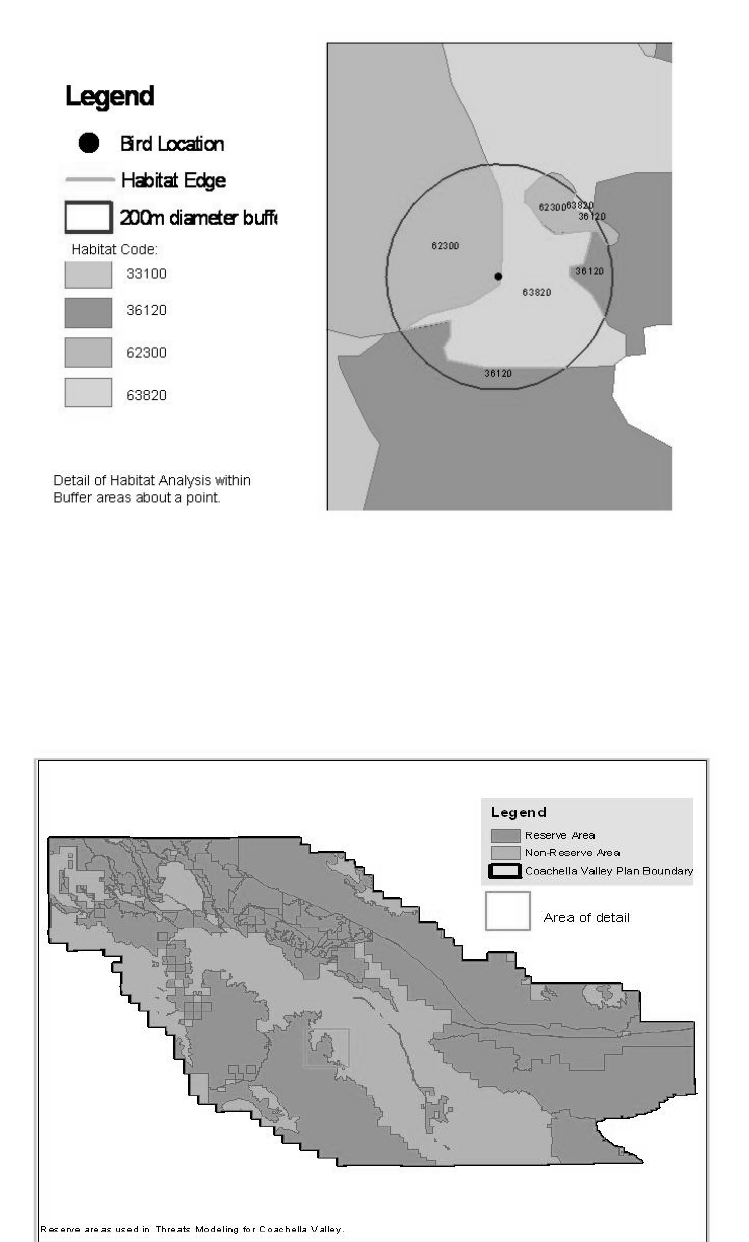
Proposed Major Amendment to the Coachella Valley MSHCP – September 2013
A1 - 203
Figure A8-1: Detail of Habitat Analysis with Buffer Areas around a Point
Once these vegetation variables were calculated for the bird location points, they were calculated
for a grid of points within Conservation Areas across the entire Plan area.
Figure A8-2a: Sample of Grid Points across the Plan Area
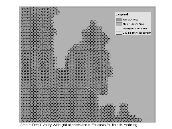
Proposed Major Amendment to the Coachella Valley MSHCP – September 2013
A1 - 204
Figure A8-2b: Smaller Area of Detail with Grid of Points for Modeling
Once the vegetation variables were generated for the bird location points, and the valley-wide
points, a statistical comparison was made to identify valley-wide points that showed similarity to
bird location points. Those valley-wide points with the greater similarity to bird location points
had higher p-values, and are indicated by the orange and pink dots in Figure A8-3.
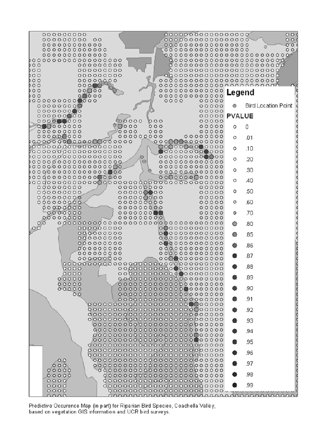
Proposed Major Amendment to the Coachella Valley MSHCP – September 2013
A1 - 205
Figure A8-3: Predictive Occurrence Map for Riparian Bird Species,
Coachella Valley, Based on Vegetation GIS Layers and
Bird Location Points Collected by UCR Bird Surveys
Proposed Major Amendment to the Coachella Valley MSHCP – September 2013
A1 - 206
8.2 Various Approaches to Sampling
8.2.1 Community Classification Index
A subset of points identified in the predictive modeling of species distributions, and additional
sites determined to be key contributing ecosystems to Coachella Valley Biodiversity will be
visited and sampled to create an index to classify plant and animal communities. Our objectives
are to obtain quantitative characterizations of communities that will be sensitive to detection of
both natural dynamic and anthropogenic changes in community structure in time and space.
Since species endangerment is most often a direct result of degraded community integrity,
monitoring the health of communities must be one of our priorities. Populations of priority
species are ideally monitored within the context of their relevant species assemblages so that real
threats can be differentiated from natural processes, and so threats can be identified and managed
before priority species are negatively affected.
1. Plant Community Classification: This will be a quantitative augmentation of the
vegetation mapping data with an additional element of assessing levels of invasion by
exotic species. Re-sampling and gathering more data on the same sites used in the
vegetation mapping effort will enable greater accuracy in determining how communities
change over time, and will establish confidence intervals for the vegetation mapping data.
2. Invertebrate Community Classification: In terrestrial sites, we anticipate that the primary
focus will be Hymenoptera. This is because they play crucial roles in the food webs of
the vertebrates in the plan, and some constitute a critical threat to many of the species in
the plan. We are developing a rapid baited sampling of the dominant species of terrestrial
ants and a longer-term pitfall sampling of terrestrial invertebrates, mainly ants and
spiders. Other sampling strategies are being explored as needed. The main focus is on
ants because they require little training or expertise for identification and are key species
for community diversity. Healthy, diverse ant communities are resistant to invasion by
the exotic ants (fire ants, argentine ants) identified as serious threats to priority species
and community integrity.
3. Vertebrate Community Classification: Different assessment groupings (birds,
amphibians, reptiles, large mammals, small mammals) have been identified and protocols
are being developed for each. The desert pupfish and the desert bighorn sheep are being
managed by CDFG independently of our effort.
4. Remote Monitoring: We are working through three projects funded by other entities to
develop technologies for monitoring bird vocalizations. These systems will be deployed
Proposed Major Amendment to the Coachella Valley MSHCP – September 2013
A1 - 207
simultaneously with the organism assessments to determine if these approaches are
appropriate and can be utilized in future analyses.
Initially, we envision two teams of two people conducting simultaneous Assessments of
Vegetation, Vertebrate, and Invertebrate Communities. Each team will sample two sites per
morning for one hour per site. After each morning Rapid Assessment period, teams will create
and maintain sampling arrays that require longer term investments (i.e. pitfall arrays,
microphones, automated cameras) and monitor spatial and temporal variation at a subset of sites
to be determined (mainly highly seasonal ecosystems where precise timing of sampling will be
critical). Climatic factors and seasonal probability of detection of priority species will determine
where and when teams will be assigned to sample sites. Field sampling protocols will be simple
and well defined to minimize variation in data quality between personnel.
8.2.2 Conceptual Framework for Sampling by Species
The second approach for determining sampling locations will be based on habitat modeling. The
original plan was based on habitat modeling based on visual differentiation of several
characteristics such as sand types, vegetation, and other features. We will expand on this initial
effort. We propose to link surveys designed to monitor the distribution and/or abundance of
target species with our efforts to model habitat associations for those same species. On the one
hand, monitoring data provide observations that can be incorporated into habitat association
models; on the other hand, habitat association models can be used to indicate areas where
monitoring activities should be located, due to the actual or expected presence of the target
species (the latter of which can serve as tests of the models), or in anticipation of expected
changes in habitat quality due to management or other activities. As noted above, there are
different “types of rarity” associated with the species to be covered under the HCP, and the
techniques discussed here pertain primarily to those that, at least in principle, could be
distributed over a relatively large spatial extent (whether in a variety of different habitat types, or
in only one habitat type, but one that is broadly distributed). In essence, we describe a regional
(as opposed to local) monitoring/modeling effort (see, for example, Larsen et al. 2001, Yoccoz et
al. 2001, Busch and Trexler 2003). For species that occur at only a few well-defined points,
regional surveys as we describe them are not effective; instead, such taxa are better monitored by
more focused surveys.
REGIONAL MONITORING SURVEYS. We assume that regional monitoring surveys for any target
taxon or taxon group will consist of a network of “points” scattered throughout the plan area. An
issue to be resolved is the distribution of these points, whether random throughout the entire
area, random stratified by habitat/vegetation type, or placed according to the expectation of a
taxon’s presence at a point. We further assume that the precise methodology for assessing the
presence of a target species (or species group) at a sampling point will be specific for that
Proposed Major Amendment to the Coachella Valley MSHCP – September 2013
A1 - 208
species. Such techniques are generally well-known to ornithologists, herpetologists,
mammalogists, botanists, etc., and will be provided by them. Thus, “points” may consist of
auditory/visual counts, small grids of traps, short transects, etc., and may differ in size. For
longer transects we assume that the precise location of each detection of a target species will be
recorded; these become “points” themselves.
We expect that for most points we will have a datum that indicates whether a target species was
detected at that point during a specific sampling effort. (For habitat modeling we will also have
an additional set of points at which the target species was observed independently from any
formal surveys – see below). This implies that most points will be relatively small, that most of
our data will be presence/absence, and that we are primarily concerned with a target’s
distributional extent rather than absolute abundance in any spatially-restricted area (although in
practice the two are usually highly correlated over large spatial scales). For a variety of well-
documented reasons, the number seen at points in a survey area invariably underestimates the
number of individuals actually present; thus, it is necessary to also estimate “detectability,” the
probability that the target species will be observed at a point if it is, in fact, present. Because not
all individuals are detected in any sample,
C = Np
where C = number counted, N = number actually present (our primary variable of interest), and p
= probability of detection.
Obviously, N = C / p, which is why we are interested in estimating p.
Several statistical techniques have been developed to enable estimation of detectability under a
variety of sampling schemes, which we illustrate using our on-going monitoring of sensitive
riparian bird species.
Example - Riparian Bird Species
The basic sampling unit is a “point count,” where an observer stands immobile at a particular
spot and for a fixed period of time (15 min) records all target species seen and/or heard. Because
several of these species are relatively inconspicuous and hence may have low probability of
detection even when present, our counts at riparian points will focus only on the target species,
generally ignoring other species (which represent a distraction to observers) that may also be
present. The target species are Least Bell’s Vireo, Southwestern Willow Flycatcher, Yellow
Warbler, Yellow-breasted Chat, and Summer Tanager. We will also track Brown-headed
Cowbirds, as they are considered a potential threat to several of the target species due to brood
parasitism.
Proposed Major Amendment to the Coachella Valley MSHCP – September 2013
A1 - 209
Avian point count data are recorded in such a way as to allow us to estimate a species’ presence,
detectability, and distribution using four different techniques.
1. Distance-based method – requires that we partition sightings of a target species during a
count period among distance-from-the-point classes. In our case we use 0-25 m, 25-50 m,
and > 50 m. Distance-based methods have a long history of use in estimating species
abundances and densities, especially when coupled with line-transect sampling (e.g.,
Burnham et al. 1980). In current terminology, our points are considered to be transects of
zero length, but the analytical technique remains the same (Rosenstock et al. 2002). (For
other taxa, non zero-length transects may be more appropriate; they can easily be
integrated into this analytical framework).
2. Temporal-based removal method – requires that we partition sightings of a target species
during a count period among time intervals. We divide the 15-minute count period into
four intervals, recording whether species are detected in the first (0-3:00), second (3:00-
5:00) third (5:00-10:00), or fourth (10:00-15:00) interval. Removal models assume that
once an individual is detected, it may no longer be counted at a subsequent time during
the survey; thus, as individuals are detected, fewer are available to be detected in
subsequent time intervals. This decline in numbers detected though time can be used to
estimate the initial number of individuals present. Farnsworth et al. (2002) provide
guidelines for using Program SURVIV (White 1983) to estimate detection probabilities.
3. Double- or multiple-counting method – requires multiple counts at points, usually using
different observers. After making certain assumptions, observations made on multiple
visits can be analyzed using mark-recapture techniques (e.g., Program MARK; White and
Burnham 1999; MacKenzie et al. in press) or logistic regression (Manly et al. 1996). An
appeal of this method is that the analytical techniques permit the use of covariates as
well.
4. Dual-frame sampling – requires that we sample from a “list frame” (points at which the
target species has been observed in the past) and an “area frame” (points at which the
target species might occur) (Haines and Pollock 1998). If the target species is observed at
an area frame point during a general sampling period, that point is moved to the list frame
for the next sampling period; if the target is not observed at a list frame point, that point
is moved to the area frame. This sampling technique dove-tails with our habitat modeling
effort, as we will use the habitat model developed for a target species to develop the area
frame.
It is not clear at this time which of these approaches will be most suitable for achieving our
specific monitoring objectives. It is certainly possible that our explorations of these techniques
Proposed Major Amendment to the Coachella Valley MSHCP – September 2013
A1 - 210
will suggest that different ones may be more appropriate for different taxa. One major concern
will be sufficiency of observations; some of the target taxa may be so uncommon as to generate
an insufficient number of detections to apply some of these techniques successfully. Our best
guess at the moment is that some combination of multiple-counting (e.g., MacKenzie et al. in
press) and dual frame sampling (Haines and Pollock 1998) will best meet our needs.
HABITAT MODELING. We are developing GIS-based models of habitat associations of the target
species (see papers in Scott et al. 2002 for numerous examples). This means that the variables
we can use are those (and only those) that can be generated directly or calculated from existing
area-wide GIS layers. This limitation is imposed by the fact that we wish to predict the
likelihood of a species’ occurrence (i.e., estimate “habitat quality”) for any point within the study
or plan area; we can only do so for points for which we have values for all variables in any
particular model, and the only area-wide variables currently available are those in the GIS-layers.
For a variety of reasons, we do not think this is likely to be a serious limitation. Most
significantly, it means that our models will be based more on landscape-level rather than local-
level attributes.
The dependent variable for most of our models will be a GIS-layer that contains the geographical
coordinate location of each observation of the target species (or species group). These points will
come from museum specimen collection records, historical observations, personal observations
from reliable sources, and surveys performed by us and others. Secondarily, we will also develop
a layer of points at which we know the target was surveyed for, but at which it was not observed.
Because of detectability issues noted above, we consider these “negatives” less informative than
“positives;” nevertheless, they can be used in certain types of modeling.
We are still developing candidate independent (“predictor”) variables for our modeling. We
imagine that many will take the form of “percent of area within X meters of the point that
consists of vegetation type Y.” These sorts of variables are generated by placing a buffer of X-m
radius around a point and recording the proportion of area within the resulting circle that consists
of each vegetation type, including type Y. Others may summarize the structural configuration of
vegetation types within the buffered area (e.g., number of different types, interspersion of
different types, amount of edge or ecotone between different types). Yet others may take the
form of “distance from the point to the nearest attribute Z,” where Z might be a road, an urban
boundary, a particular vegetation type, or any other GIS attribute we guess might be important.
Finally, we expect that interpretation of high-resolution satellite images will yield a wealth of
yet-to-be-determined attributes that may be important indicators of environmental quality for
numerous species. In addition to trying to use “positive” variables (i.e., variables we think likely
promote the presence of a species at a point), we also wish to use “negative” ones, especially
those that are related to previously identified potential threats to the target species or vegetation
type.
Proposed Major Amendment to the Coachella Valley MSHCP – September 2013
A1 - 211
INITIAL TEST CASE - RIPARIAN BIRD SPECIES IN COACHELLA VALLEY. Because no single
target riparian bird species is likely to be very abundant or occur at many different points, and
because most are broadly overlapping in general, if not specific, habitat affinities (mainly
confined to riparian vegetation types, which occur in mostly discrete patches that are distinctly
different from the surrounding matrix of desert vegetation), we will initially lump them together
for habitat modeling purposes. In a trial run using data from the Coachella Valley, the model
located potential sites that have not been surveyed but likely contain the birds of interest. These
will be further explored this next growing season. All organisms will be surveyed using this
approach.
One additional point that was generated was the sensitivity to the vegetation mapping. If this
mapping is not accurate, the model suffers. For this reason, we stress the need for accurate, high-
resolution vegetation maps. The CCB is participating in collaboration with CDFG and CNPS to
develop such maps, and to increase the data associated with the maps to increase resolution (see
habitat monitoring discussion).
1. Number of Sampling Points: This issue is yet to be addressed, but should become
somewhat clearer once we undertake preliminary analyses of our riparian data.
Unfortunately, at least for riparian birds there will be an upper limit to the number of
points we can sample due to the limited amount of riparian vegetation type throughout
the study region. For all species there will be a relatively small number of points
associated with pre-existing observations (e.g., museum records). Some non regression-
type modeling techniques, such as D2, Pearson’s planes, and GARP, appear to function
fairly well even with relatively small numbers of observations, although this is true only
so long as there is still a reasonable observations-to-variables ratio (Rotenberry et al.
2002, Peterson et al. 2002).
2. Distribution of Sampling Points: As noted above, an issue to be resolved is the
distribution of sampling points. We do not think that randomly distributing them
throughout the project area is effective; indeed, we have already acknowledged this with
respect to riparian birds simply by the fact that we have confined our sampling to riparian
vegetation types. Within riparian corridors, however, our location of points was basically
random with respect to locations of birds. Actual locations of points were constrained to a
degree by local configuration of vegetation; some areas were not accessible to us simply
because the understory was impenetrable. Such problems are likely to arise as well when
sampling points need to be sited in newly targeted but previously unvisited areas. Truly
random location of points will undoubtedly result in some placed in difficult-to-access
areas, with the tradeoff that fewer points can be sampled for a given level of effort (time
+ number of observers).
Proposed Major Amendment to the Coachella Valley MSHCP – September 2013
A1 - 212
8.2.3 Conceptual Framework for Habitat Monitoring
VEGETATION ANALYSIS—BEYOND THE MAP. California wildlands are being subject to
increasing exotic invasive plant invasion and experiencing fire, an ecological perturbation
virtually unknown in the recent past. Coastal sage scrub (CSS) has experienced massive
vegetation change to exotic annual grassland over the past 40 years, especially near urban areas
where deposition is highest. Deserts have only recently been subject to such perturbation.
Because of indirect effects on the environment (CO2, precipitation, NOx deposition), suburban
humans can leave a footprint hundreds of km. Therefore, the conservation reserves will continue
to be impacted by the changing environments. A critical biomass of 0.5 to 1T/ha dry biomass,
stimulated by N deposition and produced during wet years, triggered fires and may initiate large-
scale vegetation conversion (Fenn et al. 2003). These thresholds are characterized by rapid
upward increase in % exotic species that is promoted by increased fire frequency. Our goals are
to explore the relationships between areas occupied by exotic grasses and historical fire sites.
Standard techniques employing double sampling for percent cover and biomass of herbs, line
transects for shrubs can be used (Mueller-Dombois & Ellenberg 1974) to assess vegetation
change, particularly when coupled with vegetation mapping activities. Power analyses are used
to determine adequate sample size. Richness can be measured by using a releve approach to
detect infrequent species. Regression analysis, principle components analysis, and canonical
correspondence analysis will be used to analyze vegetation data. Biomass of herbaceous
vegetation will also be sampled to detect yearly variation and fuel load that might promote fire.
ANALYSIS. During the 2003 growing season, we will develop individual locations in
collaboration with the resource agencies and incorporate a range of techniques at varying
resolution going down to individual line transects. These analyses will allow us to determine
areas where threshold values in exotic grass invasions threaten the sustainability of the particular
reserve.
METHODS FOR REMOTE SENSING. Ultimately, there will be a need for assessing habitat
conditions over larger areas than can be surveyed with regularity. A remote sensing approach is
needed. Initially, leaf area index (LAI) can be assessed using 30-m resolution multispectral
Thematic Mapper (TM) data. To assess small features crucial to particular species, greater detail
can be gained using 4-m resolution multispectral images from the Ikonos satellite. The TM
satellite data can be coupled to a bi-directional reflectance distribution function (BRDF) model
by Nikolov (1999). This model has been successfully applied to AVHRR data to derive seasonal
LAI over the western USA at 1-km resolution and may provide additional means of
distinguishing native vegetation from exotic grasses in the remotely sensed images.
Proposed Major Amendment to the Coachella Valley MSHCP – September 2013
A1 - 213
Satellite imagery data is improving in resolution and quality rapidly. Current methods include the
new IKONOS imagery which can generate a pixel sizes down to 4m2, with features (such as
shrubs) being identifiable at a 1m resolution. Specific features, such as sand dune edges, can be
resolved at sample intervals limited only by the numbers of images acquired.
By linking satellite imagery and field sampling data, a scaling analysis can be used to integrate
the habitat structure into a single framework for scaling-up/down. Such matrices can be
mathematically linked to stability measures to detect ecological phase transitions or thresholds
and relaxation time (Li, 2002).
SYNCHRONIZATION AND VARIATION OF POPULATIONS AND COMMUNITIES. Variation through
both time and space is the dominant feature of the biota in Riverside County. Variation in space
is addressed through metapopulation modeling and sampling of habitat types. However, variation
through time is just as crucial. Although temperature is relatively predictable, precipitation can
vary by almost an order of magnitude. This variation exists in the desert and includes the El
Nino-Southern Oscillation (ENSO) phenomena and is also subject to the Pacific Decadal
Oscillation (PDO). ENSO events have been occurring with a 3-5 year periodicity whereas the
PDO occurs in decadal time scales. Although these appear to be independent, if both ENSO and
PDO -negative or both positive anomalies occur simultaneously, they may feed back into each
other. Double positives include the strong and wet El Ninos of the 1990s, and double negatives
include the severe droughts of the 1950s 1890s, and 1680s (the year of the Pueblo Revolts in
New Mexico). Projections are that we are entering a period of negative PDO when drought may
begin to predominate.
Alternatively, some climatologists have modeled global change phenomena particularly focusing
on the warming effect of elevated CO2. Their projections use a warming ocean model similar to
the El Nino phenomena and project increasing precipitation, particularly during the summer, for
southern California (e.g., Bachelet et al. 2001).
In either case, populations of both plants and animals are synchronized with these large-scale
climate drivers (e.g., Post and Forchhammer 2002). Plant responses are both direct and indirect.
Direct, in that many of the sensitive species are water-limited annuals requiring average or above
average precipitation to set seed. However, with high precipitation, exotic annual grasses also are
highly productive, often out-competing native species (Eliason and Allen 1997) and providing
fuel for fires in lowland areas (Fenn et al. 2003). Drought has some advantages in that grass
competition can be curtailed, but seed production and annual plant germination can also be
reduced. Animal populations are also tightly coupled with food resources.
Clearly, surveys cannot be undertaken on an arbitrary 5, 7, 8 or 10-year periodicity if trends are
to be determined. Understanding the relationships between climate and biota, and between

Proposed Major Amendment to the Coachella Valley MSHCP – September 2013
A1 - 214
sensitive plants, exotic invaders, and animals of concern is going to be crucial for developing
accurate monitoring protocols. Our goals are to begin working on relationships between
climactic variables, NDVI, and metapopulation dynamics to generate an appropriate sampling
periodicity.
8.3 Background on Monitoring: Aeolian Sand
Community
Rainfall appears related to fringe-toed lizard reproductive patterns as well (Barrows and Fisher,
in prep., Muth and Fisher, in prep., Figure 4). Even though fringe-toed lizard numbers have at
times over the past 15 years dropped to nearly non-detectable levels (Figure 4), those declines
have been associated with droughts; their numbers have always rebounded during average to
above average rainfall years. Sounding alarms and calls for management actions during those
drought-related natural declines would have been misguided and a waste of limited human
resources. These weather data need to be related to habitat and species level monitoring data that
are collected. Only through a thorough understanding of regional weather conditions and
patterns, can large spatial scale conclusions be drawn regarding the relative importance of either
anthropogenic or natural causes of changes in abundance of target species.
(The remainder of this page is intentionally blank)

Proposed Major Amendment to the Coachella Valley MSHCP – September 2013
A1 - 215
Areal Extent of Habitat
In addition to using weather data to distinguish between human and natural caused changes,
monitoring of the areal extent of the habitat is required. This monitoring becomes exceedingly
important to 1) determine and quantify the ebb and flow of the extent of this dynamic sand dune
habitat and the effects on target species, 2) assess future changes in landscape connectivity, and
3) evaluate the effects of changing proximity to human activities. Digital satellite imagery
(Ikonos with four meter resolution, false-color infrared, Space Imaging Corporation, Boulder,
CO) is now available and can be used to assess these changes (See example in Figure 5). These
images are extremely useful in distinguishing and quantifying different levels of stabilization
within the dune and hummock habitat matrix. The digital images are analyzed using
ARCVIEW© 3.2 Geographic Information System (GIS, ESRI, Redlands, CA) with the Image
Analysis extension. Using satellite imagery of the Coachella Valley Preserve area, the program
was tasked to divide the habitat into 10 categories based on reflectance values. Four of the
created categories dealt specifically with aeolian habitat (Figure 5) and appeared to make
separations consistent with both particle size and compaction (Barrows, pers. obs.); the other six
were upland habitats or areas of dense vegetation. Both of these variables have bearing on the
relative abundances of the dune-associated species. Additionally, by having the GIS program
“choose” the categories, the choices are without observer biases and are more likely to be
repeatable and comparable to future images.
Due to the dynamics of this habitat, new digital images should be acquired and analyzed every
two years. In this way, change analyses can be performed, directly indicating the extent of
habitat gains and losses through time. Of highest priority is the quantity and distribution of the
active aeolian habitat, a type clearly and accurately discerned by this kind of analysis. When
active aeolian habitat is in decline, the images can be used to help develop hypothesis for that
decline, and to evaluate the success of remedial management action that may be taken.
(The remainder of this page is intentionally blank)
Proposed Major Amendment to the Coachella Valley MSHCP – September 2013
A1 - 216
Glossary
areas of high biological diversity—Although the term conservation site is often used to
describe areas chosen through the process of reserve design and site identification, in actuality
these are areas of biodiversity significance and different from sites as defined in site conservation
planning. Although the planning effort may delineate rough or preliminary site boundaries or use
other systematic units such as watersheds or hexagons as site selection units, the boundaries and
the target occurrences contained within these areas are first approximations that will be dealt
with in more specificity and accuracy in the site conservation planning process.
association—The finest level of biological community organization in the US National
Vegetation Classification, defined as a plant community with a definite floristic composition,
uniform habitat conditions, and uniform physiognomy. This is the system used in the California
Native Plant Society’s Manual of California Vegetation (Sawyer and Keeler-Wolf 1995). With
the exception of a few associations that are restricted to specific and unusual environmental
conditions, associations generally repeat across the landscape. They also occur at variable spatial
scales depending on the steepness of environmental gradients and the patterns of distribution.
biological diversity—The variety of living organisms considered at all levels of organization
including the genetic, species, and higher taxonomic levels. Biological diversity also includes the
variety of habitats, ecosystems, and natural processes occurring therein.
biodiversity hot spot—Typically, a geographic location under a high degree of threat and
characterized by unusually high species richness and large numbers of endemic species.
bioreserve—A landscape, large in size with naturally functioning ecological processes and
containing outstanding examples of ecosystems (ecological systems), communities, and species
which are endangered or inadequately protected.
coarse filter-fine filter approach—A working hypothesis that assumes that conservation of
multiple, viable examples of all coarse-filter targets (communities and ecological systems) will
also conserve the majority of species (fine-filter targets). The term coarse filter refers to targets at
the community or system level of biological organization whereas coarse-scale refers to spatial
scale of, for example, terrestrial targets that roughly cover 20,000–1,000,000 acres.
coarse-scale approach—Ecological systems or matrix communities are spatially large terrestrial
targets referred to as coarse-scale. The coarse-scale approach is the first step in the portfolio
assembly process where all coarse-scale targets are represented or “captured” in the ecoregion
(including those that are feasibly restorable).
Proposed Major Amendment to the Coachella Valley MSHCP – September 2013
A1 - 217
community—Natural or plant communities (also called terrestrial communities) are community
types of definite floristic composition, uniform habitat conditions, and uniform physiognomy.
Natural communities are defined by the finest level of classification, the “plant association” level
of the National Vegetation Classification. Like ecological systems, terrestrial communities are
characterized by both a biotic and abiotic component. Even though they are classified based
upon dominant vegetation, we use them as inclusive conservation units that include all
component species (plant and animal) and the ecological processes that support them.
connectivity—Conservation sites or reserves have permeable boundaries and thus are subject to
inflows and outflows from the surrounding landscapes. Connectivity in the selection and design
of nature reserves relates to the ability of species to move across the landscape to meet basic
habitat requirements. Natural connecting features within the ecoregion may include river
channels, riparian corridors, ridgelines, or migratory pathways.
conservation focus—Those targets that are being protected and the scale at which they are
protected (e.g. local scale species and small patch communities; intermediate scale species and
large patch communities; coarse scale species and matrix communities; and regional scale
species).
conservation goal—In ecoregional planning, the number and spatial distribution of on-the-
ground occurrences of targeted species, communities, and ecological systems that are needed to
adequately conserve the target in an ecoregion.
conservation site—A site which maintains targets and their supporting ecological processes
within their natural ranges of variability. A functional conservation site will conserve a small
number of ecological systems, communities, or species at one or two scales below regional and
targets tend to be relatively few, often sharing similar ecological processes.
conservation status—Usually refers to the category assigned to a conservation target such as
threatened, endangered, imperiled, vulnerable, and so on.
conservation target (see target)
conservation value—A criterion in the site selection process that is based upon the number,
diversity (scale, aquatic/terrestrial), and health of conservation targets.
Core Habitat—As defined by the SAC, Core Habitat for a given species is a habitat patch or
aggregation of habitat patches that 1) is of sufficient size to support a viable population of that
species; 2) is not fragmented by roads or unsuitable habitat; 3) has intact ecological processes;
Proposed Major Amendment to the Coachella Valley MSHCP – September 2013
A1 - 218
and 4) has effective corridors and connections to other habitats, where applicable, to allow gene
flow among populations and to promote movement of large predators.
corridor—A route that allows movement of individuals or taxa from one region or place to
another. In ecoregional planning, it is important to establish corridors among sites for
conservation targets that require such areas for dispersal and movement. Focal species may help
in designing corridors and linkages.
data dictionary - A data dictionary is a list that maintains, for each coverage, the names of the
attributes and a description of the attribute values (including a description of each code, if
necessary). Having a data dictionary for your database is invaluable as a reference during the
project as well as for transferring information to others.
data layer (see GIS coverage)
decline/declining - For conservation targets, the historical or recent decline through all or part of
its range. Declining species exhibit significant, long-term declines in habitat/and or numbers, are
subject to a high degree of threat, or may have unique habitat or behavioral requirements that
expose them to great risk.
Disjunct - Disjunct species have populations that are geographically isolated from other
populations.
distribution pattern—The overall pattern of occurrence for a particular conservation target. In
conservation projects, often referred to as the relative proportion of the target’s natural range
occurring within a given area (i.e. endemic, widespread, limited, disjunct, peripheral).
ecological communities (see community)
ecological drainage units (EDU)—Aggregates of watersheds that share ecological and
biological characteristics. Ecological drainage units contain sets of aquatic systems with similar
patterns of hydrologic regime, gradient, drainage density, & species distribution. Used to
spatially stratify ecoregions according to environmental variables that determine regional
patterns of aquatic biodiversity and ecological system characteristics.
ecological integrity—The probability of an ecological community or ecological system to
persist at a given site is partially a function of its integrity. The ecological integrity or viability of
a community is governed primarily by three factors: demography of component species
populations; internal processes and structures among these components; and intactness of
landscape-level processes which sustain the community or system.
Proposed Major Amendment to the Coachella Valley MSHCP – September 2013
A1 - 219
ecological system (see terrestrial ecological systems or aquatic ecological system).
ecoregion—A relatively large area of land and water that contains geographically distinct
assemblages of natural communities. These communities (1) share a large majority of their
species, dynamics, and environmental conditions, and (2) function together effectively as a
conservation unit at global and continental scales.” Ecoregions were defined by Robert Bailey as
major ecosystems resulting from large-scale predictable patterns of solar radiation and moisture,
which in turn affect the kinds of local ecosystems and animals and plant found within.
edge effect—The influence of a habitat edge on interior conditions of a habitat or on species that
use interior habitat. Greater amounts of edge habitat can often lead to deleterious effects on
“interior” target species.
efficiency—A principle in which occurrences of coarse-scale ecological systems that contain
multiple targets at other scales are given priority. This is accomplished through identification of
functional sites and landscapes. In more academic literature, efficiency refers to conserving the
greatest amount of biological diversity in the least amount of land area.
element—A term originating from the methodology of the Natural Heritage Network that refers
to species, communities, and other entities (e.g., migratory bird stopovers) of biodiversity that
serve as both conservation targets and as units for organizing and tracking information.
element occurrence (EO)—A term originating from the methodology of the Natural Heritage
Network, including the California Natural Diversity Data Base, that refers to a unit of land or
water on which a population of a species or example of an ecological community occurs. For
communities, these EOs represent a defined area that contains a characteristic species
composition and structure. In this Plan, element occurrences are referred to as known locations.
endangered species—A species that is federally listed or proposed for listing as Endangered by
the U.S. Fish and Wildlife Service under the Endangered Species Act.
endemic—Species that are restricted to an ecoregion (or a small geographic area within an
ecoregion), depend entirely on a single area for survival, and therefore, are often more
vulnerable.
essential conservation area - Conservation areas that are required for the long-term viability of
one or more target species or natural communities. Includes corridors for natural processes as
part of essential area. Because a given conservation area was deemed essential does not mean
that it, by itself, is sufficient to provide viability for a species.
Proposed Major Amendment to the Coachella Valley MSHCP – September 2013
A1 - 220
feasibility—A principle used in this conservation planning process to include Core Habitat,
ecosystem process, or linkage areas in the reserve design if they are suitable and contribute to
conservation plan goals. Factors contributing to feasibility may include management
considerations, the probability of success, and implementation strategies.
fine filter—To ensure that the coarse-fine filter strategy adequately captures all viable, native
species and ecological communities, conservation planning also targets species that cannot be
reliably conserved through the coarse-filter approach and may require individual attention
through the fine filter approach. Wide-ranging, very rare, extremely localized, narrowly endemic,
or keystone species are all likely to need fine-filter strategies.
Flagship species—Charismatic species, used to draw attention to an issue or to build support for
reserve selection.
focal species—Focal species have spatial, compositional and functional requirements that may
encompass those of other species in the region and may help address the functionality of
ecological systems. Focal species may not always be captured in the portfolio through the coarse
filter. This planning effort used The Nature Conservancy’s approach, which defines wide-
ranging and keystone as examples of focal species.
fragmentation—Process by which habitats are increasingly subdivided into smaller units,
resulting in their increased insularity as well as losses of total habitat area. Fragmentation may be
caused by humans (such as development of a road) or by natural processes (such as a tornado).
functionality—A principle to ensure all sites in a conservation area are functional or feasibly
restorable to a functional condition. Functional sites maintain the size, condition, and landscape
context within the natural range of variability of the respective conservation targets.
GAP (National Gap Analysis Program)—Gap analysis is a scientific method for identifying
the degree to which native animal species and natural communities are represented in our
present-day mix of conservation lands. Those species and communities not adequately
represented in the existing network of conservation lands constitute conservation “gaps.” The
purpose of the Gap Analysis Program (GAP) is to provide broad geographic information on the
status of ordinary species (those not threatened with extinction or naturally rare) and their
habitats in order to provide land managers, planners, scientists, and policy makers with the
information they need to make better-informed decisions.
georeference—Georeferencing establishes the relationship between objects on a planar map and
known real-world coordinates, such as section corners.
GIS (Geographic Information System) - An organized system of computer hardware, software,
Proposed Major Amendment to the Coachella Valley MSHCP – September 2013
A1 - 221
and geographic data designed to efficiently capture, store, update, manipulate, analyze, and
display all forms of spatial (geographically referenced) information.
GIS coverage—1. A digital version of a map forming the basic unit of vector data storage in
ARC/INFO. A coverage stores map features as primary features (such as arcs, nodes, polygons,
and label points) and secondary features (such as tics, map extent, links, and annotation).
Associated feature attribute tables describe and store attributes of the map features. 2. a set of
thematically associated data considered as a unit. A coverage usually represents a single theme,
or layer, such as soils, streams, or roads.
habitat—The place or type of site where species and species assemblages are typically found
and/or successfully reproducing. In addition, marine communities and systems are referred to as
habitats. They are named according to the features that provide the underlying structural basis for
the community.
habitat enhancement -- any manipulation of habitat that improves its value and ability to meet
specified requirements of one or more Covered Species, including actions to reverse the effects
of previous disturbance, control exotic species, and retain natural diversity.
indicator species—A species used as a gauge for the condition of a particular habitat,
community, or ecosystem. A characteristic or surrogate species for a community or ecosystem.
indigenous—A species that is naturally occurring in a given area and elsewhere.
irreplaceable—The single most outstanding example of a target species, community, or system,
or a population that is critical to a species remaining extant and not going extinct.
keystone species—A species whose impacts on its community or ecosystem are large; much
larger than would be expected from its abundance. (e.g. beaver or prairie dogs)
landscape—A heterogeneous land area composed of a cluster of interacting ecosystems that are
repeated in similar form throughout.
landscape level or landscape scale—Landscape level actions (conservation planning,
monitoring) focus on geographically large areas with functional ecosystem processes and
coarse-scale conservation targets
large patch—Communities that form large areas of interrupted cover. Individual occurrences of
this community patch type typically range in size from 50 to 2,000 hectares. Large patch
communities are associated with environmental conditions that are more specific than those of
matrix communities, and that are less common or less extensive in the landscape. Like matrix
Proposed Major Amendment to the Coachella Valley MSHCP – September 2013
A1 - 222
communities, large-patch communities are also influenced by large-scale processes, but these
tend to be modified by specific site features that influence the community.
linear communities—Communities that occur as linear strips are often, but not always, ecotonal
between terrestrial and aquatic systems. Examples include coastal beach strands, bedrock
lakeshores, and narrow riparian communities. Similar to small patch communities, linear
communities occur in very specific ecological settings, and the aggregate of all linear
communities covers, or historically covered, only a small percentage of the natural vegetation of
an ecoregion. They also tend to support a specific and restricted set of associated flora and fauna.
Linear communities differ from small patch communities in that both local-scale processes and
large-scale processes strongly influence community structure and function.
linkage – A planned connection between habitat “islands” to provide protected movement
opportunities and increased range for various species, thereby helping to maintain healthy
populations and genetic diversity. See corridors
map units - The coordinate units in which a geographic data set (e.g., a coverage) is stored in
ARC/INFO or ARCView. Map units can be inches, centimeters, feet, meters, or decimal degrees.
mapping precision - the accuracy with which a location of an observation or occurrence of a
species or natural community has been mapped, dependent upon the original source of
information.
matrix-forming or matrix communities—Communities that form extensive and contiguous
cover may be categorized as matrix (or matrix-forming) community types. Matrix communities
occur on the most extensive landforms and typically have wide ecological tolerances. They may
be characterized by a complex mosaic of successional stages resulting from characteristic
disturbance processes (e.g. New England northern hardwood-conifer forests). Individual
occurrences of the matrix type typically range in size from 2,000 to 500,000 hectares. In a typical
ecoregion, the aggregate of all matrix communities covers, or historically covered, as much as
75-80% of the natural vegetation of the ecoregion. Matrix community types are often influenced
by large-scale processes (e.g. climate patterns, fire) and are important habitat for wide-ranging or
large area-dependent fauna, such as large herbivores or birds.
maximum extent practicable—The biological standards as proposed by the SAC focus on
maximizing conservation by incorporating natural features, artificial buffers (e.g. roads) and
other features to the greatest extent possible.
Proposed Major Amendment to the Coachella Valley MSHCP – September 2013
A1 - 223
metadata—Metadata documents the content, source, reliability, and other characteristics of data.
Metadata are particularly important in the iterative conservation planning process because this
documentation will expedite the review of existing tabular and geospatial data sets when a
conservation plan is revisited and will minimize the likelihood of “lost” data.
metapopulation—A network of semi-isolated populations with some level of regular or
intermittent migration and gene flow among them, in which individual populations may go
extinct but can then be recolonized from other source populations (this is referred to as rescue
effect).
minimum mapping unit—The minimum sizes or dimensions for features to be mapped as lines
or areas for a given map scale. For example, long narrow features such as streams and rivers will
be represented as lines if their width is less than 0.10 inch. If a polygon is smaller than .125 inch
on aside, it will be represented as a point.
minimum dynamic area—The area needed to insure survival or re-colonization of a site
following disturbance that removes most or all individuals. This is determined by the ability of
some number of individuals or patches to survive and the size and severity of stochastic events.
mosaic—An interconnected patchwork of distinct vegetation types.
native—Those species and communities that were not introduced accidentally or purposefully
by people but that are found naturally in an area. Native communities are those characterized by
native species and maintained by natural processes. Native includes both endemic and
indigenous species.
natural community — The array of native plants and animals, many of which are
interdependent, in a given ecosystem. Often named for the principal type of vegetation in the
community, for example, “desert dry wash woodland” and “active sand dunes.” This assemblage
of plants and animals interacts with one another, the abiotic environment around them, and is
subject to primarily natural disturbance regimes. Those assemblages that are repeated across a
landscape in an observable pattern constitute a natural community type.
network of conservation sites—A reserve system connecting multiple nodes and corridors into
a landscape that allows material and energy to flow among the various components.
nonhabitat matrix — A natural habitat that is unsuitable for the survival of the target species,
usually adjacent to, interconnected with, or surrounding suitable habitat.
Proposed Major Amendment to the Coachella Valley MSHCP – September 2013
A1 - 224
occurrence—Spatially referenced examples of species, communities, or ecological systems.
May be equivalent to CNDDB Element Occurrences, or may be more loosely defined locations
delineated through 1) the definition and mapping of other spatial data, or 2) the identification of
areas by experts.
partnership—Collaborative relationship with a diverse array of public and private
organizations, agencies, and individuals.
patch community—Communities nested within matrix communities and maintained primarily
by specific environmental features rather than disturbance processes.
photo interpretation —A systematic examination of aerial photos, and frequently, other
supporting materials such as maps and reports of field observations. Based on this study, an
interpretation is made as to the physical nature of objects and phenomena appearing in the
photographs. Interpretations may take place at a number of levels of complexity, from the simple
recognition of objects on the earth's surface to the derivation of detailed information regarding
the complex interactions among earth surface and subsurface features.
population viability analysis (PVA)—A collection of quantitative tools and methods for
predicting the likely future status (e.g., likelihood of extinction or persistence) of a population or
collection of populations of conservation concern. A PVA estimates the likelihood of population
viability over a determinate time period, based on life history variables.
rangewide—Referring to the entire distribution of a species, community, or ecological system.
rapid ecological assessment (REA)—Technique for using remote sensing information
combined with on-the-ground selected biological surveys to relatively quickly assess the
presence and quality of conservation targets, especially at the community and ecosystem level.
representation—A principle of reserve selection and design referring to the capture of the full
spectrum of biological and environmental variation within a network of reserves or conservation
sites, including all genotypes, species, communities, ecosystems, habitats, and landscapes.
representativeness—Captures multiple examples of all conservation targets across the diversity
of environmental gradients appropriate to the conservation Plan Area (e.g., temperature/moisture
gradient, or some other physical gradient).
resolution—Resolution is the accuracy at which a given map scale can depict the location and
shape of map features. For example, at a map scale of 1:63,360 (1 inch = 1 mile), features
smaller than .10-mile long or wide only measure .10-inch wide or long on the map. The larger
Proposed Major Amendment to the Coachella Valley MSHCP – September 2013
A1 - 225
the map scale, the higher the possible resolution. As map scale decreases, resolution diminishes
and feature boundaries must be smoothed, simplified, or not shown at all. For example, small
areas may have to be represented as points.
satellite imagery—An image, which is a graphic representation or description of an object, that
is typically produced by an optical or electronic device. Other common examples include
scanned data and photographs. An image is stored as a raster data set of binary or integer values
that represent the intensity of reflected light, heat, or another range of values on the
electromagnetic spectrum. Remotely sensed images (such as satellite imagery) are digital
representations of the Earth. Landsat and SPOT are two types of satellite imagery used in this
Plan.
section—Areas of similar physiography within an ecoregional province; a hierarchical level with
the U.S. Forest Service ECOMAP framework for mapping and classifying ecosystems at
multiple geographic scales.
site (or conservation site)—Areas that are defined by the presence of conservation targets, are
the focus of conservation action, and are the locus for measuring conservation success.
Conservation planning identifies and selects conservation targets and locates occurrences of
these targets. Based on geographic proximity, these target occurrences are grouped together into
sites.
SITES—Software consisting of computerized algorithms designed specifically for The Nature
Conservancy users in ecoregional planning to aid in selecting conservation sites.
small patch—Communities that form small, discrete areas of vegetation cover. Individual
occurrences of this community type typically range in size from 1 to 50 hectares. Small patch
communities occur in very specific ecological settings, such as on specialized landform types or
in unusual microhabitats. The specialized conditions of small patch communities, however, are
often dependent on the maintenance of ecological processes in the surrounding matrix and large
patch communities. In many ecoregions, small patch communities contain a disproportionately
large percentage of the total flora, and also support a specific and restricted set of associated
fauna (e.g. invertebrates or herptofauna) dependent on specialized conditions.
source (of stress)—An extraneous factor, either human (i.e. activities, policies, land uses) or
biological (e.g. non-native species), that infringes upon a conservation target in a way that results
in stress.
spatial pattern—Within an ecoregion, natural terrestrial communities may be categorized into
four functional groups on the basis of their current or historical patterns of occurrence, as
Proposed Major Amendment to the Coachella Valley MSHCP – September 2013
A1 - 226
correlated with the distribution and extent of landscape features and ecological processes. These
groups are identified as matrix communities, large-patch communities, small-patch communities,
and linear communities.
stakeholder—In a particular project or area, someone who: 1) would benefit if TNC achieved its
project goals, 2) would be hurt, or believe they could be hurt by TNC’s goals, 3) could shape
public opinion about TNC’s project even if it might not directly affect them, and 4) has the
authority to make decisions affecting TNC’s goals.
stratification—A hierarchical division of an ecoregion into nested, progressively smaller
geographic units. Spatial stratification is used to represent each conservation target across its
range of variation (in internal composition and landscape setting) within the ecoregion, to ensure
long-term viability of the type by buffering against degradation in one portion of its range, and to
allow for possible geographic variation.
stress—Something that impairs or degrades the size, condition, or landscape context of a
conservation target, resulting in reduced viability.
sufficient conservation area—A conservation area that includes enough habitat to contain a
viable population size of one or more target species. The inclusion of one or more additional
conservation areas may be sufficient, but not essential, to the protection of a species.
target—Also called conservation target. An element of biodiversity selected as a focus for
conservation planning or action. The three principle types of targets in this habitat conservation
planning program are species, ecological communities, and ecological systems.
terrestrial ecological community—Plant community types of definite floristic composition,
uniform habitat conditions, and uniform physiognomy. Terrestrial ecological communities are
defined by the finest level of classification, the “plant association” level of the National
Vegetation Classification.
terrestrial ecological systems—Dynamic spatial assemblages of ecological communities that 1)
occur together on the landscape; 2) are tied together by similar ecological processes (e.g., fire,
hydrology), underlying environmental features (e.g., soils, geology), or environmental gradients
(e.g., elevation, hydrologically-related zones); and 3) form a robust, cohesive, and
distinguishable unit on the ground. Ecological systems are characterized by both biotic and
abiotic (environmental) components and can be terrestrial, aquatic, marine, or a combination of
these.
Proposed Major Amendment to the Coachella Valley MSHCP – September 2013
A1 - 227
threat—The combined concept of ecological stresses to a target and the sources of that stress to
the target.
threatened species—Species federally listed or proposed for listing as Threatened by the U.S.
Fish and Wildlife Service under the Endangered Species Act.
umbrella species—Typically wide-ranging species that require large blocks of relatively natural
or unaltered habitat to maintain viable populations. Protection of the habitats of these species
may protect the habitat and populations of many other more restricted or less wide ranging
species.
urgency—A qualitative measure referring to the immediacy of severe threats—taking into
account how severe the threat is and how likely it is to destroy or seriously degrade the targets.
viable/viability—The ability of a species to persist for many generations or an ecological
community or system to persist over some time period. An assessment of viability will often
focus on the minimum area and number of occurrences necessary for persistence. However,
conservation goals should not be restricted to the minimum but rather should extend to the size,
distribution, and number of occurrences necessary for a community to support its full
complement of native species.
viable population—A population is considered viable if it contains an estimated 5,000 to 10,000
individuals for vertebrates, 10,000 to 20,000 individuals for invertebrates. These numbers imply
a population of sufficient size to persist through fluctuations caused by environmental variation
and to have a realistic potential for genetic interactions.
vulnerable—Vulnerable species are usually abundant, may or may not be declining, but some
aspect of their life history makes them especially vulnerable (e.g., migratory concentration or
rare/endemic habitat). For example, sandhill cranes are a vulnerable species because a large
percentage of the entire population aggregates during migration along a portion of the Platte
River in Nebraska.
Proposed Major Amendment to the Coachella Valley MSHCP – September 2013
A1 - 228
INTENTIONALLY LEFT BLANK
