Challenge Manual
Challenge_Manual
User Manual:
Open the PDF directly: View PDF ![]() .
.
Page Count: 10

EY NEXTWAVE DATA SCIENCE CHALLENGE 2019 - MANUAL
To make sure you are eligible to participate, please check the Terms and Conditions
since country/region conditions may apply. Also, you will find there all dates and details of
the different phases of this challenge.
1. Context of the challenge
The EY NextWave Data Science Challenge 2019 focuses on how data can help the next smart
city thrive, and boost the mobility of the future. Global urbanization is on the rise, with more
than 50% of the world’s population living in cities; according to the UN, that number will reach
60% by 2030 – that’s nearly 1.5 billion more than in 2010.
While this trend creates great opportunities for cities, it also presents challenges to
governments on how to upgrade infrastructure, alleviate congestion and address pollution.
Electric and autonomous vehicles, along with the explosion of the ride sharing economy, are
helping to address these challenges which also disrupt mobility and demand innovative
solutions.
In parallel, public authorities have more information than ever on how citizens move around in
the city. However, a gap exists between having this data and using it to improve the user travel
experience for citizens. Forward-looking authorities have a chance to innovate infrastructure
to make their city a better place to live in a better working world.
Here’s your chance to narrow that gap. As a challenge participant, you will be able to download
a dataset with a vast number of anonymous geolocation records from the US city of Atlanta
(Georgia), during October 2018. Your task is to produce a model that helps authorities to
understand the journeys of citizens while they move in the city throughout the day. If you dig
deep enough, your work could inspire solutions that help city authorities anticipate disruptions,
make real-time decisions, design new services, and reshape infrastructures in order that cities
as smart as their citizens.
2. Teaming Up
Once you have made the first submission, you will be able to see yourself in the ranking. When
accessing the ranking, you will see all the participants that submitted any piece of work in the
challenge. Next to them you will see a yellow button saying: “Request Team Up”. Click on that
button and you will be taken to a window where you will be able to request to that user the
option to team up. The other member will then see the team request in the “Profile” tab on the
left banner under “Request”, where he/she will have to accept. Once the request is accepted
you will become a team and both of your names will appear in the ranking.
3. Dataset Description
Students will have access to a data file data_train.csv that contains the anonymized geolocation
data of multiple mobile devices in the City of Atlanta (US) for 11 working days in October 2018.
The devices’ ID resets every 24 hours; therefore, you will not be able to trace the same device
across different days. Therefore, every device ID represents a 1-day journey.
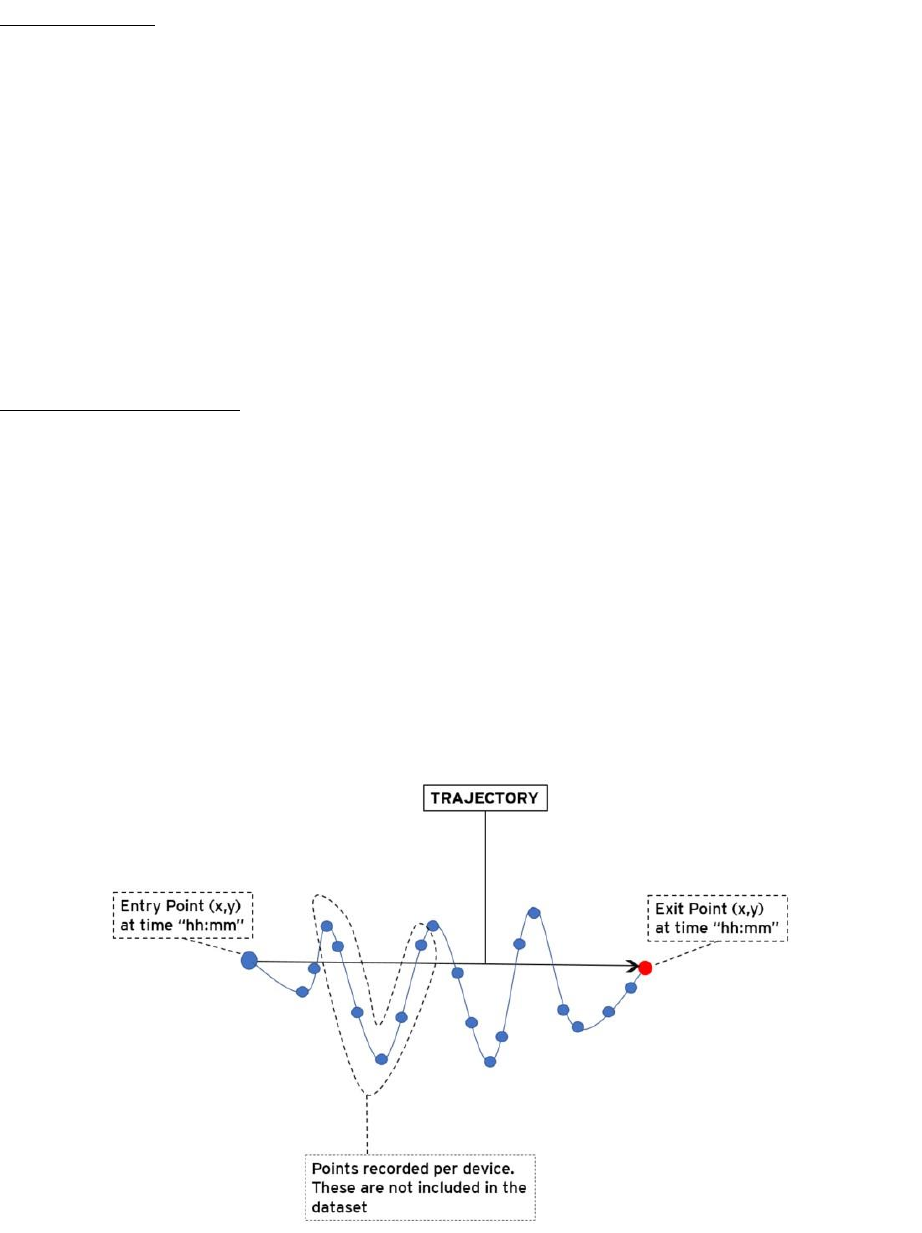
Each journey is formed by several trajectories. A trajectory is defined as the route of a moving
person in a straight line with an entry and an exit point. See an example below of one trajectory
from one of the devices:
As you can see, trajectories are a simplification of the real path of a person.
A trajectory ends when a person stops moving and stays in the same place for a while and when
the device stops recording for some time.
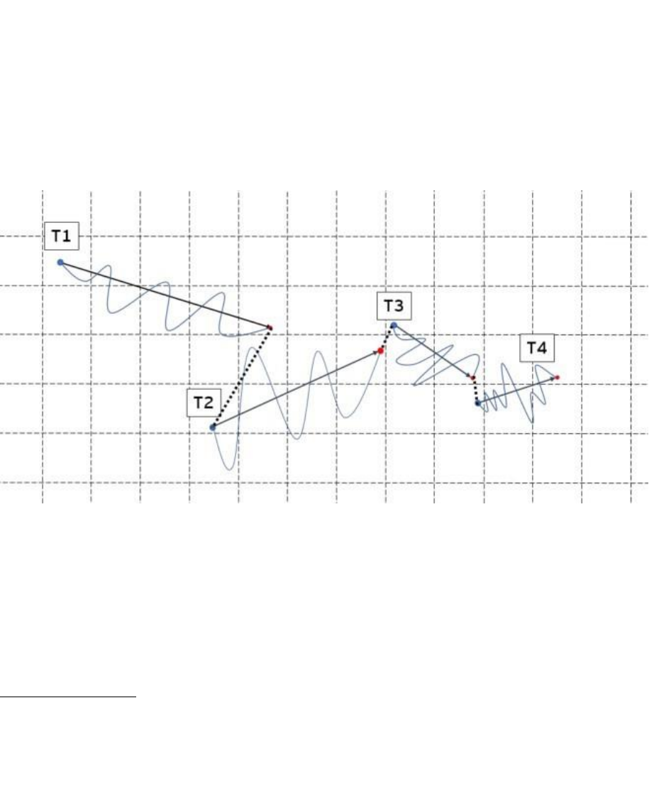
For each device you will get multiple trajectories. The set of all trajectories of a device
represents a simplification of the journey of one person for 24 hours. The graphic below shows
a full journey of a device.
It is important to note that each device has a different number of trajectories
Trajectories are separated. In the graph, this separation is shown as a dotted line between the
exit point of a trajectory and the entry point of the next one. These dotted lines represent blind
parts of the journey where the device did not record the location.
4. Dataset Details
There are approximately 210,000 devices and 11 columns in the database. You will receive
these records separated into two datasets to download:
• A train dataset (data_train.csv)
• A test dataset (data_test.csv)
The train dataset contains 80% of the records, while the test dataset contains 20%. The test
dataset will then be split into public and private datasets.
The variables in the dataset are as follows:
Variable name
Type
Description
hash
String
Represents the unique identifier of a device
trajectory_id
String
Represents the unique identifier of a trajectory associated to a device
time_entry*
Date
Indicates the local time for the starting point of the trajectory (HH:mm:ss)
time_exit*
Date
Indicates the local time for the ending point of the trajectory (HH:mm:ss)
Vmax
Integer
Represents the maximum velocity registered in the course of a trajectory.
Vmin
Integer
Represents the minimum velocity registered in the course of a trajectory.
Vmean
Integer
Represents the average velocity registered in the course of a trajectory.
x_entry
Double
Entry x coordinate (cartesian projected position)
y_entry
Double
Entry y coordinate (cartesian projected position)
x_exit
Double
Exit x coordinate (cartesian projected position)
y_exit
Double
Exit y coordinate (cartesian projected position)
*All the data related to time is shown in Atlanta’s local time (Eastern Time).
5. The challenge
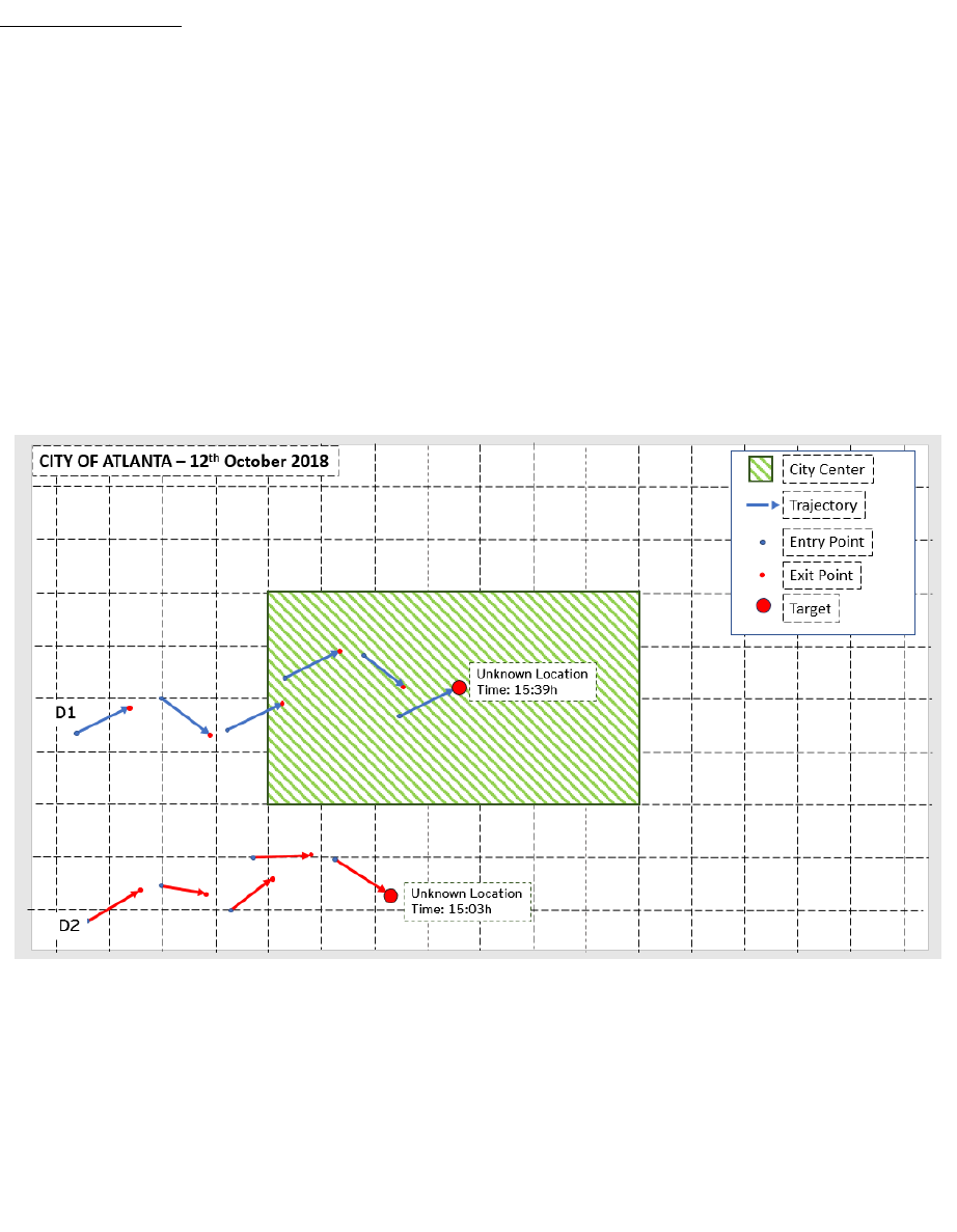
You must predict how many people are in the city center between 15:00 and 16:00.
The test dataset contains a number of devices where the trajectories after 15:00 have been
removed. All but one: After 15:00, you will find one last trajectory, with (1) entry location, (2)
entry time and an exit time that is between 15:00 and 16:00. But the exit point has been
removed.
Your task is to predict the location of this last exit point and whether this device is within
the city center or not. The target variable is the latter.
See the graphic example below.
After you estimate the position of each target, you will have to classify that point based on
whether it is located inside the city center or not. To do so, you will have to implement a rule
that outlies the limits of the city center of Atlanta (decimal point “.”):
3750901.5068 ≤ 𝑥 ≤ 3770901.5068
−19268905.6133 ≤ 𝑦 ≤ −19208905.6133
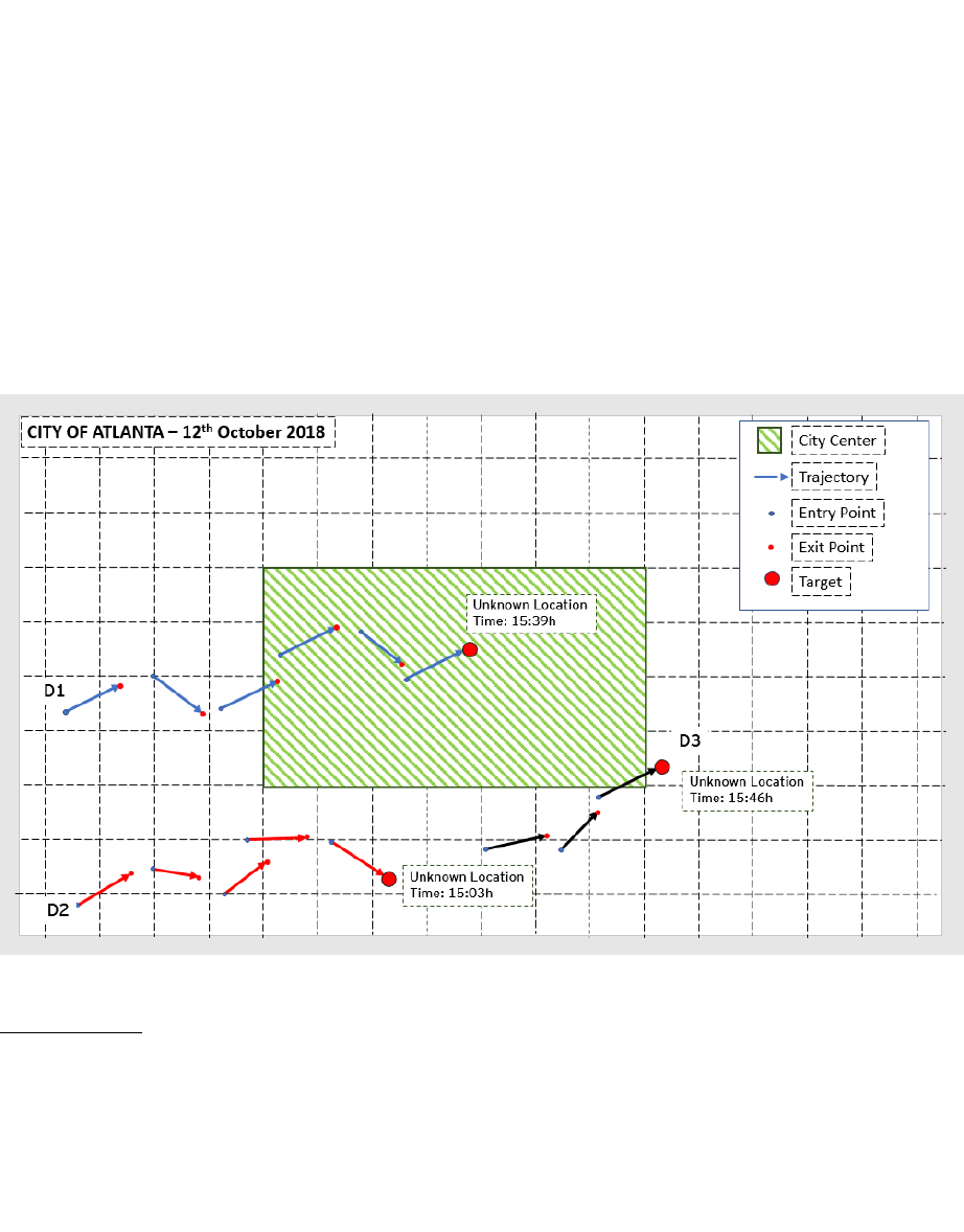
You will need to classify each of the exit points whether they are within (1) or outside (0) the
limits of the city center. For example, Device 1 in the graph is in the city center between 15:00
and 16:00, therefore Device 1 will be classified with a “1” while Device 2, which is not in the
city center in that timestamp will be classified with a “0”.
Some trajectories may “cross” the city center, but their exit point will be outside the city
center. See the example of Device 3 (D3) in the graph below. For the sake of simplicity, these
trajectories are considered outside the center, given that we only consider if the exit point is
within boundaries or not.
6. Submission
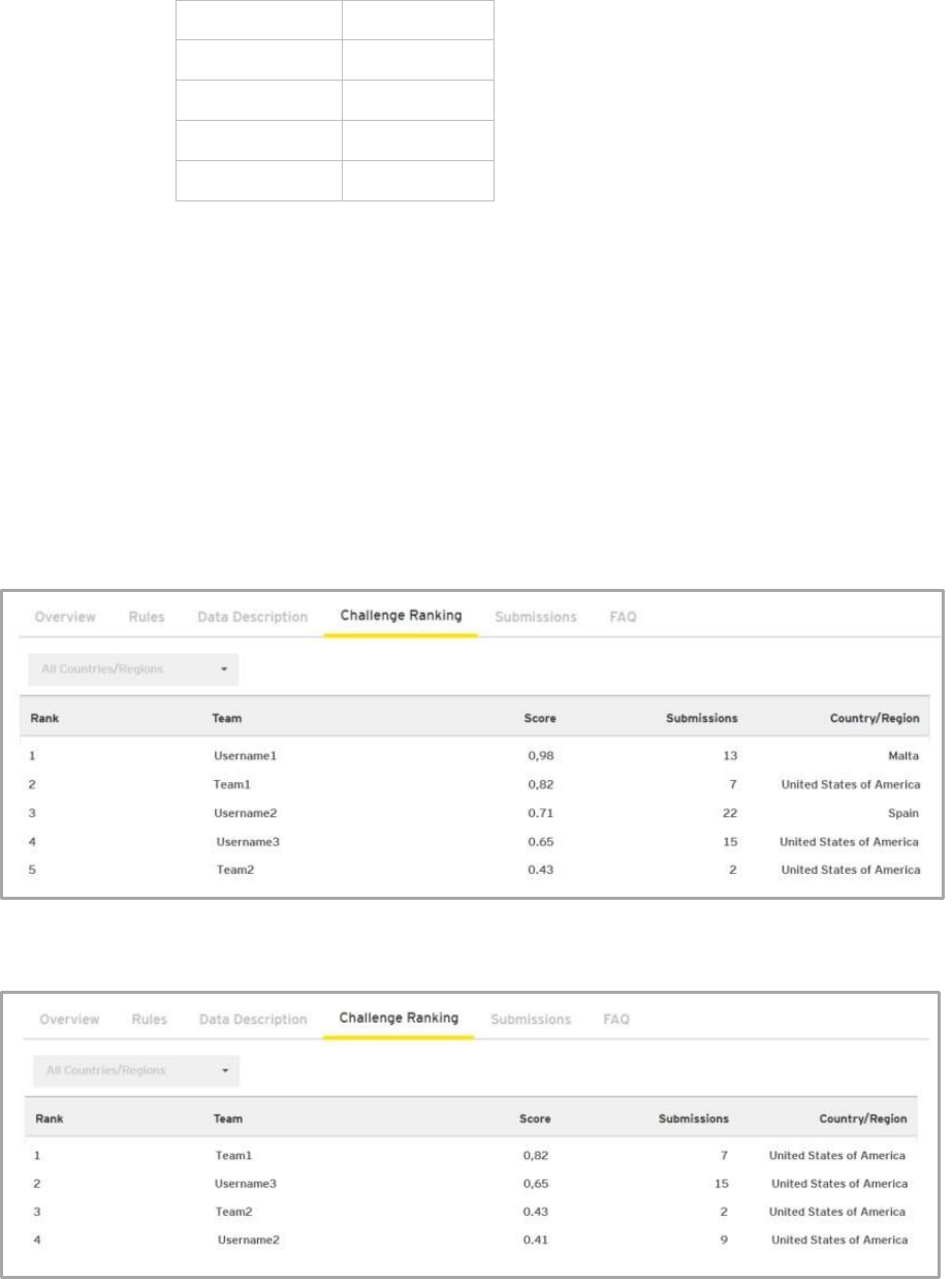
After classifying each of the targets, you will have to submit your results in the following
format: trajectory_id ; city_center
The trajectory id identifies the last trajectory of a device and the city center identifies the
location of that point. Here’s an example of how a submission would look:
trajectory_id
city_center
123df5
1
345rgf
0
678lsp
0
910dcw
1
Trajectory “123df5” ends in the center, while trajectory 345rgf does not.
Submissions are evaluated using the F1-score between the predicted and the observed target.
Your results will be compared to the real data both using public and private datasets. In the
challenge ranking you will be able to see the score based on the public dataset only. Your score
will be between 0 and 1, 1 meaning you got all the values correct and 0 meaning you didn’t get
any.
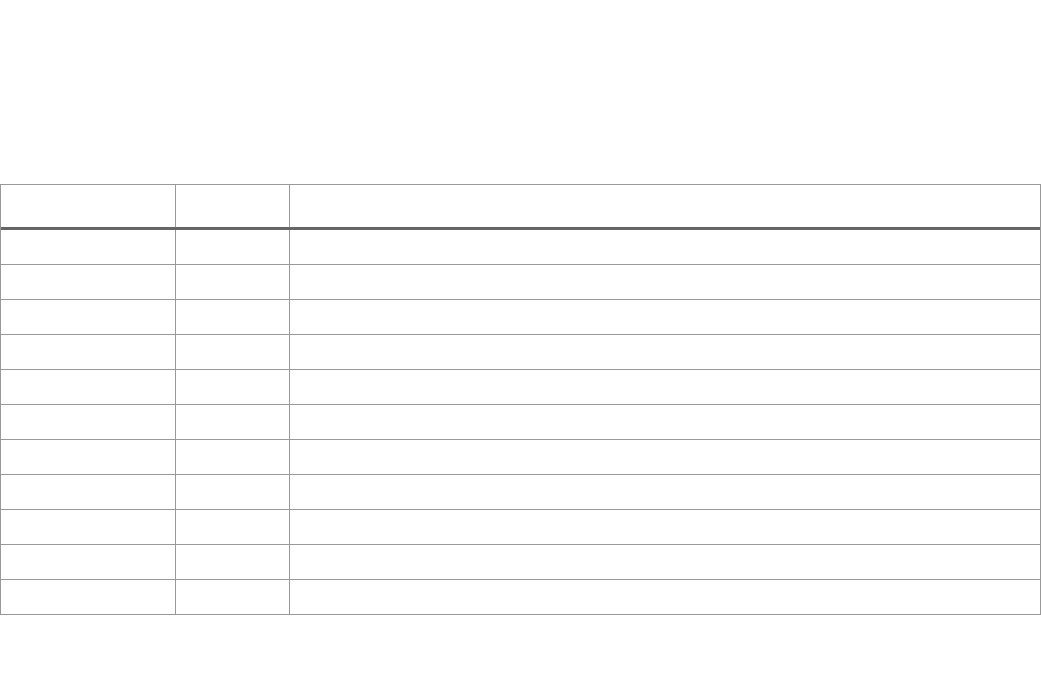
This an example of how the global (All countries) ranking would look:
And this is an example of how the “United States of America” ranking would look:

7. Suggestions
• Remember you can participate as a team of up to two persons.
• Be mindful that there is a time component in the dataset. When proceeding with the
analysis, data may need to be aggregated or grouped to be successfully processed.
• Be rigorous during the data cleaning process.
• Do not forget to consider the presence of outliers.
• It would be advisable to work on cloud solutions for better performance.
• External datasets can be used to complement the analysis. Read the terms and conditions
for more clarification on this.
8. Important competition dates
• Competition starts on 1 April 00:00 (CET) and ends on 10 May 2019, 23:59 (CET).
• The global and local rankings will be available on the 11 May onwards.
• Before 14 May, EY will announce the country / region winners.
• The global award ceremony is 14 June 2019 in New York City, New York.
Please read in detail Terms & Conditions to understand all dates and details of the different
phases of the competition.
9. Country / region finals
If you are among the top performers in your country / region on 10 May, you will be invited by
the local EY firm to take part in the country / region final. Check Terms & Conditions for more
details.
Finalists will present their findings to a group of judges to compete to become the country /
region winner.
Before participating in the Finals, please take the following points into consideration to ensure
you are prepared:

1) Get prepared before the competition ends
Check the national (your country’s / region’s) ranking periodically. If you’re at the top or among
the leaders who might be invited to the finals, get ready for the next stage. Do not wait until
the last minute or the final confirmation to make sense of your results. During the competition
take time to identify non-obvious patterns, consider alternative approaches, and think of
potential opportunities of how cities could use geolocation information.
2) Be prepared to demonstrate your eligibility and support your findings
If you are shortlisted for the country / regional finals, you will be required to send information
that demonstrates your eligibility to participate in the challenge.
Also, you will need to send information supporting your work. See Terms and Conditions for
full details.
3) What to expect during country / regional finals?
Data science goes beyond deciding what model or calculation to use. Good data scientists make
sense of their findings, think of real-world applications, and articulate their ideas to colleagues.
For that reason, all country / regional finalists are required to present their analysis to local EY
leadership.
The format of the country / region final will consist of selected participants presenting their
work to a panel of EY judges. Requirements for the presentations will be issued to finalists in
advance.
Each judge will use a standard scorecard to assess a finalist’s performance separately. The
assessment will include: methodologies and algorithms used, depth of insights provided, use of
external information, ability to communicate (including level of English), and quality of the
presentation.
See Terms and Conditions for full details.
10. Requesting help
In case you need help using the platform, please visit the help section here:
https://datascience.ey.com/help
