PI TJ 14 01 _OPR B367 14, Buzzards Bay_Instructions OPR Bay Instructions
User Manual: _OPR-B367-TJ-14, Buzzards Bay_Instructions instructions pdf - FTP File Search (4/20)
Open the PDF directly: View PDF ![]() .
.
Page Count: 27
UNITED STATES DEPARTMENT OF COMMERCE
National Oceanic and Atmospheric Administration
NATIONAL OCEAN SERVICE
Office of Coast Survey
Silver S
p
rin
g
, Mar
y
land 20910-3282
FINAL Project Instruction
Date Submitted: March 26, 2014
Platform: NOAA Ship Thomas Jefferson
Project Number: TJ-14-01(OMAO)
Project Title: Buzzards Bay, Narraganset Bay, and Vicinity
Project Dates: 03/31/2014 – 09/30/2014
Prepared by: ________________________ Dated: __________________
LCDR Michael Gonsalves, NOAA
Chief, Operations Branch
Hydrographic Surveys Division
Approved by: ________________________ Dated: __________________
Jeffrey Ferguson
Chief, Hydrographic Surveys Division
Office of Coast Survey
Approved by: ________________________ Dated: ________________
CAPT Anne K. Lynch, NOAA
Commanding Officer
Marine Operations Center - Atlantic
Digitally signed by
GONSALVES.MICHAEL.O.127563
5126
Date: 2014.03.27 07:03:24 -04'00'
Date: 2014.03.27
07:36:12 -04'00'

2
I. Overview
A. Brief Summary and Project Period
This survey is scheduled to begin in April 2014 and end in September 2014. This
project is being conducted in support of NOAA’s Office of Coast Survey to
provide contemporary hydrographic data in order to update the nautical charting
products and reduce survey backlog in the area.
B. Days at Sea (DAS)
Of the 59 DAS scheduled for this project, 0 DAS are funded by an OMAO
allocation, 59 DAS are funded by a Line Office Allocation, 0 DAS are Program
Funded, and 0 DAS are Other Agency funded. This project is estimated to exhibit
a High Operational Tempo.
C. Operating Area
The project area is located in the Approaches to Buzzards Bay, MA. A layout of
the project area can be found with the detailed project instructions appended to
these instructions.
D. Summary of Objectives
To support safe navigation through the acquisition and processing of
hydrographic survey data for updating nautical charts and by the identification
and dissemination of dangers to navigation as identified during the course of
survey operations.
E. Participating Institutions
N/A
F. Personnel/Science Party: name, title, gender, affiliation, and nationality
G. Administrative
1. Points of Contact:
Principal Investigator:
Name (Last,
First) Title Date
Aboard Date
Disembark Gender Affiliation Nationality
Chauveau, Bryan PS 03/31/2014 4/11/2014 M NOAA USA
Marshall, Jeff PS 03/31/2014 4/11/2014 M NOAA USA
Chauveau, Bryan PS 08/18/2014 08/27/2014 M NOAA USA
Self-Miller,
Vanessa PS 09/22/2014 09/30/2014 F NOAA USA
Chauveau, Bryan PS 09/22/2014 09/30/2014 M NOAA USA

3
LCDR Michael Gonsalves, NOAA
Chief, Operations Branch
Hydrographic Surveys Division
1315 East West Hwy, #6854
Silver Spring, MD 20910
(301) 713-2702 x112
Michael.Gonsalves@noaa.gov
Project Coordinator:
Paul Turner
Physical Scientist, Operations Branch
Hydrographic Surveys Division
1315 East West Hwy, #6708
Silver Spring, MD 20910
(301) 713-2702 x106
Paul.Turner@noaa.gov
Chief Scientist:
CDR James Crocker, NOAA
Commanding Officer, NOAA Ship Thomas Jefferson
439 West York Street
Norfolk, VA 23510-1114
(603) 812-8784
CO.Thomas.Jefferson@noaa.gov
2. Diplomatic Clearances
None Required.
3. Licenses and Permits
The Office of Coast Survey is sensitive to the potential effects of its
operations on the physical, biological, and cultural marine environment. In
accordance with the National Environmental Protection Act, Coast Survey
prepared a Programmatic Environmental Assessment to gauge the
environmental impacts resulting from surveying and other data-gathering
activities. As a result, the National Ocean Service has published a Finding
of No Significant Impact (FONSI) for the Office of Coast Survey program
of conducting hydrographic surveys for the calendar years 2013 - 2018.
For further information, please refer to
http://www.nauticalcharts.noaa.gov/Legal/
II. Operations
The Chief Scientist is responsible for ensuring the scientific staff are trained in planned
operations and are knowledgeable of project objectives and priorities. The Commanding Officer
4
is responsible for ensuring all operations conform to the ship’s accepted practices and
procedures.
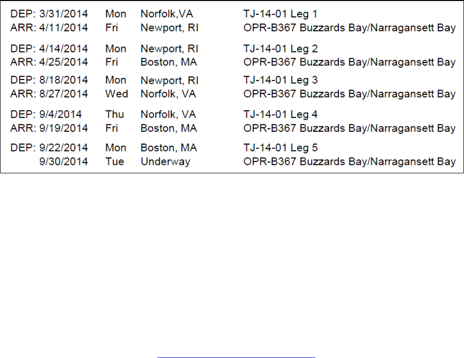
A. Project Itinerary:
Itinerary will be based upon the ship’s schedule and executed under the direction of the
Commanding Officer. Every effort shall be made by the Commanding Officer to
maximize the operational efficiency of assigned projects. Please refer to ships sailing
schedule below:
B. Staging and Destaging: N/A
C. Operations to be Conducted:
Hydrographic survey operations per the appended project instructions using two survey
launches up to 10 hr/day for data acquisition and project field support. Additionally, the
ability to run concurrent 24 hr ship survey operations for short periods of time or for
extended periods of time with reduced launch operations.
D. Dive Plan
All dives are to be conducted in accordance with the requirements and regulations of the
NOAA Diving Program (http://www.ndc.noaa.gov/dr.html) and require the approval of
the ship’s Commanding Officer.
Dives are not planned for this project.
E. Applicable Restrictions
Conditions which preclude normal operations:
• Poor weather conditions
• Equipment failure
• Safety concerns
• Personnel shortage
5
III. Equipment
A. Equipment and Capabilities provided by the ship (itemized)
1. Two fully-outfitted and operational survey launches to support shallow water
survey operations utilizing hull-mounted side scan sonar, multibeam, and
vertical beam sonar systems.
2. Ship fully-outfitted with hydrographic survey equipment to support
multibeam survey operations.
3. Personnel to staff and operate the ship’s survey equipment for 24 hr/day
operations and a minimum of 2 survey launches and equipment for up to 10
hr per day concurrently, at the discretion of the command to ensure the most
efficient survey operations.
4. A fully-staffed survey department to efficiently manage the project’s data
processing requirements.
B. Equipment and Capabilities provided by the scientists (itemized)
Hydrographic Surveys Division shall provide Physical Scientists for hydrographic
data acquisition, processing, training, and data quality assurance support during
project survey operations. Additionally, shore-based technical support shall be
provided for survey systems and data acquisition and processing software.
IV. Hazardous Materials
A. Policy and Compliance
No Hazardous Materials are being brought aboard the ship for this project.
B. Radioactive Materials
No Radioactive Isotopes are planned for this project
V. Additional Projects
A. Supplementary (“Piggyback”) Projects
No Supplementary Projects are planned.
B. NOAA Fleet Ancillary Projects
No NOAA Fleet Ancillary Projects are planned.

6
VI. Disposition of Data and Reports
Disposition of data gathered aboard NOAA ships will conform to NAO 216-101 Ocean Data
Acquisitions and NAO 212-15 Management of Environmental Data and Information. To guide
the implementation of these NAOs, NOAA’s Environmental Data Management Committee
(EDMC) provides the NOAA Data Documentation Procedural Directive (data documentation)
and NOAA Data Management Planning Procedural Directive (preparation of Data Management
Plans). OMAO is developing procedures and allocating resources to manage OMAO data and
Programs are encouraged to do the same for their Project data.
VII. Meetings, Vessel Familiarization, and Project Evaluations
A. Pre-Project Meeting: The Principal Investigator and Commanding Officer will
conduct a meeting of pertinent members of the scientific party and ship’s crew to
discuss required equipment, planned operations, concerns, and establish
mitigation strategies for all concerns. This meeting shall be conducted before the
beginning of the project with sufficient time to allow for preparation of the ship
and project personnel. The ship’s Operations Officer usually is delegated to assist
the Principal Investigator in arranging this meeting.
B. Vessel Familiarization Meeting: The Commanding Officer is responsible for
ensuring scientific personnel are familiarized with applicable sections of the
standing orders and vessel protocols, e.g., meals, watches, etiquette, drills, etc. A
vessel familiarization meeting shall be conducted in the first 24 hours of the
project’s start and is normally presented by the ship’s Operations Officer.
C. Post-Project Meeting: The Commanding Officer is responsible for conducted a
meeting no earlier than 24 hrs before or 7 days after the completion of a project to
discuss the overall success and short comings of the project. Concerns regarding
safety, efficiency, and suggestions for future improvements shall be discussed and
mitigations for future projects will be documented for future use. This meeting
shall be attended by the ship’s officers, applicable crew, the Chief Scientist, and
members of the scientific party and is normally arranged by the Operations
Officer and Chief Scientist.
D. Project Evaluation Report
Within seven days of the completion of the project, a Customer Satisfaction
Survey is to be completed by the Chief Scientist. The form is available at
http://www.omao.noaa.gov/fleeteval.html and provides a “Submit” button at the
end of the form. Submitted form data is deposited into a spreadsheet used by
OMAO management to analyze the information. Though the complete form is
not shared with the ships, specific concerns and praises are followed up on while
not divulging the identity of the evaluator.

7
VIII. Miscellaneous
A. Meals and Berthing
The ship will provide meals for the scientists listed above. Meals will be served 3 times
daily beginning one hour before scheduled departure, extending throughout the project,
and ending two hours after the termination of the project. Since the watch schedule is
split between day and night, the night watch may often miss daytime meals and will
require adequate food and beverages (for example a variety of sandwich items, cheeses,
fruit, milk, juices) during what are not typically meal hours. Special dietary requirements
for scientific participants will be made available to the ship’s command at least seven
days prior to the project.
Berthing requirements, including number and gender of the scientific party, will be
provided to the ship by the Chief Scientist. The Chief Scientist and Commanding Officer
will work together on a detailed berthing plan to accommodate the gender mix of the
scientific party taking into consideration the current make-up of the ship’s complement.
The Chief Scientist is responsible for ensuring the scientific berthing spaces are left in the
condition in which they were received; for stripping bedding and linen return; and for the
return of any room keys which were issued. The Chief Scientist is also responsible for the
cleanliness of the laboratory spaces and the storage areas utilized by the scientific party,
both during the project and at its conclusion prior to departing the ship.
All NOAA scientists will have proper travel orders when assigned to any NOAA ship.
The Chief Scientist will ensure that all non NOAA or non Federal scientists aboard also
have proper orders. It is the responsibility of the Chief Scientist to ensure that the entire
scientific party has a mechanism in place to provide lodging and food and to be
reimbursed for these costs in the event that the ship becomes uninhabitable and/or the
galley is closed during any part of the scheduled project.
All persons boarding NOAA vessels give implied consent to comply with all safety and
security policies and regulations which are administered by the Commanding Officer. All
spaces and equipment on the vessel are subject to inspection or search at any time. All
personnel must comply with OMAO's Drug and Alcohol Policy dated May 17, 2000
which forbids the possession and/or use of illegal drugs and alcohol aboard NOAA
Vessels.
B. Medical Forms and Emergency Contacts
The NOAA Health Services Questionnaire (NHSQ, Revised: 02 JAN 2012) must be
completed in advance by each participating scientist. The NHSQ can be obtained from
the Chief Scientist or the NOAA website
http://www.corporateservices.noaa.gov/~noaaforms/eforms/nf57-10-01.pdf.
All NHSQs submitted after March 1, 2014 must be accompanied by NOAA Form (NF)
57-10-02 - Tuberculosis Screening Document in compliance with OMAO Policy 1008
(Tuberculosis Protection Program).

8
The completed forms should be sent to the Regional Director of Health Services at the
applicable Marine Operations Center. The NHSQ and Tuberculosis Screening Document
should reach the Health Services Office no later than 4 weeks prior to the start of the
project to allow time for the participant to obtain and submit additional information
should health services require it, before clearance to sail can be granted. Please contact
MOC Health Services with any questions regarding eligibility or completion of either
form. Ensure to fully complete each form and indicate the ship or ships the participant
will be sailing on. The participant will receive an email notice when medically cleared to
sail if a legible email address is provided on the NHSQ.
The participant can mail, fax, or email the forms to the contact information below.
Participants should take precautions to protect their Personally Identifiable Information
(PII) and medical information and ensure all correspondence adheres to DOC guidance
(http://ocio.os.doc.gov/ITPolicyandPrograms/IT_Privacy/PROD01_008240).
The only secure email process approved by NOAA is Accellion Secure File Transfer
which requires the sender to setup an account. Accellion’s Web Users Guide is a
valuable aid in using this service, however to reduce cost the DOC contract doesn’t
provide for automatically issuing full functioning accounts. To receive access to a “Send
Tab”, after your Accellion account has been established send an email from the
associated email account to accellionAlerts@doc.gov requesting access to the “Send
Tab” function. They will notify you via email usually within 1 business day of your
approval. The ‘Send Tab” function will be accessible for 30 days.
Contact information:
Regional Director of Health Services
Marine Operations Center – Atlantic
439 W. York Street
Norfolk, VA 23510
Telephone 757-441-6320
Fax 757-441-3760
Email MOA.Health.Services@noaa.gov
Prior to departure, the Chief Scientist must provide an electronic listing of emergency
contacts to the Executive Officer for all members of the scientific party, with the
following information: contact name, address, relationship to member, and telephone
number.
C. Shipboard Safety
Hard hats are required when working with suspended loads. Work vests are required
when working near open railings and during small boat launch and recovery operations.
Hard hats and work vests will be provided by the ship when required.
Wearing open-toed footwear or shoes that do not completely enclose the foot (such as
sandals or clogs) outside of private berthing areas is not permitted. At the discretion of

9
the ship CO, safety shoes (i.e. steel or composite toe protection) may be required to
participate in any work dealing with suspended loads, including CTD deployment and
recovery. The ship does not provide safety-toed shoes/boots. The ship’s Operations
Officer should be consulted by the Chief Scientist to ensure members of the scientific
party report aboard with the proper attire.
D. Communications
A progress report on operations prepared by the Chief Scientist may be relayed to the
program office. Sometimes it is necessary for the Chief Scientist to communicate with
another vessel, aircraft, or shore facility. Through various means of communications, the
ship can usually accommodate the Chief Scientist. Special radio voice communications
requirements should be listed in the project instructions. The ship’s primary means of
communication with the Marine Operations Center is via email and the Very Small
Aperture Terminal (VSAT) link. Standard VSAT bandwidth at 128kbs is shared by all
vessels staff and the science team at no charge. Increased bandwidth in 30 day increments
is available on the VSAT systems at increased cost to the scientific party. If increased
bandwidth is being considered, program accounting is required and it must be arranged at
least 30 days in advance.
E. IT Security
Any computer that will be hooked into the ship's network must comply with the OMAO
Fleet IT Security Policy 1.1 (November 4, 2005) prior to establishing a direct connection
to the NOAA WAN. Requirements include, but are not limited to:
(1) Installation of the latest virus definition (.DAT) file on all systems and
performance of a virus scan on each system.
(2) Installation of the latest critical operating system security patches.
(3) No external public Internet Service Provider (ISP) connections.
Completion of the above requirements prior to boarding the ship is required.
Non-NOAA personnel using the ship's computers or connecting their own computers to
the ship's network must complete NOAA’s IT Security Awareness Course within 3 days
of embarking.
F. Foreign National Guests Access to OMAO Facilities and Platforms
Foreign National access to the NOAA ship or Federal Facilities is not required for this
project.
VIII. Appendices
1. Primary Project Instructions: OPR-B367-TJ-14, Buzzards Bay and Approaches

1
Hydrographic Survey Project Instructions
Project Name:
Buzzards Bay, Narraganset Bay, and Vicinity
Project Number:
OPR-B367-TJ-14
Assigned Field Unit:
NOAA Ship Thomas Jefferson
Assigned Processing Branch:
Atlantic Hydrographic Branch
Signed Date:
03/26/2014
Project Instructions Version:
Final
Planned Acquisition Time:
Start Date: 03/2014
End Date: 09/2014
Delivery Dates:
120 days from completion of data acquisition.
Purpose and Location:
This project is being conducted in support of NOAA's Office of Coast Survey to provide
contemporary hydrographic data in order to update the nautical charting products and reduce
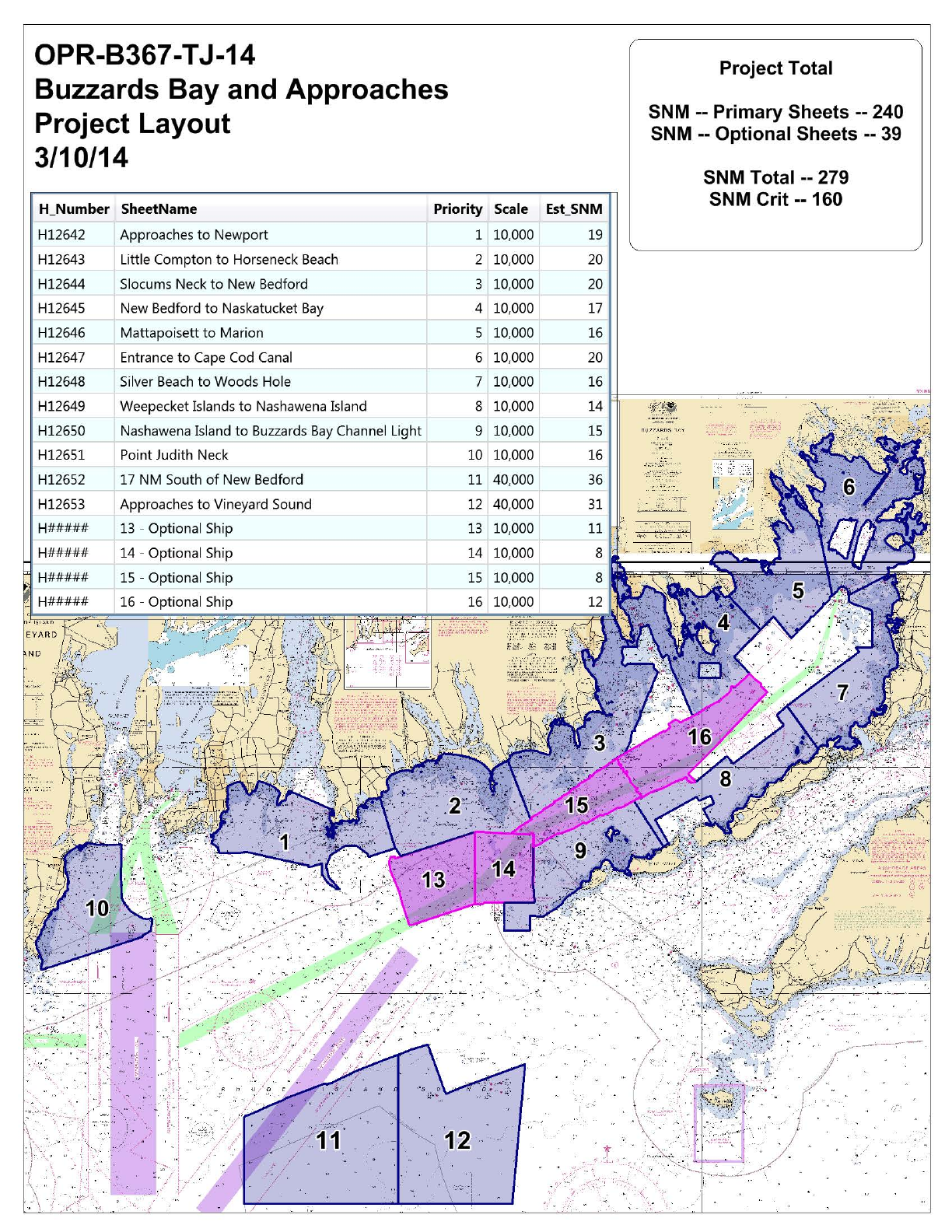
the survey backlog within the area. This project will cover approximately 279 square nautical
miles (snm) of which 160 snm are critical survey areas as designated in the NOAA Hydrographic
Survey Priorities, 2012 edition.
Supporting Documents:
Hydrography shall consist of Navigable Area Surveys in accordance with the following support
documents. Data from surveys is intended to supersede all prior survey data in the common area.
NOS Hydrographic Surveys Specifications and Deliverables Manual (HSSD), April 2013
NOS Field Procedures Manual for Hydrographic Surveying (FPM), April 2013
Hydrographic Survey Technical Directive (HTD): 2013-4 Configuration Management
PERSONNEL SAFETY AND DATA QUALITY SHALL ALWAYS BE EMPHASIZED OVER DATA
QUANTITY! THE HYDROGRAPHER SHALL NEVER SUBJECT PERSONNEL OR BOATS TO
UNDUE RISKS AND HAZARDS.

2
Registry Details:
General Locality: Buzzards Bay, MA
Registry
Number
Priority
Sublocality
State or
Territory
Scale
Estimated
SNM
Instructions
H12642
1
Approaches
to Newport
Rhode Island
10000
19
H12643
2
Little Compton
to Horseneck
Beach
Massachusetts
Rhode Island
10000
20
H12644
3
Slocums Neck
to New Bedford
Massachusetts
10000
20
H12645
4
New Bedford
to Naskatucket
Bay
Massachusetts
10000
17
H12646
5
Mattapoisett
to Marion
Massachusetts
10000
16
H12647
6
Entrance
to Cape
Cod Canal
Massachusetts
10000
20
H12648
7
Silver Beach
to Woods Hole
Massachusetts
10000
16
H12649
8
Weepecket
Islands to
Nashawena
Island
Massachusetts
10000
14
H12650
9
Nashawena
Island to
Buzzards Bay
Channel Light
Massachusetts
10000
15
H12651
10
Point
Judith Neck
Rhode Island
10000
16
H12652
11
17 NM South
of New Bedford
Rhode Island
40000
36
H12653
12
Approaches
to Vineyard
Sound
Massachusetts
40000
31
HXXXXX
13
Buzzards Bay
Ship Channel,
Sheet 1
Massachusetts
Rhode Island
10000
11
Secondary, Optional
Ship Sheet. Assigned
as time allows and
not to interfere with
primary sheets 1 - 12.
3
Registry
Number
Priority
Sublocality
State or
Territory
Scale
Estimated
SNM
Instructions
HXXXXX
14
Buzzards Bay
Ship Channel,
Sheet 2
Massachusetts
10000
8
Secondary, Optional
Ship Sheet. Assigned
as time allows and
not to interfere with
primary sheets 1 - 12.
HXXXXX
15
Buzzards Bay
Ship Channel,
Sheet 3
Massachusetts
10000
8
Secondary, Optional
Ship Sheet. Assigned
as time allows and
not to interfere with
primary sheets 1 - 12.
HXXXXX
16
Buzzards Bay
Ship Channel,
Sheet 4
Massachusetts
10000
12
Secondary, Optional
Ship Sheet. Assigned
as time allows and
not to interfere with
primary sheets 1 - 12.
Coverage & Limits:
Inshore Limit:The inshore limit of hydrography will be the farthest offshore of the following: (1)
the 4-meter depth contour or (2) the line defined by the distance seaward from the MHW line
which is equivalent to 0.8 millimeters at the scale of the largest scale nautical chart.
Coverage Type: Object Detection
Instructions:
Coverage Water Depth
Coverage Required
4 meters to 20 meters water depth
200% SSS with concurrent Set Line Spacing
SBES or MBES with Backscatter, or
Object Detection MBES with Backscatter
Greater than 20 meters water depth
Complete Multibeam with Backscatter
Assigned Tasks
Acknowledgement:
Acknowledge receipt of these instructions and submit any comments or questions via email to
Paul Turner at Paul.Turner@noaa.gov.
Aids to Navigation (ATONs):
There are no ATONs specifically assigned for this project. Any ATONs located within the survey
area should be verified so that they serve their intended purpose in accordance with section 7.2 of
the HSSD.

4
AWOIS Items:
There are no AWOIS investigation requirements for this project.
Maritime Boundary Points (MBPs):
Investigate Maritime Boundary Points in accordance with section 3.5.6 of the FPM.
Bottom Samples:
Obtain bottom samples in accordance with section 7.1 of the HSSD in areas designated by
the feature object class springs (SPRING) in the Project Reference File (PRF). Review the
recommended bottom sample locations with regards to the acquired survey data. Contact
HSD Operations Branch if it is determined that modifying the bottom sample plan would better
differentiate the varying bottom characteristic within the survey area. Any modification to the
bottom sample plan shall closely maintain the same plan provided. This may increase or decrease
the sample density but should closely maintain the same numbers of samples per survey as
originally assigned.

5
Chart Comparison:
Use only the latest editions of the largest scale NOS charts covering the project area. Compare
in accordance with section 4.5 of the FPM and section 8.1.4, D.1 of the HSSD. Resolve any
discrepancies identified in the field and explain them in the Descriptive Report. The charts, listed
below, were used in the preparation of these project instructions and accompanying project files.
Affected Raster Charts
Chart
Number
Scale
Edition
Number
Edition Date
LNM Date
NM Date
13235
5000
7
07/2012
06/26/2012
07/07/2012
13223
20000
43
06/2013
06/18/2013
06/29/2013
13232
20000
5
11/2009
10/27/2009
11/07/2009
13228
20000
12
11/2009
11/10/2009
11/21/2009
13236
20000
31
04/2012
04/03/2012
04/14/2012
13219
15000
13
12/2011
11/29/2011
12/10/2011
13221
40000
59
03/2012
03/06/2012
03/17/2012
13230
40000
50
08/2012
08/03/2010
08/14/2010
13229
12000
32
06/2013
06/18/2013
06/29/2013
13218
80000
42
07/2013
07/16/2013
07/27/2013
Affected ENCs
ENC Name
Scale
Edition
Update
Application
Date
Issue Date
Preliminary
US5MA28M
5000
7
08/20/2012
09/11/2013
NO
US5RI21M
15000
6
01/04/2013
03/25/2013
NO
US5RI22M
20000
23
09/16/2013
11/15/2013
NO
US5MA24M
20000
11
08/10/2012
11/21/2013
NO
US5MA26M
20000
14
08/14/2012
06/06/2013
NO
US5MA27M
20000
22
08/31/2012
09/26/2013
NO
US5RI20M
40000
13
12/26/2012
12/26/2012
NO
US5MA25M
40000
19
08/28/2012
06/06/2013
NO
US5MA20M
40000
7
10/25/2013
10/25/2013
NO
US4MA23M
80000
27
11/07/2013
12/11/2013
NO
6
Coast Pilot:
Review and make recommendations for changes to the Coast Pilot. Coast Pilot excerpts
can be downloaded from the Coast Pilot website (http://www.nauticalcharts.noaa.gov/nsd/
cpdownload.htm). Submit the revised Coast Pilot section or a report stating no changes are
recommended, via email to Coast.Pilot@noaa.gov and ocs.ndb@noaa.gov with a courtesy copy
to the HSD OPS project planner and the appropriate Processing Branch. The report should be
submitted as soon as possible following field work for the project. Refer to sections 3.5.7 and
5.2.2.2.5 of the FPM for more information.
Dangers to Navigation (DTONs):
Generate DTON reports in accordance with the HSSD, section 8.1.3. DTON reports should be
sent to ocs.ndb@noaa.gov. It is of paramount importance that DTONs be reported as soon as
possible.

7
Junctions:
Junction with data from the surveys listed below. A Survey Junction Analysis is NOT required for
Junction Surveys H10461, H10496, H10575, and H10434 if the Secondary, Optional Ship Sheets
are surveyed. Refer to sections 2.2.2.3 and 4.5.2 of the FPM.
Registry
Number
Scale
Year
Platform
Relative
Location
H10404
10000
1991
NOAA Ship Rude
W
H10434
10000
1992
NOAA Ship Rude
N
F00373
10000
1992
NOAA Ship Rude
N
H10461
10000
1993
NOAA Ship Rude
NE
H10496
10000
1993
NOAA Ship Rude
NE
H10511
10000
1993
NOAA Ship Rude
NE
H10530
10000
1994
NOAA Ship Rude
NE
H10575
10000
1994
NOAA Ship Rude
N
H10520
10000
1994
NOAA Ship Rude
NE
H10648
10000
1995
NOAA Ship Rude
SW
H10659
10000
1995
NOAA Ship Rude
SW
H10605
10000
1995
NOAA Ship Rude
W
H10711
10000
1996
NOAA Ship Rude
NW
H11318
10000
2004
NOAA Ship Rude
NE
H11319
10000
2004
NOAA Ship Rude
NE
H11076
5000
2004
NOAA Ship Thomas Jefferson
E
H11922
10000
2008
NOAA Ship Thomas Jefferson
SE
H11995
10000
2008
NOAA Ship Thomas Jefferson
SW
H11996
10000
2008
NOAA Ship Thomas Jefferson
SW
H11921
10000
2008
NOAA Ship Thomas Jefferson
S
H12324
10000
2011
Navigation Response Team 5
S
Progress Reports:
Email monthly progress reports in accordance with section 5.2.2.2.1 of the FPM to
progress.sketches@noaa.gov with a copy to the chief of the assigned Processing Branch. The
submittal is due within 5 days after the end of each month.
Survey Outlines:
Generate a survey outline in accordance with the HSSD, section 8.1.2. Submit survey outlines to
survey.outlines@noaa.gov.
8
Horizontal Control Requirements:
Comply with the horizontal control requirements in section 3 of the HSSD.
Vertical Control Requirements:
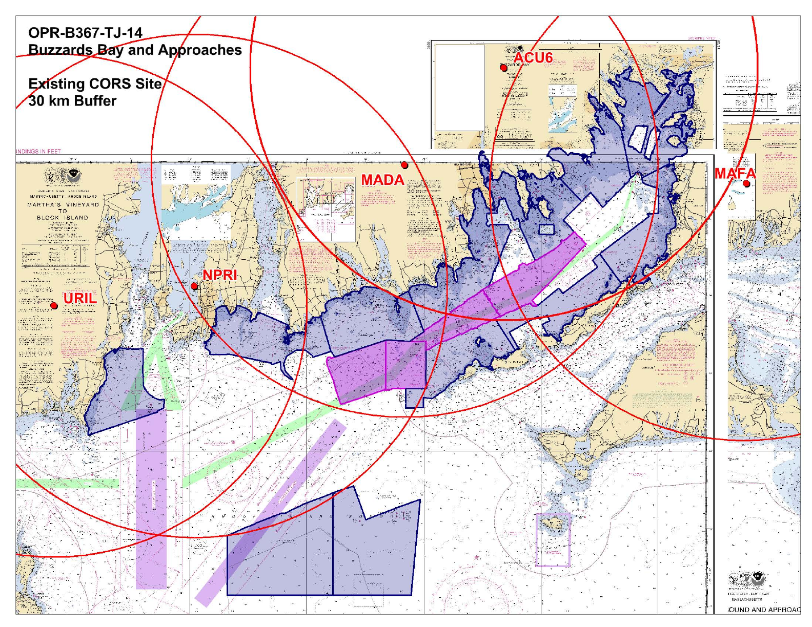
Comply with the horizontal control requirements in section 4 of the HSSD. HSD Ops has
performed preliminary analysis of CORS Stations. Results are shown on the attached image
following the Sheet Layout. Available CORS stations are shown in addition to a 30 km buffer
surrounding the station.
TCARI
Comply with the requirements from CO-OPS which are included with the project data from
the Operations Branch. Submit surveys with final approved water levels applied. Contact the
Operations Branch if this causes the survey to miss a submission deadline.
VDatum
Please refer to Appendix 1 attached to this document for ERS vertical specific deliverables.
Vertical control will either be the CO-OPS provided model or VDATUM, and will officially be
decided on upon delivery of interim deliverable products, as per Appendix 1. The uncertainties
contained in the table below are reported at the 1-sigma confidence level.
VDatum
Version
Geoid
Area
Area
Version
Separation
Uncertainty
3.2
2012
NY, CT, RI
2
10.2
centimeters
NWLON Gauges
Operating Water Level Station
Station ID
Woods Hole
8447930
Newport
8452660
Quonset Point
8454049
Orthometric Imagery:
No Orthometric Imagery has been provided for this project.
Shoreline and Nearshore Features:
Conduct a limited shoreline verification using the composite source file (CSF). All other
submerged or visible cultural features inside the limit of survey shall be verified. All features with
attribute asgnmt populated with 'Assigned' shall be addressed even if they are inshore of NALL.
Preliminary analysis of the nautical chart was conducted at HSD OPS. See section 3.5.5.2.2 of
the FPM.
10
User Contacts
The following primary offices and persons shall be contacted at or near the beginning and end of
the field operations to discuss survey objectives and accomplishment (Mandatory) or are listed for
contact at the discretion of the Commanding Officer (Reference).
NOAA Navigation Manager, Northeast
LCDR Brent Pounds, NOAA
National Marine Fisheries Service's, Narragansett Laboratory
Phone: 401-782-3252
Fax: 701-782-3292
Email: Brent.Pounds@noaa.gov
Obligation: Mandatory
Northeast Marine Pilots
CAPT Howard McVay Jr., President
Phone: 401-847-9050
Fax:
Email: captmcvay@cox.net
Obligation: For Reference
Chief, Waterways Management Division, USCG
CDR Ed LeBlanc, Commander
U.S. Coast Guard, Sector Southeastern New England
Phone: 401-435-2351
Fax:
Email: Edward.G.LeBlanc@uscg.mil
Obligation: For Reference
Chief, Navigation Section, USACE, New England District
Mr. Ed O'Donnell
US Army Corps of Engineers
Phone: 978-318-8375
Fax:
Email: Edward.G.O'Donnell@usace.army.mil
Obligation: For Reference
SHPO and Executve Director
Ms. Brona Simon
Massachusetts Historical Commission
Phone: 617-727-8470
Fax: 617-727-5128
Email: Brona.Simon@state.ma.us
Obligation: For Reference
Deputy Director of Special Projects, Rhode Island SHPO
Mr. Edward F. Sanderson
11
Phone: 401-222-4130
Fax: 401-222-2968
Email: esanderson@preservation.ri.gov
Obligation: For Reference
Lobstermen Association, Massachusetts
Bill Adler
Phone: 781-545-6984
Fax:
Email: bill.adler@lobstermen.com
Obligation: For Reference
President
Lanny Dellinger, President
Rhode Island Lobstermen’s Association, Inc.
Phone: 401-294-7352
Fax:
Email: lad0626@aol.com
Obligation: For Reference
Appendix I
OPR-B367-TJ-14 ERS Test & Evaluation Deliverables
1 DELIVERABLES
Commanding Officer, NOAA Ship Thomas Jefferson shall provide an analysis of VDatum ERS
test and evaluation no greater than 60 days from the completion of data acquisition. Preliminary
results to include:
Recommendation on vertical transformation technique (VDatum ERS or Tidal
Package) using crossline data. Compare crossline HIPS PVDL ProcessedDepths,
referenced to MLLW reduced via discrete zoning, relative to crossline HIPS
PVDL ProcessedDepths, referenced to MLLW reduced via VDatum (Pydro/Post
Acquisition Tools/Tool/Caris/Compare Time Series Data).
Upon review of interim deliverables, HSD will determine the final vertical transformation
technique to be used to create the final deliverables. For further information on final deliverables
refer to the HSSD & FPM.

WATER LEVEL INSTRUCTIONS
OPR-B367-TJ-2014, Buzzards Bay, Narragansett, Bay, and Vicinity
(10/15/2013 LL)
1.0. TIDES AND WATER LEVELS
1.1. Specifications
Tidal data acquisition, data processing, tidal datum computation and final tidal zoning shall be
performed utilizing sound engineering and oceanographic practices as specified in National
Ocean Service (NOS) Hydrographic Surveys Specifications and Deliverables (HSSD), dated
April 2013, and OCS Field Procedures Manual (FPM), dated May 2013. Specifically reference
Chapter 4 of the HSSD and Sections 1.5.8, 1.5.9, 2.4.3, and 3.4.2 of the FPM.
1.2. Vertical Datums
The tidal datums for this project are referenced to Chart Datum, Mean Lower Low Water
(MLLW) and Mean High Water (MHW). Soundings are referenced to MLLW and heights of
overhead obstructions (bridges and cables) are referenced to MHW.
1.2.1. Water Level Data Acquisition Monitoring
The Commanding Officer (or Team Leader) and the Center for Operational Oceanographic
Products and Services (CO-OPS) are jointly responsible for ensuring that valid water level data
are collected during periods of hydrography. The Commanding Officer (or Team Leader) is
required to monitor the pertinent water level data via the CO-OPS Web site at
http://tidesandcurrents.noaa.gov/hydro.shtml, or through regular communications with CO-
OPS/Oceanographic Division (OD) personnel before and during operations. During traditional
non duty hours, the Commanding Officer/Team Leader may contact the Continuous Operational
Real-Time Monitoring System (CORMS) watch stander who is available 24 hours/day - 7
days/week for assistance in assessing the status of applicable water level station operation. The
CORMS watch stander may be contacted either by phone at 301-713-2540 or by Email:
CORMS@noaa.gov. Problems or concerns regarding the acquisition of valid water level data
identified by the Commanding Officer/Team Leader shall be communicated with CO-OPS/OD
(nos.coops.hpt@noaa.gov) to coordinate the appropriate course of action to be taken such as
gauge repair and/or developing contingency plans for hydrographic survey operations. In
addition, CO-OPS is required to coordinate with the Commanding Officer (or Team Leader)
before interrupting the acquisition of water level data for the NWLON stations mentioned above
for any reason during periods of hydrography.
1.2.2. The Hydro Hot List (HHL)
Please contact CO-OPS' Hydrographic Planning Team (HPT) at nos.coops.hpt@noaa.gov and
CO-OPS' Operational Engineering Team (OET) at nos.coops.oetteam@noaa.gov at least three
business days before survey operations begin, and within 1 business day after survey operations
are completed so that the appropriate CO-OPS National Water Level Observation Network
(NWLON) control water level station(s), as well as any required subordinate station(s), is/are
added to or removed from the CO-OPS Hydro Hotlist (HHL)
(http://tidesandcurrents.noaa.gov/hydro). Include start and end survey dates, full project number
(e.g. OPR-H355-TJ-10), and control and subordinate station numbers. The notification must be

sent to both teams as OET is responsible for configuring the station in the CO-OPS data base and
HPT manages the addition and removal of stations from the HHL.
Station Station ID Control or
Subordinate Type (e.g.
NWLON,
PORTS©,
etc)
Comment
Woods Hole 8447930 Control NWLON
Newport 8452660 Control NWLON
Quonset Point 8454049 Control PORTS
Table 1: All stations that need to be added to the HHL in support of B367TJ2014
It is important to know that the addition of a water level station to the HHL ensures the station is
monitored by CORMS and any problems are reported daily. However, platforms should view the
HHL each morning of active survey operations and click on the eyeball icon to double check that
there are not problems with the required stations on that day. If a platform notices problems with
data on their survey day of operation, please contact HPT at nos.coops.hpt@noaa.gov, CORMS at
CORMS@noaa.gov, and their respective headquarters point of contact at HSD or NSD. Stations
on the HHL are given priority for maintenance should a station cease normal operation during
scheduled times of hydrography. CO-OPS will notify a field unit within 1 business day if a HHL
water level station ceases operation during scheduled times of hydrography. This is in addition to
the daily CORMS report that CORMS sends to NOAA field units, if the field unit's e-mail
address is added to the CORM's daily e-mail list. To be added to the CORMS daily HHL report,
the platform should contact CO-OPS’ Data Monitoring and Analysis Team (DMAT) at nos.co-
ops.dmat@noaa.gov and request to be added.
If the stations are listed on HHL, then weekly priority processing will occur and, for those water
level stations, verified 6-minute water level data will be made available every week on Monday
or Tuesday. If Monday happens to be a federal holiday, then the 6-minute verified water level
data will be made available on the following Tuesday or Wednesday.
1.3. Tide Reducer Stations
1.3.1. CO-OPS Long Term Water Level Station Operation and Maintenance
The NWLON stations, Woods Hole, MA (8447930), Newport, RI (8452660), and Quonset Point,
RI (8454049), will provide water level reducers for this project. Therefore it is critical that it
remains in operation during the survey. See Sections 1.1. and 1.2. concerning responsibilities.
No leveling is required at Woods Hole, MA (8447930), Newport, RI (8452660), or Quonset, RI
(8454049) by NOAA’s Thomas Jefferson personnel.
CO-OPS/FOD is responsible for the operation and maintenance of all NWLON primary control
stations. If a problem is identified at an NWLON primary control station, FOD shall make all
reasonable efforts to repair the malfunctioning station. However, CO-OPS may request
assistance from the NOAA ship or NRT personnel in the actual repair of the water level station to
facilitate a rapid repair. CO-OPS/FOD and the Commanding Officer (or Team Leader) shall
maintain the required communications until the repairs to the water level station have been
completed.
1.3.2. Subordinate Station Requirements

No subordinate water level stations are required for this project, however, supplemental and/or
back-up water level stations may be necessary depending on the complexity of the
hydrodynamics and/or the severity of the environmental conditions of the project area. The
installation and continuous operation of water level measurement systems (tide gauges) at
subordinate station locations is left to the discretion of the Commanding Officer (or Team
Leader), subject to the approval of CO-OPS. If the Commanding Officer (or Team Leader)
decides to install additional water level stations, then a 30-day minimum of continuous data
acquisition is required. For all subordinate stations, data must be collected throughout the entire
survey period for which they are applicable, and not less than 30 continuous days. This is
necessary to facilitate the computation of an accurate datum reference as per NOS standards.
1.3.3. Tide Component Error Estimation
This section is not applicable for this project. Tidal Constituent And Residual Interpolator
(TCARI) automatically calculates the error associated with water level interpolation. This error is
incorporated into the residual/harmonic solutions and included in the Total Propagated Error
(TPE) for the survey. Uncertainty values input into TCARI model are 2-sigma. Pydro will
automatically supply 1-sigma values to CARIS when computing uncertainty.
1.3.4. GOES Satellite Enabled Subordinate Stations
This section is not applicable for this project.
1.3.5. Benchmark Recovery and GPS Requirements
This section is not applicable for this project.
1.3.6. Residual Water Level Station(s) Data
Tidal Constituent And Residual Interpolation (TCARI) method uses harmonic constituents and
residuals from historical and operating water level stations to provide precise water level
correction for bathymetric surveys. Download the Preliminary/Verified data at following water
level station(s) data for all periods of survey.
The operating stations at Woods Hole, MA (8447930), Newport, RI (8452660), and Quonset
Point, RI (8454049) will provide residuals for this project and must remain in operation during all
periods of hydrography.
Station Number Station Name Latitude(N) Longitude(W)
8449730 Woods Hole 41° 31.4' 70° 40.3'
8452660 Newport 41° 30.3' 71° 19.6'
8454049 Quonset Point 41° 35.2' 71° 24.6'
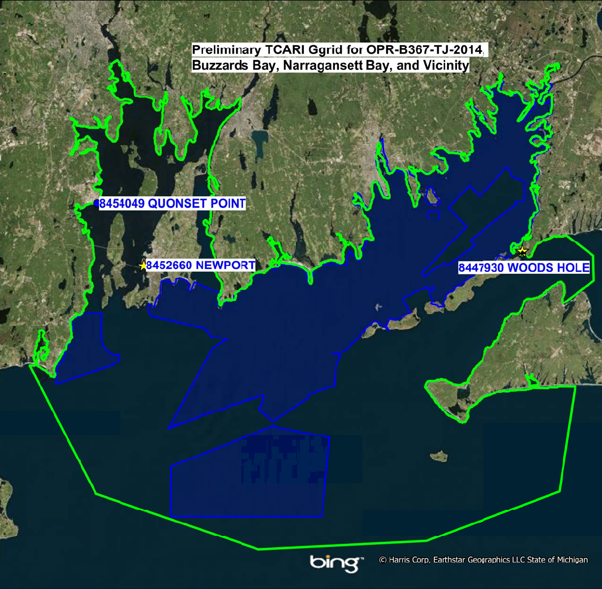
1.4. Tidal Constituent and Residual Interpolation (TCARI)
1.4.1. For hydrography in the area of Buzzards Bay and Narragansett Bay, apply the TCARI
grid “B367TJ2014.tc” supplied in conjunction with the water level data from Section 1.3.6 to
produce a seamless tide correction. Refer to the TCARI Field SOP for detailed TCARI
instructions.

1.4.2. This section is not applicable for this project.
1.4.3. TCARI Graphic
A diagram created in Mapinfo, which includes the exported TCARI grid boundary, is provided in
digital copy format to assist with the information provided in section 1.4.1.
1.4.4. TCARI Final Solutions
Upon completion of project, submit a Pydro generated request for smooth tides, with times of
hydrography abstract and mid/mif tracklines attached. Forward this request to
final.tides@noaa.gov. Provide the project number, as well as sheet number, in the subject line of
the email.
CO-OPS will review the times of hydrography, final tracklines, and six-minute water level data
from all applicable water level gauges. If there are any discrepancies, CO-OPS will make the
appropriate adjustments and forward a revised TCARI grid and solutions to the field group and
processing branch for final processing.
1.5. Fetchtides
Preliminary and verified six minute water level time series data may be retrieved from the CO-
OPS database via the Fetchtides application. Fetchtides provides a mechanism to store imported
data locally and combines multiple days of data into one CARIS readable tide (.tid) file.
Fetchtides is available for download at Hydrosoft Online
(https://inside.nos.noaa.gov/hydrosoft/hydrosoftware.html. For more information, please see the
Fetchtides User Manual in the FPM chapter 3 appendix.
1.6 Water Level Records
This section is not applicable for this project.