Navigation Manual Pdf K41414NV
User Manual: Navigation Manual Pdf 2014 Acura TL Owners Manual Pdf | SERVICE MANUAL OWNERS
Open the PDF directly: View PDF ![]() .
.
Page Count: 160 [warning: Documents this large are best viewed by clicking the View PDF Link!]
201
Navigation Manual
(Unlinked)
This document may not contain hyperlinks and may be formatted for printing instead of
web use. This is due to changes in content and specifications of the vehicle that happen
throughout the model year. This manual will be replaced with a hyperlinked version at the
end of the model year.
© 2013 Honda Motor Co., Ltd. P/N 00X31-
4 TL
TK4-8400K

Table of Contents
Navigation System
1
Introduction ..................................4
Manual Overview............................4
System Overview ............................4
Accessories Precautions ..................5
Important Safety Information .........5
Map Overview.................................6
Current Street ................................... 6
Verifi ed/Unverifi ed Street ................ 6
User Agreement ............................8
Getting Started ...........................10
System Controls ............................ 10
Voice Control Basics ..................... 13
Using the Voice Control System .....14
Improving Voice Recognition .........14
Selecting an Item in a List ............15
Entering Information ....................16
System Start-up ............................. 18
System Language Selection .......... 18
Bluetooth® HandsFreeLink®......... 19
Map Screen Legend ......................20
Map Screen Description ................ 21
Zoom In/Out .................................. 21
Map Scrolling ................................ 21
Displaying Current Location ......... 21
System Function Diagram .............22
Entering a Destination ...............23
By Address ....................................24
Selecting the Province or State ...... 24
Selecting the ZIP Code .................. 25
Selecting the City ........................... 25
Selecting the Street ........................ 26
Entering the Street Number ........... 28
By Address Book ..........................28
Adding Addresses to the Personal
Address Book ............................ 29
By Previous Destinations ..............29
By Place Name ..............................30
By Place Category ......................... 31
Subcategories ................................. 32
Finding a restaurant ....................... 34
Place Name .................................... 35
City Vicinity .................................. 35
Sort by Distance to Travel ............. 36
Search by Keyword ........................ 36
Sort by Zagat Rating ...................... 37
By Place Phone Number ............... 37
By ZAGAT® 2012 .........................38
By Coordinate ............................... 39
By Intersection ..............................40
By Map Input ................................ 41
Showing the Map of Current
Position .......................................41
Showing the Map of City ............... 42
Showing the Map of Provinces ...... 43
Showing the Map of USA, Canada
and Mexico ................................ 45
By Go Home 1 or 2 ....................... 45
Driving to Your Destination ......47
Driving to Your Destination .......... 47
Calculate Route to Screen .............47
Changing the Routing Method ...... 48
Viewing the Routes ........................ 48
Viewing the Destination Map ........ 49
Map Screen ...................................50
Route Line ...................................... 50
Voice Guidance Prompts ............... 50
Map Screen Legend ....................... 52
Guidance Screen ........................... 53
Guidance Screen Legend ............... 53
Distance and Time to Destination ... 54
Map Menu .....................................54
Guidance Menu ............................. 55
Di rect ions ....................................... 55
EXIT INFO (Highway Exit
Information) .............................. 56
Guidance Mode .............................. 56
Map Information ........................... 57
Showing Icons on the Map ............57

Table of Contents
2 Navigation System
Map Orientation ............................59
Current Location ............................ 60
Map Legend ................................... 60
Map Scale ..................................... 61
Destination Icon ............................ 62
Various Other Icons ...................... 62
Landmark Icons ............................. 62
Going Off the Route......................64
Off-road Tracking .........................64
Viewing/Saving the Current
Location .................................... 65
Pop-ups and Disclaimers...............66
Changing the Route.......................67
DEST Screen (Route) .................... 67
Destination Lists ............................ 70
Changing Your Destination ........... 71
Find Nearest (Voice command) ..... 71
Go Home (Voice command) .......... 71
Using Interface Dial to Change
Destination ................................ 71
Entering a Destination from the
DEST Screen (while en route) ... 72
Continue Trip to Screen ................72
Information Features .................73
INFO Screen .................................73
Cellular Phone................................ 73
Voice Info ...................................... 74
Setup .............................................. 75
INFO Screen (Other) .................... 75
Calendar ........................................ 75
Scenic Road Information ............... 77
Calculator ...................................... 78
System/Device Information ........... 79
Map Update Status ......................... 79
Roadside Assistance....................... 79
Key to Zagat Ratings ..................... 80
Show Wallpaper ............................. 81
System Setup ...............................82
SETUP Mode ................................82
SETUP Screen (Main Set up) .......82
Brightness ...................................... 82
Contrast .......................................... 82
Black Level .................................... 82
Volume .......................................... 83
Interface Dial Feedback ................. 83
Personal Information .....................83
Address Book ................................. 83
Home Address ................................ 87
PIN ................................................. 88
Previous Destinations .................... 89
Music Search .................................90
Song By Voice™ (SBV) ................. 90
Phonetic Modifi cation .................... 91
SET UP Screen (Other) .................92
Basic Settings ................................92
Units (mile or km) ......................... 93
Voice Recognition Tutor ................ 93
Verbal Reminders .......................... 93
Routing & Guidance .....................93
Rerouting ....................................... 93
Unverifi ed Area Routing ................ 94
Edit Avoid Area ............................. 98
Edit Waypoint Search Area ......... 100
Guidance Mode .............................101
Clock Adjustment ........................ 101
Auto Daylight ................................101
Auto Time Zone ........................... 102
Time Adjustment.......................... 102
Vehicle ........................................ 102
Off-road Tracking ........................ 102
Correct Vehicle Position .............. 103
Colour ......................................... 104
Map Colour .................................. 104
Menu Colour ................................ 105
Switching Display Mode
Manually ................................. 105
Switching Display Mode
Automatically .......................... 106

Table of Contents
Navigation System
3
Language ..................................... 107
Wallpapers Setting ...................... 107
Importing Pictures from USB ...... 108
Selecting Wallpaper Pictures ....... 108
Delete pictures on HDD ............... 109
Reset Factory Default Settings .... 109
Clear Personal Data .................... 110
Rearview Camera .........................111
Rearview Camera Brightness
Adjustment ...............................111
Rearview Camera Image ..............111
System Initialization .................112
System Initialization ................... 112
Entering the Security Code ......... 112
GPS Initialization ........................ 113
Map Matching ............................. 113
System Limitations ...................115
GPS Reception Issues ...................115
Database Limitations ...............116
Client Assistance ......................118
Coverage Areas .........................120
Map Coverage .............................120
U.S. Detailed Coverage Areas ..... 120
PUERTO RICO ........................... 125
Canada Detailed Coverage Areas 126
Frequently Asked Questions ....132
Troubleshooting ........................ 139
Glossary ....................................140
Glossary ...................................... 140
Voice Command Index .............143
Global Commands ...................... 143
Navigation General Commands... 143
Navigation Display Commands... 144
Find Place Commands ................ 145
Climate Control Commands ....... 146
Radio Voice Commands ............. 147
Disc Voice Commands ............... 148
HDD Voice Commands .............. 148
AUX Voice Commands .............. 148
USB Voice Commands ............... 149
iPod Voice Commands ................ 149
Bluetooth® Audio Commands ......149
Song By Voice™ Commands ......150
Cellular Phone Commands ......... 150
SET UP Screen (Main Set up)
Commands .............................. 150
On-Screen Commands ................ 151
On-Screen Spelling Assist .......... 151
IN DEX .......................................155
Other .........................................159

Introduction
4 Navigation System
Manual Overview
The manual is divided into the
following sections:
• Getting Started - A basic introduction
that discusses the controls and how to
communicate with the system.
• Entering a Destination - How to enter
an address or locate a point of interest
(POI).
• Driving to Your Destination - An
explanation of the map features,
guidance, and cautions.
• Information Features - An
explanation of the information
features, voice command help, and
other accessories.
• System Setup - How to set up and
tailor the system for your personal
use and use the Address Book.
The back of this manual contains:
• Map Coverage (page 120 )
• Frequently Asked Questions (FAQs)
(page 132 )
• Troubleshooting Guide (page 139 )
• Glossary of Terms (page 140 )
• Voice Command List (page 143 )
System Overview
Your navigation system is a highly
sophisticated location system with
voice control that uses satellites and a
map database to show you where you
are and to help guide you to a desired
destination.
The navigation system receives signals
from the global positioning system
(GPS), a network of 24 satellites in
orbit around the earth. By receiving
signals from several of these satellites,
the navigation system can determine the
latitude, longitude, and elevation of your
vehicle. In addition, a gyroscopic yaw
sensor and a vehicle speed sensor in
your vehicle keep track of the direction
and speed of travel at all times.

Introduction
Navigation System 5
The navigation system applies location,
direction, and speed information to
the maps and calculates a route to the
destination you enter. As you drive to
that destination, the system provides
map and voice guidance.
The navigation system is easy to
use. The locations of many places of
business and entertainment are already
entered in the system. You can select
any of them as a destination by using
the Interface Dial or voice control.
There are several ways to enter a
destination, such as by point of interest
(POI), by address, by phone number,
and by selecting it from the map. The
last 50 destinations are saved for reuse
at a later date. The system also allows
you to store a home address to simplify
returning home from your destination.
Accessories Precautions
If you have rear window tinting
installed, be aware that if the tint has
metallic properties, it can seriously
degrade or prevent GPS reception. This
is because the GPS antenna is located
behind the navigation display in the
centre of the dashboard.
If you plan to install electronic
components such as radar detectors,
vehicle tracking devices, remote
starters, additional amplifi ers, or other
audio components, ensure that they are
not located near the navigation display
in the centre of the dashboard, or near
the GPS antenna behind the navigation
display. Signal noise emanating from
these devices can cause intermittent
disruption of the navigation system.
Important Safety Information
The navigation system can distract your
attention from the road if you focus
on the screen or operate the system’s
controls while driving.
Enter as much information as possible
into the system before you begin
driving, or when the vehicle is stopped.
Then, as you drive, listen to the audio
instructions and use voice commands
when possible.
Introduction
6 Navigation System
WARNING
Using the navigation system
while driving can take your
attention away from the road,
causing a crash in which you
could be seriously injured or
killed.
Only operate system controls
when the conditions permit you
to safely do so.
While driving, do not look at the screen
or operate the system controls for more
than a second or so at a time, and only
after deciding you can do so safely. Pull
to the side of the road if you need more
time to look at the screen or operate the
controls.
The navigation system is designed to
provide route information to help you
reach your destination. However, this
route guidance may sometimes confl ict
with current road conditions such as
street closures, road construction,
detours, and out-of-date map data.
Additionally, the system itself has
certain limitations (see page 115 ).
Therefore, you must verify the audio
and visual route information provided
by the system by carefully observing
the roadway, signs and signals, etc. If
you are unsure, proceed with caution.
Always use your own good judgment,
and obey traffi c laws while driving.
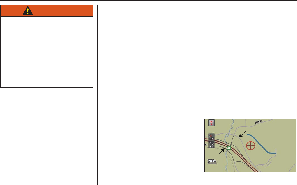
Map Overview
Current Street
The current street on which your vehicle
is located appears at the bottom of the
map screen (see page 20 ). A message
saying “Not on a digitized road” may
appear instead when you drive half a
mile away from a mapped road. For
more details, see O f f - r o a d T r a c k i n g on
page 64 .
Verifi ed/Unverifi ed Street
Your navigation system has two kinds
of streets: verifi ed (red, gray and pink)
and unverifi ed (purple). The differences
between the two types of streets are
contrasted in the chart on page 7 .
Verified street
Unverified street

Introduction
Navigation System 7
V e r i fi ed streets Unverifi ed streets
When
displayed
These roads are found within metropolitan areas, and
include interstate highways and major roads connecting
cities.
These roads are found in rural areas, and typically include
residential streets away from the centre of a town.
Street colour Shown as red (highways), pink (state routes), or gray
(verifi ed streets) on the daytime map screen.
Shown on the daytime map screen as purple.
Map quality
The database vendor has verifi ed these streets.
Information like turn restrictions, average speed, and
whether it is a one-way street have been gathered and used
when creating your route to a destination.
These streets have not been verifi ed by the database
vendor. The system does not contain information on one-
way streets, turn restrictions, or the road’s average speed.
They are shown on the map for reference and may have
errors in map location, naming, and address range.
Routing
differences
While driving to your destination, the displayed route line
is solid blue. The system provides voice and map guidance
to your destination.
Your route line is either a purple dotted “vector line,” or
a dashed pink/blue line. For information on selecting this
option, and the routing differences, see Unverifi ed Area
Routing on page 94 .
Cautions
There are no pop-up boxes urging extra caution during
a route. However, because roads constantly change, you
are urged to use common sense, and always obey posted
traffi c restrictions.
Regardless of whether the user chooses route guidance,
there are cautionary screens before and during the route
urging the user to be extra cautious, and obey all traffi c
restrictions. See Unverifi ed Area Routing on page 94 .
Guidance
voice
Voice guidance issues instructions such as “In a 800
metres, make a right turn.”
The phrase “if possible” is added to each guidance
instruction. For example: “In a 800 metres, make a right
turn, if possible.”
Time and
distance
“to go”
The time and distance “to go,” displayed while en route to
a destination, is based on the average speed and distance
for the roads used for your route.
The time and distance “to go,” displayed while en route to
a destination, is based on the average speed and distance
for the roads used for your route.

User Agreement
8 Navigation System
In using this HDD “Satellite Linked
Navigation System” (the “HDD”),
which includes HONDA MOTOR
CO., LTD. software, PIONEER
CORPORATION software, and
NAVTEQ database contents
(hereinafter referred to as “Licensers”),
you are bound by the terms and
conditions set forth below. By using
your copy of the HDD, you have
expressed your Agreement to the terms
and conditions of this Agreement. You
should, therefore, make sure that you
read and understand the following
provisions. If for any reason you do not
wish to be bound by the terms of this
Agreement, please return the HDD to
your dealer.
• The HDD may not be copied,
duplicated, or otherwise modifi ed, in
whole or in part, without the express
written permission of the Licensers.
• The HDD may not be transferred or
sublicenced to any third party for
profi t, rent or loan, or licenced for
reuse in any manner.
• The HDD may not be decompiled,
reverse engineered or otherwise
disassembled, in whole or in part.
• The HDD may not be used in a
network or by any other manner of
simultaneous use in multiple systems.
• The HDD is intended solely for
personal use (or internal use where
the end-user is a business) by the
consumer. The HDD is not to be used
for commercial purposes.
• The Licensers do not guarantee to the
client that the functions included in
the HDD meet the specifi c objectives
of the user.
• Licenser shall not be responsible for
any damages caused by the use of
the HDD to the actual user or to any
third party.
• The warranty on the HDD shall not
extend to an exchange or refund due
to misspelling, omission of letters, or
any other cosmetic discrepancy in the
contents of the HDD.
• The right to use the HDD shall expire
either when the user destroys the
HDD or software, or when any of the
terms of this Agreement are violated
and the Licensers exercise the option
to revoke the licence to use the HDD
or software.

User Agreement
Navigation System 9
• The terms and conditions hereof
apply to all subsequent users and
owners as well as to the original
purchaser.
• The logos of oil companies, hotels,
convenience stores, and other
businesses are displayed for your
information and convenience, and
in no way imply any sponsorship,
approval or endorsement of these
companies, or their products.
The logos are trademarks of their
respective owners.
• The marks of companies displayed
by this product to indicate business
locations are the marks of their
respective owners.
The use of such marks in this product
does not imply any sponsorship,
approval, or endorsement by such
companies of this product.
The user shall indemnify and save
harmless the Licensers, and their
offi cers, employees and agents, from
and against any claim, demand or
action, irrespective of the nature of the
cause of the claim, demand or action,
alleging loss, costs, expense, damages
or injuries (including injuries resulting
in death) arising out of the use or
possession of the HDD or software.
Use, duplication, or disclosure of this
HDD by or on behalf of the United
States government is subject to
“Restricted Rights” as set forth at FAR
52.227-14, -19 or DFARS 252.227-
7013, as applicable. Manufacturers
are the Licensers, including HONDA
MOTOR CO., LTD., 2-1-1 Minami
Aoyama Minato-Ku Tokyo 107-8556
JAPAN., PIONEER CORPORATION,
1-4-1 Meguro Meguro-ku Tokyo 153-
8654 Japan., NAVTEQ Corporation,
425 W Randolph St. Chicago, IL
60606, USA.
Getting Started
10 Navigation System
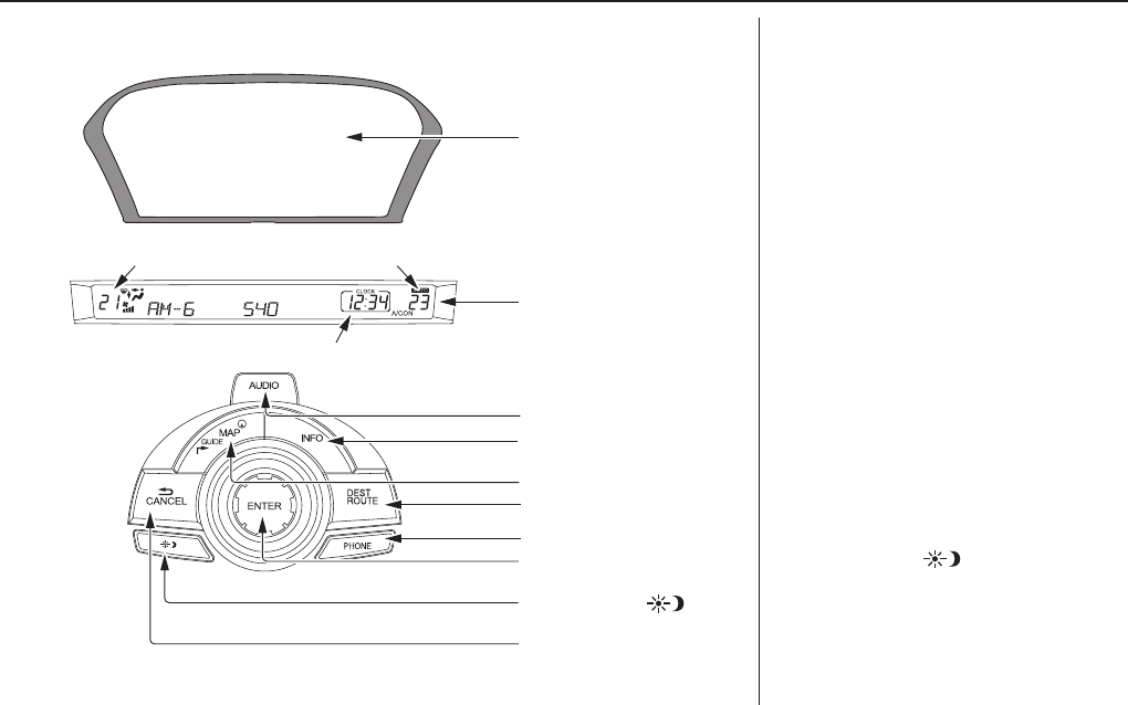
AUDIO button
Press to display the audio screen.
For more information on audio system
features, see the Audio section of the
your owner’s manual.
INFO button
Displays the “Main Info” options on
the INFO screen. When selecting
the “Other” tab, displays the “Other”
options on the INFO screen. See page 73 .
MAP/GUIDE button
Displays the map. When en route,
switches between the map and
Directions screens. See page 20 or 52 .
DEST/ROUTE button
Displays the “Dest. MENU 1” options
on the DEST screen. When en route,
displays the “Route” options on the
DEST screen. See page 23 or 67 .
Display Mode button
Adjusts the screen brightness for Day
or Night mode, or turns the screen OFF.
See page 105 .
CANCEL button
INFO button
Interface Dial/
ENTER button
PHONE button
AUDIO button
MAP/GUIDE button
Lower Display
Screen
Display Mode
button
Passenger’s TemperatureDriver’s Temperature
Time (set by navigation system)
DEST/ROUTE button
System Controls
Getting Started
Navigation System 11
PHONE button
Press to display the Cellular phone
screen.
For more information, see the
Bluetooth® HandsFreeLink® section of
your owner’s manual.
CANCEL button
Cancels the current screen and returns
to the previous screen display.
NOTE:
The BACK button on the steering
wheel performs the same basic
function. See BACK button on page 13 .
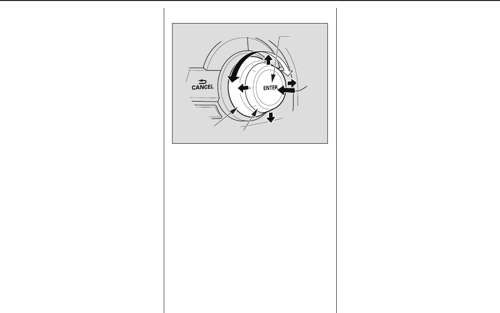
Interface Dial/ENTER button
SELECTOR
ENTER
KNOB
To see areas beyond the map that is
displayed, you can move the Interface
Dial left, right, up, or down. Rotating
the Interface Dial knob allows
you to change the scale. Rotating it
clockwise reduces the scale, showing
less area with greater detail. Rotating
it counterclockwise increases the scale,
showing more area with less detail.
You can also rotate the Interface
Dial knob to scroll through a list
or highlight items in a list to select.
After making a selection in a menu
or list, push in on the Interface Dial
(ENTER button) to enter the selection
into the system.
In almost all cases, you can enter a
selection into the system by pushing in
on the Interface Dial.

Getting Started
12 Navigation System
Screen
All selections and instructions are
displayed on the screen. The display
is not a “touch screen” - you enter
information into the system either by
voice or by using the Interface Dial.
Clean the screen with a soft, damp
cloth. You may use a mild cleaner
intended for use on computer screens.
NOTE:
Whenever you shift to R (Reverse), the
rear view behind the vehicle is shown
on the navigation system screen. See
page 111 .
Lower Display
Shows a summary of the audio and
climate control information, as well as
the time. This summary is helpful as a
confi rmation when adjusting audio or
climate by voice.
The audio summary consists of the
radio band, frequency, and volume. For
XM radio, a brief description of the
station and current music is displayed.
The climate status consists of the
driver’s and passenger’s temperature,
fan speed, ON/OFF (A/C), and vent
setting. The time is automatically set
by the navigation system. Settings
can be adjusted in SETUP (see T i m e
Adjustment on page 102 ).
Getting Started
Navigation System 13
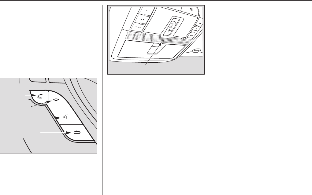
Voice Control Basics
Your vehicle has a voice control system
that allows hands-free operation of most
of the navigation system functions. You
can also control the audio system and
the climate control system. The voice
control system uses the TALK and
BACK buttons on the steering wheel
and a microphone near the map lights
on the ceiling.
TALK button
BACK button
PICK-UP
button
HANG-UP
button
NOTE:
While using the voice control system,
all of the speakers are muted.
Microphone (on the ceiling)
TALK button
This button activates the voice control
system. Press and release it when you
want to give a voice command. See
Voice Command Index on page 143 for a
list of voice commands.
BACK button
This button has the same function as
the CANCEL button. When you press
and release it, the display returns to the
previous screen. When the previous
screen appears, the system replays the
last prompt.
When you press this button during
voice recognition, voice recognition is
ended. (The display does not return to
the previous screen.)

Getting Started
14 Navigation System
Using the Voice Control System
You should use the voice control system
as much as possible, and consider
manual entry using the Interface Dial
as a backup method.
Most of the system’s functions can be
controlled by voice commands activated
with the TALK button. To control your
navigation system by voice:
• Press and release the TALK button.
On the map screen, a voice
recognition screen and pop-up voice
icon are displayed. If you press
and release the TALK button while
on any other screen, only the pop-up
voice icon appears.
• Wait for the beep.
• Give a voice command. (Voice
commands that the system recognizes
are highlighted.)
Once the microphone picks up your
command, the system changes the
display in response to the command
and prompts you for the next command.
Using the TALK button, answer the
prompts as required.
If the system does not understand a
command or you wait too long to give
a command, on the Voice Recognition
Example Commands screen, it responds
with “Pardon? No command was heard.
Please press the TALK button and say
a command. To return to the previous
screen, press the BACK button.” On
any other screen, it responds with
“Pardon? No command was heard.
Please press the TALK button and
say a command.” If the system cannot
perform a command or the command is
not appropriate for the screen you are
on, a beep will sound.
You can fi nd out which voice
commands are available for a particular
screen by saying “Help.” The system
will display and read the list of
available commands to you. (When
Help is grayed out, this feature cannot
be used.)
When you speak a command, the
system generally either repeats the
command as a confi rmation or asks you
for further information. If you do not
wish to hear this feedback, you can turn
it off.
However, hearing the feedback will
familiarize you with the way the system
expects commands to be phrased. See
the Voice Recognition Tutor setting
in SET UP.
If you hear a prompt such as “Please
use the Interface Dial to...” or “Please
choose an area with the Interface
Dial,” the system is asking for input that
cannot be performed using the voice
control system.
Improving Voice Recognition
To achieve optimum voice recognition
when using either the navigation or
Bluetooth® HandsFreeLink® voice
control system, the following guidelines
should be followed:
NOTE:
Make sure the correct screen is
displayed for the voice command that
you are using. See Voice Command
Index on page 143 .
• It is best if the windows and sunroof
are closed. If they are open, speak
a little louder to overcome the wind
noise.

Getting Started
Navigation System 15
• The fan speed automatically lowers
when the TALK button is pressed.
Adjust the airfl ow from both the
dashboard and side vents so air does
not blow against the microphone on
the ceiling.
• If more than one person is speaking
at the same time, the system may
misinterpret your command.
• After pressing and releasing the
TALK button, wait for the beep, then
give a voice command.
• Give a voice command in a clear,
natural speaking voice without
pausing between words.
• Try to reduce any background noise.
• If you are still having trouble with the
voice control system, refer to Voice
Info on the INFO screen (Main
Info).
NOTE:
The voice control system can only be
used from the driver's position. The
microphone does not recognize voice
commands from anywhere else in the
vehicle.
Selecting an Item (Button)
on the Screen
On most screens, there are items that
can be selected (like buttons with titles
such as OK or Return). To select
an item on any screen, do one of the
following:
• Use the voice control system and
say the name of the desired item.
Almost all selectable items on the
screen, including some listed items,
are recognized by the voice control
system.
• Move the highlighting to the desired
item with the Interface Dial or its
knob, then push in on the Interface
Dial.
Tip:
If items are grayed out, this means that
they cannot be selected.
Selecting an Item in a List
To scroll through a list, do one of the
following:
• Rotate the Interface Dial knob to
scroll one item at a time.
• Use the voice control system to scroll
page by page. For example, to scroll
up, say “Up” or “Previous.” To scroll
down, say “Next” or “Down.”
If you cannot fi nd the desired name,
or have made an error, return to
the previous screen by pressing the
CANCEL or the BACK button.
To select the desired item in the list, do
one of the following:
• Use the voice control system, and say
the item number of the desired item.
• Rotate the Interface Dial knob to
move the highlighting to the item,
then push in on the Interface Dial.

Getting Started
16 Navigation System
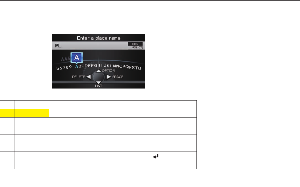
Entering Information
When the system needs input from you,
the display changes to a screen similar
to the one on the next page. You can
then use the displayed letters, numbers,
or symbols to enter information. You
can enter your keyboard input in either
of the following ways:
• Say the desired letter, number, or
symbol on the screen if you are
entering a city or street name.
• Move the highlighting to the desired
letter, number, or symbol by rotating
the Interface Dial knob, then push
in on the Interface Dial.
Each entered letter will appear at the
top of the display. To enter a space
between words, say “Space” or move
the Interface Dial to the right. To
delete an entry, say “Delete” or move
the Interface Dial to the left.
If a letter has options (such as accent
marks or symbols), they will appear
in gray next to the selected letter on
the upper row. Move the Interface
Dial up to select OPTION, and use
the Interface Dial knob to select the
letter.
To enter symbols, rotate the Interface
Dial Knob and select # or @, then
move the Interface Dial up to select
OPTION.
When entering an address, the system
searches the database for words that
match the letters you are entering. As a
result, you will notice that some letters
are no longer available.
When the system fi nds only one entry
that matches, it completes the name
entry for you. If the system fi nds more
than one entry that matches your input,
a list of these matches is displayed.
Tip:
When entering a name of a city, street,
or place, or if you are unsure of the
spelling of the name, enter the letters
that you are sure of, then move the
Interface Dial down to select LIST.
The system will display a list of names
that most closely match your input. For
each letter that is entered, the number of
corresponding choices is displayed on
the right-hand side.
Getting Started
Navigation System 17
NOTE:
The voice command names that can be used for each letter are shown below. For
additional keyboard symbols, see page 152 .
Say Or say “...” Say Or say “...” Say Or say “...” Say Or say “...”
AAlpha/Apple HHotel/Henry OOscar VVictor
BBravo/Boy IIndia/Igloo PPapa/Paul W
Whiskey/William
CCharlie JJuliet/John QQuebec/Queen XX-ray
DDelta/Dog KKilo/King RRomeo/Robert YYankee/ Yellow
E Echo/Edward LLima/Larry SSierra/Sam ZZulu/Zebra
FFoxtrot/Frank MMike/Mary TTango/Tom Enter
GGolf/George N
November/Nancy
UUniform/Uncle
Getting Started
18 Navigation System
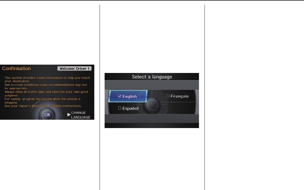
System Start-up
When you change the power mode to
the ON mode, it takes about 10 seconds
for the navigation system to boot up.
The fi rst screen to appear is the
navigation system globe screen.
The screen then changes to the
Disclaimer screen:
System Language Selection
Move the Interface Dial to the right to
select CHANGE LANGUAGE.
On the Select a language screen, you
can select the language to be used by
the entire system by choosing from the
language choices that are displayed.
After you have changed the language
settings, you will be returned to the
Disclaimer screen.
Read this disclaimer carefully so you
understand it before continuing. Push
in on the Interface Dial to select OK,
and the map screen will appear on the
display. The “OK” cannot be activated
by voice.
If you do not push in on the Interface
Dial, the screen will go dark after 30
seconds. (You can also display the
Wallpaper screen. See page 107 .)
To return to the Disclaimer screen,
press any navigation or voice control
button.
Getting Started
Navigation System 19
If you have entered any Calendar
reminders, they are displayed after you
select OK. See Calendar on page 75 .
The Calendar reminder screen
remains displayed until you select OK
or Remind Later by rotating the
Interface Dial knob and pushing in
on the Interface Dial, or press the
CANCEL button.
If you select OK and push in on the
Interface Dial, the reminder will not
show up again. (It will be deleted from
the Calendar.)
If you select Remind Later and push
in on the Interface Dial, the reminder
will show up again the next time you
start the vehicle. If there are several
reminders, the next reminder will be
displayed.
If you press the CANCEL button, the
system will skip all the reminders. The
reminders will show up again the next
time you start the vehicle.
NOTE:
The system will display the current
message and any older or previously
unread messages, with the newest
message appearing fi rst and the
remaining messages appearing in date
order.
If you turn off the engine during route
guidance and then restart the vehicle,
the Continue Trip to screen will be
displayed. For more information, see
on page 72 .
Bluetooth® HandsFreeLink®
If you have a Bluetooth-compatible cell
phone that is paired with the system,
then CALL on the Calculate route to
screen is enabled.
When you select CALL, the system
dials the number shown on the screen.
For more information on Bluetooth®
HandsFreeLink®, see your owner’s
manual.
Getting Started
20 Navigation System
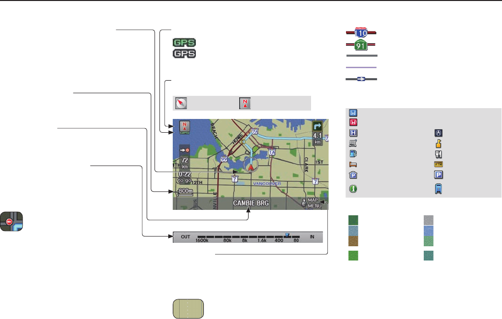
Map Screen Legend
Vehicle Position (see page 65 )
(Use voice command “Display
current location” or use the
Interface Dial to show current
location.)
Current Map Scale
(see page 61 )
Current Street
(see page 6 )
Map Scale Adjustment
(km or mile per half inch appears only
when you zoom in or out by rotating the
Interface Dial knob.)
No Entry Icon
NOTE:
See Map Legend in the Map
Information on the MAP MENU
screen for further explanation.
Streets
(see Map Overview on page 6 )
: Highways (Red)
: Interstates (Pink)
: Verifi ed Streets (Gray)
: Unverifi ed Streets (Purple)
: One-Way Streets (see page 62 )
(80 metres scale only)
Landmark Icon - Generic (see page 62 )
Honda Dealer (USA)
Honda Dealer (Canada, Mexico)
Hospital Acura Dealer
Grocery Store School
Gas Station Restaurant
Hotel/Lodging ATM
Parking Garage Parking Lot
Highway Exit
Information Post Offi ce
Map Features
Park Airport/Business
Hospital Body of Water
Shopping Mall Cemetery
Golf Course/
Stadium University
NOTE:
If you move the Interface Dial over
an area (map features shown above),
the name is displayed at the top of the
screen.
GPS Signal Strength
: Best Reception
: Good Reception
(Missing): Poor/No Reception
Map Orientation
(see page 59 )
“Heading Up” “North Up”
Map Menu
(see page 54 )
(Push in on the Interface Dial to view.)
“Breadcrumbs”
(see Off-road Tracking on page 64 )
Getting Started
Navigation System 21
Map Screen Description
Zoom In/Out
Rotate the Interface Dial knob to
change the map scale. Zooming in
increases the detail, while zooming
out gives you a wide area view. After
changing the scale, give the system a
few moments to update the display.
Map Scrolling
To view other map areas, move the
Interface Dial left, right, up, or down.
The map will shift in that direction. To
return the map to your current location,
press either the MAP/GUIDE, the
CANCEL, or the BACK button on the
steering wheel.
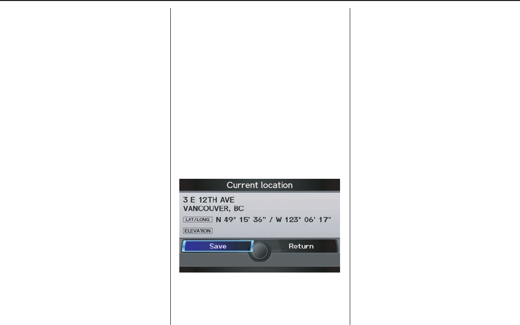
Displaying Current Location
You can see the current address,
latitude, longitude, and elevation at any
time by doing one of the following:
• Use the voice control system and say
“Display the current location.”
• Push in on the Interface Dial
while displaying the map of the
current location, and select Map
Information. Rotate the Interface
Dial knob to select CURRENT
LOCATION.
The Current location screen will
appear on the display.
NOTE:
The elevation will not appear when the
system is temporarily lacking proper
GPS information. The system elevation
may not agree with elevations shown
on roadside elevation signs, and may
fl uctuate plus or minus 30 metres or
more.
You can save the current location in
your Address Book by doing one of the
following (if an Address Book PIN has
been set, you need to enter your PIN.):
• Use the voice control system and say
“Save.”
• Select SAVE by rotating the
Interface Dial knob and push in on
the Interface Dial.
Say “Register the current location” on
the map screen, and you can register
the current location without displaying
the Current Location screen.
Select Return to return to the previous
screen.
Getting Started
22 Navigation System
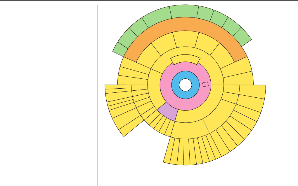
System Function Diagram
This diagram shows the navigation
system features, starting at the centre
and working outward in layers. The
navigation programme starts at “Key
ON,” and then displays the globe
screen (blue). If OK is selected on the
Disclaimer screen, the functions in the
yellow segments of the diagram become
available in the SET UP and INFO
screens.
The items above the map screen show
various methods to begin driving to
your destination (orange). You are
provided with map/voice guidance,
routing cautions, and a direction list.
While driving to your destination, use
the voice control system as much as
possible to interact with the navigation,
audio, and climate control systems
(green).
R
E
M
I
N
D
E
R
S
(pg. 19)
C
A
L
E
N
D
A
R
(
M
A
P
/
V
O
I
C
E
G
U
I
D
A
N
C
E
,
R
O
U
T
I
N
G
C
A
U
T
I
O
N
S
,
D
I
R
E
C
T
I
O
N
S
L
I
S
T
)
-
D
R
I
V
I
N
G
T
O
Y
O
U
R
D
E
S
T
I
N
A
T
I
O
N
-
I O V : E C
" P L E H "
) L L A (
(pg.74)
: E C I O V
N O I T A M R O F N I "
" N E E R C S
(pg.73)
: E C I O V
o t ( " U N E M "
) e t u o r e g n a h c
(pg.67)
: E C I O V
F W O H " G N O L R O R A
N I T S E D E H T O T " ? N O I T A
(pg.54)
VOI CE:
"DISPLAY (OR S AVE )
CURRENT LOCA TION"
(pg.21)
: E C I O V
E M I T T A H W "
" ? T I S I
(pg.143)
I O V : E C
" O I D U A "
(pg.147)
I O V : E C
E T A M I L C
P M E T , N A F
(pg.146)
R E T N E
Y A W S T N I O P
) 86 . g p (
I O V : E C
O M O O Z / N I M O O Z " " T U
(pg. 144)
I O V : E C
" S N O C I Y A L P S I D / E D I H "
(pg.144)
CALL (pg.73)
LIST (pg.74)
CONTRAST (pg.82)
BLACK LEVEL (pg.82)
VOLUME (pg.83)
PERSONAL
INFORMATION (pg.83)
INTERFACE
DIAL FEEDBACK (pg.83)
CLOCK ADJUSTMENT
(pg.101)
ROUTING GUIDANCE
(pg.93)
BASIC
(pg.92)
LIST
(pg. 74)
ENTER (pg. 76)
LIST
(pg. 77)
(pg. 78)
MATH
VERSION
(pg. 79)
DOWNLOAD
(pg. 79)
CALL
(pg. 79)
S S E R P
K O
CALENDAR
SCENIC
ROAD INFO
CALCULATOR
SYSTEM/DEVICE
INFO
MAP DATA
UPDATE
STATUS
ROADSIDE
ASSISTANCE
/ D N A B T C E L E S
Y C N E U Q E R F
E C N A L A B L O V
D C
S N O I T C N U F
R E H T O
D U A O I
S S E N T H G I R B
T U O / N I M O O Z
T
H
E
D
I
S
C
L
A
I
M
E
R
S
C
R
E
E
N
(
p
g
.
1
8
)
VOI CE: "FIND
NEARES
T ..."
ATM , ETC.
(pg. 54)
A T C E L E S
A N I T S E D N O I T
H T I W
F R E T N I L A I D E C A
(pg. 41)
: E C I O V
" E M O H O G "
(pg. 45)
: E C I O V
R O F " U N E M "
R E T N E
N O I T A N I T S E D
N E E R C S
(pg. 23)
E U N I T N O C
E H T O T
N O I T A N I T S E D
) E M U S E R (
T R A T S E R R E T F A
(pg. 72)
G
L
O
B
E
S
C
R
E
E
N
KEY
ON
CELLULAR
PHONE
VOICE INFO
BRIGHTNESS (pg.82)
SET UP
(MAIN)
V
O
I
C
E
C
O
M
M
A
N
D
S
O F N I
N E E R C S
pg. 143)
(
D U A
pg. 147)
( O I
R T N O C E T A M I L C L O
pg. 146)(
COLOUR (pg.104)
LANGUAGE
(pg.107)
WALLPAPER (pg.107)
RESET FACTORY DEFAULT (pg.109)
CLEAR PERSONAL DATA (pg.110)
VEHICLE
(pg.102)
SET UP
(OTHER)
CHECK
(pg. 77)
For more information,
see your owner’s
manual.
OIDUA
NOTTUB
I
N
F
O
B
U
T
T
O
N
(
p
g
.
7
5
)
(
p
g
.
7
5
)
I
N
F
O
B
U
T
T
O
N
T
H
E
M
A
P
S
C
R
E
E
N
Entering a Destination
Navigation System 23
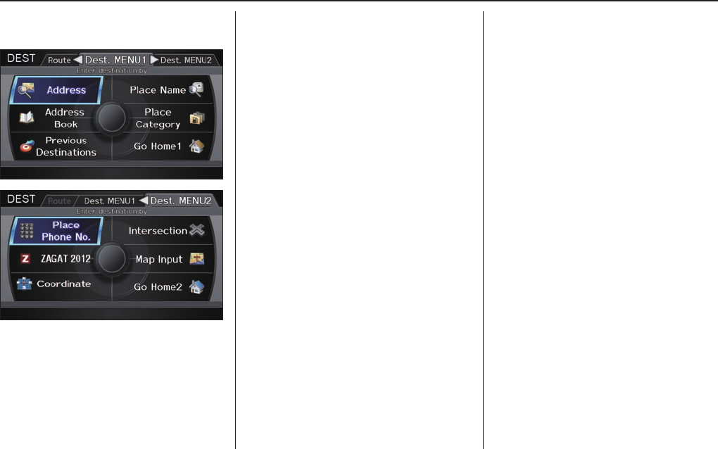
When you press the DEST/ROUTE
button, the display changes to:
To display the “Dest. MENU 1” tab
or the “Dest. MENU 2” tab, move the
Interface Dial to the left or right.
NOTE:
If you press the DEST/ROUTE button
while en route, the DEST screen
(Route) will be displayed. To enter the
destination, select the “Dest. MENU
1” tab by moving the Interface Dial to
the right.
Address (see page 24 )
You can enter the street, city, province
or ZIP (postal) code to search for your
destination.
Address Book (see page 28 )
You can select locations stored in the
Address Book as destinations. The
addresses of these locations can also
be saved. The system can store up to a
combined total of 200 DRIVER 1 and
DRIVER 2 addresses.
Previous Destinations (see page 29 )
When you enter a destination with
any of the available selections (except
Address Book, Go Home 1 and Go
Home 2), the last 50 destinations are
saved by the system. Use this selection
to choose a destination again.
NOTE:
If Previous Destinations is grayed
out, there are no Previous Destinations
entered.
Place Name (see page 30 )
You can input the names of the places
to search for your destination.
Place Category (see page 31 )
The system has been programmed
with the locations of many businesses,
parks, hospitals, etc. This selection lets
you search these by category, name, or
Zagat 2012 (for restaurant information).
Go Home 1 (see page 45 )
This selection allows you to select Home
Address 1 as a destination.
NOTE:
If you have no home address entered,
the system prompts you for one.
Entering a Destination
24 Navigation System
Place Phone No. (See page 37 )
You can search for the destination by
inputting a place’s phone number.
ZAGAT 2012 (See page 38)
This selection allows you to fi nd a
restaurant by the ZAGAT Rating
information.
Coordinate (See page 39 )
You can search for the destination by
inputting the latitude and longitude for
the destination.
Intersection (see page 40 )
This selection allows you to enter the
names of two intersecting streets in
a city. This is useful if you know the
general location of your destination, but
not the exact address.
Map Input (See page 41 )
You can select a destination from the
MAP screen.
Go Home 2 (See page 45 )
If you select this feature, you can select
Home Address 2 as a destination.
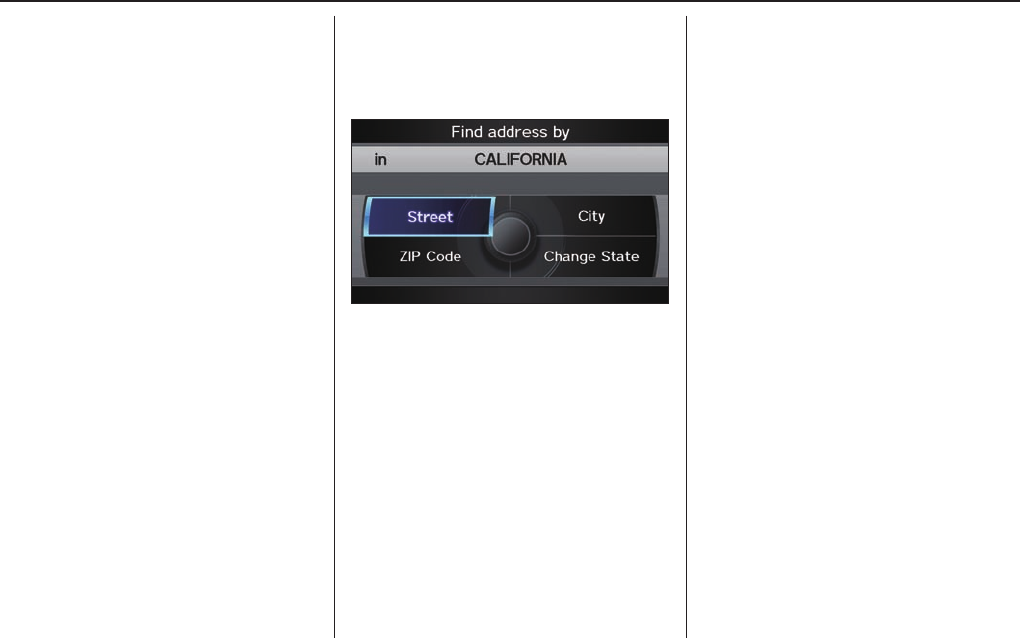
By Address
After you select Address from the
DEST screen (Dest. MENU 1), the
display changes to:
Tip:
• When entering an address by voice, it
is more effi cient to say the city name
fi rst, then the street name.
• When entering an address by the
Interface Dial, it is usually easier
to enter the street fi rst. A city or cities
that the street appears in will be
displayed. For your convenience, you
do not have to enter both city and
street.
NOTE:
• If you fi nd that your city is not listed,
it may be part of a larger metropolitan
area. Try entering the street fi rst.
• Prior to departure, you can set areas
to avoid. The system then includes
them in its calculations for the
destination you have entered. See
Edit Avoid Area on page 98 .
Selecting the Province or State
The province you are in is displayed
at top of the screen. If your desired
destination is in another province, select
CHANGE PROVINCE by moving the
Interface Dial to the left or right.
The display then changes to the Select
a province screen. Use the voice
control system and say the name or
corresponding number of the province,
or rotate the Interface Dial knob to
select the province.
You can select either of the Canada/
AK, USA, or Mexico tab by moving
the Interface Dial to the left or right.
If you select Canada/AK, Canada and
Alaska will be displayed. If you choose
USA, the American mainland, Hawaii,
and Puerto Rico will be displayed. If
you select Mexico, the states of Mexico
will be displayed.
Entering a Destination
Navigation System 25
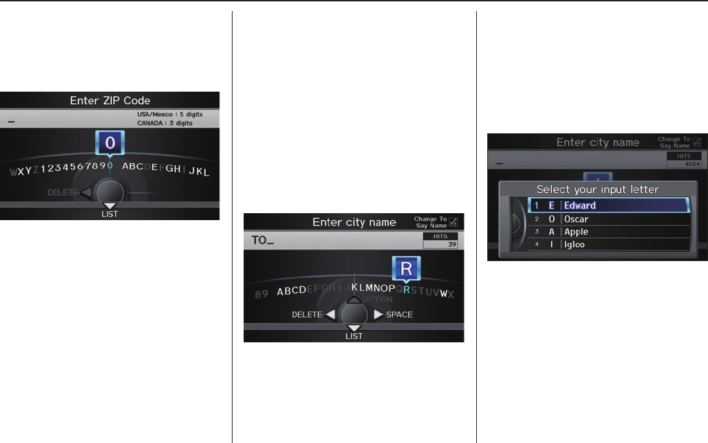
Selecting the ZIP Code
If you rotate the Interface Dial knob
and select ZIP code while on the Find
address by screen, the Enter ZIP
Code screen will display.
Use the Interface Dial to input the
Postal code. If the Postal code is found,
the Select a city screen will appear,
listing all cities with that Postal code.
If you only know the partial Postal
code, input the fi rst few digits, move the
Interface Dial down, and select List.
Tip:
This system is enabled for both
American and Canadian Postal codes.
Selecting the City
This is helpful if the street runs through
several cities, and you know what city
includes the street. The city you are in
is displayed on the screen.
By Voice Control:
Say “City” on the Find address by
screen, and the display changes to the
Enter city name screen.
Say the city name by saying individual
letters, or words that represent the
letters, one at a time.
The system has a talk back function.
If your spoken letter is not recognized,
the system will talk back to you. For
example, if you say “E” but the system
does not recognize the command, it
will ask you, “Please select the number
of the input letter from the list,” and the
following pop-up box will appear:
You should select a letter by saying the
number.
Alternatively, to improve voice
recognition, you can say “Echo” or
“Edward” instead of “E.” See page 17 for
a list of available words for each letter.
By Interface Dial:
Select City, and the display then
changes to the Enter city name screen.
Entering a Destination
26 Navigation System
Tip:
After the display has been changed
to the Enter city name screen, the
name of the city where your vehicle is
currently located will be displayed.
Vehicle position may not be displayed
when the automobile is travelling off
road. You can select the City that is
currently displayed and conduct a
Street search by moving the Interface
Dial down.
Use the Interface Dial to enter the
name of the city.
The system will display a list of city
names, with the closest match to the
name you entered at the top of the list.
Select the number (1-6) of the desired
city from the list.
You can also enter part of the name and
look for the name you want from the list
that appears.
Tip:
For name input, you don’t need to enter
spaces and symbols (&, -, %, etc.). The
system is also enabled for partial match
searches. For example, when you
search “LOS ANGELES,” it is on the
list of search results if you input “LOS”
or “ANGELES.”
Listings of cities and towns in the non-
detailed coverage area may have an
asterisk “*” next to their names. If you
select one, a pop-up box is displayed
saying, “No detailed street data...”, and
a street address cannot be entered (see
Map Coverage o n p ag e 1 20 ) . Tr y e nt e r i n g
the street fi rst, and then select the city if
available.
Select DESTINATION MAP and use
the Interface Dial to select an icon,
approximate area, or street you wish to
choose as your destination. Otherwise,
a central location of the city will be
selected. If you select a point of interest
(POI) or road in an unverifi ed area, you
may or may not have routing in these
areas. See Map Overview on page 6 .
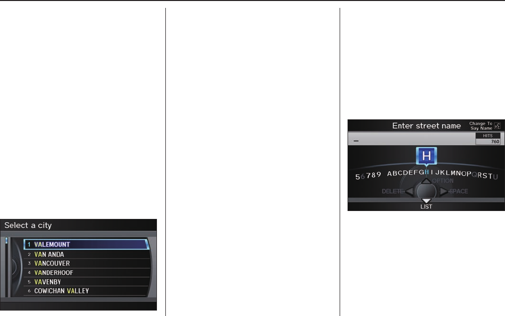
Selecting the Street
By Voice Control
After you have selected the city, or if
you say “Street” on the Find address
by screen, the display changes to the
Enter street name screen.
Say the street name by saying
individual letters or numbers, or words
that represent the letters, one at a time.
The system has a talk back function.
If your spoken letter is not recognized,
the system will talk back to you. For
example, if you say “E” but the system
does not recognize the command, it
will ask you, “Please select the number
of the input letter from the list,” and the
following pop-up box will appear:
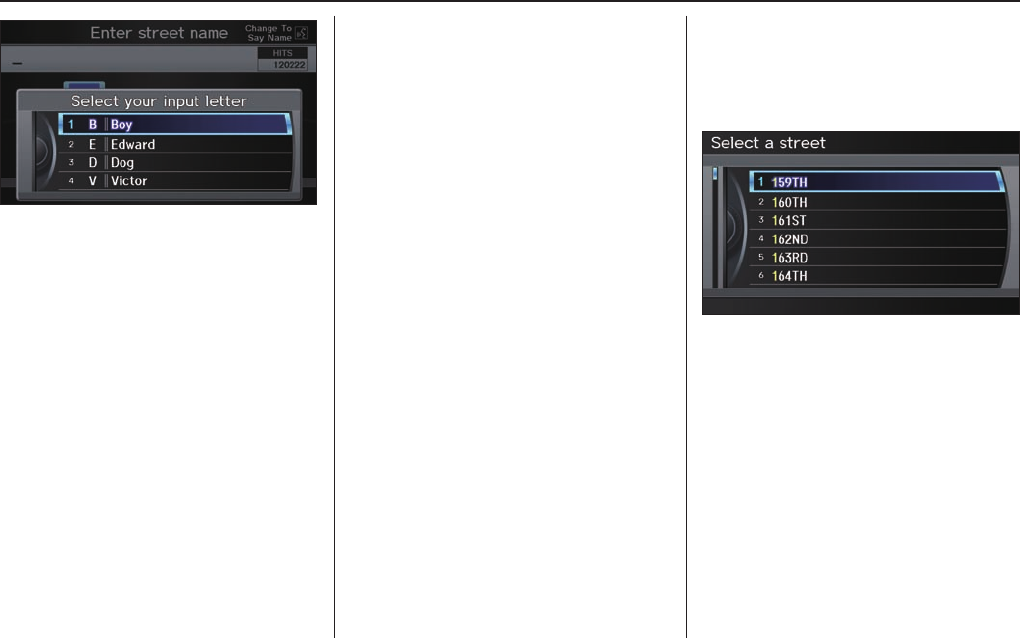
Entering a Destination
Navigation System 27
You should select a letter by saying the
number.
Alternatively, to improve voice
recognition, you can say “Echo” or
“Edward” instead of “E.” See page 17 for
a list of available words for each letter.
By Interface Dial:
After you have selected the city, or if
you selected Street in the beginning,
the display changes to the Enter street
name screen. Use the Interface Dial
to enter the name of the street (e.g.,
ELM or 42ND) that is your destination.
When entering the names of major
highways, it is possible to use the
following abbreviations for names of
the highways. For interstates, use an
“I” (I-10). For U.S. freeways, use “US”
(US-18). For state freeways, use the two
character state designation (CA-101).
For county roads, use the appropriate
designation (G-2, for example).
For Trans-Canada and Provincial
highways, use “Hwy” (HWY-7). For
County roads, use “CR” (CR-32). For
Regional Roads, use “RR” (RR-5).
Tip:
When entering a street, you do not need
to enter the direction (N, S, E, W) or
the type (St, Ave, etc.). The system will
automatically determine that for you,
based on your entered city and street
number.
The system will display a list of street
names, with the closest match to the
name you entered at the top of the list.
Select the number (1-6) of the desired
street from the list.

Entering a Destination
28 Navigation System
Entering the Street Number
After you have completed the street
name, the display changes to the Enter
street number screen. Use the voice
control system and say the address
number as a continuous string of
numbers. For example, the address 1527
should be spoken as “One, fi ve, two,
seven.” You can also use the Interface
Dial to enter the street number.
Some address numbers may not be
available on the selected street. For
example, let’s say the individual address
ranges for a selected street name are
1 - 20 and 9,000 - 10,000, with an
overall range shown on the display of 1
to 10,000. If you try to enter a number
outside the individual address ranges
such as 500, the system will show this
number as unavailable (grayed out).
• When using the Interface Dial, the
system only allows you to choose
available address numbers.
• When using voice control, the
system beeps if you try to select an
unavailable (grayed out) address
number.
If you did not select a city in the
beginning, the street name you selected
might appear in more than one city. The
system will give you a list of cities that
the street appears in. Select the desired
city from the list. The system then
displays the Calculate route to screen
(see Driving to Your Destination on
page 47 ).
Tip:
If the particular address you want
cannot be found, select Map Input on
the DEST screen (Dest. MENU 2) and
use the Interface Dial to select the
appropriate location on the map (see
By Map Input on page 41 ).
Select DESTINATION MAP and use
the Interface Dial to select an icon,
approximate area, or street you wish to
choose as your destination. Otherwise,
a central location of the street will be
selected. If you select a point of interest
(POI) or road in an unverifi ed area, you
may or may not have routing in these
areas. See Map Overview on page 6 .
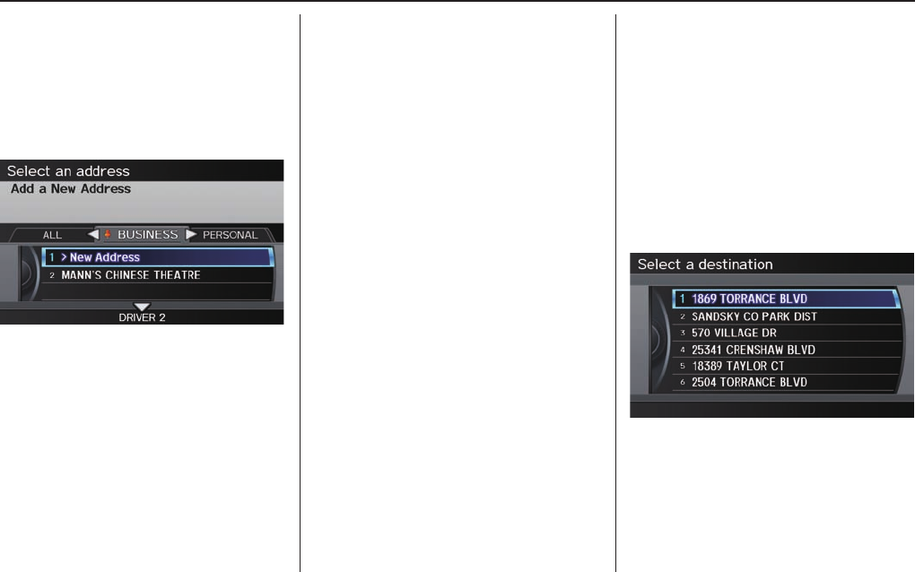
By Address Book
This selection allows you to choose a
personal address entry for a destination.
After you select Address Book from
the DEST screen (Dest. MENU 1), the
display changes to:
If an Address Book PIN has been set
in SETUP, the system prompts you to
enter your PIN. Say or enter your PIN.
If the PIN has not been entered, the
system displays the list.
To switch the list between Driver 1 or
Driver 2, move the Interface Dial
down.
NOTE:
When changing settings related to the
PIN, please see Address Book PIN
on page 88 .
Entering a Destination
Navigation System 29
The system then displays a list of the
places entered in your personal Address
Book. Using the Interface Dial, you
can sort the displayed addresses by
ALL, BUSINESS, PERSONAL,
UNFILED, or by other categories you
may create.
Scroll through the list to fi nd your
desired destination. After you select it,
the system then displays the Calculate
route to screen (see Driving to Your
Destination on page 47 ).
Tip:
If you select New Address in the
list, you can store a new address
in the personal Address Book. For
information on inputting New Address,
see Address Book on page 84 .
Adding Addresses to the
Personal Address Book
There are three ways to enter addresses
to the personal Address Book:
• Selecting New Address on the
Select an address screen (see page
84 ).
• Entering them to the personal
Address Book feature in SET UP (see
page 84 ).
• Adding them to the Address Book
directly from the Calculate route to
screen (see page 47 ).
NOTE:
• Destinations chosen from the
Address Book do not show up in
Previous Destinations.
• Prior to departure, you can set areas
to avoid. The system then includes
them in its calculations for the
destination you have entered. See
Edit Avoid Area on page 98 .
• For information on the available
voice commands, see V o i c e
Command Index on page 143 .
By Previous Destinations
Every time you route to a destination,
that destination is saved by the system.
Up to 50 destinations can be stored.
Select Previous Destinations from
the DEST screen (Dest. MENU 1) to
choose one of those destinations.
After you select Previous
Destinations, the display lists the last
50 destinations entered, with the most
recent appearing fi rst.
NOTE:
• If Previous Destinations is
grayed out, there are no Previous
Destinations entered.
Entering a Destination
30 Navigation System
• Neither your home address nor the
personal Address Book is displayed
on the Previous Destinations list.
Scroll through the list and say the line
number (1-6) of the destination, or
select the desired destination you want.
Once you select the desired destination,
the system then displays the Calculate
route to screen (see Driving to Your
Destination on page 47 ).
NOTE:
• Prior to departure, you can set areas
to avoid. The system then includes
them in its calculations for the
destination you have entered. See
Edit Avoid Area on page 98 .
• For information on the available
voice commands, see V o i c e
Command Index on page 143 .
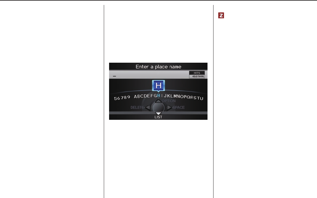
By Place Name
If you select Place Name from the
MENU screen (Dest. MENU 1), the
display will switch to the Enter a
place name screen. Use the Interface
Dial to input the location name. You
can input this place name by spelling
out the word one letter at a time.
Well-known facilities and other
businesses known by more than one
name can be searched for by multiple
name queries.
If you select a restaurant name with a
icon next to it, move the Interface
Dial to the right to view the Zagat
information.
NOTE:
• Prior to departure, you can set areas
to avoid. The system then includes
them in its calculations for the
destination you have entered. See
Edit Avoid Area on page 98 .
• ZAGAT information is not displayed
by fi nding destination in Mexico.
The place name closest to what you
input will be displayed at the top of
the list. If the place falls into multiple
categories, the categories are listed after
making a selection.
If you move the Interface Dial down
while the list is displayed, the display
will switch to SORT BY DISTANCE
or SORT BY NAME.
Entering a Destination
Navigation System 31
NOTE:
When there are more than 20,000
destinations, the ordering of the items
in the list cannot be sorted by distance
or name.
When you select a location, the system
displays the Calculate route to screen.
(See Driving to Your Destination o n
page 47 .)
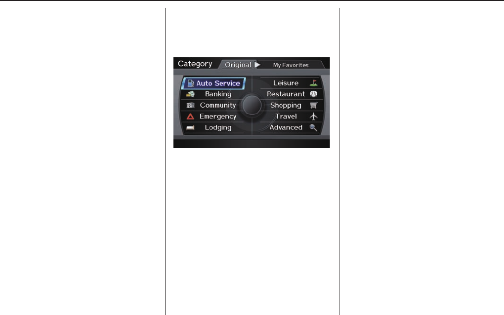
By Place Category
After you select Place Category from
the MENU screen (Dest. MENU 1),
the display changes to:
If you select a category from the list,
you can select even more detailed sub-
categories.
Let’s assume you want to fi nd a coffee
shop (restaurant) called “Bucks.”
• If you know the phone number of the
coffee shop, select Place Phone
No., then enter the 10-digit number
with area code. This is the quickest
way to fi nd it. See By Place Phone
Number o n p a g e 3 7 .
• The second best method is to select
Place Category, then Restaurant,
then CAFÉ/COFFEE SHOP, and
then enter the keyword “Bucks.” The
list will include all restaurants that
have the letters “bucks” anywhere in
the name.
• You can try to enter “Bucks” using
Place Name, but you may have
to search through a list that might
include Bucks Welding, Bucks
Surplus, etc.
NOTE:
• Prior to departure, you can set areas
to avoid. The system then includes
them in its calculations for the
destination you have entered. See
Edit Avoid Area on page 98 .
• You can enter the desired destination
using the voice control system. For
information on the available voice
commands, see 143 .

Entering a Destination
32 Navigation System
Subcategories
If you select a subcategory and move the
Interface Dial down, the subcategory is
stored to “My Favorites.” A maximum
of 30 subcategories may be stored.
Tip:
If you are not sure of the spelling of
a place, the best way to fi nd it is to
use the keyword search. Select Place
Category, choose a category and
subcategory from the menus, then
select Search by Keyword, and
enter the partial name.

Entering a Destination
Navigation System 33
Auto Service Leisure Travel
ALL TYPES(AUTO SERVICE)*1
ACURA DEALERS
ACURA ROADSIDE ASSISTANCE
HONDA DEALERS
GAS STATION
HYDROGEN STATION
AUTO PARTS & ELECTRONICS
AUTO REPAIR & MAINTENANCE
CAR WASH & DETAILING
MOTORCYCLE DEALERS
OTHER CAR DEALERS
PARKING GARAGE /HOUSE
PARKING LOT
RENTAL CAR AGENCY
ROADSIDE ASSISTANCE
ALL TYPES(LEISURE)*1
AMUSEMENT PARK
GOLF COURSE
HISTORICAL MONUMENT
MARINA
MOVIE THEATER
MUSEUM
PARK/RECREATION A REA
PERFORMING ARTS
SPORTS COMPLEX
TOURIST ATTRACTION
ALL TYPES(TRAVEL)*1
AIRPORT
AUTOMOBILE CLUB
BED & BREAKFAST
BUS STATION
CAMPING
COMMUTER RAIL STATION
FERRY TERMINAL
HOTEL/MOTEL
NAMED PLACE
PARK & RIDE
PARKING GARAGE /HOUSE
PARKING LOT
RENTAL CAR AGENCY
REST AREA
SKI AREA
TOURIST ATTRACTION
TOURIST INFORMATION
TRAIN STATION
TRAVEL AGENCY
TRUCK STOP/PLAZA
Restaurant*2
ALL TYPES(RESTAURANT)*1
ALL TYPES(ZAGAT ONLY)*3
AMERICAN
CHAIN RESTAURANT
CAFÉ/COFFEE SHOP
CALIFORNIAN
CHINESE
CONTINENTAL
FAST FOOD
FRENCH
GERMAN
GREEK
ICE CREAM/DESSERT
INDIAN
ITALIAN
JAPANESE
KOREAN
MEXICAN
PIZZA
SEAFOOD
THAI
VEGETARIAN
VIETNAMESE
OTHER FOOD
Banking
ALL TYPES(BANKING)*1
ATM
BANK
CHECK CASHING / MONEY TRANSFER
Community Advanced
ALL TYPES(COMMUNITY)*1
BUSINESS
CITY HALL
CIVIC/COMMUNITY CENTER
CONVENTION/EXHIBITION CENTER
COURT HOUSE
HIGHER EDUCATION
LIBRARY
POST OFFICE
SCHOOL
If the category you want is not listed, you can try to fi nd it with a
keyword. When you select this option, the display changes to the Enter
a category name screen. If the system fi nds any categories with the
keyword you entered, the display changes to the Select a category
screen. Select the desired category.
Emergency Shopping
ALL TYPES(EMERGENCY)*1
ACURA ROADSIDE ASSISTANCE
HOSPITAL
POLICE STATION
ROADSIDE ASSISTANCE
VETERINARIAN
ALL TYPES(SHOPPING)*1
ACCESSORIES/JEWELRY
AUTO PARTS & ELECTRONICS
BOOKS/MUSIC/VIDEO
CLOTHING/SHOES/BAGS
FURNITURE/HOME FURNISHING
GROCERIES/SUPERMARKET
HOME IMPROVEMENT
MALL/DEPARTMENT STORE
OFFICE SUPPLIES/ELECTRONICS
PHARMACY/DRUG STORE
PET FOOD/SUPPLIES
SEWING/LINEN
SPORTING GOODS
TOYS/ARTS/CRAFTS
Lodging
ALL TYPES(LODGING)*1
BED & BREAKFAST
HOTEL/MOTEL
*1: When trying to fi nd a specifi c subcategory, select the category ALL TYPES. Some subcategories may be miscategorized.
*2: See page 38 additional information on Restaurants.
*3: For information on the Zagat-surveyed restaurants, see Key to Zagat Ratings on page 80.
Entering a Destination
34 Navigation System
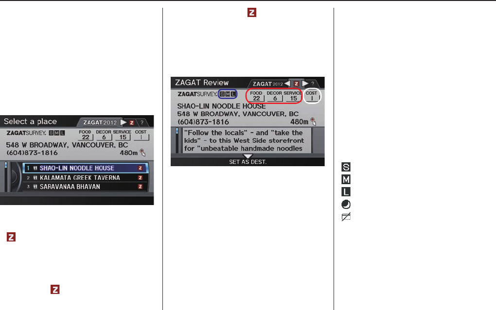
Finding a restaurant
The ZAGAT SURVEY for some
restaurants is available in the system.
See the INFO screen (Other), “Key to
ZAGAT Rating” for an explanation of
these ratings (see page 80).
NOTE:
Restaurant information in Mexico
cannot be searched with ZAGAT 2012.
On the Select a place screen,
restaurants with a Zagat Rating have
a icon at the end of the line. To list
only restaurants with Zagat Reviews,
say “Zagat” or select ZAGAT 2012.
You can view the complete Zagat
Review for a selected restaurant by
selecting the tab.
By voice, select the tab by saying
“Zagat list number X” (where X is the
line number 1-3). Alternatively, use the
Interface Dial to fi rst select the line
item, and move the Interface Dial to
the right to view the survey.
Say “Read List” or push in on the
Interface Dial, and the review will be
read to you. Move the Interface Dial
down to display the Calculate route to
screen.
NOTE:
Scrolling through the Zagat Review is
disabled when the vehicle is moving.
“Food,” “Decor,” and “Service”
categories (red frame) are rated using
numbered values (e.g., 22, 21, 20 etc.)
“Cost” (white frame) is the average cost
of a meal (including drink and tip). If
unavailable then estimated cost symbols
are shown:
“VE”: Very Expensive
“E”: Expensive
“M”: Moderate
“I”: Inexpensive
The symbols, if displayed (blue frame),
indicate the following information:
open on Sunday
open on Monday
open for lunch
serving after 11 PM
no credit card accepted
Entering a Destination
Navigation System 35
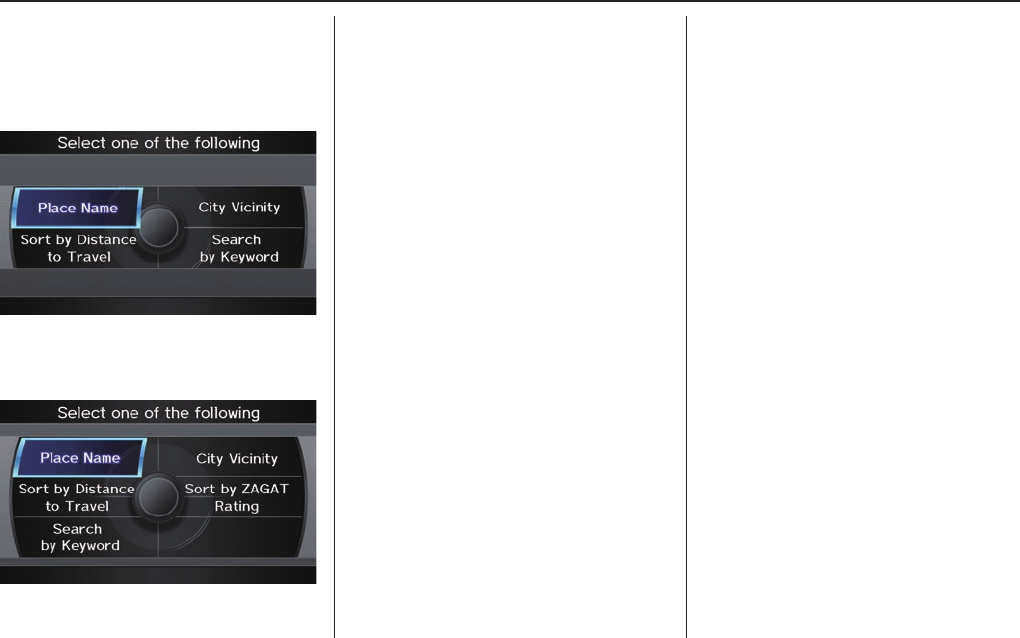
After selecting a category, the system
will give you the options of Place
Name, Sort by Distance to
Travel, City Vicinity, or Search by
Keyword with the following screen:
If you selected Restaurant as a
category, Sort by ZAGAT Rating
will be included as an option.
Place Name
When you select this option, the display
changes to Enter a place name
screen. Enter the place name, using
the Interface Dial. After entering the
place name, if you move the Interface
Dial down while the list is displayed,
the display will switch to SORT BY
DISTANCE or SORT BY NAME.
Once you select a place, the system then
displays the Calculate route to screen
(see Driving to Your Destination on
page 47 ).
NOTE:
When there are more than 20,000
destinations, the ordering of the items
in the list cannot be changed to listing
by order of distance or alphabetical
order
City Vicinity
The system allows you to fi nd points of
interest in the vicinity of the city you
entered. When you select this option,
the display changes to Enter city name
screen. Enter the name of the city using
the Interface Dial. If the system does
not fi nd an exact match, select LIST
when you fi nish entering the name of
the city. Select a desired city from the
list.
Once you have selected the city, the
display changes to Enter a place
name screen. Enter the name of the
place using the Interface Dial.
The system searches within a 30
kilometres radius of the city centre. If
more than 1000 POIs are located, only
the fi rst 1000 are displayed.
Once you select a place, the system then
displays the Calculate route to screen
(see Driving to Your Destination on
page 47 ).
Entering a Destination
36 Navigation System
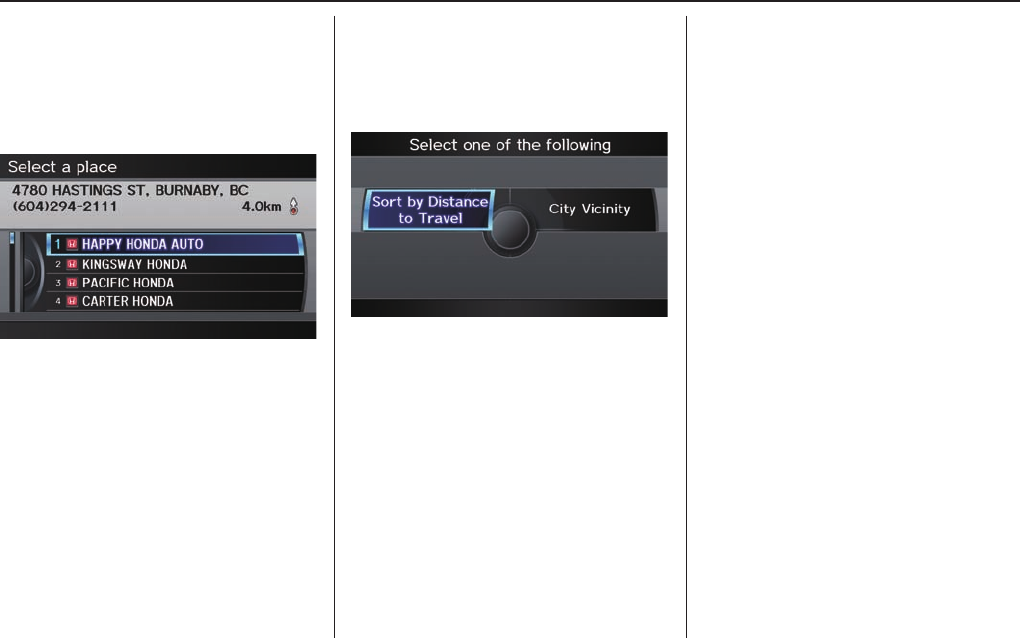
Sort by Distance to Travel
When you select this option, the system
gives you a list of all the places in the
subcategory. This list is arranged by
distance from your current location,
with the closest at the top of the list.
The distance and direction to the
destination at the cursor position in
the list are shown on the screen. The
distance shown is straight line distance
(as the crow fl ies), not driving distance.
Say or select the number (1-4) of the
desired destination from the list.
Once you select a place, the system then
displays the Calculate route to screen
(see Driving to Your Destination on
page 47 ).
Search by Keyword
If you do not know the exact name of
the destination, you can fi nd the place
with a keyword. When you select this
option, the display changes to:
You can fi nd your destination with a
keyword using the Sort by Distance
to Travel option or City Vicinity option.
If you select the Sort by Distance
to Travel option, the Enter keyword
for place screen appears. Enter the
keyword using the Interface Dial. If
the system does not fi nd an exact match,
select LIST when you fi nish entering the
keyword. The system starts searching for
places that match the entered keyword. If
you see your desired place, select it from
the list. If not, scroll through the list to
fi nd the desired place.
If you move the Interface Dial down,
the scope of the search can be increased.
When there are a large number of search
results, the number of locations will
increase to 100, 200, and up to 1000
locations. When the number of locations
is 100 or less, you can increase the scope
to 800 kilometres, 1600 kilometres or
the entire Canada by using Search
radius.
If you select the City Vicinity option,
the Enter city name screen appears.
Enter the name of the city using the
Interface Dial. The system will
display a list of city names, with the
closest match to the name you entered
at the top of the list. Select your desired
city name from the list. Once you
have selected your desired city name,
the Enter keyword for place screen
appears. Enter the keyword using the
Interface Dial to specify the desired
place.
Once you select a place, the system then
displays the Calculate route to screen
(see Driving to Your Destination on
page 47 ).
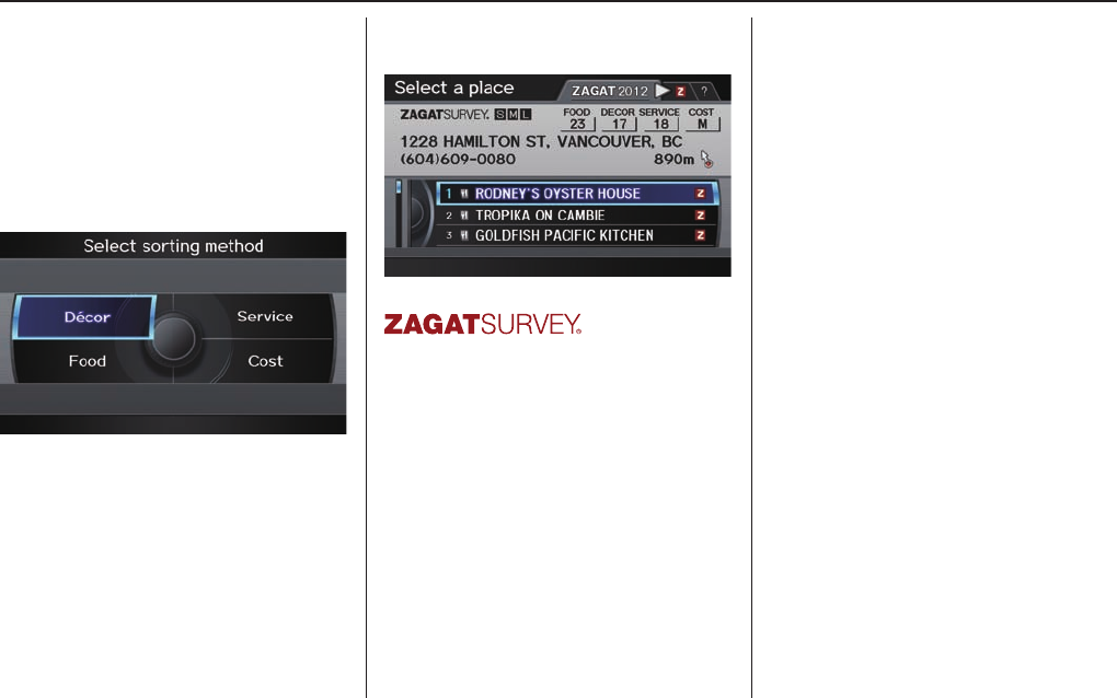
Entering a Destination
Navigation System 37
Sort by Zagat Rating
This item appears on the Select one
of the Following screen only when
“Restaurant” has been selected as the
category.
When you use this option, you can
search for restaurants using the Zagat
Ratings information.
Food, Décor, Service - When you
select Food, Décor, or Service, the
restaurant will be listed by rating value.
Cost - When you select Cost, the
restaurant will be listed by the average
cost of a meal (including drink and tip).
When you select a sorting method, the
list of restaurants will appear.
Copyright© 2012 Zagat Survey, LLC. All rights reserved.
You can see the survey for a listed item
by selecting the “Z” tab, or by saying
“Zagat list number X” (where X is the
number 1-3).
Once you select a restaurant, the system
then displays the Calculate route to
screen (see Driving to Your Destination
on page 47 ).
NOTE:
• Selecting this sorting method will show
you Zagat’s highest-rated restaurants
by the options, and not necessarily by
distance from your current location.
• For details on the ratings and
symbols, say “Key to Zagat rating”
or select the “?” tab using the
Interface Dial.
• Restaurant information on Mexico
cannot be searched with ZAGAT
2012.
By Place Phone Number
You can select a destination by phone
number. Only phone numbers saved
in the system are recognized. The
phone numbers of private residences
and numbers entered in your private
address book are not in the system. If
you select Place Phone No. on the
DEST screen (Dest. MENU 2), the
display will switch to the Enter Phone
Number screen. Use the Interface
Dial to enter the phone number.
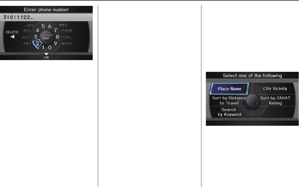
Entering a Destination
38 Navigation System
NOTE:
Prior to departure, you can set areas to
avoid. The system then includes them in
its calculations for the destination you
have entered. See Edit Avoid Area o n
page 98 .
When you edit the phone number,
continue pushing in on Interface Dial
more than three seconds to display
the Edit Mode screen. You can move
the position of the cursor by rotating
Interface Dial knob. To return the
Enter phone number screen, move
Interface Dial down.
After entering the number, move the
Interface Dial down and select OK.
Multiple listings for the same phone
number may be shown.
Tip:
When using the voice control system,
the entry should be spoken as a
continuous string of numbers. For
example, the telephone number (310)
555-4000 should be spoken as “Three,
one, zero, fi ve, fi ve, fi ve, four, zero, zero,
zero.”
By ZAGAT® 2012
The ZAGAT 2012 option allows you to
fi nd a restaurant by the ZAGAT Rating
information. When you select ZAGAT
2012 on the DEST screen (Dest.
MENU 2), the system lets you select
the metro area, neighborhood, and food
type to search the restaurant you like.
After you select the food type, the
following display appears:
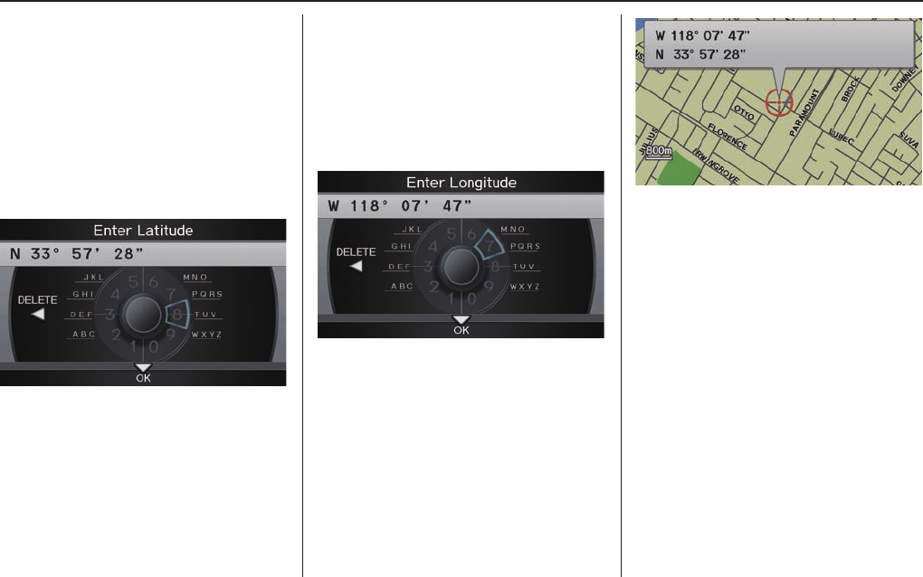
Entering a Destination
Navigation System 39
By Coordinate
If you select Coordinate from the
DEST screen (Dest. MENU 2),
the display will change to the Enter
Latitude screen. Use the Interface
Dial to input the latitude.
NOTE:
Latitude and longitude must be entered
up to the seconds’ value.
NOTE:
Prior to departure, you can set areas to
avoid. The system then includes them in
its calculations for the destination you
have entered. See Edit Avoid Area o n
page 98 .
After entering the number, move the
Interface Dial down and select OK.
The display will change as indicated in
the following paragraph.
On the Enter Longitude screen,
use the Interface Dial to input the
longitude.
With the selection of Coordinate, it
is assumed that you are searching for
the destination within the area that is in
the closest proximity. The display will
change as indicated on the next page.
Move the Interface Dial to fi nd the
desired destination. The map and target
mark move in the same direction.
If so desired, you can also rotate the
Interface Dial knob and change the
scale of the map. When the target mark
are on the desired icon, map location,
or road, push in on the Interface Dial.
The address for this location will be
displayed at the very top of the screen.
The yellow box (shown in scales above
1 mile) denotes the area that can be
viewed with the Interface Dial when
the current map is clicked.
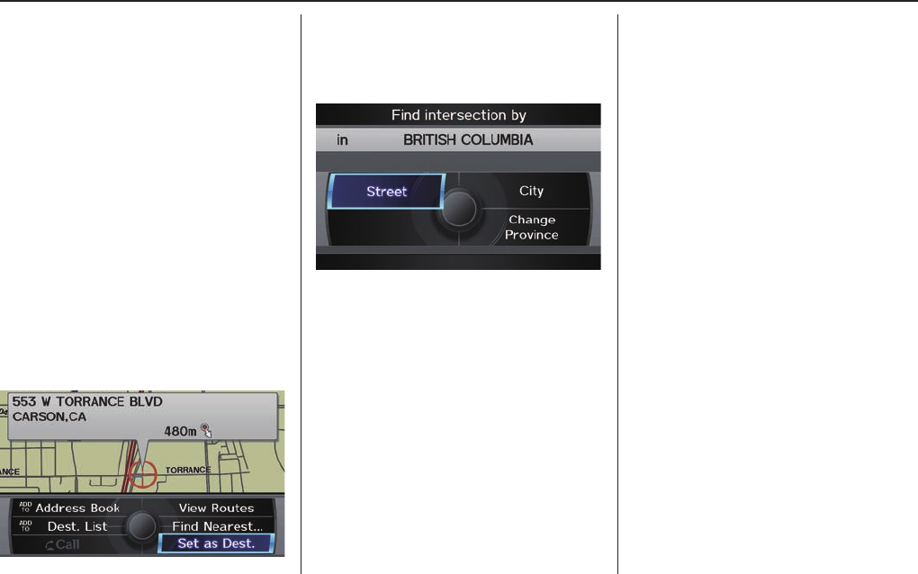
Entering a Destination
40 Navigation System
NOTE:
Information icons are displayed at
scales from 1,6 kilometres to 400
metres, POI icons are displayed at 200
metres or less, and roads are displayed
at 400 metres or less.
When you fi nd the desired address,
press on the Interface Dial again. If
it is not the desired address, change
the location of the target mark with
the Interface Dial. Push in on the
Interface Dial again to display a new
address.
If you select a single icon or a section
of road within the target mark, the
following screen appears. Select Set
as Dest. and calculate the route for the
destination that you selected.
By Intersection
After you select Intersection from
the DEST screen (Dest. MENU 2), the
display changes to:
To select an intersection outside the
province you are currently in, select the
province. For details of how to select a
province, see Selecting the Province or
State on page 24 .
Next, select the city where the
intersection is located. For details of
how to select a city, see Selecting the
City on page 25 .
Last, select the two streets which
intersect. For details of how to select a
street, see Selecting the Street o n p a g e 2 6 .
If the two streets that you have selected
do not intersect, no intersection will
appear.
Tip:
When entering an address, it is usually
easier to enter the street fi rst. A city
or cities that the street appears in will
be displayed. For your convenience,
you do not have to enter both city and
street.
NOTE
• If you fi nd that your city is not
listed, it may be part of a larger
metropolitan area. Try entering the
street fi rst.
• Prior to departure, you can set areas
to avoid. The system then includes
them in its calculations for the
destination you have entered. See
Edit Avoid Area o n p a g e 9 8 .
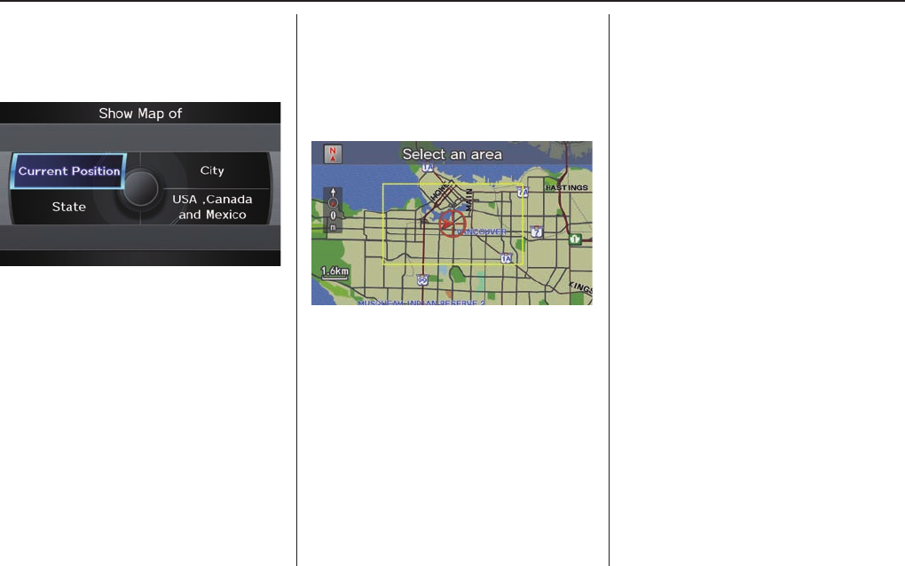
Entering a Destination
Navigation System 41
By Map Input
After you select Map Input from the
DEST screen (Dest. MENU 2), the
display changes to:
Select Current Position, City,
Province, or USA, Canada and
Mexico to display the map.
NOTE:
• Prior to departure, you can set areas
to avoid. The system then includes
them in its calculations for the
destination you have entered. See
Edit Avoid Area o n p a g e 9 8 .
• For information on the available
voice commands, see Voice
Command Index on page 143 .
Showing the Map of Current
Position
The Current Position selection
assumes that you are looking for a
destination in the immediate area. The
display changes to:
The red arrow indicates your vehicle
position. Find your desired destination
by moving the Interface Dial up and
down and to the left and right. The map
and target mark will move in the same
direction.
The yellow box indicates the area you
will see when you click on the current
map with the Interface Dial. The
scale will decrease each time you push
in the Interface Dial.
If desired, rotate the Interface Dial
knob to change the map scale. When
you have the target mark on the desired
icon, polygon, or road, push in on the
Interface Dial. The address of the
location will appear at the top of the
screen (at scales less than 1 mile).
NOTE:
Information icons are displayed at
scales from 1,6 kilometres to 400
metres, POI icons are displayed at
200 metres mile or less, and roads are
displayed at 400 metres or less.
If this is the desired address, push in
on the Interface Dial again. If not,
use the Interface Dial to reposition
the target mark, then push in on the
Interface Dial again to display the
new address.
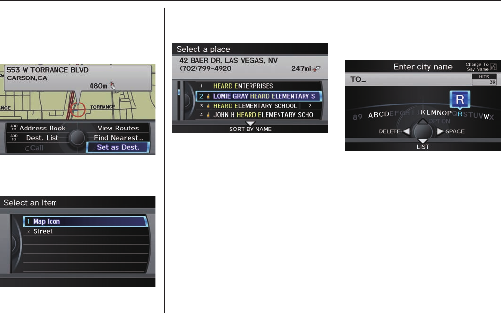
Entering a Destination
42 Navigation System
If you select a single icon or road
segment within the target mark, the
following screen appears. Select Set
as Dest. to calculate a route to the
selected destination.
If you select multiple icons within the
cursor radius, the following screen
appears.
Select an item from the list.
Then select OK to calculate a route to
the selected destination.
Showing the Map of City
You can search for a city name in all
coverage areas.
By Voice Control:
Say the city name by saying individual
letters, or words that represent the
letters, one at a time.
The system has a talk back function.
If your spoken letter is not recognized,
the system will talk back to you. For
example, if you say “E” but the system
does not recognize the command, it
will ask you “Please select the number
of the input letter from the list” and the
following pop-up box will appear:
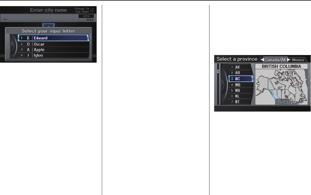
Entering a Destination
Navigation System 43
You should select a letter by saying the
number.
Alternatively, to improve voice
recognition, you can say “Echo” or
“Edward” instead of “E.” See page 17 for
a list of available words for each letter.
By Interface Dial:
With the City selection, the display
changes to the Enter city name screen.
For instructions on entering the city
name, see Selecting the City on page 25 .
When you have entered the desired
city, the display changes to a map. The
starting location will be the central
position in the selected city.
See Showing the Map of Current
Position on page 41 for instructions
on fi nding and entering your desired
destination.
Showing the Map of Provinces
By Voice Control:
Say “Province” on the Show map of
screen, and the display changes to the
Select a province screen. Say the
province name (e.g., British Colombia
or BC) or the province number (1-7).
You can select either the Canada/AK,
USA, or Mexico tab by moving the
Interface Dial to the left and right.
If you select Canada/AK, Canada and
Alaska will be displayed. If you choose
USA, the American mainland, Hawaii,
and Puerto Rico will be displayed. If
you select Mexico, the states of Mexico
will be displayed.

Entering a Destination
44 Navigation System
Say the province name by saying
individual letters, or words that
represent the letters, one at a time.
By Interface Dial:
With the Province selection, the
display changes to the Select a
province screen.
After you select the desired province,
the display changes to a map of the
province, with the target mark located
near the middle.
The yellow box indicates the area you
will see when you click on the current
map with the Interface Dial. The
scale will decrease each time you push
in on the Interface Dial.
Use the Interface Dial to move the
target mark to the area of the province
close to your intended destination. If
desired, rotate the Interface Dial
knob to change the map scale. When
you have the target mark in the desired
area, push in on the Interface Dial.
The address of the location you have
selected will appear at the top of the
screen.
NOTE:
Information icons are displayed at
scales from 1,6 kilometres to 400
metres, POI icons are displayed at 200
metres or less, and roads are displayed
at 400 metres or less.
If this is the desired address, push in
on the Interface Dial again. If not,
use the Interface Dial to reposition
the target mark, then push in on the
Interface Dial again to display the
new address.
If you selected a single icon or road
segment, select Set as Dest. to
calculate a route to the selected
destination. If you selected multiple icons
within the cursor radius, select an item
from the list. Then select OK to calculate
a route to the selected destination.

Entering a Destination
Navigation System 45
Showing the Map of USA,
Canada and Mexico
With the USA, Canada and Mexico
selection, the display changes to:
The yellow box indicates the area you
will see when you click on the current
map with the Interface Dial. The
scale will decrease each time you push
in on the Interface Dial.
Use the Interface Dial to move the
target mark to the area of the country
close to your intended destination.
Then push in on the Interface Dial.
If desired, rotate the Interface Dial
knob to change the map scale. When
you have the target mark on the desired
icon, polygon, or road, push in on the
Interface Dial. The address of the
location you have selected will appear
at the top of the screen.
NOTE:
Information icons are displayed at
scales from 1,6 kilometres to 400
metres, POI icons are displayed at 200
metres or less, and roads are displayed
at 400 metres or less.
If this is the desired address, push in
on the Interface Dial again. If not,
use the Interface Dial to reposition
the target mark, then push in on the
Interface Dial again to display the
new address.
If you selected a single icon or road
segment, select Set as Dest. to
calculate a route to the selected
destination. If you selected multiple icons
within the cursor radius, select an item
from the list. Then select OK to calculate
a route to the selected destination.
By Go Home 1 or 2
Selecting Go Home 1 or 2 from the
DEST screen (Dest. MENU 1 or 2)
takes you to the address you have set as
“home.”
If a Go Home 1 or 2 PIN has been
set, the system prompts you to enter
your PIN.
Say or enter your PIN. The system will
then display the Calculate route to
screen (see Driving to Your Destination
on page 47 ).
If a Go Home 1 or 2 PIN has not been
set, the system displays the Calculate
route to screen after you select Go
Home 1 or 2 (see Driving to Your
Destination o n p a g e 4 7 ) .

Entering a Destination
46 Navigation System
NOTE:
• To edit Home Address, see Home
Address o n p a g e 8 7 .
• When no Home Address 1 or 2 has
been set, the SETUP screen will be
displayed. For details, see Home
Address o n p a g e 8 7 .
• Prior to departure, you can set areas
to avoid. The system then includes
them in its calculations for the
destination you have entered. See
Edit Avoid Area o n p a g e 9 8 .
• PINs are optional. If you choose to
use a PIN, make sure you remember
it. If you forget your PIN, your dealer
will have to reset it for you, and all
PINs will be cleared.
• If a PIN is desired, enter it using the
PIN feature in SET UP. See page 88 for
information on entering your PIN.
Driving to Your Destination
Navigation System 47
Driving to Your Destination
A route typically has three phases.
• Initial route calculation (Calculate
route to screen) (see page 47 )
• Change the route while en route (see
page 67 ).
• Resume the route when restarting the
engine (see Continue Trip to Screen
on page 72 ).
Calculate Route to Screen
Say or select OK. The system calculates
the route (see Map Screen on page 50 ).
NOTE:
• Prior to departure, you can set areas
to avoid. The system then includes
them in its calculations for the
destination you have entered. See
Edit Avoid Area on page 98 .
• For information on the available
voice commands, see Voice
Command Index on page 143 .
Further selections from the Calculate
route to screen include:
ADD TO Address Book
Allows you to add the destination to
your Address Book. See By Address
Book on page 28 .
NOTE:
If EDIT Address Book is displayed,
the destination is already stored in your
Address Book. You can edit the address
in your Address Book by selecting this
button. For information on editing your
Address Book, see Address Book on
page 83 .
ADD TO Dest. Lists
Allows you to add a location to the
Destination Lists as a destination
or waypoint. While on the Calculate
route to screen, rotate the Interface
Dial knob and select Calculate
route to. The Add to Dest. List
screen appears and the destination is
added.
CALL
Dials the number on the screen
when available. See Bluetooth®
HandsFreeLink® on page 19 .
Driving to Your Destination
48 Navigation System
Changing the Routing Method
The system lets you select the way you
want to drive to your destination. Select
Route Pref. on the Calculate route
to screen by rotating the Interface
Dial knob.
• You can choose MAX or MIN for
three settings: Use Highways, Use
Toll Roads, and Use Ferries. The
route calculations for the current
selection will be displayed in the
upper right-hand corner of the screen.
The generated route may not be the
route you would choose. For safety
reasons, the system generally applies
the following rules to your route:
• Shortcuts through residential areas
are avoided.
• Right turns are favored over left turns
or U-turns.
• Restricted turns (turns that cannot be
made during or at certain times of the
day) are not used.
Viewing the Routes
If you select View Routes on the
Calculate route to screen, you can
view three possible routes to your
destination. You can also use the
Interface Dial to verify the areas
peripheral to the map. If you select
View Routes, the display changes to:
These different routes are shown and
calculated based on the setup options in
Route Preference.
You can select one of the three routes
(1-3) by rotating the Interface Dial
knob. The system will calculate the
selected route and display the map
screen.
Driving to Your Destination
Navigation System 49
NOTE:
• The driving distance and time
estimated for the various routes is
displayed.
• It is not unusual for the different
methods to pick the same route.
Voice commands cannot be used
while the system is calculating.
• Zoom IN/OUT to view route details
is not available on the View Routes
screen. After moving the Interface
Dial and scrolling through the map,
you can then zoom in or out on the
map screen to view your route in
details.
Based on the route data, you can change
the routing method by rotating the
Interface Dial knob.
Once you confi rm your selection, say
the number of the desired routing
method or push in on the Interface
Dial.
The calculated route will be highlighted
as a blue line, and a voice prompt
will tell you how to proceed along the
highlighted route.
Push in on the Interface Dial and
select Voice to have the guidance
repeated.
Viewing the Destination Map
If you move the Interface Dial down
and select DESTINATION MAP while
on the Calculate route to screen,
a map of the destination vicinity is
displayed. Press the CANCEL or
BACK button, or select Return to
return to the previous screen. You can
view the destination map anytime while
en route by saying “Display destination
map.”

Driving to Your Destination
50 Navigation System
Map Screen
When you select OK on the Calculate
route to screen, the map screen
appears, showing your highlighted
route (blue line) in real time.
Route Line
When driving on unverifi ed streets
(purple), the route line changes to either
a purple dotted “vector line” pointing
to your destination, or a blue-pink line.
See Unverifi ed Area Routing on page
94 for a detailed explanation of how
to enable unverifi ed routing, and the
related cautions and disclaimers.
NOTE:
You can always view the entire route by
simply saying, “Display entire route.”
“Vector line” (unverifi ed routing off)
Blue-pink unverifi ed route line
(unverifi ed routing on)
Voice Guidance Prompts
As you get near the guidance point,
you will hear a voice reminder and
see a pop-up window showing you the
guidance point. You will typically hear
three prompts:
• The fi rst is about 800 metres from the
guidance point if you are traveling on
an ordinary road or street, or about
3 kilometres from the guidance point
if you are traveling on a freeway.
• The next is about 400 metres
from the guidance point if you are
traveling on an ordinary road or
street, or about 1,600 metres from the
guidance point if you are traveling on
a freeway.
• The fi nal prompt is close to your
actual turn.
If the distance between the next two
guidance points is very small, both of
them are displayed on the screen in
a single window, and the voice will
remind you of them at the same time.

Driving to Your Destination
Navigation System 51
NOTE:
• You can say “Voice” at any time, or
select Voice after pushing in on the
Interface Dial to be reminded of the
next guidance point.
• Typically, a pop-up guidance window
shows your next turn, and a voice
guidance is heard. The timing of
guidance varies depending on the
type of road you are on and the
distance to the next guidance point.
When the guidance in unverifi ed areas,
the phrase “if possible” is inserted
before each guidance prompts. See
Unverifi ed Area Routing on page 94
for more detailed information on the
unverifi ed routing.
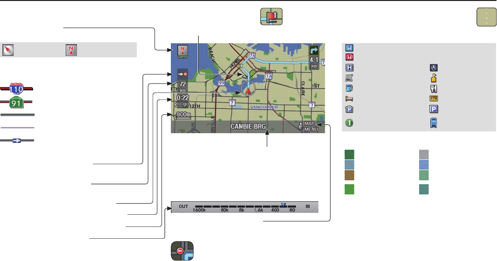
Driving to Your Destination
52 Navigation System
Map Screen Legend
Map Orientation
(see page 59 )
“Heading Up” “North Up”
Streets
(see Map Overview on page 6 )
: Highways (Red)
: Interstates (Pink)
: Verifi ed Street (Gray)
: Unverifi ed Street (Purple)
:
One-Way Streets (see page 62 )
(80 metres scale only)
Direction of Destination
(when en route)
Distance to Destination
(see page 54 )
Vehicle Position (see page 65 )
Time to Destination (see page 54 )
Current Map Scale (see page 61 )
Map Scale Adjustment
(Mile or km per half-inch appears only when
you zoom in or out by rotating the Interface
Dial knob.) (see page 61 )
Waypoint (see page 68 )
Blue Line Calculated route (see page 50)
Current Street
(see page 65 )
Map Menu (see page 54 )
(Push in on the Interface Dial to view.)
No Entry Icon
“Breadcrumbs”
(see Off-road Tracking on page 64 )
Landmark Icon - Generic (see page 62 )
Honda Dealer (USA)
Honda Dealer (Canada, Mexico)
Hospital Acura Dealer
Grocery Store School
Gas Station Restaurant
Hotel/Lodging ATM
Parking Garage Parking Lot
Highway Exit
Information Post Offi ce
Map Features
Park Airport/Business
Hospital Body of Water
Shopping Mall Cemetery
Golf Course/
Stadium University
NOTE:
If you move the Interface Dial over an
area (map features shown above), the
name is displayed at the top of screen.
NOTE:
See Map Legend in the Map Information on the MAP MENU screen for further explanation.
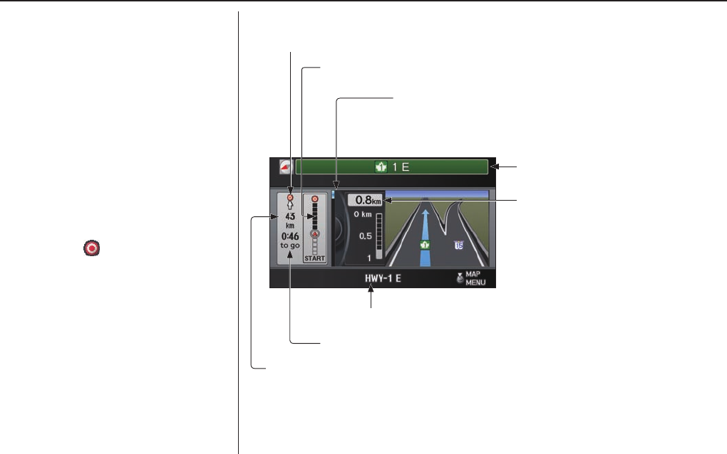
Driving to Your Destination
Navigation System 53
Guidance Screen
The guidance screen offers an
alternative way to view your route
information. Many of the icons and
screen features are similar to those on
the map screen. While driving to your
destination, press the MAP/GUIDE
button to switch between the map and
guidance screens. The guidance
screen shows you:
Milestone to Destination - The
position of the small circular icon
shows your trip progress. As you get
closer to your destination, the indicator
will approach .
NOTE:
• The map and voice guidance in
unverifi ed areas differ from those in
verifi ed areas.
• Current manoeuvres and those
within 300 metres will show on
the Countdown bar, indicating the
distance until the next manoeuvre.
• Lane information is not displayed
while driving on the road in Mexico.
Guidance Screen Legend
Time to Destination (see page 54 )
Milestone to Destination (see page 53 )
Direction of Destination, “as the crow fl ies”
Distance of Next Driving Manoeuvre
Street Name to Next Driving
Manoeuvre
Scroll: to view guidance manoeuvres
(rotate Interface Dial knob)
Current Street (see page 6 )
Distance to Destination (see page 54 )
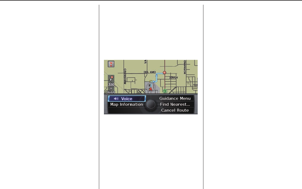
Driving to Your Destination
54 Navigation System
Distance and Time to
Destination
When you select a destination, the
distance to the destination is the actual
road distance of the calculated route,
and not “as the crow fl ies.” When
viewing a list of destinations (points
of interest), such as restaurants, the
distance is “as the crow fl ies” (see Sort
by Distance to Travel on page 36 ).
The displayed time to the destination
may differ from the actual travel time
because the time is calculated based
on the posted road speed data and your
current speed.
NOTE:
If you are en route and the Interface
Dial is moved, the “Time to
Destination” and “Distance to
Destination” indications are replaced
with an indicator showing distance
from the current vehicle location.
Map Menu
When the map screen is displayed,
pressing in on the Interface Dial
displays the Map menu. If the map is
scrolled, the Map menu will not appear.
Press the MAP/GUIDE button, the
BACK button, or the CANCEL button
to return to the basic map screen.
Voice - Shown if currently en route.
Select to hear the next guidance
manoeuvre.
Guidance Menu - Allows you to
confi rm Directions and Highway Exit
information en route. You also can
change Guidance Mode (single screen/
split screen). For detailed information
on this feature, see Directions on page
55 , EXIT INFO on page 56 , or Guidance
Mode on page 56 .
Find Nearest … - Selects a
subcategory from the list to search the
nearest POI from your current location.
For detailed information on this feature,
see Subcategories on page 32 .
Map Information - Allows you to
confi rm information on the map or
change the settings of displaying a
map. For detailed information on this
feature, see Map Orientation on page
59 , Showing Icons on the Map on page 57 ,
Viewing/Saving the Current Location
on page 65 or Map Legend o n p a g e 6 0 .
Cancel Route - Cancels your current
route. The map screen will display your
current position.
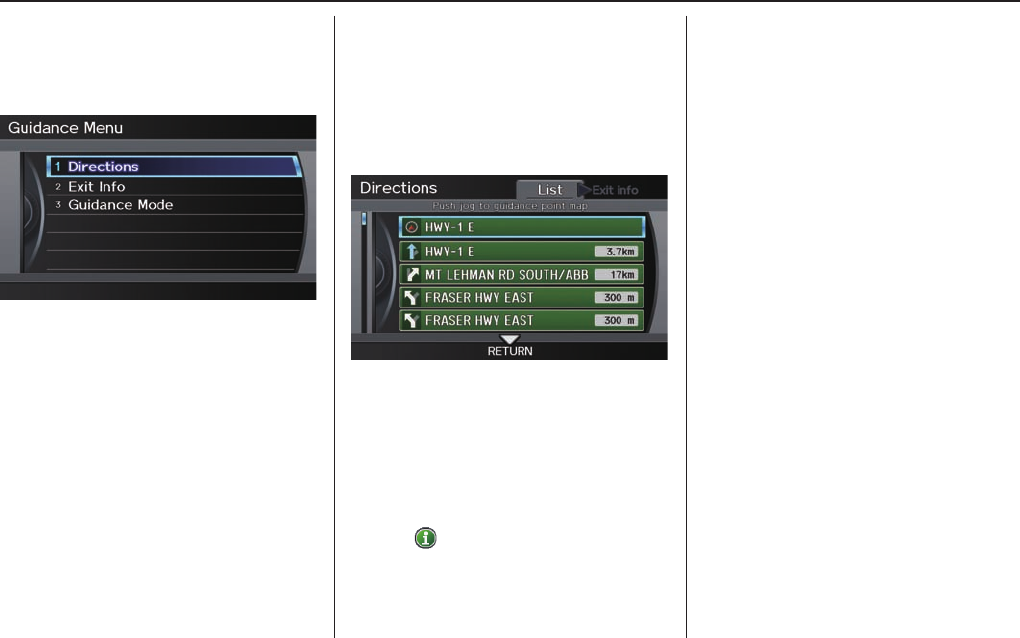
Driving to Your Destination
Navigation System 55
Guidance Menu
When you select Guidance Menu
from the Map menu, the Guidance
menu screen appears.
Directions - Select to confi rm the
directions (guidance points) to your
destination (see page 55).
Exit Info. - Allows you to set a new
destination or waypoint located near a
highway exit when you are en route (see
page 56).
Guidance Mode - Allows you to select
the guidance mode (single screen or
split screen) (see page 56).
Directions
You can display a list of the
manoeuvres on your route and confi rm
the distance betweem them.
If you select Guidance Menu from
the Map menu and then select
Directions, the display changes to:
NOTE:
• When you select a manoeuvre from
the list, a map of the manoeuvre is
shown.
• Manoeuvres that occur at highway
exits or contain highway exit
information will show the exit info
icon ( ).
Press the CANCEL button or the
BACK button, or move the Interface
Dial down to return to the previous
screen.
You can scroll one manoeuvre at a time
by rotating the Interface Dial knob.
The route guidance display disappears
and guidance ends when you reach your
destination. Press the DEST/ROUTE
button to return to the DEST screen
(Dest. MENU 1 or 2).

Driving to Your Destination
56 Navigation System
EXIT INFO (Highway Exit
Information)
NOTE:
Currently, only available when
travelling in the United States.
You can search highway exit
information (gas stations, restaurants,
ATMs, etc.) and add new destinations
or waypoints to the calculated route.
Select the Guidance Menu from the
Map menu screen. Select Exit Info,
and a list of highway exits for the route
is displayed.
If you select the freeway exit you plan
on taking, a list of businesses in the
area will be displayed. You can choose
a listing to set as a new destination or
waypoint, and say or select OK.
On the map screen, you can display
Highway Exit information using the
Interface Dial. The Exit Info icon will
only be displayed on the map screen if
there is any highway exit information
available. Choose the 400 metres, 800
metres or 1,6 kilometres scale, then
move the target mark to the desired Exit
Info icon and push in on the Interface
Dial. Choose a place from the list and
set it as a new destination or waypoint.
NOTE:
• To turn on “Highway exit
information” on the map screen,
display the icon bar and select the “
” icon (see page 62 ).
• Exit Info, cannot be selected when
the highway exit is in Mexico.
Guidance Mode
When en route to a destination, you
have two display options: single-screen
mode (the factory default) or split-
screen mode.
If you select the Guidance Menu on
the Map menu screen and then select
Guidance Mode, the Selection
screen will appear.
Single-screen mode - While the map
screen is displayed, only the map is
shown with occasional guidance pop-up
windows as you approach a manoeuvre.
When you press the MAP/GUIDE
button and switch to the Guidance
screen, only the Directions screen is
displayed.
Split-screen mode - While the map
screen is displayed, the map is displayed
on the left of the screen, and the next
manoeuvre is on the right side of the
screen. You will see the same screen
setup when you press the MAP/GUIDE
button.
Guidance mode can be changed in SET
UP (see Guidance Mode on page 101 ).
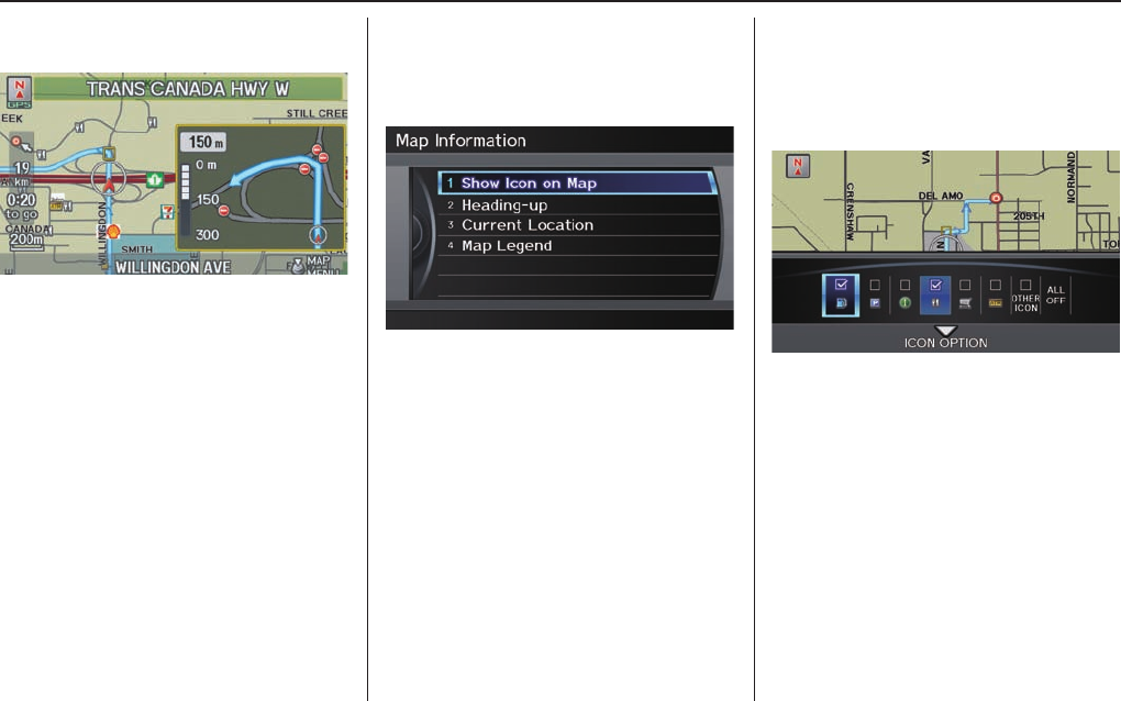
Driving to Your Destination
Navigation System 57
When you get near the manoeuvre, the
map screen changes to:
On the map screen, the location of
the manoeuvre is marked with a small
yellow square. The guidance window
is simply an enlargement of the next
manoeuvre area. After you complete the
manoeuvre, the display returns to a full
map screen when single-screen mode is
set, or to a map and direction list screen
when split-screen mode is set.
Showing Icons on the Map
Selecting Show Icon on Map from
Map Information on the Map menu
(see page 54 ) displays the following
screen:
The screen consists of the following
items:
Icon Bar
The icon bar allows you to manually
select the icons that are displayed on the
map (see page 63 for a list of these icons).
Map Information
When you select Map Information from
the Map menu, the Map information
screen appears.
Show Icon on Map - Allows you to
select the icons displayed on the map
(see page 57).
North-up/Heading-up - Select North-
up or Heading-up to change map
orientation (see page 59). On scales
greater than 1 mile, this button is
grayed out (North-up only mode).
Current Location - Allows you
to display and/or save your current
location (see page 65).
Map Legend - Allows you to learn the
meaning of map features (see page 60).
Driving to Your Destination
58 Navigation System
In the screen shown, gas station and
restaurants are selected. Rotate the
Interface Dial knob and push in
to select (blue with box checked)
or remove them (black with box
unchecked). You can also display
or hide the same icons by using the
“Display” or “Hide” voice commands
on the map screen (see page 144).
ICON OPTIONS
This feature allows you to “fi ne tune”
some of the icons on the Icon bar.
If you move the Interface Dial down
and select ICON OPTIONS, the
following screen will be displayed:
The three icon choices — Parking,
Restaurant, and Other Icon — can
each be tailored to your needs.
For instance, let’s assume that your
hospital is not displayed on the map,
and you want to make sure that your
settings are correct. You would do the
following:
• First, ensure that the Other Icon
button on the Icon Bar is selected.
• Second, select Other Icon and
verify that the hospital option is
on (blue with box checked). This
procedure is explained below.
If you select Other Icon from the
Select category for icon settings
screen, the other icon options are
displayed:
In the example shown, only POST
OFFICE and SCHOOL are selected
and will show up on the map. To also
see HOSPITAL on the map, this would
need to be turned on by fi rst selecting it
and then pushing in on the Interface
Dial to select it so it appears as below.
Driving to Your Destination
Navigation System 59
Exit, and save your settings by moving
the Interface Dial down (OK).
NOTE:
When viewing the map screen, you can
turn some icons on using voice control.
See the Voice Command Index on
page 143 for the available “Display” and
“Hide” icon commands.
Map Orientation
The map can be orientated two ways:
• North-up: North pointing up as you
would normally view a paper map.
• Heading-up: The map constantly
rotates so the road you are driving on
always points up (as you see the road
through your front windshield).
“North Up”
“Heading Up”
NOTE:
The red arrow in both heading symbols
always shows the direction north.
Push in on the Interface Dial when
you are on the map screen, and select
Map Information. Select North-
up or Heading-up, or say “Display
heading up” or “Display north up.”
In the larger map scales (above 2 mile
or 3 kilometre), the map is always
oriented with north facing upward. You
cannot change the orientation.
NOTE:
For information on the available voice
commands, see Voice Command Index
on page 143 .
Driving to Your Destination
60 Navigation System
Current Location
Whenever you are on a map screen, you
can always obtain your current location
either by pushing in on the Interface
Dial, selecting Current Location
from Map Information, or by using
the voice control system and saying
“Display current location.” A screen
pops up which shows the address of
your current location, as well as the
latitude, longitude, and elevation.
Map Legend
You can use the Map legend screens
to learn the meaning of map features,
icons, colours, etc. used in this system.
When you say or select Map Legend,
the display changes to:
Say or select the desired item or item
number to view each section of the map
legend.

Driving to Your Destination
Navigation System 61
Map Scale
Rotate the Interface Dial knob or a voice command such as “Display 800 metres scale” (see page 144 ) to change the scale of the
map. Zooming in increases the detail, while zooming out gives you a view of a wider area. After changing the scale, give the
system a few moments to update the display.
Functions available at various map scales
Map Scale (English and Metric) For
selecting units, see page 93 .
1/20mi. 1/8 mi. 1/4 mi. 1/2 mi. 1 mi. 2 mi. 5 mi. 15 mi. 50 mi. 150 mi. 350 mi. 1000 mi.
80 m 200 m400 m800 m
1.6 km
3 km 8 km 24 km 80 km
240 km 560 km
1600 km
POI icon symbols (like ATM) page 62 XX
Breadcrumbs (off-road tracking dots) page 64 XXXX
Highway exit information icons page 62 XXX
One-way traffi c icon page 62 X
Unverifi ed road display (purple)
page 6
XXXXXXXX
Map orientation “Heading up” page 59 XXXXX
Map orientation “North up” page 59 XXXXXXXXXXXX
Map features (park, golf course) page 52 XXXXXXXXXXX
Avoid area shown on map
page 98
XXX
Avoid area scales (when creating)
page 98
XXX
Waypoint “fl ag” icons page 68 XXXXXXXXXXXX
NOTE:
• You can change between miles or kilometres in SETUP (see Units on page 93 ).
• For information on the available voice commands, see Voice Command Index on page 143 .
Driving to Your Destination
62 Navigation System
Destination Icon
The destination icon only shows the
approximate location of the destination.
This occurs because a city block can
have as many as 100 possible addresses
(for example, the 1400 block is followed
by the 1500 block.) Since most cities
use only a portion of the 100 possible
addresses (for example, in the 1400
block, the addresses may only go up to
1425 before the 1500 block starts).
Therefore, the address 1425 will be
shown a quarter of the way down the
block by the system instead of near the
end of the block where the destination
is actually located.
Tip:
When en route, you can view a map
showing your destination. Using voice
control, say “Display destination
map.”
Various Other Icons
Landmark Icons
Landmark icons are shown in the map
screen on 1/20 and 1/8 mile scale, or 80
and 200 metre scale. The Highway exit
information is displayed on the 400,
800 metres, and 1,6 kilometres scales.
The icons are:
Honda Dealer (Canada,
Mexico)
Honda Dealer (USA)
Acura Dealer
Hospital School
Grocery
Store Restaurant
Gas
Station ATM
Hotel/
Lodging
Parking
Lot
Parking
Garage Post Offi ce
Highway Exit Information
One-Way Traffi c Icon
The one-way traffi c icons (see Map
Screen Legend on page 52 ) are only
shown on the 80 metres scale.
Some icons can be turned on or off. To
hide or display icons, use the Interface
Dial to select Map Information from
the Map menu, and select Show Icon
on Map (see page 57 ). You can also
hide or display icons by using voice
commands (see page 144 ).
You can select most landmark icons
with the Interface Dial to display the
icon’s information. See the table on
page 63 for exceptions.
NOTE:
• The same icon list can be viewed
on the screen by selecting Map
Legend from the Map Information
screen in the Map menu.
• When there are overlapping
landmark icons, a list of the points
of interest (POIs) is displayed when
selected.
• For information on the available
voice commands, see Voice
Command Index on page 143 .

Driving to Your Destination
Navigation System 63
For some icons, you can choose to show or hide them on the map, while others like Honda Dealers are always shown. The table below
shows the features for each icon type. Some Points of Interest (POIs) like Police Stations are not shown as an icon, but you can still
locate the nearest one with the voice command, “Find nearest Police station.” See Find Place Commands on page 145 .
Landmark icon
POI type Icon can be
manually
displayed
Icon can be
manually
hidden
Icon selection
by voice
Icon can be selected
as a destination on
the map screen with
the Interface Dial
POI can be found
on the map
screen using voice
command “Find...”
Honda/Acura dealer Yes, always No No Yes Yes
Hospital Yes Yes Yes Yes Yes
School Yes Yes Yes Yes Yes
ATM Yes Yes Yes Yes Yes
Gas station*1 Yes Yes Yes Yes Yes
Restaurants*2 Yes Yes Yes Yes Yes
Post offi ce Yes Yes Yes Yes Yes
Grocery store*1 Yes Yes Yes Yes Yes
Hotel*1/ Lodging Yes Yes Yes Yes Yes
Police station No icon No icon No icon No icon No icon
Shopping, Tourist attraction, Bank No icon No icon No No Yes
Pa rking ga rage Yes Yes Yes Yes Yes
Parking lot Yes Yes Yes Yes Yes
Highway exit information Yes Yes Yes Yes (choose POI) No
One-way traffi c icon Yes Yes No No No
*1. When these types are selected for view on the map, some icons are shown as “brand icons.”
*2. When selecting Restaurant on the Select category for icon settings screen (see ICON OPTIONS on page 58 ), specialty
types of restaurants, like Chinese or Italian, can be individually displayed or hidden. See Showing Icons on the Map on page
63 . Also see the Voice Command Index on page 144 for the “Display,” “Hide,” and “Find” commands.
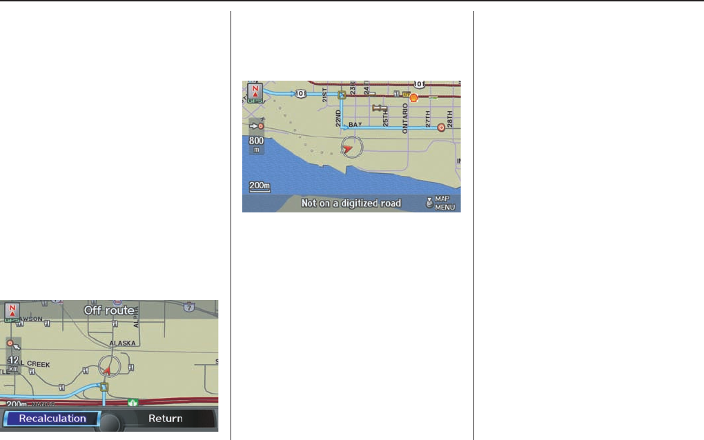
Driving to Your Destination
64 Navigation System
Going Off the Route
If you leave the calculated route,
“Recalculating...” is displayed at the
top of the screen. The system will
recalculate the route from your current
location and direction to the desired
destination then give you a new route
instruction. This is done automatically
if you have set Rerouting to
AUTOMATIC on the SET UP screen
(Other) (see page 93 ).
If the Rerouting option in SET UP is
set to MANUAL, “Off route” appears
at the top of the screen when you leave
the calculated route. Say “Recalculate,”
or select Recalculation whenever
you want the system to perform a
recalculation.
Off-road Tracking
If you drive away from a mapped road,
“Not on a digitized road” appears at the
bottom of the screen.
The map screen starts displaying a
series of dots (breadcrumbs) to show
the path you have taken if Off-road
Tracking on the SET UP screen
(Other) is set to ON (see page 102 ).
By following the dots, you can
backtrack to the mapped road you
originally left. “Breadcrumbs” may
occasionally be displayed in urban
areas, such as large parking lots in
shopping malls, or in new subdivisions
where the roads are not yet in the
database. In other cases, you may see
dots if the system temporarily goes off
route, like in a parking garage where
the GPS signal is unavailable.
These dots appear only in the 80, 200,
400, and 800 metres map scales. Rotate
the Interface Dial knob to change
scales if necessary.
Off-road tracking continues for
approximately 240 kilometres; dots
at the beginning of the trail will start
disappearing when you exceed that
distance. When you reach a mapped
road, the system stops displaying dots.
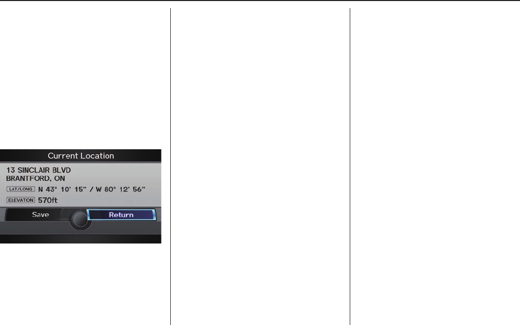
Driving to Your Destination
Navigation System 65
Viewing/Saving the Current
Location
Whenever you are on a map screen,
you can always obtain your current
location either by pushing in on the
Interface Dial, selecting Current
Location from Map Information, or
by using the voice control system and
saying “Display current location.” A
screen pops up which shows the address
of your current location, as well as the
latitude, longitude, and elevation.
NOTE:
The elevation will not appear when the
system is temporarily lacking proper
GPS information. The system elevation
may not agree with elevations shown
on roadside elevation signs, and may
fl uctuate plus or minus 30 metres or
more.
You can store the current location for
later use. It does not change or cancel
your current route.
For example, you are following
the system’s directions to get to a
destination. While sitting at a stoplight
you notice a store on the corner, but do
not have time to visit it right now.
You can save the location to select as a
destination at a later date.
To save the location, say “Save current
location” or select Save on the Current
location screen. The Edit address
book screen with the current location
data will appear. You can edit the name,
phone number, or category name to be
saved in your personal Address Book.
Select Return and you will be returned
to the Map Information screen.
You can then use Address Book from
the DEST screen (Dest. MENU 1) to
select the saved location, and return to
the same spot.
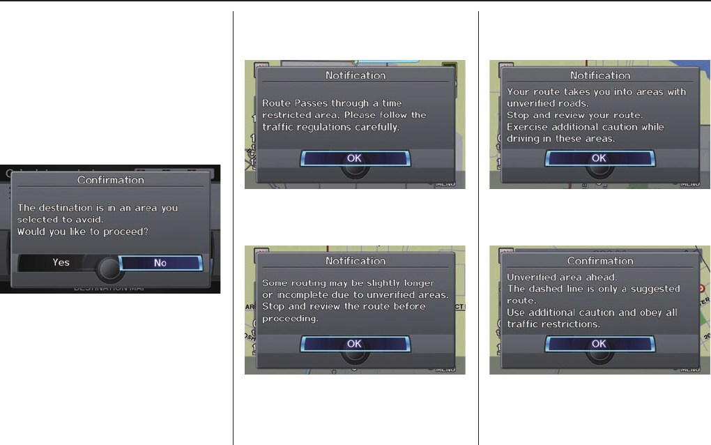
Driving to Your Destination
66 Navigation System
Pop-ups and Disclaimers
When you say “OK” in the Calculate
Route to screen, or if you change your
route, the system checks your route and
provides you with pop-up messages for
the following situations:
• Your route takes you into an area that
you previously set as an “Avoid Area”
(see Edit Avoid Area on page 98 ).
• Your route includes traffi c restrictions
in the vicinity of the departure point
or destination.
• Your route passes through unverifi ed
areas (see Unverifi ed Area Routing
on page 94 ).
• Your route includes unverifi ed areas
(see Unverifi ed Area Routing on page
94 ).
• You are about to enter an unverifi ed
area (see Unverifi ed Area Routing on
page 94 ).
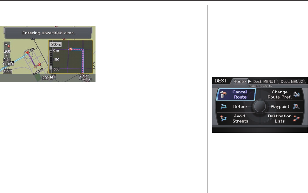
Driving to Your Destination
Navigation System 67
• You actually entered an unverifi ed
area (see Unverifi ed Area Routing on
page 94 ).
Changing the Route
While en route, you may wish to alter
your route, add an interim “Waypoint”
(pit stop), choose a different destination,
or cancel your current destination. To
change your present route, you can do
any of the following:
Say “Menu,” or press the DEST/
ROUTE button to view the DEST
screen (Route):
• Cancel Route (page 68 )
• Detour (page 68 )
• Avoid Streets (page 68 )
• Change Route Preference (page 68 )
• Waypoint (page 68 )
• Destination Lists (page 70 )
Choose a different destination (other
methods) by:
• Saying, “Find Nearest...” to fi nd a
POI (page 71 ).
• Saying, “Go Home” (page 71 ).
• Using the Interface Dial to select a
different POI or address on the map
(page 71 ).
• Pressing the DEST/ROUTE button
and selecting the “Dest. MENU 1 or
2” tab on the DEST screen (page 72 ).
DEST Screen (Route)
Pressing the DEST/ROUTE button
displays the DEST screen (Route):
NOTE:
The “Route” tab can be selected only
when you are en route.
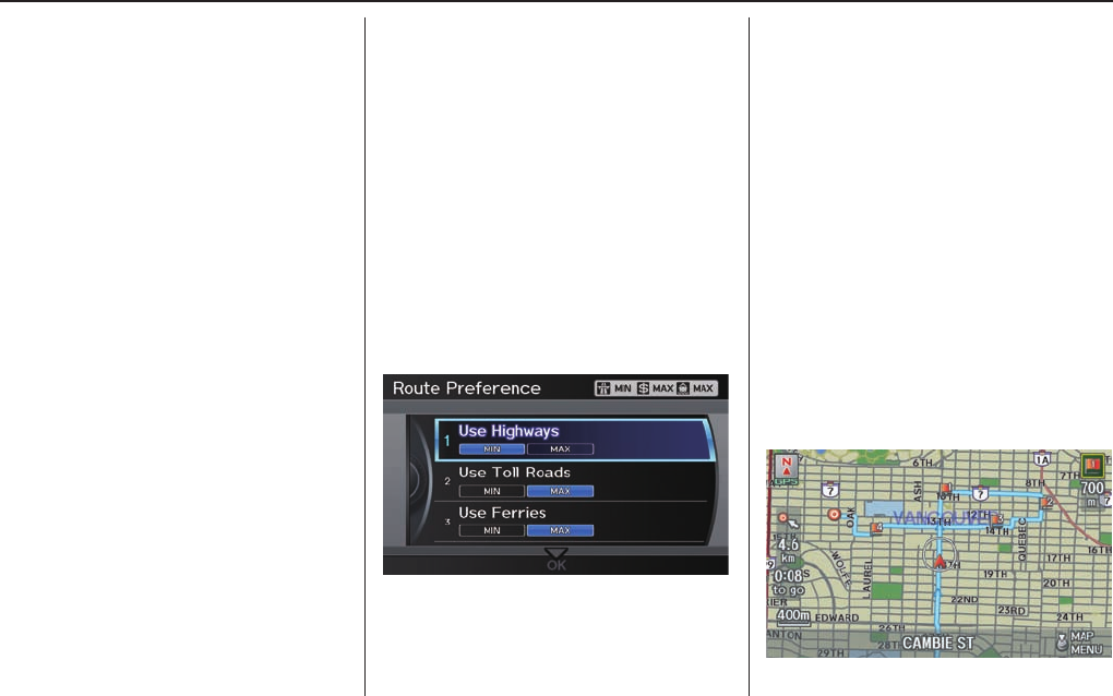
Driving to Your Destination
68 Navigation System
Cancel Route
Cancels the current route (and any
waypoints) and returns you to the map
screen.
Detour
Calculates a detour route for you if
you encounter an unexpected obstacle
such as a closed road or extremely
heavy traffi c congestion. If a detour
is selected, the system will attempt to
recalculate a new route, avoiding the
next 8 kilometres (while on a highway)
or 1,6 kilometres (while on a surface
street).
Avoid Streets
From the DEST screen (Route), if
you say or select Avoid Streets, the
system displays a list of streets that will
get you to your destination. This feature
allows you to avoid a street or streets
along your route. This is helpful if you
know of road construction, closures,
or excessive traffi c along the route.
Simply select the street or streets you
wish to avoid. You can store up to 10
streets to be avoided. You cannot avoid
your current street or the streets of
your waypoint(s) or destination (system
beeps if selected).
NOTE:
Although you can choose streets to
avoid, you cannot choose specifi c
streets you want to use.
Change Route Preference
From the DEST screen (Route), if you
say or select Change Route Pref.,
then the Route Preference screen is
displayed. See Changing the Routing
Method on page 48 for details.
Waypoint
Waypoints allow you to add an
interim “pit stop” while travelling to
a destination. For instance, you may
want to stop for gas or food, and then
continue on to your destination.
Although you can enter up to fi ve places
including the destination at a time,
typically you may never use more than
one at a time.
Waypoints are routed to in the order
they were entered (number 1 fi rst, etc.),
with your fi nal destination routed to
last.
When you enter waypoints, they appear
on the map screen as small red fl ags
numbered 1-4.
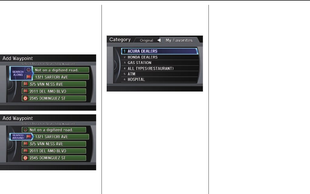
Driving to Your Destination
Navigation System 69
Next, select the categories from the
“Originals” or “My Favorites” tab on
the Category screen, then follow the
menu prompts to select a destination.
When the system performs a search
from SEARCH ALONG, it displays
matches that lie within a corridor on
either side and in front of your route.
From SEARCH AROUND, the system
displays matches that are a uniform
distance from the departure point/
waypoint/destination.
The search “corridor” distance value
can be changed in Edit Waypoint
Search Area in SET U P (se e page 10 0 ).
If you add a waypoint, the Dest List
screen will be displayed. If you move
the Interface Dial down and select
OK, the addition is completed and
rerouting begins. Press the MAP/
GUIDE button to return to the map
screen without adding the waypoint.
To add another waypoint, press the
DEST/ROUTE button and repeat the
procedure.
If Waypoint is grayed out, the
maximum of fi ve places (including the
destination) has been entered.
NOTE:
The system does not allow you to select
the roads you want to use to get to a
destination. However, after you enter a
destination, you can select intersections
or POI waypoints that the system will
use to tailor your route.
Adding Waypoint
From the DEST screen (Route),
if you say or select Waypoint, the
Add Waypoint screen is displayed.
Select either SEARCH AROUND
or SEARCH ALONG by rotating
Interface Dial knob.
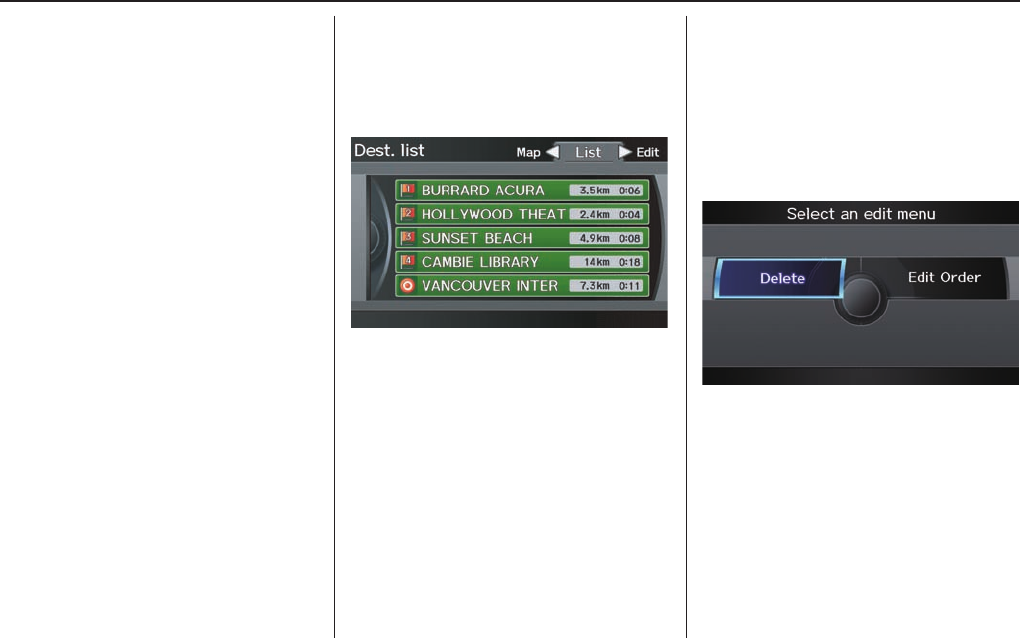
Driving to Your Destination
70 Navigation System
Destination Lists
If you select Destination Lists
from the DEST screen (ROUTE),
you can store four waypoints and one
destination simultaneously. If you
cancel the route, everything will be
deleted.
Verifying Destination Lists
If you select Destination Lists
from the DEST screen (ROUTE), the
display will change to the Dest. List
screen.
If you move the Interface Dial to the
left to select Map, you will be able to
see all the destinations on the map.
NOTE:
Prior to departure, you can set areas to
avoid. The system then includes them in
its calculations for the destination you
have entered. See Edit Avoid Area o n
page 98 .
Editing Destination Lists
If you rotate the Interface Dial
knob to the right to select Edit on the
Dest. List screen, the select an edit
menu screen will appear. If you select
Delete, you can select which items to
delete. If you select Edit Order, you
can change the order of items in the list.

Driving to Your Destination
Navigation System 71
Changing Your Destination
There are four methods by which you
can change or add a waypoint to your
route. These are:
Find Nearest (Voice command)
From the map screen, say one of the
“Find Nearest...” voice commands to
locate the nearest gas station, ATM,
restaurant or other point of interest. See
the “Find Nearest” voice commands
listing on page 145.
Go Home (Voice command)
From the map screen, say “Go Home
1” or “Go Home 2.” If an address has
been entered in both Home Address
1 and Home Address 2, say “Go
Home” and the system will give
preference to Home Address 1 and
display the confi rmation screen.
Using Interface Dial to Change
Destination
While following a calculated route, you
can select a new destination with the
map screen and the Interface Dial.
With the map screen displayed, use
the Interface Dial to move the cursor.
It will change to target mark. Use the
Interface Dial to position the target
mark on your desired new destination,
street, or icon, then push in on the
Interface Dial. The Select an item
screen or a pop-up menu may be
displayed if there are multiple POIs in
the vicinity.
NOTE:
The Select an item screen will be
displayed when the target mark are
positioned near multiple icons or
locations. A pop-up menu will be
displayed when the target mark are
positioned on a particular street.
If this is not your desired new
destination, press the CANCEL button
or the BACK button to return to the
map screen. Reposition the target mark
with the Interface Dial, then push in
on the Interface Dial again to see the
new address.
When the Select an item screen is
displayed, select an item from the list,
and the Calculate route to screen is
displayed. Then select OK and push in
on the Interface Dial.
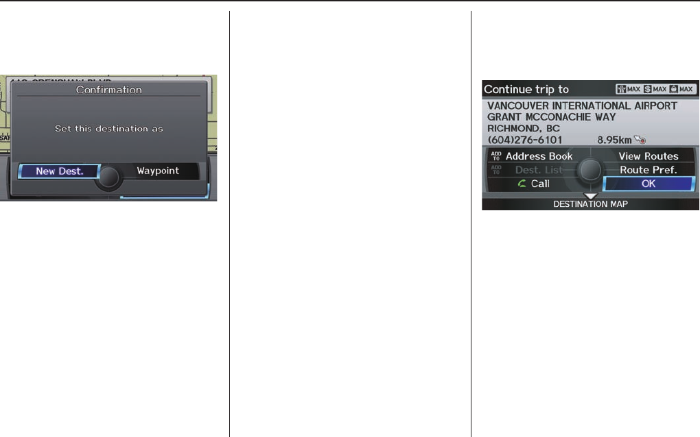
Driving to Your Destination
72 Navigation System
When the pop-up menu is displayed,
select New Dest. to set your location
as a replacement destination, or
Waypoint to set as a waypoint.
The system will return to the map
screen and recalculate the route to your
new destination or waypoint.
Entering a Destination from the
DEST Screen (while en route)
If you say “Menu”, or press the DEST/
ROUTE button and select the “Dest.
MENU 1” or “Dest. MENU 2” tab,
the system displays the DEST screen.
Follow the procedure described in
Entering a Destination, which begins
on page 23 .
When the Calculate route to screen is
displayed, select OK and push in on the
Interface Dial.
When the pop-up menu is displayed,
select New Dest. to set your location
as a replacement destination, or
Waypoint to set as a waypoint.
The system will return to the map
screen and recalculate the route to your
specifi ed new destination or waypoint.
Continue Trip to Screen
If you restart the vehicle without having
completed your prior trip, you will see
the following screen:
• To continue to your destination or
other waypoints, say or select OK.
• To cancel your destination, press
the CANCEL button or the BACK
button on the steering wheel, or
using the voice control system, say
“Cancel” or “Back.”
• If you wish to change the routing
method, select Route Pref. by using
the Interface Dial.
• For additional information on
changing the routing method, see
Changing the Routing Method on
page 48 .
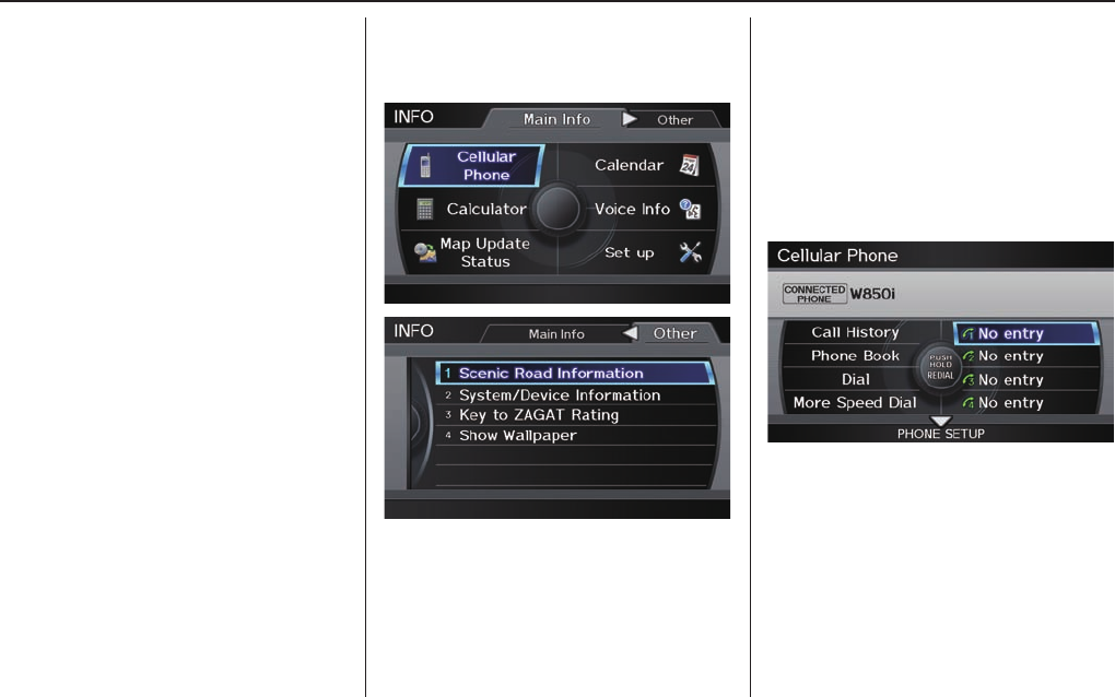
Information Features
Navigation System 73
The INFO function consists of two
main screens. To display the INFO
screen (Main Info), say “Information”
or press the INFO button. To change it
to the INFO screen (Other), select the
“Other” tab. You can switch screens by
selecting the tab.
You can use the voice control system to
select any item on the INFO screen.
NOTE:
For information on the available voice
commands, see Voice Command Index
on page 143 .
INFO Screen
When you say “Information” or press
the INFO button, the display changes to:
Move the Interface Dial to the left
and right to display Main Info or
Other.
Cellular Phone
The Cellular Phone option (available
on some phones) allows you to import
up to 1,000 entries (up to 10 phone
numbers per entry) to the phonebook of
Bluetooth® HandsFreeLink® (HFL).
Say or select Cellular Phone from
the INFO screen (Main Info), and the
display changes to:
NOTE:
• For more information on this feature,
see your owner’s manual.
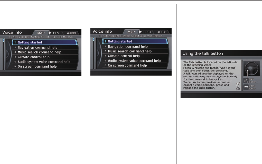
Information Features
74 Navigation System
Voice Info
When you say or select Voice Info on
the INFO screen (Main Info), you will
see the following screen:
You can select the “MAP,” “MENU,” or
“AUDIO” tab by moving the Interface
Dial to the left or right.
NOTE:
You can select an item by saying either
the line number or the item name.
There is a tutorial available for the
voice command help. Say or select
Getting started, and the display
changes to:
Select the line number of the desired
tutorial you want to view, and the
tutorial will automatically be read.
To stop the reading, push in on the
Interface Dial and select STOP. To
resume the reading, push in on the
Interface Dial again.
When you make a command help
selection under any of the help screens,
you will see the help commands that
can be used with voice control. You
can say “Read List” or push in on the
Interface Dial to select Using the
talk button, and the system will read
the list to you.
For a listing of all voice commands, see
Voice Command Index on page 143 .
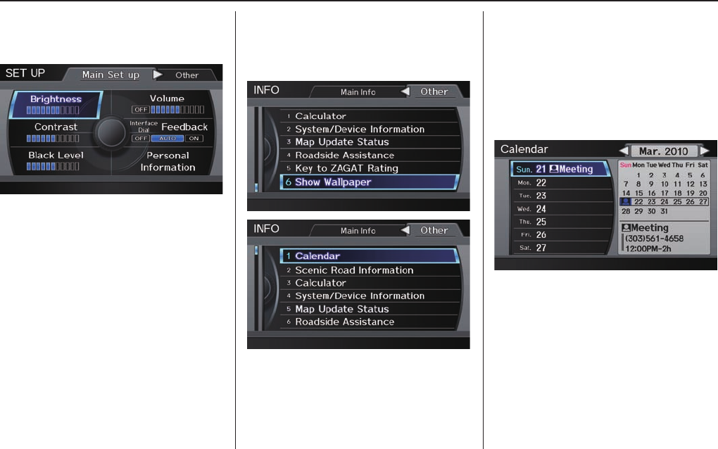
Information Features
Navigation System 75
Setup
When you select Setup, you will see
the following screen:
For detailed information on the SETUP
screen, see System Setup on page 82.
INFO Screen (Other)
Select the “Other” tab to view
additional information, and the
following screen appears:
NOTE:
Map Data Update Status can be
selected only during the update of map
data.
Calendar
The Calendar option allows you
to enter events and be reminded of
them in the future. When you say
or select Calendar from the INFO
screen (Other), the system shows the
calendar with the current calendar day
highlighted.
Dates with an icon indicate there is a
scheduled entry for that date.
NOTE:
Entries may be stored in the calendar
for 10 years.
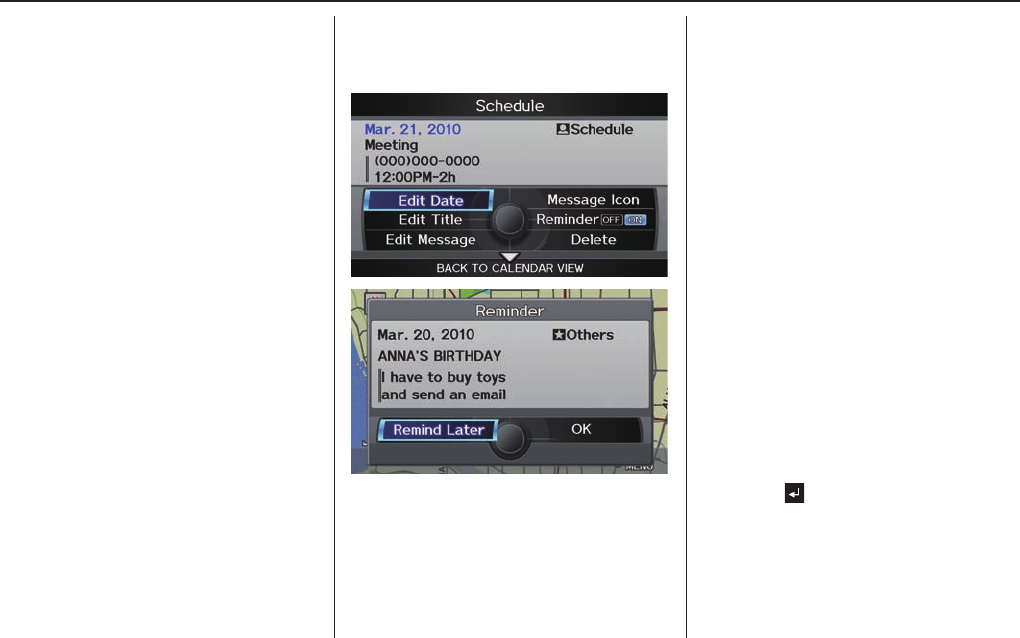
Information Features
76 Navigation System
You can scroll through the calendar day
by day by rotating the Interface Dial
knob, or select the day by voice. When
you move the Interface Dial up or
down, you can also scroll through the
calendar week by week. To change the
month, say “Next month” or “Previous
month,” or move the Interface Dial
right or left.
Entering Your Schedule
Set your schedule by selecting the day on
the calendar, and the display changes to:
Reminder
The default for Reminder is ON. This
allows the system to remind you of the
calendar item the next time you start the
vehicle. See S y s t e m S t a r t - u p on page 18 .
Edit Date
This allows you to move your calendar
entry to a different date. If you say or
select Edit Date, the Edit Date screen
is displayed with existing entries grayed
out. When you select a new date, the
display will return to the Schedule
screen.
Edit Title
Say or select Edit Title, then enter the
name of your title using the Interface
Dial. Once you have entered the title,
say or select OK. The title will be
displayed on the specifi ed date on the
Calendar screen and the display will
return to the Schedule screen.
Edit Message
Say or select Edit Message, and the
system will show the Edit Message
screen. You can enter a message on two
lines. Use to change the line.

Information Features
Navigation System 77
Once you have entered the message,
say or select OK. The message will be
displayed on the specifi ed date on the
Calendar screen and the display will
return to the Schedule screen.
Message Icon
Say or select Message Icon, and
the system displays a list of icons you
can select to help identify the type of
message you entered. The message icon
you choose will be displayed alongside
the specifi ed date on the Calendar
screen.
Delete
Say or select Delete to display the
confi rmation screen. If you select
YES, the entry that is displayed will be
deleted.
Back to Calendar View
Once you have fi nished entering the
schedule, say or select BACK TO
CALENDAR VIEW by moving the
Interface Dial down. The Calendar
screen will appear and display the
scheduled entry.
NOTE:
• Only one entry can be stored for
each calendar day.
• A maximum of 50 entries can be
stored in the calendar. After you
reach 50 entries, a warning message
will appear telling you that the limit
has been reached. You can clear any
older entries as needed.
• The system displays active calendar
entries only after you answer OK on
the Disclaimer screen.
• For more information, see System
Start-up on page 18 .
Scenic Road Information
Say or select Scenic Road
Information while on the INFO
screen (Other), and the display will
change as indicated below.
The number of scenic roads for each
province will be listed.
Select a province and a list of the
scenic roads in that province will be
displayed. After making a selection,
the scenic road will display on the Map
Click screen at a scale, where its main
portion is the focal point of the map.
You can then set this as a destination or
waypoint.
If you select a scenic road that runs
through multiple provinces, only the
portion of the road in the selected
province will be displayed.
Information Features
78 Navigation System
NOTE:
You cannot select state that exists in
Mexico on this screen.
Calculator
When you say or select Calculator on
the INFO screen (Other), the display
changes to:
Use the Interface Dial and Knob to
use the following features:
Calculator
The calculator function operates like a
standard handheld calculator.
Unit Conversion
Values entered on the calculator can be
converted from one unit to another (e.g.,
inches to millimetres).
To perform a conversion:
1. Enter a numeric value to be converted
(for example, 100).
2. Move the Interface Dial down to
select UNIT CONVERSION. The
screen changes to:
3. Rotate the Interface Dial knob to
select the type of unit you want to
convert (for example, weight) and
push in on the Interface Dial to
select. The screen for that conversion
type appears (see illustration in step
4).
4. Select the base unit (e.g., pounds)
that you wish to convert to some
other unit. All other units will change
automatically depending on the base
unit value. In the example below,
1000 mm converts to 100 cm, 1 m
(U.S.), etc.
NOTE:
• If you do not enter a value to be
converted, only “Temperature” units
are selectable.
• Conversions using negative values
may produce meaningless or
physically impossible values.
• To return the Calculator screen,
select CALC. by moving the
Interface Dial to the right.
Information Features
Navigation System 79
System/Device Information
Say or select System/Device
Information while on the INFO
screen (Other), and the display will
change as indicated below.
You will need this information when
ordering an update DVD. See page 119 for
more information.
Map Update Status
During data updates, you can check
the update status for map data for each
province.
During the update of map data, say or
select Map Update Status while on
the INFO screen (Main Info), and the
display will change as indicated below.
NOTE:
• This operation can only be carried
out during a disc update.
• You can check the data update status
with the status bar that is displayed
on the screen.
• If you say “Question” or select the ?
tab, you can refer to the Map Update
Status explanation.
Roadside Assistance
Acura Roadside Assistance is provided
as a service to Acura clients. When
paired with a Bluetooth-enabled
cell phone, the system can call for
assistance as long as the setting is
switched ON.
Say or select Roadside Assistance
while on the INFO screen (Other), and the
display will change as indicated below.
When you select the country, the phone
number for Roadside Assistance and
vehicle position information will be
displayed.
Say “Call” or select CALL with the
Interface Dial, and then select Yes
from the confi rmation screen.
Information Features
80 Navigation System
Key to Zagat Ratings
By saying or selecting Key to Zagat
Ratings on the INFO screen (Other),
you can see the explanation of the
data displayed for the Zagat-surveyed
restaurants.
NOTE:
Restaurant information on Mexico
by Key to Zagat Ratings is not be
displayed.
• “Food,” “Décor,” and “Service”
categories (red circle) are rated using
numbered values (e.g., 0-9, 10-15,
etc.)
• “Cost” (white circle) is the average
cost of a meal (including drink and
tip).
The code displayed has the following
meaning:
“VE”: Very Expensive
“E”: Expensive
“M”: Moderate
“I”: Inexpensive
• The symbols, if displayed, indicate
the following information:
open on Sunday
closed on Sunday
open on Monday
closed on Monday
open for lunch
lunch not served
serving after 11 PM
no credit card accepted
Use the Interface Dial to scroll
through the Key to Zagat Ratings
screens.
Copyright© 2012 Zagat Survey, LLC. All rights reserved.

Information Features
Navigation System 81
Show Wallpaper
If you say or select Show wallpaper
from the INFO screen (Other), the
wallpaper that is currently selected will
be displayed on the screen. If you push
in on the Interface Dial, the original
screen will return. For instructions on
changing Wallpapers Setting, see page
107 .
System Setup
82 Navigation System
SETUP Mode
The SET UP function consists of two
main screens that allow you to change
and update information in the system.
NOTE:
For information on the available voice
commands, see Voice Command Index
on page 150 .
SETUP Screen (Main Set up)
Select Set up from the INFO screen
(Main info), and the following screen
will display.
Brightness
The screen brightness has 11 settings.
To change the brightness, use the voice
control system and say “Brightness up”
or “Brightness down.” You can also
select Brightness and change the
setting by rotating the Interface Dial
knob.
Tip:
If you are having trouble viewing the
screen in bright lighting conditions, try
increasing the brightness.
Contrast
The screen contrast has 11 settings.
To adjust the contrast, use the voice
control system and say “Contrast up”
or “Contrast down.” You can also select
Contrast and change the setting by
rotating the Interface Dial knob.
Black Level
The screen black level has 11 settings.
To change the black level, use the voice
control system and say “Black level up”
or “Black level down.” You can also
select Black Level and change the
setting by rotating the Interface Dial
knob.
NOTE:
You can have separate daytime and
night time settings for Brightness,
Contrast, and Black Level. Adjust each
setting when the display is in either
daytime or night time mode. Use the
Display Mode but ton (page 10 a nd 105 ) to
select Daytime or Night time mode.
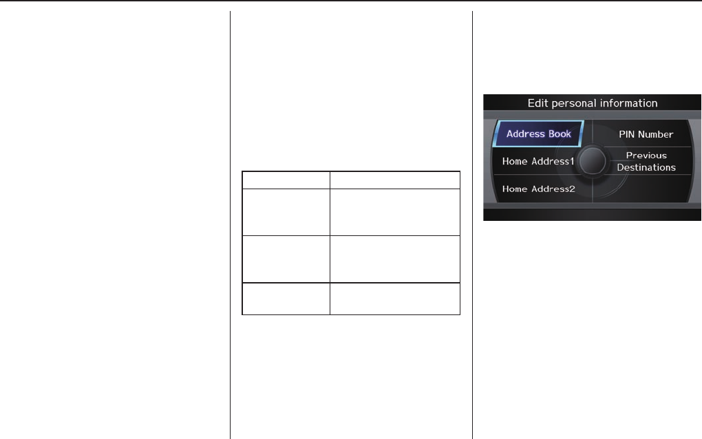
System Setup
Navigation System 83
Volume
The navigation voice volume has 11
setting and can be adjusted by:
• Using the voice control system and
saying “Volume up” or “Volume
down.”
• Selecting Volume and changing the
setting by rotating the Interface
Dial knob.
• Saying “Volume Off,” or selecting
Volume and then OFF.
NOTE:
If you turn the volume off, you will not
hear route guidance or voice command
confi rmations.
If you then select Voice in the Map
menu, you will hear route guidance at
the default volume.
Interface Dial Feedback
This setting allows you to control
when (and if) the system will read the
current selection you choose with the
Interface Dial. The purpose of this
feature is to minimise the need to look
at the screen while operating the dial.
You can set the one of the three settings
explained in the following table. The
factory default is AUTO.
Setting Degree of assistance
ON When selection is made,
the system always reads
what is selected.
AUTO
(factory default)
The system reads
selection only when
moving
OFF No voice assistance
when selecting.
Personal Information
From the SET UP screen (Main
Set up), say or select Personal
Information and the following screen
appears:
Address Book
The Address Book allows up to a
total of 200 address entries. After
200 entries, no more entries can be
added. The 200 addresses are shared
between DRIVER 1 and DRIVER 2.
For example, if DRIVER 1 has 150
addresses, DRIVER 2 can only have 50.
You can add, modify, and delete
information in the personal Address
Book list.

System Setup
84 Navigation System
You may choose to use a Personal
Identifi cation Number (PIN) to protect
your privacy. However, PINs are
optional, and if you decide to use one,
record it in case you forget the number
(see page 88 ).
NOTE:
If you forget your PIN, your dealer will
have to reset it for you, and all of your
stored information will be cleared.
You can do the following functions in
the address book:
• Enter an address (see page 84 )
• Edit an existing address (see page 85 )
• Delete an existing address (see page
87 )
Accessing the Address Book List
After selecting the Address Book,
move the Interface Dial down while
on the Select an address screen to
change to DRIVER 1 or DRIVER 2.
If an Address Book PIN has been set,
the system prompts you to enter your
PIN. Verify that the correct user is
displayed, then enter your PIN. After
entering your PIN correctly by voice
or by using the Interface Dial, the
system displays your Address Book.
If no Address Book PIN has been set,
the system displays your Address Book
after selecting DRIVER 1 or DRIVER
2.
NOTE:
Personal information cannot be backed
up or moved to another navigation
system.
Entering an Address
Select New Address by pushing in on
the Interface Dial when beginning to
build your Address Book list.
If you move the Interface Dial down,
you can change to DRIVER 1 or
DRIVER 2.
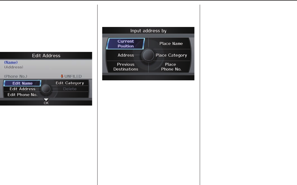
System Setup
Navigation System 85
Edit Name
You may use the “Name” fi eld to give
the entry a name or title that you will
recognize later, such as “Doctor Smith”
or “Broadway Theatre.” If you do not
give the address a name, the system will
assign one (Address 001, etc.).
Say or select Edit Name. Then use the
Interface Dial to enter the name.
Select OK when fi nished.
NOTE:
You can always re-enter, edit, or make
changes to any entry. “Address” is the
only required fi eld.
Edit Address
When you say or select Edit Address,
the display changes to:
Current Position - Allows you to use
your current position as the address.
Address - Requires you to enter the
city and address you wish to store. The
operation is the same as selecting
Address from the DEST screen
(Dest. MENU 1). See page 24 .
Previous Destinations - Allows you
to choose one of the locations in the
Previous Destinations list for your
Address Book list. This operation
is the same as selecting Previous
Destinations from the DEST screen
(Dest. MENU 1). See page 29 .
Place Name - Allows you to select one
of the Point of Interest (POI) locations
already stored in the system as one of
your personal addresses. This is the
same as selecting Place Name from
the DEST screen (Dest. MENU 1).
See page 30 .
Place Category - Allows you to select
a point of interest (POI) that has been
saved in the system as one individual
address. This is the same as selecting
Place Category from the DEST
screen (Dest. MENU 1). See page 31 .
Place Phone Number - This feature
is very convenient when you know the
phone number of place or business that
you want to save. This is the same as
selecting Place Phone No. from the
DEST screen (Dest. MENU 1). See
page 37 .

System Setup
86 Navigation System
After you have used one of these
six options to enter the address, the
initial screen for entering the personal
address is redisplayed, with the
address shown in the “Address” fi eld.
If you have entered the address using
Place Name, Place Category, or
Place Phone No., the phone number
corresponding to the address also
appears in the “Place Phone No.” fi eld.
Edit Phone Number
You can enter the phone number of
the address. If the address was chosen
with Place Name, Place Category,
or Place Phone No., and it has a
phone number, that number is entered
automatically.
Say or select Edit Phone No. to
display the Enter phone number
screen. Enter the phone number,
including the area code, by using the
voice control system (say the entire
phone number one digit at a time) or by
using the Interface Dial. Say or select
OK when fi nished.
Edit Category
If desired, you can specify the category
of the address or the icon. Say or select
Edit Category to display the Select a
category screen.
Scroll the screen and select a category by
saying the number next to your choice,
or by pushing in on the Interface Dial.
To add a new category, select New
Category from the list. To edit or
delete a category, select Edit by moving
the Interface Dial to the right. The
system will display the Select an edit
menu screen. Follow the on-screen
prompts to edit or delete a category. If
you delete a category that was used to
categorise addresses, the category for
those addresses becomes “UNFILED.”
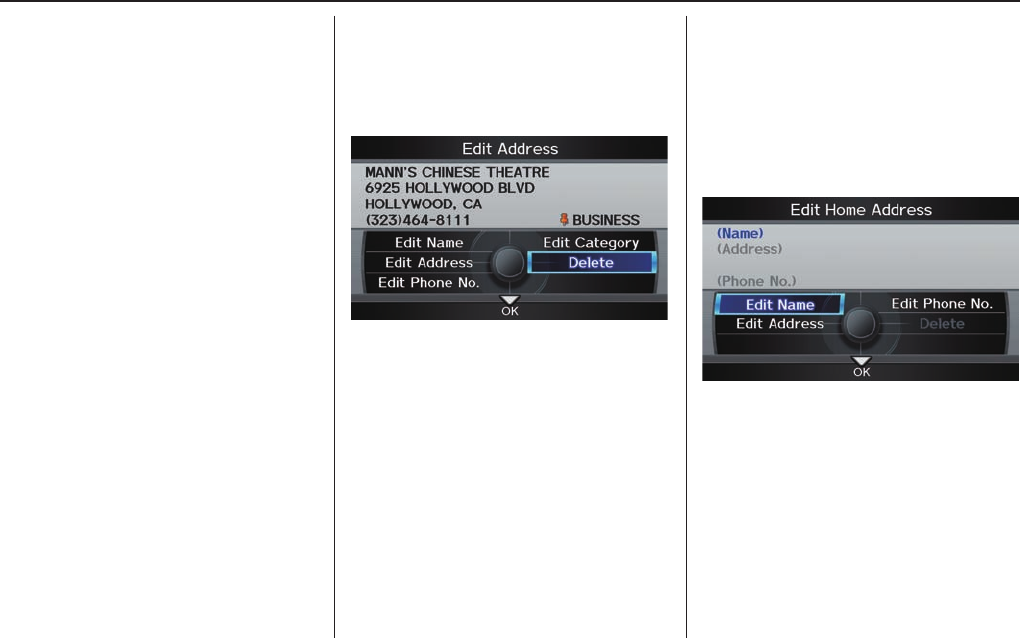
System Setup
Navigation System 87
NOTE:
You can have 100 categories (including
UNFILED). These are shared between
DRIVER 1 and DRIVER 2.
The system will then display everything
that you have entered.
If all the information is correct, say or
select OK. This will return you to the
Address Book list.
If you want to enter another address,
select New Address in the list, then
repeat the procedures above. If not,
press the CANCEL button.
Delete an Address
This feature allows you to select an
address to delete. Once an address is
selected, say “Delete” or push in on the
Interface Dial to select Delete.
Home Address
This feature lets you return “Home”
from any location simply by saying
“Go home 1 or 2” at the map screen.
Alternatively, you can select Go home
1 or 2 on the DEST screen (Dest.
MENU 1 or 2). See By Go Home 1 or
2 on page 45 .
Select Home Address 1 or Home
Address 2.
Enter the name, address, and phone
number in the same way as entering a
personal address, then say or select OK.
To leave the screen, press the CANCEL
button.
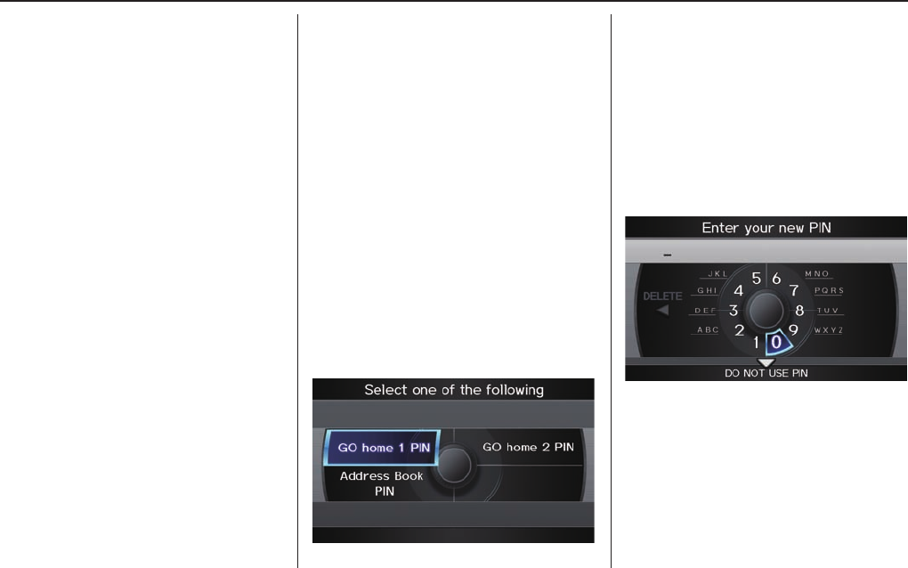
System Setup
88 Navigation System
NOTE:
If your Home Address cannot be found
in the system, then while located on
the street close to your home, select
“Current Position” when entering the
“Edit Address” fi eld.
PIN
You can set a four-digit PIN (Personal
Identifi cation Number) for accessing
and changing personal addresses and
your home address if desired. Once you
set the PIN on this screen, the system
asks you to enter the PIN when you
access a personal address or your home
address.
NOTE:
PINs are optional. If you choose to use
a PIN, make sure you remember it. If
you forget your PIN, the dealer will
have to reset it for you, and all of your
stored information will be cleared.
When you select PIN Number, the
display changes to:
Address Book PIN
If you choose to enter a PIN for the
personal Address Book, you will
have to enter it any time you edit your
Address Book (see page 84 ) or select
Address Book on the DEST screen
(Dest. MENU 1) (see page 28 ).
1. Select Address Book PIN.
2. The display changes to:
3. Enter your new four-digit PIN. If
you do not wish to use a PIN, select
DO NOT USE PIN.
NOTE:
The factory default is no PIN.

System Setup
Navigation System 89
4. When you have entered your PIN,
the display changes to the Please
reenter new PIN screen. Enter the
same number to validate the number
you have selected.
5. If you have entered the same number
both times, the display returns to the
Select one of the following screen.
If not, “INCORRECT PIN” appears.
Enter your PIN again.
NOTE:
• If you wish to remove your PIN,
return to the same screen and, after
entering your PIN correctly, select
DO NOT USE PIN.
• PINs are optional. If you choose to
use a PIN, make sure you remember
it. If you forget your PIN, your dealer
will have to reset it for you, and all
PINs will be cleared.
Go home 1 or 2 PIN
1. Select Go home 1 or 2 PIN, and
the system displays the Enter your
new PIN screen.
2. Enter your PIN in the same way as
entering the Address Book PIN.
NOTE:
• The factory default is no PIN. If you
choose to use a PIN, you will have to
enter it whenever you say “Go home
1 or 2” at the map screen or select
Go home 1 or 2 on the DEST
screen (Dest. MENU 1 or 2).
• PINs are optional. If you choose to
use a PIN, make sure you remember
it. If you forget your PIN, your dealer
will have to reset it for you, and all
stored information will be cleared.
Previous Destinations
Allows you to delete some or all of your
previous destinations.
1. Select this option, and the display
changes to:
2. Scroll through the list and fi nd the
address you want to delete.
3. Select the address to delete by
saying the line number, or by using
the Interface Dial.
NOTE:
To cancel the deletion of Previous
Destinations, select the address that was
to have been deleted and push in on the
Interface Dial before performing step 4.
4. Say or select OK to perform the
deletion, and the display returns to
the previous screen.
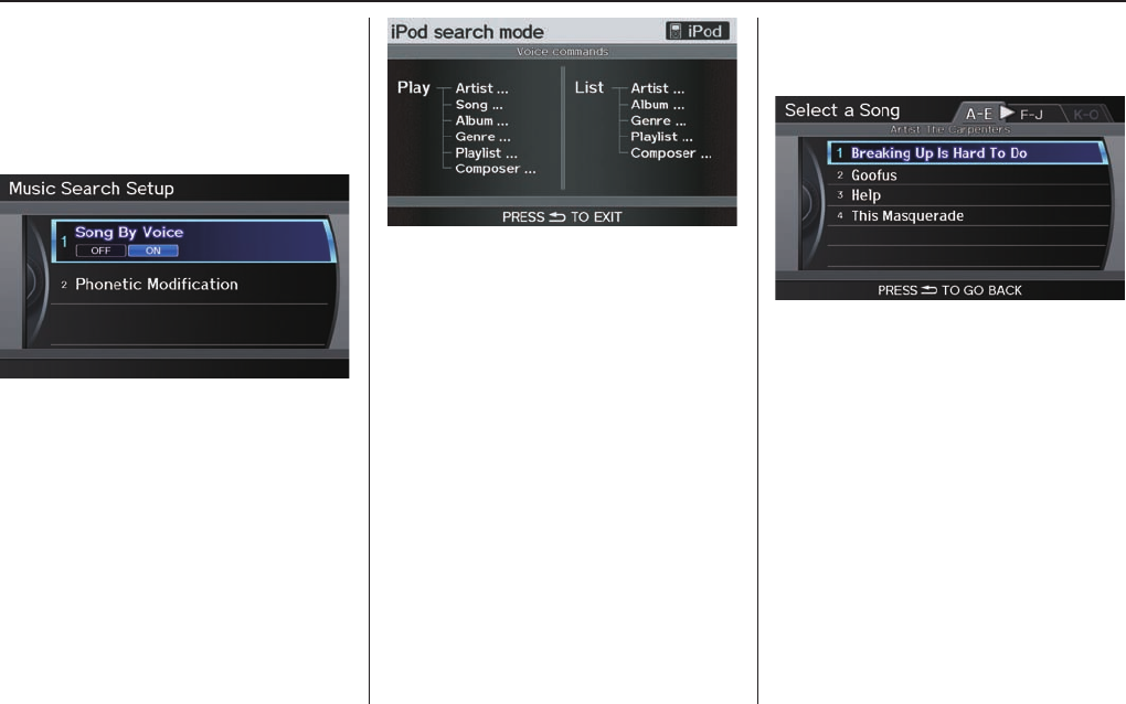
System Setup
90 Navigation System
Music Search
On the iPod playback screen, push
the interface selector down to display
AUDIO MENU. Turn the interface
knob to select Music Search Setup.
Music Search Setup screen appears.
Song By Voice™ (SBV)
Song By Voice™ allows you to search
for and play music from your HDD or
iPod using voice commands.
To activate this mode, press the TALK
button on the steering wheel and say
“Hard Disc Drive Search” or “iPod
Search” depending on the media that
you would like to access. From this
mode, you can use the following voice
commands to select songs or display a
song list.
Say the desired voice command
followed by the artist, song title, album,
genre, playlist, or composer you wish to
select. For example, when you say “Play
artist A,” the system will provide voice
feedback and start playing all songs of
that artist.
NOTE:
• For information on the available
voice commands in the Song By
Voice™ mode, see Song By Voice™
Commands on page 150.
• Languages other than English may
not be available for artist name, song
title, album title, etc.
• You can turn this feature ON or
OFF.
When you say “List artist A,” the
system will provide the following song
list for that artist.
Select the desired song. The system
will start playing the selected song
and return back to the main Song By
Voice™ screen.
To cancel the Song By Voice™
mode,press the BACK button on the
steering wheel or any navigation button.
NOTE:
Once you have canceled this mode,
you will need to say “Hard Disc Drive
Search” or “iPod Search” again to
reactivate this mode.
See your owner’s manual for more
information on how to operate HDD
and iPod audio features.
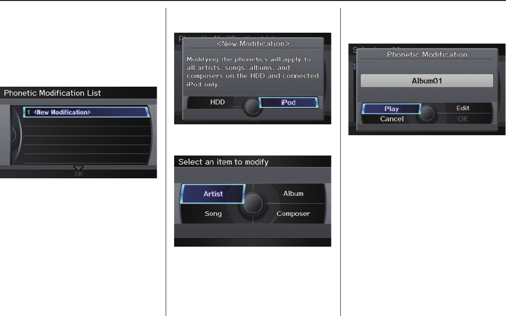
System Setup
Navigation System 91
Phonetic Modifi cation
You can modify the phonetics for all
artists, songs, albums, and composers
on the HDD and connected iPod. The
modifi ed phonetics can be used for
the voice commands in the Song By
Voice™ mode.
Select Artist, Track, Album, or
Composer and then select an item to
modify.
As in the example above, select the
artist name stored as “No Name.” To
play back the phonetic modifi cation and
check that it sounds right, select Play.
Select Edit and enter the desired
phonetic (e.g., “ABC”), and then select
OK.
When you select New Modifi cation,
the following screen appears:
Select HDD or iPod depending on the
media that you would like to access.
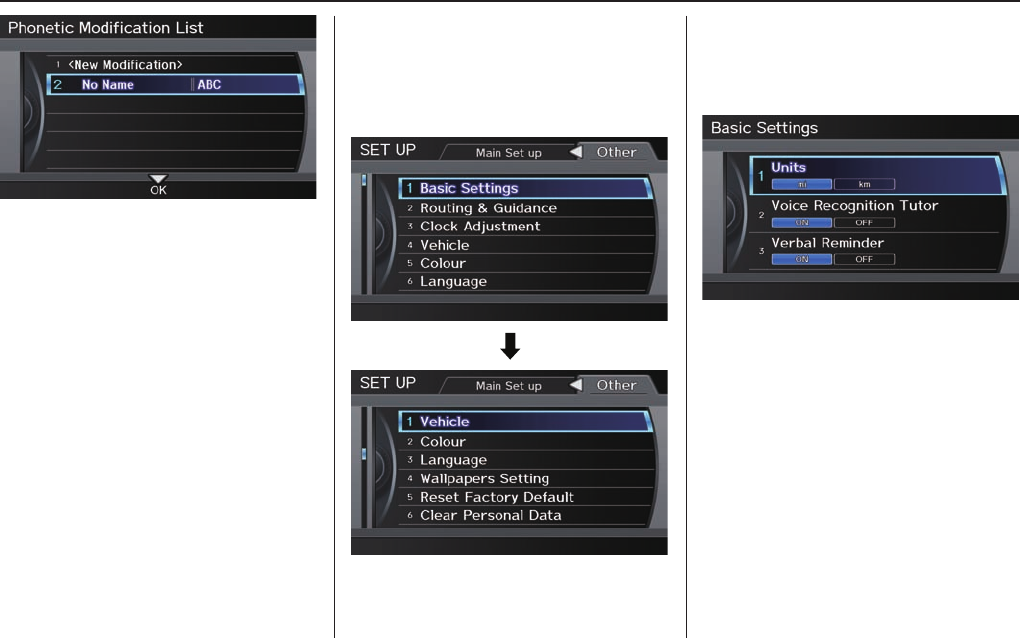
System Setup
92 Navigation System
The artist “No Name” is modifi ed
to “ABC” and you can use the voice
command “Play artist ABC” in the
Song By Voice™ mode (see page 90).
If you add some other phonetics,
repeat the procedure. When you fi nish
modifi cation, select OK.
NOTE:
• When Song By Voice is set to
OFF, Phonetic Modifi cation will
be grayed out.
• Up to 2,000 phonetic modifi cation
items can be stored.
SET UP Screen (Other)
Select the “Other” tab by moving the
Interface Dial to the right to view
additional SET UP functions and the
following screen appears:
Basic Settings
From the SET UP screen (Other),
say or select Basic Settings and the
following screen appears:
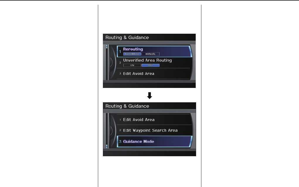
System Setup
Navigation System 93
Units (mile or km)
Allows you to select the units for the
entire system (mile or km).
Voice Recognition Tutor
Allows you to turn voice control system
prompts ON or OFF. When OFF, you
will not hear the voice control system
confi rmations or prompts.
Verbal Reminders
If the parking brake has not been
disengaged, or if either the driver or a
passenger forgets to buckle his/her seat
belt, an audio voice warning is given.
This function can be toggled between
ON and OFF at this time.
Routing & Guidance
From the SET UP screen (Other), say
or select Routing & Guidance and
the following screen appears:
Rerouting
If Rerouting is set to AUTOMATIC
and you deviate from the route, you will
see “Recalculating...” at the top of the
screen for several seconds as the system
calculates a new route. This is followed
by new routing instructions.
If Rerouting is set to MANUAL, you
will hear a tone when the “Off route”
message is displayed. Say “Recalculate”
or select Recalculation on the screen
to make the system recalculate your
new route.
NOTE:
• It is strongly recommended that you
leave the system set to the factory
default (Automatic).
• If you live in an area with poor
mapping, you may wish to set
Rerouting to MANUAL to avoid
constant recalculation. However,
you will have to manually select
Recalculation on the screen to
have the system plot a new route.

System Setup
94 Navigation System
Unverifi ed Area Routing
Allows you to receive turn-by-turn map and voice guidance in unverifi ed areas when en route to a destination (see Manual
Overview on page 6 ). The chart below illustrates the routing differences with this setting ON or OFF.
Unverifi ed Area Routing: OFF (factory default) Unverifi ed Area Routing: ON
Decision:
Why choose
ON or OFF?
The driver wishes to navigate manually by using the
navigation map and choosing the streets that lead to the
destination. The driver understands that unverifi ed roads
may not be accurate, and can contain errors in location,
naming, and address range.
The driver chooses to let the navigation system suggest
possible routing. The driver understands that in some cases
guidance may not be appropriate. Unverifi ed roads may not
be accurate, and can contain errors in location, naming, and
address range.
What you will
see...
A blue dotted vector line is displayed on the map that
continually points to your destination. The driver should
stop and then use the map to select streets that lead to the
destination.
A blue-pink dashed route line highlights suggested
unverifi ed streets on the map while travelling to your
destination. This is in sharp contrast to the normal blue
route line displayed in verifi ed areas.
Cautionary
messages
There are cautionary pop-up screens and voice
announcements, before and during the route. These serve as
reminders that you should obey all traffi c restrictions.
There are cautionary pop-up screens and voice
announcements, before and during the route. These serve as
reminders that you should exercise additional caution, and
obey all traffi c restrictions.
Guidance
(map/voice)
There is no turn-by-turn map or voice guidance. Voice guidance commands end with the words “if possible.”
This is to remind the driver to verify all traffi c restrictions
before making a manoeuvre.
Directions list
A direction list is typically not available. However,
depending on your route, directions are provided to help you
reach the fi rst available verifi ed road.
A direction list is provided showing street names and turn
symbols in pink.
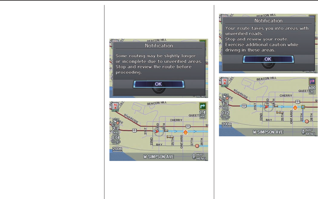
System Setup
Navigation System 95
Unverifi ed Area Routing
When driving to your destination, you
have the choice of using or not using
“unverifi ed” roads. You make this
choice in the SET UP screen. The next
few pages contain an example of a route
to a destination in an unverifi ed area
explaining the routing differences found
in unverifi ed areas.
With Unverifi ed Area Routing OFF,
the system tries to use verifi ed roads
whenever possible. In this example,
since only verifi ed streets are used, it
created a longer route than necessary.
With Unverifi ed Area Routing
ON, the route is shorter, but consists
of unverifi ed (purple) streets that may
not be accurate. Because the streets are
unverifi ed, there may be errors in street
location, name, or address range.
Additional caution is recommended in
these areas. Always obey posted traffi c
restrictions.
Because both routes bypass or use
unverifi ed streets, it is recommended
that you stop and review the map.
Unverifi ed Area Routing “OFF”
Unverifi ed Area Routing “ON”
NOTE:
Unverifi ed roads are shown only when
viewing the map in the 1/20, 1/8, 1/4
mile map scales, or the 80, 200, 400
metre map scales.
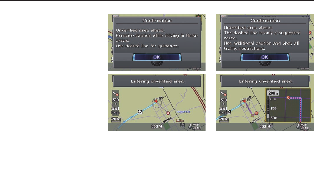
System Setup
96 Navigation System
With Unverifi ed Area Routing
OFF, before you enter an unverifi ed
street, a caution box appears on the
screen and a voice message is given.
This lets you know that you are about
to enter an unverifi ed area and that you
will be following a dotted “vector line”
that points to your destination.
With Unverifi ed Area Routing ON,
a caution box appears on the screen and
is read by the voice. In this case, you
will be presented with a dashed blue/
pink line instead of the regular blue
route line. This is your signal to pay
attention to posted traffi c restrictions.
You cannot assume that all guidance is
appropriate.
In both cases, when you actually enter
the unverifi ed street, a short caution
will remind you. You will see and hear
this short caution message whenever
you enter unverifi ed areas.
If you regularly enter and leave
unverifi ed roads for short amounts
of time, there may be cases where no
guidance is provided.
Unverifi ed Area Routing “OFF” Unverifi ed Area Routing “ON”
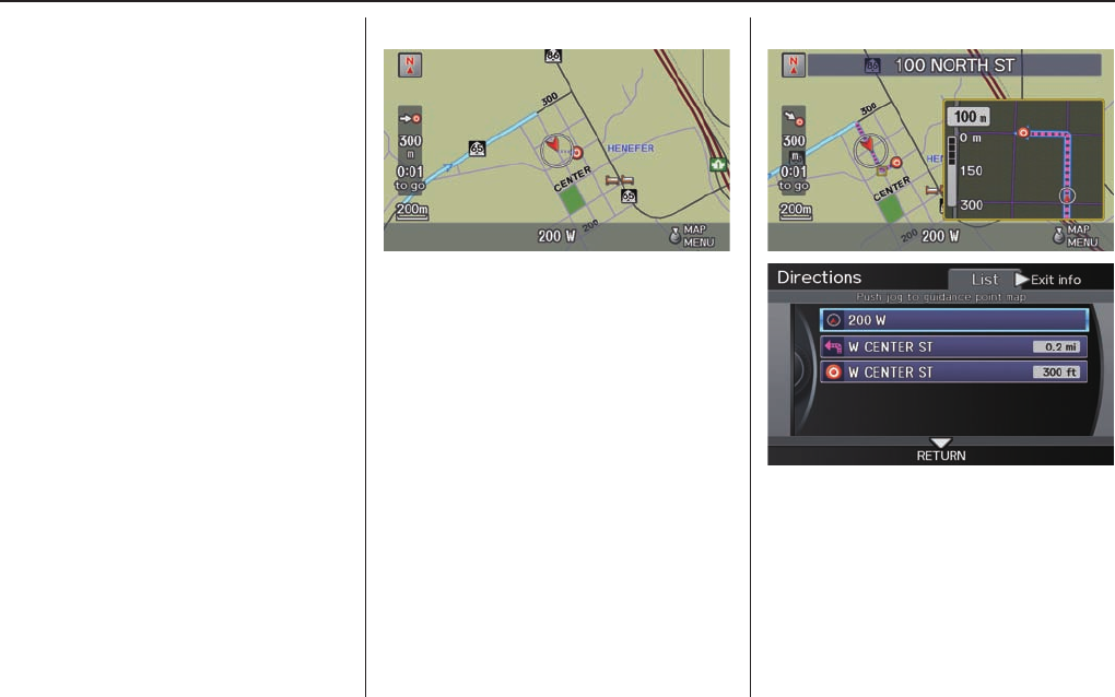
System Setup
Navigation System 97
With Unverifi ed Area Routing
OFF, you are presented with a blue
“vector line” that always points to the
destination. You must manually choose
streets from the map that will lead
to your destination. No guidance is
provided, and there are no directions to
the destination.
With Unverifi ed Area Routing ON,
a blue/pink route line is shown for
unverifi ed segments. Voice guidance
commands in unverifi ed areas always
end with “if possible.” This is your
signal that you should use additional
caution, and obey all traffi c restrictions.
The manoeuvre window “arrow” shows
any portions of unverifi ed turns in blue/
pink dashes.
These guidance manoeuvres are
only a suggestion. You should always
confi rm that the manoeuvre is possible.
A directions list is also provided that
shows any unverifi ed roads in a blue
colour, with pink arrows pointing to the
next manoeuvre.
Unverifi ed Area Routing “OFF”
NOTE:
For the pop-up menu displayed when
pushing in on the Interface Dial from
the map screen, Voice is grayed out.
With Unverifi ed Area Routing OFF, no
Direction List is provided.
If you select Directions in the
Guidance Menu on the Map Menu
screen, you will receive guidance by
Directions while you are driving.
Unverifi ed Area Routing “ON”
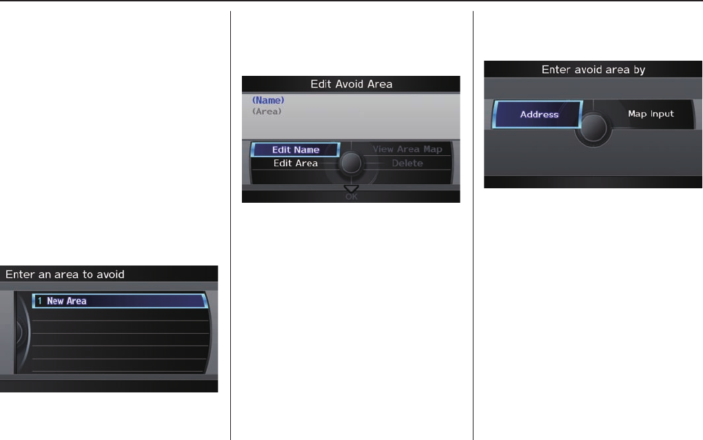
System Setup
98 Navigation System
Edit Avoid Area
This function allows you to select areas
you wish to avoid when calculating a
route to your destination. You can select
up to fi ve areas to avoid. You may wish
to set up an “avoid area” to route around
long-term road construction, closures,
or any area you wish to avoid. If you
enter a route that takes you through or
into an “avoid area,” a pop-up box will
warn you that your route takes you into
one of these areas. However, you can
still choose destinations in an avoided
area.
When you select Edit Avoid Area, the
following list screen is displayed.
You can select New Area, or select
one of your existing areas to modify. If
you choose New Area, the following
screen is displayed:
Say or select Edit Name, and use the
Interface Dial to enter the name on
the Enter avoid area name screen (25
characters max). Say or select OK to
return to the previous screen.
Say or select Edit Area to create the
area to be avoided. The following
screen appears:
Either select Address or Map Input
on the Enter avoid area by screen.
Each choice provides a slightly different
way to locate the approximate map
display for drawing the area you wish
to avoid.
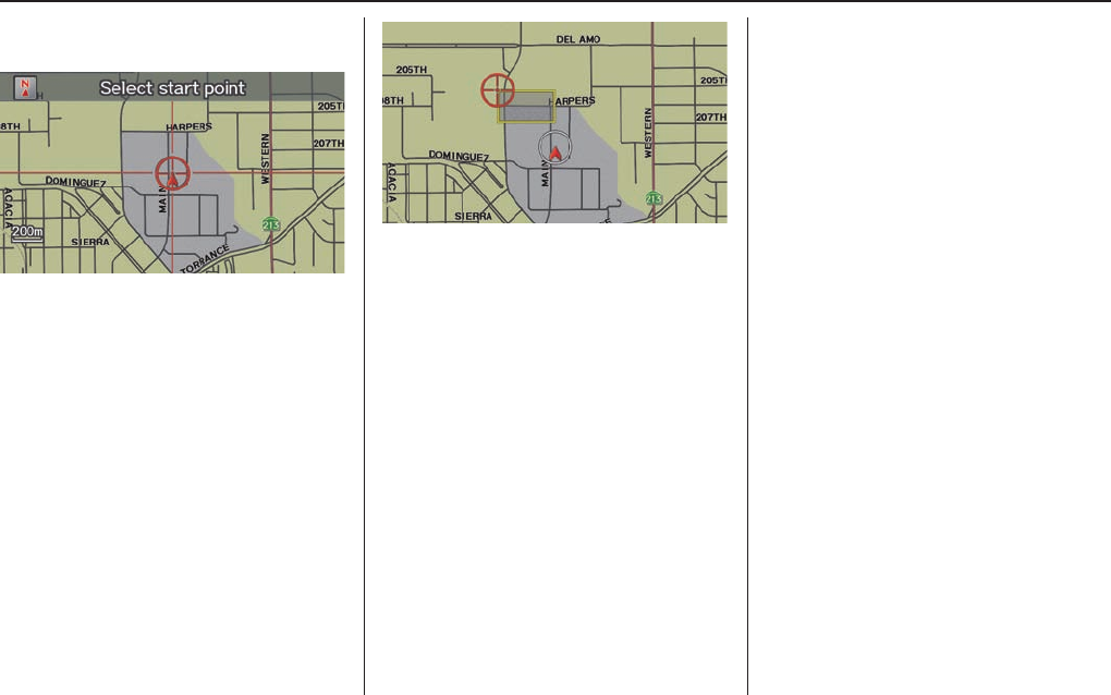
System Setup
Navigation System 99
After selecting the choice, a map
screen will be displayed.
Rotate the Interface Dial knob to
select the map scale (available scales
are 80, 200 and 400 metres scales). Use
the Interface Dial to move the target
mark (red circle) to the desired start
point and push in on the Interface
Dial to “set” the start point. Then
move the Interface Dial in a straight
or diagonal direction to encompass the
area to be avoided.
NOTE:
The maximum size of the “Avoid area”
is 800 metres in length or width.
The selected area will be displayed as a
shaded box with a yellow border. Push
in on the Interface Dial to set the end
point of the avoided area. To “redraw”
the area, select CANCEL and repeat
the area selection process.
Say or select OK to return to the Edit
avoid area screen.
If your selected area contains a
highway, the system will prompt you
with a pop-up box saying “Do you want
to avoid highways?” Answering “No”
allows you to enter a route through an
avoided area on a highway and skip the
“Avoid area caution box” (see Pop-ups
and Disclaimers on page 66 ).
When you return to the Edit avoid
area screen, the “Vicinity” fi eld is
automatically fi lled in by the system.
Re-edit the area “Name” if desired.
Select OK on the Edit avoid area screen
to fi nish editing. Your new avoided area
will now appear on the “Avoid area” list
and be viewable on the map screen.
NOTE:
You can select areas to avoid, however
you cannot select roads or areas that
you want the system to use for routing.
System Setup
100 Navigation System
Edit Waypoint Search Area
When driving en route to your
destination, you can select a temporary
destination waypoint (marked with a
small fl ag on the map) along your route
for gas, a restaurant, or other POI.
When you resume your trip from the
waypoint, the system continues the trip
to your original destination. To use this
feature, see on page 68 .
This SET UP item allows you to select
the distance from your highlighted
route line (on either side of your
route) that the system will search for a
waypoint.
From the Routing & Guidance screen,
select Edit Waypoint Search Area,
and then choose the desired search
distance for either “On Highways” or
“On Surface Street.”
The diagram below shows how
the system handles the search for
“SEARCH ALONG” or “SEARCH
AROUND the Destination” (see on
page 69 ).
1.6km
For “Places along the route,” the system
looks in front of you within a corridor
width specifi ed by your values for “On
Highways” or “On Surface Street.”
The system checks the upcoming area,
based on your input.
For “Places around the destination,”
the system searches outwards in a
spiral from the destination. In this case,
specifi c search values are not needed;
the matches are displayed in order of
distance from destination.
NOTE:
These settings do not affect the search
range used for the voice commands like
“Find nearest gas station” that are also
available when viewing the map screen.
System Setup
Navigation System 101
Guidance Mode
Allows you to select the guidance
display mode: Single Screen or Split
Screen.
To get to Guidance Mode from the
SET UP screen, select the “Other”
tab, Routing & Guidance, and
Guidance Mode.
The factory default is Single Screen.
NOTE:
The Guidance Mode on the Map
Menu screen can also be selected.
See Driving to Your Destination on
page 56 .
Clock Adjustment
From the SET UP screen (Other), say
or select Clock Adjustment and the
following screen appears:
This screen allows you to set or adjust
the following:
• Auto Daylight (Default = ON)
• Auto Time Zone (Default = ON)
• Adjust Time (adjust your clock)
• Reset (resets this screen’s settings to
factory defaults)
Auto Daylight
Sets automatic daylight saving time ON
or OFF. If set to ON, the clock will
automatically “spring ahead” or “fall
behind” by one hour when a daylight
saving time change occurs.
NOTE:
Even if you have set Auto Daylight to
ON, this function is not activated in
areas that do not adopt daylight saving
time.

System Setup
102 Navigation System
Auto Time Zone
Sets automatic time zone selection by
GPS to ON or OFF. If you are driving
across the country and passing through
time zones, then this feature will
automatically set the time to the time
zone you are travelling through.
However, if you live and work in two
different time zones, you may want to
turn this feature off.
NOTE:
When driving near a time zone
boundary, the displayed time zone may
fl uctuate between the two zone times.
Time Adjustment
Adjusts the current time in hours and
minutes. Select the current time by
moving the Interface Dial up, and
then switch HOUR and MINUTE
by moving the Interface Dial to
the left and right and changing the
value by rotating the Interface Dial
knob. Selecting OK returns you to
the previous screen. You can reset the
adjustment by selecting RESET.
NOTE:
Selecting RESET also clears any
changes you made to “Auto Daylight,”
or “Auto Time Zone” settings.
Depending on your location, you may
need to adjust these settings.
Vehicle
From the SET UP screen (Other), say
or select Vehicle and the following
screen appears:
Off-road Tracking
With this ON, the system will
provide white off-road tracking dots
(“breadcrumbs”) on the map screen
whenever you drive into an area where
the map does not show any roads. See
Map Screen Legend on page 52 .
System Setup
Navigation System 103
After you have travelled approximately
800 metres away from a mapped road,
the system will display a series of
white dots on the map screen to show
the path you have travelled. This is
provided so you can follow the dots
to backtrack to the mapped road you
originally left.
Tracking continues until you reach a
mapped road. See Off-road Tracking on
page 64 .
Tracking is shown only in the 1/20, 1/8,
1/4, and 1/2 mile scales, or the 80, 200,
400, and 800 metre scales. Rotate the
Interface Dial knob to change the
scales if necessary.
NOTE:
To clear existing dots, turn this feature
OFF and exit SET UP. To re-enable
this feature, return to SET UP and turn
it on again.
Correct Vehicle Position
The system relies on satellites for
positioning information. Buildings,
tunnels, and other objects can block
or refl ect these signals, requiring the
system to use “dead reckoning” to
determine your location and direction.
This can sometimes lead to small errors
in positioning, such as showing you on
an adjacent street.
NOTE:
Using this function to adjust vehicle
position is not recommended. When the
system acquires a GPS signal, it will
automatically place the vehicle in the
correct location.
If you choose to do this, follow these
steps:
1. Stop the vehicle.
2. Select Correct Vehicle Position,
and the system will display a
Correct vehicle position screen.
3. Use the Interface Dial to move the
vehicle position arrowhead to the
correct location, and push in on the
Interface Dial. The display will
change to:
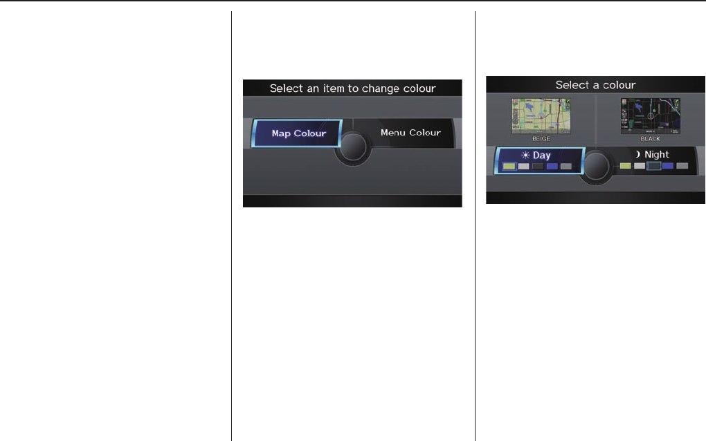
System Setup
104 Navigation System
4. Rotate the Interface Dial knob
so the vehicle position arrowhead is
pointing in the correct direction, and
push in on the Interface Dial. The
display will return to the previous
screen.
NOTE:
If you continually have to do this, there
are either problems in the database
or GPS reception problems. See
Accessories Precautions on page 5 .
5. As you drive, the current road will
be displayed at the bottom of the
screen.
Colour
From the SET UP screen (Other), say
or select Colour and the following
screen appears:
Map Colour
Allows you to choose the map colour
from one of fi ve colours for the Day and
Night mode.
Press the CANCEL button to return to
the previous screen.
NOTE:
• Choose “White” (factory default is
Beige) as the Day colour to obtain
the best daytime display contrast.
• Choose “Black” (factory default) as
the Night colour to obtain the best
night time display contrast.
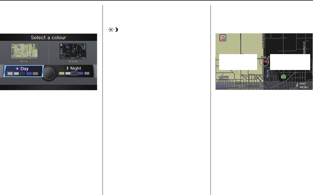
System Setup
Navigation System 105
Menu Colour
Allows you to choose the menu colour
from one of fi ve colours for the Day and
Night modes.
Press the CANCEL button to return to
the previous screen.
NOTE:
• Choose “White” (factory default)
as the Day colour to obtain the best
daytime display contrast.
• Choose “Black” (factory default) as
the Night colour to obtain the best
night time display contrast.
Switching Display Mode
Manually
Pressing the Display Mode button
allows you to toggle through the
screen display modes: Day, Night, or
Off. When selecting Day or Night, the
Brightness bar will be displayed; rotate
the Interface Dial knob and adjust
the Brightness value. This button is
the overriding control for the day/night
display mode, and is the simplest way to
control the display mode.
See the chart on page 106 for an
explanation of other day/night display
mode adjustments and how they interact
with each other.
Day Mode Night Mode
(Example of Day/Night Mode)
System Setup
106 Navigation System
Switching Display Mode Automatically
llumination control Operation But remember
Display Mode button (see page
10)
Allows selection of Day, Night or Off display
mode. This button has the highest priority and
overrides all other display control adjustments
listed below.
When the car is restarted, the display mode
previously selected by this button is canceled
and is determined by one of the controls below.
Sunlight sensor (middle of dash near
the windshield, see the vehicle Owner’s
manual for location)
If the sunlight sensor detects daylight and
the headlights are turned on, the system
automatically overrides (cancels) the Night
display and displays the Day display mode.
If desired, use the Display Mode button
to override this automatic choice.
Dash illumination adjustment knob
(see the vehicle Owner’s manual for
location)
When headlights are turned on, and you wish
to have the Day display mode, then adjust the
illumination to the full bright setting (beeps).
Remember to adjust the dash brightness back to
mid-range to allow auto switching by sensing
whether the headlights are on or off.
Headlights (Auto/On/Off) When turned on, the display changes to Night
display mode. The previous two controls listed
above can cancel this function.
Use the Display Mode button, or, with
the headlights on, adjust the dash illumination
to full bright to set the display to your desired
choice.
Map Day/Night screen colour choice
(see page 104 for the Day and Night
colour choices)
The user can select the colour of the screen that
will be displayed for the Day and Night display
modes.
For best contrast, ensure that the map colour is
white for Day and black for Night.
Recommended Display Mode Day/Night settings:
• With the headlights on, select mid-range for the dash illumination (see the vehicle Owner’s manual for location of knob).
• With the headlights off, select mid-range for the dash illumination (see the vehicle Owner’s manual for location of knob).
• On the SET UP “Colour” adjustment screen, choose white for the map Day display and black for the map Night display
(see page
104 ). Inappropriate adjustment of these colours can cause the Day/Night modes to appear inoperative.
NOTE:
See the vehicle Owner’s manual for additional information regarding the dash brightness adjustment.
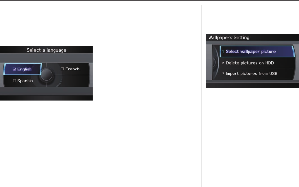
System Setup
Navigation System 107
Language
Selects the language to be used on each
screen that the system displays. From
the SET UP screen (Other), say or
select Language and the following
screen will be displayed.
You can choose from three languages:
English, French, or Spanish.
NOTE:
• If you select one language, and
then select a different language
immediately after, there are cases
where the conversion will not be
successful. In this case, conversion
of all the voice data has not been
completed (the system will display a
message).
• Voice confi rmation of cities and
streets only occurs out when English
has been selected.
• When French or Spanish is selected,
messages will continue to be
displayed in English.
Wallpapers Setting
From the SET UP screen (Other), say
or select Wallpapers Setting and the
following screen will be displayed.
With the factory default, two images
are provided for the HDD.
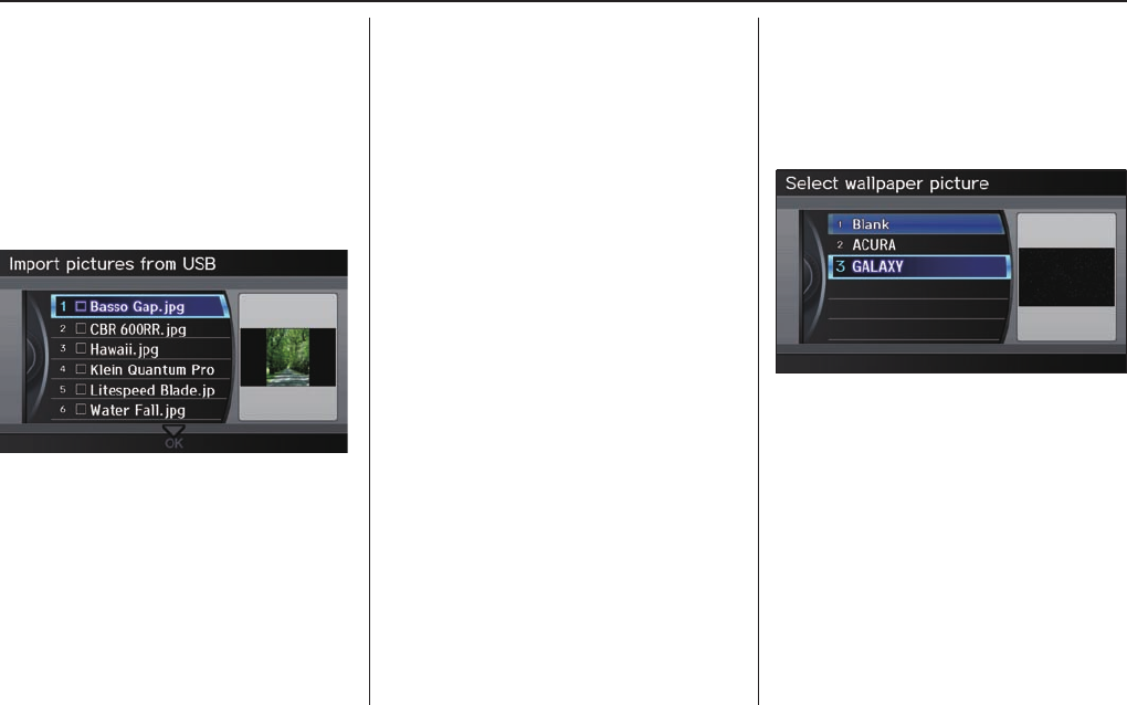
System Setup
108 Navigation System
Importing Pictures from USB
To use a wallpaper image other than
the factory defaults, you can import
pictures from a USB thumb drive or
similar device.
If you say or select Import pictures
from USB and a USB thumb drive
is properly connected, the following
screen will display.
Rotate the Interface Dial knob and
select the images to be uploaded to the
HDD. Move the Interface Dial down
and select OK.
NOTE:
• Depending on the USB thumb drive,
pictures may not be imported.
• You can import images from the root
directory. Images in folders cannot
be imported.
• The display image size is 800 x 480
pixels. Smaller images are displayed
with the extra area appearing in
black. Larger images are reduced to
a displayable size without changing
the aspect ratio.
• Ten uploaded images (in BMP or
JPEG format) can be saved to the
HDD for Driver 1 and Driver 2 each.
• Incompatible data formats or images
greater than 6 MB cannot be saved.
• When the fi le name is longer than
221 characters, the image cannot be
uploaded.
• If you attempt to uploaded an image
with the same name as an existing
image, a pop-up screen will appear,
asking if you want to overwrite the
existing image fi le.
• When music fi les that are saved
within a USB thumb drive are
being played, image fi les cannot be
uploaded.
• You cannot import images while
driving.
Selecting Wallpaper Pictures
Establish the Wallpaper setting for
those images that are within the HDD.
If you say or select Select wallpaper
picture, a list of the images in the
HDD will appear.
NOTE:
If Wallpaper has not been set up,
“Blank” will be selected.
If you select an image, the image will
appear in a pop-up screen. Select OK to
complete the setup. The selected image
will be highlighted on the list screen.
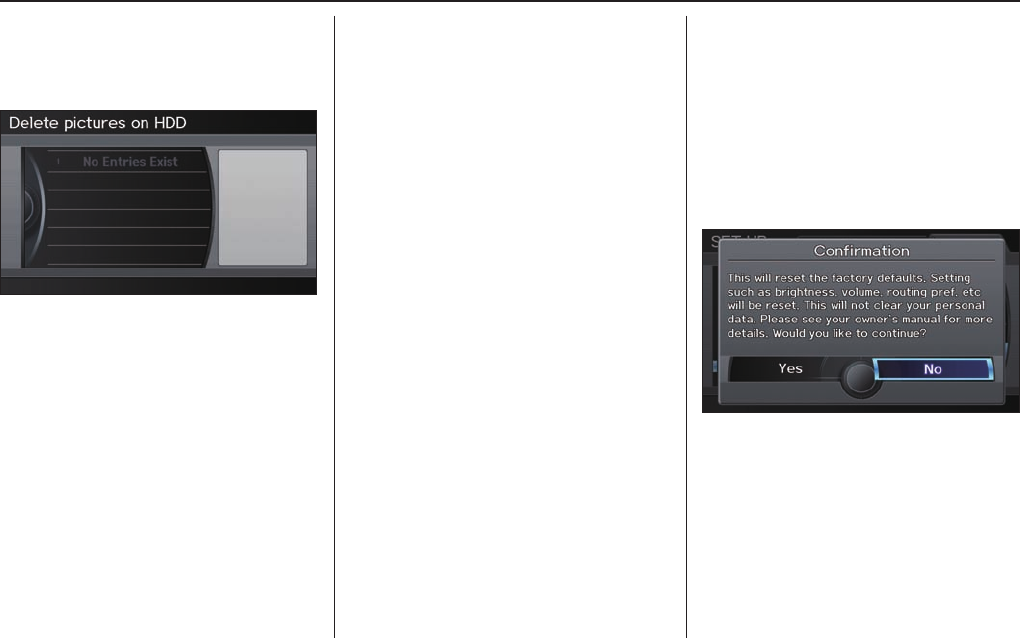
System Setup
Navigation System 109
Delete pictures on HDD
If you say or select Delete pictures
on HDD, a list of the images on the
HDD will appear.
To delete the image, use the Interface
Dial to select it, and the image will
display. Select OK if you want to
continue to delete the image, and the
list of images will be displayed, with
your selected image highlighted. Move
the Interface Dial down to select OK
to delete. A confi rmation message will
appear.
NOTE:
• If there are no images on the HDD,
“No Entries Exist” will appear.
• You cannot delete images while
driving.
Images that have not yet completed
migration from a USB thumb drive,
etc.) cannot be deleted.
Reset Factory Default
Settings
The Set up settings and rear camera
brightness value settings can be
returned to the factory default settings.
If you say or select Reset Factory
Default from the SET UP screen
(Other), the following screen will
display.
If you select Yes, the following Set up
settings return to the factory default
settings. If you select No, these settings
will remain as they are currently set.
• Brightness, Contrast, Black Level,
Volume, Interface Dial Feedback,
Brightness (Rear Camera)
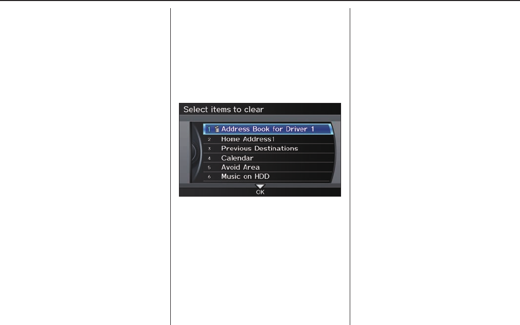
System Setup
110 Navigation System
• Basic Settings: Units, Voice
Recognition Tutor, Verbal Reminder
• Routing & Guidance: Rerouting,
Unverifi ed Area Rerouting, Traffi c
Rerouting, Edit Waypoint Search
Area, Guidance Mode
• Clock Adjustment: Auto Daylight,
Auto Time Zone, Time
• Vehicle: Off-road Tracking
• Colour: Map Colour, Menu Colour
NOTE:
Messages are not deleted.
Clear Personal Data
Any uploaded data, calendar entries,
address books, stored destinations, or
other settings can be cleared or returned
to factory defaults. If you say or select
Clear Personal Data from the SET
UP screen (Other), the Select items
to clear screen will display.
Rotate the Interface Dial knob and
select the data to be deleted.
If a PIN number is set, the screen for
entering the PIN code will be displayed.
A pop-up screen verifying whether
deletion is to be continued or not will
be displayed, and then another deletion
verifi cation message will appear. Select
Yes to commence the deletion; select
No to suspend it.
NOTE:
• When the Address Book is deleted,
all contents (except the Categories)
will be deleted.
• When Cellular Phone Information is
deleted, Voice Tag information will
also be deleted.
• If you select Music on HDD or
Music Search Phonetics, the system
will automatically be restarted after
deletion.
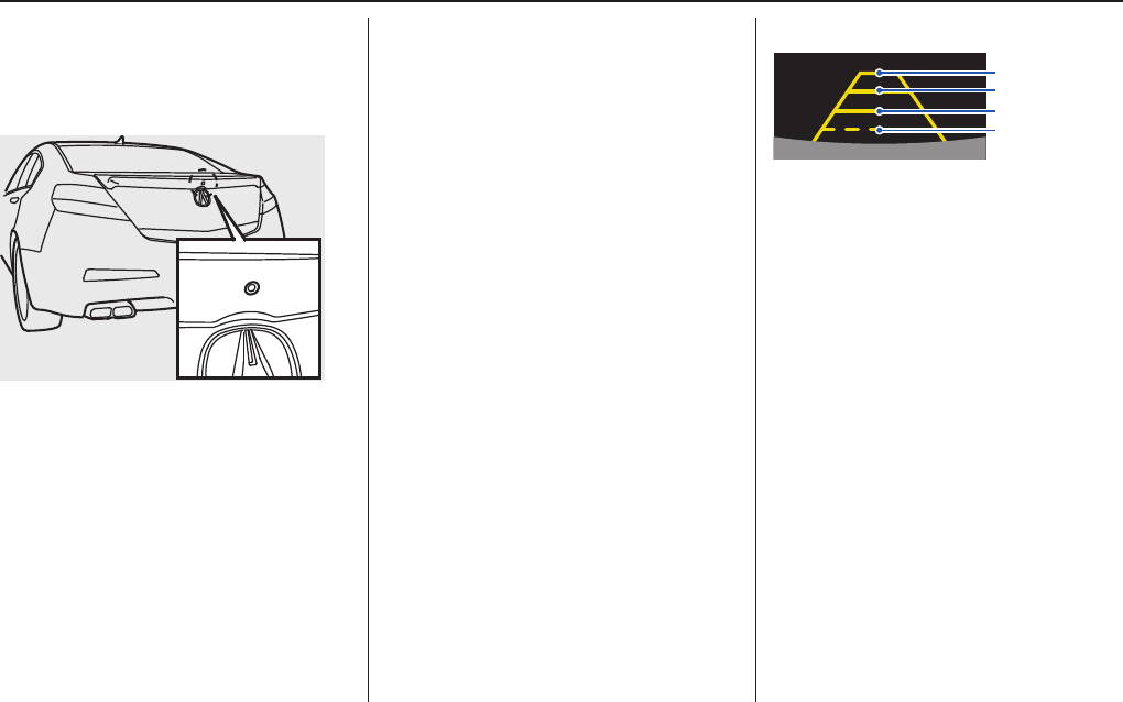
System Setup
Navigation System 111
Rearview Camera Image
4th line (9 ft, 3 m)
3rd line (6.5 ft, 2 m)
2nd line (3 ft, 1 m)
1st line (1.5 ft, 0.5 m)
The rearview camera display has
distance guidelines indicating distance
from the back of the vehicle to one of
the lines.
NOTE:
• The rearview camera has a special
lens that makes distances appear
closer than they actually are.
• The rearview camera display has
a limited range, and the size and
position of objects around the area
may appear different from reality.
Make sure to check the surrounding
area carefully.
Rearview Camera
Your vehicle is equipped with a
rearview camera as shown in the
illustration.
When you shift to R (Reverse) with the
power mode in the ON mode, the rear
view is shown on the navigation screen.
Parking guidelines appear in the rear
view. For the best image, always keep
the rearview camera lens clean, and be
sure it is not covered.
Since the rearview camera display area
is limited, you should always back up
slowly and carefully, and look behind
you for obstacles.
Rearview Camera Brightness
Adjustment
When in reverse, the navigation “hard”
buttons are locked out, except the
rotating portion of the Interface Dial
knob. Rotate the Interface Dial
knob clockwise to make the camera
image brighter, and counterclockwise to
darken the image.
This brightness adjustment is
independent of the screen brightness
adjustment in SET UP.
NOTE:
• The camera brightness cannot be
adjusted by voice control.
• Slight delays can occur when
switching to the camera image
(especially when fi rst starting your
vehicle), or switching back to the
map/menu screen. This is normal.

System Initialization
112 Navigation System
System Initialization
If for any reason you lose power
to the vehicle (e.g., the battery is
disconnected), the navigation and audio
system will require initialization. Once
completed, your system will be ready
to use.
This initialization requires the
following:
• Entry of the 5-digit anti-theft security
code to “unlock” the navigation and
audio system.
• GPS initialization (may not be
needed depending on the length of
time the system was without power).
(See GPS Initialization on page 113 .)
• Map matching to align the GPS
coordinates to a place on the map
(displays current street at the bottom
of the map). (See Map Matching on
page 113 .)
Entering the Security Code
When you purchased the vehicle,
you should have received one card
containing a 5-digit anti-theft code
used to activate both the navigation and
audio system.
Enter the 5-digit security code in
accordance with the instructions in your
owner’s manual. If you do not enter the
security code, navigation, audio, and
voice recognition will not function.
If you lose the card or do not have
access to it, you can retrieve it using
one of the following methods:
1) Call Acura Client Services at
1-888-9-ACURA-9.
2) Visit your dealer.
You will need your radio serial number
and vehicle VIN to retrieve the anti-
theft code.
To retrieve the radio serial number,
press and hold the audio preset 1 and 6
buttons. Continue to hold the buttons,
then turn on the radio. Record the serial
number shown on the radio display.
NOTE:
The anti-theft security code is
unrelated to your optional navigation
system PIN (for Address Book or Home
Address).
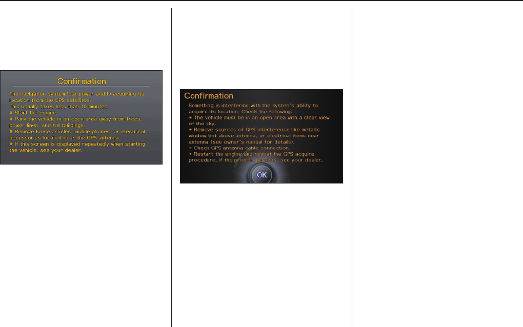
System Initialization
Navigation System 113
GPS Initialization
Depending on the length of time the
battery was disconnected, your system
may require GPS initialization. If it
does, the following screen appears:
If this procedure is not necessary,
the system proceeds directly to the
Disclaimer screen (see page 18 ).
During initialization, the system
searches for all available GPS satellites
and obtains their orbital information.
During this procedure, the vehicle
should be out in the open with a clear
view of the sky.
If the navigation system fi nds the
satellites properly, this box clears and
the Disclaimer screen is shown. If
within 10 minutes the system fails to
locate a suffi cient number of satellites
to locate your position, the following
screen appears:
If the system is still unable to acquire
a signal, follow the instructions on the
screen, or contact your local dealer for
assistance.
NOTE:
The average acquiring time is less than
10 minutes.
Map Matching
This part of the initialization matches
the GPS coordinates found above with a
road on the map screen. To perform this
part of the procedure, ensure that the
navigation system is displaying a map,
and drive the vehicle on a mapped road
(a road shown on the map screen). Do
not enter a destination at this time.
When the name of the current road you
are driving on appears at the bottom
of the screen, the entire procedure is
complete. Your system is now ready to
use.

System Initialization
114 Navigation System
Although your navigation system is one
of the most highly sophisticated pieces
of equipment you will fi nd in a modern
automobile, you may fi nd during its use
that it has certain limitations.
The system uses GPS signals to aid
in determining its current location.
The GPS is operated by the U.S.
Department of Defense. For security
reasons, there are certain inaccuracies
built into the GPS that the navigation
system must constantly compensate for.
This can cause occasional positioning
errors of up to several hundred feet.
For example, in urban areas where
streets are close together, this could
cause the system to show that you are
travelling on a street that parallels the
street you are actually on. The system
will, under most circumstances, correct
itself while you drive.

System Limitations
Navigation System 115
Also, depending on your current view
of the sky and the position of the
satellites, the elevation may be shown
incorrectly.
You may also notice some delay of the
vehicle position icon at intersections;
this is normal.
GPS Reception Issues
The signals received from the GPS
satellites are extremely weak (less
than a millionth of the strength of
a local FM station) and require an
unobstructed view of sky. The signal
can easily be interrupted or interfered
with by the following:
• Aftermarket metallic window tint
above or to the sides of the GPS
antenna (located on the back of the
navigation display)
• Cell phones, PDAs, or other
electronic devices docked in a cradle
or lying loose on the dashboard
• Remote starters or “hidden” vehicle
location systems mounted near the
navigation unit
• Other aftermarket audio electronic
devices mounted near the navigation
unit
• Trees, tall buildings, highway
overpasses, tunnels, or overhead
electrical power wires
Although the system will direct you
to your desired destination, it may not
always generate what you consider to
be the most direct route. Try changing
the method of routing. See Changing
the Routing Method on page 48 . You may
also have Unverifi ed Area Routing set
to OFF. See Unverifi ed Area Routing on
page 94.
Additionally, the mapping database
contains verifi ed and unverifi ed maps.
See Map Overview on page 6 . A
Disclaimer screen will warn you if
your route includes unverifi ed streets.
Unverifi ed streets may be missing from
the map, in the wrong location, or have
an incorrect name or address range.
Exercise additional caution when
driving in these unverifi ed areas.
The destination icon shows the
approximate location of the destination.
This occurs because a city block can
have as many as 100 possible addresses
(for example, the 1400 block is followed
by the 1500 block) Since most cities
use only a portion of the 100 possible
addresses (for example, in the 1400
block, the addresses may only go up to
1425 before the 1500 block starts), the
address 1425 will be shown a quarter of
the way down the block by the system
instead of at the end of the block where
the destination is actually located.
You may fi nd that the system
occasionally reboots. This is indicated
by the display returning to the globe
screen. A reboot can be caused by a
number of things, such as extreme
temperatures or shock from bumpy
roads. It does not necessarily indicate
a problem that requires service. If this
happens frequently, please see your
dealer.
System Limitations

Database Limitations
116 Navigation System
You will fi nd that some points of
interest (POI) may be missing when you
search the database. This can be caused
if at the time the database was gathered,
the name was misspelled, the place
was improperly categorised, or the POI
change is not yet in the database. This
means you may not fi nd places listed
that you know exist. This is also true
for police agencies and hospitals. In
outlying areas, facilities listed may not
be the closest. Always check with local
information sources if you need law
enforcement or hospital services.
Every effort has been made to verify
that the system’s database was accurate
at the time it was created. However,
businesses do close or relocate, and new
businesses start in the old locations.
For this reason, you may occasionally
fi nd inaccurate information when you
select and drive to a point of interest
(for example, a restaurant is now a
jewelry store). The number of these
inaccuracies increases the longer you go
without an update.
The digitized map database refl ects
conditions as they existed at various
points in time before production.
Accordingly, your database may contain
inaccurate or incomplete data or
information due to the passage of time,
road construction, changing conditions,
or other causes.
Due to ongoing software and database
improvements, navigation software
and mapping versions may change in
the middle of a production year. The
version shipped with your vehicle was
the most recent available at the time of
production and is considered standard
equipment for that vehicle. There is
no free programme to retrofi t early
production vehicles with the latest
software and mapping versions. For
update DVD ordering information, see
page 119 .
In addition, this database does not
include, analyze, process, consider, or
refl ect any of the following categories
of information:
• Neighborhood quality or safety
• Population density
• Availability or proximity of law
enforcement
• Emergency, rescue, medical, or other
assistance
• Construction work, zones, or hazards
• Road and lane closures
• Legal restrictions (such as vehicular
type, weight, load, height, and speed
restrictions)
• Road slope or grade
• Bridge height, width, weight, or other
limits

Database Limitations
Navigation System 117
• Traffi c facilities safety
• Special events
• Pavement characteristics or
conditions
We assume no liability for any
incident that may result from an error
in the programme, or from changed
conditions not noted above.
Copyrights
• Copyright © 2012 Zagat Survey,
LLC. All rights reserved.
• © 2012 NAVTEQ All Rights
Reserved.
• Portions of the software in this
product are copyright 2007 The
FreeType Project (www.freetype.org).
All rights reserved.
Licenced under the FreeType Project
LICENSER, 2006-Jan-27. (http://
www.freetype.org/FTL.TXT)

Client Assistance
118 Navigation System
Reporting Errors
Occasionally, you may encounter
database errors.
• If the error pertains to highways
and main “verifi ed” roads shown in
black on the map, then report it either
online at
http://update.navteq.com/, or to
Acura Client Services.
• If the error involves a purple
“unverifi ed” road, then do not report
it. These areas have not been verifi ed
and are provided for reference only
(see Map Overview on page 6 ).
• For errors in points of interest (POI),
like a business that has changed its
name, do not report them. Keep in
mind that depending on when the
data was collected, the database can
be out of date. The business may
have not reported the change(s), or
not be in the database at all. Update
Navigation DVDs are available for
purchase, usually in the fall of each
year. See Obtaining a Navigation
Update DVD on page 119 regarding
updates to the navigation system.
• If the error does not involve the
database, such as vehicle position
icon error, screen error messages,
or other GPS related errors, see
Frequently Asked Questions on page
132 , System Limitations o n p ag e 115 , o r
Troubleshooting on page 139 .
Acura Client Services
Telephone: 1-888-9-ACURA-9
Hours: 8:00 am to 7:30 pm Monday to
Friday (Eastern time)
Mail:
Acura Navi
Honda Canada Inc.
Acura Client Services
180 Honda Boulevard
Markham, ON
L6C 0H9
E-mail: acura_cr@ch.honda.com

Client Assistance
Navigation System 119
Visiting Your Dealer
We strive to make this manual as
complete as possible and to answer all
questions regarding operation of the
system. Occasionally, you may run into
a specifi c issue that you cannot fi nd
in the book. You may save yourself a
trip to the dealer by fi rst consulting the
following resources:
• The Troubleshooting section (see
page 139 )
• The Frequently Asked Questions
(FAQs) section (see page 132 )
• The FAQs found on the online update
DVD order site (see “Obtaining a
Navigation Update DVD”)
• For detailed questions regarding
HFL, audio, or other systems that
interact with the navigation system,
see your owner’s manual, or the
Advanced Technology Guide.
• Call Acura Client Services (see
Acura Client Services on page 118 ).
• For database or POI issues, follow the
guidelines in the “ Reporting Errors ”
section (see page 118 ).
If your question is still unanswered
and you wish to visit the dealer, please
be prepared to demonstrate the issue
to the service consultant. That way,
the service consultant can document
the issue for the factory to allow more
effi cient troubleshooting.
Some issues may at fi rst seem random,
but you may notice a pattern, like they
only occur when you enter a specifi c
address, when driving on a certain road,
or just when it’s cold. This information
is very useful to the service consultant.
Be patient, the service consultant may
be unfamiliar with your specifi c issue.
Obtaining a Navigation
Update DVD
Acura is continually expanding the
scope of the navigation system.
Upgraded software may be made
available to navigation system owners
periodically, usually in the fall of each
year.
To purchase an updated DVD, you will
need your vehicle’s VIN number and the
System/Device Information from the
INFO screen (Other). Order online by
going to www.acuranavi.ca.
NOTE:
• Update DVDs are not available at
your dealer. However, the dealer may
order an update DVD for you out of
courtesy. There is no programme for
free DVD updates.
• The update DVD order line staff
cannot answer technical questions
regarding navigation operation,
coverage, or POIs.

Coverage Areas
120 Navigation System
Map Coverage
The system provides map coverage for
the following U.S. states, as well as for
Canada, Puerto Rico, and Mexico. The
all map coverage consists of accurately
mapped (verifi ed) metropolitan areas
(in the following list) and a less
accurate (unverifi ed) rural database.
See Map Overview on page 6 for a
discussion of map coverage.
The cities and metropolitan areas in the
following list are fully mapped. Only
major streets, roads, and highways have
been verifi ed outside these areas. If
your route passes through these areas,
routing may be limited, depending on
your routing choices. See Unverifi ed
Area Routing on page 94 .
If you desire additional map coverage
information, contact Acura Client
Services or go to www.acura.ca. Enter
your vehicle model and model year, and
then select the province for which you
want to verify map coverage.
U.S. Detailed Coverage Areas
Alabama
Auburn-Opelika
Birmingham/Tuscaloosa
Huntsville
Mobile
Montgomery
Alaska
Anchorage
Fairbanks-Denali
Juneau
Arizona
Phoenix Metro
Prescott
Sedona
Tucson
Yuma
Arkansas
Fayetteville
Fort Smith
Hot Springs
Little Rock
Pine Bluff
California
Central Valley - including Fresno,
Merced, Modesto, and Stockton
Humboldt
Los Angeles/San Diego Metro
Mammoth Lakes
Redding
Sacramento Metro
San Francisco Bay (approximately
Monterey to Sonoma) – including
Monterey County and Hollister
Southern California Area – including
Bakersfi eld and San Luis Obispo
Yuba
Colorado
Denver/Boulder/Colorado Springs/
Ski Resorts Metro area – including
Ft. Collins
Durango
Grand Junction
Telluride
Connecticut
Bridgeport
Danbury
Hartford Metro
New Haven Metro
Norwalk
Stamford
Delaware
Entire state – including Dover,
Wilmington Metro area, New
Castle County

Coverage Areas
Navigation System 121
Florida
Cape Canaveral/Cocoa Beach/
Titusville
Dixie County
Florida Keys
Fort Myers Metro area – including
Naples
Fort Pierce
Gainesville
Jacksonville Metro – including St.
Johns County
Miami/Fort Lauderdale/West Palm
Beach Metro
Orlando/Daytona Beach/Melbourne
area – including Osceola County
Panama City
Pensacola
Tallahassee
Tampa Bay/St. Petersburg Metro
– including Pasco and Manatee
Counties
Vero Beach
Georgia
Athens
Albany
Atlanta Metro
Augusta/Aiken Metro
Columbus
Dalton
Macon
Rome
Valdosta
Warner Robbins
Hawaii (all cities for the following
islands)
Hawaii
Kauai
Lanai
Maui
Molokai
Oahu
Idaho
Boise
Idaho Falls
Pocatello
Sun Valley Ski Resorts
Illinois
Bloomington-Normal
Carbondale
Champaign
Charleston
Chicago Metro (to Wisconsin border)
– including Lake County, IN, and
Dekalb County, IL
East St. Louis Metro
Galesburg
Moline
Peoria
Quincy
Rock Island
Rockford
Springfi eld
Urbana-Danville
Indiana
Bloomington
Evansville
Fort Wayne
Gary/Hammond Metro
Indianapolis Metro
Kokomo Metro
Lafayette
Muncie
Northwest Indiana
South Bend/Elkhart/Goshen
Terre Haute
Iowa
Ames
Cedar Rapids
Davenport
Des Moines
Dubuque
Iowa City
Sioux City
Waterloo-Cedar Falls

Coverage Areas
122 Navigation System
Kansas
Kansas City/Leavenworth Metro
Topeka
Wichita
Kentucky
Bowling Green
Lexington
Louisville
Owensboro
Louisiana
Baton Rouge
Lafayette
New Orleans Metro
Shreveport
Maine
Bangor
Bar Harbor/Acadia National Park
Portland/Lewiston/Auburn
Southern Maine
Maryland
State of (partial) - Baltimore/
Washington D.C. Metro – including
Charles and Carroll Counties
Cumberland
Ocean City
Massachusetts
Boston/Cape Cod Metro
Cape Cod
Springfi eld Metro area
Complete coverage of all cities in
Barnstable, Berkshire, Bristol,
Essex, Hampshire, Hampden,
Middlesex, Norfolk, Plymouth,
Suffolk, and Worcester Counties
Michigan
Detroit Metro area – including Ann
Arbor, Pontiac, Flint, Clinton,
Eaton, and Monroe Counties
Kalamazoo
Northern Michigan Resort Area
– including Traverse City, Elk
Rapids, Petoskey, Charlevoix,
Boyne City, and Harbor Springs
Saginaw-Midland
Southeast Michigan – including
Detroit - Grand Rapids - Lansing
Southern Michigan
Minnesota
Duluth
Minneapolis/St. Paul Metro –
including cities in Anoka Scott and
Carver Counties
Mankato
Moorhead
Rochester
Mississippi
Alcorn County
Biloxi/Gulfport
Jackson
Memphis
Pascagoula
Tupelo
Missouri
Branson
Columbia
Jefferson City
Joplin
Kansas City (KS-MO) Metro
– including Platte County
Lake of the Ozarks
Springfi eld
St. Louis Metro (IL-MO) – including
additional cities in Jefferson
County
Montana
Billings
Helena
Missoula
Nebraska
Lincoln (Lancaster County)
Omaha
Nevada
Las Vegas Metro
Reno/Lake Tahoe

Coverage Areas
Navigation System 123
New Hampshire
Lebanon
Manchester
Nashua
The State of (partial) – including
Laconia , Keene, Lebanon,
Manchester, Concord, Franklin,
Portsmouth, Dover, Rochester,
Somersworth
New Jersey
Camden Metro
Newark Metro
Southern New Jersey – including
Atlantic City/Cape May/
Cumberland Metro
Trenton Metro – including Ocean
and Hunterdon Counties
New Mexico
Albuquerque
Las Cruces
Santa Fe
Taos Ski Resorts
New York
Binghamton
Buffalo – including Erie and
Niagara Counties
Eastern New York – including
the Adirondack, Oneonta -
Cooperstown, New York City
Metro, Albany, Glen Falls,
Schenectady, Troy
Elmira
Ithaca
Lake Placid
Rochester – including cities in
Monroe County
Syracuse
Utica
Watertown
North Carolina
Asheville
Charlotte Metro
Greenville/New Bern
Fayetteville
Hickory
Jacksonville
Morgantown
Outer Banks
Raleigh-Durham Metro
Wilmington
Winston-Salem/Greensboro Metro
North Dakota
Fargo Metro
Grand Forks
Ohio
Akron
Columbus/Marysville Metro
Cincinnati Metro – including Butler
County
Cleveland Metro – including Geauga
County
Dayton
Lima
Mansfi eld
Parkersburg
Portsmouth
Steubenville
Springfi eld
Toledo (Lucas County)
Youngstown
Oklahoma
Oklahoma City
Tulsa
Oregon
Bend
Corvalis
Eugene
Medford
Portland/Salem Metro
Seaside/Astoria/Cannon Beach

Coverage Areas
124 Navigation System
Pennsylvania
Allentown
Eastern Pennsylvania
Erie
Gettysburg
Harrisburg
Lancaster
Philadelphia Metro
Reading
Southeastern Pennsylvania
Southwest Pennsylvania – including
Pittsburgh and Washington County
State College/University Park
Wilkes-Barre/Scranton
Williamsport
York
Rhode Island
Newport
Providence Metro
South Carolina
Beaufort
Charleston
Columbia
Greenville/Spartanburg – including
additional cities in Greenville and
Spartanburg Counties
Myrtle Beach Metro
Rock Hill Metro
Sumter/Florence
South Dakota
Rapid City
Sioux Falls
Tennessee
Chattanooga
Chester County
Franklin County
Johnson City/Kingsport/Bristol
Knoxville/Farragut Metro
Memphis Metro – including Desoto
and Tunica Counties
Nashville
Texas
Abilene
Amarillo
Austin Metro
Beaumont
Big Bend
Brownsville
Bryan/College Station
Corpus Christi
Dallas/Fort Worth Metro – including
additional cities in Grayson
County
El Paso
Houston Metro – including
additional cities in Galveston
County
Laredo
Lawton
Longview
Lubbock
McAllen
Midland/Odessa Metro
Nacogdoches-Lufkin
San Angelo
San Antonio Metro
South Padre Island
Texarkana
Wichita Falls
Utah
Moab
Ogden
Park City
Salt Lake City Metro
St. George
Vermont
Rutland
State of (partial) – including
Burlington, Montpelier
Virginia
Washington D.C. detailed area
– including Alexandria, Arlington,
Fairfax, Falls Church, Fauquier
County, Fredericksburg City,
Manassas, and additional cities
in Loudon and Prince William
Counties

Coverage Areas
Navigation System 125
Bristol
Charlottesville
Danville
Emporia
Lynchburg
Richmond Metro
Roanoke
Shenandoah National Park
Staunton-Waynesboro-Harrisonburg
Williamsburg/Norfolk/Virginia
Beach Metro – including Charles
City, Hopewell, Kent, and Prince
George Counties
Winchester
Washington
Bellingham
Portland/Salem/Eugene
Seattle/Tacoma/Olympia Metro –
including Island County
Spokane
Tri-Cities
Whatcom
Point Roberts (community)
Yak ima
West Virginia
Charleston
Harper’s Ferry Metro
Huntington
Morgantown
Parkersburg
Wisconsin
Appleton
Beloit
Eau Claire
Green Bay
Janesville
Kenosha County
La Crosse
Madison
Manitowoc
Lake Geneva
Milwaukee Metro – including
Milwaukee, Ozaukee, Washington,
and Waukesha Counties
Neenah
Oshkosh
Racine
Sheboygan
Southeastern Wisconsin
Wausau
Wyoming
Cheyenne
Grand Teton/Jackson
Jackson Ski Resorts
PUERTO RICO
Arecibo
Bayamon
Cabo Rojo
Caguas
Canovanas
Carolina
Ceiba
Cidra
Dorado
Fajardo
Guayama
Guaynabo
Humacao
Juana Diaz
Juncas
Las Piedras
Loiza
Mayaguez
Ponce
Toa Alta
Toa Baja
Trujillo Alto
Yubacoa
Catano
Catano
Fort Buchanan

Coverage Areas
126 Navigation System
Gurabo
Celada
Gurabo
San Juan
Hato Rey
San Juan
Santurce
Canada Detailed Coverage Areas
Alberta
Airdrie
Alberta
Calgary
Edmonton
Grande Prairie
Lethbridge
Medicine Hat
Parkland County
Red Deer
Red Deer County
Rocky View No 44
St Albert
Strathcona County
Sturgeon County
Wood Buffalo
British Columbia
Abbotsford
Burnaby
Campbell River
Central Saanich
Chilliwack
Colwood
Comox
Coquitlam
Courtenay
Cranbrook
Dawson Creek
Delta
Esquimalt
Fort St John
Kamloops
Kelowna
Langford
Langley
Langley Twp
Maple Ridge
Mission
Nanaimo
New Westminster
North Cowichan
North Saanich
North Vancouver
North Vancouver District
Oak Bay
Penticton

Coverage Areas
Navigation System 127
Pitt Meadows
Port Alberni
Port Coquitlam
Port Moody
Powell River
Prince George
Richmond
Saanich
Salmon Arm
Sidney
Squamish
Summerland
Surrey
Terrace
Vancouver
Vernon
Victoria
West Vancouver
White Rock
Williams Lake
Manitoba
Brandon
Winnipeg
New Brunswick
Bathurst
Campbellton
Dieppe
Edmundston
Fredericton
Miramichi
Moncton
Moncton Parish
Oromocto
Quispamsis
Riverview
Rothesay
Saint John
Saumarez
Newfoundland & Labrador
Bay Roberts
Conception Bay South
Corner Brook
Gander
Grand Falls-Windsor
Happy Valley-Goose Bay
Labrador City
Marystown
Mt Pearl
Paradise
Portugal Cove-St Philip’s
St John’s
Stephenville
Torbay
Northwest Territories
Hay River
Yellowk nife
Nova Scotia
Cape Breton
East Hants
Halifax
Kings
Lunenburg

Coverage Areas
128 Navigation System
Ontario
Ajax
Amherstburg
Aurora
Barrie
Belleville
Bracebridge
Bradford West Gwillimbury
Brampton
Brant
Brantford
Brockville
Burlington
Caledon
Cambridge
Centre Wellington
Chatham-Kent
Clarence-Rockland
Clarington
Clearview
Cobourg
Collingwood
Cornwall
East Gwillimbury
Essa
Essex
Fort Erie
Georgina
Greater Napanee
Greater Sudbury
Grimsby
Guelph
Haldimand
Halton Hills
Hamilton
Huntsville
Innisfi l
Kawartha Lakes
Kenora
King
Kingston
Kingsville
Kitchener
Lakeshore
Lasalle
Leamington
Lincoln
London
Loyalist
Markham
Middlesex Centre
Midland
Milton
Mississauga
New Tecumseth
Newmarket
Niagara Falls
Niagara-on-the-Lake
Norfolk
North Bay
North Grenville
Oakville
Orangeville
Orillia
Oro-Medonte
Oshawa
Ottawa
Owen Sound
Pelham
Petawawa
Peterborough
Pickering
Port Colborne
Port Hope and Hope
Prince Edward
Quinte West
Richmond Hill
Sarnia
Sault Ste Marie
Scugog
Smith-Ennismore-Lakefi eld
South Frontenac
Springwater
St Catharines
St Clair
St Thomas
Stratford
Strathroy-Caradoc
Tecumseh
Thorold

Coverage Areas
Navigation System 129
Thunder Bay
Tillsonburg
Timmins
Toronto
Uxbridge
Vaughan
Waterloo
Welland
Whitby
Whitchurch-Stouffville
Wilmot
Windsor
Woodstock
Woolwich
Prince Edward Island
Charlottetown
Cornwall
Montague
Stratford
Summerside
Québec
Alma
Amos
Anjou
Aylmer
Baie-Comeau
Beaconsfi eld
Beauport
Bellefeuille
Beloeil
Blainville
Boisbriand
Boucherville
Brossard
Cap-De-La-Madelaine
Cap-Rouge
Chambly
Charlesbourg
Châteauguay
Chicoutimi
Côte-St-Luc
Deux-Montagnes
Dolbeau-Mistassini
Dollard-Des Ormeaux
Dorval
Drummondville
Fleurimont
Gaspé
Gatineau
Granby
Grand-Mère
Greenfi eld Park
Hull
Joliette
Jonquière
Kirkland
La Baie
La Plaine
La Prairie
La Salle
Lachenaie
Lachine
L’a n c ie n n e -L o r e t t e
L’a s so mp t io n
Laval
Le Gardeur
Lévis
L’î l e -B i za r d
Longueuil
Loretteville
Magog
Mascouche
Mirabel
Montréal
Montréal-Nord
Mont-Royal
Mont-St-Hilaire
Outremont
Pierrefonds
Pointe-Claire

Coverage Areas
130 Navigation System
Québec
Repentigny
Rimouski
Rivière-Du-Loup
Rock Forest
Rosemère
Rouyn-Noranda
Salaberry-De-Valleyfi eld
Sept-Îles
Shawinigan
Sherbrooke
Sorel-Tracy
St-Augustin-de-Desmaures
St-Bruno-De-Montarville
St-Constant
Ste-Anne-Des-Plaines
Ste-Catherine
Ste-Foy
Ste-Julie
Ste-Thérèse
St-Eustache
St-Georges
St-Hubert
St-Hyacinthe
St-Jean-Chrysostome
St-Jean-Sur-Richelieu
St-Jérôme
St-Lambert
St-Laurent
St-Lazare
St-Léonard
St-Luc
St-Nicolas
Terrebonne
Thetford Mines
Trois-Rivières
Trois-Rivières-Ouest
Val-Bélair
Val-D’or
Varennes
Vaudreuil-Dorion
Verdun
Victoriaville
Westmount
Saskatchewan
Corman Park No 344
Estevan
Humboldt
Lloydminster
Meadow Lake
Melfort
Moose Jaw
North Battleford
Prince Albert
Regina
Saskatoon
Swift Current
Weyburn
Yorkton

Coverage Areas
Navigation System 131
CANADA CONNECTOR ROADS
The Cross-Canada Connector Road
allows for travel between the provinces
of British Columbia and Quebec in
DCA 11. Major metropolitan city POIs
are also included.
Road Inclusion
Roads in the province of British
Columbia
Hwy-1/Trans Canada Hwy from
Alberta/BC boundary to Vancouver
detailed city
Hwy-3/Crowsnest Hwy from Hwy-1/
Trans Canada Hwy (Hope) to Hwy-
5/Coquihalla Hwy (Hope)
Hwy-5/Coquihalla Hwy (in Hope)
to Hwy-1/Trans Canada Hwy (in
Kamloops)
Hwy-99 between Vancouver and
Whistler
Roads in the province of Alberta
Hwy-1/Trans Canada Hwy across whole
province
Hwy-1A from Cochrane to Canmore
Hwy-1X from Hwy-1A to Hwy-1/Trans
Canada Hwy Morley Road from Hwy-
1/Trans
Canada Hwy
Hwy-3/Crowsnest Hwy (at Medicine
Hat) to Lethbridge
Hwy-4 (at Lethbridge) to 1-15 (U.S.
border)
Hwy-36 between Hwy-3 (in Taber) and
Hwy-4 (in Warner)
Hwy-3/Crowsnest Hwy (in Lethbridge)
to Hwy-2 (in Fort Macleod)
Hwy-2 (in Fort Macleod) to Hwy-1/
Trans Canada Hwy (in Calgary)
Roads in the province of
Saskatchewan
Hwy-1/Trans Canada Hwy across whole
province
Roads in the province of Manitoba
Hwy-1/Trans Canada Hwy across whole
province
Hwy-100/Trans Canada Hwy in
Winnipeg (partial beltway)
Hwy-75 from Hwy-100/Trans Canada
Hwy (Winnipeg) south to link with
1-29 (U.S. border)
Roads in the province of Ontario
Hwy-69/Trans Canada Hwy from
Muskoka district to Sudbury
Hwy-17/Trans Canada Hwy from
Ottawa Detailed Area Coverage to
Manitoba border
Hwy-17B at Sault Ste Marie to link
with 1-75 (U.S. border)
Hwy-61 from Hwy-17 at Thunder Bay
to link with US-61 (U.S. border)
Hwy-11 from Muskoka district to North
Bay
Hwy-60 and Hwy-127 in Nipissing
County

Frequently Asked Questions
132 Navigation System
Map and Features, Voice Operation, Entering Addresses
Problem Solution
Why does the Disclaimer screen need to be displayed
every time I start the car? I am the only driver. The Disclaimer screen reminds you and your guest drivers to always operate
the navigation system in a safe manner.
I tried entering an address, but the city or street could
not be found. Is there any other way to route to the
location?
Some cities are lumped in with a major metro area. Try entering the street
fi rst. In rural “unverifi ed” areas or new subdivisions, streets may be missing,
or only partially numbered. Try selecting the destination directly from the
map. See By Map Input on page 41 .
When I enter an address, some letters become grayed
out. Is this normal? Yes. As you enter each letter in an address or a point of interest (POI), the
system looks in the database to see what letters are possible and “grays out”
letters that do not apply.
How do I delete Personal Addresses, Previous
Destinations, or the Home Address? This is done in the SET UP screen (Main Set up), under “Personal
Information.” See page 83.
I cannot hear the navigation system voice. 1) Ensure that Volume in the SET UP screen (Main Set up) is not OFF.
See page 83 .
2) Go to “Basic Settings” in the SET UP screen (Main Set up), and set
Voice Recognition Tutor to ON. See page 93 .
The voice control system is having diffi culty recognizing
my voice commands. Ensure that the vents are not blowing on the microphone on the ceiling, the
vehicle is as quiet as possible, and you are using the correct command when
speaking (see Improving Voice Recognition on page 14). Say “Help” at any
screen to see a list of the applicable voice commands. If the system cannot
recognize your command because of background noise, speak louder.
When the system pronounces the street name in the
guidance command or reads the destination address, it
sounds strange. What causes this?
The basic guidance phrase uses a studio-recorded voice, but the street name
is pronounced by the system using a machine-generated voice. Consequently,
the name may be mispronounced or sound strange at times.
Frequently Asked Questions

Frequently Asked Questions
Navigation System 133
Problem Solution
When I drive at night, the screen is bright and will not
switch to the night display mode. Why? Verify the following: The nighttime dash brightness control is not set to
maximum, and Map Colour in SET UP is set to Black for Night. See
Switching Display Mode Manually on page 105 .
The daytime map screen is dark like the night display
mode, and it is hard to see. Why? Verify the following: The Map Colour in SET UP is set to White for Day.
See Switching Display Mode Manually on page 105 .
How do I change or remove my PIN? Go to “Personal Information” in the SETUP screen (Other), and select PIN
Number. Select GO Home 1 PIN or GO Home 2 PIN or Address Book
PIN and enter your existing PIN. You then have the choice to change or
remove the PIN. See page 88 .
I forgot the PIN for Home, or the PIN for personal
addresses (DRIVER 1 or DRIVER 2). How do I reset it? PINs are optional. See information regarding PINs on page 88 . Your dealer
can reset the PIN for you.
CALL is not available on the Calculate route to screen.
Why? Your phone is not paired to HFL, or if your phone is paired, it is in use; press
the HANG-UP button.

Frequently Asked Questions
134 Navigation System
Guidance, Routing
Problem Solution
The navigation system does not route me the same way
I would go, or the way some other mapping programme
displays. Why is this?
The navigation system attempts to generate the optimum route. See Changing
the Routing Method on page 48 .
Why is the street I’m on not shown on the map? It has
been here for more than a year. The mapping database is constantly undergoing revision. See page 120 for ways
to obtain the latest detailed coverage information.
The vehicle position icon is not following the road and
the “GPS icon” text in the upper left hand corner of the
screen is white or missing.
• The GPS antenna (located on the back of the navigation display) may
be blocked by personal items. For best reception, remove items from the
dashboard, such as radar detectors, cell phones, or loose articles.
• Metallic tinting or other aftermarket devices can interfere with the GPS
reception. Please see your dealer. Also see System Limitations on page 115 .
I entered a destination, but the blue highlighted route
and voice guidance stopped, or turned into a blue/pink
dashed line before I got to my destination. Why is this?
Your route has entered an unverifi ed area. See Unverifi ed Area Routing on
page 94 .
The map rotates while I make turns. How can I stop
this? Select the North-up map orientation by voice, or by selecting North-up from
the Map menu. See Map Orientation on page 59 .
Sometimes, I cannot select between the North-up and
Heading-up map orientations. Why is this? The Heading-up map orientation can only be shown in the lower scales (80
metres - 1,6 kilometres scales). See Map Scale on page 61 .
While driving to my destination, the “time to go” display
sometimes increases, even though I am getting closer. The “Time to go” is based on actual road speeds. However if your speed
slows down when you encounter slower traffi c, the system updates the “Time
to go” based of your actual speed to give you a better estimate of arrival time.
The vehicle position icon on the map “lags” a short
distance behind, especially when I arrive at an
intersection. Is there anything wrong?
No. When at an intersection, the system is unaware of the width of the
intersecting road. Large differences in vehicle position can indicate a
temporary loss of the GPS signal. See GPS Reception Issues on page 115 .
While I drive, my screen shows white dots
(“breadcrumbs”) on it. What do they mean? These are called “breadcrumbs.” If you drive more than 800 metres from
mapped roads, the off-road tracking feature begins to function. See Off-road
Tracking on pages 64 and 102.

Frequently Asked Questions
Navigation System 135
Problem Solution
How can I get rid of the white dots (“breadcrumbs”)
from my screen? Go to “Vehicle” in the SET UP screen (Other), and set Off-road Tracking
to OFF, then return to the map. See page 102 .
A road that I selected to avoid is being used when
routing. What is wrong? When you “draw” your area to avoid, make sure to select sections of roads
that include at least one intersection. See page 98 .
My elevation (shown when I display the current position)
seems to fl uctuate even though my elevation has not
changed.
This is normal and due to errors in satellite position. The elevation can vary
+/- 30 metres. See System Initialization on page 112 .
My elevation is missing on the “current position” screen.
Why? If the GPS antenna cannot receive signals from at least four satellites, the
elevation is not displayed. Try moving the vehicle into an open area. If the
elevation is zero, or below sea level, the elevation is also not displayed.

Frequently Asked Questions
136 Navigation System
Update DVD, Coverage, Map Errors, Limitations
Problem Solution
When is my city going to become part of a fully verifi ed
detailed coverage area? The mapping database vendor is constantly revising map coverage. See Map
Coverage page 120 for ways to obtain the latest detailed coverage information.
Will the navigation system work outside North America? The system contains maps for the 50 U.S. states, as well as for Canada, Puerto
Rico, and Mexico. See Map Coverage on page 120 .
Can I play video DVDs in my navigation system? No. The navigation system is designed only to read music discs and the update
DVD provided with your vehicle. The system cannot read other mapping
databases or video DVDs. If you experience any problems that you cannot
resolve, please contact your dealer.
I found some errors in the database. How do I report
them? Minor errors are bound to occur in a large database. If you encounter major
errors, you can report them following the instructions on page 118 .

Frequently Asked Questions
Navigation System 137
Display, Accessories
Problem Solution
The display appears dim when starting the car in really
cold weather. Is there a problem? No. This is normal, and it will become brighter after a few minutes.
Rear Camera
Problem Solution
When I shift gears, the rear camera image is delayed. When shifting into or out of reverse, you may experience delays when the
screen image switches between the navigation screen and the rear camera
image. This is normal.
The rear camera image is too dark or too bright. How do
I adjust the brightness? While the camera image is displayed, use the rotating portion of the
Interface Dial (knob) to adjust the brightness. This adjustment does not
affect the Setup screen brightness adjustments.
Miscellaneous Other Questions
Problem Solution
My clock frequently changes forward and backward by
one hour. Why is this? The clock is being automatically set based on your GPS location. If you live
and work on the boundary between two time zones, you can turn off this
feature. See page 102 .
When driving near a time zone border, the time changes
even though I am not near the time zone. Why is this? The time zone borders are only approximated in the system. Depending on
the geography of the time zone boundary, the switch to a different zone can
be erratic. See page 102 .
My province does not observe daylight saving time. How
do I turn off this feature? You can turn off this feature. See page 101 .
Daylight saving time occurred, but the navigation system
did not change time even though SETUP shows Auto
Daylight is ON.
The automatic daylight saving time feature does not work in regions where
the daylight saving time system is not adopted.

Frequently Asked Questions
138 Navigation System
Problem Solution
The navigation system automatic daylight time feature is
not switching the navigation system clock on the correct
dates. Why is this?
1) Go to the Clock adjustment screen in SETUP and ensure that Auto
Daylight is ON.
2) The automatic daylight saving time feature does not work in regions where
the daylight saving time system is not adopted.
For more information, see Clock Adjustment on page 101 .
The navigation system clock switched by one hour for no
apparent reason. What can cause this? You may be driving near a time zone boundary (see Auto Daylight on page 101 ).
See page 101 for more information.
My battery was disconnected or went dead, and the
navigation system is asking for a code. Where do I fi nd
this code?
There should be a card in the glove box with the anti-theft code for the
navigation/audio system. This card contains the 5-digit security code and
serial number. If you cannot fi nd it, your dealer can help you out.
I speak a language other than English. Are there any
other languages available for the system? Besides English, you may select French or Spanish for your language setting.
However, messages will continue to be in English.

Troubleshooting
Navigation System 139
Screen Error Message Solution
The display temperature is too high! For protection, the
display will shut down. This message will appear briefl y when the display temperature is too high,
and then the display will turn off until the temperature cools down. The
system will turn back on when the display cools down.
Cannot write to the HDD due to the low temperature.
Please wait until the system warms up. The temperature is below -30°C and the navigation system has diffi culty
reading the HDD. The system will start up when the temperature warms up.
Cannot access the HDD due to low atmospheric
pressure. Navigation and HDD audio functions are
disabled. The system will restart when atmospheric
pressure is OK.
Navigation HDD audio functions are disabled. The system will restart when
atmospheric pressure is OK.
Route has not been completed. Please try again from a
different location. This message will appear when you are routing to or from a place (new area)
that is not in the database. Try planning a different route to or from a different
location.*
No alternate route found. Original route will be
followed. No alternative route method was found. The original route method will be used.*
Ensure that a road name is displayed at the bottom of the map.
This destination cannot be found in database. The destination was not found in the database. Try another destination nearby,
or select the destination with the Interface Dial.*
* If the error persists, or is shown for a wide area, see your dealer.
Troubleshooting

Glossary
140 Navigation System
Glossary
The following is a glossary of terms
pertaining to the voice recognition
navigation system.
Avoid Area - Areas you wish to avoid
can be entered into the system, and
will be avoided while routing.
Breadcrumbs - Off-road tracking dots
that can be followed on the map to
retrace your route back to a mapped
(digitized) road. This function can be
turned on/off in the SETUP screen
(Other).
Database - This consists of the map
data, and the POI (Points of Interest)
data stored on the HDD.
DCA - Detailed Coverage Area.
U.S. states, as well as Canada, Puerto
Rico, and Mexico, are mapped. See
page 120 for a list of these areas.
Digitized Road - A road that appears
on the navigation screen. The road
name will appear at the bottom of the
navigation screen. If the user drives
“off road,” the navigation system will
display “breadcrumbs,” depending
on how far you drive from a mapped
road.
Disclaimer Screen - Screen containing
cautionary information. It is meant to
be read carefully and acknowledged
by the client when using the
navigation system.
FAQ - Frequently Asked Questions. See
page 132 for a list of the client FAQs and
troubleshooting information.
GPS - Global Positioning System.
A network of 24 satellites in orbit
around the earth. The navigation
system can simultaneously receive
signals from up to 12 satellites to
accurately position the vehicle on the
map.
GPS Antenna - Located on the back of
the navigation display, which is in the
centre of the dashboard. Electronic
items operating in this general
location can interfere with the GPS
signal.
HDD - Hard Disc Drive. The primary
data storage device containing your
vehicle’s navigation and map software
and uploaded wallpaper images. The
HDD can also store audio fi les. See
the Audio section of your owner’s
manual for more information.
HFL - Bluetooth® HandsFreeLink®.
Your vehicle is equipped with
this feature, which uses Bluetooth
technology as a wireless link between
the vehicle and your Bluetooth-
compatible cell phone.
Icon - Symbol representing Points of
Interest (POI) that can be displayed
on the map.

Glossary
Navigation System 141
Initialization - This refers to the period
needed to reacquire the GPS satellite
orbital information whenever the
navigation system power has been
disconnected. This can take 10 to 45
minutes with the vehicle out in an
open area.
LCD - Liquid Crystal Display. The
navigation screen.
Map Matching - The received GPS
information allows the navigation
system to position the vehicle on the
map. Map matching has occurred
if the map screen is displaying the
current street name in the bottom-
shaded area.
Mic -Abbreviation for the microphone
used for receiving voice commands.
It is located near the map lights in the
ceiling.
MW - Manoeuvre Window. While en
route to a destination, this window
displays information about the next
manoeuvre.
Navi - Abbreviation for the navigation
system.
North Pointer - The map symbol
showing the map orientation. See
page 59 .
Off road - This occurs when the user
leaves mapped roads. Off-road
tracking dots (“breadcrumbs”) are
displayed if the option is enabled in
the SETUP screen. The user can use
them to return to a mapped road. The
bottom of the navigation screen will
say, “Not on a digitized road.”
Outlying Areas - These are rural areas
that typically have only their main
roads mapped. All other roads are
shown in purple for reference only,
since they have not been verifi ed.
PIN - Personal Identifi cation Number.
A 4-digit number created by the
client to protect personal information.
POI - Point of Interest. These are the
businesses, schools, etc. found under
Place category or Place Name
on the DEST screen (Dest. MENU
1). See page 62 .
Polygon - Coloured areas on the map
screen denoting parks, schools, etc.
See Map Screen “features” for a list
of the assigned colours. See page 52 .
Reminder - Automatic pop-up
Calendar message. See Calendar on
page 75 .
Security Code - Code needed to
activate the navigation system or
audio system. See Entering the
Security Code on page 112 .
Unverifi ed Streets - These streets have
not been verifi ed for turn restrictions,
one-way, etc. They are shown in
purple on the map. Unverifi ed streets
may be missing from the map, shown
in the wrong location, or have an
incorrect name or address range.

Glossary
142 Navigation System
USB - Universal Serial Bus. A
computer hardware interface used to
store and play audio fi les from USB
devices, such as thumb drives or
iPods. Image fi les can also be stored
to USB devices and uploaded to the
HDD. See the Audio section in your
owner’s manual for more information.
Vehicle Speed Sensor - Provides speed
signal to the navigation system for
moving the VP icon on the map.
Verifi ed Streets - These streets consist
of the detailed metropolitan coverage
areas and all other inter-town
connection roads. These roads are
shown in black, red, or pink on the
map.
Voice Control - See VR.
VP - Vehicle Position. When in map
mode, this circular icon shows the
vehicle position on the map. Push in
on the Interface Dial, select Map
Informaton on the Map menu,
and then rotate the Interface Dial
Knob to select the CURRENT
LOCATION. It shows the latitude,
longitude, and elevation of your
current position.
VR - Voice Recognition. This allows
voice control of many of the
navigation functions. The hardware
consists of the microphone, voice
control switch (TALK/BACK
buttons), and the front speakers.
Waypoint - A temporary destination
you may enter while en route (e.g., a
gas station, ATM, etc.). See page 68 .
Yaw Rate Sensor - Senses when the
vehicle makes a turn, which makes
the VP change direction on the map
as you turn.
Zagat Ratings - Restaurant ratings
information provided by Zagat
Survey. See the INFO screen on page
80 for an explanation of the ratings.

Voice Command Index
Navigation System 143
Voice Command Index
Global Commands
The system accepts these commands on
any screen.
Help (displays the list of commands
for current displayed screen)
Display map (displays the map
screen)
Display menu (displays the DEST
screen (Dest. MENU 1 or 2))
Display information (displays the
INFO screen)
Display audio screen (displays the
Audio screen)
Display phone screen (displays the
Cellular Phone screen)
Back (to previous screen, same as
CANCEL or BACK button)
Cancel (cancels current activity)
What is today’s date? (reads the
current date)
What time is it?
Voice Command Index
The “Voice Info” option on the INFO
screen (Main Info) lists many of the
following controls. To avoid distraction
while you are driving, the system can
read the commands for you.
The commands are accessible at any
time while driving and can be read
to you so that you do not need to
memorize all of them.
Navigation General
Commands
The system accepts these commands on
a map/guidance screen.
Display menu (if en route, displays
the DEST screen (Route))
Display navigation (if en route,
displays the DEST screen (Route))
Display map
Display map guide (when en route,
shows the next manoeuvre)
Display information (or just
Information)
Display audio screen
Cancel
Backward (or just Back)
What time is it?
Help (reads list of Navigation General
and Navigation Display Commands
at any screen)
What is today’s date? (reads the
current date)

Voice Command Index
144 Navigation System
How long to the destination?
(when en route, tells the time to
destination)*
How far to the destination? (when
en route, tells the distance to
destination)*
Display destination map (when
en route, shows the map of the
destination)
Display entire route (when en route,
adjusts the map scale so that the
entire route is displayed)
Register the current location (puts
current location in the personal
Address Book)
* These commands are not available if
you scroll the map while en route to a
destination.
Voice Info
Navigation Display
Commands
The system accepts these commands on
a map/guidance screen.
Display current location (shows
current latitude, longitude, and
elevation)
Display north up
Display heading up
Display zoom in
Display zoom out
Display: (the selected scale)
80 m (1/20 mile) scale
200 m (1/8 mile) scale
400 m (1/4 mile) scale
800 m (1/2 mile) scale
1600 m (1 mile) scale
3 km (2 mile) scale
8 km (5 mile) scale
24 km (15 mile) scale
80 km (50 mile) scale
240 km (150 mile) scale
560 km (350 mile) scale
1600 km (1000 mile) scale
Display : (display the selected icon on
the screen)
ATM
gas station
restaurant
zagat restaurant
post offi ce
grocery store
lodging (hotel, motel)
parking garage
parking lot
school
hospital
highway exit information

Voice Command Index
Navigation System 145
Hide : (hide the selected icon from the
screen)
ATM
gas station
restaurant
zagat restaurant
post offi ce
grocery store
lodging (hotel, motel)
parking garage
parking lot
school
hospital
one way
highway exit information
Max zoom in
Max zoom out
Go home 1
Go home 2
Find Place Commands
The system accepts these commands on
a map/guidance screen.
F i n d n e a r e s t : ( fi nd the nearest
selection)
Auto Service centre
ACURA dealer
HONDA dealer
Gas station
Hydrogen station
Auto parts & electronics shop
Auto repair & maintenance shop
Car wash & detailing shop
Motorcycle dealer
Other car dealer
Parking garage
Parking lot
Rental car agency
Roadside assistance
Banking centre
ATM
Bank
Check cashing place
Community
Business place
City hall
Civic centre
Convention centre
Court house
University
Library
Post offi ce
School
Emergency room
Hospital
Police station
Veterinarian
Lodging
Bed & breakfast
Hotel
Leisure centre
Amusement park
Golf course
Historical monument
Marina
Movie theater
Museum
Park
Performing arts centre
Sports complex
Restaurant
Zagat restaurant
American restaurant
Chain restaurant
Café/Coffee shop

Voice Command Index
146 Navigation System
Californian restaurant
Chinese restaurant
Continental restaurant
Fast food restaurant
French restaurant
German restaurant
Greek restaurant
Indian restaurant
Italian restaurant
Japanese restaurant
Korean restaurant
Mexican restaurant
Seafood restaurant
Thai restaurant
Vegetarian restaurant
Vietnamese restaurant
Other restaurant
Pizza restaurant
Ice cream shop
Shopping Area
Accessory store
Book store
Clothing store
Shoe store
Furniture store
Grocery store
Home improvement store
Mall
Offi ce supply store
Pharmacy
Pet food store
Sewing store
Sporting goods store
Toy store
Travel Centre
Airport
Automobile club
Bus station
Camping site
Commuter rail station
Ferry terminal
Named place
Park & ride
Rest area
Ski area
Tourist attraction
Tourist information centre
Train station
Travel agency
Truck stop
Climate Control Commands
The system accepts these commands on
most screens.
Climate control automatic (controls
temperature to your selection)
Passenger climate control automatic
Climate control on
Climate control off
Climate control
Air conditioner on*
Air conditioner off*
Air conditioner
Climate control defrost on*
Climate control defrost off*
Climate control defrost
Rear defrost on*
Rear defrost off*
Rear defrost
Climate control fresh air
Climate control recirculate
Climate control vent
Climate control sync on
Climate control sync off
Climate control sync
Climate control bi-level (vent and
fl oor)
Climate control fl oor
Climate control fl oor and defrost
Passenger climate control vent

Voice Command Index
Navigation System 147
Passenger climate control bi-level
Passenger climate control fl oor
Fan speed up
Fan speed down
Fan speed # (#:1-7) (for best voice
control, lower the fan speed)
Driver temperature # degrees
(#: 14 - 30 degrees C)
Passenger temperature # degrees
(#: 14 - 30 degrees C)
Driver temperature up
Driver temperature down
Passenger temperature up
Passenger temperature down
Driver temperature max hot
Driver temperature max cold
Passenger temperature max hot
Passenger temperature max cold
Radio Voice Commands
The system accepts these commands on
most screens.
Audio on*
Audio off*
Audio
Radio on*
Radio off*
Radio
Radio select FM1
Radio select FM2
Radio select AM
Radio tune to # FM (#: frequency.
Example Radio 95.5 FM)
Radio tune to # AM (#: frequency.
Example Radio 1020 AM)
Radio seek up
Radio seek down
Radio next station
Radio preset # (#: 1-6)
Radio FM preset # (#: 1-6)
Radio FM1 preset # (#: 1-6)
Radio FM2 preset # (#: 1-6)
Radio AM preset # (#: 1-6)
Radio auto select*
Radio scan*
Radio select XM1
Radio select XM2
XM channel # (#: 1-255)
XM channel up
XM channel down
XM category up
XM category down
XM preset # (#: 1-6)
XM1 preset # (#: 1-6)
XM2 preset # (#: 1-6)
XM scan*
XM category scan*
XM channel scan*
XM category mode
XM channel mode
* Repeating these commands switches
(toggles) the function between On
and Off, so the action that occurs
may not match the command you
speak.
NOTE:
Radio volume levels cannot be
controlled using voice control. Use
the buttons on your steering wheel.
See your owner’s manual for more
information.

Voice Command Index
148 Navigation System
Disc Voice Commands
The system accepts these commands on
most screens.
DISC play
DISC play track # (#: 1-30)
DISC skip forward
DISC skip back
DISC track random*
DISC track repeat*
DISC track scan
DISC folder up
DISC folder down
DISC folder random*
DISC folder repeat*
DISC folder scan*
DISC normal play (resumes “Play”
from these commands: “DISC
track random,” “DISC track
repeat,” and “DISC track scan”)
* Repeating these commands switches
(toggles) the function between On
and Off, so the action that occurs
may not match the command you
speak.
HDD Voice Commands
The system accepts these commands on
most screens.
HDD play
HDD play track # (#:1-30)
HDD skip forward
HDD skip back
HDD album up
HDD album down
HDD genre up
HDD genre down
HDD artist up
HDD artist down
HDD track up
HDD track down
HDD playlist up
HDD playlist down
HDD track repeat*
HDD track scan*
HDD track random*
HDD normal play (resumes “Play”
from the random-, repeat-, or
scanplay)
* Repeating these commands switches
(toggles) the function between On
and Off, so the action that occurs
may not match the command you
speak.
AUX Voice Commands
The system accepts these commands on
most screens.
AUX play
* Repeating these commands switches
(toggles) the function between On
and Off, so the action that occurs
may not match the command you
speak.

Voice Command Index
Navigation System 149
USB Voice Commands
The system accepts these commands on
most screens.
USB play
USB play track # (#:1-30)
USB skip forward
USB skip back
USB track random*
USB track repeat*
USB track scan*
USB folder up
USB folder down
USB folder random*
USB folder repeat*
USB folder scan*
USB normal play
* Repeating these commands switches
(toggles) the function between On
and Off, so the action that occurs
may not match the command you
speak.
iPod Voice Commands
The system accepts these commands on
most screens.
iPod play
iPod play track # (#:1-30)
iPod skip forward
iPod skip back
iPod track shuffl e*
iPod album shuffl e*
iPod track repeat*
iPod normal play (resumes “Play”
from the shuffl e- or repeat-play)
* Repeating these commands switches
(toggles) the function between On
and Off, so the action that occurs
may not match the command you
speak.
Bluetooth® Audio Commands
The system accepts these commands on
most screens.
Bluetooth AUDIO play
Bluetooth AUDIO skip forward
Bluetooth AUDIO skip back
Bluetooth AUDIO pause
Bluetooth AUDIO resume
Bluetooth AUDIO group up
Bluetooth AUDIO group down
* Repeating these commands switches
(toggles) the function between On
and Off, so the action that occurs
may not match the command you
speak.

Voice Command Index
150 Navigation System
Song By Voice™ Commands
The system accepts these commands on
most screens.
iPod Search (activates Song By
Voice™)
HDD Search (activates Song By
Voice™)
What/Who am I listening to?
Who is this?
What’s playing?
Who’s playing?
What album is this?
List album (specify album)
List artist (specify artist)
List composer (specify composer)
List genre (specify genre)
List playlist (specify playlist)
Play album (specify album)
Play artist (specify artist)
Play composer (specify composer)
Play genre (specify genre)
Play playlist (specify playlist)
Play song (specify song)
NOTE:
Song By Voice™ commands are
available for tracks stored in the HDD
or iPod.
Cellular Phone Commands
The system accepts these commands on
any screen.
Dial/Call by number
Dial/Call by voice tag
NOTE:
Voice tags can be recorded for each of
your speed dial entries. Please see your
owner’s manual for storing speed dial
and voice tags.
Voice Command Index
SET UP Screen (Main Set up)
Commands
The system accepts these commands
on SET UP screen (Main Set up).
(For SET UP screen (Other), simply
say what is written on the screen, and
follow the voice prompts)
Brightness up
Brightness down
Brightness minimum/min.
Brightness maximum/max.
Contrast up
Contrast down
Contrast minimum/min.
Contrast maximum/max.
Black level up
Black level down
Black level minimum/min.
Black level maximum/max.
Volume up
Volume down
Volume minimum/min.
Volume maximum/max.
Volume off
Interface dial feedback off
Interface dial feedback auto
Interface dial feedback on

Voice Command Index
Navigation System 151
On-Screen Commands
The system accepts these commands
on any screen. There are over 100
on-screen commands. Just say what
is written on the screen (this excludes
listed items).
Next (or “Down”)
Previous (or “Up”)
Return
OK (except at Disclaimer screen)
Delete
On-Screen Spelling Assist
When speaking the letters or using
“spell mode,” you can substitute the
name that represents each letter or
symbol. This improves recognition. For
example:
• To select the letter “A”:
Say “A,” “Alpha,” or “Apple.”
• To select the letter “M”:
Say “M,” “Mary,” or “Mike.”
The system will respond to the names
shown in the following tables.
NOTE:
• The system will only respond to the
names shown in the following tables.
• To select the letter “A,” you can also;
select the “A” by using the Interface
Dial.
• To select the number “1,” say “One”
or “Number One,” or select the “1”
by using the Interface Dial.
• To select the symbol “- (hyphen),”
say “Hyphen” or “Symbol Hyphen,”
or select the “-” by using the
Interface Dial.
• When selecting letters using the voice
control system, a confi rmation box
may pop up to confi rm the letter.
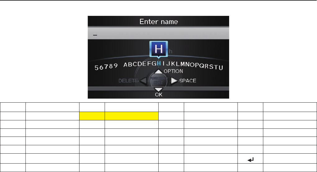
Voice Command Index
152 Navigation System
Letters Assist Defi nitions:
Say Or say “...” Say Or say “...” Say Or say “...” Say Or say “...”
AApple/Alpha HHenry/Hotel OOscar VVictor
BBoy/Bravo IIgloo/India PPaul/Papa W William/Whiskey
CCharlie J John/Juliet QQueen/Québec X X-Ray
DDog/Delta KKing/Kilo RRobert/Romeo Y Yellow/Yan kee
EEdward/Echo LLarry/Lima SSam/Sierra Z Zebra/Zulu
FFrank/Foxtrot MMary/Mike TTom /Tango Enter
GGeorge/Golf NNancy/November UUncle/Uniform
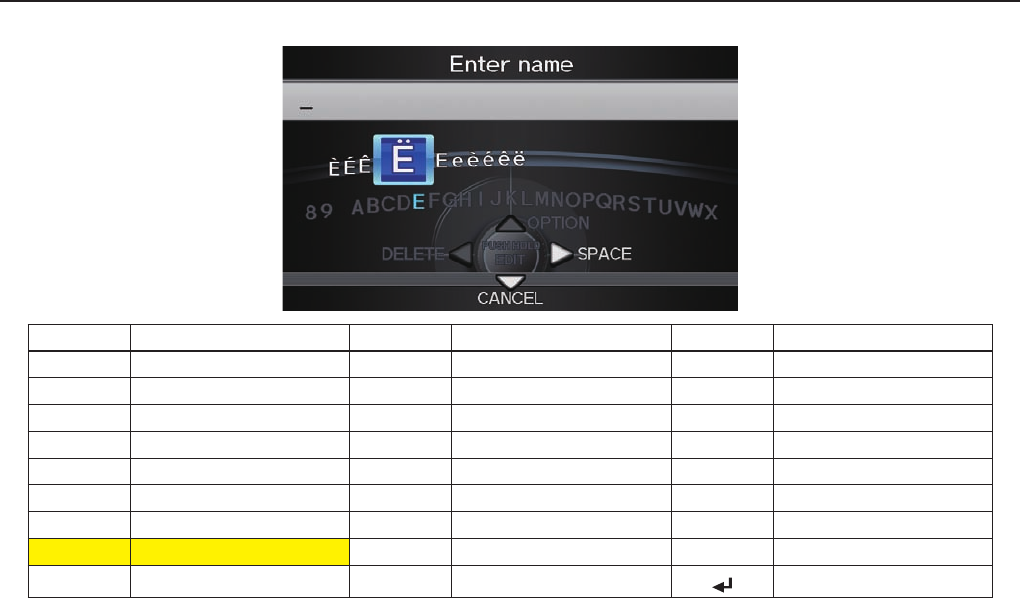
Voice Command Index
Navigation System 153
Symbol Assist Defi nitions:
Symbols Say “...” or “Symbol ...” Symbols Say “...” or “Symbol ...” Symbols Say “...” or “Symbol ...”
ÀA grave îI circumfl ex _Underscore
ÂA circumfl ex ïI umlaut `Back quote
ÄA umlaut ÔO circumfl ex ,Comma
ÇC cedilla Ù U grave .Dot
ÈE grave Û U circumfl ex ?Question Mark
ÉE acute Ü U umlaut :Colon
ÊE circumfl ex @At sign ;Semi colon
ËE umlaut ^ Caret + Plus
ìI grave * Asterisk Enter
NOTE:
The term “grave” (used for symbols À, È, Ì, and Ù) is pronounced like “save.”
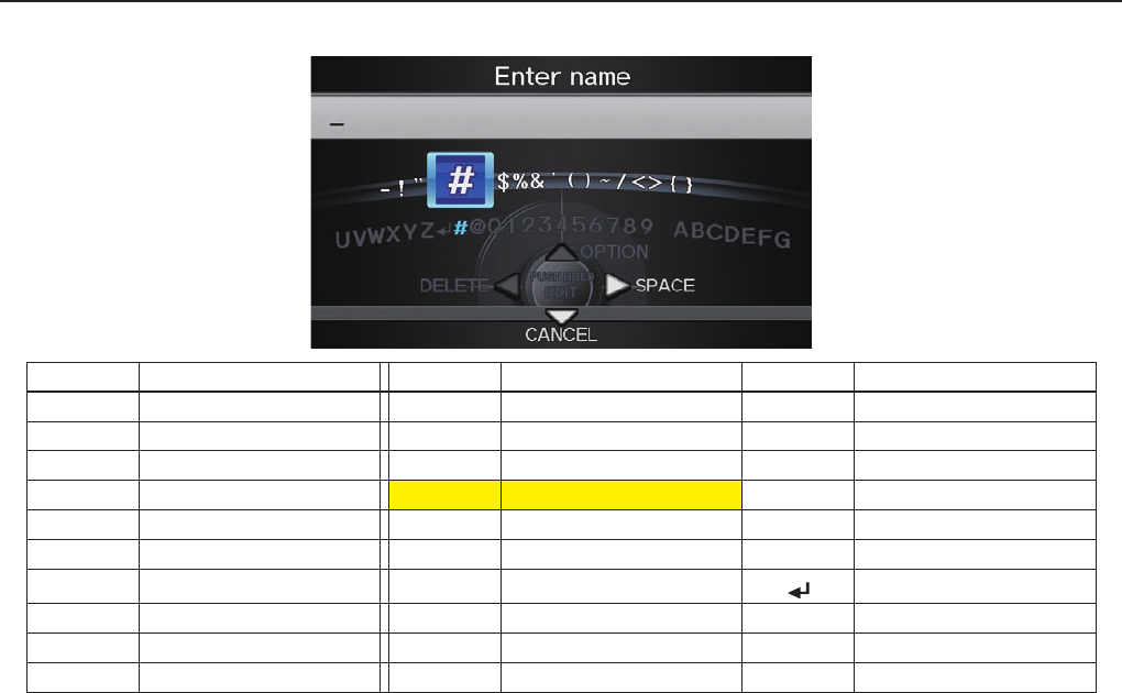
Voice Command Index
154 Navigation System
Numbers and Additional Symbol Assist Defi nitions:
Numbers Say “...” or “Number ...” Symbols Say “...” or “Symbol ...” Symbols Say “...” or “Symbol ...”
1One - Hyphen ~ Tilde
2Two ! Exclamation point /Slash
3Three ” Double quote <Less than
4 Four # Pound > Greater than
5 Five $ Dollar { Open brace
6 Six % Percent } Close brace
7 Seven & Ampersand Enter
8 Eight ’ Apostrophe
9 Nine ( Open parenthesis
0 Zero ) Close parenthesis

INDEX
Navigation System 155
A
Accessing the Address Book
List ................................................. 84
Acura Client Services .......................118
Adding Destinations to the List ........ 47
Adding Waypoint .............................. 69
Address ................................. 23, 24, 83
Address Book ........................ 24, 28, 83
Address Book PIN ............................ 88
Advanced .......................................... 33
AUDIO button ................................... 10
Auto Daylight ...................................101
Auto Service ...................................... 33
Auto Time Zone .............................. 102
Avoid Streets ..................................... 68
B
BACK button ..................................... 13
Banking ............................................. 33
Basic Settings .................................... 92
Black Level ........................................ 82
Bluetooth® Audio Commands ........... 149
Bluetooth® HandsFreeLink® ............. 19
Breadcrumbs ............................... 20, 64
Brightness.......................................... 82
By Address ........................................ 24
By Address Book .............................. 28
By Coordinate ................................... 39
By Go Home 1 or 2 ........................... 45
By Intersection .................................. 40
By Map Input .................................... 41
By Place Category ............................. 31
By Place Name .................................. 30
By Place Phone Number ................... 37
By Previous Destinations .................. 29
C
Calculator .......................................... 78
Calendar ......................................19, 75
CALL ................................................ 19
CANCEL button ............................... 11
Cancel Route ..................................... 68
Category ................................ 23, 31, 85
Cellular Phone ................................... 73
Change Route Preference .................. 67
Change Province ......................... 24, 44
Changing the Route .......................... 67
Changing the Routing Method .......... 48
Changing Your Destination ............... 71
City .............................................. 25, 42
City Vicinity ...................................... 35
Client Assistance ..............................118
Climate Control Commands ........... 146
Clock Adjustment .............................101
Colour .............................................. 104
Community ....................................... 33
Contrast ............................................. 82
Convert (Unit) ................................... 78
Correct Vehicle Position .................. 103
Coverage Areas ............................... 120
Current Location ..........................21, 60
Current Position ............................... 41
Current Street ...................................... 6
D
Database Limitations .......................116
Destination .............................23, 29, 85
Destination Icon ................................ 62
Destination Map ................................ 49
DEST/ROUTE button ....................... 10
Detour ............................................... 68
INDEX
156 Navigation System
Directions .......................................... 55
Disc Voice Commands .................... 148
Display Mode button ......................... 10
Driving to Your Destination .............. 47
E
Edit Avoid Area ................................. 98
Edit Waypoint Search Area ............. 100
Edit/Delete Address .................... 85, 87
Emergency ......................................... 33
Entering a Destination ....................... 23
Entering Address Book ..................... 84
Entering Security Code ....................112
Entering the Street Number .............. 28
Entering Your Schedule .................... 76
Error Message ................................. 139
Exit Info ............................................ 56
F
Find Place Commands .....................145
Frequently Asked Questions ........... 132
G
Getting Started .................................. 10
Global Commands ...........................143
Glossary .......................................... 140
Go Home 1 or 2 ................................. 45
Go Home 1 or 2 PIN ......................... 89
Going Off the Route .......................... 64
GPS Initialization .............................113
Guidance Mode ................................101
Guidance Screen ............................... 53
H
Home Address ................................... 87
Hotel/Motel (Lodging) ...................... 33
I
Icon Bar ............................................. 57
INFO button .................................10, 73
INFO screen ...................................... 73
Interface Dial .................................... 11
Interface Dial Feedback .................... 83
Interface Dial knob ........................... 11
Intersection .................................. 2 4, 4 0
K
Key to Zagat Ratings ......................... 80
L
Landmark Icons ................................ 62
Leisure............................................... 33
Lodging ............................................. 33
Lower Display ................................... 12
M
Map Colour ..................................... 104
Map Coverage ................................. 120
Map Input .................................... 24, 41
Map Legend ...................................... 60
Map Matching ..................................113
Map Orientation ................................ 59
Map Scale .......................................... 61
Map Screen ................................. 20, 50
MAP/GUIDE button ....................10, 53
Menu Colour ................................... 105
Microphone ....................................... 13
Music Search ..................................... 90

INDEX
Navigation System 157
N
Navigation Display Commands ....... 144
Navigation General Commands .......143
O
Off-road Tracking ..................... 64, 102
On-Screen Commands .....................151
On-Screen Spelling Assist ...............151
P
Personal Information ......................... 83
PHONE button .................................. 11
Phone Number ................................... 36
PIN .................................................... 83
Place Name ......................23, 30, 35, 86
Previous Destinations .............23, 29, 89
Province .................................24, 41, 43
R
Radio Voice Commands ...................147
Read List ........................................... 74
Rearview Camera .............................111
Recalculation ............................... 6 4, 93
Reporting Errors ..............................118
Rerouting ........................................... 93
Restaurant ......................................... 33
Route ................................46, 48, 67, 68
Routing & Guidance ......................... 93
Routing Method ............................... 48
S
Save Current Location....................... 65
Schedule ............................................ 76
Screen ................................................ 12
Search by Keyword ........................... 36
Security Code ...................................112
Selecting the City ........................ 25, 42
Selecting the Province ....................... 24
Selecting the Street............................ 26
SETUP Screen (Main Setup)
Commands ................................... 150
Shopping ........................................... 33
Show Icon on Map ............................ 62
Single-screen Mode ........................... 57
Song By Voice™ (SBV) .................... 90
Sort by Distance to Travel ................. 36
Split-screen Mode ............................. 56
State ................................................... 24
Street ........................................... 26, 52
Switching Display Mode ..........105, 106
System Controls ................................ 10
System Function Diagram ................. 22
System Information ........................... 79
System Initialization ........................112
System Limitations...........................115
System Set up .................................... 82
System Start-up ................................. 18
T
TALK button ..................................... 13
Time Adjustment ............................. 102
Travel ................................................. 33
Troubleshooti ng ............................... 139
U
Unit Conversion ................................. 78
Units (mile or km) ............................. 93
Unverifi ed Area Routing ................... 94
Unverifi ed streets ................................ 6
Update DVD.....................................119
Use Ferries ........................................ 48
Use Highways .................................... 48
Use Toll Roads .................................. 48
Using the Voice Control System ....... 14

INDEX
158 Navigation System
V
Vehicle ............................................. 102
Verifi ed Streets .................................... 6
View Routes ...................................... 48
Visiting Your Dealer ........................119
Voice Command Index .....................143
Voice Control Basics ......................... 13
Voice Info .......................................... 74
Voice Recognition ............................. 14
Voice Recognition Tutor .................... 93
Volume .............................................. 83
W
Waypoints ........................................ 10 0
Z
Zagat 2012 ......................................... 38

Other
Navigation System 159
1) This device complies with Part 15 of the
FCC Rules and Canadian RSS-210/RSS-
Gen. Operation is subject to the following
two conditions: (1) this device may not
cause harmful interference, and (2) this
device must accept any interference
received, including interference that may
cause undesired operation.
2) The FCC requires the user to be notifi ed
that any changes or modifi cations made
to this device that are not expressly
approved by the party responsible for
compliance may void the user’s authority
to operate the equipment.
3) This product emits radio frequency
energy, but the radiated output power
of this device is far below the FCC and
IC radio frequency exposure limits. This
equipment complies with FCC and IC
RF radiation exposure limits forth for an
uncontrolled environment. Nevertheless,
the device should be used in such a
manner that the potential for human
contact with the antenna during normal
operation is minimized.
