In Brief NSPL User Guide May 2018
NSPL%20User%20Guide%20May%202018
User Manual:
Open the PDF directly: View PDF ![]() .
.
Page Count: 40

May 2018
National Statistics
Postcode Lookup
User Guide
Edition:
May 2018
Editor:
ONS Geography
Office for National Statistics

NSPL User Guide
May 2018
Office for National Statistics
2
A National Statistics Publication
National Statistics are produced to high professional standards
set out in the Code of Practice for Official Statistics. They are
produced free from political influence.
About Us
Office for National Statistics
The Office for National Statistics (ONS) is the executive office of
the UK Statistics Authority, a non-ministerial department which
reports directly to Parliament. ONS is the UK government’s
single largest statistical producer. It compiles information about
the UK’s society and economy, and provides the evidence-base
for policy and decision-making, the allocation of resources, and
public accountability. The Directors General of ONS report
directly to the National Statistician who is the Authority's Chief
Executive and the Head of the Government Statistical Service.
Government Statistical Service
The Government Statistical Service (GSS) is a network of
professional statisticians and their staff operating both within
the ONS and across more than 30 other government
departments and agencies.
Contacts
This publication
For information about the content of this publication, contact
ONS Geography Customer Services
Tel: 01329 444971
Email: ons.geography@ons.gsi.gov.uk
Other customer enquiries
ONS Customer Contact Centre
Tel: 0845 601 3034
International: +44 (0)845 601 3034
Minicom: 01633 815044
Email: info@ons.gsi.gov.uk
Post: Room 1.101, Government Buildings,
Cardiff Road, Newport, South Wales NP10 8XG
www.ons.gov.uk
Media enquiries
Tel: 0845 604 1858
Email: media.relations@ons.gsi.gov.uk
Copyright and Reproduction
Please refer to the 'Postcode products' section on our Licences
page for the terms applicable to these products.
TRADEMARKS
Gridlink is a registered trademark of the Gridlink Consortium
and may not be used without the written consent of the Gridlink
Programme Board.
The Gridlink logo is a registered trademark.
OS AddressBase is a registered trademark of Ordnance
Survey (OS), the national mapping agency of Great Britain.
Boundary-Line is a trademark of OS, the national mapping
agency of Great Britain.
Pointer is a registered trademark of Land and Property Services,
an Executive Agency of the Department of Finance and Personnel
(Northern Ireland).

NSPL User Guide
May 2018
Office for National Statistics
3
Contents
1. Introduction ................................................................................................................................................................................. 5
2. News ............................................................................................................................................................................................... 5
2.1 Cancer Alliances / National Cancer Vanguard and Sustainability and Transformation Partnerships ...... 5
2.2 Format Changes – Names and Codes Files ..................................................................................................................... 5
2.3 Important NSPL Field Changes from February 2018 ................................................................................................... 5
2.4 Northern Ireland IMD Changes ............................................................................................................................................ 5
3. Licensing Requirements .......................................................................................................................................................... 6
4. Postcode Counts and Currency ............................................................................................................................................ 6
5. Geography Updates on the NSPL ....................................................................................................................................... 6
6. Frequently Asked Questions (FAQ) ..................................................................................................................................... 6
7. Postcode Content ...................................................................................................................................................................... 7
8. Gridlink ........................................................................................................................................................................................ 8
9. Geographic Coordinates ......................................................................................................................................................... 8
10. Assignment of Postcodes to Geographies on the NSPL ............................................................................................ 9
11. PO Boxes and Non-geographic Postcodes ..................................................................................................................... 9
12. Terminated Postcodes ............................................................................................................................................................. 9
13. Postcode Reorganisations ...................................................................................................................................................... 9
14. Former Strategic Health Authorities (SHA), Health Boards and Health & Social Care Board ................... 10
15. Former Primary Care Organisations (PCO), Local Health Boards (LHB), Community Health Partnerships
(CHP) and Local Commissioning Groups (LCG) ........................................................................................................... 10
16. County Electoral Divisions (CED) ....................................................................................................................................... 10
17. 2011 Census Output Areas (OA) ........................................................................................................................................ 10
18. 2011 Census Area Classification for Output Areas (OAC) ........................................................................................ 11
19. 2011 Census Super Output Areas (SOA) & Scottish Data and Intermediate Zones (DZ & IZ) ................. 12
20. Westminster Parliamentary Constituencies ................................................................................................................... 12
21. European Electoral Regions (EER) ..................................................................................................................................... 13
22. Nomenclature of Units for Territorial Statistics (NUTS) ............................................................................................ 13
23. NHS England (Regions) (NHSER) ....................................................................................................................................... 13
24. Regions (Former Government Office Regions - GOR) .............................................................................................. 13
25. Local Learning and Skills Council (LLSC)/Dept. of Children, Education, Lifelong Learning and Skills
(DCELLS), Enterprise Regions (ER) ..................................................................................................................................... 13
26. Travel to Work Areas (TTWA) .............................................................................................................................................. 14
27. National Parks ........................................................................................................................................................................... 14
28. 2011 Census Workplace Zones (WZ) ............................................................................................................................... 14
29. Clinical Commissioning Groups (CCG) ............................................................................................................................ 14

NSPL User Guide
May 2018
Office for National Statistics
4
30. 2011 Census Built-up Areas (BUA)/Built-up Area Sub-divisions (BUASD) ........................................................ 14
31. 2011 Census Rural-Urban Classification ......................................................................................................................... 15
32. Local Enterprise Partnerships (LEP) ................................................................................................................................... 16
33. Police Force Areas (PFA) ........................................................................................................................................................ 16
34. Index of Multiple Deprivation (IMD) ................................................................................................................................ 17
35. Cancer Alliances and the National Cancer Vanguard (CALNCV) .......................................................................... 17
36. Sustainability and Transformation Partnerships (STP) .............................................................................................. 17
37. Names and Codes.................................................................................................................................................................... 17
38. Directory Specifications ......................................................................................................................................................... 17
39. Data Format ............................................................................................................................................................................... 17
40. Limitations/Data Quality ....................................................................................................................................................... 18
Table 1 - Numbers of Postcodes by User Type ............................................................................................................................ 19
Table 2 - Numbers of Postcodes, Postcode Sectors and Postcode Districts .................................................................... 20
Table 3 - Numbers of Postcodes With A Grid Reference ......................................................................................................... 23
Table 4 - Numbers of Terminated Postcodes ............................................................................................................................... 25
Annex A - NSPL Record Specification .............................................................................................................................................. 26
Annex B - Data Format ........................................................................................................................................................................... 39
Annex C - 2011 Census Very Small Population Wards and Their Assigned OA .............................................................. 40

NSPL User Guide
May 2018
Office for National Statistics
5
1. Introduction
The National Statistics Postcode Lookup (NSPL) relates both current and terminated postcodes in the
United Kingdom to a range of current statutory administrative, electoral, health and other statistical
geographies via ‘best-fit’ allocation from 2011 Census Output Areas (OA). National Parks and
Workplace Zones are exempt from ‘best-fit’ and use ‘exact-fit’ allocations – see Section 7 for further
details. It helps support the production of area based statistics from postcoded data. The NSPL is
produced by ONS Geography, who provide geographic support to the Office for National Statistics
(ONS) and geographic services used by other organisations. The NSPL is issued quarterly.
This User Guide contains information about the NSPL including:
• directory content;
• data currency;
• latest news, including area changes;
• the methodology for assigning areas to postcodes;
• data format;
• summary statistics; and
• data quality and limitations.
The NSPL reflects current and terminated postcodes using information supplied monthly by Royal
Mail. In most instances, the NSPL relates postcodes (as at the third Friday of the month prior to each
release) to geographic areas as at the end of the preceding year.
The NSPL uses the Government Statistical Service (GSS) standard 9-character codes throughout.
Lookup files linking these codes to statutory area names are included with the NSPL, in the
'Documents' folder. You are encouraged to adopt these standard names and codes, as they are the
recognised standard for National Statistics.
The NSPL is available to download (see Annex C) and the record specification at Annex B includes
complete details of all available fields.
2. News
2.1 Cancer Alliances / National Cancer Vanguard and Sustainability and
Transformation Partnerships
The May 2018 release of the NSPL includes the Cancer Alliances / National Cancer Vanguard
(CALNCV) and the Sustainability and Transformation Partnerships (STP).
2.2 Format Changes – Names and Codes Files
From May 2018, the names and codes files that accompany each release of the ONSPD will be
supplied in MS Excel (XLSX) and UTF8 Comma Separated Variable (CSV) format. The latter replaces
the tab-delimited text (TXT) format as the latter does not support the accented characters in some
geography names. Click here for further information.
2.3 Important NSPL Field Changes from February 2018
For the February 2018 release onwards, the NSPL will include the following field after CTY:
• County electoral division (CED)
Two other fields will also be changing:
• The 2012 Pan SHA field (HRO) will be updated to the NHS England (Regions) (NHSER)
• The GOR field will be renamed RGN to reflect the 2010 Regions (former GORs)
The HRO field will still be available on the NHSPD. These changes are being made to maintain the
manageability of the postcode directory file sizes.
2.4 Northern Ireland IMD Changes
The NI Index of Multiple Deprivation (IMD) was updated in November 2017. These changes are
included from February 2018 on the NSPL.

NSPL User Guide
May 2018
Office for National Statistics
6
3. Licensing Requirements
You should be aware of the attribution and sub-licensing requirements associated with the use of the
Code-Point Open data (from which our postcode products are derived) contained in the OS
OpenData Licence, namely that you, the licensee:
• Must always use the following attribution statements to acknowledge the source of the
information:
Contains OS data © Crown copyright and database rights [year]
Contains Royal Mail data © Royal Mail copyright and database rights [year]
Contains National Statistics data © Crown copyright and database rights [year]
• Must ensure that the same attribution statements are contained in any sub-licences of the
Information that are granted, together with a requirement that any further sub-licences do the
same.
You should note that following agreement with Land and Property Services (LPS) Northern Ireland,
Open Government Licensing terms do not apply to NI postcodes; separate licensing terms and
conditions now apply in the form of an LPS End User licence or contact LPS directly for commercial
use. Please see the Licences web page for further details.
Note: We do not have the capability to deal with detailed postcode queries relating to Scotland
and Northern Ireland, but can pass them on to the appropriate government departments.
4. Postcode Counts and Currency
The NSPL contains postcodes within the United Kingdom, the Channel Islands and the Isle of Man.
They are current to the 3rd Friday of the previous month and include both live and terminated
postcodes.
Table 1 shows the split between large and small users by country, and the change in the numbers of
postcodes since the previous quarter (counts taken from the ONSPD).
Table 2 shows the numbers of postcodes, postcode sectors and postcode districts by postcode area.
Table 3 shows the numbers of postcodes assigned grid references by positional quality indicator,
country and user type (counts taken from the ONSPD).
Table 4 shows the numbers of terminated postcodes.
5. Geography Updates on the NSPL
The OA lookups that serve as inputs to each release of the NSPL are usually updated at the end of
each year. Therefore, the February release of the NSPL will generally be the first to reflect any
geography changes in the previous year. This release contains 2017 LAD, ward and LAU2 codes, and
April 2018 CCG updates.
6. Frequently Asked Questions (FAQ)
Why are some postcodes not assigned to administrative and electoral areas?
- This mainly applies to new postcodes, which are assigned grid references by ONS Geography
using imputation techniques - see Sections 6 and 7. In some cases the imputation procedure
cannot assign a grid reference and, because the NSPL processing system assigns postcodes to
OAs using grid references, codes for the administrative and electoral areas cannot be derived. In
time, the addresses in the new postcodes are surveyed by Ordnance Survey (OS), who then
assign accurate grid references.
Why are some postcodes assigned to the wrong administrative and electoral areas?
- There are two reasons:

NSPL User Guide
May 2018
Office for National Statistics
7
1. Imputation: Some postcodes are assigned to administrative and electoral areas using an
imputed grid reference. Imputation is not an exact science and can cause postcodes to be
wrongly assigned until more accurate information becomes available. Please inform ONS
Geography Customer Services of any postcodes considered to be wrongly assigned.
2. Straddling: As the postal, OA and higher geographies do not map directly onto one another,
addresses within a postcode often straddle boundaries. Postcodes are always assigned to
single administrative and electoral areas via ‘best-fit’ allocation of OA whilst allocation of
postcode to OA is based upon a single grid reference (which is the mean of all the addresses
in the postcode, snapped to the address closest to the mean). This will inevitably lead to
apparent wrong assignments, where addresses in a postcode fall in two
administrative/electoral areas (see Section 6).
Why don’t postcode areas follow administrative and electoral area boundaries?
- Postcode areas are defined and used by Royal Mail for efficient mail delivery and have no
relationship with administrative and electoral areas. Royal Mail requires a relatively stable
geography in order to deliver its services, which the administrative and electoral area geography
cannot provide.
Why do some postcodes appear to move around?
- There are three main reasons:
1. Update: As the grid reference allocation is updated from imputed to surveyed (see Section
6), so the allocation of one or more geographies may also change.
2. Drift: With demolition and new-build, the addresses that constitute a postcode may change.
If this happens the centroid grid reference will also change, and the geography allocations
will be updated accordingly.
3. Re-use: Royal Mail endeavour to never re-use a postcode, but under some circumstances a
postcode may be terminated and then brought back into use in a different location. If this
happens, the grid reference and geography allocations will change accordingly.
Why have some allocations changed after August 2012 when the geographies haven’t changed?
- As part of the 2011 Census Output Area maintenance, OAs had their population weighted
centroids recalculated using the latest Census populations. As well as this there was also a
change in centroid calculation from the mean average to the median average. This change in
the population and methodology means that almost all OA population weighted centroids have
moved from their original position. In a number of cases the new OA population weighted
centroids now fall into different higher geographies. This causes the differences in the
allocations after August 2012, even where the geographies haven’t changed.
7. Postcode Content
The NSPL contains both ‘live’ postcodes and postcodes which have been terminated by Royal Mail
but not subsequently re-used (see Section 8).
Postcode coverage is for the entire United Kingdom, the Channel Islands and the Isle of Man. The
split between large and small users and country and the changes in the numbers of postcodes since
the previous NSPL are shown in Table 1 of the Version Notes.
The numbers of postcodes, postcode sectors and postcode districts by postcode areas are shown in
Table 2 of the Version Notes.

NSPL User Guide
May 2018
Office for National Statistics
8
The NSPL contains fixed length 7- and 8-character postcode formats, and the variable length e-Gif
(e-Government Interoperability Framework) standard postcode format. The latter allows for a single
space between the two (outward and inward) parts of the postcode (see Annex A).
8. Gridlink
The postcode is a key piece of data that can provide a geo-spatial reference for many uses beyond
the delivery of mail. In order to make full use of its potential, and to deliver improved consistency, a
consortium of organisations was formed in 1999 to allow the specialist resources of each member to
be pooled. The Gridlink Consortium consists of Royal Mail Group plc, OS (GB), National Records of
Scotland (NRS), Northern Ireland Land and Property Services (LPS) and ONS.
It was recognised that a core set of data within each Consortium member’s postcode products
needed to be consistent and branded. The branding name is 'Gridlink' and the core data used in
the NSPL are:
• All current (i.e. ‘live’) UK unit postcodes (but ONS maintains postcodes terminated and not
subsequently re-used by Royal Mail).
• Grid references to 1 metre resolution.
• Positional quality indicators for grid references.
Each of the Gridlink Consortium members produces their postcode products based upon the core
data.
9. Geographic Coordinates
Postcode coordinates on the NSPL are available in two formats – 1 metre resolution grid reference
and decimal degrees latitude and longitude.
The majority of grid references are derived from OS AddressBase that contains grid references for
each address. Newly introduced postcodes initially have a grid reference that has been imputed by
ONS Geography. In due course these are replaced by improved OS AddressBase grid references
which use data supplied by OS field surveyors.
Each grid reference is given a Positional Quality Indicator (PQI) to denote the accuracy of the grid
reference, as follows:
1 - within the building of the matched address closest to the postcode mean,
2 - as for 1 above, except by visual inspection of Landline maps (Scotland only),
3 - approximate to within 50 metres,
4 - postcode unit mean (mean of matched addresses with the same postcode, but not snapped to an
address),
5 - imputed by ONS, by reference to surrounding postcode grid references,
6 - postcode sector mean (mainly PO Boxes),
8 - terminated postcode, last known ONS grid reference used,
9 - no coordinates available.
The grid references provided for Northern Ireland postcodes are derived from the LPS 'Pointer'
product and use the Irish National Grid system that covers all of Ireland and is independent of the
British National Grid.
The degrees latitude and longitude are calculated from the 1 metre grid reference by converting the
easting and northing to numeric and then one point shapefile is created for GB using the
'BritishNatGrid' coordinate system and another for Northern Ireland using 'Ireland 1965.ING'. These
files are then projected to GCS_WGS_1984, using an OSGB_1936_to_WGS_1984_Petroleum

NSPL User Guide
May 2018
Office for National Statistics
9
transformation for GB and a TM75_to_WGS_1984_2 transformation for NI. Latitude and longitude are
then calculated from the resulting x and y co-ordinates.
No geographic coordinates are provided for postcodes in the Channel Islands and the Isle of Man.
10. Assignment of Postcodes to Geographies on the NSPL
Postcodes are assigned to administrative, electoral and health areas by 'best-fit' allocation to OA
using the population-weighted centroid grid reference for each OA plotted against a range of digital
boundaries using a ‘point-in-polygon’ methodology. Postcodes are themselves plotted to OA
boundaries using their centroid grid reference and the same point-in-polygon methodology. The
exceptions are National Parks (these are exempt due to the nature of their boundaries) and
Workplace Zones (these are exempt as they are not built from whole OAs) – postcodes are allocated
to these on an 'exact-fit' basis using the same point-in-polygon methodology.
11. PO Boxes and Non-geographic Postcodes
Non-geographic postcodes can either be special postcodes assigned to some large users of the
postal service or PO Boxes that lie within a (pseudo) postcode district that does not form a discrete
part of a post town. These will all have been assigned a grid reference, usually the local Royal Mail
sorting office, and the majority have a PQI of 1 but some have been assigned a PQI of 6 (see Section
9).
12. Terminated Postcodes
Postcodes are frequently terminated by Royal Mail for various reasons but most commonly it is due
to the demolition/re-development of buildings or to postcode reorganisations (see next section).
Terminated postcodes are occasionally re-used by Royal Mail but not usually before an elapsed
period of two or three years. In such circumstances, all terminated postcodes and their grid
references are retained on the NSPL and a 'termination' date is added which provides a clear
indication of a postcode’s status.
Areal data assigned to terminated postcodes are updated prior to each release of the NSPL, so the
directory contains
current
information linked to each record.
If, and when, a postcode is subsequently re-used by Royal Mail the old grid reference and
termination date are removed, thus deleting all reference to the former existence of the postcode
from the NSPL. The new location of the postcode will initially have a grid reference imputed by ONS
Geography, which will eventually be replaced by an improved one derived from OS AddressBase.
As the Gridlink system processes only 'live' postcodes it is not possible to assign Gridlink quality
grid references to postcodes terminated prior to November 2000. Grid references for these
postcodes have been copied from the old 'Traditional' postcode directory and have been given a
single PQI (value 8).
The numbers of terminated postcodes included in each issue of the NSPL are shown in Table 4 of the
Version Notes.
13. Postcode Reorganisations
Royal Mail occasionally conduct postcode reorganisations in order to create more postcodes in areas
where the number of postcodes that can be created under the current structure is exhausted. For
example, SO3 was reorganised some years ago into SO31 and SO32 to cater for current demands,
and the reorganisation additionally allows SO33-SO39 postcodes to be assigned at a later date.
Royal Mail issue lists of postcode reorganisations in their 'Update' series, details of which can be
found at their website.

NSPL User Guide
May 2018
Office for National Statistics
10
14. Former Strategic Health Authorities (SHA), Health Boards and Health & Social
Care Board
The maintenance of health area codes is the responsibility of the Organisation Data Services (ODS) in
England, and ONS on behalf of NHS Scotland and Health Solutions Wales. These areas were
reorganised in England in 2002, in Wales in 2003 and in Scotland in 2006. The SHAs in England were
further reorganised by the NHS on 1 July 2006 to reduce the number from 28 to 10 before being
abolished on 31 March 2013. In Northern Ireland the Health & Social Care Board effective from 1
April 2009 replaced the four previous Health & Social Services Boards. The following health authority
codes apply to Channel Islands and the Isle of Man:
L00000001 – Jersey
L00000002 – Guernsey (incl. Sark and Herm)
L00000003 – Alderney
M00000001 – Isle of Man
15. Former Primary Care Organisations (PCO), Local Health Boards (LHB),
Community Health Partnerships (CHP) and Local Commissioning Groups (LCG)
Postcodes on the NSPL have been assigned PCO codes (England), LHB codes (Wales), CHP codes
(Scotland), LCG codes (NI) or Primary Healthcare Directorate code (Isle of Man). Postcodes in the
Channel Islands (for which there are no equivalent areas) have been assigned a pseudo code.
The primary care geography in England was reorganised significantly on 1 October 2006. When
PCOs were statutorily defined, they were done so in terms of whole local authority districts and/or
electoral wards (in most instances) that existed at the time. There were 146 Primary Care Trusts (PCT)
and five Care Trusts in place when they were abolished on 31 March 2013.
The 22 LHBs in Wales (from 1 April 2003) merged to form seven LHBs on 1 October 2009.
CHPs were established by the NHS boards in Scotland as key building blocks in the modernisation of
the NHS joint services. Managed jointly by local authorities and health boards, CHPs nested within
council area boundaries but some crossed health board boundaries. In April 2012, the 36 CHPs
became 34, covering the whole of Scotland. CHPs were terminated on 31 March 2015.
Five LCGs were introduced in Northern Ireland on 1 April 2009.
A single Primary Healthcare Directorate was introduced in the Isle of Man in 2008 to support the
rollout of NHS systems.
16. County Electoral Divisions (CED)
English county councils use county electoral divisions (CED) to elect councillors. These CEDs must be
confined within district boundaries, but need not be based on whole electoral wards. The only
exceptions are the Isles of Scilly and the Greater London Authority (GLA). CEDs do not exist within
UAs.
17. 2011 Census Output Areas (OA)
2001 Census OAs were built from clusters of adjacent unit postcodes but as they reflected the
characteristics of the actual Census data they could not be generated until after data processing.
They were designed to have similar population sizes and be as socially homogenous as possible
(based on tenure of household and accommodation type) - note though that homogeneity was not
used as a factor in Scotland. Urban/rural mixes were avoided where possible (i.e. OAs preferably
consisted entirely of urban postcodes or entirely of rural postcodes). They had more-or-less regular
shapes and tended to be constrained by obvious boundaries such as major roads. The OAs were
required to have a specified minimum size to ensure the confidentiality of data.

NSPL User Guide
May 2018
Office for National Statistics
11
England and Wales
OAs were maintained after the 2011 Census so that they could be adjusted where the populations
had changed significantly. Where an OA had breached its upper threshold of 625 population or 250
households it was split down to create a number of smaller OAs. Where an OA had breached its
lower threshold of 100 population or 40 households it was merged with an adjacent OA to create a
geography that was within threshold.
OAs created as part of the 2011 Census maintenance were based on postcodes as at Census Day
2011 while the unmaintained OAs reflected the postcodes as at Census Day 2001. The minimum OA
size is 40 resident households and 100 resident persons but the recommended size was rather larger
at 125 households. These size thresholds meant that unusually small wards and parishes were
incorporated into larger OAs. In total there are 181,408 OAs in England (171,372) and Wales (10,036).
National Statistics policy is that estimates published for any geographical area are aggregations of
whole OAs (the lowest geographical level for which census estimates are produced). This policy
ensures that estimates can be released for any area that contains at least one OA, in that it will
contain the minimum population to ensure confidentiality. Eighteen wards have a very small
population and have been assigned to a 'parent' OA (see Annex C for details).
In 2003, OAs fitted within the boundaries of 2003 statistical wards (and parishes) but this relationship
had not been maintained for 2011 due to the high levels of administrative geography boundary
change. In 2003 postcodes that straddled an electoral ward/division (or parish) boundary were split
between two or more OAs. This scenario is now more prevalent as the postcodes have changed
during the intercensal period without this being reflected within the OA hierarchy.
Scotland
OAs for the 2011 Census were created as groups of postcodes nesting as well as possible into the
following geographies, in descending order of preference (when not all postcodes in the OA belong
to a single combination of these area types).
- Council Area
- The 2010 Locality dataset
The main aim governing this order of geographies was to give continuity with the 2001 OAs while
ensuring, as far as possible, that 2011 OAs fit into the appropriate locality (urban area) which are
seen as an increasingly important statistical area. Where possible, postcodes that were excluded from
the 2010 Locality dataset, but subsequently met the population density criteria for inclusion in a
locality, were included in an OA in the locality or grouped to form a new urban OA.
The majority of 2011 OAs are of similar size to those used in 2001 to allow as much comparison as
possible with the 2001 Census data. Where a 2001 OA dropped below the 2011 minimum thresholds
for confidentiality (50 persons and 20 households) e.g. because of housing demolitions, it was
merged with a neighbouring 2001 OA. In addition, 2001 OAs which increased in size, particularly
those which exceeded the 2011 recommended maximum threshold (approximately 78 households),
were split where possible into two or more OAs.
Northern Ireland
Updated 2011 Census OAs are called small areas and are re-coded to nine-character format. There
are 4,537 small areas in Northern Ireland.
18. 2011 Census Area Classification for Output Areas (OAC)
The 2011 Census OAC is used to group together geographic areas according to key characteristics
common to the population in that grouping. These groupings are called clusters, and are derived
using 2011 population census data. The classification was originally produced with lower case

NSPL User Guide
May 2018
Office for National Statistics
12
characters but these have been converted to upper case for consistency purposes on the NSPL. You
can download a complete listing of the OAC names and codes from the Open Geography portal.
19. 2011 Census Super Output Areas (SOA) & Scottish Data and Intermediate
Zones (DZ & IZ)
SOAs exist in England, Wales and Northern Ireland; the Scottish equivalents are DZs and IZs.
England and Wales
The Lower Layer SOAs (LSOA) were designed with a mean population figure of 1,500 and each
consists of a grouping of OAs, typically five. There are 34,753 LSOAs, with an absolute minimum
population size of 1,000.
The Middle Layer SOAs (MSOA) have a mean population figure of 7,200 (minimum 5,000) and consist
of a grouping of LSOAs. MSOAs are constrained by the 2003 local authority boundaries used for
2001 Census outputs.
The LSOAs and MSOAs have been maintained as part of the 2011 Census OA maintenance. As with
OAs, they have been split or merged where they have breached predefined population and
household thresholds.
Scotland
DZs are groups of OAs which have populations of between 500 and 1,000 household residents.
Redrawn as a result of detailed population information from the 2011 Census, they have been
available since November 2014.
IZs are the geography that sits above DZs and they have a minimum population of 2,500 - 6,000,
which are of a size between the LSOAs and MSOAs in England and Wales. There are 1,279 IZs.
Northern Ireland
In Northern Ireland SOAs were released in 2005. There is one layer of SOA, with a population size
between 1,300 and 2,800, similar in size to the LSOAs in England and Wales.
20. Westminster Parliamentary Constituencies
England and Wales
Parliamentary constituencies relate to those defined by the Parliamentary Constituencies (England)
Order 2007, the Parliamentary Constituencies (England) (Amendment) Order 2008 and the
Parliamentary Constituencies (Wales) (Amendment) Order 2008, and which came into effect at the
May 2010 General Election. No further changes are envisaged until 2020.
Scotland
The Scottish Parliament (Constituencies) Act 2004, passed by the UK parliament in July 2004, came
into effect upon the dissolution of the last UK parliament and breaks the linkage between UK
parliamentary constituencies and Scottish parliamentary constituencies. This Act has enabled the
Westminster government to reduce the number of Scottish constituencies in the UK parliament in
line with recommendations made by the Boundary Commission for Scotland following its Fifth
Periodical Review of Constituencies (December 2004).
The Parliamentary Constituencies (Scotland) Order 2005 details the reduction of the number of
constituencies for the UK parliament from 72 to 59 Scottish seats. The changes bring the size of
Scottish constituencies more into line with the size of English seats. English constituencies currently
contain nearly 70,000 voters on average, compared to the Scottish average of 53,500.

NSPL User Guide
May 2018
Office for National Statistics
13
Northern Ireland
In Northern Ireland the commission's Fifth Periodical Report on Parliamentary Constituencies
outlined changes to and the composition of constituencies in 2010. In practice the new parliamentary
constituencies are not very different to their predecessors. As before there are 18 constituencies, all
retaining the same name. In the main, the boundary amendment process has involved the re-
assigning of existing electoral wards from one constituency into a neighbouring constituency. The
only exception concerns Derryaghy ward within Lisburn City local government district which
previously resided entirely within Lagan Valley county constituency. It has now been split into two
separate wards - Derryaghy (North) and Derryaghy (South), the former now included in Belfast West
borough constituency, the latter remaining where it was.
21. European Electoral Regions (EER)
EERs are as defined in the European Parliamentary Elections Bill (Bill 65, 1997) to amend the
European Parliamentary Elections Act 1978 so as to alter the method used in Great Britain for
electing Members of the European Parliament. The Bill created 9 EERs in England with 64 MEPs;
Scotland, Wales and Northern Ireland each constitute a single EER, with 7 MEPs, 4 MEPs and 3 MEPs
respectively.
22. Nomenclature of Units for Territorial Statistics (NUTS)
NUTS is a hierarchical classification of spatial units that provides a breakdown of the European
Union’s territory for producing regional statistics that are comparable across the Union.
The NUTS area classification in the United Kingdom comprises current national administrative and
electoral areas, except in Scotland where some NUTS areas comprise whole and/or part Local
Enterprise Regions.
NUTS levels 1-3 are frozen for a minimum of three years and NUTS levels 4 and 5 are called local
administrative units (LAU) levels 1 and 2 respectively.
The NSPL contains the LAU2 code (9-character ward code for England and Wales, 'S31' code for
Scotland and, currently, the 10-character Eurostat code for Northern Ireland). A comprehensive
lookup of LAU and NUTS codes is included with the accompanying metadata.
23. NHS England (Regions) (NHSER)
NHSERs (formerly NHS Commissioning Regions - NHS CR) are sub-divisions of the NHS
commissioning board. There are four NHS ERs in England and they were renamed from NHS CRs in
May 2017. The NHS CRs were formed on 1 April 2013, replacing pan SHAs, and are responsible for
providing clinical and professional leadership at sub-national level. They are also responsible for the
co-ordination of planning, operational management and emergency preparedness at sub-national
level and undertaking direct commissioning functions and processes.
24. Regions (Former Government Office Regions - GOR)
The nine GORs were abolished on 1 April 2011 and are now known as 'regions' for statistical
purposes. They were the primary statistical subdivisions of England and also the areas in which the
Government Offices for the Regions fulfilled their role. Each GOR covered a number of local
authorities and will remain as a 'frozen' geography on the NSPL.
25. Local Learning and Skills Council (LLSC)/Dept. of Chil dren, Education, Lifelong
Learning and S kills (DCELLS), Enterprise Regions (ER)
LLSCs were introduced in 2001, replacing TECs in England. They were abolished on 31 March 2010.
Also in 2001, TECs in Wales were replaced by ELWas (Education and Learning Wales). In April 2007
DCELLS replaced ELWas. These organisations were established to increase the standards and range

NSPL User Guide
May 2018
Office for National Statistics
14
of learning opportunities for businesses, communities and the individual. There were 47 LLSCs in
England and there are four DCELLS areas in Wales.
ERs replaced LECs in Scotland after September 2007. Government-funded bodies, they aim to foster
local economic growth and development in Scotland.
26. Travel to Work Areas (TTWA)
TTWAs are used in labour market analysis and reflect reasonably self-contained zones in which the
bulk of the resident population also work. The 228 current TTWAs were defined in 2015 using 2011
Census information on home and work addresses and are built from 2011 Census LSOAs in England
and Wales, DZs in Scotland, and SOAs in Northern Ireland. The previous (2007) areas were based on
the same statistical geographies from the 2001 Census.
27. National Parks
National parks are designed to conserve the natural beauty and cultural heritage of areas of
outstanding landscape value, and to promote public understanding and enjoyment of these areas.
There are currently 13 national parks in England and Wales. Of these, 10 were designated in the
1950s following the National Parks and Access to the Countryside Act 1949, The Broads
(Norfolk/Suffolk) has had a similar status since 1989 (the Broads has its own special authority, the
Broads Authority, which is similar to the National Park Authorities but with extra powers in relation to
navigation) and The New Forest was given national park status in 2005. The South Downs is the
latest national park, becoming fully operational on 1 April 2011. In Scotland the National Parks
(Scotland) Act was passed in July 2000. The first Scottish national park, Loch Lomond and the
Trossachs, was established in July 2002, and the Cairngorms National Park was established in March
2003. Their boundaries are not constrained by any other geography. Unlike other geographies (apart
from Workplace Zones – see next section), postcodes are assigned to a national park on an 'exact-fit'
basis rather than 'best-fit'.
28. 2011 Census Workplace Zones (WZ)
Following the 2011 Census, a new geography, WZ, was created for England and Wales, followed in
due course by Scotland and Northern Ireland. These were produced based on workplace data
collected from the Census. WZs are created by merging or splitting the 2011 OAs using WZ postcode
building blocks, and because of this, postcodes are allocated to WZs on an 'exact-fit' basis rather
than 'best-fit'. The upper threshold of a WZ is unlimited postcodes or 625 workers and the lower
threshold is three postcodes or 200 workers.
29. Clinical Commissioning Groups (CCG)
CCGs are groups of GPs that are responsible for designing local health services in England by
commissioning or buying health and care services, and all GP practices have to belong to a CCG.
They came into effect on 1 April 2013 and are built from 2011 LSOAs.
30. 2011 Census Built-up Areas (BUA)/Built-up Area Sub-divisions (BUASD)
England and Wales
BUAs and BUASDs were created as part of the 2011 Census outputs and provide information on
villages, towns and cities, allowing comparisons between people living in built-up areas and those
living elsewhere. Previously called urban areas, data has been produced every 10 years since 1981.
A new methodology to capture the areas was used in the 2011 version, but it still follows the rules
used in previous versions so that results will be broadly comparable.
There are areas included in the ONSPD but not in the NSPL. These BUAs and BUASDs have been
identified as areas that have not been allocated a population. In most cases this is because they do
not have any residential buildings – for example, industrial estates, airports, theme parks, etc. There
NSPL User Guide
May 2018
Office for National Statistics
15
are 337 BUAs where population has not been allocated (305 in England, 32 in Wales) and 133
BUASDs where population has not been allocated (123 in England, 10 in Wales).
Scotland
This data is not yet available.
Northern Ireland
This data is not yet available.
31. 2011 Census Rural-Urban Classification
England and Wales
The rural and urban classification of postcodes for England and Wales allows a rural/urban view of
datasets. It is based on the 2011 rural-urban classification of OAs released in August 2013. This
product was sponsored by a cross-Government working group comprising Department for
Environment, Food and Rural Affairs (DEFRA), Department of the Communities and Local
Government (DCLG), ONS and the Welsh Government. It is a revised version of the classification
produced after the 2001 Census, but with additional detail in the urban domain.
Postcodes have been assigned to the urban or rural category of the OA into which each one falls.
OAs are treated as 'urban' if they were allocated to a 2011 built-up area with a population of 10,000
or more. The urban domain is then further sub-divided into three broad morphological types based
on the predominant settlement component. As with the previous version of the classification, the
remaining 'rural' OAs are grouped into three broad morphological types based on the predominant
settlement component.
The classification also categorises OAs based on context – i.e. whether the wider surrounding area of
a given OA is sparsely populated or less sparsely populated.
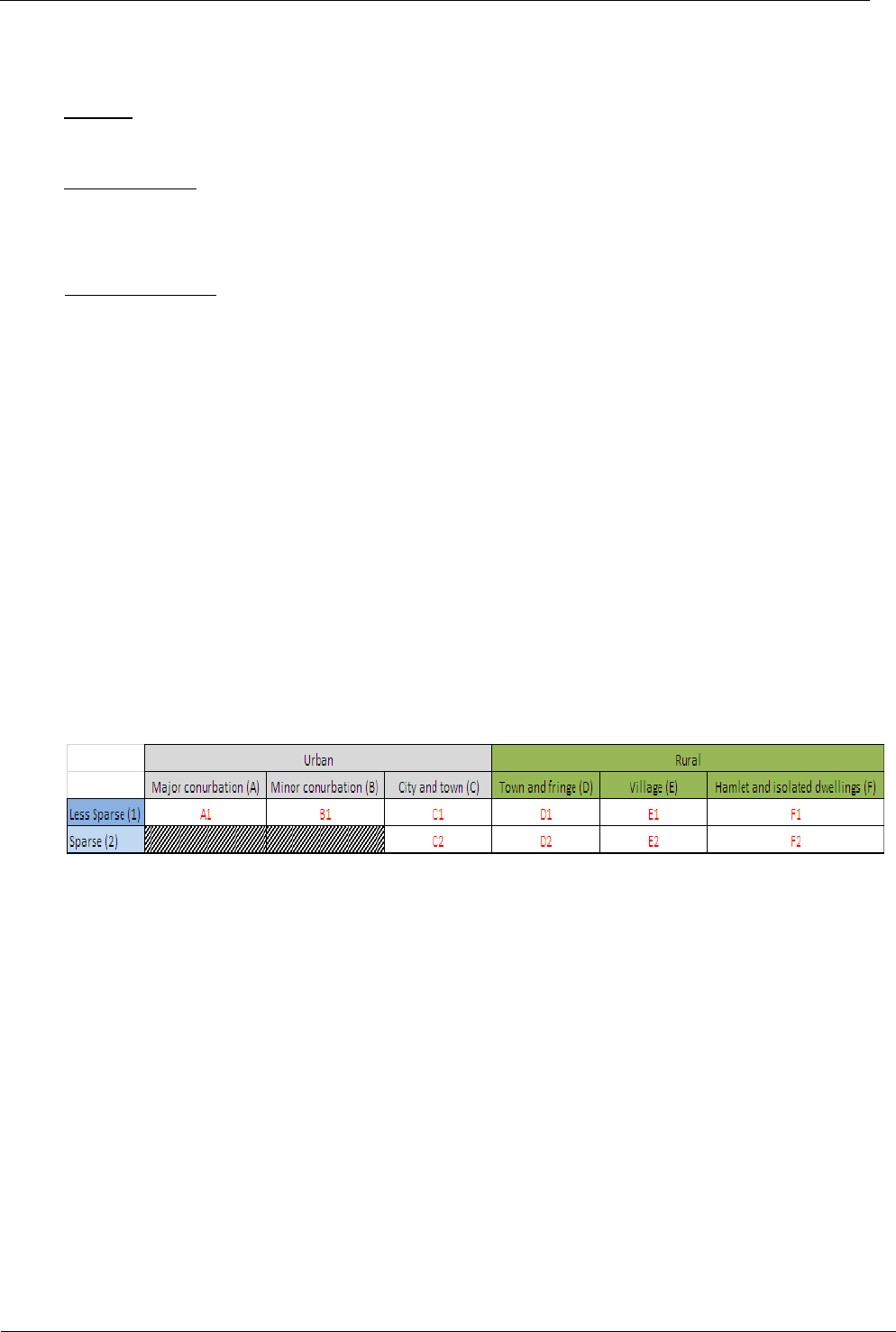
The resulting classification produces the following 10 classes (note, there are no major or minor
conurbations in a sparse context):
A1 = urban major conurbation: OA falls within a built-up area with a population of 10,000 or more
and is assigned to the 'major conurbation' settlement category. The wider surrounding area is less
sparsely populated;
B1 = urban minor conurbation: OA falls within a built-up area with a population of 10,000 or more
and is assigned to the 'minor conurbation' settlement category. The wider surrounding area is less
sparsely populated;
C1 = urban city and town: OA falls within a built-up area with a population of 10,000 or more and is
assigned to the 'city and town' settlement category. The wider surrounding area is less sparsely
populated;
C2 = urban city and town in a sparse setting: OA falls within a built-up area with a population of
10,000 or more and is assigned to the 'city and town' settlement category. The wider surrounding
area is sparsely populated;
D1 = rural town and fringe: OA is assigned to the 'town and fringe' settlement category. The wider
surrounding area is less sparsely populated;
D2 = rural town and fringe in a sparse setting: OA is assigned to the 'town and fringe' settlement
category. The wider surrounding area is sparsely populated;

NSPL User Guide
May 2018
Office for National Statistics
16
E1 = rural village: OA is assigned to the 'village' settlement category. The wider surrounding area is
less sparsely populated;
E2 = rural village in a sparse setting: OA is assigned to the 'village' settlement category. The wider
surrounding area is sparsely populated;
F1 = rural hamlet and isolated dwellings: OA is assigned to the 'hamlet and isolated dwelling'
settlement category. The wider surrounding area is less sparsely populated;
F2 = rural hamlet and isolated dwellings in a sparse setting: OA is assigned to the 'hamlet and
isolated dwelling' settlement category. The wider surrounding area is sparsely populated.
Scotland
The rural-urban classification in Scotland is consistent with the Scottish Executive’s core definition of
rurality that defines settlements of 3,000 or less people to be rural. It also classifies areas as remote
based on drive times from settlements of 10,000 or more people. This definition is unchanged from
the 2001 Census:
1 = Large Urban Area: Settlement of over 125,000 people;
2 = Other Urban Area: Settlement of 10,000 to 125,000 people;
3 = Accessible Small Town: Settlement of 3,000 to 10,000 people, within 30 minutes’ drive of a
settlement of 10,000 or more;
4 = Remote Small Town: Settlement of 3,000 to 10,000 people, with a drive time of 30 to 60 minutes
to a settlement of 10,000 or more;
5 = Very Remote Small Town: Settlement of 3,000 to 10,000 people, with a drive time of over 60
minutes to a settlement of 10,000 or more;
6 = Accessible Rural: Settlement of less than 3,000 people, within 30 minutes’ drive of a settlement of
10,000 or more;
7 = Remote Rural: Settlement of less than 3,000 people, with a drive time of 30 to 60 minutes to a
settlement of 10,000 or more;
8 = Very Remote Rural: Settlement of less than 3,000 people, with a drive time of over 60 minutes to
a settlement of 10,000 or more.
Northern Ireland
This data is not yet available.
32. Local Enterprise Partnerships (LEP)
LEPs are voluntary partnerships between local authorities and businesses in England set up in 2011
by the Department for Business, Innovation and Skills to help determine local economic priorities
and lead economic growth and job creation within the local area. They carry out some of the
functions previously carried out by the regional development agencies which were abolished in
March 2012. To date there are 39 LEPs in operation, with some areas overlapping. Please see the
'Guide to Presenting Statistics for LEPs' document on the Open Geography portal for further details.
33. Police Force Areas (PFA)
There are currently 43 PFAs in England and Wales (39 in England and 4 in Wales), with one each for
Scotland and Northern Ireland. They each comprise one or more complete local authority. Please
see the 'Guide to Presenting Statistics for Police Force Areas' document on the Open Geography
portal for further details.

NSPL User Guide
May 2018
Office for National Statistics
17
34. Index of Multiple Deprivation (IMD)
England
The 2015 IMD ranks each English LSOA from 1 (most deprived) to 32,844 (least deprived). See link
for further information.
Wales
The 2014 Welsh equivalent (WIMD) ranks each Welsh LSOA from 1 (most deprived) to 1,909 (least
deprived). See link for further information.
Scotland
The 2016 Scottish equivalent (SIMD16), based on 2011 Census DZs, ranks each DZ from 1 (most
deprived) to 6,976 (least deprived). See link for further information.
Northern Ireland
The 2017 NI equivalent based on 2001 SAs (unchanged for 2011) ranks each SA from 1 (most
deprived) to 890 (least deprived. See link for further information.
N.B. Each IMD is unique ONLY within each country, and therefore should not be used in isolation.
35. Cancer Alliances and the National Cancer Va nguard (CALNCV)
CALNCVs lead the local delivery of the Independent Cancer Taskforce’s ambitions for improving
services, care and outcomes for everyone with cancer. There are currently three National Cancer
Vanguard areas (one covering Greater Manchester and two covering London) and 16 Cancer
Alliances covering the rest of England.
36. Sustainability and Transformation Partnerships (STP)
There are 44 STPs covering all of England, where local NHS organisations and councils have drawn
up proposals to improve health and care in the areas they serve. STP can also stand for ‘sustainability
and transformation plan’ - plans drawn up in each of these areas setting out ways to improve NHS
services and population health in England.
37. Names and Codes
The names of all administrative and health areas are the standard names adopted for use throughout
National Statistics. The names are those used in Acts of Parliament and Statutory Instruments to
publish changes to the administrative and health geographies.
The NSPL uses the Government Statistical Service (GSS) standard nine-character codes for
administrative, electoral and health areas. You are encouraged to adopt these standard names and
codes, as they are the recognised standard for National Statistics. You can download full names and
codes listings from the Open Geography portal.
38. Directory Specifications
Annex A lists the specification for the records on the NSPL, giving the length and description of each
field, the range of possible codes and any qualifying comments. It also provides further general
information on each field, such as source, currency and extent of data. For those customers using
the .dbf or .csv formats, the field names are also given.
39. Data Format
The NSPL is available to download in comma separated variable format. Details are given in Annex B.

NSPL User Guide
May 2018
Office for National Statistics
18
40. Limitati ons/Data Quality
No warranty is given by ONS as to the accuracy or comprehensiveness of the data contained on the
NSPL. We will take reasonable steps to correct any identified errors and, if appropriate, will re-issue
the NSPL.
Two types of errors may occur in the NSPL - omissions and inaccuracies. With such a large file it is
inevitable that some information will be missing. With monthly postcode updating procedures the
likelihood of missing postcodes is small. The very latest postcodes (i.e. those introduced between
the latest monthly postcode update and the issue of the NSPL) will not be included, but any other
missing postcodes are likely to have been absent from the Royal Mail data file which forms the basis
of the monthly input into the NSPL. Missing postcodes should therefore be reported to ONS
Geography Customer Services for forwarding to Royal Mail.
As previously stated, inaccuracies also originate from two sources – straddling and wrong
assignments (imputation).
You should also note that the use of the NSPL to allocate individual addresses to geographies might
be imprecise because of the effects of straddling and wrong assignments.
If you identify any errors and/or omissions, you should notify ONS Geography Customer Services
and, with the assistance of the appropriate Gridlink Consortium member organisation, we will
endeavour to:
- investigate all reports of suspected errors and/or omissions to areal references; and
- inform you of the outcome within 5 working days if we can resolve the query ourselves.
Corrections and identified omissions to the data content of the NSPL are included on the subsequent
NSPL release.
Incompatibility with certain spreadsheet packages
Due to the large number of records on the NSPL, the standard CSV file is incompatible with certain
standard spreadsheet packages. You should use the ‘multi-CSV’ file, which includes a file for each
postcode area, instead.

NSPL User Guide
May 2018
Office for National Statistics
19
Table 1
Numbers of Postcodes by User Type
(and the Changes Since the Previous Release)
Large users
Small users
Total
Country
FEB 2018
MAY 2018
Change
FEB 2018
MAY 2018
Change
FEB 2018
MAY 2018
Change
England
628,726
629,839
+1,113
1,545,383
1,547,588
+2,205
2,174,109
2,177,427
+3,318
Wales
27,043
27,074
+31
111,234
111,316
+82
138,277
138,390
+113
Scotland
41,135
41,174
+39
181,447
181,657
+210
222,582
222,831
+249
Great Britain
696,904
698,087
+1,183
1,838,064
1,840,561
+2,497
2,534,968
2,538,648
+3,680
Northern Ireland
9,308
9,319
+11
51,781
51,846
+65
61,089
61,165
+76
United Kingdom
706,212
707,406
+1,194
1,889,845
1,892,407
+2,562
2,596,057
2,599,813
+3,756
Guernsey
881
881
0
2,488
2,488
0
3,369
3,369
0
Jersey
1,144
1,146
+2
2,379
2,381
+2
3,523
3,527
+4
Channel Islands
2,025
2,027
+2
4,867
4,869
+2
6,892
6,896
+4
Isle of Man
1,624
1,626
+2
4,383
4,391
+8
6,007
6,017
+10
All
709,861
711,059
+1,198
1,899,095
1,901,667
+2,572
2,608,956
2,612,726
+3,770
NB. The above figures, taken from the ONSPD, include ‘live’ and terminated postcodes.

NSPL User Guide
May 2018
Office for National Statistics
20
Table 2
Numbers of Postcodes, Postcode Sectors and Postcode Districts
Postcode Area
Post
code
Area
Code
Postcode
Districts
Post
code
Sectors
Postcodes
Live
Terminated
Total
Aberdeen
AB
40
179
16,961
21,596
38,557
St Albans
AL
10
39
7,737
3,498
11,235
Birmingham
B
79
268
41,615
18,968
60,583
Bath
BA
19
81
15,020
4,623
19,643
Blackburn
BB
15
79
13,142
5,488
18,630
Bradford
BD
27
112
16,987
6,133
23,120
Bournemouth
BH
26
103
15,180
6,771
21,951
Bolton
BL
12
53
10,319
3,481
13,800
Brighton
BN
38
146
22,052
12,454
34,506
Bromley
BR
9
39
6,890
3,589
10,479
Bristol
BS
47
205
26,653
18,150
44,803
Belfast
BT
82
278
48,971
12,194
61,165
Carlisle
CA
30
85
12,553
3,483
16,036
Cambridge
CB
16
85
10,370
8,491
18,861
Cardiff
CF
46
203
23,264
18,716
41,980
Chester
CH
37
213
18,735
5,230
23,965
Chelmsford
CM
28
104
17,670
9,086
26,756
Colchester
CO
16
75
13,053
4,628
17,681
Croydon
CR
11
66
8,006
6,422
14,428
Canterbury
CT
22
83
14,779
4,699
19,478
Coventry
CV
24
106
20,074
7,585
27,659
Crewe
CW
13
52
9,411
4,300
13,711
Dartford
DA
18
59
8,992
3,632
12,624
Dundee
DD
11
52
8,924
2,257
11,181
Derby
DE
25
129
17,006
12,613
29,619
Dumfries
DG
15
42
6,819
863
7,682
Durham
DH
12
47
8,927
2,405
11,332
Darlington
DL
18
68
13,253
3,262
16,515
Doncaster
DN
33
117
21,548
5,931
27,479
Dorchester
DT
11
39
7,790
1,873
9,663
Dudley
DY
14
59
10,989
3,341
14,330
London E
E
22
108
16,395
11,289
27,684
London EC
EC
30
140
3,887
8,578
12,465
Edinburgh
EH
57
168
24,264
7,593
31,857
Enfield
EN
12
48
8,528
4,359
12,887
Exeter
EX
33
130
22,138
6,037
28,175
Falkirk
FK
21
49
7,699
1,825
9,524
Blackpool
FY
9
42
7,252
2,681
9,933
Glasgow
G
57
241
31,641
14,644
46,285
Gloucester
GL
27
118
20,860
7,311
28,171
Guildford
GU
40
145
22,056
12,986
35,042

NSPL User Guide
May 2018
Office for National Statistics
21
Postcode Area
Post
code
Area
Code
Postcode
Districts
Post
code
Sectors
Postcodes
Live
Terminated
Total
Harrow
HA
10
58
10,291
6,967
17,258
Huddersfield
HD
9
42
7,096
3,532
10,628
Harrogate
HG
5
25
4,395
1,851
6,246
Hemel Hempstead
HP
24
80
13,870
7,560
21,430
Hereford
HR
9
33
6,336
1,476
7,812
Hebrides
HS
9
11
964
118
1,082
Hull
HU
21
70
10,891
4,170
15,061
Halifax
HX
7
32
5,655
1,662
7,317
Ilford
IG
11
35
5,929
3,927
9,856
Ipswich
IP
34
115
20,882
5,634
26,516
Inverness
IV
53
85
7,271
3,313
10,584
Kilmarnock
KA
30
87
11,586
2,433
14,019
Kingston upon Thames
KT
24
92
14,260
7,836
22,096
Kirkwall
KW
16
22
1,824
266
2,090
Kirkcaldy
KY
17
75
10,044
2,967
13,011
Liverpool
L
66
582
20,472
22,398
42,870
Lancaster
LA
23
66
11,798
2,764
14,562
Llandrindod Wells
LD
8
16
2,211
421
2,632
Leicester
LE
28
152
22,188
11,857
34,045
Llandudno
LL
67
150
20,118
4,040
24,158
Lincoln
LN
13
49
9,097
2,679
11,776
Leeds
LS
32
150
21,503
9,887
31,390
Luton
LU
8
36
6,199
3,996
10,195
Manchester
M
48
302
31,632
26,397
58,029
Medway
ME
21
83
16,203
5,482
21,685
Milton Keynes
MK
28
114
15,265
7,054
22,319
Motherwell
ML
12
55
9,597
1,991
11,588
London N
N
25
113
17,608
11,265
28,873
Newcastle upon Tyne
NE
67
230
33,088
11,464
44,552
Nottingham
NG
32
167
28,706
8,058
36,764
Northampton
NN
20
101
16,268
8,231
24,499
Newport
NP
25
142
13,661
16,555
30,216
Norwich
NR
36
114
23,274
4,604
27,878
London NW
NW
13
83
14,220
10,932
25,152
Oldham
OL
17
70
13,038
4,496
17,534
Oxford
OX
28
146
19,473
14,767
34,240
Paisley
PA
78
116
9,300
3,503
12,803
Peterborough
PE
39
162
26,296
12,163
38,459
Perth
PH
43
61
6,050
1,250
7,300
Plymouth
PL
36
99
17,406
4,708
22,114
Portsmouth
PO
34
131
23,998
8,409
32,407
Preston
PR
13
83
12,940
6,678
19,618
Reading
RG
35
184
22,989
22,127
45,116
Redhill
RH
21
90
15,961
7,775
23,736
Romford
RM
21
71
9,836
5,109
14,945
Sheffield
S
55
249
33,350
15,198
48,548

NSPL User Guide
May 2018
Office for National Statistics
22
Postcode Area
Post
code
Area
Code
Postcode
Districts
Post
code
Sectors
Postcodes
Live
Terminated
Total
Swansea
SA
53
153
23,148
5,901
29,049
London SE
SE
30
130
20,569
12,980
33,549
Stevenage
SG
19
65
11,776
4,818
16,594
Stockport
SK
19
113
16,393
8,303
24,696
Slough
SL
12
58
10,721
5,764
16,485
Sutton
SM
7
29
4,362
2,188
6,550
Swindon
SN
23
113
14,356
6,692
21,048
Southampton
SO
31
181
18,237
21,397
39,634
Salisbury
SP
11
47
8,505
2,641
11,146
Sunderland
SR
11
43
6,553
2,003
8,556
Southend-on-Sea
SS
19
81
11,816
5,232
17,048
Stoke-on-Trent
ST
22
90
17,541
4,813
22,354
London SW
SW
29
141
20,402
15,581
35,983
Shrewsbury
SY
26
86
14,322
2,700
17,022
Taunton
TA
24
67
11,611
2,881
14,492
Galashiels
TD
15
36
4,464
722
5,186
Telford
TF
13
43
6,921
2,160
9,081
Tonbridge
TN
40
128
22,535
9,547
32,082
Torquay
TQ
14
50
9,940
3,067
13,007
Truro
TR
28
68
11,938
3,100
15,038
Cleveland
TS
30
103
17,359
5,304
22,663
Twickenham
TW
20
80
11,148
8,689
19,837
Southall
UB
12
41
7,097
4,267
11,364
London W
W
35
217
19,045
20,652
39,697
Warrington
WA
18
97
18,078
7,222
25,300
London WC
WC
15
46
2,709
4,684
7,393
Watford
WD
14
70
7,321
8,433
15,754
Wakefield
WF
18
75
14,293
3,708
18,001
Wigan
WN
8
35
7,095
1,936
9,031
Worcester
WR
17
50
8,603
3,677
12,280
Walsall
WS
15
67
10,023
4,669
14,692
Wolverhampton
WV
18
62
10,454
3,685
14,139
York
YO
37
161
18,384
15,450
33,834
Shetland
ZE
3
4
648
95
743
United Kingdom
121
3,089
12,314
1,751,816
847,996
2,599,812
Guernsey
GY
10
16
3,339
30
3,369
Isle of Man
IM
11
53
4,700
1,317
6,017
Jersey
JE
5
29
3,237
290
3,527
Channel Islands/ Isle
of Man
3
26
98
11,276
1,637
12,913
Total
124
3,115
12,412
1,763,092
849,633
2,612,725
NB. The postcode directory also contains the Santander UK plc postcode GIR 0AA, giving a total of 2,612,726
unit postcodes.

NSPL User Guide
May 2018
Office for National Statistics
23
Table 3
Numbers of Postcodes With A Grid Reference
England
Wales
Scotland
PQI
Large user
Small user
Large user
Small user
Large user
Small user
No.
%
No.
%
No.
%
No.
%
No.
%
No.
%
1
387,258
61.5%
1,490,893
96.3%
14,688
54.3%
92,792
83.4%
22,834
55.5%
163,772
90.2%
2
0
0.0%
0
0.0%
0
0.0%
0
0.0%
0
0.0%
290
0.2%
3
811
0.1%
2,379
0.2%
23
0.1%
115
0.1%
68
0.2%
479
0.3%
4
39
0.0%
105
0.0%
2
0.0%
15
0.0%
7
0.0%
5
0.0%
5
39,331
6.2%
4,806
0.3%
1,615
6.0%
195
0.2%
2,431
5.9%
687
0.4%
6
65,659
10.4%
129
0.0%
2,219
8.2%
3
0.0%
4,182
10.2%
15
0.0%
8
130,645
20.7%
49,106
3.2%
7,874
29.1%
18,194
16.3%
11,264
27.4%
16,401
9.0%
9
6,096
1.0%
170
0.0%
653
2.4%
2
0.0%
388
0.9%
8
0.0%
Blank
0
0.0%
0
0.0%
0
0.0%
0
0.0%
0
0.0%
0
0.0%
Total
629,839
100%
1,547,588
100%
27,074
100%
111,316
100%
41,174
100%
181,657
100%
Great Britain
Northern Ireland
United Kingdom
PQI
Large user
Small user
Large user
Small user
Large user
Small user
No.
%
No.
%
No.
%
No.
%
No.
%
No.
%
1
424,780
60.8%
1,747,457
94.9%
1,382
14.8%
46,776
90.2%
426,162
60.2%
1,794,233
94.8%
2
0
0.0%
290
0.0%
0
0.0%
0
0.0%
0
0.0%
290
0.0%
3
902
0.1%
2,973
0.2%
0
0.0%
0
0.0%
902
0.1%
2,973
0.2%
4
48
0.0%
125
0.0%
0
0.0%
0
0.0%
48
0.0%
125
0.0%
5
43,377
6.2%
5,688
0.3%
3,283
35.2%
1,766
3.4%
46,660
6.6%
7,454
0.4%
6
72,060
10.3%
147
0.0%
0
0.0%
0
0.0%
72,060
10.2%
147
0.0%
8
149,783
21.5%
83,701
4.5%
2,778
29.8%
2,865
5.5%
152,561
21.6%
86,566
4.6%
9
7,137
1.0%
180
0.0%
1,876
20.1%
439
0.8%
9,013
1.3%
619
0.0%
Blank
0
0.0%
0
0.0%
0
0.0%
0
0.0%
0
0.0%
0
0.0%
Total
698,087
100%
1,840,561
100%
9,319
100%
51,846
100%
707,406
100%
1,892,407
100%

NSPL User Guide
May 2018
Office for National Statistics
24
Table 3 (cont’d)
Numbers of Postcodes With A Grid Reference (cont'd)
Channel Islands
Isle of Man
All
PQI
Large user
Small user
Large user
Small user
Large user
Small user
No.
%
No.
%
No.
%
No.
%
No.
%
No.
%
1
n/a
n/a
n/a
n/a
426,162
59.9%
1,794,233
94.4%
2
n/a
n/a
n/a
n/a
0
0.0%
290
0.0%
3
n/a
n/a
n/a
n/a
902
0.1%
2,973
0.2%
4
n/a
n/a
n/a
n/a
48
0.0%
125
0.0%
5
n/a
n/a
n/a
n/a
46,660
6.6%
7,454
0.4%
6
n/a
n/a
n/a
n/a
72,060
10.1%
147
0.0%
8
n/a
n/a
n/a
n/a
152,561
21.5%
86,566
4.6%
9
2,027
100.0%
4,869
100.0%
1,626
100.0%
4,391
100.0%
12,666
1.8%
9,879
0.5%
Blank
0
0.0%
0
0.0%
0
0.0%
0
0.0%
0
0.0%
0
0.0%
Total
2,027
100%
4,869
100%
1,626
100%
4,391
100%
711,059
100%
1,901,667
100%
NB. The above figures, taken from the ONSPD, include ‘live’ and terminated postcodes.

NSPL User Guide
May 2018
Office for National Statistics
25
Table 4
Numbers of Termina ted Postcodes
Country
Number
England
723,309
Wales
47,089
Scotland
65,404
Great Britain
835,802
Northern Ireland
12,194
United Kingdom
847,996
Channel Islands
320
Isle of Man
1,317
All
849,633

NSPL User Guide
May 2018
Office for National Statistics
26
Annex A
NSPL Record Specification
Length
Data description
Range of codes/
Entity code
Comments
Field name
7
Unit postcode – 7
character version
AB11AA-ZE999ZZ
(maximum range)
All current (‘live’) postcodes within the United Kingdom, the Channel Islands and the Isle
of Man, received monthly from Royal Mail.
Also, all terminated (‘closed’) postcodes that have not been subsequently re-used by
Royal Mail within the United Kingdom and by the postal administrations in the Channel
Islands and the Isle of Man.
2, 3 or 4 character outward code - left aligned;
3 character inward code - right aligned;
3rd and 4th characters may be blank ()
PCD
8
Unit postcode – 8
character version
AB11AA-ZE999ZZ
(maximum range)
As above, except:
2, 3 or 4-character outward code - left aligned;
3-character inward code - right aligned;
5th character always blank and 3rd and 4th characters may be blank ()
PCD2
8
Unit postcode -
variable length (e-
Gif) version
AB11AA-ZE999ZZ
(maximum range)
2, 3 or 4-character outward code;
Single space ();
3-character inward code
PCDS
6
Date of
introduction
YYYYMM
(year and month)
The most recent occurrence of the postcode’s date of introduction.
DOINTR
6
Date of
termination
YYYYMM
(year and month)
or null
If present, the most recent occurrence of the postcode’s date of termination, otherwise:
null = ‘live’ postcode
DOTERM
1
Postcode user
type
0 or 1
Shows whether the postcode is a small or large user.
0 = small user;
1 = large user
USERTYPE

NSPL User Guide
May 2018
Office for National Statistics
27
Length
Data description
Range of codes/
Entity code
Comments
Field name
6
National grid
reference -
Easting
numeric or null
The OS grid reference Easting to 1 metre resolution; blank for postcodes in the Channel
Islands and the Isle of Man. Grid references for postcodes in Northern Ireland relate to
the Irish National Grid.
OSEAST1M
7
National grid
reference -
Northing
numeric or null
The OS grid reference Northing to 1 metre resolution; blank for postcodes in the
Channel Islands and the Isle of Man. Grid references for postcodes in Northern Ireland
relate to the Irish National Grid.
OSNRTH1M
1
Grid reference
positional quality
indicator
1-6, 8-9
Shows the status of the assigned grid reference.
1 = within the building of the matched address closest to the postcode mean;
2 = as for status value 1, except by visual inspection of Landline maps (Scotland only);
3 = approximate to within 50 metres;
4 = postcode unit mean (mean of matched addresses with the same postcode, but not
snapped to a building);
5 = imputed by ONS, by reference to surrounding postcode grid references;
6 = postcode sector mean, (mainly PO Boxes);
8 = postcode terminated prior to Gridlink® initiative, last known ONS postcode grid
reference2;
9 = no grid reference available
OSGRDIND
2 Postcodes with an ‘8’ code are those that were terminated prior to the Gridlink initiative which became operational in November 2000. The grid references are those
assigned by ONS for postcodes in England and Wales and those assigned by the General Register Office for Scotland and the Department for Economic Development in
Northern Ireland for their respective postcodes. Consequently, the grid references for England and Wales will be mainly to 100 metre resolution while the grid references
for other parts of the UK will be to 10 metre resolution.
Postcodes terminated since November 2000 retain the same positional quality indicators as they had prior to their termination.

NSPL User Guide
May 2018
Office for National Statistics
28
Length
Data description
Range of codes/
Entity code
Comments
Field name
9
2011 Census
Output Area (OA)/
Small Area (SA)
E00, W00, S00, N00,
pseudo or null
The 2011 Census OAs in GB and SAs in Northern Ireland were based on 2001 Census
OAs, and they form the building bricks for defining higher level geographies. Pseudo
codes are included for Channel Islands and Isle of Man. The field will otherwise be blank
for postcodes with no grid reference.
E00000001 - E00176774 = England;
W00000001 - W00010265 = Wales;
S00088956 – S00135306 = Scotland;
N00000001 – N00004537 = Northern Ireland;
L99999999 (pseudo) = Channel Islands;
M99999999 (pseudo) = Isle of Man;
null = no information available
OA11
9
County
E10, pseudo or null
The current county to which the postcode has been assigned. Pseudo codes are
included for English UAs, Wales, Scotland, Northern Ireland, Channel Islands and Isle of
Man. The field will otherwise be blank for postcodes with no OA code.
E10000002 - E10000034 = England;
E99999999 (pseudo) = England (UA/MD/LB);
W99999999 (pseudo) = Wales;
S99999999 (pseudo) = Scotland;
N99999999 (pseudo) = Northern Ireland;
L99999999 (pseudo) = Channel Islands;
M99999999 (pseudo) = Isle of Man;
null = no information available
CTY

NSPL User Guide
May 2018
Office for National Statistics
29
Length
Data description
Range of codes/
Entity code
Comments
Field name
9
County Electoral
Division
E58, pseudo or null
The county electoral division code for each English postcode. Pseudo codes are included
for the remainder of the UK. The field will be blank for English postcodes with no OA
code.
E58000001 – E58001720 = England;
E99999999 (pseudo) = England;
W99999999 (pseudo) = Wales;
S99999999 (pseudo) = Scotland;
N99999999 (pseudo) = Northern Ireland;
L99999999 (pseudo) = Channel Islands;
M99999999 (pseudo) = Isle of Man;
null = no information available
CED
9
Local Authority
District
(LAD)/unitary
authority (UA)/
metropolitan
district (MD)/
London borough
(LB)/ council area
(CA)/district
council area
(DCA)
E06, E07, E08, E09,
W06, S12, N09, pseudo
or null
The current district/UA to which the postcode has been assigned. Pseudo codes are
included for Channel Islands and Isle of Man. The field will otherwise be blank for
postcodes with no OA code.
E06000001 - E06000057 = England (UA);
E07000004 - E07000243 = England (LAD);
E08000001 - E08000037 = England (MD);
E09000001 - E09000033 = England (LB);
W06000001 - W06000024 = Wales (UA);
S12000005 - S12000046 = Scotland (CA);
N09000001 - N09000011 = Northern Ireland (DCA);
L99999999 (pseudo) = Channel Islands;
M99999999 (pseudo) = Isle of Man;
null = no information available
LAUA

NSPL User Guide
May 2018
Office for National Statistics
30
Length
Data description
Range of codes/
Entity code
Comments
Field name
9
(Electoral)
ward/division
E05, W05, S13, N08,
pseudo or null
The current administrative/electoral area to which the postcode has been assigned.
Pseudo codes are included for Channel Islands and Isle of Man. The field will otherwise
be blank for postcodes with no OA code.
E05000026 – E05011094 = England;
W05000041 – W05001038 = Wales;
S13002516 – S13003127 = Scotland;
N08000101 – N08001140 = Northern Ireland;
L99999999 (pseudo) = Channel Islands;
M99999999 (pseudo) = Isle of Man;
null = no information available
WARD
9
Former Strategic
Health Authority
(SHA)/ Local
Health Board
(LHB)/ Health
Board (HB)/
Health Authority
(HA)/ Health &
Social Care Board
(HSCB)
E18, W11, S08, ZB001,
L00, M00 or null
The health area code for the postcode. SHAs were abolished in England in 2013 but the
codes remain as a ‘frozen’ geography. The field will otherwise be blank for postcodes
with no OA code.
E18000001 - E18000010 = England (SHA);
W11000023 - W11000029 = Wales (LHB);
S08000015 - S08000028 = Scotland (HB);
ZB001 = Northern Ireland (HSCB);
L00000001 - L00000003 = Channel Islands (HA);
M00000001 = Isle of Man (HA);
null = no information available
HLTHAU
9
NHS England
(Region) (NHS ER)
E40, pseudo or null
The NHS ER code for the postcode. Pseudo codes are included for Wales, Scotland,
Northern Ireland, Channel Islands and Isle of Man. The field will be blank for postcodes
in England with no grid reference.
E4000001 – E40000006 = England;
W99999999 (pseudo) = Wales;
S99999999 (pseudo) = Scotland;
N99999999 (pseudo) = Northern Ireland;
L99999999 (pseudo) = Channel Islands;
M99999999 (pseudo) = Isle of Man;
null = no information available
NHSER

NSPL User Guide
May 2018
Office for National Statistics
31
Length
Data description
Range of codes/
Entity code
Comments
Field name
9
Country
E92, W92, S92, N92,
L93 or M83
The code for the appropriate country (i.e. one of the four constituent countries of the UK
or Crown dependencies - the Channel Islands or the Isle of Man) to which each postcode
is assigned.
E92000001 = England;
W92000004 = Wales;
S92000003 = Scotland;
N92000002 = Northern Ireland;
L93000001 = Channel Islands;
M83000003 = Isle of Man
CTRY
9
Region
(former GOR)
E12, pseudo or null
The region code for each postcode. Pseudo codes are included for Wales, Scotland,
Northern Ireland, Channel Island and Isle of Man. The field will otherwise be blank for
postcodes with no OA code.
E12000001 - E12000009 = England;
W99999999 (pseudo) = Wales;
S99999999 (pseudo) = Scotland;
N99999999 (pseudo) = Northern Ireland;
L99999999 (pseudo) = Channel Islands;
M99999999 (pseudo) = Isle of Man;
null = no information available
RGN
9
Westminster
parliamentary
constituency
E14, W07, S14, N06,
pseudo or null
The Westminster parliamentary constituency code for each postcode. Pseudo codes are
included for Channel Islands and Isle of Man. The field will otherwise be blank for
postcodes with no OA code.
E14000530 - E14001062 = England;
W07000041 - W07000080 = Wales;
S14000001 - S14000059 = Scotland;
N06000001 – N06000018 = Northern Ireland;
L99999999 (pseudo) = Channel Islands;
M99999999 (pseudo) = Isle of Man;
null = no information available
PCON

NSPL User Guide
May 2018
Office for National Statistics
32
Length
Data description
Range of codes/
Entity code
Comments
Field name
9
European
Electoral Region
(EER)
E15, W08, S15, N07,
pseudo or null
The European Electoral Region code for each postcode. A pseudo code is included for
Channel Islands and Isle of Man. The field will otherwise be blank for postcodes with no
OA code.
E15000001 - E15000009 = England;
W08000001 = Wales;
S15000001 = Scotland;
N07000001 = Northern Ireland;
L99999999 (pseudo) = Channel Islands;
M99999999 (pseudo) = Isle of Man;
null = no information available
EER
9
Local Learning
and Skills Council
(LLSC)/ Dept. of
Children,
Education,
Lifelong Learning
and Skills
(DCELLS)/
Enterprise Region
(ER)
E24, W16, S09, pseudo
or null
The LLSC (England), DCELLS (Wales) or ER (Scotland) code for each postcode. Pseudo
codes are included for Northern Ireland, Channel Islands and Isle of Man. The field will
otherwise be blank for postcodes with no OA code.
E24000001 - E24000047 = England (LLSC);
W16000001 - W16000004 = Wales (DCELLS);
S09000001 - S09000006 = Scotland (ER);
N99999999 (pseudo) = Northern Ireland;
L99999999 (pseudo) = Channel Islands;
M99999999 (pseudo) = Isle of Man;
null = no information available
TECLEC
9
Travel to Work
Area
(TTWA)
E30, W22, S22, K01,
N12, pseudo or null
The TTWA code for the postcode. Pseudo codes are included for Channel Islands and
Isle of Man. The field will otherwise be blank for postcodes with no OA code.
E30000004 - E30000294 = England;
W22000003 - W22000034 = Wales;
S22000005 - S22000083 = Scotland;
K01000009 - K01000014 = cross-border;
N12000001 – N12000010 = Northern Ireland;
L99999999 (pseudo) = Channel Islands;
M99999999 (pseudo) = Isle of Man;
null = no information available
TTWA

NSPL User Guide
May 2018
Office for National Statistics
33
Length
Data description
Range of codes/
Entity code
Comments
Field name
9
Primary Care Trust
(PCT)/ Care Trust/
Care Trust Plus
(CT)/ Local Health
Board (LHB)/
Community
Health
Partnership
(CHP)/ Local
Commissioning
Group (LCG)/
Primary
Healthcare
Directorate (PHD)
E16, E17, W11, S03,
ZC010– ZC050, M01,
pseudo or null
The code for the PCT/CT areas in England, LHBs in Wales, CHPs in Scotland, LCG in
Northern Ireland and PHD in the Isle of Man. A pseudo code is included for Channel
Islands. The field will otherwise be blank for postcodes with no OA code.
E16000001 - E16000151 = England (PCT);
E17000001 - E17000006 = England (CT);
W11000023 - W11000029 = Wales (LHB);
S03000001 - S03000044 = Scotland (CHP);
ZC010 - ZC050 = Northern Ireland (LCG);
M01000001 = Isle of Man (PHD);
L99999999 (pseudo) = Channel Islands;
null = no information available
PCT
10
LAU2 area
E05, W05, S31, UKN,
pseudo or null
The national LAU2-equivalent code for each postcode. Pseudo codes are included for
Channel Islands and Isle of Man. The field will otherwise be blank for postcodes with no
grid reference.
E05000026 – E05011094 = England;
W05000041 – W05001038 = Wales;
S31000001 – S31001229 = Scotland;
UKN0100001 - UKN0507021 = Northern Ireland;
L99999999 (pseudo) = Channel Islands;
M99999999 (pseudo) = Isle of Man;
null = no information available
NUTS

NSPL User Guide
May 2018
Office for National Statistics
34
Length
Data description
Range of codes/
Entity code
Comments
Field name
9
National park
E26, W18, W31, S21,
pseudo or null
The National parks cover parts of England, Wales and Scotland. Pseudo codes are
included for Northern Ireland, Channel Islands and Isle of Man. The field will otherwise
be blank for postcodes with no grid reference.
E26000001 - E26000012 = England;
E99999999 (pseudo) = England (non-National Park);
W18000001 - W18000003 = Wales;
W31000001 = Wales (non-National Park);
S21000002 - S21000003 = Scotland;
S99999999 (pseudo) = Scotland (non-National Park);
N99999999 (pseudo) = Northern Ireland;
L99999999 (pseudo) = Channel Islands;
M99999999 (pseudo) = Isle of Man;
null = no information available
PARK
9
2011 Census
Lower Layer Super
Output Area
(LSOA)/ Data
Zone (DZ)/ SOA
E01, W01, S01,
95AA01S1– 95ZZ16S2,
pseudo or null
The 2011 Census LSOA code for England and Wales, SOA code for Northern Ireland and
DZ code for Scotland. Pseudo codes are included for Channel Islands and Isle of Man.
The field will otherwise be blank for postcodes with no OA code. N.B. NI SOAs remain
unchanged from 2001.
E01000001 - E01033768 = England;
W01000001 - W01001958 = Wales;
S01006506 - S01013481 = Scotland;
95AA01S1 - 95ZZ16S2 = Northern Ireland;
L99999999 (pseudo) = Channel Islands;
M99999999 (pseudo) = Isle of Man;
null = no information available
LSOA11

NSPL User Guide
May 2018
Office for National Statistics
35
Length
Data description
Range of codes/
Entity code
Comments
Field name
9
Middle Layer
Super Output
Area (MSOA)/
Intermediate
Zone (IZ)
E02, W02, S02, pseudo
or null
The 2011 Census MSOA code for England and Wales and IZ code for Scotland. Pseudo
codes are included for Northern Ireland, Channel Islands and Isle of Man. The field will
otherwise be blank for postcodes with no OA code.
E02000001 - E02006934 = England;
W02000001 - W02000423 = Wales;
S02001236 - S02002514 = Scotland;
N99999999 (pseudo) = Northern Ireland;
L99999999 (pseudo) = Channel Islands;
M99999999 (pseudo) = Isle of Man;
null = no information available
MSOA11
9
2011 Census
Workplace Zone
E33, W35, S34, N19,
pseudo or null
The UK WZ code. Pseudo codes are included for Channel Islands and Isle of Man. The
field will be blank for UK postcodes with no grid reference.
E33000001 – E33050868 = England;
W35000001 – W35002710 = Wales;
S34000001 – S34005375 = Scotland;
N19000001 – N19001756 = Northern Ireland;
L99999999 (pseudo) = Channel Islands;
M99999999 (pseudo) = Isle of Man;
null = no information available
WZ11
9
Clinical
Commissioning
Group (CCG)/
Local Health
Board (LHB)/
Community
Health
Partnership
(CHP)/ Local
Commissioning
Group (LCG)/
Primary
Healthcare
Directorate (PHD)
E38, W11, S03, ZC010–
ZC050, M01, pseudo or
null
The code for the CCG areas in England, LHBs in Wales, CHPs in Scotland, LCG in
Northern Ireland and PHD in the Isle of Man. A pseudo code is included for Channel
Islands. The field will be blank for postcodes in England or Wales with no OA code.
E38000001-E38000228 = England (CCG);
W11000023-W11000029 = Wales (LHB);
S03000001-S03000044 = Scotland (CHP);
ZC010-ZC050 = Northern Ireland (LCG);
M01000001 = Isle of Man (PHD);
L99999999 (pseudo) = Channel Islands;
null = no information available
CCG

NSPL User Guide
May 2018
Office for National Statistics
36
Length
Data description
Range of codes/
Entity code
Comments
Field name
9
Built-up Area
(BUA)
E34, W37, K05, pseudo
or null
The code for the BUAs in England and Wales. Pseudo codes are included for those OAs
not classed as ‘built-up’ and cross-border codes are included for areas straddling the
English/Welsh border. Pseudo codes are also included for Scotland, Northern Ireland,
Channel Islands and Isle of Man. The field will otherwise be blank for postcodes with no
OA code.
E34000001-E34005057 = England;
E34999999 (pseudo) = England (not covered);
W37000001-W37000427 = Wales;
W37999999 (pseudo) = Wales (not covered);
K05000001-K05000011 = cross-border;
S99999999 (pseudo) = Scotland;
N99999999 (pseudo) = Northern Ireland;
L99999999 (pseudo) = Channel Islands;
M99999999 (pseudo) = Isle of Man;
null = no information available
BUA11
9
Built-up Area
Sub-division
(BUASD)
E35, W38, K06, pseudo
or null
The code for the BUASDs in England and Wales. Pseudo codes are included for those
OAs not classed as ‘built-up’ and cross-border codes are included for areas straddling
the English/Welsh border. Pseudo codes are also included for Scotland, Northern
Ireland, Channel Islands and Isle of Man. The field will otherwise be blank for postcodes
with no OA code.
E35000001-E35001670 = England;
E35999999 (pseudo) = England (not covered);
W38000001-W38000153 = Wales;
W38999999 (pseudo) = Wales (not covered);
K06000001-K06000004 = cross-border;
S99999999 (pseudo) = Scotland;
N99999999 (pseudo) = Northern Ireland;
L99999999 (pseudo) = Channel Islands;
M99999999 (pseudo) = Isle of Man;
null = no information available
BUASD11

NSPL User Guide
May 2018
Office for National Statistics
37
Length
Data description
Range of codes/
Entity code
Comments
Field name
2
2011 Census
rural-urban
classification
A1-F2, 1-8, pseudo or
null
The 2011 Census rural-urban classification of OAs for England and Wales, Scotland and
Northern Ireland. A pseudo code is included for Channel Islands and Isle of Man. The
field will otherwise be blank for postcodes with no OA code.
A1-F2 = England and Wales:
1-8 = Scotland;
null = Northern Ireland;
Z9 (pseudo) = Channel Islands/Isle of Man;
null = no information available
RU11IND
3
2011 Census
Output Area
classification
(OAC)
1A1-8B3, pseudo or
null
The 2011 Census OAC code for each postcode in the UK. A pseudo code is included for
Channel Islands and Isle of Man. The field will otherwise be blank for postcodes with no
OA code.
1A1 – 8B3 = UK;
9Z9 (pseudo) = Channel Islands/Isle of Man;
null = no information available
OAC11
10
Decimal degrees
latitude
Numeric
The postcode coordinates in degrees latitude to six decimal places; 99.999999 for
postcodes in the Channel Islands and the Isle of Man, and for postcodes with no grid
reference.
LAT
10
Decimal degrees
longitude
Numeric
The postcode coordinates in degrees longitude to six decimal places; 0.000000 for
postcodes in the Channel Islands and the Isle of Man, and for postcodes with no grid
reference.
LONG
9
Local Enterprise
Partnership (LEP) -
first instance
E37, pseudo or null
The primary LEP code for each English postcode. Pseudo codes are included for the rest
of the UK. The field will otherwise be blank for postcodes with no OA code.
E37000001 – E37000042 = England;
W99999999 (pseudo) = Wales;
S99999999 (pseudo) = Scotland;
N99999999 (pseudo) = Northern Ireland;
L99999999 (pseudo) = Channel Islands;
M99999999 (pseudo) = Isle of Man;
null = no information available
LEP1

NSPL User Guide
May 2018
Office for National Statistics
38
Length
Data description
Range of codes/
Entity code
Comments
Field name
9
Local Enterprise
Partnership (LEP)
– second instance
E37, pseudo or null
Where LEPs overlap, the secondary code for each affected English postcode. Pseudo
codes are included for the rest of the UK. The field will otherwise be blank for postcodes
with no OA code.
E37000001 – E37000042 = England;
W99999999 (pseudo) = Wales;
S99999999 (pseudo) = Scotland;
N99999999 (pseudo) = Northern Ireland;
L99999999 (pseudo) = Channel Islands;
M99999999 (pseudo) = Isle of Man;
null = no information available
LEP2
9
Police Force Area
(PFA)
E23, W15, S23, pseudo
or null
The PFA code for each postcode. A single PFA covers each of Scotland and Northern
Ireland (not coded). A pseudo code is included for Channel Islands and Isle of Man. The
field will otherwise be blank for postcodes with no OA code.
E23000001 – E23000039 = England;
W15000001 – W15000004 = Wales;
S23000009 = Scotland;
N99999999 (pseudo) = Northern Ireland;
L99999999 (pseudo) = Channel Islands;
M99999999 (pseudo) = Isle of Man;
null = no information available
PFA
5
Index of Multiple
Deprivation (IMD)
Numeric
The IMD rank for the LSOA of each postcode, where 1 is the most deprived. A zero is
included for Channel Islands and Isle of Man, also for postcodes with no OA code.
1 – 32844 = England;
1 – 1909 = Wales;
1 – 6976 = Scotland;
1 – 890 = Northern Ireland;
0 = Channel Islands;
0 = Isle of Man;
0 = no information available
IMD

NSPL User Guide
May 2018
Office for National Statistics
39
Annex B
Data Format
Available for free download in ASCII text and Comma Separated Variable format from the Open Geography
Portal.
File name: NSPL_mmm_yyyy
Where ‘mmm’ = month e.g. ‘NOV’
Where ‘yyyy’ = year e.g. ‘2016’
Format: Comma Separated Variable
File type: .csv
Record length: 289
Format: ASCII
File type: .txt
Record length: 289

NSPL User Guide
May 2018
Office for National Statistics
40
Annex C
2011 Census Very Small Population Wards and Their Assigned OA
Very Small
Population Ward
code
Very Small Population Ward
name
Assigned OA
City of London
E05009298
Cheap
E00000007
E05009299
Coleman Street
E00000019
E05009290
Bassishaw
E00000021
E05009293
Bread Street
E00000024
E05009297
Castle Baynard
E00000024
E05009289
Aldgate
E00000035
E05009291
Billingsgate
E00000035
E05009294
Bridge
E00000035
E05009306
Langbourn
E00000035
E05009295
Broad Street
E00166755
E05009296
Candlewick
E00166755
E05009301
Cornhill
E00166755
E05009307
Lime Street
E00166755
E05009300
Cordwainer
E00166757
E05009303
Dowgate
E00166757
E05009311
Vintry
E00166757
E05009312
Walbrook
E00166757
Isles of Scilly
E05008322
Bryher
E00096400
