RX60 AGERGBL915 User Manual Rev13 REDLINE_102716x REDLINE_102716 Email REDLINE 102716
User Manual: RX60-AGERGBL915-User-Manual-Rev13-REDLINE_102716-email
Open the PDF directly: View PDF ![]() .
.
Page Count: 74
RX60 User Manual Rev. 12 (8/26/2016)
AGEAGLE RX60
MODEL AGERGBL915
USER MANUAL
Rev. 12 (8/26/2016)
REDLINE V10/27/16
!

RX60 User Manual Rev. 12 (8/26/2016)
©2016 AgEagle Aerial Systems. All Rights Reserved. 1 | Page
Introduction
RX60 User Manual Rev. 12 (8/26/2016)
©2016 AgEagle Aerial Systems. All Rights Reserved. 2 | Page
!"#$%&'(#"&)*$+*,&
-.%.$/&
Prohibited
Warning
Read Before
Continuing
Tips and
Reminders
Inspect
0#"1,*#2.3&
READ THE ENTIRE USER MANUAL BEFORE FIRST FLIGHT
Operator Assumes All Responsibility for Safe Operation
Never fly within 5 miles of any airport or airstrip without authorization.
Do not allow children near the aircraft or launcher.
Never fly where any aerial operations or planes are flying.
Never fly over populated areas or busy roadways.
Never fly over or near wind turbines.
Never allow RX60 to fly beyond line of sight.
Keep children away from aircraft launcher.
Never stand near or to the side of rotating propeller.
Never leave launcher armed without the safety pin installed.
OBEY ALL FEDERAL AND LOCAL REGULATIONS
Always do a thorough preflight to ensure everything is ready for flight
Obtain proper FAA credentials
Follow FAA Guidelines
PLEASE VISIT RAVENHELP.COM FOR THE NEWEST UPDATES TO THE USER MANUAL

RX60 User Manual Rev. 12 (8/26/2016)
©2016 AgEagle Aerial Systems. All Rights Reserved. 3 | Page
-#2#4*4#5$"&56&7+33.$4&'.1($5,5%8&
It is important that AgEagle customers realize there are some limitations of the current
aerial mapping technology. To understand this it is helpful to have a basic knowledge of
how the software utilizes hundreds of individual images to create one mosaic.
To assemble aerial maps from a collection of separate images, large portions of each image
must overlap each other. Within the overlapping area, the computer identifies unique
points, which it uses to align the images. Like a big puzzle, the computer assembles the
images by looking for unique features and patterns to help align the images. Such features
might include a road, a large, tree, a patch of weeds, or an area where the crop is missing.
Early in the crop life cycle, when bare ground can still be seen between the rows, there are
many more unique points which make processing (stitching) simple and fast. However as
some crops mature, the canopy of the plants cover the ground when viewed from above,
making the stitching process slow and difficult. In fact, it is possible that in a large field of
mature corn that the current technology may not stitch an image mosaic at all. To be clear,
this is not a new problem. Photogrammetrists have had to deal with the same problem when
handling imagery depicting large bodies of water for quite some time now; and frankly a
gentle breeze blowing over a tall canopy can turn the field into a “sea of crops” where the
mosaic process is concerned. Fortunately, most of the benefits from aerial imaging can be
realized early in the season when crops benefit the most from precision applied nutrients, or
when crop scouting for weeds, insects, or disease is most important.
As a customer, it is important to understand that you may not always get the ideal aerial
image with the current technology. Sometimes the images are so homogenous that you
may not get an aerial map at all or it may take several hours to process it or it will be a less
desirable tiled map.
AgEagle realizes that this technology is going to continue to improve. When it does,
AgEagle will do everything in our power to provide a way to upgrade your system, but
whether or not that is possible will depend on the emerging technology.
We do not know what the future holds, nor do we know what the associated costs will be,
but rest assured that we want you to realize value from the technologies.
In the meantime, there are some things you can do to minimize error and improve overall
stitching success.
● Pay attention to details by following the checklists
● Fly with more overlap of narrower paths
● Fly at a higher altitude
● Fly during optimal conditions (completely clear or completely overcast, non-variable
winds, etc.)

RX60 User Manual Rev. 12 (8/26/2016)
©2016 AgEagle Aerial Systems. All Rights Reserved. 4 | Page
It is important to understand and appreciate that the AgEagle is an aircraft that requires
extreme attention to details. Just like anything that flies, checklists must be followed and
small details must be checked to ensure that the AgEagle is ready and safe to fly. If you
forget just one thing in the checklist, or think that “close enough is good enough”, it is likely
that the aircraft will crash and destroy itself as well as the payload. It is your responsibility to
make sure every flight is successful. Failing to do proper preflight inspections and carefully
following the checklist will likely result in catastrophic damage.
Typically the AgEagle RX60 will fly for 45 minutes with standard batteries. The acres that it
can cover within the 45 minutes are affected by the path width (spacing), wind, battery
conditions, and the altitude at which you choose to fly. When flying at 400 feet above the
ground in no winds at 80% side overlap typically 300 acres can be covered. You should
plan on around 250 acres per flight.
AgEagle ensures that your aircraft is free of any manufacturing defects because each
aircraft is flight tested at our factory and it is test flown again upon the training and delivery
to our each of our customers. AgEagle claims no warranty. Most damage can be corrected
with gorilla glue and tape. It is rare that an aircraft is damaged beyond repair ability.
It is the operator’s responsibility to do a complete and thorough preflight inspection of each
component. Just like a pilot of a manned aircraft, it is the pilot in command to ensure the
drone is flight worthy. If anything about the drone does not look right, it should not be flown.
“Good enough” is not good enough! Everything must be right for safe trouble free
operations.
Only the person who has received training from AgEagle or an authorized dealer is
authorized to operate the AgEagle. If additional people need to be trained, contact your
AgEagle dealer or AgEagle directly to learn more about the cost to train more operators.
Lastly, each person operating the AgEagle must have the appropriate credentials from the
FAA. To learn about obtaining an FAA part 107-certification visit http://www.faa.gov/uas/.

RX60 User Manual Rev. 12 (8/26/2016)
©2016 AgEagle Aerial Systems. All Rights Reserved. 5 | Page
91:$5;,./%.2.$4"&
At AgEagle, we want to give acknowledgements to the open-source hardware and web
communities that have helped answer and create the AgEagle RX60.
We would like to thank these companies and web communities:
• 3DRobitics
• Botlink
• Ardupilot Open Source Community
All ideas and implementations for the AgEagle RX60 were created by employees at
AgEagle. Issues relating to the system were accessed by AgEagle, and resolved using web
community forums and ideas.
Our products and ideas are created and maintained solely by employees at AgEagle Aerial
Systems.
RX60 User Manual Rev. 12 (8/26/2016)
©2016 AgEagle Aerial Systems. All Rights Reserved. 6 | Page
75$4.$4"&
Introduction ........................................................................................................................... 1!
Using This Manual ............................................................................................................. 2!
Legend………. ................................................................................................................. 2!
Disclaimer ........................................................................................................................ 2!
Limitations of Current Technology .................................................................................. 3!
Acknowledgements ........................................................................................................... 5!
Product Overview ................................................................................................................. 8!
Aircraft ................................................................................................................................ 9!
Included in the Box .......................................................................................................... 9!
Key Features .................................................................................................................. 10!
Overview….. .................................................................................................................. 11!
Hardware….. .................................................................................................................. 11!
Recommended Spare Parts List .................................................................................... 11!
Recommended System Maintenance ............................................................................ 12!
Handheld Flight Controller ............................................................................................. 13!
Overview….. .................................................................................................................. 13!
Controls and Operation .................................................................................................. 13!
Flight………………………………………………………………………………………………...15!
Operational Flying Conditions ........................................................................................... 16!
Flight Limits and No Fly Zone ........................................................................................... 16!
Initial Setup & Calibration .................................................................................................. 17!
Takeoff & Flight ................................................................................................................. 20!
Landing……… .................................................................................................................. 21!
Post-Flight ......................................................................................................................... 22!
Pre-flight Procedures & Checklist ..................................................................................... 24!
Botlink………………………………………………………………………………………………26!
User Interface ................................................................................................................... 27!
Online Botlink XRD Registration ....................................................................................... 28!
Updating Your Botlink XRD ............................................................................................... 29!
Botlink First Flight ............................................................................................................. 30!
Binding Cameras .............................................................................................................. 41!
Tips for Binding the GoPro to your RX60 .......................................................................... 42!
Saving Maptiles (Prefetching Maps) ................................................................................. 43!
Uploading Offline Flight Images ........................................................................................ 45!
Registering Your AgEagle RX60 for its First Flight ........................................................... 46!
!!!!!!USB Connection!................................................................................................................................!47!
RX60 User Manual Rev. 12 (8/26/2016)
©2016 AgEagle Aerial Systems. All Rights Reserved. 7 | Page
Managing Maps after Flight .............................................................................................. 48!
Downloading Maps after Flight ......................................................................................... 50!
Additional Information ....................................................................................................... 51!
Overlap and Sidelap ........................................................................................................ 52!
Tablet (Android Device) .................................................................................................. 53!
Camera .............................................................................................................................. 54!
Lens Cleaning ................................................................................................................ 54!
Charging….. ................................................................................................................... 54!
Additional Information .................................................................................................... 54!
Charging ........................................................................................................................... 55!
Camera….. ..................................................................................................................... 55!
Aircraft LiPo Batteries .................................................................................................... 55!
Handheld Flight Controller ............................................................................................. 56!
Launcher ........................................................................................................................... 57!
Quick Setup Guide ......................................................................................................... 57!
Rail……………. .............................................................................................................. 57!
Carriage……… .............................................................................................................. 57!
Bungee Cords ................................................................................................................ 59!
Specifications Sheet ........................................................................................................ 60!
Troubleshooting Guide ...................................................................................................... 62!
FAQ……………………………………………………………………….……………………….63!
Emergency Landing Procedures .................................................................................... 65!
RX60 Wing ..................................................................................................................... 65!
Launcher…… ................................................................................................................. 67!
Charger and Batteries .................................................................................................... 68!
Index…….. ........................................................................................................................... 69!

RX60 User Manual Rev. 12 (8/26/2016)
©2016 AgEagle Aerial Systems. All Rights Reserved. 8 | Page
Product Overview
RX60 User Manual Rev. 12 (8/26/2016)
©2016 AgEagle Aerial Systems. All Rights Reserved. 9 | Page
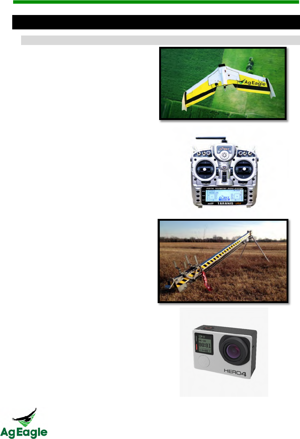
9#313*64&
<$1,+/./&#$&4(.&=5>&
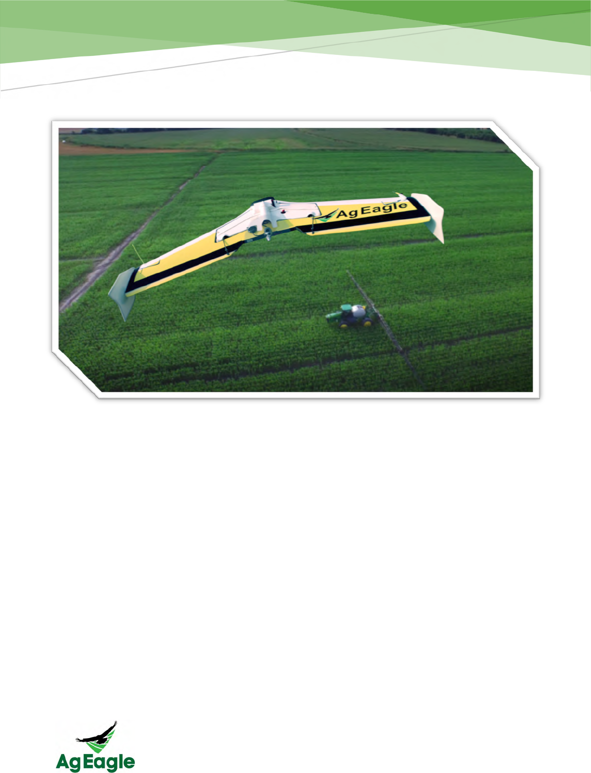
RX60 Flying Wing
Taranis RC Radio
Aircraft Launcher
GoPro Camera Modified for Measuring
Crop Health
(Near-Infrared)
Ground Support Equipment

RX60 User Manual Rev. 12 (8/26/2016)
©2016 AgEagle Aerial Systems. All Rights Reserved. 10 | Page
?.8&@.*4+3."&
• Strong Carbon Fiber Reinforcement
- Carbon fiber infused and incased airframe.
- This provides the end user with a more rugged and durable system.
• Automatic Flight
- From launching to landing, the entire time the aircraft is in the air there is no
need for pilot control inputs!
• Easy-to-Use Flight Planning
- Simply click around the field your wish to fly and the scan pattern is
automatically created. You can adjust for altitude, path width and other
details quickly and easily.
• Easy post flight processing
- After the flight, simply allow the images to transfer from the camera to the
XRD and be combined with inertial data for each image. The image files and
JSON logs can be uploaded to the Botlink processing server for hassle free
aerial map creation.
RX60 User Manual Rev. 12 (8/26/2016)
©2016 AgEagle Aerial Systems. All Rights Reserved. 11 | Page
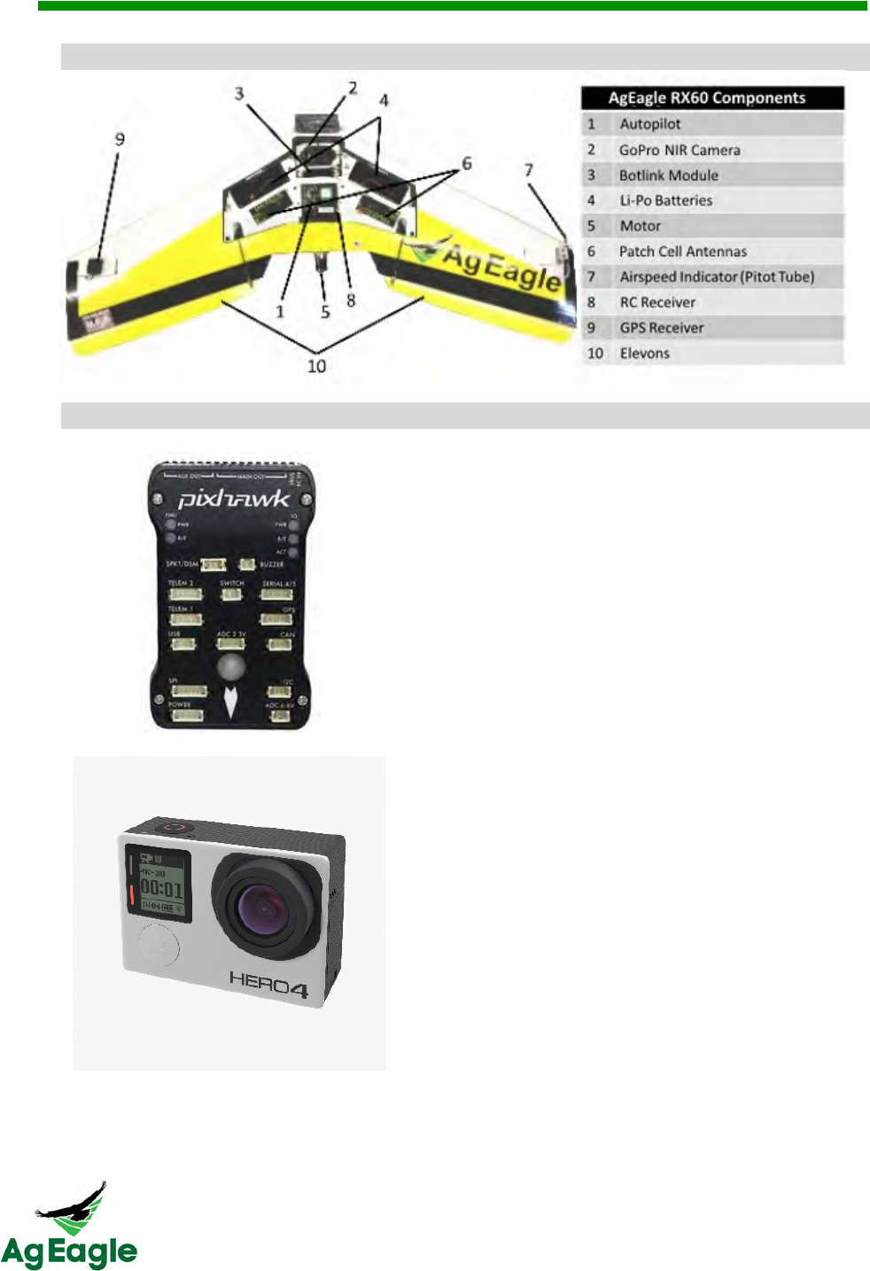
AB.3B#.;&
C*3/;*3.&
Autopilot
• Advanced autopilot system based on
the PX4 open-hardware project.
• Records flight information on
removable SD card.
GoPro NIR Camera
• Modified to allow infrared photos to be
taken.
• Provides a stable photography
platform and high quality images.
GPS Receiver
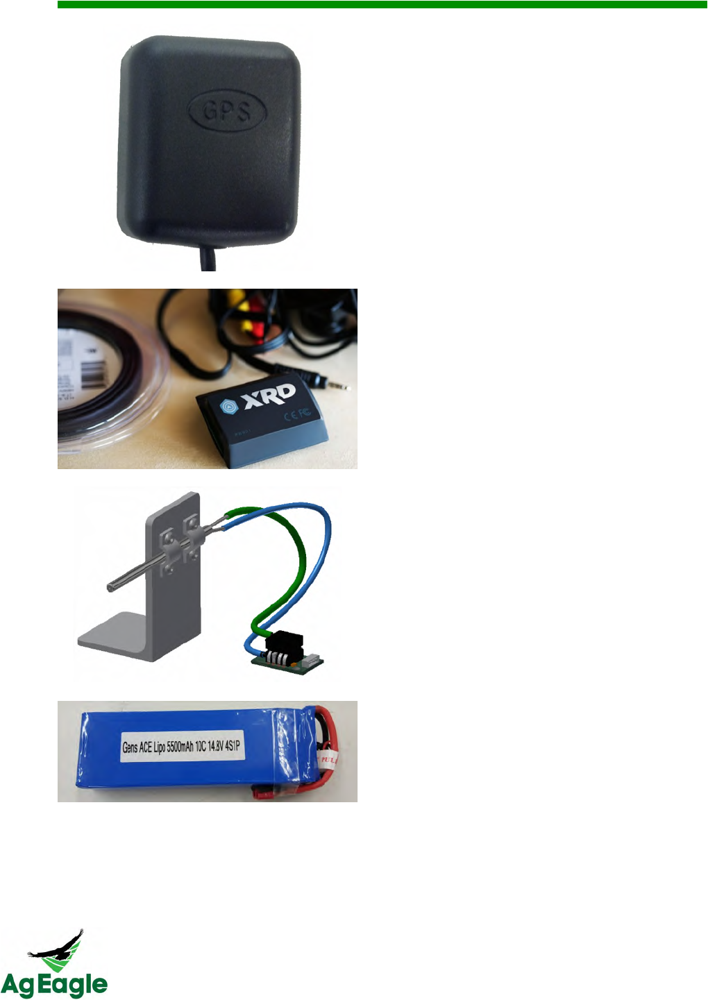
RX60 User Manual Rev. 12 (8/26/2016)
©2016 AgEagle Aerial Systems. All Rights Reserved. 0 | Page
• High accuracy GPS antenna.
• Provides location-based signal to the
autopilot to ensure that the mission
plan is being correctly followed.
Botlink Module
• Manages flight data, aerial imagery
and pilot controls
Airspeed Indicator
• Provides autopilot with airspeed
readings.
• Critical component for accurate
autopilot tracking and flight.
2 x Batteries
• 5500 mAh capacity
• 14.8V 10C
• Four Cell
• You must use the batteries sold from
your Raven dealer. (Do not use the
3300 cell batteries from previous
AgEagle system)
Patch Antennas
RX60 User Manual Rev. 12 (8/26/2016)
Patch antennas (currently not used)
NOT PICTURED IN DIAGRAM
Servos
• Actuates the control surfaces to
control aircraft.
• Top quality servos to ensure reliability
and longevity.
Electronic Speed Controller (ESC)
• Used to control the power that is sent
to the motor.
• Communicates to the autopilot system
to accurately control propeller RPMs.

RX60 User Manual Rev. 12 (8/26/2016)
©2016 AgEagle Aerial Systems. All Rights Reserved. 11 | Page
D.1522.$/./&EF*3.&G*34"&-#"4&
!
Here’s a list of recommended spare parts:
• Propeller (12 x 6, included in your ground support kit)
• Propeller Collet (included in your ground support kit)
• 2" Ext Launcher Springs (can be ordered from Raven)
• Lipo Battery Checker (included in your ground support kit)
• Socket Head Cap Screws M3 x 8
• Nylon Washer (included in your ground support kit)
• Pitot Tube Cleaner Assembly (included in your ground support kit)
• Winglets (extras can be ordered from Raven)
• Screw Driver Set (included in your ground support kit)
• Ball Wrench 2.4 mm (included in your ground support kit)
• Camera Lens Cleaning Kit (included in your ground support kit)
• Operators Manual (included in your ground support kit)
RX60 User Manual Rev. 12 (8/26/2016)
©2016 AgEagle Aerial Systems. All Rights Reserved. 12 | Page
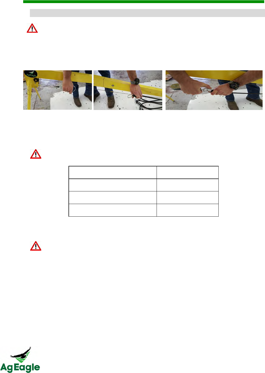
D.1522.$/./&E8"4.2&)*#$4.$*$1.&
This list describes the checks that should be done regularly to your system. Failing to do
these checks and keeping the system maintained can result in system failure.
It is the drone operator's responsibility to conduct a thorough preflight of each component
for a successful flight
Check Daily:
• Ensure antenna on Taranis Radio Controller is at a 90 degree angle for best
connection range
• Check winglets for security with nylon screws
• Always use fully charged batteries
• Check Pitot tube (airspeed tube) for any obstructions/mud or pinched/damaged
tubing. This is done by looking down the Pitot tube. If clear, you should be able to
see light
NEVER blow into the pitot tube to clear obstructions! This can damage the
sensor beyond repair and result in aircraft failure.
• Pull servo control rods to ensure good connection to servo and elevon
• Check security of motor mounting
• Check propeller to ensure it is securely fastened. The writing on the propeller should
be facing the aircraft. Make sure no debris (mud, dirt, etc.) is stuck to the prop
• Confirm GPS is securely attached
• Check aircraft for any damage from previous flights
• Check elevons to ensure they have full range of motion. (Do not move the elevons
rapidly)
• Check nose bumper for security
• Check camera lens for cleanliness
• Check launcher lugs on bottom of aircraft to ensure they are securely attached
• Check winglet thumbscrews. Ensure they are tight and don’t pull out
• Check pitot tube stand for security
• Check tubing to pitot for cuts or pinches
• Check connection between the camera and the Botlink XRD
• Check launcher carriage, ensure it is properly sliding on rail
Check Yearly:
• Change motor every 8,000 acres flown
• Replace batteries with any sign of damage
RX60 User Manual Rev. 12 (8/26/2016)
©2016 AgEagle Aerial Systems. All Rights Reserved. 13 | Page
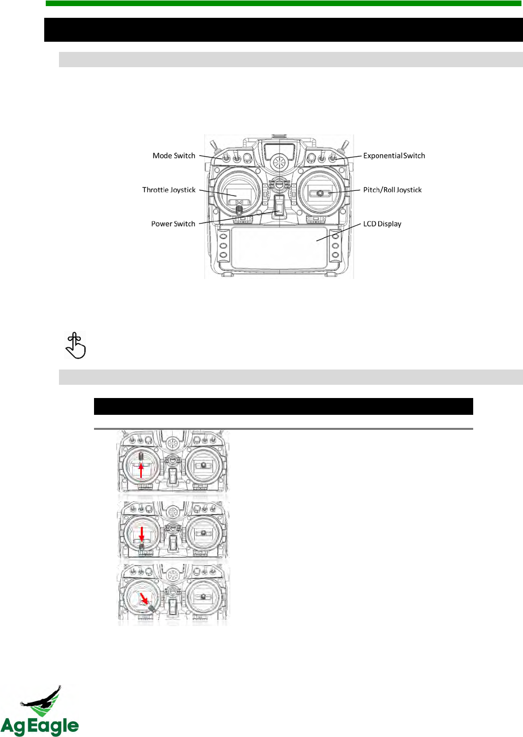
C*$/(.,/&@,#%(4&75$435,,.3&
AB.3B#.;&
The FrSky Taranis X9D is a radio transmitter used to control the aircraft. The primary
purpose is to set up the aircraft and provide a means for manual control if needed. The
majority of flying is done from the autopilot and will only require active use of the radio
during set-up and takeoff, as well as flaring the aircraft during landing.
Please make note of the neutral positions of the joysticks. The throttle (left) joystick is
zeroed at the lowest centered position. While the pitch/roll (right) joystick is zeroed at the
center position.
The throttle joystick does not automatically reset the forward/backward position
while the pitch/roll joystick will automatically center.
75$435,"&*$/&AF.3*4#5$&
Left Stick Operation
Movement Direction
Input
Aircraft Response
Throttle 100%
Propeller Rotates
Throttle 0%
Propeller Stops
Fully Arming
Position
Long Tone
*when successful
RX60 User Manual Rev. 12 (8/26/2016)
©2016 AgEagle Aerial Systems. All Rights Reserved. 14 | Page
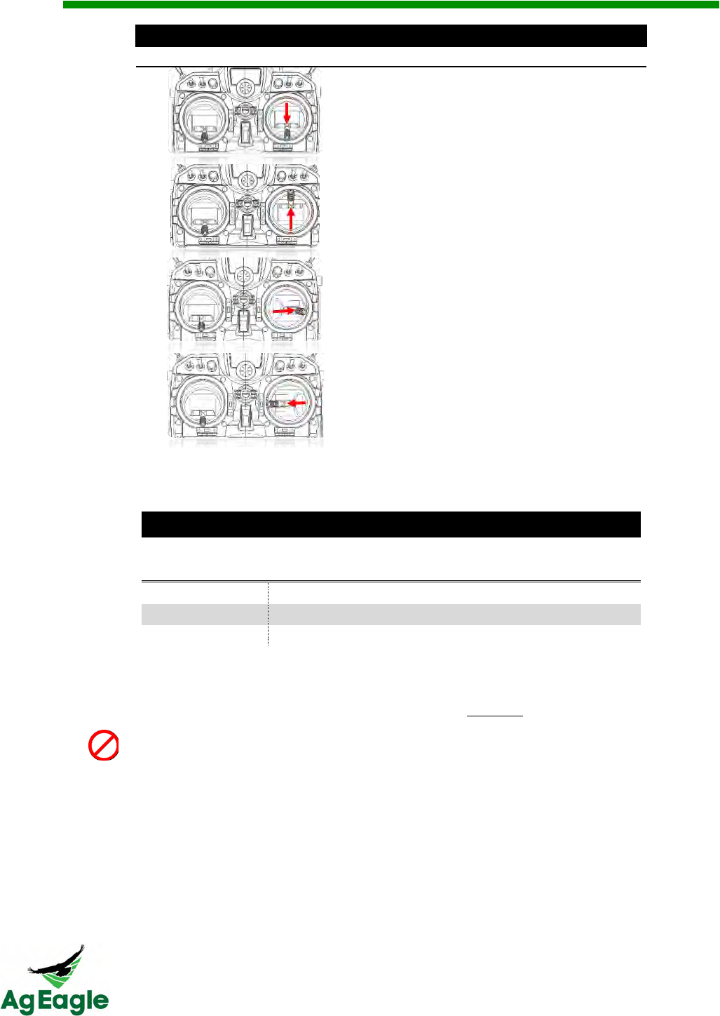
Right Stick Operation
Movement Direction
Input
Aircraft Response
Pitch Up
Both Elevons Up
Pitch Down
Both Elevons Down
Roll Right
Right Elevon Up
Left Elevon Down
Roll Left
Right Elevon Down
Left Elevon Up
Switch Operation
Switch Position
Left Switch
(Mode Switch)
Right Switch
(Exponential Switch)
Top
Manual (FBWA)
High Control Response
Middle
RTL
Moderate Control Response
Down
Auto
Mild Control Response
The trim switches are active on the controller. NEVER press on the trim
switches (The trim switches can be confirmed to be centered by observing the
(-) on the LCD display of the Taranis. If the dot is not centered in the middle of
the ( ) move the trim switch until it is centered in the ( ). Do NOT fly if the trim
switches have been changed from center.

RX60 User Manual Rev. 12 (8/26/2016)
©2016 AgEagle Aerial Systems. All Rights Reserved. 15 | Page
Flight

RX60 User Manual Rev. 12 (8/26/2016)
©2016 AgEagle Aerial Systems. All Rights Reserved. 16 | Page
AF.3*4#5$*,&@,8#$%&75$/#4#5$"&
• Avoid flying in adverse weather conditions including rain, sleet, snow, fog and wind
conditions exceeding 30 mph.
• Only fly in open areas with no obstacles or obstructions.
• Avoid flying near large structures; large metal buildings may have an adverse effect
on the onboard compass.
• Never fly over populated areas or busy roadways.
• Avoid flying close to electromagnetic producing devices (i.e. radio towers, cell
towers, etc.)
• Avoid launching downwind of trees or buildings as severe turbulence may be
encountered.
@,#%(4&-#2#4"&*$/&H5&@,8&I5$.&
RX60 operators should follow all regulations set forth by aviation regulation organizations
such as the Federal Aviation Administration (FAA), International Civil Aviation Organization,
Transport Canada and local aviation authorities. Please research local laws and/or
regulations to ensure you are flying legally.
RX60 User Manual Rev. 12 (8/26/2016)
©2016 AgEagle Aerial Systems. All Rights Reserved. 17 | Page
<$#4#*,&E.4+F&J&7*,#K3*4#5$&
Pre-Arming Sequences
It is the drone operator's responsibility to conduct a thorough preflight of each component for a
successful flight
1. Setup launcher and aim into the wind, and install the launcher legs
2. Arm and lock the trolley into the launch position and install the safety pin.
The amount of bungee cords needed for launch may vary depending on wind
speed. On average, 6-8 should be sufficient while higher wind speeds may
require fewer bungees.
The bungee cords may lose some strength over time due to heat and sunlight
degradation. Replace launcher bungees yearly.
3. Install winglets and fully charged batteries.
Inspect each battery. If damaged or puffy, DO NOT FLY! Replace with new
battery. See the Charger and Batteries section for further details.
4. Check elevons to ensure they have full range of motion. Do not move the elevons
rapidly.
5. Check Pitot tube (airspeed tube) for any obstructions/mud or pinched/damaged tubing.
This is done by looking down the Pitot tube. If clear, you should be able to see light
through the Pitot tube. If plugged, pull off tubes before cleaning with Pitot tube rod
included in the ground support kit.
NEVER blow into the pitot tube to clear obstructions! This can damage the
sensor beyond repair and result in aircraft failure.
The plastic pitot tube connected to the center port of the metal pitot tube must
be connected to the top port of the airspeed sensor
6. Pull servo control rods to ensure good connection to servo and elevon
7. Ensure the servos are securely attached to the wing and not loose
8. Place aircraft on level surface on ground. Leave the aircraft in this position until the
Takeoff section is reached.
Do not place the aircraft on launcher at this time!
RX60 User Manual Rev. 12 (8/26/2016)
©2016 AgEagle Aerial Systems. All Rights Reserved. 18 | Page
9. Make sure the micro-SD card is inserted in the XRD (The maximum SD card that can be
installed in the XRD is 32GB). Turn on the aircraft using the power plug. This will start
the calibration procedures, it’s important that the aircraft is not disturbed during this
process.
Do not disturb aircraft during calibration process! Wait at least 45 seconds
before pre-arming the aircraft.
10. Turn on the GoPro camera. Press and hold the side wrench button to turn on the
camera’s Wi-Fi. The camera will blink blue when Wi-Fi is on.
11. The camera during this process should make 1 chirp, then 3-5 seconds later make 5
chirps. (About one minute after turning the aircraft on). This ensures the camera is
wirelessly connected to the Botlink Co-Pilot. (Do not proceed to the next step until the
camera is confirmed to be connected)
12. Turn on Taranis Radio Controller, and confirm setting is in MANUAL with the throttle (left
stick down) at the bottom.
Aircraft propeller may turn on if the aircraft senses movement and the Taranis is
in AUTO. For safety, make sure Taranis is in MANUAL with the throttle down.
13. Press and hold the pre-arm button on aircraft until it shows a solid red light.
When all pre-arming conditions are met, you will hear a “happy” tone (3 tone)
from the autopilot.
Pre-Arming Conditions
• Barometer Calibrated
• Compass Calibrated
• GPS Lock
• INS Calibration Complete
• Parameter Checks
• Airspeed Sensor Functioning
14. Immediately after the “happy” tone is heard, move the left control stick of the flight
controller to the lower right corner.
NEVER allow the left stick to be pushed forward during the pre-arming
sequences. This can cause the propeller to start spinning unknowingly.
Wait until a long solid tone is emitted from the Autopilot. This will indicated that
the aircraft is FULLY ARMED.
15. As soon as the long solid tone is emitted press and hold the pre-arm button until it starts
flashing, this will indicate that the aircraft is calibrated but disarmed.
RX60 User Manual Rev. 12 (8/26/2016)
©2016 AgEagle Aerial Systems. All Rights Reserved. 19 | Page
Mission Planning
16. Open the Botlink application.
If this is your first time flying, go to the section Botlink First Flight (Page 30)
17. Press the 3 line Menu button in the upper left corner
18. Press Connect To Drone and connect to your aircraft
18.1. If you are flying over telemetry radios, select the drone profile that is set up
with the telemetry connection (Example name: USB001)
19. Press the Menu button and select Missions. In the lower right hand corner, press the
plus button and select the Survey option
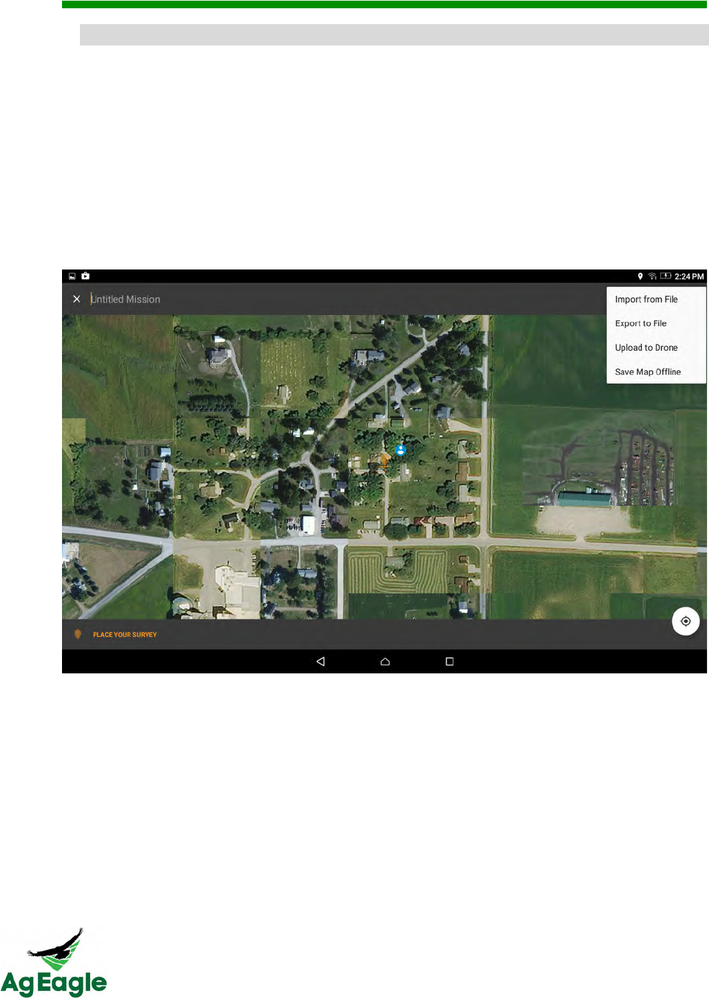
20. Pan to the field that you would like to survey and press Place Your Survey
21. Move the area to fit your field, and set the Altitude and Overlap. You may also name
your mission
21.1. Read the Overlap and Sidelap portion of the manual for any questions
concerning how much overlap you need
22. Once you are satisfied with the flight area, press Save in the upper right corner to save
your mission
23. Select the mission you just created, and press the Upload to Drone button (lower right
hand corner, image of a plane taking off)
Sensor Calibration
24. The first preflight calibration on Botlink is to set the wind direction. Slide the slider in the
upper right hand corner to Manual, and select on the compass where the wind is
coming FROM. Press Next when complete.
25. Follow the instructions on the screen and run the airspeed calibration. After pressing
the “start airspeed calibration” cup your hands over the Pitot tube to protect it from the
wind. Do not hold your finger over the end of the Pitot tube. Press Next when
complete.
Make sure shown airspeed is fluctuating between 2-7 mph after calibration.
The Botlink application will tell you if the calibration is a success (If the
airspeed is not fluctuating between 2-5 mph do not fly! There may be an
obstruction in the pitot tube. Flying with an obstructed pitot tube will cause a
crash)
26. Next step is to choose your camera. Select your camera profile from the drop down
menu. If your camera is already connected, it should be already selected in the drop
down menu. Press Next when complete.
27. Press the Next button, (we don’t test the motor on the aircraft using the Botlink app for
skip this step)
28. Aim your aircraft for takeoff and press Next.
29. Set the loiter area and the landing area. Make sure you land into the wind.
RX60 User Manual Rev. 12 (8/26/2016)
©2016 AgEagle Aerial Systems. All Rights Reserved. 20 | Page
The landing sequence will be added once the survey has been finalized. Make
sure to plan your landing with enough room in case of adverse flight conditions.
The planning purposes the distance between the center of the loiter to the
desired landing location can be set from a minimum of 600 feet to a maximum
distance of 800 feet.
30. Press the Upload button to write the mission to the aircraft.
31. Install the white covers back onto the aircraft.
Make sure that the mode switch is still in the manual position prior to moving
the aircraft.
'*:.566&J&@,#%(4&
Final Checks &Takeoff
32. Place the RX60 onto the launcher making sure that all four arms are properly fit into the
launch lug receiver notches on the bottom of your aircraft.
DO NOT allow anybody to walk in front of the armed launcher. Accidental
launches can happen and may cause serious injury to anybody in front of the
launcher!
33. Approach the aircraft from the nose and arm the aircraft by pressing the pre-arm button
until it is illuminated solid red. (Do not reach over the propeller! The motor may
inadvertently start up. Always keep hands, arms and fingers away from the propeller!)
At this point the aircraft is fully armed and ready to fly. Treat the aircraft very
carefully and DO NOT allow anybody to get close to or stand to the side of the
propeller! Any bump or sudden movement of the drone may engage the motor.
34. Make sure that the elevons deflect down when armed, this will indicate that the aircraft
is still in manual mode (When the aircraft is on the launcher).
35. Check for proper aircraft operation using the flight controller.
35.1. Move the right stick down and observe that the elevons deflect up.
35.2. Move the right stick up and observe that the elevons deflect down.
35.3. Move the right stick left and observe that the left elevon deflects up.
35.4. Move the right stick right and observe that the right elevon deflects up.
Inspect the push rods to make sure nothing is loose or broken, also make sure
the elevons move smoothly and don’t jerk or jump around. This could indicate
that a servo has become damaged. Also make ensure the servo’s are securely
attached to the wing and are not loose.
RX60 User Manual Rev. 12 (8/26/2016)
©2016 AgEagle Aerial Systems. All Rights Reserved. 21 | Page
36. Make sure nobody is near or to the side of the propeller and announce to any
bystanders “Motor test, clear prop!” Slowly move the left stick up to about ¼ throttle
and hold for 3-4 seconds. The propeller should spin and you should feel airflow behind
the aircraft.
Inspect the propeller and make sure that it is not loose or showing excessive
vibration during this test.
NEVER fly the aircraft if any component is loose, missing or damaged!
37. Toggle the mode switch between Manual and Auto position. Make sure that the elevons
move drastically between the modes. Do not pause in the middle mode (RTL) move the
mode switch swiftly between modes not hesitating in the RTL mode. Doing so will
cause flaws in the written flight plan .
If the elevons don’t move drastically in the UP direction (If the elevons are flat
or turned downward), the mission isn’t loaded on the aircraft. Do NOT fly if the
elevons did not move up! Return to step 10 if this happens, and set your mode
switch to Manual. Also if there is any question if the mode switch was paused
in the RTL position, go back to step 10.
38. Remove the launcher safety pin and announce to bystanders, “Launcher is armed!”
Keep the safety pin on your person after removal; do not place on the ground.
39. Do another final check that both elevons are deflected up and that the airspeed is
fluctuating and not exceeding 7 mph. (as indicated on the tablet)
40. Hold the right stick of the flight controller straight back and observe that the elevons
deflect up slightly higher.
41. While holding the right stick back, approach the launcher and depress the foot pedal to
launch the aircraft.
Keep the right stick back until the aircraft is airborne for at least 5 seconds.
-*$/#$%&
1. Once aircraft has completed the mission, it will start its landing procedure.
2. The aircraft will circle at the area that you specified when setting up the mission.
3. Once aircraft is below 125 feet, it will come in for the final approach
Check that both elevons deflect UP by the same amount, about 18 degrees.
This will indicate that the aircraft is ready to fly with autopilot.

RX60 User Manual Rev. 12 (8/26/2016)
©2016 AgEagle Aerial Systems. All Rights Reserved. 22 | Page
4. The RX60 will automatically land, but flaring the aircraft about 5-7 feet off of the ground
will help for a softer landing
“Flaring” is to gently pull the right stick of the Taranis back (to the bottom). This
will bring the nose of the aircraft up, and slow down
5. Change modes from AUTO to MANUAL after landing, and make sure your throttle is all
of the way down.
6. Keep your aircraft on until all of the images have transferred to the XRD. IF YOU TURN
OFF THE PLANE BEFORE THE IMAGES FINISH TRANSFERING, THE IMAGES WILL
CONTINUE TO TRANSFER WHEN TURNED BACK ON. You can fly during the day and
unplug after flight, but turn the aircraft back on at the end of all of your flights to transfer the
images to the XRD.
G5"4L@,#%(4&
Keep the aircraft on until your tablet gives the notification that the images have
successfully transferred from the GoPro to the XRD. IF YOU TURN OFF THE PLANE
BEFORE THE IMAGES FINISH TRANSFERING, THE IMAGES WILL CONTINUE TO
TRANSFER WHEN TURNED BACK ON. You can fly during the day and unplug after
flight, but turn the aircraft back on at the end of all of your flights to transfer the images
to the XRD.
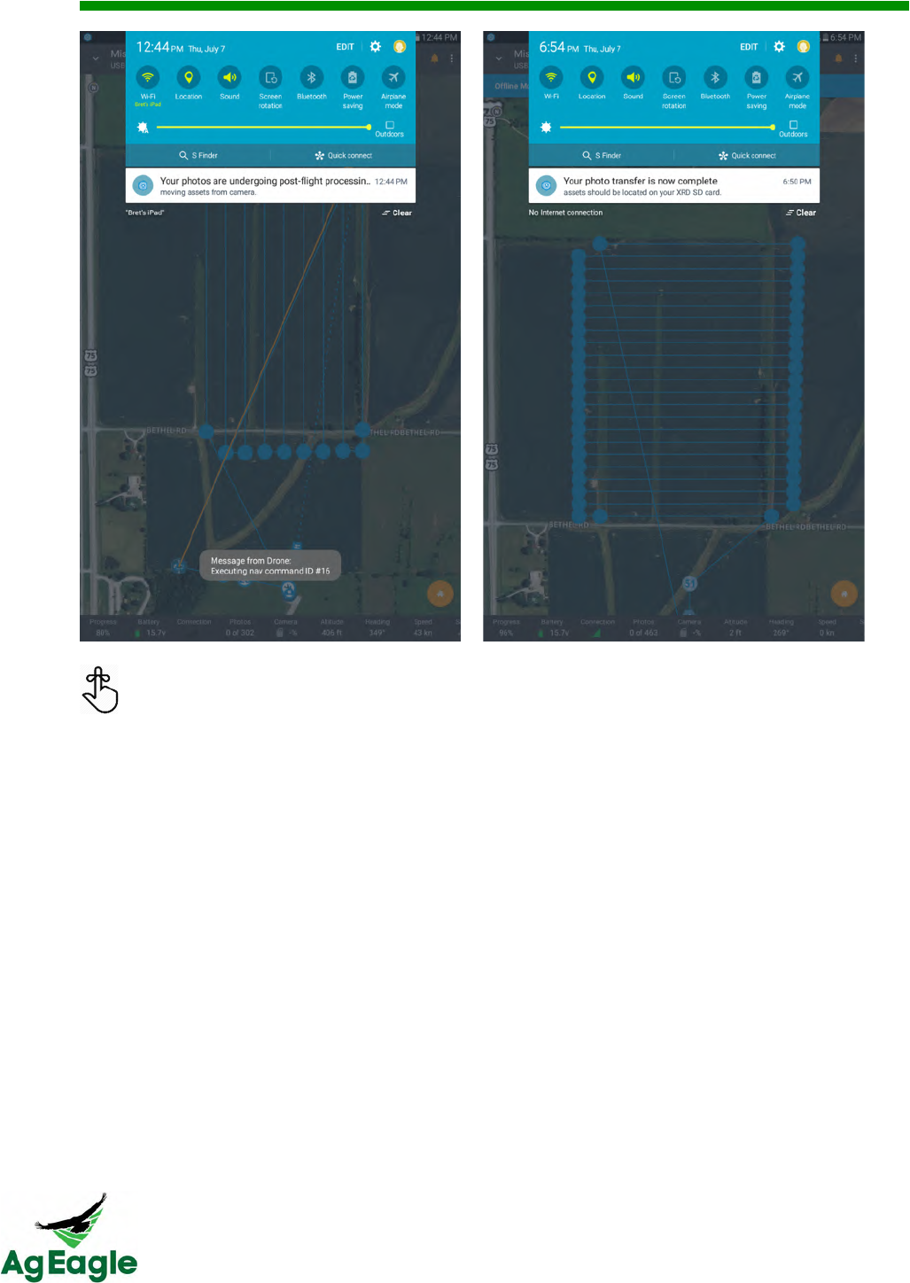
When the images start to transfer from the camera to the XRD, your tablet will get a
notification that lets you know that your photos are undergoing post-flight processing
(picture on the left). When the image transfer from the GoPro to the XRD is complete, you
will get another notification letting you know (picture on the right). To see your notifications,
drag down from the top of the screen.
RX60 User Manual Rev. 12 (8/26/2016)
©2016 AgEagle Aerial Systems. All Rights Reserved. 23 | Page
Once the mission is complete and you have uploaded the images from the sd card in
the XRD, you can log ontoand view the processing of the map. The image will be
located in your Queue.
After flight, you will need to upload the image set to the stitcher. To learn how to do this,
visit the Uploading Offline Flight Images section of this manual.
After the images have successfully transferred from the GoPro to the XRD,
make sure to turn the GoPro off and the Wi-Fi off so the battery doesn’t die
before your next flight

RX60 User Manual Rev. 12 (8/26/2016)
©2016 AgEagle Aerial Systems. All Rights Reserved. 24 | Page
G3.L6,#%(4&G351./+3."&J&7(.1:,#"4&
AgEagle RX60 MODEL AGERGBL915 - 8/24/16 RED 10/04/16
Follow this checklist for each and every flight
□ Check Pitot tube for any obstructions (look down Pitot tube to see obstructions)
□ Check the pitot tube for security and tubing is free from holes or pinched areas
□ Pull servo control rods to ensure good connection to servo and elevon
□ Ensure that the servos are securely attached
□ Install camera, winglets, propeller and fully charged batteries
□ Place aircraft on level surface on ground
□ Turn on AgEagle with power plug (Do not move drone for 60 seconds)
□ Turn on Camera and the Wi-Fi on the camera
□ Listen for 6 beeps from the camera before the next step
□ Turn on Taranis flight controller, place in manual mode with throttle down
□ Press the pre-arm button on plane until the light glow continuously
□ Arm the aircraft once you hear the 3 tone (happy tone) by holding the left stick on
the Taranis to the bottom right side until a long tone is heard
□ Press the pre-arm button to disarm until the light blinks
□ Open the Botlink App and connect to the correct aircraft
□ Clear the memory on the camera and the XRD from the app
□ Set up mission plan in Botlink App
□ Set the landing location clear of obstacles and the loiter area is downwind on the
Botlink App
□ Run the airspeed calibration on the Botlink app while cupping your hand over the
Pitot tube. While doing so check again for holes in tubing or pinches.(Do not
press your finger over the end of the Pitot tube!)
□ Write the mission plan from Botlink App to the drone Place aircraft on launcher
facing into the wind (Use caution not to drop or make sudden moves as the motor
will engage if bumped)
□ Press the pre-arm button to fully arm the plane (button turns solid red)
□ Test elevons for correct movement with Taranis in manual mode and test the
motor / propeller
□ Swiftly move the mode switch on the Taranis to the AUTO MIDE = bottom position
□ Check that elevons are BOTH UP. DO NOT LAUNCH IF BOTH ARE NOT UP!
□ Hold the right stick of the Taranis to the bottom if winds are light
□ Launch the aircraft
□ Release the right stick when the drone launches
RX60 User Manual Rev. 12 (8/26/2016)
©2016 AgEagle Aerial Systems. All Rights Reserved. 25 | Page
Follow these steps following each flight
□ Disarm the drone by holding down on the “pre-arm” button until it begins blinking
□ Leave drone on to allow the images to be transferred from the camera to the
computer (Do not travel with the AgEagle on in the car). IF YOU TURN OFF THE
PLANE BEFORE THE IMAGES FINISH TRANSFERING, THE IMAGES WILL
CONTINUE TO TRANSFER WHEN TURNED BACK ON.
□ Turn off the Taranis radio and charge if necessary
□ Monitor the progress of the image transfer from the app, once transferred:
o Turn off the drone (unplug the power plug)
o Turn off the camera and the camera WiFi
□ Remove micro SD card from the XRD computer
□ Upload the image sets to your flybotlink.com web portal for processing
Preparing for next flights
□ Charge drone batteries
□ Charge camera
□ Charge Taranis
□ Charge tablet device
□ Prefetch background maps for next flight areas
□ Have extra micro SD cards handy for next flights

RX60 User Manual Rev. 12 (8/26/2016)
©2016 AgEagle Aerial Systems. All Rights Reserved. 26 | Page
Botlink

RX60 User Manual Rev. 12 (8/26/2016)
©2016 AgEagle Aerial Systems. All Rights Reserved. 27 | Page
!".3&<$4.36*1.&
Botlink can be accessed by using an Android tablet and the Botlink application on the
Google Play Store.
Familiarize yourself with the home screen. Reading this screen correctly will allow you to fly
safer, smarter, and faster than ever before
RX60 User Manual Rev. 12 (8/26/2016)
©2016 AgEagle Aerial Systems. All Rights Reserved. 28 | Page
A$,#$.&=54,#$:&MD0&D.%#"43*4#5$&
To activate your XRD for its first flight, there are a few simple steps.
1. Fill out the XRD Billing Form
a. Monthly Plan
i. https://botlink.formstack.com/forms/xrd_monthly
b. Yearly Plan
i. https://botlink.formstack.com/forms/xrd_yearly
2. As long as the billing information was processed correctly, a Botlink Support agent will
receive the request and begin processing. Once we process the activation request it may
take up to 48 hours before the XRD will be active.
A Botlink Support agent will reach out to the customer once we get confirmation of the
completed activation.
Once hitting "Submit" within these forms the credit card information entered will
be automatically processed.
RX60 User Manual Rev. 12 (8/26/2016)
©2016 AgEagle Aerial Systems. All Rights Reserved. 29 | Page
!F/*4#$%&N5+3&=54,#$:&MD0&
MAKE SURE YOUR AIRCRAFT HAS AT LEAST 50% BATTERY BEFORE STARTING
THE UPDATE.
Download the update file from Botlink, and use your computer to transfer the file onto your
XRD’s microSD card. Insert the microSD card back into your XRD and power on your
aircraft. The XRD will automatically update itself, and you can monitor the update by
watching the LED on the XRD. It will blink normal for a while, then shut off as it is restarting
itself. Once the LED comes back on, the update is complete, and you will be able to
reconnect to the aircraft in the Botlink app. This process should take less than 20 minutes.
RX60 User Manual Rev. 12 (8/26/2016)
©2016 AgEagle Aerial Systems. All Rights Reserved. 30 | Page
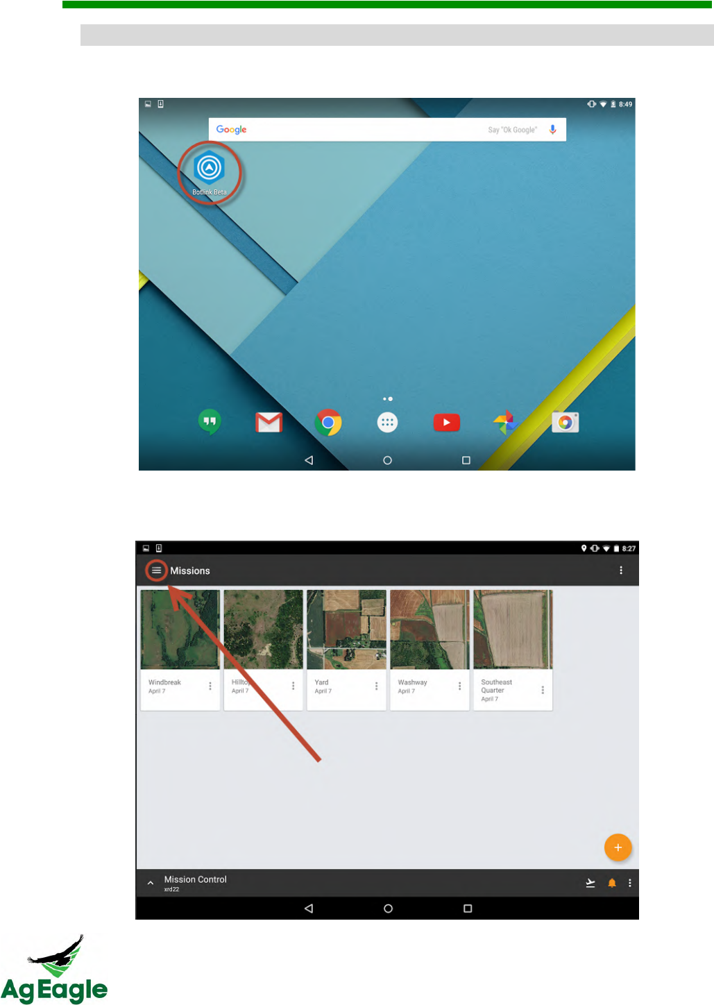
=54,#$:&@#3"4&@,#%(4&
1. Open the Botlink app (application) on Tablet
2. Once the app is opened, select the hamburger (three-lined menu drawer) icon in the
upper left hand corner to access the main menu.
RX60 User Manual Rev. 12 (8/26/2016)
©2016 AgEagle Aerial Systems. All Rights Reserved. 31 | Page
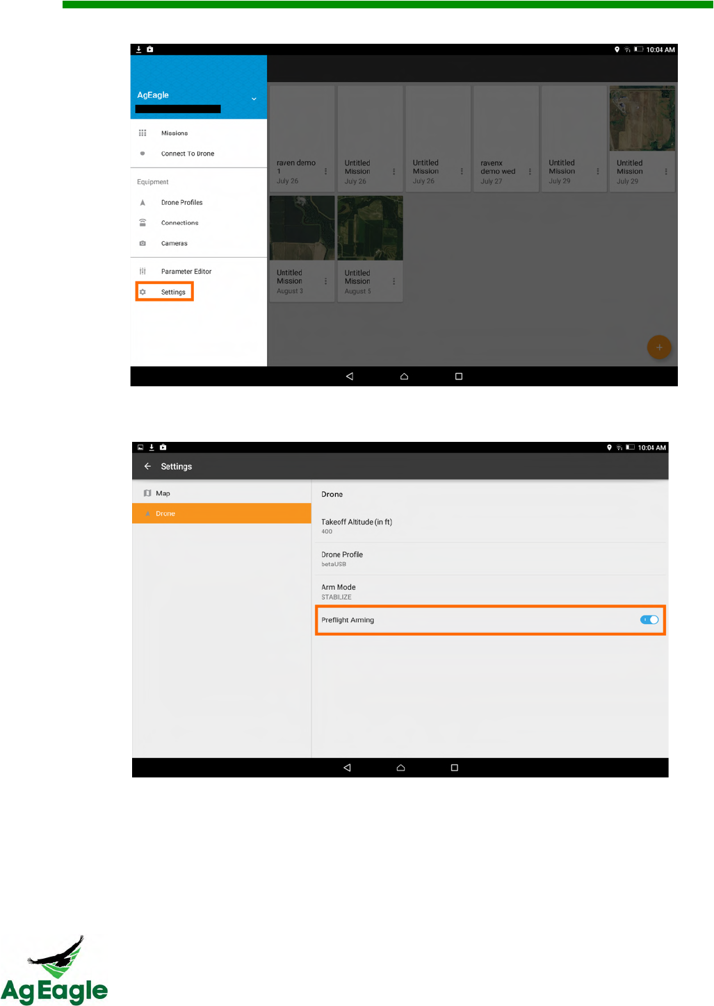
3. Go to the Settings option
4. Select “Drone” in settings, and make sure the “Preflight Arming” is turned ON
RX60 User Manual Rev. 12 (8/26/2016)
©2016 AgEagle Aerial Systems. All Rights Reserved. 32 | Page
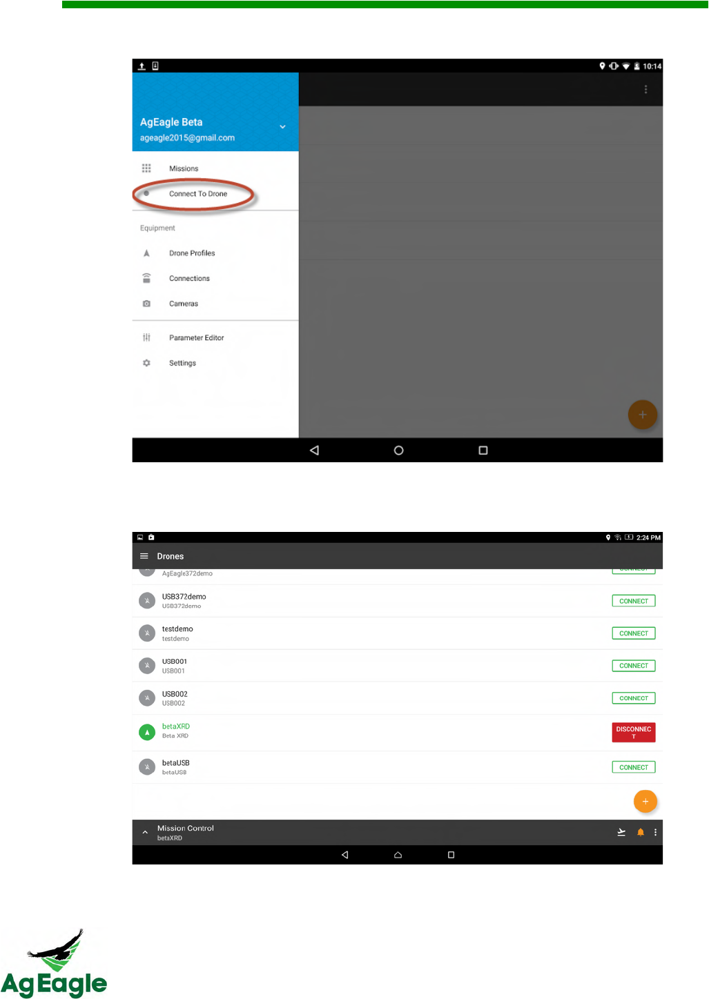
5. Press the Menu button again and select the Connect to Drone option.
6. Select the overflow (three vertical dots) icon next to the drone being connected
NOTE: Select the USB connection (typical) for USB telemetry connectivity
RX60 User Manual Rev. 12 (8/26/2016)
©2016 AgEagle Aerial Systems. All Rights Reserved. 33 | Page
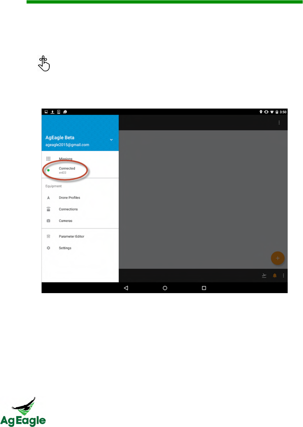
7. Once app starts to connect to the aircraft the app will advance to the Mission Control
page and provide status updates including:
a. Connection status of aircraft
b. Camera connection status
c. Flight alerts within the current airspace requirements
Selecting the alarm icon in the upper right hand corner will display connection
statuses and alerts.
8. Once the app is connected to the aircraft, the name of the drone profile will display under
the Mission Control heading AND it will display “Connected” in the main menu. To get to
the main menu use the down arrow (upper left hand corner) to navigate to the Missions
(Mission Planning) page and then use the hamburger icon.
9. To load an existing mission go to step 13.
RX60 User Manual Rev. 12 (8/26/2016)
©2016 AgEagle Aerial Systems. All Rights Reserved. 34 | Page
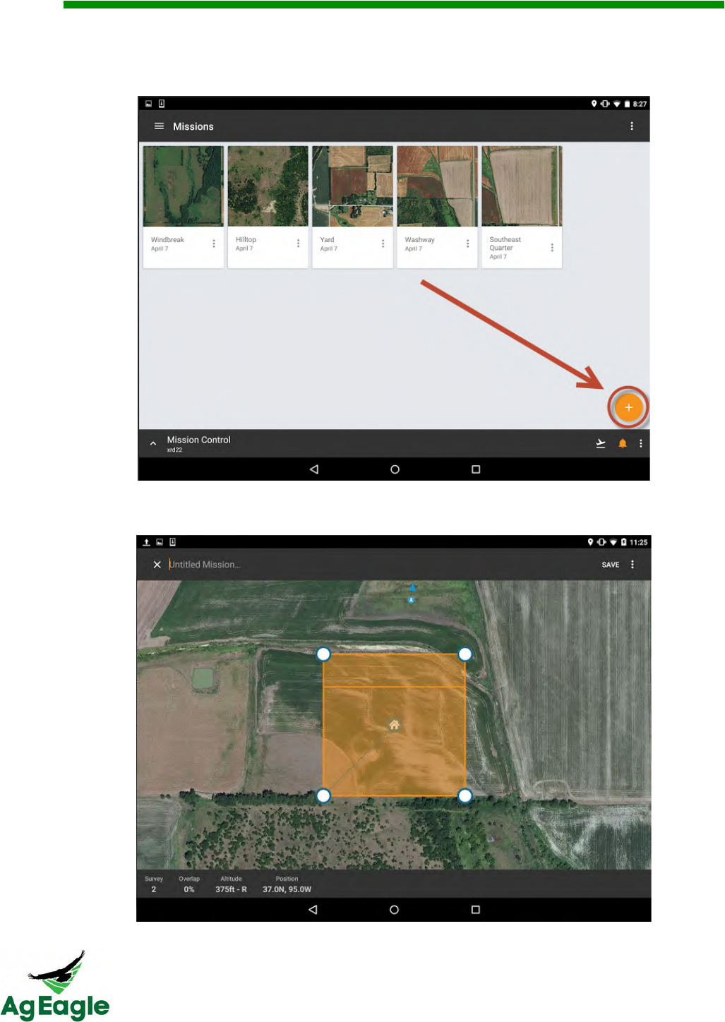
10. To create a new mission navigate to the Missions (mission planning) page. Select the
orange plus icon in the lower right hand corner and then select the green survey option
to create a new mission.
11. The screen will now advance to a map and allow entry of the field points and details of
the new mission.
RX60 User Manual Rev. 12 (8/26/2016)
©2016 AgEagle Aerial Systems. All Rights Reserved. 35 | Page
12. Name the mission, zoom in/out, and select Place Your Survey to define coordinates of
the field.
a. A default map will provide 4 points (white dot with blue border) to define
the default corners of the field.
b. Each point can be moved by touching the point and dragging it to a
specific point on the map.
c. To add additional points, single tap anywhere on the border of the
polygon and a new point will appear which can be dragged to any specific
point on the map.
d. To delete points, press and hold the point until an orange banner appears
with a trash can. Select the trash can to delete the point.
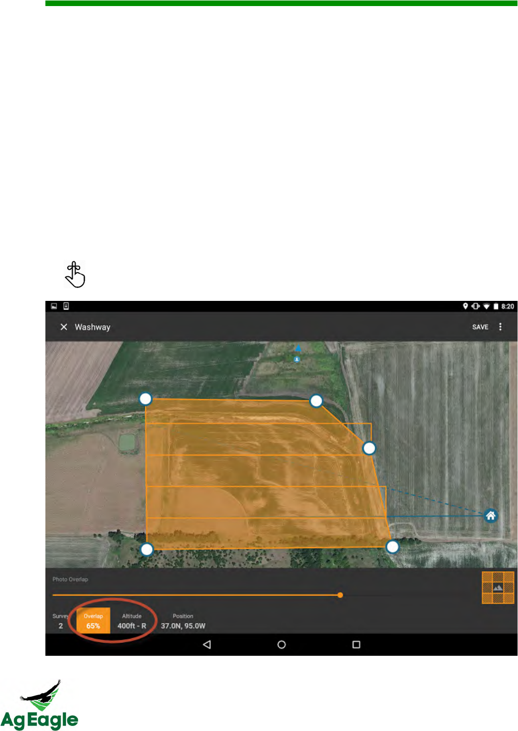
13. Select and define the Overlap and Altitude of the mission.
a. Overlap defines how much picture overlap is needed to properly stitch
and process the photos during the mission. Using a range of 60% to 75%
overlap will provide optimization for photo stitching.
b. Choose an altitude that abides with current local and federally mandated
regulations.
To deselect items on the bottom ribbon touch the bottom ribbon again.
RX60 User Manual Rev. 12 (8/26/2016)
©2016 AgEagle Aerial Systems. All Rights Reserved. 36 | Page
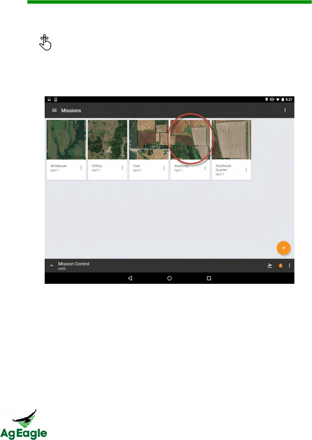
14. Once the field polygon is defined, select Save and the screen will advance to the
Missions (mission planner) page displaying all missions that have been saved.
If the mission is not saved, then there is risk that the created mission can be
lost and the user will have to start over.
15. Select the newly created mission or previously stored mission by single tapping the map
portion of the selected mission.
RX60 User Manual Rev. 12 (8/26/2016)
©2016 AgEagle Aerial Systems. All Rights Reserved. 37 | Page
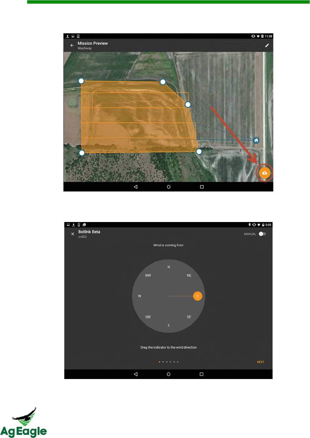
16. Select the orange cloud icon to set the current flight conditions and final aircraft
parameters. These are the final steps to complete prior to launch.
17. Deselect the auto compass calibration button in the upper right hand corner and then
manually select the direction indicator to match the current wind direction. When
complete, select the Next button.
RX60 User Manual Rev. 12 (8/26/2016)
©2016 AgEagle Aerial Systems. All Rights Reserved. 38 | Page
18. Ensure the “Air Speed” has a value above zero and is active before pressing the
Calibrate button. Cup hand around (not touching) the Pitot tube and then press the play
triangle to start the calibration process. Wait for the timer to count down and verify the
airspeed calibration was successful. When complete, select the Next button.
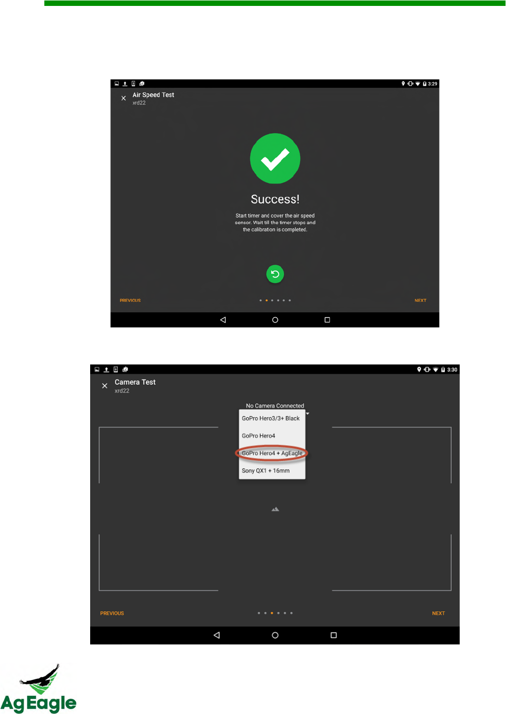
19. Select the drop down menu and select the “GoPro Hero4 + AgEagle” camera. When
complete, select the Next button.
RX60 User Manual Rev. 12 (8/26/2016)
©2016 AgEagle Aerial Systems. All Rights Reserved. 39 | Page
20. Motor Test is not used for the AgEagle RX60 aircraft. Do not use this feature. Select
Next.
21. The Take Off screen will illustrate a dashed green take off polygon that shows the
direction the aircraft should take off. The blue (orange outlined) polygon is illustrating
current orientation of the aircraft. Select the Next button.
Ensure both polygons are lined up prior to launch.
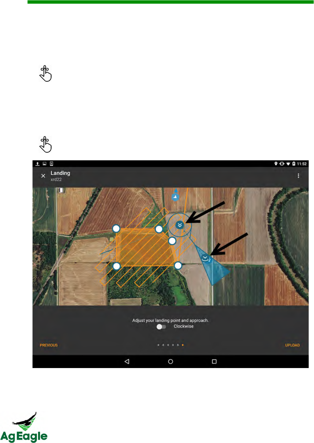
22. Zoom in/out to position the map to define the landing zone. Use the single white down
arrow to move the landing zone around on the map and use the double white down
arrow to orient the heading of the landing zone, position the loiter zone, and manipulate
the length of decent. Once landing zone is finalized, select the Upload button which will
send this mission to the aircraft.
The clockwise button changes the direction of the loiter in cases where wind may
affect the loiter placement.
RX60 User Manual Rev. 12 (8/26/2016)
©2016 AgEagle Aerial Systems. All Rights Reserved. 40 | Page
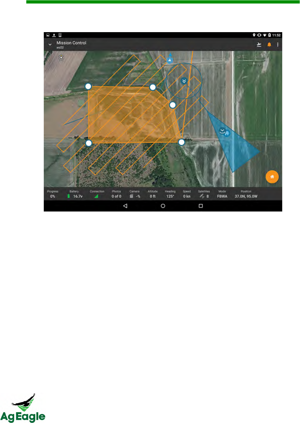
23. The screen will advance to Mission Control and the aircraft will be ready to use the
current mission once launched.
RX60 User Manual Rev. 12 (8/26/2016)
©2016 AgEagle Aerial Systems. All Rights Reserved. 41 | Page
=#$/#$%&7*2.3*"&
Most drones have some sort of sensor on-board, usually a camera, to accomplish a given
task. Through Botlink you can add and manage your sensors and their actions.
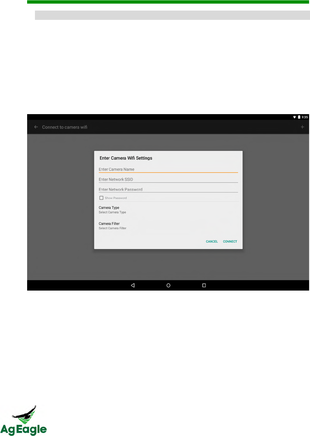
To connect to a camera you need to first be connected via a Drone Profile. Once connected
you can scan for Wi-Fi signals or manually connect using the plus button on the upper right.
Simply follow the on-screen directions to create a camera connection. Currently the only
cameras supported are the GoPro Hero 4 and Sony QX1.
Do not bind the camera to other devices! This can cause connection problems to the
aircraft.

RX60 User Manual Rev. 12 (8/26/2016)
©2016 AgEagle Aerial Systems. All Rights Reserved. 42 | Page
'#F"&653&=#$/#$%&4(.&O5G35&45&85+3&DMPQ&
1. Turn on the camera, then turn on Wi-Fi
2. Turn the aircraft on
3. Listen for the camera to connect. This usually is 5 or 6 beeps from the camera
4. Connect the tablet to the aircraft, and check to see if the camera is CONNECTED to
the plane
5. Turn on Handheld flight controller
RX60 User Manual Rev. 12 (8/26/2016)
©2016 AgEagle Aerial Systems. All Rights Reserved. 43 | Page
E*B#$%&)*F4#,."&RG3.6.41(#$%&)*F"S&
To fly your aircraft without any cellular data, you must prefetch maps on the Botlink map.
You will need to be connected to the internet to prefetch maps, so this process should be
done before you travel to the field.
1. In order to have maptiles while flying without a cellular connection between the internet
and your tablet you need to download them while you have an internet connection. So
before you leave your home or head into the dead zone make sure to open Botlink and
press More Options button (3 dot button in the upper right corner of your screen).
Select Save Maptiles to download them to your device. A small, orange loading bar will
appear on the bottom right of your screen to indicate the progress of the download.
RX60 User Manual Rev. 12 (8/26/2016)
©2016 AgEagle Aerial Systems. All Rights Reserved. 44 | Page
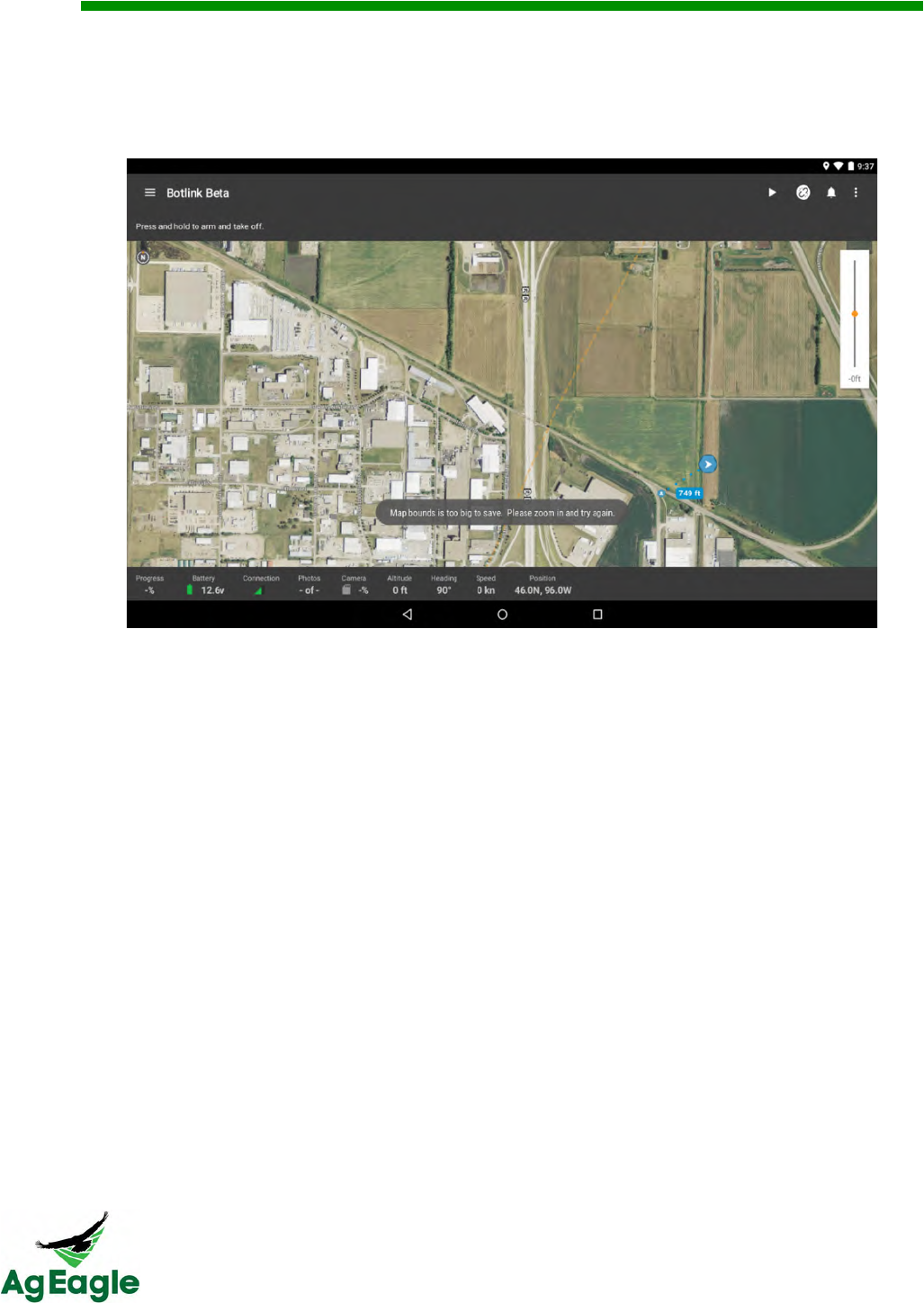
2. Make sure to be zoomed in fairly far in order to save the maptiles. The app will display a
message letting you know if you are still too far out to save the tiles. The good news
though is there is no limit to amount of maptiles you can download for offline use (aside
from the available space on your device).
RX60 User Manual Rev. 12 (8/26/2016)
©2016 AgEagle Aerial Systems. All Rights Reserved. 45 | Page
!F,5*/#$%&A66,#$.&@,#%(4&<2*%."&
Make sure to leave the aircraft and GoPro on until the images have transferred from
the GoPro to the XRD. IF YOU TURN OFF THE PLANE BEFORE THE IMAGES FINISH
TRANSFERING, THE IMAGES WILL CONTINUE TO TRANSFER WHEN TURNED BACK
ON. You can fly during the day and unplug after flight, but turn the aircraft back on at the
end of all of your flights to transfer the images to the XRD.
1. Put your micro SD card from the XRD into your computer. You will see a folder that is
titled “pictures”. Your flight images are in that folder. Once you are in “pictures” each flight
will have its own folder of .JSON logs and .JPEG images.
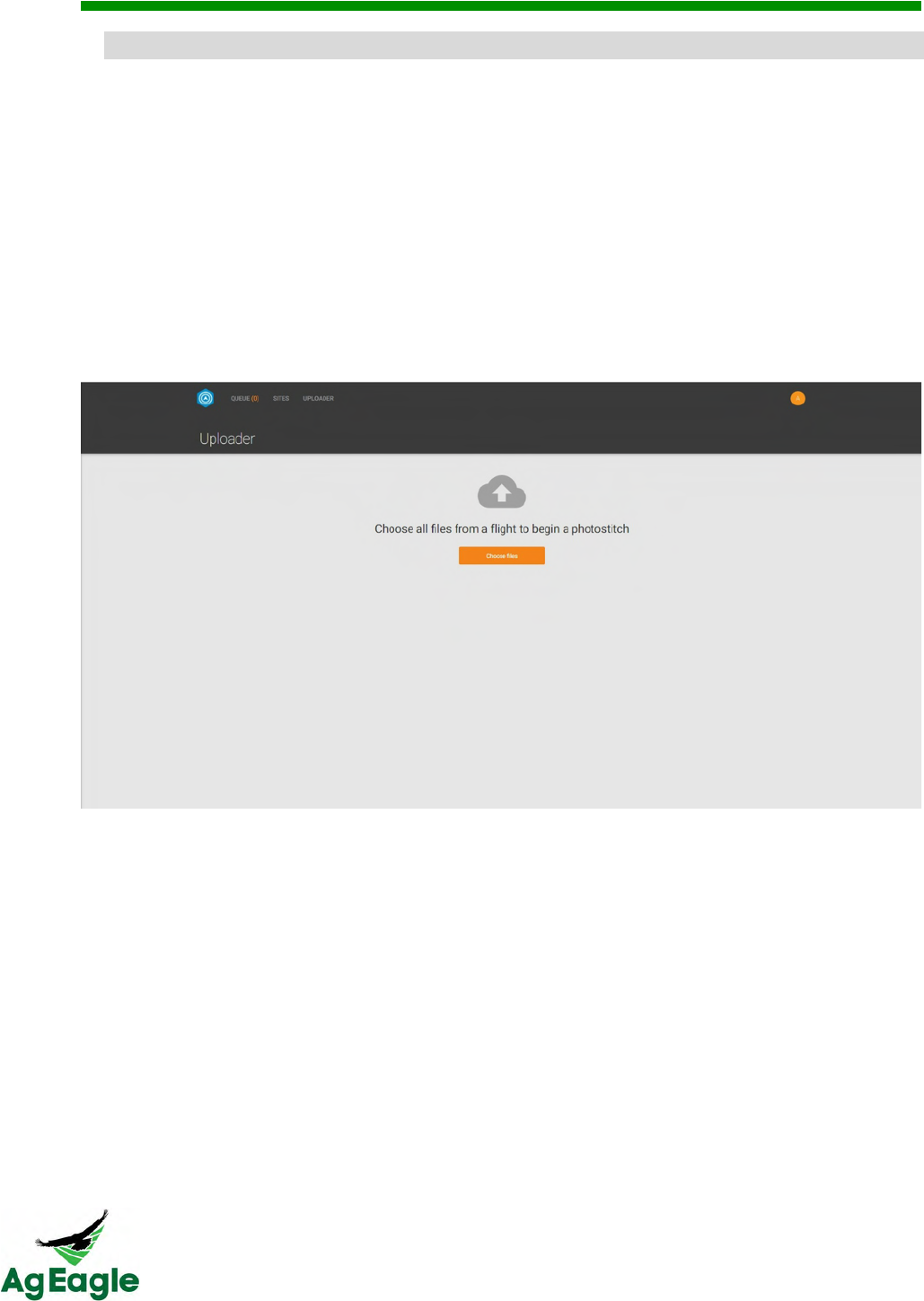
2. To upload images after flight, go to your fly.botlink.com account and select the
UPLOADER tab.
3. Select the images from your flight. Also, include the .JSON files as well. They are crucial
to georeferencing the map, as well as producing a nice clean map. The .JSON files should
be numbered the same as the images.
4. When upload is complete, let the stitcher process your images. You can check back in
the Queue to see if the stitcher is complete with your map.
RX60 User Manual Rev. 12 (8/26/2016)
©2016 AgEagle Aerial Systems. All Rights Reserved. 46 | Page
D.%#"4.3#$%&N5+3&9%T*%,.&DMPQ&653"&@#3"4&@,#%(4&
The first step to being able to fly is creating a Drone Profile which once set up will allow you to get
up in the air faster than ever before. To start, tap the Add button to create a new profile and give this
newly created profile a name. This is helpful to differentiate between multiple airframes.
Connections
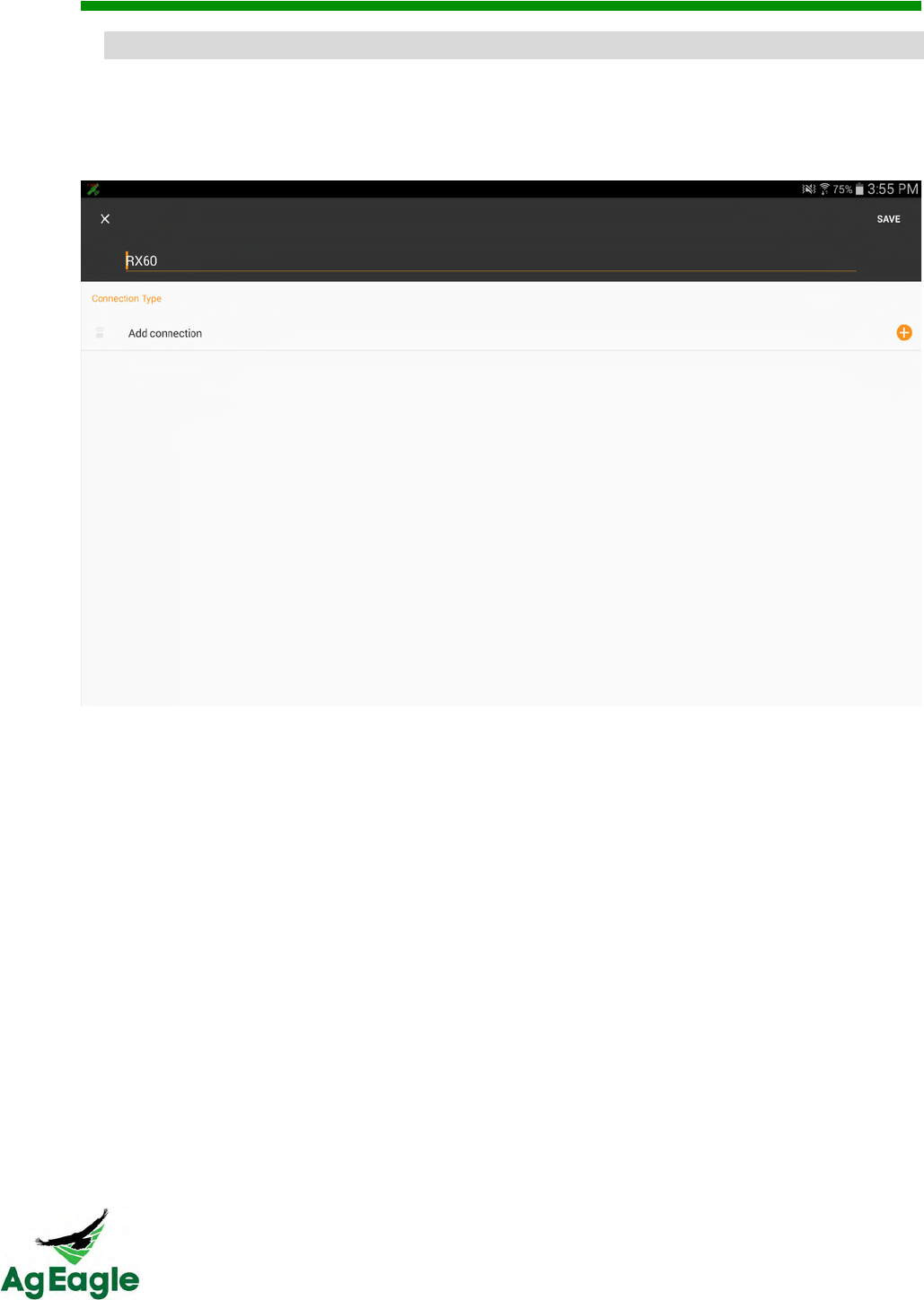
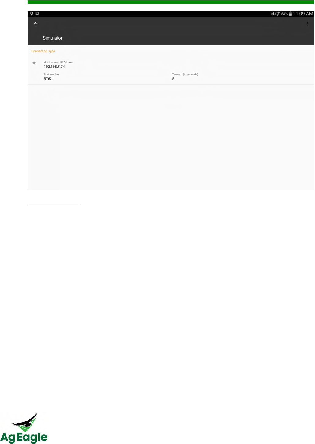
Once you have created a Drone Profile the next step is to define the Connection. This tells
Botlink how to communicate to this specific airframe. The three connection types are XRD,
USB, and Network. Again, make sure to give each a name to help differentiate between the
multiple connections. Use the USB mode for flying over the telemetry radios.
RX60 User Manual Rev. 12 (8/26/2016)
©2016 AgEagle Aerial Systems. All Rights Reserved. 47 | Page
USB Connection
Use this to control your drone using a USB device (usually a 915 MHz Radio). Just make sure to
choose the correct Baud Rate.
Connecting to your Drone
Once you have successfully created your Drone Profile and Connection you can connect to
your drone. Go back to the Drone Profile, select your newly created profile, press More
Options, press Edit, and press either "No Device Connected" or the Add Button. Select
your Connection and press Save. To connect, simply press the More Options button next
to the Drone Profile you'd like to connect with and select Connect. While connected, the
corresponding Drone Profile and Connection will be highlighted in green to indicate the
current state.
RX60 User Manual Rev. 12 (8/26/2016)
©2016 AgEagle Aerial Systems. All Rights Reserved. 48 | Page
)*$*%#$%&)*F"&*64.3&@,#%(4&
In addition to the mobile app Botlink has created a web portal to allow you to manage your
data collected in the field. Whenever you fly a survey mission and take images they are
uploaded to our cloud to be stitched. These images can be viewed via this portal.
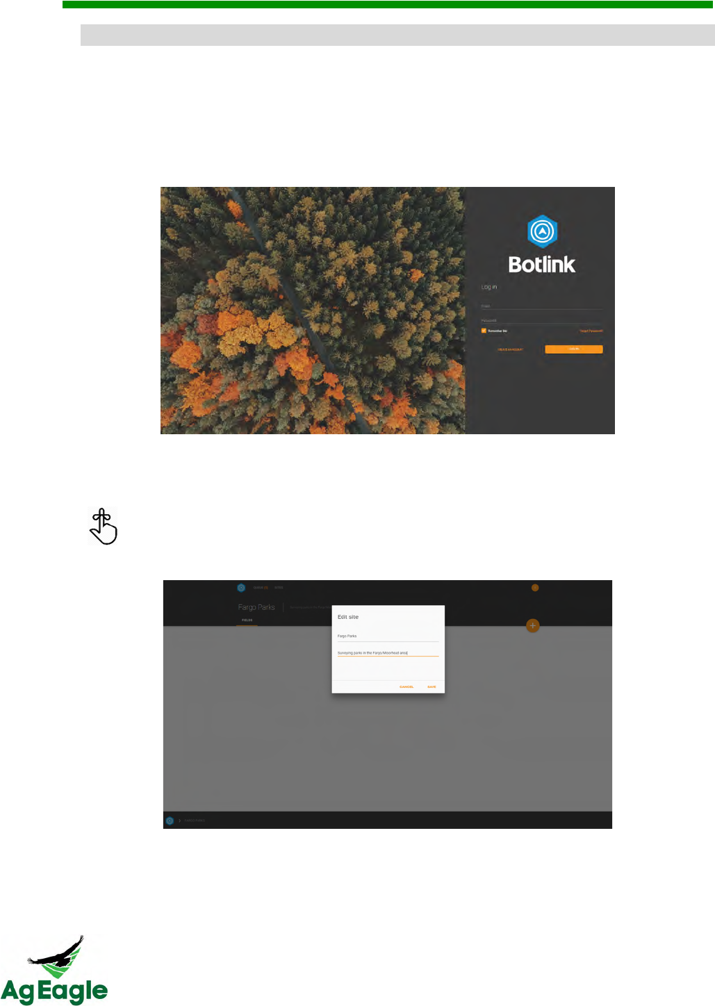
1. In order to get into your account head over to https://fly.botlink.com and sign in using the
same credentials used on your mobile app.
2. Once logged in you'll be able to view your Sites, which are the different locations that
you have flown at. In order to add a new Site simply click the orange Add New button.
You can edit the name and description of each Site by clicking on the name at
the top of the screen.
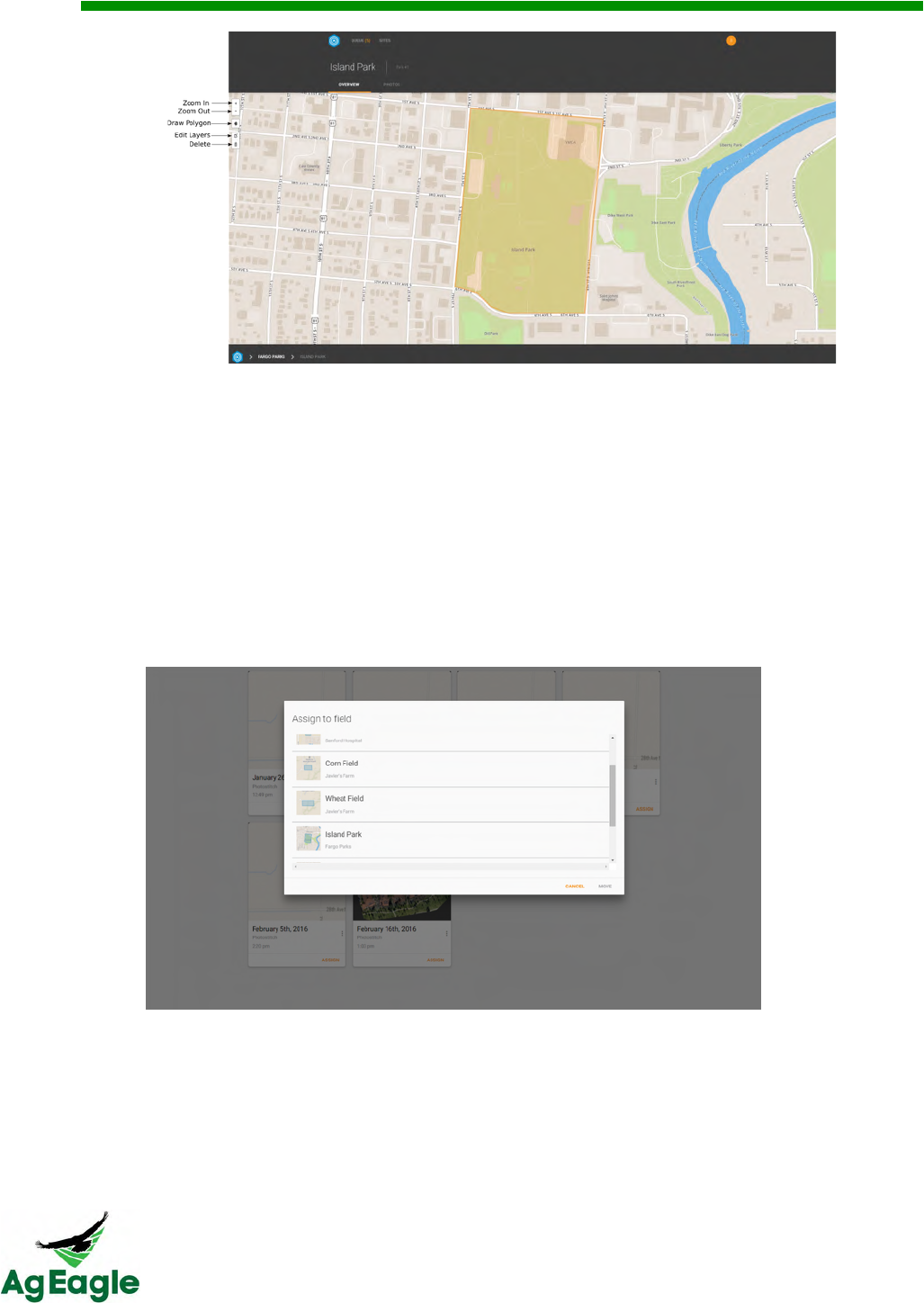
3. Now that you have created a Site the next breakdown is to create a Field. Fields are
the subdivisions of a Site. Breaking a Site down into separate Fields allows you to
specify exactly where each of your surveys are within your Site.
RX60 User Manual Rev. 12 (8/26/2016)
©2016 AgEagle Aerial Systems. All Rights Reserved. 49 | Page
4. To create a Field simply press the Add New button while within a Site. This will bring
you to a screen similar to the one above with a default polygon created on the map.
First, use the Delete tool to discard the default polygon. Then use Draw Polygon to
create the bounds of where your survey was on the map. This allows anybody who
views your Fields to know exactly where that flight took place.
5. If you look below the Field name and description you will see two tabs; Overview and
Photos. As you can see above the Overview is the main screen of a Field. The Photos
tab is where your stitched images for that Field will be stored. In order to pair a stitched
image to a Field we need to first assign them.
6. Your survey images, whether they are waiting to be stitched or are already complete,
are stored in the Queue. On each photo stitch job there is an Assign button and a More
Options button. More Options gives you a download link to save that image to your
device. The Assign button brings up a list of all your Fields. Use this to assign that
image to the correct Field and now when you navigate to the Photos tab within your
Field, that image will be displayed.

RX60 User Manual Rev. 12 (8/26/2016)
©2016 AgEagle Aerial Systems. All Rights Reserved. 50 | Page
05;$,5*/#$%&)*F"&*64.3&@,#%(4&
Read the Managing Maps After Flight section before continuing.
TO DOWNLOAD GEOREFERENCED .TIFF IMAGES:
1. Your survey images, whether they are waiting to be stitched or are already complete, are
stored in the Queue. On each photo stitch job there is an Assign button and a More
Options button. More Options gives you a download link to save that image to your
device. The Assign button brings up a list of all your Fields. Use this to assign that image
to the correct Field and now when you navigate to the Photos tab within your Field, that
image will be displayed.
TO DOWNLOAD GEOREFERENCED SHAPE FILES:
1. You must assign the image to a site and field to download a shape file.
2. Your survey images, whether they are waiting to be stitched or are already complete, are
stored in the Queue. On each photo stitch job there is an Assign button and a More
Options button. The Assign button brings up a list of all your Fields. Use this to assign that
image to the correct Field and now when you navigate to the Photos tab within your Field,
that image will be displayed.
3. Press the 3 dots on the image you want to download
4. Select DOWNLOAD OTHER IMAGES
5. Select the SHP and click download

RX60 User Manual Rev. 12 (8/26/2016)
©2016 AgEagle Aerial Systems. All Rights Reserved. 51 | Page
Additional Information

RX60 User Manual Rev. 12 (8/26/2016)
©2016 AgEagle Aerial Systems. All Rights Reserved. 52 | Page
AB.3,*F&*$/&E#/.,*F&
Overlap and Sidelap determine how often your camera takes a picture, as well as the width
in-between each pass (swath width). Overlap and Sidelap are measured in percentages
instead of feet. A higher percentage means that more of the picture that the camera is
taking will be overlapping with the pictures beside it. So a higher overlap means that the
camera will be taking pictures faster, and at the end of the flight the camera will have taken
more pictures. A higher Sidelap means that more of the picture is overlapping with the
pictures on the previous path, so the swath width will be narrower.
Botlink has combined Sidelap and overlap into one option to make it easier on the end user.
They combined it into just Overlap.
For row crops:
- At the beginning of the growing season, it is good to fly around 65% overlap
- During the middle of the growing season, when the crop has very few unique points, it is
good to fly around 70% even up to 80%
For other crops:
- The more unique points in the crop, the lower overlap is needed. Typically other crops
(such as orchards or vineyards) can be as low as 60%. Other crops that have very few
unique points (wheat) will need 70% to 80% during the growing season.

RX60 User Manual Rev. 12 (8/26/2016)
©2016 AgEagle Aerial Systems. All Rights Reserved. 53 | Page
'*K,.4&R9$/35#/&0.B#1.S&
• The tablet that is needed for flight is an android device that is running at least
Android 4.4.2. We recommend using a Lenovo TAB 2 a10 device, or a tablet with
similar specifications.
• The micro USB must have a full micro USB type A port to run the telemetry radio
when flying. Most Android tablets have a full micro USB type A port.
• When using the telemetry radios to fly, the colored end of the micro USB cable
(cable that connects the tablet to the telemetry radio) must plug into the tablet
• The tablet doesn’t need to have its own cell plan to fly online. You can connect your
tablet to a mobile hotspot.
RX60 User Manual Rev. 12 (8/26/2016)
©2016 AgEagle Aerial Systems. All Rights Reserved. 54 | Page
7*2.3*&
The standard sensor included in the RX60 package is a GoPro HERO4 Black, modified for
remote sensing of vegetation
• Camera modified with flat lens for better image processing
• Camera modified with high quality near infrared filter for mapping stress in crops
-.$"&7,.*$#$%&
Included in your Ground Support kit for the aircraft are paper wipes and lens cleaner. Make
sure before every flight that your lens is clean of debris, as this can affect image processing.
Do not spray directly on camera, as liquid can cause camera damage.
7(*3%#$%&
Please see the “Camera” tab under the “Charging” section of this manual
9//#4#5$*,&<$6532*4#5$&
Please see the “Binding Cameras” tab under the “Botlink” section of this manual to bind
your camera
After flight, make sure to turn the GoPro off and the Wi-Fi off so the battery
doesn’t die before your next flight
RX60 User Manual Rev. 12 (8/26/2016)
©2016 AgEagle Aerial Systems. All Rights Reserved. 55 | Page
7(*3%#$%&
7*2.3*&
The GoPro camera is charged through the USB cable provided with your aircraft. Plug into
computer or wall. The light is on solid red during charging, and off when fully charged.
9#313*64&-#G5&=*44.3#."&
The AgEagle RX60 comes with a LiPo battery charger to charge the batteries. The model
is a Hitec LiPo charger x4 AC Plus. This charger has the capabilities to charge up to 4
batteries at once.
To charge your batteries, follow these steps:
1. Plug in the Li-Po charger into the wall
2. Installing the Leads to the Charger
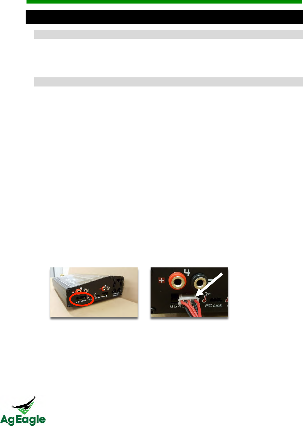
3. There are two locations to install the jumper leads.
4. Balance Lead Port- In the photo below, the port is indicated by the red oval. The port
has 7 pins, but only use the pins marked “-,1,2,3,4”. With the index guide lines
facing UP (see arrow), insert the XH Balance 4S lead into the port as shown.
5. Installing the Leads to the Charger
There are two locations to install the jumper leads.
a. Balance Lead Port- In the photo below, the port is indicated by the
red oval. The port has 7 pins, but only use the pins marked “-,1,2,3,4”.
With the index guide lines facing UP (see arrow), insert the XH
Balance 4S lead into the port as shown.
b. Deans Lead Port- In the photo below, the port is indicated by the
white oval. The port has a red postive (+) and black negative (-) plug.
RX60 User Manual Rev. 12 (8/26/2016)
©2016 AgEagle Aerial Systems. All Rights Reserved. 56 | Page
Insert the leads, matching the colors as shown.
c. Battery Connections- Plug the other ends into the battery as shown.
Consult the charger Owner’s Manual to set the charger functions to
match the battery specifications
d. Charger Supplied Leads- The leads supplied by the charger
manufacturer (shown below) should be kept as back up leads should
the others be lost or damaged.
6. Set the charger for LiPo Charge by pressing the Increase button
Every 5th charge on the batteries select the LiPo Balance option. This will take
longer, but will balance the cells of the batteries
7. Press Start and set the proper amps and voltage (5.5 amps and 14.8 4S)
8. Hold the Enter button, and the charger will run a check on the battery
9. If the check passes, press the Enter button to start charging
C*$/(.,/&@,#%(4&75$435,,.3&
The TARANIS handheld flight controller comes with its own charger included in the
controller case. The port for the charger is on the side of the controller. A green LED light
is on the back, blinking means that it is charging, a solid green light means it’s fully charged.
RX60 User Manual Rev. 12 (8/26/2016)
©2016 AgEagle Aerial Systems. All Rights Reserved. 57 | Page
-*+$1(.3&
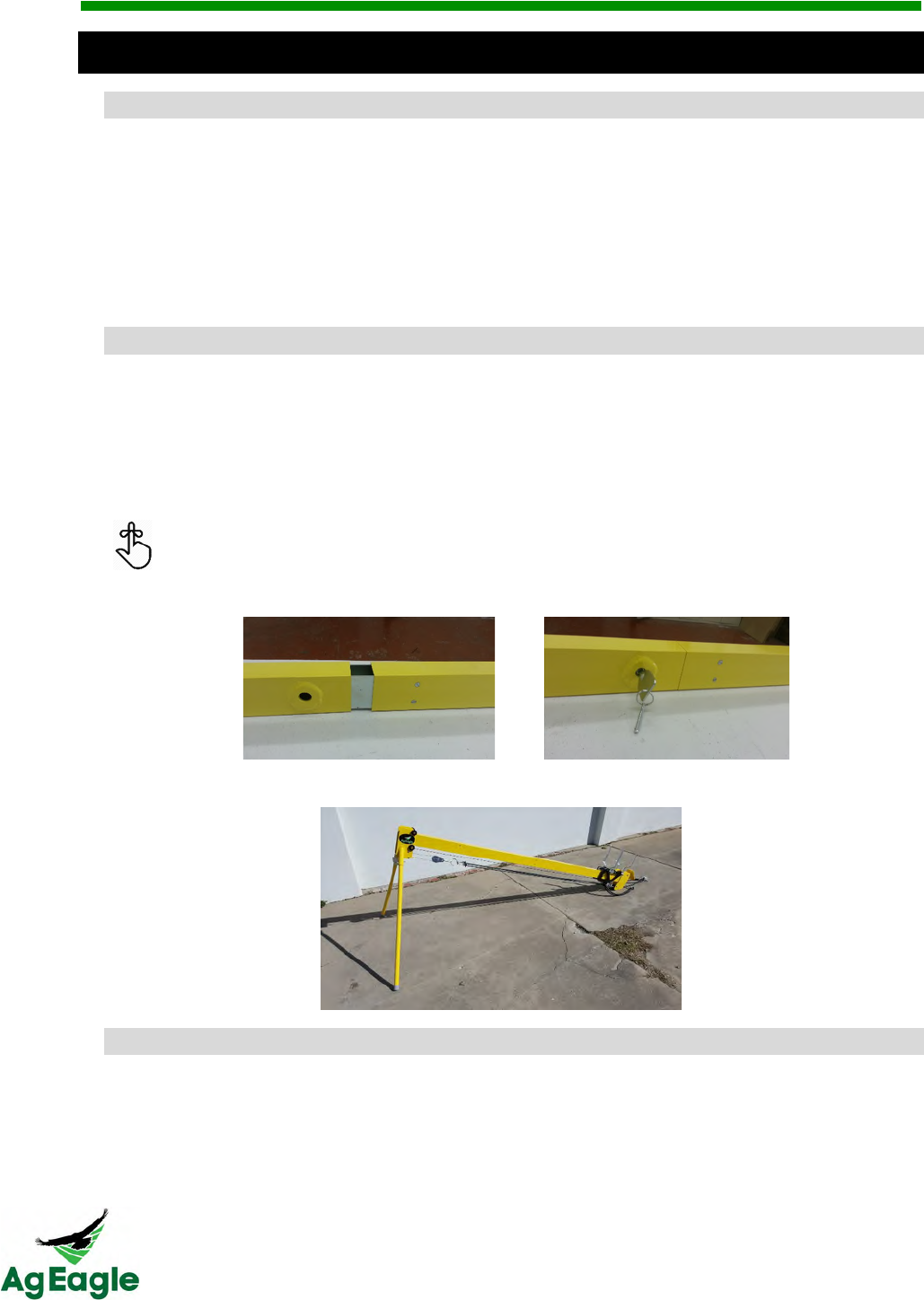
U+#1:&E.4+F&O+#/.&
1. Assemble the launcher
2. Slide the carriage to the bottom so that the foot latch holds it
3. Insert “Remove Before Flight” safety pin
4. Install proper number of bungees
5. Raise and latch front arms
6. Raise aft arms
7. Set aircraft onto launcher
D*#,&
See the instructions below for assembling the launcher.
1. Tilt the front rail to remove the legs from inside the tube. Set aside.
2. Assemble the rail male to female until connection is flush.
3. In the leg receiver tube, one of the pins has a hex key attached. Use it to join the
two rails. The male sleeve must be tightly expanded to firmly lock into the other rail.
Tighten connection by turning hex key COUNTER CLOCKWISE. To loosen,
turn the hex key CLOCKWISE.
4. Insert the legs into the front receiver tubes and insert safety pin.
7*33#*%.&
5. Ensure the launcher arms are NOT in the up
6. Unhook bungees to allow the carriage to be pushed down to the end comfortably.
RX60 User Manual Rev. 12 (8/26/2016)
©2016 AgEagle Aerial Systems. All Rights Reserved. 58 | Page
Do not push with too many bungees as it makes it too difficult to push safely
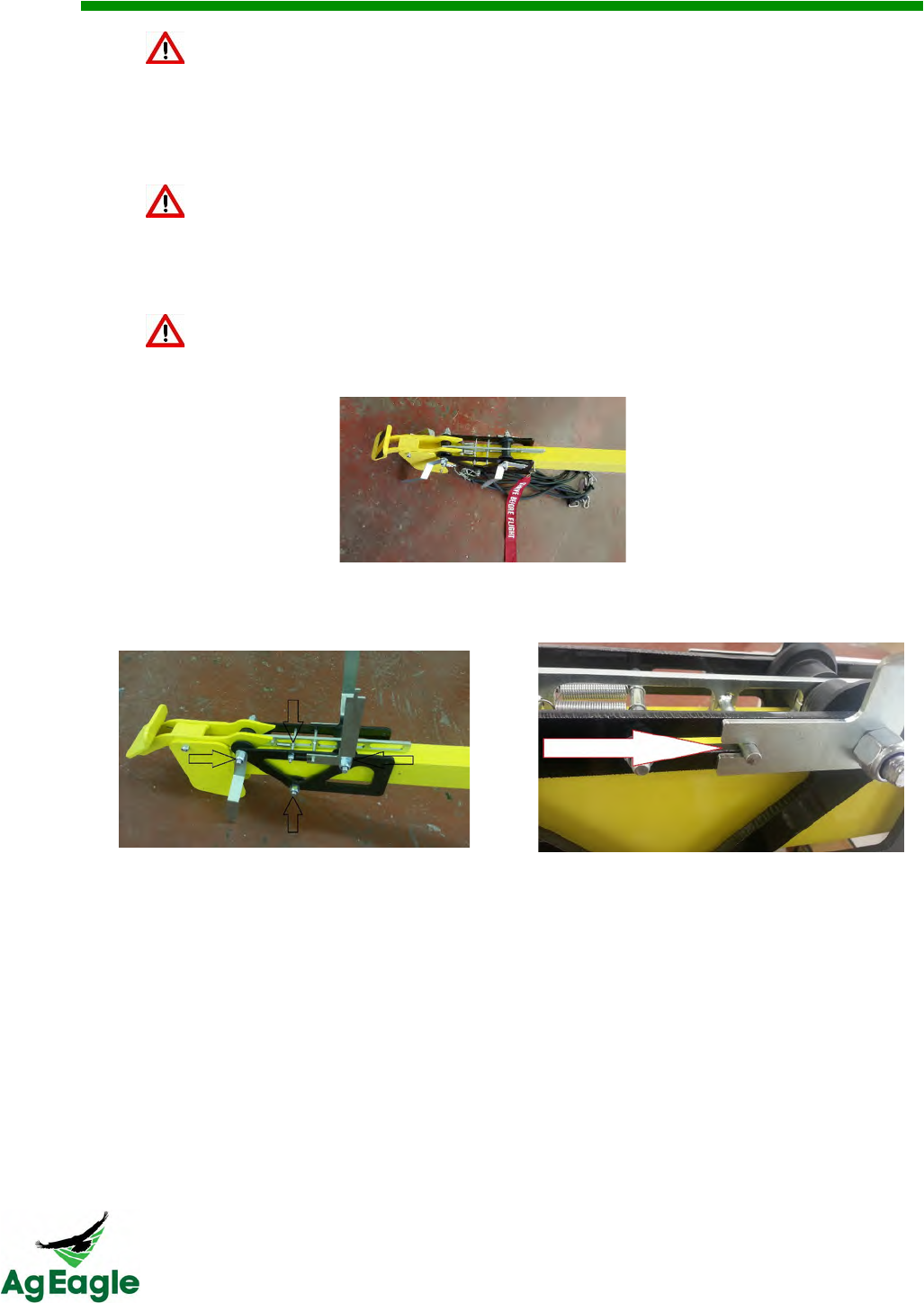
7. Roll the carriage to the bottom of the rail until it latches in the foot release by pushing
with the heal of them palm of your hands forward axle bolts and nuts
Never push carriage into position with the launching arms in the up position
8. Immediately insert the “REMOVE BEFORE FLIGHT” flag through the rail. The holes
are just in front of the carriage frame.
Do not proceed without the safety pin correctly installed
9. Raise the front release arms, pull back the center hammer bar and insert the release
bar into the arm slots. Check both sides to make sure release bar is full engaged
into the notches of the launcher arms.
The carriage should be frequently checked for smooth operation from the top to the bottom
of the rail by raising the carriage to the top of the rail with a slack cable and release. If the
action is not smooth:
• Check to make sure the axle bolts are not over tightened. The arms should swing
freely when there are no bungees attached.
• Also check the spring retention bolt to make sure it has not been tightened so hard
as to pinch the trolley carriage.
• Check the hammer springs for wear. If any of the four springs show spaces between
the windings, it is becoming worn and will cause launching issues. Replace the
springs if they show any signs of wearing (space between the windings).
• Also check the bottom trolley carriage bolt to make sure the rollers are not being
pinched.
• Apply dry lubricant every 25 launches to help insure smooth operation.
RX60 User Manual Rev. 12 (8/26/2016)
©2016 AgEagle Aerial Systems. All Rights Reserved. 59 | Page
=+$%..&753/"&
Never allow children near or around the aircraft or launcher
10. To install the launcher, hold the pulley ring in one hand, and the end of a bungee in
the other hand. Pull the bungee and attached the snap spring clip onto the pulley
ring. Continue until the appropriate number of bungees are attached.
Generally speaking, the number of bungees required depends on the velocity of the wind
and the condition of the rubber latex bungees. Over time and with much exposure to the
sun, the bungees will lose of elasticity, thus requiring more bungees to launch.
It is NEVER recommended to you all 8 bungees all of the time. Doing so will
cause excess wear and possible damage to the launcher triggering mechanism.
Estimated Wind Speed (MPH)
Number of Bungees
0-6
8
7-19
7-6
20+
5
The launcher is now set and ready to use. To disassemble, reverse the steps noted above.
Never release the carriage without the aircraft installed! Doing so will damage the
launcher

RX60 User Manual Rev. 12 (8/26/2016)
©2016 AgEagle Aerial Systems. All Rights Reserved. 60 | Page
EF.1#6#1*4#5$"&E(..4&
!
AgEagle!RX60!Specifications!
Manufacturer*
!!
Manufacturer!
AgEagle!Aerial!Systems,!Inc.!
117!S.!4th!St.!
Neodesha,!KS!66757!
USA!
Make!and!Model!
AgEagle!RX60!
UAV*Description*
!!
Category!
Fixed!Wing!(Flying!Wing)!
Composition!
Composite/Hard!Shell!
Measurements!
Wingspan:!54"!(137.2!cm)!
Fuselage!Length:!27"!(68.58!cm)!
Prop.!Dia.:!12"!(30.48!cm)!
Weight!
Max!Gross!T.O.:!7.06!lb.!(3.20!kg)!
Empty!Weight:!4.36!lb.!(1.97!kg)!
Payload!Weight:!2.44!lb.!(1.11!kg)!
Propulsion!System!
Electric!(Pusher)!
Fuel/Energy!System!
2!x!Li-Po!Batteries!
5500!mAh;!14.8V;!25C;!4!Cell!
Take-Off!Method!
Catapult!
Landing!Method!
Belly!Landing!
Navigation!Equipment!
PX4!Autopilot!
Dual!GPS!(L1/L2!&!Glonass)!
Handheld!Flight!Controller!(Visual)!
Electronic!Surveillance!Equipment!
GPS!through!Tablet/PC/Smartphone!
Flight!Sensors!
Barometric!Altimeter,!Airspeed!Indicator,!
2!x!Accelerometer,!2!x!Gyroscope,!
2!x!Magnetometer,!GPS,!Glonass!
Redundant!Systems!
Low!Battery!Return!to!Launch!
No!Radio!Contact!Return!to!Launch!
Visual!Detectability!!High!Visibility!Graphics!
Flight!Performance!
Operating*Airspeed:!31-49!mph!(13.8-22!m/s)!
Cruise*Airspeed:!33!mph!(14.7!m/s)!
Max*Descent*Rate:!394!ft./min!(2!m/s)!
Max*Climb*Rate:!984!ft./min!(5!m/s)!
Max*Turn*Rate:!150!deg/s!
Endurance:!60!mins.!w/!Std.!Batteries!
Operating!Limitations!!Operating*Temp:!32-170°F!(0-76°C)!
Demonstrated*Wind:!42!mph!(18.8!m/s)!

RX60 User Manual Rev. 12 (8/26/2016)
©2016 AgEagle Aerial Systems. All Rights Reserved. 61 | Page
Max*Recommended*Wind:!30!mph!(13.4!m/s)!
Daytime!Operation!Only!
Visual!Line!of!Sight!(VLOS)!Required!
!
Control*Station*
!!
Control!Method!
Pre-Programmed!Autopilot!
Manual!Flight!
Auto!land!
Flight!Instrumentation!
Altitude,!Airspeed,!Attitude,!Heading,!
Climb/Descent!Rate,!Present!Position!
System!Diagnostics!and!Monitoring!
Low!Battery!
Environmental!Warnings!
N/A!
Redundant!Systems!
N/A!
Communications*
!!
C2/Data!Bands!and!Frequencies!
2.4!GHz!Handheld!Flight!Controller!
Cell!Towers!
Radio!Range!
2.4!GHz:!≈1!mile!
Cell!Tower:!Unlimited!
Lost!Link!Indications!
Low!RSSI!Radio!Indication!
Measures!for!Mitigation!RF!Interference!
Remain!in!VLOS!
Stay!clear!of!RFI!sources!(i.e.!radio!towers,!etc.)!
Single!or!Dual!Redundant!Control!Links!
Single!
Voice*Communication*
!!
Primary!ATC!Communication!
N/A!(Pilot!Defined)!
Backup!Communication!
N/A!(Pilot!Defined)!
Communication!Latencies!
N/A!(Pilot!Defined)!
Ground!Communication!Systems!
N/A!(Pilot!Defined)!
Payload*
!!
Payload!Limitations!
None!
Dangerous!Payload!
Li-Po!Batteries!
Secondary!Purpose!of!Payload!
Aerial!Photography!
Increase!to!Pilot!Workload!
None!
!
! !

RX60 User Manual Rev. 12 (8/26/2016)
©2016 AgEagle Aerial Systems. All Rights Reserved. 62 | Page
Troubleshooting Guide

RX60 User Manual Rev. 12 (8/26/2016)
©2016 AgEagle Aerial Systems. All Rights Reserved. 63 | Page
@9U&
Q. Why do I have to make sure my aircraft travels into the wind throughout the
mission?
A. If the aircraft isn’t flying into the wind during turns it will overshoot the next flight path.
This can cause missing images at the turns throughout the mission and could result
in inaccurate maps and/or missing data on maps.
Q. Why do I have to launch into the wind?
A. When launching the aircraft it has to get up to flight speed in a very short amount of
time. In order to make this achievable faster the aircraft must be launched into the
wind to maximize airspeed. If launched with the wind, airspeed would be launch
speed minus the wind speed, and most likely resulting in a failed launch.
Q. How do I locate a downed aircraft?
A. There are two main methods for locating an aircraft if it doesn’t land where you
intended.
• Using GPS coordinates from PC/Tablet.
- It’s important that you do not turn off the PC/Tablet in case the aircraft is
damaged or has lost signal and is not able to report its location.
- Using the last reported position from Botlink and/or PC start heading towards
the aircraft. Make note of the last known altitude and speed as the aircraft
could glide farther from the last GPS location if still airborne.
• Using the Taranis Flight Controller RSS (Radio Signal Strength).
- The flight controller can be used as a radio beacon detector
Q. What happens if my flight controller loses power during flight?
A. If flying in close proximity of any obstacles we recommend that you immediately
cancel the flight. Without the ability to take manual control of the aircraft it can
present a dangerous situation if something should go wrong. If no risks are present,
the flight can be allowed to finish on autopilot mode.
• Emergency landing from PC/Tablet.
- On the mission control screen of the Botlink application, there is a button that
brings the aircraft back home.
Q. What happens if my PC/Tablet loses power during flight?
A. If no risks are present the flight can be allowed to finish in autopilot mode. If a
problem occurs during flight, use the flight controller to take manual control of the
aircraft and land in a safe location.
This is why it’s important to plan flights within the aircrafts endurance (battery life).
It is also important to be able to take manual control at any time during the flight.
Q. What happens if my camera lens gets scratched?
A. If your camera lens is scratched it could interfere with the imaging process and
cause inaccurate mapping results. The lens should be replaced before any more
missions are flown.

RX60 User Manual Rev. 12 (8/26/2016)
©2016 AgEagle Aerial Systems. All Rights Reserved. 64 | Page
Q. Do weather conditions affect flight?
A. Yes! Do not fly in rain, sleet, or snow. Do not fly in winds above your comfort level,
or above 30 mph. A very hot day may require more bungees than a cold day. A cold day
(below 40 degrees) may affect the bungees on the launcher, and stretch them out.
Q. Does altitude affect flight?
A. Yes! Flying at a higher altitude requires a larger prop to get the aircraft airborne. We
provide larger props for areas 4000 feet above sea level.
Q. What happens if you plan a mission longer than the aircraft endurance?
A. Although the AgEagle has a minimum safe voltage in the autopilot which will cause
the flying wing drone to head home and land automatically, it should only be used as an
emergency back up. A more responsible and safe way to operate the AgEagle drone is to
monitor the battery voltage as displayed on the Android tablet. When the battery voltage
approaches 14.2 volts, the landing sequence should be initiated by flipping the yellow
switch on the Taranis to the middle position for "RTL" return to landing. Or hold the play
button down on the top right hand corner of the Android tablet to begin the RTL.
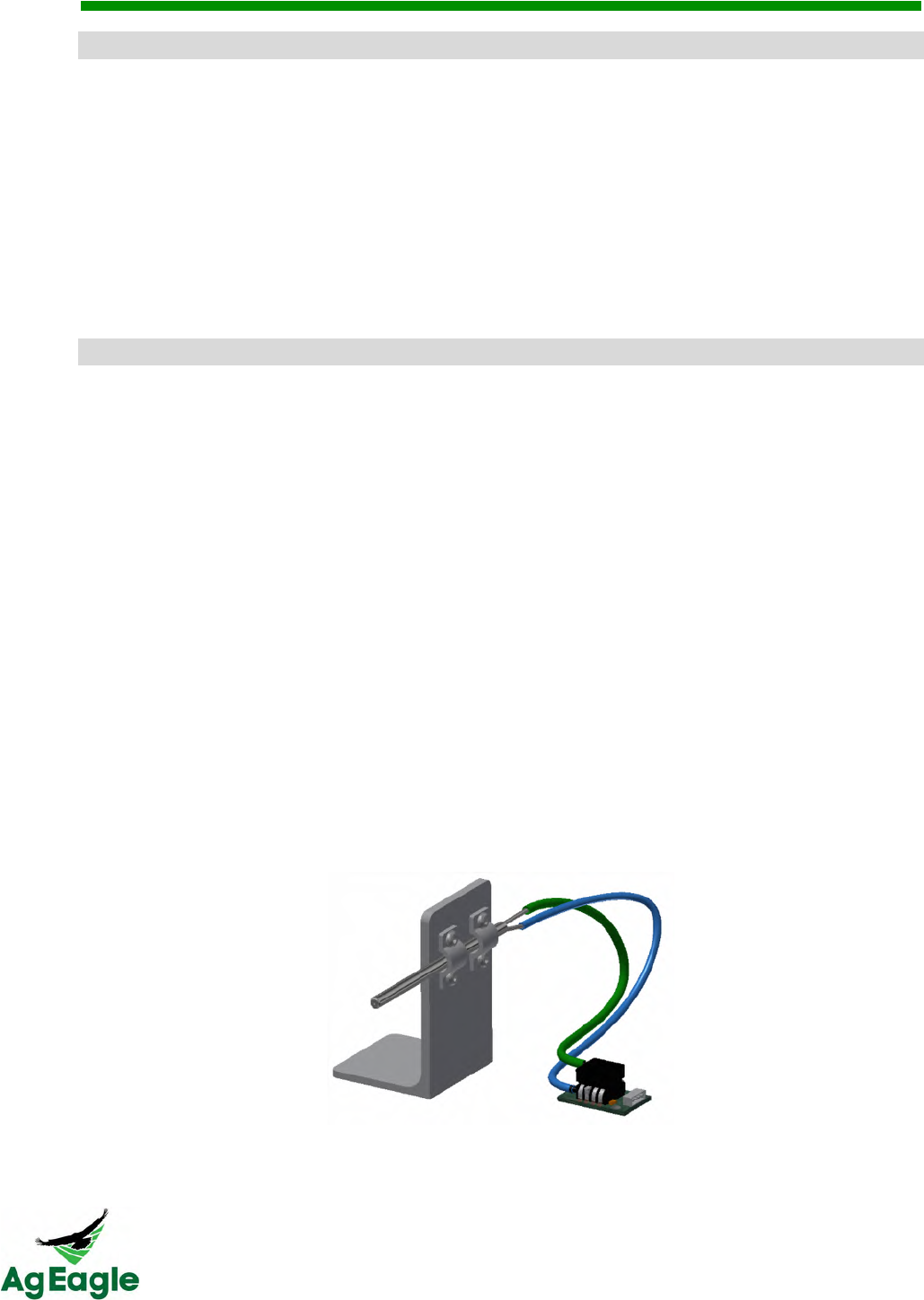
RX60 User Manual Rev. 12 (8/26/2016)
©2016 AgEagle Aerial Systems. All Rights Reserved. 65 | Page
T2.3%.$18&-*$/#$%&G351./+3."&
• If your aircraft is set to land into an object
o Let the aircraft loiter normally, but when the plane exits the loiter at 125 feet,
kick it into manual mode. From here, nose the aircraft hard down and move
left or right to avoid the object. When the aircraft is close to the ground, make
sure to nose the aircraft back up for a softer landing. Safety features help the
aircraft from nosing down too much, but if the aircraft doesn’t nose down
enough or have enough motor movement, it can drop below the stall speed
and stall
DMPQ&V#$%&
• Carbon fiber servo push rods are damaged/disconnected
o If the carbon fiber rods have come loose at the end of the carbon fiber, you can
use 5 minute epoxy included in your ground support kit to attach the rods
o If the carbon fiber rod has frayed or cracked, DO NOT FLY! Contact Raven for
replacement carbon fiber rods
• Clearing Pitot Tube
o Before every flight, you should look down the metal Pitot tube. The connecting
tubes leading out of the back of the metal Pitot tube are clear, so you should see
daylight through the Pitot tube. If you don’t see daylight in the tube, the Pitot
tube is plugged, DO NOT FLY! Also, if the pitot tube is ever damaged, bent or
misaligned, do NOT fly until the pitot tube is replaced.
§ To clear the Pitot tube, remove the tube from the back of the Pitot tube,
then, run the small metal wire through the tube. This will clear the debris,
and you can reinstall the tubes. WHEN CLEARING PITOT TUBE, DO
NOT POKE A HOLE IN THE FLEXIBLE TUBE! MAKE SURE TO
REINSTALL THE RUBBER TUBES ON THE CORRECT PITOT TUBE
OUTLET!
§ The photo below demonstrates the correct installation of the tubing. The
top tube from the airspeed sensor should go to the main Pitot tube outlet.
• If nylon screw for the winglets pulls the metal insert out

RX60 User Manual Rev. 12 (8/26/2016)
©2016 AgEagle Aerial Systems. All Rights Reserved. 66 | Page
o Apply a small amount of Gorilla Glue to the metal insert. Gorilla Glue requires a
small amount of water to start the chemical reaction. Since Gorilla Glue also
expands, use painter’s blue masking tape to hold the metal insert in place.
Gorilla Glue takes about 2 hours for 80% of the reaction to take place.
• Bent motor shaft
o If the motor shaft is bent, DO NOT FLY! This can cause blurry images, poor
flight times, and possible crash
o Contact Raven for support
• Installing a new propeller
o Use a screwdriver or stiff metal rod inserted though the hold on the end of the
collet by turning counter clockwise.
o Remove the propeller from the collet, and replace with an undamaged propeller.
MAKE SURE THE WRITING ON THE PROPELLOR IS FACING TOWARDS
THE MOTOR WHEN REINSTALLING
o Slide the collet back on the motor shaft as far as it will go. Tighten with the
screwdriver or stiff metal rod.
• Launcher lug falls out/loose
o Use Gorilla Glue to reinstall the launcher lug. Gorilla Glue requires a small
amount of water to start the chemical reaction. Gorilla Glue also expands, so
have something holding the metal insert in place. Gorilla Glue takes about 2
hours for 80% of the reaction to take place.
• Making simple repairs to leading edge.
o Gorilla Tape can fix minor damage on the leading edge of the plane. After you
have applied the tape, make sure the aircraft still has the correct center of gravity
§ You can check the center of gravity by putting 2 fingers on the balance
line on the bottom of the aircraft. The aircraft should balance at that line.
If that is balanced, then balance the aircraft left and right. This can be
done by placing a finger in the center of the nose bumper and a finger by
the motor, and check for balance.
• Making simple repairs to wing surfaces
o Gorilla Tape can be used to fix minor damage to the wing surfaces. Check
aircraft for balance.
§ You can check the center of gravity by putting 2 fingers on the balance
line on the bottom of the aircraft. The aircraft should balance at that line.
If that is balanced, then balance the aircraft left and right. This can be
done by placing a finger in the center of the nose bumper and a finger by
the motor, and check for balance.
o You can also use a syringe and Gorilla Glue to fix minor cracks. Make sure the
plane is held tightly together after applying, because Gorilla Glue expands.
Check aircraft for balance.

RX60 User Manual Rev. 12 (8/26/2016)
©2016 AgEagle Aerial Systems. All Rights Reserved. 67 | Page
§ You can check the center of gravity by putting 2 fingers on the balance
line on the bottom of the aircraft. The aircraft should balance at that line.
If that is balanced, then balance the aircraft left and right. This can be
done by placing a finger in the center of the nose bumper and a finger by
the motor, and check for balance.
• How “bad” is bad. I had a hard landing, but how can I tell if the wing is OK and not bent
out of shape?
o If the aircraft has a crack or crease running through the plane, and if the plane
wing can be bent while holding onto one side, DO NOT FLY!
o If you ever question the integrity of the aircraft, DO NOT FLY and call Raven for
questions.
-*+$1(.3&
• Sluggish action (same weather conditions but just slow at launch)
o Check the overall status of the launcher
§ This can be done with 2 tests. The first, undo all of the bungees and hold
the cable above the launcher. Let the carriage go, and it should roll down
the rail with ease. If it slows or gets hung up, you may have a problem
with an overtightened carriage or the hex bolt isn’t tight enough
§ The second test is dry launching with one bungee. This will slow the
motion down so you can see if you have any issues
§ NEVER DRY LAUNCH WITH MORE THAN ONE BUNGEE
• Stiff action (carriage does not seem to roll smoothly).
o Make sure to tighten the hex key until it’s tight
o Use a dry lubricant on the launcher rail
o If anyone worked on the carriage, they may have over tightened the axle bolts or
spring retention bolt. The arms should swing easily when not under tension and
the spring retention bolt should allow for some slight free movement.
o Should the problem persist, it could be due to a slight bowing of the launch rail at
the connection joint. In this case, replace the BOTTOM ½” carriage axle bolt with
a 7/16” x 4” hex head screw bolt. Do not over tighten.
• Identifying worn or degraded bungees
o If the bungees are frayed or cracked, you should replace. Over time, bungees
can show signs of wear when you stretch them, we recommend replacing at least
every 2 years.
o The life of the bungees can be extended by disconnecting at the end of the flying
day or putting into storage. Never store the bungees in direct sunlight.
• Identifying worn or degraded springs.
o If springs show signs of being stretched and no longer hold tension, replace all of
them.
• Identifying worn or degraded bumpers

RX60 User Manual Rev. 12 (8/26/2016)
©2016 AgEagle Aerial Systems. All Rights Reserved. 68 | Page
o The rubber stop bumpers are necessary to protect the hammer/trigger from
excessive wear and to reduce the expended energy following each launch. Look
for excessive cracking or being substantially out of round. The life of the
bumpers can be extended by loosening their retention bolts and rotating them
slightly a few times throughout the flying season.
o If they show excessive wear, replace all of them.
• Adjusting launcher arms. (became bent during transport or dropped)
o Set the aircraft on the launcher and line up the launcher arms. The aircraft
should sit at an 18 degree slope, and should face directly down the launcher rail.
Bend the launcher arm until it fits in the aircraft’s lugs, but make sure the aircraft
still sits straight and level.
• Damage to center trigger bar/hammer (due to excessive use of bungees).
o It is possible to damage the hammer it can be straightened, but once it’s been
bent, it will be subject to accelerated wear. Order a replacement as soon as
possible.
7(*3%.3&*$/&=*44.3#."&
• Puffy batteries - What causes it? Are they dangerous?
o Puffy batteries are a sign that the battery is damaged or worn. LiPo batteries are
high energy devices and are more sensitive to shock or misuse. Never toss a
battery; always place it gently. Do not place heavy or sharp edged items on a
battery as any pressure could compromise the cells resulting in an unwanted,
aggressive chemical reaction and possible fire.
o Batteries can also become enlarged from being discharged too much. Aircraft
batteries should always remain ABOVE 20% battery. If you drop below this
often, the battery life will become significantly less
o Make sure to use LIPO BALANCE on the charger at least every 5th time you
charge
o Batteries can also become puffy after a crash. If the battery is puffy after a
crash, you should dispose of the battery
o If a corner of the battery is dented, dispose of the battery
o You should always remain in the same room as the battery charger if you are
charging the batteries
o To avoid charging or battery damage, THOROUGHLY read the charger manual.
• When batteries are not in use, do not store fully charged, but discharge them to 50%
capacity. This will help reduce the chances of a battery dropping a cell, and becoming
unsafe to use
• Use the battery checker included in your ground support kit
o Do not fly on partially charged batteries.
o Check each cell of the battery to make sure you don’t have a dropped cell within
a battery
RX60 User Manual Rev. 12 (8/26/2016)
©2016 AgEagle Aerial Systems. All Rights Reserved. 69 | Page
<$/.>&
A*
Aircraft!·!8,!42,!43,!47!
Airspeed*Indicator!·!9!
Autopilot!·!8!
B*
Batteries!·!9!
C*
Controls!and!Operation!·!12!
D*
Disclaimer!·!1!
E*
Electronic*Speed*Controller*(ESC)!·!10!
F*
FAQ!·!49,!51!
Final*Checks*&Takeoff!·!17!
Flight!·!14!
Flight!Limits!and!No!Fly!Zone!·!14!
G*
GPS*Receiver!·!9!
H*
Handheld!Flight!Controller!·!12!
Hardware!·!8!
I*
Included!in!the!Box!·!6!
Initial!Setup!&!Calibration!·!15!
K*
Key!Features!·!7!
L*
Left!Stick!Operation!·!12!
Legend!·!1!
M*
Mission*Planning!·!16!
O*
Operational!Flying!Conditions!·!14!
P*
Pre-Arming*Sequences!·!15!
Pre-flight!Procedures!&!Checklist!·!20!
Product!Overview!·!6!
R*
Right!Stick!Operation!·!13!
S*
Sensor*Calibration!·!17!

RX60 User Manual Rev. 12 (8/26/2016)
©2016 AgEagle Aerial Systems. All Rights Reserved. 70 | Page
Servos!·!10!
Switch!Operation!·!13!
T*
Takeoff!&!Flight!·!17!
2
!
