Calculating Canopy Gap Fraction With ImageJ From A Hemispherical Photo Hemiphot Guide
User Manual:
Open the PDF directly: View PDF ![]() .
.
Page Count: 3
Calculating canopy gap fraction with imageJ from a hemispherical
photo
JohnGodlee
2018_09_02
Part1-Takinghemisphericalphotos
Alistoftipsfortakinggoodhemisphericalphotos:
Takephotosunderauniformlyovercastsky,ideallybeforethesunhasrisentoohighinthesky,orjustbeforesunset.Ifindinthemorningthephotosaregenerallybetterandathighlatitudes
youwillhavemoretimethaninthetropics..
Ensurethatthecameraislevelandthelensispointingstraightup.Usethespiritlevelonthecamerahotshoetodothis.
Adjustthetripodsothatthetopofthecameralensis1mabovetheground,oraboveanyunderstoreyvegetation,whicheverishigher.
Turnthecamerasothetopofthecamerabodyisfacingnorth,takeacompass!Thisensuresthatthetopofthecapturedphotoisalsofacingnorth,whichisnecessaryforcalculatingLAI..
Makeuseofthearticulateddisplayonthecameratogetagoodviewofthephotobeforeyoutakeit.
Setthecamera:
Manualshootingmode
Manualfocus
Setthefocustoinfinity
Exposurecompensation=-0.7
Capturingfinejpeg&RAWimagesatthesametime
Thecameratimeanddateisaccurate(thisispurelyforeaseofmatchingphotostosites)
SettheApertureto5
AdjusttheISOandshutterspeedsothephotoisneutrallyexposedbuttheshutterspeedisalwaysover1/60sec,otherwiseyouwillintroducecamerashakewhenyoupressthebutton
Takeallphotosinlandscapedimensions,neverportait.
Makesureyouallduckdownbelowthecamerawhentheimageisbeingtaken!
Makesurethereisbatteryandyouhavethesparebattery
MakesurethereisanSDcardinthecamera,andtakeaspare.
Coverthelenswiththelenscapbetweenphotos.PLEASEPLEASEPLEASE!!!
Kitlistfortakinghemisphericalphotos:
Camerawithappropriatefisheyelens
Lenscapforcamera
Lenscleaningsolutionandlenscloth
Tripod
Fullychargedbatteryforcamera
SDcardforcamera
Spiritlevelhotshoeattachmentforcamera
Compass
Notebookandpencil
GPSunit
tapemeasure>2m
Waterproofbagtocovercamera
Part2-Creatingablackandwhitethresholdedimage
1. OpenImageJ
2. File->Open ,thenselectanimage
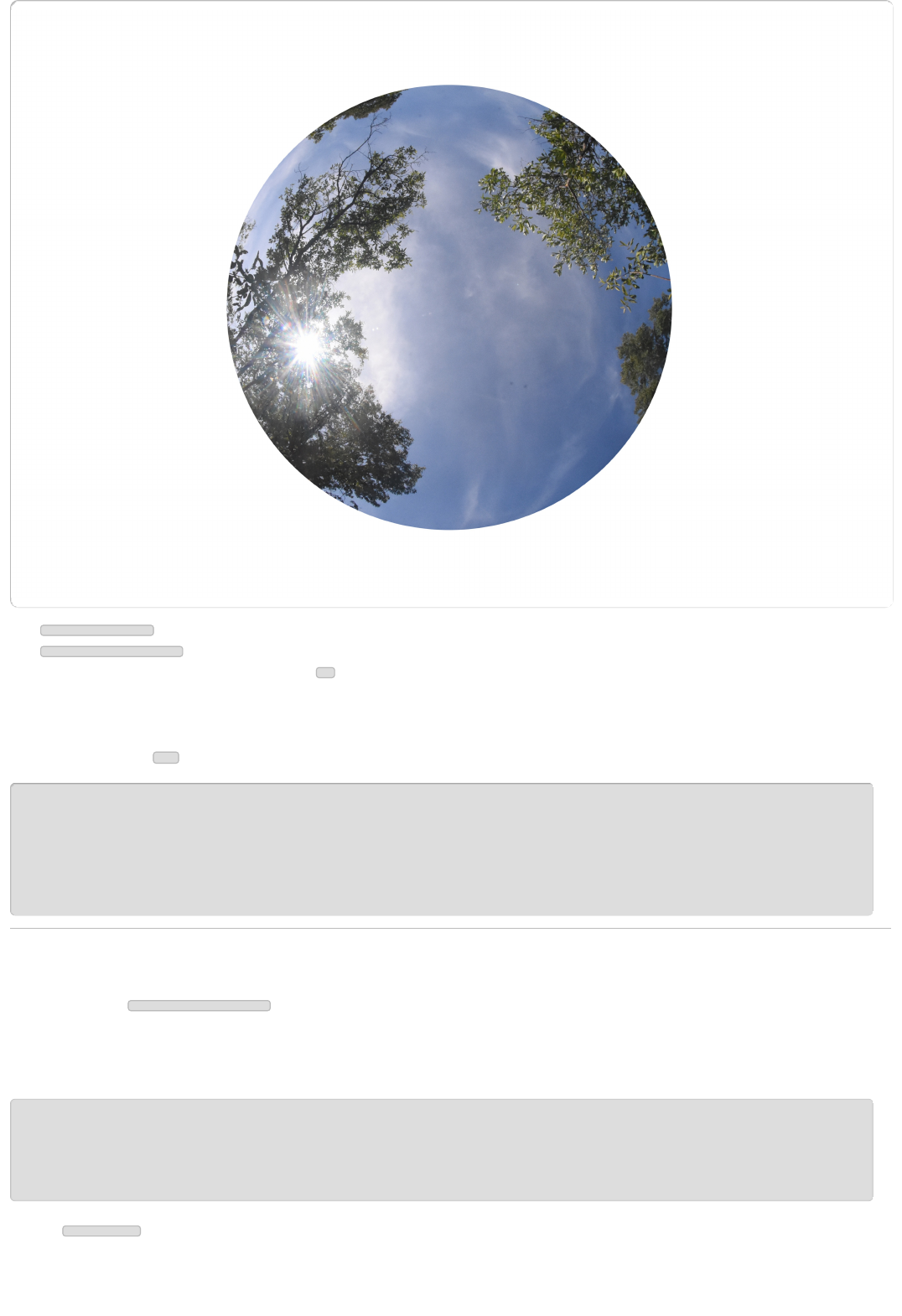
3. Visuallyinspecttheimagetoseethatthereisn'tmassiveamountsoflensflare.Ifyouhavelotsoflensflare,thephotoshouldbethrownout!Thisiswhatlensflarelookslike:
4. Image->Type->8-bit
5. Image->Adjust->Threshold ,manuallyadjusttheimagesoallthebranchesareredandtheskyiswhite,orasnearasyoucangetit.
6. Savethenewlythresholdedimageasajpeginafoldercalled img .
7. Rinseandrepeatforallimages.
Theaboveprocesscanbeautomatedwithamacro,butthisassumesthattheimagesarealluniformlyexposed.
Thisisthemacro,savedasa .ijm file.Thisisuntestedsouseatyourownrisk:
//Automaticallycreateathresholdedimageforuseinfurtheranalysis.ChangethevaluesofsetThresholdtoachievedifferentresults.
//Partiallytested
//SaveasaJpegintheBatchmacrodialoginImageJ
run("8-bit");
run("Threshold...");
setThreshold(0,146);
setOption("BlackBackground",false);
run("ConverttoMask");
Part3-CalculatingLeafAreaIndex
1. OpenRStudio.
2. Openanewscript( File->NewFile->RScript )
3. Savethescriptinafolderabovetheimagesfolder:
4. EnterthefollowingpreambleintotheRscript:
#Setworkingdirectorytolocationofthresholdedimages
setwd("LOCATION_OF_ANALYSIS")
#Sourcethefunctionsusedtocalculatestuff
source("hemiphot.R")
#Packages
library(jpeg)
5. Add white_image.jpg tothesamefolderwherethethresholdedimagesarefound
6. ReadinallthethresholdedimagesandcreateanemptydataframewhichwilllaterbefilledwithcanopytraitstatisticslikeLAIandcanopyopenness.

#Listallimagesinthedirectory
all_images<-list.files("img/",pattern=".JPG")
#Howmanyimages
img_length=length(all_images)
#Createemptydataframe,6x7andfillitwithzeroes
all_data=data.frame(matrix(data=0,nrow=img_length,ncol=7))
names(all_data)=c("File","CanOpen","LAI","DirectAbove","DiffAbove","DirectBelow","DiffBelow")
#Fillfirstcolumnwithimagenames
all_data[,1]=all_images
7. Readinthereferenceimage( white_img.jpg )asamatrixofpixelvalues:
white_img<-readJPEG("img/white_image.jpg",native=F)
8. Setsomeparametersforthelocationthephotosarebeingtaken.Approximatelocation(0.1degreeslatitude)isgoodenoughforourpurposes.Notethatthevaluesbelowareforsomewherein
Africaandshouldbechanged:
location.latitude=-15
location.altitude=200
location.day=30
location.days=seq(15,360,30)#roughlyeachmidofthe12months
9. Setsomeparametersfortheimages,croppingthemtoacircleandsettingthethreshold.TheseparametersareonesIhaveusedonthiscamera,sodon'tneedtobechanged:
##Imageparameters
###Drawingcirclesandidentifyingtheimagecentrepoint
hemi_dim<-dim(white_img)
radius<-max(rowSums(white_img[,,1]>0.4)/2)
###determineusingasingleimageandfillinhereforbatchprocessing
location.cx=(hemi_dim[2]/2)#xcoordinateofcenterofimage
location.cy=(hemi_dim[1]/2)#ycoordinateofcenterimage
location.cr=radius#radiusofcircle
location.threshold=0.42#Mustgetthistomatchallimages,ormaybecouldusealookuptable/dictionary?DoesRhavedictionaries?
10. Set some atmospheric parameters. I've loosely estimated these for this location, but by no means is it scientific. I would not have much confidence in the statistics generated using these
parameters,namely DirectAbove , DiffAbove , DirectBelow and DiffBelow .
#atmosphericparameters
##Atmospherictransmissivity-Normallysetat0.6,butcanvarybetween0.4-0.6inthetropics
location.tau=0.6
##AmountofdirectlightthatisusedasdiffuselightintheUniformOvecastSky(UOC)
location.uoc=0.15
11. Runabigforlooptocalculatethestatisticsforeachphoto
for(iin1:img_length){
##readfile
image<-readJPEG(paste("test_img/",all_images[i],sep=""),native=F)
##convertoHemiimage
image<-Image2Hemiphot(image)
##setcirlceparameters
image<-SetCircle(image,cx=location.cx,cy=location.cy,cr=location.cr)
##selectbluechannel
image<-SelectRGB(image,"B")
#threshold
image<-ThresholdImage(im=image,th=location.threshold,draw.image=F)
#canopyopenness
gap.fractions<-CalcGapFractions(image)
all_data[i,2]=CalcOpenness(fractions=gap.fractions)
##calculateLAIaccordingtoLicor'sLAIAnalyzer
all_data[i,3]=CalcLAI(fractions=gap.fractions)
##PhotosyntheticPhotonFluxDensity(PPDF,umolm-1s-1)P
rad<-CalcPAR.Day(im=image,
lat=location.latitude,d=location.days,
tau=location.tau,uoc=location.uoc,
draw.tracks=F,full.day=F)
all_data[i,4]=rad[1]
all_data[i,5]=rad[2]
all_data[i,6]=rad[3]
all_data[i,7]=rad[4]
}
12. Finally,lookattheoutput,whichisstoredin all_data
all_data
