Table Of Contents Little Navmap User Manual En
User Manual:
Open the PDF directly: View PDF ![]() .
.
Page Count: 179 [warning: Documents this large are best viewed by clicking the View PDF Link!]
- Introduction
- Acknowledgments
- Donations
- Installation
- Quick Overview
- First Start
- Menus and Toolbars
- Map Display
- Map Display Legend
- Map Display Compass Rose
- Map Flight Plan Editing
- User-defined Waypoints
- Online Networks
- Search Dock Window
- Search Dock Window - Procedures
- Navigation Databases
- Flight Plan Formats
- Flight Plan Dock Window
- Flight Plan Procedures
- Flight Plan Edit Position
- Flight Plan Route Description
- Flight Plan Elevation Profile Dock Window
- Information Dock Window
- Weather
- Printing the Map
- Load Scenery Library Dialog
- Connecting to a Flight Simulator
- Checking for Updates
- Options Dialog
- Running without Flight Simulator Installation
- Customize
- Creating or adding Map Themes
- Coordinate Formats
- Files
- Tutorials - General
- Tutorial - Building a VFR Flight Plan
- Tutorial - Building an IFR Flight Plan with Approach Procedures
- Tips and Tricks
- Tips for old and slow Computers
- Glossary
- License

1.1
1.2
1.3
1.4
1.5
1.6
1.7
1.8
1.9
1.10
1.11
1.12
1.13
1.14
1.15
1.16
1.17
1.18
1.19
1.20
1.21
1.22
1.23
1.24
1.25
1.26
1.27
1.28
1.29
1.30
1.31
1.32
1.33
1.34
1.35
1.36
1.37
TableofContents
Introduction
Acknowledgments
Donations
Installation
QuickOverview
FirstStart
GeneralRemarks
MenusandToolbars
Statusbar
MapDisplay
MapDisplayLegend
MapDisplayCompassRose
MapFlightPlanEditing
User-definedWaypoints
OnlineNetworks
SearchDockWindow
SearchDockWindow-Procedures
NavigationDatabases
FlightPlanFormats
FlightPlanDockWindow
FlightPlanProcedures
FlightPlanEditPosition
FlightPlanRouteDescription
FlightPlanElevationProfileDockWindow
InformationDockWindow
LegendDockWindow
SimulatorAircraftDockWindow
Weather
PrintingtheMap
PrintingtheFlightPlan
LoadSceneryLibraryDialog
ConnectingtoaFlightSimulator
CheckingforUpdates
OptionsDialog
RunningwithoutFlightSimulatorInstallation
Customize
CreatingoraddingMapThemes
2


LittleNavmapUserManual
Version2.0
LittleNavmapisafreeopensourceflightplanner,navigationtool,movingmap,airportsearchandairportinformation
systemforFlightSimulatorX,FlightSimulator-SteamEdition,Prepar3Dv2tov4andX-Plane11.
Donotusethisprogramforrealworldnavigation.
MoreaboutmyprojectsatGitHub.
Copyright2015-2018AlexanderBarthel
LastupdatedMonJul09201812:23:15GMT+0200(CEST).
Introduction
4

Acknowledgments
Abigthank-youforallpeoplesupportingme,sendingmetheirlogfiles,screenshots,ideasforimprovements,friendly
messages,donationsandmore.
AhugeThankyou!toPaulWattsforhissupport,fortesting,tips,linkstoincredibletoolsandforallhisworkonthe
manual.
PlentyofthankstoHervéSorsforallowingmetoincludehisupdated magdecl.bglfilewithLittleNavmap.
Averyspecialthank-youtoRobertoS.fromSwitzerlandforhisvaluableinputandalsohelpingwithhiscapabilityto
findthemostobscurebugs.
ThankstoNavigraphforkindlyallowingmetoincludeafreeAIRACcycleinthedownload.ThanksforRichardStefan
forhisgreatsupport.CurrentAIRACcyclescanbepurchasedfromNavigraph.
AbigThankyou!toJeanLucfromRealityXPforhisgreatsupport.
ThankstoJosefromfsAerodataforhiskindsupport.
TheFrenchtranslationoftheprogramwasdonebyPatrickJUNGaliasPatbest.Thankyou!
Dankeschön!fortheGermantranslationtomerspielerandStephanLeukert.
ThankstoRicardoVitorforthetranslationtoBrazilianPortuguese.
ThankstoDaniel"Wolf"(wolfinformatica.com)fortheSpanishtranslation.
Thankyou!toEddyCrequiefordoingtheDutchtranslation.
Thankstoallbetatestersfortheireffort,patienceandideas:Barry,Jean-Pierre,Brian,Gérard,John,Remi,Paolo,
Samandmanyothers.
AnotherbigDanke!toMarcfromGermanyforallhisgreatideasandendlessbugreports.
Thankstoallintheforumswhopatientlysupportedmeandgaveinvaluablefeedbackduringthepublicbeta:
AVSIM,SimOuthouse,FlightX.netandFSDeveloper.com.
ThisprojectandmylibraryatoolswouldnotexistwithoutthefabulousdocumentationoftheBGLfilesinthe
FSDeveloperWiki.So,hereahugethank-youtoallthecontributors.
AlsoathankyoutoEdWilliamsforhisAviationFormulary.
WithouttheopensourceMarblewidgetthatallowsmetoaccessanddisplayallthemapsIwouldstillbebusydoing
thatmyselfforyears.
NoQtapplicationframeworkandIcouldnotevendrawasimplebutton.
Let'snotforgetaboutalltheservicesthatprovideusalltheonlinemapsforfree:
StamenDesign,OpenTopoMapandCARTO.
Athank-youtotheGIScience/GeoinformaticsResearchGroupofHeidelbergUniversityforkindlygivingme
permissiontousetheirmapOpenMapSurfer.
Andlastbutnotleast:IftherewerenoOpenStreetMapanditsthousandsofcontributorsnoneofuswouldhaveany
mapsatall.
Acknowledgments
5


Installation
Highlightedtextisusedtodenotewindow,menu,button,fileordirectorynames.
LittleNavmapforWindowsisa32-bitapplicationandwastestedwithWindows7,Windows8,Windows10(32-bit
and64-bit).
ThemacOSandLinuxversionsareboth64-bitandweretestedwithmacOSSierraandUbuntuLinux.
Updating
DeleteallinstalledfilesofapreviousLittleNavmapversionbeforeinstallinganewversion.Allfilesfromtheprevious
ZIParchivecanbedeletedsincesettingsarestoredinseparatedirectories(exceptcustommapthemes).Inanycase
donotmergetheinstallationdirectories.
Thereisnoneedtodeletetheoldsettingsdirectory.Theprogramiswritteninawaythatitcanalwaysworkwithold
settingfiles.
Windows
TheinstallationofLittleNavmapdoesnotchangeanyregistryentries(inWindows)andinvolvesasimplecopyoffiles
thereforeaninstallerorsetupprogramisnotrequired.
Donotextractthearchiveintothefolder c:\ProgramFiles\or c:\ProgramFiles(x86)\sincethisrequires
administrativeprivileges.Windowskeepscontrolofthesefolders,thereforeotherproblemsmightoccurlikereplaced
ordeletedfiles.
ExtracttheZiparchiveintoafolderlike c:\Users\YOURNAME\Documents\LittleNavmap, c:\Users\YOURNAME\Programs\Little
Navmapor c:\LittleNavmap.Thenstarttheprogrambydouble-clicking littlenavmap.exe.
SeeFirstStartformoreinformationonthefirststartafterinstallation.
InsomecasesyouhavetoinstalltheVisualC++RedistributablePackagesforVisualStudio2013.
InstalltheVisualC++RedistributablePackageifyougetawarningabouttheSSLsubsystemnotbeing
initialized.Theprogramwillnotbeabletouseencryptednetworkconnections(i.e.HTTPS)thatareneededto
checkforupdatesortoloadonlinemaps.
Installboth32and64bitversions.
Usuallythisisalreadyinstalledsincemanyotherprogramsrequireit.
Youalsohavetoinstalltheredistributableifyougetanerrorlike Errorwhilecheckingforupdates...ErrorcreatingSSL
context.
LittleNavmapisa32-bitapplicationandwastestedwithWindows7,Windows8andWindows10(32-bitand64-bit).
WindowsXPisnotsupported.
Youcanfindredistributablepackagesforallversionshere:ThelatestsupportedVisualC++downloads.
OtherSimulatorsthanFSXSP2
ThisprogramwascompiledusingplainFSXSP2(noAcceleration)SimConnectversion10.0.61259.0.
YoumighthavetoinstallanolderversionofSimConnectifyouusePrepar3DorFSXSteamEdition.Ifnotsureabout
thissimplytryLittleNavmapout.Ifitfailswithanerrormessagefollowtheinstructionsbelow:
Installation
7

Prepar3D:Inthesamedirectoryas Prepar3D.exeisa redist\Interfacedirectory(normally C:\ProgramFiles
(x86)\LockheedMartin\Prepar3Dv4\redist\Interface).TherearemultiplelegacyversionsofSimConnectavailable.You
havetoinstall FSX-SP2-XPACK.msiforLittleNavmap.
FSXSteamEdition:Theinstallationaddsthefolder C:\ProgramFiles(x86)\Steam\SteamApps\common\FSX\SDK\CoreUtilities
Kit\SimConnectSDK\LegacyInterfaceswhereyoucanfindthelegacySimConnectinterfaces.
ImproveStart-upTime
Anti-virusprogramcansignificantlyslowdownthestartupandexecutionoftheprograminWindows.
Therefore,itisrecommendedtoexcludethefollowingdirectoriesfromscanning:
Diskcacheformaptiles: C:\Users\YOURUSERNAME\AppData\Local\.marble\data
Scenerylibraryanduserdatadatabases C:\Users\YOURUSERNAME\AppData\Roaming\ABarthel\little_navmap_db
ThesedirectoriestonotcontainexecutablefilesandareaccessedfrequentlybyLittleNavmap.
macOS
ExtracttheZIPfileandcopythe LittleNavmapapplicationtothefolder Applicationsoranyotherfolder.
Linux
Extractthetararchivetoanyplaceandruntheexecutable littlenavmaptostarttheprogramfromaterminal:
./littlenavmap
Mostfilemanagerswillstarttheprogramifdouble-clicked.
X-Plane
LittleNavmapcanonlyconnecttoX-PlaneusingtheLittleXpconnectX-Planepluginwhichhastobeinstalled
aswell.
TheLittleXpconnectpluginisincludedintheLittleNavmaparchivebutcanalsobedownloadedseparately.Seethe
included README.txtinthe LittleXpconnectdirectoryforinstallationinstructions.
Theplugin64-bitonlyandisavailableforWindows,macOSandLinux.
AdditionalPrograms
ThedownloadedLittleNavmaparchivecontainstwoadditionaldirectories(orapplicationsformacOS):
LittleNavconnect:AcompletecopyoftheprogramallowingremoteflightsimulatorconnectionsforFSX,P3DandX-
Plane.
LittleXpconnect:Thisisthe64-bitpluginthatisneededforLittleNavmaporLittleNavconnecttoconnecttoX-Plane.
Installation
8
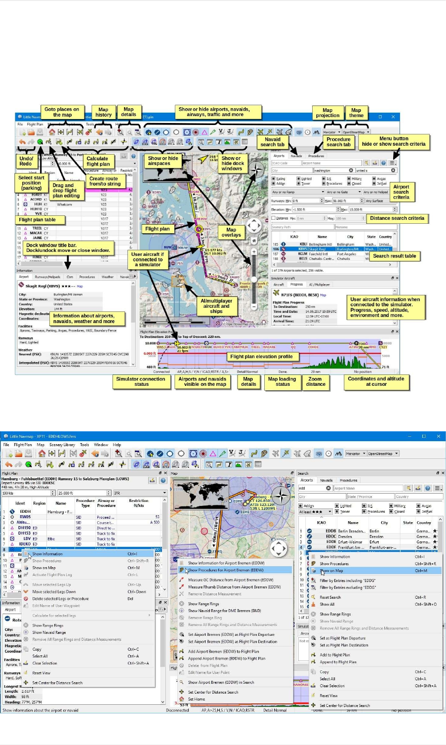
QuickOverview
Pictureabove:AquickoverviewofLittleNavmap1.8.5showingthemostimportantfunctions.
QuickOverview
9

Pictureabove:Thethreemostimportantcontextmenus(version1.8.5)whicharecanbeusedtobuildaflightplan.
QuickOverview
10

FirstStart
LittleNavmapwillcopyandpreparetheincludedNavigraphdatabaseonthefirststartup.SeeNavigraphformore
informationabouttheintegration.
TheSceneryLibraryDialogdialogwillbeshownoncethepreparationisfinished.Fromthereyoucanselectall
recognizedFlightSimulatorsandloadtheirscenerylibrariesintoLittleNavmap'sinternaldatabase.
NotethatX-Planecannotberecognizedautomatically.Youhavetosetthepathinthe SceneryLibraryDialog
beforeyoucanloadthedatabaseorselectingitinthemenu.
OnedatabaseiskeptforeachsimulatorandcanbechangedontheflyintheSceneryLibraryMenu.
AwarningdialogwillbeshownonWindowswhenstartingLittleNavmapthefirsttimeonasystemwithoutFSXor
P3Dflightsimulatorinstallations.SeechapterRunningwithoutFlightSimulatorInstallationformoreinformationon
this.
YoucanalsogodirectlytotheSceneryLibraryDialogfromthereifyouhaveX-Planeinstalled.
OneormorescenerylibrarydatabasesmayneedtobeupdatedwhenyouinstallanewversionofLittleNavmap.A
questiondialogwillpopuppromptingyoutoerasethenowincompatibledatabase.Youcanreloadthesceneryinthe
SceneryLibraryDialogaftererasingthedatabases.
RecommendedthingstodoafterInstalling
Theelevationdatawhichisusedbydefaultislimitedandhasalotofproblems.Therefore,Irecommendto
downloadandusetheofflineGLOBEelevationdata.SeeOptionsDialog/FlightPlanElevationProfileformore
information.
Havealookatthetutorialsifyouusetheprogramthefirsttime.
SeeInstallNavigraphUpdatesonmyhomepageforinformationhowtoupdateLittleNavmap'snavigationdata.
SeeConnectingtoaFlightSimulatorforthenextsteptouseLittleNavmapasamovingmap.TheincludedLittle
XpconnectpluginhastobeinstalledforX-Plane.
HowtorunanetworkSetup
SeethetwochaptersbelowifyouliketorunLittleNavmapinanetworkedsetupusingonecomputerfortheflight
simulatorandonecomputertorunLittleNavmap.
ConnectingtoaFlightSimulator
RunningwithoutFlightSimulatorInstallation
Howtoprepareanetworksetup:
1. Install/extractthewholeLittleNavmaparchiveontheflyingandnetworkcomputer.
2. CopyLittleXpconnecttotheX-PlanepluginsfolderifyouuseX-Plane.
3. UseLittleNavmaptogeneratethescenerydatabaseontheflyingcomputer.Mainmenu-> SceneryLibrary->
LoadSceneryLibrary...
4. Copythedatabasefilestothenetworkcomputer.QuitLittleNavmapbeforecopying.
Flyinginanetworksetup:
1. Startthesimulator
2. StartLittleNavconnectontheflyingcomputer.
FirstStart
11

3. RunLittleNavmaponthenetworkcomputer.
4. ConnectLittleNavmaponthenetworkcomputertoLittleNavconnectontheflyingcomputer.Mainmenu->
Tools-> FlightSimulatorConnection...
Seelinksabovefordetailedinstructions.
General
UserInterface
DockWindows
TheuserinterfaceofLittleNavmapconsistsofamainwindowandseveraldockwindowswhichcanbedetachedfrom
themainwindoworarrangedinanyorderwithinthemainwindow.
Thedockedwindowscanbemovedaroundintheirdockedpositionandcanbedetachedfromthemainwindowby
simplydraggingthemoutsideofthemainwindow,bydouble-clickingtheirtitlebarorbyclickingonthewindow
symbolonthetopright.
Doubleclickonthedockedwindow'stitlebarorclickonthewindowsymbolagaintomovethewindowsbackintotheir
dockedposition.
Alldockedwindowsexceptthemapwindowcanbeclosediftheyarenotneeded.Youcanevendropdocked
windowsoneachothertocreateatabbedview.Thetabswillappearatthebottomofthedockstackinthiscase.
Hold Ctrlwhileclickingonthewindowtitlebartopreventawindowfromgoingintodockedstateandkeepit
floating.
Toolbarsarealsomovablebyclickingonthelefthandleandcanalsobeclosedordetachedfromthemainwindow.
Usethe MainMenu-> Windowmenutorestoreclosedwindowsortoolbars.
The MainMenu-> Window-> ResetWindowLayoutmenuitemcanbeusedtoresetthestateandpositionsofall
dockwindowsandtoolbarsbacktotheirdefault.
ContextMenus
Usethecontextmenustobuildaflightplan.
Contextmenuscanbefoundinthefollowingplaces:
Mapdisplaywindow-MapContextMenu
Flightplantable-FlightPlanTableViewContextMenu
Airportandnavaidsearchresulttables-SearchResultTableViewContextMenu
Proceduresearchtree-ProcedureTreeContextMenu
Thecontextmenusprovidefunctionalitytogetmoreinformationaboutanobjectattheclickedpositionortobuildor
editaflightplan.
TooltipHelp,HelpButtonsandHelpMenu
ThehelpmenuofLittleNavmapcontainslinkstotheonlinehelp,anincludedofflinehelpPDFdocument,online
tutorialsandthemaplegend.
Theprogramusestooltipstodisplaymoreinformationonbuttonsandothercontrols.
Amoredetaileddescriptionisshownontheleftsideofthestatusbarifyouhoverthemouseoveramenuitem.
FirstStart
12

Mostdialogsandsomedockwindowsshowhelpbuttons whichwillopenthecorrespondingsectionsofthe
onlinemanual.
WindowTitle
Themainwindowtitleindicatesthecurrentlyselectedsimulatordatabase( FSX, FSXSE, P3DV2, P3DV3, P3DV4or
XP11),theflightplanfilenameandatrailing *iftheflightplanhasbeenchanged.
A NwillbeappendediftheNavigraphdatabaseisused:
P3DV4:Allfearturesonthemapandallinformationindialogsandwindowscomesfromtheflightsimulator
database.
P3DV4/N:AirportsandILSareshownandusedfromtheflightsimulatordatabase.Navaids,airspace,airways
andproceduresareusedfromtheNavigraphdatabase.
(P3DV4)/N:AlldataisusedfromtheNavigraphdatabase.Noaprons,notaxiwaysandnoparkingpositionsare
availableforairports.
InformationandSimulatorAircraftText
Youcanchangethetextsizepermanentlyintheoptionsdialogforthesewindows.
Aquickwaytochangethetextsizeistousethemousewheeland Ctrlkey.Thissettingwon'tbesavedacross
sessions,though.
Tabs
Tabsthatappearontopofawindowarefixed.Atooltipgivesmoreinformationaboutthefunctionofatab.
Tabsatthebottomofawindowappearwhenyoudropdockwindowsoneachother.Grabawindowtitlebartomove
awindowoutofthestackeddisplay.Youcanchangetheorderofthesetabsbydraggingthemaround.
Themousewheelallowstocyclebetweentabsinamoreconvenientway.
CopyandPaste
Almostalldialogs,textlabelsandallinformationwindowsinLittleNavmapallowcopyandpaste.
Youcanselectthetextusingthemouseandtheneitheruse Ctrl+Corthecontextmenutocopyittotheclipboard.
Theinformationandsimulatoraircraftwindowsevensupportcopyingofformattedtextincludingtheicons.Thiscanbe
helpfultoreporterrors.
Thetableviewsfortheflightplanorairport/navaidsearchresultsallowcopyingoftheresultsinCSVformattothe
clipboardwhichcanbepastedintoaspreadsheetprogramlikeLibreOfficeCalcorMicrosoftExcel.
TranslationandLocale
LittleNavmapiscurrentlyavailableinseverallanguages.
Iwillhappilysupportanybodywhowouldliketotranslatetheuserinterfaceormanualintoanotherlanguage.
LanguagepackagescanbeaddedtoaLittleNavmapinstallationlateroncetheyareavailable.SeeTranslatinginthe
GithubLittleNavmapwikiformoreinformation.
Youcanoverridetheuserinterfacelanguageinthedialog Optionsthethetab UserInterface.
FirstStart
13

DespiteusingtheEnglishlanguageintheuserinterfacethelocalesettingsoftheoperatingsystemwillbeused.So,
e.g.onaGermanversionofWindowsyouwillseecommaasadecimalseparatorinsteadoftheEnglishdot.
ThelanguageandlocalesettingscanbeforcedtoEnglishinthedialog Optionsonthetab UserInterfaceifa
translateduserinterfaceisnotdesired.
PleasenotethatsomescreenshotsinthismanualweretakenusingGermanlocale,thereforeacommaisusedasa
decimalseparatorandadotasathousandsseparator.
MapLegend
Thelegendexplainsallthemapiconsandthe FlightPlanElevationProfileicons.Itisavailableinthe Legenddock
windoworinthismanual:Legend.
NamingConventionsusedinthisManual
Highlightedtextisusedtodenotewindow,menu,button,fileordirectorynames.SeetheGlossaryforexplanations
ofcommontermsinthismanual.
Rating
Airportsgetazerotofivestarratingdependingonfacilities.Airportsthathavenoratingareconsideredboringandwill
bedisplayedusingagraysymbolbelowallotherairportsonthemap( EmptyAirport).Thisbehaviorcanbeswitched
offinthe Optionsdialogonthe MapDisplaytab.
Thecriteriabelowareusedtocalculatetherating.Eachitemgivesonestar:
1. Add-on(or3DforX-Plane)
2. Parkingpositions(ramporgate)
3. Taxiways
4. Aprons
5. Towerbuilding(onlyifatleastoneoftheotherconditionsismet).
Allairportsthatarenotlocatedinthedefault ScenerydirectoryofFSX/P3Dorarelocatedinthe CustomScenery
directoryofX-Planeareconsideredadd-onairportswhichraisestheratingbyonestar.
Airportsinthe CustomScenery/GlobalAirports/Earthnavdata/apt.datfileofX-Planeare3Dairportswhichraisesthe
ratingbyonestartoo.
NavdataUpdates
LittleNavmapcomeswithareadytousedatabasefromNavigraphincludingairspaces,SIDs,STARsandmore.The
databasecanbeupdatedbyusingNavigraph'sFMSDataManager.
SeethechapterNavigationDatabasesformoreinformation.
FSXandPrepar3D
LittleNavmapiscompatiblewithnavdataupdatesfromfsAerodataorFSX/P3DNavaidsupdate.
X-Plane
LittleNavmapwilluseanynavdataupdatesthatareinstalledinthedirectory CustomData.Anyolderupdatesinstalled
intheGPSdirectoriesarenotused.
User-defineddatafromthefiles user_fix.datand user_nav.datisreadandmergedintothedatabaseiffound.
FirstStart
14

NotethatneitherARINCnortheFAACIFPfilesaresupported.
MagneticDeclination
ThecalibratedmagneticdeclinationofaVORmaydifferfromtheactualdeclinationinaregionasitdoesinreality.
Therefore,magneticcoursevaluesmightdifferinsomecases.
FSXandPrepar3D
Thedeclinationusedtocalculatethemagneticcourseistakenfromthe magdec.bglfileinthescenerydatabase.
Updatesforthisfileareavailablehere:FSX/P3DNavaidsupdate.
X-Plane
ThedeclinationvaluesforX-Plane(airportsandallnavaidsexceptVORs)iscalculatedbasedontheincluded
magdec.bglfilewhichisbasedonthevaluesforthebeginningof2017.
FirstStart
15
MenusandToolbars
ThischapterdescribesallthemenuitemsofLittleNavmap.Youwillfindmostofthisfunctionalityonthetoolbarsas
wellwhicharenotbedescribedseparately.Keycombinationscanbeseenonthemenuitemsandarenotlistedin
thismanual.
Pictureabove:Menuandtoolbarsdockedindefaultpositions.
FileMenu
NewFlightPlan
Erasesthecurrentflightplan.
YouhavetousetheSearchResultTableViewContextMenu,theMapContextMenuortheFlightPlanRoute
Descriptiondialogtocreateaflightplan.
OpenFlightPlan
OpensanFSXPLN,anFS9PLN,anFSCPLN,anX-PlaneFMSoranFLPflightplanfile.Thetypeoffileis
determinedbycontentandnotfileextension.SeeFlightPlanFormatsformoreinformation.
Anopenedflightplanfilewillbereloadedonstartup(reloadandcenteringcanbeswitchedoffinthe Optionsdialog
onthe Startupand UserInterfacetab).
ProcedureinformationandgroundspeedwillbeaddedtotheflightplanifaPLNfileissavedbyLittleNavmap.The
additionalinformationwillbeignoredbyFSXorP3DbutallowstoreloadallinformationbyLittleNavmap.
AppendFlightPlan
Addsdeparture,destinationandallwaypointstothecurrentflightplan.
Using AppendFlightPlanallowstoloadormergecompleteflightplansorflightplansnippetsintoanewplan.All
waypointsareaddedattheendofthecurrentflightplan.Thenyoucanusethe DeleteselectedLegsand Moveselected
Legsup/downcontextmenuitemstoarrangethewaypointsandairportsasrequired.SeeFlightPlanTableView
ContextMenu.
Allarrivalprocedureswillberemovedwhenappendingaflightplan.
SaveFlightPlan
SaveFlightPlanasPLN
SavestheflightplantoanFSX/P3DPLNfile(XMLformat).Thisannotatedformatallowstosaveallflightplan
attributesofLittleNavmap.
MenusandToolbars
16

SaveFlightPlanasPLNchangesthecurrentfiletypeandnameinLittleNavmapwhichmeansthatallfurthersaves
willgointothenewPLNfile.
Itisrecommendedtosaveallflightplansinthisformattokeepallinformationofaplan.Evenwhenusingthelimited
FMSformatforX-Plane.SeeFlightPlanFormatsformoreinformation.
LittleNavmapwillallowflightplanstobecreatedthatmaybeusefulasaflightplansnippetbutareunusablebythe
flightsimulator.Thisoccursifaflightplandoesnothaveadepartureordestinationairport.Awarningdialogwillbe
shownwhensavingaincompleteflightplan.
Awarningdialogwillalsobeshownifthedepartureairporthasparkingpositionsbutnoneisassignedintheflight
plan.
Procedureswillbesavedasanannotationintheflightplanfileiftheflightplancontainsany.Thiscausesnoproblem
forthesimulatorsandmostotherprograms.UseExportcleanFlightPlanifaprogramhasproblemsreadingthePLN
filessavedbyLittleNavmap.
Notethatthewaypointsofaprocedurearenotsavedwiththeflightplan.ThisisnotsupportedbyFSXorP3D.Use
theGPS,FMCorotherwaystoselectaprocedureinyouraircraft.
Thesetgroundspeedisalsosavedwiththeflightplan.
NotethatP3Dv4.2overwritestheflightplanwhenloading,whicherasesallannotations.Saveacopyofthe
plantoanotherlocationifyouliketokeepallinformationaboutproceduresorspeed.
SaveFlightPlanasX-PlaneFMS11
SavestheflightplanusingthenewX-PlaneFMS11format.ThisformatcanonlybeusedinX-Plane11.10and
above.DonottrytoloaditintotheFMSorGPSofX-Plane11.05.Itmightcrashthesimulator.
Awarningdialogwillbeshownwiththewarningabovewhensaving.
SeeFlightPlanFormatsformoreinformationonlimitations.
ThisfunctionchangesthecurrentfiletypeandnamewhichmeansthatallfurthersaveswillgointothenewFMSfile
andthefilewillbereloadedonnextstart.
StoreFMSfilesintothe Output/FMSplansdirectoryinsidetheX-Planedirectoryifyouwouldliketousetheflightplan
intheX-PlaneGPS,theG1000ortheFMS.
SaveFlightPlanasFLP
ExportsthecurrentflightplanasanFLPfileusablebytheX-PlaneFMS,AerosoftAirbusandotheradd-onaircraft.
Thisformatislimitedsoadialogisshownifanyunsupportedfeaturesaredetectedinthecurrentflightplan.
SeeFlightPlanFormatsformoreinformationonlimitations.
ThisfunctionchangesthecurrentfiletypeandnamewhichmeansthatallfurthersaveswillgointothenewFLPfile
andthefilewillbereloadedonnextstart.
StoreFLPfilesintothe Output/FMSplansdirectoryinsidetheX-PlanedirectoryifyouwanttoloaditintotheFMS.
ExportasCleanPLN
MenusandToolbars
17

SavesaflightplanwithoutanyprocedureorspeedannotationsifprogramshaveproblemsreadingthePLNfiles
savedbyLittleNavmap.Thisisrarelyneeded.
Likeanyotherexportfunctionthisdoesnotchangethecurrentfilenameandtype.Furthersaveswillstillusethe
samefilenameandformatasbefore.
SeealsoFlightPlanFormats.
ExportFlightPlanasX-PlaneFMS3
SavestheflightplanusingtheolderX-PlaneFMS3formatwhichislimitedbutcanbeloadedbyX-Plane10andX-
Plane11.05.Awarningdialogisshownifanyunsupportedfeaturesaredetectedinthecurrentflightplan.
SeeFlightPlanFormatsformoreinformationonlimitations.
Thisexportfunctionthisdoesnotchangethecurrentfilenameandtype.Furthersaveswillstillusethesamefile
nameandformatasbefore.
StoreFMSfilesintothe Output/FMSplansdirectoryinsidetheX-Planedirectoryifyouwouldliketousetheflightplan
intheX-PlaneGPSorFMS.
ExportFlightPlantootherFormats(Sub-Menu)
SeeFlightPlanFormatsformoredetailedinformationontheavailableexportformats.
Exportfunctionsdonotchangethecurrentfilenameandtype.Furthersaveswillstillusethesamefilenameand
formatasbefore.
ExportFlightPlanasGarminGTNGFP
ExportstheflightplaninGFPformatusedbytheFlight1GTN650/750.
Proceduresarenotincludedintheexportedfile.
SeeFlightPlanFormatsformoreinformationaboutthisexportformatandhowtoworkaroundlockedwaypoints.
ExportFlightPlanasGFPforRealityXPGTN
SaveflightplanasGFPfileusablebytheRealityXPGTN750/650Touch.Thisformatallowstosaveproceduresand
airways.
SeealsoNotesabouttheGarminFormatsGFPandFPLforinformationaboutpathsandotherremarks.
ExportFlightPlantoFPLfortheRealityXPGNS
SaveflightplanasFPLfileusablebytheRealityXPGNS530W/430WV2.
Proceduresortheirrespectivewaypointsarenotincludedintheexportedfile.
ThedefaultdirectorytosavetheflightplansfortheGNSunitsis C:\ProgramData\Garmin\GNSTrainerData\GNS\FPLforall
simulators.ThedirectorywillbecreatedautomaticallybyLittleNavmaponfirstexportifitdoesnotexist.
SeealsoNotesabouttheGarminFormatsGFPandFPL.
ExportFlightPlanasPMDGRTE
ExportsthecurrentflightplanasaPMDGRTEfile.
Proceduresortheirrespectivewaypointsarenotincludedintheexportedfile.
MenusandToolbars
18

ExportFlightPlanasTXT
ExportsthecurrentflightplanasaTXTfileusablebyJARDesignorRotateSimulationsaircraft
Neitherproceduresnortheirrespectivewaypointsareincludedintheexportedfile.
ExportFlightPlanasMajesticDashFPR
ExportsthecurrentflightplanfortheMajesticSoftwareMJC8Q400.Notethattheexportiscurrentlylimitedtoalistof
waypoints.
Theflightplanhastobesavedto FSXP3D\SimObjects\Airplanes\mjc8q400\nav\routes.
ExportFlightPlanasIXEGFPL
ExportsthecurrentflightplanasanFPLfileusablebytheIXEGBoeing737classic.
SIDs,STARsorapproachproceduresarenotexported.
Thefileshouldbesavedto XPLANE\Aircraft\X-Aviation\IXEG737Classic\coroutes.Youmighthavetocreatethedirectory
manuallyifitdoesnotexist.
ExportFlightPlantocorte.inforFlightFactorAirbus
Appendsthetheflightplantoaneworalreadypresent corte.incompanyroutesfilefortheFlightFactorAirbus
aircraft.
Thefilewillbeautomaticallycreatedifitdoesnotexist.Otherwisetheflightplanwillbeappendedtothefile.Youhave
toremovetheflightplanmanuallyfromthe corte.infilewithasimpletexteditorifyouwishtogetridofit.
Locationofthefiledependsonaircrafttype.
ExportFlightPlanasFLTPLANforiFly
SaveflightplanasFLTPLANfilefortheiFly737NG.Theformatdoesnotallowsavingofprocedures.
Savethefileto FSXP3D\iFly\737NG\navdata\FLTPLAN.
ExportFlightPlanforProSim
Appendsflightplantothe companyroutes.xmlfileforProSimsimulators.Theformatdoesnotallowsavingof
procedures.
Createsabackupfilenamed companyroutes.xml_lnm_backupbeforemodifyingthefile.
ExportFlightPlanasPLNforBBSAirbus
SaveflightplanasPLNfilefortheBlackboxSimulationsAirbus.Theformatdoesnotallowsavingofprocedures.
Savethefileto FSXP3D\BlackBoxSimulation\AirbusA330or FSXP3D\BlackboxSimulation\CompanyRoutesdependingon
aircraft.
ExportFlightPlanforUFMC
SaveflightplanasUFMCfile.Theformatdoesnotallowsavingofprocedures.
Savetheflightplanto XPLANE\CustomData\UFMC\FlightPlans.
ExportFlightPlanforX-FMC
SaveflightplanasFPLfileusablebyX-FMC.Theformatdoesnotallowsavingofprocedures.
MenusandToolbars
19

ThefileshouldbesavedtoPathto XPLANE\Resources\plugins\XFMC\FlightPlans.
ExportFlightPlanasGPX
ExportsthecurrentflightplanintoaGPSExchangeFormatfilewhichcanbereadbyGoogleEarthandmostother
GISapplications.
Theflightplanisexportedasarouteandtheflownaircrafttrailasatrackincludingsimulatortimeandaltitude.
Theroutehasdepartureanddestinationelevationandcruisealtitudesetforallwaypoints.Waypointsofall
proceduresareincludedintheexportedfile.Notethatthewaypointswillnotallowtoreproduceallpartsofa
procedurelikeholdsorprocedureturns.
Donotforgettocleartheaircrafttrail(DeleteAircraftTrail)beforeflighttoavoidoldtrailsegmentsinthe
exportedGPXfile.Or,disablethereloadingofthetrailintheoptionsdialogonpage Startup.
ShowFlightPlaninSkyVector
OpensthedefaultwebbrowserandshowsthecurrentflightplaninSkyVector.Proceduresarenotshown.
Example:ESMSNEXI2BNILENL617ULMUGM609TUTBIZ101GUBAVSTM7CENBO.NotemissingSIDand
STARinSkyVector.
SaveWaypointsforApproaches
SaveWaypointsforSIDandSTAR
Saveprocedurewaypointsinsteadofprocedureinformationifchecked.Thisaffectsallflightplanexportandsave
formats.
Usethisifyoursimulator,GPSorFMCdoesnotsupportloadingordisplayofapproachprocedures,SIDorSTAR.
ProcedureinformationisreplacedwithrespectivewaypointsthatallowtodisplayproceduresinlimitedGPSorFMS
units.
Savingflightplanswiththismethodhasseverallimitations:
Severalapproachlegtypeslikeholds,turnsandprocedureturnscannotbedisplayedproperlybyusingjust
waypoints/coordinates.
Speedandaltitudelimitationsarenotincludedintheexportedlegs.
TheprocedureinformationisdroppedfromthesavedflightplanandcannotbereloadedproperlyinLittle
Navmap.Thus,youwillseethewaypointsofaSIDorSTARbutnotthedetailedprocedureinformation.Youhave
todeletetheaddedwaypointsandre-selecttheproceduresafterloading.
Duetotheselimitationsitisrecommendedtosaveacopyoftheflightplanwithfullinformationbeforeenablingoneof
theseoptions.
AddGoogleEarthKML
AllowsadditionofoneormoreGoogleEarthKMLorKMZfilestothemapdisplay.AlladdedKMLorKMZfileswillbe
reloadedonstartup.Reloadandcenteringcanbeswitchedoffinthe Optionsdialogonthe Startupand User
Interfacetab.
DuetothevarietyofKMLfilesitisnotguaranteedthatallfileswillshowupproperlyonthemap.
ClearGoogleEarthKMLfromMap
MenusandToolbars
20

RemovesallloadedKMLfilesfromthemap.
WorkOffline
StopsloadingofmapdatafromtheInternet.ThisaffectstheOpenStreetMap,OpenTopoMapandalltheotheronline
mapthemesaswellastheelevationdata.Ared Offline.indicationisshowninthestatusbarifthismodeisenabled.
Youshouldrestarttheapplicationaftergoingonlineagain.
SaveMapasImage
Savesthecurrentmapviewasanimagefile.AllowedformatsareJPEG,PNGandBMP.
PrintMap
Allowstoprintthecurrentmapview.SeePrintingtheMapformoreinformation.
PrintFlightPlan
Opensaprintdialogthatallowsyoutoselectflightplanrelatedinformationtobeprinted.SeeMapFlightPlanPrinting
formoreinformation.
Quit
Exitstheapplication.Willaskforconfirmationifthereisachangedflightplan.
FlightPlanMenu
Undo/Redo
Allowsundoandredoofallflightplanchanges.
SelectaStartPositionforDeparture
Aparkingspot(gate,ramporfuelbox),runwayorhelipadcanbeselectedasastartpositionatthedepartureairport.
AparkingpositioncanalsobeselectedinthemapcontextmenuitemSetasFlightPlanDeparturewhenright-clicking
onaparkingposition.Ifnopositionisselectedthelongestprimaryrunwayendisselectedautomaticallyasstart.
MenusandToolbars
21
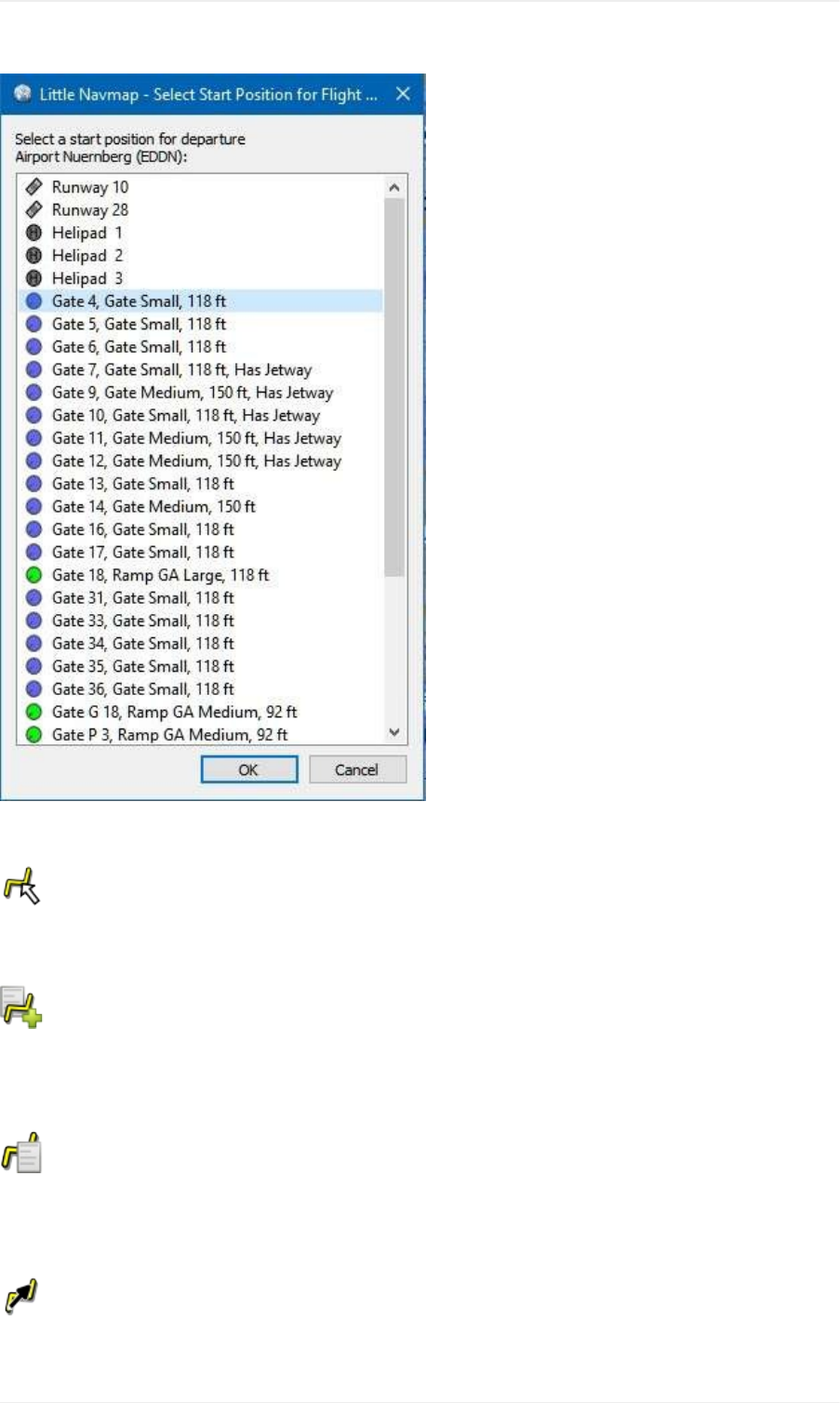
Pictureabove:ThestartpositionselectiondialogforEDDN.
EditFlightPlanonMap
Togglestheflightplandraganddropeditmodeonthemap.SeeFlightPlanEditing.
NewFlightPlanfromRouteDescription
Opensadialogwiththeroutedescriptionofthecurrentflightplanthatalsoallowstomodifythecurrentflightplanor
enteranewone.FlightPlanfromRouteDescriptiongivesmoreinformationaboutthistopic.
CopyFlightPlanRoutetoClipboard
CopiestheroutedescriptionofthecurrentflightplantotheclipboardusingthesettingsfromtheFlightPlanfrom
RouteDescriptiondialog.
CalculateDirect
Deletesallintermediatewaypointsandconnectsdepartureanddestinationusingagreatcircleline.
MenusandToolbars
22

Youcancalculateaflightplanbetweenanykindofwaypoints,evenuser-definedwaypoints(right-clickonthemap
andselect AddPositiontoFlightplantocreateone).Thisallowsthecreationofsnippetsthatcanbemergedinto
flightplans.ForexampleyoucanusethisfeatureforcrossingtheNorthAtlanticwithvaryingdeparturesand
destinations.Thisappliestoallflightplancalculationmodes.
CalculateRadionav
CreatesaflightplanthatusesonlyVORandNDBstationsaswaypointsandtriestoensurereceptionofatleastone
stationalongthewholeflightplan.NotethatVORstationsarepreferredbeforeNDBandDMEonlystationsare
avoidedifpossible.Calculationwillfailifnotenoughradionavaidscanbefoundbetweendepartureanddestination.
Buildtheflightplanmanuallyifthisisthecase.
Thiscalculationcanalsobeusedtocreateaflightplansnippetbetweenanykindofwaypoint.
CalculatehighAltitude
UsesJetairwaystocreateaflightplan.
Calculatedflightplansalongairwayswillobeyallairwayrestrictionslikeminimumandaltitude.Theprogramwillalso
adheretoone-wayandmaximumaltituderestrictionsforX-Planebasednavdata.
Theresultingminimumaltitudeissetintheflightplanaltitudefield.Theflightplanaltitudefieldisnotchangedifno
altituderestrictionswerefoundalongtheflightplan.
Asimplifiedeast/westruleisusedtoadjustthecruisealtitudetoodd/evenvalues(thiscanbeswitchedoffinthe
Optionsdialogonthe FlightPlantab).
Thedefaultbehavioristojumpfromthedepartureairporttothenextwaypointofasuitableairwayandviceversafor
thedestination.Thiscanbechangedin Optionsdialogonthe FlightPlantabifVORorNDBstationsarepreferred
astransitionpointstoairways.
TheairwaynetworkofFlightSimulatorisnotcomplete(thenorthAtlantictracksaremissingforexample-these
changedaily),thereforecalculationacrosslargeoceanareascanfail.
Createtheairwaymanuallyasaworkaroundoruseanonlineplanningtooltoobtainaroutestringandusethe New
FlightPlanfromStringoptiontocreatetheflightplan.
Thiscalculationcanalsobeusedtocreateaflightplansnippetbetweenanykindofwaypoint.
CalculatelowAltitude
UsesVictorairwaystocreateaflightplan.Everythingelseisthesameasin CalculatehighAltitude.
CalculatebasedongivenAltitude
UsethevalueinthealtitudefieldoftheflightplantofindaflightplanalongVictorand/orJetairways.Calculationwill
failifthealtitudevalueistoolow.Everythingelseisthesameasin CalculatehighAltitude.
ReverseFlightPlan
MenusandToolbars
23
Swapsdepartureanddestinationandreversesorderofallintermediatewaypoints.Adefaultrunwayisassignedfor
thenewdeparturestartposition.
Notethatthisfunctiondoesnotconsiderone-wayairwaysintheX-Planedatabaseandmightresultinaninvalidflight
plan.
AdjustFlightPlanAltitude
ChangestheflightplanaltitudeaccordingtoasimplifiedEast/Westruleandthecurrentroutetype(IFRorVFR).
Roundsthealtitudeuptothenearesteven1000feet(ormeter)forwesterlyflightplansorodd1000feet(ormeter)for
easterlyflightplans.Adds500feetforVFRflightplans.
MapMenu
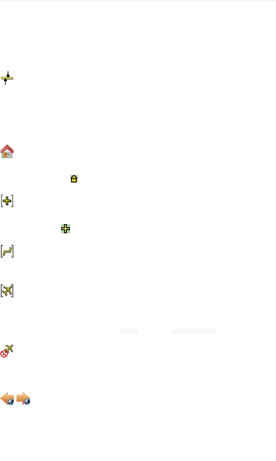
GotoHome
GoestothehomeareathatwassetusingSetHomeusingthesavedpositionandzoomdistance.Thecenterofthe
homeareaishighlightedbya symbol.
GotoCenterforDistanceSearch
Gotothecenterpointusedfordistancesearches.SeeSetCenterforDistanceSearch.Thecenterforthedistance
searchishighlightedbya symbol.
CenterFlightPlan
Zoomsoutthemap(ifrequired)todisplaythewholeflightplanonthemap.
CenterAircraft
ZoomstotheuseraircraftifdirectlyconnectedtoaflightsimulatororremotelyconnectedusingLittleNavconnectand
keepstheaircraftcenteredonthemap.
Thecenteringoftheaircraftcanbechangedinthe Optionsdialogonthe SimulatorAircrafttab.
DeleteAircraftTrail
Removestheuseraircrafttrail.Itisalsodeletedwhenconnectingtoaflightsimulator.Thetrailissavedandwillbe
reloadedonprogramstartup.
MapPositionBack/Forward
Jumpsforwardorbackwardinthemappositionhistory.Thecompletehistoryissavedandrestoredwhenstarting
LittleNavmap.
ViewMenu
MenusandToolbars
24
ResetDisplaySettings
Resetsallmapdisplaysettingsbacktodefault.
Pictureabove:Allsettingtoolbuttonshighlightedthatareaffectedby ResetDisplaySettings.
Details
MoreDetails
DefaultDetails
LessDetails
Increasesordecreasesthedetaillevelforthemap.Moredetailsmeansmoreairports,morenavaids,moretext
informationandbiggericons.
Notethatmapinformationwillbetruncatediftoomuchdetailischosen.Aredwarningmessagewillbeshowninthe
statusbarifthisisthecase.
Thedetaillevelisshowninthestatusbar.Rangeis-5forleastdetailto+5formostdetail.
ForceShowAddonAirports
Add-onairportsarealwaysshownindependentlyoftheotherairportmapsettingsifthisoptionisselected.Thisallows
viewingonlyadd-onairportsbycheckingthisoptionanddisablingthedisplayofhard,softandemptyairports.
ShowAirportswithhardRunways
Showairportsthathaveatleastonerunwaywithahardsurface.
ShowAirportswithsoftRunways
Showairportsthathaveonlysoftsurfacedrunwaysoronlywaterrunways.Thistypeofairportmightbehiddenonthe
mapdependingonzoomdistance.
ShowemptyAirports
Showemptyairports.Thisbuttonormenuitemmightnotbevisibledependingonsettingsinthe Optionsdialogon
the MapDisplaytab.Thestatusofthisbuttoniscombinedwiththeotherairportbuttons.Thismeans,forexample:
Youhavetoenablesoftsurfacedairportdisplayandemptyairportstoseeemptyairportshavingonlysoftrunways.
MenusandToolbars
25
Anemptyairportisdefinedasonewhichhasneitherparkingnortaxiwaysnorapronsandisnotanadd-on.These
airportsaretreateddifferentlyinLittleNavmapsincetheyarethemostboringofalldefaultairports.Emptyairportsare
drawngrayandbehindallotherairportsonthemap.
Airportshavingonlywaterrunwaysareexcludedfromthisdefinitiontoavoidunintentionalhiding.
X-Planeand3Dairports
ThefunctioncanbeextendedtoX-Planeairportswhicharenotmarkedas 3D.Thiscanbedonebychecking
ConsiderallX-Planeairportsnotbeing3Demptyinthe Optionsdialogonthe MapDisplaytab.Allairportsnotbeing
markedas 3Dwillbeshowningrayonthemapandcanbehiddenlikedescribedaboveifenabled.
Anairportisconsidered3Difitisstoredin XPLANE/CustomScenery/GlobalAirportScenery/Earthnavdata/apt.dat.
Thedefinitionof 3Disarbitrary,though.A 3Dairportmaycontainjustasingleobject,suchasalightpoleoratraffic
coneoritmaybeafullyconstructedmajorairport.
ShowVORStations
ShowNDBStations
ShowWaypoints
ShowILSFeathers
ShowVictorAirways
ShowJetAirways
Showorhidethesefacilitiesornavaidsonthemap.Navaidsmightbehiddenonthemapdependingonzoom
distance.
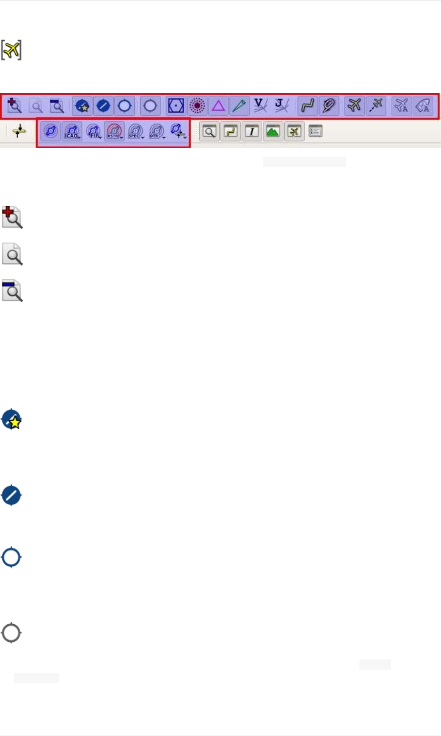
Airspaces
Notethatairspacesarehiddeniftheairportdiagramisshown.
ShowAirspaces
Allowstoenableordisablethedisplayofallairspaceswithoneclick.Usethemenuitemsbelowthisoneorthe
toolbarbuttonstodisplayorhidethevariousairspacetypes.
Theairspacestoolbarcontainsbuttonseachhavingadropdownmenuthatallowstoconfiguretheairspacedisplay
likeshowingorhidingcertainairspacetypes.Eachdropdownmenualsohas Alland Noneentriestoselector
deselectalltypesinthemenu.
ShowOnlineNetworkAirspaces
MenusandToolbars
26
Thisbuttonormenuitemisonlyvisibleifanonlinenetworkisenabled.
Itallowstohideorshowcenter,tower,ground,approachandotherairspacesfromthecurrentlyselectedonline
networkindependentlyofthesimulatororNavigraphairspaces.
Onlineairspacescanalsobeshownorhiddenbytypeusingthemenuitemsbelow.
Notethatthedisplayedairspacecirclesdonotdepicttherealairspaceboundariesbutaremerelyanindicatorforthe
presenceofanactivecenterortower.
SeeOnlineNetworksandOnlineFlying.
ICAOAirspaces
AllowsselectionofClassAtoClassEairspaces.
FIRAirspaces
AllowsselectionoftheClassFandClassGairspacesorflightinformationregions.
RestrictedAirspaces
ShoworhideMOA(militaryoperationsarea),restricted,prohibitedanddangerairspaces.
SpecialAirspaces
Showorhidewarning,alertandtrainingairspaces.
OtherAirspaces
Showorhidecenter,tower,modeCandotherairspaces.
AirspaceAltitudeLimitations
Allowsfilteringoftheairspacedisplaybyaltitude.Eitherbeloworabove10,000ftor18,000ftoronlyairspaces
intersectingwiththeflightplanaltitude.
Userpoints
Allowstohideorshowuser-definedwaypointsbytype.
Themenuitem UnknownTypesshowsorhidesalltypeswhichdonotbelongtoaknowntype.
Thetype Unknown showsorhidesalluserpointswhichareexactlyoftype Unknown.
SeeUser-definedWaypointsformoreinformationonuser-definedwaypoints.
ShowFlightPlan
Showorhidetheflightplan.Theflightplanisshownindependentlyofthezoomdistance.
MenusandToolbars
27

ShowMissedApproaches
Showorhidethemissedapproachesofthecurrentflightplan.Thisdoesnotaffectthepreviewinthesearchtab
Procedures.
Notethatthisfunctionchangestheactiveflightplanlegsequencing:Sequencingtheactivelegwillstopifthe
destinationisreachedandmissedapproachesarenotdisplayed.Otherwisesequencingwillcontinuewiththemissed
approachandthesimulatoraircraftprogresswillshowtheremainingdistancetotheendofthemissedapproach
instead.
ShowAircraft
Showstheuseraircraftandkeepsitcenteredonthemapifconnectedtothesimulator.Theuseraircraftisalways
shownindependentlyofthezoomdistance.
Theiconcolorandshapeindicatestheaircrafttypeandwhethertheaircraftisonground(grayborder).
Useraircraftinflight.
Aclickontheuseraircraftshowsmoreinformationinthe SimulatorAircraftdockwindow.
Moreoptionstochangethemapbehaviorwhileflyingcanbefoundinthedialog OptionsonthetabSimulatorAircraft.
Theaircraftcenteringwillbeswitchedoffwhenusingoneofthefollowingfunctions.Notethatthisdefaultbehavior
canbemodifiedintheoptionsdialog.
Double-clickintoatableviewormapdisplaytozoomtoanairportoranavaid.
Contextmenuitem Showonmap.
GotoHomeor GotoCenterforDistanceSearch.
Maplinkin Informationdockwindow.
ShowFlightPlan,whenselectedmanually,orautomaticallyafterloadingaflightplan.
CenteringaGoogleEarthKML/KMZfileafterloading
Thisallowsaquickinspectionofanairportornavaidduringflight.Todisplaytheaircraftagainuse MapPositionBack
orenable ShowAircraftagain.
ShowAircraftTrail
Showtheuseraircrafttrail.Thetrailisalwaysshownindependentlyofthezoomdistance.Itissavedandwillbe
reloadedonprogramstartup.
Thetrailisdeletedwhenconnectingtoaflightsimulatororitcanbedeletedmanuallybyselecting MainMenu-> Map-
> DeleteAircraftTrail.Thetrailisalsodeletedwhentheuseraircraftjumpsoverlargedistancewhenassigninga
newairport,forexample.
Thelengthofthetrailislimitedforperformancereasons.Ifitexceedsthemaximumlength,thetrailistruncatedand
theoldestsegmentsarelost.
ShowCompassRose
Showacompassroseonthemapwhichindicatestruenorthandmagneticnorth.Aircraftheadingandaircrafttrack
areshownifconnectedtoasimulator.
MenusandToolbars
28

Theroseiscenteredaroundtheuseraircraftifconnected.Otherwiseitiscenteredonthemapview.
SeeCompassRosefordetails.
ShowAIandMultiplayerAircraftorShips
ShowsAIandmultiplayeraircraftorshipsonthemap.Multiplayervehiclescanbedisplayedfrome.g.FSCloud,
VATSIMorSteamsessions.
Theiconcolorandshapeindicatestheaircrafttypeandwhethertheaircraftisonground(grayborder).
AIormultiplayeraircraftfromthesimulator.Thisincludesaircraftthatareinjectedbythevariousonlinenetwork
clients.AclickontheAIaircraftorshipshowsmoreinformationinthe SimulatorAircraftdockwindowinthetab AI/
Multiplayer.
Multiplayeraircraft/clientfromanonlinenetwork.SeeOnlineNetworks.Aclickontheonlineaircraftshows
informationinthe Informationdockwindowintheseparatetab OnlineClients.
Notethat,inX-Plane,shiptrafficisnotavailableandAIaircraftinformationislimited.
ThedisplayedvehiclesarelimitedbytheusedmultiplayersystemifLittleNavmapisnotconnectedtoanonline
networklikeVATSIMorIVAO.Multiplayeraircraftwilldisappeardependingondistancetouseraircraft.ForAIinFSX
orP3Dthisiscurrentlyabout100nauticalmilesoraround200kilometers.
Smallershipsareonlygeneratedbythesimulatorwithinasmallradiusaroundtheuseraircraft.
LittleNavmaplimitsthedisplayofAIvehiclesdependingonsize.Zoomclosetoseesmallaircraftorboats.
Onthelowestzoomdistanceallaircraftandshipsaredrawntoscaleonthemap.
AircraftlabelsareforcedtoshowindependentlyofzoomlevelforthenextfiveAI/multiplayeraircraftclosesttothe
userthatarewithin20nmdistanceand5000ftelevation.
Allaircrafticonscanbecustomized:User,AIandMultiplayerAircraftIcons.
ShowMapGrid
Showalatitude/longitudegridaswellasthemeridianandantimeridian(nearthedateline)onthemap.
ShowCountryandCityNames
Showcountry,cityandotherpointsofinterest.Availabilityoftheseoptionsdependsontheselectedmaptheme.See
Theme.
ShowHillshading
Showhillshadingonthemap.Availabilityoftheseoptionsdependsontheselectedmaptheme.SeeTheme.
Projection
Mercator
MenusandToolbars
29
Aflatprojectionthatgivesthemostfluidmovementandthesharpestmapwhenusingpicturetilebasedonlinemaps
themeslikeOpenStreetMaporOpenTopoMap.
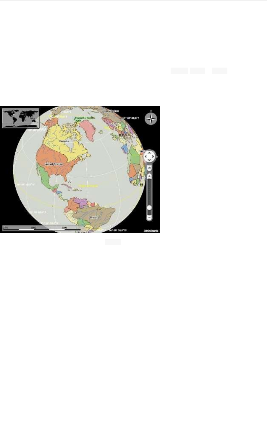
Spherical
Showsearthasaglobewhichisthemostnaturalprojection.Movementcanstutterslightlywhenusingthepicturetile
basedonlinemapsthemeslikeOpenStreetMaporOpenTopoMap.Usethe Simple, Plainor Atlasmapthemesto
preventthis.
Onlinemapscanappearslightlyblurredwhenusingthisprojection.Thisisaresultfromconvertingtheflatimagetiles
tothesphericaldisplay.
Pictureabove:Sphericalmapprojectionwith Simpleofflinemapthemeselected.
Theme
Pleasenotethatalltheonlinemapsaredeliveredfromfreeservicesthereforefastdownloadspeedsandhigh
availabilitycannotbeguaranteed.Inanycaseitiseasytodeliverandinstallanewonlinemapsourcewithoutcreating
anewLittleNavmaprelease.SeeCreatingoraddingMapThemesformoreinformation.
OpenStreetMap
Thisisanonlineraster(i.e.basedonimages)mapthatincludesahillshadingoption.NotethattheOpenStreetMap
hillshadingdoesnotcoverthewholeglobe.
MenusandToolbars
30
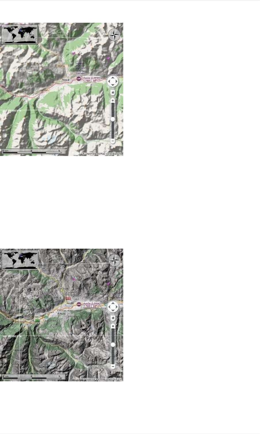
Pictureabove:ViewatanItalianairportusingOpenStreetMapthemeandhillshading.
OpenMapSurfer
TheOSMRoadslayerprovidedbyHeidelbergUniversity.Thisthemeincludesoptionalhillshadingwhichisavailable
worldwide.
Notethatthehillshadingoptionofthismapismarkedexperimental.
Mapdataforthismapisprovidedby©OpenStreetMapcontributors,renderingbyGIScienceResearchGroup@
HeidelbergUniversityandmapstylingbyMaximRylov.
SRTM;ASTERGDEMisaproductofMETIandNASA.
Pictureabove:ViewatanItalianairportusingtheOpenMapSurferthemeandhillshading.
OpenTopoMap
MenusandToolbars
31
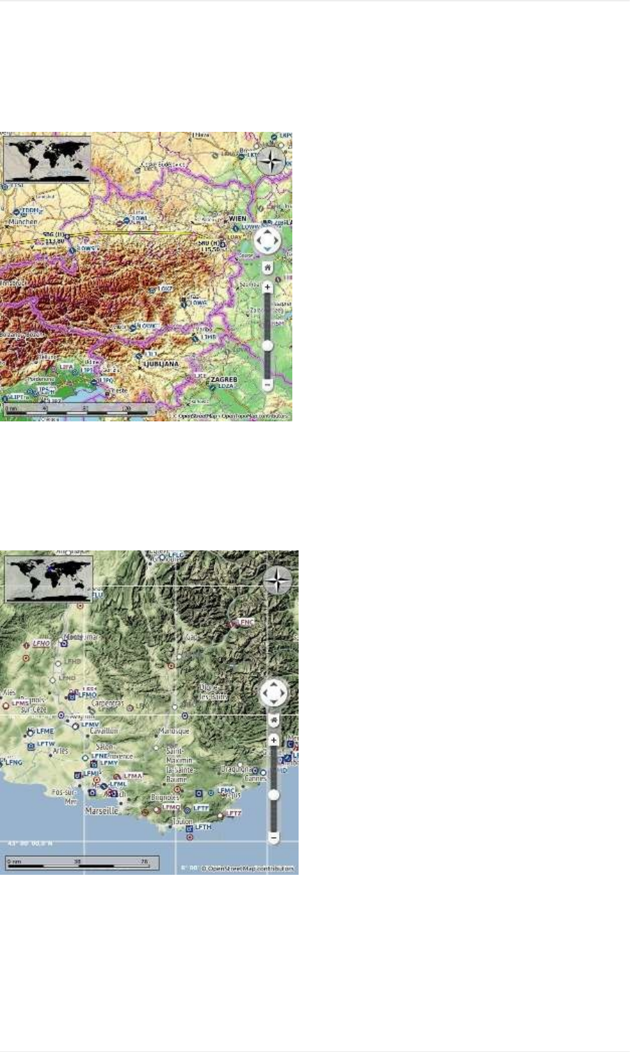
Anonlinerastermapthatmimicsatopographicmap.Includeshillshadingandelevationcontourlinesatlowerzoom
distances.
ThetilesforthismapareprovidedbyOpenTopoMap.
Pictureabove:ViewattheeasternAlpsusingOpenTopoMaptheme.AflightplanisshownnorthoftheAlps.
StamenTerrain
Aterrainmapfeaturinghillshadingandnaturalvegetationcolors.Thehillshadingisavailableworldwide.
MaptilesbyStamenDesign,underCCBY3.0.DatabyOpenStreetMap,underODbL.
Pictureabove:ViewshowingStamenTerraintheme.
CARTOLight(Newinversion1.4.4)
AverybrightmapcalledPositronwhichallowstoconcentrateontheaviationfeaturesonthemapdisplay.Themap
includesthesamehillshadingoptionastheOpenStreetMap.
MaptilesandstylebyCARTO.DatabyOpenStreetMap,underODbL.
MenusandToolbars
32

CARTODark(Newinversion1.4.4)
AdarkmapcalledDarkMatter.ThemapincludesthesamehillshadingoptionastheOpenStreetMap.
MaptilesandstylebyCARTO.DatabyOpenStreetMap,underODbL.
Simple(Offline)
Thisisapoliticalmapusingcoloredcountrypolygons.Boundariesandwaterbodiesaredepictedcoarse.Themap
includedinLittleNavmaphasanoptiontodisplaycityandcountrynames.
Plain(Offline)
Averysimplemap.ThemapisincludedinLittleNavmapandhasanoptiontodisplaycityandcountrynames.
Boundariesandwaterbodiesaredepictedcoarse.
Atlas(Offline)
Averysimplemapincludingcoarsehillshadingandlandcolors.ThemapisincludedinLittleNavmapandhasan
optiontodisplaycityandcountrynames.Boundariesandwaterbodiesaredepictedcoarse.
SceneryLibraryMenu
FlightSimulators
OnemenuitemiscreatedforeachFlightSimulatorinstallationordatabasefound.Thesemenuitemsallowswitching
ofdatabasesonthefly.ThemenuitemisdisabledifonlyoneFlightSimulatorwasfound.
TheloadedAIRACcycleisdisplayedonlyforX-PlanesincetheinformationisnotavailableforFSXorP3D
simulators.
YouhavetosetthebasepathtotheX-Planedirectoryinthe LoadSceneryLibraryDialogfirsttoenabletheX-
Planemenuitem.
ThismenuissynchronizedwithsimulatorselectionintheLoadSceneryLibraryDialog.Onceadatabaseis
successfullyloaded,thedisplay,flightplanandsearchwillswitchovertothenewlyloadedsimulatordata.
NotethattheprogramdoesnotkeepyoufromusingaX-Planescenerydatabasewhilebeingconnectedto
FSX/Prepar3Dorviceversa.Youwillgetunwantedeffectslikewrongweatherinformationifusingsucha
setup.
Theprogrammightchangealoadedflightplanifyouswitchbetweendifferentdatabases.Thiscanhappenifa
departurepositionissetintheplanwhichdoesnotexistintheotherdatabase.Click NewFlightPlanbeforeswitching
toavoidthis.
Navigraph
ThissubmenualsoindicatingtheAIRACcycleisaddedifaNavigraphdatabaseisfoundinthedatabasedirectory.
SeethechapterNavigationDatabasesformoreinformationaboutthesedatabasesandthethreedifferentdisplay
modesshownbelow.
UseNavigraphforallFeatures
CompletelyignoresthesimulatordatabaseandtakesallinformationfromtheNavigraphdatabase.
UseNavigraphforNavaidsandProcedures
MenusandToolbars
33

ThismodeblendsnavaidsandmorefromtheNavigraphdatabasewiththesimulatordatabase.Thisaffectsthemap
display,allinformationandandallsearchwindows.
DonotuseNavigraphDatabase
IgnorestheNavigraphdatabaseandshowsonlyinformationreadfromthesimulatorscenery.
ShowDatabaseFiles
OpenLittleNavmap'sdatabasedirectoryinafilemanager.SeeRunningwithoutFlightSimulatorInstallationformore
informationoncopyingdatabasefilesbetweendifferentcomputers.ThisallowsLittleNavmaptoberunonaremote
computer(e.g.Windows,MacorLinux)usingthesamedatabasethatwascreatedonthecomputerrunningtheflight
simulator.
LoadSceneryLibrary
Openthe LoadSceneryLibrarydialog.SeeLoadSceneryLibraryDialogformoreinformation.Thismenuitemis
disabledifnoflightsimulatorinstallationsarefound.
CopyAirspacestoX-PlaneDatabase
CopyairspaceinformationfromanFSXorP3DdatabasetoanX-Planedatabase.ThisisneededsinceX-Plane
comeswithlimitedairspaceinformation.
AllairspacesalreadyloadedfromX-Planearedeletedbeforecopying.SeeX-PlaneAirspacesformoreinformation.
YouhavetoswitchtoanFSXorP3Dsimulatordatabasefirsttoenablethismenuitem.
TheairspaceinformationisdeletedwhenreloadingtheX-Planedatabase.Thereforeyouhavetocopytheairspaces
againafterreloading.
UserdataMenu
SeeUser-definedWaypointsformoreinformationonuser-definedwaypoints.
ShowSearch
Raisethedockwindow Searchandthetab Userpointswhereyoucanedit,adddeleteandseachuser-defined
waypoints.
ImportCSV
ImportaCSVfilethatiscompatiblewiththewidelyusedformatfromPlan-Gandaddsallthecontenttothedatabase.
NotethattheCSVformatistheonlyformatwhichallowstowriteandreadallsupporteddatafields.
SeeCSVDataFormatforamoredetaileddescription.
ImportX-Planeuser_fix.dat
Importuser-definedwaypointsfromthefile user_fix.dat.ThefiledoesnotexistbydefaultinX-Planeandhastobe
createdeithermanuallyorbyexportingfromLittleNavmap.
Thedefaultlocationis XPLANE/CustomData/user_fix.dat.
MenusandToolbars
34

Theimporteduserpointsareoftype Waypoint whichcanbechangedafterimportusingthebulkedit
functionality.
TheformatisdescribedbyLaminarResearchhere:XP-FIX1101-Spec.pdf.
SeeX-Planeuser_fix.datDataFormatformoreinformation.
ImportGarminGTN
Readsuser-definedwaypointsfromtheGarmin user.wptfile.RefertothemanualoftheGarminunityouareusingfor
moreinformationaboutformatandfilelocation.
Theimporteduserpointsareoftype Waypoint whichcanbechangedafterimportusingthebulkedit
functionality.
SeeGarminuser.wptDataFormatformoreinformation.
ExportCSV
Createorappenduser-definedwaypointstoaCSVfile.Adialogasksifonlyselecteduserpointsshouldbeexported
andiftheuserpointsshouldbeappendedtoanalreadypresentfile.
Notethattheexportedfilecontainsanextracolumn RegioncomparedtothePlan-Gformat.Thedescriptionfield
supportsmorethanonelineoftextandspecialcharacters.Therefore,notallprogramsmightbeabletoimportthis
file.Ifneeded,adapttheuser-definedwaypoints.
ExportX-Planeuser_fix.dat
Onlyselecteduserpointsorallcanbeexported.Theexporteddatacanoptionallybeappendedtoanalreadypresent
file.
Notalldatafieldscanbeexportedtothisformat.Theidentfieldisrequiredforexport.
Also,youhavetomakesurethattheuserwaypointidentisuniquewithinthe user_fix.dat.
SeeX-Planeuser_fix.datDataFormatformoreinformationaboutlimitations.
ExportGarminGTN
Onlyselecteduserpointsorallcanbeexported.Theexporteddatacanoptionallybeappendedtoanalreadypresent
file.
Notalldatafieldscanbeexportedtothisformat.Theidentfieldisrequiredforexport.Somefieldslikethenameare
adaptedtolimitations.
SeeX-Planeuser_fix.datDataFormatformoreinformationaboutlimitations.
ExportXMLforFSX/P3DBGLCompiler
ThisexportoptionscreatesanXMLfilewhichcanbecompiledintoanBGLfilecontainingwaypoints.
Theregionandidentfieldsarerequiredforthisexportoption.
SeethePrepar3DSDKdocumentationforinformationonhowtocompiletheBGLandhowtoaddthistothe
simulator.
MenusandToolbars
35

CreateLogbookentries
Checkingthismenuitemenablesasimplelogbookfeature.
LittleNavmapwillcreateauserpointoftype Logbook oneachtakeoffandlandingwhenconnectedtoa
simulator.
Thesetwologbookentriescontainallavailableinformation,liketheflightplan,time,fuelconsumedandmuchmore.
Cleardatabase
Removealluser-definedwaypointsfromthedatabase.
ACSVbackupfilenamed little_navmap_userdata_backup.csviscreatedinthesettingsdirectory
C:\Users\YOURUSERNAME\AppData\Roaming\ABarthelbeforedeletingalluser-definedwaypoints.
LittleNavmapalsocreatesafulldatabasebackuponeverystart.SeeFiles.
ToolsMenu
FlightSimulatorConnection
Openthe ConnectdialogallowingLittleNavmaptoconnectdirectlytoaFlightSimulator,theLittleXpconnectX-Plane
plugin,orremotelyusingtheLittleNavconnectagent.SeeConnectingtoaFlightSimulatorformoreinformation.
ResetallMessages
Re-enablealldialogsthatweredisabledbyselecting Donotshowthisdialogagainorsimilarmessages.
Options
OpentheOptionsdialog.
WindowMenu
MapOverlays
Showorhidefloatingmapoverlays,liketheoverviewonthetopleftorthecompassonthetoprightcornerofthemap
window.
Search
FlightPlan
Information
FlightPlanElevationProfile
MenusandToolbars
36

SimulatorAircraft
Legend
Openorclosethesedockwindows.Themapdockwindowcannotbeclosed.
MainToolbar,MapToolbar,MapAirspacesToolbar,MapOptionsToolbar,
FlightPlanToolbar,DockWindowToolbar,Statusbar
Showorhidethesetoolbarsandthestatusbar.
ResetWindowLayout
Resetthemainwindowlayoutbacktodefault.Thisinvolvesvisibility,positionandstateofalldockwindowsaswellas
thetoolbars.Thisfunctioncanbehelpfulifadockwindowgetslostonmultimonitorsetups.
HelpMenu
Contents(Online)
Showtheonlineusermanualinthedefaultwebbrowser.
Contents(Offline,PDF)
ShowtheincludedPDFusermanualinthedefaultPDFviewer.
NavMapLegend
Showthenavigationrelatedmaplegendinthe Legenddockwindow.Youcanalsoaccessthelegendhere:Navmap
Legend.
MapLegendforcurrentMapTheme
Showthemapthemedependentbaselegendinthe Legenddockwindow.Notethatthelegendisnotavailableforall
mapthemes.
AboutLittleNavmap
ShowversionandrevisionnumberforLittleNavmap,alsocontainslinkstothedatabasedirectory,configurationfile,
logfileandtheauthor'se-mailaddress.
AboutMarble
DisplayinformationabouttheMarblewidgetthatisusedtodownloadandshowthemaps.
MenusandToolbars
37

AboutQt
DisplayinformationabouttheQtapplicationframeworkthatisusedbyLittleNavmap.
DontateforthisProgram
Opensthedonationwebpageinyourdefaultbrowser.
IfyouwouldliketoshowyourappreciationyoucandonateusingPayPal.
Donationsarepurelyoptionalbutgreatlyappreciated.
CheckforUpdates
Allowstomanuallycheckforupdates.Thiswillalsoshowupdatesthatwererecentlyignoredbypressingthe Ignore
thisUpdateonthenotificationdialog.
SeeCheckingforUpdatesformoreinformation.
Statusbar
Thestatusbaratthebottomofthemainwindowshowsvariousindications(fromlefttoright):
Lastactionorquickhelpexplainingamenuitemortoolbarbutton.
Connectionstatusforalocalorremoteconnection.Thetooltipprovidesmoredetailaboutthestatus,likethe
hostnameforremoteconnections.
Connecting...:Theprogramistryingtoestablishaconnectionwhichwasinitiatedeithermanuallyor
automatically.
Connected:Aconnectionwasestablished.
Disconnected:ThesimulatororLittleNavconnectexited.
Indicatorthatshowsairporttypes,airspaces,navaidsorAIvehiclescurrentlyvisibleonthemap.Thetooltipgives
moredetails.
Aredwarningmessage Toomanyobjectswillbeshowniftoomanyobjectsaredisplayedonthemapdueto
toohighadetaillevel.Themapdisplaywillbeincompleteifthishappens.
Ared Databaseemptymessagewillbeshownifthecurrentlyselecteddatabasehasnocontentandneedsto
beloaded.
Mapdetaillevel.Rangeis-5forleastdetailto+5formostdetail.
Onlinemapdownloadprogressindicator.Thisshowsthestateofthecurrentmapdownload.Thetextisprefixed
withared Offline.indicationifofflinemodeisenabled.
Done.:Allmapdataloadedsuccessfully.
WaitingforData...:Mapdataismissinginthecacheandwasrequested.Nowwaitingforreply.
WaitingforUpdate...:Mapdataisalreadyloadedbutexpiredaftertwoweeks.Waitingfornewdataafter
requestinganupdate.
Incomplete.:Downloadfailed.Notethattheprogressindicatorcanlooklikeitisstuckinthemessage
WaitingforData...ifnohillshadingisavailableforaOpenStreetMapregionorifyouzoomintooclose
whenusingcertainonlinemaps.
Zoomdistance(viewpointdistancetoearthsurface)innauticalmilesorkilometers.
Cursorpositiononmapaslatitudeandlongitudedependingonselectedunitinthedialog Options.
GroundelevationbelowthecursorafterashortdelayiftheGLOBEofflineelevationdataisselected.
MagneticvarianceatthecursorpositionindegreesWestorEast.
MenusandToolbars
38

Currentdateofmonthandzulu/UTCtime hours:minutes:seconds.Thisistherealworldtimeandnotthesimulator
time.Thetooltipgivesmoredateandtimeinformation.
Pictureabove:Statusbarofversion1.8.5withmessageaboutthelastactionontheleftside( Optionschanged.),the
connectionstatusandatooltipthatindicateswhatiscurrentlyshownonthemap.Allmapfeaturesareshown.The
mapdetaillevelisunchangedandthemapcoordinatesareshownonthebottomright.Altitudeatcursorisshowntoo
sinceofflineelevationdataisinstalled.Theonlinemapdownloadprogressindicatorshows Done.indicatingallmap
tilesweredownloaded.Zoomdistanceis7.8nauticalmiles.
MenusandToolbars
39

MapDisplay
SeetheNavMapLegendfordetailsaboutthevarioussymbolsshownbythemap.
Moving
Useclickanddragtomovethemapandthemousewheeltozoominorout.Youcanalsousetheoverlaybuttonson
therightsideofthemap.
Alternativelyusethekeyboardtomovearoundthemap:
Cursorkeys:Scrollthemap
+and -:Zoominandout
Alt+Leftand Alt+Right:Goforwardorbackwardinthemappositionhistory
Ctrl++and Ctrl+-:Increaseordecreasedetails
Ctrl+Home:Gotohomepostion
Ctrl+End:Gotocenterfordistancesearch
Donotforgettoactivatethemapwindowbyclickingintoitbeforeusingkeysformovement.
MouseClicks
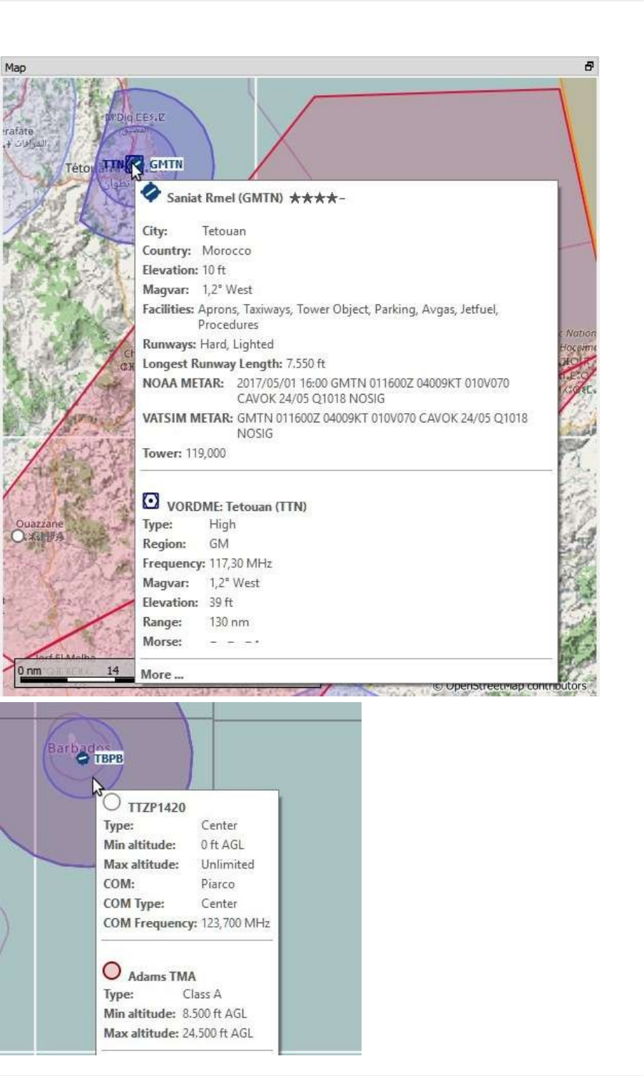
Asingleclickonanairport,navaid,airwaylineorairspaceshowsdetailsinthe Informationdockwindow.
Asingleclickonauseraircraft,AIaircraftormultiplayeraircraftshowsdetailsinthe SimulatorAircraftdockwindow.
Adouble-clickzoomsinshowingeithertheairportdiagramorthenavaidcloselyandalsoshowsdetailsinthe
Informationdockwindow.ThesameappliesforallAIormultiplayeraircraftorships.
Thedouble-clickandsingle-clickfunctionalitydoesnotworkforflightplanwaypointsorairportsiftheflightplanedit
modeisenabled.Theeditmodecanbedisabledusingthetoolbaror MainMenu-> FlightPlan-> EditFlightPlanon
Map.
Themouseclicksensitivitycanbeadjustedinthe Optionsdialogonthe Maptab.
Aircraft
TheuseraircraftandAIormultiplayeraircraftorshipswillbeshownonthemapiftheprogramisconnectedtoaflight
simulator.ColorindicatesuserorAIormultiplayervehicleandthesymbolshapeindicatesiftheaircraftisan
piston/turboprop,jet,helicopteroraship.Thesymboloutlinechangestograyifanaircraftisonground.
LittleNavmaplimitsthedisplayofAIvehiclesdependingonsize.Zoomclosetoseesmallaircraftorboats
AIandmultiplayeraircraftongroundareshownonlyonsmallzoomdistancestoavoidclutteredairports.Thismeans
thatanAIaircraftcandisappearfromthemapwhenlandingonanairport.
Onthelowestzoomdistanceallaircraftaredrawntoscaleasaretheparkingspotswhichmeansyoucaneasily
checkifyouraircraftfitsonanapron,parkingspotortaxiway.
Ayellowwindarrowandlabelsforthesituationaroundtheuseraircraftcanbedisplayedonthetopcenterofthemap.
Thedisplayedlabelsforaircraftcanbeconfiguredinthedialog Optionsontab MapDisplay.Nolabelsareshownfor
shiptraffic.
SeetheNavMapLegendfordetailsabouttheaircrafttype.
MapDisplay
40

Tooltips
Hoveringthemouseoverthemapwillshowtooltipsforallmapobjectsincludingairports,VOR,NDB,airways,
parking,fuelbox,towers,aircraftandships.Thetooltipistruncatedandshowsamessage More...ifitgetstoolong.
Inthatcasereducedetailsorzoomincloser.
Thesensitivityforthetooltipdisplaycanbeadjustedinthe Optionsdialogonthe Maptab.
MapDisplay
41
MapDisplay
42
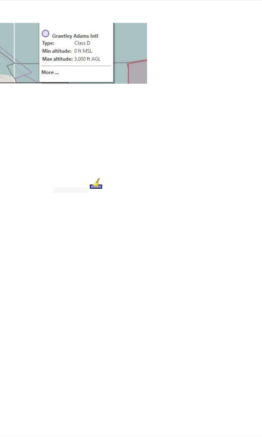
Picturesabove:TooltipwithinformationforanairportandaVORandatooltipwithinformationaboutairspaces.
Highlights
Airports,navaidsorotherfeaturesthatareselectedintheflightplantableorinasearchresulttablearehighlightedon
themapwithagreen/blackorayellow/blackringrespectively.
Waypointsthatareselectedintheprocedurepreviewarehighlightedwithablue/blackring.
Thesehighlightcirclesprovideallfunctionalityofvisiblemapobjects,eveniftheobjectsarenotshownatthecurrent
zoomdistance(ringisempty).Thisallowsdouble-clickforzoomin,single-clickforinformationdockwindowandall
contextmenuentries.
Youcanusethebutton ClearSelection ontopoftheflightplanandsearchwindowstoremoveanymap
highlights.
AirportDiagram
Thedisplaywillchangefromasingleicontoanairportdiagramifyouzoomindeepenoughtoanairport.The
diagramshowsalltaxiways,parkingpositions,gates,runwaysandmore.
Theairportdiagramprovidesmoreinformationthroughtooltipsforparkingandtowerpositions.Aright-clickona
parkingpositionopensthecontextmenuandallowstoselectthestartpositionforflightplandeparture.
Airspacesarehiddeniftheairportdiagramisshown.
SeetheNavMapLegendfordetailsabouttheairportdiagram.
MapDisplay
43
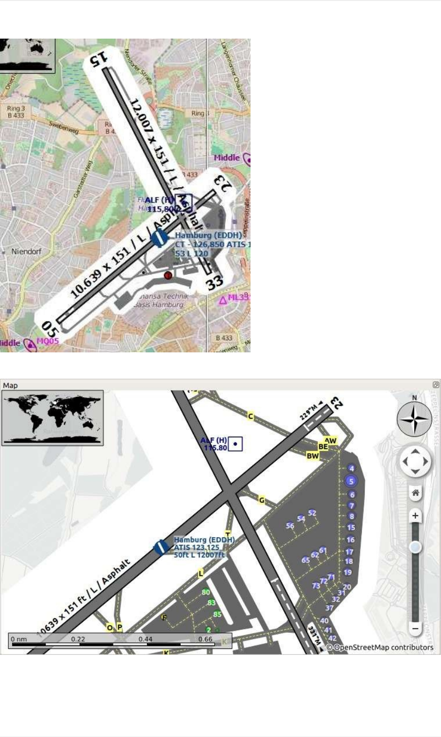
Pictureabove:HighlevelviewoftheairportdiagramofEDDH.
Pictureabove:Detailedviewoftheairportdiagram.Showsbluegatesontherightandafewgreengeneralaviation
rampparkingspotsontheleft.Longdisplacedthresholdofrunway33isvisible.Dashedyellowlinesindicatetaxi
paths.
MapDisplay
44

MapContextMenu
Themapcontextmenucanbeactivatedusingright-clickorthemenukey.Menuitemsareenabledordisabled
dependingonselectedobjectandsomemenuitemscontainthenameoftheselectedmapobjectforclarification.
ShowInformation
Showdetailedinformationinthe Informationdockwindowforthenearestairport,oneormoreairways,oneormore
airspacesorallnavaidsnearthecursor.
SeetheInformationDockWindowfordetails.
ShowProcedures
Opentheproceduresearchtabofthesearchdockwindowanddisplayallproceduresfortheairport.
SeeProcedureSearchformoreinformation.
MeasureGCDistancefromhere
Displaydistancesfromtheselectedoriginasyoumovethemouseoverthemap.Left-clickonthemaptoend
measuringandkeepthemeasurementline.Allmeasurementlinesaresavedandwillberestoredonnextstartup.
Youcanusethekeyboard,mousewheelorthemapoverlaystoscrollandzoomwhiledraggingaline.
Right-click,presstheescapekeyorclickoutsideofthemapwindowtocancelthemeasurementlineediting.
Measurementlinesusenauticalmiles,kilometersorstatuemilesasunit.Feetormeterwillbeaddedasunitifthe
linesareshortenough.Thisallowstomeasuree.g.takeoffdistanceforcrossingtakeoffs.
Agreatcirclegivestheshortestdistancefrompointtopointonearthbutdoesnotuseaconstantcourse.Forthat
reasonthemeasurementlinewillshowtwocoursevalues.Oneforthestartandonefortheendposition.
Courseisalwaysindicatedindegreestruewhichisindicatedbythesuffix °T.Additionalinformationlikeidentor
frequencywillbeaddedtothelineifthemeasurementstartsatanavaidoranairport.
Thewidthofdistancemeasurementlinescanbechangedinthedialog Optionsonthetab MapDisplay.
SeetheNavMapLegendfordetailsonmeasurementlines.
MeasureRhumbDistancefromhere
ArhumblineisalineofconstantcourseandusedbetweenthewaypointsofanairwayorwhenapproachingaVOR
orNDBstation.Distancebetweenpointsisslightlylongerthanthegreatcircleroute.
Thecourseforarhumblineisindicatedindegreesmagneticandtrue( °M, °Tor °M/Tifbothvaluesareequal).
Themagneticdeclinationtocalculatethemagneticcoursewillbetakenfromtheglobal magdec.bglfileattheoriginof
themeasurement.
Themagneticdeclinationofanairportornavaidwillbeusedifthemeasurementstartsatasuchapoint.Additional
informationlikeidentandfrequencywillbeaddedtothelineinthiscaseaswell.
SeeMagneticDeclinationforremarksonthattopic.
MapDisplay
45
RemoveDistancemeasurement
Removetheselectedline.Thismenuitemisactiveifyouright-clickontheendpointofadistancemeasurementline
(smallcross).
ShowRangeRings
Showmultipleredrangeringsaroundtheclickedposition.Thenumberanddistanceoftherangeringscanbe
changedinthe Optionsdialogonthe MapDisplaytab.Alabelindicatestheradiusofeachringinnauticalmiles.
Thewidthofallrangeringscanbechangedinthedialog Optionsonthetab MapDisplay.
ShowNavaidrange
Showaringaroundtheclickedradionavaid(VORorNDB)indicatingthenavaid'srange.Alabelshowsidentand
frequencyandtheringcolorindicatesthenavaidtype.
RemoveRangeRing
Removetheselectedringsfromthemap.Thismenuitemisactiveifyouright-clickonthecenterpointofarangering
(smallcircle).
RemoveallRangeRingsandDistancemeasurements
Removeallringsanddistancemeasurementlinesfromthemap.
SetasFlightPlanDeparture
Thisisactiveiftheclickisatanairport,anairportparkingpositionorafuelbox.Itwilleitherreplacethecurrentflight
plandepartureoraddanewdepartureiftheflightplanisempty.
Thedefaultrunwaywillbeusedasstartingpositioniftheclickedobjectisanairport.Theairportandparkingposition
willreplaceboththecurrentdepartureandstartpositionifaparkingpositionisclickedwithinanairportdiagram.
SetasFlightPlanDestination
Thismenuitemisactiveiftheclickisatanairport.Itwilleitherreplacetheflightplandestinationoraddtheairportif
theflightplanisempty.
AddPositiontoFlightPlan
Inserttheclickedobjectintothenearestflightplanleg.Theobjectwillbeaddedbeforedepartureorafterdestinationif
theclickedpositionisneartheflightplanendpoints.
Thetext Positionisreplacedwithanobjectnameifanairport,navaidoruserpointisattheclickedposition.
Auser-definedflightplanpositionisaddedtotheplanifnoairportornavaidisneartheclickedpoint.
MapDisplay
46

Auserpointisconvertedtoauser-definedflightplanpositionifaddedtotheplan.
AppendPositiontoFlightPlan
Sameas AddPositiontoFlightPlanbutwillalwaysappendtheselectedobjectorpositionafterthedestinationorlast
waypointoftheflightplan.
DeletefromFlightPlan
Deletetheselectedairport,navaidoruserflightplanpositionfromtheplan.
EditFlightPlanPosition
Changethenameorpositionofauser-definedwaypoint.SeeEditFlightPlanPosition.
Thelengthofthenameislimitedto10characterswhensavingtoaPLNfile.Otherflightplanformatshavestronger
limitationsonlengthandallowedcharacters.
Youcanalsoeditthecoordinatesdirectlyinsteadofdraggingtheflightplanposition(FlightPlanEditing).
SeeCoordinateFormatsforalistofformatsthatarerecognizedbytheeditdialog.
AddUserpoint
Addauser-definedwaypointtotheuserdata.Somefieldsoftheuserpointdialogarepopulatedautomatically
dependingontheselectedmapobject.
Coordinatesarealwaysfilled-in.Iftheselectedobjectisanairportornavaid,auserpointoftype Airportor Waypoint
respectivelyiscreatedandthefieldsIdent,Region,NameandAltitudearefilled-in.
Iftheselectedpositionisemptymapspace,auserpointoftype Bookmarkiscreatedatthisposition.Altitudeisfilled-in
ifGLOBEofflineelevationdataisinstalled.SeeFlightPlanElevationProfile.
SeeAddUserpointsformoreinformation.
EditUserpoint
Opentheeditdialogforauserpoint.Onlyenablediftheselectedobjectisauserpoint.SeeEditUserpoints.
MoveUserpoint
Movetheuserpointtoanewpositiononthemap.Onlyenablediftheselectedobjectisauserpoint.
Left-clicktoplacetheuserpointatthenewposition.Right-clickorpresstheescapekeytocanceltheoperationand
returntheuserpointtoitsformerposition.
DeleteUserpoint
MapDisplay
47

Removetheuser-definedwaypointfromtheuserdataafterconfirmation.Onlyenablediftheselectedobjectisa
userpoint.
ShowinSearch
Showthenearestairport,navaid,userpoint,onlineclientoronlinecenterinthesearchdialog.Thecurrentsearch
parametersarereset.
SetCenterforDistanceSearch
Setthecenterpointforthedistancesearchfunction.SeeDistancesearch.Thecenterforthedistancesearchis
highlightedbya symbol.
SetHome
Setthecurrentlyvisiblemapviewasyourhomeview.Thecenterofthehomeareaishighlightedbya symbol.
MapDisplay
48
Legend
Bydefault,allspeedsaregiveninknots,distancesinnauticalmiles,altitudesandelevationsinfeet.Theunitscanbe
settoimperialormetricinthedialog Optionsonthetab Units.
Colors,sizeandtextlabelsofsomemapelementscanbechangedinthedialog Optionsonthetab MapDisplay.This
legendshowsthedefaultvalues.
Headingandcoursearesuffixedwith °Tfortruecourseor °Mformagneticcourse.
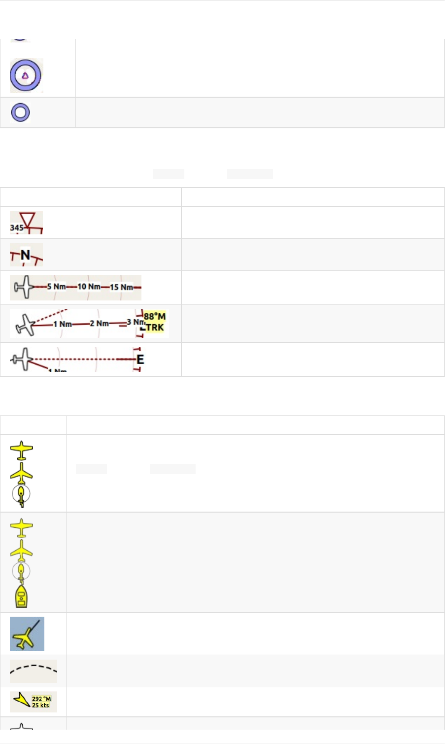
MapMarks
Symbol Description
Centerofthehomeposition.
Centerpointthatwillbeusedfordistancesearches.
Flightplanwithdistance,directionandmagneticcourseateachleg.
Flightplanprocedurelegwiththesameinformationasabove.
Activeflightplanleg
Flightplandeparturepositiononairport.Eitherparking,fuelbox,helipad,waterorrunway.
Topofdescentpointwithdistancetodestination.
Rangeringslabeledwithdistance.
VORorNDBrangeringslabeledwithidentandfrequency.ColorindicatesNavaidtype.
Greatcircledistanceandcoursemeasurementlineindicatinglengthandtrueheadingat
startanddestination.Thetwoheadingvalueswillbeequalforsmalldistances.Forshorter
distanceslengthisalsoshowninfeetormeters.
Rhumblineofequalbearingdistancemeasurementindicatingdistanceandtrueheading.
RhumblinesareusedtoapproachaVORorNDBortravelalongairways.Forshorter
distanceslengthisalsoshowninfeet.
Measurementlinesstartingfromanairportornavaidhavethesamecolorandadditional
identandfrequencylabels.Courseforrhumblineswillbeshowninmagneticifthenavaid
hasamagneticvariationattribute.
Ahighlightedairportornavaidselectedinthesearchresulttable.
Ahighlightedairportornavaidselectedintheflightplantable.
MapDisplayLegend
49
Highlightedpositionsofaprocedureleginthepreview.Smallcircleshowfromandlarge
circletoposition.
Thincircleshowstherecommendedorrelatednavaidofaprocedureleg.Thiscanbea
VORDMEforaDMEarcapproachlegforexample.
CompassRose
Linethicknesscanbechangedindialog Optionsonthetab MapDisplay.
Symbol Description
Truenorth.
Magneticnorth.
Distancecirclesandmarksfromuseraircraftifconnected.
Solidlineshowsaircrafttrackindegreesmagneticifconnected.
Dashedlineshowsaircraftheadingifconnected.
AircraftandShips
Symbol Description
Currentuservehicleifconnectedtotheflightsimulator.Labelsvaryandcanbecustomizedin
Optionsonthetab MapDisplay.Theuseraircraftdependsonselectedaircraft(jet,
piston/turboproporhelicopter).Optionallyablackneedleprotrudingfromthenosecanshow
thecurrenttrack.
Useraircraftorshiponground
Needleshowingthecurrenttrackoftheaircraft.Aircraftnoseshowsheading.
Useraircrafttrailifconnectedtotheflightsimulator.
Windaroundtheuseraircraftwithdirectionindegreesmagneticandspeed.
MapDisplayLegend
50

AIormultiplayeraircraft.Labelsvaryandcanbecustomizedin Optionsonthetab Map
Display.Thesymboldependsonaircrafttype(jet,piston/turboprop,helicopterorship).
Onlinenetworkaircraft/client.Labelsvaryandcanbecustomizedasabove.
Airports
Airportshavingcontroltowersareshownindarkblueothersinmagenta.Add-onairportnamesandidentsareshown
italicandunderlined.Airportsthatarepartoftheflightplanhavealightyellowtextbackground.
Thesymbolisshownsmallerifanairporthasnorunways.Thisisthecaseforsomeadd-onairportsthatuseanother
techniquelikephotoscenerytodisplayrunways.
Symbol Description
Airportswithhardsurfacerunwayslongerthan8,000ftor2,400meters.Allrunwayslongerthan
4,000ftorabout1,200metersareshown.Onlyforlowerzoomdistances.
Airportswithhardsurfacerunways.Whitelineshowsheadingoflongestrunway.
Airportswithsoftsurfacerunways.
Emptyairportsshowningray.Notaxiways,noparkingspotsandnoaprons.
Seaplanebasehavingonlywaterrunways.
Militaryairport.
Heliporthavingonlyhelipadsandnorunways.
Abandonedairport.Allrunwaysareclosed.
Airportsthathavefuelavailable.
Airportlabelshowingname,ident,ATISfrequency,elevation,lightedrunways( L)andlengthof
longestrunway.Thetextlabelsforanairportcanbechangedinthedialog Optionsonthetab
MapDisplay.
Navaids
MapDisplayLegend
51
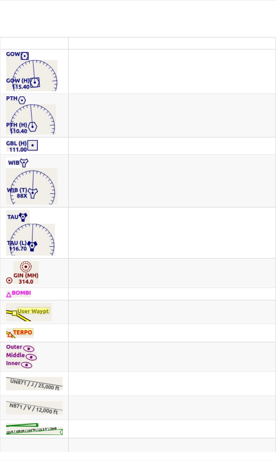
Navaidsthatarepartoftheflightplanhavealightyellowtextbackground.
Symbol Description
VORDMEincludingident,type(High,LoworTerminal)andfrequency.Compass
roseshowsmagneticvariationonlowerzoomdistances.
VORincludingident,typeandfrequency.
DMEincludingident,typeandfrequency.
TACANincludingident,type(High,LoworTerminal)andchannel.Compassrose
showsmagneticvariationonlowerzoomdistances.
VORTACincludingident,type(High,LoworTerminal)andfrequency.Compass
roseshowsmagneticvariationonlowerzoomdistances.
NDBincludingident,type(HH,H,MHorCL-compasslocator)andfrequency.
Waypointwithname.
User-definedwaypointwithname.
Invalidairport,waypoint,VORorNDBthatispartoftheflightplanbutcouldnotbe
foundintheSceneryDatabase.
Markerwithtypeandheadingindicatedbylensshape.
Jetairwaywithlabelshowingname,type(JetorBoth),minimumandmaximum
altitude.Textdependsonzoomdistance.Aprecedingarrowwillshowtheallowed
directioniftheairwayisone-way.
Victorairwaywithlabelshowingname,type(VictororBoth),minimumand
maximumaltitude.Textdependsonzoomdistance.Aprecedingarrowwillshow
thealloweddirectioniftheairwayisone-way.
ILSwithglideslope.Labelshowsident,frequency,magneticheading,glideslope
pitchandDMEindicationifavailable.
MapDisplayLegend
52
Localizer.Labelshowsident,frequency,magneticheadingandDMEindicationif
available.
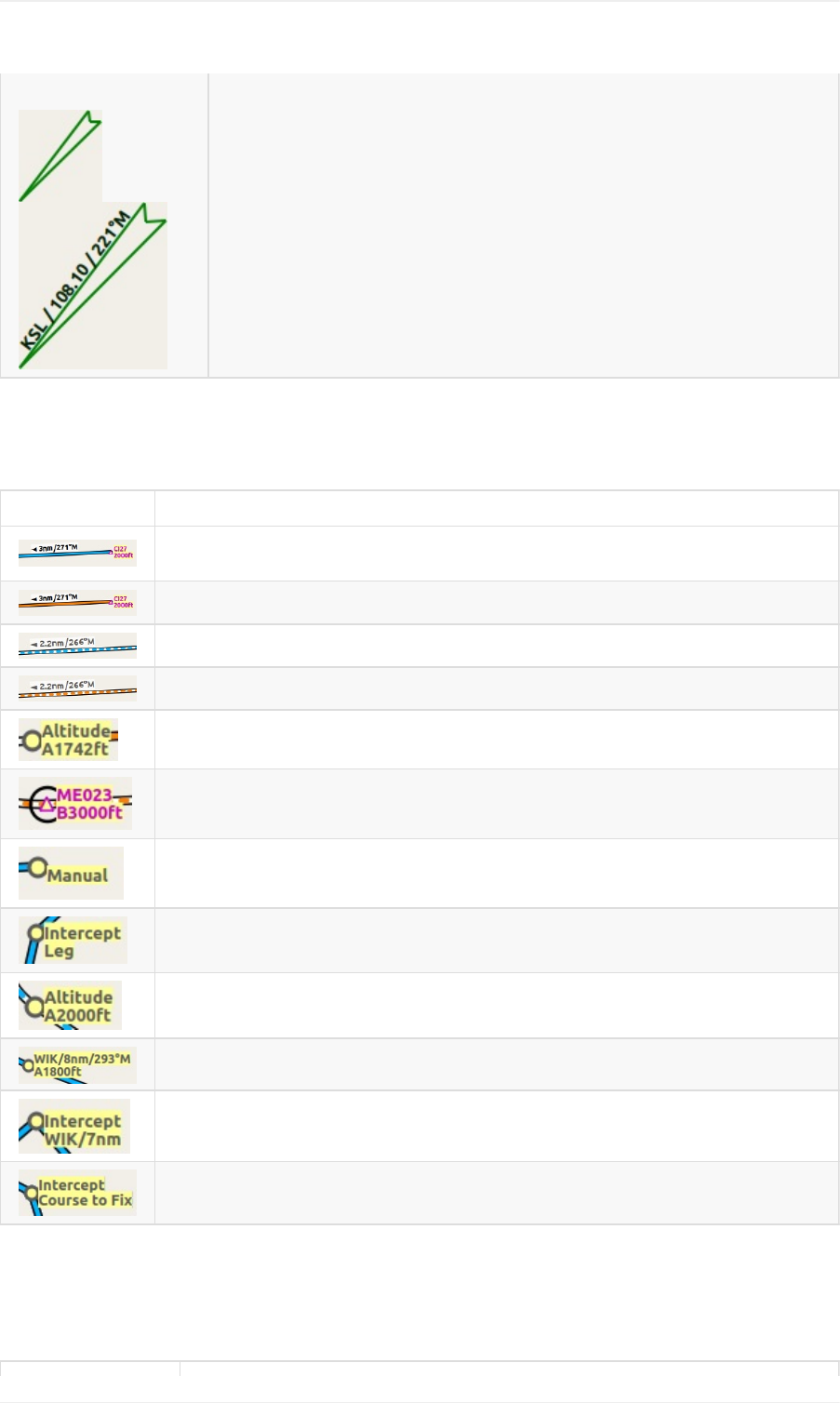
Procedures
SeechapterProceduresformoredetailedinformationonallthelegs.
Symbol Description
SID,STAR,approachortransitionleginpreviewwithdistance,directionandmagnetic
courseateachleg.
SID,STAR,approachortransitionlegwhichispartoftheflightplan.
Missedapproachleginpreview.
Missedapproachlegwhichisapartoftheflightplan.
Grayyellowfilledcircleindicatesaprocedurepointwhichisnotanavaidbutdefinedby
courseand/ordistancefromanavaid,analtituderestrictionormanualtermination.
Ablackcircleindicatesanoverflywaypoint.Canbeaprocedurepointoranavaid.
Flyaheading,trackoraholduntilmanuallyterminatedbyATC.
Interceptthenextapproachlegatacourseofabout45degrees.
Procedurelegthatisterminatedwhenreachingthegivenaltitude.
Afixdefinedbyacourseorheadinganddistancetoanavaid.
ThisfixisdefinedbyaheadingortrackwhichisterminatedbyreachingaDMEdistance.
Interceptacoursetothenextfixatanangleofabout45degrees.
AirportDiagram
Runway,taxiway,helipadandaproncolorsindicatesurfacetype.Whiteisusedforanunknownorinvalidsurfacetype
givenbyanadd-ondeveloper.
MapDisplayLegend
53
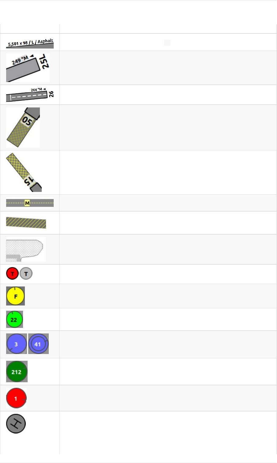
Symbol Description
Runwaywithlength,width,lightindicator( L)andsurfacetype.
Runwayendwithidentandmagneticheading.
Displacedthreshold.Donotuseforlanding.
Overrunarea.Donotusefortaxi,takeofforlanding.
Blastpad.Donotusefortaxi,takeofforlanding.
Taxiwaywithnameandcenterline.
Closedtaxiway.
Semitransparentdottedapronsandtaxiwaysindicatethatnosurfaceisdrawn.Itmight
useaphototextureorsimplythedefaultbackground.
Tower.Redifatowerfrequencyisavailable.Otherwisejustviewposition.
Fuel
GArampwithparkingnumberandheadingtickmark.
Gatewithnumberandheadingtickmark.Secondringindicatesavailabilityofjetway.
Cargoramp
Militarycombatparkingorcargoramp.
MapDisplayLegend
54
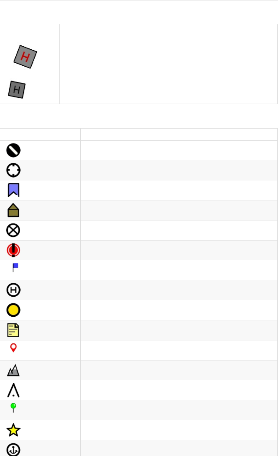
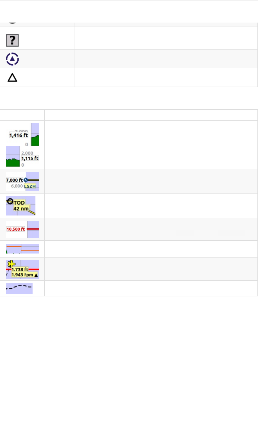
Unknown
VRP-visualreportingpoint
Waypoint
ElevationProfileLegend
Symbol Description
Groundwithdepartureelevationontheleftanddestinationairportelevationontheright.
Flightplanaltitude.
Topofdescentwithdistancetodestination.
Minimumsafealtitudeforflightplan.Thisiselevationplus1000feetroundeduptothenext
500ft.The1000feetbuffercanbechangedinthedialog Optionsonthetab FlightPlan
Minimumsafealtitudeforaflightplansegment.Thesamerulesapplyastotheminimum
safealtitudeforflightplan.
Useraircraftifconnectedtothesimulator.Labelsshowactualaltitudeandclimb/sinkrate.
Useraircrafttrailifconnectedtotheflightsimulator.
MapDisplayLegend
56
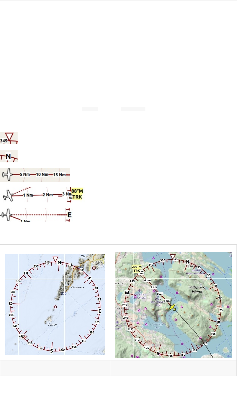
CompassRose
Thecompassroseindicatestruenorth,magneticnorth,aircraftheadingandaircrafttrack.
Useraircraftheading,track,distanceringsandmarkersareshownifLittleNavmapisconnectedtoasimulator.The
roseiscenteredaroundtheuseraircraftifconnected.
Thecompassroseiskeptcenteredinthecurrentviewifnotconnectedtoasimulator.Magneticdeclinationisbased
onthedeclinationinthecenter.
Thesizeisadaptedtothemapviewsizebutnotlargerthan1000nmandnotsmallerthan4nm.
Linethicknesscanbechangedindialog Optionsonthetab MapDisplay.
Indicators
Truenorth.
Magneticnorth.
Distancecirclesandmarksfromuseraircraftifconnected.
Solidlineshowsaircrafttrackindegreesmagneticifconnected.
Dashedlineshowsaircraftheadingindegreesmagneticifconnected.
Examples
Pictureabove:Compassrosewithoutsimulator
connection.
Pictureabove:Compassrosecenteredarounduser
aircraft.
MapDisplayCompassRose
57

MapFlightPlanEditing
Theflightplandraganddropeditingmodeisenabledbydefault.Itcanbetoggledusingthetoolbaror MainMenu->
FlightPlan-> EditFlightPlanonMap.
Youcanusethekeyboard,themousewheelorthemapoverlaystoscrollandzoomwhileeditingtheroute.
Notethattheflightplandraganddropeditingisbasedontheassumptionthatadirectconnectionbetweendeparture
anddestinationalreadyexists.
Alwaysselectdepartureanddestinationfirstifyouwouldliketobuildyouflightplanmanually.Thiswillconnectboth
pointswithagreatcircleline.Basedonthislineyoucanstarttoaddnavaidstoyourflightplan.
Notethatselectingairwaysisnotpossible.
Thecursorwillchangeintoacross ifanewnavaidcanbeaddedtoaleg.Acursor willbeshownifa
presentnavaidcanbereplacedbyanotheroneorifauserpositioncanbemoved.
Thefollowingfunctionalityisavailable:
Clickonaflightplanleg:Startseditingandaddsanewwaypointdependingonwherethenextclickisdone:
Onasingleairportandnavaid:Objectisinsertedintotheflightplansegment.
Onmultipleairportsornavaids:Amenupopsupthatallowsyoutoselecttheobjecttobeinserted.
Noairportandnonavaid:Auser-definedpositionisinsertedintotheflightplan.
Clickonwaypoint:Startseditingandreplacestheselectedwaypointwithanobjectdependingonwhereyou
clicknext:
Onasingleairportandnavaid:Objectreplacestheselectedwaypoint.
Onmultipleairportsornavaids:Amenupopsupthatallowstopicktheobjectthatshouldreplacethe
selectedwaypoint.
Noairportandnonavaid:Auser-definedpositionreplacesthewaypoint.
Clickondepartureordestination:Replacesthedepartureordestinationwithanobjectdependingonwhere
youclicknext:
Onasingleairport:Airportreplacesthedepartureordestination.Adefaultrunwayisassignedasstart
positionifthedepartureisreplacedwithanewairport.
Onanavaid:Objectreplacesdepartureordestinationwhichresultsinaninvalidflightplan.Theflightplan
canbesavedandloaded(awarningwillbeshown)butisunusablebytheflightsimulator.
Onmultipleairportsornavaids:Amenupopsupthatallowstoselecttheobjectthatreplacesdepartureor
destination.
Noairportandnonavaid:Auser-definedpositionreplacesthewaypointresultinginaninvalidflightplan.
Right-clicking,pressingtheescapekeyoranyclickoutsideofthemapwindow:Cancelcurrentoperation.
Limitationsifproceduresareused:Youcannotaddnavaidsinorbetweenprocedures,norcanyoudelete
procedurelegs.Thecursorwillnotchangeshapewhenyouhoveroveraprocedure.Thefollowingisnotallowed:
AddawaypointbetweendepartureairportandSID.
AddawaypointbetweenSTARorapproachanddestinationairport.
AddawaypointbetweenSTARandapproachortransition.
Moveorremovethefirstorlastwaypointofaprocedure.
Alldepartureordestinationproceduresareremovedifthedepartureordestinationairportismovedorreplaced.The
sameappliesifwaypointsareprependedbeforeorappendedafterdepartureordestination.
MapFlightPlanEditing
58
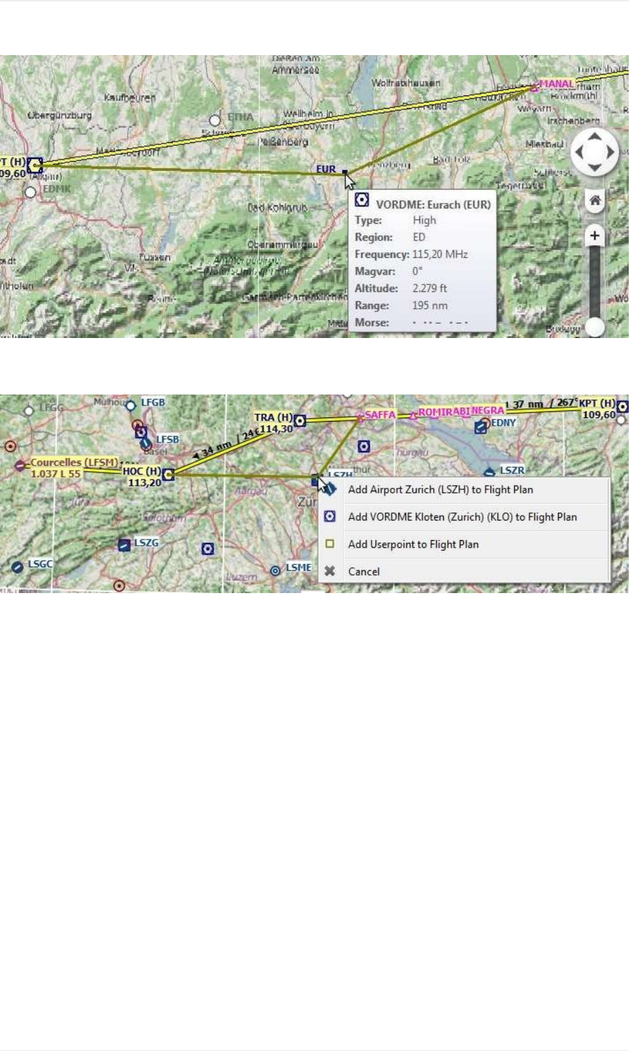
Pictureabove:Insertinganavaidintoaflightplanlegbyclickingandmovingthelegline.Atooltipforthenavaidis
shown.
Pictureabove:ReplacingVORTRAintheflightplanwithanotheronebysimplyclickingandmovingthewaypoint
TRAontoKLO.Aselectionmenupopsupfordisambiguation.
MapFlightPlanEditing
59
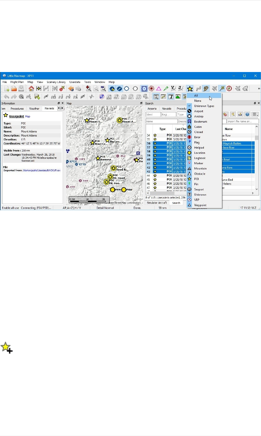
User-definedWaypoints
User-definedwaypoints(oruserpoints)allowforadding,editing,searching,exporting,andimportingbookmarks,
pointsofinterest,waypointsandmore.Youcanpickfreelywhichtypesyouwanttoseeasiconsonthemap.
Pictureabove:Anoverviewofuserpointfunctionalityshowinginformationontheleftdockwindow,highlighted
userpointsonthemap,userpointsselectedinthesearchwindowontheright,andthedropdownmenuopenedby
clickingtheuserpointiconinthedockwindow.
User-definedWaypointSearch
Thefunctionalityofthesearchfiltersandtheresulttableissimilartotheairportandnavaidsearch.SeeSearchDock
Windowforinformationaboutsearchfiltersandbuttons.
Additionalcontextmenuitemsandbuttonsallowadding,editing,anddeletingofuserpoints.
TopButtonsandadditionalMenuItems
SeeSearchResultTableViewContextMenuforadescriptionofcommoncontextmenuitemsacrossallsearch
dialogs.
AddUserpoint
Addauser-definedwaypointtotheuserdata.
Somefieldsofthenewuserpointdialogarepopulatedautomaticallydependingonaselecteduserpointor,ifnothing
isselectedinthesearchresulttable,basedonpreviousadditions.Thisallowstoquicklyaddsimilaruserpointstothe
databasewithouttheneedtore-enteralltheinformation.
Notethatyouhavetoaddthecoordinatesmanuallyifthedialogsstartsemptyi.e.nothingwasselectedintheresult
table.AdduserpointswiththemapcontextmenuAddUserpointtoavoidthisandhavethecoordinatesset
automatically.
User-definedWaypoints
60
Seebelowformoreinformationabouttheadddialog.
EditUserpoint
Opentheeditdialogforoneormoreuserpoints.
Theeditdialogshowsacolumnofcheckboxesontherightsideifmorethanoneuserpointisselected.Theseallowto
choosethefieldstoedit.
Seebelowformoreinformationabouttheadddialog.
DeleteUserpoint
Removetheselecteduserpointsafteraconfirmationdialog.
ResetSearch
Clearsearchfiltersandreverttoshowingallentriesinthesearchresulttableview.
ClearSelection
Deselectallselectedentriesinthetableandremoveanyhighlightcirclesfromthemap.
Help
Displayaquickhelpinthetooltip.Clicktoopenthischapterofthemanualinthedefaultbrowser.
MenuButton
Dropdownmenubuttonthatallowstohideorshowsearchoptions.
Thedropdownmenuprefixesmenuitemswithachangeindicator *toshowthattherelatedfilterrowhas
modifications.
AddUserpointsDialog
ThedialogisshownwhenselectingAddUserpoint inthemapcontextmenu,usingthetopbuttoninthe
userpointsearchtab,orselecting AddUserpointfromthecontextmenuinthesearchresulttable.
Thedialogwillbepopulatedautomaticallydependingontheselectedmapcontext,theselectioninthesearchresult
tableorpreviousadditions.
Typecanbeselectedfromadropdownlistorenteredfreely.
Thefield Descriptionallowsmultilinetextandspecialcharacters.Formattinglikeitalicorboldisnotsupported.
Thefield Visiblefromallowstodefinevisibilityonthemapdependingonzoomdistance.Thezoomdistance
(viewpointdistancetoearthsurface)forthecurrentmapviewisshownintheStatusbar.Theuserpointwillbevisible
forallzoomdistancessmallerthanthevaluein Visiblefrom.Maximumvalueis3000nmandminimumvalueis1nm.
User-definedWaypoints
61
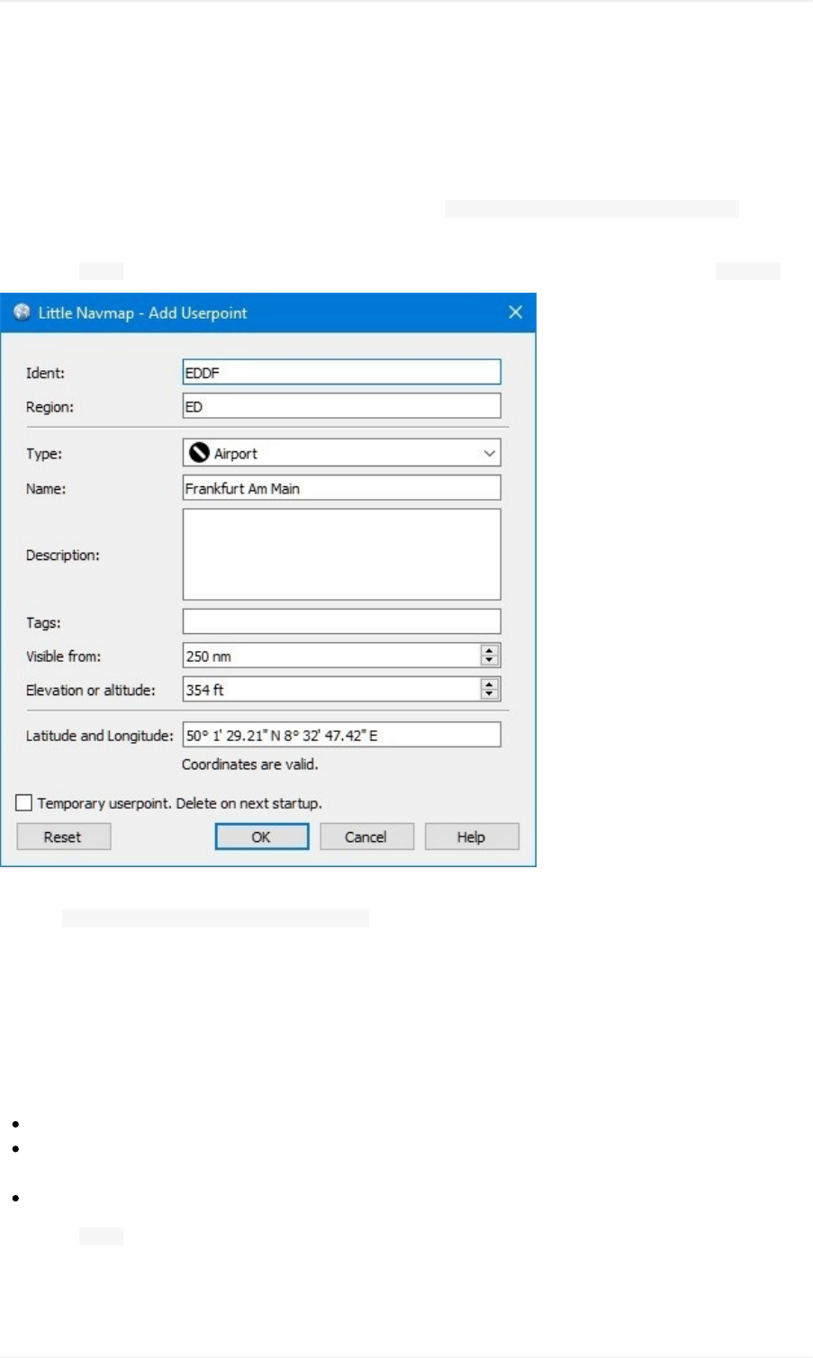
Validcoordinatesarerequiredtoconfirmthedialog.SeeCoordinateFormatsforadetaileddescriptionofthe
recognizedcoordinateformats.Alabelbelowthecoordinatesdisplaystheparsedcoordinatesoranerrormessagein
casethecoordinatescouldnotbeparsed.
Allothertextfieldsareoptionalandcanbeleftblank.
TheuserpointisremovedonnextstartupofLittleNavmapwhen Temporaryuserpoint.Deleteonnextstartup.is
checked.
Thebutton Resetclearsallfieldswithexceptionofthecoordinatesandsetsthetypeoftheuserpointto Bookmark.
Pictureabove:Adddialogthathasbeenpopulatedautomaticallybycontext.Theuserright-clickedonanairportand
selected AddUserpointAirportFrankfurtamMain(EDDF).
EditUserpointsDialog
AsingleUserpoint
Theeditdialogshowsthesameeditfieldsasthedialogusedtoadduserpointsabove.
Additionalmetadatashownatthebottom:
LastChange:Dateandtimeofimport,creationorchange.
Importedfromfile:FileandpathofsourcefilefromCSV,X-PlaneorGarminimport.Youcanfiltertheuserpoint
searchforthisname.
Temporaryuserpoint-willbedeletedonnextstartup.Thisindicatesthattheuserpointistemporary.
Thebutton Resetundoesallmanualchangesandrevertsallfieldstotheiroriginalstate.
User-definedWaypoints
62
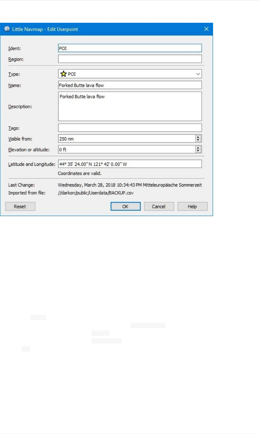
Pictureabove:Editdialogforasingleuserpoint.
MultipleUserpoints
Ifmorethanoneuserpointwasselectedforediting,theeditdialogshowsacolumnofcheckboxesontherightside.
Ifchecked,thefieldtotheleftisunlockedandanytextenteredwillbeassignedtotherespectivefieldinallselected
userpoints.Uncheckedfieldswillnotbealteredforanyoftheuserpoints.
Incombinationwiththepowerfulsearchfunction,thisallowsforbulkchangeslikefixinganinvalidregionand
simultaneouslychangingthevisibilityrangefortheaffecteduserpoints:
1. Searchforalluserpointswiththeinvalidregion.
2. Selectalltheresultinguserpoints,e.g.byclickingononeoftheuserpointsamongthesearchresultsand
pressing Ctrl+Aorbyclickingonthetopleftcornerofthecolumnheader.
3. Right-clickoneofthehighlighteduserpointsandselect EditUserpointsfromthecontextmenu.
4. Clickthecheckboxtotherightofthe Region:fieldandchangetheregion.
5. Clickthecheckboxtotherightofthe Visiblefrom:fieldandadjustthevalue.
6. Click OK.
User-definedWaypoints
63
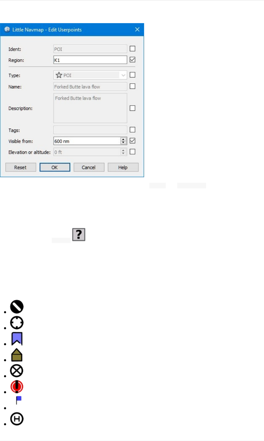
Pictureabove:Editdialogformorethanoneuserpoint.Thefields Regionand Visiblefromwillbechangedforall
selectedpoints.Allotherfieldsremainunchanged.
Types
Theuserpointtypecanbeanytextstring.Ifthetextmatchesanentryfromthelistbelow,theappropriateiconisused.
Otherwise,theiconfor Unknown isused.
Typesandiconscanbecustomizedandnewtypescanbeadded.SeeUserpointCategoryIconsforinformationon
howtodothis.
Sometypesareusedasdefaultswhenaddingnewuserpoints.Thisdependsonthecontext,i.e.whatwasbelowthe
cursorwhenright-clickingonthemap.
Notethattheuserpointtypescannotbetranslatedtootherlanguagesfornow.
Airport:Defaultwhencreatingauserpointontopofanairport.
Airstrip
Bookmark:Defaulttypefornewuserpoints.
Cabin
Closedairport
Error
Flag
Helipad
User-definedWaypoints
64
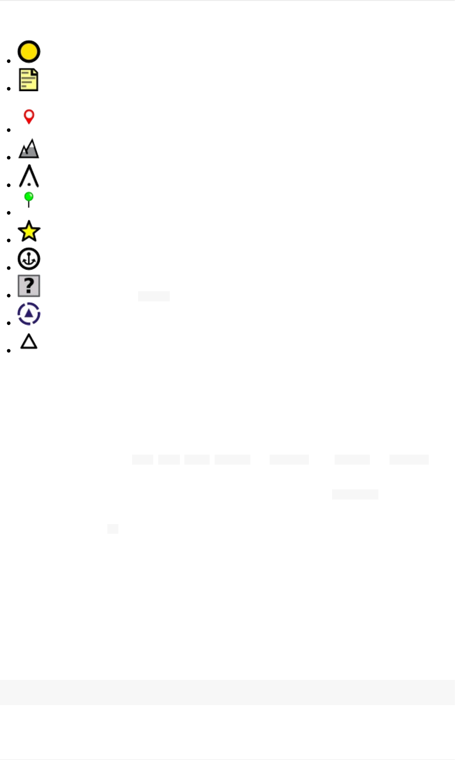
Location
Logbook:Typeofautomaticallyaddedlogbookentriesfortakeoffandlanding.SeemenuitemCreate
Logbookentries.
Marker
Mountain
Obstacle
Pin
POI
Seaport
Unknown:Typenamed Unknownandalltypeswhichdonotmatchthedefaulttypesinthislist.
VRP:Visualreportingpoint.
Waypoint:Defaultwhencreatingauserpointontopofanavaid.
CSVDataFormat
TheCSVdataformatisalignedtotheformatalreadyusedaroundtheflightsimulatorcommunityandother
applications.
Eachrowinthefilerepresentsauser-definedwaypoint.
Theminimumfieldsforimportare Type, Name, Ident, Latitudeand Longitude.Only Latitudeand Longitudeneed
tobefilled,therestcanbeempty.
AlltwelvefieldsaresavedwhenexportinguserpointsasCSV.Also,themultilinefield Descriptionisenclosedin
quotesifneededandpreserveslinebreaks.
Englishnumberformat(dot .asdecimalseparator)isusedinimportandexporttoallowexchangeoffileson
computerswithdifferentlanguageandlocalesettings.
LittleNavmapusesUTF-8encodingwhenreadingandwritingfiles.Thisisonlyrelevantifyouusespecialcharacters
likeumlauts,accentsorothers.Otherwiseencodingdoesnotmatter.
IfanapplicationfailstoloadaCSVfileexportedbyLittleNavmap,useLibreOfficeCalc,MicrosoftExceloranyother
spreadsheetsoftwarecapableofreadingandwritingCSVfilestoadapttheexportedfiletotheformatexpectedby
thatapplication.
SeeComma-separatedvaluesintheWikipediafordetailedinformationontheformat.
Exampleforanabsoluteminimaluserpointconsistingofcoordinatesonly:
,,,49.0219993591,7.8840069771
User-definedWaypoints
65

Visiblefromwillbesettothedefaultof250nmandtheuserpointwillbeshownusingthe Unknown iconafter
import.
Exampleforaminimaluserpointrecordwithtype Mountain,identandnameforimport:
Mountain,MyPointofInterest,MYPOI,49.0219993591,7.8840069771
Visiblefromwillbesettothedefaultof250nmafterimport.
Exampleforanexporteduserpointwithtype Mountainandallfieldsset:
Mountain,MyPointofInterest,MYPOI,49.0219993591,7.8840069771,1200,2.0085027218,"View,Interesting,Point","Interestingpoi
nt""Eselsberg""-niceview",ED,250,2018-05-17T17:44:26.864
TakenoteofthefollowingchallengeswhenparsingCSVfiles:Inthefield Tags,thelist "View,Interesting,Point"is
enclosedindoublequotessinceitcontainscommas.Thefielddescription "Interestingpoint""Eselsberg""-niceview"
isenclosedindoublequotessincethetextitselfcontainsapairofdoublequotes( "Eselsberg")whichare,inturn,
escapedbyanotherdoublequoteeach.
CSVFields
Position Name Required Empty
Allowed Comment
1 Type Yes Yes
Oneofthepredefinedoruser-definedtypes.Theicon
for Unknownisusedifthetypedoesnotmatchoneof
theknowntypes.
2 Name Yes Yes Freetousefield.UsedforGarminexport.
3 Ident Yes Yes
RequiredonlyforGarminandX-Planeexport.Hasto
beauniquevalididentifierwithmaximumoffive
charactersfortheseexports.
4 Latitude Yes No Rangefrom-90to90degreesusingdot .as
decimalseparator
5 Longitude Yes No Rangefrom-180to180degreesusingdot .as
decimalseparator.
6 Altitude No Yes Mustbeavalidnumberifused.Unitisalwaysfeet.
7Magnetic
variance No Yes Ignoredonimportandsettoavalidcalculatedvalue
onexport.
8 Tags No Yes Freetousefield.GUIhasnospecialtagsearch.
9 Description No Yes Freetousefieldwhichallowslinebreaks.
10 Region No Yes
TwoletterICAOregionofauserpointorwaypoint.
UsedforX-Planeexport.Replacedwithdefaultvalue
ZZonX-Planeexportifempty.
11 Visible
from No Yes
Definesfromwhatzoomdistanceinnauticalmiles
(shownonStatusBar)theuserpointisvisible.Setto
250nmifemptyonimport.
12
Last
update
timestamp
No Yes
ISOdateandtimeoflastchange.Formatis
independentofsystemdateformatsettings.Format:
YYYY-MM-DDTHH:mm:ss.Example: 2018-03-
28T22:06:16.763.NoteditableinGUI.
User-definedWaypoints
66
X-Planeuser_fix.datDataFormat
ThisallowstoreadandwritetheX-Plane user_fix.datfileforuser-definedwaypoints.Thefiledoesnotexistby
defaultandhastobesavedto XPLANE/CustomData/user_fix.dat.
TheformatisdescribedbyLaminarResearchinaPDFfilewhichcanbedownloadedhere:XP-FIX1101-Spec.pdf.
Thefileconsistsofaheaderandanumberofrowsfortheuserfixes.Eachrowhasfivecolumnswhichareseparated
byspaceortabcharacters.
Therearefivecolumnsofdatainthefile:
1. Latitude
2. Longitude
3. Ident
4. Airportident
5. Region
Examplefor user_fix.dat:
I
1101Version-datacycle1704,build20170325,metadataFixXP1101.NoCopyright(c)2017achwodu
50.8816670012.58666700PACECENRTZZ
-36.29987335174.71089172N0008NZNIZZ
99
Notethat,whiletheuser-definedwaypointsarenotdisplayedontheX-Planemap,theycanbeselectedand
usedtobuildflightplansintheX-PlanestockGPSandFMS.
Import
Examplelinefrom user_fix.databove:
50.8816670012.58666700PACECENRTZZ
ThecoordinatesarereadintotheLittleNavmapuserpointcoordinates.
Thefixident PACECisreadintotheIdentfieldinLittleNavmap.
Thefixairport ENRT(enroute:noairporthere)isreadintotheTagsfieldinLittleNavmap.
Theregion ZZ(invalidornoregion)isreadintotheRegionfieldinLittleNavmap.
Typewillbesetto Waypoint forallimportedfixes.
Export
Themappingisthesameasfortheimport.
Identtofixident.
Tagstofixairport.
Regiontofixregion.
Allotherfieldsareignored.
Theidentisadjustedtomatchauptofivedigitandlettercombination.Ageneratedidentisusedifthatisnotpossible
ortheidentisempty.
Fixairportisalways ENRTwhenexporting.
User-definedWaypoints
67

Theregionisadjustedforatwoletterdigitandlettercombination. ZZisusedifthatisnotpossibleortheregionis
empty.
Theidenthastobeuniqueinthe user_fix.dat.Thereforeitisrecommendedtosetauniqueidentforeach
waypointmanuallyorleavethefieldemptysoLittleNavmapcangenerateanidentduringexport.
Garminuser.wptDataFormat
TheGarminuserwaypointfileisaCSVfile.Eachrowinthefilerepresentsauniqueuserwaypoint.
Theremustbefourcolumnsofdatainthefile:
1. Waypointident
2. Waypointnameordescription
3. Latitude
4. Longitude
Exampleofa user.wptfile:
MTHOOD,MTHOODPEAK,45.3723,-121.69783
CRTRLK,CRATERLAKE,42.94683,-122.11083
2WTER,2NMWESTTERRACINA,41.28140000,13.20110000
1NSAL,1NMNORTHSALERNOTOWN,40.69640000,14.78500000
Thewaypointidentcanbeupto10numbersorcapitallettersbuttheGTNwillshortenthenametothefirst6
characters.Nospecialcharactersorsymbolscanbeused.LittleNavmapadjuststheidentaccordingly.
Thewaypointnamecanbeupto25numbers,capitalletters,spaces,orforwardslash /characters.Thenameis
displayedwhenselectingwaypointstoprovideadditionalcontexttothepilot.LittleNavmapadjuststhename
accordingtolimitations.
Import
Examplelinefrom user.wptabove:
MTHOOD,MTHOODPEAK,45.3723,-121.69783
Theident MTHOODisreadintotheIdentfieldinLittleNavmap.
Thename MTHOODPEAKisreadintotheNamefieldinLittleNavmap.
ThecoordinatesarereadintotheLittleNavmapuserpointcoordinates.
Typewillbesetto Waypoint forallimportedwaypoints.
Export
Mappingoffieldsissameasimportbutallfieldsareadjustedtolimitations.
Note:Ifanimportedwaypointendsupbeingwithin0.001°latitudeandlongitudeofanexistinguserwaypointinthe
GTN,theexistingwaypointandnamewillbereused.
ExportXMLforFSX/P3DBGLCompiler
ThisexportoptioncreatesanXMLfilewhichcanbecompiledintoanBGLfilecontainingwaypoints.
Theregionandidentfieldsarerequiredforthisexportoption.Ifregionisemptyorotherwiseinvalid ZZisused.All
waypointsareoftype NAMED.
User-definedWaypoints
68

SeePrepar3DSDKdocumentationforinformationonhowtocompileandaddtheBGLtothesimulator.
Example:
<?xmlversion="1.0"encoding="UTF-8"?>
<FSDataversion="9.0"xmlns:xsi="http://www.w3.org/2001/XMLSchema-instance"xsi:noNamespaceSchemaLocation="bglcomp.xsd">
<!--CreatedbyLittleNavmapVersion2.0.1.beta(revision2b14e14)on20180517T12:24:36-->
<Waypointlat="47.40833282"lon="15.21500015"waypointType="NAMED"waypointRegion="ZZ"magvar="4.02111530"waypointIden
t="WHISK"/>
<Waypointlat="47.39666748"lon="15.29833317"waypointType="NAMED"waypointRegion="ZZ"magvar="4.01835251"waypointIden
t="SIERR"/>
</FSData>
DatabaseBackupFiles
LittleNavmapcreatesafulldatabasebackuponeverystartsinceundofunctionalityisnotavailableforuserpoints.
YoucanalsousetheCSVexporttocreatebackupsmanuallysinceCSVallowstoexportthefulldataset.
SeeUserdataforinformationaboutdatabasebackupfiles.
User-definedWaypoints
69
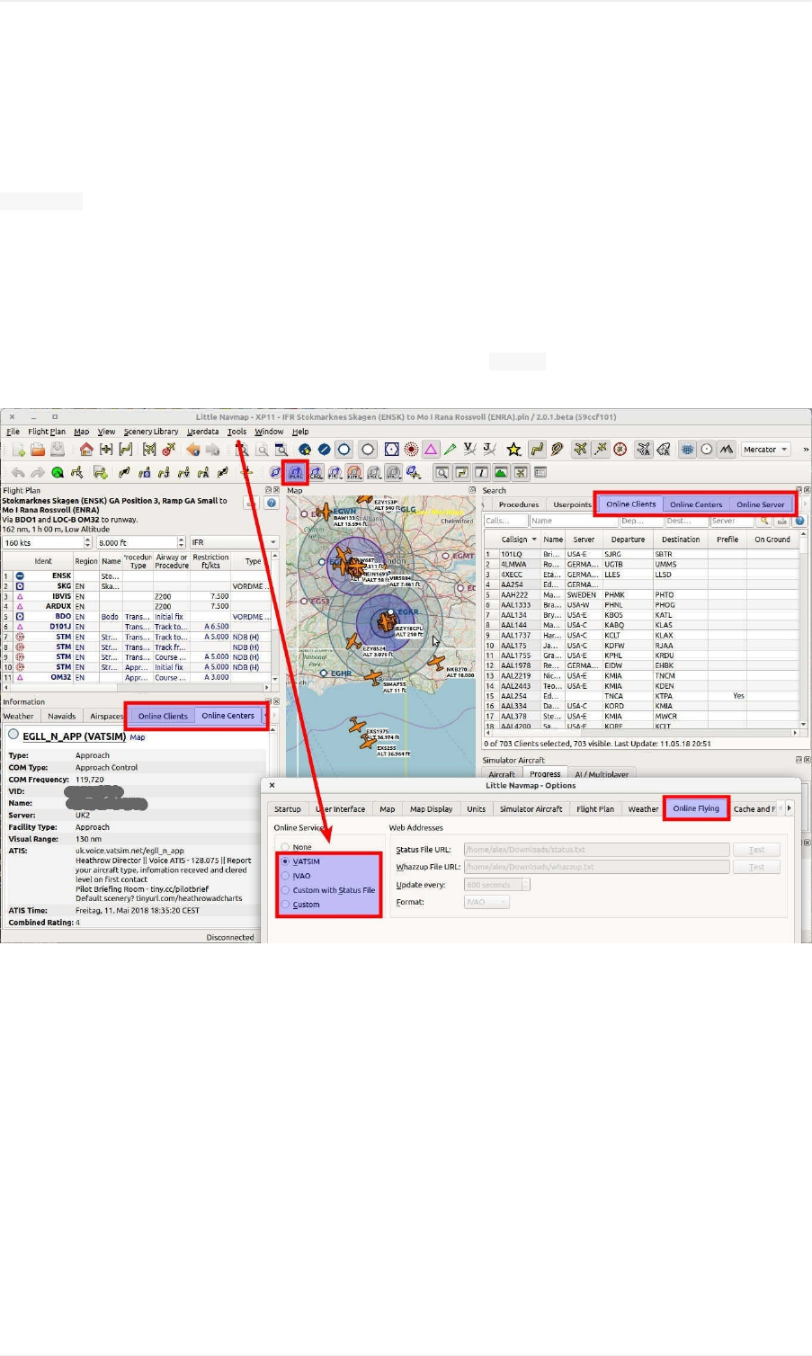
OnlineNetworks
TheonlinenetworkfunctionalityallowstoconnecttoVATSIM,IVAOorotheronlinenetworkswhichpublish
whazzup.txtfiles.Thiscoversdisplayofinformationforcenters,clientsandserversonthemap.
Networkspecificinformationlikeusernames,activecenters/towers,frequencies,flightplansandmuchmoreare
displayedworldwidewithoutlimitslikedistancetotheuseraircraft.
Notethatallrelatedwindowtabs,menuitemsandtoolbarbuttonsarehiddenifonlinenetworksaredisabled
whichisthedefault.
Accesstoonlinenetworkscanbeenabledandconfiguredinthedialog OptionsontabOnlineFlying.Predefined
optionsforthewellknownnetworksareavailableaswellasfreelyconfigurableones.
Pictureabove:Anoverviewofallonlinenetworkrelatedwindows,tabsandbuttons.
SimulatorandOnlineAircraftDuplicates
LittleNavmapfetchesdatafromonlinenetworksusinganintervalofthreeminutesdependingonsettingsand
network.
TheprogramalsofetchesAIormultiplayeraircraftfromthesimulatorwhichareupdatedabouttwotimesasecond.
Theseaircraftareinjectedintothesimulatorbythevariousonlineclientssotheyarevisiblewithinthesimulator.
Therefore,theuseraircraftandotherclientaircraftcanappearduplicatedonthemap.
LittleNavmaptriestoremovetheseduplicatesbymatchingtheaircraftregistration(simulator)andtheclientcallsign
(onlinenetwork).AircraftcanappearduplicatedifthisinformationisnotavailablewhichisthecaseforX-Plane.Refer
totheconfigurationofyouronlinenetworktoolhowtoaddthisinformation.
OnlineNetworks
70
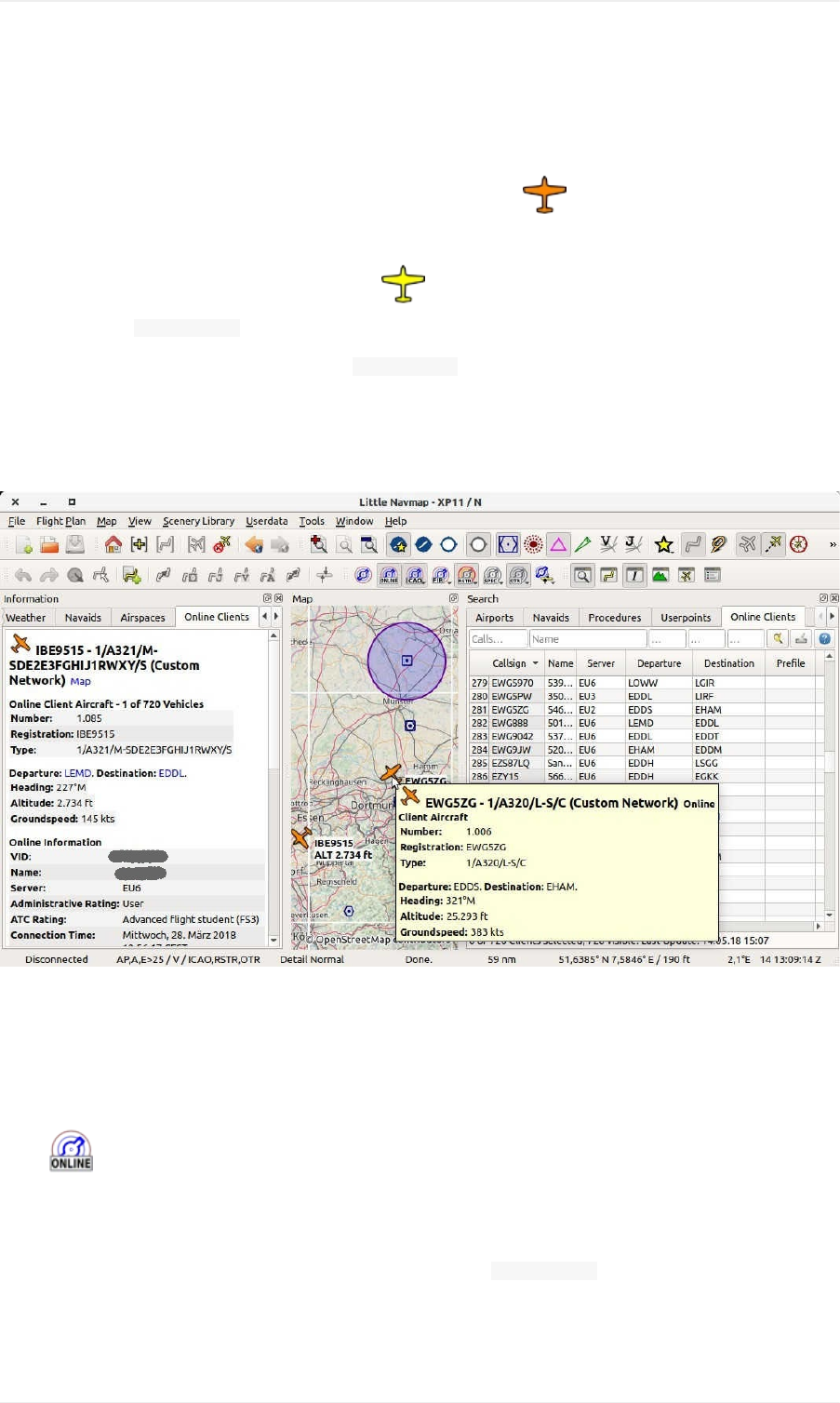
MapDisplay
Clients
Onlinenetworkclientsortheiraircraftaredisplayedonthemapusingthe symbol.Thisincludessimulator
aircraftthatwererecognizedasonlinenetworkclients.
Theuseraircraftisalwaysdisplayedusingtheyellow orasimilarsymboldependingonaircrafttypeand
simulator.Usethe ShowinSearchmapcontextmenuitemtoseeyourownaircraftinthelistofonlineclients.
Informationforonlineaircraftisshownonthetab OnlineClientsintheInformationDockWindow.
Allotherfunctionalitylikecontextmenu,double-click,tooltips,maphighlightsandotherarethesameasfortheother
aircraft.
SeeAircraftandShipsinthelegendforallsymbols.
Pictureabove:Onlinenetworkclients/aircraftinsearchtab,map,tooltipandinformationwindow.
Centers
OnlinecentersaredisplayedascircularairspacesinLittleNavmapandprovidethesamefunctionalityastheother
airspaces(tooltips,informationandmore).Theycanbeenabledseparatelyfromtheotherairspacesbyusingthe
button ormenuitemShowOnlineNetworkAirspaces.
Notethatthecirclesdonotrepresenttherealairspacesandareonlyusedtoindicatethepresenceofan
activecenter,tower,groundorotherposition.
Detailedinformationforonlinecenters/airspacesisshownonthetab OnlineCentersintheInformationDockWindow.
Thefollowingtypesareavailableandcanbeenabledinthedropdownmenusontheairspacetoolbarorsubmenu
Airspaces:
OnlineNetworks
71
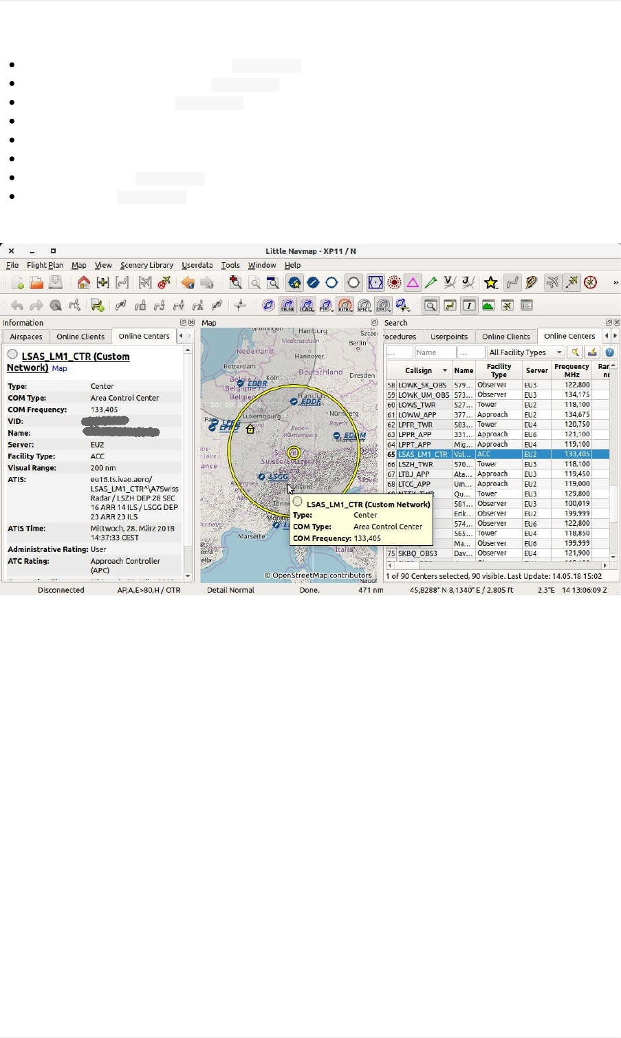
Observer:Circlesizeistakenfromthe VisualRangevalueofthecenter.
FlightInformation(Center):Uses VisualRange.
Delivery(Clearance):Uses VisualRange.
Ground:Showsacirclewithadiameterof10nm.
Tower:20nmcircle.
Approach:40nmcircle.
ACC(Center):Uses VisualRange.
Departure:Uses VisualRange.
Thesizeofthecircleshapescanbechangedintheconfigurationfile.SeeOnlineNetworkCenter.
Pictureabove:Onlinenetworkcenter/ATCinsearchtab,map,tooltipandinformationwindow.
OnlineNetworkClientSearch
OnlineNetworkCenterSearch
Thefunctionalityofthesearchfiltersinthesetwotabsandtheresulttablesaresimilartotheairportandnavaid
search.SeeSearchDockWindowforinformationaboutsearchfilters,buttonsandcontextmenuitems.
OnlineServerSearch
Displaysallonlineserversinatableandhasnosearchfunctionality.Youcanusethecontextmenutocopypartsof
theresulttableliketheIPaddress.
OnlineNetworks
72

SearchDockWindow
Thesearchdockwindowcontainsseveraltabswithsimilarfunctionalitythatallowstosearchforobjectsbyname,
identorothercriteria.
Airport,navaid,userpointandonlinesearchtabscontainmultiplerowsofsearchfilters.Theserowscanbeswitched
onandoffwiththedropdownmenuonthemenubutton onthetoprightintheairport,navaidanduserpoint
searchtabs.
Thedropdownmenuprefixesmenuitemswithachangeindicator *toshowthattherelatedfilterrowhas
modifications.Youcanusethistofindoutwhyasearchdoesnotgivetheexpectedresults.
Ifyoudonotgettheexpectedresultsornoresultsatallusethe ResetSearchmenuitem,button or
press Ctrl+Rtoclearallsearchcriteria.
Filtersaredefinedbyvariouscontrolswhicharemostlyselfexplaining.Onlytextfiltersandthetri-statecheckboxes
like Lighted, Approachor Closedneedafewextraremarksbelow.
Allfilterscanbeusedtogetherwhereallconditionshavetobemet( andoperator).Allfiltersexceptthedistance
searchfilterareappliedimmediately.Thedistancesearchisappliedafterashortdelayforeachchange.
Enteringthreeorfourcharactersinthe ICAOCodefieldoftheairportsearchtabwilltriggeraquicksearch
whichignoresallotherfiltersandshowstheairportsmatchingthatpartialorfullICAOcode.
Atooltiponthebluehelpbuttononthetoprightshowsinformationaboutsearching.
Textfilters
Thestandardistosearchforentriesthatstartwiththeenteredtext.
Theplaceholder *standsforanytext.Oncea *isincludedintheterm,thestandardsearch(matchstartoftext)is
nolongerused.Inthatcaseyoumighthavetoadda *attheendofthesearchtermaswelltogettheexpected
result.
Thesearchisnegated(findallentriesthatdonotmatch)ifthefirstcharacterinasearchboxisa -.
Notethatalloftheabovedoesnotapplytonumericfieldslike Runways:Minor Altitude:Max.
Tristatecheckboxes
Theseareusedtofilterairportsbypresenceofcertainfacilitiesorproperties.
BelowarethestatesastheyareshowninWindows10:
BlackBox:Conditionisignored.
Checked:Conditionmustmatch.
EmptyBox:Conditionmustnotmatch.
Colorsandlookofthesecheckboxesvarywiththemeandoperationsystem.Soinsteadofgrayanothercolormight
beused(redfillonLinuxora -formacOS).
Distancesearch
SearchDockWindow
73
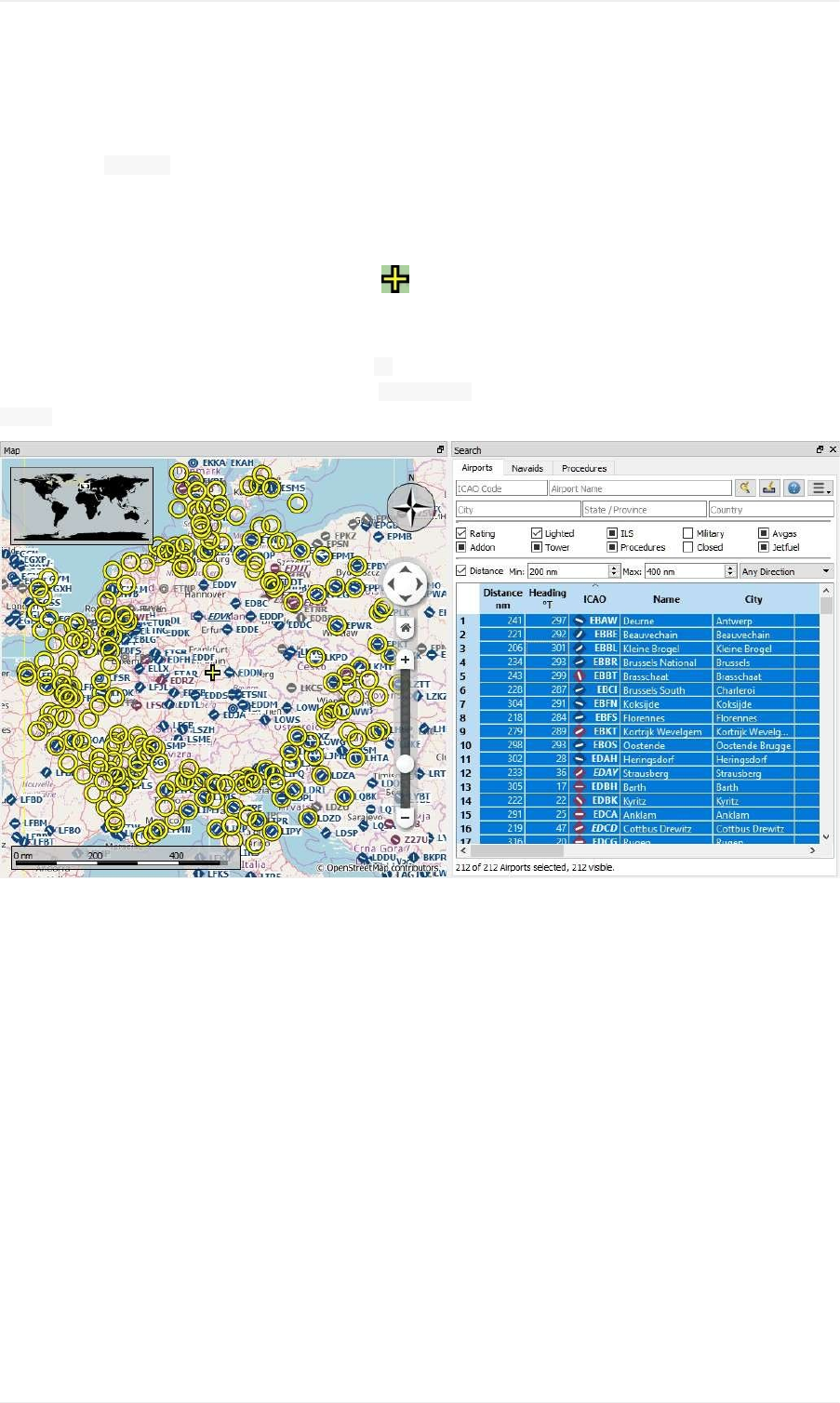
Thisfunctionisonlyavailableintheairportandnavaidsearch.
Thisfunctionallowsyoutocombineallothersearchoptionswithasimplespatialsearch.
Thecheckbox Distancehastobeselectedtoenablethissearch.Theresultwillincludeonlyairportsornavaidsthat
arewithinthegivenminimumandmaximumrangeofnauticalmilesfromthesearchcenter.Thisallowsyoutoquickly
searchforadestinationthatiswithintherangeofyouraircraftandfulfillsothercriterialikehavinglightedrunwaysand
fuel.
Thecenterforthedistancesearchishighlightedbya symbol.
Torestrictthesearchfurtheryoucanselectadirection(North,East,SouthandWest).
Checkthedropdownmenuforthechangeindicator *andthesearchfieldsforanyremainingtextifthedistance
searchdoesnotgiveanyorunexpectedresults.Use ResetSearchinthecontextmenuoftheresulttableorpress
Ctrl+Rtoclearallsearchcriteria.
PictureaboveAcomplexdistancesearch:Findallairportswithinadistancebetween200and400nauticalmiles
fromFrankfurt(EDDF).Airportsshouldhavearatinggreaterthan0andshouldhaveatleastonelightedrunway.
Militaryandclosedairportsareexcluded.Theresultingairportsarehighlightedonthemapbyselectingtheminthe
searchresulttable.
SearchDockWindow
74
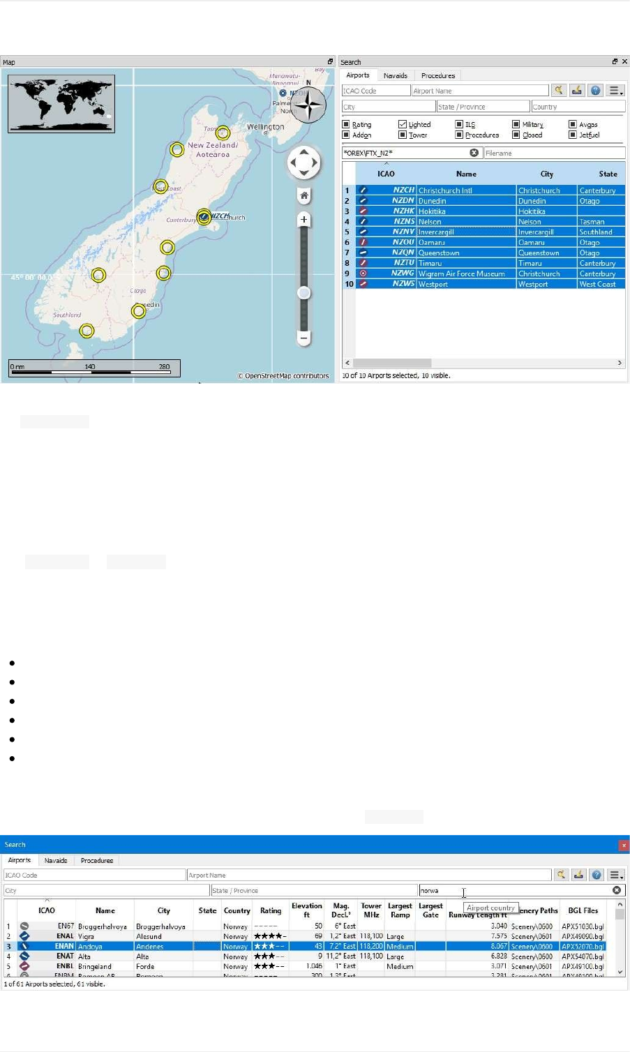
PictureaboveAcomplexsearchforscenery:Thisexampleshowshowtofindspecificadd-onscenerybyusing
the SceneryPathsearchfield.ThisshowsallairportsoftheOrbxNewZealandSouthIslandadd-onscenerythathave
lightedrunways.
SearchResultTableView
Allselectedelementsinthetableviewwillbehighlightedonthemapusingablack/yellowcircle.SeeHighlightsfor
moreinformation.
Use Shift+Clickor Ctrl+Clicktoselecttwoormoreelements(multi-selection).
Header
Theheaderofalltableviewsallowsthefollowingmanipulation:
Clickonthetopleftcornerofthecolumnheader:Selectallresultrows.
Clickonacolumnheader:Sortascendingordescending(onlyforsearchresulttables-notforflightplantable).
Clickanddragonthecolumnheader:Changecolumnorder.
Double-clickoncolumnborder:Automaticallyfitcolumnsizetocontent.
Clickanddragoncolumnborder:Changecolumnwidth.
Clickintotheemptyspacebelowallrows:Deselectallentriesandremovehighlightsonthemap.
Theaboveappliestoalltableviewsintheprogramandpartiallyalsotothetreeviewoftheproceduresearch.
Theprogramsavesthesortorder,columnwidthsandpositionsuntil ResetViewisselectedinthecontextmenu.
SearchDockWindow
75
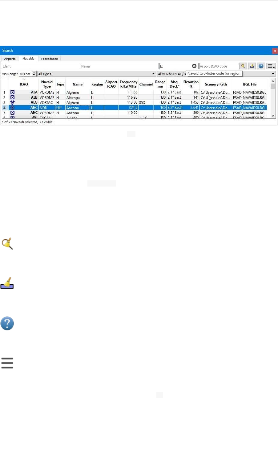
Pictureabove:Airportsearchresulttable.Alladditionalsearchoptionsarehiddenbyusingthedropdownmenuof
themenubuttononthetopright.
Pictureabove:NavaidsearchlimitedtoICAOregion LI(Italy)andVOR,VORTACandTACANstationsthathavea
rangeof100ormorenauticalmiles.
MouseClicks
Adouble-clickonanentryinthetableviewshowseitheranairportdiagramorzoomstothenavaidorotherfeature.
Additionally,detailsareshowninthe Informationdockwindow.Singleclickselectsanobjectandhighlightsitonthe
mapusingablack/yellowcircle.
TopButtons
Availablebuttonsandmenuitemsdependonsearchtab.
ResetSearch
Clearsearchfiltersandshowallentriesagaininthesearchresulttableview.
ClearSelection
Deselectallentriesinthetableandremoveanyhighlightcirclesfromthemap.
Help
Displayaquickhelpinthetooltip.Clicktoopenthischapterofthemanualinthedefaultbrowser.
MenuButton
Dropdownmenubuttonthatallowstohideorshowsearchoptions.
Thedropdownmenuprefixesmenuitemswithachangeindicator *toshowthattherelatedfilterrowhas
modifications.Youcanusethistofindoutwhyasearchdoesnotgivetheexpectedresults.
SearchResultTableViewContextMenu
Availablemenuitemsdependonsearchtab.
SearchDockWindow
76

ShowInformation
SameastheMapContextMenu.
ShowProcedures
Opentheproceduresearchtabofthesearchdockwindowanddisplayallproceduresfortheairport.
SeeProcedureSearchformoreinformation.
ShowonMap
Showeithertheairportdiagramorzoomstothenavaid,userpointorotherfeaturesonthemap.
FollowSelection
Themapviewwillbecentered-notzoomedin-ontheselectedfeaturewhenthisfunctionisenabled.
FilterbyEntriesincluding/excluding
Usethefieldunderthecursortosetasearchfilterthatincludesorexcludesthetextofthefield.Thisisonlyenabled
fortextcolumns.
ResetSearch
Clearsearchfiltersandreverttoshowingallentriesinthesearchresulttableview.
ShowAll
Thetableviewdoesnotshowallentriesinitiallyforperformancereasons.Thismenuitemallowstoloadandshowthe
wholesearchresult.Theviewswitchesbacktothelimitednumberofentriesafterasearchfilterismodifiedorthesort
orderischanged.Thenumberofall,visibleandselectedentriesisshownatthebottomofthetab.
Beawarethatshowingallnavaidsandairportscantakesometimeespeciallyiftheyarehighlightedonthemapwhen
selectingallentriesinthesearchresult.Theprogramdoesnotcrashbutneedsafewsecondstohighlightallthe
objectsonthemap.
ShowRangeRings
ShowNavaidrange
RemoveallRangeRingsandDistancemeasurements
SetasFlightPlanDeparture
SearchDockWindow
77

SetasFlightPlanDestination
AddPositiontoFlightPlan
AppendPositiontoFlightPlan
SameastheMapContextMenu.
Copy
CopytheselectedentriesinCSVformattotheclipboard.Thiswillobservechangestothetableviewlikecolumn
orderandsortorder.TheCSVincludesaheaderline.
SelectAll
Selectallvisibleentries.Toselectallavailableentriesthefunction ShowAllhastobeusedfirst.
ClearSelection
Deselectallentriesinthetableandremoveanyhighlightcirclesfromthemap.
ResetView
Resetsortorder,columnorderandcolumnwidthstodefault.
SetCenterforDistanceSearch
SameastheMapContextMenu.
SearchDockWindow
78
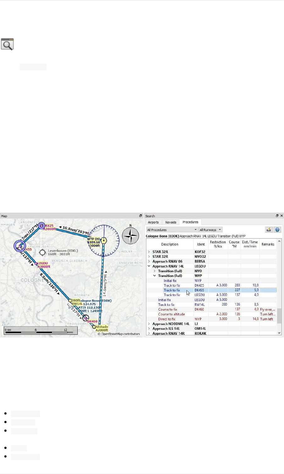
SearchDockWindow-Procedures
Thetab Proceduresallowspreviewingandaddingapproachanddepartureprocedurestotheflightplan.Procedures
ofaselectedairportarearrangedinatreewhichindicatesthedependenciesbetweenapproachesandtransitions.
NotethattheSIDandSTARnamesarelimitedto5charactersinFSXandP3DduetoalimitationintheBGLfile
format.Thereforeprocedurenamesareslightlymodified.However,thisdoesnotapplytoproceduresfroma
NavigraphorX-Planescenerydatabase.
SeetheProcedureschapterofthismanualformoredetails.
Procedurelegsareshownwhenaprocedurenodeisexpandedinthetree.Procedurescanbefilteredbyrunwayand
type.
Right-clickonaproceduretogetmoreoptionsinthecontextmenu,likecenteringthemapontheprocedureoradding
ittoyourflightplan.
Usethecontextmenuoftheflightplantabletoremoveprocedureslikeanyotherwaypoint.SeeDeleteSelectedLegs
orProcedure.
Procedurelegsarehighlightedinredifoneormorenavaidscouldnotberesolved.Awarningdialogwillbedisplayed
ifyoutrytoaddthisproceduretoaflightplan.
Pictureabove:ShowingatransitionandaRNAVapproach.Startandendpointofatransitionlegarehighlightedon
themap.
ProcedureTree
Legsareshownindarkbluewhilemissedapproachlegsareshownindarkredcolor.
Boldredtextindicatesanerrorintheleg.Theprocedureisincompleteandshouldnotbeusedinaflightplan.
Description:Eitherdescriptionoftheprocedureorflightinstructionforprocedurelegs.
Course°M:Magneticcourseforaleg.
Dist./Time:Distanceofflyingtimeforaleg.Holdscanhavealegtimeinminutesoralegdistanceinnautical
miles.
Ident:Identoftheinitialfixornameoftheprocedure.Fixnameforlegs.
Restriction:Eitherminimumaltitudeforenrouteairwaysegment,procedurealtituderestrictionorprocedure
SearchDockWindow-Procedures
79

speedlimit.A /separatesaltitudeandspeedrestriction.Thefollowingaltituderestrictionsexistforprocedures:
Numberonly:Flyataltitudeorspeed.Example: 5.400or 210.
PrefixA:Flyatorabovealtitudeorspeed.Example: A1.800.
PrefixB:Flyatorbelowaltitudeorspeed.Example: B10.000or B220.
Range:Flyatorabovealtitudeoneandatorbelowaltitudetwo.Example: A8.000,B10.000.
Altitudeandspeedlimit:Valuesseparatedby /.Example: A8.000,B10.000/B220.
Speedlimitonly:Aprefixed /indicatesnoaltitudebutaspeedrestriction.Example: /B250.
Remarks:Showsfly-over,turndirectionorrelatednavaidforaprocedureleg.
TopButtons
TypeFilter(AllProcedures)
ThetypefilterisnotavailableforanFSXorP3Dstockdatabase.AnavdataupdateisneededtogetSIDandSTAR
procedures.
ThisfilterisalwaysavailableforaX-PlanedatabasewhichcontainsSIDsandSTARsalreadyinthestockdata.
Thetypefilterallowstheselectionsbelow:
AllProcedures:SID,STARandapproaches
DepartureProcedures:OnlySID
ArrivalProcedures:STARandapproaches
OnlyApproachesandTransitions:NoSIDandnoSTAR
Therespectivetransitionsarealwaysshown.
RunwayFilter(AllRunways)
Thisfilterisalwaysavailableandhelpstofindproceduresforacertaindepartureorarrivalrunway.
ClearSelection
Deselectallentriesinthetableandremoveanyhighlightcirclesfromthemap.
Help
Openthischapterofthemanualinthedefaultbrowser.
ProcedureTreeContextMenu
ShowonMap
Centerthemapontheselectedprocedure.
FollowSelection
Themapviewwillbezoomedontheselectedprocedurewhenthisfunctionisenabled.
InsertintoFlightPlan/UseasDestination/UseasDeparture
SearchDockWindow-Procedures
80

Textandfunctionalityofthismenuitemdependsontheselectedproceduretypeandwhethertheprocedure'sairport
isalreadythedepartureordestinationairportofthecurrentflightplan.
Usethecontextmenuoftheflightplantabletoremoveprocedures.SeeDeleteSelectedLegsorProcedure.
Ifatransitionisselected,thecorrespondingprocedure(approach,SIDorSTAR)isaddedorreplacedaswell.
Insert...intoFlightPlan:
Thismenuitemwilladdtheselectedproceduretothecurrentflightplan.Aprocedureofthesametype(SID,STARor
approachwithorwithouttransition)willbereplacedifalreadypresentintheflightplan.
Use...asDestinationor Use...asDeparture:
Thiswilladdorreplacethedestinationordepartureairportandaddtheselectedprocedure.
Iftheflightplanisempty,thedepartureordestinationairportisaddedtotheflightplanaswell.
ExpandAll/CollapseAll
Expandallproceduressothattheirlegsandtransitionsareshownorcollapsethetree.
ResetSearch
Clearsearchfiltersandreverttoshowingallproceduresinthetree.
ClearSelection
Deselectthecurrentlyselectedprocedureandremovethepreviewfromthemap.
ResetView
Resetcolumnorderandcolumnwidthstodefault.
SearchDockWindow-Procedures
81
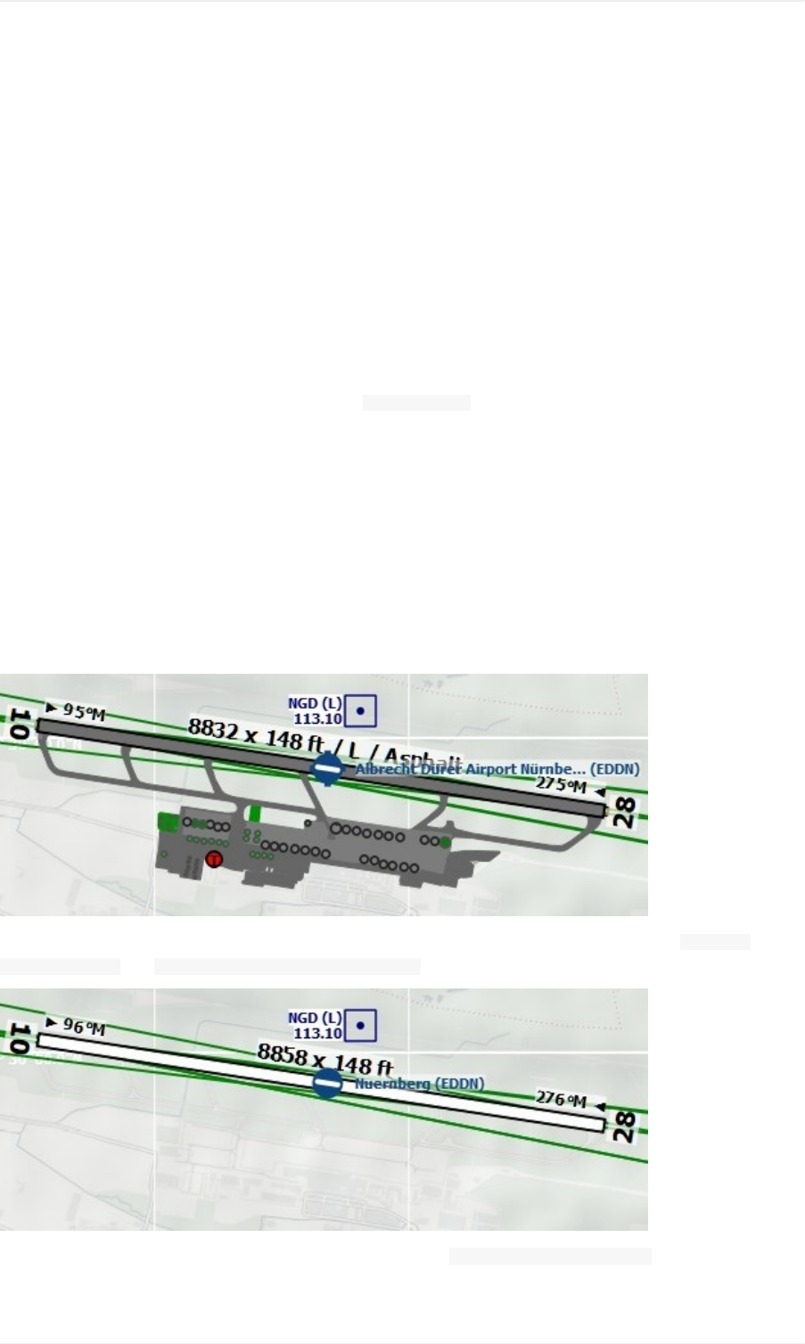
NavigationDatabases
LittleNavmapcanuseuptotwodatabasesinparallel:
1. Simulatordatabase:CreatedbyreadingthescenerylibraryofFSX,P3DorX-Plane.
2. Navigationdatabase:ProvidedbyNavigraph.Doesnothavetobecompiledandcanbeupdatedbythe
NavigraphFMSDataManager.
LittleNavmapisbundledwithanavigationdatabasefromarecentAIRACcyclethatisenabledperdefault.
SeeInstallNavigraphUpdatesonmyhomepageforinformationhowtoupdateLittleNavmap'snavigation
data.
Threedisplaymodescanbeselectedfromthemenu SceneryLibraryasshownbelow.
UseNavigraphforallFeatures
UsesonlyinformationfromtheNavigraphdatabase.
Notethatairportinformationislimitedinthismode.Thismeansthataprons,taxiways,parkingpositions,runway
surfaceinformationandfuelinformationarenotavailable.Additionally,smallerairportsmightbemissing.
Runwaylayoutmightnotmatchtherunwaylayoutinthesimulatorifyouusestockorolderairportscenery.
Anadvantageofthismodeisthatapproachproceduresalwaysmatchtheairportrunwaylayout.
Pictureabove:AirportdiagramforEDDNfromsimulatorscenery(X-Plane)asshowninthemodes Donotuse
NavigraphDatabaseand UseNavigraphforNavaidsandProcedures.
Pictureabove:AirportEDDNfromtheNavigraphdatabasewhile UseNavigraphforallFeaturesisenabled.Note
missingrunwaysurfaceinformationandmissingaprons,taxiwaysandparkingpositions.
NavigationDatabases
82

DonotuseNavigraphDatabase
CompletelyignorestheNavigraphdatabaseandshowsonlyinformationreadfromthesimulatorscenery.
UseNavigraphforNavaidsandProcedures
DefaultmodeafterinstallationorupdateofLittleNavmap.
ThismodeblendsnavaidsandotherfeaturesfromtheNavigraphdatabasewiththesimulatordatabase.Thisaffects
themapdisplay,allinformationwindowsandandallsearchwindows.
Thefollowingfeaturesaretakenfromthesimulatordatabasewhenusingthismode:
Airports(also Searchdockwindow,tab Airport)
Aprons
Taxiways
Parkingpositions
COMfrequencies
ILS
ThefollowingfeaturesaretakenfromtheNavigraphdatabase:
Navaids(waypoints/intersections,VOR,NDB,marker)whichaffects:
Searchdockwindow,tab Navaid
Flightplancalculation
RouteDescription
Procedures(approaches,SIDsandSTARs).Thisaffects:
Searchdockwindow,tab Procedures
Loadinganddisplayofproceduresfromflightplans.
Airways
Airspaces
Limitationsinthismode
LittleNavmapignoresanymismatchesbetweenproceduresandrunwaysduetoairportupdatesandwillnot
displayawarning.Updateanairportusingpaywareorfreewaresceneryifyoufindthatanapproachordeparture
proceduredoesnotstartatarunwayendofanairport.
Procedurescannotberecognizedwhenselecting ShowProceduresinthemenuifanairporthaschangeditsICAO
ident(e.g. KulikLake:identchangedfrom LKKto PAKL).Ifyoususpectsuchacaseusethemode UseNavigraph
forallFeaturestogettheproceduresfortheairport.
Theairportsearch Proceduresonlyconsidersproceduresavailableinthesimulator.Switchto UseNavigraphfor
allFeaturestolookforairportsthathaveproceduresfromtheNavigraphdatabase.
ILSplacementorpresencemightnotmatchapproachproceduresifanairporthasanewILSwhichisnotpresent
instocksceneryoranoldsceneryadd-on.IfyouencounteranILSapproachwithoutILSstation,switchto Use
NavigraphforallFeaturestoovercomethislimitation.
UsingthefsAerodatanavdataupdatewillmitigateorevenremoveallofthelimitationsabovesinceitwillsynchronize
thesimulatorscenerywiththeNavigraphdatabase.
NavigationDatabases
83
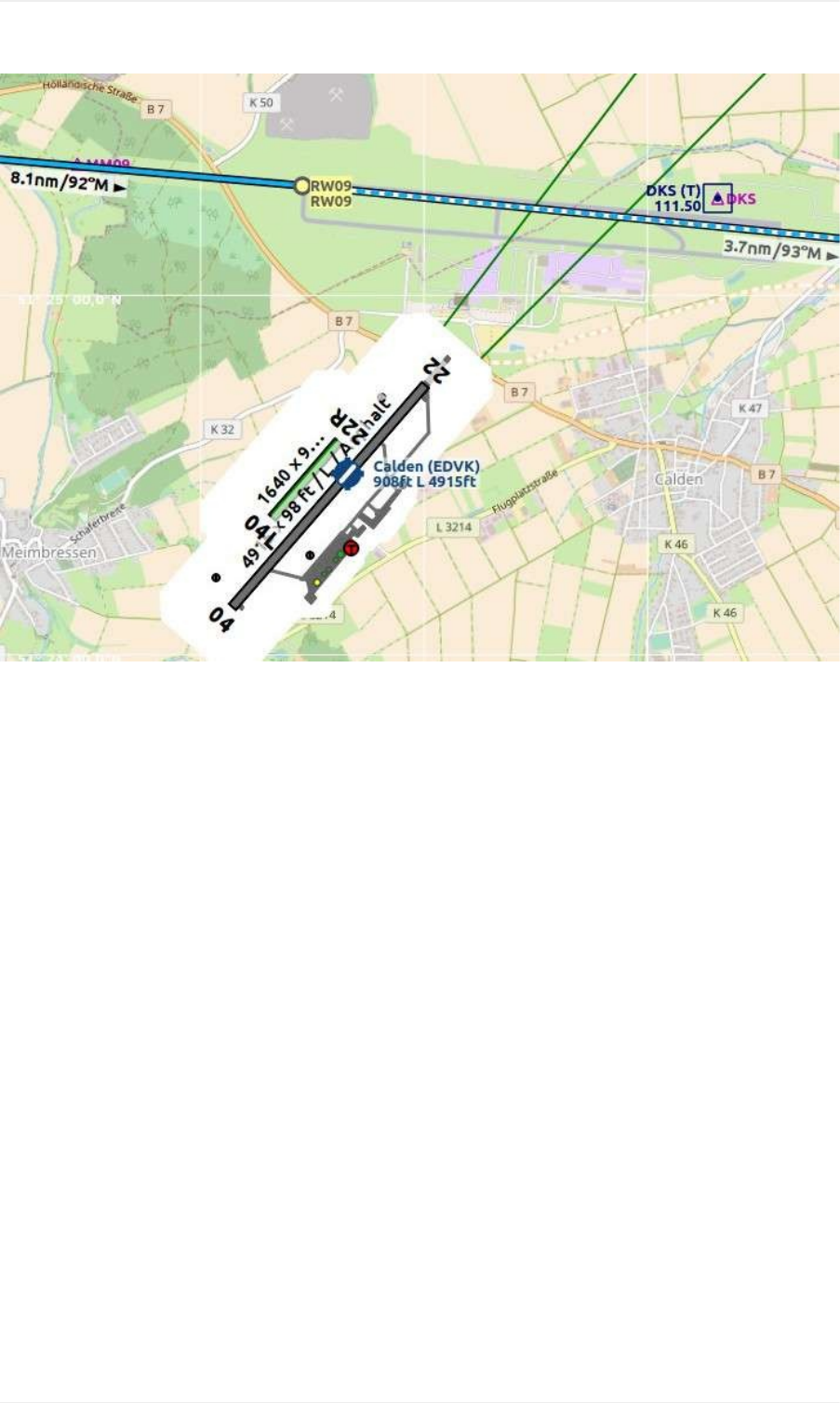
Pictureabove:Anextremeexampleforrunway/proceduremismatch.TheapproachfromtheNavigraphdatabase
cycle1707endsatthenotvisiblerunway09whiletheoutdatedsceneryfromFSXshowstheairportatthewrong
position.EDVKwasrebuildnorthofCaldenin2013.TheOpenStreetMapbackgoundshowsthenewairport.
NavigationDatabases
84

FlightPlanFormats
LittleNavmapsupportsseveralflightplanformats,allofwhichhavedifferentlimitations.Onlysomeoftheseformats
canbeloadedandsaved.
Theprogramusesdifferent Saveas...filedialogsinsteadofjustone.Thismeansthedirectoryforeachfileformatis
retainedseparately,removingtheneedtonavigatebackandforthbetweentheFSXflightplandirectory,theP3D
flightplandirectoryandtheX-PlaneFMSoutputdirectory.
Notethedifferencebetween SaveFlightPlanas...and ExportFlightPlanas...: Exportdoesnotchangethe
currentfilenamewhile Saveas...does.
FeatureTable
ThetablebelowshowsthecapabilitiesofLittleNavmapandthesupportedflightplanformats(X=supported,0=not
supported):
Format Read Write Airw. VFR/
IFR
User
Wpt.
Names
Dep.
Parking
Cruise
Alt.
Ground
speed Proc.
FSXPLN
annotated X X X X X X X X X
FSXPLN X X X X X X X 0 0
FS9PLN
clean X 0 X X X X X 0 0
FSCPLN X 0 X 0 X 0 0 0 0
X-Plane
FMS11 X X X 0 X 0 X 0 X
X-Plane
FMS3 X X 0 0 X 0 X 0 0
FLP X X X 0 0 0 0 0 X
RealityXP
GNSFPL 0 X 0 0 X 0 0 0 0
RealityXP
GTNGFP 0 X X 0 X 0 0 0 X
Flight1GTN 0 X X 0 0 0 0 0 0
PMDGRTE 0 X X 0 0 0 0 0 0
TXT 0 X X 0 0 0 0 0 0
MajesticDash
FPR 0 X 0 0 0 0 0 0 0
IXEG737FPL 0 X X 0 0 0 0 0 0
FLTPLAN
foriFly 0 X X 0 0 0 0 0 0
ProSim
companyroutes.xml 0 X X 0 0 0 0 0 0
PLNfor
BBSAirbus 0 X X 0 0 0 0 0 0
2
1
FlightPlanFormats
85

UFMC 0 X X 0 0 0 0 0
FPLfor
XFMC 0 X X 0 0 0 0 0
FlightFactor
corte.in 0 X X 0 0 0 X 0
GPX 0 X 0 0 0 0 0 0
Procedurewaypointsareexcludedfromallfileformatsbydefault,exceptforGPX.YouhavetousetheGPSorFMS
inthesimulatortoselectprocedures.
YoucanenablesavingofwaypointsbycheckingthemenuitemsSaveWaypointsforApproachesand/orSave
WaypointsforSIDandSTAR.
Adialogisshownifanyunsupportedfeaturesaredetectedinthecurrentflightplanwhentryingtosaveaplan.You
candisablethisdialogforfuturesavesifyouknowwhatyouaredoing.
Thecurrentfilenameandtypewillchangeifyousaveaplantoaformatthatisreadableandwritable.Thisdoesnot
happenwhenexporting.
Anexampleshowshowtheprogramdealswiththelimitedformats:
1. Createaflightplanincludingprocedures.
2. SaveasPLN-currentfilenamechangestonewfilename NAME.pln.
3. SaveasFMS-awarningisshownandaftersavingthecurrentfilenamechangestonew NAME.fms.
4. Restartprogram- NAME.fmswillbereloadedandproceduresarelost.
5. NowexportasGFP-Currentfilenameremains NAME.fms.
UserWaypointNames
Userwaypointnameswillbeadaptedtoformatlimitationswhensaving.Thatmeansthatwaypointnamescanchange
whenreloadingaflightplan.
PLN:MaximumlengthforFSXorPrepar3Dis10charatersandnospecialcharactersareallowed.Unsupported
characterswillberemovedandthelengthwillbetruncated.
FMS:Nospacesallowed.Thesewillbereplacedwithunderscores( _).
FLP:Alluserwaypointnameswillbereplacedbycoordinates.
FSXPLN
TheformatFSXPLNisusedasadefaultformatbecauseitsupportsmostfeaturesandallowstoincludeadditional
informationinformofannotationswhichwillbeignoredbyflightsimulatorsandmostothertools.
NotethatP3Dv4.2overwritestheflightplanwhenloading,whicherasesallannotations.Saveacopyofthe
plantoanotherlocationifyouliketokeepallinformationaboutproceduresorspeed.
FS9PLN
FileformatoftheFlightSimulator2004.UsesthesamePLNextensionastheFSXPLNformat.LittleNavmapcan
onlyreadthisformat.ThereforeawarningdialogisshownbeforeoverwritingafilewiththenewerFSXPLNformat.
CleanPLN
FlightPlanFormats
86

ThisisthesameastheFSXPLNbutwithoutadditionalannotationswhichcontaininformationaboutselected
proceduresorgroundspeed.Usethisformatifanapplicationcannotdealwiththeannotatedformat.
FMS11(X-Plane)
NewX-PlaneFMSformatwhichcanbeloadedintothestockGPS,theG1000andtheFMSofX-Plane11.10.Thisis
thedefaultsaveformatforX-PlaneFMSnow.UsetheexportfunctiontosaveoldFMSversion3files.
ThisformatissupportedasofX-Plane11.10.ItcanalreadybeusedinthebetaversionsbutmightcrashX-
Planeversion11.05andbelow.
LittleNavmapcanreadandwritethisformat.
Storethesefilesintothe Output/FMSplansdirectoryinsidetheX-Planedirectory.
FMS3(X-Plane)
X-PlaneFMSformatwhichcanbeloadedintothestockGPSandFMSofX-Plane10and11.05.Theformatisvery
limitedandbasicallystoresonlyalistofwaypoints.
LittleNavmapcanreadandwritethisformat.
Storethesefilesintothe Output/FMSplansdirectoryinsidetheX-Planedirectory.
FLP
AformatthatcanbereadbytheX-PlaneFMS(nottheX-PlaneGPS),AerosoftAirbusandotheradd-onaircraft.
Supportsairwaysandprocedures.
YoucanloadthesefilesintotheX-PlaneFMSincludingairwayinformation.ProceduresaresavedintheFLPbut
cannotloadedyetbytheFMS.Youhavetoselectthesemanuallyafterloadingtheflightplan.
Storethesefilesintothe Output/FMSplansdirectoryinsidetheX-PlanedirectoryifyouwanttousetheminX-Plane.
FPL(RealityXPGarminGNS)
FlightplanformatasFPLfileusablebytheRealityXPGNS530W/430WV2.
Thisfileformatcanonlybeexported.Readingisnotsupported.
SeebelowforinformationonknownproblemswhenexportingflightplandatafortheGNS.
LittleNavmapconsidersthe GNSAPPDATAenvironmentvariableifset.SeetheGNSmanualformoreinformation.
ThedefaultdirectorytosavetheflightplansfortheGNSunitsis C:\ProgramData\Garmin\GNSTrainerData\GNS\FPLforall
simulators.ThedirectorywillbecreatedautomaticallybyLittleNavmaponfirstexportifitdoesnotexist.
GFP(RealityXPGarminGTN)
SaveflightplanasGFPfileusablebytheRealityXPGTN750/650Touch.
Thisfileformatcanonlybeexported.Readingisnotsupported.
SeebelowforinformationonknownproblemswhenexportingflightplandatafortheGTN.
LittleNavmapconsidersthe GTNSIMDATAenvironmentvariableifset.SeetheGTNmanualformoreinformation.
FlightPlanFormats
87

GarminGTNTrainer6.41
ThedefaultdirectorytosavetheflightplansfortheGTNunitsis C:\ProgramData\Garmin\Trainers\GTN\FPLNforall
simulators.ThedirectorywillbecreatedautomaticallybyLittleNavmaponfirstexportifitdoesnotexist.
GarminGTNTrainer6.21
Ifyou'reusingthetrainerversion6.21thenthedefaultpathis C:\ProgramData\Garmin\GTNTrainerData\GTN\FPLN.You
havetocreatethisdirectorymanuallyandthennavigatetoitinthefiledialogwhensaving.LittleNavmapwill
remembertheselecteddirectory.
GFP(Flight1GarminGTN)
ThisistheflightplanformatusedbytheFlight1GTN650/750.
Thisfileformatcanonlybeexported.Readingisnotsupported.
SeebelowforinformationonproblemswhenexportingflightplandatafortheGTN.
ThedefaultdirectoriestosavetheflightplansfortheGTNunitsare:
Prepar3Dv3:C:\ProgramFiles(x86)\LockheedMartin\Prepar3Dv3\F1TGTN\FPL.
Prepar3Dv4:C:\ProgramFiles\LockheedMartin\Prepar3Dv4\F1TGTN\FPL.
FlightSimulatorX:C:\ProgramFiles(x86)\MicrosoftGames\FlightSimulatorX\F1GTN\FPL
YoumightneedtochangetheuserprivilegesonthisdirectoryifyoursavedflightplansdonotshowupintheGTN.
Giveyourselffullcontroland/orownershipofthisdirectorytoavoidthis.
AtypicalsymptomisthatyoucansavetheflightplaninLittleNavmapandyoucanalsoseethesavedplaninLittle
Navmap'sopendialogsbutitdoesnotshowupintheGTNunit.Changetheprivilegesoftheexportdirectoryas
mentionedaboveifthatisthecase.
Thefileisasimpletextformatcontainingonlyonelineoftext.Exampleforthecontentofaflightplanfilenamed KEAT-
CYPU.gfp:
FPN/RI:F:KEAT:F:EAT.V120.SEA.V495.CONDI.V338.YVR.V330.TRENA:F:N50805W124202:F:N51085W124178:F:CAG3:F:N51846W124150:F:CYPU
RTE(PMDG)
APMDGRTEfile.Filelocationdependsontheusedaircraftbutisusually PMDG\FLIGHTPLANSinthesimulatorbase
directory.
TXT(JARDesignandRotateSimulations)
AsimplefileformatusablebyJARDesignorRotateSimulationsaircraft.Locationdependsontheusedaircraftwhich
isusuallyintheX-Planedirectory aircraft.
Thefileisasimpletextformatcontainingonlyonelineoftext.Exampleforthecontentofa TXTfilenamed
CBZ9CYDC.txt:
CBZ9SIDAIRIEV324YKAB8DURAKSTARCYDC
FPR(MajesticDash)
FlightplanformatfortheMajesticSoftwareMJC8Q400.Notethattheexportiscurrentlylimitedtoalistofwaypoints.
Theflightplanhastobesavedto YOURSIMULATOR\SimObjects\Airplanes\mjc8q400\nav\routes.
FlightPlanFormats
88

NotethattheFMCintheDashwillshowinvalidcoordinateswhenyoupress INFOonawaypointorairport.Theflight
plan,navigationandautopilotarenotaffectedotherwise.
FPL(IXEGBoeing)
ExportsthecurrentflightplanasaFPLfileusablebytheIXEGBoeing737.TheformatisthesameasTXTbutwitha
differentfileextension.
Thefileshouldbesavedto XPLANE\Aircraft\X-Aviation\IXEG737Classic\coroutes.Youhavetocreatethedirectory
manuallyifitdoesnotexist.
corte.in(FlightFactorAirbus)
AformatfortheFlightFactorAirbus.Thefileisnottruncatedandflightplansareappendedwhensaving.
FlightplansaresavedinaslightlyextendedATSroutenotationwhichalsoallowstosavethecruisealtitudeand
approachprocedures.Editthefilewithasimpletexteditorifyouwanttoremoveflightplans.
Example:
RTEETOPS002EINN06UNBE2AUNBEGDCT5420NDCTNICSON236AALLEXQ822ENEDCTCORVTKJFKI22RJFKBOS01CI30FL360
RTEEDDFEGLLEDDF25CBIBT4GBIBTIUZ29NIKUL610LAMEGLLI27RLAMCI25FL330
FLTPLAN(iFly737NG)
FlightplanformatfortheiFly737NGforFSXorP3D.Thefilehastobesavedto
YOURSIMULATOR/iFly/737NG/navdata/FLTPLAN.
Procedurescannotbesaved.
companyroutes.xml(ProSim)
AflightplanformatforProSim.Theflightplanisappendedtothefile companyroutes.xmlwhensaving.Removeflight
plansmanuallyinatexteditor.
LittleNavmapcreatesuptotwobackupfileswhensavingtheflightplan: companyroutes.xml_lnm_backupand
companyroutes.xml_lnm_backup.1.
Procedurescannotbesaved.
Example:
<?xmlversion="1.0"encoding="UTF-8"?>
<companyroutes>
<routename="EFMAESGT">EFMARUNGAN872TEBN623BEDLAN866NEGILESGT</route>
<routename="LGIRLEDA">LGIRSUDUJ65TRLUM601RUTOMM601QUENNQ123LULIXP167GINOXUM601BCNUN975SELVALEDA</route>
</companyroutes>
PLN(BBSAirbus)
ThisformatisfortheBlackboxSimulationsAirbusforFSXorP3D.Savethisto YOURSIMULATOR/Blackbox
Simulation/CompanyRoutesor YOURSIMULATOR/BlackBoxSimulation/AirbusA330dependingonaircrafttype.
Thisformatcannotsaveprocedures.
UFMC(UniversalFlightManagementComputer)
FlightPlanFormats
89

AflightplanformatfortheUFMC.Theformatdoesnotallowsavingofprocedures.
Savetheflightplanto XPLANE\CustomData\UFMC\FlightPlans.
FPLforX-FMC(UniversalFMCforX-Plane)
SaveflightplanasFPLfilefortheX-FMC.Theformatdoesnotallowsavingofprocedures.
ThefileshouldbesavedtoPathto XPLANE\Resources\plugins\XFMC\FlightPlans.
GPX
GPXisnotaflightplanformat.
TheGPSExchangeFormatcanbereadbyGoogleEarthandmostotherGISapplications.
Theflightplanisembeddedasarouteandtheflownaircrafttrailasatrackincludingsimulatortimeandaltitude.
Theroutehasdepartureanddestinationelevationandcruisealtitudesetforallwaypoints.Waypointsofall
proceduresareincludedintheexportedfile.Notethatthewaypointswillnotallowtoreproduceallpartsofa
procedurelikeholdsorprocedureturns.
NotesabouttheGarminFormatsGFPandFPL
VariousproblemscanappearwhenreadingexportedflightplansintotheGarminunits.Mostofthesearearesultof
theGarminnavigationdatabasewhichusesdataofanolderAIRACcycle(mostly1611atthetimeofwriting).
Updatedsimulatororadd-ondatabases(liketheoneinLittleNavmap)canusethelatestnavdataoranoldonefrom
FSXorP3Dstockdata.X-Plane11.10stocknavdataiscurrentlybasedon1611.
Anywaypoints,airwaysorproceduresthatareremoved,addedorrenamedovertimecancauselockedwaypointsor
othermessageswhenreadingaflightplanintotheGNSorGTN.
ItiseasytoremovelockedwaypointswithintheGNSorGTNtoenabletheflightplantobeactivated.Refertothe
documentationoftheGarminunit.
LittleNavmapallowstochangetheGarminexporttoreplaceallwaypointswithuser-definedwaypointstoavoid
locking.Whilethisisasufficientapproachtoavoidthelockedwaypointsitcomeswithafewlimitations:
Departureanddestinationairportarenotsavedasuser-definedwaypoints.ThesehavetoexistintheGarmin
navigationdatabase.
Navaidinformationlikefrequenciescannotbedisplayedsincethewaypointcannotberelatedtotheradionavaid.
ProcedureslikeSIDandSTARcannotbesavedwiththeflightplanandhavetobeselectedmanually.
TheGTN(nottheGNS)changesallnamestoageneric USERWPT...scheme.
Theexportofuser-definedwaypointscanbeenabledintheoptionsdialogontab FlightPlan.
.TheFPRformatdoesallowsavingofairwaysandproceduresbutthiswillbeimplementedinafuturerelease
ofLittleNavmap.↩
.User-definedwaypointswillberenamedwhenloadingintotheGTN.↩
1
2
FlightPlanFormats
90
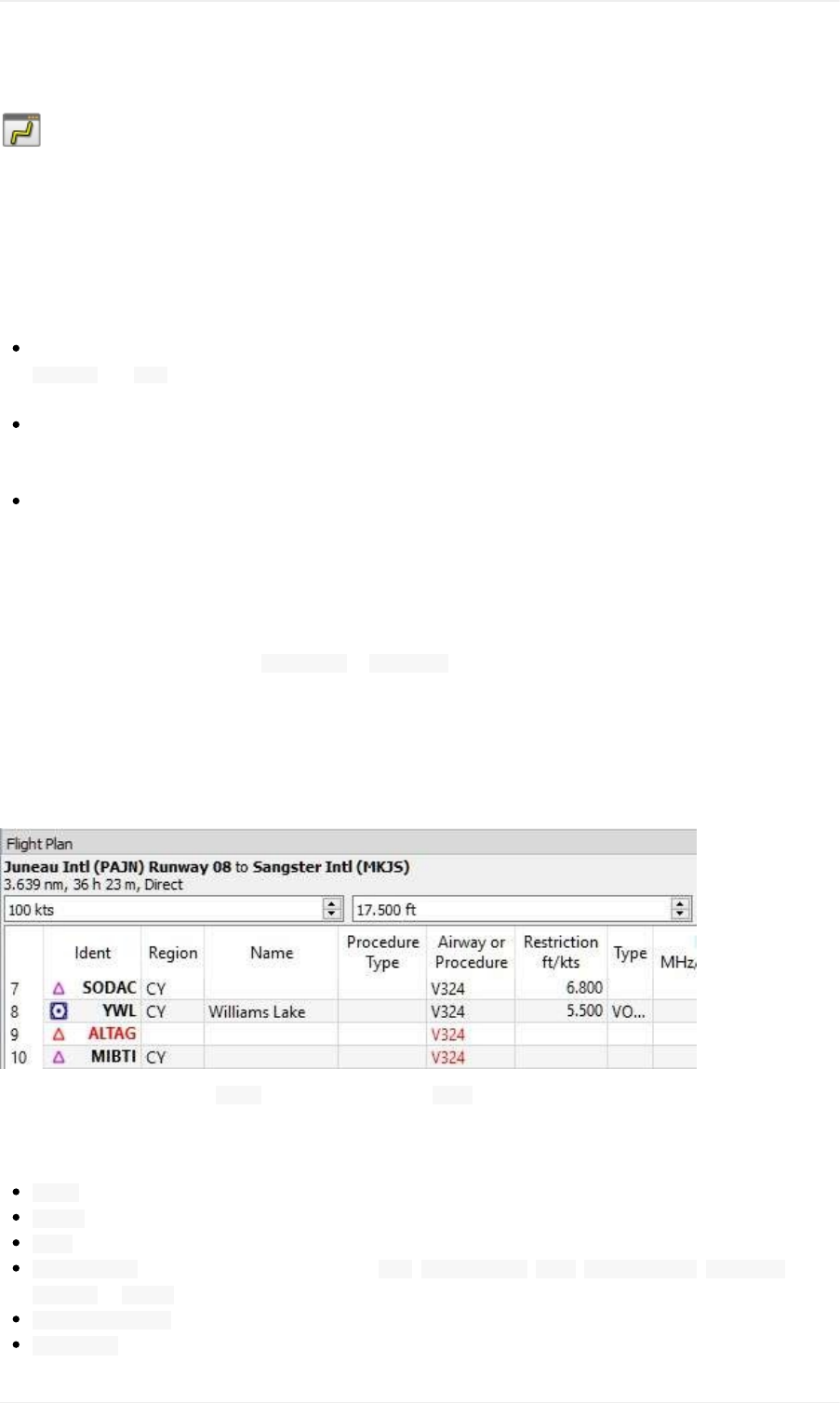
FlightPlanDockWindow
UpperPart
Thetopshowsalabelthatcontainsdeparture,departureposition(parking,runwayorhelipad),destination,flightplan
distance,travelingtime,usedproceduresandflightplantype.
Besidesthelabeltherearethreeinputfieldsontopofthisdockwindow:
Speed(kts):Groundspeed.Thevalueofthisfieldisusedonlyforcalculatingtravelingtimesinthetableview:
LegTimeand ETA(estimatedtimeofarrivalatawaypointgiven0:00asstarttime).Itissavedasanannotation
withtheflightplanandnotusedforsimulatoruseraircraftcalculations.
Cruisealtitude(ft):Thisvalueissavedwiththeflightplanandisalsousedtocalculateanairwayflightplan
basedongivenaltitude.Thisfieldissetautomaticallytotheminimumaltitudeforaflightplanifaplanalong
VictororJetairwaysiscalculatedandaltituderestrictionswerefound.SeeCalculatebasedongivenAltitude.
FlightPlanType(IFRorVFR):Thisissavedwiththeflightplan.
FlightPlanTable
Thetableviewallowsthesameoperationsasthesearchtableviewexceptsorting.Seehereformoreinformation.
Allselectedelementsintheflightplantableviewwillbehighlightedonthemapusingablack/greencircle.See
Highlightsformoreinformation.Use Shift+Clickor Ctrl+Clicktoselecttwoormoreelements(multi-selection).
TheactiveflightplanlegishighlightedinmagentawhenLittleNavmapisconnectedtoasimulator.
Procedurelegshavedarkbluecolorandlegsofamissedapproachhaveadarkredcolor.
Ifawaypointofaflightplancannotbefoundinthedatabaseitwillbedisplayedinred.Thiscanhappeniftheused
AIRACcyclesdonomatch.Thesameappliestoairways.Thepositiononthemapisstillcorrect.
Pictureabove:Thewaypoint ALTAGandpartsoftheairway V324couldnotbefoundinthedatabase.
TableColumns
Ident:ICAOidentofthenavaidorairport.
Region:Twoletterregioncodeofanavaid.
Name:Nameofairportorradionavaid.
ProcedureType:Thetypeofthisleg'sprocedure. SID, SIDTransition, STAR, STARTransition, Transition,
Approachor Missed.
AirwayorProcedure:Containstheairwaynameforenroutelegsorprocedureinstruction.
Restriction:Eitherminimumaltitudeforenrouteairwaysegment,procedurealtituderestrictionorprocedure
FlightPlanDockWindow
91
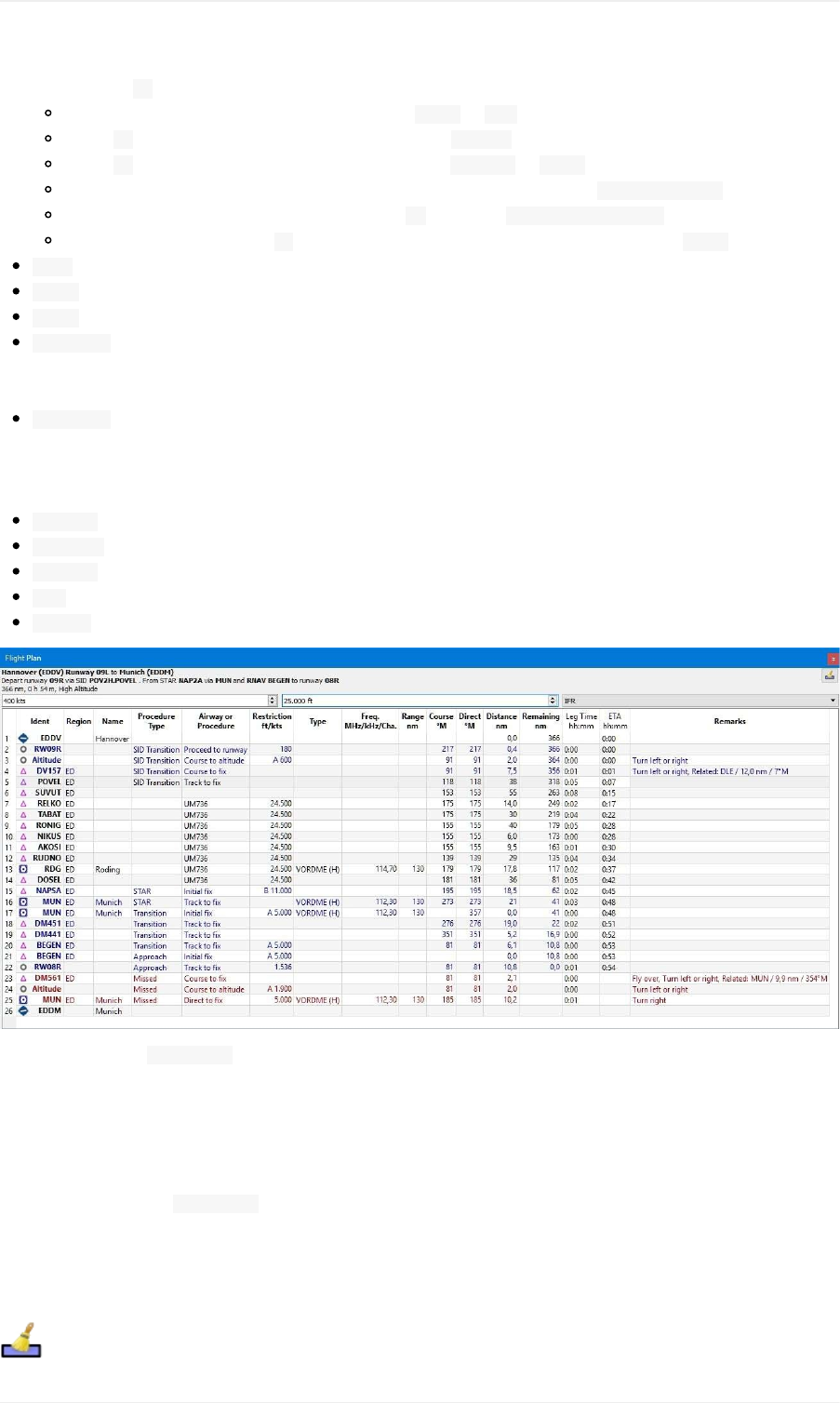
speedlimit.A /separatesaltitudeandspeedrestriction.Thefollowingaltituderestrictionsexistforprocedures:
Numberonly:Flyataltitudeorspeed.Example: 5.400or 210.
PrefixA:Flyatorabovealtitudeorspeed.Example: A1.800.
PrefixB:Flyatorbelowaltitudeorspeed.Example: B10.000or B220.
Range:Flyatorabovealtitudeoneandatorbelowaltitudetwo.Example: A8.000,B10.000.
Altitudeandspeedlimit:Valuesseparatedby /.Example: A8.000,B10.000/B220.
Speedlimitonly:Aprefixed /indicatesnoaltitudebutaspeedrestriction.Example: /B250.
Type:Typeofaradionavaid.
Freq.:Frequencyorchannelofaradionavaid.
Range:Rangeofaradionavaid.
Course°M:**Thisisthestartcourseofthegreatcirclerouteconnectingthetwowaypointsoftheleg.Usethis
courseatdepartureifyoutravellongdistanceswithoutnavaids.Beawarethatyouhavetochangeyoucourse
constantlywhentravelingalongagreatcircleline.
Direct°M:**Thisistheconstantcourseoftherhumblineconnectingtwowaypointsofaleg.Dependingonroute
anddistanceitcandifferfromthecourseofthegreatcircleline.Usethiscourseifyoutravelalongairwaysor
towardsVORorNDBstations.OpposedtothecourseshownbytheflightsimulatorGPSunitthiswillgiveyouthe
preciseradialwhenapproachingaVORorNDBonaflightplan.
Distance:Distanceoftheflightplanleg.
Remaining:Remainingdistancetodestinationairportorprocedureendpoint(usuallytherunway).
LegTime:Flyingtimeforthisleg.Calculatedbasedonthegivengroundspeed.
ETA:Estimatedtimeofarrival.Thisisastaticvalueandnotupdatedwhileflying.
Remarks:Turninstructions,flyoverorrelatednavaidforprocedurelegs.
Pictureabove:The FlightPlandockwindow.TheflightplanusesaSIDfordepartureandaSTAR,atransitionand
anapproachforarrival.
MouseClicks
Adouble-clickonanentryinthetableviewshowseitheranairportdiagramorzoomstothenavaid.Additionally,
detailsareshowninthe Informationdockwindow.Asingleclickselectsanobjectandhighlightsitonthemapusinga
black/greencircle.
TopButton
ClearSelection
FlightPlanDockWindow
92
Deselectallentriesinthetableandremoveanyhighlightcirclesfromthemap.
FlightPlanTableViewContextMenu
ShowInformation
SameastheMapContextMenu.
ShowonMap
Showeithertheairportdiagramorzoomtothenavaidonthemap.Thezoomdistancecanbechangedinthedialog
Optionsonthetab Map.
MoveSelectedLegsup/down
Moveallselectedflightplanlegsupordowninthelist.Thisworksalsoifmultiplelegsareselected.
Airwaynameswillberemovedwhenwaypointsintheflightplanaremovedordeletedbecausethenewflightplan
legswillnotfollowanyairwaybutratherusedirectconnections.
Proceduresorprocedurelegscannotbemovedandwaypointscannotbemovedintooracrossprocedures.
DeleteSelectedLegsorProcedure
Deleteallselectedflightplanlegs.Use Undoifyoudeletelegsaccidentally.
Thewholeprocedureisdeletediftheselectedflightplanlegisapartofaprocedure.Deletingaproceduredeletesits
transitiontoo.
EditNameofUserWaypoint
Allowstochangethenameofauser-definedwaypoint.Thelengthofthenameislimitedto10characters.
CalculateforselectedLegs
Thisisasubmenucontainingentriesforflightplancalculationmethodsasdescribedhere:
CalculateRadionav, CalculatehighAltitude, CalculatelowAltitudeand Calculatebasedon
givenAltitude.
Calculateaflightplanfragmentbetweenthefirstandlastselectedwaypoint.Allexistinglegsinbetweenaredeleted
andreplacedwiththecalculatedflightplanfragment.
Thismenuisonlyactivewhenmorethanoneflightplanlegisselectedandneitherthefirstnorthelastselectedrowis
aprocedure.Youcaneitherselectthefirstandthelastleg( Ctrl+Click)andstartthecalculationoryoucanselecta
wholerangeoflegs( Shift+Clickanddrag)beforecalculation.
Thisfunctioncanbeusefulifyouhavetocrossoceaniclegsthatarevoidofairways:
1. Setdepartureanddestination.
FlightPlanDockWindow
93

2. Findthelastwaypointonanairwaybeforeenteringtheocean.Choosetheclosesttotheflightplanline.Addthe
waypointtotheflightplan.
3. Selectdepartureandthiswaypointandcalculatetheflightplanfragment.
4. Repeattheprocessforthefirstwaypointonanairwayclosetothecoastofyourdestinationcontinent.
5. Selectthiswaypointandthedestinationandcalculatetheflightplanfragment.
Whilenotentirelyrealistic,thisisasensibleworkarounduntilLittleNavmapsupportsNATorPACOTtracks.
ShowRangeRings
SameastheMapContextMenu.
ShowNavaidrange
Showtherangeringsforallselectedradionavaidsintheflightplan.Simplyselectalllegsoftheflightplananduse
thisfunctiontodisplayarangecircleforeachradionavaidintheflightplan.
Otherwise,thesameastheMapContextMenu.
RemoveallRangeRingsandDistancemeasurements
SameastheMapContextMenu.
Copy
CopytheselectedentriesinCSVformattotheclipboard.TheCSVwillincludeaheader.Thiswillobservechangesto
thetableviewlikecolumnorder.
SelectAll
Selectallflightplanlegs.
ClearSelection
Deselectallcurrentlyselectedflightplanlegsandremoveanyhighlightcirclesfromthemap.
ResetView
Resetthecolumnorderandcolumnwidthstodefault.
SetCenterforDistanceSearch
SameastheMapContextMenu.
FlightPlanDockWindow
94

Procedures
General
Departureandarrivalprocedureswilltypicallybeusedwhenflyinganairliner,butsmalleraircraft,too,havetouseat
leastanapproachprocedureattheirdestinationwhenflyingIFR.Flightsimulatorstockdataprovidesonlyapproaches
andtransitions.SIDsandSTARsarenotavailable.Thesecanbeaddedbynavdataupdates.
Anairlineflightcontainingallvariationscanusethefollowingproceduresorsegments:
1. Departureairport
2. SID
3. SIDTransition
4. Enrouteairwaysystem
5. STARtransition
6. STAR
7. Transitiontoapproach
8. Approach
9. Destination
AsmallaircraftIFRflightcanusethefollowingproceduresorsegments:
1. Departureairport
2. Enrouteairwaysystem
3. Transitiontoapproach
4. Approach
5. Destination
Notethattransitionsmakeonlysensetogetherwithanapproach,aSIDoraSTARwhichwillguideyoutoorfromthe
runway.Youcanselectatransitiononlytogetherwiththerespectiveprocedure(althoughtheSIDmaybeemptyand
consistonlyofatransition).Ifyoudeleteaprocedurefromtheflightplan,itstransitionwillbedeletedtoo.
ProcedureinformationissavedtogetherwithaflightplanasanannotationinthePLNfileandwillberestoredbyLittle
Navmapwhenloadingtheflightplan.
Procedurewaypointsareexcludedfromallflightplanformatsbydefault.YouhavetousetheGPSorFMSinthe
simulatortoselectprocedures.
ProcedurewaypointsarenotsavedintheflightplansincethePLNformatdoesnotsupportallthedifferentlegtypes
andtheflightsimulatorwouldnotbeabletodisplaythemcorrectly.SelecttheproceduresmanuallyinyourGPSor
FMCasneeded.
YoucanenablesavingofwaypointsbycheckingthemenuitemsSaveWaypointsforApproachesand/orSave
WaypointsforSIDandSTAR.
InsertingaProcedureintoaFlightPlan
Right-clickonanairportinthemap,theairportsearchtable,ortheflightplantable,andselect ShowProcedures(or
ShowDepartureProcedures, ShowArrivalProcedures)fromthecontextmenu.Thiswillshowthetab Proceduresinthe
dockwindow Search.
Insertaprocedureintotheflightplanusingthecontextmenuintheproceduretreeview.
SeeProcedureSearchformoreinformation.
DeletingaProcedurefromaFlightPlan
FlightPlanProcedures
95
DeletingaProcedurefromaFlightPlan
Deletingasinglelegthatispartofaprocedurewillremovethewholeprocedureanditstransition.Deletingalegthat
ispartofatransitionwillremoveonlythetransition.
Pictureabove:Abouttoremovethetransition MUNoftheapproach RNAVBEGENfromtheflightplan.
Limitationswheneditingaflightplanwithprocedures
Deletingalegofaprocedurewillremovethewholeprocedurefromtheflightplan.
Youcannotmoveaprocedurelegupordownneithercanyoumoveoraddaflightplanlegintoaprocedure.
Youcannotaddwaypointsinbetweenprocedures(e.g.betweenaSTARandanapproach).Waypointscanonly
beaddedtotheroutebetweendepartureandarrivalprocedures.
YoucannotaddwaypointsbetweendepartureairportandaSIDprocedure.
Youcannotaddwaypointsbetweenarrivalprocedureanddestinationairport.
IfyoudeleteorreplacethedepartureairportallSIDproceduresareremovedtoo.
Ifyoudeleteorreplacethedestinationairportallapproachandarrivalproceduresareremovedtoo.
FlyingProcedures
Procedurelegsarepre-calculated,withtheexceptionofholdsandprocedureturns.Thismeansyoucanflythem
mostlyastheyaredrawnonthemap.Ifindoubtabouthowtoflyaleg(e.g.iftoomanylinesareoverlapping)lookat
theproceduretableintheflightplanwindow.
FlightPlanProcedures
96
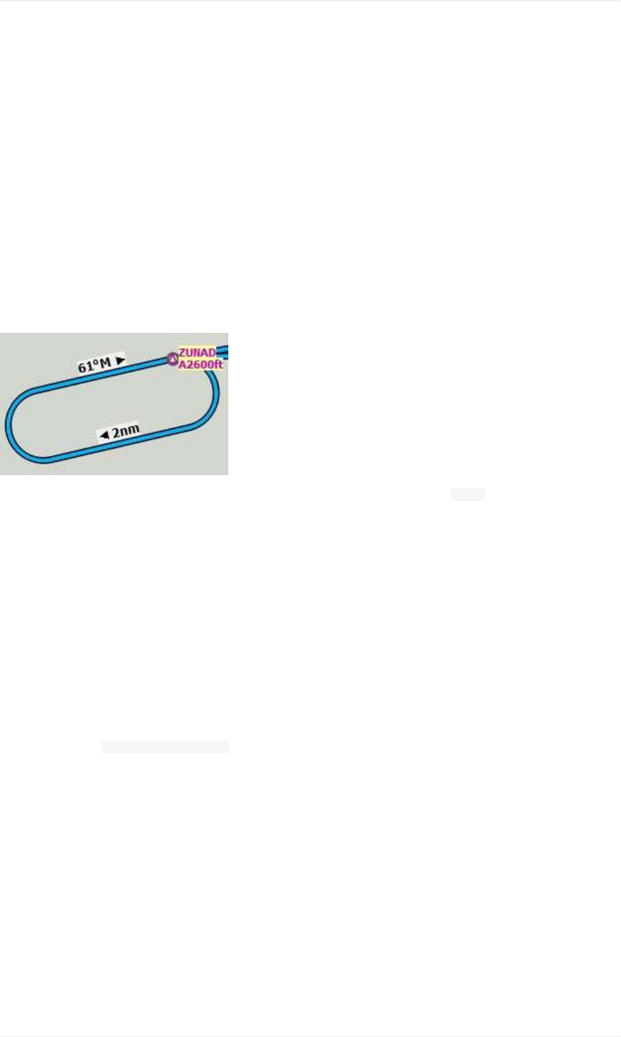
Holds
Noentryorexitprocedureisshown.Youhavetofindaproperentryprocedureyourself.Holdshaveastraightleg
flyingtimeinminutesoradistance.
Ifatimeisgiven,flytheholdasusual:
1. Enteratthefixusingaproperentryprocedure
2. Doastandardturn
3. Flythestraightlegforthegiventime(typicallyoneminute)
4. Dostandardturn
5. Flytofix
6. ExitholdwhendoneorinstructedbyATC
Donotfollowthelinesexactly,theyarejustanindicatorforwhattofly.Anexceptionareholdswhereadistanceis
givenforthestraightleg.Theholdsizewillmatchthedistanceinthiscase.
Pictureabove:Aholdwith2nauticalmilesstraightsegmentlength.Enterandexitat ZUNADandflyatorabove2600
feet.Courseis61°magneticdegrees.
ExitingaHold
LittleNavmapwilldetectwhenaholdisexitedandadvancetheactivelegtothenextoneifoneofthetwoconditions
ismet:
1. Ifthenextlegcontinuesafterorattheholdfix:Whenapproachingtheholdfixafteronecircuitcontinue
straighton.Thenextlegwillbeactivatedafterhalfanauticalmileuptoonenauticalmile.
2. Ifthenextlegstartsbeforetheholdfix:Exittheholdatitsfix.Exitrightturnholdstotheleftandviceversa
(i.e.turnoutsidethehold).Proceedtothefixofthenextlegwhichwillbeactivated.
Youcanactivatethenextlegmanuallyifyoudonotexittheholdatitsfix.Right-clickintheflightplantableonthe
nextlegandselect ActivateFlightPlanLeg.
Procedureturns
Theflightsimulatordatamovestheturnpointofaprocedureturn10nauticalmilesoutfromthefixwhichisusuallytoo
faraway.
Flytheprocedureturnasusual:Minimumoneminutefromthefix.Usemoreifyouneedspacetocatchthenextfix
afterthecoursereversal.Thenturnusinganteardroporastandard45/180degreeturn.Again:Followthe
procedures,notthelines.
FlightPlanProcedures
97
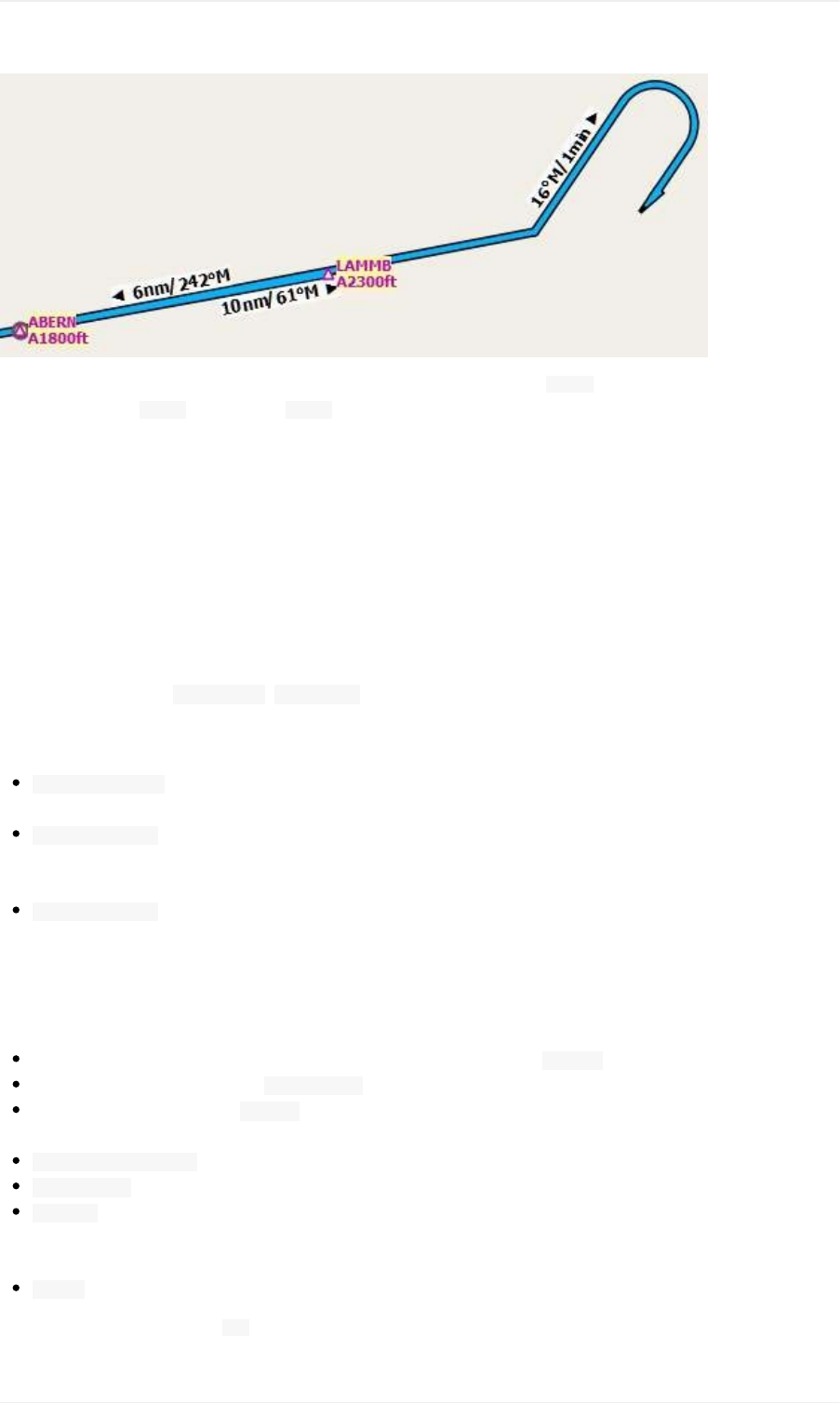
Pictureabove:Aprocedureturn.Flyatleastoneminuteoutbound61°from ABERN,turnleftto16°,flyoneminute,
turn180°andflyto LAMMB,then242°to ABERN.
Distances
Allprocedurelegs,withtheexceptionofholdsandprocedureturns,areincludedwhencalculatingflightdistance.This
meansthetotalflightplandistanceaswellasthetopofdescentpointwillchangewhenselectinganapproachora
transition.
Thetopofdescentpointcalculationdoesnotconsideraltituderestrictionsinprocedures.
SpecialLegTypes
Allprocedurelegtypes( TracktoFix, InitialFixandmore)thatareshowninLittleNavmaparebasedonthe
ARINC424pathterminatorconcept.Adeeperknowledgeoftheselegtypesisnotimportantforthesimulatorpilot
withtheexceptionoftwotypesthatareaddedbyLittleNavmap.
StartofProcedure:Thislegisaddedifaproceduredoesnotstartwithaninitialfixbutratherwithacourse,
headingortracktoafix.Itindicatesthefirstpositionoftheprocedureandisnotrelatedtoafix.
ProceedtoRunwayinaSID:ThefirstlegofaSIDtoindicatethestartpositionontherunway.Theprogrammight
fallbacktotheairportcenteriftherunwaycouldnotbefound.Thealtituderestrictionindicatestheelevationof
therunway.
ProceedtoRunwayinanapproach:Thislegisaddedtoanapproachproceduretoshowthecourselinefroma
missedapproachpoint(MAP)totherunwayend.Itisaddedifanapproachdoesnotendwitharunwayfixand
hasanaltituderestriction50feetabovethethreshold.
FixTypesinaProcedure
Waypoints:Terminalwaypointsorradionavaids.Somearemarkedas flyoverintheapproachtable.
Radialanddistance:Example: WIK/7nm/291°M.Afixdefinedbyacourseorheadinganddistancetoanavaid.
DistancetoDME:Example: WIK/9nm.Thisfixisdefinedbyaheadingortrackwhichisterminatedbyreachinga
DMEdistance.
InterceptCoursetoFix:Interceptacoursetothenextfixatanangleofabout45degrees.
InterceptLeg:Interceptthenextapproachlegatacourseofabout45degrees.
Altitude:Alegorholdthatisterminatedbyreachingacertainaltitudeandisusedmostlyonmissed
approaches.Sincethedistancedependsontheaircraft,2nauticalmileslengthareusedforthisleg.Youcan
ignorethelineandproceedtothenextlegoncethealtitudecriteriaissatisfied.
Manual:Flyaheading,trackoraholduntilmanuallyterminatedbyATC.
Runwayfixesareprefixedwith RW.Theyusuallyhaveanaltituderestrictionafewfeetabovetherunway.Higher
altituderestrictions(i.e.>500ft)indicateacirclingapproach.
FlightPlanProcedures
98

AltitudeandSpeedRestrictions
Restrictionsareshownonthemapandintheflightplantable.
Numberonly:Flyataltitudeorspeed.Mapexamples: 5400ftor 210kts.
PrefixA:Flyatorabovealtitudeorspeed.Mapexample: A1800ftor A200kts.
PrefixB:Flyatorbelowaltitudeorspeed.Mapexample: B10000ftor B240kts.
Range:Flyatorabovethefirstaltitudeandatorbelowthesecondaltitude.Mapexample: A8000B10000ft.Same
forspeed.
RelatedNavaids
Manyfixeshavearelatedorrecommendednavaid.ThiscanbeaVOR,NDB,ILSorawaypoint.Therelatednavaid
comeswithradialanddistancevaluesthatcanbeusedtolocatewaypointswhenflyingwithoutGPSorsimplyfor
crosscheckingtheposition.
MissedApproaches
Missedapproachlegsareactivatedoncethesimulatoraircraftpassesthelastpointofanapproach.Thedisplayof
remainingflightplandistancewillswitchtodisplayofremainingdistancetolastmissedapproachleg.
Nomissedapproachlegsareactivatedifmissedapproachesarenotshown.
LegHighlightsontheMap
Uptothreepointswillbehighlightedwhenclickingonaprocedureleginthetreeinthesearchwindow:
Asmallbluecircleshowsthebeginningoftheleg.
Theendofthelegisshownbyalargebluecircle.
Athincircleshowsthelocationoftherecommendedorrelatedfixifavailable.
InvalidData
Alegentrywilldrawnredifanavaidwasnotresolvedduringthescenerydatabaseloadingprocess.Thishappens
onlywhenthesourcedataisnotvalidorincomplete.Inthiscase,theresultingprocedureisnotusableandawarning
dialogwillbeshownifessentialnavaidsaremissing.
FlightPlanProcedures
99
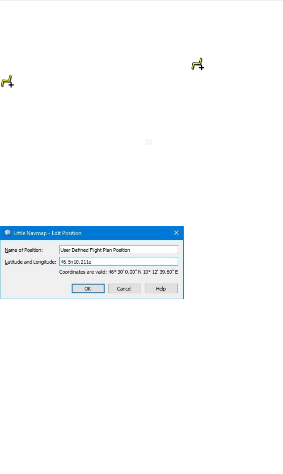
EditFlightPlanPosition
Thisdialogallowstoeditauser-definedflightplanpositionthatwasaddedwith AddPositiontoFlightPlanor
AppendPositiontoFlightPlan.
Name
YoucanenteranystringbutallinvalidcharacterswillberemovedwhensavingasaFSX/P3DPLNfile.Otherfile
formatshavemorelimitations.
Allowedareupperandlowercaseletters,digits,underscore _andspace.Allothercharactersareremovedwhen
theflightplanissavedandlongnamesaretruncatedto10characters.
Coordinates
YoucanalsoeditthecoordinatesdirectlyinthisdialogbesidesusingthedraganddropMapFlightPlanEditing.This
canbeusefulifyou'dliketoaddwaypointswithwellknowncoordinateslikevisualreportingpoints.
Thetooltipofthecoordinateinputfieldshowstheavailableformats.
SeeCoordinateFormatsformoreinformation.
Pictureabove:Editingauser-definedflightplanposition.
FlightPlanEditPosition
100
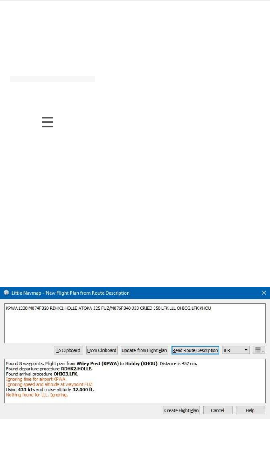
FlightPlanRouteDescription
Thisdialogallowsyoutocreateaflightplanfromaroutedescriptionasgeneratedorprovidedbyvariousonline
services.
The NewFlightPlanfromRouteDescriptiondialogopenswiththeroutedescriptionforthecurrentflightplanwhichalso
containsinformationaboutspeedandcruisealtitudeifenabled.
Thetophalfofthedialogholdstheroutedescriptioninputfield,whilethebottomhalfshowsanymessages,warnings
orerrorsthatoccurduringreading.
Themenubutton providesadropdownmenuthancanbeusedtocustomizethegeneratedroutestring.
Thedescriptionparserwilltrytouseasmuchoftherouteaspossibleevenifpartsoftheflightplanlikewaypointsor
airwayscannotbefoundornamesareambiguous.Youwillseewarningsinthebottomhalfifthatisthecase.
Ifaroutecoversalongdistanceandcontainsawaypointnamewhichisnotunique,awrongwaypointmightbeadded
totheflightplan.Correctorremovethiswaypointmanually.
ManywaypointsandairwayswillnotbefoundifroutedescriptionsfromthelatestAIRACsourcesareusedtogether
withFSX/P3Dstockdatafrom2005.Itisrecommendedtouseanavigationdataupdateforthestockscenerywhen
readingroutedescriptionsfromonlinesourceslikeRouteFinder,OnlineFlightPlanner,SimBrieforSkyVector.
Ifanavdataupdateisnotanoption,picktheonlineservice'sAIRACcyclethatisclosesttothecyclethenavigation
dataofyourflightsimulatorisbasedon.
NotethatevenflightplanscalculatedinLittleNavmapcannotbeconvertedbackexactlyinsomecases.Thishappens
duetonavaidambiguitieslikeNDBandVORstationshavingthesamenamesorerrorsinthesourcedata.
Thecruisespeedandaltitudeareusedtocreatetheflightplanifgiven.Otherwisethecruisealtitudeisautomatically
determinedbytheflightplantype(IFRorVFR)andtheminimumaltitudeoftheusedairwaysegments.
SIDandSTARproceduresrequireanavdataupdateexceptforX-Planewhichalreadycomeswithacomplete
navigationdatabase.
FlightPlanRouteDescription
101

Pictureabove:Aroutedescriptionthatwasreadsuccessfullywithafewwarningsaboutignoredelements.The
waypoint LLLcouldnotbefound.Speed,altitude,SIDandSTARwererecognized.Thegroundspeedof433knotsis
calculatedbasedongivenmachnumber0.74andstandardatmosphereconditions.
Buttons
ToClipboard:Copythecurrentdescriptionasplaintexttotheclipboard.
FromClipboard:Inserttextfromclipboardintotheinputfield.Theinsertedtextisconvertedtouppercaseandall
invalidcharactersareremovedfromthetext.
UpdatefromFlightPlan:Createtheroutestringfromthecurrentflightplanagain.Usethisafterchangingsettings
withdropdownmenubutton.
ReadRouteDescription:Readstheroutedescriptionanddisplaysanymessages,warningsanderrorsinthe
bottomhalfofthedialog.Thecurrentflightplanisnotaffectedbythisaction.
IFR/ VFR:Definesthetypeofthegeneratedflightplanandtheautomaticallydeterminedcruisealtitude.
MenuButton :
Adddepartureanddestinationairport:Notethatdisablingthisoptionwillresultinaroutestringwhichcannot
bereadbackintoaflightplan.
AddDCT(direct)instructions:Add DCTforanydirectwaypointconnectionsintheflightplan.
Addcruisespeedandaltitudeinstruction:Addcruisealtitudefromflightplanandgroundspeedassetinthe
flightplandockwindow.
AddSIDandSTAR:AddSIDandSTARnamesifanyareusedfordepartureorarrival.
AddgenericSIDandSTAR:Addthegeneric SIDand STARkeywordsifnorealSIDand/orSTARwere
selected.
AddWaypointsinsteadofAirways:Doesnotinsertanyairwaynamesbutuseswaypointsonly.
CreateFlightPlan:Closesthedialogandcreatesanewflightplanfortheparsedroutedescriptionandreplaces
thecurrentplan.Youhavetoclick ReadRouteDescriptionbeforeyoucancreateaflightplan.
Format
Theroutedescriptionhastofollowtheformatrulesbelow:
FROM[ETD][SPEEDALT][SID][.TRANS][ENROUTE][STAR][.TRANS]TO[ETA][ALTERNATES]
Allelementsinsquarebracketsareoptional.
FROMand TO:Thesearetherequired3or4letteridentsfordepartureanddestinationairports.
Examples: KEAT, CYPU, S16.
ALTERNATES:Alternateairportsareoptionalandaresimplyappendedtotheflightplan.Alternatescannotbeusedin
combinationwithanapproachprocedure.
SPEEDALT:Anoptionalentrythatcontainsthecruisespeedandaltitude.Seebelowforadetails.
ENROUTE:Thisisalistofeither WAYPOINToran AIRWAYWAYPOINTformingtheactualflightplan.Thefirstentryhastobe
anairport,waypoint,VORorNDB.
WAYPOINT:Awaypoint,VOR,NDB,airportoruser-definedcoordinates.Seebelowforadetailsaboutcoordinates.A
waypointcanbeprefixedwith DCTtoindicateadirectconnectionnotusinganairway.Waypointscanbesuffixedwith
anoptional /SPEEDALTvaluealthoughthisisignored.
Examples: TAU, BOMBI, AST, CL, EDDF.
AIRWAYWAYPOINT:Airwayandendwaypointontheairwayseparatedbyaspace.
Examples: V495CONDI, V338YVR, V330TRENA.
FlightPlanRouteDescription
102

SID.TRANSand STAR.TRANS:Eitherthewords SIDor STARorrealSID,STARandtransitionnameswheretheoptional
transitionisseparatedbya ..Thegenerickeywords SIDand STARcreateadirectconnectiontotheenroutepart.
Examples: RDHK2.HOLLE, OHIO3.LFK, RDHK2, OHIO3.
Featuresnotsupported
ETDand ETA:Fourdigitdepartureandarrivaltimeattachedtotheairportidentareignored.
WAYPOINT.SPEEDALT:Forexample BOMBI/N0090A060.Altitudechangesatwaypointsarenotsupportedandignoredwhen
reading.
SpeedandAltitude
Cruisinggroundspeedandcruisinglevelnotseparatedbyaspace.
Speedisprefixedwith:
K:Kilometersperhourfollowedbyafourdigitvalue.
N:Knotsfollowedbyafourdigitvalue.
M:Machfollowedbyathreedigitvalue.Themachvalueisconvertedtoknotsgroundspeedassumingstandard
atmosphereconditionsatthegiveflightaltitude.
Altitudeisprefixedwith:
F:Flightlevelinthreedigits.
S:Metricflightlevelinthreedigitsoftensofmeters.
A:Altitudeinhundredsoffeetinthreedigits.
M:Altitudeintensofmeterinfourdigits.
Examples:
N0410F310410knotsatflightlevel310.
M071F320Mach0.71atflightlevel320.
K0790M0710790kilometersperhourat7100meters.
Coordinates
Coordinatescanbesuppliedindifferentformats:
Degreesonly(7characters):Twodigitsandnorth/southindicatorplusthreedigitsandeast/westindicator.
Example: 51N010E
Degreesandminutes(11characters):Twodigitsdegrees,twodigitsforminutesandnorth/southindicator.Then
threedigitsfordegrees,twodigitsforminutesandeast/westindicator.
Example: 4010N03822W.
Degrees,minutesandseconds(15characters):Twodigitsdegrees,twodigitsforminutes,twodigitsforseconds
andnorth/southindicator.Thenthreedigitsfordegrees,twodigitsforminutes,twodigitsforsecondsandeast/west
indicator.ThisformatisusedbySkyVectorforexample.
Example: 481200N0112842E.
FlightPlanRouteDescription
103

NorthAtlantictrackpoints(NAT).Twodigitsdegreesnorthandtwodigitsdegreeswestfollowedbycharacter N.
Example: 5010N.
Coordinatewaypointpairswithdegreesandminutesasaboveandprefixedwithnorth/southandeast/west
indicator.
Examples: N4200W02000or N4200/W02000.
GarminGFPformat(13characters)north/southindicator,twodigitsdegrees,threedigitsforminutesby10.Then
east/westindicator,threedigitsdegrees,threedigitsminutesby10.ThisformatisusedbytheFlight1GTN650/750.
Example: N48194W123096
FlightPlanDescriptionExamples
FrankfurtMain(EDDF)toFiumicino(LIRF):
Directconnection:
EDDFLIRFor EDDFDCTLIRF.
VORtoVOR:
EDDFFRDKPTBOACMPLIRF.
Sameasabovewithdeparturetime( ETD)andarrivaltime( ETA)whichbothwillbeignored:
EDDF1200FRDKPTBOACMPLIRF1300.
Sameasaboveonflightlevel310at410knots:
EDDFN0410F310DCTFRDDCTKPTDCTBOADCTCMPDCTLIRF
UsingJetairways:
EDDFASKIKT844KOVANUL608TEDGOUL607UTABAUM738NATAGY740LORLOM738AMTELM727TAQLIRF
Sameasaboveonflightlevel310atmach0.71withanadditionalspeedandaltitudeat NATAGwhichwillbe
ignored:
EDDFM071F310SIDASKIKT844KOVANUL608TEDGOUL607UTABAUM738NATAG/M069F350Y740LORLOM738AMTELM727TAQSTARLIRF
User-definedwaypointswithdegree/minutenotationandanalternateairport LIRE:
EDDFN0174F2554732N00950E4627N01019E4450N01103ELIRFLIRE
FlightplanusingSIDandSTARprocedureswithtransitions:
KPWARDHK2.HOLLEATOKAJ25FUZJ33CRIEDJ50LFKOHIO3.LFKKHOU
FlightplanusingthegenericSIDandSTARkeywords:
KPWASIDATOKAJ25FUZJ33CRIEDJ50LFKSTARKHOU
FlightPlanRouteDescription
104

FlightPlanElevationProfileDockWindow
Thisdockwindowshowsthegroundelevationandflightplancruisealtitudetogetherwillallflightplanwaypoints.Itis
onlyavailablewhenaflightplanisloaded.TheuseraircraftwillbeshowntooifLittleNavmapisconnectedtothe
simulator.
ElevationprocessingisdoneinthebackgroundsincedatahastobedownloadedandcomputationisCPUintensive.
Therefore,theupdateoftheelevationdisplaycantakefromafewsecondsuptohalfaminute.Thisbackground
updateisstartedaftercreatingorchangingtheflightplanorwhennewelevationdatawasdownloaded.Thedisplay
willbeupdatedaccordinglywhenevernewdataisavailable.
Closethe FlightPlanElevationProfilewindowifyouthinkthatitcausesperformanceproblemsorstutters.All
updateswillstoponcethewindowisclosed.
Beawarethattheelevationdisplaycoversonlytheflightplanandwillnotchangethedepictionifyougetoffflightplan
withyoursimulatoraircraft.
Theflightplanisonlyshownatcruiselevelandthedescentsegment.Although,youwillseeyouruseraircraftand
trailclimbinganddescending.
OnlineElevationData
Notethattheonlineelevationdatadoesnotcoverallcountriesandcurrentlyendsat60degreesnorth.Thedata
containsmultipleknownerrors.
Thecalculationofonlineelevationpointsislimitedtoflightplansegmentsnotlongerthan2000nauticalmilestoavoid
overloading.Addmorewaypointsorcalculateaflightplantoavoidthislimitation.
OfflineElevationData
UsingthefreelydownloadableGLOBE-GlobalLandOne-kmBaseElevationProjectelevationdatahasseveral
advantages:
Fasterupdates
Worldwidecoverage
Noknownerrors
Displayofaltitudebelowthecursorinthestatusbar
SeethedialogCacheandFilesintheoptionsdialogforinstructionshowtodownloadandinstalltheGLOBEdata.
ProfileWindow
Additionalinformationisshowninalabelontopofthewindowifthemouseishoveredoverthediagram.The
correspondingpositionwithintheflightplanishighlightedonthemaptoo.
Followinginformationisshowninthetoplabelifconnectedtoaflightsimulatorwithanactivesession:
Distancefromuseraircrafttoflightplandestination
Distancetothetopofdescent
Inaddition,theinformationbelowisshowninthetoplabelwhenhoveringthemouseoverthediagram:
Fromandtowaypoint
FlightPlanElevationProfileDockWindow
105

Distancefromdepartureandtodestinationfromthepositionofthemousecursor.
Groundelevationatcursorposition.
Flightplancruisealtitudeaboveground.
Safealtitudeforthecurrentflightplanlegatthepositionofthemousecursor.
Formoreinformationseethe Navmaptabinthe LegenddockwindowortheNavMapLegendfordetails.
Pictureabove:Flightplanelevationprofilewithlineindicatingthemousehoveringposition.Orangelinesshow
minimumsafealtitudeforflightplansegments.Topofdescentpointisshownontheupperrightpartofthewindow.
FlightPlanElevationProfileDockWindow
106

InformationDockWindow
Thisdockwindowcontainstextinformationaboutairportsinseveraltabsaswellasinformationforoneormore
navaids,airwaysinanothertabplusanadditionaltabshowingairspaceinformation.
Atab Weatheralsoincludesdecodedweatherinformationfortheselectedairport.
Allinformationcanbecopiedtotheclipboardasformattedtext.Usethecontextmenuofthetextfieldsoruse Ctrl+A
toselectalland Ctrl+Ctocopythecontenttotheclipboard.
Informationisshownwhenselectingoneofthe ShowInformationfor...contextmenuitemsinthemap,flightplan
dockwindoworthesearchresulttable.Oneairportandallnavaidsareloadedintotheinformationdisplayifmultiple
objectsareclosetowhereyouright-clickedonthemap.
Abluelink Mapallowsjumpingtotheshownairportornavaidonthemap.Additionallinksforhelipadsareavailablein
thetab Runways/Helipads.
Anairwayisalwaysdisplayedwithallitswaypoints.Clickanybluewaypointlinktocenterthemaparoundthe
waypoint.
Theinformationaboutairportsandnavaidsincludesoneormorelinksatthebottomoftheobjectinformationin
section Scenery.TheselinkspointtothematchingBGL(FSX,P3D)orDAT(X-Plane)filesthatcontaininformation
abouttheairportornavaid.Clickthelinkstoopenthecontainingfolderinyourfilemanager(e.g.WindowsExplorer).
Ifpossible,thematchingfilewillbeselectedautomatically.
MultiplelinkscanappearforairportssincethesecanbemodifiedbymultipleBGLorDATfilesfromdifferentadd-on
sceneriesornavdataupdates.
InformationDockWindow
107
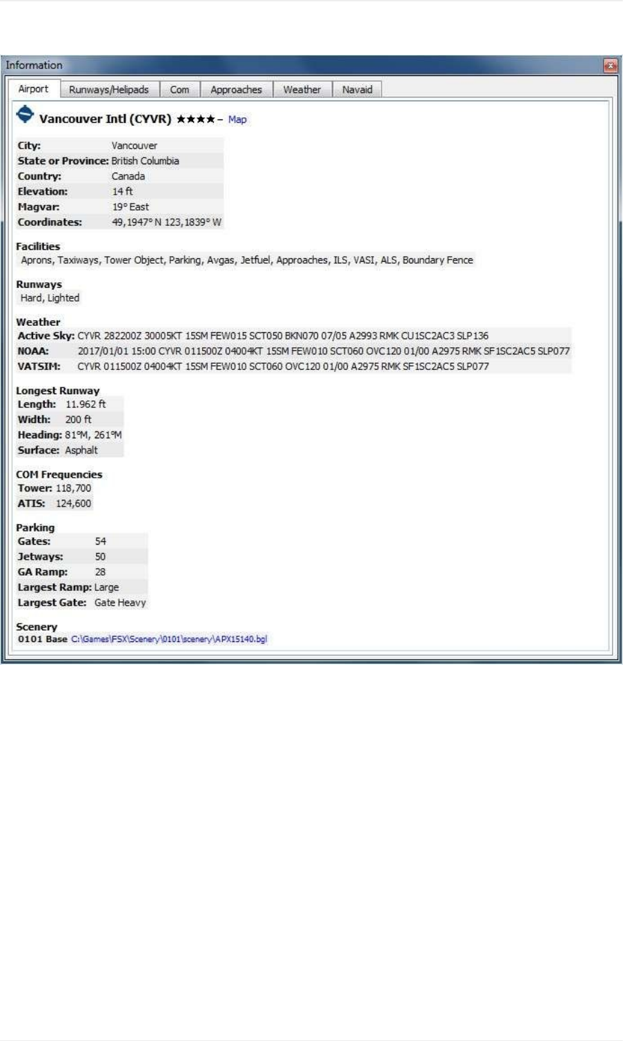
Pictureabove:Airportinformationoverview.Additionaltabsshowinformationforrunways,COMfrequencies,
approachesandweather.
InformationDockWindow
108
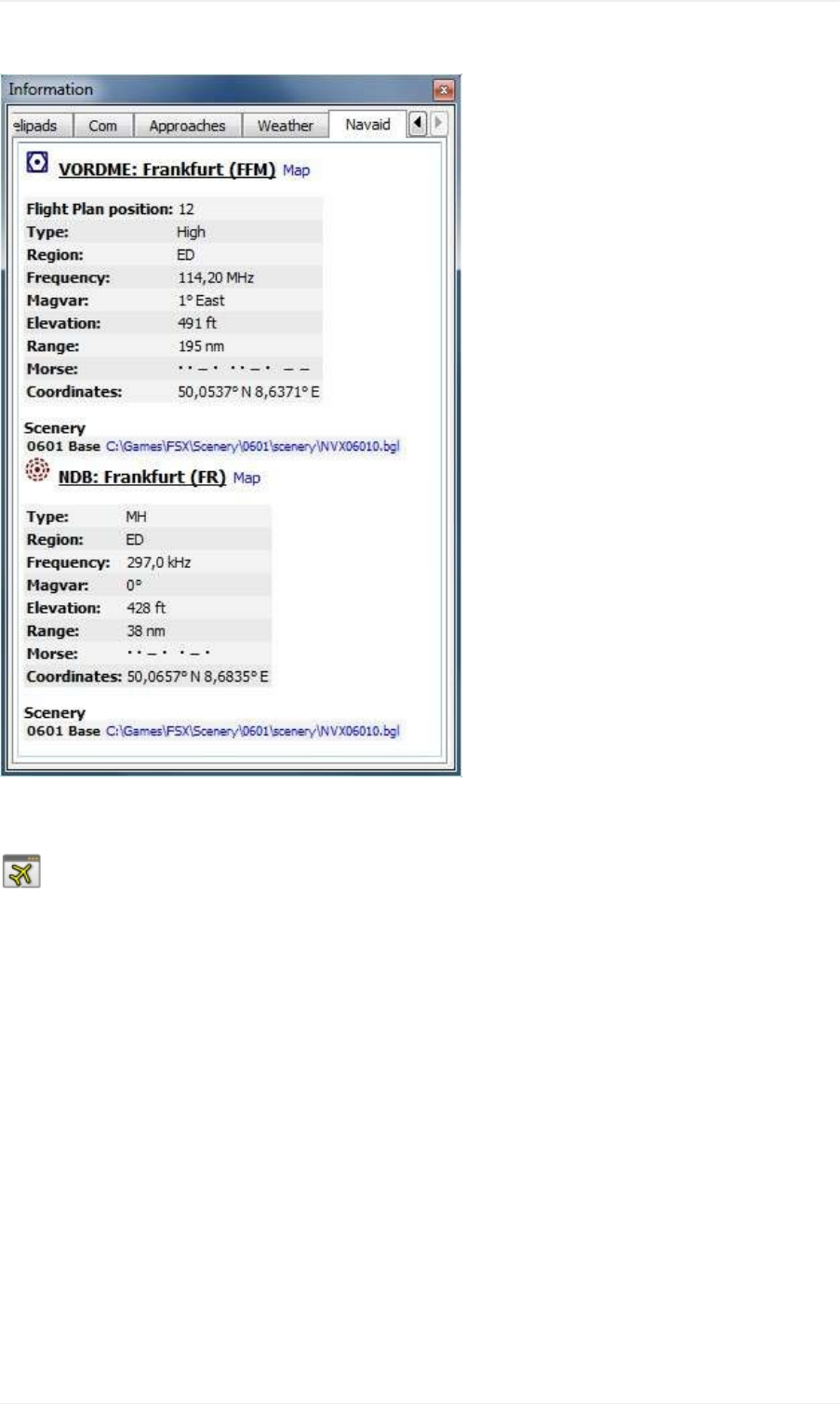
Pictureabove:Navaidinformation.Twonavaidswereclosetothecursorwhenclicked.
SimulatorAircraftDockWindow
ThisdockwindowshowsinformationabouttheuseraircraftandaboutAIormultiplayeraircraftinseveraltabs.Little
Navmaphastobeconnectedtothesimulatortoenablethisfeature.SeeConnectingtoaFlightSimulatorformore
informationonthistopic.
TabAircraft
Givesanoverviewabouttheuseraircraftandshowstype,weightandfuelinformation.
InformationDockWindow
109
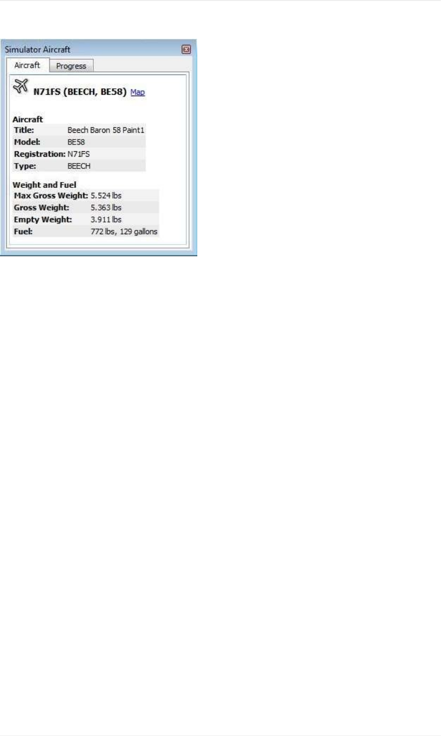
Pictureabove:AircraftinformationwhenconnectedtoaFlightSimulator.
TabProgress
Showsinformationsimilartoaflightmanagementcomputerabouttheuseraircraft.Thiscoversflightplanprogress,
altitude,speed,ambientandenvironmentparameters.
InformationDockWindow
110
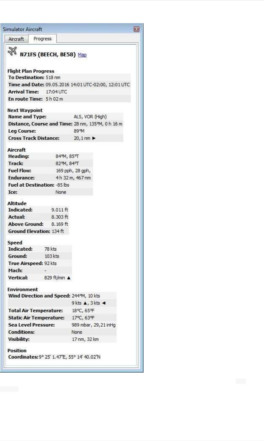
Pictureabove:Progressandambientinformationofthecurrentflightsituation.Somefieldsortableslike Next
Waypointareonlyavailablewhenaflightplanisloaded.
TabAI/Multiplayer
InformationaboutanAIormultiplayeraircraftfromthesimulator(notonlinenetworks)orshipisdisplayedinthistabif
avehicleisclickedonthemap.
InformationDockWindow
111
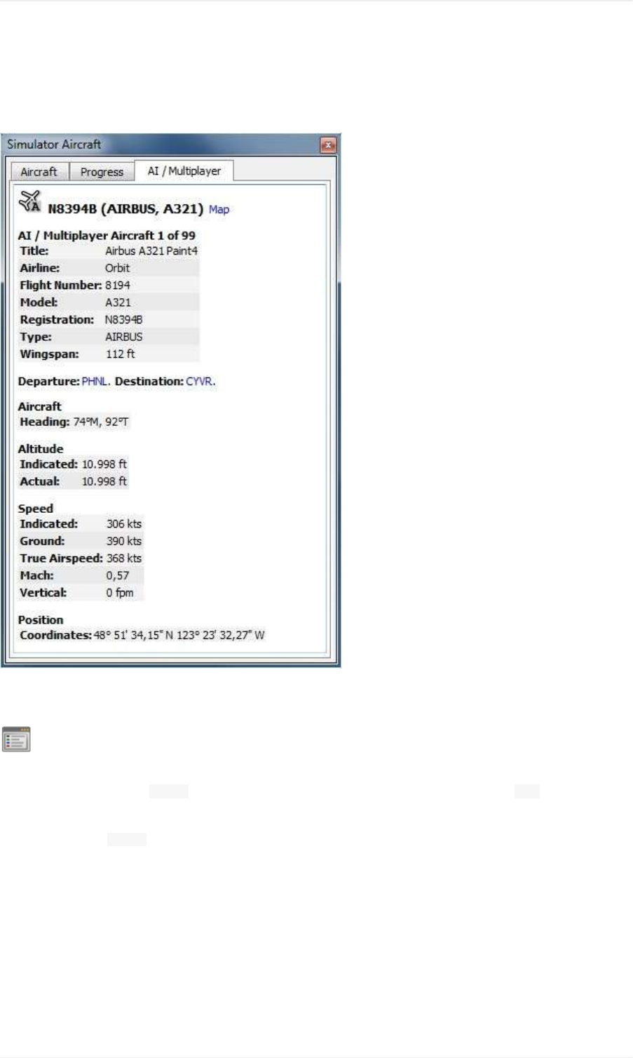
Thisalsoincludestheaircraft'sdepartureanddestinationairportsthatcanbeshownonthemapbyclickingonthe
bluelinks(onlyforFSXorP3Dandifaflightplanisfiled).
NotethatinformationonAIaircraftislimitedonX-Plane.Onlyposition,altitudeandheadingcanbedisplayed.
Pictureabove:InformationaboutanAIaircraft.
LegendDockWindow
Containstwotabs:Onetab Navmapexplainingthevariousairportandnavaidsymbolsandatab Mapwhichshowsthe
generallegendforthebasemapliketheOpenStreetMapforexample.
Thecontentsofthe Navmaplegendarealsoavailableintheonlinemanual:NavMapLegend.
Notethatthegeneralmaplegendisnotavailableforallmapthemes.
InformationDockWindow
112

Weather
LittleNavmapcandisplayMETARsfromseveralsources:
FSXorP3Difconnected.Thisalsoappliestonetworksetups.
X-Planerealtimeweatherfromthe METAR.rwxfile.NotavailablewhenLittleNavmaprunsonadifferentcomputer
thanyourflightsimulator.
NOAAonlineweatherservice
VATSIMnetworkonlineweatherservice
HiFiSimulationTechnologies:
ActiveSkyNext(ASN)
AS16
ActiveSkyforPrepar3Dv4(ASP4)
Youcandefineinthe Optionsdialogonthe WeathertabwhichsourcesareusedtodisplaytheMETARinformationin
tooltipsorthetab Weatherinthe Informationdockwindow.
YouhavetosetthebasepathforX-Planeinthe LoadSceneryLibrarydialogtoenablereadingoftheweatherfile.
Certainfeatureslikeregionsofmanuallycreatedweatherfilesarenotsupported.
METARsareshownintheairporttooltipsandonthe Airportoverviewtab.Decodedweatherinformationforall
sourcesisavailableinthetab Weather.
ThedateandtimeinformationofthedecodedweatherdisplayishighlightedinrediftheMETARinformationisolder
thansixhours.
NotesaboutX-Planeweather:LittleNavmapcanonlyreadtheX-Plane METAR.rwxfilewhichcontainsdownloaded
onlineweather.TheprogramcannotreadcustomweathersituationsfromX-Plane.Ifyouusecustomweather,Little
Navmaponlyhasaccesstothelocalweatheraroundtheaircraft.BeawarethatLittleNavmapmightdisplay
informationfromanobsoleteorinactivedownloadedweatherfile.
Weather
113
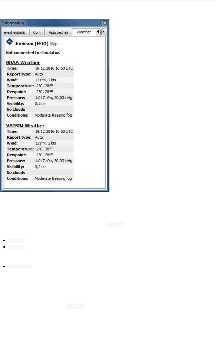
Pictureabove:Decodedweatherinformationfromtwoonlinesources.Flightsimulatorisnotconnected.
FlightSimulator
WeatherinformationfromaflightsimulatorortheX-Plane METAR.rwxfallsinoneofthreecategories,dependingonthe
selectedairport:
Station:Theairporthasaweatherstation.Thisisthemostpreciseweatherindication.
Nearest:Theselectedairporthasnoweatherstationandthereportfromtheclosestexistingweatherstationwas
fetched.TheidentofthecloseststationaswellasdistanceandelevationareshownintheMETARandonthe
decodedweathertab.Notethatthethisweatherstationisnotnecessarilyanairport.
Interpolated(notforX-Plane):Theweatherisinterpolatedbytheflightsimulatorusingthreestationsclosestto
theselectedairport.FSXandP3Donlyprovidenon-interpolatedweatherforairportsclosetotheuseraircraft.
Theweatherforotherairportsisalwaysinterpolated.TheidentoftheselectedairportisusedintheMETAR
reportforthiskindofweatherreport.
Theflightsimulatorweatherisupdatedevery15secondstocatchchangesintheweathertheme.
LittleNavmapwatchestheX-Plane METAR.rwxfileforchangesandwillapplyupdatesimmediately.
Notethatthenearestweatherwillnotnecessarilydepicttheweatherattheselectedstationduetotheinterpolation
betweenmultiplestationswhichisdonebythesimulator.
Online-NOAAandVATSIM
Onlineweatherfrombothsourcesisupdatedevery10minutes.
Weather
114

ActiveSky
AllActiveSkyprogramsarerecognizedautomaticallyonstartupforeachsimulator.The current_wx_snapshot.txtand
activeflightplanwx.txtfilesareloadedandmonitoredforchanges.Weatherwillbereloadedandupdatedinthe
informationdisplayifnecessary.
Youcanalsoselectthe current_wx_snapshot.txtfilemanually.InthatcasetheMETARsfromthisfilearedisplayedfor
allinstalledflightsimulators.The activeflightplanwx.txtwillbeloadedfromthesamedirectory.
ManualfileselectioncanalsobeusefulifanewActiveSkyversionisnotsupportedbyLittleNavmapyet.
DepartureanddestinationweatherwillbedisplayedifaflightplanisloadedinoneoftheActiveSkyprograms.A
suffix Destinationor DeparturewillindicatetheusageofActiveSkyflightplanweatheronthetab Weather.Thisgives
ActiveSkyusersthemostpreciseweatherindicationfordepartureanddestination.
Notethattheindicationof Departureor DestinationdependsentirelyontheflightplanloadedinActiveSkyandnot
theflightplaninLittleNavmap.
Weather
115
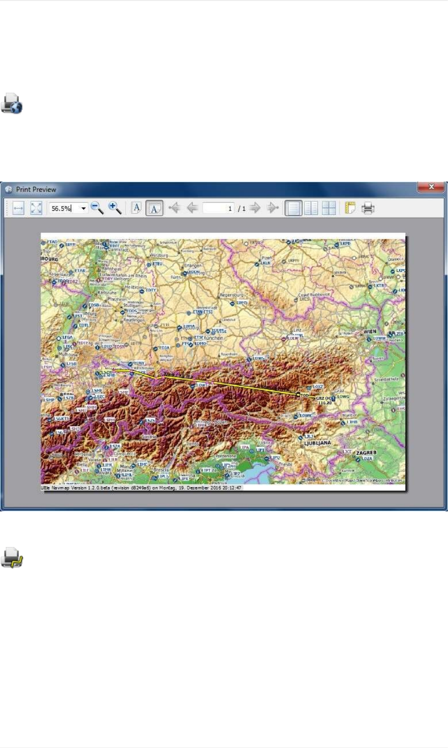
Printing
PrintMap
Opentheprintpreviewdialogallowingthecurrentmapviewtobeprinted.
Printingiscurrentlylimitedtothescreenresolutionofthecurrentmapview.Togetalessblurryprintoutenlargethe
mapwindowasmuchaspossible.Youcanundockthemapwindowtoachievethis.
Pictureabove:Printpreviewdialogforthecurrentmap.
PrintFlightPlan
Printthecurrentflightplantogetherwithdepartureanddestinationairportinformation.
OptionsforcustomizingtheFlightPlanTable
Theprintedflightplantablewillhavethesameorderofcolumnsastheflightplantableinthedockwindow.Columns
willbeomittedfromprintingiftheirwidthisreducedtominimumsize.SeeTableViewformoreinformation.
PrintingtheMap
116
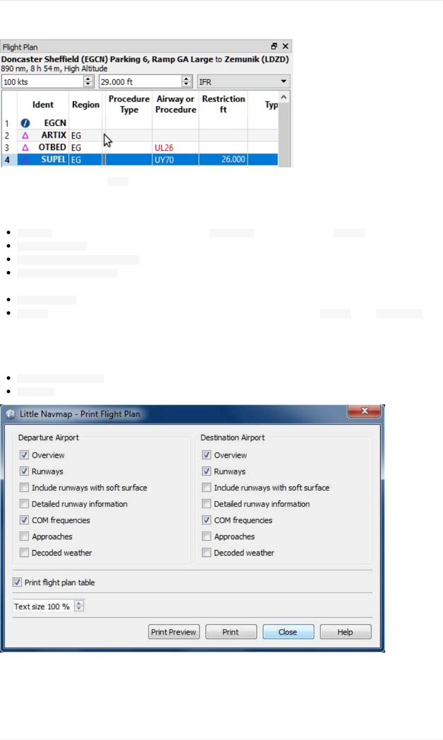
Pictureabove:Thecolumn Nameiscollapsedandwillnotbeaddedtotheprintedflightplantable.
OptionsforDepartureandDestination
Overview:Printtheairportoverviewasshowinthe Informationdockwindowontab Airport.
Runways/Helipads:Printrunwayandhelipadinformation.
Includerunwayswithsoftsurface:Includerunwayswithsoftsurfaceslikegrass,gravelandothers.
Detailedrunwayinformation:Includedetailedinformationfortherunwayendslikeapproachlighting,VASItypes,
ILSinformationandmore.
COMfrequencies:Includecommunicationfrequenciesliketower,ATIS,UNICOMandothers.
Weather:Printthedecodedweatherforallenabledsourcesasshownonthetab Weatherinthe Informationdock
window.
Generaloptions
Printflightplantable:Printtheflightplanasseenintheflightplantable.
Textsize:Reducethetextsizetoavoidunnecessarylinebreaksorincreaseitforbetterreadability.
Pictureabove:Printflightplanoptionsdialog.
PrintingtheMap
117

LoadSceneryLibraryDialog
ThisdialogallowsloadingofthescenerylibrarydatafromallfoursupportedflightsimulatorsintotheLittleNavmap
internaldatabase.Thescenerylibrarytoloadcanbeselectedinthe Simulator:dropdownbox.
Thedialogshowsinformationaboutthecurrentlyselecteddatabaseincludingthenumberofloadedairports,database
versionandmore.
FSXandP3Donly:Thebasepathandthe scenery.cfgpathwillbeshownintwotexteditfieldsforthecurrently
selectedsimulator.Thesefieldsarepopulatedautomatically,butcanbechangedtoanyothervalidlocation.All
valuesaresavedindividuallyforeachflightsimulatortype.
X-Planeonly:X-Planecannotberecognizedautomatically.Youhavetoselectthebasepathmanually.OnWindows
thatcanbeapathlike C:\Simulators\X-Plane11,theexecutablebeing C:\Simulators\X-Plane11\X-Plane.exe.
Loadingascenerylibrarycantakefrom2to15minutesdependingonyoursetupandamountofsceneryadd-ons.
Youcanspeedthisupbyexcludingdirectoriescontainingneitherairportnornavigationdatainthe Optionsdialogon
the SceneryLibraryDatabasetab.
ForFSX/P3D,allairportsthatarenotlocatedinthedefault ScenerydirectoryofFSX/P3Dareconsideredtobeadd-
onairports.ForX-Plane,allairportslocatedinthe CustomScenerydirectoryofX-Planeareconsideredtobeadd-on
airports.Add-onairportsarehighlightedonthemapusingemphasized(boldanditalic)text.
Ifanadd-ononlycorrectsairportelevationsornavigationdata,itmightbeundesirabletodisplaytheupdatedairports
asadd-onairportsonthemap.Youcanexcludefolderspopulatedbythisadd-onfromtheadd-onrecognitioninthe
Optionsdialogonthe SceneryLibraryDatabasetab.
SeeOptionsformoreinformationaboutexcludingscenery.
Ifyoucanceltheloadingprocessoriftheloadingprocessfails,thepreviousscenerylibrarydatabaseisrestored
immediately.
Themenu SceneryLibrary-> FlightSimulatorsissynchronizedwiththesimulatorselectioninthedialog.Oncea
databaseissuccessfullyloaded,thedisplay,flightplanandsearchswitchinstantaneouslytothenewlyloaded
simulatordata.
Notethatthefinalnumberofairports,navaidsandotherobjectsshowninthe LoadSceneryLibrarydialogarelower
thanthecountsshownintheprogressdialog,because,afterthedatahasbeenloaded,aseparateprocessremoves
duplicatesanddeletesstockairportsthatwerereplacedbyadd-ons.
FSXorP3Donly:Theprogramtriestofindthebasepathsand Scenery.cfgfilesautomatically.Thetypicallocations
ofthe Scenery.cfgforWindows7/8/10are:
FlightSimulatorX:C:\ProgramData\Microsoft\FSX\Scenery.cfg
FlightSimulator-SteamEdition:C:\ProgramData\Microsoft\FSX-SE\Scenery.cfg
Prepar3Dv2:C:\Users\YOUR_ACCOUNT_NAME\AppData\Roaming\LockheedMartin\Prepar3Dv2\Scenery.cfg
Prepar3Dv3:C:\ProgramData\LockheedMartin\Prepar3Dv3\Scenery.cfg
Prepar3Dv4:C:\ProgramData\LockheedMartin\Prepar3Dv4\Scenery.cfg
Anerrordialogisshownafterloadingifanyfilescouldnotbereadordirectorieswerenotfound.Inthiscaseyou
shouldcheckiftheairportsoftheaffectedsceneriesdisplaycorrectlyandshowthecorrectinformation.Theerror
dialogallowscopyandpasteofformattedtextwhichisusefulforerrorreporting.
LoadSceneryLibraryDialog
118

The LoadSceneryLibrarydialogshowsthelasttimeofloading( LastUpdate:),theprogramandthedatabaseversion.
Majordatabaseversiondifferencesindicateincompatibledatabases.Theprogramwillaskiftheincompatible
databasescanbeerasedonstartupbeforethescenerydatabasecanbereloaded.Minordatabasedifferences
indicatecompatiblechangeswhereareloadisrecommendedbutnotrequired.
X-PlaneAirportsandNavdata
LittleNavmapreadsairportandnavaiddatafromX-Plane's *.datfiles.Tocheckaversionofafileyoucanopenitin
atexteditorthatiscapableofdealingwithlargefiles.Thefirstlinesofthefilewilllooklike:
A
1100GeneratedbyWorldEditor1.6.0r1
11549000A4JohnsonCitySTOLport
...
Thefirstnumberinthesecondlineisthefileversion.Hereitis 1100.
LittleNavmapcanreadthefollowingX-Planesceneryfiles:
Airports( apt.dat):Version850upto1100.ThiscoversX-Plane10airportsandolderadd-onscenery.Newer
filesthan1100mightworkbutarenottested.
Navdata( earth_awy.dat, earth_fix.datand earth_nav.dat):Version850upto1100.ThisexcludesX-Plane10
navdatafiles.Newerfilesthan1100mightworkbutarenottested.
Procedures( ICAO.datinthe CIFPdirectory):AllproceduresfromX-Plane11.
Airspaces( *.txt):Theincluded usa.txtandallfilesinOpenAirformat.Seenextchapterformoreinformation.
Additionallythefiles user_fix.datand user_nav.datintheX-Planedirectory CustomDataareread.
X-PlaneAirspaces
AllfilesinOpenAirairspaceformatwillbeloadedwhenreadingtheX-Planescenerylibrary.
YoucanalsocopyairspacesfromapresentFSXorPrepar3Ddatabaseifyouownthesesimulators.SeeCopy
AirspacestoX-PlaneDatabase.
Notethatairspacefilescanhaveerrorswhichmaypreventtheloadingofanairspacefile.Theseharderrorsare
reportedafterloadingthescenerylibrary.Othererrorsonlyaffectingsingleairspacesorthegeometryarereportedin
thelogfileonly.
X-Plane11comeswithasingleairspacefilethatcanbefoundin YOUR_XPLANE_DIRECTORY/Resources/default
data/airspaces/usa.txt.AdditionalairspacefilescanbedownloadedfromtheOpenAirspaceDirectory,Soaring
Services,openAIPorLuftraumdatenDeutschlandforexample.
Airspacefilesmusthavea .txtextensionandareloadedfromthefollowingdirectoriesbyLittleNavmap:
YOUR_XPLANE_DIRECTORY/Resources/defaultdata/airspaces
YOUR_XPLANE_DIRECTORY/CustomData/Airspaces
YOUR_ACCOUNT_NAME/Documents/LittleNavmap/X-PlaneAirspaceswhere Documentsisthedocumentsdirectoryinyour
language.
ThefilescanbeencodedinanyUTFformatbutmusthaveaBOMtoberecognizedproperly.OtherwiseWindows
ANSIcoding( Windows-1252)isused.Specialcharacterslikeumlautsoraccentsarenotdisplayedcorrectlyinnamesif
theencodingisnotcorrect.Allotherfunctionalityisunaffected.
YoucanconvertthefilesusinganyadvancededitorlikeNotepad++forexample.
LoadSceneryLibraryDialog
119
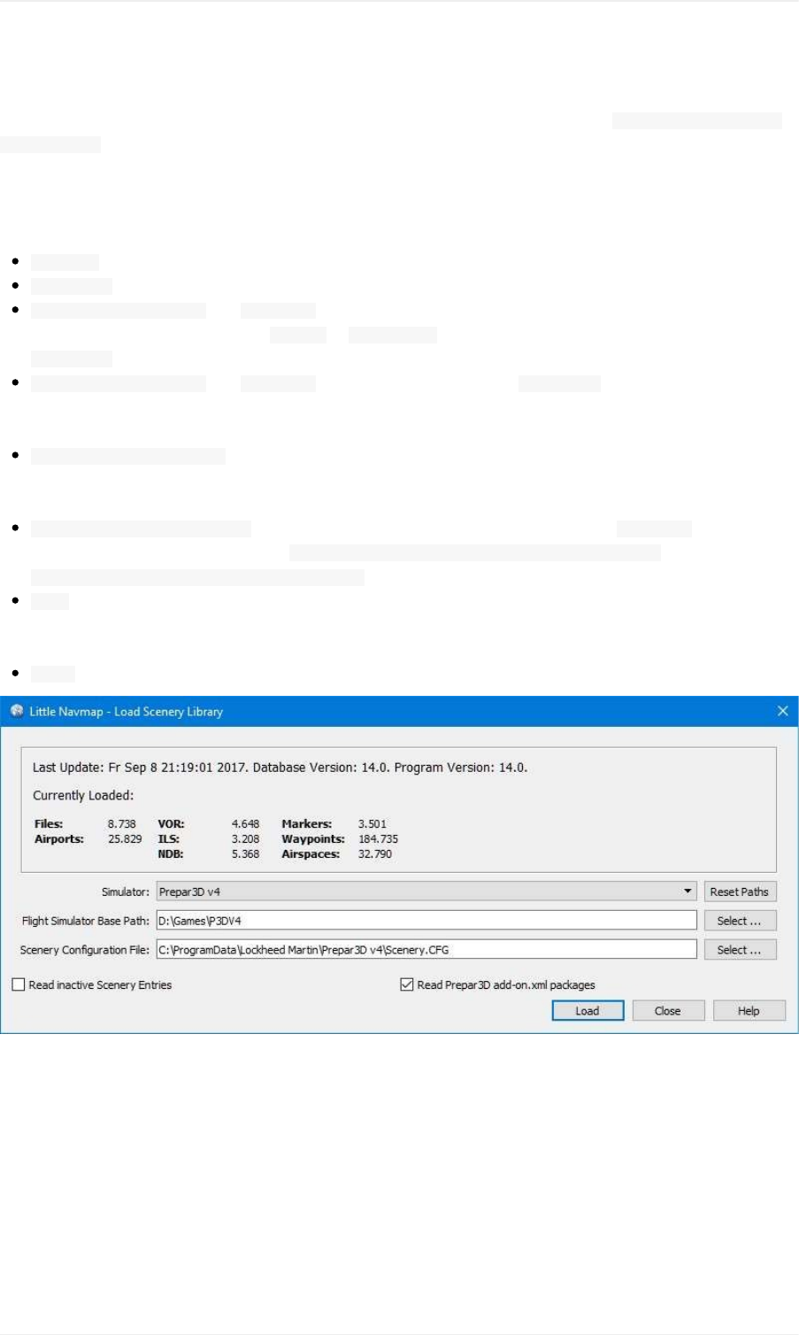
Airspaceswillappearasduplicatesinthemapifanairspacefileisfoundinmorethanoneofthesedirectories.
IfX-Planecrasheswhenloadingcertainairspacefiles,movethesefilestothefolder Documents/LittleNavmap/X-
PlaneAirspacesinstead.Thisway,theairspacesareatleastavailableinLittleNavmapwhichismoreerror
tolerant.
LoadSceneryLibraryDialogOptions
Simulator:Selectthesimulatortoload,showdatabasestatisticsinthelabelabove.
ResetPaths:Resetallpathsbacktodefaultvalues.
FlightSimulatorBasePathand Select...:Thepathtothebasedirectoryoftheselectedflightsimulator.This
usuallythedirectorycontainingthe FSX.exeor Prepar3D.exe.Thisisthebaseforallrelativepathsfoundinthe
scenery.cfgfile.
SceneryConfigurationFileand Select...(onlyFSXandP3D):Thefile scenery.cfgofthesimulator.Youcan
alsocreatecopiesoftheoriginalfile,modifythembyremovingoraddingsceneriesandselectthemherefor
loading.
ReadinactiveSceneryEntries(onlyFSXandP3D):Thiswillreadallsceneryentries,alsotheinactive/disabled
ones.Thisishelpfulifyouuseatooltodisablescenerybeforeflyingbutstillwanttoseealladd-onsceneriesin
LittleNavmapwithoutreloading.
ReadPrepar3Dadd-on.xmlpackages(onlyP3Dv3andv4):Ifenabled,readsP3Dv4orv3 add-on.xmlpackages.
Thesearereadfromsubdirectoriesof C:\Users\YOURUSERNAME\Documents\Prepar3Dv4Files\Add-onsand
C:\Users\YOURUSERNAME\Documents\Prepar3Dv4Add-ons.
Load:Startsthedatabaseloadingprocess.Youcanstoptheloadingprocessatanytimeandtheprevious
databaseisrestored.Thedialogisclosedandtheprogramwillswitchtoshowtheloadeddatabaseonceitis
successfullyloaded.
Close:Keepallsettingsandchangesinthedialogandcloseitwithoutloadinganything.
Pictureabove:LoadSceneryDialog.ScenerydataisalreadyloadedforFSX.
LoadSceneryLibraryDialog
120
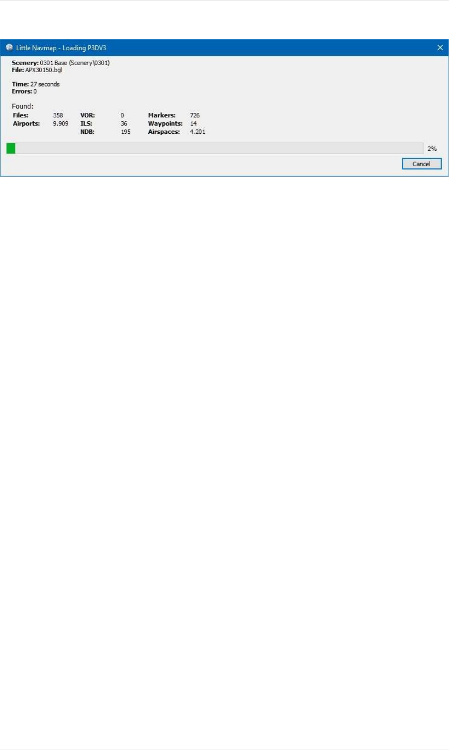
Pictureabove:ProgressdialogshownwhileloadingthescenerylibraryintoLittleNavmap'sinternaldatabase.
LoadSceneryLibraryDialog
121
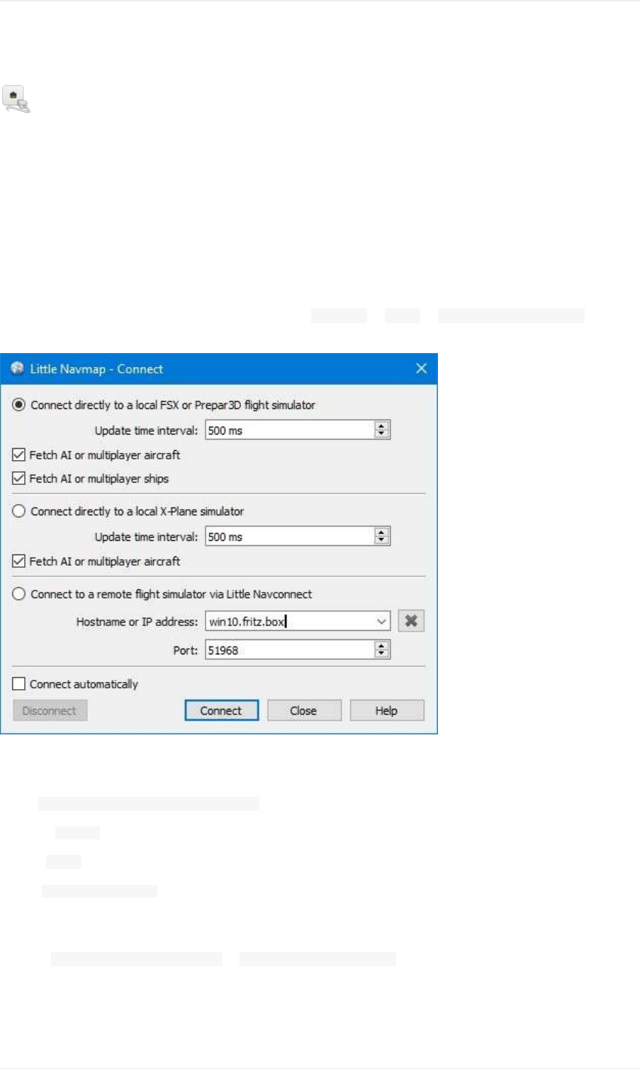
ConnectingtoaFlightSimulator
Thesetupprocedureisdifferentforlocalconnectionsandremote(networked)connectionstoaflightsimulator.
LittleNavmapcanconnectdirectlyifallprogramsarerunningonthesamecomputer.TheLittleNavconnectagentis
neededifLittleNavmapisusedonaremotecomputer.
LocalConnection
AllSimulators
OpentheconnectiondialoginLittleNavmapbyselecting MainMenu-> Tools-> FlightSimulatorConnectionand
choosethesimulatortowhichtheconnectionshouldbeestablished.
Pictureabove:LittleNavmapconnectdialogsetupforalocalconnectiontoFSXorP3D.Theconnectionwillbe
establishedmanually.
Select ConnectdirectlytolocalFlightSimulator.
Nowclick Connect.ThedialogwillcloseandLittleNavmapwilltrytoestablishaconnectioninthebackground.
Clicking Closekeepsallchangesandclosesthedialogwithoutestablishingaconnection.
Enable Connectautomaticallyifyoudonotwanttoconnectmanually.Thestartorderofprogramsdoesnotmatterif
thisischeckedandLittleNavmapwillfindthesimulatoronceitisstartedorwhenitisalreadyrunning.Thisisthe
recommendedsetting.
Deselect FetchAIormultiplayeraircraftor FetchAIormultiplayershipstodisablethetransferofthisinformationto
theprogram.ThiscanbeusefulforperformancereasonsifyouuselargeamountsofAIbutdonotwanttoseeitin
LittleNavmap.
X-Plane
ConnectingtoaFlightSimulator
122

YouhavetointalltheincludedLittleXpconnectplugintouseLittleNavmapasamovingmapwithX-Plane.
ThepluginisbundledwithLittleNavmapandcanbedownloadedseparatelytoo.
Copythewholeplugindirectory LittleXpconnectintothedirectory pluginsinthedirectory ResourcesintheX-Plane
installation.Thecompletepathshouldlooklike .../X-Plane11/Resources/plugins/LittleXpconnect
YoucanchecktheX-Planepluginmanagertoseeifitisloadedcorrectly.
WhenconnectingwithLittleNavmapselecttheoption ConnectdirectlytoalocalX-Planesimulator.
RemoteConnection
UseraircraftandweatherinformationistransferredtoLittleNavmaponaremotecomputerbyusingtheLittle
Navconnectagentontheflyingcomputerwhichcircumventstheerrorproneandtedioussetupofaremote
SimConnectconnection.
NotethatweatherinformationcannotbetransferredacrossaremoteconnectionfromX-Plane.
YouhavetoextracttheZIParchivethatcontains littlenavmap.exeand littlenavconnect.exeonbothcomputers.Then
loadthescenerydatabaseonthecomputerrunningthesimulatorandcopythedatabaseovertotheremote
computer.SeeRunningwithoutFlightSimulatorInstallationfordetails.
MakesurethatthemajorversionsofLittleNavmapandLittleNavconnectmatch,otherwiseyoumightgetanerror
message.UsetheversionofLittleNavconnectwhichisincludedintheLittleNavmapdownloadarchiveifunsure.
ForX-PlaneyoualsohavetoinstalltheLittleXpconnectplugin.Seethefile README.txtindirectory LittleXpconnect
forinstallationinstructions.
StartLittleNavconnectontheFlyingComputer
LittleNavconnectisbundledtogetherwiththeLittleNavmapdownloadarchive.StartLittleNavconnect
(littlenavconnect.exe)onthecomputerrunningthesimulatorandtakenoteofthemessagethatisprintedinthe
loggingwindow.Youonlyneedthecoloredvalueswhichtellyouthenameandaddressofthecomputerrunningthe
simulator.YoucanusetheIPaddressorthehostname.
LittleNavconnectcanprintmultipleIPaddressesorhostnamesdependingonyournetworkconfiguration.Thiscan
happenifyouhaveEthernetpluggedinandareconnectedusingwirelessLANtoo,forexample.Youhavetotryifyou
areunsurewhichonetouse.AlsomakesuretosetuptheWindowsfirewallproperlytoallowcommunicationbetween
littlenavmap.exeand littlenavconnect.exeonbothcomputers.
Pictureabove:LittleNavconnectisrunningandwaitingforaFlightSimulator.Itisrunningonthecomputer
win10.fritz.boxwiththeIPaddress 192.168.2.13.
ChangetheportinLittleNavconnect's Optionsdialogifyouseeanerrormessagelikeshownbelow:
ConnectingtoaFlightSimulator
123
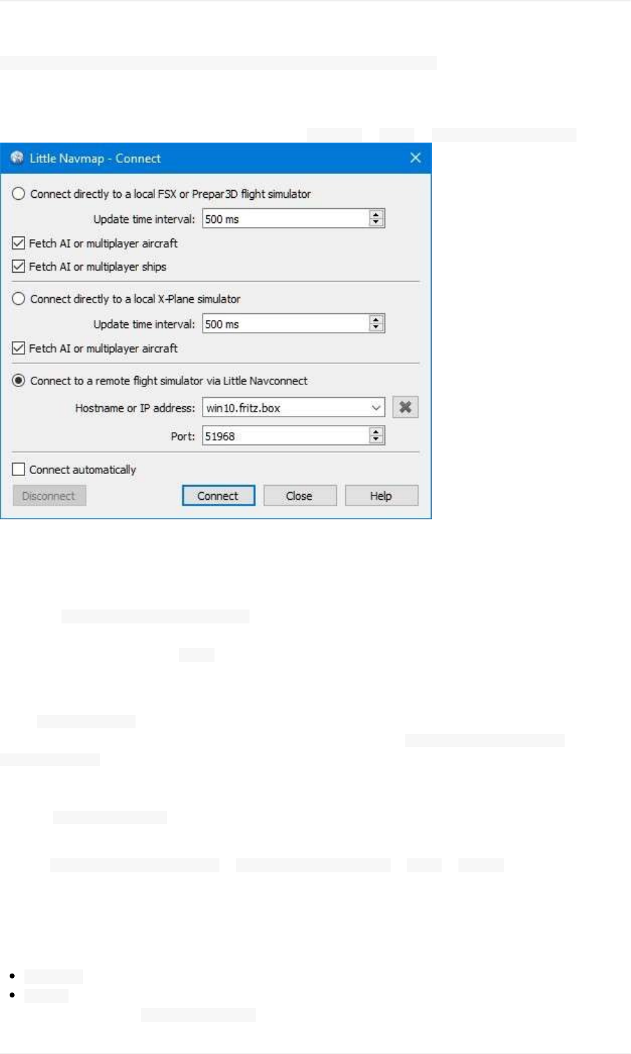
[2016-07-2716:45:35]Unabletostarttheserver:Theboundaddressisalreadyinuse.
StartLittleNavmapontheClient/RemoteComputer
OpentheconnectiondialoginLittleNavmapbyselecting MainMenu-> Tools-> FlightSimulatorConnection.
Pictureabove:ConnectdialogwithcorrectvaluestoaccessthecomputerrunningthesimulatorandLittle
Navconnectasshownabove.
Nowdothefollowingafteropeningthedialog:
1. Select ConnecttoaremoteFlightSimulator.
2. Addthevalueforhostname.ThiscanbeeitherthehostnameortheIPaddressprintedbyLittleNavconnect.
3. Checkthevaluefortheport. 51968isthedefaultvalueandusuallydoesnotneedtobechanged.
4. Clickconnect.ThedialogwillcloseandLittleNavmapwilltrytoestablishaconnectioninthebackground.
Establishingaconnectioncantakesometime,dependingonyournetwork.Theaircraftwillshowuponthemapand
onthe SimulatorAircraftdockwindowonceaflightissetupandloadedonthesimulator.Ifnoflightisloadedyet
(i.e.thesimulatorstillshowstheopeningscreen),youwillseethemessage Connected.Waitingforupdate.inthe
SimulatorAircraftdockwindow.
Notethatitcantakeawhileuntilanerrorisshownifyouusedthewrongvaluesforhostnameorport.
Selecting Connectautomaticallyisrecommended.Thestartorderofallthreeprograms(simulator,LittleNavconnect
andLittleNavmap)doesnotmatterifthisischeckedandtheprogramswillfindeachother.
Deselect FetchAIormultiplayeraircraftor FetchAIormultiplayershipsin Tools-> OptionsofLittleNavconnectto
disablethetransferofthisinformationacrossthenetwork.Thiscanbeusefulforperformancereasonsifyouuselarge
amountsofAIbutdonotwanttoseeitinLittleNavmap.
ConnectDialogOptions
Disconnect:Disconnectthecurrentsessionandstopautomaticreconnect.
Connect:Trytoconnect.Anerrordialogwillbeshownifnoconnectioncanbeestablished.LittleNavmapwill
constantlytryagainif Connectautomaticallyisenabled.
ConnectingtoaFlightSimulator
124

Close:Closethedialogwithoutanychangestothecurrentconnectionstatus.
Connectautomatically:LittleNavmapwilltrytoconnectconstantlyifthisisenabled.Thisistherecommended
setting.
Allconnectionattemptswillstopimmediatelyifyoudeselectthisbutton.
Youhavetoclick Connectoncetostarttheautomaticconnectionattemptsaftercheckingthisbutton.
UpdateTimeInterval:Allowedrangeis50millisecondsupto1second.LittleNavmapfetchesdatafroma
simulatorusingthistimeinterval.Increasethisvalueifyouexperiencestuttersorlaginthesimulator.Alower
valuewillresultinmorefluidmapupdatesinLittleNavmap.
FetchAIormultiplayeraircraftand FetchAIormultiplayerships:DisablesfetchingofAIvehicles.These
settingsareappliedimmediately.NotethatshiptrafficisnotavailableforX-Plane.
ConnectingtoaFlightSimulator
125
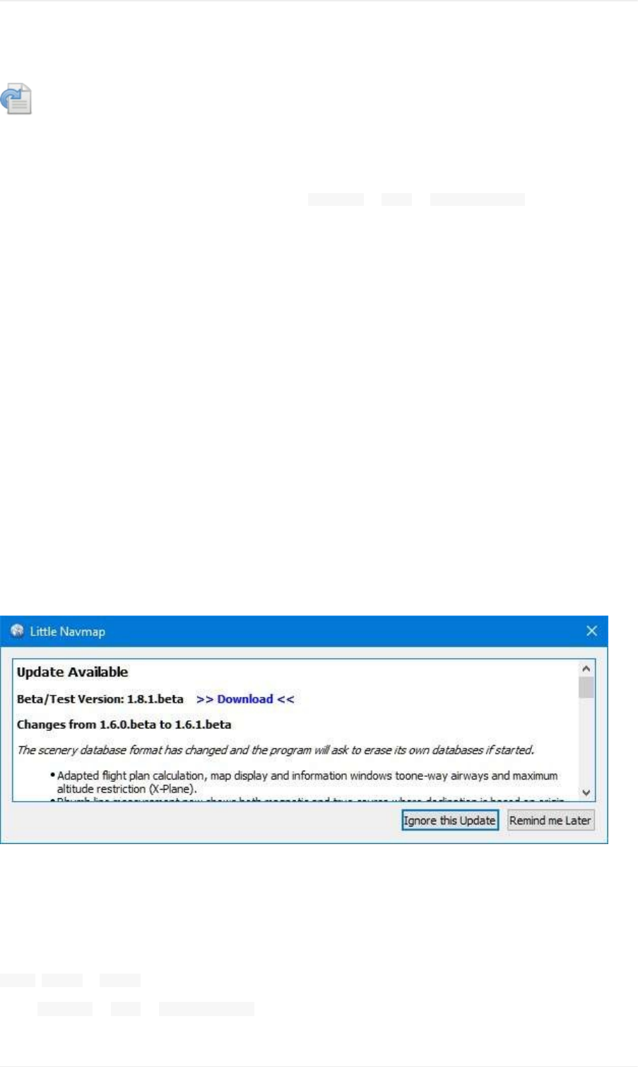
CheckingforUpdates
LittleNavmapwillautomaticallycheckitshomepageforavailableupdatesonstartup.Frequencyandupdate
channelsareconfigurable.Seebelowforconfigurationoptions.
Youcanalwayscheckmanuallyforupdatesbyselecting MainMenu-> Help-> CheckforUpdates.
Notethattheinstallationstillhastobedonemanually.
Notification
Thedialogshowingavailableupdatescontainsachangelog,variousothermessagesandoneormoredownload
links.
IgnorethisUpdate
Pressingthisbuttonwillputtheshownversiononablacklist.Youwillnotseeanyremindersforthisversionagainbut
fornewerversions.
Thisbuttonisnotvisiblewhencheckingmanually.
Notethatamanualcheckforupdatesignorestheblacklistedupdates.
RemindmeLater
Dismissthedialog.Youwillbenotifiedagainonnextstartupdependingonselectedfrequency.Youcanalsopress
theescapekeytotriggerthisaction.
Thisbuttonisnotvisiblewhencheckingmanually.
Pictureabove:Updatenotificationdialogshowinganavailablebetaversionincludingchangeloganddownloadlink.
Options
CheckforUpdates:
Daily, Weeklyor Manual.
Select MainMenu-> Help-> CheckforUpdatestosearchmanuallyfornewversions.
CheckingforUpdates
126
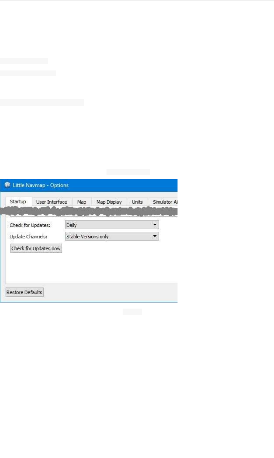
Notethatthedailyorweeklycheckisonlydonewhenstartingtheprogram.
UpdateChannels:
StableVersionsonly:Thiswillshowonlynotificationsfortestedandstableversionswithacompletemanual.
StableandBetaVersions:Willadditionallycheckforbeta/testversions.Betaversionsareprogramreleasesthat
alreadycontainallplannedfeaturesforastablereleasebutarestillnottestedcarefully.Themanualmightbe
incomplete.
Stable,BetaandDevelopmentVersions:LittleNavmapwillalsoshownotificationsfordevelopmentreleases.Theseare
neithercompletenorwelltested.Featuresmightchangeovertimeandthemanualisnotupdatedfornew
functionality.
Abackupofallsettingsisrecommendedbeforerunningadevelopmentversion.
CheckforUpdatesnow
Checksforupdatesimmediately.Thiswillusethecurrentsettingsasshowninthedialog.Itwillalsoshownotifications
forupdatesthatwereignoredbypressingthe IgnorethisUpdateonthenotificationdialog.
Pictureabove:Updatenotificationsettingsindialog Options.
CheckingforUpdates
127

OptionsDialog
Mostoptionsareself-explainingandtooltipscontainmoredetailedexplanationsifapplicable.
Youcanimmediatelychecktheeffectofyourchangesonthemapdisplaybymovingthedialog Optionstotheside
andpressing Apply.
Thebutton RestoreDefaultsonlyrestorestheoptionsofthisdialogbacktodefault.Othersettingslikemapdisplay,
tableviewsordockwindowpositionsarenotaffected.ToresetallsavedsettingscompletelyseeTroubleshoot.
Startup
AllowstocustomizewhatshouldbeloadedandshownonstartupofLittleNavmap.
Youcanalsoconfigurethefrequencyoftheautomaticupdatecheckandchannels.SeeCheckingforUpdatesfor
moreinformation.
UserInterface
Hasoptionsfortextsizesininformationwindowsandflightplanaswellasthesearchresulttable.
Youcanalsochangetheoverallstyleforthegraphicaluserinterface.Theuserinterfacestylescontaina Nightmode
thatcanbeusedfornightflightsindarkrooms.Youcanalsodimthemapandelevationprofiledisplay.
Arestartisnotneededbutrecommendedafterchangingastyle.
Thecolorsforthestyles Fusionand Nightcanbechangedbyeditingconfigurationfiles.SeeCustomizeformore
information.
Thistabalsocontainsoptionstoforcetheprogramlanguageandlocalesettings(number,dateandtimeformats)to
Englishifyoudonotwanttouseatranslateduserinterface.
OptionsDialog
128
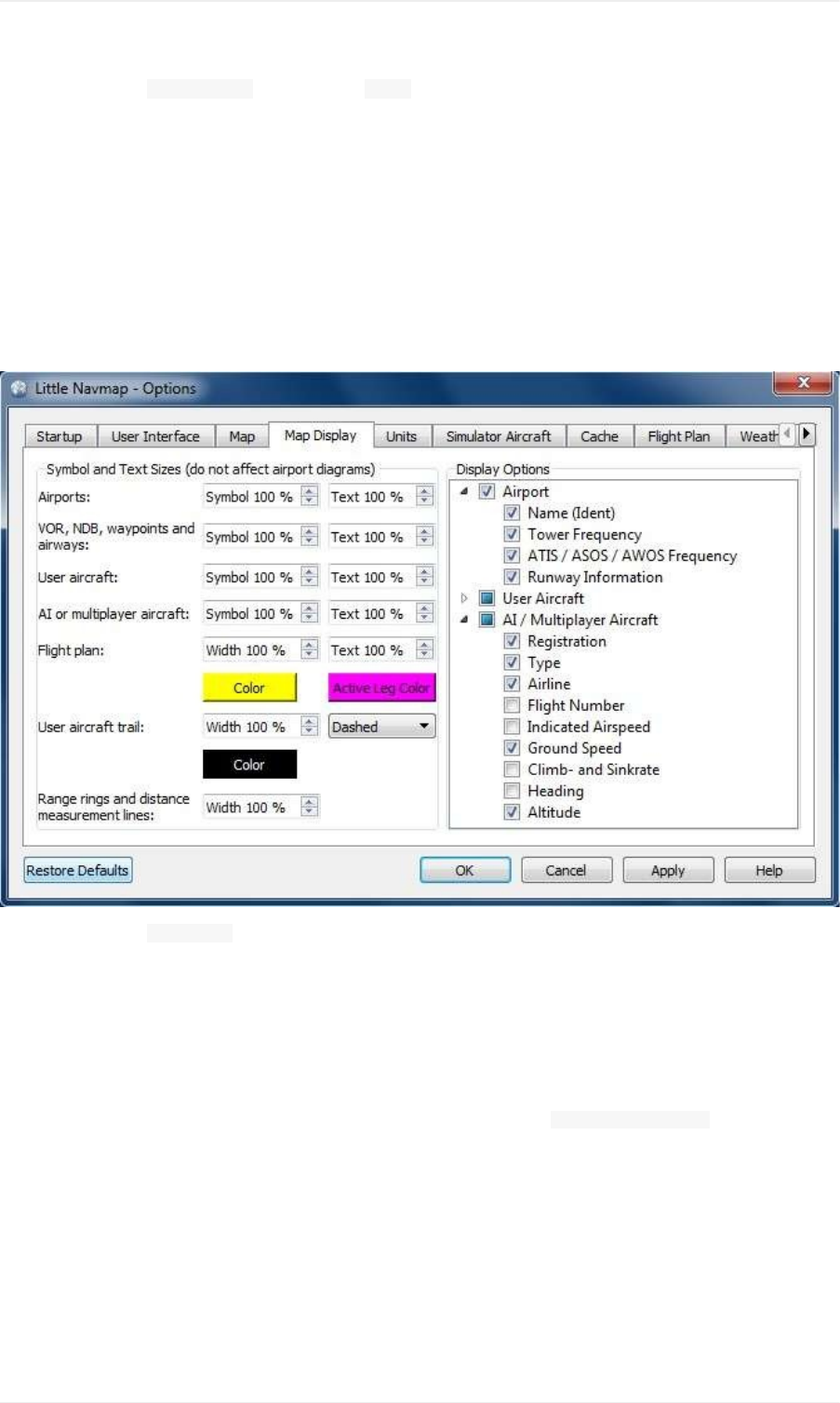
Pictureabove:Tab UserInterfaceusingthestyle Night.
Map
Hasmaprelatedcustomizationoptions.Allowstosettheclicksensitivity,zoomdistancesandmore.
MapDisplay
Thistabcontainsoptionsforsymbolandtextsizes,flightplanandaircrafttrailcolorsandmore.
Therightsideofthetabcontainsatreeviewthatallowstoselectthetextlabelsthatshouldbeshownatairports,user
aircraftandAI/multiplayeraircraft.
Pictureabove:Tab MapDisplay.
Units
YoucanchangeallunitsthatareusedbyLittleNavmaponthistabbetweennautical,imperialandmetric.Mixed
settingslikemeterforaltitudeandnauticalmilesfordistancearepossible.
Notethatanynumbersusedintheprogramarenotconvertedwhenchangingunits.Thatmeansthatyouwill
haveaminimumaltitudebufferof1000meterafterchangingthesetting AltitudeandElevationfromfeetto
meter.Thisalsoappliestoflightplanaltitude.Therefore,donotforgettoadaptthesenumbersafterchanging
units.
SimulatorAircraft
Allowstochangevariousaspectsaroundthedisplayoftheuseraircraft.Allsettingsresultinginamorefluidaircraft
displaywillusemoreCPUandcanpotentiallyinducestuttersinthesimulator.
Centermaponaircraftandnextflightplanwaypoint
OptionsDialog
129

Themapiszoomedtoshowboththeaircraftandthenextactivewaypointontheflightplanifthisisenabled.
Thedefaultmodeistosimplycenterthemapontheaircraft.
Themapwillfallbacktothedefaultmodeifnoflightplanisloaded.
Donotuseboxmodeforfollowingtheaircraft.Movethemapconstantly.
Mapwillfollowtheaircraftconstantlywhenchecked.Thisisalsousedfor Centermaponaircraftandnextflightplan
waypoint.
ThisoptionwillcauseLittleNavmaptoconsumemoreCPUresourceswhileflying.
Simulatoraircraftscrollboxsize(percentofmapwindowsize)
Smallervalueskeeptheaircraftcenteredandwillmovethemapoften.Largevalueswillupdatethemaponlywhen
aircraftreachesmapboundary.
Thissettingisignoredwhen Centermaponaircraftandnextflightplanwaypointischeckedandaflightplanisset.
Keepactivelegontopofflightplantable
Theactive(magenta)legwillbeshownontopoftheflightplantablewhenanewlegisactivated.
Allowscrollingandzoominginthemap
Themapwillstopfollowingtheaircraftforthegiventimeiftheuserdoesanyinteractionwiththemaplikescrollingor
zooming.Youcanquicklycheckoutthedestinationoryouroverallprogress,andafteryoustopinteractingwiththe
map,LittleNavmapwillreturntofollowingyouraircraft.
Jumpbacktoaircraftandresumeaircraftfollowingafterthistime
Timeuntilaircraftfollowingisactivatedagainafteranymapinteractionlikescrollingorzooming.
CacheandFiles
MapDisplay
HereyoucanchangethecachesizeinRAMandondisk.Thesecachesareusedtostorethedownloadedimages
tilesfromtheonlinemapsliketheOpenStreetMap,OpenMapSurferorOpenTopoMap.
Allimagetilesexpireaftertwoweeksandwillbereloadedfromtheonlineservicesthen.
Notethatareductionofsizeorerasingthediskcacheisdoneinbackgroundandcantakeawhile.
TheRAMcachehasaminimumsizeof100MBandamaximumsizeof2GB.
Thediskcachehasaminimumsizeof500MBandamaximumsizeof8GB.
FlightPlanElevationProfile
ThebottompartofthistaballowstoinstallthethefreelydownloadableGLOBE-GlobalLandOne-kmBaseElevation
Projectelevationdata.
DownloadtheZIParchivefromthelinkinthedialogandextractit.Selecttheextracteddirectoryusing SelectGLOBE
Directory...so,thatitpointstothefiles a10gto p10g.Thelabelinthedialogwillshowanerrorifthepathisinvalid.
OptionsDialog
130

Pictureabove:Tab CacheandFileswithproperlyselectedGLOBEelevationdata.
FlightPlan
Hereyoucansetpreferencesforflightplancalculationoradjusttheruleofthumbforthetopofdescentdisplay.
Weather
Youcanselectthevariousweathersourcesthatshouldbeshowninthe Informationdockwindoworinthemap
tooltips.
Theweathertype FlightSimulatorwilleitherdisplayweatherfromtheFSXorP3DconnectionorfromX-Planes
METAR.rwxweatherfile.
ActiveSkycanonlybeselectedifeitherActiveSkyNext,AS16orActiveSkyforPrepar3Dv4areinstalledorthe
weatherfileisselecteddirectly.SelectingtheActiveSkyweatherfiledirectlycanbeusefulifyourunanetworked
setup.UseWindowssharesoracloudservicetogetaccesstothefileontheremotecomputer.
TheURLsoftheNOAAandVATSIMweathercanbemodifiedifyouliketouseanothersourceortheserviceschange
theURLs.
ThetestbuttonsfortheonlineweatherservicescanalsobeusedtofindoutifLittleNavmapcanconnecttoInternet.
Checkyourfirewallsettingsifthesefail.
OptionsDialog
131
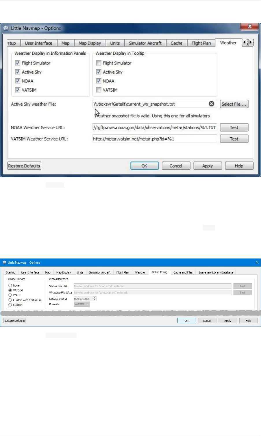
Pictureabove:Tab WeatherwithmanuallyselectedActiveSkyweatherfileonanetworkshare.
OnlineFlying
Thistaballowstochangesettingsforonlinenetworks.
Notethatallrelatedwindowtabs,menuitemsandtoolbarbuttonsarehiddenifthisissetto None.
SeeOnlineNetworksforanoverview.
Notallnetworksmightbeenableddependingonrelease.
Pictureabove:Tab OnlineFlyingwithVATSIMnetworkenabled.
OnlineService
None
Disablesallonlineservicesandhidesallrelatedwindowtabs,menuitemsandtoolbarbuttons.Nodownloadswillbe
done.
VATSIM
UsesthepredefinedconfigurationfortheVATSIMnetwork.Noothersettingsareneeded.
Theupdateratedependsonconfigurationandistypicallythreeminutes.
OptionsDialog
132

IVAO
UsesthepredefinedconfigurationfortheIVAOnetwork.Noothersettingsareneeded.
Theupdateratedependsonconfigurationandistypicallythreeminutes.
CustomwithStatusFile
Thisoptionallowstoconnecttoaprivatenetworkandwilldownloada status.txtfileonstartupwhichcontains
furtherlinkstoe.g.the whazzup.txtfile.
Custom
Thisoptionallowstoconnecttoaprivatenetworkandwillperiodicallydownloada whazzup.txtfilewhichcontains
informationaboutonlineclients/aircraftandonlinecenters/ATC.
Settings
StatusFileURL
URLofthe status.txtfile.Youcanalsousealocalpathlike C:\Users\YOURUSERNAME\Documents\status.txt.
Thisfileisdownloadedonlyonstartupoftheprogram.
Apushbutton TestallowstocheckiftheURLisvalidandshowsthefirstfewlinesfromthedownloadedtextfile.
Thisdoesnotworkwithlocalpaths.
ThestatusfileformatisexplainedintheIVAOdocumentationlibrary:StatusFileFormat.
WhazzupFileURL
URLofthe whazzup.txtfile.Youcanalsousealocalpathlike C:\Users\YOURUSERNAME\Documents\whazzup.txt.
Thisfileisdownloadedaccordingtothesetupdaterate.
Apushbutton TestallowstocheckiftheURLisvalid.Thetestdoesnotworkwithlocalpaths.
ThewhazzupfileformatisexplainedintheIVAOdocumentationlibrary:WhazzupFileFormat.
UpdateEvery
Setstheupdateratethatdefineshowoftenthe whazzup.txtfileisdownloaded.
Allowedvaluesare30to1800seconds,180sbeingthedefault.
Youcanusesmallerupdateratesforprivateonlinenetworkstoimprovemapdisplayupdates.
Donotuseupdateratessmallerthantwominutesforofficialonlinenetworks.Theymightdecidetoblockthe
applicationifdownloadsareexcessive.
Format
IVAOor VATSIM.Dependsontheformatusedbyyourprivatenetwork.Trybothoptionsifunsure.
SceneryLibraryDatabase
Allowstoconfiguretheloadingofthescenerylibrarydatabase.
NotethatthesepathsapplytoallFlightSimulators,FSX,P3DandX-Plane.
Youhavetoreloadthescenerydatabaseinorderforthechangestotakeeffect.
OptionsDialog
133
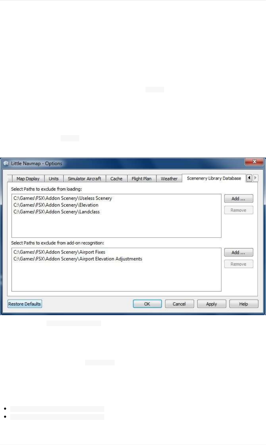
SelectPathstoexcludefromloading
Alldirectoriesincludingsub-directoriesinthislistwillbeomittedwhenloadingthescenerylibraryintotheLittle
Navmapdatabase.Youcanalsousethislisttospeedupdatabaseloadingifyouexcludedirectoriesthatdonot
containairportsornavaids(landclass,elevationdataandothers).
SelectPathstoexcludeadd-onrecognition
Allscenerydatathatisfoundoutsideofthebaseflightsimulator Scenerydirectoryisconsideredanadd-onandwill
behighlightedonthemapandalsoconsideredduringsearchforadd-ons.
Youcanusethislisttomodifythisbehavior.
Add-ons,likeOrbxFTXVectororfsAerodataaddsceneryfilesthatcorrectcertainaspectsofairportslikeelevation,
magneticvarianceorothers.Alltheseairportswillberecognizedasadd-onairportssincealltheirfilesarenotstored
inthebaseflightsimulator Scenerydirectory.
Insertthecorrespondingdirectoryintothislisttoavoidunwantedhighlightingoftheseairportsasadd-ons.
Pictureabove:Tab SceneryLibraryDatabasewiththreedirectoriesexcludedfromloadingandtwodirectories
excludedfromadd-onrecognition.
Examples
Providedyoursimulatorisinstalledin C:\Games\FSX.
ORBXVector
Excludethedirectoriesbelowfromadd-onrecognition.Donotexcludethemfromloadingsinceyouwillseewrong
airportaltitudes.
C:\Games\FSX\ORBX\FTX_VECTOR\FTX_VECTOR_AEC
C:\Games\FSX\ORBX\FTX_VECTOR\FTX_VECTOR_APT
Flight1UltimateTerrainEurope
OptionsDialog
134

Excludethesedirectoriesfromloadingtospeeduptheprocess:
C:\Games\FSX\Scenery\UtEurAirports
C:\Games\FSX\Scenery\UtEurGP
C:\Games\FSX\Scenery\UtEurLights
C:\Games\FSX\Scenery\UtEurRail
C:\Games\FSX\Scenery\UtEurStream
C:\Games\FSX\Scenery\UtEurWater
ORBXRegions
Excludethesedirectoriesfromloading:
C:\Games\FSX\ORBX\FTX_NZ\FTX_NZSI_07_MESH
C:\Games\FSX\ORBX\FTX_NA\FTX_NA_CRM07_MESH
C:\Games\FSX\ORBX\FTX_NA\FTX_NA_NRM07_MESH
C:\Games\FSX\ORBX\FTX_NA\FTX_NA_PNW07_MESH
C:\Games\FSX\ORBX\FTX_NA\FTX_NA_PFJ07_MESH
OptionsDialog
135

RunningwithoutFlightSimulatorInstallation
Youcanuse littlenavmap.exeonallcomputersnomatterifSimConnectoraflightsimulatorareinstalledornot.
FollowthesestepsifyouwanttoinstallLittleNavmaponacomputernotcontaininganyflightsimulatorinstallationfor
anetworkedsetup,forexample.Nofunctionalityisaffectedexceptdirectconnectcapabilitywhicharenotneededin
thiscase.
Thisscenarioistypicallyusedwhenconnectingtotheflightsimulatortowatchtheprogressofaflightremotely.
Flightplanscanbecreated,loadedandsavedontheclientcomputer.Youonlyhavetomakesurethattheseare
transferedtotheflightsimulatorcomputerusingWindowssharesorbyothermeans.
TheseinstructionsapplytoWindows,macOSandLinuxcomputersequally.
1. InstallLittleNavmaponbothyourflyingcomputerandtheclientcomputerwithoutsimulator.
2. Startitontheflyingcomputerandgeneratethescenerylibrarydatabases.SeeLoadSceneryLibraryDialog
aboveformoreinformation.
3. Select MainMenu-> SceneryLibrary-> ShowDatabaseFilesontheflyingcomputer.Thiswillopenthedirectory
containingthedatabasefilesinafilemanagerlikeWindowsExplorerorAppleFinder.Youwillfindoneormore
databasefilelike little_navmap_fsx.sqlite, little_navmap_p3dv3.sqliteor little_navmap_xp11.sqlite.
4. ExitLittleNavmapontheflyingcomputer.
5. StartLittleNavmapontheclient/remotecomputerandselect SceneryLibrary-> ShowDatabaseFiles.
6. ExitLittleNavmapontheclientcomputersoyoucancopythedatbasefiles.
7. Copythedatabasefilestoyourclientcomputerusingnetworkshares,USBsticksorwhateveryoulike.Usethe
filemanagerwindowsopenedbytheproceduresabove.
8. StartLittleNavmapontheclientcomputer.Themenu SceneryLibraryshouldcontainanentryforeachcopied
databasefileornoentryatallifonlyonedatabasefilewascopied.Airporticonsshouldbevisibleonthemapin
eithercase.Thereisnoneedtoreloadthescenerylibrarydatabasenowsinceyoujustcopiedafully
populateddatabasefile.
SeetheConnectingtoaFlightSimulatorforinformationaboutnetworkedsetups.
RunningwithoutFlightSimulatorInstallation
136

CustomizingGeneral
LittleNavmapcreatesmultipleconfigurationfilesinthedirectory C:\Users\YOURUSERNAME\AppData\Roaming\ABarthelwhen
started.Theseallowextendedcustomizationoftheprogram.
ThefilesusetheWindows- INIstylethathasgroupsinsquarebracketsand key=valuelines.Seehereformore
informationaboutthistypeofconfigurationfiles.
NotethatyouhavetorestartLittleNavmaptoseeanychanges.Also,donoteditthefileswhileLittleNavmapis
runningsinceitmightoverwriteyourchanges.
Toundoallchangessimplydeleteafile.ItwillbecreatedagaincontainingthedefaultvalueswhenLittleNavmapis
started.
SinglelinescanalsobedeletedandwillberestoredwiththedefaultvaluewhenLittleNavmapisstarted.
Keysandvaluesarecasesensitive.Orderinthefilesisnotimportantifthekeysremainintheirrespectivesections.
Theprogrammightreorderthekeyswhensavingorupdatingthefiles.
Version
SomeoftheINIfilescontainasection [Options]withakey Versionasshownbelow.
[Options]
Version=2.0.1
DonotdeletethissinceLittleNavmapreliesonthisinformationwhenupdatingthefile.Itwillresetthefile
occasionallywheneverthedefaultsettingschange.Abackupwillbecreatedtosaveyouruser
customizations.
Addthisversionsectiontoallnewfiles.Otherwise,LittleNavmapmightresetthecontent.
Examplesforbackupfiles: little_navmap_mapstyle_backup_2.0.0.inior little_navmap_mapstyle_backup.ini.
Thefilewillbebackedupandresetifyoudeleteorchangetheversion.
GUI
Onlytwouserinterfacestylescanbecustomized.Theseare Fusionand NightandcanbefoundinthedialogUser
Interfacetaboftheoptionsdialog.Thesetwostylesareavailableonalloperatingsystems.
Twofilesaregeneratedthatallowthecustomizationforallwindow,buttonanddialogcolors.Theseare:
C:\Users\YOURUSERNAME\AppData\Roaming\ABarthel\little_navmap_fusionstyle.ini
C:\Users\YOURUSERNAME\AppData\Roaming\ABarthel\little_navmap_nightstyle.ini
ThekeynamesinthesefilesarederivedfromtheQtpaletteoptions.Eachkeyconsistsofthegroupandrolename
separatedbyanunderscore.Seebelowformoreinformationonthecolorformatsused.
Seehereformoreinformationaboutgroupsandroles.
OnlineNetworkCenter
Customize
137

Theconfigurationfile C:\Users\YOURUSERNAME\AppData\Roaming\ABarthel\little_navmap.iniallowstochangethesizeofthe
onlinenetworkcentercircles.
Radiusisinnauticalmiles.Thevisualrangeisusedifradiusis-1.Nocircleisdrawnifthevalueis0.
Donotdeletethisfilesinceitcontainsallprogramsettings,maphistory,openedfilesandmore.Editonlythe
keysshownbelow.
[Online]
CenterRadiusACC=-1
CenterRadiusApproach=20
CenterRadiusDelivery=-1
CenterRadiusDeparture=-1
CenterRadiusFIR=-1
CenterRadiusGround=5
CenterRadiusObserver=-1
CenterRadiusTower=10
MapDisplay
Thefile C:\Users\YOURUSERNAME\AppData\Roaming\ABarthel\little_navmap_mapstyle.iniallowstocustomizevariousaspectsof
themapdisplayandiscurrentlylimitedtocolorsandpens.Mostkeynamesareselfexplaining.Seebelowformore
informationaboutcolorvalues.
ColorFormat
Colorcanbeinoneoftheseformatswhicharecommonlyusedinwebdesign:
#RRGGBBeachofR,G,BandAisasinglehexdigit.Eachcolorvaluerangesfrom00-FF(decimal0-255)
#AARRGGBBfirsttwodigitscontainthealpha/transparencyvalue. 00equalstofullytranparentand FF(decimal
255)toopaque.
SVGcolorname
SVGcolornameisoneofthecolorsdefinedinthelistofSVGcolorkeywordnamesprovidedbytheWorldWideWeb
Consortium;forexample, steelblueor gainsboro.Notethatyoucannotenteranalphachannelvalueifyouusea
colorname.
Youcanusethew3schoolscolorpickertogetthehexvaluesforacolor.
Examples:
Active_Highlight=#308cc6
AlertFillColor=darkred
ApproachFillColor=#3060808a
PenFormat
Apencontainsthefollowingvaluesinacommaseparatedlist:
Colorasdescribedabove
Penwidthasafloatingpointvaluemeasuredinpixels.Youhavetouse .asdecimalseparatornomatterwhat
yourlocaledefines.
Penstyle.Oneofthefollowingvalues: Solid, Dash, Dot, DashDotand DashDotDot.
Examples:
RestrictedPen=#fd8c00,2,DashDotDot
Customize
138

ModecPen=#509090,2,Solid
NationalParkPen=#509090,2.1,Solid
Icons
TochangeanicondownloaditfromtheGithubsourcerepositoryIconResourcesorextracttheincludedfile Little
Navmap/customize/icons.zip.
Modifytheiconandsaveitintothesettingsdirectory C:\Users\YOURUSERNAME\AppData\Roaming\ABarthel.LittleNavmapwill
automaticallydetectandusetheicononnextstartup.
TheformatislimitedtoSVG(ScalableVectorGraphics(SVG)Tiny1.2Specification)whereadvancedgraphics
effectsliketextureswillnotwork.
YoucanusethefreevectordrawingprogramInkscapetoedittheicons.RestartLittleNavmaptoseethechanges.
User,AIandMultiplayerAircraftIcons
Alliconsforuser,AI/multiplayeraircraft,helicoptersandshipsarestoredintheprogrambutcanbeoverloadedbythe
user.
Theiconsare:
aircraft_boat_ground_user.svg
aircraft_boat_ground.svg
aircraft_boat_user.svg
aircraft_boat.svg
aircraft_helicopter_ground_user.svg
aircraft_helicopter_ground.svg
aircraft_helicopter_user.svg
aircraft_helicopter.svg
aircraft_jet_ground_user.svg
aircraft_jet_ground.svg
aircraft_jet_user.svg
aircraft_jet.svg
aircraft_small_ground_user.svg
aircraft_small_ground.svg
aircraft_small_user.svg
aircraft_small.svg
aircraft_online.svg
aircraft_online_ground.svg
Thesuffixesarechosenbyvehicletype,status(groundorairborne)anduserorAI/multiplayer.Theiconisfor
airbornevehiclesif groundismissingandforAI/multiplayervehiclesif userismissing.Forhistoricalreasonsall
iconsareprefixedwith aircraft.
UserpointCategoryIcons
Iconsforuserpointcategoriesarestoredintheprogrambutcanbeoverloadedbytheuseraswell.
Defaultcategoryiconscanbeoverloadedwithanothericonbyplacingafilewithoneofthedefaultcategorynamesin
thesettingsdirectory.
Newcategoriescanbeaddedbyplacinganewiconadheringtoacertainnamepatterninthedefaultdirectory.
Customize
139

userpoint_Airport.png
userpoint_Airstrip.png
userpoint_Bookmark.png
userpoint_Cabin.png
userpoint_Closed.png
userpoint_Error.png
userpoint_Flag.png
userpoint_Helipad.png
userpoint_Location.png
userpoint_Logbook.png
userpoint_Marker.png
userpoint_Mountain.png
userpoint_Obstacle.png
userpoint_Pin.png
userpoint_POI.png
userpoint_Seaport.png
userpoint_Unknown.png
userpoint_VRP.png
userpoint_Waypoint.png
Thetextbetweenthefirstunderscore _andthe .pngendingdefinesthecategory.Forexample userpoint_My
Places.pngcreatesanewcategory MyPlaces.
Donotusespecialcharacterslike /forcategories.Onlyletters,digits,space,underscoreanddashesareallowed.
Umlautsandaccentedcharactersarenoproblem.
Customize
140

CreatingoraddingMapThemes
ToaddanarbitraryonlineorofflinemaptoLittleNavmapsimplyaddthemapdirectoryfromadownloadedorself
createdmapthemetothe data\maps\earthdirectory.
ThefullpathtotheDGMLfile(seelinksbelowformoredetailsaboutDGML)describingthemapmustbe c:\Own
Programs\LittleNavmap\data\maps\earth\opencyclemap\opencyclemap.dgmlifyouliketoaddtheOpenCycleMapforexample.
TheDGMLfilecanrefertoanonlinemapserviceorincludedofflinemapdata.Usuallyamapthemecontainsmany
morefilesthanonlytheDGML.
Themenu MainMenu-> Map-> Themeandthetoolbardropdownboxwillreceiveanentryforeachadditionalmap
theme.
Theoptions ShowCountryandCityNamesand ShowHillshadingareenabledforalladditionalmapthemesbutmightnot
workdependingonpropertiesdefinedinthemap'sDGMLfile.
MoremapsandinformationaboutmapconfigurationandDGMLfilescanbefoundhereontheMarble/KDEpages:
DownloadmoremapsfortheMarblewidget(onlyEarthmapsaresupportedin LittleNavmap):AdditionalMaps
Atutorialthatshowshowtocreateamapthemebasedontiledimages:Marble/CustomMaps
AtutorialshowinghowtocreateamapthemebasedonOSMSlippyMaps:Howtocreatemapthemesbasedon
OSMslippymaps
HowtocreateahistoricalmapforMarble:HistoricalMapsforMarble
CreatingoraddingMapThemes
141
CoordinateFormats
Thischapterbrieflydescribestherecognizedcoordinateformatsinflightplanpositiondialogsanduserpointdialogs.
Theinputfieldshowsamessagebelowwhichindicatesifthecoordinateswererecognizedandshowsthetranslated
coordinatesinthepresetformataschosenindialog Optionsontab Units.Aredmessageisshownincaseoferror.
Checkthedisplayedtranslatedcoordinatestoverifythatyourinputwasparsedcorrectly.
Pictureabove:Editingauser-definedflightplanposition.Tooltipgivesaquickhelponcoordinateformats.
General
Latitudehastobefirstandlongitudesecond.
N/SandE/Wdesignatorsarerequired.Casedoesnotmatter.
Degree,minuteandsecondsignscanbeomittedifnumbersareseparatedbyspaces.
Aspaceisonlyrequiredtoseparatelatitudeandlongitudeordegrees/minutes/secondsifnounitsignsareused.
Decimalseparatorcanbeperiod(English)orthelocaledependentseparatorlikee.g.comma(German).
OtherFormats
Thesehavetobegivenexactlyasshownintheexamples.
Degreesandminutes: N44124W122451, N14544W017479or S31240E136502
Degreesonly 46N078W
Degreesandminutes 4620N07805W
Degrees,minutesandseconds 481200N0112842E(Skyvector)
Degreesandminutesinpair N6500W08000or N6500/W08000
NATtype 5020N
Examples
Degrees,minutesandseconds: N49°26'41.57"E9°12'5.49"or 49°26'41.57"N9°12'5.49"E
Degreesanddecimalminutes: N54*16.82'W008*35.95', N5233.58E1317.26or 49°26.69'N9°12.09'E
Decimaldegreesonly: 49.4449°N9.2015°Eor N49.4449°E9:2015°
CoordinateFormats
142

Files
Logs
LogfilesofLittleNavmaparestoredinthesedirectories:
Windows: C:\Users\YOURUSERNAME\AppData\Local\Temp\abarthel-little_navmap.log
Linux: /tmp/abarthel-little_navmap.log
macOS: /var/folders/RANDOMIZED_DIRECTORY_NAME/abarthel-little_navmap.log
Theprogramkeepsthreelogfilesandrotatestheseoneachstartup.Soyoumayfinduptothreelogs:
abarthel-little_navmap.log, abarthel-little_navmap.log.1and abarthel-little_navmap.log.2.
Makesuretosendthecorrectlogfileafteracrash.Theprogramwillrotatethelogfilesonrestart.Ifunsuresendall
copiesinaZip-file.
Ifyouliketoreportanissuewhenloadingthescenerydatabase:Loadthedatabaseandquittheprogram.Thencopy
thelogfiletoanotherfolderbeforerestartingtheLittleNavmap.
Configuration
Allconfigurationfilesformyprogramsarestoredinthesedirectories:
Windows: C:\Users\YOURUSERNAME\AppData\Roaming\ABarthel
LinuxandmacOS: $HOME/.config/ABarthel
little_navmap.ini:INIstyleconfigurationfile.Textfile.
little_navmap.history:Themappositionhistory.Binaryfile.
little_navmap.track:Theuseraircrafttrack.Binaryfile.
Threemoreconfigurationfilesarecreatedforcustomizationofcolorsandstyles:
little_navmap_fusionstyle.ini:INIstyleconfigurationfileforcustomizingtheGUIcolorsofthestyle Fusion.
little_navmap_nightstyle.ini:Asabovebutforthestyle Night.
little_navmap_mapstyle.ini:INIstyleconfigurationfile.Textfile.Usedforcustomizationofthemapdisplay.
SeeCustomizationformoreinformation.
LittleNavmapmightresetthesefileswhenupdated,butonlyaftercreatingbackupfiles.
DiskCache
Thediskcachethatisusedtostoreallthedownloadedonlinemaptileimagescanbefoundhere:
Windows C:\Users\YOURUSERNAME\AppData\Local\.marble\data
LinuxandmacOS: $HOME/.local/share/marble
YoucandeletethecachemanuallytosavespaceifLittleNavmapisnotrunning.
Databases
Databasesarestoredinthedirectories:
Windows: C:\Users\YOURUSERNAME\AppData\Roaming\ABarthel\little_navmap_db
LinuxandmacOS: $HOME/.config/ABarthel/little_navmap_db
Files
143

AllthesedatabasesareSQLitefileswhichcanbeviewedwithe.g.DBBrowserforSQLiteifyou'reinterestedin
relationaldatabases.
Donotmodify,move,renameordeletedatabaseswhileLittleNavmapisrunning.
SceneryLibrary
Thenumberoffilesdependsonwhichsimulatorsyouhaveinstalledandwhichscenerylibrariesyou'veloaded.
Thefilesare:
little_navmap_.sqlite:Anemptydummydatabase.
little_navmap_fsx.sqlite:FlightSimulatorX
little_navmap_fsxse.sqlite:FlightSimulator-SteamEdition
little_navmap_p3dv2.sqlite:Prepar3Dv2
little_navmap_p3dv3.sqlite:Prepar3Dv3
little_navmap_p3dv4.sqlite:Prepar3Dv4
little_navmap_xp11.sqlite:X-Plane11
little_navmap_navigraph.sqlite:Navigraphnavdatabase.Canbeeithertheincludeddatabaseoranupdate
installedbytheNavigraph_FMSDataManager.
Userdata
Thefile little_navmap_userdata.sqlitecontainstheuser-definedwaypoints.
LittleNavmapcreatesabackupcopyonstartupandkeepsuptofourbackupfiles: little_navmap_userdata_backup.sqlite
to little_navmap_userdata_backup.sqlite.3.Youcancopythesefilesbacktotheoriginaldatabase
little_navmap_userdata.sqliteifyoudidsomethingwrong.
OtherDatabaseFiles
Additionalfileslike
little_navmap_compiling.sqlite,
little_navmap_compiling.sqlite-journal,
little_navmap_temp.sqlite,
little_navmap_temp.sqlite-journal,
little_navmap_onlinedata.sqliteor
little_navmap_onlinedata.sqlite-journal
areusedbytemporaryprocesseslikethedatabasecompilationoronlinenetworkdata.Thesecanbeignored.
Files
144

Tutorials
General
Thetutorialsarebasedon:
FSXorP3DscenerybutcanbeeasilyadaptedtoX-Plane.
Analreadyloadedscenerydatabasewhichnormallyhappensrightafterthefirststartup.
ThestocknavigationdataofFSXorP3D.Differencesmightappearifyouusenavdataupdatesorairportscenery
add-ons.
Allfunctionswillbereferredbythenamesinthemainmenubyusing MenuName-> MenuItem.Theiconsareshown
aswell,soyoucanfindthebuttonsononeofthetoolbars.Screenshotswillprovidemorehelp.
QuickStart
Tohaveacleancommonbase,Irecommendthefollowing:
Select Window-> ResetWindowLayouttogetallthedockwindowsbackintotheirdefaultplace.
Usethemaptheme OpenStreetMapwithhillshading enabled.
Resetthemapdisplaysettingsin Map-> ResetDisplaySettingstomakesurethatallneededfeaturesareshown
onthemap.
Select File-> NewFlightPlan tostartwithacleanflightplan.
Tutorials
1. BuildingaVFRFlightPlanThistutorialwillshowhowtocreateasimpleflightplanbasedonthemapandits
contextmenus.
2. BuildinganIFRFlightPlanwithApproachProceduresThislongtutorialwillshowyouhowtocreateamore
complexIFRflightplanincludingapproachprocedures.Itintroducestheadvancedairportsearchfunctionality,
thespatialsearchandtheautomaticflightplancalculation.
Tutorials-General
145
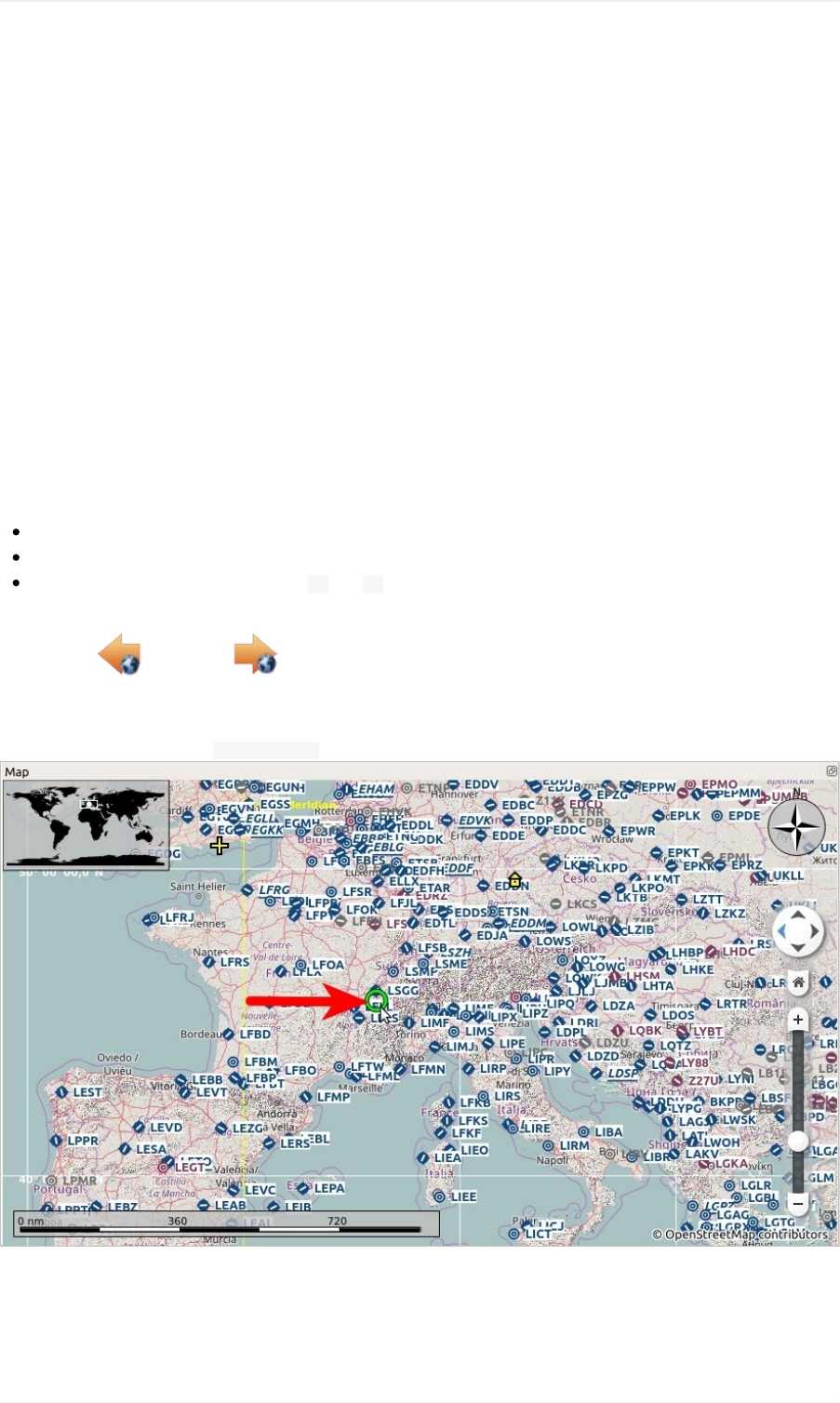
BuildingaVFRFlightPlan
General
Thistutorialwillshowhowtocreateasimpleflightplanbasedonthemapanditscontextmenus.
TheflightwilltakeusthroughthelovelyvalleysoftheFrenchalps.Youcanusethisflightplanforanysmallaircraft
likethefreeFlight1Cessna162SkyCatcherorthedefaultCessna172.
TheflightwillonlygothroughClassEairspace.ThereisnoneedtocontactATC.
Theflightplanis:Meythet(LFLP)Parking11,RampGASmalltoChalles-les-Eaux(LFLE),41nm,0h24m,Direct
DepartureAirport
Findthedepartureairport:ClickintothemapandzoomtotheFrenchAlps.Youcanusethefollowingfunctionsto
navigate:
Themapoverlayontheleft.
Themouse(clickanddrag)tomoveandthemousewheeltozoom.
Thecursorkeystomoveandthekeys +and -forzoominginandout(clickintothemapwindowtoactivateit
beforeusingthekeys).
Usetheback andforward buttonstojumpinthepositionhistorylikeawebbrowser.
SeealsoMapDisplay.
Lookforthedepartureairport Meythet(LFLP)aroundhere:
Closerwithtooltip:
Tutorial-BuildingaVFRFlightPlan
146
Now:
Zoominuntilyouseetheairportdiagramshowingtaxiways,runwaydetails,parkingpositionsandmore.
Zoominfurtheruntilyouseethewhiteparkingnumbers.
Right-clickonthecenterofoneofthegreenrampparkingspots(11isusedhere).
Choose SelectAirportMeythet(LFLP)/Parking11asFlightPlanDeparture inthecontextmenu.
Thiswillselectyourdepartureparkingpositionwhichwillbehighlightedbyablack/yellowcircle.Theairportwillbe
addedtotheflightplanasdeparturetoo.
Youcanalsoclickontheairporticonandselectitfordeparture.Arunwaywillbeautomaticallyassignedasdeparture
position.
Tutorial-BuildingaVFRFlightPlan
147
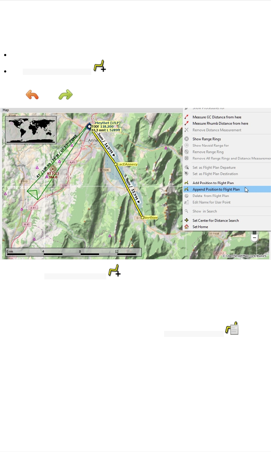
EnRouteWaypoints
Weaddthewaypointsnow:
ScrollalongthevalleytothesoutheastacrossthelakeLacd'Annecy.
Click AppendPositiontoFlightPlan .Theclickedpositionwillbeaddedasanuser-definedwaypointtothe
endofyourplan.
Clickundo orredo ifyoudon'tlikewhatyoujustadded.
Anotherfunctionis AddPositiontoFlightPlan whichwillinserttheclickedpositiontothenearestflightplanleg.
Youcanusethistoadduser-definedpositions,airportsornavaidsinthemiddleofaflightplan.Thenearestlegwill
bechosenautomaticallybyLittleNavmap.
LittleNavmapwillautomaticallyassignnamestotheuser-definedwaypoints.Youcanleavetheseastheyareor
replacethemwithamoremeaningfulname.
Tochangeawaypointnameright-clickontheuserwaypointandselect EditNameofUserWaypoint .Usenearby
villages,mountains,lakesorotherpointsofinterest.
Theflightsimulatorlimitsthenametoacertainlengthandtocertaincharacters.Nothingwillbeaddedtothenameifit
istoolongorifyoutypethewrongcharacters.
Tutorial-BuildingaVFRFlightPlan
148
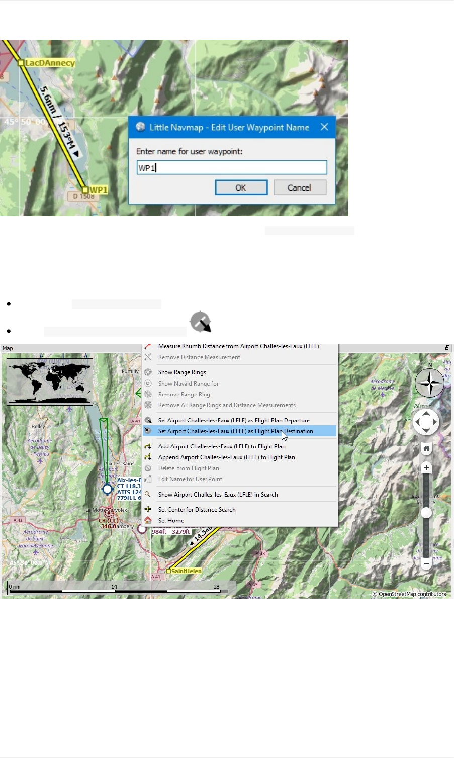
Keepaddingpointsandstayawayfromthemountainsuntilyou'reat Challes-les-Eaux(LFLE).
DestinationAirport
Toaddthedestination:
Right-clickon Challes-les-Eaux(LFLE)
Select SetAirportasFlightPlanDestination .
Nowthereisaflightplan.Yoursmightlookabitdifferent.
Tutorial-BuildingaVFRFlightPlan
149
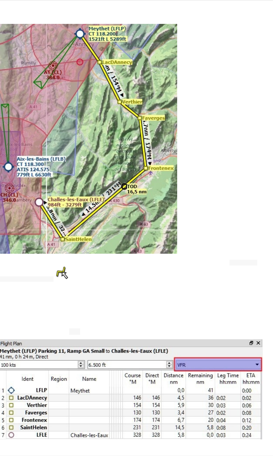
Youcanalsousethedraganddropfeaturetomovepointsoraddnewones.Enableitbychecking FlightPlan->
EditFlightPlanonMap andclickonaflightplanwaypointtomoveit.Clickonaflightplanlegtoaddanew
waypointintothisleg.
SeeMapFlightPlanEditingformoreinformation.
CruiseAltitude
Changetheflightplantypeto VFRifnotalreadydone.
Tutorial-BuildingaVFRFlightPlan
150
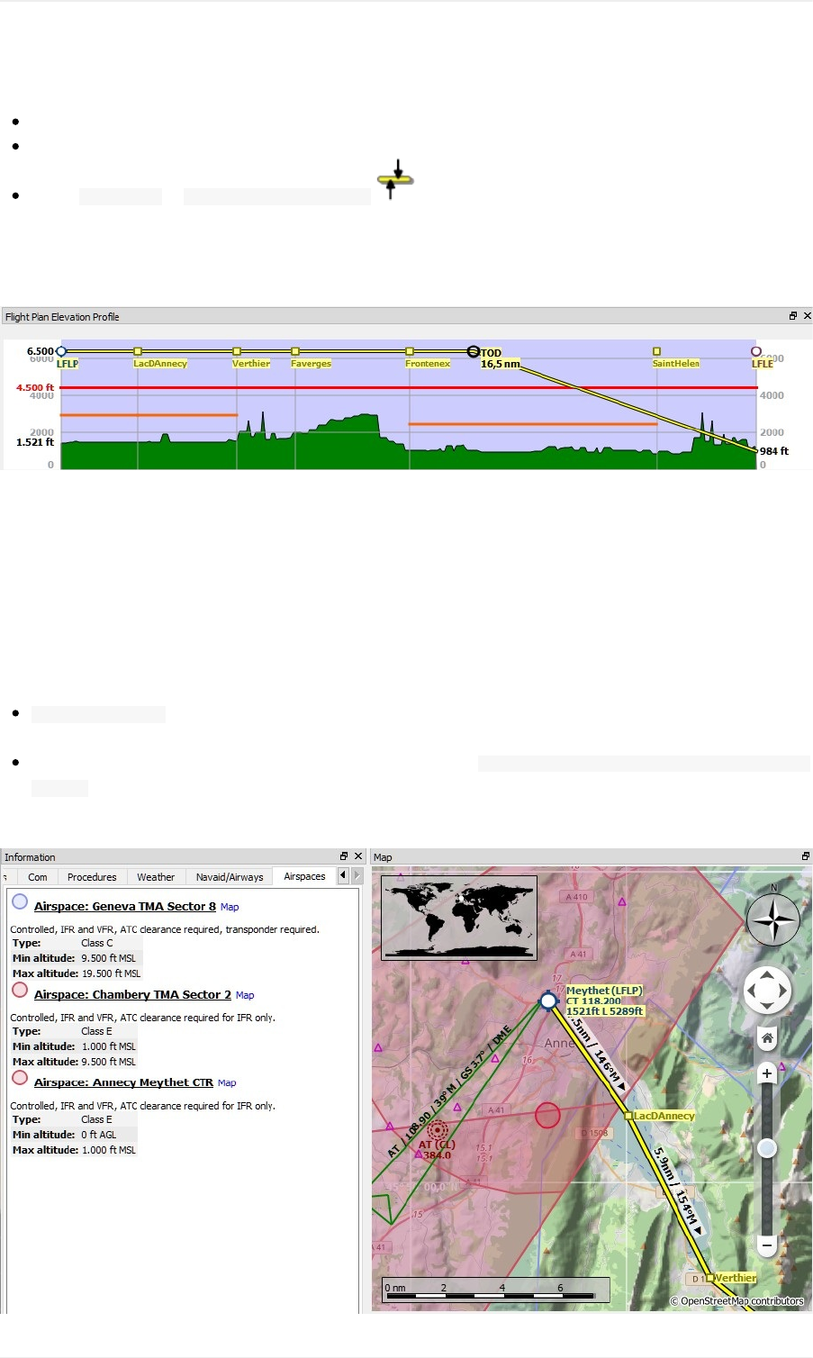
Nowcheckthecruisealtitude:
Lookattheflightplanelevationprofile.Thereisaredlineindicatingtheminimumsafealtitude.
Adjusttheflightplancruisealtitudeuntilyou'reabovetheredline.
Select FlightPlan-> AdjustFlightPlanAltitude togetthecorrectaltitudeadjustedbythehemispherical
rule.
NotethatthedefaulthemisphericalruleisnotcorrectforFranceuntilyouchangeitintheoptionsdialog,butI'llavoid
thisforthesakeofsimplicitynow.
Youprobablynoticedthatyouwillgetclosetogroundnearthedestination.Bepreparedtocircumventsome
mountainsthere.
Airspaces
Nowlookifyourflightplantouchesanyairspaces.
Clickintooneoftheairspacesnearbystartanddestinationandhavealookattheinformationdockwindow.Thereare
severalairspaces:
GenevaTMASector8whichstartsat9,500feetabovemeansealevel(MSL).Thisishigherthanourcruisealtitude
andwon'taffectus.
TwoClassEairspaces.Theinformationwindownotesforthese: Controlled,IFRandVFR,ATCclearancerequiredfor
IFRonly.NoproblembecausewewillflyusingVFR.
Thesituationissimilaratthedestination.
Tutorial-BuildingaVFRFlightPlan
151
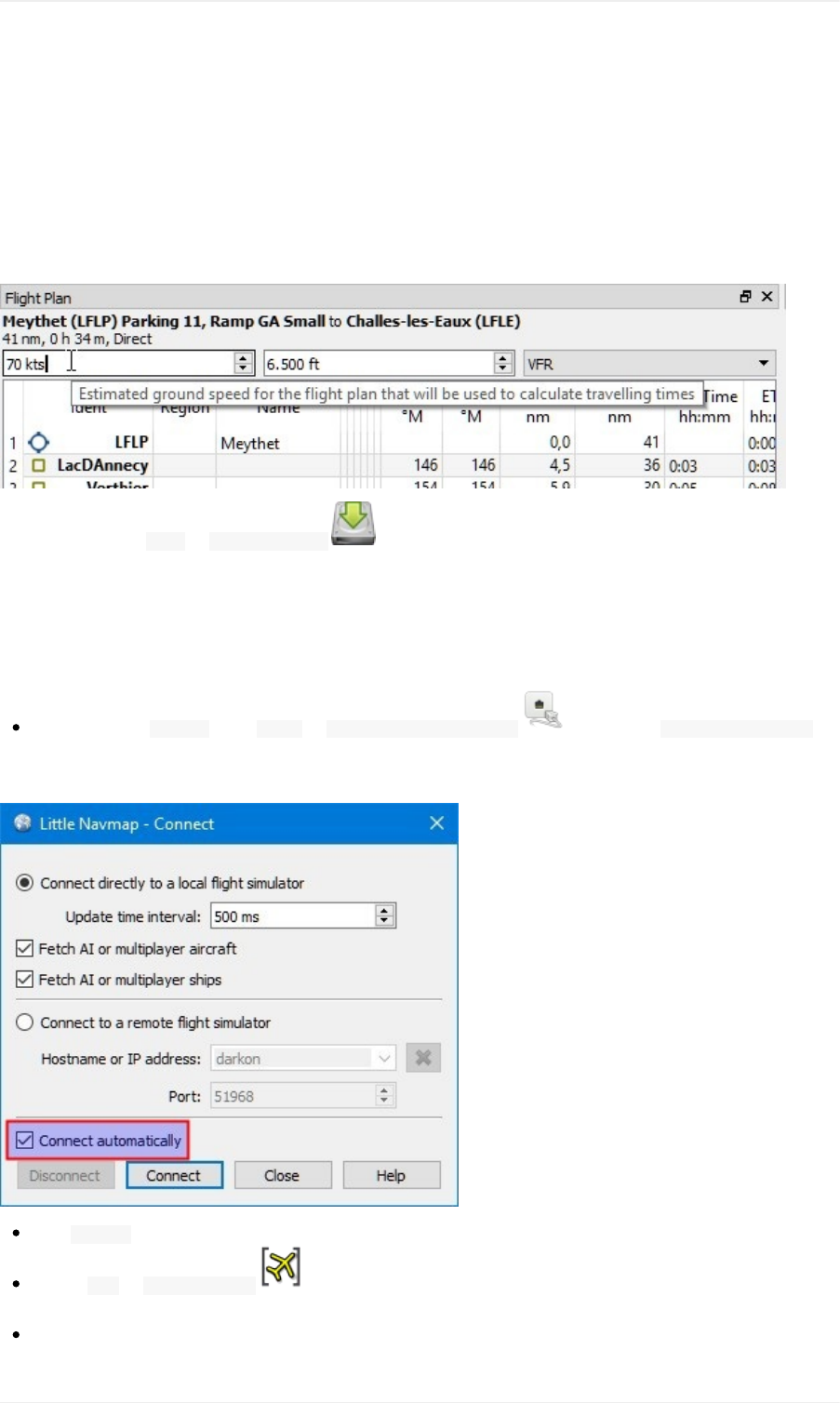
Groundspeed
Nowadjustthespeedtoyourexpectedgroundspeed.Thisallowstheprogramtoestimateflyingtimeforthewhole
planandforthelegs.
ThespeedissavedasanannotationinthePLNfile.SowhenyouloadtheplanintoLittleNavmapitwillrestorethe
givenspeed.Thespeedvaluehasnoeffectinthesimulator.
Notethattheplanisstaticandwillnotchangeduringflight.
Savetheplanusing File-> SaveFlightPlan .Theprogramusuallyfindstherightdirectoryfortheflightplans
andgivesasensiblenamebydefault.
Flying
FollowthestepsbelowtogetamovingmapandseeyouraircraftinLittleNavmap:
Openthedialog Connectusing Tools-> FlightSimulatorConnection andcheckif Connectautomaticallyis
selected.Enableitifnot.LittleNavmapwillfindthesimulatornomatterifitisalreadystartedorwillbestarted
later.
Click Connectwhichwillclosethedialog.
Enable Map-> CenterAircraft .Themapwilljumptothesimulatoraircraftandkeepitcenteredifan
activeflightisloaded,i.e.thesimulatorisnotintheopeningscreen.
Startthesimulatorifnotalreadydone,loadtheflightplanandgoflying.
Tutorial-BuildingaVFRFlightPlan
152

SeealsoConnectingtoaFlightSimulator.
LookingatPlaceswhileFlying
Theprogramwillstopfollowingyouraircraftifyoustartanyactionthatzoomsintoanairportornavaid(double-click,
toolbarbuttonorlinkintheinformationwindow):
Double-clickonthedestinationairportforexampletozoomtotheairportdiagram.
Whendoneclickthebackbutton untilyouarebackatyouraircraft.
Thenenable Map-> CenterAircraft againtokeeptheaircraftcentered.
Tutorial-BuildingaVFRFlightPlan
153

BuildinganIFRFlightPlanwithApproachProcedures
ThistutorialwillshowyouhowtocreateamorecomplexIFRflightplanincludingapproachprocedures.Itintroduces
theadvancedairportsearchfunctionalityandtheautomaticflightplancalculation.
Whilethistutoriallooksquitelengthyitisnormallyamatterofhalfaminutetogetaflightplanifyouknowwhereto
go.Theplanningeffortshownhereisbiggertohighlightsomeofthemoreadvancedfeaturesoftheprogram.
YoushouldatleastreadthroughtheVFRtutorialBuildingaVFRFlightPlan.
TheflightplanwillgoacrosstheUKusinganIFRcapableaircraft.Itsmaximumrangeshouldbemorethan600
nauticalmilesincludingreservesandacruisealtitudeof10,000feet.
Iwillnotgointodetailedfuelplanningproceduresinthistutorial.Thatisanotherstoryforanothertime.
Thetutorialassumesthefollowingpreconditions:
Youleftyouraircraftat Bembridge(EGHJ)attheendofthelastflightortreatthisasyouhomebase.
Youdon'tknowwhereyouwanttoflytoday.
Youknowtherequirementsforyouraircraft:
Range
Minimumrunwaylength
Hardrunways
Needaparkingspotatthedestination
Fuelforflyingback
CleanupSearch
Gotothedockwindow Searchandfollowthestepsbelow:
Right-clickintotheresulttableandselect ResetSearch togetridofallsearchcriteriathatmayaffectthe
query.
Clickthemenubutton andmakesurethatthesearchgroups Facilities, Runway, Parkingand Distance
fromMarkarechecked.Deselectallothersyoudon'tneed.
Tutorial-BuildinganIFRFlightPlanwithApproachProcedures
154
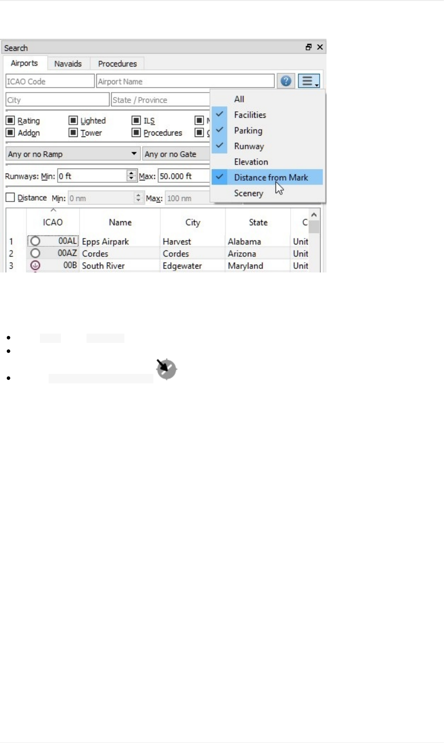
AssignDeparture
Nowlookforthedepartureairport:
Enter EGHJinthe ICAOCodesearchfieldonthetopleft(casedoesnotmatter).
Right-clickontheairportintheresulttable.
Choose SetasFlightPlanDeparture .Thiswillassignadefaultrunwayasastartposition.
Tutorial-BuildinganIFRFlightPlanwithApproachProcedures
155
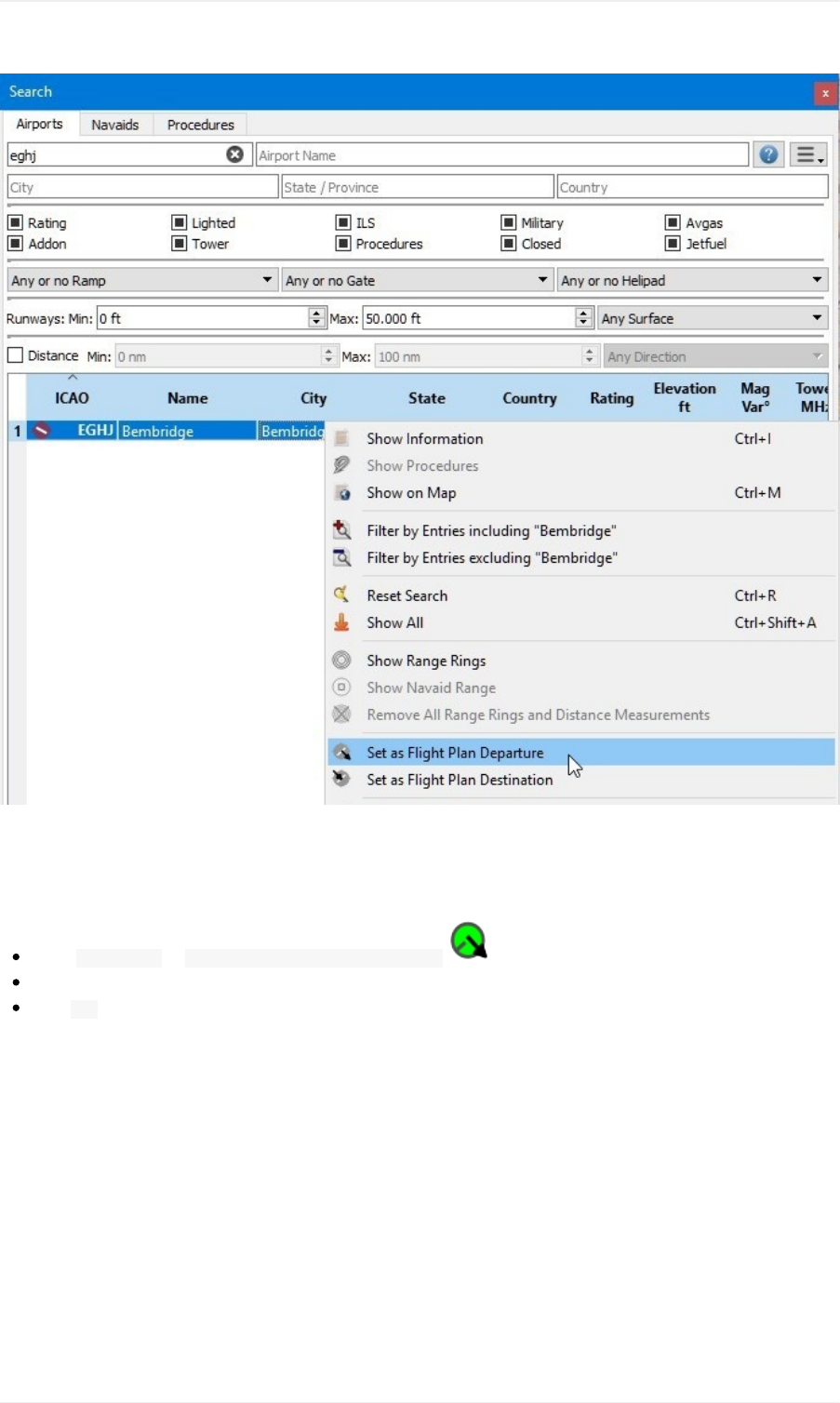
Yourflightplanhasoneentrynow.Thisisalreadysufficientifyouwanttoflyapatternandliketoseedistance,speed
andtimeinformationtotheairport.
Startingfromarunwayisnotquiterealistic.Let'sselectaparkingposition:
Goto FlightPlan-> SelectaStartPositionforDeparture .
ChooseoneoftheGAsmallramppositions.
Click Okandthepositionwillbehighlightedonthemap.
Tutorial-BuildinganIFRFlightPlanwithApproachProcedures
156
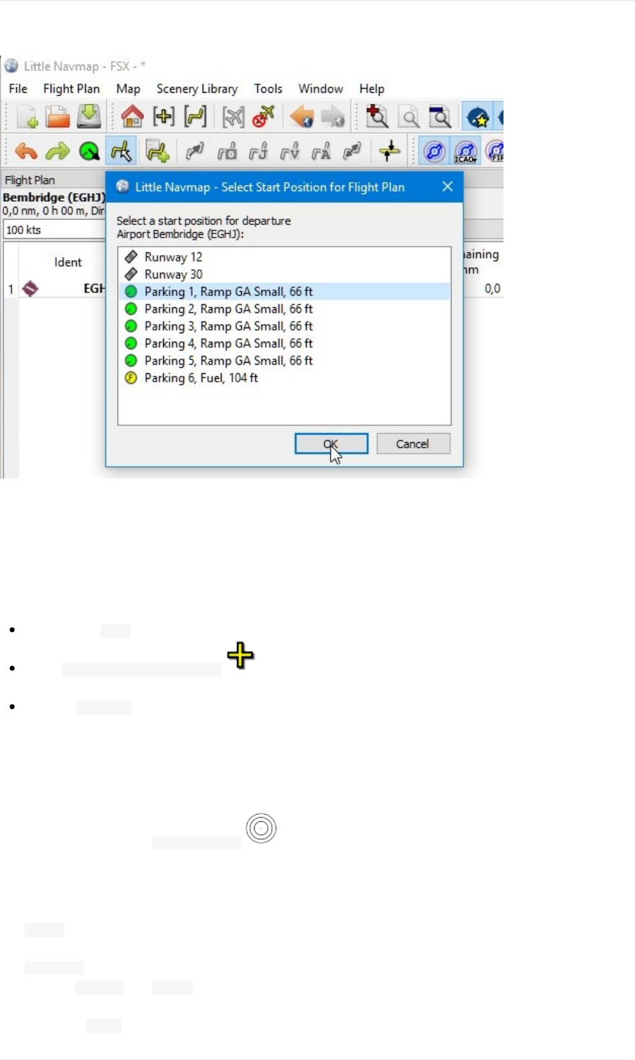
Alternativelyyoucanalsoselectthestartpositiondirectlyonthemap'scontextmenuasdescribedintheVFRtutorial.
SeealsoSetasFlightPlanDeparture
SearchforDestination
Nowlookforasuitabledestinationairport:
Right-clickon EGHJinthesearchresultagain.
Select SetCenterforDistanceSearch .Youcanalsodothisinthemap.Thisisthecenterpointforthe
spatialsearch.
Clearthe ICAOCodesearchfieldnow(itisacommonmistaketoleavethetextfieldsfilledwhendoingdistance
searcheswhichwillgiveyouanemptyresulttable).
Wewillnowlookforairportsthatareinrangeoftheaircraftbutnottooclose.Also,certaincriteriahavetobefulfilled,
likehavingparkingspotsthatfittheaircraftandarunwaywhichislongenough.
Youcanalsofindairportsinaircraftrangebyusingtherangeringswhereyoucanright-clickintothemaponyour
departureairportandselect ShowRangeRings ,althoughthisfunctiondoesnotallowthedetailedairportfilters.
Wewillusethespatialsearchinsteadofrangeringssincewe'dliketoseeonlysuitableairportsforoutaircraft.
Checkthefollowingintheairportsearchtab:
1. Rating:We'dliketogetairportsthatareeitheradd-onsorhavebasicsceneryrequirements,liketaxiways,
parkingspotsandmore.Everythingelseisboring.
2. Procedures:Showonlyairportsthathaveprocedurestospiceuptheapproachabit.
3. Deselect Militaryand Closed(clickthecheckboxestwice):Thiswillreturnonlycivilianairportsandavoid
airportsthathaveallrunwaysclosed.
4. Alsocheck Avgassowecanfillupforourreturntripanddon'thavebegforfuelatanearbyroad.
Tutorial-BuildinganIFRFlightPlanwithApproachProcedures
157
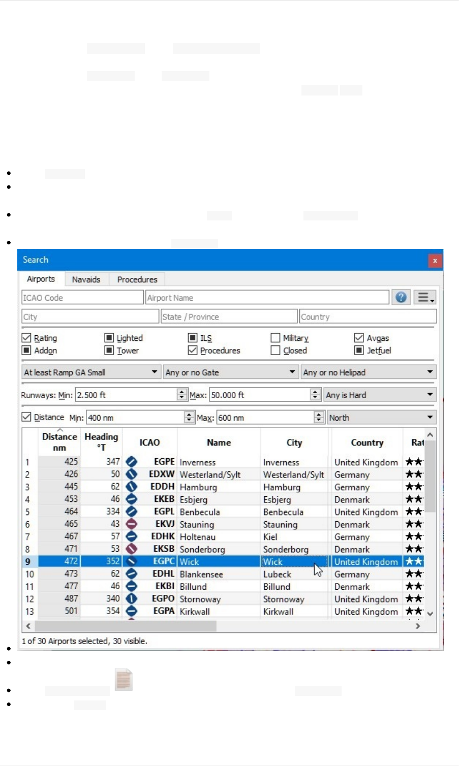
5. Inthecombobox AnyornoRampselect AtleastRampGAsmall.Thiswillincludeonlyairportsintheresultthat
havesuitableparkingspots.
6. Inthecombobox AnySurfaceselect AnyisHardtoavoidairportshavingonlysoftsurfacedrunways.
7. Selectaminimumrunwaylengthof2,500feetforyouraircraftinthefield Runways:Min:.
SeealsoSearchDockWindow-AirportsandNavaids.
Youcanalsolimitthemaximumrunwaylengthifyouarelookingforashortlandingchallenge,butnotnow.
Thesearchresultchangesontheflywhiledoingalltheseadjustments,thoughwearenotthereyet:
Check Distance:toactivatethespatialsearch.
Changethemaximumdistanceto600andtheminimumto400nauticalmiles(toavoidshorthops).Theresult
tablewillnowupdatewithasmalldelaysincethedistancesearchismorecomplex.
Tofindonlyairportsnorthofyourpositionselect Northinthecombobox AnyDirection.Notethatthesearch
resultissortedbydistancewiththeclosestairportfirst.
Chooseanairportforyourtrip.Weuse Wick(EGPC)forthistutorial.
Right-clickonWickintheresulttable.
Select ShowInformation .Thiswillfillthetabsinthedockwindow Information.
Selectthetab Weatherandlookforthewinddirectiontogetanideaoftheexpectedlandingrunway.StartAS16
orActiveSkyNextifyouareusingthese.
Forthistutorialweassumethatthewindsfavorrunway13.
Tutorial-BuildinganIFRFlightPlanwithApproachProcedures
158
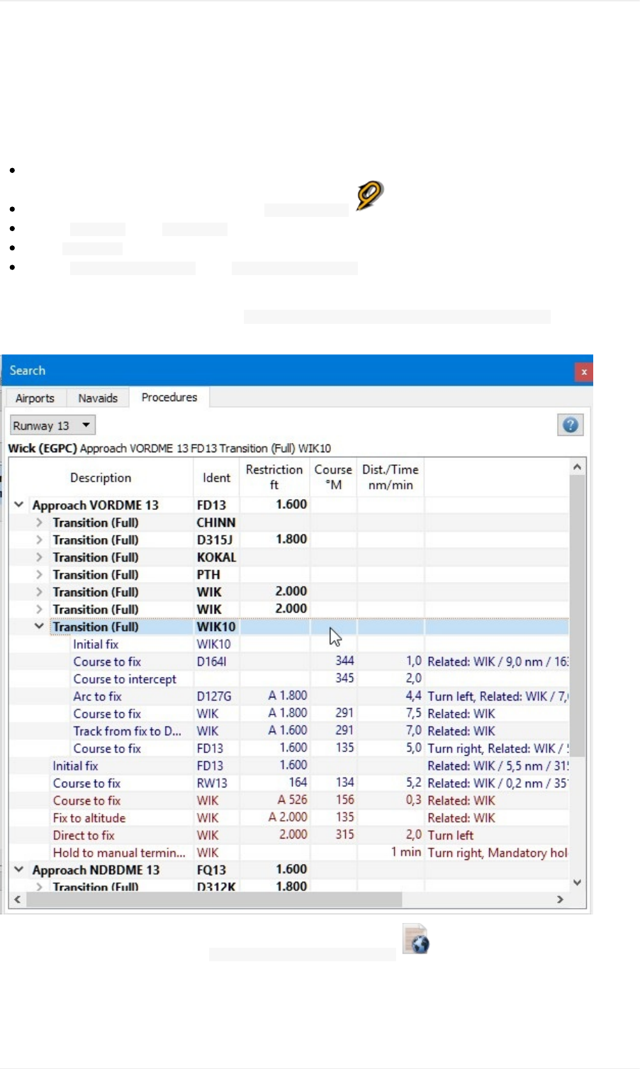
SeealsoWeather.
SelectanApproachProcedure
We'llselectanapproachprocedurenow:
Gobacktothesearchresult.
Right-clickontheairportWickagain.Select ShowProcedures .Thiswillpopuptheproceduresearchtab.
Choose Runway13inthe AllRunwayscomboboxtoseeonlyapproachesfor13.
Select ExpandAllinthecontextmenutoseealsothetransitionsforeachapproach.
Choose ApproachVORDME13FD13using Transition(Full)WIK10sinceweexpecttolandonrunway13andarrive
fromsouth.
Thetoplabelintheproceduresearchshows Wick(EGPC)ApproachVORDME13FD13Transition(Full)WIK10fortheselected
approachand/ortransition.Youcanalsoseeapreviewonthemap.
Right-clickonthetransitionandselect ShowApproachandTransitiononMap .Thiswillcentertheprocedureonthe
map.Youcanhoverthemouseoverthewaypointsoftheapproachtoseemoreinformationinatooltip.Youcanalso
clickonthelegsintheproceduretreetoseetherespectivestartandendpoints.
Tutorial-BuildinganIFRFlightPlanwithApproachProcedures
159
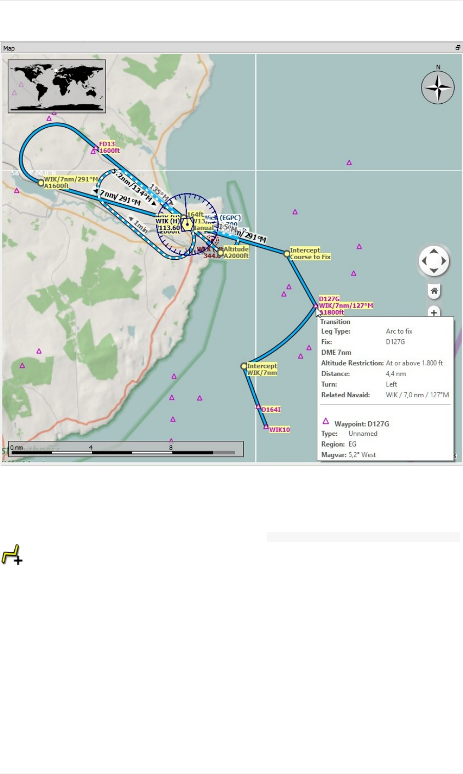
Theprocedurelookssufficientlycomplicatedtomakeaninterestingapproach.
Moreinformationonproceduresearch:SearchDockWindow-Procedures.AlsoseeProceduresforgeneral
informationonprocedures.
Ifyoulikewhatyouseeright-clickagainonthetransitionandselect UseEGPCandApproachandTransitionasDestination
.
Thiswilldotwothings:
1. AddWickasthedestinationairporttotheflightplan.Anypreviousdestinationintheflightplanwillbereplaced.
2. Addtheapproachanditstransitiontotheflightplan.Theprocedurelegsuseadarkbluecolorandthemissed
approachlegsuseadarkredcolorintheflightplantable.Flightplanenroutelegsareblack.Again,anyprevious
procedureisreplacedwiththisnewone.
Aboutaddingtransitionandapproaches:Approachesandtransitionsarecloselyrelatedwhichisalreadyindicated
bythetreestructureintheproceduresearchtab.Youcanaddanapproachalonebutatransitionalwaysbelongsto
anapproach.
Youhavetoselectthetransitiontoaddorshowboth,approachandtransition.
CalculateaFlightPlan
Tutorial-BuildinganIFRFlightPlanwithApproachProcedures
160
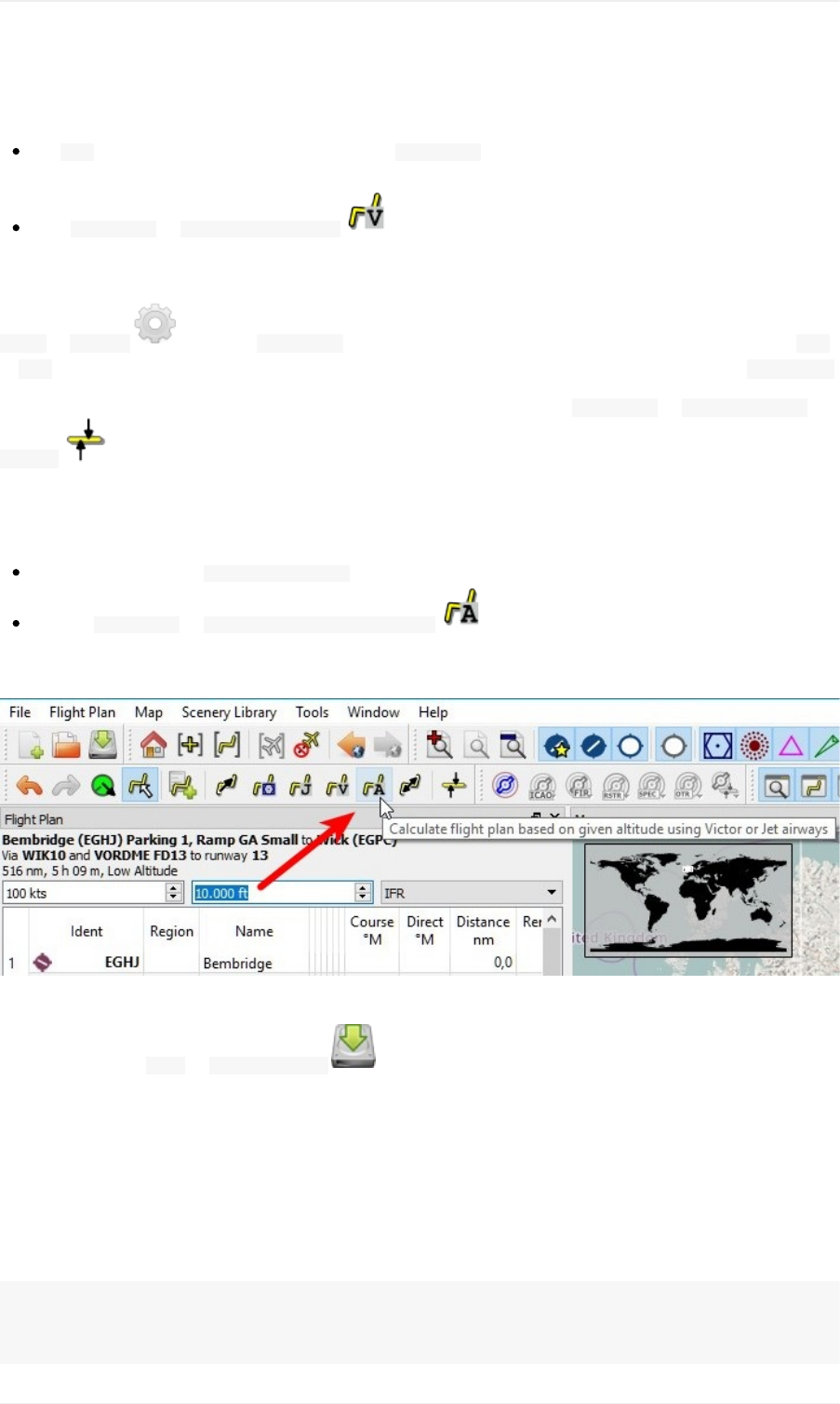
Nowwehavethedepartureairport,anapproachprocedureandthedestinationallconnectedbyaline.Nextistheen
routepartoftheflightplan:
Set IFRastheflightplantypeinthedockwindow FlightPlan.Thisallowstheautomaticflightplancalculation
toadjustthecruisealtitude.
Click FlightPlan-> CalculatelowAltitude tostarttheautomaticflightplancalculationforVictorairways.
Thecalculationwillcreatearoutefromyourdepartureairporttotheintialfixofthetransition.
Theflightplancruisealtitudeisautomaticallyadjustedaccordingtothehemisphericalrule(therulecanbechangedin
Tools-> Options onthetab FlightPlan),thealtituderestrictionsoftheairwaysandtheflightplantype( VFR
or IFR).Youcanseetheminimumaltitudeforeachairwaysegmentintheflightplantableinthecolumn Restriction.
Thealtitudecanalsobeadjustedaccordingtothehemisphericalrulebyclicking FlightPlan-> AdjustFlightPlan
Altitude .
Nowtheminimumaltitudeof16,000feetisabittoohigh.
Therefore,tryanalternatecalculationmethodwhichlimitsyourcruisealtitude:
Enter10,000feetinthe Flightplanaltitudefield.
Clickon FlightPlan-> CalculatebasedongivenAltitude .Thiswillresultinaflightplanthatusesonly
airwayshavingaminimumaltitudebeloworequalto10,000feet.NotethatyoucangetamixofVictorandJet
airwaysdependingonusedaltitude.Thecalculationmightalsofailifyousetthecruisealtitudetoolow.
Usethisflightplanfornow.
Savetheplanusing File-> SaveFlightPlan .Theprogramusuallyfindstherightdirectoryfortheflightplans
andgivesasensiblenamebydefault.
Thewaypointsoftheapproachprocedurearenotsavedintheflightplan.Youhavetoselecttheapproachinyour
GPSorFMCinthesimulatororflyitbyradionavaidsandastopwatch.
WhatLittleNavmapsavesinthePLNaretheprocedurenameswhichallowstheprogramtorestoretheapproach
whenloadingthePLNfile.
Thetoplabelintheflightplandockwindowreadsnow:
Bembridge(EGHJ)Parking1,RampGASmalltoWick(EGPC)
ViaWIK10andVORDMEFD13torunway13
517nm,5h10m,LowAltitude
Tutorial-BuildinganIFRFlightPlanwithApproachProcedures
161
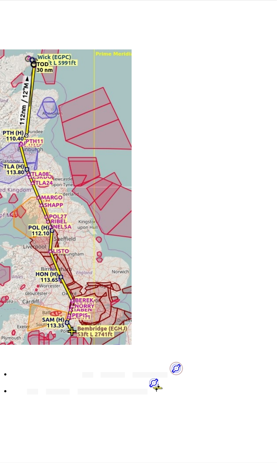
Adjustthegroundspeedintheflightplandockwindowaccordingtotheusedaircrafttogetabettertimeestimate.
Theplanmightlookdifferent,dependingifyouusestocknavaidsornavdataupdates.
Nowyoucancheckifyoupassthroughanyairspaces:
Enableairspacesbyselecting Map-> Airspaces-> ShowAirspaces ifnotalreadydone.
Check Map-> Airspaces-> Atflightplancruisealtitude inthemenuorthetoolbarmenubutton.
Tutorial-BuildinganIFRFlightPlanwithApproachProcedures
162
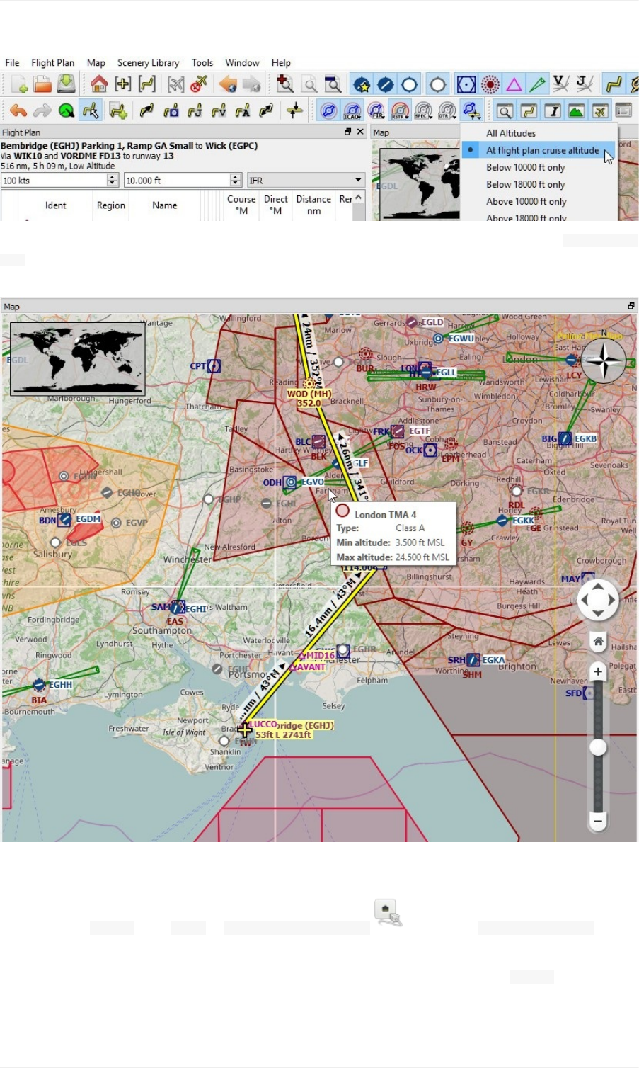
Thiswilldisplayonlyairspacesonthemapthatarerelevantforyourcruisealtitude.Youcanalsoselect Below10000ft
onlytoseeallrelevantairspacesintheclimbordescentphase.Usethetooltipsonthemaptogetinformationabout
airspacesliketype,minimumandmaximumaltitude.
Flying
Openthedialog Connectusing Tools-> FlightSimulatorConnection andcheckif Connectautomaticallyis
selected.Enable,ifnot.
LitteNavmapwillfindthesimulatornomatterifitisalreadystartedorifitisstartedlater.Click Connect.
SeealsoConnectingtoaFlightSimulator.
Tutorial-BuildinganIFRFlightPlanwithApproachProcedures
163
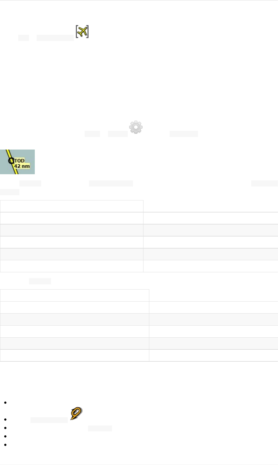
Enable Map-> CenterAircraft .Themapwilljumptothesimulatoraircraftandkeepitcentered.Thiswill
happenonlyifanactiveflightisloaded,i.e.thesimulatorisnotintheopeningscreen.
Startthesimulatorifnotalreadydone,loadtheflightplanandgoflying.
TopofDescent
Atopofdescentindicationisdisplayedonthemapandintheelevationprofilewhichalsoshowsthedistancefromtop
ofdescenttothedestination.Thisnumberincludesthedistanceofapproachprocedures(excludingholds).
Notethataltituderestrictionsarenotconsideredyetinthetopofdescentcalculation.
Youcanchangethedescentrulein Tools-> Options onthetab FlightPlan.Thedefaultis3nauticalmiles
for1,000feet.
Thetab Progressinthedockwindow SimulatorAircraftwillshowthedistancetothetopofdescentinthe FlightPlan
Progresssection:
FlightPlanProgress
ToDestination: 74nm
TimeandDate: 21.05.1712:33UTC
LocalTime: 14:33CEST
TODtoDestination: 64nm
ToTopofDescent: 10,1nm
Thesection Altitudewillshowtheverticalpathdeviationafterpassingthetopofdescent:
Altitude
Indicated: 5,090ft
Actual: 5,051ft
AboveGround: 5,051ft
GroundElevation: 0ft
VerticalPathDev.: -511ftbelow▲
ChangingProcedures
Nowtheweatherhaschangedrequiringanapproachtorunway31:
Right-clickonthedestinationairportatthebottomoftheflightplantable.
Choose ShowProcedures .
Thenchangetherunwayfilterto Runway31.
ExpandtheapproachVORDME31toseethetransition.
Selectthetransition.
Tutorial-BuildinganIFRFlightPlanwithApproachProcedures
164

Thelabelontopofthewindowshowsnow ApproachVORDME31FD31Transition(Full)CHINN.
Right-clickontheselectedtransition.
Choose UseEGPCandApproachandTransitionasDestination fromthecontextmenuwhichwillreplacethe
currentprocedureinyourflightplanwiththenewone.
Thetoplabelintheflightplandockwindowreadsnow:
Bembridge(EGHJ)Parking1,RampGASmalltoWick(EGPC)
ViaCHINNandVORDMEFD31torunway31
526nm,5h15m,LowAltitude
Tocompletelygetridofaprocedure:
Selectanylegoftheprocedureintheflightplantable.
Right-clickandchoose DeleteselectedLegorProcedure toremovethewholeprocedure.Alternativelypress
the Delkey.
IfATCclearsyoutotheinitialfixoftheprocedure:
1. Deleteanyintermediatewaypointsbetweenyourcurrentaircraftpositionandtheinitialfixoftheprocedure:Right-
clickintheflightplantableandselect DeleteselectedLegorProcedure forallwaypointsbetweenyour
currentaircraftpositionandtheinitialfixorstartoftheprocedure.Avoiddeletingyourapproach(youcanalso
right-clickonaflightplanwaypointonthemapanddeleteitfromthecontextmenu).
2. Thenright-clickonyouraircraftonthemapandselect AddPositiontoFlightPlan .
Thiswillgiveadirectconnectionfromyourcurrentaircraftpositiontothestartoftheprocedurewhichyoucanuseto
getcourseanddistancetotheintialfix.
Below:Afterchangingtheapproachprocedureandaddingauser-definedwaypointattheaircraftpositiontotheflight
plan.Nowwegetcourseandaltitudeindicationsforadirectlegtothestartofthetransition(43nmand314degrees
magneticcourse).
Tutorial-BuildinganIFRFlightPlanwithApproachProcedures
165
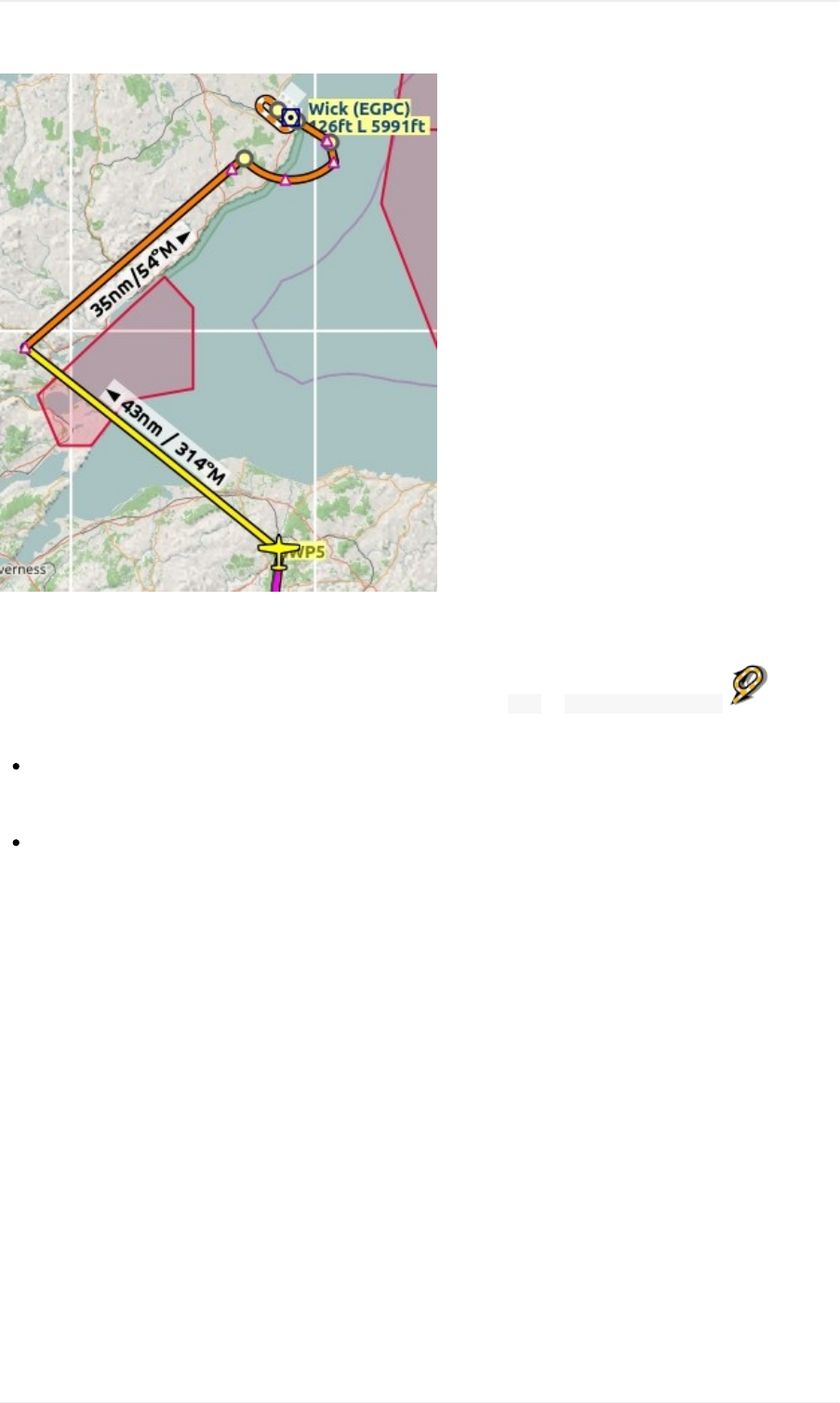
GoingMissed
Irecommendhidingthemissedapproachesonthemapbyunchecking Map-> ShowMissedApproaches .This
helpsunclutteringthemapdisplay.
Ifthemissedapproachisnotshown:Theprogresswindowshowsdistanceandtimetodestination.Activating
thenextleg(showninmagentacolor)willstopifthedestination(i.e.therunwaythreshold)isreached,evenwhen
passingthethreshold.
Ifthemissedisshownandtheaircraftpassestherunwaythreshold:Thefirstlegofthemissedapproachis
activatedandsimulatoraircraftprogresswilldisplaytheremainingdistancetotheendofthemissedprocedure.
Tutorial-BuildinganIFRFlightPlanwithApproachProcedures
166
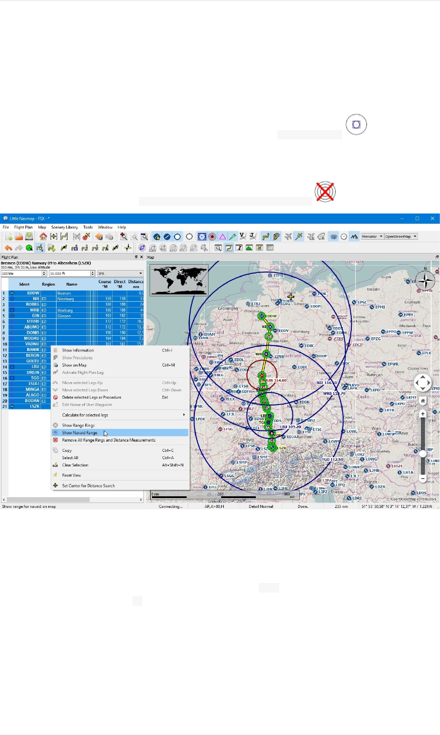
TipsandTricks
ShowallNavaidRangesofaFlightPlan
Selectalllegsintheflightplantable,thenright-clickonanylegandselect ShowNavaidRange .Thiswillplacea
rangeringaroundeveryradionavaidintheflightplan.
SeealsoShowNavaidrange.
Removetherangeringsbyselecting RemoveallRangeRingsandDistanceMeasurements .
UsethemeasurementlinestogetaVORRadialIntersection
Measurmentlinescanstartatairportsornavaidswheretheyusethemagneticvariationifavailable.Youcanuse
themtofindanairportbyradialanddistanceifyouliketonavigatetheoldfashionedway.
BelowisanexamplethatgetsradialanddistancefromtwoVORsfor ETUO.Measurementlinescanalsostartat
NDBsorwaypoints.Notethesuffix Mwhichindicatesmagneticcourse.
SeealsoMeasureGCDistancefromhereandMeasureRhumbDistancefromhere.
TipsandTricks
167
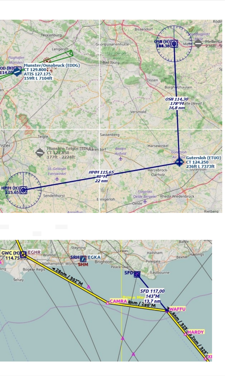
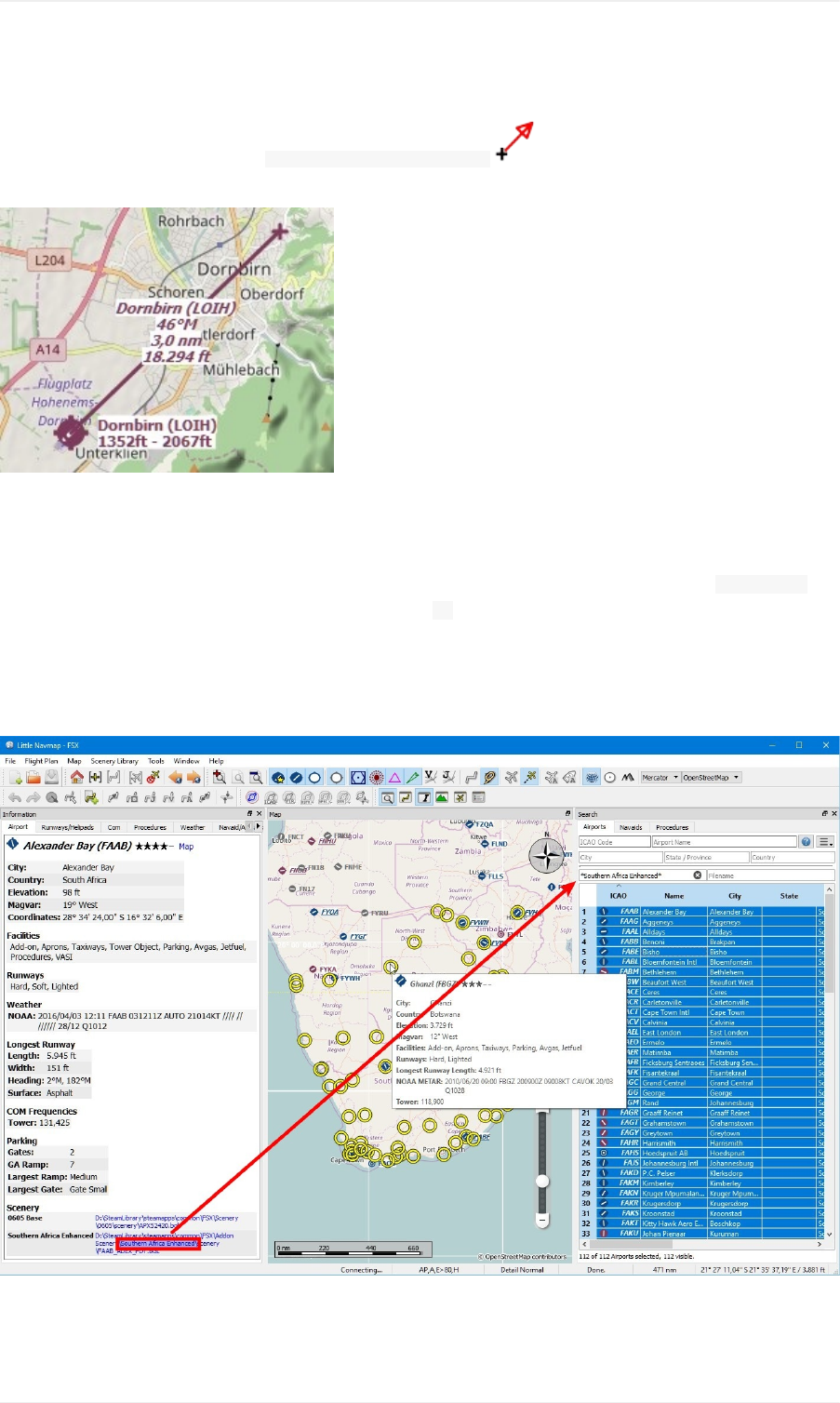
UsethemeasurmentlinesforApproachGuidance
Right-clickontheairportandchoose MeasureRhumbDistancefromhere .Pullthelineusingtheopposingcourseto
3nauticalmilesouttogetguidanceforthefinalapproach.
SearchforAdd-OnAirports
Youcanusethescenerypathtolookforadd-onairportsofacertaindeveloper.Clickononeoftheadd-onairports
andcopytherelevantpartofthepathfromtheinformationwindow.Insertthispathfragmentintothe SceneryPath
inputfieldintheairportstabofthesearchdockwindow.Add *atthebeginningandattheendsinceitisonlypartof
apath.
SeealsoTextFilters.
Selectallintheresulttabletogetallairportshighlightedonthemap.
UsetheSearchFunctiontoplanaRoundtheWorldTrip
Thespatialsearchfunctionisusefultoplanaroundtheworldtour.Assumeyou'dliketogoeast:
TipsandTricks
169
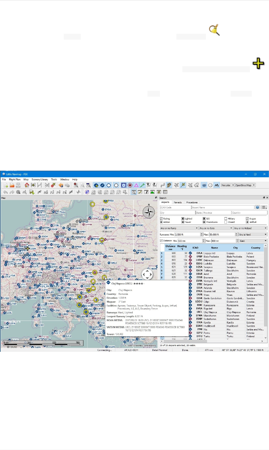
1. Gotothedockwindow Search,right-clickintotheresulttableandselect ResetSearch togetridofall
searchcriteriathatmayaffectthequery.
2. Setyourdepartureairport.
3. Right-clickonyourdepartureairportinthesearchoronthemapandselect SetCenterforDistanceSearch .
Thisisthecenterpointforthespatialsearch.
4. Addanyadditionalcriteriainthesearchlikelightedrunways,procedures,fuel,minimumrunwaylengthandmore.
5. Adjusttheminimumandmaximumdistance,setdirectionto Eastandclickthecheckboxbefore Distance.
6. Selectallintheresulttabletoseetheairportsonthemap.
7. Chooseyournextdestinationairport.
8. Addasdestination.
9. Calculateplan.
10. Fly.
11. Backto2.untilyouaredonearoundtheworld.
Picturebelowshowsaqueryresultforairportsintheeast.Notethattheblack/yellowhighlightcircleshavetooltipstoo
nomatteriftheairportisvisibleornot.
TipsandTricks
170

TipsforoldandslowComputers
SaveCPUCycles
Dialog Options-> Map-> Detailswhilescrolling...:Use Normal...
Dialog Options-> SimulatorAircraft-> SimulatorAircraftscrollboxsize...:Useahighervaluetoreducemap
updates.
Closethewindow FlightPlanElevationProfile.Itwillstopallbackgroundprocessingwhenclosed.
Avoidairspaces.Switchthemoffusingthe buttonontheairspacestoolbar.
SwitchoffallAItrafficinthedialog Connect.Seehere.
Usethemapprojection Mercator.Itconsumeslessresourcessinceitcanusethedownloadedimagetilesasis
anddoesnottransformthemtothesphericalformat.
ReduceMemoryConsumption
Replacethecompletesection [Settings]inthe little_navmap.iniwiththesectionbelowtoreducecachesizes.
[Settings]
DatabaseCacheKb=5000
InfoQueryAirportCache=100
InfoQueryAirportSceneryCache=100
InfoQueryAirwayCache=100
InfoQueryApproachCache=100
InfoQueryComCache=100
InfoQueryHelipadCache=100
InfoQueryIlsCache=100
InfoQueryNdbCache=100
InfoQueryRunwayCache=100
InfoQueryRunwayEndCache=100
InfoQueryStartCache=100
InfoQueryTransitionCache=100
InfoQueryVorCache=100
InfoQueryWaypointCache=100
MapQueryAirspaceLineCache=100
MapQueryApronCache=100
MapQueryHelipadCache=100
MapQueryParkingCache=100
MapQueryRunwayCache=100
MapQueryRunwayOverwiewCache=100
MapQueryStartCache=100
MapQueryTaxipathCache=100
Troubleshoot
Programcrashesonstartup:Deletethesettingsandthedatabasefiles.InWindows7,8or10thesecanbe
foundin c:\Users\YOURUSERNAME\Appdata\Roaming\ABarthel.Delete(orbetter:renameormove)thefiles
little_navmap.ini, little_navmap.track, little_navmap.historyandthedirectory little_navmap_db.Trytodeletethe
databasefirstifthesecausetheproblem.Thentrytodeletethesettingsfilesifremovingdatabasesdidnothelp.
Programstartsslowly:Thiscanhappenifadistancesearchisenabledinoneofthesearchtabs.Thesearchis
executedateachstart.Simplydisablethedistancesearchorresetthesearchoptionstoavoidtheslowstartup.
Onlinemapsdonotloadorupdate:CheckyourfirewallsettingsifWindowsblocksanyoutgoingconnections.
Alsocheckiftheofflinemodewasnotenabledaccidentallyinmenu File.CheckifLittleNavmapcanconnectto
theinternetbygoingtotheoptionsdialogontab Weather.Useoneofthebuttons TestforNOAAorVATSIM
TipsforoldandslowComputers
171

weather.LittleNavmapcannotreachtheinternetifthesefail.
ZoomcanbetoofastwhenusingatouchpadwithOpenStreetMap,OpenTopoMaporoneoftheotheronline
mapthemes.Usethe Plain, Simpleor Atlasmapthemesorusetheoverlayzoombuttonsorthekeyboard( +
and -).
side-by-sideconfigurationerror:YouarerunningLittleNavmaponacomputerwithoutsimulator(i.e.no
SimConnect)installationifyougetthiserror.Use littlenavmap-nosimconnect.exeinsteadwhichprovidesall
functionalityexceptdirectconnectionandscenerydatabaseloading.Note: littlenavmap-nosimconnect.exeisnot
usedanymoreasofLittleNavmapversion1.4.4.Youcanuse littlenavmap.exeonallcomputersnomatter
ifSimConnectisinstalledornot.
Searchshowsnoresultorunexpectedresults:Checkthedropdownmenuforthechangeindicator *and
thesearchfieldsforanyremainingtextifthedistancesearchdoesnotgiveanyorunexpectedresults.Use Reset
Searchinthecontextmenuoftheresulttableorpress Ctrl+Rtoclearallsearchcriteria.
Searchorflightplantablesshowsstrangecolumnnameslike airport_idorothers:Thiscanhappenifthe
programisupdated.Use ResetViewinthecontextmenuoftheresulttable.
OnlinemapslikeOpenStreetMaporOpenTopoMapmapscanendupblurredwhenusingfunctionalitylike
CenterFlightPlanor GotoHome.Zoomonceinandoutusingthemousewheel,overlayzoombuttonsor
keyboardtofixthis.
Theflightplanelevationprofilehaserrorsorinvalidelevationdata:Theonlineelevationdatacontains
severalknownerrors.UsetherecommendedGLOBEofflineelevationdata.Seehereforinformationhowto
installtheofflinedata.
OpenStreetMapshowsadarkgraybackgroundonsomeplaceswithouthillshadingcoverage(forexample
NewZealand).UseanothermapthemeorswitchoffhillshadingfortheOpenStreetMap.
Loadingofthescenerydatabasetakestoolong:Excludescenerydirectoriescontainingonlylandclass,
elevationdataorotherforLittleNavmapirrelevantdata.Youcandothatinthe Optionsdialogonthe Scenery
LibraryDatabasetab.SeeOptions.
Crashwhileloadingthescenerylibrarydatabase:Youcanexcludescenerydirectoriesinthe Optionsdialog
onthe SceneryLibraryDatabasetabifloadingofanadd-onBGLcausestheprogramtocrash.Donotrestartthe
programafteritshowsthecrashdialogandinsteadloadthelogfilewhichistypically
C:\Users\YOURUSERNAME\AppData\Local\Temp\abarthel-little_navmap.log.ThepathmayvarydependingonyourWindows
installation.Searchforthelastlineinthelog-filethatlookslike:
[2016-10-1422:58:21.903defaultINFO]unknown:===="404of521(77%)""APX41080.bgl"
Nowsearchfor APX41080.bglandexcludeitsdirectoryfromloadinginthe Optionsdialog.
KnownProblems
Someairportadd-onsdonotmodifythestockairportsbutonlyaddnewsceneryandbuildings.Theseadd-ons
willnotberecognizedassuchandarethereforenothighlightedonthemap(italicandunderlinedtext).
Add-ondevelopershavetouseallkindofworkaroundstoavoidFSXorP3Dlimitationswhichmeansthedisplay
andinformationgivenforadd-onairportsisnotalwayscorrect.AlotofthesechangesarealsodonetomakeAI
behaveproperly.Typicalexamplesare:Airportswithoutrunways,airportswithrunwaydimensions0by0ftor0ft
runwaywidth,taxiwayswith0ftwidth,seeminglyclosedtaxiways,duplicateairports,duplicaterunwaysinwater,
taxiwaysinwater,militarygatesatcivilianairportsandmore.
Routedescriptionparsingcanskipwaypointsinrarecasesevenforpreviouslycalculatedflightplans.Thiscan
happenduetofragmentedairways,errorsinthesourcedataorambiguitiesbetweennavaids.
SomeKML/KMZfilesdonotshowuponthemap.AddingacenterpointpushpintotheKML/KMZfilecanfixthis.
CoverageforonlineelevationandOpenStreetMaphillshadingdataislimitedandcurrentlyendsat60degree
north.UsetheOpenTopoMap,OpenMapSurferorStamenTerrainmapthemeswhichhaveworldwidecoverage
forhillshading.
Thereareerrorsintheonlineelevationsourcedata(likeinnorthernItaly,PoValleyorLakeTiticacainPeruand
TipsforoldandslowComputers
172

Bolivia)whichwillshowupintheflightplanelevationprofile.
TheMercatorprojectionshowsoccasionaldisplayproblemsdependingonzoomdistancelikehorizontallines
neartheantimeridianormissingflightplansegments.
TheMarblefloatingmapoverlaysonthemapcanbeconfiguredbutdonotsaveallsettingsexcepttheirvisibility.
Flightplanandairwaysaredrawnusinggreatcirclelinesinsteadofrhumblines.Distanceandcoursearenot
affectedbythis.
Magneticvarianceispartiallynotset(forexampleVORDMECambridgeBayYCB)orinconsistentbetween
airportsanadjacentnavaids.Thisisanerrorinthesource.
Airportsaremisplaced(forexampleCaboSanLucas,MM15inMexico)comparedtothebackgroundmaps.This
isanerrorinthesourcedataandcannotbefixed.
Mapprintoutscanbefuzzysincetheydependonscreenresolution.Asaworkaroundincreasethesizeofthe
visiblemapwindow.
Verylongroutelegscandisappearfromthemapwhenzoomingin.Thelabelisstillvisiblethough.
Tooltipsoflargeairspacescanappearatwrongplaces.
ScrollingthemapcanbeveryslowforsomecomplexX-Planeairports.
Thewrongproceduresarerestoredsometimesiftheflightplanisreloadedwhenanairporthasmorethanone
procedurewiththesamename.
Proceduresaredrawnincorrectlyinsomecases.
Theairportsearchattribute Proceduresdoesnotworkcorrectlyinthemixeddatabase.Itwillshowonlysimulator
airportshavingproceduresinsteadofusingtheNavigraphairportstatus.
HowtoreportaBug
IfsomethinggoeswrongsendmeanyinvolvedfileslikeKML,PLNorBGL(ifcopyrightpermits),LittleNavmap'slog
fileandconfigurationfilewhichbothcanbelocatedintheaboutdialog.Mye-mailaddressesareshownintheabout
dialogofLittleNavmapaswell.
Addallnecessaryinformation:
Operatingsystem:
Windows:7,8or10
macOS:ElCapitan,SierraorHighSierra
Linux:whichdistributionandversion
Simulator:
X-Plane:10,11.05or11.10betaversion
FSX,FSXSE,P3DV4orV4.1
Addanyflightplansorotherfilesifinvolvedintheerror
Pleaseaddallstepsthatarenecessarytoreproducetheerror.
Ifpossiblesendmethelogfile.
Pleasecompresslogfilesusingziptoavoidstuffingmymailbox.
Whenanerroroccursduringloadingofthescenerylibrarysendmetheoffendingfileifsizepermits.Thefullname
andpathofthefileisshownontopoftheerrordialogifaspecificisthecause.
Ifyou'reconcernedaboutprivacywhensendinglogfiles:Thelogfileswillcontainallsystempaths(likeyour
Documentsdirectory)whichwillalsoincludeyourusernameasapartofthepath.Theymightalsocontainyour
computer'snameandIPaddressinyournetwork.
Iwouldsuggestyouremovethisinformationifyou'reconcernedaboutit.
TipsforoldandslowComputers
173

Innocasearefilenamesofanythingbuttheflightsimulatororitsconfigurationfilesincluded.Nonamesorcontents
ofpersonalfilesareincludedinthelogfiles.
Istronglyrecommendsendingthelogfilesbyprivateforummessageorbyemailandnotattachthemtoforumposts
wheretheyarepubliclyvisible.
TipsforoldandslowComputers
174

3D
X-Planeairportwhichcontainsatleastone3Dobject.Maybeafullyconstructedmajorairport.
Add-onairport
ThisisanairportthatwasfoundoutsidetheFlightSimulatordefaultsceneryfolderwhenloadingthedatabase.
ArrivalProcedure
Approach,transitionorSTARprocedure.
BGL
Abinaryfilewiththeextension BGLwhichispartofaflightsimulatorscenerycontainingairport,navaidorairway
information.Thesefilescanalsocontaintraffic,landclass,elevationorotherinformationwhichisnotrelevantforLittle
Navmap.
DAT
AtextfileformatusedbyX-Planetostoreairport,navaidandprocedureinformation.
DepartureProcedure
SIDprocedure.
CSV
Comma-separatedvaluestextfile.
DME
Distancemeasuringequipmentoraradionavaid.
Emptyairport
Anairportthathasnotaxiways,noparkingpositionsorgates,noapronsandisnotanadd-onairportandisnota
waterairport.
Fix
Thistermreferstoawaypoint,radionavaidorancalculatedpointonaprocedure.
Glossary
175

FLP
FlightplanformatusedbytheX-PlaneFMS,AerosoftAirbusandotheradd-onaircraft.
FMS
X-Planeflightplanformat.
FS9
FlightSimulator2004.
FSX
FlightSimulatorXorFlightSimulator-SteamEdition.
GIS
AgeographicalinformationsystemlikeGoogleEarthforexample.
InitialFix
Thisisthefirstfixofaprocedure.
Navaid
VOR,VORTAC,TACAN,NDBorwaypoint/intersection.
NDB
Nondirectionalbeacon-radionavaid.
P3D
Prepar3Dv2tov4.
Parking
GAramp,cargoramp,fuelboxorgate.
PLN
FSXandP3Dflightplanformat.Cansaveallinformationinflightplansusingannotations.
Glossary
176

Procedure
Approach,transition,SIDorSTAR.
Radionavaid
VOR,VORTAC,TACANorNDB.
Rating
Airportzerotofivestarratingdependingonfacilities.
SceneryLibraryDatabase
Thisisaninternaldatabase(SQLite)thatiscreatedbyLittleNavmapwhenreadingalltheflightsimulatorBGLorDAT
files.Itallowsfastcomplexsearchesandmapdisplay.
SID
Standardinstrumentdeparture.
SimConnect
Aprogramminginterfacethatallowsapplicationstoreadandwriteflightsimulatorparameters.
STAR
Standardterminalarrivalprocedure.Usuallyfollowedbyatransitionandanapproach.
Startposition
Usedfordepartureinflightplans.Eitherrunway,helipad,GAramp,cargoramp,fuelboxorgate.
TACAN
Tacticalairnavigationsystem-radionavaidusedbymilitaryaircraft.
VOR
VHFOmniDirectionalRadioRange-radionavaid.
VORDME
Glossary
177

VHFOmniDirectionalRadioRangewithdistancemeasuringequipment-radionavaid.
VORTAC
Co-locatedVHFomnidirectionalrange(VOR)beaconandtacticalairnavigationsystem(TACAN)beacon.
Userpoint
Auser-definedwaypointlikeabookmark,pointofinterestorvisualreportingpoint(VRP).
VRP
VisualreportingpointforVFRflights.Auserpointtype.
POI
Generalpointofinterest.Auserpointtype.
FlightPlanPosition
Auser-definedwaypointwhichispartoftheflightplan.
Glossary
178

License
Thisprogramisfreesoftware:youcanredistributeitand/ormodifyitunderthetermsoftheGNUGeneralPublic
LicenseaspublishedbytheFreeSoftwareFoundation,eitherversion3oftheLicense,or(atyouroption)anylater
version.
Thisprogramisdistributedinthehopethatitwillbeuseful,butWITHOUTANYWARRANTY;withouteventheimplied
warrantyofMERCHANTABILITYorFITNESSFORAPARTICULARPURPOSE.SeetheGNUGeneralPublic
Licenseformoredetails.
YoushouldhavereceivedacopyoftheGNUGeneralPublicLicensealongwiththisprogram.Ifnot,see
http://www.gnu.org/licenses.
License
179
