Runway_directory Runway Directory
runway-directory-sample runway-directory-sample
User Manual: runway_directory
Open the PDF directly: View PDF ![]() .
.
Page Count: 25
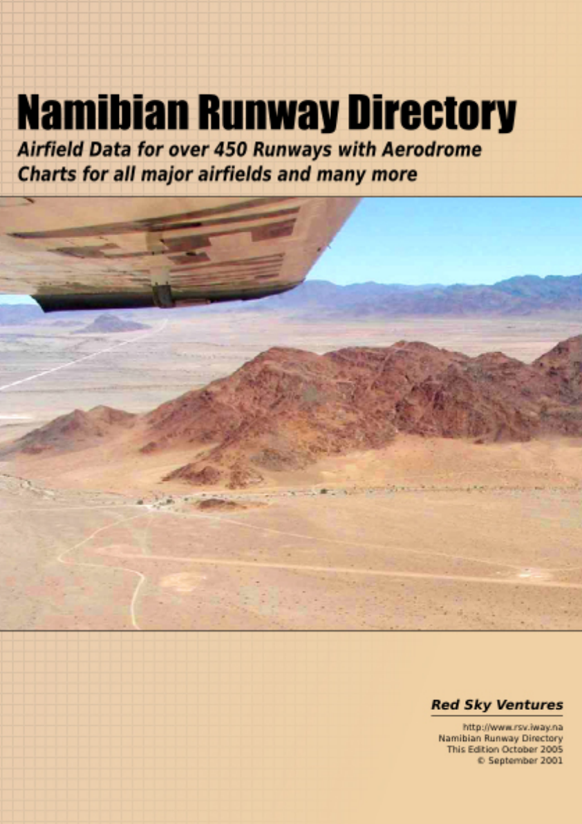
Namibian Airfield Directory
Second Edition August 2005
First Published November 2004
Published by Red Sky Ventures cc
Written by Oleg Roud
Maintained by Red Sky Ventures, 1618 Designs, Oleg Roud
© 2004 Red Sky Ventures
Disclaimer, Copyright
While every attempt is made to ensure the accuracy and completeness of the
information, some errors may exist and the author or any third party involved in the
compilation cannot accept responsibility of any kind from use of this material.
All charts and pages the of this publication bear notice of copyright by the author and
may not be reproduced for commercial use in any form or means without the prior
written permission of the author.
Information is subject to change without notice.

Contents
General
Introduction
Contacts and Updates
Conversion Factors and Formulas
FYR, FYD, FYP areas:
List and limitation of restricted, Dangerous and Prohibited airspaces.
Telephone Directory
Namibian Operational Information
Chart Section
Chart Explaination
Chart Layout
Legend
Overfly Points
Aerodrome Data (Alphabetical)
Visual approach & aerodrome charts

General
Introduction
This Aerodrome Directory has been developed for use in pre flight planning and air
navigation under visual flight condition. Aerodrome charts are provided to assist pilots
on VFR flights by providing airfield data and surrounds in a convenient graphic or
pictorial form, and should be used together with the applicable aeronautical charts,
aeronautical information publications and NOTAMs.
Caution
Many airfields in this directory are privately owned and their conditions may not be
detailed in NOTAMs if they or the services become unusable, temporarily or
permanently. Before departure information should always be obtained on unfamiliar
fields to determine the current state of the runway.
Contacts
The most common criticism of Aviation Directories I have heard is “That book has so
many mistakes”. RSV Aviation took over this project because we felt there was
insufficient airfield information available in Namibia. With over 500 airfields entries,
and many more not yet included, of which only 1/3 we have first hand information on,
inevitably there will be corrections to make. So please, if you know of any information
to improve the content or quality of this publication, instead of criticising, help us to
make this available to all pilots flying in Namibia for safer and more enjoyable
aviating.
Contact or Send information to the following people
D Bruckert
+264 81 2446336
rsv@iway.na
O Roud
+264 81 2468440
For all new information on runway charts we will provide free the latest updates for
your version of the airfield directory.
Conversions and Formulas
Conversions
1 kilogram = 2.204 pounds 1 pound = 0.454 kilograms
1 litre = 0.264 US gallons 1 gallon = 3.785 litres
1 litre = 0.22 Imperial gallons 1 Imperial gallon = 4.55 litres
1 nauticle mile = 1.852 miles 1 kilometer = 0.54 nautical miles
1 nautical mile = 1.15 miles 1 mile = 0.87 nauticle miles
1 foot = 0.3048 meters 1 meter = 3.281 feet
1 inch = 2.54 centimeters 1 centimeter = 0.394 inches
1 milibar = 0.029536 Hg 1 Hg = 33.8 milibars
Formulas
Celcius (C) to Farenheit (F) C = 5/9 x (F-32)
Pressure Altitude (PA) PA = Alt AMSL + 30 X (QNH - 1013)
Percent to gradient fpm fpm = % x G/S/100 x 1.013
Specific Gravity (SG) SG x volume(l) = weight(kg)
Standard Temperature (ST) ST = 15 - 2 x PA/1000
ie 30ft higher every mb below 1013
ie 2 degrees cooler per 1000ft
Density Altitude (DA) DA = PA +(-) 120ft/deg above (below) ST
ie 120ft higher for every degree hotter than
standard
One in 60 rule 1 degree of arc = 1nm at radius of 60nm
ie degrees of an arc approximately equal
length of arc at a radius of 60nm
FUEL: volume/weight - litre/pounds
JET A1 AVGAS
litres pounds/litre pounds litres pounds/litre pounds
0.57 1 1.8 0.631 1 1.58
Crosswind component per 10kts wind
Kts 10 20 30 40 50 60 70 80
10 2 3 5 6 8 9 9 10
FYR, FYD, FYP areas
FYR 97 - Walvis Bay Harbour
500 AGL / GND
Harbour area.
No aircraft shell fly over this harbour area below 500ft,
except whilst taking off or landing, without the
authorisation of the port authority.
FYR 131 - Grootfontein Military Training area
FL 240 / GND
Military training area.
No aircraft to enter this airspace unless prior permission
has been received from Chief Air Traffic Controller,
Windhoek.
FYR 132 - Gum Gum Weapons Range
FL 220 / GND
Military firing range.
No aircraft to enter this airspace unless prior permission
has been received from Chief Air Traffic Controller,
Windhoek.
FYR 133 - Oserikari Weapons Range
FL 220 / GND
Military firing range.
No aircraft to enter this airspace unless prior permission
has been received from Chief Air Traffic Controller,
Windhoek Tel. (062) 540276 / 540256
FYR 134 - Walvis Bay
4500 ALT / GND No aircraft to enter this airspace unless prior permission
has been received from Walvis Bay ATSU.
FYD 130 - Windhoek/Eros Flying Training Area
9000 ALT / GND
General Flying area.
All aircraft entering or leaving this area outside the hours
of operation of the Eros ATSU must advise Windhoek
Approach accordingly.
FYP 93 - Seal Colony at Wolfs Bay
1000 AGL / GND
Circle 2nm at
S264919 E0150730
Nature reserves.
No person shall, in any aircraft whatsoever, fly into this
area.
FYP 94 - Bird Island at Walvis Bay
1000 AGL / GND
Circle 1 nm at
S225236 E0143212
Nature reserves.
No person shall, in any aircraft whatsoever, fly into this
area.
FYP 95 - Seal Colony and Bird Platforms at Cape Cross
1000 AGL / GND
A strip 1 nm seaward 3 nm inland and 9
nm long south of S214600 E0135800
Nature reserves.
No person shall, in any aircraft
whatsoever, fly into this area.

Contact Directory
Name Contact
ATC Chief +264 61 702216
ATC Clearances +264 61 702060
ATC Radio Training and Licenses +264 81 2453911
+264 81 2734949
rbruckert@gmail.com
ATC Tower Eros +264 61 702090/1/9
Aviation Centre +264 81 1241784
+264 61 220648
Bay Air +264 81 249 2103
+264 64 204319
Briefing Eros +264 61 702080
Briefing Cape Town International +27 21 9340263
Briefing Johannesburg International +27 11 9286517/8
Comav +264 81 1277522
+264 61 227512
Desert Air +264 81 1246405
+264 61 228101
DCA Ministry of Transport +264 61 2089111
DCA Licensing +264 61 102240
Eros Pilot Shop +264 81 2439964
+264 61 212590
Met Cape Town International +27 21 9340450/8
Met Johannesburg International +27 11 9755671/3
Met Pretoria +27 12 3093100
Met Windhoek +264 62 540327
+264 62 540059
NATA +264 81 1271330
+264 61 702170
Profile Safaris +264 61 224358
Red Sky Ventures +264 81 2446336
+264 61 256832
rsv@iway.na
Scenic Air +264 81 1299981
+264 61 249268

Contact Directory
Name Contact
Sefofane Air Charter +264 61 255735
South Africa Airfields aviationdirect@worldonline.co.za
info@aviationdirect.co.za
Vodamet +27 82 2325600 1 2030
West Air Charters +264 81 1246813
West Air Engineer +264 81 1247546
WFTC +264 61 238191
Wings Over Africa +264 61 255001
Wings n Things

Namibian Operational Information
Radio Frequencies
A listening watch is required on the following frequencies in the respective types of
airspace, where no other frequency has been assigned.
124.8 Unmanned airfields without assigned frequencies.
Uncontrolled airspace in Windhoek FIR below 1500ft AGL.
124.7 Uncontrolled airspace in Windhoek FIR airspace over 1500ft.
Also Windhoek Area control and information service.
124.4 General Flying Areas, eg FYD130, areas assigned for training and
general aviation flights.
130.35 Air to Air chat for transmission of non essential information.
123.4 Glider traffic and unmanned glider fields.
Note:
Relays do not provide 100% coverage on 124.7, in remote areas or low altitudes, if no
contact is established blind transmissions should be made, or request a relay from
another aircraft.
Because of un-uniform terrain beware of aircraft possibly operating on 124.7 or 124.8
in the same areas, try to monitor both on climb out/approach and any time doubt exists.
All unmanned frequencies require blind transmissions at regular intervals
Altitudes
Circuit Altitude
Circuit altitude is 1000ft above ground for piston, 1500ft above ground for turbines.
Transition Altitude/Level
Transition altitude where not published is 2000ft AGL, and Transition level 3000ft
AGL for flights in VMC.
Semi Circular
The semi circular rule for uncontrolled airspace in Namibia applies to magnetic track as
follows for VFR flights between 1500ft AGL up to FL195, (No VFR traffic is
permitted above FL195):
East (001-179) Odd Flight levels, +500ft
West (180-359) Even flight levels +500ft
This rule has the exception of two corridors directly North and South of Windhoek, to
prevent traffic on similar routes at different levels, if in doubt request information from
the briefing office.

Namibian Operational Information
VFR/IFR Traffic
All charts unless specified are for VFR only, however be aware there may be IFR
aircraft operating on Visual Approaches, remember in VMC all pilots are required to
maintain a good lookout for other traffic, to maintain a listening watch on the
appropriate frequencies and transmit intentions when required.
Other
Time
UTC+1hr winter, 0100UTC 1st Sunday April to 0100UTC 1st Sunday September,
UTC+2hrs summer
(Winter time)
Official Language
English
License Requirements
ICAO, FAA and JAR licenses can be validated or converted to a full Namibian license.
In all cases at least a flight test, law exam, and radio exam will be required. For pilots
with little experience it is also recommended that training be completed prior to
undertaking the tests to become familiar with local operating requirements.
Commercial licenses will not be converted without a valid work permit or Visa.

Charts
All charts are for VFR use only
Chart Explaination
Airfield data in table form is included with the approach charts in alphabetical order for
ease of reference. Each letter has a list of all runways, followed by charts of those
runways with charts available.
In the airfield lists the following distinctions have been made:
Listings in BOLD indicate a chart is available.
Listings in ITALICS indicate the airfield has been visually inspected, but
insufficient information for charts.
All other coordinates have been compiled from written data sources only.
Notes on format changes
New runways have been included with photographs when available, however pictures
have been taken en route and so are unfortunately not always North orientated. Area
charts have on some occasions been omitted due to either a lack of information or no
useful information. Due to variations in sources of information and updates some
pictorial representations and chart formats differ slightly. Although this is not desirable
it was felt providing the information albeit in different formats is better than not. The
legend gives a broad guideline to pictorial/graphical representation.
Charts
Visual Approach Chart Aerodrome Chart
Chart Type
Coordinates Name
RWY
Radio Frequencies
Radio Aids Altitudes
Visual Approach Chart Plan View
Notes
Chart Type
Coordinates Name
RWY
Aerodrome Chart Plan View
Landing
Instructions Caution Runway
Data
Information Provided
Name Aerodrome name and location indicator, if assigned.
RWY Runway identification (two digit magnetic direction)
Altitudes Airport elevation above MSL, Grid MORA from WAC
(VFR) charts, Transition altitude when published.
Notes Facilities available, owner/operator contacts, additional
requirements, and relative position.
Landing Instruction Circuit joining requirements and operating tips.
Caution Specific hazards to be aware of.
Runway Data Direction, surface, elevation (threshold), dimensions and
slope. Note: some data may be pilot estimates due to lack of
correctly surveyed information.

Charts
Chart Legend

Overfly Points
Name Coordinates Remarks
Cape Cross S21°46'00 E013°57'00 Min alt 1000ft AGL
Namibia's largest permanent seal colony, restriction GND to 1000ft
Conception Bay S23°57'00 E014°28'00 Heavy VFR Traffic
Edward Bolen Ship Wreck, seal colonies, close to diamond camps
Cross Point S20°54'00 E013°27'00 Toscanini
Diamond Camp North S24°09'57 E014°37'31 Heavy VFR Traffic
Diamond Camp South S24°15'57 E014°37'31 Heavy VFR Traffic
Three deserted diamond camps and abandoned ox wagon lying in a row directly N/S
Sandwich Bay S23°25'00 E014°27'00 Min alt 300ft AGL
Bird colony, restriction GND to 1500ft
Shauny Shipwreck
Smaller shipwreck en route from Walvis Bay to Conception Bay
Sossusvlei S24°44'00 E015°20'00 Heavy VFR Traffic
Sossusvlei lookout area, sossusvlei and other pans at end of dune valley

Aerodrome Charts A
AERODROME POSITION ELEV RUNWAY SURFACE
Aandster, S25°21'00 E016°06'00 3380' 05/23 900x15m Compact sand
Ababis Guest Farm, S23°59'26 E016°04'52 E/W 900m Gravel
- Ph 061 293362 email ababis@namib.com, Nauklaft Park
Achenib, S23°10'00 E018°15'00 4300' 15/33 914m Firm Sand
Ai-Ais (Hot Springs), FYAA S27°58'00 E017°38'00 1500' 01/19 07/25 Firm Sand
- Note: approx 3nm SW of springs, co-ordinates on some SA World Aeronautical Charts incorrect
Akanous, S24°40'00 E019°46'00 3500'
Aloegrove, S20°22'29 E016°56'21 E/W 1500m Gravel
- Aloegrove Safari Lodge, 067 306 231/2, email aloegrove@iway.na, web www.aloegrove.com
Altdoorn, S27°55'00 E017°40'00 3000' 800m Sand
Altenstein (Omatava), S22°14'00 E018°10'00 5600'
- Contact: Mrs S Wilckens 062 560 234
Amauni (Omahone) (Ongolulu), S17°33'00 E017°42'00 3800' 10/28 1650m Gravel
Amieb Ranch, S21°49'00 E015°37'00 3300' E/W 1000m Gravel
- Ameib Ranch Ph 064 540843 Fax 064 530904
Aminius, FYAM S23°38'00 E019°20'00 4100' 03/21 914m Firm Sand
Andaea, S18°03'00 E021°25'00 3300'
- Note: Rather use Bagani
Andara, S18°03'00 E021°25'30 3300'
- Note: rather use Bagani
Anib Lodge, S24°25'55 E018°06'06 3500' N/S 980m Gravel
- Anib Lodge Ph 063 240529 Fax 063 240516 email anib@natron.net, Mariental aera, farm to Northern
side of runway
Anib Ranch, S19°21'39 E018°19'21 4230' 12/30 700m Hard Soil
- U Gaertner 067 240305, R Gaertner +27 12 3483039, Prior permission required, windsock in center of
field on Northern side, hangar close to threshold 30, maize field to South
Anigab, S26°21'00 E015°05'00 100'
Arandis, FYAR S22°28'00 E014°59'00 1905' 10/28 Asphalt
Aranos, FYAN S24°10'00 E019°10'00 3900' E/W
Ariamsvlei, FYAM S28°10'00 E019°50'00 2400' 700m Sand

AERODROME POSITION ELEV RUNWAY SURFACE
Aroab, S26°48'00 E019°40'00 3300' 800m
Auanis, S22°44'00 E016°08'00 5200' 640m Sand/Grass
Auas, S25°53'00 E016°56'00 4220' 02/20 1372m Gravel
11/29 550m
Aub (Merino), S22°40'00 E016°30'00 5400' 550m
Auberes (Sinclair Mine), S25°44'00 E016°23'00 4000' 550m Uneven Stones
Aukam, S26°55'00 E016°50'00 4700' 730m Sand
Auob, S24°49'00 E018°46'00 3500' 17/35 1600mx15m Gravel
- Auob Country Lodge Ph:(063) 250 101 Fax:250 102
email: auob@mweb.com.na, Wdk Res. Ph:(061)240 375 Fax: 256 598
Aus, FYAS S26°41'00 E016°18'00 4720' 11/29 Earth
Aus Marble, S27°26'06 E016°33'53
Aussenkehr, FYAK S28°28'13 E017°28'22 984' 14/32 2500m Gravel
- Norotshama River Lodge Tel:(063)297215/297359
www.norosthama.com Res. Tel:(061)224712
Completion scheduled 2005.
Aussenkehr (old), FYAK S28°23'24 E017°25'32 1000' 3000m
Autseib, S21°55'00 E014°30'00 900'

Information Aandster,
S25°21'00 E016°06'00 05/23
Aandster Traffic 124.8 Elevation 3380ft
Windhoek info 124.7 Grid MORA 8000ft
Notes
ATS Nil
Fueling Nil
Customs/Immigration Nil
Owner/Operator Nil
Other Information submitted by Eric Van Amerom
Cautions/Warnings
Game on RWY.
Runway shoulders very soft.
Windsock at western side of holding point 05.
Telephone line eastern side of runway parallel to road.
Landing Instructions
Right hand circuit recommended Rwy 05 due to big hill on left base.
Airstrip close to Toktokkie airsrip.
2 Windmills at the main house gives a good indication of RWY use
Runway Data
05/23
THR: 3380ft
Compact Sand
900m x 15m
Slope: nil sig
Last Revised 16 Apr 2003

Visual Approach Chart Aandster,
S25°21'00 E016°06'00 05/23
Aandster Traffic 124.8 Elevation 3380ft
Windhoek info 124.7 Grid MORA 8000ft
Last Revised 16 Apr 2003
Information Ai-Ais (Hot Springs), FYAA
S27°58'00 E017°38'00 01/19 07/25
Ai-Ais Traffic 124.8 Elevation 1500ft
Windhoek Info 124.7 Grid MORA 7100ft
Notes
ATS Unmanned
Fueling Nil Facilities
Customs/Immigration Nil Facilities
Owner/Operator Local Government, Hobas Environment and Tourism Office Ph 063 266028.
Prior Permission Required
Other Hot Springs: Ai-Ais Hot Springs
Ph 063 262045 Fax 063 262047
email: reservations@mweb.com.na
Cautions/Warnings
Storm water run off can cause bad damage to southern part of 01/19 and southern edge of 07/25
Landing Instructions
Relative Position: 8nm SE of Ai-Ais Hot Springs Resort, Note co-ordinates in SA World Aeronautical Charts
and in some publications are incorrect, Canyon Lodge can be used as an alternate.
Runway Data
01/19 07/25
THR: 3000ft THR: 3000ft
Gravel/Sand Gravel/Sand
1000m x 20m 1000m x 20m
Slope: Nil Sig Slope: Nil Sig
Last Revised 02 Jun 2002
Visual Approach Chart Ai-Ais (Hot Springs), FYAA
S27°58'00 E017°38'00 01/19 07/25
Ai-Ais Traffic 124.8 Elevation 1500ft
Windhoek Info 124.7 Grid MORA 7100ft
Last Revised 02 Jun 2002
Aerodrome Chart Ai-Ais (Hot Springs), FYAA
S27°58'00 E017°38'00 01/19 07/25
Ai-Ais Traffic 124.8 Elevation 1500ft
Windhoek Info 124.7 Grid MORA 7100ft
Last Revised 02 Jun 2002
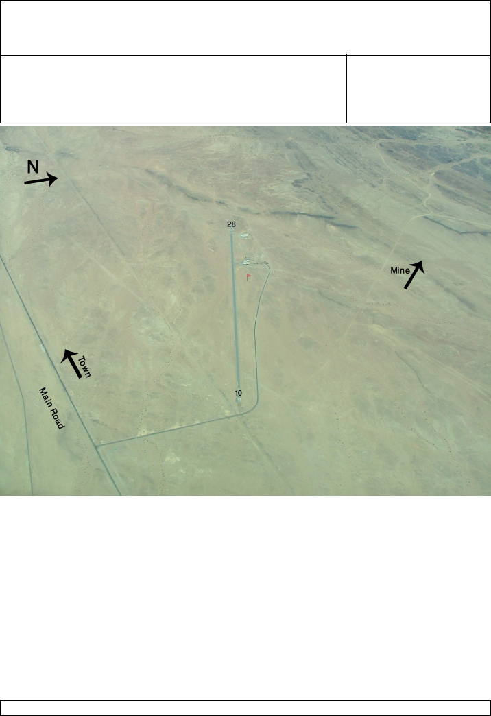
Information Arandis, FYAR
S22°28'00 E014°59'00 10 28
Arandis Traffic 123.5 Elevation 1905ft
Swakopmund 126.3 Grid MORA 3900ft
Walvis Bay 122.5
Windhoek Info 124.7
Notes
ATS Nil
Fueling Nil
Customs/Immigration Nil
Owner/Operator Rossing Mine
Contact: General manager Ph 064 520 9111
Fax 064 520 2326
Other
Cautions/Warnings
Training may take place in the vicinity
Landing Instructions
Runway 28 right circuit
Runway Data
10 28
THR: 1905ft THR: 1827ft
Asphalt Asphalt
1920m x 20m 1920m x 20m
1.2% Up 1.2% Down
Last Revised 27 Jun 2004
Aerodrome Chart Arandis, FYAR
S22°28'00 E014°59'00 10 28
Arandis Traffic 123.5 Elevation 1905ft
Swakopmund 126.3 Grid MORA 3900ft
Walvis Bay 122.5
Windhoek Info 124.7
Last Revised 27 Jun 2004
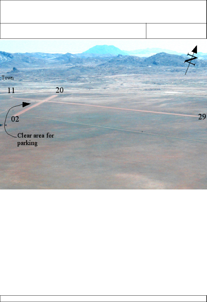
Information Aus, FYAS
S26°41'00 E016°18'00 11/29
Aus Traffic 124.8 Elevation 4720ft
Windhoek Info 124.7 Grid MORA 7800ft
Notes
ATS Nil
Fueling Nil
Customs/Immigration Nil
Owner/Operator
Other Area contact: Klein-Vista Tel./fax:(063) 258021/258116
email: ausvista@namibhorses.com
Cautions/Warnings
Cross runway direction estimated, no information available
Landing Instructions
Town and high ground to West of field
Runway Data
11/29
THR: 4720ft
Gravel
1430m x 20m
Nil slope
Last Revised 10 Mar 2004
Aerodrome Chart Aus, FYAS
S26°41'00 E016°18'00 11/29
Aus Traffic 124.8 Elevation 4720ft
Windhoek Info 124.7 Grid MORA 7800ft
Last Revised 10 Mar 2004
