626 Spencer
User Manual: 626
Open the PDF directly: View PDF ![]() .
.
Page Count: 57
UPPER QUABOAG WATERSHED AND NORTH
QUABBIN REGION LANDSCAPE INVENTORY
MASSACHUSETTS HERITAGE LANDSCAPE
INVENTORY PROGRAM
Massachusetts Department of Conservation and Recreation
Central Massachusetts Regional Planning Commission
North Quabbin Regional Landscape Partnership
SPENCER RECONNAISSANCE REPORT

PROJECT TEAM
Massachusetts Department of Conservation and Recreation
Richard K. Sullivan, Jr, Commissioner
Joe Orfant, Director, Bureau of Planning & Resource Protection
Patrice Kish, Director, Ofce of Cultural Resources
Wendy Pearl, Director, Historic Landscape Preservation Initiative
Jessica Rowcroft, Preservation Planner
Central Massachusetts Regional Planning Commission
Adam Burney, Associate Land Use Planner
North Quabbin Regional Landscape Partnership
Jay Rasku, Partnership Coordinator
Project Consultants
Dodson Associates, Ltd. Public Archeology Laboratory (PAL)
Peter Flinker, Principal Virginia Adams
Sarah la Cour, Project Manager Holly Herbster
Reid Bertone-Johnson
Hillary King
Local Project Coordinator
Jennifer Grybowski, Clerk - Ofce of Development & Inspectional Services
Local Heritage Landscape Participants
Spring 2008
Anne Anow, Spencer Historic Commission
Brandon Avery, North Brookeld Historical
Commission
Mary Baker Wood
Helen Barnes, Spencer Historic Commision
Fabio Carrera, Spencer Planning Board
Sally Chroback, Spencer Historic Commision
Karen Cullen, Spencer Ofce of Development
and Inspection Services
David Glass
Anna Maria Hughes, Spencer Historic
Commision
Ellen Knight
Gordan Knight
Mike Paquette
Theresa Parker
Dana Reed
Maria Reed
Nancy Richardson
Ellen Sousa
Rob Sousa
Michael Toomey
A.P. White, Brookeld Historical Commission
Patti White, Brookeld Historical Commission
Deval L. Patrick
Governor
Timothy P. Murray
Lt. Governor
Ian A. Bowles, Secretary, Executive
Office of Energy & Environmental Affairs
Richard K. Sullivan, Jr., Commissioner
Department of Conservation & Recreation
COMMONWEALTH OF MASSACHUSETTS • EXECUTIVE OFFICE OF ENERGY & ENVIRONMENTAL AFFAIRS
Department of Conservation and Recreation
251 Causeway Street, Suite 600
Boston MA 02114-2119
617-626-1250 617-626-1351 Fax
www.mass.gov/dcr

CONTENTS
Introduction . . . . . . . . . . . . . . . . . . . . . . . . . . . . . . . . . . . . . . . . . . . . . . . . . . . . . . . . . . . . . . . . . 1
PART I: Heritage Landscape Inventory
Local History . . . . . . . . . . . . . . . . . . . . . . . . . . . . . . . . . . . . . . . . . . . . . . . . . . . . . . . . . . 3
Priority Heritage Landscapes . . . . . . . . . . . . . . . . . . . . . . . . . . . . . . . . . . . . . . . . . . . . 5
Green Property and Schoolhouse #3
Sibley Farm/Wendy Warner Farm
Wilson Farm
Wire Village and Turkey Hill Brook
St. Joseph’s Abbey
Spencer Priority Heritage Landscape Map . . . . . . . . . . . . . . . . . . . . . . . . . . . . . . . . 21
PART II: Planning for Heritage Landscapes
Inventory and Documentation . . . . . . . . . . . . . . . . . . . . . . . . . . . . . . . . . . . . . . . . . . . 23
Planning and Zoning Tools and Techniques . . . . . . . . . . . . . . . . . . . . . . . . . . . . . . . . 25
Implementation Strategies . . . . . . . . . . . . . . . . . . . . . . . . . . . . . . . . . . . . . . . . . . . . . . 30
Conclusion . . . . . . . . . . . . . . . . . . . . . . . . . . . . . . . . . . . . . . . . . . . . . . . . . . . . . . . . . . . . . . . . . 31
Appendix A: Heritage Landscapes Identied by Community . . . . . . . . . . . . . . . . . . . . . . . 33
Appendix B: Preservation and Planning Tools . . . . . . . . . . . . . . . . . . . . . . . . . . . . . . . . . . . . 37
Appendix C: Works Cited . . . . . . . . . . . . . . . . . . . . . . . . . . . . . . . . . . . . . . . . . . . . . . . . . . . . 53
Massachusetts Heritage Landscape Inventory Program 1
Spencer Reconnaissance Report
INTRODUCTION
Heritage landscapes are special places created by human interaction with the natural environment
that help dene the character of a community and reect its past. They are dynamic and evolving,
reect the history of a community and provide a sense of place. They show the natural ecology that
inuenced land use patterns and often have scenic qualities. This wealth of landscapes is central to
each community’s character, yet heritage landscapes are vulnerable and ever changing. For this
reason it is important to take the rst step toward their preservation by identifying those landscapes
that are particularly valued by the community – a
favorite local farm, a distinctive neighborhood or
mill village, a unique natural feature or an important
river corridor.
To this end, the Massachusetts Department of
Conservation and Recreation (DCR) and its regional
partners, the Central Massachusetts Regional
Planning Commission (CMRPC) and the North
Quabbin Regional Landscape Partnership (NQRLP),
have collaborated to bring the Heritage Landscape
Inventory program to fteen communities in central
Massachusetts. The goals of the program are to help
communities identify a wide range of landscape
resources, particularly those that are signicant
and unprotected, and to provide communities with
strategies for preserving heritage landscapes.
The communities within the Upper Quaboag Watershed
and North Quabbin region of central Massachusetts
share a common dispersed settlement pattern as well
as an early agricultural economy and later shift into
manufacturing. Developed along a series of major
waterways and their tributaries, including the Millers,
Quaboag and Ware Rivers, this region contains vast
cultural and historic resources and uncommon natural
beauty. The heritage landscapes in the participating
communities reect the agrarian and industrial past while providing recreational and educational
opportunities for today. From scenic town commons and natural areas to civic buildings and burial
grounds, the heritage landscapes within the region collectively tell the story of their varied and
often turbulent, history.
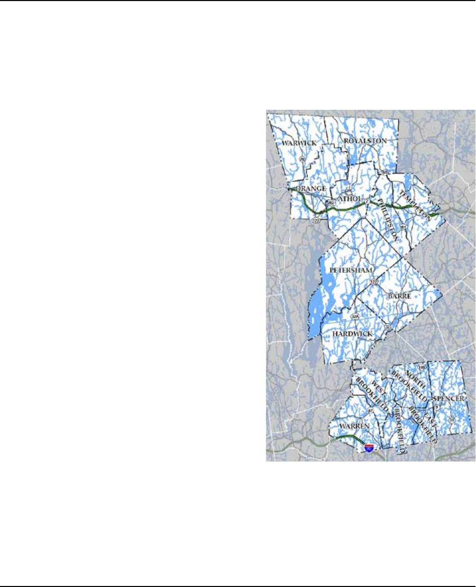
Upper Quaboag Watershed and North Quabbin Region
Heritage Landscape Inventory project area

2 Massachusetts Heritage Landscape Inventory Program
Spencer Reconnaissance Report
Methodology
The methodology for the Heritage Landscape Inventory program was developed in a pilot project
conducted in southeast Massachusetts. It is outlined in the DCR publication Reading the Land,
which has provided guidance for the program since its inception. In summary, each community
organized a heritage landscape identication meeting during which residents and town ofcials
identify and prioritize the landscapes that embody the community’s character and its history.
This meeting is followed by a eldwork session including the consulting team, accompanied by
interested community members. The nal product for each community is an individualized Heritage
Landscape Reconnaissance Report. This report outlines the community’s landscape history,
discusses broader land planning issues identied by the community, describes the priority heritage
landscapes and issues associated with them and concludes with preservation recommendations.
Massachusetts Heritage Landscape Inventory Program 3
Spencer Reconnaissance Report
PART I: HERITAGE LANDSCAPE INVENTORY
LOCAL HISTORY
Spencer’s many hills and stream valleys have determined its history and growth from Native
American times to the modern era. There are no known major Native Americans settlements here,
but the Seven Mile and Cranberry Meadow Rivers were likely used as major thoroughfares and for
seasonal hunting and harvesting.
The land that is now Spencer was purchased
from the Native Americans by a group of
settlers from Boston in 1686. Originally
part of Leicester, the Town of Spencer
was incorporated in 1775. Nathaniel
Wood was rst to settle the area in 1717,
on a 100-acre lot on the western border of
town. The original village was formed at
the geographic center of the town with a
meetinghouse in 1743, followed by other
institutional buildings and a tavern. Most
of the residents lived on large farm tracts
dispersed throughout the Town.
In the mid- to late-18th century, water-based industries emerged on Spencer’s streams and rivers,
and by the early-19th century, two more villages developed. Starting at the turn of the 19th century,
Upper and Lower Wire Villages manufactured wire along Turkey Hill Brook corridor, which at one
time contained 7 dams, 11 factories and 26 buildings. Also during this time, textile, boot and shoe
manufacturing developed in the center of town.
The arrival of the Western Railroad in 1841 expanded Spencer’s economy and population and
another village, Spencer Depot, developed southwest of the Center. During this period there was
a decrease in agricultural production as some farmers turned to work in the factories, and many
elds reverted back to woodland. Dairying, however, remained a large part of Spencer’s economy
through the early-1900s.
By the 1890s, electric streetcar service was running along Main Street leading to Worcester in the
east and Brookeld and Warren in the west. This marked the early suburbanization of Spencer,
enabling residents to travel outside of town for work. Many of Spencer’s factories closed during
the Depression or soon after. Two of three textile mills closed by 1931, and the mills throughout
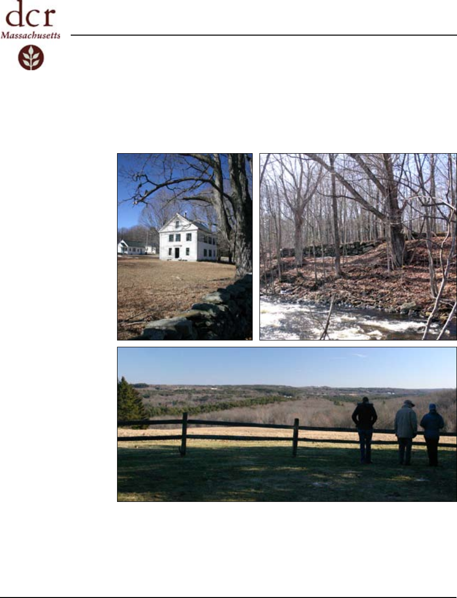
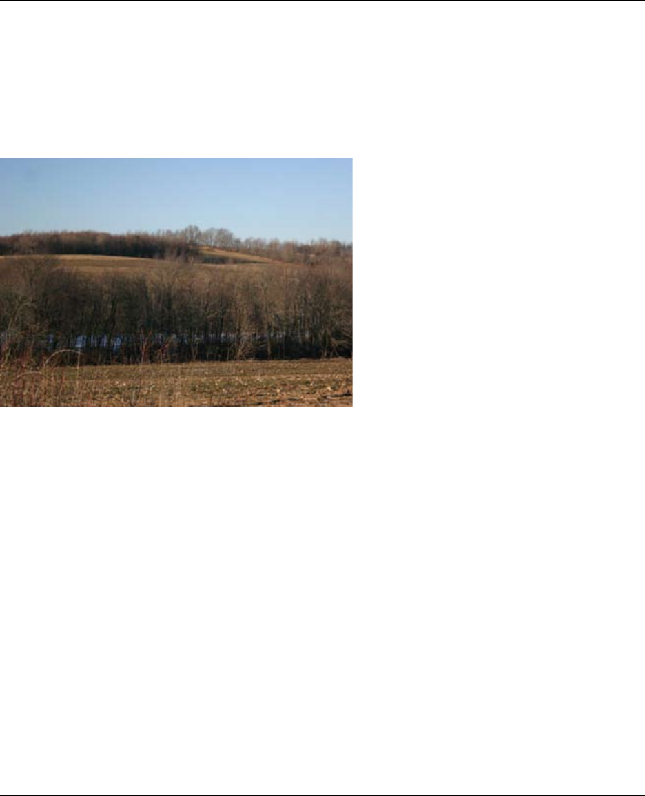
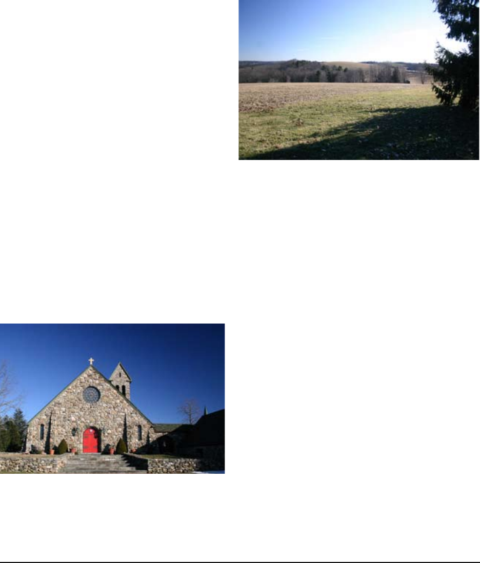
View of St. Joseph’s Abby elds from Northwest Road

4 Massachusetts Heritage Landscape Inventory Program
Spencer Reconnaissance Report
the Wire Villages were discontinued by the 1940s. Although several small wire manufacturers
remained in business, the town experienced a decrease in population during this time.
With the age of the automobile, however, roads were improved and the Town’s population grew
again as people were moving out from more urban areas. Cottages were built on ponds throughout
Spencer, which sparked an increase in regional tourism. Residents and visitors were attracted by
the Town’s rural scenic character and quality of life.
Today the town is primarily residential although some industry and agriculture remain. St. Joseph’s
Abbey is the home of the Trappist Preserves processing plant and there are several dairy farms
still in operation. Recreational and tourist opportunities in Spencer include Howe State Park,
Camp Marshall, the Buck Hill Center and the MidState Trail, the Depot Trail, the Snowbirds and
snowmobile trails.
Massachusetts Heritage Landscape Inventory Program 5
Spencer Reconnaissance Report
PRIORITY HERITAGE LANDSCAPES
Spencer is experiencing signicant growth pressure and will need to determine how it will affect
the rural character of the community and the heritage landscapes that the community nds valuable.
In the public identication meeting, participants identied priority landscapes in town that dene
the heritage of the community. These heritage landscapes provide a cross section of the types of
landscapes that contributed to the historical development of the town and together tell the story
of Spencer’s past. The following text describes the unique value that each of these landscapes
provides to the community and a set of recommendations for its preservation and protection.
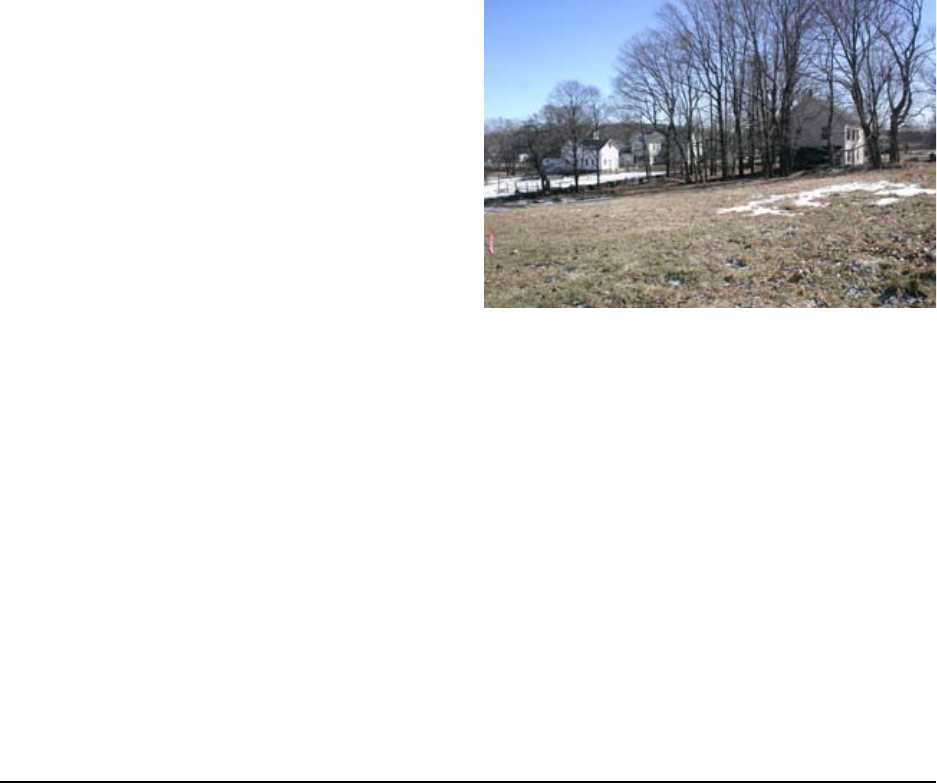
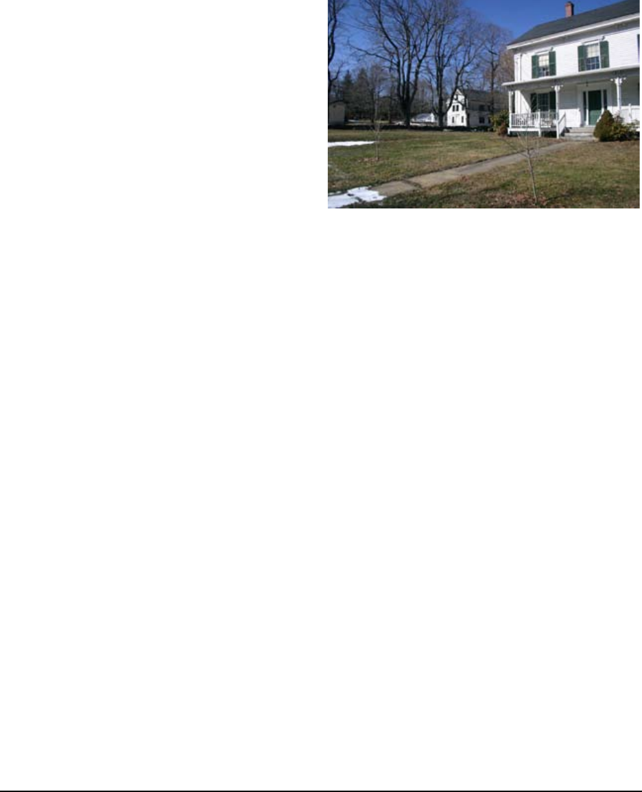
Green Property and Schoolhouse #3
Green Farm
In the same family for over 150 years, the Green
farm is located on 11.9 acres on Main Street in the
center of Spencer. Richard Green still lives in the
farmhouse built in 1856 by his great-grandfather
who also owned the yellow house to the west
with the associated greenhouses. Although in
need of repair, the farmhouse contains original
1856 wallpaper that was damaged by the 1938
hurricane and an original ice box in the kitchen.
As a working farm, the land behind the farmhouse
was originally open from the house to the shore
of Lake Whittemore. Over time, woodlands have
started to encroach on the farmland from the lakefront. Only about half of the property remains
open including several horse paddocks directly adjacent to the house. Although not currently an
allowed use in the town center other than by Special Permit, the horses kept on the property are
grandfathered under the terms of the 1975 conservation restriction deeded to the Town by Herbert
Green, Richard Green’s grandfather.
The Green property abuts the Town-owned Luther Hill Park along a portion of its western
boundary from the shore of Lake Whittemore running south. According to the 1975 Conservation
Restriction, an easement allows for public use of the 10-acres running up from the lakefront for
recreational purposes and nature study. Trails may be laid out and maintained by the Spencer
Conservation Commission. Although not utilized in recent years, Mr. Green recalls High School
classes using the area as an outdoor classroom. In addition to the farmhouse, the property contains
the original barns as well as historic landscape features such as stone walls, hedge rows and orchard
remnants.
Rear yard of Schoolhouse #3, Green home in the distance

6 Massachusetts Heritage Landscape Inventory Program
Spencer Reconnaissance Report
Schoolhouse #3
Built by the Green family in 1857, Schoolhouse #3 is
located on ¾ acre that the Green family subdivided out
of their farmland. It was purchased by the Town and
operated as a school until it was sold back to Green family
in 1924 when the schools were consolidated. From that
time until the present, the Green family has maintained
the property and it has had a variety of uses including
serving as an emergency hospital, in case of air raids,
during WWII. The building is currently un-occupied and
used for storage.
Although structurally sound, the building has no running water or electricity and is in need of
rehabilitation. The interior of the building still retains the original school blackboards. The
Schoolhouse is on a separate parcel, under different ownership than the farmhouse, and is currently
for sale. The open eld behind the Schoolhouse, also originally part of the Green farm, is a
separate parcel owned by Richard Green’s stepdaughter and is also currently on the market. Both
of these parcels run along Park Street and adjoin the Luther Hill Park to the North. Stone pillars
and a gate into the Park are located at the end of Park Street but they have been closed to vehicular
access. Neither of these parcels was included in the 1975 Conservation Restriction deeded to the
Town.
Opportunities:
• The Town of Spencer is interested in the historical and recreational value of these sites as
not many agricultural landscapes still exist so close to the center of town. Their proximity
to Luther Hill Park and Lake Whittemore are also important to the town.
• The Schoolhouse could be rehabilitated for use by the Historical Society and/or Park and
Recreation Commission as well as a general community room
• The Green Farmhouse has been inventoried with the Massachusetts Historical
Commission
Issues:
• The future of the Green farm and its farmhouse is unclear, as Mr. Green and his older
brother are the last members of the family
• Both the Green farmhouse and Schoolhouse are in relatively poor condition and in need of
rehabilitation in the near future
• The Schoolhouse site and lot behind it are currently for sale and could be sold and/or
developed at any time
Historic photograph showing schoolhouse #3 with
the Green Home in the background
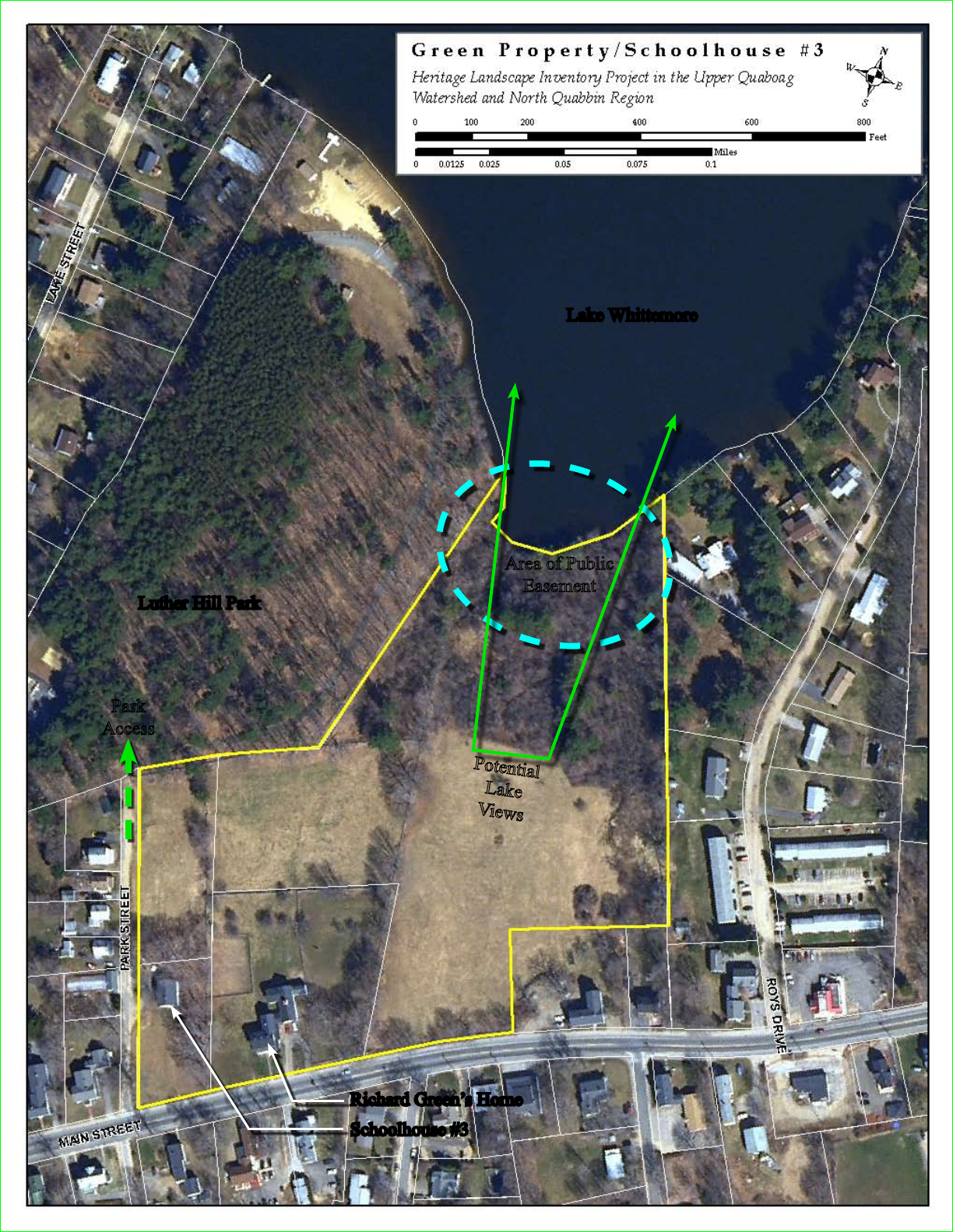
Richard Green’s Home
Schoolhouse #3
Luther Hill Park
Lake Whittemore
Potential
Lake
Views
Area of Public
Easement
Park
Access
8 Massachusetts Heritage Landscape Inventory Program
Spencer Reconnaissance Report
Recommendations:
1. The easement allowing public access
on the back portion of the Green Farm
at Lake Whittemore should be utilized,
opening up paths and restoring views
to the lake from the Farm and Main
Street, with owners permission and
Conservation Commission approval.
2. The Town/Historical Commission
should work with the owners of the
Schoolhouse and vacant parcel to pursue
a Preservation Restriction to preserve
the historic character of the building and
a Conservation Restriction for the associated landscape of the Green Farm (see pages 28
and 26 for more about PRs and CRs)
3. Schoolhouse #3 should be rehabilitated by the Town or other civic organization such as
the Historical Society, for use as a museum or children’s/community center. The town
may also consider models such as the DCR Historic Curatorship Program to facilitate
rehabilitation of the schoolhouse, and possibly the farmhouse in the future.
4. The parcel behind the Schoolhouse should be purchased by a non-prot organization and/
or the Town Parks and Recreation Commission, making a connection between the center of
town and Luther Hill Park, along with the Schoolhouse #3, the Green Property easement,
and Lake Whittemore
Photo taken in front of Green Home, with School #3 in the
background
Massachusetts Heritage Landscape Inventory Program 9
Spencer Reconnaissance Report
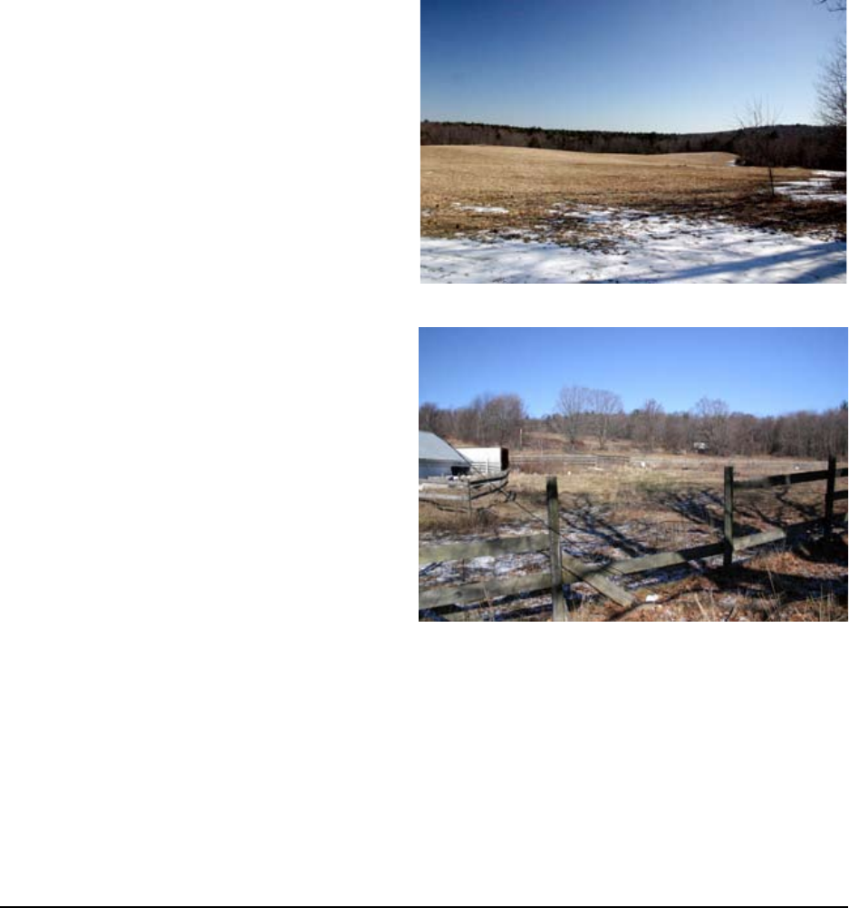
Sibley Farm/Wendy Warner Farm
These two farms consist of three contiguous agricultural parcels between to Route 9 and Greenville
Street. The Wendy Warner Farm is in the Chapter 61 Program, and the Sibley Farm is under no
protection. Totaling approximately 350 acres, the Sibley and Warner Farm properties represent one
of the largest undeveloped, and most scenic,
pieces of land in the center of Spencer.
The former Sibley Farm is located off of Main
Street (Route 9) and is a beautiful collection
of rolling hills, large tracts of forest, open hay
elds and small ponds. Near the boundary
along Main Street the site contains a portion
of the Old Boston Post Road that locals claim
George Washington rode on. Carriage ruts
can still be seen at certain times of the year.
The archeological remains of a schoolhouse
(possibly #1) are located along the northern
section of the property and the site is also
said to contain the foundations of the Sibley
mansion , which was blown down in the 1938
hurricane. Although no longer owned by the
Sibley family or actively farmed, the current
owners lease several acres to a local farmer for
hay production.
Access to the Sibley Farm parcels is from
Main Street on what was the original Sibley
Farm Road and through a gate on Greenville
Street that also accesses the Wendy Warner
Farm property. Located off of Greenville
Street farther to the south, there are several buildings that remain from the Wendy Warner Farm.
The buildings are late 19th and 20th century vernacular; they are not in very good shape having
been vacant for some time, and their historical and architectural signicance is minimal. Several
acres are still open in this portion of the site and also possibly hayed.
Vacant property, formerly Wendy Warner Farm
View into Sibley Farm looking South
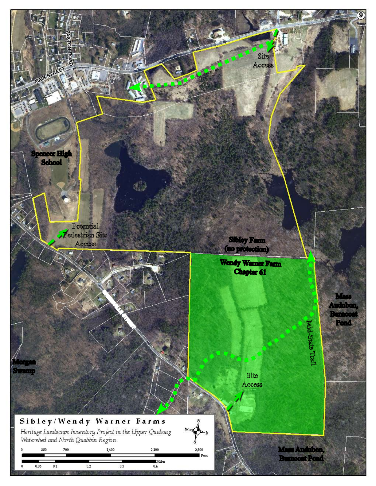
Sibley Farm
(no protection)
Wendy Warner Farm
Chapter 61
Spencer High
School
Mass
Audubon,
Burncoat
Pond
Mass Audubon,
Burncoat Pond
Site
Access
Site
Access
Potential
Pedestrian Site
Access
Mid-State Trail
GREENVILLE STREET
Morgan
Swamp

Massachusetts Heritage Landscape Inventory Program 11
Spencer Reconnaissance Report
The Mid-State Trail runs through the Wendy Warner Farm parcel connecting from the Morgan
Swamp area to the Southwest, to Mass Audubon land adjacent to the East. Mass Audubon owns
approximately 194 acres surrounding the Southeast boundaries of the site including a portion of
Burncoat Pond. The Town of Spencer retains Conservation Restrictions on three additional parcels
totaling 68 acres, located south on Greenville Street.
Opportunities:
• Large undeveloped parcel in center of Town with good access from both Main and Greenville
Streets
• Beautiful site with rolling hills and water bodies provides an important natural resource for
hydrological systems and wildlife habitats
• The Old Boston Post Road is an important historical resource
• Connections could be made to Spencer High School west of the Farm
• The MidState Trail runs through the Wendy Warner parcel
• The Wendy Warner parcel is listed under Chapter 61, Forest Tax Law, which provides a
temporary form of protection and allows the Town right-of-rst-refusal if it is taken out of
this designation
Issues:
• Currently owned by a group of investors, the land (both the Sibley and Warner Farms) has
been permitted for large-scale development including commercial and residential areas
Recommendations:
1. A development application has been permitted for this land but the Town should work with
the property owners to revise the plans in a way that provides for clustered development
and the retention of signicant conservation land; establishing an Open Space Residential
Development Zone may help to facilitate this process (see page 28 for more about this
type of zoning). The town should work closely with the owner to preserve the majority of
open elds adjacent to Route 9 and to re-design the new roadway/entrance to blend into the
landscape as much as possible.
2. The Town should obtain a Preservation Restriction on the portion of the Old Boston Post
Road, as it runs through the site, for public access and interpretation. (see page 28 for more
about PRs). If the Community Preservation Act were adopted in town, funds could be used
to help purchase this PR (see page 26 for more about the CPA).
3. The town should develop a strategy for acquisition of Chapter 61 parcels throughout
town, should they change land use or ownership (see page 27 for more about Chapter 61
Policy).
4. The Parks and Recreation Commission should pursue a connection to the MidState Trail
from Main Street through the Sibley Farm property. This could also utilize CPA funds.
12 Massachusetts Heritage Landscape Inventory Program
Spencer Reconnaissance Report
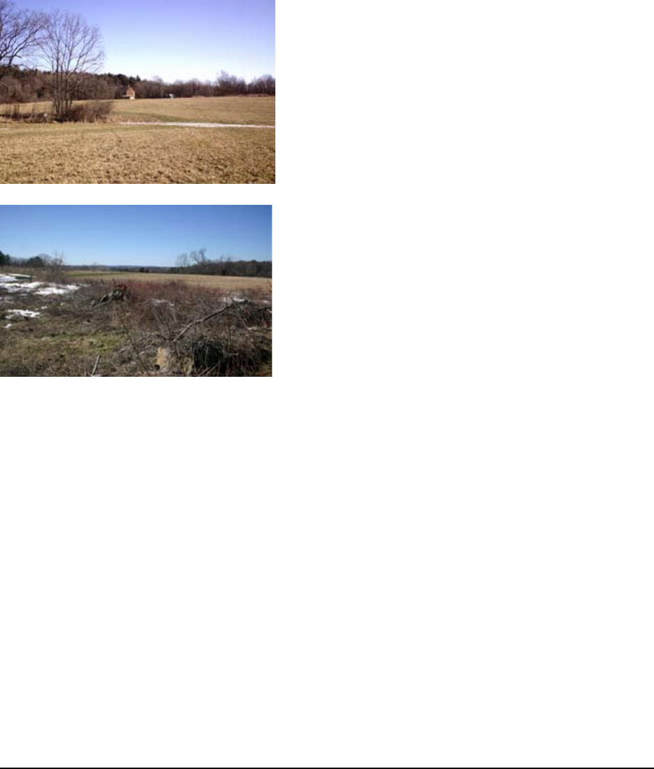
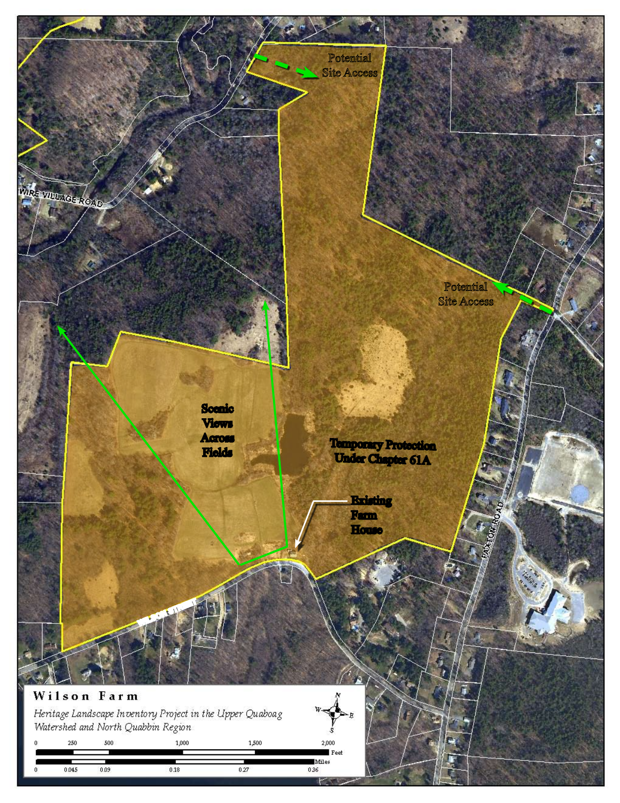
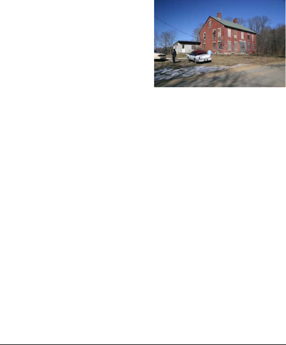
Wilson Farm
The 150-acre Wilson Farm dates from the 1700’s
and has remained in the Wilson family since that
time. The original 1740 farmhouse still stands at 115
Wilson Street although the Wilson family no longer
lives on the property and it is currently vacant. All
other outbuildings have been demolished but the barn
foundations remain to the west of the farmhouse.
Actively farmed until recently, the site was well known
in the 20th century for its local produce and vegetable
stand. Today the site contains large portions of forest
land, large open elds, a small pond and spectacular
views across the elds to the northwest.
Primary access to the site is the frontage along Wilson
Street. The site also abuts Wire Village Road and Paxton
Road across from Donnelly Street. This portion of the
site is heavily forested and there are some steep slopes.
The entire parcel is currently under the temporary
protection of Chapter 61A designation, but this status
will soon be lost since the farming has ceased..
Opportunities:
• Beautiful sloping land with stunning views to the north and west
• Large tracts of forest land that provide wildlife habitat
• Several points of access
• Chapter 61A provides the Town with the right-of-rst-refusal for acquisition or the
procurement of conservation restrictions
• The farm and farmhouse have been inventoried on MHC inventory forms.
Issues:
• Currently for sale as the family needs to secure some nancial benet from the land
• Family has few resources - would consider putting remainder in Conservation Restriction
if the town can help with grants, etc.
• Vulnerable to large-scale development
Views across Wilson Farm and to the West
Wilson Farm elds looking toward old farmhouse
Scenic
Views
Across
Fields
Existing
Farm
House
WILSON STREET
Potential
Site Access
Potential
Site Access
Temporary Protection
Under Chapter 61A
14 Massachusetts Heritage Landscape Inventory Program
Spencer Reconnaissance Report
Recommendations:
1. The Town should work with Wilson family
to explore options for the development of
a portion of the site while preserving the
remainder of the property in a Conservation
Restriction (see page 26 for more about
CRs). Clustered development could be
located in the eastern portion of the property
with access from Paxton Road and Wire
Village Road while the remainder of the
site could be conserved for public access.
This would provide nancial benet to
the owner without the loss of this valuable
scenic and cultural resource.
2. Procure a scenic easement on the view to the northwest from the Farmhouse on Wilson
Street (see page 29 for more about scenic protection).
3. The Historical Commission/Society should pursue the nomination of this historic building
to the National Register of Historic Places. Work with the property owner to rehabilitate
the 1740 farmhouse and/or sell it with a Preservation Restriction and small portion of
land (see page 28 for more about PRs). Also consider models such as the DCR Historic
Curatorship Program to facilitate the rehabilitation.
Old Wilson Farmhouse
Massachusetts Heritage Landscape Inventory Program 15
Spencer Reconnaissance Report
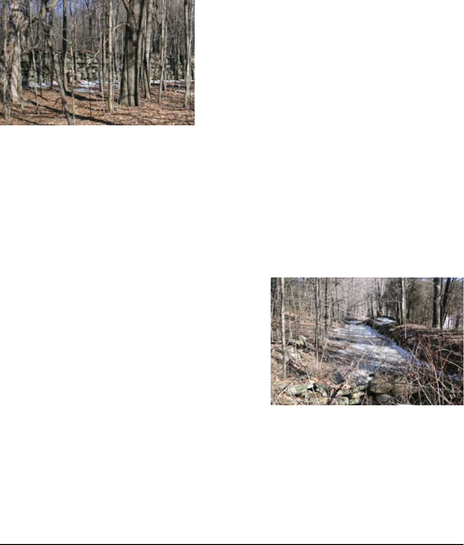
Wire Village and Turkey Hill Brook
The Turkey Hill Brook runs along Wire Village Road,
and once held an extensive wire industry which now
remains only in ruins and local lore. The Upper and
Lower Villages bookend the industrial area and retain a
few homes from that period of town history.
The Upper and Lower Wire Villages
Wire manufacturing started in Spencer around 1800
and continued until the early 1940s. The largest and
longest running was the Spencer Wire Co. but there
were other wire manufacturers in both Lower and Upper Wire Villages including Prouty, Hatch,
and Snow. The several mills along Turkey Hill Brook in both villages changed hands many times
and many were incorporated into the Spencer Wire Co. By the late 1890s, there were seven dams
and 24 buildings associated with the Company.
Located at the junction of Wire Village Road and Hastings Road, Lower Wire Village was the site
of Spencer Wire Co. Mill #5 which operated on the West side of Turkey Hill Brook during the
1800s. A large portion of a dam remains near the road on what was also former Spencer Wire Co.
land. There are some buildings that were former mill housing going up Hastings Road to the north
and a trail extends southwest from the junction along
north side of the Brook. This is private property but
some public access is allowed.
Upper Wire Village consists of the majority of former
Spencer Wire Co. land on both sides of Turkey Hill
Brook at the junction of Nugget Farm Road and Wire
Village Road. This area included mills #1-3 as well as
accessory buildings and the two mill ponds that were
located to the north above the intersection. Various
foundations are located in the woods along Wire Village
Road between the road and Turkey Hill Brook in this area. The former Mill housing neighborhood
ran on the East side of Paxton Road south of Nugget Farm Road and many original houses remain
but have been modernized in the 20th century.
Turkey Hill Brook Corridor
Turkey Hill Brook runs through both Upper and Lower Wire Village and supplied the water
power for the mill operations. Turkey Hill Brook Park is the site of Spencer Wire Co. mill #4
Remains of old canal at Turkey Hill Brook Park
Dam ruins at Lower Mill Village

16 Massachusetts Heritage Landscape Inventory Program
Spencer Reconnaissance Report
and associated outbuildings of which several foundations remain as well as part of the canal and
towpath. The remains of a second dam, 15-20’ high, are located where the Brook crosses under
Wire Village Road.
Farther northeast along the north side of the Brook is the site of ballelds that were accessible by a
foot bridge where Gold Nugget Farm lands run down to the Brook. According to local lore, these
elds were built by Spencer Wire Co. and used from 1880’s through 1920’s by the mill workers.
Since the end of the wire manufacturing business in Spencer, the Turkey Hill Brook corridor has
become primarily wooded and regained a more natural state.
Opportunities:
• Several parcels along Turkey Hill Brook are already protected by the town
• Many Spencer Wire Co. foundations and other structures remain within the villages and
along the Turkey Brook corridor
• Much of the Brook between the two villages is still undeveloped and provides a great
opportunity for trails, access, and wildlife protection.
Issues:
• Other than the Turkey Hill Brook Park, much of the land is under private ownership in
many small parcels
• Mill ruins and remnants are fragile and will be lost to the elements before long if not
documented and protected
Recommendations:
1. Protect the Turkey Hill Brook Corridor from Upper to Lower Wire Village as signicant
cultural and natural resource through a Corridor Protection Overlay District (see page 27
for more about these districts).
2. Upper and Lower Wire Villages should be nominated to the National and State Registers of
Historic Places.
3. The Town of Spencer should pursue the development of a Wire Village Heritage Trail
extending from Upper Wire Village, along the Brook and ending in Lower Wire Village.
This could include the purchase of trail easements along the Brook as well as interpretive
signage and the re-creation of the footbridge near the former ballelds. Parking areas
could be located within each village hub as well as Turkey Hill Brook Park. CPA funds
could be utilized in the creation of this cultural trail system (see page 26 for more about the
CPA)
4. The Conservation Commission should be informed of the signicance of these cultural
resources, and the town should familiarize themselves with the DCR publication Terra
Firma #5: Stones that Speak: Forgotten Features of the Landscape
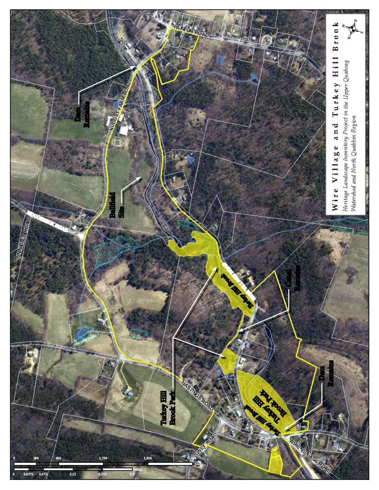
Turkey Hill Brook
Turkey Hill
Brook Park
Turkey Hill Brook
Turkey Hill
Brook Park
Dam
Remains
Dam
Remains
Balleld
Site
Canal
Remains
WIRE VILLAGE ROAD
MCCORMICK ROAD
18 Massachusetts Heritage Landscape Inventory Program
Spencer Reconnaissance Report
St. Joseph’s Abbey
The Trappist Monks of St. Joseph’s Abbey
own approximately 1900 acres of rolling
farmland and forest with 360-degree views
of North Spencer. Originally the Sagandorf
Dairy Farm, the monks purchased the property
in 1948-49 and incorporated the farm into their
development of the site. Several portions of
the original farm buildings still exist in portions
of their complex including the remains of a
windmill near the guesthouse and the former
cow barn. The land was actively farmed by the
brothers until the 1980s and is now leased out
to several local farmers who have corn and hay
operations.
The site is open to the public via the main 1-mile access road off of Route 31. Although Alta Crest
Road also accesses the site from Route 31, it is no longer a Town-owned road but privately owned
and maintained by the Abbey. St. Joseph’s land also abuts Northwest Road to the west which the
Spencer Historical Commission is seeking to have designated as a scenic road. Northwest Road
is lined with stone walls, large street trees, scenic farmland and stunning views to the Abbey
property.
The monks at St. Joseph’s Abbey also operate a
jelly processing plant that produces their well-
known Trappist Preserves. They prepare, package
and ship these preserves around the country from
the site. There are currently 60 monks residing
full time on the property but they also operate a
guesthouse for retreats of up to two weeks at a
time. In addition to the guesthouse, living quarters
and jelly plant, there are two churches within the
complex as well as courtyards, landscaped grounds
and a small cemetery.
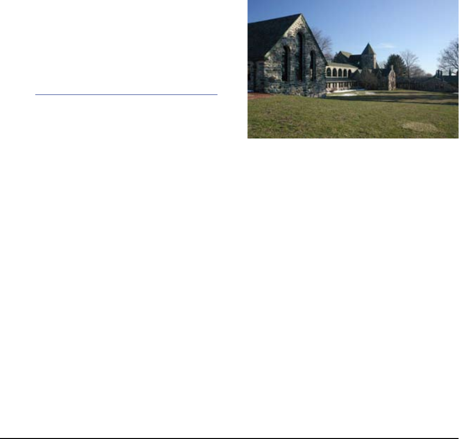
North-facing side of St. Joseph’s Abby. The terrace leads into
a garden, a few trees from an old orchard stands to the East.
View from Joseph’s Abby guest house looking West
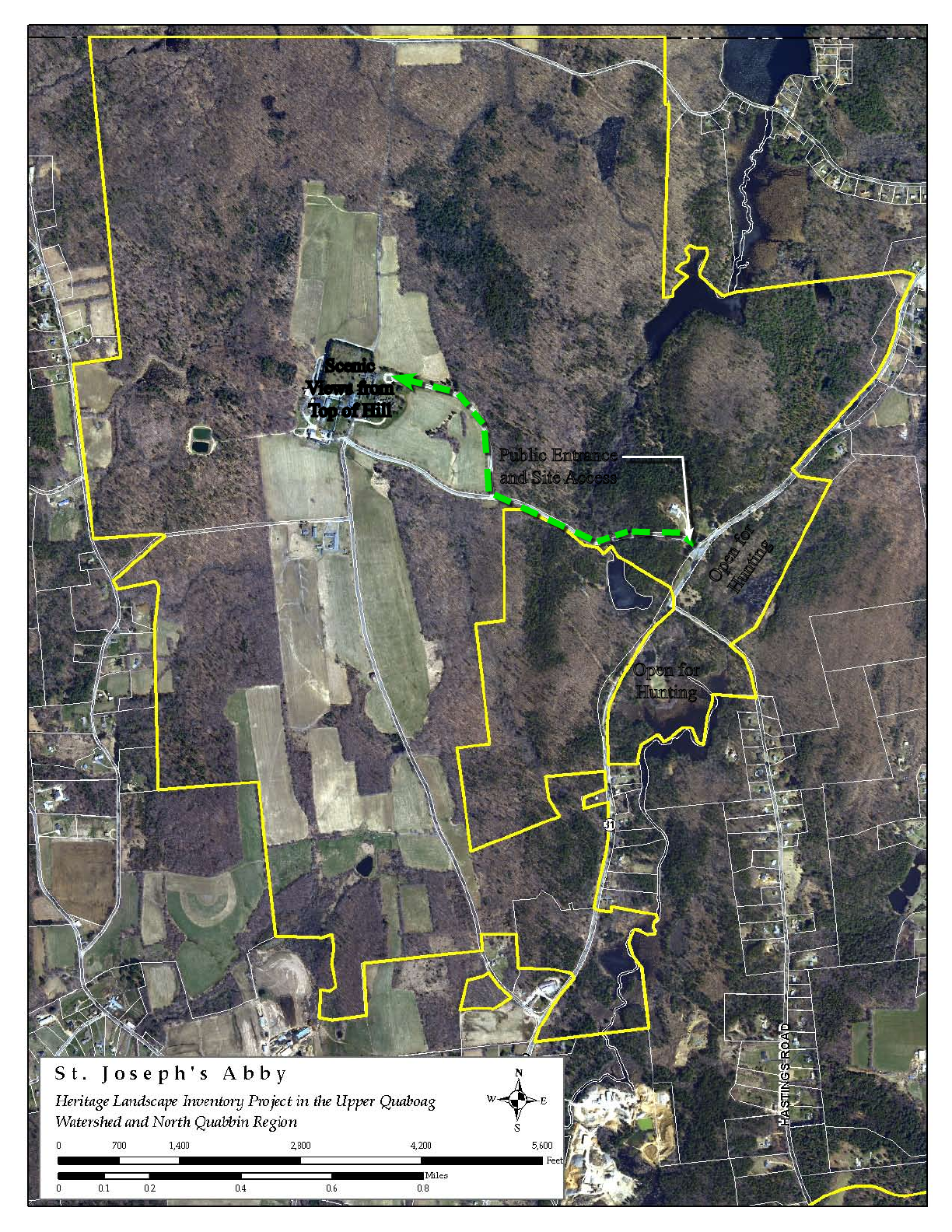
Public Entrance
and Site Access
Open for
Hunting
Open for
Hunting
Scenic
Views from
Top of Hill
20 Massachusetts Heritage Landscape Inventory Program
Spencer Reconnaissance Report
Opportunities:
• Large, beautiful piece of land with stunning views and historic, agrarian landscape
• Potential recreation or conservation opportunities
Issues:
• Not currently under any form of protection
• The property has limited public access
Recommendations:
1. The town should pursue a Scenic Overlay
District on the property in case of changes
in ownership (see page 29 for more about
scenic protection).
2. The town should work with the
Massachusetts Land Trust Coalition’s
Religious Lands Conservancy Project and
the Abbey to identify areas that should be
protected
3. The town should investigate the possibility
of creating public trail access on more
remote portions of the site including the
two parcels located across Route 31 which are currently open to hunting. CPA funds could
be utilized to create public trails (see page 26 for more about the CPA).
4. The Town should adopt a Scenic Road Bylaw and pursue designation of Northwest Road
as a scenic road (see page 29 for more about this bylaw).
5. The Historical Commission should pursue the nomination of the Abbey buildings and
landscape to the National Register of Historic Places and a historic district.
North-facing side of St. Joseph’s Abby
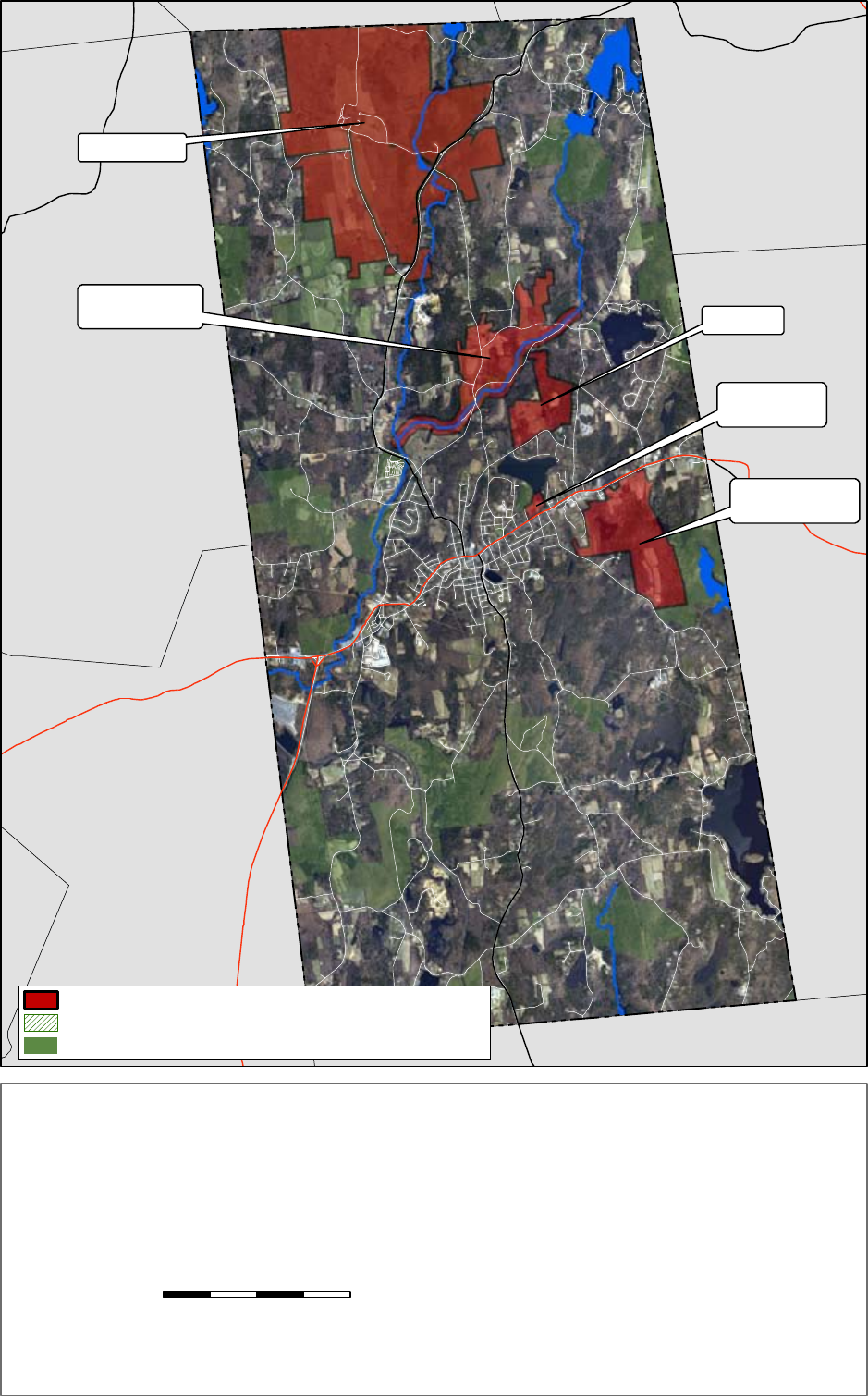
St. Joseph's Abby
Wire Village
& Turkey Hill Brook Wilson Farm
Sibley Farm
Wendy Warner Farms
Green Propoerty
& Schoolhouse #3
LEICESTER
PAXTON
NORTH BROOKFIELD
EAST BROOKFIELD
CHARLTON
OAKHAM
NEW BRAINTREE
BROOKFIELD
UV
49
Priority Heritage Landscapes
Priority Heritage Landscapes Overlap with Permanently Protected Open Space
Permanently Protected Open Space
S p e n c e r , M a s s a c h u s e t t s
P r i o r i t y H e r i t a g e L a n d s c a p e s
Prepared for: Massachusetts Department of Conservation and Recreation, Heritage Landscape
Inventory Project in the Upper Quaboag Watershed and North Quabbin Region
Prepared by: Dodson Associates, Ltd., Landscape Architects and Planners
Ashfield, Massachusetts
25 June 2008 .
0 0.4 0.8 1.2 1.60.2 Miles
"Office of Geographic and Environmental Information (MassGIS), Commonwealth of Massachusetts Executive Office of EnvironmentalAffairs"
MassGIS 2005 Orthophotos
For Planning Purposes Only


Massachusetts Heritage Landscape Inventory Program 23
Spencer Reconnaissance Report
PART II: PLANNING FOR HERITAGE LANDSCAPES
As our communities undergo rapid land use changes, heritage landscapes are particularly
threatened because they are often taken for granted. There is a broad variety of resources that
communities can call upon to protect these irreplaceable landscapes. What follows is a review
of the tools that Spencer already has in place, as well as a number of recommended actions for
the future. The measures already in place for Spencer provide a strong foundation for heritage
landscape preservation, but additional measures have been identied in the following text that will
aid the development of a holistic preservation planning strategy. Appendix B includes extended
descriptions of preservation measures. These tools should be considered in combination with
those recommendations made in Part I for Spencer’s priority landscapes.
INVENTORY AND DOCUMENTATION
1. Massachusetts Historical Commission Records
We cannot advocate for something until we clearly identify it – in this case, the physical
characteristics and historical development of the town’s historic and archeological resources. The
necessary rst step is to record information about the resources at the Massachusetts Historical
Commission. The Massachusetts Historical Commission’s (MHC) Inventory of Historic and
Archaeological Assets is a statewide list that identies signicant historic resources throughout
the Commonwealth. In order to be included in the inventory, a property must be documented on
an MHC inventory form, which is then entered into the MHC database. This searchable database,
known as the Massachusetts Cultural Resource Information System (MACRIS), is now available
online at http://www.sec.state.ma.us/mhc. Information on the specic locations of archaeological
sites is not available to the general public in order to protect these sensitive and non-renewable
cultural resources.
Current Listings: According to the MHC, Spencer’s inventory documents over 400 cultural
resources from the mid 18th century to the 20th century ranging from individual buildings to
farms, factories and historic districts. Of the heritage landscapes identied by the community
as priority resources, the Henry R. Green House, the Wilson Farm, St. Joseph’s Abbey and Wire
Village are all listed under MACRIS.
Spencer also has fourteen documented archaeological sites recorded with MHC. Ten of these are
prehistoric and 4 are historic. These resources reect the Native American settlement of the region
as well as the early industrial development of the modern era. The number of prehistoric sites
documented provides Spencer with signicant archaeological potential.

24 Massachusetts Heritage Landscape Inventory Program
Spencer Reconnaissance Report
Recommendations: The MACRIS list for Spencer reects an extensive overview of historic
buildings and landscapes within the community. In the future, Spencer may want to consider
researching and documenting additional archaeological sites.
2. National and State Register Listing
The National Register of Historic Places is the ofcial federal list of districts, sites, buildings,
structures and objects that have been determined signicant in American history, architecture,
archaeology, engineering and culture. Listing brings a number of benets including recognition,
consideration when federally-or state-funded projects may impact the resource, eligibility for
tax credits, and qualication for certain grant programs. Resources on the National Register are
automatically added to the State Register of Historic Places.
Current Listings: The Town of Spencer’s National Register (NR) program began with the listing of
the Route 9 (Old Boston Post Road) Mile Markers in 1971. In 1986 several individual buildings
including Memorial Town Hall, the Fire Station (near Town Hall), and the Sugden Block were
added as well as the Spencer Town Center Historic District. The Grove Street School, the Pleasant
Street School and the East Main-Cherry Street Historic District were added in 1996.
In addition to National Register listing, the Grove Street School, the Pleasant Street School,
Memorial Town Hall, Spencer Fire Station (near Town Hall) and the Sugden Block all have
Preservation Restrictions placed on them. All National Register listings are automatically listed in
the State Register of Historic Places.
Recommended Listings: The Spencer Historical Commission should consider nominating the
1740 Wilson Farmhouse as an individual property and Upper Wire Village and St. Joseph’s Abbey
buildings and landscape as National Register districts.
3. Heritage Landscape Inventory List from Local Identication Meeting
Each town involved in the Upper Quaboag Watershed and North Quabbin Region Heritage
Landscape Inventory held a local identication meeting to solicit input from a range of community
members to identify potential heritage landscapes throughout the town. The lists were prioritized
by the community, with help from the consultants, to create a list of ve to ten priority areas,
which were described in Part I of this report. The complete list of the town’s over 120 identied
heritage landscapes is included as Appendix A of this report and provides a sound resource list for
future documentation activities and potential funding opportunities. Spencer’s meeting was held
on January 30, 2008 with approximately 20 community members present.

Massachusetts Heritage Landscape Inventory Program 25
Spencer Reconnaissance Report
PLANNING AND ZONING TOOLS AND TECHNIQUES
1. Comprehensive, Open Space and other Planning Documents
It is important that Open Space Plans, Comprehensive or Master Plans, and other planning
documents address heritage landscapes as vital features of the community, contributing not only to
unique sense of place but also to environmental, recreational and economic health.
Current Plans: Spencer completed a Community Master Plan in 2003 that contains information
about scenic roads, trail development and zoning recommendations as well as utilizing information
created in the 2001 Open Space and Recreation Plan (OSRP). The Spencer OSRP provides a
valuable source of information for landscape character, signicant natural and scenic resources and
a conservation and recreation lands inventory. This inventory includes a table of land ownership
and levels of protection including lands in Chapter 61 and under permanent protection.
Recommended Plans: The Town of Spencer should consider updating its Open Space and
Recreation Plan within the next couple of years.
2. Zoning Bylaws and Ordinances
Effective and innovative preservation tools exist in the legal and regulatory realm. These range
from a wide array of zoning, bylaw and ordinance mechanisms, to incentive programs and owner-
generated restrictions on land use.
Current Zoning: In 2006, Spencer amended their zoning bylaws to include Open Space Residential
Development (4.8.2). This bylaw provides for the clustering of residential buildings and
infrastructure in order to set aside a portion of the site for open space. In their 2003 Master Plan,
the Town identied this as a technique for preserving the rural character of the community and for
allowing exibility in the design of new residential neighborhoods.
The 2006 Spencer Zoning Bylaw also added a Town Center Mixed Use District, a Village
Residential District and a Lake Residential District. These zoning districts provide the opportunity
for the community to provide land use controls on neighborhood areas that are unique in their
development history. Spencer also has a Wetlands Protection Bylaw.

26 Massachusetts Heritage Landscape Inventory Program
Spencer Reconnaissance Report
Additional Planning and Zoning Tools and Techniques for Spencer’s landscapes:
Agricultural Preservation Restrictions (APR)
The Agricultural Preservation Restriction (APR) Program is a voluntary program managed by the
Massachusetts Department of Agricultural Resources. It is intended to provide a “non-development”
alternative to farmers and other owners of “prime” and “state important” agricultural land.
When faced with the inability to actively farm and rising tax assessments, this offers the farmer
the opportunity to retain the property rather than sell it for development. The State purchased
a permanent deed restriction on the property for the difference between fair market value and
agricultural value. The deed restriction would preclude any use of the property that will negatively
impact its agricultural viability.
Agricultural Preservation Zoning
An agricultural preservation overlay zone can be created that will promote and protect the practice
of farming. This can help to preserve lands on which farming is most viable, lands that maintain
an adequate agricultural base in town and areas that preserve the culture and landscape of farming.
This can be accomplished in several ways including requiring all new large-scale residential
development to be clustered on areas least suitable for agriculture and away from farms and views.
An agricultural preservation bylaw can also use the site plan review process to require dedicated
open space to remain as farmland and include that new development be located on least suitable
soils for agriculture and be integrated into the existing landscape.
Community Preservation Act
By enabling legislation created in 2000, the Community Preservation Act (CPA) helps communities
provide funds for the preservation of open space and historic resources and the creation of affordable
housing and recreational facilities. The funds are raised through a property tax surcharge ranging
from 0.5% to 3% and are administered by a local Community Preservation Committee. A minimum
of 10% of the annual revenues must be used for each of the three core areas: acquisition and
preservation of open space, acquisition and preservation of historic buildings and landscapes and
creation and support of affordable housing. The remaining 70% can be used for any combination
of the above uses and for recreational uses. If adopted by Spencer, Community Preservation Act
funds could be used for acquisitions such as Schoolhouse #3 and the purchase of conservation
restrictions on the Wilson, Green and St. Joseph’s Abbey properties.
Conservation Restrictions
A permanent deed restriction between a landowner and a holder - usually a public agency or a
private land trust; whereby the grantor agrees to limit the use of his/her property for the purpose
of protecting certain conservation values in exchange for tax benets. EOEEA’s Division of

Massachusetts Heritage Landscape Inventory Program 27
Spencer Reconnaissance Report
Conservation Services provides assistance to landowners, municipalities, and land trusts regarding
conservation restrictions and has produced The Massachusetts Conservation Restriction Handbook
as a guide to drafting conservation restrictions. Conservation Restrictions could be pursued for the
view from St. Joseph’s Abbey and the Wilson Farm.
Corridor Protection Overlay District
A Corridor Protection Overlay District is intended to promote appropriate development within a
given corridor, serving to protect natural (and sometimes cultural) resources. As an overlay zone,
all regulations pertaining to the underlying zone apply, except to the extent that the overlay zone
modies or provides for alternatives to the underlying requirements. Corridor Protection Overlay
Districts can be used cooperatively by adjoining communities to provide continuous protection
across municipal boundaries. This type of zoning tool should be considered for the Turkey Hill
Brook and the Wire Villages corridor.
Chapter 61 Policy
Massachusetts General Laws Chapter 61 was created in the 1970s when many farmers and
forestland owners were forced to sell their land due to rising property values and taxes. The
legislation became known as the Forestland Act but was quickly followed by Chapter 61A, the
Farmland Assessment Act and 61B, the Open Space Act. This new legislation required towns to
reduce assessments on farm, forest and open space lands as long as the owners made a commitment
to keep their land in that use.
A major provision of this law allows the town the right of rst refusal on these lands if the lands
are to be sold for residential, commercial or industrial purposes. This provision provides the town
with the opportunity to match a fair market value offer for the property. Adoption of a Chapter
61 Policy would outline a response process for the town to follow when these lands come out of
the program. This may include a requirement for the select board to collaborate with other town
boards, conservation groups and other interested parties, and hold a public meeting. For more
information about the Chapter 61 Program and to see a sample Chapter 61 Policy, please see
the Mount Grace Land Conservation Trust website (http://mountgrace.org/), to download their
Chapter 61 Handbook.
Both the Wilson Farm and a portion of the Sibley property are currently under Chapter 61 and
Spencer should strongly consider exercising their right of rst refusal particularly in the case of
the Wilson Farm. However, given the short time frame for decision-making the Town should plan
ahead for raising the necessary funds.

28 Massachusetts Heritage Landscape Inventory Program
Spencer Reconnaissance Report
Demolition Delay Bylaw
Demolition delay bylaws provide a time period in which towns can consider alternatives to
demolition of historic buildings and structures. The local historical commission should work with
MHC staff to develop a bylaw that would best suit the town and should work with other town
groups to publicize the advantages of a demolition delay bylaw to the community. Most demolition
delay bylaws apply to structures that were built more than 50 years ago. The most common delay
of demolition is six months; however many communities are nding that a one-year delay is more
effective. A demolition delay bylaw requires a majority vote of Town Meeting.
Local Historic Districts (LHD)
Local Historic Districts are designated through the adoption of a local ordinance that recognizes
special areas within a community where the distinctive characteristics of buildings and places are
preserved and protected by the designation. These districts are the strongest form of protection for
the preservation of historic resources. They are adopted by a 2/3 vote of Town Meeting and are
administered by a district commission appointed by the Board of Selectmen.
Both the Spencer Town Center National Register District and the East Main- Cherry Street
National Register District may benet from local historic district designation that provides stronger
protection through local bylaws designed to protect the important features of the buildings within
the district. National Register districts have no such controls.
Open Space Zoning
Open Space Zoning – also known as Cluster Development Bylaw, Open Space Communities
Zoning, Open Space Development Overlay District, Open Space Preservation Subdivision, or
Open Space Residential Development – allows greater density than would otherwise be permitted
on a parcel, in an effort to preserve open space. Typically, construction is limited to half of the
parcel, while the remaining land is permanently protected under a conservation restriction.
Preservation Restrictions
Preservation Restrictions protect historic and archaeological properties from changes that may
be inappropriate. A Preservation Restriction (easement) on a property restricts present and future
owners from altering a specied portion of that building, structure, or site. A restriction can run
for a few years or in perpetuity and may be included as part of the property deed. Preservation
restrictions can be donated or purchased by a government body or private preservation organization
and are enforced by the holder of the restriction. Charitable donations of easements on historical
buildings or archaeological sites may qualify for federal income tax deductions. A preservation
restriction should be pursued for the historic Old Boston Post Road located on the Sibley Farm.

Massachusetts Heritage Landscape Inventory Program 29
Spencer Reconnaissance Report
Scenic Overlay District Zoning
Scenic Overlay District Zoning protects scenic vistas by providing for a no-disturb buffer on private
lands, thereby helping to maintain specic viewpoints. This type of zoning is more far-reaching
than a Scenic Roads Bylaw (see below) and may be applied to numbered routes.
Scenic Vista Protection Bylaw
This is a preservation planning tool that seeks to protect the scenic qualities of mountains, hills
and rolling terrain by requiring additional design criteria for new construction in these visually
sensitive areas. A scenic vista protection bylaw can be created as a scenic overlay district to
protect a larger area or can address specic views such as those only visible from a certain area or
above a certain elevation. A scenic protection bylaw is generally administered through site plan
review and the development application process.
Scenic Roads Bylaw
Local roads, owned and maintained by the Town, can be designated as Scenic Roads in order to
preserve their rural and/or historic character. A scenic roads bylaw is an effective tool for the
preservation of these signicant heritage landscapes. Adopted as part of the local zoning bylaws,
the scenic roads ordinance requires a public hearing by the planning board before any work is
undertaken in a public right-of-way that would involve the cutting of trees or the destruction of
stone walls. This bylaw only applies to trees and stone walls within the town-owned right-of-way
and to local roads and not state routes. The Town should pursue the designation of Northwest
Road as a Scenic Road.

IMPLEMENTATION STRATEGIES
Outreach, Education and Interpretation
In order to create a community of advocates, we need to raise public awareness and broaden the
base of support. This includes developing opportunities to learn about and celebrate the places and
history of the town, as well as to care for them.
Collaboration
Protecting community character, respecting history, and promoting smart growth are interrelated
concerns that impact heritage landscapes and require collaboration across a broad spectrum of the
community. This includes communication among town boards and departments, as well as public-
private partnerships.
Technical Assistance
Regulations and creative solutions for heritage landscapes are constantly changing and emerging.
Public and private agencies offer technical assistance with the many issues to be addressed,
including DCR, MHC, and the Central Massachusetts Regional Planning Commission.
Funding Opportunities
Funding rarely comes from a single source, more often depending on collaborative underwriting
by private, municipal, and regional sources. Each town also has a variety of funding sources that
are locally-based and sometimes site-specic.
A list outlining options for the above strategies can be found in Appendix B.

Massachusetts Heritage Landscape Inventory Program 31
Spencer Reconnaissance Report
CONCLUSION
The Heritage Landscape Reconnaissance Report for Spencer provides an initial preservation-
planning document that identies priority heritage landscapes and discusses strategies for their
long-term protection. Spencer contains a rich diversity of heritage landscape types ranging from
industrial corridors to 18th century farms and former one- room schoolhouses. These landscapes
reect the strong history and character of the community and are tangible pieces of the Spencer
story.
This Report provides a starting point for preservation strategies but the heritage landscapes
identied, especially the priority landscapes, will need additional research and documentation
including the preparation of MHC inventory forms. Additional information allows for better
consensus building and the support of the broader community in order to successfully implement
the recommendations for these landscapes. Ultimately, preservation and protection implementation
requires a collaboration of local boards and commissions, regional and state agencies and non-
prot entities.
Distribution of this Reconnaissance Report to various municipal boards and commissions involved
in making land use decisions will assist Spencer with an overall strategy for the preservation of
its community’s character. The breadth of action steps outlined in this document will require a
cooperative effort and a variety of local groups to take the lead on implementation. Included in
the recommendations are several actions that can be taken by the Spencer Historical Commission
including the nomination of St. Joseph’s Abbey, the Wilson farmhouse and Upper Wire Village
to the National Register of Historic Places. Several recommendations have been made that the
Town of Spencer should pursue such as the adoption of a Corridor Protection Overlay Zone for the
Turkey Hill Brook corridor and the pursuit of Conservation Restrictions on the Green and Wilson
Farms.
A public outreach campaign that educates the community about it’s heritage landscape resources
is also an important tool for increasing awareness and support for these landscape’s protection.
This Report provides an important rst step for Spencer’s preservation planning program and
can provide the foundation for future historic preservation, conservation and recreation planning
activities. The commitment of the citizens of Spencer to their heritage is apparent in the historic
landscape character and fabric that makes Spencer the vibrant and beautiful place it is.

The project team suggest that the following recommendations be the top three priorities for the
Town of Spencer as it works to protect the heritage landscape character of the community:
1. Adopt the Community Preservation Act.
2. Adopt a Demolition Delay Bylaw.
3. Purchase Conservation Restrictions on the Schoolhouse #3 parcel and the vacant parcel
behind it.

Massachusetts Heritage Landscape Inventory Program 33
Spencer Reconnaissance Report
APPENDIX A: SPENCER HERITAGE LANDSCAPES
Landscape Name Landscape Notes
Agricultural
Wilson Farm
Also identied as archaeological, natural, residential, and
scenic landscape
Sibley Farm
Also identied as archaeological, residential, and scenic
landscape
Sheep Farm, Curtis Farm (Paxton Line) Also identied as a scenic landscape
Country Acre Fall
Green’s Farm Also identied as an open space & recreation landscape
Bercumbe Farm
Smalls Farm
Jolicour Farm
Alta Crest/Abby Zukas Farm
Bemis Orchard & Settlement Also identied as a residential landscape
Gold Nugget Farm
Pulling’s Farm
Andrew’s Farm (Laurel Dale)
Royalcrest
Moose Hill Also identied as a natural landscape
Castleberry Horse Farm
Archaeological
Manly Ransom Home Site Also identied as a scenic landscape
“The Oven”
Old Howe Mill in St Park
Burial
Cranberry Meadow Cemetery
Old Cemetery
Old St. Mary’s
Pine Grove (Rte 31)
St. Mary’s on Rte 9
Indian Burial and Grainery
Note: Highlighted landscapes have been designated “Priority Landscapes” by the town or
directly correspond to a Priority Landscape

34 Massachusetts Heritage Landscape Inventory Program
Spencer Reconnaissance Report
Civic
Richard Sugden Library
Congregational Church
South Spencer/Hillsville - Village Center
Also identied as archaeological, institutional, and
residential landscape
Old Firehouse
Wire Village - Upper and Lower
Also identied as archaeological, industrial, institutional,
residential, and scenic landscape
Town Hall
Cherry Street Fire House
Old Denny Hall
Industrial
Shoe factory next to Green’s Farm
Washington Hill House
Prouty’s
Institutional
School House #3
Historically linked to Green’s Farm, also identied as a
scenic landscape
St. Joseph Abbey Also identied as a scenic landscape
David Prouty High School
Northwest School House (x2)
4H Camp Marshal
Girl Scout Camp Laurelwood
Spencer Fairgrounds
Treasure Valley Boy Scout, Spencer & Oakham
Military
Encampments near Catholic cemetery
Knox Trail
Prouty Park
Powder Mill
Note: Highlighted landscapes have been designated “Priority Landscapes” by the town or
directly correspond to a Priority Landscape

Massachusetts Heritage Landscape Inventory Program 35
Spencer Reconnaissance Report
Natural
5 Mile River Also identied as an archaeological and a scenic landscape
Turkey Hill Brook
Also identied as an archaeological landscape, location of
former Wire Village
David’s Hill Also identied as an agricultural landscape
Howe Park Also identied as an industrial landscape
7 Mile River
Also identied as an archaeological landscape, arrowheads
found here
Balance Rock on Mid-State Trail
Hastings Pond & Mill Dams
Open Space/Recreation
Brook’s Pond and Foundry Sites
Also identied as an industrial, natural, residential,
transportation, and scenic landscape
Whitemore
Luther Hill Park
Browning Pond
Sugden Pond
Shaw Pond
Thompson
Cranberry
Snowmobile Trails
Small’s Field
Mid-State
Depot Trail Also identied as a transportation landscape
Ralph Warren Trail
Bemis Park Trail
Bemis Park
Stiles Res.
Note: Highlighted landscapes have been designated “Priority Landscapes” by the town or
directly correspond to a Priority Landscape

36 Massachusetts Heritage Landscape Inventory Program
Spencer Reconnaissance Report
Residential
Prouty Carriage House
Pleasant Street Historic District
Sagendorph Mansion
Cherry Street Neighborhood
Richard Sugden House
45 Ash Street
Bemis Settlement
Spencer Country Inn
Transportation
Northwest Road Identied as a scenic road
Brook’s Pond Road Identied as a scenic road
Andrew’s Old Airport
Boston Post Road Also identied as an archaeological and scenic landscape
McCormick Road
Gold Nugget Road
Browning Pond Road
Buteau Road Identied as a scenic road
William Casey Road Identied as a scenic road
Borkum Road Identied as a scenic road
Briarcliff Road Identied as a scenic road
East Charlton Road Identied as a scenic road
Old Depot - Arty’s Rest
Boston/Albany - Conrail
Note: Highlighted landscapes have been designated “Priority Landscapes” by the town or
directly correspond to a Priority Landscape

Massachusetts Heritage Landscape Inventory Program 37
Spencer Reconnaissance Report
APPENDIX B: GUIDE TO PRESERVATION & PLANNING TOOLS FOR
HERITAGE LANDSCAPES
Preservation planning is a four-step process: identication, evaluation, education and protection.
Within the realm of protection, there is a vast array of tools that communities can call upon and
that are most effective when used in combination with one another. Stewardship of these resources
involves education and community support, planning with a clear set of goals, and regulatory
mechanisms.
Three useful documents to consult when planning preservation strategies are:
♦ Department of Conservation and Recreation, Reading the Land
♦ Massachusetts Historical Commission, Survey Manual
♦ Massachusetts Historical Commission, Preservation through Bylaws and Ordinances
The following three sections detail the resources and strategies available for heritage landscape
preservation - from documentation and evaluation, to public education, to regulating activities and
nding the revenue necessary to fund the effort. These lists are meant to cover a variety of regional
areas and opportunities, all may not apply to any given community.
INVENTORY AND DOCUMENTATION
Massachusetts Historical Commission Records
The vital rst step in developing preservation strategies for heritage landscapes is to record
information about the resources on MHC inventory forms. One cannot advocate for something unless
one knows precisely what it is – the physical characteristics and the historical development.
Survey methodology has advanced since the early work of the 1980s. If a community had survey
work done during that time period, it is time for an inventory update, looking at resources in a more
comprehensive and connected way than may have been done at that time. Even if survey work is
more recent, there may be a need to document more resources throughout the community.
Using the Massachusetts Historical Commission survey methodology:
♦ Compile a list of resources that are under-represented or not thoroughly researched,
beginning with heritage landscapes.
♦ Document unprotected resources rst, beginning with the most threatened resources.

38 Massachusetts Heritage Landscape Inventory Program
Spencer Reconnaissance Report
♦ Make sure to document secondary features on rural and residential properties, such as
outbuildings, stone walls and landscape elements.
♦ Record a wide range of historic resources including landscape features and industrial
resources.
♦ Conduct a community-wide archaeological reconnaissance survey to identify patterns
of prehistoric and historic occupation and to identify known and probable locations of
archaeological resources associated with these patterns. Known and potential precontact
and historic archaeological sites should be professionally eld-checked to evaluate
cultural associations and integrity. A professional archaeologist is one who meets the
professional qualications (950 CMR 70.01) outlined in the State Archaeologist Permit
Regulations (950 CMR 70.00).
National and State Register Listing
Survey work for the National Register of Historic Places, a program of the National Park Service
includes evaluation of whether resources meet the qualications for its listing. This will provide
new information about the eligibility of properties. Using the information generated in the survey
work and the accompanying National Register evaluations, expand your town’s National Register
program.
♦ Develop a National Register listing plan, taking into consideration a property’s or
area’s integrity and vulnerability. Properties in need of recognition in order to advance
preservation strategies should be given priority. All sites listed on the National Register
are automatically added to the State Register.
PLANNING AND ZONING TOOLS AND TECHNIQUES
Comprehensive, Open Space and other Planning Documents
Communities use a variety of planning exercises and documents to dene their goals and vision of
the future, address community-wide issues, and recommend measures to respond to them. There
are state mandates for towns to prepare Comprehensive or Master Plans and Open Space and
Recreation Plans.
♦ Comprehensive or Master Plans provide an important frame of reference for land use
decisions, and incorporate all of a community’s issues including economic development,
housing and transportation into an integrated plan. Heritage landscapes need to be seen

Massachusetts Heritage Landscape Inventory Program 39
Spencer Reconnaissance Report
through the lenses of community character, historic preservation, environmental health,
and economic viability and growth. Their future and the values they contribute should
be addressed within these multiple perspectives, not solely as historical assets of the
community.
♦ Like Comprehensive Plans, Open Space Plans look holistically at the community—
its history, demographics and growth patterns, and current conditions—to make
recommendations that protect open space and natural resources for ecological health and
public benets. The Heritage Landscape Inventory Program provides a framework for
looking at these important resources, and this new understanding should be incorporated
into Open Space Plans.
♦ Many communities have other plans that have been prepared as well.
Zoning Bylaws and Ordinances
A wide range of laws, bylaws and regulations is available to protect heritage landscapes. Following
are brief descriptions of some of the most widely used and/or most effective of these tools, arranged
alphabetically.
Adaptive Reuse Overlay District
An Adaptive Reuse Overlay District is superimposed on one or more established zoning districts
in order to permit incentive-based reuses of existing built properties. These districts can be
created to allow for the adaptive reuse of properties of a certain kind, or within a specied
area within a community. As an overlay zone, all regulations pertaining to the underlying zone
apply, except to the extent that the overlay zone modies or provides for alternatives to the
underlying requirements.
Agricultural Preservation Restrictions (APR)
The Agricultural Preservation Restriction (APR) Program is a voluntary program managed
by the Massachusetts Department of Agricultural Resources. It is intended to provide a
“non-development” alternative to farmers and other owners of “prime” and “state important”
agricultural land. When faced with the inability to actively farm and rising tax assessments,
this offers the farmer the opportunity to retain the property rather than sell it for development.
The State purchased a permanent deed restriction on the property for the difference between
fair market value and agricultural value. The deed restriction would preclude any use of the
property that will negatively impact its agricultural viability.

40 Massachusetts Heritage Landscape Inventory Program
Spencer Reconnaissance Report
Agricultural Preservation Zoning
An agricultural preservation overlay zone can be created that will promote and protect the
practice of farming. This can help to preserve lands on which farming is most viable, lands
that maintain an adequate agricultural base in town and areas that preserve the culture and
landscape of farming. This can be accomplished in several ways including requiring all new
large-scale residential development to be clustered on areas least suitable for agriculture and
away from farms and views. An agricultural preservation bylaw can also use the site plan
review process to require dedicated open space to remain as farmland and include that new
development be located on least suitable soils for agriculture and be integrated into the existing
landscape.
Archaeological Resource Protection
Archaeological sites are non-renewable cultural resources that can be permanently altered
or destroyed through unauthorized digging, artifact collection, and development. Protection
of archaeological sites can occur through a number of different strategies and mechanisms.
An important rst step is the development of a town-wide archaeological resource protection
plan. Based on a professional reconnaissance survey of resources in the community, this plan
would recommend steps for their preservation. Options for protection include acquisition,
preservation restrictions, site plan review, an archaeological review bylaw and public education.
Reasonable thresholds for local review of archaeological resources should be developed in
consultation with the Massachusetts Historical Commission and interested groups such as
Native Americans. Reasonable thresholds for local review of archaeological resources should
be developed in consultation with the Massachusetts Historical Commission and interested
groups such as the Massachusetts Commission on Indian Affairs.
Community Preservation Act
By enabling legislation created in 2000, the Community Preservation Act (CPA) helps
communities provide funds for the preservation of open space and historic resources and the
creation of affordable housing and recreational facilities. The funds are raised through a
property tax surcharge ranging from 0.5% to 3% and are administered by a local Community
Preservation Committee. A minimum of 10% of the annual revenues must be used for each of
the three core areas: acquisition and preservation of open space, acquisition and preservation
of historic buildings and landscapes and creation and support of affordable housing. The
remaining 70% can be used for any combination of the above uses and for recreational uses.
Conservation Restrictions (CR)
A permanent deed restriction between a landowner and a holder - usually a public agency
or a private land trust; whereby the grantor agrees to limit the use of his/her property for the

Massachusetts Heritage Landscape Inventory Program 41
Spencer Reconnaissance Report
purpose of protecting certain conservation values in exchange for tax benets. Executive Ofce
of Energy and Environmental Affairs (EOEEA) Division of Conservation Services provides
assistance to landowners, municipalities, and land trusts regarding conservation restrictions
and has produced The Massachusetts Conservation Restriction Handbook as a guide to drafting
conservation restrictions.
Corridor Protection Overlay District
A Corridor Protection Overlay District is intended to promote appropriate development
within a given corridor, serving to protect natural (and sometimes cultural) resources. As an
overlay zone, all regulations pertaining to the underlying zone apply, except to the extent that
the overlay zone modies or provides for alternatives to the underlying requirements. The
Corridor Protection Overlay District can be used cooperatively by adjoining communities to
help maintain continuous protection across town lines.
Chapter 61 Policy
Massachusetts General Laws Chapter 61 was created in the 1970s when many farmers and
forestland owners were forced to sell their land due to rising property values and taxes. The
legislation became known as the Forestland Act but was quickly followed by Chapter 61A,
the Farmland Assessment Act and 61B, the Open Space Act. This new legislation required
towns to reduce assessments on farm, forest and open space lands as long as the owners made
a commitment to keep their land in that use.
A major provision of this law allows the town the right of rst refusal on these lands if the lands
are to be sold for residential, commercial or industrial purposes. This provision provides the
town with the opportunity to match a fair market value offer for the property. Adoption of a
Chapter 61 Policy would outline a response process for the town to follow when these lands
come out of the program. This may include a requirement for the select board to collaborate
with other town boards, conservation groups and other interested parties, and hold a public
meeting. For more information about the Chapter 61 Program and to see a sample Chapter 61
Policy, please see the Mount Grace Land Conservation Trust website (http://mountgrace.org/),
to download their Chapter 61 Handbook.
Demolition Delay Bylaw
Demolition delay bylaws provide a time period in which towns can consider alternatives to
demolition of historic buildings and structures. The local historical commission should work
with MHC staff to develop a bylaw that would best suit the town and should work with other
town groups to publicize the advantages of a demolition delay bylaw to the community. Most
demolition delay bylaws apply to structures that were built more than 50 years ago. The most

42 Massachusetts Heritage Landscape Inventory Program
Spencer Reconnaissance Report
common delay of demolition is six months; however many communities are nding that a
one-year delay is more effective. A demolition delay bylaw requires a majority vote of Town
Meeting.
Design Review
Design Review is a non-regulatory process that is undertaken by a town appointed Design
Review Board. The board reviews the design of new construction and additions – typically
those taking place in already built-up areas. Recommendations are made to the planning
board to help preserve appropriate building patterns and architectural styles, with the goal
of maintaining the overall character of a given area. Design Review Boards often limit their
review to exterior architectural features, site design and signage.
Downtown Revitalization Zoning
Downtown Revitalization Zoning seeks to encourage businesses to locate in downtowns. Zoning
of this nature is typically written to be attractive to businesses of a certain kind that would work
well within the given infrastructure and transportation needs, but can also incorporate some
of the same elements as Village Center Zoning (see below), such as encouraging mixed use
development at a pedestrian-friendly scale, with minimal setbacks and off site parking.
Expedited Local Permitting - Chapter 43D
Expedited Local Permitting (Chapter 43D) provides an efcient process for municipal
permitting and grants for up to $150,000 for such things as professional stafng assistance,
local government reorganization, and consulting services. Participating towns benet from
marketing of their site and online promotion of their pro-business regulatory climate. In order
to pursue Expedited Local Permitting, a town must have commercial and/or industrial zoning
in place for the site, and there must be space for a building of at least 50,000 square feet of
oor area.
Flexible Development Zoning
Flexible Development Zoning allows for greater exibility and creativity when subdividing
land, to conform and work with the natural and cultural resources of a site and minimize
alteration or damage to these resources, rather than follow standard requirements of subdivision
regulations. While this does not prevent land from being subdivided, it does allow for the
protection of some features, serves to preserve some undeveloped land, and promotes better
overall site planning.

Massachusetts Heritage Landscape Inventory Program 43
Spencer Reconnaissance Report
Local Historic Districts (LHD)
Local Historic Districts are designated through the adoption of a local ordinance that recognizes
special areas within a community where the distinctive characteristics of buildings and places
are preserved and protected by the designation. These districts are the strongest form of
protection for the preservation of historic resources. They are adopted by a 2/3 vote of Town
Meeting and are administered by a district commission appointed by the Board of Selectmen.
For more information review the Massachusetts Historic Commission's (MHC) guidebook,
Establishing Local Historic Districts, available on the MHC website.
Neighborhood Architectural Conservation Districts (NCD)
Neighborhood Architectural Conservation Districts (sometimes known as Neighborhood
Conservation Districts) are local initiatives that recognize special areas within a community
where the distinctive characteristics of the neighborhood are important. They are less
restrictive than Local Historic Districts in that they focus on a few key architectural elements
and massing, scale, and setback in an effort to embrace overall neighborhood character. As in
Local Historic Districts, changes are reviewed by a Neighborhood Architectural Conservation
District Commission.
Open Space Zoning
Open Space Zoning – also known as Cluster Development Bylaw, Open Space Communities
Zoning, Open Space Development Overlay District, Open Space Preservation Subdivision,
or Open Space Residential Development – allows greater density than would otherwise be
permitted on a parcel, in an effort to preserve open space. Typically, construction is limited
to half of the parcel, while the remaining land is permanently protected under a conservation
restriction.
Preservation Restrictions
Preservation Restrictions protect historic and archaeological properties from changes that may
be inappropriate. A Preservation Restriction (easement) on a property restricts present and
future owners from altering a specied portion of that building, structure, or site. A restriction
can run for a few years or in perpetuity and may be included as part of the property deed.
Preservation restrictions can be donated or purchased by a government body or private
preservation organization and are enforced by the holder of the restriction. Charitable
donations of easements on historical buildings or archaeological sites may qualify for federal
income tax deductions.

44 Massachusetts Heritage Landscape Inventory Program
Spencer Reconnaissance Report
Rate of Development Bylaw
A town may slow the rate of its growth within reasonable time limits to allow the community
to engage in planning and preparation for growth. This measure must be used for the purpose
of conducting studies and planning for rational development, and not for restraining the rate of
growth for a period of unlimited duration.
Right to Farm Bylaw
A Right to Farm Bylaw asserts the rights of farmers to pursue agricultural activities, provides
community support for farming activities and requires dispute resolution so that abutters cannot
make nuisance claims. Agricultural landscapes are widely considered to be signicant heritage
landscapes for which there is constant concern of potential development. This bylaw serves to
help active farmers remain just that - active.
Scenic Overlay District Zoning
Scenic Overlay District Zoning protects scenic vistas by providing for a no-disturb buffer on
private lands, thereby helping to maintain specic viewpoints. This type of zoning is more far-
reaching than a Scenic Roads Bylaw (see below) and may be applied to numbered routes.
Scenic Roads Bylaw
Local roads, owned and maintained by the Town, can be designated as Scenic Roads in order
to preserve their rural and/or historic character. A scenic roads bylaw is an effective tool for
the preservation of these signicant heritage landscapes. Adopted as part of the local zoning
bylaws, the scenic roads ordinance requires a public hearing by the planning board before
any work is undertaken in a public right-of-way that would involve the cutting of trees or the
destruction of stone walls. This bylaw only applies to trees and stone walls within the town-
owned right-of-way and to local roads and not state routes.
Scenic Vista Protection Bylaw
This is a preservation planning tool that seeks to protect the scenic qualities of mountains, hills
and rolling terrain by requiring additional design criteria for new construction in these visually
sensitive areas. A scenic vista protection bylaw can be created as a scenic overlay district to
protect a larger area or can address specic views such as those only visible from a certain area
or above a certain elevation. A scenic protection bylaw is generally administered through site
plan review and the development application process.
Shade Tree Act
The Shade Tree Act is a part of MGL Chapter 87, which denes all trees within the public way
as public shade trees. The municipal Tree Warden is responsible for the care, maintenance and

Massachusetts Heritage Landscape Inventory Program 45
Spencer Reconnaissance Report
protection of all public shade trees (except those along state highways). Trimming or removal
of any public shade trees greater than 1.5” in diameter requires a public hearing. Chapter 87
applies to all communities; however, some communities have adopted their own Shade Tree
Act Bylaws that provide stricter regulations than those mandated in Chapter 87.
Site Plan Review
Site Plan Review provides the planning board (and other boards and committees, depending
how the bylaw is written) with an opportunity to consider a variety of community concerns
– such as impacts to vehicular circulation, scenic vistas, topography and natural resources
– during the permit process. Boards may comment on site plans and request changes to the
design. Site Plan Review is typically limited to large scale projects and tied to the special
permit process.
Smart Growth Zoning – Chapter 40R & 40S
Smart Growth Zoning (Chapter 40R) provides nancial rewards to communities that adopt
special overlay zoning districts allowing as-of-right high density residential development in
areas near transit stations, areas of concentrated development, or areas that are suitable for
residential or mixed use development. Such zoning can help direct compact growth to areas
that are already developed – such as historic village centers – thereby discouraging growth
in less suitable areas. Chapter 40S provides State funding for any net-added school costs that
come from children living in newly developed housing within a Smart Growth District.
Transfer of Development Rights (TDR)
TDR is a regulatory technique that allows a landowner to separate building or development rights
from the property and sell them, receiving compensation for preserving land and allowing for
the development to occur in areas selected for higher density projects. In essence, development
rights are “transferred” from one district (the “sending district”) to another (the “receiving
district”). As a result, development densities are shifted within the community to achieve both
open space preservation and economic goals without changing overall development potential.
Village Center Zoning
The goal of Village Center Zoning is to meet the needs of a small-scale, mixed-use, pedestrian-
friendly area by encouraging compact development. New construction is required to be built
at a scale that is compatible with the neighborhood and to have a reduced (or no) setback from
the street. Parking may be directed to discourage large lots in front of buildings. Village Center
Zoning shares many similarities with Traditional Neighborhood Development, and the terms
are sometimes used interchangeably.

46 Massachusetts Heritage Landscape Inventory Program
Spencer Reconnaissance Report
Wetlands Protection Act and Bylaws
The Wetlands Protection Act (MGL Chapter 131, Section 40) protects wetlands by requiring a
careful review by local conservation commissions of proposed work that may alter wetlands.
The law also protects oodplains, riverfront areas, land under water bodies, waterways, salt
ponds, sh runs and the ocean. Communities may also adopt their own Wetlands Protection
Bylaw, providing stricter regulations than those mandated in Chapter 131.
IMPLEMENTATION STRATEGIES
Outreach, Education and Interpretation
The best stewards and advocates for heritage landscape protection are members of the community.
There are many ways to communicate the importance of these special places to the public, and to
connect their preservation with the shared values and goals that community members have already
expressed in various planning documents and forums.
Think creatively about how to educate the community about the values and threats to heritage
landscapes, and how each town resident benets from these special places. Use a combination of
strategies to get the word out about heritage landscapes and preservation of community character,
including:
♦ Festivals and Tours – Tours are a great way to draw attention to the history around us,
and to engage more people in caring for it. Consider hosting a Heritage Celebration Day
including tours and family-friendly activities, or plan a celebration around a particular
place or area on a meaningful date. Make sure events are well publicized.
♦ Signage and Banners – Signs are a very effective way to announce special historic sites
and districts. Banners can also bring attention to the signicance of an area and make a
celebratory statement about its contribution to the town.
♦ Written Materials – Clear, concise and engaging written material with engaging
illustrations is a reliable way to relay information about community character and
heritage landscapes. Make use of fact sheets and yers to get the word out on particular
issues such as a town ordinance that protects heritage landscapes, a threat that needs to
be addressed, or an upcoming event.
♦ School Curricula – Start teaching at a young age. Children are very receptive to engaging
stories, and there are no better stories to excite childrens’ imaginations and build pride
of place than stories of their town’s past and present. Teachers have an opportunity to
connect history with environmental issues through classroom study, hands-on history

Massachusetts Heritage Landscape Inventory Program 47
Spencer Reconnaissance Report
projects, and eld exploration of a town’s heritage landscapes. Subsequently, students
have an opportunity to teach their parents that preservation is everybody’s business.
♦ Lectures and Workshops – Use these forums to raise awareness, educate at a deeper
level about the community’s history and its resources, and broaden the base of interest.
♦ Website – Keep Historical Commission and local historical organizations’ entries on the
town’s website current, and include information about issues, proposals for preservation
strategies, and upcoming events.
♦ Press Releases – Use all avenues including press releases to keep the public informed
when a meeting or event is about to occur. Work with local reporters to develop special
interest articles that highlight landscape resources.
Remember that bringing an issue or a heritage landscape to people’s attention once will have only
short-term effect. Outreach, education and interpretation must be ongoing concerns that involve
preservation and conservation interests, teachers and community organizations in repeated projects
to attract and engage the general public.
Collaboration Opportunities
Because heritage landscapes encompass such a broad range of resources and issues—from
preservation of town centers, scenic roads and river corridors to promotion of smart growth and
economic development – stewardship of these resources involves many interests in a community. It
is essential that there be good communication between the many departments and committees that
address issues related to heritage landscapes. Collaboration between public and private partners is
also an essential element in a successful preservation strategy.
♦ Broaden the base. Preservation, particularly preservation of landscapes, is not just for
the Historical Commission. It is important that the cause not be marginalized by those
who view preservation as opposed to progress, or to personal interests. A look at DCR’s
Reading the Land shows the range of organizations and viewpoints that value heritage
landscapes.
♦ Nurture public-private partnerships. Friends groups, neighborhood associations, and
local land trusts all have important roles to play to spread the word, and to expand the
capacity of the public sector to care for heritage landscapes.
♦ Take advantage of forums created to share issues and ideas. For instance, the Massachusetts
Department of Agricultural Resources offers a “cluster” format for monthly discussion
and information exchange meetings among area farmers.
♦ Share resources across communities. Towns that lack funding for a town planner position,
for instance, have found that “sharing” a planner with another community can be quite
effective.

48 Massachusetts Heritage Landscape Inventory Program
Spencer Reconnaissance Report
Technical Assistance
Beyond DCR, the Central Massachusetts Regional Planning Commission and the North Quabbin
Regional Landscape Partnership, technical assistance is available from many governmental and
non-prot sources, most often free of charge to municipalities and non-prot organizations.
♦ American Farmland Trust: Clearinghouse of information supporting farmland protection
and stewardship.
♦ Regional planning agencies are charged with assisting communities with local planning
efforts:
• Central Massachusetts Regional Planning Commission serves the Heritage
Landscape Inventory Program towns of Barre, Brookeld, East Brookeld,
Hardwick, North Brookeld, Spencer, Warren and West Brookeld.
• Franklin Regional Council of Government serves the Heritage Landscape
Inventory Program towns of Orange and Warwick.
• The Montachusett Regional Planning Commission serves the Heritage Landscape
Inventory Program towns of Athol, Petersham, Phillipston, Royalston, and
Templeton.
♦ The North Quabbin Regional Landscape Partnership provides assistance and small grants
to help protect ecologically, historically, economically, and culturally signicant open
space within the North Quabbin Region.
♦ The Mount Grace Land Conservation Trust is a regional non-prot organization that
assists with conservation efforts of productive farm and forest land in parts of central and
western Massachusetts.
♦ Citizen Planner Training Collaborative: Provides local planning and zoning ofcials with
training opportunities and online information; they also hold an annual conference to
support land use planning.
♦ Massachusetts Historical Commission: Provides technical assistance as well as grants to
municipalities and non-prots for preservation planning and restoration projects.
♦ New England Small Farm Institute: A non-prot dedicated to providing technical
assistance, information and training to farmers.
♦ The Trustees of Reservations: Offers conservation and landscape protection workshops,
publications and connections through the Putnam Conservation Institute. The Trustees
also manages a unique Conservation Buyer Program that links interested sellers with
conservation-minded buyers and assists with establishing permanent property protection
mechanisms.
♦ Massachusetts Department of Agricultural Resources is the state agency dedicated to
supporting the agricultural activities in the state through special initiatives, programs and
technical assistance.

Massachusetts Heritage Landscape Inventory Program 49
Spencer Reconnaissance Report
♦ The Trust for Public Land is a national non-prot that assists municipalities with land
conservation efforts.
♦ DCR’s Lakes and Ponds Program works with local groups and municipalities to protect,
manage and restore these valuable aquatic resources. They provide technical assistance to
communities and citizen groups, help to monitor water quality at various public beaches
to ensure public safety, and provide educational materials to the public about a range of
lake issues.
♦ Massachusetts Agricultural Commissions has recently launched a new website that
includes helpful information both for communities with Agricultural Commissions and
for those learning more about forming one.
♦ UMASS extension (NREC) – Natural Resources and Environmental Conservation) can
provide assistance on issues related to land and water resource protection, smart growth/
sustainability measures and forestry and farming management.
♦ The East Quabbin Land Trust provides assistance to protect ecological and historic
landscapes through the conservation and stewardship of the farmlands, woodlands and
waters of 8 Central Massachusetts towns
♦ Opacum Land Trust provides assistance to protect ecologically and culturally signicant
open space within 13 south-central Massachusetts towns.
Funding Opportunities
Funding for preservation projects is an important aspect of implementing strategies to protect
heritage landscapes. There are local, state, regional, national and non-prot funding programs and
resources that can assist communities in preservation and land conservation-related issues. The
availability of such assistance varies from year to year and private property is not always eligible
for funding. Examples include:
Local Funding Assistance
♦ Towns that have adopted the Community Preservation Act (CPA) nd it to be an
excellent funding source for many heritage landscape projects. While tricky to pass in
lean economic times, the number and types of projects that are beneting across the
Commonwealth makes the CPA worthy of consideration. Such projects include MHC
inventory, National Register nominations, cemetery preservation, open space acquisition
and preservation and restoration of public buildings. The CPA (M.G.L. Chapter 44B)
establishes a mechanism by which cities and towns can develop a fund dedicated to
historic preservation, open space and affordable housing. Local funds are collected
through a 0.5% to 3% surcharge on each annual real estate tax bill. At the state level, the

50 Massachusetts Heritage Landscape Inventory Program
Spencer Reconnaissance Report
Commonwealth has established a dedicated fund which is used to match the municipality’s
collections under the CPA. The amount of the surcharge is determined by ballot vote at
a local election.
Adoption of the Community Preservation Act, by a majority vote on a ballot question, fosters
partnerships among historic preservationists, conservationists and affordable housing advocates.
At least 10% of the funds must be used to preserve historic resources; at least 10% must be
used to protect open space; and at least 10% must be used to advance affordable housing. The
remaining 70% must be used for one of these three uses as well as recreational needs and can
be distributed in varying proportions depending upon the projects that the city or town believes
are appropriate and benecial to the municipality. Additional information about the CPA can be
found at www.communitypreservation.org.
♦ Municipalities can establish land acquisition funds, increasing their revenue from sources
such as an annual xed line item in the municipal budget; income from forestry, farming
and leasing of town-owned land; gifts and bequests; grants and foundation funding; and
passage of the CPA, detailed above.
State Funding Assistance
Funding for a variety of preservation projects, primarily for municipalities and non-prot, is
available through the Massachusetts Historical Commission (MHC), the EOEEA Division of
Conservation Services (DCS), the Department of Conservation and Recreation (DCR) and other
state agencies. Further information on these programs is available on the agency websites.
♦ MHC Survey and Planning Grants support survey, National Register and a wide variety
of preservation planning projects.
♦ The Massachusetts Preservation Projects Fund (MPPF), administered through the
MHC, funds restoration and rehabilitation projects.
♦ Towns that have a local historic district bylaw may apply for Certied Local Government
(CLG) status which is granted by the National Park Service (NPS) through the MHC.
At least 10% of the MHC’s yearly federal funding allocation is distributed to CLG
communities through Survey and Planning matching grants. To become a CLG, the town
completes an application; after being accepted as a CLG, it les a report yearly on the
status of applications, meetings, and decisions; in return the town may apply for the
matching grant funding that the MHC awards competitively to CLGs annually. Presently
18 cities and towns in Massachusetts are CLGs. NOTE: CLG status is dependent in

Massachusetts Heritage Landscape Inventory Program 51
Spencer Reconnaissance Report
part on a municipality having at least one Local Historical District as evidence of the
community’s commitment to historic preservation.
Open Space Plans, with a requirement of updating the plan every ve years, make a community
eligible for Executive Ofce of Energy and Environmental Affairs (EOEEA) grants and
technical assistance programs through the Department of Conservation Services.
♦ The Massachusetts LAND Program of DCS assists local conservation commissions in
acquiring land for the purposes of natural and cultural resource protection and passive
outdoor recreation.
♦ The Massachusetts PARC Program, another DCS initiative, is geared toward assisting
towns and cities in acquiring and developing land for park and outdoor recreation
purposes.
♦ DCS Conservation Partnership Grants assist non-prots in acquiring interests in land
for conservation or recreation, and have also been used in the past to help protect active
agricultural lands.
♦ The Federal Land and Water Conservation Fund, distributed through the DCS, can
support heritage landscape protection by providing up to 50% of the total project cost for
the acquisition or renovation of park, recreation or conservation areas. Municipalities,
special districts and state agencies are eligible to apply.
The Department of Conservation and Recreation (DCR) administers a variety of grant
programs that can help with heritage landscape preservation:
♦ Urban and Community Forestry grants fund projects which will result in sustained
improvements in local capacity for excellent urban and community forestry
management.
♦ The Recreational Trails Grant Program provides funding on a reimbursement basis for a
variety of recreational trail protection, construction, and stewardship projects.
The Department of Agricultural Resources Farm Viability Enhancement Program works
with farmers to develop sound business plans and funding assistance to implement them.
Regional and Non-Prot Funding Assistance
♦ The Trust for Public Land (TPL) is a national, nonprot, land conservation organization
that conserves land for people to enjoy as parks, community gardens, historic sites,
rural lands and other natural places. TPL helps communities identify and prioritize

52 Massachusetts Heritage Landscape Inventory Program
Spencer Reconnaissance Report
lands to be protected; secure nancing for conservation; and structure, negotiate and
complete land transactions. TPL’s New England Ofce recently launched the Worcester
County Conservation Initiative, to accelerate the pace of land conservation in central
Massachusetts by helping communities plan and nance conservation projects.
♦ The National Trust for Historic Preservation offers a variety of nancial assistance
programs. Based on the availability of funding, the National Trust awards more than $2
million in grants and loans each year for preservation projects nationwide.
♦ Regional planning organizations do not administer grants, but can work with communities
to write grants or help them nd funding:
• Central Massachusetts Regional Planning Commission serves the Heritage
Landscape Inventory Program towns of Barre, Brookeld, East Brookeld,
Hardwick, North Brookeld, Spencer, Warren and West Brookeld.
• Franklin Regional Council of Government serves the Heritage Landscape
Inventory Program towns of Orange and Warwick.
• The Montachusett Regional Planning Commission serves the Heritage Landscape
Inventory Program towns of Athol, Petersham, Phillipston, Royalston, and
Templeton.
♦ The North Quabbin Regional Landscape Partnership offers a Small Grants Program to
eligible organizations. More information can be found at: http://www.nqpartnership.
org/sgp.htm. The Partnership also provides technical assistance.
Federal Funding Assistance
♦ The Farmland and Ranchland Protection Program of the U.S. Department of Agriculture
has protected 85 farms to date in Massachusetts on 6,335 acres with matching funds.
Eligible organizations are federally recognized Indian tribes, states, local government,
and nongovernmental organizations. They are required to provide 50-50 matching funds
for purchase of conservation easements in land with prime, productive soils that are
subject to a pending offer, for the purpose of limiting conversion to non-agricultural uses
of the land.
♦ The National Park Service’s Rivers & Trails Program provides technical assistance to
community groups and government agencies so they can conserve rivers, preserve open
space, and develop trails and greenways. The program does not offer grants, but can
provide staff to help identify needs, assist partners in navigating the planning process,
and help with organizational development and capacity building. The program can serve
as a catalyst for successful trail development and conservation efforts.

Massachusetts Heritage Landscape Inventory Program 53
Spencer Reconnaissance Report
APPENDIX C: WORKS CITED
Booth, Bonnie, et. al. Town of Spencer Open Space and Recreation Plan. 2001.
Central Massachusetts Regional Planning Commission, et. al. Spencer, Massachusetts:
Community Master Plan. June 2003.
Department of Housing and Community Development Community Proles.
http://www.state.ma.us/dhcd
Fiske, Jeffrey H. History of Spencer, Massachusetts, 1875-1975. c.1990.
Historic USGS Maps. University of New Hampshire Library Digital Collections Initiative.
http://docs.unh.edu/nhtopos/nhtopos.htm
Massachusetts Cultural Resource Information System (MACRIS). http://mhc-macris.net/
Massachusetts Historical Commission Reconnaissance Survey Town Report. http://www.sec.
state.ma.us/mhc/mhchpp/TownSurveyRpts.htm, 1982-1984.
Washburn, Rodney. A Glimpse of the Past at Brooks Pond. Delivered at the Meeting of the
Worcester Fire Society, Massachusetts. January 1980.
