Furuno Mfd12 Users Manual NOAA Charts Update Info Spring 2013x
2015-08-11
: Furuno Furuno-Mfd12-Users-Manual-800724 furuno-mfd12-users-manual-800724 furuno pdf
Open the PDF directly: View PDF ![]() .
.
Page Count: 9

NOAA 2013 Update
Contents
1.Introduction .............................................................................................................. 2
2.Data Description ....................................................................................................... 2
2.1.Vector Charts ..................................................................................................... 2
2.2.Raster Charts ..................................................................................................... 4
3.Installation on NavNet3D ......................................................................................... 5
3.1.Deleting the old data .......................................................................................... 5
3.2.Installing the New Data ...................................................................................... 6
4.Installation on NavNet TZtouch ................................................................................ 7
4.1.Deleting the old data .......................................................................................... 7
4.2.Installing the new data ....................................................................................... 8
5.Appendix: Vector Charts Added ............................................................................... 8
1. Introduction
Furuno is pleased to announce the release of a new update for the free NOAA USA
data. This update provides the following improvements and additions:
- Updated NOAA Vector Charts (S57): This edition adds 71 new Vector Charts to
the library as well as many other chart updates. Please refer to the end of this
document for the complete list of charts that were added.
- Updated NOAA Raster Charts: This edition includes the latest chart updates
that can be found on the NOAA paper charts.
- NEW “USACE” River Charts: The edition introduces brand new vector charts
for the main US Rivers. The vector chart data is based on the US Army Corp of
Engineers. Please refer to the end of this document for the complete list of rivers
that are included.
2. Data Description
2.1. Vector Charts
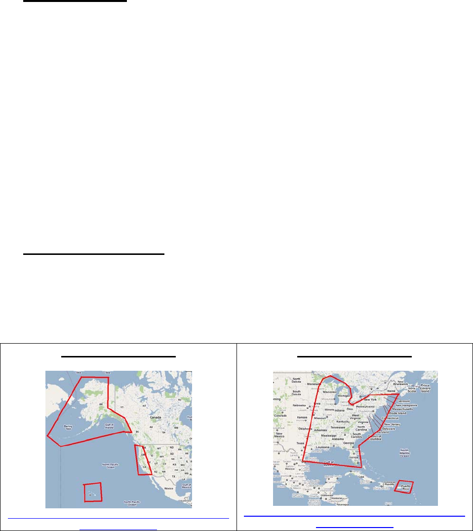
The Coastal Vector Charts for the USA are included in two separate files with the same
boundaries as the previous version. The names of the files are the same, with the
exception of the last two digits, which have been changed (from “06” to “09”):
SDUS01VS57MAP09
West Coast and Hawaii
http://download.mapmedia.com/vector/SDUS01VS
57MAP09.dbv.zip
SDUS00VS57MAP09
East Coast and Gulf of Mexico
http://download.mapmedia.com/vector/SDUS00VS
57MAP09.dbv.zip
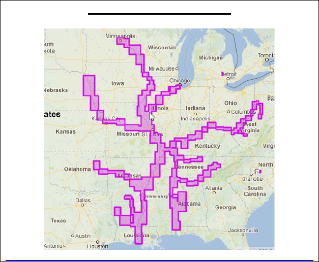
The new River Vector Charts are included in one new file:
SDUS02VS57MAP09.dbv
US Rivers
http://download.mapmedia.com/vector/SDUS02VS57MAP09.dbv.zip
The following rivers are covered:
• Allegheny River, Mile 0-15
• Arkansas River, Mile 0-444
• Atchafalaya River, Mile 0-118
• Black Warrior-Tombigbee Rivers, Mile 0-393
• Cumberland River, Mile 0-381
• Green River, Mile 1 -108
• Illinois River, Mile 0-322
• Kaskaskia, Mile 2 to 36
• Kanawha River, Mile 0-91
• Lower Mississippi River, Mile 236-951
• Missouri River, Mile 0-735
• Monongahela River, Mile 0-128
• Ohio River, Mile 0-981
• Ouachita River, Mile 5 to 338
• Red River, Mile 0-237
• Tennessee River, Mile 0-652 (Including Tellico, Hiwassee, Clinch and Emory Rivers)
• Tennessee-Tombigbee Waterway, Mile 218-450
• Upper Mississippi River, Mile 0-866
Please refer to the Appendix at the end of this document for a complete list of the River
Vector Charts included in this update.
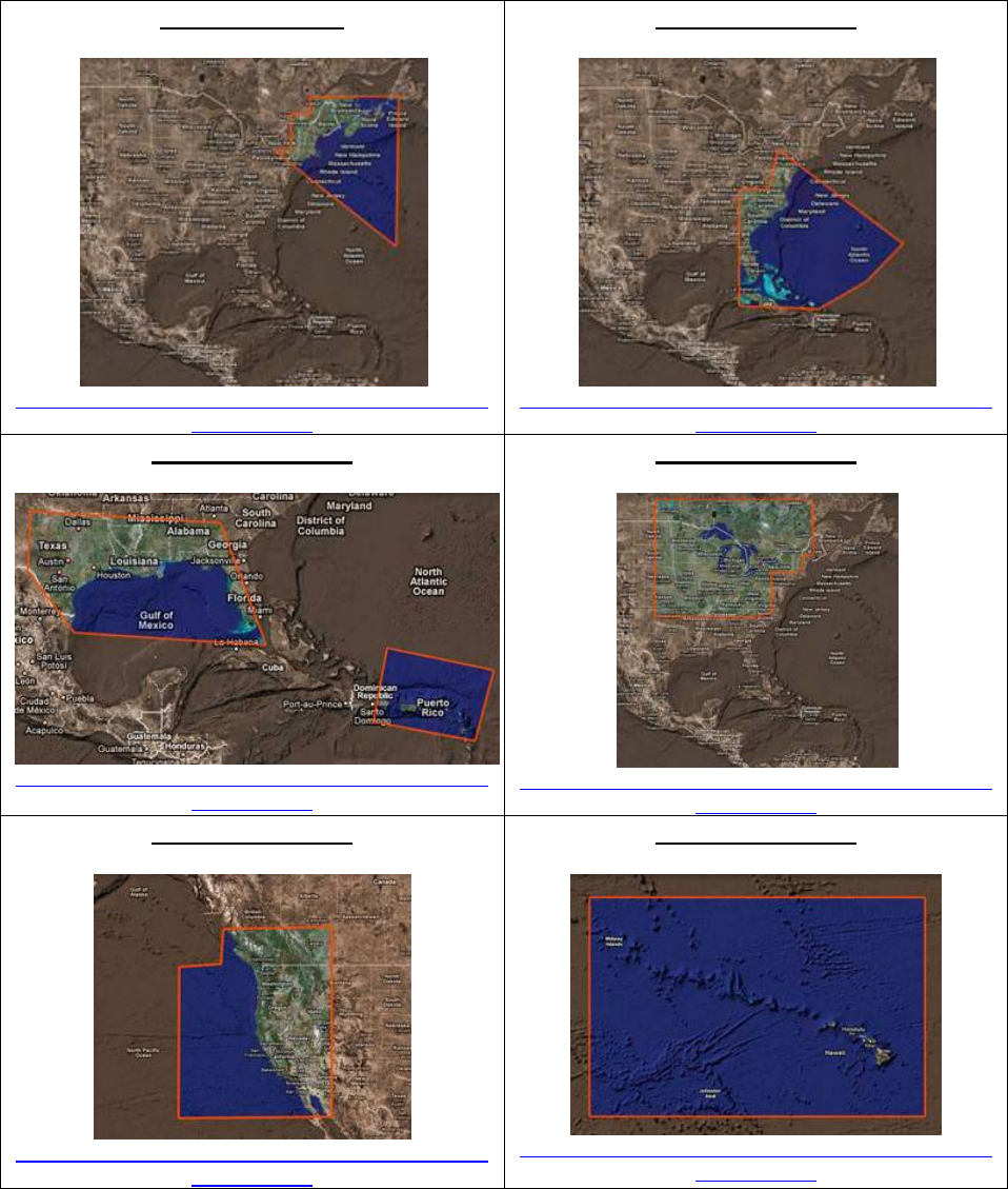
2.2. Raster Charts
The Raster Charts for the USA are included in 9 files with the same boundaries as the
previous version. The names of the files are the same, with the exception of the last two
digits that have been incremented (from “05” to “06”):
SDU01RMAP06
http://download.mapmedia.com/raster/SDUS01RM
AP06.dbr.zip
SDUS02RMAP06
http://download.mapmedia.com/raster/SDUS02RM
AP06.dbr.zip
SDUS03RMAP06
http://download.mapmedia.com/raster/SDUS03RM
AP06.dbr.zip
SDUS04RMAP06
http://download.mapmedia.com/raster/SDUS04RM
AP06.dbr.zip
SDUS05RMAP07
http://download.mapmedia.com/raster/SDUS05RM
AP07.dbr.zip
SDUS06RMAP06
http://download.mapmedia.com/raster/SDUS06RM
AP06.dbr.zip
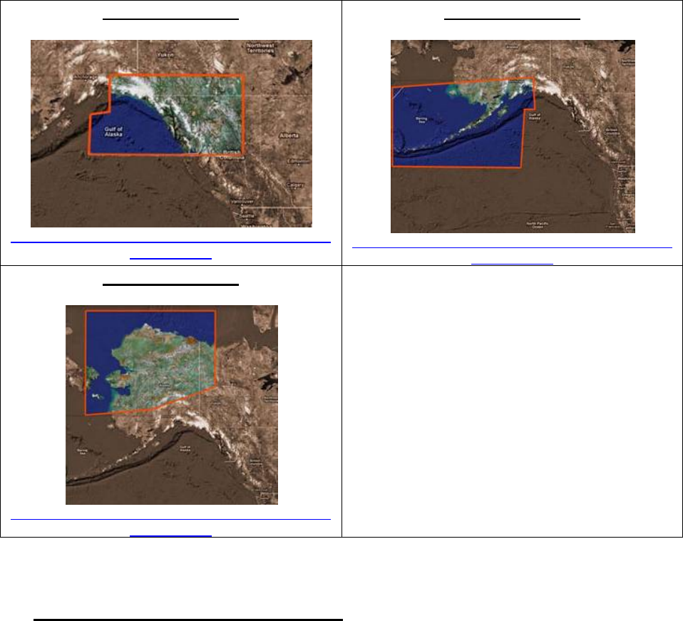
SDUS07RMAP06
http://download.mapmedia.com/raster/SDUS07RM
AP06.dbr.zip
SDUS08RMAP06
http://download.mapmedia.com/raster/SDUS08RM
AP06.dbr.zip
SDUS09RMAP06
http://download.mapmedia.com/raster/SDUS09RM
AP06.dbr.zip
3. Installation on NavNet 3D
3.1. Deleting the old data
Before installing the new charts it is recommended that you manually delete the old
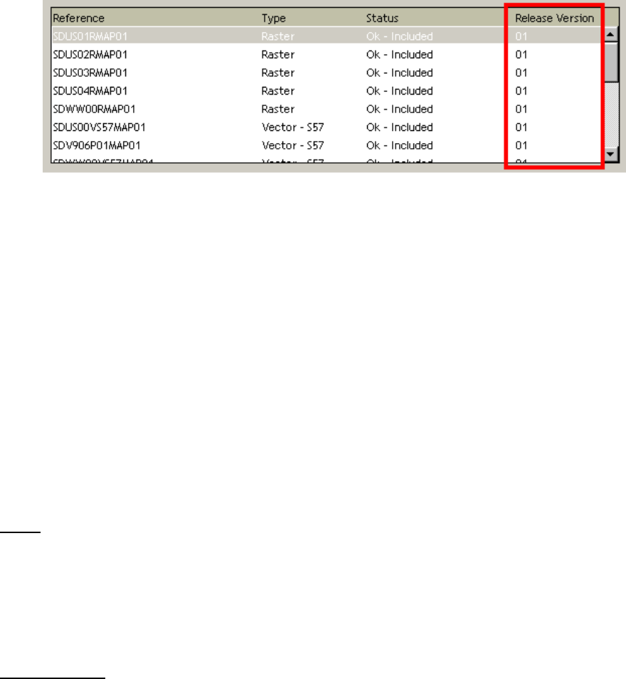
chart data on every MFD. To determine which version of data is installed on an MFD,
press the [MENU] key, select the “Chart” page and select the “Data Catalog”. To delete
a file, right click on it and choose “Delete”:
- If the release version of the US NOAA Vector charts “SDUSxxV57MAP” ends
with “01”, “02”, “03”, “04”, “05” or “06”, this unit should be updated with the new
“09” Vector charts.
- If the release version of the US NOAA Raster charts “SDUSxxRMAP” ends with
“01”, “02”, “03”, “04”, or “05”, this unit should be updated with the new “06” Raster
charts.
3.2. Installing the New Data
If an MFD needs to be updated with the new charts, you can download them using the
links provided above. You may also return your existing 1TB (not 500GB) External
Chart Hard Drive to Furuno to be updated at no charge. If you have not ordered an
External Chart Hard Drive, this would be an excellent and highly recommended time to
do so. You can order one containing the latest Library, using part number MM3-WRL-
DHD ($200 list price).
Copy the data at the root of the SD-Card(s). If you downloaded the files from Internet,
make sure to unzip them before transferring them on the SD-Card.
Note that if your MFD has Software v2.07, you can use a large SD-Card (16GB for
example) and transfer multiple files at the same time.
Note: On the MFDBB, it is highly recommended to load the new chart data via the USB
port using an SD-Card to USB adapter or a large USB Flash Drive (16GB for example).
Insert the SD-Card into the upper slot of the MFD to which the data is to be uploaded.
On the MFDBB, it is recommended to load the charts from one of the USB 2.0 ports
(making the transfer much faster).
IMPORTANT: When loading multiple charts at the same time, make sure you don’t
overload the MFD memory. To know how much data you can load onto the MFD, look
at the number of Memory Slots remaining (Menu -> Chart Catalog) and multiply this
value by two. This will give the maximum number of Gigabits that you can load on the
MFD (ex: if four memory slots are available, you can load up to 8GB of data onto the
SD-Card or Flash Drive)
Press the [MENU] key, select the “Chart” page and then select “Data Catalog”. Press
the “Install Data” button.
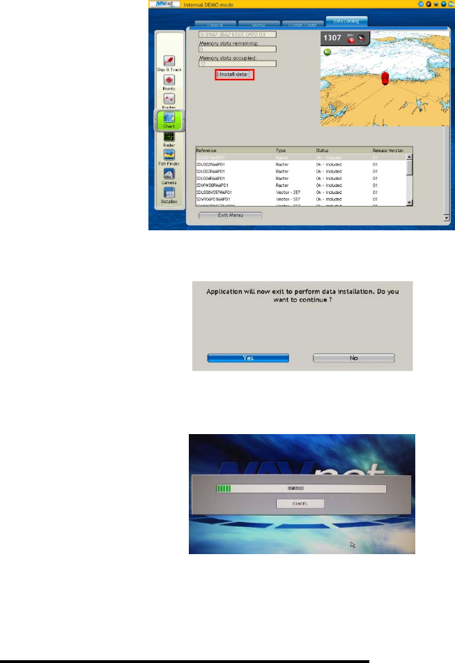
Select “Yes” when the following prompt appears:
The transfer will begin and a window displaying a progress bar will appear:
When the progress bar is complete, it will disappear from the screen and the MFD will
start. The new data is now loaded and ready for use.
4. Installation on NavNet TZtouch
On NavNet TZtouch, the charts are directly read from the SD-Card located under the
cover over the left SD-Card Slot. To update the charts, remove the SD-Card and insert
it into the SD-Card reader of your computer.
4.1. Deleting the old data
Browse on the SD-Card to the NOAA USA folder and delete the files in the Raster and
Vector Folders.

4.2. Installing the new data
If an MFD needs to be updated with the new chart data, you can download them using
the links provided above.
You may also return your existing External Chart Hard Drive to Furuno to be updated at
no charge. If you have not ordered an External Chart Hard Drive, this would be an
excellent and highly recommended time to do so. You can order one containing the
latest Library, using part number MM3-WRL-DHD ($200 list price).
Copy the data to the NOAA - Raster and Vector Folders of the SD-Card. If you have
downloaded the files from Internet, be sure to unzip them before transferring them
onto the SD-Card.
You also need to update the chart catalog to reflect these changes. You can download
the latest catalog file at http://www.maxsea.fr/data/catalogue.zic. After you download the
file, copy it to the root directory of the chart SD-Card.
If you have multiple TZT MFDs, repeat this process with all the SD-Cards. Note that
once you have updated one SD-Card, you may use the “Clone” function of the MFD to
duplicate SD-Cards.
5. Appendix: Vector Charts Added
Chart Naming Convention:
The 1st and 2nd characters represent the country code (US).
The 3rd character represents the navigation purpose. The U.S. has five classifications:
- # 1 is for overview charts with scales ranging from 1:1,500,001 or smaller
- # 2 is for general charts with scales ranging from 1:600,001 - 1:1,500,000
- # 3 is for coastal charts with scales ranging from 1:150,001 - 1:600,000
- # 4 is for approach charts with scales ranging from 1:50,001 - 1:150,000
- # 5 is for harbor charts with scales ranging from 1:50,000 or larger
The 4th and 5th characters represent the state.
List of new coastal vector charts:
US4FL43MUS1EEZ3MUS5AK9JMUS5CA76M
US4NY1BMUS3AK89MUS5AK9KMUS5CA80M
US5AN01MUS5AK14MUS5AK9LMUS5CA82M
US5FL16MUS5AK3MMUS5AK9MMUS5CA83M
US5FL17MUS5AK4TMUS5AK9NMUS5HA13M
US5FL27MUS5AK82MUS5AK9OMUS5HA15M
US5FL43MUS5AK93MUS5AK9PMUS5HA18M
US5FL53MUS5AK94MUS5AK9QMUS5HA21M
US5FL54MUS5AK96MUS5AK9RMUS5HA56M
US5FL56MUS5AK97MUS5AK9SMUS5OR41M
US5FL84MUS5AK9AMUS5AK9TMUS5OR45M
US5GA15MUS5AK9BMUS5AK9UMUS5OR46M
US5OH12MUS5AK9CMUS5AK9VMUS5SP31M
US5PR11MUS5AK9DMUS5AK9WMUS5WA70M
US5PR33MUS5AK9EMUS5AK9XM
US5SC24MUS5AK9FMUS5AK9YM
US5TX25MUS5AK9GMUS5AK9ZM
US5VA09MUS5AK9HMUS5AKJ3M
US6ME56MUS5AK9IMUS5CA11M
List of new river charts:
U37IL082U37MN086U37OH439U37TN085U37UM359
U37IL137U37MO000U37OH534U37TN133U37UM432
U37IL199U37MO101U37OH582U37TN218U37UM481
U37IL257U37MO201U37OH644U37TN262U37UM526
U37IL302U37MO301U37OH736U37TN306U37UM553
U37KA001U37MO399U37OH852U37TN361U37UM578
U37KA024U37MO499U37OH912U37TN391U37UM615
U37KA050U37MO600U37OU005U37TN450U37UM660
U37KA065U37OH001U37OU089U37TN518U37UM723
U37KK002U37OH012U37OU178U37TN564U37UM785
U37LM236U37OH032U37OU256U37TN606U37UM819
U37LM325U37OH087U37RR007U37TT218
U37LM425U37OH128U37RR071U37TT320
U37LM520U37OH166U37RR165U37TT385
U37LM601U37OH204U37TB001U37UM000
U37LM716U37OH275U37TB088U37UM079
U37LM829U37OH312U37TB176U37UM155
U37MN001U37OH332U37TN005U37UM218
U37MN042U37OH391U37TN047U37UM301
