Garmin 01039 LOW POWER COMMUNICATIONS TRANSMITTER User Manual c550 OM indd
Garmin International Inc LOW POWER COMMUNICATIONS TRANSMITTER c550 OM indd
Garmin >
USERS MANUAL
StreetPilot® c550™
owner’s manual

© 2006 Garmin Ltd. or its subsidiaries
Garmin International, Inc.
1200 East 151st Street,
Olathe, Kansas 66062, U.S.A.
Tel. 913/397.8200 or 800/800.1020
Fax 913/397.8282
Garmin (Europe) Ltd.
Unit 5, The Quadrangle,
Abbey Park Industrial Estate,
Romsey, SO51 9DL, U.K.
Tel. 44/0870.8501241
Fax 44/0870.8501251
Garmin Corporation
No. 68, Jangshu 2nd Road,
Shijr, Taipei County, Taiwan
Tel. 886/2.2642.9199
Fax 886/2.2642.9099
All rights reserved. Except as expressly provided herein, no part of this manual may be reproduced, copied, transmitted,
disseminated, downloaded or stored in any storage medium, for any purpose without the express prior written consent
of Garmin. Garmin hereby grants permission to download a single copy of this manual onto a hard drive or other
electronic storage medium to be viewed and to print one copy of this manual or of any revision hereto, provided that
such electronic or printed copy of this manual must contain the complete text of this copyright notice and provided
further that any unauthorized commercial distribution of this manual or any revision hereto is strictly prohibited.
Information in this document is subject to change without notice. Garmin reserves the right to change or improve its
products and to make changes in the content without obligation to notify any person or organization of such changes
or improvements. Visit the Garmin Web site (www.garmin.com) for current updates and supplemental information
concerning the use and operation of this and other Garmin products.
Garmin®, MapSource®, and StreetPilot® are registered trademarks and c550™ is a trademark of Garmin
Ltd. or its subsidiaries and may not be used without the express permission of Garmin.
SiRF, SiRFstar and the SiRF logo are registered trademarks of SiRF Technology, Inc. SiRFstarIII and
SiRF Powered are trademarks of SiRF Technology, Inc.
The Bluetooth® word mark and logos are owned by the Bluetooth SIG, Inc. and any use of such marks by
Garmin is under license. Other trademarks and trade names are those of their respective owners.
March 2006 Part Number 190-00642-00 Rev. A

Garmin © 2005 i c550 Owner’s Manual
PREFACE
Quick Links
• Finding an address: page 5
• Viewing the Map page: page 13
• Using hands-free cell phone:
page XX
• Listening to MP3 files: page 25
• Transferring files to your c550:
pages 17–20 and page 55
• Adjusting the volume: page 5
• Adjusting the brightness: page 5
• Cleaning and storing your unit:
pages 52–53
• Tips and Shortcuts: page 5
PREFACE
Congratulations on purchasing the Garmin® StreetPilot® c550™.
Serial Number
Record the serial number (8-digit number on the back of the unit)
in case your c550 needs service or you want to purchase additional
maps.
Serial Number: ___ ___ ___ ___ ___ ___ ___ ___
Contact Garmin
Contact Garmin if you have any questions or if you should
encounter any difficulty while using your c550.
In the U.S.A, contact Garmin Product Support by phone at
913/397.8200 or 800/800.1020, Monday–Friday, 8 AM–5 PM
Central Time. To send us a question through e-mail, go to
www.garmin.com/support/ and click Technical Support.
Fill out the form and click Submit .
In Europe, contact Garmin (Europe) Ltd. at 44/0870.8501241.
Tell us how you like this
manual! Fill out the Product
Documentation Survey. Go
to http://www.garmin.com/
contactUs/ and click Product
Documentation Survey.

Garmin © 2005 ii c550 Owner’s Manual
TABLE OF CONTENTS
Favorites .............................................13
Saving Places You Find ................................. 13
Finding Saved Places .................................... 13
Saving Your Current Location ........................ 13
Editing Saved Places ....................................14
Viewing the Map and Other Pages .......15
Viewing the Map Page .................................. 15
Trip Information Page ................................... 16
Turn List ..................................................... 17
Next Turn Page ............................................ 17
Managing Files on Your c550 ...............18
Step 1: Insert an SD Card (Optional) ............. 18
Step 2: Connect the USB Cable ..................... 18
Step 3: Transfer Files to Your c550 .................19
Step 4: Eject and Unplug the USB Cable ......... 20
Information about Your c550 Drives ............... 20
Additional Help ............................................ 20
Deleting Files from Your c550 ........................ 21
Supported File Types .................................... 21
Preface ...................................................i
Serial Number ................................................i
Contact Garmin ..............................................i
Quick Links ....................................................i
Find It and Go! ......................................1
Finding Your Destination .................................1
Following Your Route ......................................2
Adding a Stop to Your Route ............................3
Adding a Detour to a Route .............................4
Stopping Your Route ......................................4
Adjusting the Volume .....................................5
Adjusting the Brightness .................................5
c550 Tips and Shortcuts .................................5
Where To? .............................................6
Go! Page Options ...........................................6
Finding an Address ........................................7
Go Home ......................................................8
Finding Points of Interest ................................9
Finding Recently Found Places ....................... 10
Finding a Place Using the Map ....................... 11
Expanding Your Search ................................. 12

Garmin © 2005 iii c550 Owner’s Manual
TABLE OF CONTENTS
Listening to MP3 Files .........................22
Using the Hands-free Features of Your
c550 ..................................................23
Connecting Your Phone to the c550 Using
BlueTooth ................................................ 23
Phone Menu ................................................ 25
FM TMC Traffic Information ................28
Connecting the FM Traffic Receiver ................. 28
Avoiding Traffic ............................................29
Viewing Traffic Events .................................. 29
Adding a Subscription .................................. 30
Customizing the c550 ..........................31
Restoring Settings ....................................... 31
Changing the Map Settings ........................... 32
Changing the System Settings ....................... 33
Localizing Your c550 ..................................... 34
Customizing the Display ............................... 36
Changing the Navigation Settings .................. 37
Changing the Bluetooth Settings .................... 38
Using the Travel Guide .................................. 39
Custom POIs (Points of Interest) .................... 40
Appendix .............................................41
Mounting Your c550 ..................................... 41
Resetting Your c550 ..................................... 43
Clearing User Data .......................................43
Caring for Your c550 ................................... 44
Updating the c550 Software .......................... 46
Purchasing and Loading Additional MapSource
Maps ....................................................... 46
Loading MapSource Waypoints on Your c550 ... 47
Bluetooth® Wireless Technology
Troubleshooting ........................................ 48
USB Interface Troubleshooting ....................... 48
Battery Information ....................................50
About Satellite Signals ................................. 51
Technical Specifications ................................ 52
Software License Agreement ......................... 53
FCC Compliance .......................................... 54
Index .................................................. 55
Garmin © 2005 1 c550 Owner’s Manual
FIND IT AND GO!
FIND IT AND GO!
Go outside where you have a clear view of the sky to get satellite signals. Turn on your Garmin StreetPilot
c550 to begin acquiring GPS satellite signals. The bars in the upper-left corner indicate satellite
strength. After your c550 has acquired satellite signals, find your destination and go to it.
Finding Your Destination
Touch Food, Hotels….
➋
Enjoy the route!
➏
Touch Go!
➎
Touch Where to?
➊
Touch a destination.
➍
Touch a category.
➌
✔
TIP: Touch and to see more choices.
Garmin © 2005 2 c550 Owner’s Manual
FIND IT AND GO!
Following Your Route
Follow the route to your destination using the Map page. As you travel, your c550 guides you to your
destination with vocal prompts, turn arrows on the map, and directions at the top of the Map page. If you
depart from the original route, your c550 recalculates the route and provides new route directions.
Your route is marked
with a magenta line.
Follow the arrows as
you make turns.
A checkered
flag marks your
destination.
Read the driving
instructions at the
top of the page.
For more information about using the Map page, see pages 13–16.
Taking a Better Route
As you get closer to the destination the c550 evaluates more road options when calculating the route,
which may result in a better route than what was originally calculated. When the StreetPilot has found a
better route, a yellow diamond with a road in it is displayed in the lower-left corner of the Map page.
Touch to take the better route.
If you need to take a detour, press the Menu button to open the Menu page and touch Detour.
Garmin © 2005 3 c550 Owner’s Manual
FIND IT AND GO!
Adding a Stop to Your Route
You can add a stop (via point) to your route. The c550 gives you
directions to the stop and then to your final destination.
With a route active, touch
Menu > Where to?
Touch Yes to add this stop
before your destination.
Touch No to make this
your new final destination
Search for the extra stop.
Touch Go!
➌
➋
➍
➊
NOTE: You can
add only one stop to
your route.
Garmin © 2005 4 c550 Owner’s Manual
FIND IT AND GO!
Touch Menu to return to
the Menu page.
➊
Touch Stop to end
navigation. Touch Detour
and your unit creates a
new route if possible.
➋
Adding a Detour to a Route
If you need to take a detour from your current route, touch
Detour from the Menu page of the c550. The unit calculates
a new route and provides you with new instructions. The c550
attempts to get you back on your original route as soon as possible.
On some routes, the route you are currently taking might be the
only reasonable option. In this case, you cannot take a detour.
Stopping Your Route
If you want to stop your current route, return to the Menu page
and touch Stop.
Garmin © 2005 5 c550 Owner’s Manual
FIND IT AND GO!
Adjusting the Volume
Turn the Volume knob on the right side of the unit up to raise the
volume or down to lower it.
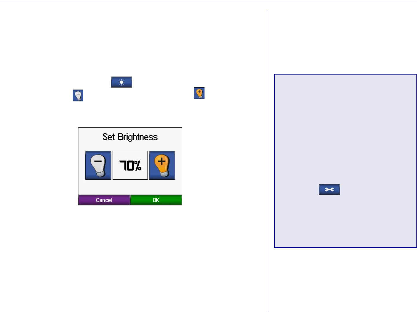
Adjusting the Brightness
From the Menu page, touch to adjust the backlight
brightness. Touch to lower the brightness and to raise it.
Touch OK when you are done.
c550 Tips and
Shortcuts
• To quickly return to the Menu
page, press and hold Back.
• To extend the battery life,
turn off GPS when you do not
need to receive GPS signals.
Touch > System > GPS
Mode > GPS Off.
• For more tips about the
battery, see page 57.
Garmin © 2005 6 c550 Owner’s Manual
WHERE TO?
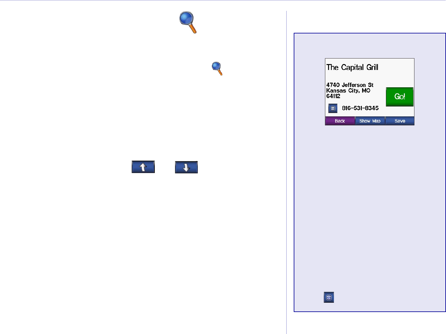
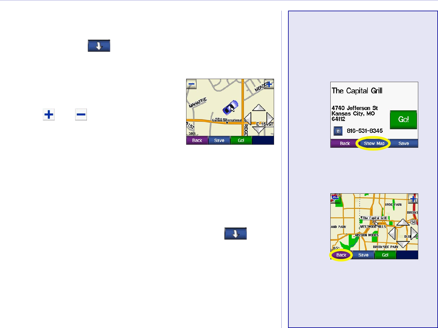
Go! Page Options
Touch Go! to create a turn-by-
turn route to this location.
Touch Show Map to view this
location on the map.
Touch Save to save this location
as one of your Favorites. See
pages 9 through 12 for more
information.
If a cell phone with Bluetooth
wireless technology is connected,
touch to call this location.
WHERE TO?
The Where To? menu provides several different categories used
to search for locations. From the Menu page, touch Where To?
To learn how to perform a simple search using the Where To
menu, see page 1.
Address—enter the house number and street name to find a
specific address. See page 3.
Go Home—navigate a route to your Home Location.
Food, Hotel…—search for places such as schools, shopping
centers, and hospitals. Touch and to view all of the
categories.
Recently Found—find places you have recently found.
Favorites—save and find your favorite locations. See page 7
Extras—find optional items such as Custom POIs and Garmin
Travel Guide™ points. See page XX and XX.
Intersections—find the intersection of two streets.
Cities—find a city.
Browse Map—use the map to find the location you are looking
for. See the next page.
Garmin © 2005 7 c550 Owner’s Manual
WHERE TO?
Finding an Address
To find an address, touch Where to? from the Menu page. Touch Address.
Finding an intersection is very similar to finding an address.
Touch Intersection and enter the two street names.
Touch a state.
➊
Type the number
of the address and
touch Done.
➍➌
Touch a city.
➎
Type the street
name and touch
Done.
➏
Touch the street. Touch the address, if
necessary. Touch Go!
➐
Touch Spell City
and spell the city.
➋
Garmin © 2005 8 c550 Owner’s Manual
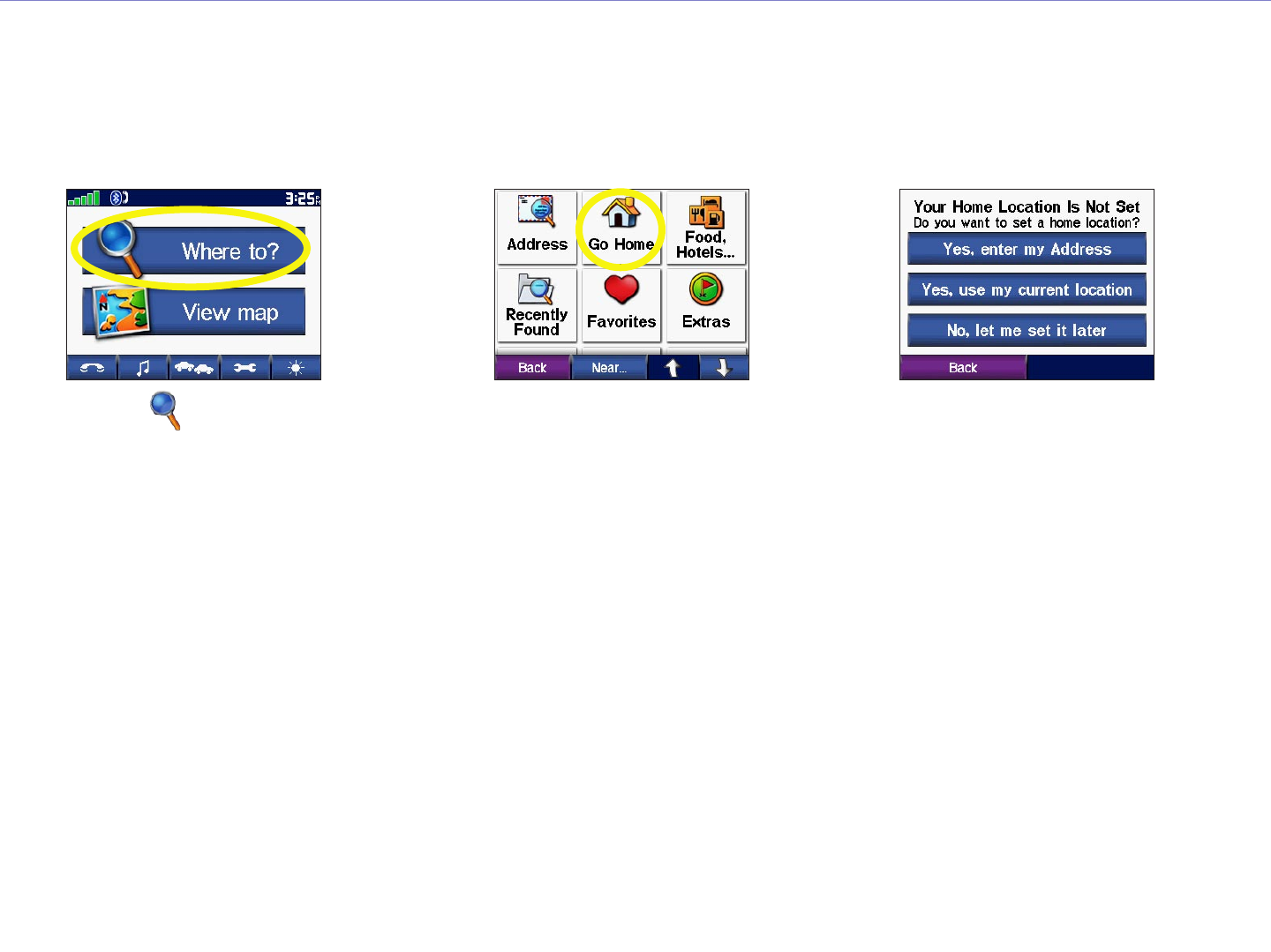
WHERE TO?
Go Home
You can set a Home location for the place you return to most often. After you have set your Home, you can
easily Go Home.
Touch an option.
➌
Touch Go Home.
➋
Touch Where to?.
➊
Going Home
Once your Home location is set, you can route to it at any time by touching Where To? > Go Home.
Changing Your Home Location
To change your Home Location, you must first delete it from Favorites: from the Menu page, touch
Where To? > Favorites > HOME > Edit > Delete > Yes. (For information about editing and deleting
a saved location from your Favorites, see page 15.) After you delete your Home Location, reset it following
the steps above.
Garmin © 2005 9 c550 Owner’s Manual
WHERE TO?
Finding Points of Interest
To find a point of interest (such as a restarant, hotel, or
attraction), touch Where to? from the Menu page. Touch
Food, Hotels…. Touch a sub-category (such as Food) to find
the location.
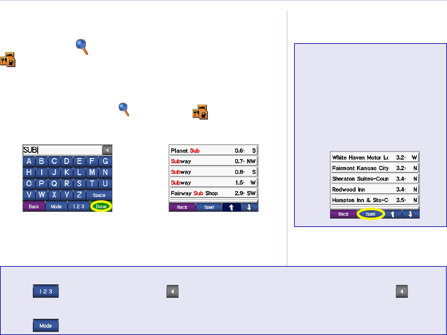
Finding a Place by Spelling the Name
From the Menu page, touch Where to? > Food,
Hotels… > Spell Name.
Using the on-screen
keyboard, enter letters
contained in the name.
Touch Done.
➊
Touch the place
you want to visit.
Touch Go!
➋
✔
TIP: In any search results
list, if you do not see the
place you want visit or
you want to narrow your
search results list, touch
Spell and enter the name
or part of the name.
Using the On-Screen Keyboard
Touch to enter numbers. Touch to delete the last character entered; touch and hold to
delete the entire entry.
Touch to change the keyboard mode to use diacritical characters or special characters.
Garmin © 2005 10 c550 Owner’s Manual
WHERE TO?
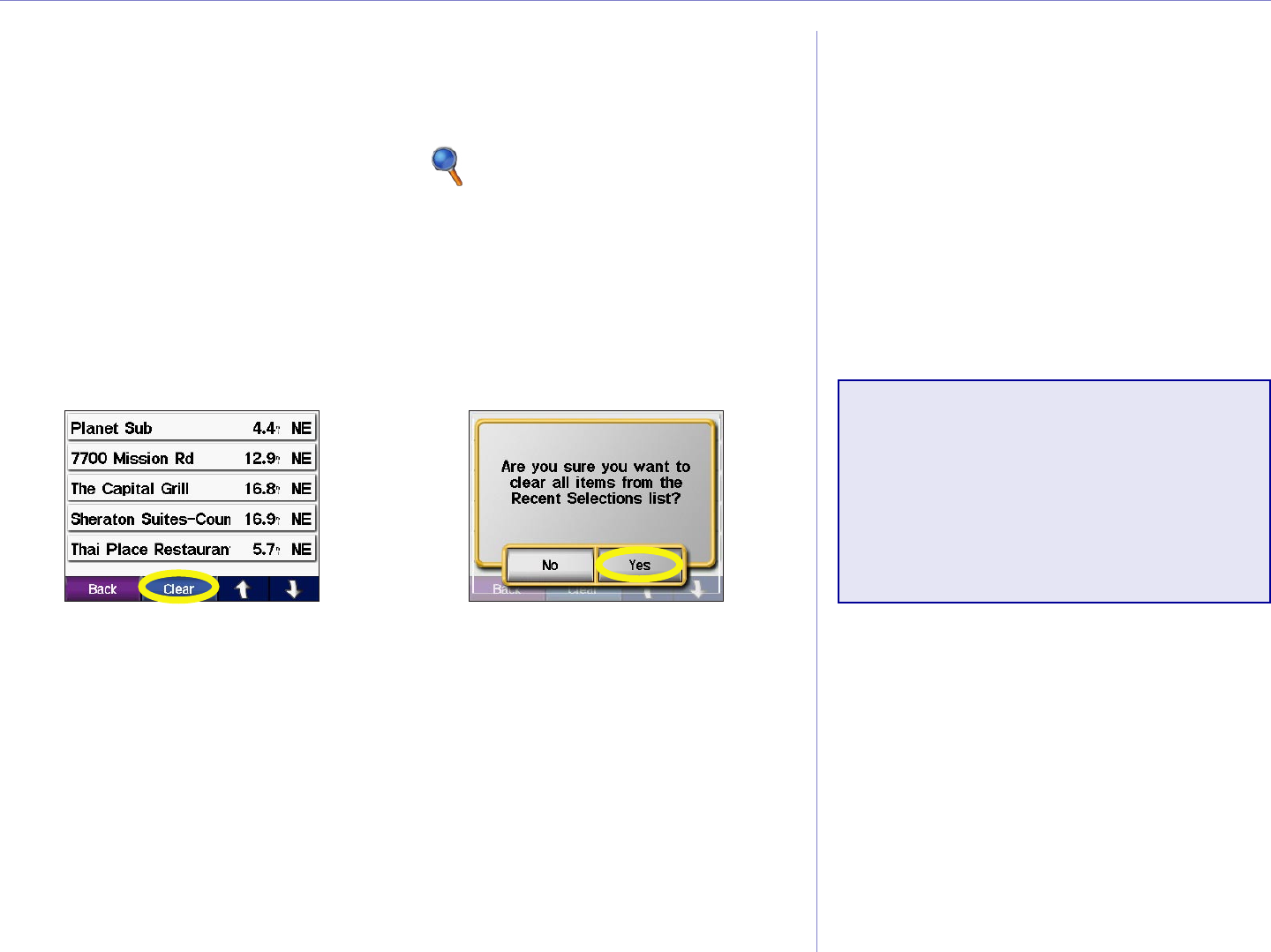
Finding Recently Found Places
Your c550 stores the last 50 of your recent finds in the Recently
Found list. The most recently viewed places appear at the top of
the list. From the Menu page, touch Where to? > Recently
Found to view your recently found items.
Deleting Recently Found Places
To remove all places from the Recently Found list, touch Clear.
Then touch Yes.
➊ ➋
NOTE: When you touch
Clear, all items from the
list are removed. It does
not delete the actual place
from your unit.
Garmin © 2005 11 c550 Owner’s Manual
WHERE TO?
Finding a Place Using the Map
Use the Browse Map page to view different parts of the map.
Touch Where to? > > Browse Map.
Tips for Browsing the Map
• Touch the arrows to view different parts
of the map.
• Touch and to zoom in and out.
• Touch any object on the map. An arrow
appears pointing at the object you
selected.
• Touch Go to navigate to the selected location.
• Touch Save to save this location to your Favorites.
• Touch Back to return to the previous screen.
• To save your current location, touch Where to? > >
Browse Map. The Browse Map page opens with your current
location selected. Touch Save to save your current location in
Favorites.
• If the GPS is off, touch Set Loc. to set your location to the
selected location.
Viewing Places on
the Map
You can view a place you have
found on the Map page.
Touch Show Map.
➊
Touch Back, Save,
or Go!
➋
Garmin © 2005 12 c550 Owner’s Manual
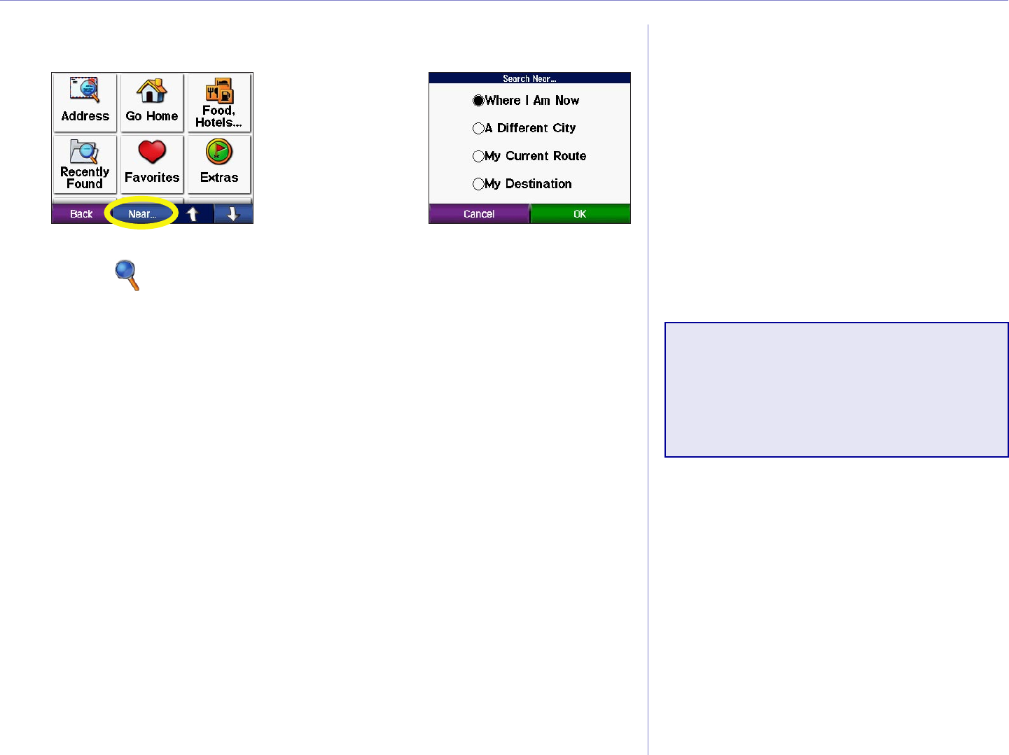
WHERE TO?
Expanding Your Search
From the Menu page,
touch Where to?
Then touch Near.
➊
Touch an option.
Touch OK.
➋
Where I Am Now—searches for places near your current
location.
A Different City—searches for places near the city you enter.
My Current Route—searches for places along the route you are
currently navigating.
My Destination—searches for places near your route
destination.
NOTE: Your c550
automatically searches for
places near your current
location.
Garmin © 2005 13 c550 Owner’s Manual
FAVORITES
FAVORITES
Saving Places You Find
➊
After you have
found a place,
touch Save.
➋
Touch OK.
Finding Saved Places
From the Menu page, touch Where to?.
Touch Favorites. Touch the place
you want to visit.
➋➊
Saving Your
Current Location
Touch the vehicle icon on the
map. Touch Yes.
Garmin © 2005 14 c550 Owner’s Manual
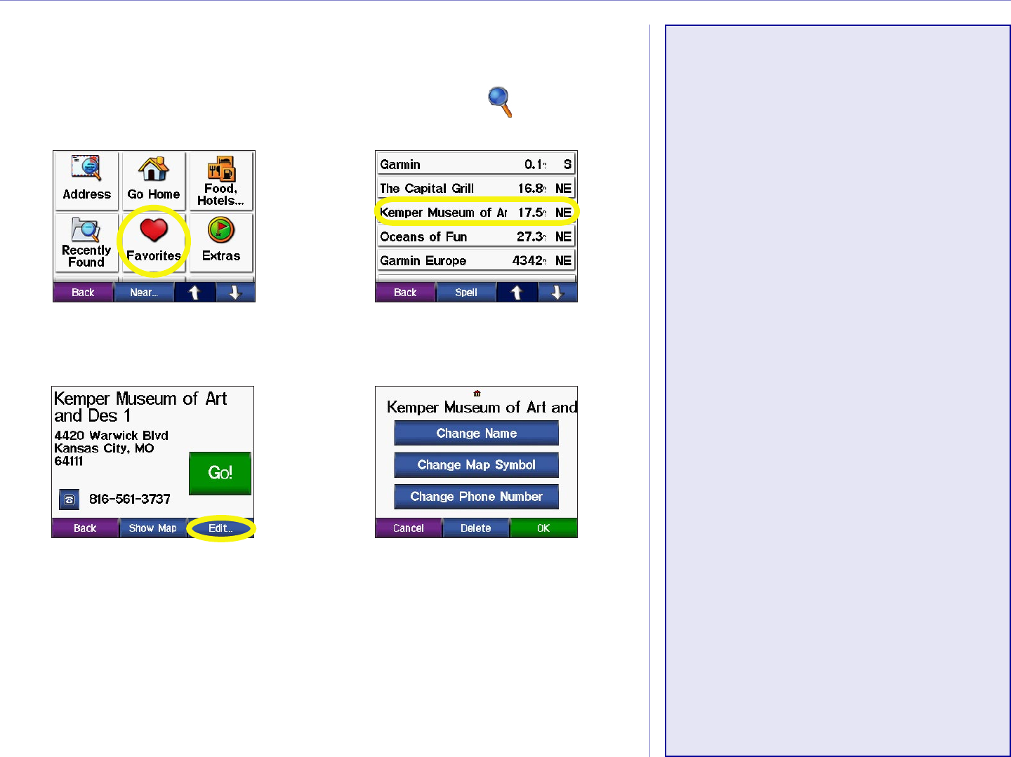
FAVORITES
Editing Saved Places
After you save a place, you can change the name of the place and
its symbol on the map. From the Menu page, touch Where to?
Touch Favorites.
➊
Touch the Edit button.
The Edit window opens.
➍
Touch a button edit
the saved location.
➌
Touch the place
you want to edit.
➋
Deleting Saved Places
To delete this saved place, touch Delete. Then touch Yes.
Changing the Name
To change the name, touch
Change Name. Enter the
new name using the on-screen
keyboard. Touch Done.
Changing the Map
Symbol
To change the symbol used on
the map, touch Change Map
Symbol and touch a symbol from
the list.
Changing the Phone
Number
You can save a phone number
for this location to use with your
Bluetooth® enabled cellular
phone. Touch Change Phone
Number, enter a phone number,
and touch Done.
Garmin © 2005 15 c550 Owner’s Manual
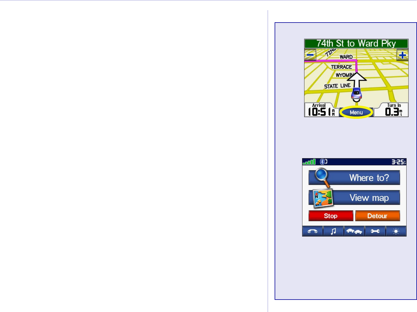
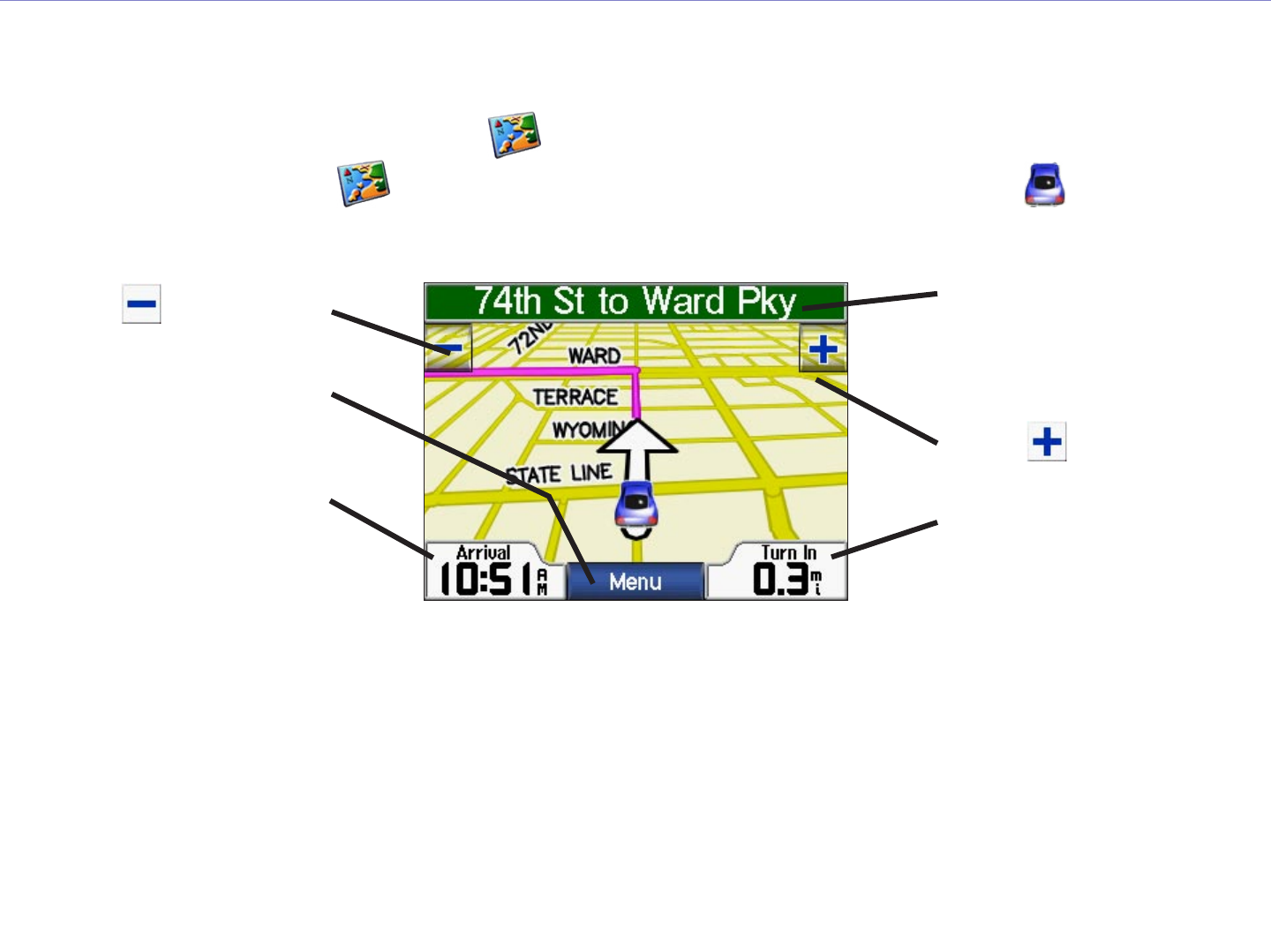
VIEWING THE MAP PAGE AND OTHER PAGES
VIEWING THE MAP AND OTHER PAGES
Viewing the Map Page
From the Menu page, touch View map to open the Map page. The position icon shows your
current location. Touch areas of the page to see additional information, as described below.
Touch Arrival or
Speed to open the Trip
Information page. See
page 14.
Map Page while Navigating a Route
When navigating, touch
Turn In to open the Next
Turn page. See page 15.
When navigating, touch
the text bar to open the
Turns List. See page 15.
Touch to zoom out.
Touch to zoom in.
Touch Menu to return to
the Menu page.
When you are following a route, your Arrival time is displayed in the lower left corner. The distance to the
next turn (Turn In) is shown in the lower right corner.
When you are simply driving while viewing the Map page (not following a route), your Speed is shown in
the lower left corner. The direction you are heading (Driving) is shown in the lower right corner.
Garmin © 2005 16 c550 Owner’s Manual
VIEWING THE MAP PAGE AND OTHER PAGES
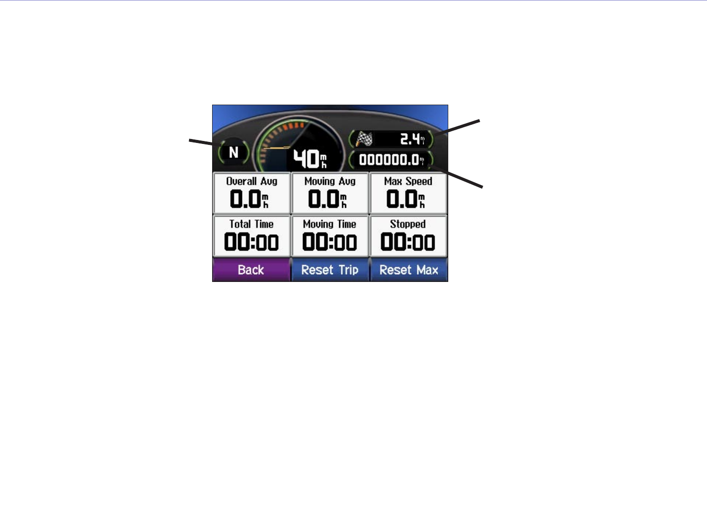
Trip Information Page
The Trip Information page displays your current speed and provides helpful statistics about your trip. To
view the Trip Information page, touch Speed or Arrival on the Map page.
Current direction
of travel
Distance traveled
(Odometer)
Distance to your final
destination
Trip Information Page
Resetting Trip Information
If you want accurate trip information, reset the trip information before beginning a trip. If you make
frequent stops, leave the c550 turned on so it can accurately measure elapsed time during the trip.
Touch Reset Trip to reset the information on the Trip Information page. Touch Reset Max to reset the
Maximum Speed.
Garmin © 2005 17 c550 Owner’s Manual
VIEWING THE MAP PAGE AND OTHER PAGES
Turn List
The Turn List displays turn-by-turn instructions for your entire route. Touch the green text bar on the top
of the Map page to open the Turn List. This page displays all turns in the route and the distance between
turns. Touch a turn on the list to view the Next Turn page for that turn. Touch Show Map to view the
entire route on the Browse Map.
Turn List
Direction of
the turn
Distance to
the turn
Upcoming turn
Distance to the
upcoming turn
Approximate time
left until this turn
Next Turn Page
Next Turn Page
The Next Turn page shows the turn on the map and the distance and time left before you reach the turn.
To view an upcoming turn on the map, touch Turn In on the Map page, or touch any turn from the Turn
List.
Use the up and down arrows to view other turns in the route. When you are finished viewing the Next Turn
page, touch Back.
Garmin © 2005 18 c550 Owner’s Manual
MANAGING FILES ON YOUR C550
MANAGING FILES ON YOUR C550
Your c550 is able to store files, such as MP3 and JPEG files. After
you connect your c550 to your computer, you can copy and paste
files to the memory or SD Card. Follow the four steps described
below and on the next page.
NOTE: The c550 is not compatible with Windows 95,
Windows 98, or Windows Me Operating Systems. This is a
common limitation of most USB Mass Storage devices.
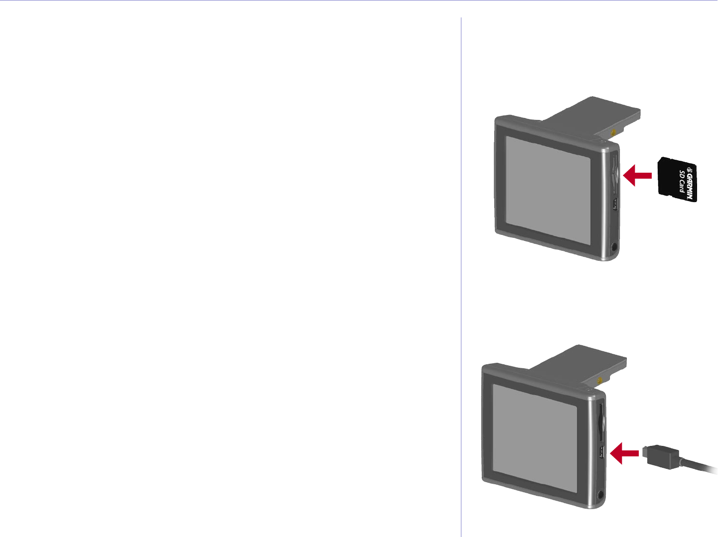
Step 1: Insert an SD Card (Optional)
The SD card slot is located on the side of the c550. To insert or
remove the card, press it in until it clicks.
Step 2: Connect the USB Cable
1. Plug the small end of the USB cable into the mini-USB
connector located on the side of your c550.
2. Connect the larger end of the USB cable to an available
USB port on your computer.
Inserting an SD Card
Connecting the USB Cable
NEW IMAGES
Garmin © 2005 19 c550 Owner’s Manual
MANAGING FILES ON YOUR C550
Step 3: Transfer Files to Your c550
1. Connect the c550 to your computer as described on the previous page.
2. Double-click the My Computer icon on your computer’s desktop.
3. Browse your computer for the file you want to copy.
4. Highlight the file and select Edit > Copy.
5. Open the “Garmin” drive or the SD card drive (see the next page for information).
6. Select Edit > Paste. The file then appears in the list of files on the c550 memory or SD card.
c550
Removable
Disk Drives

Garmin © 2005 20 c550 Owner’s Manual
MANAGING FILES ON YOUR C550
Step 4: Eject and Unplug the USB
Cable
When you are finished transferring files, double-click the Unplug
or Eject icon in your system tray. Select USB Mass Storage
Device and click Stop. Select the c550 drives and click OK. You
can unplug the USB cable from your c550 now.
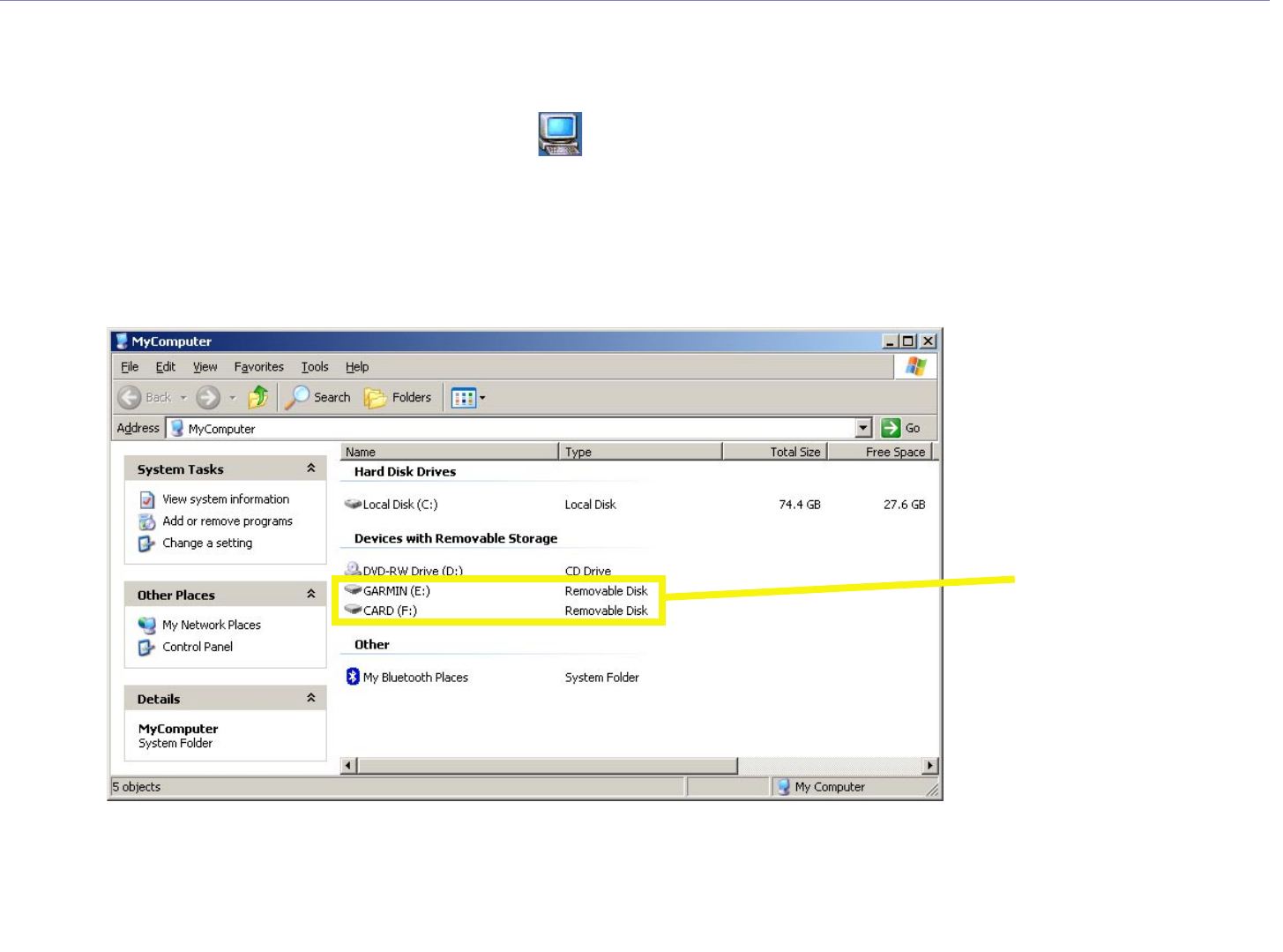
Information about Your c550 Drives
After you connect your c550 to your computer, one or two
additional drives appear in your computer’s list of drives.
“Garmin” is the available storage in the c550’s internal memory.
The other Removable Disk Drive is the SD card inserted in your
c550.
NOTE: On some Windows Operating Systems, the c550
drives may not be named automatically. See your Windows
help file or page 56 of this manual to learn how to rename
the drives.
Additional Help
For troubleshooting tips for using
the c550 with your computer to
transfer files, see page 55.

Garmin © 2005 21 c550 Owner’s Manual
MANAGING FILES ON YOUR C550
Deleting Files from Your c550
You can delete files from your c550 just as you would delete files
from your computer.
With the c550 connected to your computer, open My Computer.
Open your “Garmin” or the SD card drive. Highlight the file that
you want to delete and press the Delete key on your computer’s
keyboard.
Supported File Types
• MP3 music files
• JPEG and JPG image files for customized splash screen (see
page XX)
• GPI custom POI files from Garmin’s POI Loader (see page 51)
• GPX waypoint files from MapSource (see page 54)
• Maps from MapSource
NOTE: The c550 does not support iTunes M4A/M4P files.
CAUTION: If you are
not sure about a file’s
purpose, do NOT delete
it. Your c550 memory
contains important map
data files that should NOT
be deleted. Be especially
cautious of files located in
folders entitled “Garmin.”
Garmin © 2005 22 c550 Owner’s Manual
LISTENING TO MUSIC
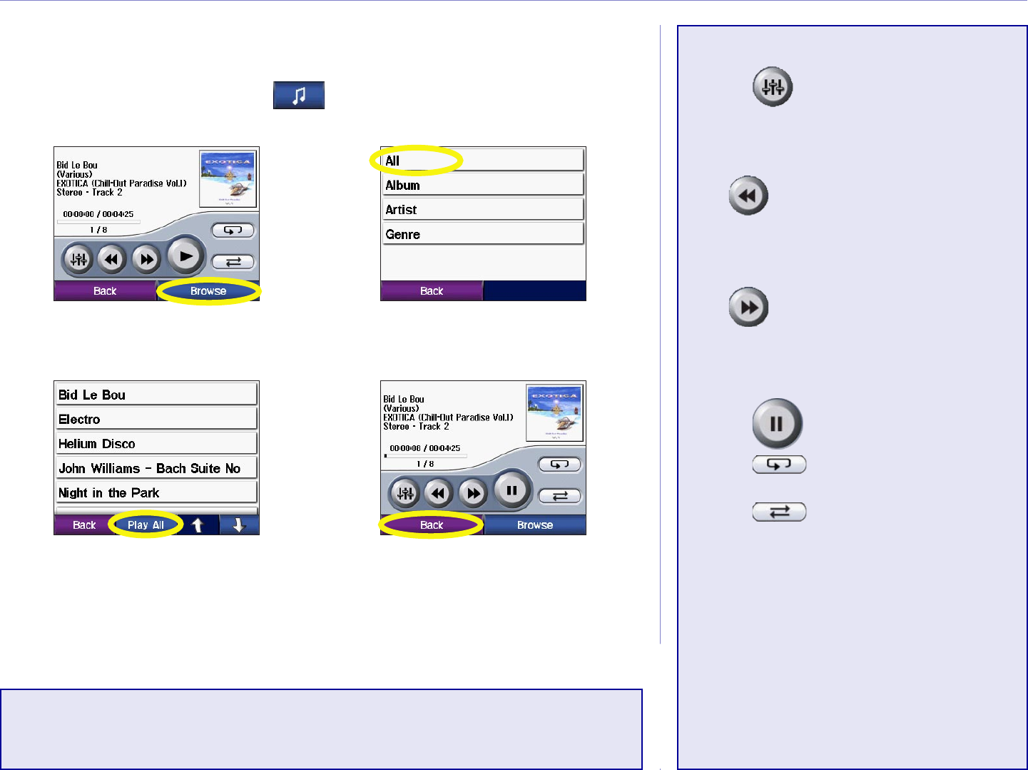
LISTENING TO MP3 FILES
From the Menu page, touch .
Touch Back to exit the
MP3 page to view other
pages, such as the map.
➍
To play the songs from
the top of the list, touch
Play All or touch the song
you want to start with.
➌
Touch a category.
➋
Touch Browse.
➊
Playing Music
Touch to select an equalizer
setting appropriate for the type of
music you are listening to.
Tap to go to the beginning of
the song; touch and hold to skip
back.
Tap to skip to the end of
the song; touch and hold to skip
ahead.
Touch to pause the song.
Touch to repeat.
Touch to shuffle.
Touch the album art to view
details about the MP3 file.
NOTE: The c550 plays MP3 files only: it does not
support iTunes M4A/M4P files.

Garmin © 2005 23 c550 Owner’s Manual
USING THE PHONE FEATURES
USING THE HANDS-FREE FEATURES OF YOUR C550
Your c550 can connect to a cellular phone that has Bluetooth wireless technology to allow hands-free
communication with full user interface. First, you must pair (connect) the phone with the c550.
We recommend that you use the settings in your phone to connect to the c550. You might need to initiate
a connection to the c550 through your phone’s “Bluetooth” settings. For more information, please refer to
the documents that came with your phone.
Connecting Your Phone to the c550 Using BlueTooth
Use the settings in your phone to pair with (connect to) the c550. You might need to initiate a connection
to the c550 through your phone’s “Bluetooth” settings. For more information, refer to the documents that
came with your phone.
NOTE: The c550’s PIN code (or passkey) is 1234.
After your phone is paired with the c550, the phone icon appears on the Menu page. Touch to access
the Phone menu and make a call.
Each time you turn on your c550, it automatically attempts to pair with the last phone that it paired with.
If you want to pair with a different phone, you can initiate a search for available devices from the c550 or
initiate pairing from the phone if the c550 is not already paired with a different phone.
When your phone is paired with your c550, a phone icon is displayed on the Menu page. Touch the
icon to open the Phone menu to place calls and review your call history.
Garmin © 2005 24 c550 Owner’s Manual
USING THE PHONE FEATURES
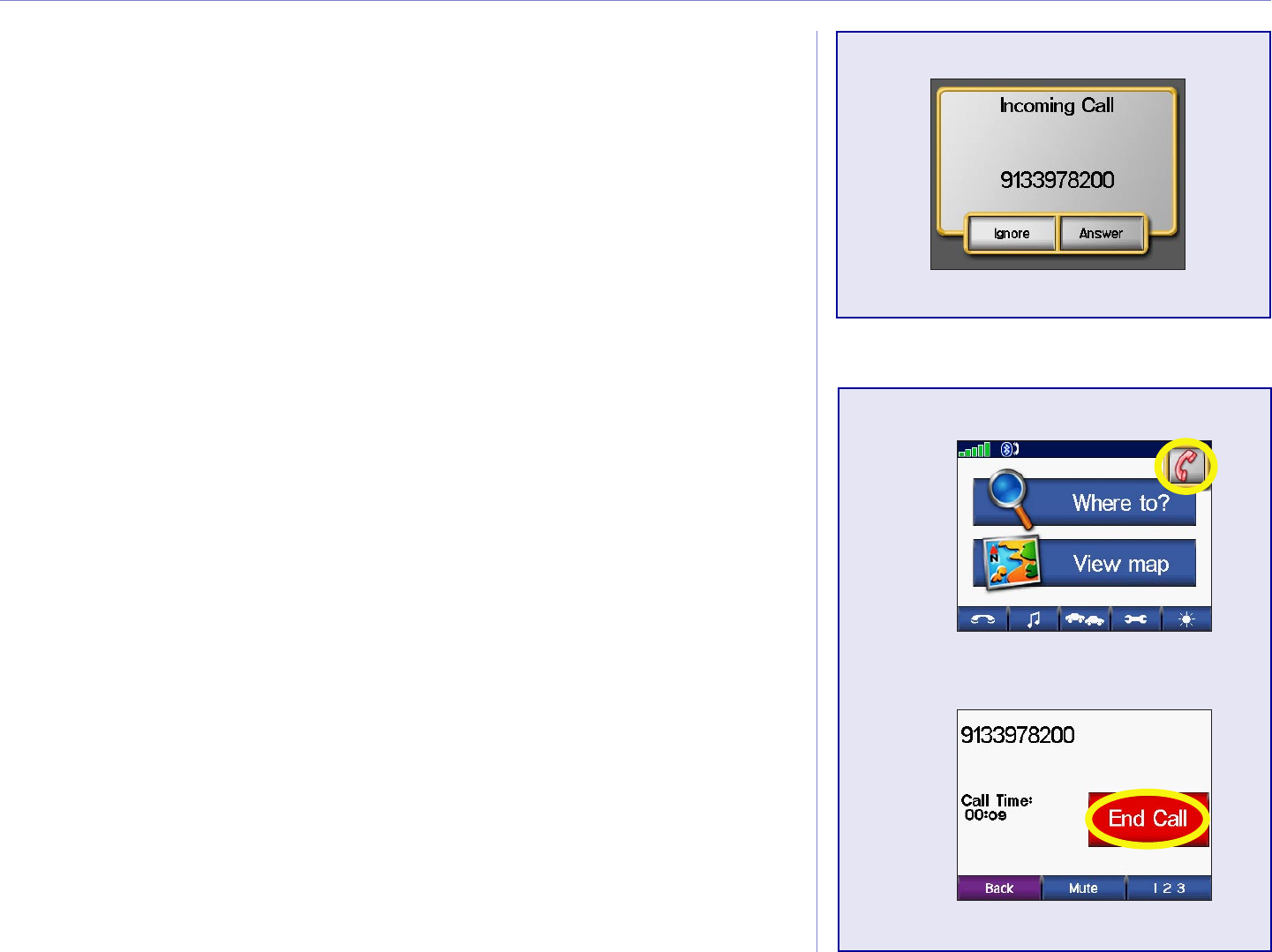
Getting a Call
When a call is being received, a window opens, allowing you to
answer the call. Touch Answer to answer the call. Touch Ignore
not answer the call and stop the phone from ringing.
In A Call
While you are on the phone, an icon floats in the upper right
corner of the screen. Touch the icon to open the In Call Menu.
Touch End Call to hang up.
➊
➋
Garmin © 2005 25 c550 Owner’s Manual
USING THE PHONE FEATURES
➊
➋
Phone Menu
Press Status to view the signal strength and the name of the
connected phone.
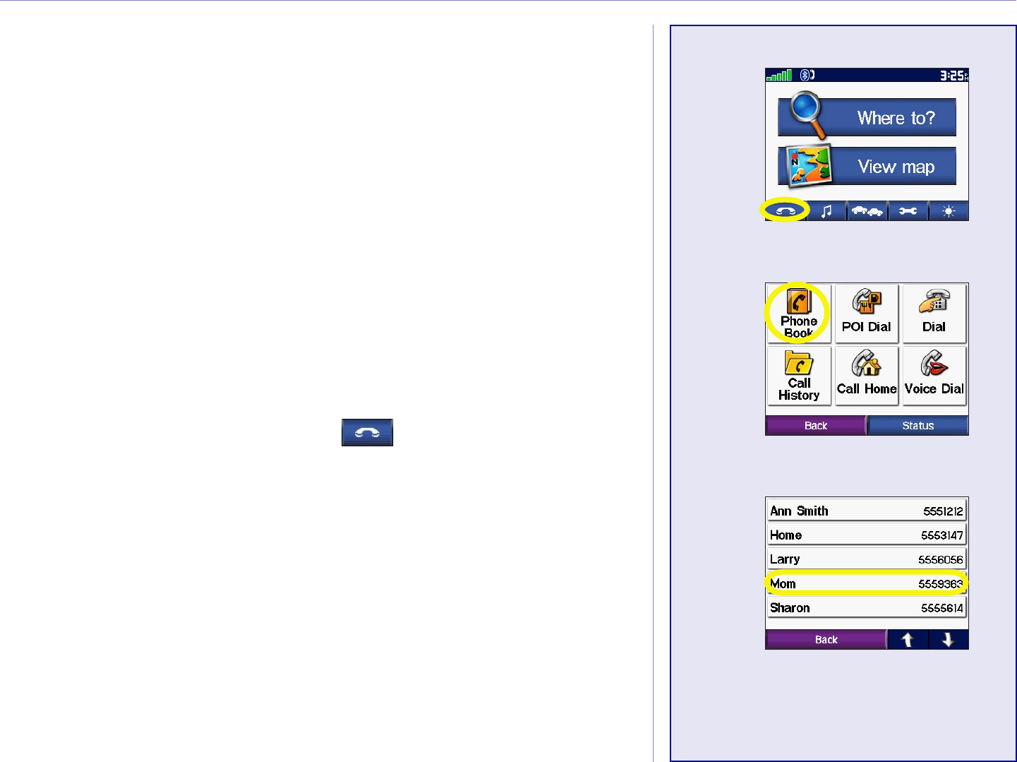
Using Your Phone Book
If your cell phone supports phone book transfer, each time your
cell phone pairs with the c550, the phone book is automatically
loaded into the c550. This way, each change you make to your
cell phone’s phone book is reflected each time you use it with your
c550.
NOTE: After your phone is paired with the c550, it may
take a few minutes for the phone book to be available.
1. From the Menu page, touch .
2. Touch Phone Book.
3. Touch the phone book entry you want to call. The call is
placed to the phone book entry you touched.
➌
Garmin © 2005 26 c550 Owner’s Manual
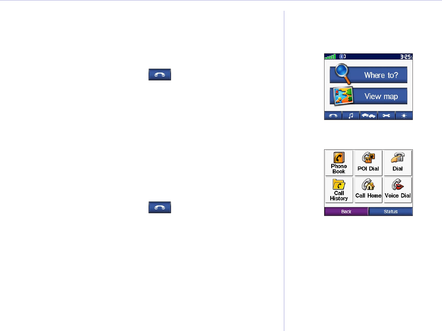
USING THE PHONE FEATURES
Dialing POIs
You can place a call to the POIs (points of interest) in the detailed
maps.
To dial a POI:
1. From the Menu page, touch .
2. Touch POI Dial.
3. Use the Find menu (Where To? menu) to search for the
POI you want to call.
4. Enter the number, and touch Dial.
Dialing Numbers
You can dial a number at any time, just as you can with your cell
phone.,
To dial a number:
1. From the Menu page, touch .
2. Touch Dial Number.
3. Enter the number, and touch Dial.

Garmin © 2005 27 c550 Owner’s Manual
USING THE PHONE FEATURES
Placing Calls Using Voice Dial
If your cell phone supports it, you can place calls by speaking the
contact’s name.
To make a call using Voice Dial:
1. From the Menu page, touch .
2. Touch Voice Dial.
3. Speak the contact you want to call.
NOTE: You may need to “train” your cell phone to
recognize your voice commands. If so, the c550 will walk
you through the process. Refer to your phone’s owner’s
manual, if necessary.
Viewing Your Call History
Each time you pair your phone with the c550, your call history
is automatically transferred to the c550. You can then view the
missed, dialed, and received calls for your cell phone.
From the Menu page, touch Phone > Call History. Touch a
category (Missed, Dialed, or Received) to view those calls. The
calls are listed in chronological order; the most recent calls are at
the top of the list. To call one of the numbers listed, touch it.
Why Should I pair my
phone to my c550?
Use the c550 as your cell phone
interface.
If you have a cellular phone that has
Bluetooth® wireless technology, you
can use your c550 as a hands-free
device. The internal microphone
in your c550 easily picks up your
voice; simply talk toward the front
of the unit. You can also hear the
phone call through the c550’s
speakers; use the Volume knob on
the right side of the c550 to adjust
the volume.
Garmin © 2005 28 c550 Owner’s Manual
FM TMC TRAFFIC INFORMATION
FM TMC TRAFFIC INFORMATION
Your c550 can use an FM TMC Traffic Receiver to receive traffic
information broadcast over the FM Radio Data System. When
a traffic message is received, your unit displays the event on the
map and can change your route to avoid the traffic incident. For
participating subscription providers and coverage areas, refer to
the Garmin Web site at http://www.garmin.com/fmtraffic.
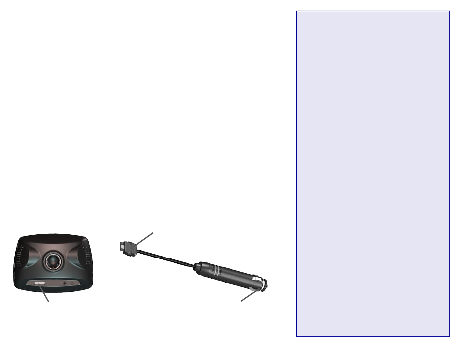
Connecting the FM Traffic Receiver
The GTM 20 provides power to the c550 as well as traffic
information.
1. Plug the power connector into the back of the c550.
2. Plug the other end into a 12-Volt receptacle in your
vehicle.
To power connector on
c550.
To 12-Volt receptacle in
vehicle.
Power connector
NOTE: You can only
access the traffic
information and settings if
the c550 is connected to an
FM Traffic Receiver.
NOTE: The FM Traffic
Receiver and c550 must
be in data range of an
FM station transmitting
TMC data to receive traffic
information.
NOTE: Garmin is not
responsible for the
accuracy of the traffic
information. The FM
Traffic Receiver simply
receives signals from the
traffic service provider and
shows that information on
your c550.
Garmin © 2005 29 c550 Owner’s Manual
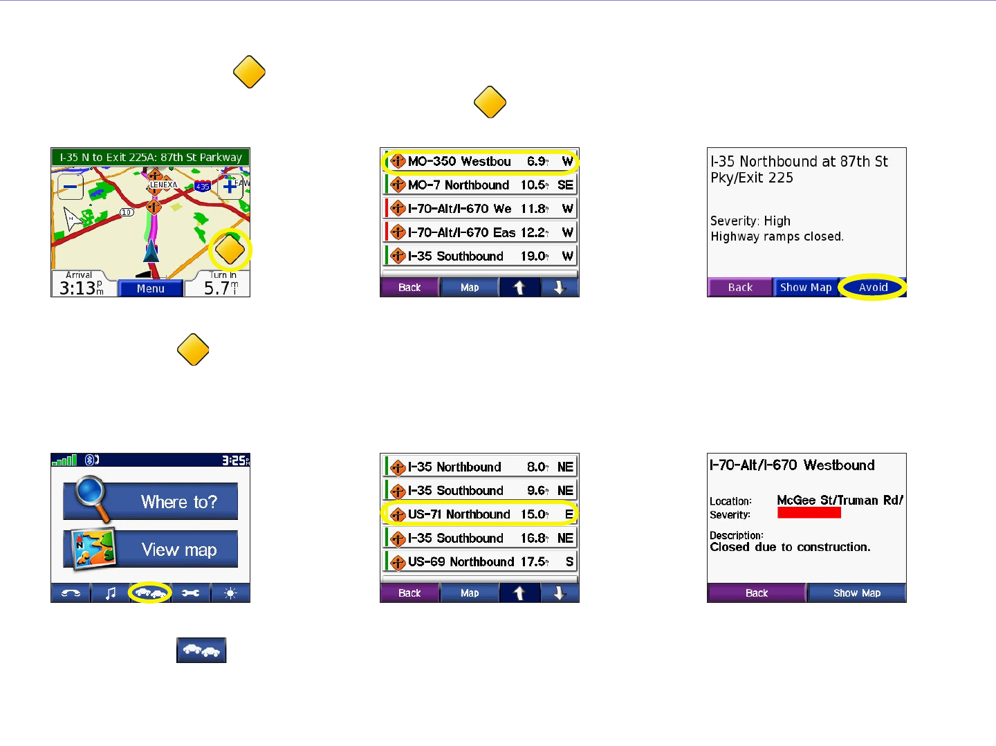
FM TMC TRAFFIC INFORMATION
Avoiding Traffic
The map page displays a when there is a traffic event on your current route or on the road you are
driving. When you are following a route, touch the to avoid the traffic.
➋ ➌➊
From the map
page, touch .
Touch Avoid.Touch an item to
view details.
Viewing Traffic Events
➋
Touch an item to
view details.
➌
Touch an option.
➊
From the Menu
page, touch .
Garmin © 2005 30 c550 Owner’s Manual
FM TMC TRAFFIC INFORMATION
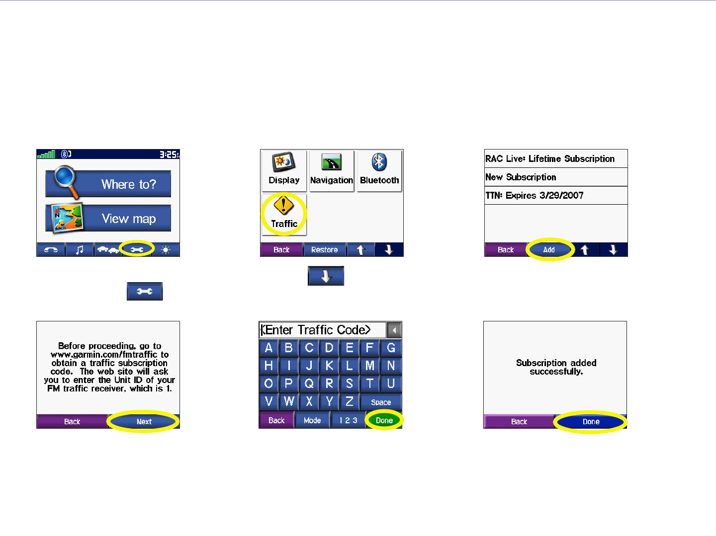
Adding a Subscription
Your FM TMC Traffic Receiver may have a trial subscription, or you may be in an area with free
service. You can also add subscriptions to expand your service area. You will need your FM TMC Traffic
Receiver’s Unit ID; see below for directions. Go to http://www.garmin.com/fmtraffic to purchase a traffic
subscription and obtain a 25-character traffic subscription code.
➍ ➎ ➏
➌➊ ➋
Touch >
Traffic.
Touch Add.
Touch Done.Enter the code and
touch Done.
Touch Next.
From the Menu
page, touch .
Garmin © 2005 31 c550 Owner’s Manual
CUSTOMIZING THE C550
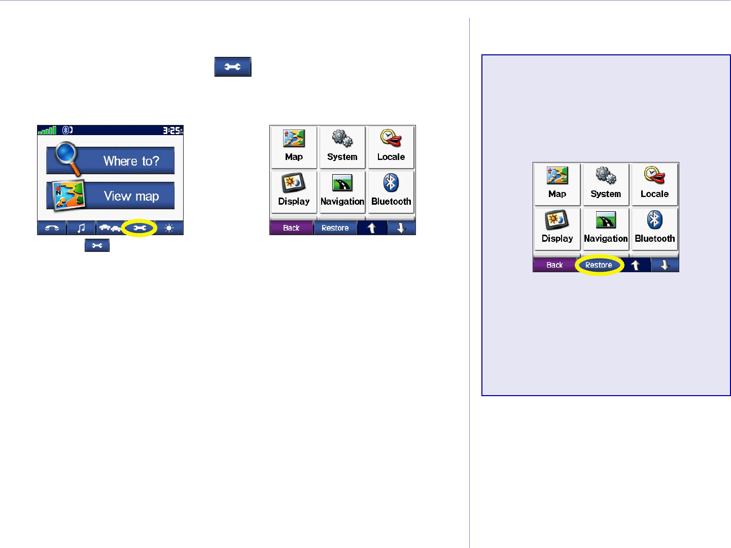
CUSTOMIZING THE C550
To change c550 settings, touch on the Menu page. See the
following pages for more information.
Touch to display
the Settings menu.
➊
Touch the setting
you want to change.
➋
Restoring Settings
To restore all settings you have
changed, press the Restore
Settings button, as shown below.
To restore settings for an
individual category, such as Map,
touch the Restore Settings button
on that particular page.
Garmin © 2005 32 c550 Owner’s Manual
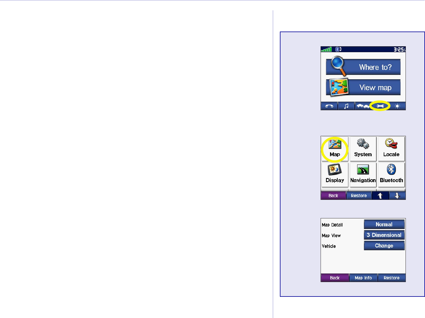
CUSTOMIZING THE C550
Changing the Map Settings
Map Detail—adjust the amount of detail shown on the map.
Displaying more detail causes the map to redraw slowly.
Map View—change the perspective of the Map page.
• Track Up—display the map in 2 dimensions (2D) with your
direction of travel at the top.
• North Up—display the map in 2D with North at the top.
• 3D—display the map in 3 dimensions (3D), Track Up
orientation. This is the default map view.
Vehicle—touch Change to change the icon used to display your
position on the map. Touch the icon you want to use.
Map Info—view the maps loaded on your c550 and their version.
Touch a map to enable (check mark present) or disable (check
mark not present) that map.
Restore—restore the original map settings.
➊
➋
➌
Garmin © 2005 33 c550 Owner’s Manual
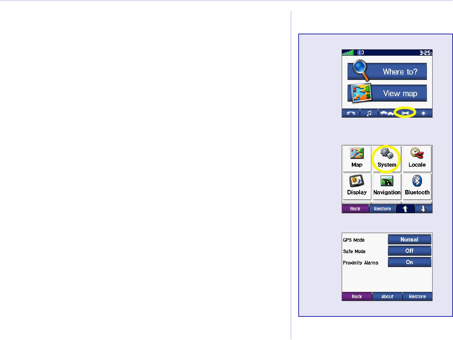
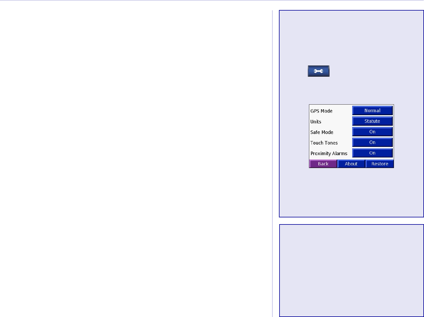
CUSTOMIZING THE C550
Changing the System Settings
GPS Mode—enable and disable GPS and WAAS/EGNOS. Select
Normal for normal GPS (no WAAS or EGNOS). For information
about WAAS and EGNOS, go to http://www.garmin.com/
aboutGPS/waas.html.
Safe Mode—turn on or off the Safe Mode feature. When your
vehicle is moving, Safe Mode disables all unit functions that
require significant operator attention and could become a
distraction while driving.
Proximity Alarms—turn on or off the alerts when you approach
Custom POIs. This option is only visible if you have loaded
Custom POIs. See page 51 for more information about Custom
POIs.
About—display your c550’s software version number, unit ID
number, and audio version number. This information is needed
when you update the system software (see page 53) or purchase
additional map data (see page 54).
Restore—restore the original system settings.
➊
➋
➌
Garmin © 2005 34 c550 Owner’s Manual
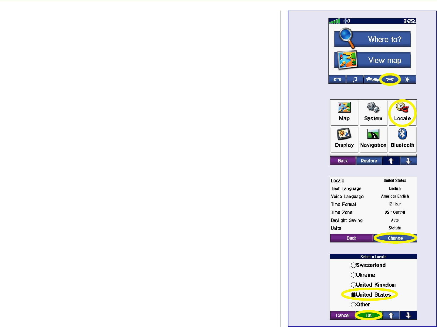
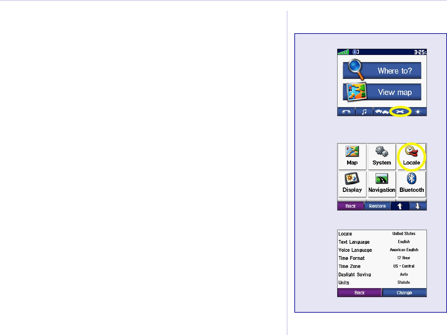
CUSTOMIZING THE C550
Localizing Your c550
View the location settings, such as language and time zone. Touch
Change to adjust the settings. In each screen, touch the setting
you want, and then touch OK.
Locale—select your location.
Text Language—change all on-screen text to the selected
language. Changing the Text Language does not change the
language of map data, such as street names and places or user-
entered data.
Voice Language—change the language for all voice prompts
and messages. Your c550 contains two different types of voice
languages: text-to-speech and pre-recorded.
Languages noted with a person’s name are text-to-speech
(TTS) voices: for example, American English-Jill is a text-to-
speech voice. The text-to-speech voices “read” and “speak” the
same words that are displayed on the c550. The voices have an
extensive vocabulary, and they pronounce the street names as
you approach turns.
The pre-recorded voices have a limited vocabulary and do not
speak names of locations or streets.
➊
➋
➌
➍
Garmin © 2005 35 c550 Owner’s Manual
CUSTOMIZING THE C550
Time Zone—select a time zone or nearby city from the list.
Daylight Saving—set to On, Off , or Auto if it is available.
Time Format—choose a 12-hour, 24-hour, or UTC time format.
Units—Change units of measure to kilometers (Metric) or miles
(Statute).
➊
➋
➌

Garmin © 2005 36 c550 Owner’s Manual
CUSTOMIZING THE C550
Customizing the Display
Color Mode—select Daytime for a light background, Nighttime
for a black background, or Auto to automatically switch between
the two.
Splash Screen—select an image to be shown when you turn
on the c550. First, load JPEG images on your c550 or SD card
using USB Mass Storage Mode. See pages 19 through 22 for more
information about loading files to your c550 or SD card.
Screen Shot—enable Screen Shot mode. Touch the camera icon
to take a picture of the screen. The picture bitmap file is saved
in XXX.
➊
➋
➌
Garmin © 2005 37 c550 Owner’s Manual
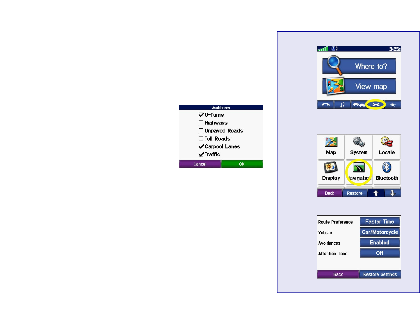
CUSTOMIZING THE C550
Changing the Navigation Settings
Route Preference—select a preference for calculating your
route. Select Faster Time to calculate routes that are faster to drive
but can be longer in distance. Select Shorter Distance to calculate
routes that are shorter in distance but can take more time to drive.
Vehicle—specify your vehicle type to optimize routes.
Avoidances—touch the Enabled button
select the road types you want to avoid on
your routes. The c550 uses these road types
only if alternative routes take you too far
out of your way or if no other roads are
available. If you have an FM TMC Traffic
Receiver, you can also avoid traffic incidents.
Attention Tone—turn on or off the attention tone.
Restore Settings—restore the original navigation settings.
➊
➋
➌
Garmin © 2005 38 c550 Owner’s Manual
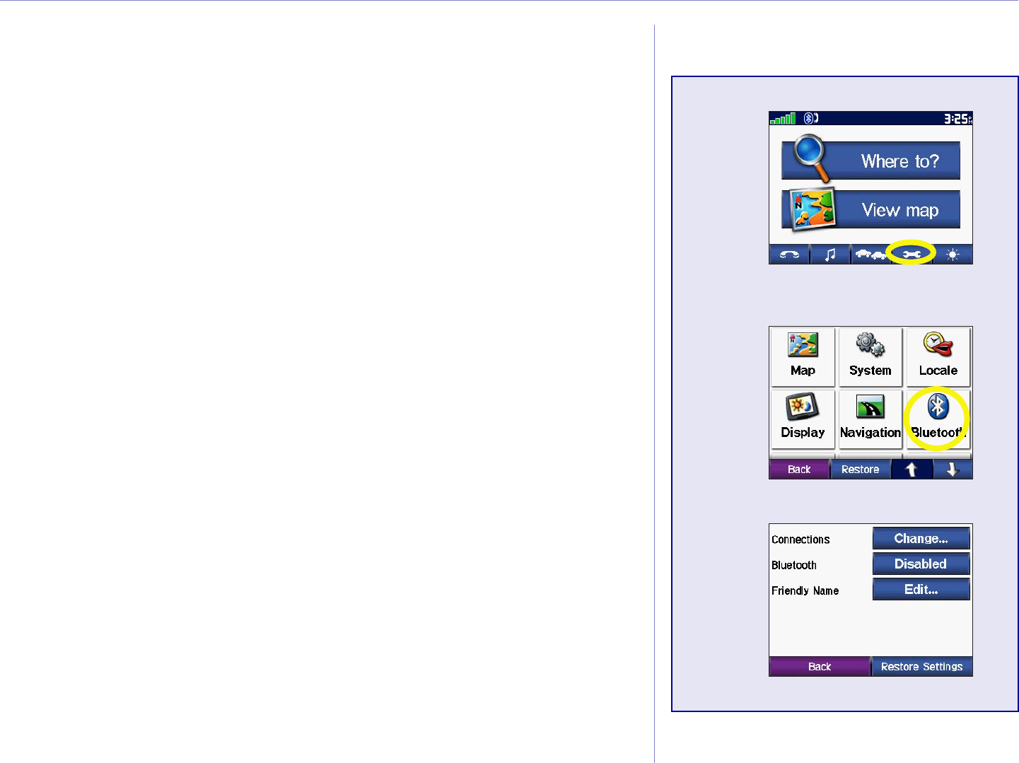
CUSTOMIZING THE C550
Changing the Bluetooth Settings
Connections—select a device to connect to. Select Add Device
to search the area for cellular phone with Bluetooth® wireless
technology. Set your cell phone to Find Me, Discoverable, or
Visible, and then touch OK. The c550 searches for all Bluetooth
wireless devices in the area and lists them. Select your phone, and
then touch OK. Enter the c550’s PIN in your phone.
NOTE: The c550’s PIN code (or passkey) is 1234.
Bluetooth—enable and disable the Bluetooth component.
Friendly Name—select to enter a friendly name that identifies
your c550 on devices that are Bluetooth enabled. Touch Done
after you have entered the name.
Drop—disconnect the c550 from your phone.
Clear—delete all Bluetooth devices from the c550’s memory. After
you clear the devices from the c550, you must pair all devices with
the c550 as if it is the first time.
Restore—restore the original Bluetooth settings. Restoring the
Bluetooth settings will not clear the pairing information.
➊
➋
➌
Garmin © 2005 39 c550 Owner’s Manual
EXTRAS AND OPTIONAL ACCESSORIES
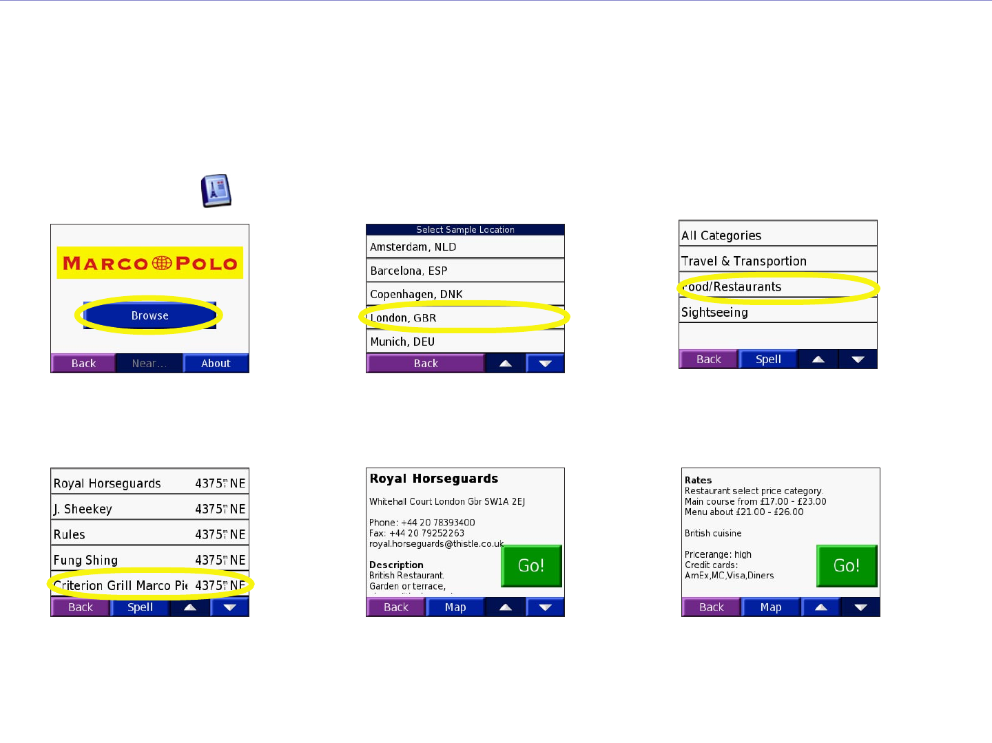
Using the Travel Guide
Much like a paper travel guide, the Garmin Travel Guide provides detailed information about places, such
as restaurants and hotels. Your nüvi comes with a few sample travel guide points; to purchase the Travel
Guide accessory, go to the Garmin Web site at http://www.garmin.com/products/nuvi/ and click the
Accessories link. You can also contact your Garmin dealer to purchase nüvi accessories. From the Menu
page, touch > Touch Travel Guide.
Touch a category.
Touch a sub-category,
if necessary.
➌
Touch an item.
➍
➊
Touch Browse.
Touch the arrows to
view more information
about the location.
➎
➋
Touch a location.
Touch Go to go to the location.
Touch Map to display this item
on a map.
➏
Garmin © 2005 40 c550 Owner’s Manual
EXTRAS AND OPTIONAL ACCESSORIES
CAUTION: Garmin is
not responsible for the
consequences of using a
custom POI database or
the accuracy of the safety
camera or other custom
POI database.
Custom POIs (Points of Interest)
Your c550 accepts custom points of interest (POI) databases,
available from various companies on the Internet. Some custom
POI databases contain alert information for points such as safety
cameras and school zones. Your c550 can notify you with a
proximity alarm when you approach one of these points.
After downloading your POI database, use the Garmin POI Loader
to install the POIs into your unit. The POI Loader is available at
http://www.garmin.com/products/c550 and click Updates and
Downloads.
Using the POI Loader program, you can store the Custom POIs on
your “Garmin” drive or your SD card. You can also customize the
proximity alert settings for each POI using the POI Loader. Refer
to the POI Loader Help File for more information; press F1 to
open the Help File.
To view your Custom POIs, touch Where To? > Extras >
Custom POIs.
To delete the Custom POIs from your c550, connect your c550 to
your computer. Open the “Garmin” drive or the SD Card drive.
Locate the folder called “POI” in the folder called “Garmin.” Delete
the file entitled “poi.gpi.”
Adjusting the
Proximity Alarms
To turn on or off the proximity
alarms, from the Menu page,
touch > System >
Proximity Alarms.
When the Proximity Alarms are
on, your c550 chimes when you
approach a Custom POI.
Garmin © 2005 41 c550 Owner’s Manual
APPENDIX
APPENDIX
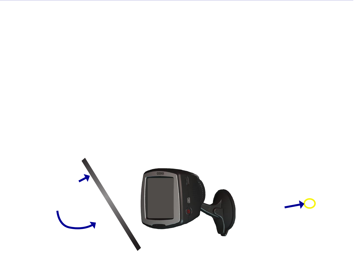
Mounting Your c550
Select a suitable location to mount the c550 on your windshield. Clean and dry the selected area of your
windshield.
1. Place the suction cup on the windshield.
2. Flip the lever back, toward the windshield.
3. Plug the power cable into the back of the c550. Plug the other end into a
12-Volt receptacle in your vehicle. Your unit may turn on automatically if
you have started your vehicle.
Warning: For use in vehicles, it is the sole responsibility of the owner/operator of a vehicle with the c550 installed to
place and secure the device so it will not interfere with the vehicle operating controls and safety devices, obstruct the
driver’s view of driving conditions, or cause personal injury in the event of an accident.
➊
➋
windshield
➎

Garmin © 2005 42 c550 Owner’s Manual
APPENDIX
Removing the c550 and the Mount
The c550 and the mount snap apart and together. To remove the mount from the c550, turn the mount
as far as you can to the right or left. Apply pressure in that direction until the mount pops out of the ball
socket.
To remove the suction cup from the windscreen, flip the lever toward you. Pull the tab on the suction cup
toward you.
Mounting the c550 on Your Dashboard
Use the enclosed mounting disk to mount your unit to the dashboard. California drivers, use the enclosed
disk to comply with California regulations: see the c-series Product Information Sheet that came in the
box for more information.
Important: The permanent mounting adhesive is extremely difficult to remove after it is installed.
To install the mounting disk:
1. Clean and dry the dashboard where you will place the disk.
2. Remove the backing from the permanent mounting adhesive on the bottom of the disk
3. Place the disk on the dashboard.
4. Place the suction cup mount on top of the disk and flip the lever down (toward the disk).
Disk
Suction
cup mount
Lever
Garmin © 2005 43 c550 Owner’s Manual
APPENDIX
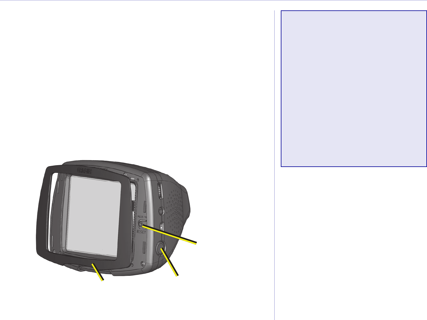
Resetting Your c550
If your unit locks up (freezes up), press the Power button to turn
off the unit, then press again to turn the unit back on. If this does
not help, reset your c550.
To reset the c550:
1. Place your thumb nail in the groove located under the
Garmin logo on the face plate.
2. Gently pull off the face plate.
3. Press the Reset button.
4. Turn the unit back on; it will operate normally.
Reset button
Power button
Face plate
Clearing User Data
Hold your finger on the lower
right corner of the c550’s screen
while turning on the c550. Keep
your finger pressed until the pop-
up window appears. Touch Yes to
clear all user data.
All original settings are restored.
Any items that you have saved are
erased.

Garmin © 2005 44 c550 Owner’s Manual
APPENDIX
Caring for Your c550
Your c550 contains sensitive electronic components that can be permanently damaged if exposed to
excessive shock or vibration. To minimize the risk of damage to your c550, avoid dropping your unit and
operating it in high shock/vibration environments.
Cleaning the Unit
The c550 is constructed of high quality materials and does not require user maintenance other than
cleaning. Clean the unit’s outer casing (not the touch screen) using a cloth dampened with a mild detergent
solution and then wipe dry. Avoid chemical cleaners and solvents that can damage plastic components.
Cleaning the Touch Screen
Clean the touch screen with a soft, clean, lint-free cloth. Use water, isopropyl alcohol, or eyeglass cleaner,
if needed. Apply the liquid to the cloth and then gently wipe the touch screen.
Protecting Your c550
Follow the cautions below to protect your c550 from damage:
• Do not store the c550 where prolonged exposure to extreme temperatures can occur (such as in the
trunk of a car), as permanent damage may result.
• Do not expose the c550 to water. Contact with water can cause this unit to malfunction.
• Do not leave your c550 in plain sight when you leave your vehicle. Take your unit with you or remove it
from view to avoid theft.
• Though a PDA stylus can also be used to operate the touch screen, never attempt this while operating a
vehicle. Never use a hard or sharp object to operate the touch screen or damage may result.

Garmin © 2005 45 c550 Owner’s Manual
APPENDIX
Using the c550 Indoors
Turn off GPS ( > System > GPS Mode > GPS Off) and use your c550 indoors. Use this setting
when do not need GPS satellite signals, such as when you are practicing or using the MP3 player.
Using a Remote Antenna
You can use an optional external remote antenna (Garmin GA 25MCX). This is very helpful when
operating the unit in a vehicle with a coated windshield or an in-screen (in the window) heating system,
which can block GPS signals. Remove the weather cap from the antenna connector located on the left side
of the c550 and connect the antenna. To purchase, go to the Garmin Web site at http://www.garmin.com/
products/c550 and click the Accessories link.
Changing the Fuse
An AGC/3AG 2 Amp, high-breaking capacity, 1500 A-rated fuse is located at
the tip of the vehicle adapter. Periodically, you may need to change the fuse.
Unscrew the black, round end piece and replace the fuse.
Charging the c550
You can charge the c550 using the 12/24-Volt car adapter connected to the suction mount.
Unscrew

Garmin © 2005 46 c550 Owner’s Manual
APPENDIX
Updating the c550 Software
If you register your c550, you will receive notification of software and map updates. To register your c550,
go to https://www.garmin.com/registration/selectreg.jsp.
To update the c550 software:
1. Connect the USB cable to your c550 and your computer. See the previous page.
2. Go to http://www.garmin.com/products/sp550. Click Software Updates.
3. Click Download next to the unit software.
4. Read and agree to the terms. Click Download.
5. Select Run (or Open). Your software is updated.
You can also use WebUpdater to update your c550 software. Go to http://www.garmin.com/products/
webupdater/ to learn about WebUpdater.
Purchasing and Loading Additional MapSource Maps
Check http://www.garmin.com/unlock/update.jsp to see if an update for your map software is available.
To find out the version of the maps that are loaded on your c550, open the Menu page. Touch > Map
> Map Info. You can also purchase additional MapSource map data from Garmin and load the maps on
your c550’s internal memory or on an optional SD card.
Follow the instructions that came with the new map data to properly install the maps to your computer
and c550. In order to enable additional maps, you need your unit ID (see page 38) and serial number (see
page i). To load maps to your c550 memory or SD card, select the name for your “Garmin” drive or SD card
drive. Refer to the MapSource help file for more information about using MapSource and loading maps on
your Garmin GPS.

Garmin © 2005 47 c550 Owner’s Manual
APPENDIX
Loading MapSource Waypoints on Your c550
Using MapSource, you can save locations (also called waypoints) and transfer them to your c550. For more
information about creating waypoints in MapSource, see the help file (press F1 to open the help file).
After you have created the waypoints, select File > Save. Select GPS eXchange Format (*.gpx) for the
Save as Type. Click the Save button.
With your c550 connected to your computer, copy the *.gpx file into in the Garmin\Waypoints folder in
the “Garmin” drive. The waypoints you created in MapSource are now in Where To? > Favorites.
Viewing Your Saved Locations in MapSource
You can also view the locations you have saved in your c550 using the MapSource program.
In MapSource, select File > Open. Select GPS eXchange Format (*.gpx) for Files of Type. Browse to
find the Garmin\Waypoints folder on your “Garmin” drive. Select Waypoints.gpx and click Open.

Garmin © 2005 48 c550 Owner’s Manual
APPENDIX
Bluetooth® Wireless Technology Troubleshooting
Problem/Question Solution/Answer
USB Interface Troubleshooting
Problem/Question Solution/Answer
How do I know my c550
is in USB Mass Storage
Mode?
When your c550 is in USB Mass Storage Mode, a picture of a c550
connected to a computer is shown. Also, you should see two new
Removable Disk Drives listed in My Computer.
My computer never
senses that the c550 is
connected.
1. Unplug the USB cable from your computer.
2. Turn the c550 off and then back on again.
3. Plug the USB cable into your computer. The c550 automatically
turns on and goes into USB Mass Storage Mode.
I cannot find any drives
named “Garmin” in my
list of drives.
Try the solution listed above.
If you have several network drives mapped on your computer,
Windows may have trouble assigning drive letters to your c550
drives. Follow the steps on the following page to assign your drive
letters.
Garmin © 2005 49 c550 Owner’s Manual
APPENDIX
Problem/Question Solution/Answer
I keep getting a message
saying “Unsafe Removal
of Device” when I unplug
the USB cable.
When you are ready to disconnect your c550 from your computer,
double-click the Unplug or Eject icon in your system tray. Select
USB Mass Storage Device and click Stop. Select the c550 drives
and click OK. You can disconnect your c550 from your computer now.
How can I rename my
c550 drives?
1. Open My Computer.
2. Select the drive you want to rename.
3. Right-click your mouse and select Rename.
4. Type the new name and press the Enter key on your computer’s
keyboard.
How do I map my c550
drives in Windows?
1. Turn off your c550.
2. Plug in the USB cable to the c550 and your computer. Your c550
will automatically turn on.
3. Click Start > Settings > Control Panel > Administrative
Tools > Computer Management > Storage > Disk
Management.
4. Click a c550 removable disk drive (either the internal memory or
your SD Card drive). Right-click your mouse and select Change
Drive Letter and Path….
5. Select Edit…, select a drive letter from the drop-down list, and
click OK.
Garmin © 2005 50 c550 Owner’s Manual
APPENDIX
Battery Tips
• Your c550’s battery should
last 4 to 8 hours depending on
usage.
• To extend the battery life, turn
off GPS ( > System >
GPS Mode > GPS Off) when
you do not need to receive
GPS signals or use Normal
mode when you do not need to
use WAAS or EGNOS.
• To extend the battery life,
turn the backlight brightness
down (from the Menu page,
touch to adjust the
brightness).
• To maximize the life of the
lithium-ion battery, do not
leave your c550 direct sunlight
and avoid prolonged exposure
to excessive heat.
Battery Information
Your unit contains an internal (non-removable) lithium-ion
battery. Contact your local waste disposal department for
information on properly disposing of the unit.
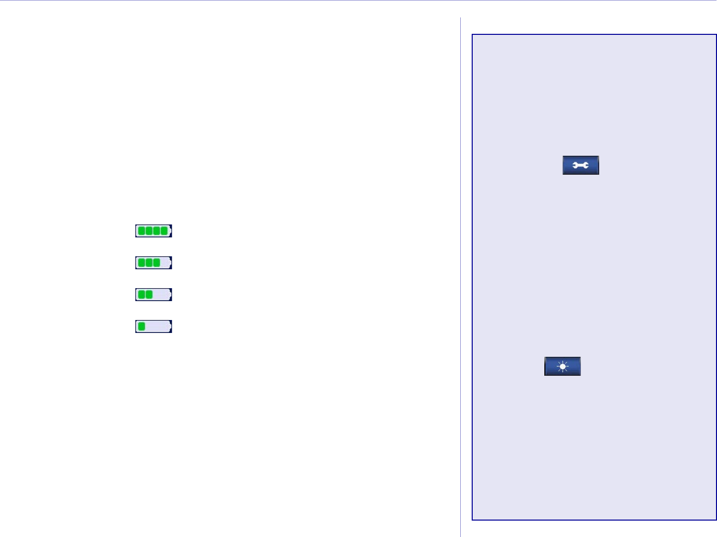
Battery Gauge
The battery icon in the upper right corner of the Menu page
indicates the status of the internal battery. If the icon is not
present, the c550 is connected to external power.
Battery 3/4 full
Full battery
Battery 1/2 full
Battery 1/4 full

Garmin © 2005 51 c550 Owner’s Manual
APPENDIX
About Satellite Signals
Your c550 must acquire satellite signals to operate. If you are indoors, near tall buildings or trees, or in a
parking garage, the c550 cannot acquire satellites. Go outside to an area free from tall obstructions to use
your c550.
When the c550 has acquired satellite signals, the signal strength bars on the Menu page are green .
When it loses satellite signals, the bars turn red or disappear .
For more information about GPS, visit the Garmin Web site at http://www.garmin.com/aboutGPS.

Garmin © 2005 52 c550 Owner’s Manual
APPENDIX
Technical Specifications
Size: 4.4” W x 3.2” H x 2.8” D
Weight: 9.45 ounces
Display: QVGA transflective TFT color display, bright white LED
backlight, and touch screen
Temperature: 32°F to 122°F (0°C to 50°C)
Charge Time: Approximately three hours to charge
Data storage: Internal memory and optional Removable SD card.
Data stored indefinitely
PC interface: USB mass storage, plug-and-play
Power Input: 12/24 VDC
Usage: 15 W max. @ 13.8 VDC
Battery life: 4 to 8 hours depending on usage
Headphone jack: Standard 3.5 mm
For a complete list of specifications, visit the Garmin Web site at
http://www.garmin.com/products/c550/spec.html.
GPS Performance
Specifications
Receiver: WAAS enabled
Acquisition times*:
Warm: <1 sec
Cold: <38 sec
Factory Reset: <45 sec
*On average for a stationary
receiver with an open sky view
Update rate: 1/sec, continuous
GPS Accuracy:
Position: <10 meters, typical
Velocity: 0.05 meter/sec RMS
GPS (WAAS) Accuracy:
Position: <5 meters, typical
Velocity: 0.05 meter/sec RMS

Garmin © 2005 53 c550 Owner’s Manual
APPENDIX
Software License Agreement
BY USING THE c550, YOU AGREE TO BE BOUND BY THE TERMS AND CONDITIONS OF THE
FOLLOWING SOFTWARE LICENSE AGREEMENT. PLEASE READ THIS AGREEMENT CAREFULLY.
Garmin grants you a limited license to use the software embedded in this device (the “Software”) in binary
executable form in the normal operation of the product. Title, ownership rights, and intellectual property
rights in and to the Software remain in Garmin.
You acknowledge that the Software is the property of Garmin and is protected under the United States of
America copyright laws and international copyright treaties. You further acknowledge that the structure,
organization, and code of the Software are valuable trade secrets of Garmin and that the Software in source
code form remains a valuable trade secret of Garmin. You agree not to decompile, disassemble, modify,
reverse assemble, reverse engineer, or reduce to human readable form the Software or any part thereof or
create any derivative works based on the Software. You agree not to export or re-export the Software to
any country in violation of the export control laws of the United States of America.
NOTE: The Garmin c550 has no user-serviceable parts. Should you ever encounter a problem
with your unit, take it to an authorized Garmin dealer for repairs.
NOTE: The c550 is fastened shut with screws. Any attempt to open the case to change or modify
the unit in any way voids your warranty and may result in permanent damage to the equipment.

Garmin © 2005 54 c550 Owner’s Manual
APPENDIX
FCC Compliance
The unit complies with Part 15 of the FCC interference limits for Class B digital devices FOR HOME
OR OFFICE USE. These limits are designed to provide more reasonable protection against harmful
interference in a residential installation, and are more stringent than “outdoor” requirements.
Operation of this device is subject to the following conditions: (1) This device may not cause harmful
interference, and (2) this device must accept any interference received, including interference that may
cause undesired operation.
This equipment generates, uses, and can radiate radio frequency energy and, if not installed and used in
accordance with the instructions, may cause harmful interference to radio communications. However,
there is no guarantee that interference will not occur in a particular installation. If this equipment
does cause harmful interference to radio or television reception, which can be determined by turning
the equipment off and on, you are encouraged to try to correct the interference by one of the following
measures:
• Reorient or relocate the receiving antenna.
• Increase the separation between the equipment and the receiver.
• Connect the equipment into an outlet on a circuit different from that to which the receiver is
connected.
• Consult an experienced radio/TV technician for help.
The unit does not contain any user-serviceable parts. Repairs should only be made by an authorized
Garmin service center. Unauthorized repairs or modifications could result in permanent damage to the
equipment, and void your warranty and your authority to operated this device under Part 15 regulations.

Garmin © 2005 55 c550 Owner’s Manual
INDEX
INDEX
Symbols
2 Dimensional 36
3 Dimensional 36
A
About Button 37
Adding a Stop to Your Route 3
Attention Tone 40
Audio version 37
Avoiding road types 40
Avoiding Traffic 33, 40
B
Battery 51
better route 2
Brightness 5
Browse the Map 12
Browsing the map 12, 14
C
Caring for your nüvi 46
Changing the settings 35
Clearing User Data 44
Computer connection 19
Connecting the USB Cable 19
Contact Garmin i
Current Location, saving 14
Customizing your nüvi 35
map 36
navigation 40
system setup 37
Custom POIs (Points of
Interest) 45
D
Daylight Saving 39
Delete
character 10
custom POIs 45
files from the nüvi 22
recent finds list 11
saved places 15
user data 44
Detour, adding 4
Disconnecting your nüvi 49
Disk Drives 20, 21
Driving directions 18
E
Editing saved places
(Favorites) 15
EGNOS 37
Eject USB 20
Expanding your search 13
F
Favorites 14, 15
Files
deleting 22
managing 19
supported types 22
transferring 20
Finding places
address 7
by name 6
intersection 7
item on the map 12
recent selection 11
saved item 14
Find a place near another
place 13
FM TMC Traffic Receiver 32–
34
Following your route 2
Fuse, changing 47
G
Go! 6
Go Home 8
GPS 5, 51
H
Home Location 8
K
Keyboard 10
L
License Agreement 54
Listening to music 23
M
M4A/M4P 23
Map 12, 16
browse 12
customize 36
zoom 12, 16
MapSource 48
Map Info Button 36
Map software
update 47
version 36
Map symbol 15
Map view 36
Metric units 39
Mounting your nüvi 43
Moving the map 12, 14
MP3 23
My Locations 14
Favorites 14
Recent Selections 11
N
Narrow your results list
spell the name 10
Navigation settings 40
Near Button 13
Next Turn Page 18
North Up 36
O
On-screen keyboard 10
P
Phone Number 15

Garmin © 2005 56 c550 Owner’s Manual
INDEX
Playing Music 23
POI 45
Position icon 16
Present Location, saving 14
Proximity Alarms 37, 45
Q
Quick Settings 5
R
Recently-Found places
delete 11
find 11
Removable Disk Drives 20, 21
Resetting your nüvi 44
Reset Max Speed 17
Reset Trip 17
Restoring Settings 35
Routing preferences 40
S
Safety camera database 45
Safe Mode 37
Satellite Signals 52
Save
places you find 6, 14
Saved Places
delete 15
edit 15
Save Current Location 12
save your current location 12,
14
School zone database 45
SD Card 19, 53
Serial Number i
Set your Location 12
Shortcuts 5
Show Map 6, 12
Software License Agreement 54
Software version 37
Spell the name of a place 10
Stop navigation 4
Stop USB 20
Storing your nüvi 46
Supported File Types 22
System Setup 37
T
Text Language 38
Touch screen
cleaning 46
Track Up 36
Traffic 32
avoid 33, 40
events 33
subscription 34
Transferring Files 20
Trip Information Page 17
Troubleshooting 50
USB 49
Turn-by-turn directions 18
Turn off the beeping 37
U
Units 39
Unit ID 37
USB 20
troubleshooting 49
User Data, deleting 44
Using the nüvi Indoors 47
V
Vehicle Type 40
Viewing Places on the Map 12
Viewing the Map 16
Voice Language 38
Volume 5
W
WAAS 37–41
Z
Zoom 12, 16

For the latest free software updates (excluding map data)
throughout the life of your Garmin products, visit the
Garmin Web site at www.garmin.com.
© Copyright 2006 Garmin Ltd. or its subsidiaries
Garmin International, Inc.
1200 East 151st Street, Olathe, Kansas 66062, U.S.A.
Garmin (Europe) Ltd.
Unit 5, The Quadrangle, Abbey Park Industrial Estate, Romsey, SO51 9DL, U.K.
Garmin Corporation
No. 68, Jangshu 2nd Road, Shijr, Taipei County, Taiwan
www.garmin.com
Part Number 190-00642-00 Rev. A