Garmin 01999 LOW POWER TRANSMITTER User Manual
Garmin International Inc LOW POWER TRANSMITTER
Garmin >
User Manual
quatix™
Owner’s Manual
February 2013 190-01594-00_0A Printed in Taiwan

All rights reserved. Under the copyright laws, this manual may not be copied, in whole or in part, without the written consent of Garmin. Garmin reserves the
right to change or improve its products and to make changes in the content of this manual without obligation to notify any person or organization of such
changes or improvements. Go to www.garmin.com for current updates and supplemental information concerning the use of this product.
Garmin®, the Garmin logo, and TracBack® are trademarks of Garmin Ltd. or its subsidiaries, registered in the USA and other countries. ANT+™, HomePort™,
quatix™, GNT™, and tempe™ are trademarks of Garmin Ltd. or its subsidiaries. These trademarks may not be used without the express permission of Garmin.
The Bluetooth® word mark and logos are owned by the Bluetooth SIG, Inc. and any use of such marks by Garmin is under license. Mac® is a registered
trademark of Apple Computer, Inc. Windows® is a registered trademark of Microsoft Corporation in the United States and other countries. Other trademarks
and trade names are those of their respective owners.

Table of Contents
Getting Started............................................................... 1
Keys........................................................................................... 1
Charging the Device.................................................................. 1
Profiles....................................................................................... 1
Changing Profiles.................................................................. 1
Creating a Custom Profile..................................................... 1
Deleting a Profile................................................................... 1
Sensors and GPS Data.............................................................. 2
Viewing the Data Pages........................................................ 2
Turning On a Sensor Mode................................................... 2
Compass............................................................................... 2
Altimeter and Barometer............................................................ 2
Changing the Plot Type......................................................... 2
Calibrating the Barometric Altimeter..................................... 2
Acquiring Satellites.................................................................... 2
Stopping GPS....................................................................... 2
Navigation.......................................................................2
Navigating to a Destination........................................................ 2
Stopping Navigation.............................................................. 3
Waypoints.................................................................................. 3
Creating a Waypoint.............................................................. 3
Finding a Waypoint by Name................................................ 3
Navigating to a Waypoint...................................................... 3
Editing a Waypoint................................................................ 3
Increasing the Accuracy of a Waypoint Location.................. 3
Projecting a Waypoint........................................................... 3
Deleting a Waypoint.............................................................. 3
Deleting All Waypoints.......................................................... 3
Routes........................................................................................ 4
Creating a Route................................................................... 4
Editing the Name of a Route................................................. 4
Editing a Route...................................................................... 4
Viewing a Route on the Map................................................. 4
Deleting a Route................................................................... 4
Reversing a Route................................................................ 4
Tracks........................................................................................ 4
Acquiring Satellite Signals and Recording a Track............... 4
Saving the Current Track...................................................... 4
Viewing Details about the Track............................................ 4
Clearing the Current Track.................................................... 4
Deleting a Track.................................................................... 4
Sending Data to HomePort™................................................ 4
Sending and Receiving Data Wirelessly............................... 4
Map............................................................................................ 5
Browsing the Map................................................................. 5
Navigating Using TracBack®..................................................... 5
Marking and Starting Navigation to a Man Overboard
Location..................................................................................... 5
Applications................................................................... 5
Sail Racing................................................................................. 5
Setting the Race Timer......................................................... 5
Sail Racing with the Race Timer........................................... 5
Setting the Race Start Line................................................... 5
Sail Racing Using the Start Line........................................... 5
Tack Assist................................................................................. 6
Calibrating the Tack Assist.................................................... 7
Calibrating the Tack Assist Manually.................................... 7
Viewing Tide Information........................................................... 7
Pairing With an Autopilot............................................................ 7
Using Autopilot...................................................................... 7
Clock.......................................................................................... 8
Setting the Alarm................................................................... 8
Starting the Countdown Timer.............................................. 8
Using the Stopwatch............................................................. 8
Adding a Custom Time Zone................................................ 8
Editing a Custom Time Zone................................................. 8
Alerts.......................................................................................... 8
Setting a Proximity Alarm...................................................... 8
Navigating with Sight 'N Go....................................................... 8
Calculating the Size of an Area.................................................. 8
Viewing the Almanacs................................................................ 8
Viewing Satellite Information...................................................... 9
Simulating a Location............................................................ 9
ANT+™ Sensors............................................................. 9
Pairing ANT+ Sensors............................................................... 9
Streaming NMEA 2000 Data...................................................... 9
Using Automatic Man Overboard............................................... 9
tempe......................................................................................... 9
Putting On the Heart Rate Monitor............................................. 9
Customizing Your Device............................................10
Setup Overview........................................................................ 10
System Settings....................................................................... 10
Customizing the Data Pages................................................... 10
Compass Settings.................................................................... 10
Setting the North Reference................................................ 10
Altimeter Settings..................................................................... 10
Setting the Device Tones......................................................... 10
Display Settings....................................................................... 10
Map Settings............................................................................ 11
Track Settings.......................................................................... 11
Time Settings........................................................................... 11
Changing the Units of Measure............................................... 11
Position Format Settings.......................................................... 11
Customizing the Main Menu.................................................... 11
Device Information.......................................................11
Viewing Device Information..................................................... 11
Updating the Software............................................................. 11
Device Care............................................................................. 11
Cleaning the Device............................................................ 11
Specifications........................................................................... 11
Battery Information................................................................... 11
Data Management................................................................... 12
File Types............................................................................ 12
Deleting Files...................................................................... 12
Disconnecting the USB Cable............................................. 12
Data Fields............................................................................... 12
NMEA 2000 Data Fields...................................................... 13
Data Pages.............................................................................. 13
Troubleshooting....................................................................... 14
Locking the Keys................................................................. 14
Resetting Your Device........................................................ 14
Resetting the Device to Factory Settings............................ 14
Clearing All Sensor Plot Data.............................................. 14
Appendix.......................................................................14
Registering Your Device.......................................................... 14
Software License Agreement................................................... 14
Index..............................................................................15
Table of Contents i

Getting Started
When using your device the first time, you should complete
these tasks to set up the device and get to know the basic
features.
1Charge the device (page 1).
2Learn about profiles and sensor data (page 2).
3Acquire satellites and record your track (page 2).
4Mark and navigate to a waypoint (page 3).
5Learn about applications (page 5).
6Stream data from your NMEA 2000® network (page 9).
7Register the device (page 14).
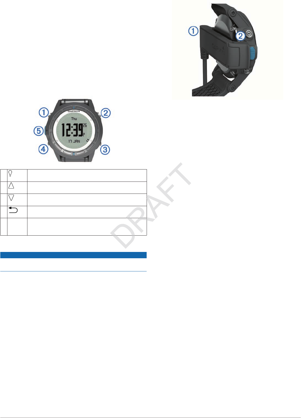
Keys
ÀSelect to turn the backlight on and off. Hold to turn the
device on and off.
ÁSelect to scroll through the data pages, options, and
settings.
ÂSelect to scroll through the data pages, options, and
settings.
ÃSelect to return to the previous screen. Hold to view the
status page.
ÄBlue key Select to open the menu for the current screen. Select to
choose an option and to acknowledge a message. Hold
to mark a waypoint.
Charging the Device
NOTICE
To prevent corrosion, thoroughly dry the contacts and the
surrounding area before charging or connecting to a computer.
The device is powered by a built-in lithium-ion battery that you
can charge using a standard wall outlet or a USB port on your
computer.
1Plug the USB end of the cable into the AC adapter or a
computer USB port.
2Plug the AC adapter into a standard wall outlet.
3Align the left side of the charging cradle À with the groove on
the left side of the device.
4Align the hinged side of the charger Á with the contacts on
the back of the device.
When you connect the device to a power source, the device
turns on.
5Charge the device completely.
Profiles
Profiles are a collection of settings that optimize your device
based on how you are using it. For example, the settings and
views are different when you are using the device when sailing
than when powerboating.
When you are using a profile and you change settings such as
data fields or units of measurement, the changes are saved
automatically as part of the profile.
Changing Profiles
When you change activities, you can quickly change the setup
of the device to suit the activity by changing the profile.
1Select the blue key.
2Select Profiles.
3Select a profile.
The profile you selected is now the active profile. Any changes
you make are saved to the active profile.
Creating a Custom Profile
You can customize your settings and data fields for a particular
activity or trip.
1Select the blue key.
2Select Setup > Profiles.
3Select an option:
• Select a profile.
• Select Create New, and select the new profile.
The profile you selected is now the active profile. The
previous profile was saved.
4If necessary, select Edit, and edit the name of the profile.
5Customize your settings (page 10) and data fields for the
active profile.
Any changes you make are saved to the active profile.
Deleting a Profile
1Select the blue key.
2Select Setup > Profiles.
3Select a profile.
4Select Delete > Yes.
Getting Started 1
Sensors and GPS Data
Viewing the Data Pages
Customizable data pages allow you to quickly access real-time
data for the compass, barometer, and temperature sensors.
When you begin tracking or navigating, additional data pages
appear.
Data pages can also show data streamed from your NMEA
2000 network through a Garmin® GNT™.
From the time of day page, select or to cycle through
the data pages.
NOTE: Sensor data is not recorded to the device.
Data Page Flows
By default, the time, compass, barometer, and temperature
pages appear in all data page flows. The organization and
appearance of other data pages depends on these conditions.
• The active profile
• Whether you are tracking, navigating, or only viewing sensor
data
• Whether you are streaming NMEA 2000 data through a
Garmin GNT
The data fields on each page can be customized. Some data
fields are available only when streaming NMEA 2000 data. See
page 13 for more information.
Turning On a Sensor Mode
The default sensor mode is on demand mode, which offers you
quick access to compass, altimeter, barometer, or temperature
data. You can also put the device in always on mode to display
continuous sensor data.
1Select the blue key.
2Select Setup > Sensors > Mode > Always On.
Compass
The device has a 3-axis compass with automatic calibration.
• Compass navigation (page 3)
• Compass settings (page 10)
Calibrating the Compass
NOTICE
Calibrate the electronic compass outdoors. To improve heading
accuracy, do not stand near objects that influence magnetic
fields, such as vehicles, buildings, and overhead power lines.
Your device was already calibrated at the factory, and the
device uses automatic calibration by default. If you experience
irregular compass behavior, for example, after moving long
distances or after extreme temperature changes, you can
manually calibrate the compass.
1Select the blue key.
2Select Setup > Sensors > Compass > Calibrate > Start.
3Follow the on-screen instructions.
Altimeter and Barometer
The device contains an internal altimeter and barometer.
•On Demand sensor data (page 2)
•Always On sensor data (page 2)
• Altimeter settings (page 10)
Changing the Plot Type
You can change the way the device plots barometer and
elevation data.
1Select the blue key.
2Select Setup > Sensors > Altimeter.
3Select Baro. Plot or Elev. Plot.
4Select an option.
Calibrating the Barometric Altimeter
Your device was already calibrated at the factory, and the
device uses automatic calibration by default. You can manually
calibrate the barometric altimeter if you know the correct
elevation or the correct barometric pressure.
1Select the blue key.
2Select Setup > Sensors > Altimeter > Calibrate.
3Follow the on-screen instructions.
Acquiring Satellites
Before you can use the GPS navigation features, such as
recording a track, you must acquire satellite signals.
The device may need a clear view of the sky to acquire satellite
signals. The time and date are set automatically based on the
GPS position. To adjust the time settings, see page 8.
For more information about GPS, go to www.garmin.com
/aboutGPS.
1Select the blue key.
2Select Start GPS.
3Wait while the device locates satellites.
Stopping GPS
1Select the blue key.
2Select Stop GPS.
Navigation
You can navigate to a route, track, waypoint, geocache, or any
saved location in the device. You can use the map or the
compass to navigate to your destination.
Navigating to a Destination
You can navigate to a destination using the compass or map
(page 5).
1Select the blue key.
2Select Start GPS.
3Wait while the device locates satellites.
4Select the blue key.
5Select an option:
• Select Waypoints.
• Select Tracks.
• Select Routes.
• Select GPS Tools > Coordinates.
• Select GPS Tools > POIs.
6Select a destination.
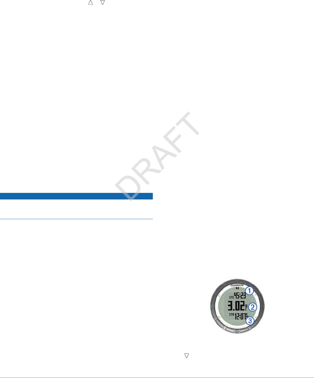
7Select Go.
The device displays time to destination À, distance to
destination Á, and estimated time of arrival Â.
8Select to view the compass page.
2 Navigation
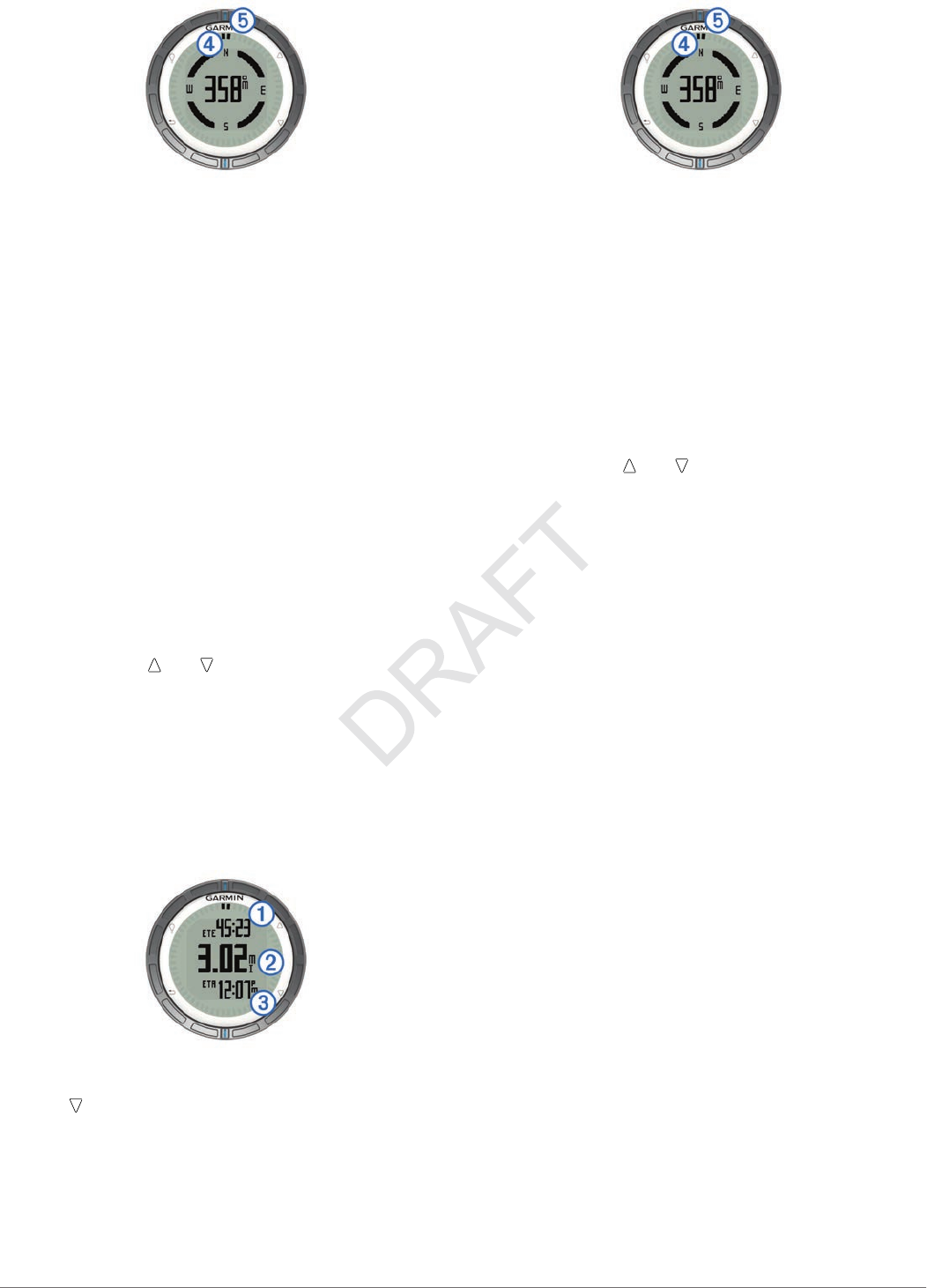
The two pointer marks à serve as a bearing pointer. The top
orange mark Ä points in the direction you are facing.
9Align the pointer marks with the top orange mark.
10Continue to walk in that direction until you reach the
destination.
Stopping Navigation
1Select the blue key.
2Select Stop Nav..
Waypoints
Waypoints are locations you record and store in the device.
Creating a Waypoint
You can save your current location as a waypoint.
1Hold the blue key.
2Select an option:
• To save the waypoint without changes, select Save.
• To make changes to the waypoint, select Edit, make
changes to the waypoint, and select Save.
Finding a Waypoint by Name
1Select the blue key.
2Select Waypoints > Spell Search.
3Use the blue key, , and to enter characters.
4When finished, select _ > Done.
Navigating to a Waypoint
1Select the blue key.
2Select Start GPS.
3Wait while the device locates satellites.
4Select the blue key.
5Select Waypoints, and select a waypoint from the list.
6Select Go.
The device displays time to destination À, distance to
destination Á, and estimated time of arrival Â.
7Select to view the compass page.
The two pointer marks à serve as a bearing pointer. The top
blue mark Ä points in the direction you are facing.
8Align the pointer marks with the top blue mark.
9Continue to travel in that direction until you reach the
destination.
Editing a Waypoint
Before you can edit a waypoint, you must create a waypoint.
1Select the blue key.
2Select Waypoints.
3Select a waypoint.
4Select Edit.
5Select an item to edit, such as the name.
6Use the blue key, , and to enter characters.
7When finished, select _ > Done.
Increasing the Accuracy of a Waypoint Location
You can refine a waypoint location for more accuracy. When
averaging, the device takes several readings at the same
location and uses the average value to provide more accuracy.
1Select the blue key.
2Select Waypoints.
3Select a waypoint.
4Select Average.
5Move to the waypoint location.
6Select Start.
7Follow the on-screen instructions.
8When the confidence reaches 100%, select Save.
For best results, collect four to eight samples for the waypoint,
waiting at least 90 minutes between samples.
Projecting a Waypoint
You can create a new location by projecting the distance and
bearing from a marked location to a new location.
1Select the blue key.
2Select Waypoints.
3Select a waypoint.
4Select Project.
5Follow the on-screen instructions.
The projected waypoint is saved with a default name.
Deleting a Waypoint
1Select the blue key.
2Select Waypoints.
3Select a waypoint.
4Select Delete > Yes.
Deleting All Waypoints
1Select the blue key.
2Select Setup > Reset > Waypoints > Yes.
Navigation 3

Routes
A route is a sequence of waypoints or locations that leads you
to your final destination.
Creating a Route
1Select the blue key.
2Select Routes > Create New.
3Select First Point.
4Select a category.
5Select the first point on the route.
6Select Next Point.
7Repeat steps 4–6 until the route is complete.
8Select Done to save the route.
Editing the Name of a Route
1Select the blue key.
2Select Routes.
3Select a route.
4Select Rename.
5Use the Orange key, , and to enter characters.
6When finished, select _ > Done.
Editing a Route
1Select the blue key.
2Select Routes.
3Select a route.
4Select Edit.
5Select a point.
6Select an option:
• To view the point on the map, select Map.
• To change the order of the point on the route, select
Move Up or Move Down.
• To insert an additional point on the route, select Insert.
The additional point is inserted before the point you are
editing.
• To add a point to the end of the route, select Next Point.
• To remove the point from the route, select Remove.
Viewing a Route on the Map
1Select the blue key.
2Select Routes.
3Select a route.
4Select View Map.
Deleting a Route
1Select the blue key.
2Select Routes.
3Select a route.
4Select Delete > Yes.
Reversing a Route
1Select the blue key.
2Select Routes.
3Select a route.
4Select Reverse.
Tracks
A track is a recording of your path. The track log contains
information about points along the recorded path, including
time, location, and elevation for each point.
Acquiring Satellite Signals and Recording a Track
Before you can use the GPS navigation features, such as
recording a track, you must acquire satellite signals.
The device may need a clear view of the sky to acquire satellite
signals. The time and date are set automatically based on the
GPS position.
1Select the blue key.
2Select Start GPS.
3Wait while the device locates satellites.
4Travel to record a track.
Your distance and time appear.
5Select to view the loop of data pages.
6Hold .
7Select an option:
• Select Pause Track to pause tracking.
• Select Save Track to save your track.
• Select Clear Track to erase the track without saving.
• Select Stop GPS to turn off GPS without deleting your
track.
Saving the Current Track
1Select the blue key.
2Select Tracks > Current.
3Select an option:
• To save the entire track, select Save.
• To save part of the track, select Save Part, and select the
part to save.
Viewing Details about the Track
1Select the blue key.
2Select Tracks.
3Select a track.
4Select View Map.
The beginning and the end of the track are marked by flags.
5Select > Details.
6Use and to view information about the track.
Clearing the Current Track
1Select the blue key.
2Select Tracks > Current > Clear.
Deleting a Track
1Select the blue key.
2Select Tracks.
3Select a track.
4Select Delete > Yes.
Sending Data to HomePort™
Before you can send data to HomePort, you must purchase
HomePort and install it on your computer (www.garmin.com
/homeport).
You can view tracks and waypoints on your computer.
1Connect your device to your computer using the USB cable.
Your device appears as a removable drive in My Computer
on Windows® computers and as a mounted volume on
Mac® computers.
2Start HomePort.
3Follow the on-screen instructions.
Sending and Receiving Data Wirelessly
Before you can share data wirelessly, you must be within 10
feet (3 m) of a compatible Garmin device.
4 Navigation
Your device can send or receive data when connected to
another compatible device. You can share waypoints,
geocaches, routes, and tracks wirelessly.
1Select the blue key.
2Select Share Data > Unit to Unit.
3Select Send or Receive.
4Follow the on-screen instructions.
Sending Data to BlueChart® Mobile
Before you can share data with the BlueChart Mobile
application, you must install it on your mobile device
(www.garmin.com/bluechartmobile).
You can view tracks and waypoints on your mobile device.
1On your quatix, select the blue key.
2Select Share Data > BlueChart Mob..
3Start BlueChart Mobile on your mobile device.
4Follow the on-screen instructions.
See the BlueChart Mobile help for more information.
Map
represents your location on the map. As you travel, the icon
moves and leaves a track log (trail). Waypoint names and
symbols appear on the map. When you are navigating to a
destination, your route is marked with a line on the map.
• Map navigation (page 5)
• Map settings (page 11)
Browsing the Map
1While navigating, select to view the map.
2Select the blue key.
3Select one or more options:
• Select Pan, and select , , , and to view different
areas.
• Select Zoom, and select and to zoom in and out of
the map.
Navigating Using TracBack®
While navigating, you can navigate back to the beginning of
your track. This can be helpful when finding your way back to
camp or the trail head.
1Select the blue key.
2Select Tracks > Current > TracBack.
Your current location À, track to follow Á, and end point Â
appear on the map.
Marking and Starting Navigation to a Man
Overboard Location
You can save a man overboard (MOB) location, and
automatically start navigation back to it.
1Hold , and select OK.
The navigation page opens.
2Navigate using the compass or map.
Applications
Sail Racing
You can use the quatix to increase the likelihood that your boat
will cross the start line of a race exactly when the race begins.
When you synchronize the race timer with the official race
countdown timer, the quatix alerts you at one-minute intervals
as the race start approaches. When you combine the race timer
with the virtual start line, the quatix measures your speed,
bearing, and remaining time on the countdown timer. The quatix
uses this data to indicate whether your boat will cross the start
line before, after, or at the correct time to start the race.
Setting the Race Timer
1Select the blue key.
2Select Sail Race > Setup > Race Timer.
3Use the blue key, , and to set the time.
Sail Racing with the Race Timer
Before you can use the race timer to start a race, you must
select the sailing profile and set the race timer.
1Select the blue key.
2Select Sail Race > Race.
3Select and to synchronize the race timer with the official
race countdown, and select the blue key to start the timer.
TIP: If necessary, after you start the timer you can select
and to add or subtract time from the race timer.
Setting the Race Start Line
You can define a race start line using two waypoints or the
waypoint of one end of the start line and the bearing to the other
end of the line.
1Select the blue key.
2Select Sail Race > Setup > Start Line.
3Select an option:
• To set your present location as the location of the first
point of the start line, select Mark Point > Mark.
• To use a previously saved waypoint as the location of the
first point of the start line, select Select, and select a
waypoint.
4Select an option:
• To set your present location as the location of the second
point of the start line, select Waypoints > Mark Point >
Mark.
• To use a previously saved waypoint as the location of the
second point of the start line, select Waypoints > Select,
and select a point.
• To set the bearing of the start line from the location of the
first waypoint, select Bearing, and enter the bearing.
Sail Racing Using the Start Line
Before you can use the device to start a race, you must select
the sailing profile and set the start line.
1Select the blue key.
2Select Sail Race > Race.
Applications 5
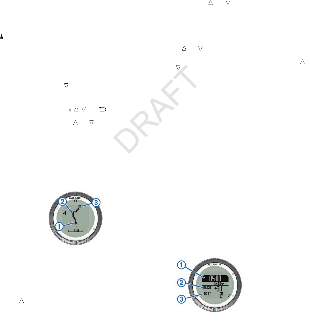
The race timer screen displays the race timer À, time to burn
Á, and distance to the start line Â.
3Select and to synchronize the race timer with the official
race countdown, and select the blue key to start the timer.
TIP: If the burn time is negative, you will arrive at the start
line after the race starts, and should modify your course or
speed accordingly. If the burn time is positive, you will arrive
at the start line before the race starts, and should modify
your course or speed accordingly.
TIP: If necessary, after you start the timer you can select
and to add or subtract time from the race timer.
Tack Assist
While cruising or racing into the wind, the quatix tack assist
feature can help you determine the ideal heading and when it is
time to tack. When you calibrate tack assist, the quatix stores
your boat's ideal port À and starboard Á tack angles and the
average true wind direction Â. It uses this data to determine
whether your boat is being positively lifted or negatively lifted
due to changes in the wind direction.
When your boat experiences positive lift, the wind direction À
has shifted so that your actual heading Á brings you closer to
your destination  than your intended heading à would have.
The quatix displays the degree to which your actual heading
varies from your expected heading Ä and your speed over
ground Å. The bezel marks Æ provide a quick reference that
corresponds to your lift angle.
When your heading indicates a consistent positive lift trend, you
should re-calibrate the true wind direction or the angle for the
current tack. Re-calibration ensures the tack assist provides
accurate information.
When your boat experiences negative lift, the wind direction À
has shifted so that your actual heading Á pushes you farther
from your destination  than your intended heading à would
have. The quatix displays the degree to which your actual
heading varies from your expected heading Ä and your speed
over ground Å. The bezel marks Æ provide a quick reference
that corresponds to your lift angle.
6 Applications
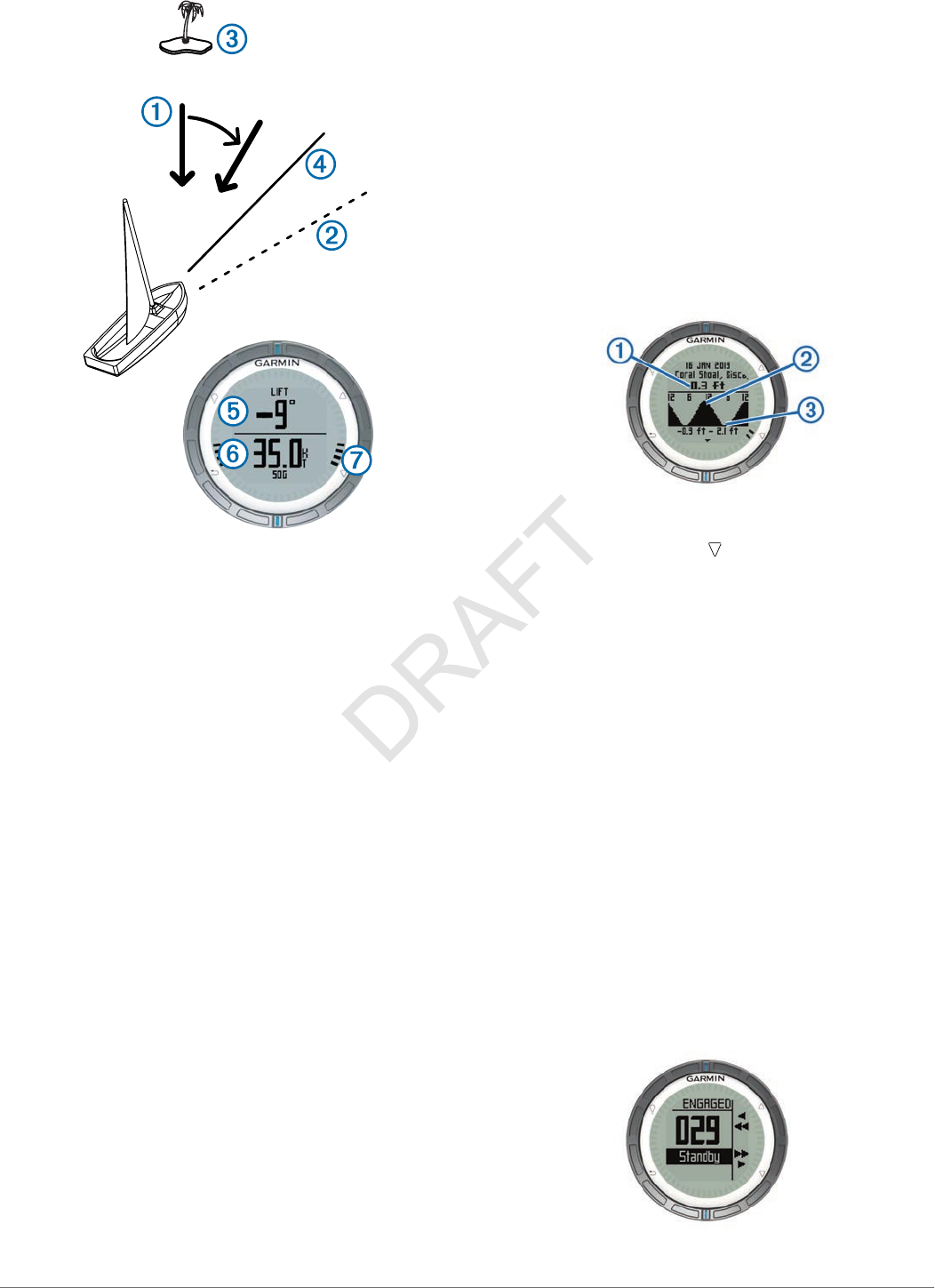
When your heading indicates a consistent negative lift trend,
you should change tack, then re-calibrate the true wind direction
or the angle for the current tack. Re-calibration ensures the tack
assist provides accurate information.
NOTE: The quatix uses GPS-based speed over ground to
determine your heading, and does not account for other factors
that can affect your boat's direction, such as currents and tides.
Calibrating the Tack Assist
Before you start a race, you must calibrate the optimal tack
angle for your boat.
1Select the blue key.
2Select Tack Assist > Full Cal..
3Follow the on-screen instructions.
Calibrating the Tack Assist Manually
During a race, you may need to adjust tack assist settings
individually to adapt to changing conditions.
1Select the blue key.
2Select Tack Assist.
3Select an option:
• To recalibrate the port or starboard tack, hold a steady
course along the intended port or starboard tack, and
select Recal..
NOTE: When you recalibrate the port or starboard tack,
the opposite tack is reset to maintain a consistent tack
angle.
• To change the tack angle, select Tack Angle, and select
an angle.
NOTE: When you change the tack angle, the port and
starboard tacks are equally increased or decreased.
• To change the true wind direction, select True Wind D,
and select the direction.
Viewing Tide Information
You can view information about a tide station, including the tide
height and when the next high and low tides will occur.
1Select the blue key.
2Select Tides > Search Near.
3Select an option:
• To search near a previously saved waypoint, select
Waypoints, and select or search for a waypoint.
• To search near a specific city, select Cities, and select or
search for a city.
A list of the tide stations near the selected location appears.
4Select a station.
A 24-hour tide chart appears for the current date, showing
the current tide height À and when the next high Á and low
tides  will occur.
5Select an option:
• To view more detailed information about the next four tide
peaks and troughs, select .
• To pan the tide chart, select the blue key, and select Pan
Chart.
• To view tide information for a different date, select the
blue key, select Change Date, and select the date.
Pairing With an Autopilot
Refer to the GHC™ owner's manual for more information about
using the GHC.
1Select the blue key.
2Select Autopilot > Yes.
3Set the GHC to search for a remote.
When the devices are paired, the autopilot screen appears
on the quatix.
Using Autopilot
Before you can use the quatix to control an autopilot, you must
install and configure a compatible Garmin GHP™ autopilot
system and pair your quatix with the GHC device. For more
information, see the owner's manual for your autopilot.
1Select the blue key.
2Select Autopilot.
3Select an option:
• To engage the autopilot heading hold, hold a steady
course, select Engage, and release the helm.
Applications 7

• To change the heading in 1° increments, with the autopilot
engaged, select for port and for starboard.
• To perform a step turn, with the autopilot engaged, hold
for port and for starboard.
• To activate a preset action, select Presets, and select a
button action. The map displays a plot of the action
performed by the button.
• To take the helm, select Standby.
Clock
Setting the Alarm
1Select the blue key.
2Select Clock > Alarm Clock > Add Alarm.
3Use the blue key, , and to set the time.
4Select Tone, Vibration, or Tone & Vib..
5Select Once, Daily, or Weekdays.
Starting the Countdown Timer
1Select the blue key.
2Select Clock > Timer.
3Use the blue key, , and to set the time.
4If necessary, select Notification, and select an option.
5Select Start.
Using the Stopwatch
1Select the blue key.
2Select Clock > Stopwatch.
3Select Start.
Adding a Custom Time Zone
1Select the blue key.
2Select Clock > Alt. Zones > Add Zone.
3Select a time zone.
The custom time zone page is added to the quick page loop
(page 2).
Editing a Custom Time Zone
1Select the blue key.
2Select Clock > Alt. Zones.
3Select a time zone.
4Select an option:
• To change the time zone, select Edit Zone.
• To customize the name of the time zone, select Edit
Label.
• To delete the time zone from the quick page loop, select
Delete > Yes.
Alerts
You can set the device to alert you in many different situations
where your awareness of the surrounding conditions or other
data is important. There are three types of alerts: event alerts,
range alerts, and recurring alerts.
Event alert: An event alert notifies you once. The event is a
specific value. For example, you can set the device to alert
you when you reach a specified elevation.
Range alert: A range alert notifies you every time the device is
above or below a specified range of values. For example,
you can set the device to alert you when your speed is below
5 knots and over 15 knots.
Recurring alert: A recurring alert notifies you every time the
device records a specified value or interval. For example,
you can set the device to alert you every 30 minutes.
Alert Name Alert Type Description
Anchor Drag Event You can set a maximum distance for
your vessel to drift after dropping anchor.
Proximity Recurring See page 8.
Distance Event,
recurring
You can set an interval or a custom
distance from your final destination.
Time Event,
recurring
You can set an interval or a custom time
from your estimated time of arrival.
Elevation Event, range,
recurring
You can set minimum and maximum
elevation values. You can also set the
device to alert you when you ascend or
descend a specified amount.
Nav. Arrival Event You can set alerts for reaching waypoints
and the final destination of a track or
route.
Speed Range You can set minimum and maximum
speed values.
Battery Event You can set a minimum battery power
value.
Setting a Proximity Alarm
Proximity alarms alert you when you are within a specified
range of a particular location.
1Select the blue key.
2Select Alerts > Proximity > Edit > Create New.
3Select a location.
4Enter a radius.
5Select Done.
Navigating with Sight 'N Go
You can point the device at an object in the distance, such as a
water tower, lock in the direction, and then navigate to the
object.
1Select the blue key.
2Select GPS Tools > Sight 'N Go.
3Point the blue marks on the bezel at an object.
4Select the blue key.
5Select an option:
• Select Set Course to navigate to the distant object.
• Select Project (page 3).
6Navigate using the compass (page 2) or map (page 5).
Calculating the Size of an Area
Before you can calculate the size of an area, you must acquire
satellites (page 2).
1Select the blue key.
2Select GPS Tools > Area Calc..
3Walk around the perimeter of the area you want to calculate.
4When you are finished, select the blue key to calculate the
area.
5Select an option:
• Select Save Track, enter a name, and select Done.
• Select Change Units to convert the area to a different
unit.
• Select to exit without saving.
Viewing the Almanacs
You can view almanac information for the sun and moon, and
hunting and fishing.
1Select the blue key.
8 Applications
2Select an option:
• To view the sunrise, sunset, moonrise, and moonset
information, select GPS Tools > Sun & Moon.
• To view the predicted best times for hunting and fishing,
select GPS Tools > Hunt & Fish.
3If necessary, select or to view a different day.
Viewing Satellite Information
The satellite page shows your current location, GPS accuracy,
satellite locations, and signal strength.
1Select the blue key.
2Select Start GPS.
3Select the blue key.
4Select GPS Tools > Satellite.
5Select to view additional information.
Simulating a Location
When you are planning routes or activities in a different area,
you can turn off GPS and simulate a different location.
1Select the blue key.
2Select Setup > System > GPS Mode > Demo Mode.
3Select a location.
4Select Go > Move to Location.
ANT+™ Sensors
The device is compatible with these optional, wireless ANT+
accessories.
• tempe™ wireless temperature sensor (page 9)
• Heart rate monitor
For information about compatibility and purchasing additional
sensors, go to http://buy.garmin.com.
Pairing ANT+ Sensors
Pairing is the connecting of ANT+ wireless devices, for
example, connecting a tempe temperature sensor with your
Garmin device.
1Bring the device within range (3 m) of the sensor.
NOTE: Stay 10 m away from other ANT+ sensors while
pairing.
2Select the blue key.
3Select Setup > ANT Sensor.
4Select your sensor.
5Select New Search.
When the sensor is paired with your device, the sensor
status changes from Searching to Connected. Sensor data
appears in the data page loop or a custom data field.
Streaming NMEA 2000 Data
While tracking or navigating, your device can stream data from
a NMEA 2000 network equipped with a Garmin GNT.
1Select the blue key.
2Select Setup > ANT Sensor > GNT > On.
The data pages display information from the sensors
connected to the NMEA 2000 network. You can customize
the data fields that appear on each data page.
3Select twice.
4Select Stream N2K to begin streaming NMEA 2000 data.
To stop streaming NMEA 2000 data, select the blue key, and
select Stop N2K.
Using Automatic Man Overboard
If your device is connected to a Garmin GNT, you can set the
device to automatically trigger the preset man overboard
function if the device loses contact with a GNT for more than 10
seconds.
1Select the blue key.
2Select Auto MOB > On.
When the device loses contact with a GNT for more than 10
seconds, the man overboard function is activated on the
device and on all chartplotters connected to the NMEA 2000
network. A man overboard waypoint is created on the
chartplotter and the device.
3Select an option:
• To acknowledge the man overboard activation and save
the MOB waypoint, select Confirm.
• To dismiss the man overboard activation in the case of
accidental triggering, select Clear.
• To dismiss the man overboard activation and turn off the
automatic man overboard function, select Disable.
tempe
The tempe is an ANT+ wireless temperature sensor. You can
attach the sensor to a secure strap or loop where it is exposed
to ambient air, and therefore, provides a consistent source of
accurate temperature data. You must pair the tempe with your
device to display temperature data from the tempe.
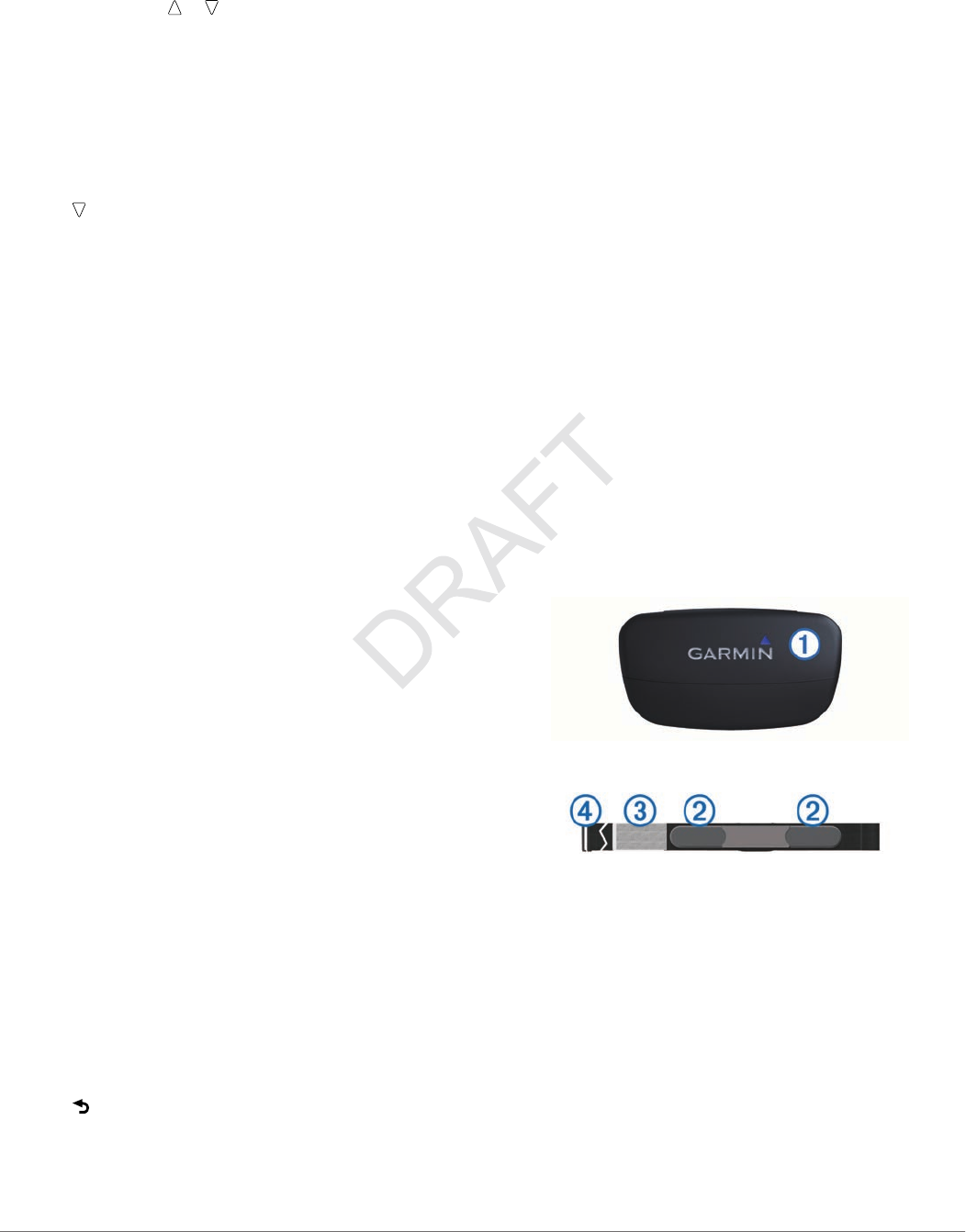
Putting On the Heart Rate Monitor
NOTE: If you do not have a heart rate monitor, you can skip this
task.
You should wear the heart rate monitor directly on your skin,
just below your breastplate. It should be snug enough to stay in
place during your activity.
1Snap the heart rate monitor module À onto the strap.
2Wet both electrodes Á on the back of the strap to create a
strong connection between your chest and the transmitter.
3If the heart rate monitor has a contact patch Â, wet the
contact patch.
4Wrap the strap around your chest, and connect the strap
hook à to the loop.
The Garmin logo should be right-side up.
5Bring the device within range (3 m) of the heart rate monitor.
After you put on the heart rate monitor, it is on standby and
ready to send data.
TIP: If the heart rate data is erratic or does not appear, you may
have to tighten the strap on your chest or warm up for 5–10
minutes.
ANT+™ Sensors 9

Customizing Your Device
Setup Overview
The Setup menu contains numerous ways to customize your
device. Garmin recommends that you take the time to
familiarize yourself with the settings for each feature. If you take
the time to customize your settings before your activity, you will
spend less time adjusting the watch during your activity.
Select the Blue key, and select Setup.
NOTE: Any changes you make are saved to the active profile
(page 1).
System: Sets the GPS settings, arrow keys, and the device
language (page 10).
Data Pages: Customizes data pages and data fields
(page 10).
Sensors: Customizes the compass (page 10) and altimeter
(page 10) settings.
ANT Sensor: Sets up wireless accessories such as the heart
rate monitor or tempe (page 9).
Tones: Customizes the tones and vibrations (page 10).
Display: Adjusts the backlight and screen contrast (page 10).
Reset: Clears the trip data, sensor plots (page 14), waypoints,
or track log, or resets all of your settings (page 14).
Map: Customizes the map orientation and how items appear on
the map (page 11).
Tracks: Customizes the track recording settings (page 11).
Time: Customizes the appearance of the time page
(page 11).
Units: Changes the units of measure for data such as distance,
elevation, and temperature (page 11).
Pos. Format: Changes how your position data appears
(page 11).
Profiles: Changes the active profile and allows you to edit your
profiles (page 1).
Menu: Customizes the items that appear in the main menu
(page 11).
About: Shows information about the device and software
(page 11).
System Settings
Select Setup > System.
GPS Mode: Sets the GPS to Normal, or Demo Mode (GPS
off).
WAAS: Sets the device to use Wide Area Augmentation
System (WAAS) GPS signals. For information about WAAS,
go to www.garmin.com/aboutGPS/waas.html.
Hot Keys: Allows you to customize the hold function of the
arrow keys.
Language: Sets the text language on the device.
NOTE: Changing the text language does not change the
language of user-entered data or map data.
USB Mode: Sets the device to use mass storage mode or
Garmin mode when connected to a computer.
Customizing the Data Pages
You can customize the data pages for each profile.
1Select the blue key.
2Select Setup > Data Pages.
3Select a category.
4Select Add Page.
5Follow the on-screen instructions to select the number of
data fields and the type of data to appear.
6If necessary, select an existing data page.
7Select an option:
• Select Edit, and change the data fields.
• Select Move Up or Move Down to change the order of
the data pages.
• Select Delete to remove the data page from the page
loop.
Compass Settings
Select Setup > Sensors > Compass.
Display: Sets the directional heading on the compass to
degrees or milli-radians.
North Ref.: Sets the north reference of the compass
(page 10).
Mode: Sets the compass to use either a combination of GPS
and the electronic sensor data when moving (Auto) or GPS
data only (Off).
Calibrate: Allows you to manually calibrate the compass sensor
(page 2).
Setting the North Reference
You can set the directional reference used in calculating
heading information.
1Select the blue key.
2Select Setup > Sensors > Compass > North Ref..
3Select an option:
• To set geographic north as the heading reference, select
True.
• To set the magnetic declination for your location
automatically, select Magnetic.
• To set grid north (000º) as the heading reference, select
Grid.
• To set the magnetic variation value manually, select User,
enter the magnetic variance, and select Done.
Altimeter Settings
Select Setup > Sensors > Altimeter.
Auto Cal.: Allows the altimeter to self-calibrate each time you
turn on GPS tracking.
Baro. Plot: Variable records changes in elevation while you are
moving. Fixed assumes the device is stationary at a fixed
elevation, so the barometric pressure should only change
due to weather. Amb. Press. records ambient pressure
changes over a period of time.
Elev. Plot: Sets the device to record elevation changes over a
period of time or distance.
Calibrate: Allows you to manually calibrate the altimeter sensor.
Setting the Device Tones
You can customize tones for messages and keys.
1Select the blue key.
2Select Setup > Tones.
3Select Messages or Keys.
4Select an option.
Display Settings
Select Setup > Display.
Backlight: Adjusts the backlight level and the length of time
before the backlight turns off.
Contrast: Adjusts the screen contrast.
10 Customizing Your Device
Map Settings
Select Setup > Map.
Orientation: Adjusts how the map is shown on the page. North
Up shows North at the top of the page. Track Up shows your
current direction of travel toward the top of the page.
Auto Zoom: Automatically selects the appropriate zoom level
for optimal use on your map. When Off is selected, you must
zoom in or out manually.
Points: Selects the zoom level for points on the map.
Track Log: Allows you to show or hide tracks on the map.
Go To Line: Allows you to select how the course appears on
the map.
Map Colors: Allows you to select whether land or water is
highlighted on the map.
Track Settings
Select Setup > Tracks.
Method: Selects a track recording method. Auto records the
tracks at a variable rate to create an optimum representation
of your tracks. If you select Distance or Time, you can set
the interval rate manually.
Interval: Allows you to set the track log recording rate.
Recording points more frequently creates a more-detailed
track, but it fills the track log faster.
Auto Start: Sets the device to record your track automatically
when you select Start GPS.
Auto Save: Sets the device to automatically save your track
when you turn off GPS.
Auto Pause: Sets the device to stop recording your track when
you are not moving.
Time Settings
Select Setup > Time.
Time Page: Allows you to customize the appearance of the time
of day.
Format: Allows you to select a 12-hour or a 24-hour display
time.
Time Zone: Allows you to select the time zone for the device.
You can select Auto to set the time zone automatically
based on your GPS position.
Changing the Units of Measure
You can customize units of measure for distance and speed,
elevation, depth, temperature, and pressure.
1Select the blue key.
2Select Setup > Units.
3Select a measurement type.
4Select a unit of measure.
Position Format Settings
NOTE: Do not change the position format or the map datum
coordinate system unless you are using a map or chart that
specifies a different position format.
Select Setup > Pos. Format.
Format: Sets the position format in which a given location
reading appears.
Datum: Sets the coordinate system on which the map is
structured.
Spheroid: Shows the coordinate system the device is using.
The default coordinate system is WGS 84.
Customizing the Main Menu
You can add, delete, or move items in the main menu.
1Select the blue key.
2Select Setup > Menu.
3Select a menu item.
4Select an option:
• Select Move Up or Move Down to change the location of
the item in the list.
• Select Remove to delete an item from the list.
• Select Insert to add an item to the list.
Device Information
Viewing Device Information
You can view the unit ID, software version, and license
agreement.
1Select the blue key.
2Select Setup > About.
Updating the Software
NOTE: Updating the software does not erase any of your data
or settings.
1Connect your device to a computer using the USB cable.
2Go to www.garmin.com/products/webupdater.
3Follow the on-screen instructions.
Device Care
NOTICE
Do not use a sharp object to clean the device.
Avoid chemical cleaners and solvents that can damage plastic
components.
Thoroughly rinse the device with fresh water after exposure to
chlorine, salt water, sunscreen, pest repellant, cosmetics,
alcohol, or other harsh chemicals. Prolonged exposure to these
substances can damage the case.
Avoid pressing the keys under water.
Avoid extreme shock and harsh treatment, because it can
degrade the life of the product.
Cleaning the Device
1Wipe the device with a cloth dampened with a mild detergent
solution.
2Wipe it dry.
Specifications
Battery type 500 mAh Lithium-ion battery
Battery life Up to 6 weeks
Water resistance Water resistant to 164 ft. (50 m)
NOTE: The watch is designed for surface
swimming.
Operating
temperature range
From -4ºF to 122ºF (from -20ºC to 50ºC)
Radio frequency/
protocol
2.4 GHz ANT+ wireless communications
protocol
Bluetooth® Smart device
Battery Information
The actual battery life depends on how much you use GPS,
device sensors, optional wireless sensors, and the backlight.
Device Information 11

Battery Life Mode
16 hours Normal GPS mode
25 hours NMEA 2000 streaming, GPS off
Up to 2 weeks Always On sensor mode
Up to 6 weeks Watch mode
Data Management
NOTE: The device is not compatible with Windows 95, 98, Me,
Windows NT®, and Mac OS 10.3 and earlier.
File Types
The device supports these file types.
• Files from HomePort. Go to www.garmin.com/trip_planning.
• GPI custom POI files from the Garmin POI Loader. Go to
www.garmin.com/products/poiloader.
• GPX track files.
• GPX geocache files. Go to www.opencaching.com.
Deleting Files
NOTICE
If you do not know the purpose of a file, do not delete it. Your
device memory contains important system files that should not
be deleted.
1Open the Garmin drive or volume.
2If necessary, open a folder or volume.
3Select a file.
4Press the Delete key on your keyboard.
Disconnecting the USB Cable
If your device is connected to your computer as a removable
drive or volume, you must safely disconnect your device from
your computer to avoid data loss. If your device is connected to
your Windows computer as a portable device, it is not
necessary to safely disconnect.
1Complete an action:
• For Windows computers, select the Safely Remove
Hardware icon in the system tray, and select your device.
• For Mac computers, drag the volume icon to the trash.
2Disconnect the cable from your computer.
Data Fields
ACCURACY (GPS): The margin of error for your exact location.
For example, your GPS location is accurate to within +/- 12
feet (3.65 m).
AMB PRESS (ambient pressure): The uncalibrated
environmental pressure.
ASCENT (ascent total): The total elevation distance ascended
since the last reset.
AVG ASCENT (average ascent): The average vertical distance
of ascent since the last reset.
AVG DESCNT (average descent): The average vertical
distance of descent since the last reset.
AVG SPEED (average speed overall): The average speed
while moving and stopped since the last reset.
BAROMETER (barometer pressure): The calibrated current
pressure.
BATTERY: The remaining battery power.
BEARING: The direction from your current location to a
destination. You must be navigating for this data to appear.
CMP HDNG (compass heading): The direction the device is
pointing based on the compass.
COG: The actual direction of travel, regardless of the course
steered and temporary variations in heading.
COMPASS: A visual representation of the direction in which the
device is pointing.
COURSE: The direction from your starting location to a
destination. Course can be viewed as a planned or set route.
You must be navigating for this data to appear.
DATE: The current day, month, and year.
DESCENT (descent total): The total elevation distance
descended since the last reset.
DISTANCE (trip odometer): A running tally of the distance
traveled since the last reset.
ELEVATION: The altitude of your current location above or
below sea level.
FINAL DEST (waypoint at final destination): The last point on
the route to the destination. You must be navigating for this
data to appear.
FINAL DIST (distance to final destination): The remaining
distance to the final destination. You must be navigating for
this data to appear.
FINAL ETA (estimated time of arrival at final destination):
The estimated time of day you will reach the final destination
(adjusted to the local time of the destination). You must be
navigating for this data to appear.
FINAL ETE (estimated elapsed time to final destination):
The estimated time remaining before you reach the
destination. You must be navigating for this data to appear.
FINAL VDST (vertical distance to final destination): The
elevation distance between your current position and the
final destination. You must be navigating for this data to
appear.
FINAL VSPD (vertical speed to final destination): The rate of
ascent or descent to a predetermined altitude. You must be
navigating for this data to appear.
GLIDE RATIO: The glide ratio required to descend from your
current position to the destination elevation. You must be
navigating for this data to appear.
GPS (signal strength): The strength of the GPS satellite signal.
GPS ELEVTN (GPS elevation): The altitude of your current
location using GPS.
GRADE: The calculation of rise (elevation) over run (distance).
For example, if for every 10 feet (3 m) you climb you travel
200 feet (60 m), the grade is 5%.
GR DEST (glide ratio to destination): The glide ratio required
to descend from your current position to the destination
elevation. You must be navigating for this data to appear.
HEADING: The direction you are moving.
HEART RATE: Your heart rate in beats per minute (bpm). Your
device must be connected to a compatible heart rate
monitor.
LAT/LON (latitude/longitude): The current position in latitude
and longitude regardless of the selected position format
setting.
LOCATION (selected): The current position using the selected
position format setting.
MAX ASCENT (maximum ascent): The maximum rate of
ascent in feet per minute or meters per minute since the last
reset.
MAX DESCNT (maximum descent): The maximum rate of
descent in feet per minute or meters per minute since the
last reset.
MAX ELEVTN (maximum elevation): The highest elevation
reached since the last reset.
12 Device Information

MAX SPEED (maximum speed): The highest speed reached
since the last reset.
MAX TEMP: The maximum temperature for the current activity.
MIN ELEVTN (minimum elevation): The lowest elevation
reached since the last reset.
MIN TEMP: The minimum temperature for the current activity.
MOV'N AVG (moving average): The average speed while
moving since the last reset.
MOV'N TIME (moving time): A running tally of the time spent
moving since the last reset.
NEXT DEST (next destination): The next point on the route.
You must be navigating for this data to appear.
NEXT DIST (next distance): The remaining distance to the
next waypoint on the route. You must be navigating for this
data to appear.
NEXT ETA: The estimated time of day you will reach the next
waypoint on the route (adjusted to the local time of the
waypoint). You must be navigating for this data to appear.
NEXT ETE: The estimated time remaining before you reach the
next waypoint in the route. You must be navigating for this
data to appear.
NEXT VDST (next vertical distance): The elevation distance
between your current position and the next waypoint in the
route. You must be navigating for this data to appear.
ODOMETER: A running tally of distance traveled for all trips.
This total does not clear when resetting the trip data.
SOG: The actual speed of travel, regardless of the course
steered and temporary variations in heading.
STOP TIME: A running tally of the time spent not moving since
the last reset.
STOPWATCH: The stopwatch time for the current activity.
SUNRISE: The time of sunrise based on your GPS position.
SUNSET: The time of sunset based on your GPS position.
TEMP (temperature): The temperature of the air. Your body
temperature affects the temperature sensor.
TIME: A running tally of the total time spent moving and not
moving since the last reset.
TIMER: The current time of the countdown timer.
TO COURSE: The direction in which you must move to get back
on the route. You must be navigating for this data to appear.
TOD (time of day): The current time of day based on your
current location and time settings (format, time zone, daylight
saving time).
TRACK DIST (track distance): The distance traveled for the
current track.
TURN: The angle of difference (in degrees) between the
bearing to your destination and your current course. L means
turn left. R means turn right. You must be navigating for this
data to appear.
VERT SPEED (vertical speed): The rate of ascent or descent
over time.
VMG (velocity made good): The speed at which you are
closing on a destination along a route. You must be
navigating for this data to appear.
XTE (cross track error): The distance to the left or right by
which you have strayed from the original path of travel. You
must be navigating for this data to appear.
NMEA 2000 Data Fields
AWA (average wind angle): The wind angle measured with
respect to the current vessel heading.
A WIND CHL (apparent wind chill) : The temperature of the
wind chill relative to the boat.
AWS (average wind speed): The average measured speed of
the wind since last reset.
CARD WIND (cardinal wind direction): The true wind direction
described in cardinal directions.
DEPTH: The depth of the water.
DRIFT: The speed of the current.
G WIND CHL (ground wind chill): The temperature of the wind
chill relative to the land.
G WIND DIR (ground wind direction): The direction of the
wind relative to the land, referenced from north.
G WIND SPD (ground wind speed): The speed of the wind
relative to the ground. If there is no current and no leeway,
ground wind speed is equivalent to the true wind speed.
H2O TEMP (water temperature): The temperature of the
water.
OPP TACK (opposite tack heading): The opposite tack
heading of the vessel based upon current tack heading.
SET: The direction of the current referenced from north.
STW (speed through water): The speed of the boat relative to
the water.
TWD (true wind direction: The true direction of the wind
relative to the vessel.
TWS (true wind speed): The true speed of the wind relative to
the vessel.
WIND VMG (wind velocity made good): The speed at which
you are making progress into the wind.
Data Pages
By default, these pages appear for the sailing profile.
Page Default Tracking Navigating Tracking with NMEA 2000 Data Navigating with NMEA 2000 Data
1 Clock Tack assist Tack assist Tack assist Tack assist
2 Temperature COG and SOG DTN, ET, and bearing COG, depth, and SOG COG, depth, and SOG
3 Barometer Distance and time COG and SOG Map Bearing and distance to opposite tack
4 Compass Compass Distance and time Wind VMG Map
5 Barometer Compass TWS and TWD Wind VMG and TWS
6 Temperature Barometer AWS and AWA AWS and AWA
7 Map Temperature Clock Clock
8 Clock Map
9 Clock
By default, these pages appear for the powerboat profile.
Device Information 13
Page Default Tracking Navigating Tracking with NMEA 2000 Data Navigating with NMEA 2000 Data
1 Clock COG and SOG DTN, ET, and bearing COG and SOG ETE, distance, and ETA
2 Temperature Distance and time COG and SOG Map Map
3 Barometer Compass Distance and time Water temperature and depth Water temperature and depth
4 Compass Barometer Compass Clock Clock
5 Temperature Barometer COG and SOG
6 Map Temperature
7 Clock Map
8 Clock
By default, these pages appear for the watersports profile.
Page Default Tracking Navigating Tracking with NMEA 2000 Data Navigating with NMEA 2000 Data
1 Clock COG and SOG DTN, ET, and bearing COG and SOG COG and SOG
2 Temperature Distance and time COG and SOG Map DTN, ET, and bearing
3 Barometer Compass Distance and time Water temperature and depth Map
4 Compass Barometer Compass Clock Water temperature and depth
5 Temperature Barometer Clock
6 Map Temperature
7 Clock Map
8 Clock
By default, these pages appear for the fitness profile.
Page Default Tracking Navigating
1 Clock COG and SOG DTN, ET, and bearing
2 Temperature Distance and time COG and SOG
3 Barometer Compass Distance and time
4 Compass Barometer Compass
5 Temperature Barometer
6 Map Temperature
7 Clock Map
8 Clock
Troubleshooting
Locking the Keys
You can lock the keys to prevent inadvertent key presses.
1Select the data page you want to view while the keys are
locked.
2Hold and to lock the keys.
3Hold and to unlock the keys.
Resetting Your Device
If the device stops responding, you may need to reset it.
1Hold for at least 25 seconds.
2Hold for one second to turn on the device.
Resetting the Device to Factory Settings
You can restore all of the device settings to the factory default
values.
1Select the blue key.
2Select Setup > Reset > All Settings > Yes.
Clearing All Sensor Plot Data
1Select the blue key.
2Select Setup > Reset > Clear Plots > Yes.
Appendix
Registering Your Device
Help us better support you by completing our online registration
today.
• Go to http://my.garmin.com.
• Keep the original sales receipt, or a photocopy, in a safe
place.
Software License Agreement
BY USING THE DEVICE, YOU AGREE TO BE BOUND BY
THE TERMS AND CONDITIONS OF THE FOLLOWING
SOFTWARE LICENSE AGREEMENT. PLEASE READ THIS
AGREEMENT CAREFULLY.
Garmin Ltd. and its subsidiaries (“Garmin”) grant you a limited
license to use the software embedded in this device (the
“Software”) in binary executable form in the normal operation of
the product. Title, ownership rights, and intellectual property
rights in and to the Software remain in Garmin and/or its third-
party providers.
You acknowledge that the Software is the property of Garmin
and/or its third-party providers and is protected under the United
States of America copyright laws and international copyright
treaties. You further acknowledge that the structure,
organization, and code of the Software, for which source code is
not provided, are valuable trade secrets of Garmin and/or its
third-party providers and that the Software in source code form
remains a valuable trade secret of Garmin and/or its third-party
providers. You agree not to decompile, disassemble, modify,
reverse assemble, reverse engineer, or reduce to human
readable form the Software or any part thereof or create any
derivative works based on the Software. You agree not to
export or re-export the Software to any country in violation of
the export control laws of the United States of America or the
export control laws of any other applicable country.
14 Appendix

Index
A
alarms 8
clock 8
proximity 8
alerts 8
location 8
almanac
hunting and fishing 8
sunrise and sunset 8
altimeter 2, 10, 14
ANT+ sensors 9
ANT+ sensors, pairing 9
area calculation 8
autopilot 7
pairing 7
unpairing 7
B
backlight 1, 10
barometer 2, 14
battery 11
charging 1
life 11
bearing pointer 3
BlueChart Mobile 5
C
calibrating
altimeter 2
compass 2
charging the device 1
cleaning the device 11
compass 2, 3, 10
computer, connecting 4
contrast 10
coordinates 2
countdown timer 8
customizing the device 10
D
data, sharing 4
data fields 10
data streaming 9
deleting
all user data 12
locations 3
profiles 1
demo mode 9
device, registration 14
distance 4
E
elevation 2
plot 2, 14
F
files, types 12
fishing times 8
G
geocaches 4
GPS 10, 11
signal 2, 4, 9
stopping 2, 9
H
heart rate monitor 9
HomePort 4, 12
hunting and fishing times 8
K
keys 1, 10
locking 14
L
language 10
locations 2, 9
editing 3
saving 3
locking, keys 14
M
main menu, customizing 11
man overboard., automatic 9 See also MOB
man overboard (MOB) 5
maps 4
browsing 5
navigating 5
orientation 11
settings 11
zoom 5
menu 1
moon phase 8
N
navigation 2
compass 2
Sight 'N Go 8
stopping 3
waypoints 3
NMEA 2000 9
north reference 10
P
pairing ANT+ sensors 9
POI Loader 12
position format 11
product registration 14
profiles 1
proximity alarms 8
R
racing 5
registering the device 14
resetting, device 14
resetting the device 14
restoring settings 14
routes 2, 4
creating 4
deleting 4
editing 4
viewing on the map 4
S
sailing
race start line 5
race timer 5
racing 5
tack angles 7
tack assist 6, 7
satellite page 9
satellite signals 2, 4, 9
screen 10
settings 10, 11, 14
sharing data 4
Sight 'N Go 8
software
updating 11
version 11
software license agreement 11, 14
specifications 11
speed 4
stopwatch 8
sunrise and sunset times 8
system settings 10
T
tack assist 6
tempe 9
temperature 2, 9
tides 7
time settings 8, 11
time zones 8, 11
timer, countdown 8
tones 8, 10
TracBack 5
tracks 2, 4, 11
deleting 4
trip planner. See routes
troubleshooting 14
U
unit ID 11
units of measure 11
updating software 11
USB
disconnecting 12
transferring files 12
user data, deleting 12
V
vibration alerts 10
W
WAAS 10
water resistance 11
waypoints 1–4
deleting 3
editing 3
projecting 3
saving 3
Z
zones, time 8
zooming 1
maps 5
Index 15

www.garmin.com/support
913-397-8200
1-800-800-1020
0808 238 0000
+44 870 850 1242 1-866-429-9296 +43 (0) 820 220 230
+32 2 672 52 54 +45 4810 5050 +358 9 6937 9758 + 331 55 69 33 99
+49 (0)1805-427646-880 + 39 02 36 699699 0800 - 023 3937
035 - 539 3727 + 47 815 69 555
00800 4412 454
+44 2380 662 915 + 35 1214 447 460 + 34 902 007 097 + 46 7744 52020
Garmin International, Inc.
1200 East 151st Street
Olathe, Kansas 66062, USA
Garmin (Europe) Ltd.
Liberty House, Hounsdown Business Park
Southampton, Hampshire, SO40 9LR UK
Garmin Corporation
No. 68, Zhangshu 2nd Road, Xizhi Dist.
New Taipei City, 221, Taiwan (R.O.C.)
© 2013 Garmin Ltd. or its subsidiaries