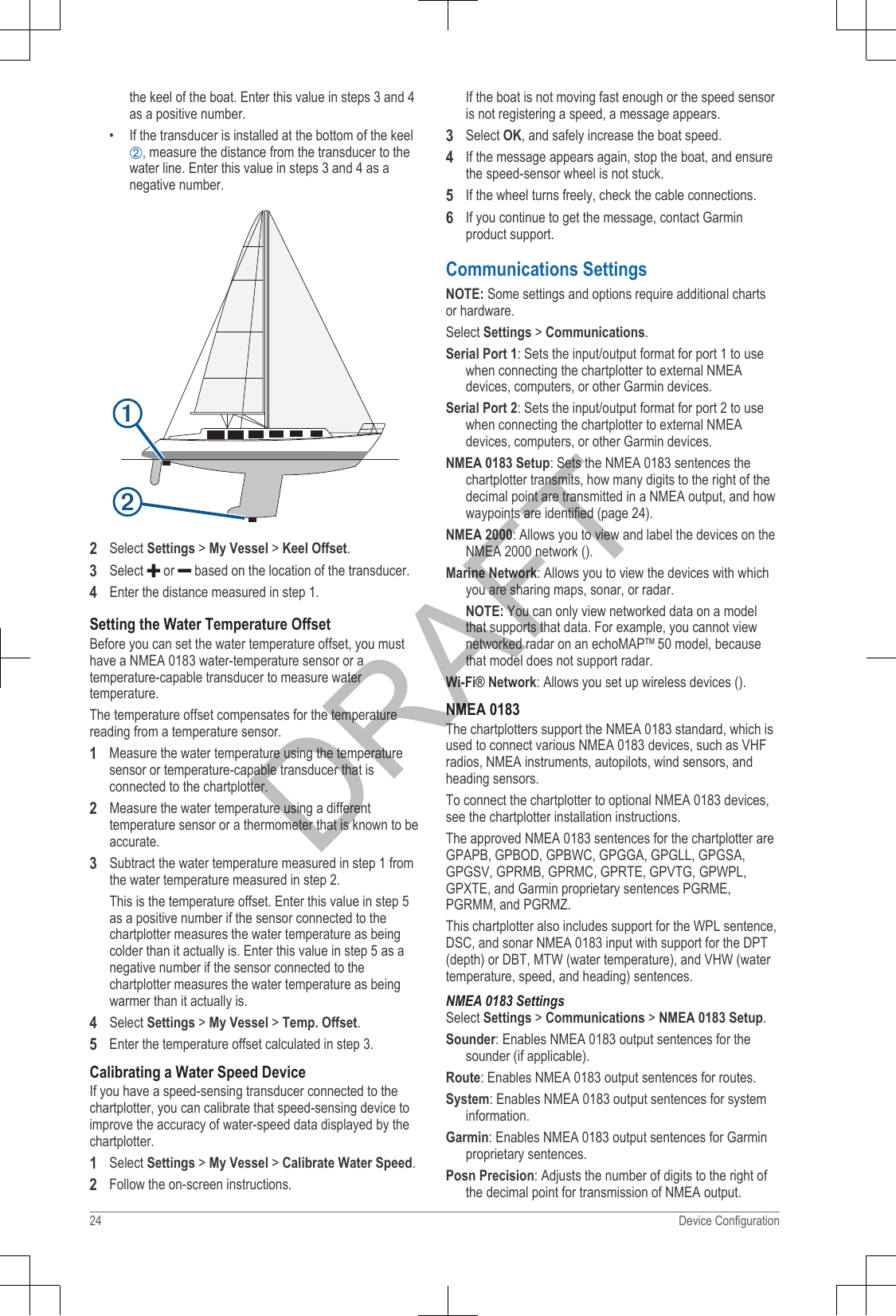
Garmin 02261B Low Power Transmitter User Manual

Garmin International Inc Low Power Transmitter

05_Users Manual 2

GPSMAP® Owner’s ManualAugust 2013 190-01658-00_0A Printed in TaiwanDRAFT
All rights reserved. Under the copyright laws, this manual may not be copied, in whole or in part, without the written consent of Garmin. Garmin reservesthe right to change or improve its products and to make changes in the content of this manual without obligation to notify any person or organization ofsuch changes or improvements. Go to www.garmin.com for current updates and supplemental information concerning the use of this product.Garmin®, the Garmin logo, BlueChart®, g2 Vision®, and MapSource® are trademarks of Garmin Ltd. or its subsidiaries, registered in the USA and othercountries. echoMAP™, GXM™, and HomePort™ are trademarks of Garmin Ltd. or its subsidiaries. These trademarks may not be used without theexpress permission of Garmin.The Bluetooth® word mark and logos are owned by the Bluetooth SIG, Inc. and any use of such marks by Garmin is under license. iOS® is a registeredtrademark of Cisco Systems, Inc. used under license by Apple Inc. microSD™ is a trademark of SD-3C, LLC. NMEA®, NMEA 2000®, and the NMEA2000 logo are registered trademarks of the National Marine Electronics Association. SiriusXM® is a registered trademark of SiriusXM Radio Inc. All othertrademarks and copyrights are the property of their respective owners. Other trademarks and trade names are those of their respective owners.DRAFT
Table of ContentsIntroduction................................................................ 1Device Front View................................................................. 1Device Keys..................................................................... 1Downloading the Manuals..................................................... 1GPS Satellite Signals............................................................ 1Adjusting the Backlight.......................................................... 1Adjusting the Color Mode...................................................... 1Customizing the Home Screen.............................................. 1Inserting Memory Cards........................................................ 1Charts and 3D Chart Views....................................... 1Navigation Chart and Offshore Fishing Chart........................ 2Zooming In and Out of the Chart..................................... 2Panning the Chart with the Keys..................................... 2Selecting an Item on the Map Using the Device Keys..... 2Chart Symbols................................................................. 2Viewing Location and Object Information on a Chart...... 2Navigating to a Point on the Chart................................... 3Viewing Details about Navaids........................................ 3Premium Charts............................................................... 3Viewing Tide Station Information............................... 3Showing Satellite Imagery on the Navigation Chart... 4Viewing Aerial Photos of Landmarks......................... 4Automatic Identification System............................................ 4AIS Targeting Symbols.................................................... 4Heading and Projected Course of Activated AISTargets ............................................................................. 4Showing AIS Vessels on a Chart or 3D Chart View........ 5Activating a Target for an AIS Vessel.............................. 5Viewing Information about a Targeted AIS Vessel.... 5Deactivating a Target for an AIS Vessel.................... 5Viewing a List of AIS Threats........................................... 5Setting the Safe-Zone Collision Alarm............................. 5AIS Distress Signals........................................................ 5Navigating to a Distress Signal Transmission............ 5AIS Distress Signal Device Targeting Symbols......... 5Enabling AIS Transmission Test Alerts...................... 5Turning Off AIS Reception............................................... 5Chart and 3D Chart View Settings......................................... 6Waypoints and Tracks Settings on the Charts and ChartViews............................................................................... 6Other Vessels Settings on the Charts and Chart Views.. 6AIS Display Settings.................................................. 6Navigation and Fishing Chart Setup................................ 6Overlay Numbers Settings............................................... 6Editing the Data Fields............................................... 6Showing a Navigation Inset............................................. 7Chart Appearance Settings.............................................. 7Fish Eye 3D Settings....................................................... 7Navigation with a Chartplotter.................................. 7Basic Navigation Questions................................................... 7Destinations........................................................................... 8Searching for a Destination by Name.............................. 8Selecting a Destination Using the Navigation Chart........ 8Searching for a Destination Using Nav Info..................... 8Searching for a Marine Services Destination................... 8Courses................................................................................. 8Setting and Following a Direct Course Using Go To....... 8Setting and Following a Course Using Auto Guidance.... 8Autopilot Navigation......................................................... 8Stopping Navigation.............................................................. 9Waypoints.............................................................................. 9Marking Your Present Location as a Waypoint................ 9Creating a Waypoint at a Different Location.................... 9Marking and Starting Navigation to an MOB Location..... 9Viewing a List of all Waypoints........................................ 9Editing a Saved Waypoint................................................ 9Moving a Saved Waypoint............................................... 9Browsing for and Navigating to a Saved Waypoint.......... 9Deleting a Waypoint or an MOB...................................... 9Deleting All Waypoints..................................................... 9Routes................................................................................... 9Creating and Navigating a Route From Your PresentLocation........................................................................... 9Creating and Saving a Route......................................... 10Viewing a List of Routes................................................ 10Editing a Saved Route................................................... 10Browsing for and Navigating a Saved Route................. 10Browsing for and Navigating Parallel to a Saved Route 10Deleting a Saved Route................................................. 10Deleting All Saved Routes............................................. 10Tracks.................................................................................. 10Showing Tracks............................................................. 10Setting the Color of the Active Track............................. 11Saving the Active Track................................................. 11Viewing a List of Saved Tracks...................................... 11Editing a Saved Track.................................................... 11Saving a Track as a Route............................................ 11Browsing for and Navigating a Recorded Track............ 11Deleting a Saved Track................................................. 11Deleting All Saved Tracks.............................................. 11Retracing the Active Track............................................. 11Clearing the Active Track............................................... 11Managing the Track Log Memory During Recording..... 11Configuring the Recording Interval of the Track Log..... 11Deleting All Saved Waypoints, Routes, and Tracks............ 11Combinations........................................................... 11Selecting a Combination...................................................... 11Customizing a Combination Screen.................................... 11Creating a Custom Combination Screen............................. 12Deleting a Combination Screen........................................... 12Gauges and Almanac Information..........................12Viewing the Compass.......................................................... 12Viewing Trip Gauges........................................................... 12Resetting Trip Gauges................................................... 12Viewing Engine and Fuel Gauges....................................... 12Customizing Engine Gauge and Fuel Gauge Limits...... 12Enabling Status Alarms for Engine Gauges.................. 12Enabling Some Engine Gauge Status Alarms............... 12Selecting the Number of Engines Shown in Gauges..... 12Customizing the Engines Shown in Gauges.................. 12Configuring the Fuel Gauges Display............................ 12Setting the Fuel Capacity of the Vessel......................... 13Synchronizing the Fuel Data with the Actual VesselFuel................................................................................ 13Setting the Fuel Alarm................................................... 13Viewing the Wind Gauges................................................... 13Configuring the Speed Source....................................... 13Configuring the Heading Source of the Wind Gauge..... 13Selecting the Range of the Close-Hauled Wind Gauge. 13Viewing the Environment Gauges....................................... 13Table of Contents iDRAFT
Configuring the Alignment of the Wind Gauge.............. 13Configuring the Heading Source of the EnvironmentGauge............................................................................ 13Setting the Barometer Reference Time......................... 13Tide, Current, and Celestial Information.............................. 13Tide Station Information................................................. 13Current Station Information............................................ 13Celestial Information...................................................... 14Viewing Tide Station, Current Station, or CelestialInformation for a Different Date..................................... 14Viewing Information for a Different Tide or CurrentStation ............................................................................ 14Viewing Almanac Information from the NavigationChart.............................................................................. 14Viewing Almanac Information from the NavigationChart......................................................................... 14Radar......................................................................... 14Radar Display Modes.......................................................... 14Transmitting Radar Signals................................................. 14Adjusting the Zoom Scale on the Radar Screen................. 14Tips for Selecting a Radar Zoom Scale......................... 14Sentry Mode........................................................................ 15Enabling Timed Transmit............................................... 15Setting the Standby and Transmit Times....................... 15Enabling a Guard Zone.................................................. 15Defining a Circular Guard Zone..................................... 15Defining a Partial Guard Zone....................................... 15Marking a Waypoint on the Radar Screen..................... 15Viewing a List of AIS Threats......................................... 15Showing AIS Vessels on the Radar Screen.................. 15VRM and EBL...................................................................... 16Showing the VRM and the EBL..................................... 16Adjusting the VRM and the EBL.................................... 16Measuring the Range and Bearing to a Target Object.. 16Radar Overlay..................................................................... 16Radar Overlay and Chart Data Alignment..................... 16Showing the Radar Overlay........................................... 16Stopping the Transmission of Radar Signals...................... 16Optimizing the Radar Display.............................................. 16Range of Radar Signals................................................. 16Radar Gain and Clutter.................................................. 16Adjusting Gain on the Radar Screen Automatically. 16Adjusting Gain on the Radar Screen Manually........ 17Minimizing Nearby Large-Object Interference......... 17Minimizing Side-Lobe Interference on the RadarScreen......................................................................17Adjusting Sea Clutter on the Radar ScreenAutomatically............................................................17Adjusting Rain Clutter on the Radar Screen............ 17Reducing Cross Talk Clutter on the Radar Screen.. 17Radar Display Settings.................................................. 17Radar Appearance Settings........................................... 17Front-of-Boat Offset....................................................... 18Measuring the Potential Front-of-Boat Offset.......... 18Setting the Front-of-Boat Offset............................... 18Digital Selective Calling.......................................... 18Networked Chartplotter and VHF Radio Functionality......... 18Turning On DSC.................................................................. 18DSC List.............................................................................. 18Viewing the DSC List..................................................... 18Adding a DSC Contact................................................... 18Incoming Distress Calls....................................................... 18Navigating to a Vessel in Distress................................. 18Man-Overboard Distress Calls Initiated from a VHFRadio............................................................................. 18Man-Overboard Distress Calls Initiated from theChartplotter.................................................................... 18Position Tracking................................................................. 18Viewing a Position Report.............................................. 19Navigating to a Tracked Vessel..................................... 19Creating a Waypoint at the Position of a TrackedVessel............................................................................ 19Editing Information in a Position Report........................ 19Deleting a Position-Report Call...................................... 19Viewing Vessel Trails on the Chart................................ 19Individual Routine Calls....................................................... 19Selecting a DSC Channel.............................................. 19Making an Individual Routine Call................................. 19Making an Individual Routine Call to an AIS Target...... 19SiriusXM®................................................................. 19SiriusXM Equipment and Subscription Requirements......... 20Weather Data Broadcasts................................................... 20Viewing Precipitation Information........................................ 20Precipitation Views........................................................ 20Storm Cell and Lightning Information.................................. 20Hurricane Information.......................................................... 20Weather Warnings and Weather Bulletins........................... 20Forecast Information............................................................ 20Viewing Forecast Information for Another Time Period. 21Viewing a Marine Forecast or an Offshore Forecast..... 21Weather Fronts and Pressure Centers.......................... 21City Forecasts................................................................ 21Viewing Sea Conditions....................................................... 21Surface Winds............................................................... 21Wave Height, Wave Period, and Wave Direction.......... 21Viewing Forecast Sea Conditions Information for AnotherTime Period................................................................... 21Viewing Fishing Information................................................ 21Surface Pressure and Water Temperature Data........... 21Forecasting Fish Locations............................................ 22Visibility Information............................................................. 22Viewing Forecast Visibility Information for Another TimePeriod............................................................................ 22Viewing Buoy Reports......................................................... 22Viewing Local Weather Information near a Buoy........... 22Creating a Waypoint on a Weather Chart............................ 22Weather Overlay.................................................................. 22Turning On the Weather Overlay on a Chart................. 22Weather Overlay Settings on the Navigation Chart....... 22Weather Overlay Settings on the Fishing Chart............ 22Viewing Weather Subscription Information.......................... 22SiriusXM Radio.................................................................... 23Customizing the Channel Guide.................................... 23Saving a SiriusXM Channel to the Presets List............. 23Adjusting SiriusXM Satellite Radio Volume................... 23Device Configuration............................................... 23Turning On the Chartplotter Automatically.......................... 23System Settings................................................................... 23GPS Settings................................................................. 23Viewing the Event Log................................................... 23Viewing System Software Information........................... 23ii Table of ContentsDRAFT
My Vessel Settings.............................................................. 23Setting the Keel Offset................................................... 23Setting the Water Temperature Offset........................... 24Calibrating a Water Speed Device................................. 24Communications Settings.................................................... 24NMEA 0183................................................................... 24NMEA 0183 Settings................................................24Viewing a List of NMEA 2000 Network Devices............ 25Setting Up the Wireless Network................................... 25Connecting a Wireless Device to the Chartplotter... 25Changing the Wireless Channel.............................. 25Setting Alarms..................................................................... 25Navigation Alarms.......................................................... 25System Alarms............................................................... 25Setting the Fuel Alarm................................................... 25Setting Weather Alarms................................................. 25Units Settings...................................................................... 25Navigation Settings.............................................................. 25Auto Guidance Line Configurations............................... 26Adjusting the Distance from Shore................................ 26Other Vessel Settings.......................................................... 27Viewing System Software Information................................. 27Restoring the Original Chartplotter Factory Settings........... 27Chartplotter Data Management...............................27Copying Waypoints, Routes, and Tracks to a Chartplotter.. 27Copying Data from a Memory Card..................................... 27Copying Waypoints, Routes, and Tracks to a MemoryCard..................................................................................... 27Copying Waypoints, Routes, and Tracks to or from allChartplotters on the Network............................................... 27Copying Built-In Maps to a Memory Card............................ 27Backing Up Data to a Computer.......................................... 27Restoring Backup Data to a Chartplotter............................. 27Saving System Information to a Memory Card.................... 28Appendix.................................................................. 28Registering Your Device...................................................... 28Loading the New Software on a Memory Card.................... 28Updating the Device Software............................................. 28Screenshots ......................................................................... 28Capturing Screenshots.................................................. 28Copying Screenshots to a Computer............................. 28NMEA 0183 Information...................................................... 28NMEA 2000 PGN Information............................................. 29Software License Agreement.............................................. 29Index......................................................................... 30Table of Contents iiiDRAFT
DRAFT
Introduction WARNINGSee the Important Safety and Product Information guide inthe product box for product warnings and other importantinformation.Device Front ViewÀAutomatic backlight sensorÁPower keyÂDevice keysÃNumber padÄSD memory card slotÅSoft keysDevice KeysTurns on and off the device when held.Adjusts the backlight and color mode when quicklypressed and released.Zooms out of a chart or view.Zooms in to a chart or view.      Scrolls, highlights options, and moves the cursor.SELECT Acknowledges messages and selects options.BACK Returns to the previous screen.MARK Saves the present location as a waypoint.HOME Returns to the Home screen.MENU Opens a menu of options for the page, whenapplicable.Closes a menu, when applicable.Downloading the ManualsYou can get the latest owner's manual and translations ofmanuals from the web.1Go to www.garmin.com/support.2Select Manuals.3Follow the on-screen instructions to download the manualfor your product.GPS Satellite SignalsWhen you turn on the chartplotter, the GPS receiver mustcollect satellite data and establish the current location. Whenthe chartplotter acquires satellite signals,   appears at thetop of the Home screen. When the chartplotter loses satellitesignals,   disappears and a flashing question markappears over   on the chart.For more information about GPS, go to www.garmin.com/aboutGPS.Adjusting the Backlight1Select Settings > System > Display > Backlight.TIP: Press   from any screen to access the backlightsettings.2Select an option:• Adjust the backlight level.• Select Auto Backlight or Auto.Adjusting the Color Mode1Select Settings > System > Display > Color Mode.TIP: Press   from any screen to access the colorsettings.2Select an option.Customizing the Home ScreenYou can add items to and rearrange items on the Homescreen.1From the Home screen, select Customize Home.2Select an option:• To rearrange an item, select Rearrange, select theitem to move, and select the new location.• To add an item to the Home screen, select Add, andselect the new item to add.• To remove an item you have added to the Homescreen, select Remove, and select the item toremove.Inserting Memory CardsYou can use optional memory cards in the chartplotter. Mapcards allow you to view high-resolution satellite imagery andaerial reference photos of ports, harbors, marinas, and otherpoints of interest. You can use blank memory cards to recordsonar data and transfer data such as waypoints, routes, andtracks to another compatible Garmin® chartplotter or acomputer.1Open the access door À on the front of the chartplotter.2Insert the memory card Á with the label facing to theright.3Press the card in until it clicks.4Close the door.Charts and 3D Chart ViewsThe charts and 3D chart views that are available depend onthe map data and accessories used.Introduction 1DRAFT
You can access the charts and 3D chart views by selectingCharts.Navigation Chart: Shows navigation data available on yourpre-loaded maps and from supplemental maps, ifavailable. The data includes buoys, lights, cables, depthsoundings, marinas, and tide stations in an overheadview.Perspective 3D: Provides a view from above and behind theboat (according to your course) and provides a visualnavigation aid. This view is helpful when navigating trickyshoals, reefs, bridges, or channels, and is beneficial whentrying to identify entry and exit routes in unfamiliarharbors or anchorages.Mariner’s Eye 3D: Shows a detailed, three-dimensional viewfrom above and behind the boat (according to yourcourse) and provides a visual navigation aid. This view ishelpful when navigating tricky shoals, reefs, bridges, orchannels, and when trying to identify entry and exit routesin unfamiliar harbors or anchorages.NOTE: Mariner's Eye 3D and Fish Eye 3D chart viewsare available with premium charts, in some areas.Fish Eye 3D: Provides an underwater view that visuallyrepresents the sea floor according to the chartinformation. When a sonar transducer is connected,suspended targets (such as fish) are indicated by red,green, and yellow spheres. Red indicates the largesttargets and green indicates the smallest.Fishing Chart: Provides a detailed view of the bottomcontours and depth soundings on the chart. This chartremoves navigational data from the chart, providesdetailed bathymetric data, and enhances bottom contoursfor depth recognition. This chart is best for offshore deep-sea fishing.NOTE: The offshore Fishing chart is available withpremium charts, in some areas.Radar Overlay: Superimposes radar information on theNavigation chart or the Fishing chart, when thechartplotter is connected to a radar. This feature is notavailable with all models.Navigation Chart and Offshore FishingChartNOTE: The offshore Fishing chart is available with premiumcharts, in some areas.The Navigation and Fishing charts allows you to plan yourcourse, view map information, and follow a route. The Fishingchart is for offshore fishing.To open the Navigation chart, select Charts > NavigationChart.To open the Fishing chart, select Charts > Fishing Chart.Zooming In and Out of the ChartThe zoom level is indicated by the scale number at thebottom of the chart. The bar under the scale numberrepresents that distance on the chart.•Select   to zoom out.• Select   to zoom in.Panning the Chart with the KeysYou can move the chart to view an area other than yourpresent location.1From the chart, use the arrow keys.2Select BACK to stop panning and return the screen toyour present location.Selecting an Item on the Map Using the DeviceKeys1From a chart or 3D chart view, select  ,  ,  , or   tomove the cursor.2Select SELECT.Chart SymbolsThis table contains some of the common symbols you mightsee on the detailed charts.Icon DescriptionBuoyInformationMarine servicesTide stationCurrent stationOverhead photo availablePerspective photo availableOther features common to most charts include depth contourlines, intertidal zones, spot soundings (as depicted on theoriginal paper chart), navigational aids and symbols,obstructions, and cable areas.Viewing Location and Object Information on aChartYou can view information about a location or an object on theNavigation chart or the Fishing chart.NOTE: The offshore Fishing chart is available with premiumcharts, in some areas.1From the Navigation chart or Fishing chart, select alocation or object.A list of options appears along the right side of the chart.The options that appear vary based on the location orobject you selected.2Select an option:•To view details of objects in the vicinity of the cursor,select Review.NOTE: Review does not appear if the cursor is notnear an object. If the cursor is near only one object,the name of the object appears.• To navigate to the selected location, select NavigateTo.• To mark a waypoint at the cursor location, selectCreate Waypoint.2 Charts and 3D Chart ViewsDRAFT
• To view the distance and bearing of the object fromyour current location, select Measure Distance.The distance and bearing appear on the screen.Select Set Reference to measure from a locationother than your current location.• To view tide, current, celestial, chart notes, or localservices information near the cursor, selectInformation.Navigating to a Point on the Chart CAUTIONThe Auto Guidance feature is based on electronic chartinformation. That data does not ensure obstacle and bottomclearance. Carefully compare the course to all visualsightings, and avoid any land, shallow water, or otherobstacles that may be in your path.When using Go To, a direct course and a corrected coursemay pass over land or shallow water. Use visual sightings,and steer to avoid land, shallow water, and other dangerousobjects.NOTE: The offshore Fishing chart is available with premiumcharts, in some areas.NOTE: Auto Guidance is available with premium charts, insome areas.1From the Navigation chart or Fishing chart, select alocation.2If necessary, select SELECT.3Select Navigate To.4Select an option:• To navigate directly to the location, select Go To.• To create a route to the location, including turns,select Route To.• To use Auto Guidance, select Guide To.5Review the course indicated by the magenta line.NOTE: When using Auto Guidance, a gray segmentwithin any part of the magenta line indicates that AutoGuidance cannot calculate part of the Auto Guidance line.This is due to the settings for minimum safe water depthand minimum safe obstacle height.6Follow the magenta line, steering to avoid land, shallowwater, and other obstacles.Viewing Details about NavaidsFrom the Navigation chart, Fishing chart, Perspective 3Dchart view, or Mariner’s Eye 3D chart view, you can viewdetails about various types of navigation aids, includingbeacons, lights, and obstructions.NOTE: The offshore Fishing chart is available with premiumcharts, in some areas.NOTE: Mariner's Eye 3D and Fish Eye 3D chart views areavailable with premium charts, in some areas.1From a chart or 3D chart view, select a navaid.2If necessary, select Review.3Select the name of the navaid.Premium Charts CAUTIONThe Auto Guidance feature is based on electronic chartinformation. That data does not ensure obstacle and bottomclearance. Carefully compare the course to all visualsightings, and avoid any land, shallow water, or otherobstacles that may be in your path.NOTE: Not all models support all charts.Optional premium charts, such as BlueChart® g2 Vision®,allow you to get the most out of your chartplotter. In additionto detailed marine charting, premium charts may containthese features, which are available in some areas.Mariner’s Eye 3D: Provides a view from above and behindthe boat for a three-dimensional navigation aid.Fish Eye 3D: Provides an underwater, three-dimensionalview that visually represents the sea floor according tothe information on the chart.Fishing Charts: Shows the chart with enhanced bottomcontours and without navigational data. This chart workswell for offshore deep-sea fishing.High Resolution Satellite Imagery: Provides high-resolutionsatellite images for a realistic view of the land and wateron the Navigation chart (page 4).Aerial Photos: Shows marinas and other navigationallysignificant aerial photos to help you visualize yoursurroundings (page 4).Detailed Roads and POI data: Shows detailed road andpoint of interest (POI) data, which includes highly detailedcoastal roads and POIs such as restaurants, lodging, andlocal attractions.Auto Guidance: Uses specified safe depth, safe height, andchart data to determine the best course to yourdestination. Auto Guidance is available when younavigate to a destination using Guide To.Viewing Tide Station Information on the chart indicates a tide station. You can view adetailed graph for a tide station to help predict the tide levelat different times or on different days.NOTE: This feature is available with premium charts, in someareas.1From the Navigation chart or Fishing chart, select a tidestation.Tide direction and tide level information appear near  .2Select an option to view additional station information:• Select the station name.• If more than one item is in the vicinity, select Review,and select the station name.Animated Tide and Current IndicatorsNOTE: This feature is available with premium charts, in someareas.You can view indicators for animated tide station and currentdirection on the Navigation chart or the Fishing chart. Youmust also enable animated icons in the chart settings(page 4).An indicator for a tide station appears on the chart as avertical bar graph with an arrow. A red arrow pointingdownward indicates a falling tide, and a blue arrow pointingupward indicates a rising tide. When you move the cursorover the tide station indicator, the height of the tide at thestation appears above the station indicator.Current direction indicators appear as arrows on the chart.The direction of each arrow indicates the direction of thecurrent at a specific location on the chart. The color of thecurrent arrow indicates the range of speed for the current atCharts and 3D Chart Views 3DRAFT
that location. When you move the cursor over the currentdirection indicator, the specific current speed at the locationappears above the direction indicator.Color Current Speed RangeYellow 0 to 1 knotOrange 1 to 2 knotsRed 2 or more knotsShowing and Configuring Tides and CurrentsNOTE: This feature is available with premium charts, in someareas.You can show static or animated tide and current stationindicators on the Navigation chart or Fishing chart.1From the Navigation or Fishing chart, select MENU >Chart Setup > Tides & Currents.2Select an option:•To show current station indicators and tide stationindicators on the chart, select On.• To show animated tide station indicators andanimated current direction indicators on the chart,select Animated.Showing Satellite Imagery on the Navigation ChartNOTE: This feature is available with premium charts, in someareas.You can overlay high-resolution satellite images on the landor on both land and sea portions of the Navigation chart.NOTE: When enabled, high-resolution satellite images arepresent only at lower zoom levels. If you cannot see high-resolution images in your optional chart region, you canselect   to zoom in. You also can set the detail level higherby changing the map zoom detail.1From the Navigation chart, select MENU > Chart Setup >Photos.2Select an option:•Select Land Only to show standard chart informationon the water, with photos overlaying the land.• Select Photo Map Blend to show photos on both thewater and the land at a specified opacity. Use theslider bar to adjust the photo opacity. The higher youset the percentage, the more the satellite photoscover both land and water.Viewing Aerial Photos of LandmarksBefore you can view aerial photos on the Navigation chart,you must turn on the Photo setting in the chart setup.NOTE: This feature is available with premium charts, in someareas.You can use aerial photographs of landmarks, marinas, andharbors to help orient yourself to your surroundings or toacquaint yourself with a marina or a harbor prior to arrival.1From the Navigation chart, select a camera icon:• To view an overhead photo, select  .•To view a perspective photo, select  . The photowas taken from the location of the camera, pointed inthe direction of the cone.2Select Review > Aerial Photo.Automatic Identification SystemThe Automatic Identification System (AIS) enables you toidentify and track other vessels, and alerts you to area traffic.When connected to an external AIS device, the chartplottercan show some AIS information about other vessels that arewithin range, that are equipped with a transponder, and thatare actively transmitting AIS information. The informationreported for each vessel includes the Maritime MobileService Identity (MMSI), location, GPS speed, GPS heading,time that has elapsed since the last position of the vesselwas reported, nearest approach, and time to the nearestapproach.AIS Targeting SymbolsSymbol DescriptionAIS vessel. The vessel is reporting AIS information. Thedirection in which the triangle is pointing indicates thedirection in which the AIS vessel is moving.Target is selected.Target is activated. The target appears larger on thechart. A green line attached to the target indicates theheading of the target. The MMSI, speed, and direction ofthe vessel appear beneath the target, if the details settinghas been set to Show. If the AIS transmission from thevessel is lost, a message banner appears.Target is lost. A green X indicates that the AIStransmission from the vessel is lost, and the chartplotterdisplays a message banner asking whether the vesselshould continue to be tracked. If you discontinue vesseltracking, the lost target symbol disappears from the chartor the 3D chart view.Dangerous target in range. The target flashes while analarm sounds and a message banner appears. After thealarm has been acknowledged, a solid red triangle with ared line attached to it indicates the location and theheading of the target. If the safe-zone collision alarm hasbeen set to Off, the target flashes, but the audible alarmdoes not sound and the alarm banner does not appear. Ifthe AIS transmission from the vessel is lost, a messagebanner appears.Dangerous target is lost. A red X indicates that the AIStransmission from the vessel is lost, and the chartplotterdisplays a message banner asking whether the vesselshould continue to be tracked. If you discontinue vesseltracking, the lost dangerous target symbol disappearsfrom the chart or the 3D chart view.The location of this symbol indicates the closest point ofapproach to a dangerous target, and the numbers nearthe symbol indicate the time to the closest point ofapproach to that target.Heading and Projected Course of Activated AISTargetsWhen heading and course over ground information areprovided by an activated AIS target, the heading of the targetappears on a chart as a solid line attached to the AIS targetsymbol. A heading line does not appear on a 3D chart view.The projected course of an activated AIS target appears as adashed line on a chart or a 3D chart view. The length of theprojected course line is based on the value of the projectedheading setting. If an activated AIS target is not transmittingspeed information, or if the vessel is not moving, a projectedcourse line does not appear. Changes in the speed, courseover ground, or rate of turn information transmitted by thevessel can impact the calculation of the projected course line.When course over ground, heading, and rate of turninformation are provided by an activated AIS target, theprojected course of the target is calculated based on thecourse over ground and the rate of turn information. Thedirection in which the target is turning, which is also based onthe rate of turn information, is indicated by the direction of the4 Charts and 3D Chart ViewsDRAFT
barb at the end of the heading line. The length of the barbdoes not change.When course over ground and heading information areprovided by an activated AIS target, but rate of turninformation is not provided, the projected course of the targetis calculated based on the course over ground information.Showing AIS Vessels on a Chart or 3D Chart ViewBefore you can use AIS, you must connect the chartplotter toan external AIS device and receive active transpondersignals from other vessels.You can configure how other vessels appear on a chart or ona 3D chart view. The display range configured for one chartor one 3D chart view are applied only to that chart or to that3D chart view. The details, projected heading, and trailssettings configured for one chart or one 3D chart view areapplied to all charts and to all 3D chart views.1From a chart or 3D chart view, select MENU > OtherVessels > Display Setup.2Select an option:• To indicate the distance from your location in whichAIS vessels appear, select Display Range, andselect a distance.• To show details about AIS-activated vessels, selectDetails > Show.• To set the projected heading time for AIS-activatedvessels, select Proj. Heading, and enter the time.• To show the tracks of AIS vessels, select Trails, andselect the length of the track that appears using atrail.Activating a Target for an AIS Vessel1From a chart or a 3D chart view, select an AIS vessel.2Select AIS Vessel > Activate Target.Viewing Information about a Targeted AIS VesselYou can view the AIS signal status, MMSI, GPS speed, GPSheading, and other information that is reported about atargeted AIS vessel.1From a chart or a 3D chart view, select an AIS vessel.2Select AIS Vessel.Deactivating a Target for an AIS Vessel1From a chart or a 3D chart view, select an AIS vessel.2Select AIS Vessel > Deactivate.Viewing a List of AIS ThreatsFrom a chart or 3D chart view, select MENU > OtherVessels > AIS List.Setting the Safe-Zone Collision AlarmBefore you can set a safe-zone collision alarm, you musthave a compatible chartplotter connected to an AIS device.The safe-zone collision alarm is used only with AIS. The safezone is used for collision avoidance, and can be customized.1Select Settings > Alarms > AIS > AIS Alarm > On.A message banner appears and an alarm sounds whenan AIS-activated vessel enters the safe-zone area aroundyour boat. The object is also labeled as dangerous on thescreen. When the alarm is off, the message banner andaudible alarm are disabled, but the object is still labeledas dangerous on the screen.2Select Range.3Select a distance for the safe-zone radius around yourvessel.4Select Time To.5Select a time at which the alarm will sound if a target isdetermined to intersect the safe zone.For example, to be notified of a pending intersection 10minutes before it will likely occur, set Time To to 10, andthe alarm will sound 10 minutes before the vesselintersects the safe zone.AIS Distress SignalsSelf-contained AIS distress signal devices transmitemergency position reports when activated. The chartplottercan receive signals from Search and Rescue Transmitters(SART), Emergency Position Indicating Radio Beacons(EPIRB), and other man overboard signals. Distress signaltransmissions are different than standard AIS transmissions,so they appear differently on the chartplotter. Instead oftracking a distress signal transmission for collision avoidance,you track a distress signal transmission to locate and assist avessel or person.Navigating to a Distress Signal TransmissionWhen you receive a distress signal transmission, a distresssignal alarm appears.Select Review > Go To to begin navigation to thetransmission.AIS Distress Signal Device Targeting SymbolsSymbol DescriptionAIS distress signal device transmission. Select to seemore information about the transmission and beginnavigation.Transmission lost.Transmission test. Appears when a vessel initiates a testof their distress signal device, and does not represent atrue emergency.Transmission test lost.Enabling AIS Transmission Test AlertsTo avoid a large number of test alerts and symbols incrowded areas such as marinas, you can select to receive orignore AIS test messages. To test an AIS emergency device,you must enable the chartplotter to receive test alerts.1Select Settings > Alarms > AIS.2Select an option:• To receive or ignore Emergency Position IndicatingRadio Beacon (EPRIB) test signals, select AIS-EPIRBTest.• To receive or ignore Man Overboard (MOB) testsignals, select AIS-MOB Test.• To receive or ignore Search and Rescue Transponder(SART) test signals, select AIS-SART Test.Turning Off AIS ReceptionAIS signal reception is turned on by default.Select Settings > Other Vessels > AIS > Off.All AIS functionality on all charts and 3D chart views isdisabled. This includes AIS vessel targeting and tracking,Charts and 3D Chart Views 5DRAFT
collision alarms that result from AIS vessel targeting andtracking, and the display of information about AISvessels.Chart and 3D Chart View SettingsNOTE: Not all settings apply to all charts and 3D chart views.Some options require premium maps or connectedaccessories, such as radar.These settings apply to the charts and 3D chart views, exceptthe Radar overlay and Fish Eye 3D (page 7).From a chart or a 3D chart view, select MENU.Waypoints & Tracks: See page 6.Other Vessels: See page 6.Surface Radar: Shows surface radar details on thePerspective 3D or Mariner's Eye 3D chart views.Weather Radar: Shows weather radar imaging on thePerspective 3D or Mariner's Eye 3D chart views.Navaids: Shows navigational aids on the Fishing chart.Laylines: Adjusts the laylines, when in sailing mode ().Chart Setup: See page 6.Overlay Numbers: See . This might appear in the ChartSetup menu.Chart Appearance: See page 7. This might appear in theChart Setup menu.Waypoints and Tracks Settings on the Charts andChart ViewsFrom a chart or a 3D chart view, select MENU > Waypoints& Tracks.Tracks: Shows tracks on the chart or 3D chart view.Waypoints: Shows the Waypoints list (page 9).New Waypoint: Creates a new waypoint.Waypoint Display: Sets how to display waypoints on thechart or 3D chart view.Active Tracks: Shows the active track options menu.Saved Tracks: Shows the list of saved tracks (page 11).Tracks Display: Sets which tracks to display on the chart or3D chart view based on track color.Other Vessels Settings on the Charts and ChartViewsNOTE: These options require connected accessories, suchas an AIS receiver or VHF radio.From a chart or 3D chart view, select MENU > OtherVessels.AIS List: Shows the AIS list (page 5).DSC List: Shows the DSC list (page 18).Display Setup: See page 6.DSC Trails: Shows the tracks of DSC vessels, and selectsthe length of the track that appears using a trail.AIS Alarm: Sets the safe-zone collision alarm (page 5).AIS Display SettingsNOTE: AIS requires the use of an external AIS device andactive transponder signals from other vessels.From a chart or 3D chart view, select MENU > OtherVessels > Display Setup.AIS Display Range: Indicates the distance from yourlocation within which AIS vessels appear.Details: Shows details about AIS-activated vessels.Proj. Heading: Sets the projected heading time for AIS-activated vessels.Trails: Shows the tracks of AIS vessels, and select the lengthof the track that appears using a trail.Navigation and Fishing Chart SetupNOTE: Not all settings apply to all charts and 3D chart views.Some settings require external accessories or applicablepremium charts.From the Navigation chart or Fishing chart, select MENU >Chart Setup.Photos: Shows camera icons in some areas when usingsome premium charts. This enables you to view aerialphotos of landmarks (page 4).Tides & Currents: Shows current station indicators and tidestation indicators on the chart (page 4).Roses: Shows a compass rose around your boat, indicatingcompass direction oriented to the heading of the boat. Atrue wind direction or apparent wind direction indicatorappears if the chartplotter is connected to a compatiblemarine wind sensor. When in sailing mode, true andapparent wind are shown on the wind rose.Weather: Sets which weather items are shown on the chart,when the chartplotter is connected to a compatibleweather receiver with an active subscription.Lake Level: Allows you to enter the present level of the lake.Overlay Numbers: See .Chart Appearance: See page 7.Overlay Numbers SettingsFrom a chart, 3D chart view, the Radar screen, or aCombinations screen, select MENU > Overlay Numbers.Edit Layout: Sets the layout of the data overlay, or datafields. You can select the data to be shown within eachdata field.Navigation Inset: Shows the navigation inset when thevessel is navigating to a destination.Navigation Inset Setup: Allows you to configure thenavigation inset to show Route Leg Details, and tocontrol when the inset appears before a turn ordestination.Compass Tape: Shows the compass tape data bar when thevessel is navigating to a destination.Editing the Data FieldsYou can change the data shown in the overlay numbersdisplayed on the charts, 3D chart views, Combinationscreens, Sonar screens, and Radar screens.1From a screen that supports overlay numbers, selectMENU.2If necessary, select Chart Setup.3Select Overlay Numbers > Edit Layout.4Select a layout.5Select a data field.6Select the type of data shown in the field.Available data options vary based on the chartplotter andnetwork configuration.6 Charts and 3D Chart ViewsDRAFT
Showing a Navigation InsetYou can control whether a navigation inset appears on somechart views. The navigation inset is shown only when theboat is navigating to a destination.1From a chart or 3D chart view, select MENU.2If necessary, select Chart Setup.3Select Overlay Numbers > Navigation Inset > Auto.4Select Navigation Inset Setup.5Complete an action:•To show waypoint velocity made good (VMG) whennavigating a route with more than one leg, selectRoute Leg Details > On.• To show next-turn data based on distance, selectNext Turn > Distance.• To show next-turn data based on time, select NextTurn > Time.• To indicate how the destination data appears, selectDestination, and select an option.Chart Appearance SettingsYou can adjust the appearance of the different chart views.Each setting is specific for the type of chart view that you arein.NOTE: Not all settings apply to all charts and 3D chart viewsand chartplotter models. Some options require premiummaps or connected accessories, such as radar.From a chart or 3D chart view, select MENU > Chart Setup >Chart Appearance.Orientation: Sets the perspective of the map.Detail: Adjusts the amount of detail shown on the map, atdifferent zoom levels.Heading Line: Shows and adjusts the heading line, which isa line drawn on the map from the bow of the boat in thedirection of travel, and sets the data source for theheading line.World Map: Uses either a basic world map or a shaded reliefmap on the chart. These differences are visible only whenzoomed out too far to see the detailed charts.Spot Depths: Turns on spot soundings and sets adangerous depth. Spot depths that are equal to or moreshallow than the dangerous depth are indicated by redtext.Safety Shading: Sets the shades from the shoreline to thespecified depth.Depth Range Shading: Specifies an upper and lower depthto shade between.Symbols: Shows and configures the appearance of varioussymbols on the chart, such as the vessel icon, navaidsymbols, land POIs, and light sectors.Style: Sets how the chart appears over 3D terrain.Hazard Colors: Shows shallow water and land with a colorscale. Blue indicates deep water, yellow is shallow water,and red is very shallow water.Safe Depth: Sets the appearance of a safe depth forMariner’s Eye 3D.NOTE: This setting affects only the appearance of hazardcolors in Mariner’s Eye 3D. It does not affect the safewater depth Auto Guidance setting or the sonar shallowwater alarm setting.Range Rings: Shows and configures the appearance ofrange rings, which help you to visualize distances insome chart views.Lane Width: Specifies the width of the navigation lane, whichis the magenta line in some chart views that indicates thecourse to your destination.Fish Eye 3D SettingsNOTE: This feature is available with premium charts, in someareas.From the Fish Eye 3D chart view, select MENU.View: Sets the perspective of the 3D chart view.Tracks: Shows tracks.Sonar Cone: Shows a cone that indicates the area coveredby the transducer.Fish Symbols: Shows suspended targets.Navigation with a Chartplotter CAUTIONThe Auto Guidance feature is based on electronic chartinformation. That data does not ensure obstacle and bottomclearance. Carefully compare the course to all visualsightings, and avoid any land, shallow water, or otherobstacles that may be in your path.To navigate, you must choose a destination, set a course orcreate a route, and follow the course or route. You can followthe course or the route on the Navigation chart, Fishing chart,Perspective 3D chart view, or Mariner’s Eye 3D chart view.NOTE: Auto Guidance is available with premium charts, insome areas.NOTE: Mariner's Eye 3D and Fish Eye 3D chart views areavailable with premium charts, in some areas.NOTE: The offshore Fishing chart is available with premiumcharts, in some areas.Basic Navigation QuestionsQuestion AnswerHow do I make the chartplotterpoint me in the direction in which Iwant to go (bearing)?Navigate using Go To. See page 8.How do I make the device guide mealong a straight line (minimizingcross track) to a location using theshortest distance from the presentlocation?Build a single-leg route andnavigate it using Route To.See page 9.How do I make the device guide meto a location while avoiding chartedobstacles?Build a multi-leg route andnavigate it using Route To.See page 9.How do I make the device steer myautomatic pilot?Navigate using Route To. See page 9.Can the device create a path forme?If you have premium mapsthat support Auto Guidanceand are in an area covered byAuto Guidance, navigateusing Auto Guidance. See page 8.How do I change the AutoGuidance settings for my boat?See page 26.Navigation with a Chartplotter 7DRAFT
DestinationsYou can select destinations using various charts and 3Dchart views or using the lists.Searching for a Destination by NameYou can search for saved waypoints, saved routes, savedtracks, and marine services destinations by name.1Select Nav Info > Search by Name.2Enter at least a portion of the name of your destination.3If necessary, select Done.The 50 nearest destinations that contain your searchcriteria appear.4Select the destination.Selecting a Destination Using the Navigation ChartFrom the Navigation chart, select a destination.Searching for a Destination Using Nav Info1Select Nav Info.2Select an option:•To view a list of preloaded locations and previouslymarked locations, select Waypoints.• To view a list of previously saved routes, selectRoutes.• To view a list of recorded tracks, select Tracks.• To view a list of slips, moorings, and other offshorepoints of interest, select Offshore Services.• To view a list of marinas and other inland points ofinterest, select Inland Services.• To search for a destination by name, select Searchby Name.3Select a destination.Searching for a Marine Services DestinationNOTE: This feature is available with premium charts, in someareas.The chartplotter contains information for thousands ofdestinations offering marine services.1Select Nav Info.2Select Offshore Services or Inland Services.3If necessary, select the marine service category.The chartplotter shows a list of the nearest locations andthe distance and bearing to each.4Select a destination.You can select   or   to view additional information or toshow the location on a chart.Courses CAUTIONThe Auto Guidance feature is based on electronic chartinformation. That data does not ensure obstacle and bottomclearance. Carefully compare the course to all visualsightings, and avoid any land, shallow water, or otherobstacles that may be in your path.When using Go To, a direct course and a corrected coursemay pass over land or shallow water. Use visual sightings,and steer to avoid land, shallow water, and other dangerousobjects.NOTE: Auto Guidance is available with premium charts, insome areas.You can set and follow a course to a destination using one ofthree methods: Go To, Route To, or Guide To.Go To: Takes you directly to the destination.Route To: Creates a route from your location to adestination, allowing you to add turns along the way.Guide To: Create a path to a destination using AutoGuidance.Setting and Following a Direct Course Using Go To CAUTIONWhen using Go To, a direct course and a corrected coursemay pass over land or shallow water. Use visual sightings,and steer to avoid land, shallow water, and other dangerousobjects.You can set and follow a direct course from your currentlocation to a selected destination.1Select a destination (page 8).2Select Navigate To > Go To.A magenta line appears. In the center of the magenta lineis a thinner purple line that represents the correctedcourse from your current location to the destination. Thecorrected course is dynamic, and it moves with your boatwhen you are off course.3Follow the magenta line, steering to avoid land, shallowwater, and other obstacles.4If you are off course, follow the purple line (correctedcourse) to go to your destination, or steer back to themagenta line (direct course).Setting and Following a Course Using AutoGuidance CAUTIONThe Auto Guidance feature is based on electronic chartinformation. That data does not ensure obstacle and bottomclearance. Carefully compare the course to all visualsightings, and avoid any land, shallow water, or otherobstacles that may be in your path.NOTE: Auto Guidance is available with premium charts, insome areas.1Select a destination (page 8).2Select Navigate To > Guide To.3Review the course indicated by the magenta AutoGuidance line.4Follow the magenta line, steering to avoid land, shallowwater, and other obstacles.NOTE: When using Auto Guidance, a gray segmentwithin any part of the magenta line indicates that AutoGuidance cannot calculate part of the Auto Guidance line.This is due to the settings for minimum safe water depthand minimum safe obstacle height.Autopilot NavigationWhen you start navigation (Go To, Route To, or Guide To), ifyou are connected through a NMEA 2000® network to acompatible Garmin autopilot, you are prompted to engage theautopilot.8 Navigation with a ChartplotterDRAFT
Stopping NavigationFrom the Navigation chart or Fishing chart, select MENU> Stop Navigation.WaypointsWaypoints are locations you record and store in the device.Marking Your Present Location as a WaypointFrom any screen, select MARK.Creating a Waypoint at a Different Location1Select Nav Info > Waypoints > Create Waypoint.2Select an option:•To create the waypoint by entering positioncoordinates, select Enter Coordinates, and enter thecoordinates.• To create the waypoint using a chart, select UseChart, select the location, and select MoveWaypoint.Marking and Starting Navigation to an MOBLocationWhen you mark a waypoint, you can designate it as a manoverboard (MOB) location.Select an option:• From any screen, select MARK > Man Overboard.• From the Home screen, select Man Overboard >Yes.An international MOB symbol marks the active MOB pointand the chartplotter sets a direct course back to the markedlocation.Viewing a List of all WaypointsSelect Nav Info > Waypoints.Editing a Saved Waypoint1Select Nav Info > Waypoints.2Select a waypoint.3Select Edit Waypoint.4Select an option:• To add a name, select Name, and enter a name.• To change the symbol, select Symbol.• To change the depth, select Depth.• To change the water temperature, select WaterTemp..• To change the comment, select Comment.• To move the position of the waypoint, select Move.Moving a Saved Waypoint1Select Nav Info > Waypoints.2Select a waypoint.3Select Edit Waypoint > Move.4Indicate a new location for the waypoint:• To move the waypoint while using the chart, selectUse Chart, select a new location on the chart, andselect Move Waypoint.• To move the waypoint using coordinates, select EnterCoordinates, and enter the new coordinates.Browsing for and Navigating to a Saved Waypoint CAUTIONThe Auto Guidance feature is based on electronic chartinformation. That data does not ensure obstacle and bottomclearance. Carefully compare the course to all visualsightings, and avoid any land, shallow water, or otherobstacles that may be in your path.When using Go To, a direct course and a corrected coursemay pass over land or shallow water. Use visual sightings,and steer to avoid land, shallow water, and other dangerousobjects.NOTE: Auto Guidance is available with premium charts, insome areas.Before you can navigate to a waypoint, you must create awaypoint.1Select Nav Info > Waypoints.2Select a waypoint.3Select Navigate To.4Select an option:• To navigate directly to the location, select Go To.• To create a route to the location, including turns,select Route To.• To use Auto Guidance, select Guide To.5Review the course indicated by the magenta line.NOTE: When using Auto Guidance, a gray segmentwithin any part of the magenta line indicates that AutoGuidance cannot calculate part of the Auto Guidance line.This is due to the settings for minimum safe water depthand minimum safe obstacle height.6Follow the magenta line, steering to avoid land, shallowwater, and other obstacles.Deleting a Waypoint or an MOB1Select Nav Info > Waypoints.2Select a waypoint or an MOB.3Select Delete.Deleting All WaypointsSelect Nav Info > Manage Data > Clear User Data >Waypoints > All.RoutesCreating and Navigating a Route From YourPresent LocationYou can create and immediately navigate a route on theNavigation chart or the Fishing chart. This procedure doesnot save the route or the waypoint data.NOTE: The offshore Fishing chart is available with premiumcharts, in some areas.1From the Navigation chart or Fishing chart, select adestination.2Select Navigate To > Route To.3Select the location of the last turn before the destination.4Select Add Turn.5If necessary, repeat step 3 and 4 to add additional turns,working backward from the destination to the presentlocation of your vessel.Navigation with a Chartplotter 9DRAFT
The last turn you add should be the first turn you make,starting from your present location. It should be the turnclosest to your vessel.6If necessary, select MENU.7Select Navigate Route.8Review the course indicated by the magenta line.9Follow the magenta line, steering to avoid land, shallowwater, and other obstacles.Creating and Saving a RouteThis procedure saves the route and all the waypoints in it.The starting point can be your present location or anotherlocation.1Select Nav Info > Routes > New Route > Use Chart.2Select the starting location of the route.3Select Add Turn.4Select the location of the next turn on the chart.5Select Add Turn.The chartplotter marks the location of the turn with awaypoint.6If necessary, repeat steps 4 and 5 to add more turns.7Select the final destination.Viewing a List of RoutesSelect Nav Info > Routes.Editing a Saved RouteYou can change the name of a route or change the turns theroute contains.1Select Nav Info > Routes.2Select a route.3Select Edit Route.4Select an option:• To change the name, select Name, and enter thename.• To select a waypoint from the turn list, select EditTurns > Use Turn List, and select a waypoint fromthe list.• To select a turn using the chart, select Edit Turns >Use Chart, and select a location on the chart.Browsing for and Navigating a Saved RouteBefore you can browse a list of routes and navigate to one ofthem, you must create and save at least one route.1Select Nav Info > Routes.2Select a route.3Select Navigate To.4Select an option:• To navigate the route from the starting point usedwhen the route was created, select Forward.• To navigate the route from the destination point usedwhen the route was created, select Backward.A magenta line appears. In the center of the magenta lineis a thinner purple line that represents the correctedcourse from your present location to the destination. Thecorrected course is dynamic, and it moves with your boatwhen you are off course.5Review the course indicated by the magenta line.6Follow the magenta line along each leg in the route,steering to avoid land, shallow water, and otherobstacles.7If you are off course, follow the purple line (correctedcourse) to go to your destination, or steer back to themagenta line (direct course).Browsing for and Navigating Parallel to a SavedRouteBefore you can browse a list of routes and navigate to one ofthem, you must create and save at least one route.1Select Nav Info > Routes.2Select a route.3Select Navigate To.4Select Offset to navigate parallel to the route, offset fromit by a specific distance.5Indicate how to navigate the route:•To navigate the route from the starting point usedwhen the route was created, to the left of the originalroute, select Forward – Port.• To navigate the route from the starting point usedwhen the route was created, to the right of the originalroute, select Forward – Starboard.• To navigate the route from the destination point usedwhen the route was created, to the left of the originalroute, select Backward – Port.• To navigate the route from the destination point usedwhen the route was created, to the right of the originalroute, select Backward – Starboard.6If necessary, select Done.A magenta line appears. In the center of the magenta lineis a thinner purple line that represents the correctedcourse from your present location to the destination. Thecorrected course is dynamic, and it moves with your boatwhen you are off course.7Review the course indicated by the magenta line.8Follow the magenta line along each leg in the route,steering to avoid land, shallow water, and otherobstacles.9If you are off course, follow the purple line (correctedcourse) to go to your destination, or steer back to themagenta line (direct course).Deleting a Saved Route1Select Nav Info > Routes.2Select a route.3Select Delete.Deleting All Saved RoutesSelect Nav Info > Manage Data > Clear User Data >Routes.TracksA track is a recording of the path of your boat. The trackcurrently being recorded is called the active track, and it canbe saved. You can show tracks in each chart or 3D chartview.Showing TracksFrom a chart or a 3D chart view, select MENU >Waypoints & Tracks > Tracks > On.10 Navigation with a ChartplotterDRAFT
A trailing line on the chart indicates your track.Setting the Color of the Active Track1Select Nav Info > Tracks > Active Track Options >Track Color.2Select a track color.Saving the Active TrackThe track currently being recorded is called the active track.1Select Nav Info > Tracks > Save Active Track.2Select an option:• Select the time the active track began.• Select Entire Log.3Select Save.Viewing a List of Saved TracksSelect Nav Info > Tracks > Saved Tracks.Editing a Saved Track1Select Nav Info > Tracks > Saved Tracks.2Select a track.3Select Edit Track.4Select an option:• Select Name, and enter the new name.• Select Track Color, and select a color.Saving a Track as a Route1Select Nav Info > Tracks > Saved Tracks.2Select a track.3Select Edit Track > Save Route.Browsing for and Navigating a Recorded TrackBefore you can browse a list of tracks and navigate to them,you must record and save at least one track (page 10).1Select Nav Info > Tracks > Saved Tracks.2Select a track.3Select Follow Track.4Select an option:• To navigate the track from the starting point usedwhen the track was created, select Forward.• To navigate the track from the destination point usedwhen the track was created, select Backward.5Review the course indicated by the colored line.6Follow the line along each leg in the route, steering toavoid land, shallow water, and other obstacles.Deleting a Saved Track1Select Nav Info > Tracks > Saved Tracks.2Select a track.3Select Delete.Deleting All Saved TracksSelect Nav Info > Manage Data > Clear User Data >Saved Tracks.Retracing the Active TrackThe track currently being recorded is called the active track.1Select Nav Info > Tracks > Follow Active Track.2Select an option:• Select the time the active track began.• Select Entire Log.3Review the course indicated by the colored line.4Follow the colored line, steering to avoid land, shallowwater, and other obstacles.Clearing the Active TrackSelect Nav Info > Tracks > Clear Active Track.The track memory is cleared, and the active trackcontinues to be recorded.Managing the Track Log Memory During Recording1Select Nav Info > Tracks > Active Track Options.2Select Record Mode.3Select an option:• To record a track log until the track memory is full,select Fill.• To continuously record a track log, replacing theoldest track data with new data, select Wrap.Configuring the Recording Interval of the TrackLogYou can indicate the frequency at which the track plot isrecorded. Recording more frequent plots is more accuratebut fills the track log faster. The resolution interval isrecommended for the most efficient use of memory.1Select Nav Info > Tracks > Active Track Options >Record Interval > Interval.2Select an option:• To record the track based on a distance betweenpoints, select Distance > Change, and enter thedistance.• To record the track based on a time interval, selectTime > Change, and enter the time interval.• To record the track plot based on a variance fromyour course, select Resolution > Change, and enterthe maximum error allowed from the true coursebefore recording a track point.Deleting All Saved Waypoints, Routes, andTracksSelect Nav Info > Manage Data > Clear User Data > All> OK.CombinationsThe Combination screen shows a combination of differentscreens at the same time. The number of options availableon the Combination screen depends on the optional devicesyou have connected to your chartplotter and whether you areusing premium maps.Selecting a Combination1Select Combinations.2Select a combination.Customizing a Combination Screen1Select Combinations.2Select a combination.3Select MENU.Combinations 11DRAFT
4Select an option:•To change the name, select Name, and enter a newname.• To customize the data shown on the screen, selectOverlay Numbers.Creating a Custom Combination ScreenYou can create a custom Combination screen to suit yourneeds.1Select Combinations > Add.2Select the data to display in the combination.3Enter a name for the combination, and select Done.Deleting a Combination Screen1Select Combinations > Customize > Remove.2Select the Combination screen to remove.Gauges and Almanac InformationGauges provide various information about the trip, engine,environment, and wind, and are available on all chartplottermodels. Numbers, Compass, and Trip gauges are availableon all chartplotters. Wind and Environment gauges requirevalid wind data from the NMEA® 0183 or NMEA 2000network. Engine gauges require a connection to the NMEA2000 network, so they are not available on all chartplottermodels.The chartplotters also provide almanac information abouttides, currents, and the sun and moon, such as rise and settimes.Viewing the CompassYou can view information about your bearing, heading, androute using the compass.Select Gauges > Compass.Viewing Trip GaugesTrip gauges show information for odometer, speed, time, andfuel for your present trip.Select Gauges > Trip Data.Resetting Trip Gauges1Select Gauges > Trip Data > MENU.2Select an option:• To set all the readings for the present trip to zero,select Reset Trip.• To set the maximum speed reading to zero, selectReset Maximum Speed.• To set the odometer reading to zero, select ResetOdometer.• To set all the readings to zero, select Reset All.Viewing Engine and Fuel GaugesBefore you can view engine and fuel gauges, you must beconnected to a NMEA 2000 network capable of sensingengine and fuel data. See the installation instructions fordetails.Select Gauges > Engine.Customizing Engine Gauge and Fuel Gauge LimitsYou can configure the upper and lower limits and the rangeof desired standard operation of a gauge. When a valueexceeds the range of standard operation, the gaugebecomes red.NOTE: Not all options are available for all gauges.1From the engine gauges screen, select MENU > GaugeSetup > Set Gauge Limits.2Select a gauge.3Select Gauge Limits > Custom > Edit Limits.4Select an option:• To set the minimum value of the standard operatingrange, select Rated Min..• To set the maximum value of the standard operatingrange, select Rated Max..• To set the lower limit of the gauge lower than therated minimum, select Scale Min..• To set the upper limit of the gauge higher than therated maximum, select Scale Max..5Select the limit value.6Repeat steps 4 and 5 to set additional gauge limits.Enabling Status Alarms for Engine GaugesYou can enable the chartplotter to display engine statusalarms.From the engine gauges screen, select MENU > GaugeSetup > Status Alarms > On.When an engine alarms is triggered, a gauge status alarmmessage appears and the gauge may become reddepending on the type of alarm.Enabling Some Engine Gauge Status Alarms1From the engine gauges screen, select MENU > GaugeSetup > Status Alarms > Custom.2Select one or more engine gauge alarms to turn on or off.Selecting the Number of Engines Shown in GaugesYou can show information for up to four engines.1From the engine gauges screen, select MENU > GaugeSetup > Engine Selection > Num. Engines.2Select an option:• Select the number of engines.• Select Auto Configure to automatically detect thenumber of engines.Customizing the Engines Shown in GaugesBefore you can customize how the engines are shown in thegauges, you must manually select the number of engines(page 12).1From the engine gauges screen, select MENU > GaugeSetup > Engine Selection > Edit Engines.2Select First Engine.3Select the engine to display in the first gauge.4Repeat for the remaining engine bars.Configuring the Fuel Gauges DisplayBefore you can configure and display the fuel levels, acompatible fuel flow sensor or tank level sensors must beconnected to the NMEA 2000 network.12 Gauges and Almanac InformationDRAFT
You can display the total amount of fuel on-board either as anumeric display that shows the total fuel or as a graphicdisplay that shows the level in each fuel tank.1Select Gauges > Engine > MENU > Gauge Setup >Fuel Display.2Select an option:• To display a numeric value for the total fuel level in alltanks, select Use Total Fuel Onboard.• To display a graphical representation of the amount offuel in each tank, select Use Fuel Tank Levels.Setting the Fuel Capacity of the Vessel1Select Settings > My Vessel > Fuel Capacity.2Enter the combined total capacity of the fuel tanks.Synchronizing the Fuel Data with the Actual VesselFuelYou can synchronize the fuel levels in the chartplotter withthe actual fuel in the vessel when you add fuel to your vessel.1Select Gauges > Engine > MENU.2Select an option:• After you have filled up all the fuel tanks on thevessel, select Fill Up All Tanks. The fuel level isreset to maximum capacity.• After you have added less than a full tank of fuel,select Add Fuel to Boat, and enter the amountadded.• To specify the total fuel in the vessel tanks, select SetTotal Fuel Onboard, and enter the total amount offuel in the tanks.Setting the Fuel AlarmBefore you can set a fuel level alarm, a compatible fuel flowsensor must be connected to the NMEA 2000 network.You can set an alarm to sound when the total amount ofremaining onboard fuel reaches the level you specify.1Select Settings > Alarms > Fuel > Fuel Alarm > On.2Enter the remaining amount of fuel that triggers the alarm.Viewing the Wind GaugesBefore you can view wind information, you must have a windsensor connected to the chartplotter.Select Gauges > Wind.Configuring the Speed SourceYou can specify whether the vessel speed data displayed onthe gauge and used for wind calculations is based on waterspeed or GPS speed.1Select Gauges > Wind > MENU > Speed Display.2Select an option:• To calculate the vessel speed based on data from thewater-speed sensor, select Water Speed.• To calculate the vessel speed based on GPS data,select GPS Speed.Configuring the Heading Source of the Wind GaugeYou can specify the source of the heading displayed on thewind gauge. Magnetic heading is the heading data receivedfrom a heading sensor, and GPS heading is calculated byyour chartplotter GPS (course over ground).1Select Gauges > Wind > MENU > Heading Source.2Select GPS Hdg or Magnetic.Selecting the Range of the Close-Hauled WindGaugeYou can specify the range of the close-hauled wind gauge forboth the upwind scale and the downwind scale.1Select Gauges > Wind > MENU.2Select an option:•To set the maximum and minimum values that appearwhen the upwind close-hauled wind gauge appears,select Change Upwind Scale, and set the angles.• To set the maximum and minimum values that appearwhen the downwind close-hauled wind gaugeappears, select Change Downwind Scale, and setthe angles.Viewing the Environment GaugesSelect Gauges > Environment.Configuring the Alignment of the Wind GaugeYou can specify the alignment of the wind gauge on theenvironment gauges.1Select Gauges > Environment > MENU > Alignment.2Select an option:• To set the top of the wind gauge to a North heading,select North Up.• To rotate the gauge so the direction in which you aremoving is at the top, select Head Up.Configuring the Heading Source of theEnvironment GaugeYou can specify the source of the heading displayed on theenvironment gauge. Magnetic heading is the heading datareceived from a heading sensor, and GPS heading iscalculated by your chartplotter GPS (course over ground).1Select Gauges > Environment > MENU > HeadingSource.2Select GPS Hdg or Magnetic.Setting the Barometer Reference TimeYou can specify the reference time used to calculate thebarometer trend. The trend is indicated in the barometer field.1Select Gauges > Environment > MENU > PressureRef. Time.2Select an option.Tide, Current, and Celestial InformationTide Station InformationYou can view information about a tide station for a specificdate and time, including the tide height, and when the nexthigh and low tides will occur. By default, the chartplottershows tide information for the most recently viewed tidestation and for the present date and time.Select Nav Info > Tides & Currents > Tides.Current Station InformationNOTE: Current station information is available with certaindetailed maps.You can view information about a current station for aspecific date and time, including the current speed and levelof the current. By default, the chartplotter shows currentGauges and Almanac Information 13DRAFT
information for the most recently viewed current station andfor the present date and time.Select Nav Info > Tides & Currents > Currents.Celestial InformationYou can view information about sunrise, sunset, moonrise,moonset, moon phase, and the approximate sky viewlocation of the sun and moon. The center of the screenrepresents the sky overhead, and the outermost ringsrepresent the horizon. By default, the chartplotter showscelestial information for the present date and time.Select Nav Info > Tides & Currents > Celestial.Viewing Tide Station, Current Station, or CelestialInformation for a Different Date1Select Nav Info > Tides & Currents.2Select Tides, Currents, or Celestial.3Select an option.• To view information for a different date, selectChange Date > Manual, and enter a date.• To view information for today, select Change Date >Current.• If available, to view information for the day after thedate shown, select Next Day.• If available, to view information for the day before thedate shown, select Previous Day.Viewing Information for a Different Tide or CurrentStation1Select Nav Info > Tides & Currents.2Select Tides or Currents.3Select Nearby Stations.4Select a station.Viewing Almanac Information from the NavigationChart1From a chart or 3D chart view, select a location.2Select Information.3Select Tides, Currents, or Celestial.Viewing Almanac Information fromthe Navigation Chart1From a chart or 3D chart view, select a location.2Select Information.3Select Tides, Currents, or Celestial.Radar WARNINGThe marine radar transmits microwave energy that has thepotential to be harmful to humans and animals. Beforebeginning radar transmission, verify that the area around theradar is clear. The radar transmits a beam approximately 12°above and below a line extending horizontally from the centerof the radar. Avoid looking directly at the radar, because theeyes are the most susceptible parts of the body.NOTE: Not all models support radar.When you connect your compatible chartplotter to an optionalGarmin marine radar, such as a GMR™ 1206 xHD or a GMR24 HD, you can view more information about yoursurroundings.The GMR transmits a narrow beam of microwave energy as itrotates to a 360° pattern. When the transmitted energycontacts a target, some of that energy is reflected back to theradar.Radar Display ModesNOTE: Not all modes are available with all radar devices andall chartplotters.Select Radar, and select a mode.Cruising Mode: Shows a full-screen image of the gatheredradar information.Harbor Mode: Intended for use in inland waters, this modeworks best with short-range signals (2 nm or less).Offshore Mode: Intended for use in open waters, this modeworks best with long-range signals.Sentry Mode: Allows you to put the radar into timed-transmitmode, in which you can configure a radar transmit andstandby cycle to conserve power. You can also enable aguard zone in this mode, which identifies a safe zonearound your boat. If you switch from Sentry mode toanother mode, the radar switches to full-time transmissionand disables all guard zones.Radar Overlay Mode: Shows a full-screen image of thegathered radar information on top of the Navigation chart.The Radar overlay displays data based on the mostrecently used radar mode.Transmitting Radar SignalsNOTE: As a safety feature, the radar enters standby modeafter it warms up. This gives you an opportunity to verify thearea around the radar is clear before beginning radartransmission.1With the chartplotter off, connect your radar as describedin the radar installation instructions.2Turn on the chartplotter.The radar warms up and a countdown alerts you whenthe radar is ready.3Select Radar.4Select a radar mode.A countdown message appears while the radar is startingup.5Select MENU > Transmit Radar.Adjusting the Zoom Scale on the RadarScreenThe radar zoom scale, also called the radar signal range,represents the distance from your position (the center) to theoutermost ring.From a Radar screen, select   or  .Each ring represents an even division of the zoom scale.For example, if the zoom scale is set at 3 miles, each ringrepresents 1 mile from the center out.Tips for Selecting a Radar Zoom ScaleThe radar zoom scale, or radar signal range, indicates thelength of the pulsed signal transmitted and received by the14 Viewing Almanac Information from the Navigation ChartDRAFT
radar. As the range increases, the radar transmits longerpulses in order to reach distant targets. Closer targets,especially rain and waves, also reflect the longer pulses,which can add noise to the Radar screen. Viewinginformation about longer-range targets can also decrease theamount of space available on the Radar screen for viewinginformation about shorter-range targets.• Determine what information you need to see on theRadar screen.For example, do you need information about nearbyweather conditions or targets and traffic, or are you moreconcerned about distant weather conditions?• Assess the environmental conditions where the radar isbeing used.Especially in inclement weather, longer-range radarsignals can increase the clutter on the Radar screen andmake it more difficult to view information about shorter-range targets. In rain, shorter-range radar signals canenable you to view information about nearby objects moreeffectively, if the rain clutter setting is configuredoptimally.• Select the shortest effective range, given your reason forusing radar and the present environmental conditions.Sentry ModeSentry mode allows you to put the radar into timed-transmitmode, in which you can configure a radar transmit andstandby cycle to conserve power. You can also enable aguard zone in this mode, which identifies a safe zone aroundyour boat and sounds an alarm when a radar object entersthe zone. Sentry mode works with all Garmin GMR modelradars.Enabling Timed TransmitFrom the sentry screen, select MENU > Sentry Setup >Timed Transmit > On.Setting the Standby and Transmit TimesBefore you can set the standby and transmit times, you mustenable timed transmit (page 15).To help conserve power, you can indicate the radar standbytime and the transmit time to implement periodic radar signaltransmissions at set intervals.1From the sentry screen, select MENU > Sentry Setup.2Select Stdby Time.3Enter the time interval between radar signaltransmissions.4Select Transmit Time.5Enter the duration of each radar signal transmission.Enabling a Guard ZoneFrom the sentry screen, select MENU > Sentry Setup >Enable Guard Zone.Defining a Circular Guard ZoneBefore you can define the boundaries of the guard zone, youmust enable a guard zone (page 15).You can define a circular guard zone that completelyencompasses your boat.1From the sentry screen, select MENU > Sentry Setup >Adjust Guard Zone > Move Radar Guard Zone >Circle.2Select the location of the outer guard zone circle.3Select the location of the inner guard zone circle to definethe width of the guard zone.Defining a Partial Guard ZoneYou can define the boundaries of a guard zone that does notcompletely encompass your boat.1From the sentry screen, select MENU > Sentry Setup >Adjust Guard Zone > Move Radar Guard Zone >Corner 1.2Touch and drag the location of the outer guard-zonecorner À.3Select Corner 2.4Touch the location of the inner guard-zone corner Á todefine the width of the guard zone.Marking a Waypoint on the Radar Screen1From a Radar screen or the Radar overlay, select alocation.2Select Create Waypoint.Viewing a List of AIS ThreatsFrom any Radar screen or the Radar overlay, you can viewand customize the appearance of a list of AIS threats.From a Radar screen or the Radar overlay, select MENU> Other Vessels > AIS List.Showing AIS Vessels on the Radar ScreenAIS requires the use of an external AIS device and activetransponder signals from other vessels.You can configure how other vessels appear on the Radarscreen. If any setting (except the AIS display range) isconfigured for one radar mode, the setting is applied to everyother radar mode. The details and projected heading settingsconfigured for one radar mode are applied to every otherradar mode and to the Radar overlay.1From a Radar screen or the Radar overlay, select MENU> Other Vessels > Display Setup.2Select an option:•To indicate the distance from your location withinwhich AIS vessels appear, select AIS Display Range,and select a distance.• To show details about AIS-activated vessels, selectDetails > Show.• To set the projected heading time for AIS-activatedvessels, select Projected Heading, and enter thetime.• To show the tracks of AIS vessels, select Trails, andselect the length of the track that appears.Radar 15DRAFT
VRM and EBLThe variable range marker (VRM) and the electronic bearingline (EBL) measure the distance and bearing from your boatto a target object. On the Radar screen, the VRM appears asa circle that is centered on the present location of your boat,and the EBL appears as a line that begins at the presentlocation of your boat and intersects the VRM. The point ofintersection is the target of the VRM and the EBL.Showing the VRM and the EBLThe VRM and the EBL configured for one mode are appliedto all other radar modes.From a Radar screen, select MENU > Show VRM/EBL.Adjusting the VRM and the EBLBefore you can adjust the VRM and the EBL, you must showthem on the Radar screen (page 16).You can adjust the diameter of the VRM and the angle of theEBL, which moves the intersection point of the VRM and theEBL. The VRM and the EBL configured for one mode areapplied to all other radar modes.1From a Radar screen, select a new location for theintersection point of the VRM and the EBL.2Select Drop VRM/EBL.3Select Stop Panning.Measuring the Range and Bearing to a TargetObjectBefore you can adjust the VRM and the EBL, you must showthem on the Radar screen (page 16).1From a Radar screen, select the target location.2Select Measure Distance.The range and the bearing to the target location appear inthe upper-left corner of the screen.Radar OverlayWhen you connect your chartplotter to an optional Garminmarine radar, you can use the Radar overlay to overlay radarinformation on the Navigation chart or on the Fishing chart.The Radar overlay superimposes radar information on theNavigation chart or the Fishing chart. Data appears on theRadar overlay based on the most recently used radar mode(such as Harbor, Offshore, or Sentry), and all settingsconfigurations applied to the Radar overlay are also appliedto the last-used radar mode. For example, if you use Harbormode and then you switch to the Radar overlay, the Radaroverlay would show Harbor mode radar data. If you changedthe gain setting using the Radar overlay menu, the gainsetting for Harbor mode would change automatically.Radar Overlay and Chart Data AlignmentWhen using the Radar overlay, the chartplotter aligns radardata with chart data based on the boat heading, which isbased by default on data from a magnetic heading sensorconnected using a NMEA 0183 or NMEA 2000 network. If aheading sensor is not available, the boat heading is based onGPS tracking data.GPS tracking data indicates the direction in which the boat ismoving, not the direction in which the boat is pointing. If theboat is drifting backward or sideways due to a current orwind, the Radar overlay may not perfectly align with the chartdata. This situation should be avoided by using boat-headingdata from an electronic compass.If the boat heading is based on data from a magnetic headingsensor or an automatic pilot, the heading data could becompromised due to incorrect setup, mechanical malfunction,magnetic interference, or other factors. If the heading data iscompromised, the Radar overlay may not align perfectly withthe chart data.Showing the Radar OverlayThe Radar overlay displays data based on the most recentlyused radar mode.From a Radar screen, select MENU > Change Radar >Radar Overlay.The radar picture appears in orange and overlays theNavigation chart.Stopping the Transmission of RadarSignalsFrom a Radar screen, select MENU > Radar to Standby.Optimizing the Radar DisplayYou can adjust the radar display settings for reduced clutterand increased accuracy.NOTE: You can optimize the radar display for each radarmode.1Select a radar range (page 16).2Restore the default value of the gain setting (page 16).3Adjust the gain setting manually (page 17).Range of Radar SignalsThe range of the radar signal indicates the length of thepulsed signal transmitted and received by the radar. As therange increases, the radar transmits longer pulses in order toreach distant targets. Closer targets, especially rain andwaves, also reflect the longer pulses, which can add noise tothe Radar screen. Viewing information about longer-rangetargets can also decrease the amount of space available onthe Radar screen for viewing information about shorter-rangetargets.Radar Gain and ClutterAdjusting Gain on the Radar Screen AutomaticallyThe automatic gain setting for each radar mode is optimizedfor that mode, and may differ from the automatic gain settingused for another mode.NOTE: Depending upon the radar in use, the gain settingconfigured for use in one radar mode may or may not beapplied to other radar modes or to the Radar overlay.NOTE: Not all options and settings are available on all radarand chartplotter models.1From a Radar screen or the Radar overlay, select MENU> Gain.2Select an available option:• Select Auto.The chartplotter sets the gain automatically once,based on average conditions, the range of the radarsignal, and the selected radar mode. The chartplotterdoes not readjust the gain automatically in responseto changing conditions.• Select Auto Harbor or Auto Offshore.The chartplotter automatically adjusts the gain for theconditions.16 RadarDRAFT
Adjusting Gain on the Radar Screen ManuallyFor optimal radar performance, you can manually adjust thegain.NOTE: Depending upon the radar in use, the gain settingconfigured for use in one radar mode may or may not beapplied to other radar modes or to the Radar overlay.1From a Radar screen or the Radar overlay, select MENU> Gain.2Select Up to raise the gain, until light speckles appearacross the Radar screen.Data on the Radar screen is refreshed every fewseconds. As a result, the effects of manually adjusting thegain may not appear instantly. Adjust the gain slowly.3Select Down to lower the gain until the specklesdisappear.4If boats, land, or other targets are within range, selectDown to lower the gain until the targets begin to blink.5Select Up to raise the gain until the boats, land, or othertargets appear steadily lit on the Radar screen.6Minimize the appearance of nearby large objects, ifnecessary.7Minimize the appearance of side-lobe echoes, ifnecessary.Minimizing Nearby Large-Object InterferenceNearby targets of significant size, such as jetty walls, cancause a very bright image of the target to appear on theRadar screen. This image can obscure smaller targetslocated near it.NOTE: Depending upon the radar in use, the gain settingconfigured for use in one radar mode may or may not beapplied to other radar modes or to the Radar overlay.1From a Radar screen or the Radar overlay, select MENU> Gain.2Select Down to lower the gain until the smaller targetsare clearly visible on the Radar screen.Reducing the gain to eliminate nearby large-objectinterference may cause smaller or distant targets to blinkor disappear from the Radar screen.Minimizing Side-Lobe Interference on the Radar ScreenSide-lobe interference may appear to streak outward from atarget in a semi-circular pattern. Side-lobe effects can beavoided by reducing the gain or reducing the radar range.NOTE: Depending upon the radar in use, the gain settingconfigured for use in one radar mode may or may not beapplied to other radar modes or to the Radar overlay.1From a Radar screen or the Radar overlay, select MENU> Gain.2Select Down to lower the gain until the semi-circular,streaked pattern disappears from the Radar screen.Reducing the gain to eliminate side-lobe interference maycause smaller or distant targets to blink or disappear fromthe Radar screen.Adjusting Sea Clutter on the Radar Screen AutomaticallyYou can set the chartplotter to automatically adjust theappearance of clutter caused by choppy sea conditions.NOTE: Depending upon the radar in use, the sea cluttersetting configured for use in one radar mode may or may notbe applied to other radar modes or to the Radar overlay.NOTE: Not all options and settings are available on all radarand chartplotter models.1From a Radar screen or the Radar overlay, select MENU> Noise Rejection > Sea Clutter.2Select Presets or Auto.3Select a setting that reflects the present sea conditions.When using a compatible radar model, the chartplotteradjusts the sea clutter based on the sea conditionsautomatically..Adjusting Rain Clutter on the Radar ScreenYou can adjust the appearance of clutter caused by rain.Reducing the radar range also can minimize rain clutter(page 14).The rain clutter setting affects the appearance of nearby rainclutter and targets more than it affects the appearance ofdistant rain clutter and targets. A higher rain clutter settingreduces the appearance of clutter caused by nearby rain, butit can also reduce or eliminate the appearance of nearbytargets.NOTE: Depending upon the radar in use, the rain cluttersettings configured for use in one radar mode may or maynot be applied to other radar modes or to the Radar overlay.1From a Radar screen or the Radar overlay, select MENU> Noise Rejection > Rain Clutter.2Select Up or Down to decrease or increase theappearance of nearby rain clutter until other targets areclearly visible on the Radar screen.Clutter caused by rain may still be visible.Reducing Cross Talk Clutter on the Radar ScreenYou can reduce the appearance of clutter caused byinterference from another nearby radar source, when thecross talk reject setting is on.NOTE: Depending upon the radar in use, the cross talk rejectsetting configured for use in one radar mode may or may notbe applied to other radar modes or to the Radar overlay.From a Radar screen or the Radar overlay, select MENU> Noise Rejection > Cross Talk Reject.Radar Display SettingsFrom any Radar screen or the Radar overlay, select MENU >Radar Setup.Orientation: Sets the perspective of the radar display. Theorientation setting applies to every radar mode. Thissetting does not apply to the Radar overlay.Appearance: Sets the color scheme, look-ahead speed, andnavigation appearance.Front of Boat: Compensates for the physical location of theradar scanner on a boat, if the radar scanner does notalign with the bow-stern axis.Radar Appearance SettingsFrom a Radar screen, select MENU > Radar Setup >Appearance.NOTE: These settings do not apply to the Radar overlay.Color Scheme: Sets the color scheme.Look-Ahead Speed: Shifts your present location toward thebottom of the screen automatically as your speedincreases. Enter your top speed for the best results.Heading Line: Shows an extension from the bow of the boatin the direction of travel on the radar screen.Rings: Shows the range rings that help you to visualizedistances on the radar screen.Radar 17DRAFT
Nav. Lines: Shows the navigation lines that indicate thecourse you have set using Route To, Guide To, or Go To.Waypoints: Shows waypoints on the radar screen.Front-of-Boat OffsetThe front-of-boat offset compensates for the physical locationof the radar scanner on a boat, if the radar scanner does notalign with the bow-stern axis.Measuring the Potential Front-of-Boat OffsetThe front-of-boat offset compensates for the physical locationof the radar scanner on a boat, if the radar scanner does notalign with the bow-stern axis.1Using a magnetic compass, take an optical bearing of astationary target located within viewable range.2Measure the target bearing on the radar.3If the bearing deviation is more than +/- 1°, set the front-of-boat offset.Setting the Front-of-Boat OffsetBefore you can set the front-of-boat offset, you must measurethe potential front-of-boat offset.The front-of-boat offset setting configured for use in oneradar mode is applied to every other radar mode and to theRadar overlay.1From a Radar screen or the Radar overlay, select MENU> Radar Setup > Front of Boat.2Select Up or Down to adjust the offset.Digital Selective CallingNetworked Chartplotter and VHF RadioFunctionalityIf you have a NMEA 0183 VHF radio or a NMEA 2000 VHFradio connected to your chartplotter, these features areenabled.• The chartplotter can transfer your GPS position to yourradio. If your radio is capable, GPS position information istransmitted with DSC calls.• The chartplotter can receive digital selective calling (DSC)distress and position information from the radio.• The chartplotter can track the positions of vesselssending position reports.If you have a Garmin NMEA 2000 VHF radio connected toyour chartplotter, these features are also enabled.• The chartplotter allows you to quickly set up and sendindividual routine call details to your Garmin VHF radio.• When you initiate a man-overboard distress call from yourradio, the chartplotter shows the man-overboard screenand prompts you to navigate to the man-overboard point.• When you initiate a man-overboard distress call from yourchartplotter, the radio shows the Distress Call page toinitiate a man-overboard distress call.Turning On DSCSelect Settings > Other Vessels > DSC.DSC ListThe DSC list is a log of the most recent DSC calls and otherDSC contacts you have entered. The DSC list can contain upto 100 entries. The DSC list shows the most recent call froma boat. If a second call is received from the same boat, itreplaces the first call in the call list.Viewing the DSC ListBefore you can view the DSC list, the chartplotter must beconnected to a VHF radio that supports DSC.Select Nav Info > Other Vessels > DSC List.Adding a DSC ContactYou can add a vessel to your DSC list. You can make calls toa DSC contact from the chartplotter.1Select Nav Info > Other Vessels > DSC List > AddContact.2Enter the Maritime Mobile Service Identity (MMSI) of thevessel.3Enter the name of the vessel.Incoming Distress CallsIf your compatible chartplotter and VHF radio are connectedusing NMEA 0183 or NMEA 2000, your chartplotter alertsyou when your VHF radio receives a DSC distress call. Ifposition information was sent with the distress call, thatinformation is also available and recorded with the call. designates a distress call in the DSC list and marks theposition of the vessel on the Navigation chart at the time ofthe DSC distress call.Navigating to a Vessel in Distress designates a distress call in the DSC list and marks theposition of a vessel on the Navigation chart at the time of theDSC distress call.1Select Nav Info > Other Vessels > DSC List.2Select a position-report call.3Select Navigate To.4Select Go To or Route To.Man-Overboard Distress Calls Initiated from a VHFRadioWhen the chartplotter is connected to a compatible VHFradio with NMEA 2000, and you initiate a man-overboardDSC distress call from the radio, the chartplotter shows theman-overboard screen and prompts you to navigate to theman-overboard point. If you have a compatible autopilotsystem connected to the network, the chartplotter promptsyou to start a Williamson’s turn to the man-overboard point.If you cancel the man-overboard distress call on the radio,the chartplotter screen prompting you to activate navigationto the man-overboard location disappears.Man-Overboard Distress Calls Initiated from theChartplotterWhen your chartplotter is connected to a Garmin NMEA 2000compatible radio and you activate navigation to a man-overboard location, the radio shows the Distress Call page soyou can quickly initiate a man-overboard distress call.For information on placing distress calls from your radio, seethe VHF radio owner’s manual. For information aboutmarking an MOB, see page 9.Position TrackingWhen you connect the chartplotter to a VHF radio usingNMEA 0183, you can track vessels that send positionreports. This feature is also available with NMEA 2000, when18 Digital Selective CallingDRAFT
the vessel sends the correct PGN data (PGN 129808; DSCCall Information).Every position report call received is logged in the DSC list(page 18).Viewing a Position Report1Select Nav Info > Other Vessels > DSC List.2Select a position-report call.3Select an option:• To switch to position report details, select  .• To switch to a Navigation chart marking the location,select  .• To switch to a Navigation chart marking the location,select Next Page.• To view the position report details, select PreviousPage.Navigating to a Tracked Vessel1Select Nav Info > Other Vessels > DSC List.2Select a position-report call.3Select Navigate To.4Select Go To or Route To.Creating a Waypoint at the Position of a TrackedVessel1Select Nav Info > Other Vessels > DSC List.2Select a position-report call.3Select Create Waypoint.Editing Information in a Position Report1Select Nav Info > Other Vessels > DSC List.2Select a position-report call.3Select Edit.• To enter the name of the vessel, select Name.• To select a new symbol, select Symbol, if available.• To enter a comment, select Comment.• To show a trail line for the vessel if your radio istracking the position of the vessel, select Trail.• To select a color for the trail line, select Trail Line.Deleting a Position-Report Call1Select Nav Info > Other Vessels > DSC List.2Select a position-report call.3Select Edit > Clear Report.Viewing Vessel Trails on the ChartYou can view trails for all tracked vessels on some chartviews. By default, a black line indicates the path of thevessel, a black dot indicates each previously reportedposition of a tracked vessel, and a blue flag indicates the lastreported position of the vessel.1From a chart or 3D chart view, select MENU > OtherVessels > DSC Trails.2Select the number of hours to show tracked vessels onthe chart.For example, if you select 4 Hours, all trail points that areless than four hours old appear for all tracked vessels.Individual Routine CallsWhen you connect the chartplotter to a Garmin VHF radioover the NMEA 2000 or the NMEA 0183 network, you canuse the chartplotter interface to set up an individual routinecall.When setting up an individual routine call from yourchartplotter, you can select the DSC channel on which youwant to communicate. The radio transmits this request withyour call.Selecting a DSC ChannelNOTE: The selection of a DSC channel is limited to thosechannels that are available in all frequency bands. Thedefault channel is 72. If you select a different channel, thechartplotter uses that channel for subsequent calls until youcall using another channel.1Select Nav Info > Other Vessels > DSC List.2Select a vessel or a station to call.3Select Call with Radio > Channel.4Select an available channel.Making an Individual Routine CallNOTE: When initiating a call from the chartplotter, if the radiodoes not have an MMSI number programmed, the radio willnot receive call information.1Select Nav Info > Other Vessels > DSC List.2Select a vessel or a station to call.3Select Call with Radio.4If necessary, select Channel, and select a new channel.5Select Send.The chartplotter sends information about the call to theradio.6On your Garmin VHF radio, select Call.Making an Individual Routine Call to an AIS Target1From a chart or 3D chart view, select an AIS target.2Select AIS Vessel > Call with Radio.3If necessary, select Channel, and select a new channel.4Select Send.The chartplotter sends information about the call to theradio.5On your Garmin VHF radio, select Call.SiriusXM® WARNINGThe weather information provided through this product issubject to service interruptions and may contain errors,inaccuracies, or outdated information, and consequentlyshould not be relied upon exclusively. Always use commonsense while navigating, and check alternate weatherinformation sources prior to making safety-related decisions.You acknowledge and agree that you shall be solelyresponsible for use of the weather information and alldecisions taken with respect to navigating in weather. Garminwill not be responsible for any consequences of usingSiriusXM weather information.NOTE: SiriusXM data is not available in all regions.SiriusXM®19DRAFT
A Garmin SiriusXM satellite weather receiver and antennareceives satellite weather data and shows it on variousGarmin devices, including the Navigation chart on acompatible chartplotter. The weather data for each featurecomes from reputable weather data centers such as theNational Weather Service and the HydrometeorologicalPrediction Center. For more information, go to www.siriusxm.com/sxmmarine.SiriusXM Equipment and SubscriptionRequirementsTo use satellite weather, you must have a compatible satelliteweather receiver. To use SiriusXM satellite radio, you musthave a compatible satellite radio receiver. Go to www.garmin.com for more information. You must also have avalid subscription to receive satellite weather and radio. Formore information, refer to the instructions for your satelliteweather and radio equipment.Weather Data BroadcastsWeather data is broadcast at five-minute intervals. When theGarmin receiver is turned on, or when a different weatherfeature is selected, the receiver must receive new databefore it can be shown. You might experience a delay beforeweather data or a different feature appears on the chart.NOTE: Any weather feature can change in appearance if thesource that provides the information changes.Viewing Precipitation InformationPrecipitation ranging from very light rain and snow, up tostrong thunderstorms, is indicated in varying shades andcolors. Precipitation is shown either independently or withother weather information.Select Weather > Precipitation.The time stamp in the upper-left corner of the screenindicates the elapsed time since the weather dataprovider last updated the information.Precipitation ViewsFrom the precipitation weather chart, select MENU.Radar Loop: Shows precipitation information as an image ofthe latest update or as an animated loop of the latestupdates. The time stamp indicates the elapsed time sincethe service provider generated the weather radar framecurrently displayed on the screen.Cloud Cover: Shows cloud cover data.Waypoints: Shows waypoints.Legend: Shows the weather legend.Storm Cell and Lightning InformationStorm cell icons   on the weather Precipitation chartindicate both the present position of a storm and theprojected path of that storm in the immediate future.Red cones appear with a storm cell icon, and the widest partof each cone points in the direction of the projected path ofthe storm cell. The red lines in each cone indicate where thestorm will most likely be in the near future. Each linerepresents 15 minutes.Lightning strikes are represented by  . Lightning appears onthe weather Precipitation chart if strikes were detected withinthe last seven minutes. The ground-based lightning detectionnetwork detects cloud-to-ground lightning only.Hurricane InformationThe weather Precipitation chart can show the presentposition of a hurricane  , a tropical storm, or a tropicaldepression. A red line stemming from a hurricane iconindicates the projected path of the hurricane. Darkened dotson the red line indicate the projected locations through whichthe hurricane will pass, as received from the weather dataprovider.Weather Warnings and Weather BulletinsWhen a marine weather warning, weather watch, weatheradvisory, weather bulletin, or other weather statement isissued, shading indicates the area to which the informationapplies. The aqua lines on the chart indicate the boundariesof marine forecasts, coastal forecasts, and offshoreforecasts. Weather bulletins may consist of either weatherwatches or weather advisories.To view information about the warning or bulletin, select theshaded area.Color Marine WeatherGroupWeather SubcategoriesLightBlueFlash FloodDarkBlueFlood Areal Flood, Coastal Flood, DebrisFlow, Flood, High Water Level,Hydrological, Lakeshore Flood, StormSurgeYellow Marine/Wind Brisk Wind, Extreme Wind, FreezingSpray, Gale, Hazardous Seas, HighSurf, High Wind, Hurricane ForceWind, Lake Wind, Les Suêtes Wind,Low Water, Marine Weather, RipTide, Small Craft, Small CraftHazardous Seas, Small Craft RoughBar, Small Craft Winds, SpecialMarine, Squall, Storm, Strong Wind,Tsunami, Waterspout, Wind,Wreckhouse WindsPink Miscellaneous Air Quality, Air Stagnation, Ashfall,Blowing Dust, Excessive Heat, FireWeather, Heat, High Heat andHumidity, Humidex, Humidex andHealth, Rainfall, Special Weather,WeatherOrange Severe StormRed TornadoPurple Tropical Hurricane, Inland Hurricane, InlandTropical Storm, Tropical Storm,TyphoonDarkGrayVisibility Dense Fog, Dense Smoke, DustStorm, SmogWhite Winter Arctic Outflow, Avalanche, Blizzard,Blowing Snow, Cold Wave, ExtremeCold, Flash Freeze, Freeze, FreezingDrizzle, Freezing Fog, Freezing Rain,Frost, Hard Freeze, Heavy FreezingSpray, Heavy Snow, Ice Storm, LakeEffect Blowing Snow, Lake EffectSnow, Sleet, Snow, Snow andBlowing Snow, Snow Squall,Snowfall, Wind Chill, Winter Storm,Winter WeatherForecast InformationThe Forecast chart shows city forecasts, marine forecasts,warnings, hurricane warnings, METARS, county warnings,20 SiriusXM®DRAFT
weather fronts and pressure centers, surface pressure, andweather buoys.Viewing Forecast Information for Another TimePeriod1Select Weather > Forecast.2Select an option:• To view the weather forecast for the next 12 hours,select Next Forecast or  , and to view forecasts up to48 hours, in 12-hour increments, select NextForecast or   again.• To view the weather forecast for the previous 12hours, select Previous Forecast or  , and to viewprevious forecasts, up to 48 hours ago, in 12-hourincrements, select Previous Forecast or   again.Viewing a Marine Forecast or an Offshore Forecast1Select Weather > Forecast.2Pan the chart to an offshore location.The Marine Forecast or Offshore Forecast options appearwhen forecast information is available.3Select Marine Forecast or Offshore Forecast.Weather Fronts and Pressure CentersWeather fronts appear as lines that indicate the leading edgeof an air mass.Front Symbol DescriptionCold frontWarm frontStationary frontOccluded frontTroughPressure-center symbols often appear near weather fronts.Pressure-CenterSymbolDescriptionIndicates a low-pressure center, which is a region ofrelatively lower pressure. Moving away from a low-pressure center results in increased pressure.Winds flow counterclockwise around low-pressurecenters in the northern hemisphere.Indicates a high-pressure center, which is a regionof relatively higher pressure. Moving away from ahigh-pressure center results in decreased pressure.Winds flow clockwise around high-pressure centersin the northern hemisphere.City ForecastsCity forecasts appear as weather symbols. The forecast isviewed in 12-hour increments.Symbol Weather Symbol WeatherPartly cloudy Fair (sunny, hot, clear)Cloudy Rain (drizzle, sleet,showers)Windy FoggySymbol Weather Symbol WeatherThunderstorms Snow (snow showers,flurries, blizzard, blowingsnow, sleet, freezing rain,freezing drizzle)Smoke (dusty, hazy)Viewing Sea ConditionsThe Sea Conditions chart shows information about surfaceconditions, including winds, wave height, wave period, andwave direction.Select Weather > Sea Conditions.Surface WindsSurface wind vectors appear on the Sea Conditions chartusing wind barbs that indicate the direction from which thewind is blowing. A wind barb is a circle with a tail. The line orflag attached to the tail of the wind barb indicates the windspeed. A short line represents 5 knots, a long line represents10 knots, and triangle represents 50 knots.Wind Barb Wind Speed Wind Barb Wind SpeedCalm 20 knots5 knots 50 knots10 knots 65 knots15 knotsWave Height, Wave Period, and Wave DirectionWave heights for an area appear as variations in color.Different colors indicate different wave heights, as shown inthe legend.The wave period indicates the time (in seconds) betweensuccessive waves. Wave period lines indicate areas thathave the same wave period.Wave directions appear on the chart using red arrows. Thedirection of each arrow pointer indicates the direction inwhich a wave is moving.Viewing Forecast Sea Conditions Information forAnother Time Period1Select Weather > Sea Conditions.2Select an option:•To view forecasted sea conditions for the next 12hours, select Next Forecast or  , and to viewforecasts up to 48 hours, in 12-hour increments,select Next Forecast or   again.•To view the forecasted sea conditions for the previous12 hours, select Previous Forecast or  , and to viewprevious forecasts, up to 48 hours ago, in 12-hourincrements, select Previous Forecast or   again.Viewing Fishing InformationThe weather Fishing chart shows present water temperature,present surface pressure conditions, and fishing forecasts.Select Weather > Fishing.Surface Pressure and Water Temperature DataSurface-pressure information appears as pressure isobarsand pressure centers. Isobars connect points of equalpressure. Pressure readings can help to determine weatherand wind conditions. High-pressure areas are generallyassociated with fair weather. Low-pressure areas areSiriusXM®21DRAFT
generally associated with clouds and the chance ofprecipitation. Isobars packed closely together show a strongpressure gradient. Strong pressure gradients are associatedwith areas of stronger winds.Pressure units are shown in millibars (mb), inches of Mercury(inHg), or hectopascals (hPa).Colored shading indicates the surface temperature of thewater, as shown in the legend in the corner of the display.Forecasting Fish LocationsYou can show areas that contain optimal weather conditionsfor specific species of fish.1From the weather Fishing chart, select Weather >Fishing > MENU > Fish Species.2Select a species of fish.3Select On.4Repeat steps 2 and 3 to show areas with optimal weatherconditions for additional species of fish.Shaded areas indicate optimal fishing areas. If you haveselected more than one species of fish, you can select ashaded area to view the fish species that are included inthe shaded area.Visibility InformationVisibility is the forecast maximum horizontal distance that canbe seen at the surface, as shown in the legend on the left ofthe screen. Variations in the visibility shading show theforecast change in surface visibility.Select Weather > Visibility.Viewing Forecast Visibility Information for AnotherTime Period1Select Weather > Visibility.2Select an option:• To view the visibility forecast for the next 12 hours,select Next Forecast or  , and to view forecasts up to48 hours, in 12-hour increments, select NextForecast or   again.• To view the visibility forecast for the previous 12hours, select Previous Forecast or  , and to viewprevious forecasts, up to 48 hours ago, in 12-hourincrements, select Previous Forecast or   again.Viewing Buoy ReportsReport readings are taken from buoys and coastalobservation stations. These readings are used to determineair temperature, dew point, water temperature, tide, waveheight and period, wind direction and speed, visibility, andbarometric pressure.1From a weather chart, select  .2Select Review > Buoy.Review does not appear if the cursor is not near anobject. If the cursor is near only one object, the name ofthe buoy appears.Viewing Local Weather Information near a BuoyYou can select an area near a buoy to view forecastinformation.1From a weather chart, select a location on the chart.2Select Local Weather.3Select an option:• To view present weather conditions from a localweather service, select Current Conditions.• To view a local weather forecast, select Forecast.• To view surface wind and barometric pressureinformation, select Sea Surface.• To view wind and wave information, select MarineBulletin.Creating a Waypoint on a Weather Chart1From a weather chart, select a location.2Select Create Waypoint.Weather OverlayThe weather overlay superimposes weather and weather-related information on the Navigation chart, the Fishing chart,and the Perspective 3D chart view. The Navigation chart andthe Fishing chart can show weather radar, height of cloudtops, lightning, weather buoys, county warnings, andhurricane warnings. The Perspective 3D chart view can showweather radar.Weather overlay settings configured for use on one chart arenot applied to another chart. The weather overlay settings foreach chart must be configured separately.NOTE: The offshore Fishing chart is available with premiumcharts, in some areas.Turning On the Weather Overlay on a ChartFrom the Navigation chart or Fishing chart, select MENU> Chart Setup > Weather > Weather > On.Weather Overlay Settings on the Navigation ChartFrom the Navigation chart, select MENU > Chart Setup >Weather.Weather: Turns on and off the weather overlay.Precipitation: Shows precipitation data.Cloud Cover: Shows cloud cover data.Satellite IR: Shows infrared satellite data, which displaysclouds based on cloud-top temperatures. Deeper shadesof gray represent colder clouds often found with cirrus orthunderstorm clouds. Lighter shades or a lack of shadingindicate warmer clouds usually associated with stratus orfog.Buoys: Shows weather buoys.Legend: Shows the weather legend.Weather Overlay Settings on the Fishing ChartFrom the Fishing chart, select MENU > Chart Setup >Weather.Precipitation: Shows precipitation radar.Sea Temperature: Shows sea temperature data.Buoys: Shows weather buoys.Legend: Shows the weather legend.Viewing Weather Subscription InformationYou can view information about the weather services youhave subscribed to and how many minutes have passedsince the data for each service was updated.Select Weather > Weather Subscription.22 SiriusXM®DRAFT
SiriusXM RadioWhen you have a Garmin SiriusXM receiver connected to thechartplotter, you may have access to SiriusXM satellite radio,depending on your subscription.Customizing the Channel GuideSiriusXM radio channels are grouped in categories. You canselect the category of channels that appear in the channelguide.1Select Media > MENU > Category.2Select a category.Saving a SiriusXM Channel to the Presets ListYou can save your favorite channels to the presets list.1Select Media.2Select the channel you want to save as a preset.3Select MENU > Presets > Add Current Channel.Adjusting SiriusXM Satellite Radio Volume1Select Media > MENU.2Select   or  .Device ConfigurationTurning On the Chartplotter AutomaticallyYou can set the chartplotter to turn on automatically when thepower is applied. Otherwise, you must turn on the chartplotterby pressing  .Select Settings > System > Auto Power.NOTE: When Auto Power is On, and the chartplotter isturned off using  , and power is removed and reappliedwithin less than two minutes, you may need to press   torestart the chartplotter.System SettingsSelect Settings > System.Display: Adjusts the backlight brightness and color scheme.Beeper: Turns on and off the tone that sounds for alarms andselections.GPS: Provides information about the GPS satellite settingsand fix.Auto Power: Turns the device on automatically when poweris applied (page 23).Language: Sets the on-screen text language.Speed Sources: Sets the source of the speed data used tocalculate true wind speed or fuel economy. Water speedis the speed reading from a water-speed sensor, andGPS speed is calculated from your GPS position.System Information: Provides information about the deviceand the software version.Simulator: Turns the simulator on or off and allows you toset the speed and simulated location.GPS SettingsSelect Settings > System > GPS.Skyview: Shows the relative position of GPS satellites in thesky.GLONASS: Turns on or off GLONASS usage (Russiasatellite system). When the system is used in situationswith poor sky visibility, this configuration can be used incombination with GPS to provide more accurate positioninformation.WAAS/EGNOS: Turns on or off WAAS (in North America) orEGNOS (in Europe), which can provide more-accurateGPS position information. When using WAAS or EGNOS,the device may take longer to acquire satellites.Speed Filter: Averages the speed of your vessel over a shortperiod of time for smoother speed values.Viewing the Event LogThe event log shows a list of system events.Select Settings > System > System Information >Event Log.Viewing System Software InformationYou can view the software version, the basemap version, anysupplemental map information (if applicable), the softwareversion for an optional Garmin radar (if applicable), and theunit ID number. You may need this information to update thesystem software or to purchase additional map datainformation.Select Settings > System > System Information >Software Information.My Vessel SettingsNOTE: Some settings and options require additional chartsor hardware.Select Settings > My Vessel.Keel Offset: Offsets the surface reading for the depth of akeel, making it possible to measure depth from thebottom of the keel instead of from the transducer location(page 23).Temp. Offset: Compensates for the water temperaturereading from a NMEA 0183 water-temperature sensor ora temperature-capable transducer (page 24).Calibrate Water Speed: Calibrates the speed-sensingtransducer or sensor (page 24).Fuel Capacity: Sets the combined fuel capacity of all the fueltanks on your vessel (page 13).Vessel Type: Enables some chartplotter features based onthe boat type.Fill Up All Tanks: Sets the tank levels to full (page 13).Add Fuel to Boat: Allows you to enter the quantity of fuelyou added to your tank, when you did not entirely fill upthe tank (page 13).Set Total Fuel Onboard: Sets the combined amount of fuelin all the fuel tanks on your vessel (page 13).Set Gauge Limits: Sets the upper and lower limits of variousgauges (page 12).Setting the Keel OffsetYou can enter a keel offset to compensate the surfacereading for the depth of a keel, making it possible to measuredepth from the bottom of the keel instead of from thetransducer location. Enter a positive number to offset for akeel. You can enter a negative number to compensate for alarge vessel that may draw several feet of water.1Complete an action, based on the location of thetransducer:• If the transducer is installed at the water line À,measure the distance from the transducer location toDevice Configuration 23DRAFT
the keel of the boat. Enter this value in steps 3 and 4as a positive number.• If the transducer is installed at the bottom of the keelÁ, measure the distance from the transducer to thewater line. Enter this value in steps 3 and 4 as anegative number.2Select Settings > My Vessel > Keel Offset.3Select   or   based on the location of the transducer.4Enter the distance measured in step 1.Setting the Water Temperature OffsetBefore you can set the water temperature offset, you musthave a NMEA 0183 water-temperature sensor or atemperature-capable transducer to measure watertemperature.The temperature offset compensates for the temperaturereading from a temperature sensor.1Measure the water temperature using the temperaturesensor or temperature-capable transducer that isconnected to the chartplotter.2Measure the water temperature using a differenttemperature sensor or a thermometer that is known to beaccurate.3Subtract the water temperature measured in step 1 fromthe water temperature measured in step 2.This is the temperature offset. Enter this value in step 5as a positive number if the sensor connected to thechartplotter measures the water temperature as beingcolder than it actually is. Enter this value in step 5 as anegative number if the sensor connected to thechartplotter measures the water temperature as beingwarmer than it actually is.4Select Settings > My Vessel > Temp. Offset.5Enter the temperature offset calculated in step 3.Calibrating a Water Speed DeviceIf you have a speed-sensing transducer connected to thechartplotter, you can calibrate that speed-sensing device toimprove the accuracy of water-speed data displayed by thechartplotter.1Select Settings > My Vessel > Calibrate Water Speed.2Follow the on-screen instructions.If the boat is not moving fast enough or the speed sensoris not registering a speed, a message appears.3Select OK, and safely increase the boat speed.4If the message appears again, stop the boat, and ensurethe speed-sensor wheel is not stuck.5If the wheel turns freely, check the cable connections.6If you continue to get the message, contact Garminproduct support.Communications SettingsNOTE: Some settings and options require additional chartsor hardware.Select Settings > Communications.Serial Port 1: Sets the input/output format for port 1 to usewhen connecting the chartplotter to external NMEAdevices, computers, or other Garmin devices.Serial Port 2: Sets the input/output format for port 2 to usewhen connecting the chartplotter to external NMEAdevices, computers, or other Garmin devices.NMEA 0183 Setup: Sets the NMEA 0183 sentences thechartplotter transmits, how many digits to the right of thedecimal point are transmitted in a NMEA output, and howwaypoints are identified (page 24).NMEA 2000: Allows you to view and label the devices on theNMEA 2000 network ().Marine Network: Allows you to view the devices with whichyou are sharing maps, sonar, or radar.NOTE: You can only view networked data on a modelthat supports that data. For example, you cannot viewnetworked radar on an echoMAP™ 50 model, becausethat model does not support radar.Wi-Fi® Network: Allows you set up wireless devices ().NMEA 0183The chartplotters support the NMEA 0183 standard, which isused to connect various NMEA 0183 devices, such as VHFradios, NMEA instruments, autopilots, wind sensors, andheading sensors.To connect the chartplotter to optional NMEA 0183 devices,see the chartplotter installation instructions.The approved NMEA 0183 sentences for the chartplotter areGPAPB, GPBOD, GPBWC, GPGGA, GPGLL, GPGSA,GPGSV, GPRMB, GPRMC, GPRTE, GPVTG, GPWPL,GPXTE, and Garmin proprietary sentences PGRME,PGRMM, and PGRMZ.This chartplotter also includes support for the WPL sentence,DSC, and sonar NMEA 0183 input with support for the DPT(depth) or DBT, MTW (water temperature), and VHW (watertemperature, speed, and heading) sentences.NMEA 0183 SettingsSelect Settings > Communications > NMEA 0183 Setup.Sounder: Enables NMEA 0183 output sentences for thesounder (if applicable).Route: Enables NMEA 0183 output sentences for routes.System: Enables NMEA 0183 output sentences for systeminformation.Garmin: Enables NMEA 0183 output sentences for Garminproprietary sentences.Posn Precision: Adjusts the number of digits to the right ofthe decimal point for transmission of NMEA output.24 Device ConfigurationDRAFT
Waypoint IDs: Sets the device to transmit waypoint namesor numbers via NMEA 0183 while navigating. Usingnumbers may resolve compatibility issues with olderNMEA 0183 autopilots.Diagnostics: Displays NMEA 0183 diagnostic information.Defaults: Restores the NMEA 0183 settings to the originalfactory defaults.Viewing a List of NMEA 2000 Network DevicesYou can view the devices connected to the NMEA 2000network.Select Settings > Communications > NMEA 2000Setup > Device List.Setting Up the Wireless NetworkThe chartplotters can create a wireless network to which youcan connect wireless devices. The first time you access thewireless network settings, you are prompted to set up thenetwork.1Select Settings > Communications > Wi-Fi® Network> Wi-Fi® Connect > On > OK.2If necessary, enter a name for this wireless network.3Enter a password.You will need this password to access the wirelessnetwork from a wireless device. The password is case-sensitive.Connecting a Wireless Device to the ChartplotterBefore you can connect a wireless device to the chartplotterwireless network, you must configure the chartplotter wirelessnetwork (page 25).You can connect up to five wireless devices to thechartplotter to share data. For example, you can connect aniOS® device to the chartplotter to share BlueChart Mobiledata.1From the iOS device, select Settings > Wi-Fi.2Select the wireless network name you entered for thechartplotter network (page 25).3Enter the password you entered when you set up thechartplotter as a wireless network.Changing the Wireless ChannelYou might need to change the wireless channel if you havetrouble finding or connecting to a device, or if you experienceinterference.1Select Settings > Communications > Wi-Fi® Network> Advanced > Wireless Channel.2Enter a new channel.You do not need to change the wireless channel in anydevices connected to this network.Setting AlarmsNavigation AlarmsSelect Settings > Alarms > Navigation.Arrival: Sets an alarm to sound when you are within aspecified distance or time from a turn or a destination.Anchor Drag: Sets an alarm to sound when you exceed aspecified drift distance while anchored.Off Course: Sets an alarm to sound when you are off courseby a specified distance.System AlarmsAlarm Clock: Sets an alarm clock.Device Voltage: Sets an alarm to sound when the batteryreaches a specified low voltage.GPS Accuracy: Sets an alarm to sound when the GPSlocation accuracy falls outside the user-defined value.Setting the Fuel AlarmBefore you can set a fuel level alarm, a compatible fuel flowsensor must be connected to the NMEA 2000 network.You can set an alarm to sound when the total amount ofremaining onboard fuel reaches the level you specify.1Select Settings > Alarms > Fuel > Fuel Alarm > On.2Enter the remaining amount of fuel that triggers the alarm.Setting Weather AlarmsBefore you can set weather alarms, you must have acompatible chartplotter connected to a weather device, suchas a GXM™ device, and have a valid weather subscription.1Select Settings > Alarms > Weather.2Turn on alarms for specific weather events.Units SettingsSelect Settings > Units.System Units: Sets the unit format for the device.Heading: Sets the direction references used in calculatingheading information. Auto Mag Var (automatic magneticvariation) sets the magnetic declination for your locationautomatically. True sets true north as the headingreference. Grid sets grid north as the heading reference(000º). User Mag Var allows you to enter the magneticvariation value manually.Position Format: Sets the position format in which a givenlocation reading appears. Do not change this settingunless you are using a map or chart that specifies adifferent position format.Map Datum: Sets the coordinate system on which the map isstructured. Do not change this setting unless you areusing a map or chart that specifies a different map datum.Pressure Ref. Time: Sets the reference time used tocalculate the barometer trend. The trend is indicated inthe barometer field.Time Format: Sets a 12-hour, 24-hour, or UTC time format.Time Zone: Sets the time zone, or allows automatic selectionbased on GPS location.Navigation SettingsNOTE: Some settings and options require additional chartsor hardware.Select Settings > Navigation.Route Labels: Sets the type of labels shown with route turnson the map.Auto Guidance: Sets the measurements for the Safe Depth,Safe Height, and Shoreline Distance, when you areusing some premium maps.Turn Transition Activ.: Sets the turn transition to becalculated based on time or distance.Turn Transition Time: Sets how many minutes before theturn that you transition to it as the next leg, when Time isselected for the Turn Transition Activ.. You can raiseDevice Configuration 25DRAFT
this value to help improve the accuracy of the autopilotwhen navigating a route or an Auto Guidance line withmany frequent turns or at higher speeds. For straighterroutes or slower speeds, lowering this value can improveautopilot accuracy.Turn Transition Dist.: Sets how far before the turn that youtransition to it as the next leg, when Distance is selectedfor the Turn Transition Activ.. You can raise this valueto help improve the accuracy of the autopilot whennavigating a route or an Auto Guidance line with manyfrequent turns or at higher speeds. For straighter routesor slower speeds, lowering this value can improveautopilot accuracy.Route Start: Selects a starting point for route navigation.Auto Guidance Line Configurations CAUTIONThe Safe Depth and Safe Height settings influence how thechartplotter calculates an Auto Guidance line. If an area hasan unknown water depth or an unknown obstacle height, theAuto Guidance line is not calculated in that area. If an area atthe beginning or the end of an Auto Guidance line isshallower than the safe water depth or lower than the safeobstacle height, the Auto Guidance line is not calculated inthat area. On the chart, the course through those areasappears as a gray line. When your boat enters one of thoseareas, a warning message appears.NOTE: Auto Guidance is available with premium charts, insome areas.You can set the parameters the chartplotter uses whencalculating an Auto Guidance line.Safe Depth: Sets the minimum depth (chart depth datum) thechartplotter uses when calculating an Auto Guidance line.NOTE: The minimum safe depth for the premium chartsis 3 feet. If you enter a Safe Depth value of less than 3feet, the charts only use depths of 3 feet for AutoGuidance route calculations.Safe Height: Sets the minimum height (chart height datum)of a bridge that your boat can safely travel under.Shoreline Distance: Sets how close to the shore you wantthe Auto Guidance line to be placed. The Auto Guidanceline may move if you change this setting while navigating.The available values for this setting are relative, notabsolute. To ensure that the Auto Guidance line is placedthe appropriate distance from shore, you can assess theplacement of the Auto Guidance line using one or morefamiliar destinations that require navigation through anarrow waterway (page 26).Adjusting the Distance from Shore CAUTIONThe Auto Guidance feature is based on electronic chartinformation. That data does not ensure obstacle and bottomclearance. Carefully compare the course to all visualsightings, and avoid any land, shallow water, or otherobstacles that may be in your path.NOTE: Auto Guidance is available with premium charts, insome areas.The Shoreline Distance setting indicates how close to theshore you want the Auto Guidance line to be placed. TheAuto Guidance line may move if you change this setting whilenavigating. The available values for the Shoreline Distancesetting are relative, not absolute. To ensure the AutoGuidance line is placed the appropriate distance from shore,you can assess the placement of the Auto Guidance lineusing one or more familiar destinations that requirenavigation through a narrow waterway.1Dock your vessel or drop the anchor.2Select Settings > Navigation > Auto Guidance >Shoreline Distance > Normal.3Select a destination that you have navigated topreviously.4Select Navigate To > Guide To.5Review the placement of the Auto Guidance line, anddetermine whether the line safely avoids known obstaclesand the turns enable efficient travel.6Select an option:• If the placement of the Auto Guidance line issatisfactory, select MENU > Stop Navigation, andproceed to step 10.• If the Auto Guidance line is too close to knownobstacles, select Settings > Navigation > AutoGuidance > Shoreline Distance > Far.• If the turns in the Auto Guidance line are too wide,select Settings > Navigation > Auto Guidance >Shoreline Distance > Near.7If you selected Near or Far in step 6, review theplacement of the Auto Guidance line, and determinewhether the line safely avoids known obstacles and theturns enable efficient travel.Auto Guidance maintains a wide clearance fromobstacles in open water, even if you set the ShorelineDistance setting to Near or Nearest. As a result, thechartplotter may not reposition the Auto Guidance line,unless the destination selected requires navigationthrough a narrow waterway.8Select an option:• If the placement of the Auto Guidance line issatisfactory, select MENU > Stop Navigation, andproceed to step 10.• If the Auto Guidance line is too close to knownobstacles, select Settings > Navigation > AutoGuidance > Shoreline Distance > Farthest.• If the turns in the Auto Guidance line are too wide,select Settings > Navigation > Auto Guidance >Shoreline Distance > Nearest.9If you selected Nearest or Farthest in step 8, review theplacement of the Auto Guidance line, and determinewhether the line safely avoids known obstacles and theturns enable efficient travel.Auto Guidance maintains a wide clearance fromobstacles in open water, even if you set the ShorelineDistance setting to Near or Nearest. As a result, thechartplotter may not reposition the Auto Guidance line,unless the destination selected requires navigationthrough a narrow waterway.10 Repeat steps 3 through 9 at least once more, using adifferent destination each time, until you are familiar withthe functionality of the Shoreline Distance setting.26 Device ConfigurationDRAFT
Other Vessel SettingsWhen your compatible chartplotter is connected to an AISdevice or VHF radio, you can set up how other vessels aredisplayed on the chartplotter.Select Settings > Other Vessels.AIS: Enables and disables AIS signal reception.DSC: Enables and disables digital selective calling (DSC).AIS Alarm: Sets the collision alarm (page 5 and page 5).Viewing System Software InformationYou can view the software version, the basemap version, anysupplemental map information (if applicable), the softwareversion for an optional Garmin radar (if applicable), and theunit ID number. You may need this information to update thesystem software or to purchase additional map datainformation.Select Settings > System > System Information >Software Information.Restoring the Original Chartplotter FactorySettingsNOTE: This will delete all settings information you haveentered.Select Settings > System > System Information >Factory Settings.Chartplotter Data ManagementCopying Waypoints, Routes, and Tracks toa ChartplotterBefore you can copy data to the chartplotter, you must havethe latest version of MapSource® or HomePort™ softwareprograms loaded on your computer and a memory cardinstalled in the chartplotter.Select an option:• Copy the data from HomePort to the preparedmemory card.For more information, see the HomePort help file.• Copy the data from MapSource to the preparedmemory card.For more information, see the MapSource help file.Copying Data from a Memory Card1Insert a memory card into a card slot.2Select Nav Info > Manage Data > Data Transfer > Card.3If necessary, select the memory card to copy data to.4Select an option:• To transfer data from the memory card to thechartplotter and combine it with existing user data,select Merge from Card.• To transfer data from the memory card to thechartplotter and overwrite existing user data, selectReplace from Card.5Select the file name.Copying Waypoints, Routes, and Tracks toa Memory Card1Insert a memory card into the card slot.2Select Nav Info > Manage Data > Data Transfer > Card> Save to Card.3If necessary, select the memory card to copy data to.4Select an option:• To create a new file, select Add New File, and entera name. The file name is saved with an .admextension.• To add the information to an existing file, select thefile from the list.Copying Waypoints, Routes, and Tracks toor from all Chartplotters on the NetworkYou can transfer information for waypoints, routes, and tracksfrom one chartplotter connected to the Garmin MarineNetwork to every other chartplotter connected to the network.The transfer may take a long time, depending on the numberof waypoints being transferred.1Select Nav Info > Manage Data > Data Transfer >NNew Waypointetwork.2Select an option:• To transfer data from the chartplotter to the otherchartplotters connected to the network, select CloneUser Data. Existing data is overwritten on thosechartplotters.• To transfer data between all the chartplottersconnected to the network, select Merge User Data.Unique data is combined with existing data on everychartplotter.Copying Built-In Maps to a Memory CardYou can copy maps from the chartplotter to a memory cardfor use with HomePort.1Insert a memory card into the card slot.2Select Nav Info > Manage Data > Data Transfer > Card.3To copy the maps loaded onto your chartplotter to thememory card, select Copy Built-In Map.Backing Up Data to a Computer1Insert a memory card into the card slot.2Select Nav Info > Manage Data > Data Transfer > Card> Save to Card.3Select a file name from the list, or select Add New File.4Select Save to Card.The file name saves with a .adm extension.5Remove the memory card and insert it into a card readerattached to a computer.6Open the Garmin\UserData folder on the memory card.7Copy the backup file on the card and paste it to anylocation on the computer.Restoring Backup Data to a Chartplotter1Insert a memory card into a card reader that is attachedto the computer.2Copy a backup file from the computer to the memorycard, into a folder named Garmin\UserData.Chartplotter Data Management 27DRAFT
3Insert a memory card into the card slot.4Select Nav Info > Manage Data > Data Transfer > Card> Replace from Card.Saving System Information to a MemoryCardYou can save system information to a memory card as atroubleshooting tool. A product support representative mayask you to use this information to retrieve data about thenetwork.1Insert a memory card into the card slot.2Select Settings > System > System Information >Garmin Devices > Save to Card.3If necessary, select the memory card to save systeminformation to.4Remove the memory card.AppendixRegistering Your DeviceHelp us better support you by completing our onlineregistration today.•Go to http://my.garmin.com.• Keep the original sales receipt, or a photocopy, in a safeplace.Loading the New Software on a MemoryCardThe device may contain a software-update memory card. Ifso, follow the instructions provided with the card. If a softwareupdate memory card is not included, you must copy thesoftware update to a memory card.1Insert a memory card into the card slot on the computer.2Go to www.garmin.com/support/software/marine.html.3Select Download next to “Garmin Marine Network withSD card.”4Read and agree to the terms.5Select Download.6Select Run.7Select the drive associated with the memory card, andselect Next > Finish.Updating the Device SoftwareBefore you can update the software, you must obtain asoftware-update memory card or load the latest software ontoa memory card.1Turn on the chartplotter.2Insert the memory card into the card slot.3Follow the on-screen instructions.4Wait several minutes while the software update processcompletes.The device returns to normal operation after the softwareupdate process is complete.5Remove the memory card.ScreenshotsYou can capture a screenshot of any screen shown on yourchartplotter as a bitmap (.bmp) file. You can transfer thescreenshot to your computer.Capturing Screenshots1Insert a memory card into the card slot.2Select Settings > System > Display > ScreenshotCapture > On.3Go to a screen you want to capture.4Hold HOME for at least six seconds.Copying Screenshots to a Computer1Remove the memory card from the chartplotter, andinsert it into a card reader that is attached to a computer.2From Windows® Explorer, open the Garmin\scrn folderon the memory card.3Copy a .bmp file from the card and paste it to any locationon the computer.NMEA 0183 InformationType Sentence DescriptionTransmit GPAPB APB: Heading or trackcontroller (autopilot) sentence"B"GPBOD BOD: Bearing (origin todestination)GPBWC BWC: Bearing and distance towaypointGPGGA GGA: Global positioningsystem fix dataGPGLL GLL: Geographic position(latitude and longitude)GPGSA GSA: GNSS DOP and activesatellitesGPGSV GSV: GNSS satellites in viewGPRMB RMB: Recommended minimumnavigation informationGPRMC RMC: Recommended minimumspecific GNSS dataGPRTE RTE: RoutesGPVTG VTG: Course over ground andground speedGPWPL WPL: Waypoint locationGPXTE XTE: Cross track errorPGRME E: Estimated errorPGRMM M: Map datumPGRMZ Z: AltitudeSDDBT DBT: Depth below transducerSDDPT DPT: DepthSDMTW MTW: Water temperatureSDVHW VHW: Water speed andheadingReceive DPT DepthDBT Depth below transducerMTW Water temperatureVHW Water speed and headingWPL Waypoint location28 AppendixDRAFT
Type Sentence DescriptionDSC Digital selective callinginformationDSE Expanded digital selectivecallingHDG Heading, deviation, andvariationHDM Heading, magneticMWD Wind direction and speedMDA Meteorological compositeMWV Wind speed and angleVDM AIS VHF data-link messageYou can purchase complete information about National MarineElectronics Association (NMEA) format and sentences from: NMEA,Seven Riggs Avenue, Severna Park, MD 21146 USA(www.nmea.org)NMEA 2000 PGN InformationType PGN DescriptionTransmit andreceive059392 ISO acknowledgment059904 ISO request060928 ISO address claim126208 NMEA: Command, request, andacknowledge group function126464 Transmit and receive PGN list groupfunction126996 Product information127250 Vessel heading128259 Speed: Water referenced128267 Water depth130306 Wind data130312 TemperatureTransmit 127258 Magnetic Variance129025 Position: Rapid update129026 COG and SOG: Rapid update129029 GNSS position data129283 Cross track error129284 Navigation data129285 Navigation route and waypoint info129539 GNSS DOPs129540 GNSS satellites in viewReceive 127245 Rudder127250 Vessel heading127488 Engine parameters: Rapid update127489 Engine parameters: Dynamic127493 Transmission parameters: Dynamic127498 Engine parameters: Static127505 Fluid level129038 AIS class A position report129039 AIS class B position report129040 AIS class B extended position report129794 AIS class A static and voyage relateddata129798 AIS SAR aircraft position report129799 Radio frequency, mode, and power129802 AIS safety-related broadcastmessageType PGN Description129808 DSC call information130310 Environmental parameters130311 Environmental parameters (obsolete)130313 Humidity130314 Actual pressure130576 Small craft statusThis data applies only to NMEA 2000-compatible products.Software License AgreementBY USING THE DEVICE, YOU AGREE TO BE BOUND BYTHE TERMS AND CONDITIONS OF THE FOLLOWINGSOFTWARE LICENSE AGREEMENT. PLEASE READ THISAGREEMENT CAREFULLY.Garmin Ltd. and its subsidiaries (“Garmin”) grant you alimited license to use the software embedded in this device(the “Software”) in binary executable form in the normaloperation of the product. Title, ownership rights, andintellectual property rights in and to the Software remain inGarmin and/or its third-party providers.You acknowledge that the Software is the property of Garminand/or its third-party providers and is protected under theUnited States of America copyright laws and internationalcopyright treaties. You further acknowledge that thestructure, organization, and code of the Software, for whichsource code is not provided, are valuable trade secrets ofGarmin and/or its third-party providers and that the Softwarein source code form remains a valuable trade secret ofGarmin and/or its third-party providers. You agree not todecompile, disassemble, modify, reverse assemble, reverseengineer, or reduce to human readable form the Software orany part thereof or create any derivative works based on theSoftware. You agree not to export or re-export the Softwareto any country in violation of the export control laws of theUnited States of America or the export control laws of anyother applicable country.Appendix 29DRAFT
IndexAaerial photos 4AIS  4–6alarm  5distress signal device 5radar  15SART  5targeting  4, 5threats  5, 15turning on  27vessels  5alarms  25anchor drag  25arrival  25collision  5engine  12gauges  12navigation  25off course  25weather  25anchor drag alarm  25animated currents, tides  3arrival alarm  25Auto Guidance  8, 25line  26shoreline distance  26autopilot  8Bbacklight  1buoy reports  22Ccelestial information  14charts  1, 4, 6appearance  7details  2heading line  7navigation  3, 4orientation  7panning  2symbols  2clock  25alarm  25collision alarm  5color mode  1combinations  11, 12customizing  11, 12selecting  11compass  12compass rose  6compass tape data bar  6courses  8current stations  13, 14indicators  4Ddatabackup  27copying  27data fields  6data management  27deleting, all user data  11destinationsnavigation chart  8selecting  8devicekeys  1, 2registration  28digital selective calling  18, 19channels  19contacts  18individual routine call  19individual routine calls  19turning on  18, 27distress call  18distress signal device  5DSC. See digital selective callingEEBL  16adjusting  16measuring  16showing  16EGNOS  23engine gauges  12configuring  12status alarms  12environment gauges  13environmental gauges  13EPIRB  5event log  23Ffactory settings  27Fish Eye 3Dsonar cone  7suspended targets  7tracks  7fishing chart  2, 22panning  2setup  6fuel alarm  13, 25fuel capacity  13, 23fuel gauges  12, 13configuring  12status alarm  13, 25synchronizing with actual fuel  13fuel onboard  23Ggaugesengine  12environment  13environmental data  13fuel  12, 13limits  12status alarms  12trip  12wind  13GLONASS  23Go To  8GPSEGNOS  23GLONASS  23signals  1WAAS  23GPS accuracy  25Hhazard colors  7home screen, customizing  1Kkeel offset  23keys  1power  1Llane width 7language  23Mman overboard  9marine services  8mark location  9memory card  27, 28detailed maps  27installing  1MOB, device 5music player  20, 23Nnavaids  3navigation alarms  25navigation chart  2, 4, 8, 22aerial photos  6marine service points  8panning  2radar overlay  16setup  6vessel trails  6, 19navigation inset  6, 7NMEA 0183  18, 24, 28NMEA 2000  18, 24, 25, 29Ooff course alarm  25offset, front of boat  18other vesselsAIS  6trails  6overlay numbers  6PPerspective 3D  22photos, aerial  4position report  19position tracking  18power key  23premium charts  3, 4aerial photos  4Fish Eye 3D  7tide and current indicators  3product registration  28Rradar  14AIS  15clutter  17color scheme  17field of view  17front-of-boat offset  18gain  16, 17optimizing display  16, 17overlay screen  16range  16range rings  17sentry mode  15timed transmit  15transmitting  14waypoints  15, 17zoom scale  14radar overlay  16radio, SiriusXM  23range rings  7registering the device  28routescopying  27creating  9, 10deleting  10editing  10navigating  10navigating parallel to  10viewing list of  10waypoints  27Ssafe depth  25safe height  25safe zone collision alarm 5SART  5satellite imagery  430 IndexDRAFT
satellite signals, acquiring  1screen, brightness 1screenshots  28capturing  28sentry mode  15guard zone  15timed transmit  15settings  23–25radar display  17system information  23, 27shoreline distance  26SiriusXM  20SiriusXM Satellite Radio  23software, updating  28software license agreement  29sonar, cone  7SOS  9suspended targets  7symbols  4system information  23, 27, 28Ttide stations  3, 13, 14indicators  4tracks  10, 11clearing  11copying  27deleting  11editing  11list  11navigating  11recording  11saving  11saving as route  11showing  6, 10trip gauges  12Uunit ID  23, 27units of measure  25updates, software  28user data, deleting  11Vvessel trails  6, 19VHF radio  18calling an AIS target  19distress calls  18DSC channel  19individual routine call  19individual routine calls  19voltage  25volume, adjusting  23VRM  16adjusting  16measuring  16showing  16WWAAS  23waterspeed  24temperature offset  24waypoints  9copying  27creating  9, 22deleting  9editing  9man overboard  9navigating to  9radar  15showing  6tracked vessel  19viewing list of  9weather  22weather  6, 20, 21alarms  25broadcasts  20charts  22fishing  21, 22fishing chart  22forecast  20–22navigation chart  22overlay  22precipitation  20sea conditions  21subscription  19, 22surface pressure  21visibility  22water temperature  21wave information  21winds  21wind gauges  13wireless devicesconnecting a wireless device  25network configuration  25Zzoomchart  2radar  14Index 31DRAFT
DRAFT
DRAFT
www.garmin.com/support913-397-82001-800-800-10200808 238 0000+44 (0) 870 85012421-866-429-9296 +43 (0) 820 220230+ 32 2 672 52 54 +385 1 5508 272+385 1 5508 271+420 221 985466+420 221 985465 + 45 4810 5050+ 358 9 6937 9758 + 331 55 69 33 99+ 39 02 36 699699 (+52) 001-855-792-76710800 0233937 +47 815 69 55500800 4412 454+44 2380 662 915 (+35) 1214 447 460+386 4 27 92 500 0861 GARMIN (427 646)+27 (0)11 251 9999+34 93 275 44 97 +49 (0)180 6 42764620 ct./Anruf. a. d. deutschenFestnetz, Mobilfunk max. 60 ct./Anruf+ 46 7744 52020Garmin International, Inc.1200 East 151st StreetOlathe, Kansas 66062, USAGarmin (Europe) Ltd.Liberty House, Hounsdown Business ParkSouthampton, Hampshire, SO40 9LR UKGarmin CorporationNo. 68, Zhangshu 2nd Road, Xizhi Dist.New Taipei City, 221, Taiwan (R.O.C.) © 2013 Garmin Ltd. or its subsidiariesDRAFT

Navigation menu