Garmin 03100 Digital Transmissions System 2412-2462 MHz User Manual
Garmin International Inc Digital Transmissions System 2412-2462 MHz
Garmin >
Contents
- 1. User Manual 1
- 2. User Manual
User Manual

© 2016 Garmin Ltd. or its subsidiaries
All rights reserved. Under the copyright laws, this manual may not be copied, in whole or in part, without the written consent of Garmin. Garmin reserves the right to change or improve its
products and to make changes in the content of this manual without obligation to notify any person or organization of such changes or improvements. Go to www.garmin.com for current updates
and supplemental information concerning the use of this product.
Garmin® and the Garmin logo are trademarks of Garmin Ltd. or its subsidiaries, registered in the USA and other countries. These trademarks may not be used without the express permission of
Garmin.
Garmin ™, Garmin Express™, myTrends™, nüMaps Guarantee™, and nüMaps Lifetime™ are trademarks of Garmin Ltd. or its subsidiaries. These trademarks may not be used
without the express permission of Garmin.
Android™ is a trademark of Google Inc. Apple® and Mac® are trademarks of Apple Inc, registered in the U.S. and other countries. The Bluetooth® word mark and logos are owned by the
Bluetooth SIG, Inc., and any use of such word mark or logo by Garmin is under license. Foursquare® is a trademark of Foursquare Labs, Inc. in the U.S. and in other countries. microSD® and
the microSDHC logo are trademarks of SD-3C, LLC. TripAdvisor® is a registered trademark of TripAdvisor LLC. Windows®, Windows Vista®, and Windows XP® are registered trademarks of
Microsoft Corporation in the United States and other countries.

• Save your favorite locations to find them quickly in the future
(Saving Locations, page 9).
• Return to recently found locations (Viewing Recently Found
Locations, page 9).
Points of Interest
A point of interest is a place that you may find useful or
interesting. Points of interest are organized by category and can
include popular travel destinations such as gas stations,
restaurants, hotels, and entertainment venues.
Finding a Location Using the Search Bar
You can use the search bar to search for locations by entering a
category, brand name, address, or city name.
1Select Where To?.
2Select Enter Search in the search bar.
3Enter all or part of the search term.
Suggested search terms appear below the search bar.
4Select an option:
• To search for a type of business, enter a category name
(for example, "movie theaters").
• To search for a business name, enter all or part of the
name.
• To search for an address near you, enter the house
number and street name.
• To search for an address in another city, enter the house
number, street name, city, and state.
• To search for a city, enter the city and state.
• To search for coordinates, enter latitude and longitude
coordinates.
5Select an option:
• To search using a suggested search term, select the term.
• To search using the text you entered, select .
6If necessary, select a location.
Finding a Location by Category
1Select Where To?.
2Select a category, or select Categories.
3If necessary, select a subcategory.
4Select a location.
Searching Within a Category
After you have performed a search for a point of interest, certain
categories may display a Quick Search list that shows the last
four destinations you selected.
1Select Where To? > Categories.
2Select a category.
3Select an option:
• Select a destination from the quick search list on the right
side of the screen.
The quick search list provides a list of recently found
locations in the selected category.
• Select a subcategory, if necessary, and select a
destination.
Navigating to Points of Interest Within a Venue
You can create a route to a point of interest (POI) within a larger
venue, such as a store in a shopping mall or a specific terminal
in an airport.
1Select Where To? > Enter Search.
2Select an option:
• To search for the venue, enter the name or address of the
venue, select , and go to step 3.
• To search for the POI, enter the name of the POI, select
, and go to step 5.
3Select the venue.
A list of categories appears below the venue, such as
restaurants, car rentals, or terminals.
4Select a category.
5Select the POI, and select Go!.
The device creates a route to the parking area or venue
entrance closest to the POI. When you arrive at the destination,
a checkered flag indicates the recommended parking area. A
labeled point indicates the location of the POI within the venue.
Exploring a Venue
You can view a list of all points of interest located within each
venue.
1Select a venue.
2Select > Explore this Venue.
Location Search Results
By default, the location search results appear in a list, with the
nearest location at the top. You can scroll down to view more
results.
ÀSelect a location to view the option menu.
Á Select to view detailed information about the selected location.
 Select to find parking areas near the location.
à Select to view alternate routes to the locations.
ÄGo! Select to start navigating to the location using the
recommended route.
Å Select to view the search results on the map.
Location Search Results on the Map
You can view the results of a location search on the map instead
of in a list.
From the location search results, select . The nearest location
appears at the center of the map, and basic information about
the selected location appears at the bottom of the map.
Finding and Saving Locations 7

The popup closes, but the notification remains active on your
phone.
• To view a notification, select the notification text.
• To listen to the notification, select Play Message.
The device reads the notification using text-to-speech
technology. This feature is not available for all languages.
• To listen to the notification using a voice command, say Play
Message.
NOTE: This option is available only when the selected
language supports the voice command feature and appears
in the map tool.
• To perform additional actions, such as dismissing the
notification from your phone, select View, and select an
option.
NOTE: Additional actions are available for only some
notification types and must be supported by the app
generating the notification.
Viewing the List of Notifications
You can view a list of all active notifications.
1Select Apps > Smart Notifications.
The list of notifications appears. Unread notifications appear
black, and previously read notifications appear gray.
2Select an option:
• To view a notification, select the notification description.
• To listen to a notification, select .
The device reads the notification using text-to-speech
technology. This feature is not available for all languages.
Hands-Free Calling
NOTE: While most phones are supported and can be used, it
cannot be guaranteed that a particular phone can be used. All
features may not be available for your phone.
Using Bluetooth wireless technology, your device can connect to
your mobile phone to become a hands-free device. While
connected, you can place or receive calls using your device.
Placing a Call
Dialing a Number
1Select Apps > Phone > Dial.
2Enter the number.
3Select Dial.
Calling a Contact in Your Phone Book
Your phone book is loaded from your phone to the device each
time your phone and the device connect. It may take a few
minutes for the phone book to be available. Some phones do
not support this feature.
1Select Apps > Phone > Phone Book.
2Select a contact.
3Select Call.
Calling a Location
1Select Apps > Phone > Browse Categories.
2Select a point of interest.
3Select Call.
Receiving a Call
When you receive a call, select Answer or Ignore.
Using the Call History
Your call history is loaded from your phone to the device each
time your phone and the device connect. It may take a few
minutes for the call history to be available. Some phones do not
support this feature.
1Select Apps > Phone > Call History.
2Select a category.
A list of calls appears, with the most recent calls at the top.
3Select a call.
Using In-Call Options
While on a call, you can select in-call options from the map.
• To transfer audio to your phone, select .
TIP: You can use this feature if you want to turn off your
device and remain on the call, or if you need privacy.
• To use the dial pad, select .
TIP: You can use this feature to use automated systems,
such as voice mail.
• To mute the microphone, select .
• To hang up, select .
Saving a Home Phone Number
TIP: After you save a home number, you can edit the home
number by editing “Home” in your list of saved locations (Editing
a Saved Location, page 9).
1Select Apps > Phone > > Set Home Number.
2Enter your phone number.
3Select Done.
Calling Home
Before you can call home, you must enter a phone number for
your home location.
Select Apps > Phone > Call Home.
Setting Up Bluetooth Features for Your
Apple Device
By default, all compatible Bluetooth features are enabled when
you pair your phone. You can enable, disable, or customize
certain features.
Connecting to the Smartphone Link App on Your
Apple Device
Before you can connect to the Smartphone Link app, you must
pair and connect your Garmin device with your
phone.
If you did not connect to the Smartphone Link app during the
pairing process, you can connect to it for additional Bluetooth
features. The Smartphone Link app communicates with your
phone using Bluetooth Smart technology. The first time you
connect to the Smartphone Link app on an Apple device, you
must enter a Bluetooth Smart security code.
1From the app store on your phone, install the Smartphone
Link app.
2On your phone, open the Smartphone Link app.
A security code appears on the Garmin device
screen.
3On your phone, enter the code.
Disabling Hands-Free Calling for Your Apple Device
You can disable hands-free calling and remain connected to
your phone for Smartphone Link data and notifications.
1Select Settings > Wireless Networks.
2Select the phone name used for hands-free calling.
TIP: Your phone may connect to hands-free calling and data
using two different names. appears colored next to the
phone name used for hands-free calling.
3Clear the Phone calls check box.
Live Services, Traffic, and Smartphone Features 13

compatible traffic receiver cable accessory. Traffic data is not
available in all areas.
Connect the device to vehicle power using the traffic receiver
cable (Mounting and Powering the Garmin Device
in Your Vehicle, page 1).
When you are within a traffic coverage area, your device can
display traffic information and help you avoid traffic delays.
Traffic Receiver Subscriptions
A regional traffic data subscription is included with most traffic
receivers. You can add subscriptions for additional regions to
your traffic receiver. For more information, go to garmin.com
/traffic.
Viewing Traffic Subscriptions
Select Settings > Traffic > Subscriptions.
Adding a Subscription
You can purchase traffic subscriptions for other regions or
countries.
1From the main menu, select Traffic.
2Select Subscriptions > .
3Write down the FM traffic receiver unit ID.
4Go to www.garmin.com/fmtraffic to purchase a subscription
and get a 25-character code.
The traffic subscription code cannot be reused. You must
obtain a new code each time you renew your service. If you
own multiple FM traffic receivers, you must obtain a new
code for each receiver.
5Select Next on the device.
6Enter the code.
7Select Done.
Enabling Traffic
You can enable or disable traffic data.
1Select Settings > Traffic.
2Select the Traffic check box.
Viewing Traffic on the Map
The traffic map shows color-coded traffic flow and delays on
nearby roads.
1From the main menu, select Apps > Traffic.
2If necessary, select > Legend to view the legend for the
traffic map.
Searching for Traffic Incidents
1From the main menu, select Apps > Traffic.
2Select > Incidents.
3Select an item in the list.
4If there is more than one incident, use the arrows to view
additional incidents.
Voice Command
NOTE: Voice command is not available for all languages and
regions, and may not be available on all models.
NOTE: Voice Activated Navigation may not achieve desired
performance when in a noisy environment.
Voice command allows you to use your device by saying words
and commands. The voice command menu provides voice
prompts and a list of available commands.
Setting the Wakeup Phrase
The wakeup phrase is a word or phrase you can say to activate
voice command. The default wakeup phrase is Voice Command.
TIP: You can reduce the chance of accidental voice command
activation by using a strong wakeup phrase.
1Select Apps > Voice Command > > Wake Up Phrase.
2Enter a new wakeup phrase.
The device indicates the strength of the wakeup phrase as
you enter the phrase.
3Select Done.
Activating Voice Command
Say your wakeup phrase.
The voice command menu appears.
Voice Command Tips
• Speak in a normal voice directed at the device.
• Reduce background noise, such as voices, or the radio, to
increase the accuracy of the voice recognition.
• Speak commands as they appear on the screen.
• Respond to voice prompts from the device as needed.
• Increase the length of your wakeup phrase to reduce the
chance of accidental voice command activation.
• Listen for two tones to confirm when the device enters and
exits voice command.
Starting a Route Using Voice Command
You can say the names of popular, well-known locations.
1Say your wakeup phrase (Setting the Wakeup Phrase,
page 15).
2Say Find Place.
3Listen for the voice prompt, and speak the name of the
location.
4Say the line number.
5Say Navigate.
Muting Instructions
You can disable the voice prompts for voice command without
muting the device.
1Select Apps > Voice Command > .
2Select Mute Instructions > Enabled.
Voice Control
For regions where the Voice Command feature is unavailable,
the Voice Control feature is activated. Voice Control allows you
to use your voice to control the device. Before you can use the
Voice Control feature, you must configure it for your voice.
Configuring Voice Control
The Voice Control feature must be configured for a single user's
voice and does not work for other users.
1Select Apps > Voice Control.
2Follow the on-screen instructions to record commands for
each voice control phrase.
NOTE: You do not have to read the exact phrase on the
screen. You may say an alternative command with the same
meaning based on your preference.
To use a voice control feature, you must say the command you
recorded for the feature.
Using Voice Control
1Say the command you recorded for the Voice Control
phrase.
The voice control menu appears.
2Follow the on-screen instructions.
Voice Command 15

The device calculates a route from your current location to
the selected location, and then it guides you to the remaining
trip destinations in order.
Editing and Saving Your Active Route
If a route is active, you can use the trip planner to edit and save
your route as a trip.
1Select Apps > Trip Planner > My Active Route.
2Edit your route using any of the trip planner features.
The route recalculates each time you make a change.
3Select Save to save your route as a trip, which you can
navigate again later (optional).
photoLive Traffic Cameras
Before you can use this feature, you must be connected to
Smartphone Link, and you must have a subscription to the
photoLive service (Subscribing to Garmin Live Services,
page 12).
photoLive traffic cameras provide live images of traffic
conditions on major roadways and intersections.
The photoLive service is not available in all areas.
Viewing and Saving photoLive Traffic Cameras
You can view live images from nearby traffic cameras. You can
also save traffic cameras for areas you travel frequently.
1Select Apps > photoLive.
2Select Touch to Add
3Select a road.
4Select a traffic camera location.
A preview of the live image from the camera appears next to
a map of the camera's location. You can select the image
preview to view the full-sized image.
5Select Save to save the camera (optional).
A thumbnail image preview of the camera is added to the
main screen of the photoLive app.
Viewing photoLive Traffic Cameras on the Map
The photoLive map tool shows traffic cameras from the road
ahead of you.
1From the map, select > photoLive.
The device shows the live image from the nearest traffic
camera on the road ahead, along with the distance to the
camera. When you pass the camera, the device loads the
live image of the next camera on the road.
2If no cameras are found for the road, select Find Cameras to
view or save nearby traffic cameras (optional).
Saving a Traffic Camera
1Select Apps > photoLive.
2Select Touch to Add.
3Select a road.
4Select an intersection.
5Select Save.
Viewing Previous Routes and Destinations
Before you can use this feature, you must enable the travel
history feature (Device and Privacy Settings, page 20).
You can view your previous routes and places you have stopped
on the map.
Select Apps > Where I've Been.
Garmin Settings
Map and Vehicle Settings
Select Settings > Map & Vehicle.
Vehicle: Sets the icon that represents your position on the map.
Driving Map View: Sets the perspective on the map.
Map Detail: Sets the level of detail on the map. More detail may
cause the map to draw slower.
Map Theme: Changes the color of the map data.
Map Tools: Sets the shortcuts that appear in the map tools
menu.
Map Layers: Sets the data that appears on the map page
(Customizing the Map Layers, page 11).
Auto Zoom: Automatically selects the zoom level for optimal
use of your map. When disabled, you must zoom in or out
manually.
myMaps: Sets which installed maps the device uses.
Enabling Maps
You can enable map products installed on your device.
TIP: To purchase additional map products, go to
http://buy.garmin.com.
1Select Settings > Map & Vehicle > myMaps.
2Select a map.
Navigation Settings
Select Settings > Navigation.
Route Preview: Shows a preview of the major roads in your
route when you start navigation.
Calculation Mode: Sets the route calculation method.
Avoidances: Sets road features to avoid on a route.
Custom Avoidances: Allows you to avoid specific roads or
areas.
Toll Roads: Sets preferences for avoiding toll roads.
Tolls and Fees: Sets preferences for avoiding toll roads and toll
stickers.
NOTE: This feature is not available in all areas.
Environmental Zones: Sets the avoidance preferences for
areas with environmental or emissions restrictions that may
apply to your vehicle.
Restricted Mode: Disables all functions that require significant
operator attention.
GPS Simulator: Stops the device from receiving a GPS signal,
and saves battery power.
Calculation Mode Settings
Select Settings > Navigation > Calculation Mode.
The route calculation is based on road speeds and vehicle
acceleration data for a given route.
Faster Time: Calculates routes that are faster to drive but can
be longer in distance.
Shorter Distance: Calculates routes that are shorter in distance
but can take more time to drive.
Less Fuel: Calculates routes that could use less fuel than other
routes.
Off Road: Calculates a direct line from your location to your
destination.
Setting a Simulated Location
If you are indoors or not receiving satellite signals, you can use
the GPS simulator to plan routes from a simulated location.
1Select Settings > Navigation > GPS Simulator.
2From the main menu, select View Map.
18 Garmin Settings
Pulling the device straight toward you may cause the mount
to release from the suction cup.
Removing the Mount from the Suction Cup
1Turn the device mount to the right or left.
2Apply pressure until the socket on the mount releases the
ball on the suction cup.
Removing the Suction Cup from the Windshield
1Flip the lever on the suction cup toward you.
2Pull the tab on the suction cup toward you.
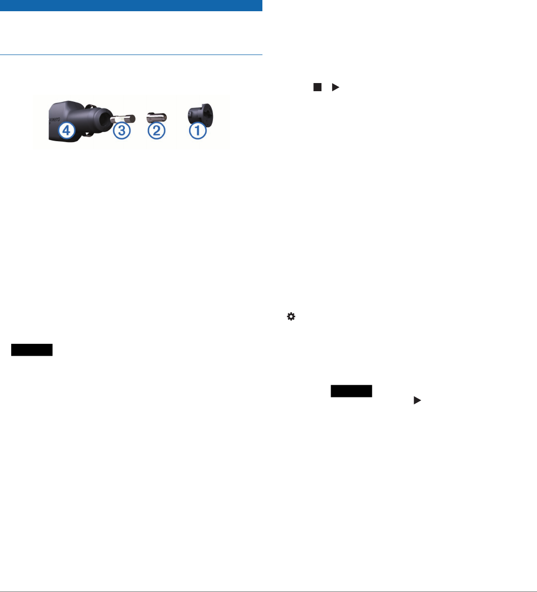
Changing the Fuse in the Vehicle Power
Cable
NOTICE
When replacing the fuse, do not lose any of the small pieces
and make sure they are put back in the proper position. The
vehicle power cable does not work unless it is assembled
correctly.
If your device does not charge in your vehicle, you may need to
replace the fuse located at the tip of the vehicle adapter.
1Rotate the end piece À counter clockwise to unlock it.
TIP: You may need to use a coin to remove the end piece.
2Remove the end piece, the silver tip Á, and the fuse Â.
3Insert a new fast-blow fuse that has the same current, such
as 1 A or 2 A.
4Place the silver tip in the end piece.
5Push in the end piece and rotate it clockwise to lock it back
into the vehicle power cable Ã.
Troubleshooting
The suction cup will not stay on my
windshield
1Clean the suction cup and windshield with rubbing alcohol.
2Dry with a clean, dry cloth.
3Mount the suction cup (Mounting and Powering the Garmin
Device in Your Vehicle, page 1).
My device is not acquiring satellite signals
• Verify the GPS simulator is turned off (Navigation Settings,
page 18).
• Take your device out of parking garages and away from tall
buildings and trees.
• Remain stationary for several minutes.
The device does not charge in my vehicle
• Check the fuse in the vehicle power cable (Changing the
Fuse in the Vehicle Power Cable, page 22).
• Verify the vehicle is turned on and is supplying power to the
power outlet.
• Verify the interior temperature of the vehicle is within the
charging temperature range indicated in the specifications.
• Verify the fuse is not broken in the vehicle power outlet.
My battery does not stay charged for very
long
• Decrease the screen brightness (Display Settings, page 19).
• Shorten the display timeout (Display Settings, page 19).
• Decrease the volume (Adjusting the Volume, page 2).
• Turn off the wi-fi radio when it is not in use (Wireless Network
Settings, page 19).
• Put the device in power saving mode when not in use
(Turning the Device On or Off, page 1).
• Keep your device away from extreme temperatures.
• Do not leave your device in direct sunlight.
My device does not connect to my phone or
Smartphone Link
• Select Settings > Wireless Networks.
The Bluetooth option must be enabled.
• Enable Bluetooth wireless technology on your phone and
bring your phone within 10 m (33 ft.) of the device.
• On your smartphone, open the Smartphone Link app, and
select > to restart the Smartphone Link background
services.
• Verify your phone is compatible.
Go to www.garmin.com/bluetooth for more information.
• Complete the pairing process again.
To repeat the pairing process, you must unpair your phone
and device (Deleting a Paired Phone, page 14), and
complete the pairing process (Pairing with Your Phone and
Connecting to Smartphone Link, page 11).
The Smartphone Link app affects the battery
charge level on my smartphone
The Smartphone Link app uses Bluetooth wireless technology to
send data to and receive data from your device. It is normal for
an active Bluetooth connection to consume some battery power.
The app also periodically checks for updates to available
services, which may consume additional battery power.
You can change the battery usage settings in the Smartphone
Link app to reduce the amount of battery power the app uses.
1From the Smartphone Link app on your smartphone, select
.
2Scroll to the Battery Usage section, and select Settings.
3Select one or more options:
• Clear the Bluetooth Auto-Connect check box.
Disabling this option may save a small amount of battery
power, but it prevents the app from connecting to your
Garmin device automatically. While this option
is disabled, you must select from the Smartphone Link
main menu each time you want to connect your device to
Smartphone Link.
• Clear the Live Services Check check box.
On some smartphones, disabling this option may
significantly reduce the battery power used by the app.
While this option is disabled, you must manually refresh
the Smartphone Link main menu to receive updated
information about available live services.
Appendix
Installing a Memory Card for Maps and Data
You can install a memory card to increase the storage space for
maps and other data on your device. You can purchase memory
cards from an electronics supplier, or go to www.garmin.com
22 Troubleshooting

/maps to purchase a memory card with pre-loaded Garmin
mapping software. The device supports microSD memory cards
from 4 to 32 GB.
1Locate the map and data memory card slot on your device
(Garmin Device Overview, page 1).
2Insert a memory card into the slot.
3Press it in until it clicks.
Data Management
You can store files on your device. The device has a memory
card slot for additional data storage.
NOTE: The device is not compatible with Windows 95, 98, Me,
Windows NT®, and Mac OS 10.3 and earlier.
About Memory Cards
You can purchase memory cards from an electronics supplier,
or purchase pre-loaded Garmin mapping software
(www.garmin.com). In addition to map and data storage, the
memory card can be used to store files such as maps, images,
geocaches, routes, waypoints, and custom POIs.
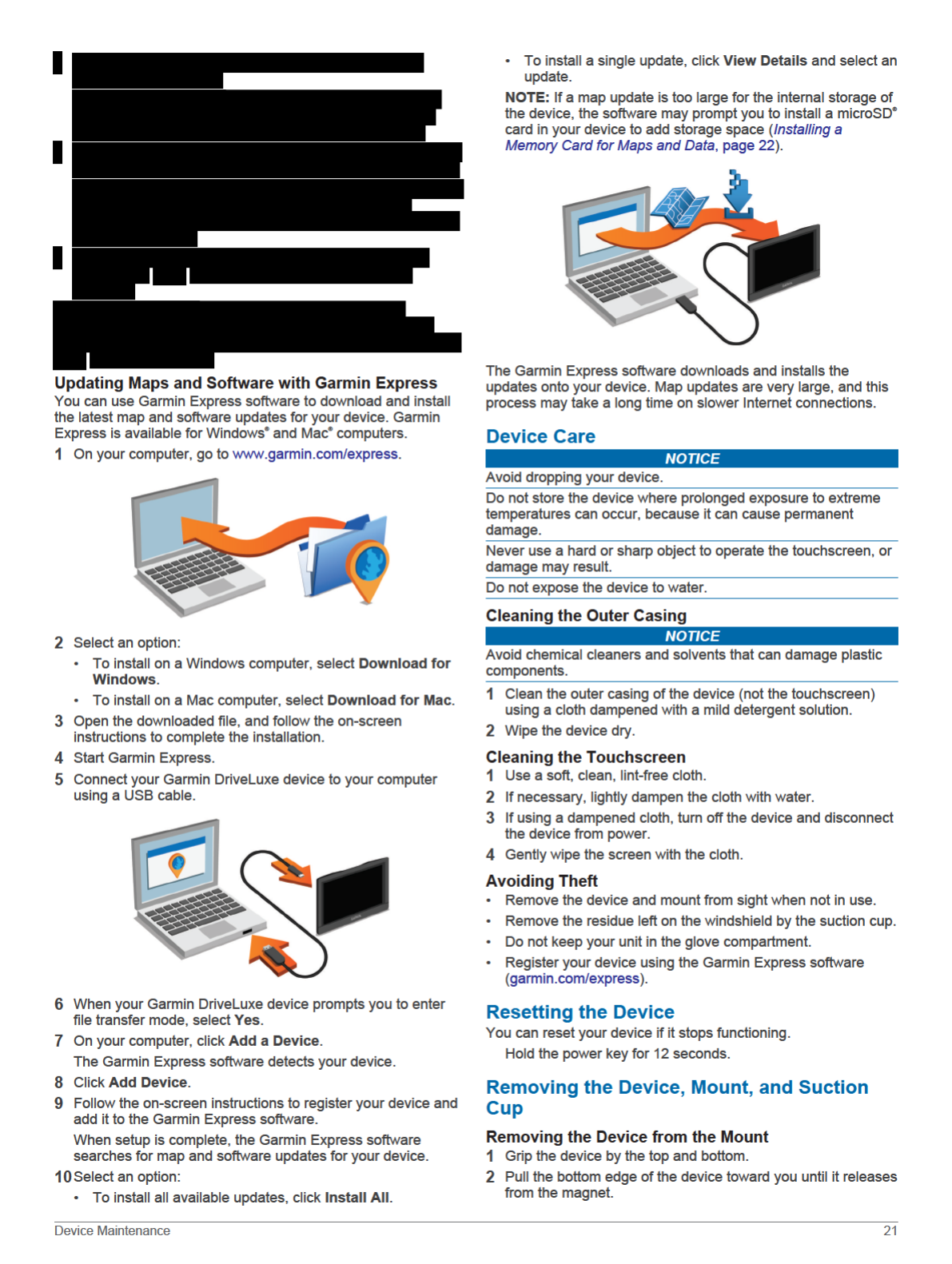
Connecting the Device to Your Computer
You can connect the device to your computer using a USB
cable.
1Plug the small end of the USB cable into the port on the
device.
2Plug the larger end of the USB cable into a port on your
computer.
3When your Garmin device prompts you to enter
file transfer mode, select Yes.
A picture of your device connected to a computer appears on
the device screen.
Depending on your computer operating system, the device
appears as either a portable device, a removable drive, or a
removable volume.
Transferring Data From Your Computer
1Connect the device to your computer (Connecting the Device
to Your Computer, page 23).
Depending on your computer operating system, the device
appears as either a portable device, a removable drive, or a
removable volume.
2On your computer, open the file browser.
3Select a file.
4Select Edit > Copy.
5Browse to a folder on the device.
NOTE: For a removable drive or volume, you should not
place files in the Garmin folder.
6Select Edit > Paste.
Disconnecting the USB Cable
If your device is connected to your computer as a removable
drive or volume, you must safely disconnect your device from
your computer to avoid data loss. If your device is connected to
your Windows computer as a portable device, it is not necessary
to safely disconnect.
1Complete an action:
• For Windows computers, select the Safely Remove
Hardware icon in the system tray, and select your device.
• For Mac computers, drag the volume icon to the trash.
2Disconnect the cable from your computer.
Viewing GPS Signal Status
Hold for three seconds.
Purchasing Additional Maps
1Go to your device product page at garmin.com.
2Click the Maps tab.
3Follow the on-screen instructions.
Purchasing Accessories
Go to garmin.com/accessories.
Appendix 23