Garmin 03185 Frequency Hopping Spread spectrum 2402-2480 MHz User Manual 1
Garmin International Inc Frequency Hopping Spread spectrum 2402-2480 MHz 1
Garmin >
Contents
- 1. User Manual
- 2. User Manual 1
User Manual 1
Quick Start Manual
Getting Started
WARNING
See the Important Safety and Product
Information guide in the product box for
product warnings and other important
information.
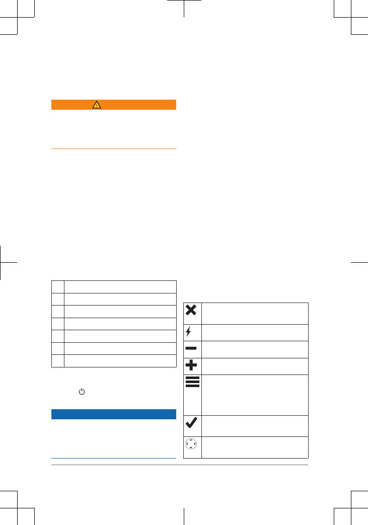
Device Overview
ÀInternal ® antenna
Á key (under protective cap)
ÂStatus LED
ÃKeys
ÄPower key
ÅMounting spine
ÆMicro-USB port (under weather cap)
Turning On the Device
Hold .
Charging the Device
NOTICE
To prevent corrosion, thoroughly dry the
USB port, the weather cap, and the
surrounding area before charging or
connecting to a computer.
NOTE: The device does not charge when
it is outside the approved temperature
range (page 6).
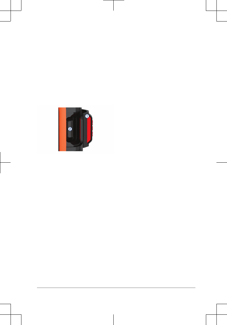
1Lift the weather cap À.
2Plug the small end of the power cable
into the USB port Á on the device.
3Plug the other end of the power cable
into an appropriate power source.
4Charge the device completely.
Keys
Select to cancel or return to the
previous page.
Select to open the shortcut menu.
Select to zoom out on the map.
Select to zoom in on the map.
Select to open the menu for the
current page.
Select twice to open the home
page.
Select to choose an option or to
acknowledge a message.
Select to view menu options or to
move the map cursor.
2 Quick Start Manual
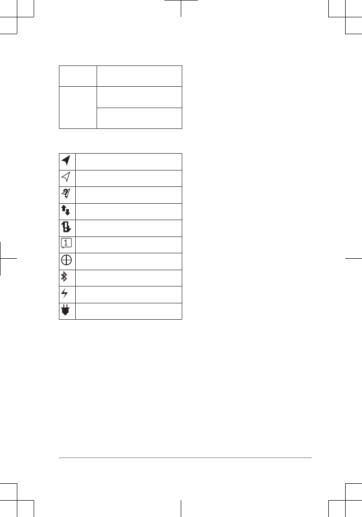
Status LED
Green
flash
You have an unread
message.
Red flash The device does not have a
clear view of the sky.
The device is below 10%
battery power.
Status Icons
3D GPS signal acquired
2D GPS signal acquired
Searching for GPS signal
Sending and receiving data
Unable to send and receive data
Unread messages
Tracking enabled
Bluetooth® technology status
Charging battery
Charging complete
Activating the Device
Before you can use your ® device,
you must activate it.
1Create an account, and select a
satellite subscription at
garmin.com.
2Turn on the device.
3Follow the on-screen instructions.
4When prompted, go outdoors to an
open area with a clear view of the sky.
5Wait while the device communicates
with the network.
NOTE: It may take up to 20 minutes to
activate your device. The device must
send and receive several messages,
which takes longer than sending a
single message during regular use.
Network
Your device requires a clear view of the
sky to track points
over the satellite network. Without
a clear view of the sky, your device
attempts to set the information until it
acquires satellite signals.
TIP: For the best connection with
satellites, attach the device to a backpack
or to your upper body.
Features
Your device has several
features for your compatible
device using the
® app.
allows you to use features on the
larger, higher resolution touchscreen on
your mobile device.
Downloadable Features: View
downloaded maps, aerial imagery,
USGS quadrangle maps, and NOAA
nautical charts on your mobile device.
You should download maps and
charts before going on your trip.
Messages: Allows you to read and write
messages, and access the contacts
list on your mobile device. Messages
appear on both devices.
NOTE: You can have only one mobile
device paired with your device at
a time.
Pairing Your Mobile Device
You must pair your device with
your mobile device to use
features.
Quick Start Manual 3

1From the app store on your mobile
device, install and open the
app.
2Place the device and your
mobile device within 3 m (10 ft.) of
each other.
3On the device, select
Settings > Pair Device
> Pair Device.
4Follow the instructions in the
app to complete the pairing
and setup process.
After the devices are paired, they connect
automatically when they are turned on and
within range.
Testing the Device
You should test the device outdoors
before using it on a trip to ensure your
satellite subscription is active.
Select Test > Test.
Wait while the device sends a test
message. When you receive a
confirmation message, your device is
ready to use.
Messages
Your device sends and receives
text messages and uses the satellite
network. You can send messages to an
SMS phone number, an email address, or
another device.
Sending a Preset Message
Preset messages are messages that you
created at garmin.com. Preset
messages have predefined text and
recipients.
1Select Preset.
2Choose a preset message, and select
Send.
Sending a Text Message
1Select Messages > New Message.
2Select an option:
• Select To: to enter new recipients.
•Select to select recipients from
your contacts list.
3Select an option:
• Select Message: to create a new
message.
• Select to select a quick text
message.
4Select Send Message.
Replying to a Message
1Select Messages.
2Select a conversation.
3Select an option:
•Select Type Reply to create a
new message, enter the
message, and select Done.
• Select Quick Reply to select a
quick text message.
Checking for Messages
Your device listens for new messages at
regular listen intervals. The device will
announce recently sent messages, and
your device receives the message at the
next listen interval. The default interval is
10 minutes.
NOTE: Your device must be in view of a
satellite at the time of the listen to receive
messages.
You can force a check for messages by
manually checking for messages, sending
a message, or sending a track point.
During a check, your device connects to
satellites and receives messages waiting
to be sent to your device.
Select Check > Check Now.
During an emergency, you can request
help. Pressing the key sends a
message to the rescue coordination
Quick Start Manual
center, and they notify the appropriate
emergency responders of your situation.
You can communicate with the rescue
coordination center during your
emergency while you wait for help to
arrive. You should only use the
function in a real emergency situation.
Initiating
NOTE: While in mode, the status bar
is red and the device cannot be turned off.
1Lift the protective cap À from the
key Á.
2Hold the key.
3Wait for the countdown.
The device sends a default message
to the emergency response service
with details about your location.
4Reply to the confirmation message
from the emergency response service.
Your reply lets the emergency
response service know that you are
capable of interacting with them
during the rescue.
For the first 10 minutes of your rescue, an
updated location is sent to the emergency
response service every minute. To
conserve battery power after the first 10
minutes, an updated location is sent every
10 minutes when moving, and every 30
minutes when stationary.
Canceling a Rescue
If you no longer need assistance, you can
cancel a rescue after it is sent to
the emergency response service.
1Lift the protective cap, and hold the
key.
2Select Cancel.
Your device transmits the cancellation
request. When you receive a
confirmation message from the
emergency response service, the
device returns to normal operation.
Tracking
Tracking records your path. When you
start tracking, your device logs your
location and updates the track line on the
map at the specified log interval. Your
device records track points and transmits
them over the satellite network at the
specified send interval. You can view the
number of track points sent, storage space
remaining, and time until the tracking log
storage is full.
TIP: You can adjust the tracking log
interval and the tracking send interval to
maximize battery life.
Starting Tracking
1Select Tracking > Start.
2If necessary, select Share to send a
message that you are tracking.
Navigation
Acquiring GPS Satellite Signals
Before you can use GPS navigation
features, you must acquire satellite
signals.
1Turn on the device.
2Wait while the device locates
satellites.
It may take up to 60 seconds to
acquire satellite signals.
Quick Start Manual 5
3If necessary, go to an open area,
away from tall buildings and trees.
Routes
A route is a sequence of locations that
leads you to your final destination. You
can create and save routes at
garmin.com.
Navigating a Saved Route
1Select Routes.
2Select a route.
3Select Navigate.
Waypoints
Waypoints are locations you record and
store in the device. Waypoints can mark
where you are, where you are going, or
where you have been.
Creating a Waypoint
You can save your current location as a
waypoint.
1Select Waypoints > New Waypoint.
2If necessary, edit the waypoint
information.
Navigating to a Waypoint
1Select Waypoints.
2Select a waypoint.
3Select Navigate.
Map
The basic map shows your location, sent
and received messages, waypoints, and a
colored track line connecting your track
points. The ® map also
shows streets, points of interest, and
topographical information.
You can customize the information
displayed on the map.
Trip Info
The trip info displays your trip time, time
moving, maximum speed, average speed,
trip distance, and trip odometer.
Device Information
Support and Updates
Go to garmin.com for easy access
to these services for devices.
• Product registration
• Product manuals
• Firmware updates
• Map downloads and updates
• Data uploads and syncing your device
with your account
Getting the Owner's Manual
The owner's manual includes instructions
for using device features and accessing
regulatory information.
Go to garmin.com/manuals/.
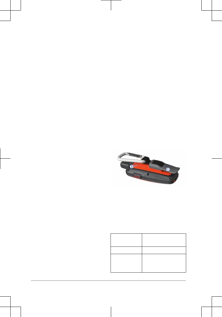
Attaching the Carabiner Clip
1Position the carabiner clip À in the
slots on the mounting spine Á of the
device.
2Slide the carabiner clip up until it locks
in place.
Removing the Carabiner Clip
Lift up on the bottom of the carabiner
clip, and slide the carabiner clip off the
mounting spine.
Specifications
Battery type Rechargeable, built-in
lithium-ion battery
Water rating IEC 60529 IPX7*
Operating
temperature
range
From -20 to 60 C
(from -4 to 140 F)
6 Quick Start Manual

Charging
temperature
range
From 0 to 45 C (from
32 to 113 F)
Radio
frequency and
protocols
Bluetooth enabled
device
Satellite enabled
device
*The device withstands incidental
exposure to water of up to 1 m for up to
30 min. For more information, go to
www.garmin.com/waterrating.
Battery Information
The actual battery life depends on your
device settings, such as the tracking and
message checking intervals.
Battery Life Mode
Up to 75 hr. 10-minute tracking send
interval and 1-second log
interval
Up to 100 hr. Default mode with 10-
minute tracking interval
Up to 30 days Power save mode with
30-minute tracking
interval
Up to 1 yr. Standby mode