Garmin 9603N Short Burst Data Transceiver User Manual

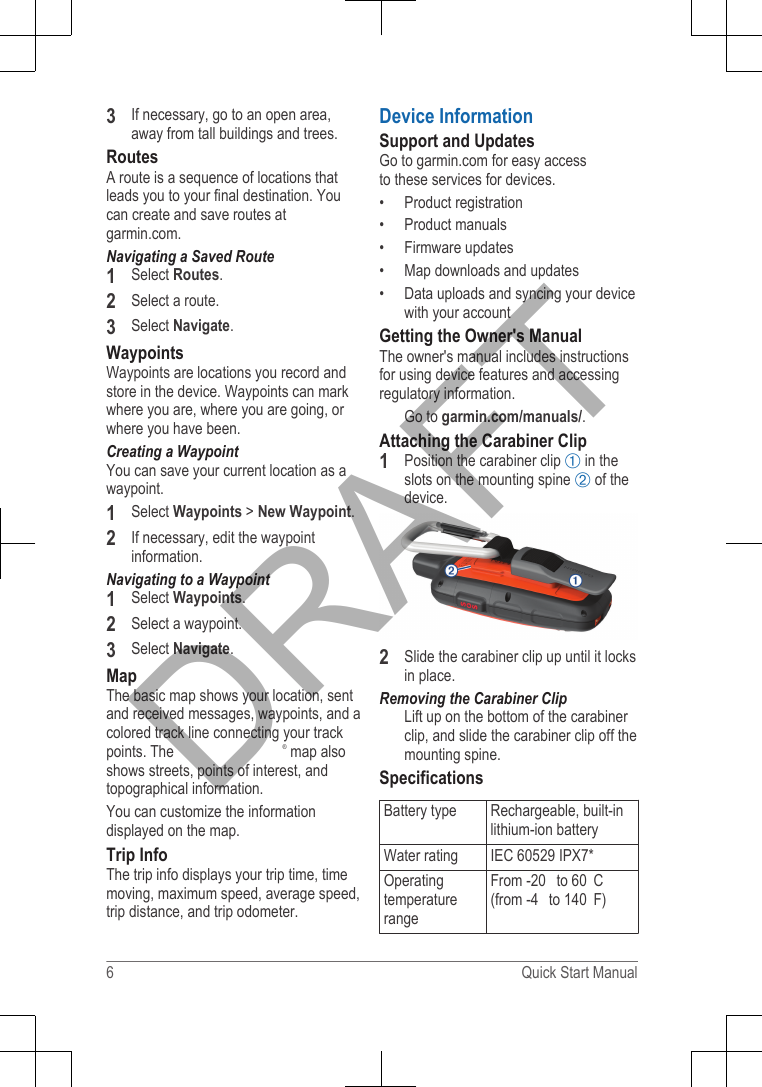
Garmin International Inc Short Burst Data Transceiver

Contents

User Manual

Quick Start ManualGetting Started WARNINGSee the Important Safety and ProductInformation guide in the product box forproduct warnings and other importantinformation.Device OverviewÀInternal  ® antennaÁ key (under protective cap)ÂStatus LEDÃKeysÄPower keyÅMounting spineÆMicro-USB port (under weather cap)Turning On the DeviceHold  .Charging the DeviceNOTICETo prevent corrosion, thoroughly dry theUSB port, the weather cap, and thesurrounding area before charging orconnecting to a computer.NOTE: The device does not charge whenit is outside the approved temperaturerange (page 6).1Lift the weather cap À.2Plug the small end of the power cableinto the USB port Á on the device.3Plug the other end of the power cableinto an appropriate power source.4Charge the device completely.KeysSelect to cancel or return to theprevious page.Select to open the shortcut menu.Select to zoom out on the map.Select to zoom in on the map.Select to open the menu for thecurrent page.Select twice to open the homepage.Select to choose an option or toacknowledge a message.Select to view menu options or tomove the map cursor.2 Quick Start ManualDRAFT
Status LEDGreenflashYou have an unreadmessage.Red flash The device does not have aclear view of the sky.The device is below 10%battery power.Status Icons3D GPS signal acquired2D GPS signal acquiredSearching for GPS signalSending and receiving dataUnable to send and receive dataUnread messagesTracking enabledBluetooth® technology statusCharging batteryCharging completeActivating the DeviceBefore you can use your  ® device,you must activate it.1Create an account, and select asatellite subscription at garmin.com.2Turn on the device.3Follow the on-screen instructions.4When prompted, go outdoors to anopen area with a clear view of the sky.5Wait while the device communicateswith the network.NOTE: It may take up to 20 minutes toactivate your device. The device mustsend and receive several messages,which takes longer than sending asingle message during regular use.NetworkYour device requires a clear view of thesky to track pointsover the satellite network. Withouta clear view of the sky, your deviceattempts to set the information until itacquires satellite signals.TIP: For the best connection withsatellites, attach the device to a backpackor to your upper body.FeaturesYour device has several features for your compatibledevice using the    ® app. allows you to use features on thelarger, higher resolution touchscreen onyour mobile device.Downloadable Features: Viewdownloaded maps, aerial imagery,USGS quadrangle maps, and NOAAnautical charts on your mobile device.You should download maps andcharts before going on your trip.Messages: Allows you to read and writemessages, and access the contactslist on your mobile device. Messagesappear on both devices.NOTE: You can have only one mobiledevice paired with your device ata time.Pairing Your Mobile DeviceYou must pair your device withyour mobile device to use features.Quick Start Manual 3DRAFT
1From the app store on your mobiledevice, install and open the app.2Place the device and yourmobile device within 3 m (10 ft.) ofeach other.3On the device, selectSettings > Pair Device> Pair Device.4Follow the instructions in theapp to complete the pairingand setup process.After the devices are paired, they connectautomatically when they are turned on andwithin range.Testing the DeviceYou should test the device outdoorsbefore using it on a trip to ensure yoursatellite subscription is active.Select Test > Test.Wait while the device sends a testmessage. When you receive aconfirmation message, your device isready to use.MessagesYour device sends and receivestext messages and uses the satellitenetwork. You can send messages to anSMS phone number, an email address, oranother device.Sending a Preset MessagePreset messages are messages that youcreated at garmin.com. Presetmessages have predefined text andrecipients.1Select Preset.2Choose a preset message, and selectSend.Sending a Text Message1Select Messages > New Message.2Select an option:• Select To: to enter new recipients.•Select   to select recipients fromyour contacts list.3Select an option:• Select Message: to create a newmessage.• Select   to select a quick textmessage.4Select Send Message.Replying to a Message1Select Messages.2Select a conversation.3Select an option:•Select Type Reply to create anew message, enter themessage, and select Done.• Select Quick Reply to select aquick text message.Checking for MessagesYour device listens for new messages atregular listen intervals. The device willannounce recently sent messages, andyour device receives the message at thenext listen interval. The default interval is10 minutes.NOTE: Your device must be in view of asatellite at the time of the listen to receivemessages.You can force a check for messages bymanually checking for messages, sendinga message, or sending a track point.During a check, your device connects tosatellites and receives messages waitingto be sent to your device.Select Check > Check Now.   During an emergency, you can requesthelp. Pressing the key sends amessage to the rescue coordination Quick Start ManualDRAFT
center, and they notify the appropriateemergency responders of your situation.You can communicate with the rescuecoordination center during youremergency while you wait for help toarrive. You should only use the function in a real emergency situation.InitiatingNOTE: While in  mode, the status baris red and the device cannot be turned off.1Lift the protective cap À from the  key Á.2Hold the  key.3Wait for the  countdown.The device sends a default messageto the emergency response servicewith details about your location.4Reply to the confirmation messagefrom the emergency response service.Your reply lets the emergencyresponse service know that you arecapable of interacting with themduring the rescue.For the first 10 minutes of your rescue, anupdated location is sent to the emergencyresponse service every minute. Toconserve battery power after the first 10minutes, an updated location is sent every10 minutes when moving, and every 30minutes when stationary.Canceling a RescueIf you no longer need assistance, you cancancel a rescue after it is sent tothe emergency response service.1Lift the protective cap, and hold the    key.2Select Cancel.Your device transmits the cancellationrequest. When you receive aconfirmation message from theemergency response service, thedevice returns to normal operation.TrackingTracking records your path. When youstart tracking, your device logs yourlocation and updates the track line on themap at the specified log interval. Yourdevice records track points and transmitsthem over the satellite network at thespecified send interval. You can view thenumber of track points sent, storage spaceremaining, and time until the tracking logstorage is full.TIP: You can adjust the tracking loginterval and the tracking send interval tomaximize battery life.Starting Tracking1Select Tracking > Start.2If necessary, select Share to send amessage that you are tracking.NavigationAcquiring GPS Satellite SignalsBefore you can use GPS navigationfeatures, you must acquire satellitesignals.1Turn on the device.2Wait while the device locatessatellites.It may take up to 60 seconds toacquire satellite signals.Quick Start Manual 5DRAFT
3If necessary, go to an open area,away from tall buildings and trees.RoutesA route is a sequence of locations thatleads you to your final destination. Youcan create and save routes at garmin.com.Navigating a Saved Route1Select Routes.2Select a route.3Select Navigate.WaypointsWaypoints are locations you record andstore in the device. Waypoints can markwhere you are, where you are going, orwhere you have been.Creating a WaypointYou can save your current location as awaypoint.1Select Waypoints > New Waypoint.2If necessary, edit the waypointinformation.Navigating to a Waypoint1Select Waypoints.2Select a waypoint.3Select Navigate.MapThe basic map shows your location, sentand received messages, waypoints, and acolored track line connecting your trackpoints. The  ® map alsoshows streets, points of interest, andtopographical information.You can customize the informationdisplayed on the map.Trip InfoThe trip info displays your trip time, timemoving, maximum speed, average speed,trip distance, and trip odometer.Device InformationSupport and UpdatesGo to garmin.com for easy accessto these services for devices.• Product registration• Product manuals• Firmware updates• Map downloads and updates• Data uploads and syncing your devicewith your accountGetting the Owner's ManualThe owner's manual includes instructionsfor using device features and accessingregulatory information.Go to garmin.com/manuals/.Attaching the Carabiner Clip1Position the carabiner clip À in theslots on the mounting spine Á of thedevice.2Slide the carabiner clip up until it locksin place.Removing the Carabiner ClipLift up on the bottom of the carabinerclip, and slide the carabiner clip off themounting spine.SpecificationsBattery type Rechargeable, built-inlithium-ion batteryWater rating IEC 60529 IPX7*OperatingtemperaturerangeFrom -20  to 60 C(from -4  to 140 F)6 Quick Start ManualDRAFT
ChargingtemperaturerangeFrom 0  to 45 C (from32  to 113 F)Radiofrequency andprotocolsBluetooth enableddeviceSatellite enableddevice*The device withstands incidentalexposure to water of up to 1 m for up to30 min. For more information, go to www.garmin.com/waterrating.Battery InformationThe actual battery life depends on yourdevice settings, such as the tracking andmessage checking intervals.Battery Life ModeUp to 75 hr. 10-minute tracking sendinterval and 1-second logintervalUp to 100 hr. Default mode with 10-minute tracking intervalUp to 30 days Power save mode with30-minute trackingintervalUp to 1 yr. Standby modeDRAFT

Navigation menu