Infrastructure Design Suite 2016 Overview Brochure
Infrastructure Design Suite 2016 Overview Brochure Infrastructure_Design_Suite_2016_Overview_Brochure Infrastructure_Design_Suite_2016_Overview_Brochure products 2016 pdf ds
Infrastructure Design Suite 2016 Overview Brochure infrastructure_design_suite_2016_overview_brochure infrastructure_design_suite_2016_overview_brochure products pdf ds
2016-06-08
: Guides Infrastructure Design Suite 2016 Overview Brochure Infrastructure_Design_Suite_2016_Overview_Brochure 2016 products pdf asi
Open the PDF directly: View PDF ![]() .
.
Page Count: 4
Visualize success with BIM
for Infrastructure
ULTIMATE
PREMIUM
STANDARD
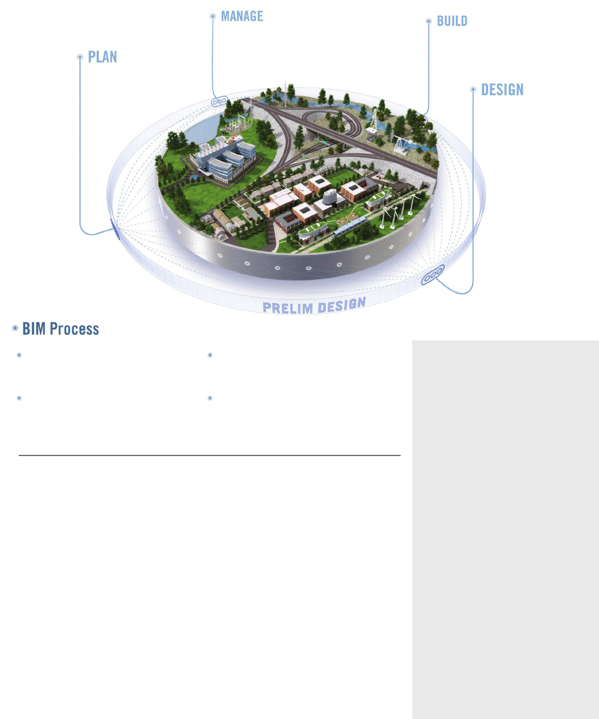
A more comprehensive BIM workflow
Are you facing these issues?
•Are your potential risks and costs
rising due to projects being planned,
designed, and built without consistent
and coordinated information?
•Is having data in multiple locations and
formats making it dicult to evaluate
existing conditions?
•Is it dicult to follow and apply
consistent engineering standards and
design rules during the design process?
•Are inecient means of sharing
information causing lost time and
duplication of efforts?
•Are you not realizing the full benefits
of model-based design, including
visualization, simulation, and analysis?
•Are you finding it dicult to get
stakeholders to understand how design
proposals will appear and perform in
the real world?
•Are your teams finding it dicult to create
compelling exhibits for building stake-
holder approval and winning new work?
•Is the cost of your project going up
because design problems are discovered
after breaking ground?
Autodesk Infrastructure Design Suite
can help you overcome these issues.
Learn more at www.autodesk.com/
infrastructuredesignsuite
A comprehensive software solution
for infrastructure projects
Autodesk® Infrastructure Design Suite is a
comprehensive software solution that provides a
BIM for Infrastructure workflow to help you gain
more accurate, accessible, and actionable insight
throughout the lifecycle of your transportation,
land, utility, and water projects. With unique
access to intelligent model-based tools, both
on the desktop and in the cloud, the suite can
help you:
•Bring multiple types of data together into
a single view to better understand project
impact and help inform design and
management decisions
•Visualize conceptual design ideas
more accurately in the context of the
existing environment
PLAN more confidently by evaluating existing
conditions and communicating the potential
impact of projects
DESIGN and document more productively with
intelligent model-based solutions that streamline
time-consuming design tasks
BUILD your projects more reliably by helping to
identify costly design and scheduling conflicts
before you break ground
MANAGE your infrastructure information more
dependably with intelligent industry models that
help you enforce data quality standards and support
future decision making
•Gain greater insight into planning, design, and
construction with integrated analysis capabilities
to better predict project outcomes
•Improve design productivity and consistency
with customizable engineering standards and
design validation rules
•More easily accommodate design changes with
synchronous design and drafting
•Create compelling visuals to help communicate
design intent and better understand projects in
real-world surroundings
•Help increase visibility into constructability,
cost, and schedules
•Manage your infrastructure information more
dependably with intelligent industry models
that help you maintain data quality standards
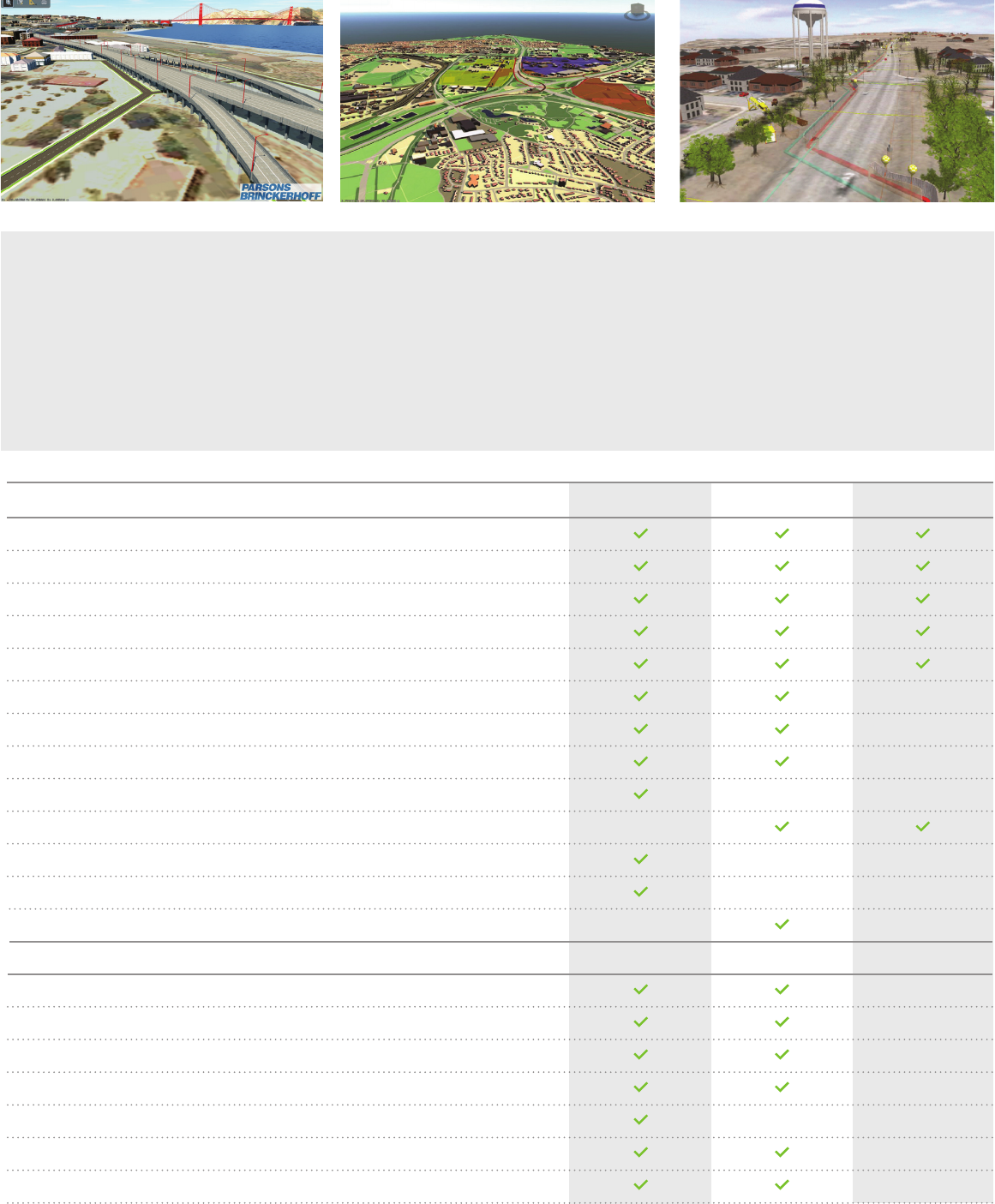
Clearly communicate design intent to assist with approvals. Help build stakeholder support with realistic project visuals. Autodesk InfraWorks. Image courtesy of Cole Engineering.
Products
Autodesk® AutoCAD®
Autodesk® AutoCAD® Map 3D
Autodesk® AutoCAD® Raster Design
Autodesk® ReCap™
Autodesk® Storm and Sanitary Analysis
Autodesk® AutoCAD® Utility Design
Autodesk® AutoCAD® Civil 3D®
Autodesk® 3ds Max®
Autodesk® Navisworks® Manage
Autodesk® Navisworks® Simulate
Autodesk® Robot™ Structural Analysis Professional
Autodesk® Revit®
Autodesk® Revit® Structure
Products and services available with Subscription
InfraWorks® 360 LT
Bridge Module*
Geotechnical Module*
Rail Layout Module*
River and Flood Analysis Module*
Structural Analysis for Revit
Green Building Studio®
ULTIMATE PREMIUM STANDARD
*This module is available to Autodesk Subscription customers of the Autodesk Infrastructure Design Suite.
Autodesk Infrastructure
Design Suite Ultimate
Advanced design and engineering
Autodesk® Infrastructure Design Suite Ultimate
2016 builds on the value of the Premium Edition
with specialized capabilities for roadway design,
architectural design, MEP engineering, and
structural engineering.
Autodesk Infrastructure
Design Suite Premium
Model-based design, analysis
and visualization
Autodesk® Infrastructure Design Suite Premium
2016 enhances your ability to implement BIM for
infrastructure, by providing model-based civil,
structural and utility design, analysis, and visual-
ization capabilities.
Autodesk Infrastructure
Design Suite Standard
Foundational planning and design
Autodesk® Infrastructure Design Suite Standard
2016 offers a familiar AutoCAD® workflow with
foundational planning, design, and coordination
capabilities.

Learn more or purchase
Access specialists worldwide who can provide product expertise, a deep understanding
of your industry, and value that extends beyond your software. To license Autodesk
Infrastructure Design Suite software, contact an Autodesk Authorized Reseller. Locate
a reseller near you at www.autodesk.com/reseller.
To learn more about and to download free* trial versions of the Autodesk
Infrastructure Design Suite, visit www.autodesk.com/infrastructuredesignsuite.
Autodesk Education
Autodesk offers students and educators a variety of resources to help ensure that
students are prepared for successful design careers. Educators can access design
software, curricula, and teaching resources, while students can access free* software,
training videos, design competitions, and career resources. Anyone can get expert
guidance at an Autodesk Authorized Training Center (ATC®) site, and validate skills with
Autodesk Certification. Learn more at www.autodesk.com/education.
Autodesk Services and Support
Keep your Autodesk products current with the latest service packs, updates, and
other maintenance releases. Access utilities and drivers, viewers, tools, certified
hardware, sample files, and plug-ins. These tools help you make the most of your
software—no matter what industry you are in. Learn more at www.autodesk.com/
servicesandsupport.
Autodesk Subscription
Subscribe to Autodesk Infrastructure Design Suite. Autodesk® Subscription gives you
an advantage with powerful cloud-based services, upgrades to the latest software
releases, online technical support, and flexible licensing privileges.** Learn more at
www.autodesk.com/subscription.
*Free products are subject to the terms and conditions of the end-user license agreement that accompanies download of
this software.
** All Subscription benefits are not available for all products in all languages and/or regions. Flexible licensing terms,
including previous version rights and home use, are subject to certain conditions.
Autodesk, the Autodesk logo, AutoCAD, ATC, Civil 3D, Green Building Studio, InfraWorks, Navisworks, ReCap, Revit,
Robot, and 3ds Max are registered trademarks or trademarks of Autodesk, Inc., and/or its subsidiaries and/or aliates in
the USA and/or other countries. All other brand names, product names, or trademarks belong to their respective holders.
Autodesk reserves the right to alter product and services offerings, and specifications and pricing at any time without
notice, and is not responsible for typographical or graphical errors that may appear in this document.
© 2015 Autodesk, Inc. All rights reserved.
Moving to Autodesk Infrastructure Design Suite allows us to offer a wider
range of services to our clients. We can now deliver project visualizations
and simulations in addition to Civil 3D models and engineering drawings.
–Matthew Dalton
CAD/GIS Consultant
SRK Consulting Limited
