Hi Target Surveying Instrument ZHDQSTAR QSTAR HIGH ACCURACY GIS DATA COLLECTION HANDHELD User Manual QStar User Manaul
Hi-Target Surveying Instrument Co., Ltd QSTAR HIGH ACCURACY GIS DATA COLLECTION HANDHELD QStar User Manaul
User Manual

Qstar series high precision mobile
GIS product specification instruction

Handbook revision situation
Revision date Revision times introduction
2012.8 1 Qstar series high precision
mobile GIS product introduction V1.0

Preface
Use of the introduction
Welcome to use Qstar series high precision mobile GIS product introduction, this manual
applies to Q star series, this manual introduced how to set and use Qstar series high
precision mobile GIS product.
Specification of the introduction
Qstar series high precision mobile GIS product is a new GPS/GIS data collector, even if you
have used other types of industrial GIS data collector, please carefully read this instruction
before use
Experience demand
In order that you can better use Qstar series high precision mobile GIS product, Hi-Target
suggests that you have a certain knowledge of measures or GIS, and carefully read this
manual. If you have any questions, please refer to the official website of Hi-Target: <
http://www.hi-target.com.cn >.
Safety technical note
Responsibility absolution
Before you use the product, you should read the introduction carefully. Hi-Target surveying
instrument Co., LTD. will not take the responsibility if you do not operate within the product
instruction。
HI-TARGET surveying instrument Co., LTD. is committed to continuously improve product
function and performance, improve the service quality, and keep the right to change the
content of the instruction without noticing in advance.
We have checked that whether the hardware and software are consistent with the content as
the prints say, but we don't rule out the possibility of bias, the picture in the instruction for
reference only, if you have a product with discrepancies, please refer to the product.
Note: pay attention to the suggestive content, it is generally special place,
need to draw your special attention, please read it carefully
Warning: the content of the warning is generally very impor
tant hints, if not
operate within the warning content , it will cause the damage of
instrument, the loss of data, and the collapse of the system, and even
endanger personal safety.

Technology and service
Hi-Target have set up the “technology and service” section in website , if you have problems
you can settle them through the "service guide" telephone, contacting regional technology
center and headquarters division or through the "experts on the judgment seat," "technology
BBS" message, we will answer your questions as soon as possible.
Related information
You can find the instructions through the following methods:
1 Purchased products from the Hi-Target will with a CD, open the CD and you can find the
instruction;
2 Land the official website of the Hi-Target, through "downloaded zone"—" product
specifications "—" GIS product "and you can it.
Your suggestion
If you have any suggestions and opinions about the introduction, please visit the official
website of the Hi-Target, and leave massage in "technical service" —"advice and complaint"
edition , your feedback will help to improve the quality of the introduction greatly .

Chapter 1
Products overview
This chapter introduces:
■ Product introduction
■ Product features
■Matters needing attention in use
C H A P T E R
1

Product introduction
Qstar series high precision mobile GIS products are equipped with complete navigation and
position function and GIS data acquisition function, with the operating mode of physical
buttons and touch screen, inputting in both Chinese and English are supported. It is designed
as industrial standard, and can be dropped from 1.5 meters high to the cement floor without
anything, equipped with IP67 level dustproof and waterproof, it can adapt to complex work
environment in the field. At the same time, the configuration of the large capacity of lithium
battery can meet the requirements of all day work.
Qstar series high precision mobile GIS products are integrated designed, and it is equipped
with functions such as GPS, embedded Windows Mobile 6.5 system, digital camera,
microphone, bluetooth communication, large storage, USB port, SD card expansion ,etc.
Product features
◊ Industrial integration design, with a variety of functions
◊ Can be used as the industrial three proof standard GPS navigation
◊ The built-in digital camera, which can realize image information site acquisition,
automatically realize GPS coordinates and image information matching labeling
◊ The built-in microphone, it can realize voice information site collected with the function
of speech play
◊ The built-in bluetooth , to realize the wireless data transmission
Use and the matters needing attention
Although Qstar series high precision mobile GIS products use the corrosion resistance and
impact resistance materials, but the instrument still need our careful use and maintenance,
and keep it in dry environment as far as possible. In order to improve the stability of the Qstar
series high precision mobile GIS products and use cycle, please avoid Qstar series high
precision mobile GIS products exposed to extreme environments,such as: damp, high
temperature, low temperature, corrosive gas or liquid, etc.
To ensure continuous observation of the satellite and satellite signal quality, the stations
should be set over the open place as far as possible, barriers are not permitted in more than
15 degree; To reduce the interference of electromagnetic wave to GNSS satellite signal,
within 200 m strong electromagnetic interference is not permitted, such as TV tower,
microwave station, high voltage transmission line; To avoid or reduce the happening of the
multipath effect, stations should be far away from to the terrain which reflect electromagnetic
wave signal strongly, such as high building, sliced waters, etc.
Warning: Qstar series high precision mobile GIS products must be
preserved and used within stipulated temperature range. Detail
requirements, please refer to chapter 4: technical parameters.

The manufacturers of non Hi-target accessories for the product are responsible for
developing, implementing and communicating safety concepts for their products, and are also
responsible for the effectiveness of those safety concepts in combination with the Hi-target
product.
The person responsible for the product must ensure that it is used in accordance with the
instructions. This person is also accountable for the training and the deployment of personnel
who use the product and for the safety of the equipment in use.
The content below is only applicable for products without radio.
This equipment has been tested and found to comply with the limits for a Class B digital
device, pursuant to part 15 of the FCC rules. These limits are designed to provide reasonable
protection against harmful interference in a residential installation. This equipment generates,
uses and can radiate radio frequency energy and, if not installed and used in accordance with
the instructions, may cause harmful interference to radio communications. However, there is
no guarantee that interference will not occur in a particular installation. If this equipment does
cause harmful interference to radio or television reception, which can be determined by
turning the equipment off and on, the user is encouraged to try to correct the interference by
one or more of the following measures:
• Reorient or relocate the receiving antenna.
• Increase the separation between the equipment and the receiver.
• Connect the equipment into an outlet on a circuit different from that to which the receiver is
connected.
• Consult the dealer or an experienced radio/TV technician for help.
FCC ID: O39ZHDQSTAR
This device complies with Part 15 of the FCC Rules. Operation is subject
to the following two conditions: (1) this device may not cause harmful
interference, and (2) this device must accept any interference received,
including interference that may cause undesired operation.

Chapter 2
The introduction of Qstar series high
precision mobile GIS products
The introduction of this chapter:
■ the front of Qstar series high precision mobile GIS products
■ the back of Qstar series high precision mobile GIS products
■ interface
■ touching pen
■ battery
■ data cable
■ belt
This chapter introduces Qstar series high precision mobile GIS products
appearance, interface, battery, touch pen and data cable, etc.
The front of Qstar series high precision mobile GIS products
The front of Qstar series high precision mobile GIS products
including the touch screen, keyboard, a microphone,protection set ,etc.
C H A P T E R
2

◊ Touch screen:3.7 inch vertical screen can do click operation directly, support inputting in
both Chinese and English.
◊ Protective set: in case that it grind 、 fell and shock, effective to avoid instrument scratching.
◊ Keyboard: direction control, the confirmation button, exit button, switch machine etc.
◊The microphone: built-in microphone can be used for the acquisition of voice messages.
The back of Qstar series high precision mobile GIS
products
The back of Qstar series high precision mobile GIS products, including the camera, battery,
the belt hole, horn, etc.
◊ Camera: built-in digital camera for video information site collection
◊ Battery: the built-in 3.7 V, 8800 mAh lithium batteries
◊ Belt: connect the strap to prevent slide.
◊ Horn: instrument real-time operating state and speech broadcast
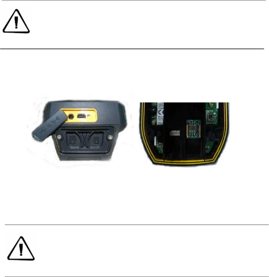
Interface
Qstar series high precision mobile GIS products interface position is identified, its main
function is charging and data transmission, installing SIM card and SD card, etc.
Picture2-3
◇ Charging interface: connect the charger for lithium battery charge.
◇ USB interface :the connection computer, used for data transmission.
◇ MicroSD card slot: it can be installed MicroSD card, can support 32 GB at most.
Note: when the horn is in water, it may appear silent or husky, dry it and it will be
back to normal. The loudspeaker and the instrument is completely waterproof,
horn with water will not affect instrument performance, but please timely dry it..
Note: when the charging interface and USB interface are not in use, please cover
the stopper, in order to achieve the purpose of waterproof, dustproof.
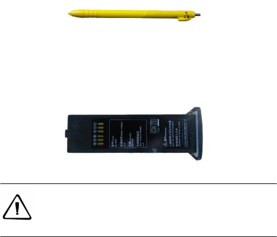
Touching pen
Qstar series high precision mobile GIS products touching pen is equipped with standard
configuration, located in Qstar series high precision mobile GIS products belt .
Picture2-4
Battery
This illustration shows the standard 8800 mAh lithium battery appearance figure.
Picture2-5
Notice: In order to protect the environment, when the lithium battery failure,
do not throw them away, please return to Hi-Target or professional battery
recycling units processing.
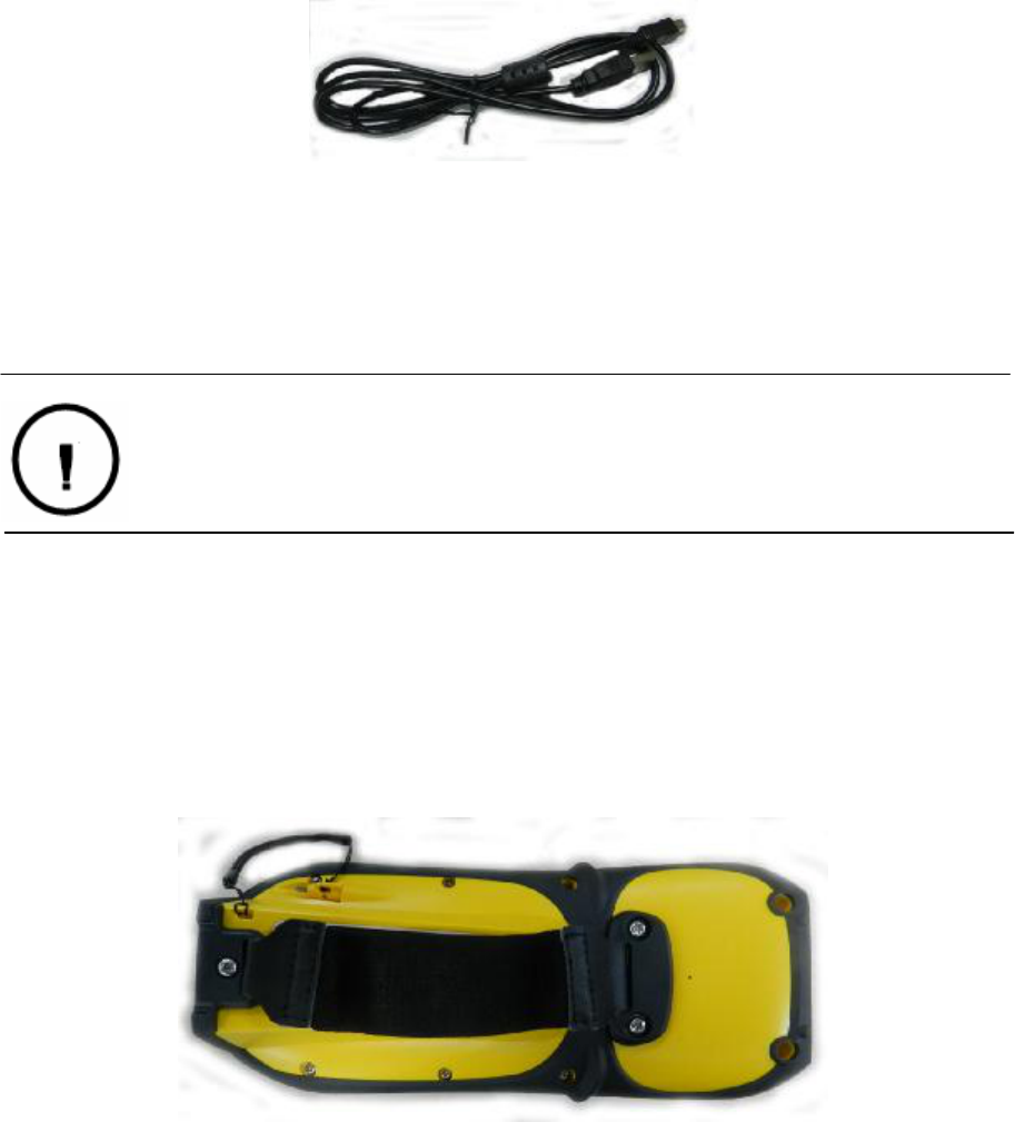
Data cable
Picture2-6
◇Qstar series high precision mobile GIS products interface: used in connection of USB with
Qstar series high precision mobile GIS products.
◇USB interface: to connect computer USB port , used for data download.
Belt
Because Qstar series high precision mobile GIS product is big, in order to prevent sliding in
the process of working, it is equipped with antiskid belt, please entangle belt when you
work .
Picture2-7
Warning: when the cable is not in use, it should be packed in where the place is
not easy to squeeze to prevent damage to the plug.

Chapter 3
Basic operation
The introduction of this section:
▇ Keyboard
▇ Touching pen
▇ MicroSD card
▇ Power supply system
▇ Switch machine operation
▇ Data obtain
▇ Application functions
Most of the Hi-Target Qstar series high precision mobile GIS products setting and operation
can be completed by touching pen, the common operation can be completed by the
keyboard . Now we will introduce the appearance and function of the keyboard simply.
Keyboard
Qstar series high precision mobile GIS products keyboard. The keyboard keys contains:
the confirmation button , exit key, F1 function keys, switch machine key and the direction key.
Figure 3-1
C H A P T E R
3
“ESC”exit button: short press it on boot-up state, means to cancel or exit the current window
operation.
“ENT”Confirm button: ok button.
Switch machine button/backlight control button: long press it for more than 3 seconds to
turns on/off it. On boot-up state, hold the button for 1 second, switch on or off the backlight .
Navigation button: move the cursor, to choice the options content.
MicroSD card
Can be used for storage of the collected data and program files. Program installation package
can be installed to program MicroSD card, just as installed in system disk space.
Power supply system
◊The battery installation and removal
Install the battery, contact the battery with a metal connector on one end with Qstar series
high precision mobile GIS product battery jar copper point, and screw up the screw.
Take out the battery, take out the screw firstly, the battery will popup little, then you can take it
out.
◊ Qstar series high precision mobile GIS product battery, charger model number
Notice: when Qstar series high precision mobile GIS product is not in work
temporarily, please close a backlight to save electricity, to extend industrial
GIS data collector work time.
Note: the MicroSD cards (also named TF card) are small volume external flash
memory storage expansion CARDS, usually used in mobile phone, PDA, users
should distinguish it between the common SD card. The volume of ordinary SD card
are larger than the MicroSD card, not suitable for Qstar series high precision mobile
GIS product. Qstar series high precision mobile GIS product can support 32 GB
MicroSD card at most for present.

Table 3-1 Qstar series high precision mobile GIS product battery, charger model
name model
8800 mAh lithium batteries BL-8800A
Lithium battery charger CL-00A
◊charge
When charging, the charger should be specialized charger with standard configuration or seat
charger in certain temperature range, and charging time should achieve a certain
requirements.The concrete use method and requirements: charging with standard
configuration is demanded when charging the Qstar series high precision mobile GIS product,
charge in 10 ℃ ~ 40 ℃ temperature range. Using for the first time in general, there should be
some battery power, you should use up the inside electricity before charging again, the first
three charging must achieve12 hours, after that charging 6 hours. If the battery is not often in
use, it must be charged once a month.
Switch machine operation
◊Boot
In the shutdown state, long press three seconds, it will boot.
Warning: 1The battery and charger manufacturer configuration are only
permitted, do not put it into the fire or metal electrodes with short circuit.
2 If you find the battery has fever, deformation, discharge, smell or other
abnormal phenomenon when the battery is in use , in charge or in storage, please
replace new battery.
3 If the use time of the battery significantly shortened, please stop using the
battery, the battery is aging, please replace new battery.
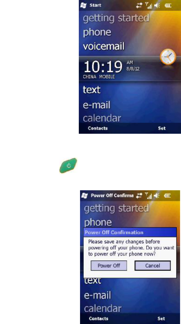
Figure 3-9
◊ shutdown
On state, long press 3 seconds, it will tip you to confirm shutdown, click on the "shut
down".
Figure3-10
Network connection
Click "start" - > "DialConnect", if you have set up dial-up parameters, click "dial-up
connection",you can direct dialing. If you did not click "new connection", then click "dial-up
connection".
For successful dial-up network, you can click "disconnect" to close the connection.
Tip: after the successfully dial-up ,don't click on the top right corner "OK" button, click on the
top left corner "start" to do other operation
Data obtain
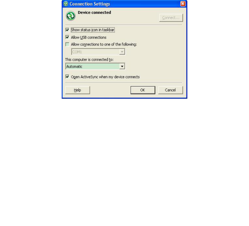
1 Install Microsoft ActiveSync
In the incidental disk (tool software \ connection program \ ActiveSync), double click
MSASYNC45. exe file, please follow the instructions to complete installation. After the
installation, find Microsoft ActiveSync and operate it in the "start menu" "program" .Set up
"allows the USB connection" In the menu "connection Settings", as shown in figure 4-21.
Figure3-11
2 The hardware connection
First,switch on Qstar series high precision mobile GIS product, enter the Windows system,
it is no need to open applications. Connect the USB port which with a smaller cable line with
the Qstar series high precision mobile GIS product , connect the other end USB plug with
your PC.
3 Software connection
When the cable is connected ,the Microsoft ActiveSync in the computer will tips you "whether
need to establish cooperation relationship," choose “cancel”,Then Microsoft ActiveSync
popup a hint, click "ok"。Then it has been connected successfully. If it is the first connections,
the computer will tips you to install the driver, just installed Windows compute driver
according to guide.
4 download data
Click on the“ browse button”of the Microsoft ActiveSync, open the resources browser of
Qstar series high precision mobile GIS product ,you can enter the related file and copy data to
the computer.
Application functions
Qstar series high precision mobile GIS product is equipde with PPP technology (the
technology used in Qstar model), built-in GPS navigation and positioning, digital camera,
microphone, 3 G communications (this function is optional), and other functions, but it must
be installed with the corresponding software. Qstar series high precision mobile GIS product
is equipped with Hi-Q software, as to how to use Hi-Q software to operate of the application
functions above, please refer to my company's "Hi-Q software operation instruction" content.

Chapter 4
Technology parameters
The introduction of this section
Technology parameters
Technology parameters
This chapter will introduces you related parameters of Qstar series high precision mobile GIS
product, the product function will vary according to the different models. When you refer to
this chapter, please refer to corresponding technical parameters according to the equipment
you purchase.
\
Model Q star5 Q star6 Q star8
System configuration
Operating system: Windows Mobile
6.5
√ √ √
806MHz high-speed CPU √ √ √
Memory: 256MB RAM √ √ √
Flash memory:8GB √ √ √
Screen: 3.7 inches color touch
screen, 640 x 480 resolution
√ √ √
GPS characteristics
High sensitivity GPS positioning
technology
√ √ √
GPS+GLONASS binary star
positioning technology
Support SBAS(WAAS,EGNOS,
MSAS)
√ √ √
Positioning time for the first ime:
30second(typical)
√ √ √
Positioning accuracy
Point positioning:5 m √ √ √
SBAS:1-3m √ √ √
PPP(accurate point positioning)
technology:1m
application function
5 million pixel camera with LED the fill
light
√ √ √
Integrated microphone and speakers √ √ √
Data communication
C H A P T E R
4

Bluetooth √ √ √
Interface: Mini USB interface √ √ √
Storage: Micro SD card slot, 32 G at
most
√ √ √
Power performance
Standard configuration 3.7 V, 3100
mAh lithium batteries
Can work continuously over 12 hours
support online charge
√ √ √
Physical properties
Key: 10 buttons, with four the
direction key and shortcut key in the
side
√ √ √
Size:14cm×8cm×3.5cm √ √ √
Weight:360g(contain battery) √ √ √
Work temperature: -30℃ ~ +70℃
storage temperature:- 40℃~+80℃
√ √ √
Dustproof waterproof:IP67 √ √ √
Shockproof: Resistance to 1.5 m free
fall
√ √ √