Intellisense Sdn Bhd 2401T100 Active RFID Tag User Manual manual
Intellisense Sdn Bhd Active RFID Tag manual
UserManual.wiki
>
Intellisense Sdn Bhd
>
2401T100 User Manual
manual
Navigation menu
Upload a User Manual
Namespaces
Wiki Guide
HTML
PDF
Info
Views
User Manual
Discussion / Help
Navigation
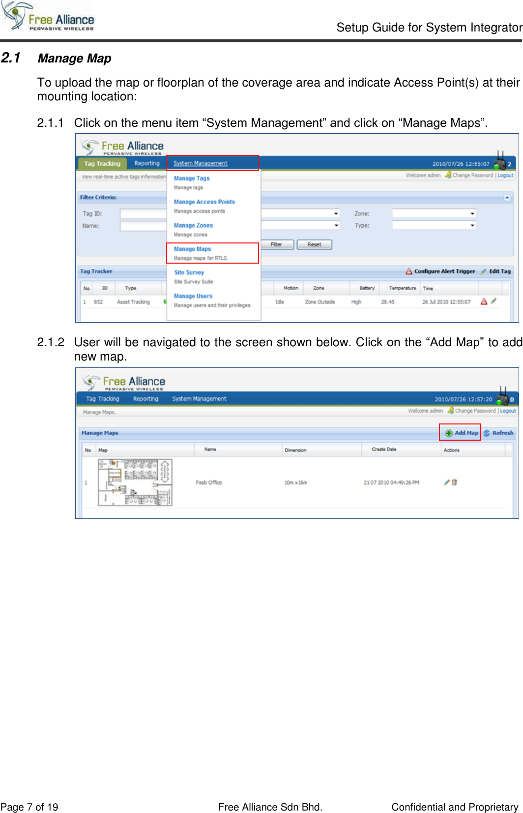
![Setup Guide for System Integrator Page 17 of 19 Free Alliance Sdn Bhd. Confidential and Proprietary 2.3.8 Primary Zone Sampling Execute below SQL script to create SQL Stored Procedure in SQL Server Management Studio CREATE PROCEDURE [dbo].[usp_MapNodes_GetByMapZoneID] -- Add the parameters for the stored procedure here @p_MapID BIGINT, @p_ZoneID BIGINT AS BEGIN -- SET NOCOUNT ON added to prevent extra result sets from -- interfering with SELECT statements. SET NOCOUNT ON; -- Insert statements for procedure here SELECT mn.ID,mn.Code,mn.MapID,mn.ActualTop,mn.ActualLeft,mn.Created,mn.Modified FROM fasb_MapsNodes AS mn INNER JOIN fasb_MapsNodesRelativedZone AS mnrz ON mnrz.MapNodeID = mn.Code AND mnrz.MapID=mn.MapID WHERE mnrz.MapID = @p_MapID AND mnrz.ZoneID = @p_ZoneID AND mnrz.ZonePriority IN (1) END 2.3.9 Proceed to section 2.3.12 to continue. NB: Do not refer section 2.3.10 if user adopts “Primary Zone Sampling”. 2.3.10 Full Sampling Execute below SQL script to create SQL Stored Procedure in SQL Server Management Studio. CREATE PROCEDURE [dbo].[usp_MapNodes_GetByMapZoneID] -- Add the parameters for the stored procedure here @p_MapID BIGINT, @p_ZoneID BIGINT AS BEGIN -- SET NOCOUNT ON added to prevent extra result sets from -- interfering with SELECT statements. SET NOCOUNT ON; -- Insert statements for procedure here SELECT mn.ID,mn.Code,mn.MapID,mn.ActualTop,mn.ActualLeft,mn.Created,mn.Modified FROM fasb_MapsNodes AS mn INNER JOIN fasb_MapsNodesRelativedZone AS mnrz ON mnrz.MapNodeID = mn.Code AND mnrz.MapID=mn.MapID WHERE mnrz.MapID = @p_MapID AND mnrz.ZoneID = @p_ZoneID END 2.3.11 Proceed to section 2.3.12 to continue. NB: Do not refer section 2.3.8 if user adopts “Full Sampling”.](https://usermanual.wiki/Intellisense-Sdn-Bhd/2401T100/User-Guide-1536397-Page-17.png)