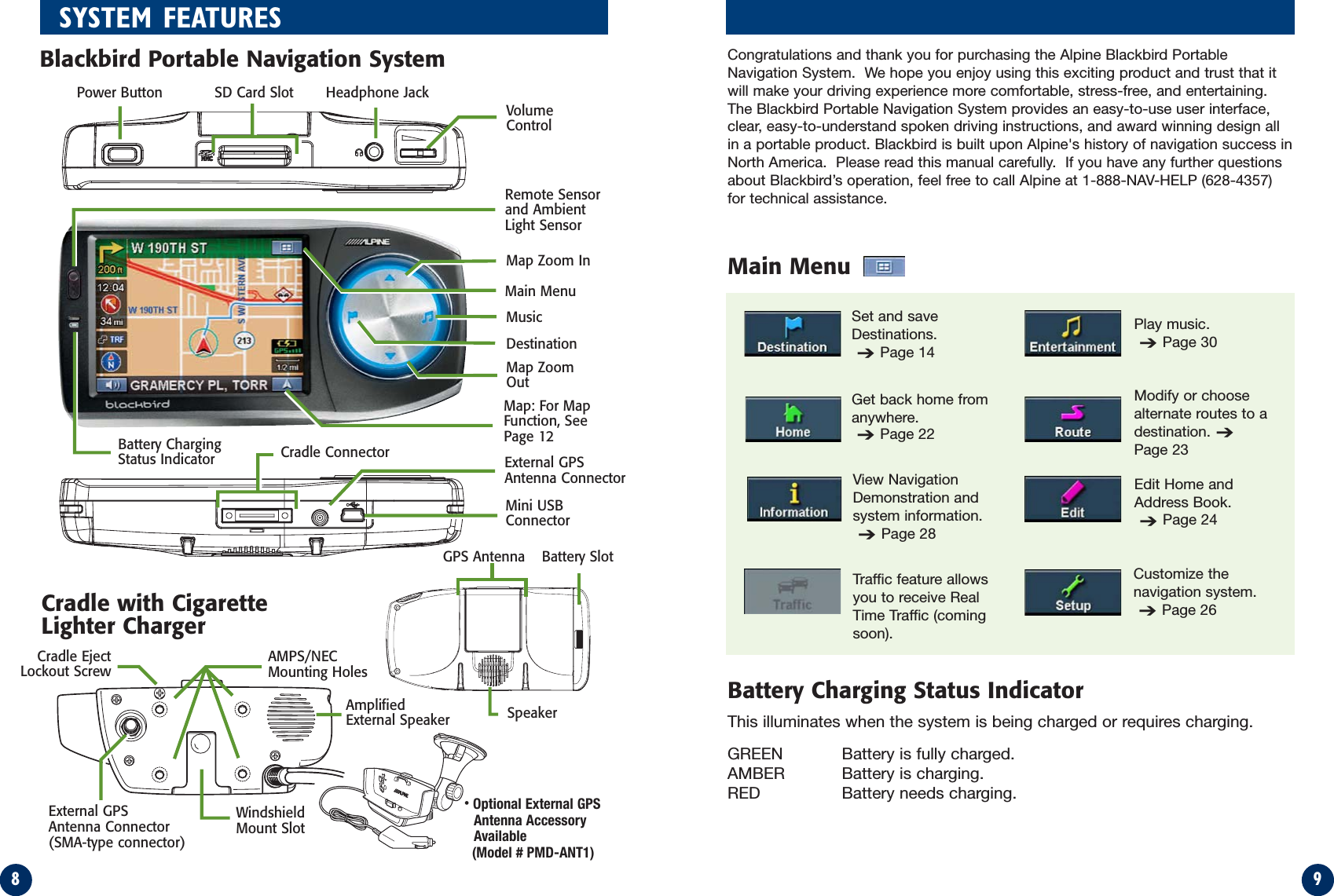
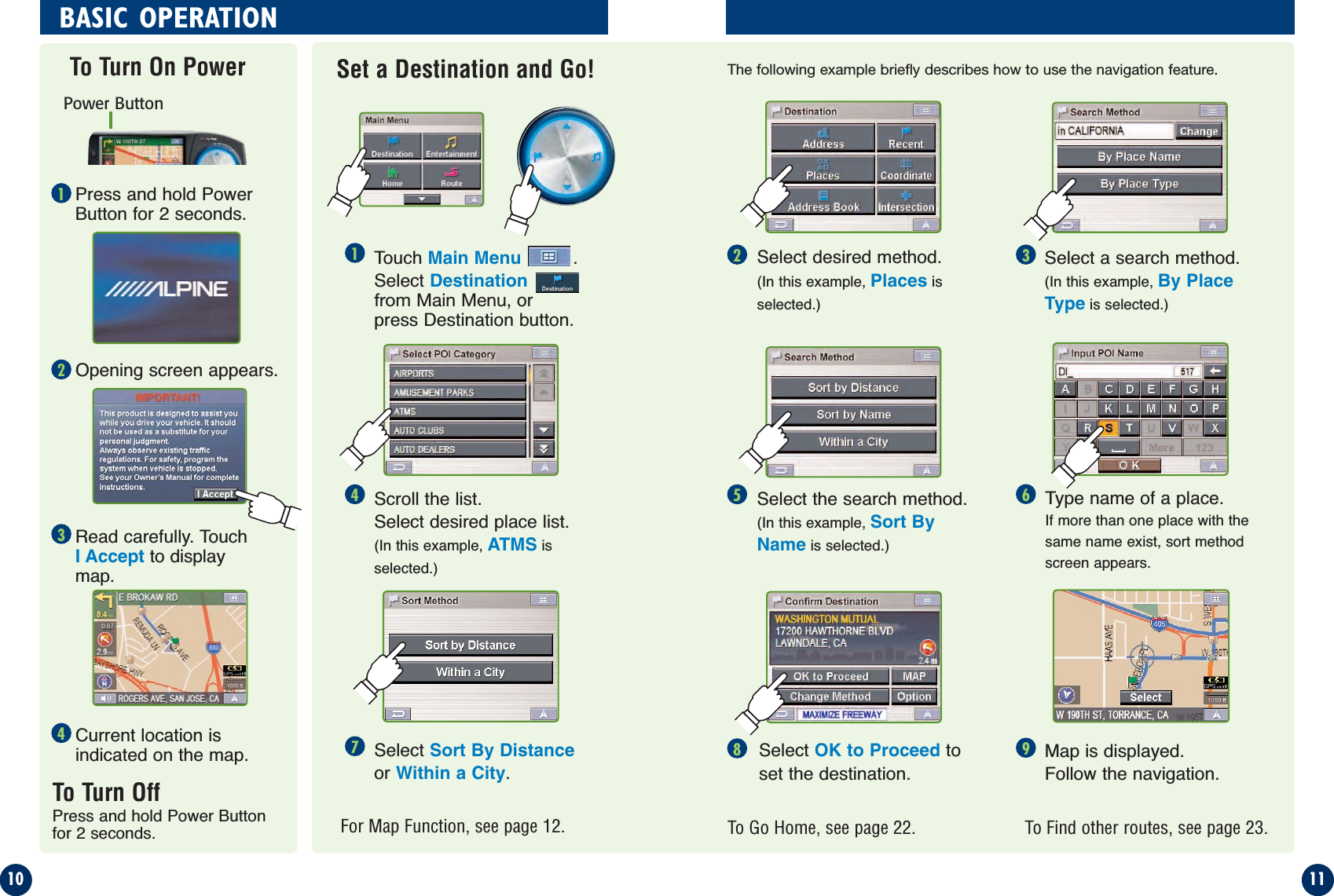
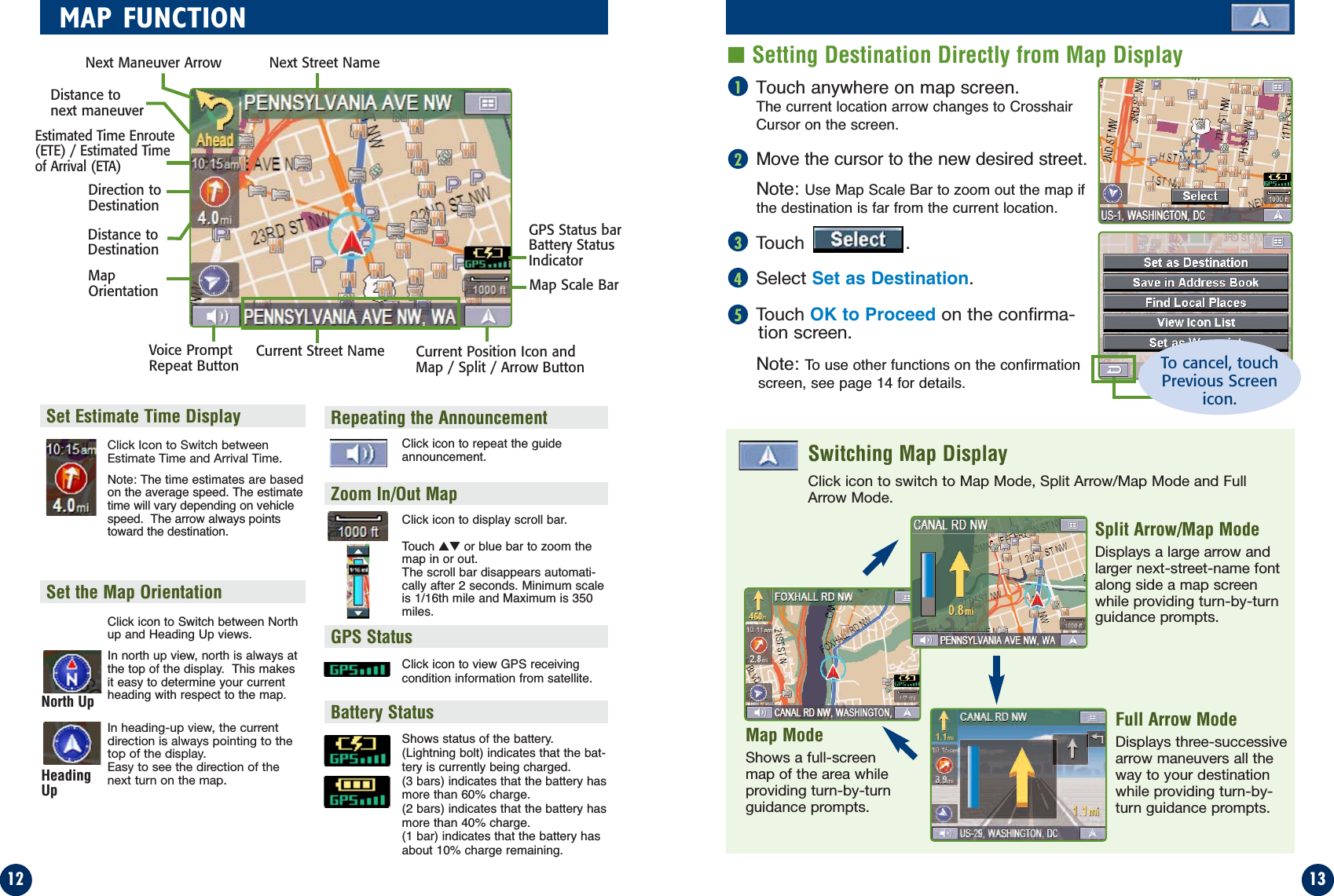
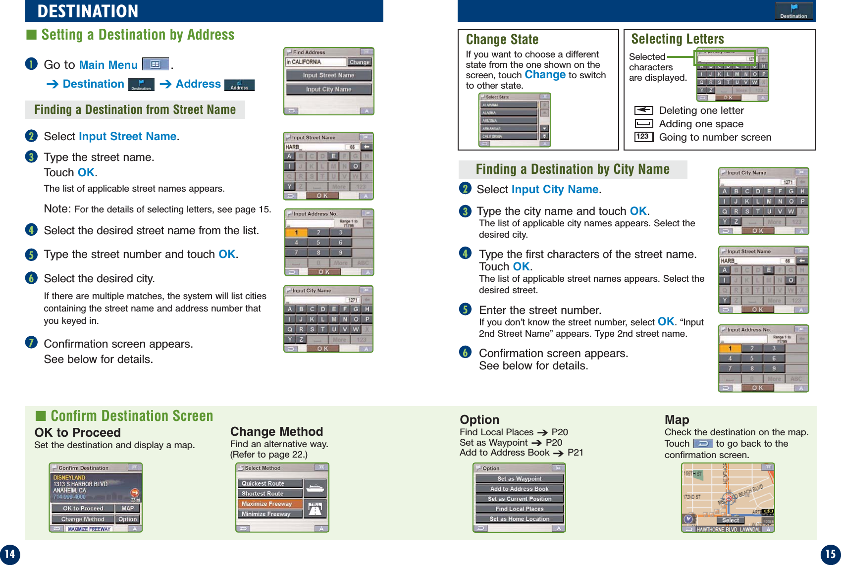
Leadtek Research LR9701C FM Transmitter ( Blackbird ) User Manual unprotected PMD B100 CR User ma

Leadtek Research Inc FM Transmitter ( Blackbird ) unprotected PMD B100 CR User ma

User Manual

PMD-B100Owner’s ManualVersion 1.0
32PRECAUTIONS■Important InformationPlease Read Carefully Before Using This Product.This product is intended to safely provide turn by turn instructions to get you to adesired destination. Please make certain that all persons using this navigation systemcarefully read these precautions and the following instructions fully. 1) This product is not a substitute for your personal judgment. Any route suggestionsmade by this navigation system may never supersede any local traffic regulations oryour personal judgment and/or knowledge of safe driving practices. Do not followroute suggestions if the navigation system instructs you to perform an unsafe orillegal maneuver, places you in an unsafe situation, or routes you into an area whichyou consider unsafe.2) Glance at the screen only when necessary and safe to do so. If prolonged viewing ofthe screen is necessary, pull over in a safe and legal manner and location.3) Do not input destinations, change settings, or access any functions requiring a pro-longed view of the monitor and/or remote control while you are driving. Pull over in asafe and legal manner and location before attempting to access the system.4) Do not use the navigation system to route you to emergency services. Not all loca-tions of emergency services such as police and fire stations, hospitals and clinics arecontained in the database. Please use your own judgment and ask for directions inthese situations.5) The map database used in the navigation system is the most recent map data avail-able at the time of production. Because of changes in streets and neighborhoods,there may be situations where the navigation system is not able to route you to yourdesired destination. In these cases, use your own judgment.6) The map database is designed to provide you with route suggestions and does nottake into account the relative safety of a suggested route or of factors which mayaffect the time required to reach your destination. The system does not reflect roadclosures or construction, road characteristics (i.e. type of road surface, slope orgrade, weight or height restrictions, etc.), traffic congestion, weather conditions, orany other factors which may affect the safety or timing of your driving experience.Use your own personal judgment if the navigation system is unable to provide youwith an alternate route. 7) There may be situations where the navigation system displays the vehicle's locationerroneously. Use your own driving judgment in this situation, taking into accountcurrent driving conditions. Please be aware that in this situation the navigation sys-tem should correct the vehicle's position automatically. However, there may be timeswhere you may have to correct the position yourself. If this is the case, pull over in asafe and legal manner and location before attempting operation.8) Make certain that the volume level of the navigation system is set to a level whichstill allows you to hear outside traffic and emergency vehicles.If there is anything in the manual about the operation of the navigation system whichyou are uncertain about, please contact your local Alpine authorized navigation dealeror Alpine at 1-888-NAV-HELP (1-888-628-4357) before using the navigation system.WARNINGSPoints to Observe for Safe UsageRead this manual carefully before using this system. Itcontains instructions on how to use this product in asafe and effective manner. Alpine cannot be responsi-ble for problems resulting from failure to observe theinstructions in this manual.This manual uses various pictorial displays to showyou how to use this product safely and to alert you topotential dangers resulting from improper connectionsand operation. Following are explanations of thesepictorial displays. It is important to fully understandthe meanings of these pictorial displays in order touse this manual and the system properly.DO NOT OPERATE ANY FUNCTION THAT TAKES YOURATTENTION AWAY FROM SAFELY DRIVING YOUR VEHICLE.Any function that requires your prolonged attentionshould only be performed after coming to a completestop. Always stop the vehicle in a safe location beforeperforming these functions. Failure to do so mayresult in an accident.KEEP THE VOLUME AT A LEVEL WHERE YOU CAN STILLHEAR OUTSIDE NOISE WHILE DRIVING.Failure to do so may result in an accident.MINIMIZE DISPLAY VIEWING WHILE DRIVING.Viewing the display may distract the driver from look-ing ahead of the vehicle and cause an accident.DO NOT DISASSEMBLE OR ALTER.Doing so may result in an accident, fire or electricshock.USE THIS PRODUCT AS SPECIFIED.Use for other than its designed application may resultin fire, electric shock or other injury.KEEP SMALL OBJECTS SUCH AS BATTERIES OUT OF THEREACH OF CHILDREN.Swallowing them may result in serious injury. If swal-lowed, consult a physician immediately.DO NOT PLACE HANDS, FINGERS OR FOREIGN OBJECTSIN INSERTION SLOTS OR GAPS.Doing so may result in personal injury or damage tothe product.USE THE CORRECT AMPERE RATING WHEN REPLACINGFUSES.Failure to do so may result in fire or electric shock.DO NOT BLOCK VENTS OR RADIATOR PANELS.Doing so may cause heat to build up inside and mayresult in fire.HALT USE IMMEDIATELY IF A PROBLEM APPEARS.Failure to do so may cause personal injury or damageto the product. Return it to your authorized ALPINEdealer or the nearest ALPINE Service Center forrepairing.DO NOT MIX NEW BATTERIES WITH OLD BATTERIES.INSERT WITH THE CORRECT BATTERY POLARITY.When inserting the batteries, be sure to observe prop-er polarity (+ and -) as instructed.Rupture or chemical leakage from the battery maycause fire or personal injury.PRECAUTIONSTemperatureBe sure the temperature inside the vehicle is between+60°C (+140°F) and -0°C (+32°F) before turning yourunit on.Fuse ReplacementWhen replacing the fuse(s), the replacement must beof the same amperage as shown on the fuse holder. Ifthe fuse(s) blows more than once, carefully check allelectrical connections for shorted circuitry. Also haveyour vehicle’s voltage regulator checked.MaintenanceIf you have problems, do not attempt to repair the unityourself. Return it to your ALPINE dealer or the near-est ALPINE Service Station for servicing.Installation LocationMake sure the PMD-B100 will not be exposed to:• Direct sun and heat • Excessive dust• High humidity  • Excessive vibrationsCharacteristics of LCD Panel• After turning the system off, a slight ghost of theimage will remain temporarily. This is an effectpeculiar to LCD technology and is normal.• Under cold temperature conditions, the screen maylose contrast temporarily. After a short warm-upperiod, it will return to normal.• The LCD panel is manufactured using an extremelyhigh precision manufacturing technology. Its effec-tive pixel ratio is over 99.99%. This means that0.01% of the pixels could be either always ON orOFF.Using HeadphonesIf ACC or the monitor's power source is turned off, aloud noise is produced through the headphone jack.Be sure to remove the headphones from your earsbefore you turn the monitor off.This symbol means important instructions.Failure to heed them can result in seriousinjury or death.WARNINGThis symbol means important instructions.Failure to heed them can result in injury ormaterial property damage.CAUTION
5TABLE OF CONTENTS4Precautions  ........................ 2Warnings ........................... 3User Agreement .................... 4Table of Contents ................... 5Installation ......................... 6How to Mount Blackbird ........... 6How to Listen to Guidance and Music from Your Car Stereo  ........ 7System Features  ................... 8Basic Operations  .................. 10To Turn On Power  ................ 10To Turn Off Power  ................ 10Set a Destination and Go!  ......... 10Map Function  ..................... 12Set Estimate Time Display  ........ 12Set the Map Orientation  ........... 12Repeating the Announcement  ..... 12Zoom In/Out Map  ................. 12GPS Status  ...................... 12Battery Status  ................... 12Setting Destination Directlyfrom Map Display  ................ 13Switching Map Display  ........... 13Destination  ........................ 14Setting a Destination by Address  ... 14Confirm Destination Screen  ....... 14Setting a Destination by Places .... 16Setting a Destination from theAddress Book  .................... 16Setting a Destination by Recently Entered Destination .............. 18Setting a Destination by Coordinates 18Setting a Destination by Intersection  19Find Local Places  ................ 20Saving a Destination into the Address Book  ................ 20Set Waypoint  .................... 21Home ............................. 22Finding a Way Home  .............. 22Finding Alternative Way to Go Home  22Route ............................ 23Recalling the Maneuver List during Guidance  ................. 23Finding Alternate Route  ........... 23Finding Detour  ................... 23Delete Route  ..................... 23Edit      ............................ 24Editing Home  .................... 25Editing Address Book  ............. 25Delete Previously Saved Destination  ...................... 25Setup ............................ 26Customizing Display  .............. 26Setting the Map Color  .......... 26Displaying and Editing Icons on the Map  .............. 26Map Orientation  ............... 26Trail  .......................... 26Background Color  .............. 26Brightness  .................... 26Adjusting Display  .............. 26Customizing Guidance  ............ 27Turning Voice On and Off  ....... 27Changing Navi Mix Volume  ...... 27Setting Estimate Time Display  .. 27Setting up the Clock  .............. 27Switching the Measuring Unit  ..... 27Setting up System  ................ 27FM Transmitter Setup ............. 27Frequency ....................... 27Remote Controll  .................. 27Information  ........................ 28Simulating Navigation  ............ 28Viewing Trip Information  .......... 28Viewing GPS Status .............. 29Viewing System Information  ....... 29Entertainment  ..................... 30Listening to Audio  ................ 30Loading Music into your Blackbird .. 30How to Upload the New Software and Map Database  ............... 31In Case of Difficulty ............... 32Battery Installation  ............... 32In the Box  ......................... 33Specifications  ..................... 34Index ........................... 35USER AGREEMENTIn using this Blackbird Portable Navigation System (hereinafter referred to as “System”), whichincludes Alpine Electronics, Inc. (“Alpine”) Software and NAVTEQ North America, LLC.(“NAVTEQ”)  Database, you are bound by the terms and conditions set forth below. By breakingthe seal on the System and using your copy of the System, you have demonstrated your agree-ment to the terms and conditions of this Agreement. You should, therefore, make sure that youread and understand the following provisions.The System may not be copied, duplicated or otherwise modified, in whole or in part, withoutthe express written permission of Alpine and NAVTEQ.The System may not be transferred or sublicensed to any third party for profit, rent or loan orlicensed for reuse in any manner.The System may not be decompiled, reverse engineered or otherwise disassembled, in wholeor in part.The System may not be used in a network or by any other manner of simultaneous use in multi-ple systems.The System is intended solely for personal use (or internal use where the end-user is a busi-ness) by the consumer.The System is not to be used for commercial purposes.Neither Alpine nor NAVTEQ guarantees to the customer that the System meet the specificobjectives of the user.Neither Alpine nor NAVTEQ shall be responsible for any damages caused by the use of theSystem to the actual user and to any third party.The warranty on the System shall not extend to an exchange or refund due to misspelling,omission of letters, or any other cosmetic discrepancy in layout found in the System.The right to use the System shall expire either when the user destroys this software, or whenany of the terms for use is violated and Alpine and/or NAVTEQ exercise the option to revoke thelicense to use this software.The terms and conditions hereof apply to all subsequent users and owners as well as to theoriginal purchaser.The NAVTEQ Database may include or reflect data of licensors, including Her Majesty TheQueen in right of CANADA. Such data is licensed on an “AS IS” basis. The licensors, includingHer Majesty The Queen, make no guarantees, representations or warranties respecting suchdata, either express or implied, arising by law or otherwise, accuracy or fitness for a particularpurpose. The licensors, including Her Majesty The Queen, shall not be liable in respect of any claim,demand or action, irrespective of the nature of the cause of the claim, demand or action alleg-ing any loss, injury or damages, direct or indirect, which may result from the use or possessionof the data or the NAVTEQ database. The licensors, including Her Majesty The Queen, shall notbe liable in any way for loss of revenues or contracts, or any other consequential loss of anykind resulting from any defect in the data or the NAVTEQ database.End User shall indemnify and save harmless the licensors, including Her Majesty The Queenand the minister, and their officers, employees and agents from and against any claim, demandor action, irrespective of the nature of the cause of the claim, demand or action, alleging loss,costs, expenses, damages or injuries (including injuries resulting in death) arising out of the useor possession of the data or the NAVTEQ database.
76INSTALLATION■How to Listen to Guidance and Music from Your Car Stereo■How to Mount Blackbird2354Find a spot suitable for the navigation system.Ensure that both the suction cup and windshieldarea are clean and free of dirt and grease beforeattaching it.Stick the suction cup mount against the windshield.Turn the knob to activate the vacuum to lock theposition.Turn the knob counterclockwise to adjust up/downposition. Then turn clockwise to set the position.Turn the knob clockwise to adjust right/left position.Then turn counter clockwise to set the position.DEVICE SHOULD NOT BE INSTALLED SO THAT ITOBSTRUCTS THE DRIVER’S VIEW.Open the antenna before inserting the navigationsystem into the cradle.  For best reception sensitivity,position the antenna 90 degrees to the main unit.Slide the navigation system into the cradle until youhear a click sound.Plug the cigarette lighter charger into the cigarettelighter socket.Improper installation may make the navigation sys-tem fall out from the cradle while driving. Pleasemake sure all locks and knobs are turned tight.Do not install the navigation while driving.Note to California consumers:  California VehicleCode 26708 prohibits the placement of any objecton windows.  Refer to your authorized Alpine dealerfor other installation options.Turning on the Transmitter and Playing Music from Your Radio You can setup Blackbird to broadcast music and navigation voice guidance directlyto your FM radio.Plug the cradle into your vehicle’s cigarette lighter/power outlet.Insert Blackbird into the cradle (See page 6 for details).Turn on your radio. Find an FM frequency from the following that is broadcastingnothing but static:  87.7 MHz, 87.9 MHz, 88.1 MHz, 88.3 MHz, 88.5 MHz, 88.7MHz, 88.9 MHz, 106.7MHz, 106.9 MHz, 107.1 MHz, 107.3 MHz, 107.5 MHz,107.7 MHz, 107.9 MHz (do this with Blackbird off at first).Turn on Blackbird.On Blackbird, go to Main Menu➔Setup➔SystemThe default broadcast frequency is 87.7 MHz.Turn the transmitter button ON in System Setup screen.Set Blackbird to that frequency and play music files on Blackbird. (Touch Main Menu➔Entertainment, or simply press Music button) Blackbirdprovides 14 frequencies to choose from. You may have to try a few frequenciesbefore you find one that works best in your vehicle.Press and hold the eject button on the cradle.Grasp the navigation system behind the antenna and remove by sliding up and out of the cradle.■To Remove the Navigation System from the CradleTurning Off the TransmitterTurn off your radio first to avoid the static noise.On Blackbird, go to Main Menu➔Setup➔System.Turn the transmitter button OFF in System Setup screen.213214561234567123WARNINGRemove the navigation system when you are awayfrom the vehicle to prevent theft.CAUTION1088.3
98SYSTEM FEATURESCongratulations and thank you for purchasing the Alpine Blackbird PortableNavigation System.  We hope you enjoy using this exciting product and trust that itwill make your driving experience more comfortable, stress-free, and entertaining.The Blackbird Portable Navigation System provides an easy-to-use user interface,clear, easy-to-understand spoken driving instructions, and award winning design allin a portable product. Blackbird is built upon Alpine's history of navigation success inNorth America.  Please read this manual carefully.  If you have any further questionsabout Blackbird’s operation, feel free to call Alpine at 1-888-NAV-HELP (628-4357)for technical assistance.Main MenuCradle with CigaretteLighter ChargerMap: For MapFunction, SeePage 12Mini USBConnectorExternal GPSAntenna ConnectorDestinationVolumeControl Map Zoom InMusicMain MenuMap ZoomOutPower Button Headphone JackBattery ChargingStatus IndicatorRemote Sensorand AmbientLight SensorTraffic feature allowsyou to receive RealTime Traffic (comingsoon).Get back home fromanywhere.➔Page 22Set and saveDestinations. ➔Page 14Play music.➔Page 30Modify or choosealternate routes to adestination.➔Page 23View NavigationDemonstration andsystem information.➔Page 28Edit Home andAddress Book.➔Page 24Customize thenavigation system.➔Page 26SD Card SlotGPS Antenna Battery SlotSpeakerCradle EjectLockout ScrewExternal GPS Antenna Connector (SMA-type connector)AMPS/NECMounting HolesWindshieldMount SlotThis illuminates when the system is being charged or requires charging.GREEN Battery is fully charged.AMBER Battery is charging.RED Battery needs charging.Battery Charging Status IndicatorBlackbird Portable Navigation SystemAmplifiedExternal Speaker•Optional External GPSAntenna AccessoryAvailable(Model # PMD-ANT1)Cradle Connector
Press and hold PowerButton for 2 seconds.Opening screen appears.Read carefully. Touch I Accept to displaymap.Current location isindicated on the map.To Turn OffPress and hold Power Buttonfor 2 seconds.To Turn On PowerPower ButtonMap is displayed.Follow the navigation.Select OK to Proceed toset the destination.Select Sort By Distanceor Within a City.To Find other routes, see page 23.To Go Home, see page 22.For Map Function, see page 12.Touch Main Menu.Select Destinationfrom Main Menu,orpress Destination button.Select desired method.(In this example, Places isselected.)Select a search method.(In this example, By PlaceType is selected.)The following example briefly describes how to use the navigation feature.Select the search method.(In this example, Sort ByName is selected.)Scroll the list. Select desired place list. (In this example, ATMS isselected.)Type name of a place. If more than one place with thesame name exist, sort methodscreen appears.1110BASIC OPERATIONSet a Destination and Go!1712344285369
Touch anywhere on map screen.The current location arrow changes to CrosshairCursor on the screen.Move the cursor to the new desired street.Note: Use Map Scale Bar to zoom out the map ifthe destination is far from the current location.Touch .Select Set as Destination.Touch OK to Proceed on the confirma-tion screen.Note: To use other functions on the confirmationscreen, see page 14 for details.1312MAP FUNCTION■Setting Destination Directly from Map Display12345Click Icon to Switch betweenEstimate Time and Arrival Time.Note: The time estimates are basedon the average speed. The estimatetime will vary depending on vehiclespeed.  The arrow always pointstoward the destination.Click icon to Switch between Northup and Heading Up views.In north up view, north is always atthe top of the display.  This makesit easy to determine your currentheading with respect to the map.In heading-up view, the currentdirection is always pointing to thetop of the display. Easy to see the direction of thenext turn on the map.Set the Map OrientationSet Estimate Time DisplayClick icon to repeat the guideannouncement.Click icon to display scroll bar.Touch ▲▼ or blue bar to zoom themap in or out.The scroll bar disappears automati-cally after 2 seconds. Minimum scaleis 1/16th mile and Maximum is 350miles.Repeating the AnnouncementZoom In/Out MapGPS StatusBattery StatusClick icon to view GPS receivingcondition information from satellite.Shows status of the battery.(Lightning bolt) indicates that the bat-tery is currently being charged.  (3 bars) indicates that the battery hasmore than 60% charge.(2 bars) indicates that the battery hasmore than 40% charge.(1 bar) indicates that the battery hasabout 10% charge remaining.Click icon to switch to Map Mode, Split Arrow/Map Mode and FullArrow Mode.Switching Map DisplayMap ModeShows a full-screenmap of the area whileproviding turn-by-turnguidance prompts.Split Arrow/Map ModeDisplays a large arrow andlarger next-street-name fontalong side a map screenwhile providing turn-by-turnguidance prompts.Full Arrow ModeDisplays three-successivearrow maneuvers all theway to your destinationwhile providing turn-by-turn guidance prompts.Distance tonext maneuverNext Street NameNext Maneuver ArrowMapOrientationDistance toDestinationDirection toDestinationEstimated Time Enroute(ETE) / Estimated Timeof Arrival (ETA)GPS Status barBattery StatusIndicatorCurrent Street NameVoice PromptRepeat Button Current Position Icon andMap / Split / Arrow ButtonMap Scale BarNorth UpHeadingUpTo cancel, touchPrevious Screenicon.
1514DESTINATION■Setting a Destination by AddressFinding a Destination from Street NameOK to ProceedSet the destination and display a map.OptionFind Local Places➔P20Set as Waypoint➔P20Add to Address Book➔P21Change MethodFind an alternative way. (Refer to page 22.)Go to Main Menu .➔Destination ➔Address■Confirm Destination ScreenSelect Input Street Name.Type the street name.  Touch OK.The list of applicable street names appears. Note: For the details of selecting letters, see page 15.Select the desired street name from the list.Type the street number and touch OK.Select the desired city.If there are multiple matches, the system will list citiescontaining the street name and address number thatyou keyed in.Confirmation screen appears. See below for details.Finding a Destination by City NameSelect Input City Name.Type the city name and touch OK.The list of applicable city names appears. Select thedesired city.Type the first characters of the street name.Touch OK.The list of applicable street names appears. Select thedesired street.Enter the street number.If you don’t know the street number, select OK. “Input2nd Street Name” appears. Type 2nd street name.Confirmation screen appears. See below for details.Change StateIf you want to choose a differentstate from the one shown on thescreen, touch Change to switchto other state.Selecting LettersDeleting one letterSelectedcharactersare displayed.Adding one spaceGoing to number screen123MapCheck the destination on the map.Touch to go back to theconfirmation screen.234567123456
Select By Place Type.Select a desired POI Category. Place type has 50 categories including ATMS,Banks, Gas Stations, Grocery Stores, Hotels,Parking Lots, Restaurants and more.Select Search Method.Finding a Destination by Place NameGo to Main Menu .➔Destination➔PlacesSelect By Place Name.Type the desired place name. Touch OK.A place list with place names appears. Note:Touch a place name to view address and telephonenumber (information may or may not be available).Select the place with correct address.For emergency locations such as Police Stations,Hospitals, etc., please verify availability before proceed-ing to such locations.Confirmation screen appears. Touch OK to Proceed to set a destination and display map.1716DESTINATION■Setting a Destination by Places21324345Go to Main Menu .➔Destination➔Address BookSelect the desired destination.Confirmation screen appears. Touch OK to Proceed to set your destination and startreceiving turn-by-turn navigation instructions.To save an address in the address book, see page 21.■Setting a Destination from the Address BookFinding a Destination by Place TypeSort by DistanceSort by NameWithin a CityThe list of place names appears inorder of distance from the currentvehicle position.Select the place. ➔OK to ProceedFollow 3 to 5 in “Finding a Destination by Place Name” on Page 16.Type the city name.The list of Places appears in order ofthe distance from the selected city.Select the desired place.Touch OK to Proceed on the confirmation screen.123555676You can select from approximately 2 Million Point-of-Interest locations stored insideyour Blackbird Portable Navigation System.  These destinations are sorted by PlaceName or by Place Type and are listed in order of distance to your current location.
Go to Main Menu .➔Destination➔IntersectionFinding a Destination by Street NameGo to Main Menu .➔Destination➔CoordinateGo to Main Menu .➔Destination➔RecentThe list of recent destinations appears. Select the destination.Confirmation screen appears. Touch OK to Proceed to set a destination and display map.Note: To use other functions on the confirmation screen, see page 14 for details.Select Input Street Name.Type in the street name. Touch OK.The list of applicable street names appears. Select the desired street.Input the second street name.If there is only one street crossing with the first street,the name of the street automatically appears.Confirmation screen appears. Touch OK to Proceed.Note: To use other functions on the confirmationscreen, see pages 14 to 15 for details.If you know the city name of the intersection you are searching,select Input City Name. The choice of the street is narrowed downautomatically. This saves time to enter the street information.Select Input City Name.Type the city name.Input the first street name.Input the second street name.Touch OK to Proceed on the confirmation screen.1918DESTINATION■Setting a Destination by Intersection■Setting a Destination by Recently Entered Destination11223341524356■Setting a Destination by CoordinatesEnter the Latitude of your destination.Touch OK.Enter the Longitude of your destination. Touch OK.Confirmation screen appears. Touch OK to Proceed to set a destination and display map.Finding a Destination by City Name234
21■Saving a Destination into the Address Book20OPTIONS■Find Local Places ■Set WaypointTouch anywhere on map screen.The current location arrow changes to Crosshair Cursor on the screen.Touch .Select Find Local Places.Select the desired category.Select the desired place.Touch OK to Proceed on the confirmationscreen.Note: To use other functions on the confirmation screen,see page 14 for details.The navigation system can display Points of Interest (POI) around the cursor position,when you scroll the map. Local places have 50 categories including ATMS, Banks,Gas Stations, Grocery Stores, Hotels, Parking Lots, Restaurants and more.Touch anywhere on map screen.The current location arrow changes to Cross hair Cursor on the screen.Move the cursor to the desired waypoint.Touch .Select Set as waypoint.When the route search is complete, the cur-rent location is displayed. The map navigatesyou to the first waypoint.Select a destination using any method.From the confirmation screen, select Option.Touch  ➔Save in Address Book.“Input Name” screen appears. Type the desired name and touch OK.Note: For the details of selecting letters, see page 15.System returns to the Main Menu screen.Note: To display the saved destination on the map, see page 16, “Setting a destination from the address book”.How to Set Waypoint from Destination MenuHow to Find Local Places Directly from Map.How to Find Local Places from Destination Menu.How to Set Waypoint Directly from MapSet a destination first from Destination  .On the confirmation screen, touch Option.Follow steps 3 to 5 above.You can set up to 10 waypoints between your current location and your current destina-tion. The final destination must be set before entering waypoints.You can also find local places from Destination Menu.You can also find local places from Destination Menu.1231234512345Enter a destination by using the method on pages14 through 19 from Destination Menu.On the confirmation screen, select Option.Select Set as Waypoint.123Enter a Destination by using methods on page 14 to 19.On the confirmation screen, touch Option.➔Set as WaypointTouch Re-Calculate to recalculate a route which includes yourwaypoint.12312345How to Set Waypoint from Address BookAny destination can be saved into the Address Book.
2322ROUTE■Recalling the Maneuver List during GuidanceGo to Main Menu .➔RouteTouch Maneuver List.List of upcoming streets andturns appears on the screen.To preview a specific point,select a street name/maneuveron the list.To go back to Route List, Go to Main Menu .➔Route■Finding Alternate Route  ■Finding DetourTouch Main Menu .➔Route➔Change MethodYou can choose Quickest Route, ShortestRoute, Maximize Freeway, Minimize Freewaywith/without Ferry and/or Toll Road.Touch Main Menu .➔Route➔DetourThe system automatically calculates and displays detour.■Delete RouteGo to Main Menu .➔Route➔Delete Route ➔YesNote: After deleting Route, you can not select RouteMenu until the next destination is set. To set up thedestination, see Destination Menu on Page 14.You can view a list of street names and upcoming turns and streets.HOME■Finding a Way Home123■Finding Alternate Way to Go HomeGo to Main Menu .➔Home ➔Change Method· Quickest Way · Shortest Route · Maximize Freeway · Minimize Freeway· With/Without Ferry · With/Without Toll RoadGo to Main Menu .➔HomeTouch OK to Proceedon the confirmation screen.Follow the map and go home.To edit theHome Address, See Page 24.You can get home from anywhere once the home address is set from Edit Menu.123
2524Go to Main Menu .➔EditTouch Edit Address BookThe list of addresses appears.Select destination you needto modify.“Edit Address Item” screenappears. See below fordetails.Note: Select DELETE ALL todelete all addresses saved in theaddress book.■Editing Address Book ■Deleting Previously Saved Destination1234Go to Main Menu .➔EditTouch Delete PreviousDestination.Select destination you needto delete.Touch YES to delete the des-tination on the confirmationscreen.Note: Select DELETE ALL to deleteall recently entered destinations.Tel Touch Tel to change the telephonenumber of the stored location.Map Touch Map to preview the changeyou made on the map.To go back to Edit Menu, Main Menu ➔EditDelete Touch Delete to delete the storedlocation.Icon Touch Icon to change the icon ofthe stored location on the map.Edit Telephone ScreenDelete ScreenChange Icon ScreenEDIT123■Editing HomeGo to Main Menu .➔EditTouch Edit Home.“Edit Home Point” screenappears.See below for details.Locations and Home address saved in Address Book can be edited for quick recall.Also information including phone numbers and icons can be modified.Name Touch Name to change thedisplay name of the storedlocation.Note: For the details of selecting letters, seepage 15.Input Name Screen1234
2726Go to Main Menu .Select Setup .Setup screen appears.■Customizing GuidanceTurning Voice On and Off  This allows you to turn ON or OFF guidance voiceprompts.Changing Navi Mix Volume                    This allows you to vary the volume of the voiceprompts with respect to the music.Setting Estimate Time Display               Estimated Time of Arrival (ETA) or Estimated Time Remaining (ETR) can be set here.You can also change between ETA and ETR directly in the map screen.  See page 12. ■Setting up the ClockYou can set the Time Zone and Daylight savingto fit your region.■Switching the Measuring UnitYou can choose the unit of measure between Milesand Kilometers.■Setting up SystemFM Transmitter SetupWhen set to ON, the FM Transmitter broadcasts musicand voice prompts (if set to ON) to an available fre-quency on your FM car radio.Frequency  Allows you to change the frequency to find the best available station for broad-casting audio to your FM radio.Remote ControlThis feature allows you to turn ON the ability for the system to receive remote controlsignals (optional RUE-4140 remote control available separately).  Turning OFF theremote control extends battery life.SETUP123■Customizing DisplaySetting the Map Color               Day - a bright tone screenNight - a dark tone screenAuto - switches automatically between Day and Night modesDisplaying and Editing Iconson the Map             POI Icons, the Home Icon and Iconsused in the Address book can be turnedon and off from the Display Setup Menu.You can also change these icons.Map OrientationNorth Up or Heading Up map viewscan be set here.  You can also changebetween North Up and Heading Upviews directly in the map screen.  Seepage 12.Background ColorYou can choose between gray or bluebackgrounds for all menu screens.TrailThe Trail feature allows you to turn onand off trail dots that appear whereverthe vehicle icon traverses.  This isespecially helpful for off-road enthusi-asts.BrightnessThe brightness of the screen can beadjusted.Adjusting Display This feature is used when the systemis connected to an Alpine MultimediaStation or stand-alone monitor andallows you to adjust the position of thepicture on the display.You can customize Display, Guidance, Clock, Measuring Unit and FM frequency fromSetup Menu.Go to Main Menu .➔Setup➔Display
2928Go to Main Menu .➔InformationSelect GPS Status.You can view the dynamic location informationreceived from satellite such as signal strength,compass (direction information), latitude/longitude,approximate altitude, and speed.  This featureallows you to view GPS satellite signal information.An explanation of the messages is shown below.“Locating GPS Satellites”: Blackbirdsearches the sky looking for GPS satellites.“Acquiring GPS Signal”:Blackbirdacquires positioning information transmittedfrom 1 to 3 tracked satellites while search-ing for more satellites (minimum 4 needed).“Fixing GPS Position”:Blackbirdrequires continuous signals from 4 or moretracked satellites (for 30 seconds) in orderto accurately fix your position.“Updating GPS Position in Real Time”:Precise GPS position (latitude and longi-tude) with date and time is now updatedevery second through 4 or more activesatellites.“Temporary Poor GPS Coverage”:Thunderstorms, dense foliage or surround-ing tall buildings may cause temporary lossof position fix (acceptable if under 30 sec-onds).“Poor GPS Signal, Lost Position Fix”:You may have entered an area where con-sistently poor GPS signal (lasting 30 sec-onds or more) makes it impossible tomaintain a position fix.“No Line of Sight, Lost GPS Tracking”:You are in an area where line of sight toGPS satellites has been blocked.Go to Main Menu .➔InformationSelect System Information.You can check the application version anddatabase version from the function. Make anote of this information and refer to it wheneveryou communicate with Alpine Tech Support oryour Alpine authorized dealer. ■Viewing GPS Status■Viewing System InformationINFORMATION■Simulating NavigationGo to Main Menu .Select Information .Select Start Demo.Demonstration starts.You can watch a demonstration of the navigation system’s voice and screen guidance.The following messages are displayed while the GPS receiver is tracking satellites:To Start a DemonstrationTo Stop a DemonstrationGo to Main Menu .Select Information .Select Stop Demo.The demonstration will end.Go to Main Menu .➔Information .Select Trip Information.The odometer displays the route distance andtime traveled.Here, you can see different types of information pertaining to your current trip.  Driving Average: Average speed since Trip Info was reset.Overall Average: Average speed since start of trip.Maximum Speed: Maximum speed reached on this trip.Driving Time: Time vehicle has been moving since the trip was reset.Idle Time: Time vehicle has been stopped (not moving) since the trip was reset.Total Time: Total elapsed time on the trip which is always the driving time plus idle time.■Viewing Trip Information12213212134412
3130■Loading Music into Your Blackbird■How to Update the New Software and Map DatabaseYou can store up to 1GB of MP3 or WMA files giving you over 16 hoursof music*.  Your music can be arranged in sub-folders for easy retrievalwhen using your Blackbird device.*MP3 files recorded at 128kbps.  Blackbird only currently supports MP3 and WMA fileswithout DRM.Plug Blackbird’s AC Adapter into a power outlet.  Connect the ACAdapter to Blackbird’s cradle connector.Connect the USB cable to your PC and then to Blackbird.Your PC will detect Blackbird as a removable storage device.  Findthe appropriate drive letter, open it, and copy songs over to theBlackbird.   When you remove the USB cable and access the musicplayer, the music will be available for you to select.Using your home PC, Blackbird can be updated with the latest mappingand Point of Interest information.  Please refer to instructions includedwith the update software on how to upgrade your Blackbird system.ENTERTAINMENT■Listening to AudioRewind Play/PauseForward FolderUpFolderDownREPAEATREPAEATREPAEATThe song is repeated.Touching the REPEAT buttonwill either repeat one song or manysongs in a folder.Touch M.I.X. to shuffle songs.Touch M.I.X. again to cancel the shuffle.All songs in the folderare repeated.Repeat is cancelled.REPEAT M.I.X.FolderNumberFileNumber PlayingTimeDisplaysSong Titlesand ArtistNames231
3332IN THE BOX■Optional Accessories■AccessoriesCradle with CigaretteLighter ChargerAC AdapterUSB Cable Carrying CaseWiping ClothQuick ReferenceGuide1200mAh Battery• Dummy SD Card (Inside Main Unit)• Registration Card Owner’s ManualThe following accessories are available from your authorized Alpine dealer.1. PMD-DOK1 –A Docking Station that allows you to connect and experienceBlackbird navigation and music player from your Alpine Multimedia Station orstand-alone display.2. PMD-KIT1 –A second car kit comprised of windshield mount, cradle, andhome AC charger.3. PMD-ANT1 –An external GPS antenna hard-wired to Blackbird used ininstances where you cannot normally receive GPS signals inside the car, dueto metallic window tint, etc.4. PMD-BAT1 –A 1200 mAh Li-Polymer battery for extra battery power on the go.5. RUE-4140 –A combination navigation and audio remote control that allowsyou to control most of Blackbird’s navigation features wirelessly.IN CASE OF DIFFICULTYIf you encounter a problem, please review the items in the following check-list. This guide will help you isolate the problem if the unit is at fault.Otherwise make sure the rest of your system is properly connected, batteriesare completely charged and contact your authorized Alpine dealer or Alpinedirectly at 1-888-NAV-HELP (1-888-628-4357).The vehicle’s position is erroneous.Drive the vehicle in an area of good GPS reception to allow the unit to recali-brate itself.Move to a location where strong GPS reception is possible.No operation· Moisture condensation ➔Allow enough time for the condensation toevaporate (about 1 hour).· Ambient temperature  ➔Lower the temperature in the vehicle to over 122°F (50°C) below 122°F (50°C) by driving with the win-dows open or air conditioner on.· Blown fuse ➔Replace with a fuse of the prescribed rating(2A glass-type fuse located in the head of thecigarette lighter adapter).The monitor display is off-center.Go to Main Menu ➔Setup ➔Display Adjustment■Battery InstallationPlace Blackbird face down on a flat surface.Press the battery door and pull away fromthe main unit body.  Attach the battery to the battery door will be a click sound-heard.  Insert and slide the battery assembly backinto the main unit until a click sound is heard.2341Always turn off power to the system beforeinstalling or removing the battery.  Failure to doso will result in damage to your system.WARNING
3534INDEXAAccessoriesAdjusting DisplayBBackground ColorBasic OperationsBattery InstallationBrightnessCChanging Sound VolumeConfirmation Destination Screen Customizing DisplayCustomizing GuidanceDDelete Previously Saved DestinationDelete RouteDestinationSetting a Destination by Address Setting a Destination by PlacesSetting a Destination by Address BookSetting a Destination by Recently Entered DestinationSetting a Destination by CoordinatesSetting a Destination by Intersection Destination MenuDisplaying and Editing Icons onthe MapEEditDelete Previously Saved DestinationEditing Address BookEditing HomeEditing Address BookEditing HomeEntertainmentListening AudioDownload Music to BlackbirdFFind Local PlacesFinding a Way HomeFinding Alternate RouteFinding Alternate Way to Go HomeFinding DetourFrequencyGGPS StatusViewing GPS StatusHHomeFinding a Way HomeFinding Alternate RouteOptional Home MenuHow to mount BlackbirdHow to Turn Power On/OffIIconIn Case of DifficultyIndexInformationSimulating NavigationViewing GPS StatusViewing System InformationViewing Trip InformationInstallationMMapGPS StatusRepeating the AnnouncementSet Estimate Time DisplaySet the Map OrientationSet a Destination Directly from Map DisplaySwitching Map DisplayZoom In/Out MapMap ColorMap OrientationPPrecautionsRRecalling the Maneuver Listduring GuidanceRemote ControlRepeating the AnnouncementRouteDelete RouteFinding Alternate RouteFinding DetourRecall the Maneuver List    during GuidanceSSaving a Destination into theAddress BookSet a Destination and Go!Set WaypointSet Estimate Time DisplaySet the Map OrientationSetting a Destination by Address Setting a Destination by AddressBookSetting a Destination by CoordinatesSetting a Destination by PlacesSetting a Destination by RecentlyEntered DestinationSetting a Destination by IntersectionSetting Destination Directly fromMap DisplaySetting Estimate Time Setting the Map ColorSetting up SystemSetting up the ClockSetupCustomizing DisplayCustomizing GuidanceSetting up SystemSetting up the ClockSwitching the Measuring UnitSimulating NavigationSpecificationsSwitching Map DisplaySwitching the Measuring UnitSystem FeaturesTTable of ContentsTrailTurning Voice On  and OffUUser AgreementVViewing GPS StatusViewing System InformationViewing Trip InformationWWarningsZZoom In/Out MapSPECIFICATIONSBLACKBIRD SPECIFICATIONSMain Unit Size 6.1” x 2.9” x 1.2” (145mm x 74mm x 29mm)Main Unit Weight 8 oz (227 g)CPU Centrality Atlas II ARM9 CPUGPS Embedded 16 channel GPS, Built-In Main Unit Antenna with Optional External Antenna ConnectionStorage Media Built-In 1” HDD with Pre-Loaded Maps of US* and CAApproximately 1GB allocated for MP3/WMA file storage(*Including Alaska and Hawaii)Card Slot Secure Digital (SD) or Multimedia Card (MMC)Audio Integrated speaker in main unit, amplified speaker in cradle,stereo headphone jack, optional docking station audio output FM Transmitter Built-in cradle, up to 14 selectable frequenciesRDS-TMC Tuner Built-in main unit w/antenna in cradle power cableUSB Interface 2.0Power RequirementsHandheld Mode 5V @ 1A (via 1200 mAh Li-Polymer Battery, approximately 2hours of continuous use)Cradle Mode 12 VDC @ 2A (via Cigarette Lighter Adapter)Fuse AGC/3AG -2AmpOperating Temp 32˚ to 140˚ F (0˚ to +60˚C)Storage Temp -13˚ to 176˚ F (-25˚ to +80˚ C)DisplayScreen Size 3.6” diagonalResolution QVGA 320 x 240 pixels, 16.7M possible colorsDisplay Type Digital TFT display with anti-glare touch screenBrightness 200 nits (typical) Note:  Due to continuous product improvement, specifications are subject to changewithout notice.332626103226271426272523141416161818191426425252425243030312022222223272922222261024323528282929286121212121313122612, 263232712232323232320102112, 2712, 261416181618191312, 2626272726262727272728341327862627529292821210
ALPINE ELECTRONICS OF AMERICA, INC.19145 Gramercy Place, Torrance,California 90501, U.S.A.Phone 1-800-ALPINE-1 (1-800-257-4631)1-888-NAV-HELP (1-888-628-4357)ALPINE ELECTRONICS OF CANADA, INC.777 Supertest Road, TorontoOntario M3J 2M9 CanadaPhone 1-416-736-62111-888-NAV-HELP (1-888-628-4357)© 2005 NAVTEQ. All Rights Reserved.© 2005 Alpine Electronics of America, Inc.  All Rights Reserved.The WTR Logo is a trademark of the Consumer Electronics Association.FCC Warning Message: This device complies with Part 15 of the FCC Rules. Operation is subject to the following two conditions:(1) This device may not cause harmful interference.(2) This device must accept any interference received, including interference that may cause undesired operation.Any changes or modifications (including the antennas) made to this device that are not expressly approved by the manufacturer may void the users' authority to operate the equipment.This equipment has been tested and found to comply with the limits for a class B digital device,pursuant to part 15 of the FCC Rules. These limits are designed to provide reasonable protection against harmful interference in a residential installation.This equipment generates, uses and can radiate radio frequency energy and, if not installed and used in accordance with the instructions, may cause harmful interference to radio communications. However, there is no guarantee that interference will not occur in a particular installation. If this equipment does cause harmful interference to radio or television reception, which can be determined by turning the equipment off and on, the user is encouraged to try to correct the interference by one or more of the following measures:---Reorient or relocate the receiving antenna.---Increase the separation between the equipment and receiver.---Connect the equipment into an outlet on a circuit different from that to which the receiver is connected.---Consult the dealer or an experienced radio/TV technician for help.

Navigation menu