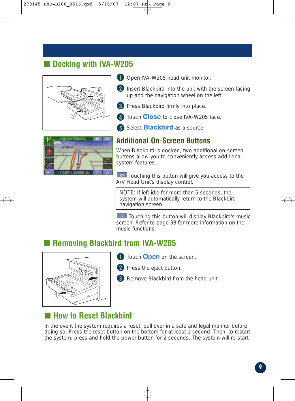
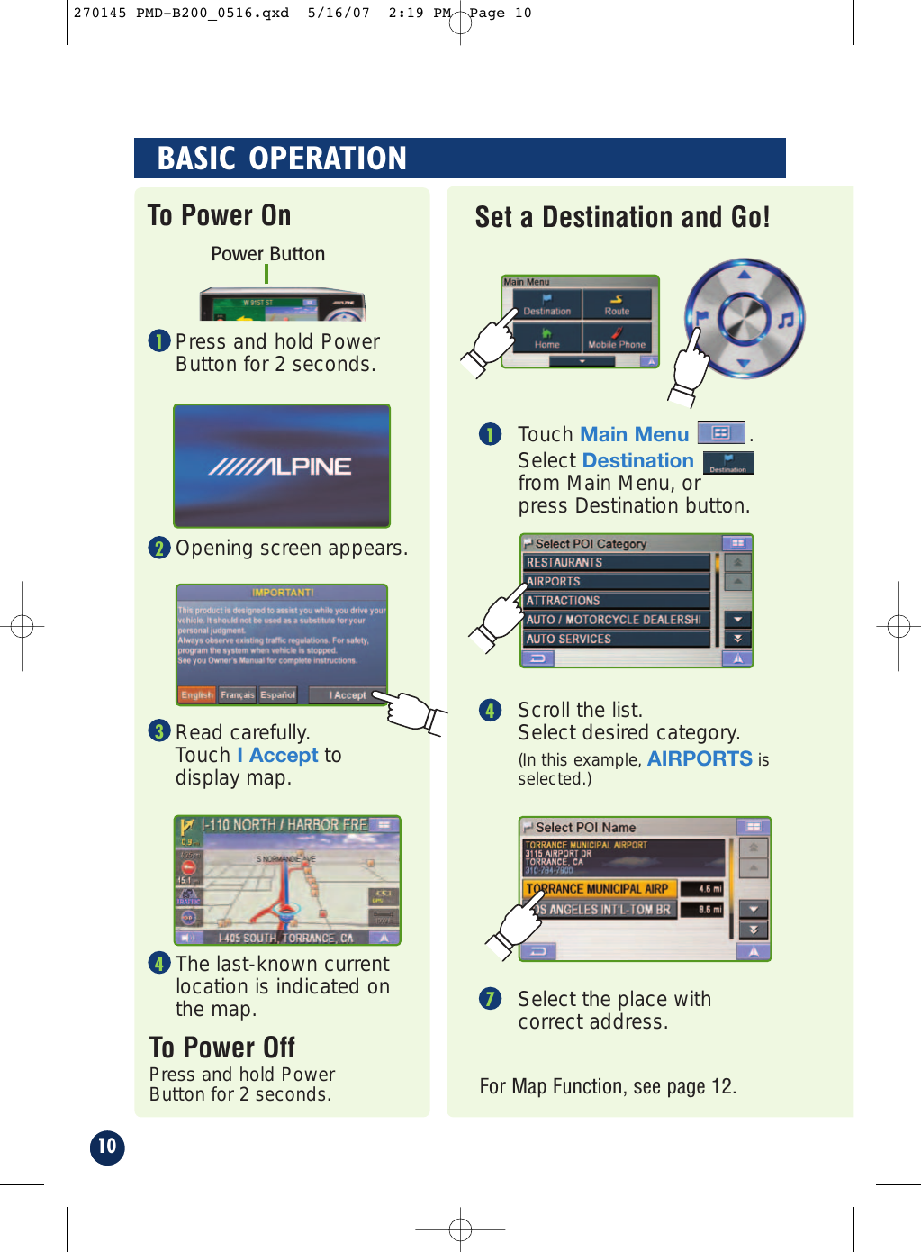
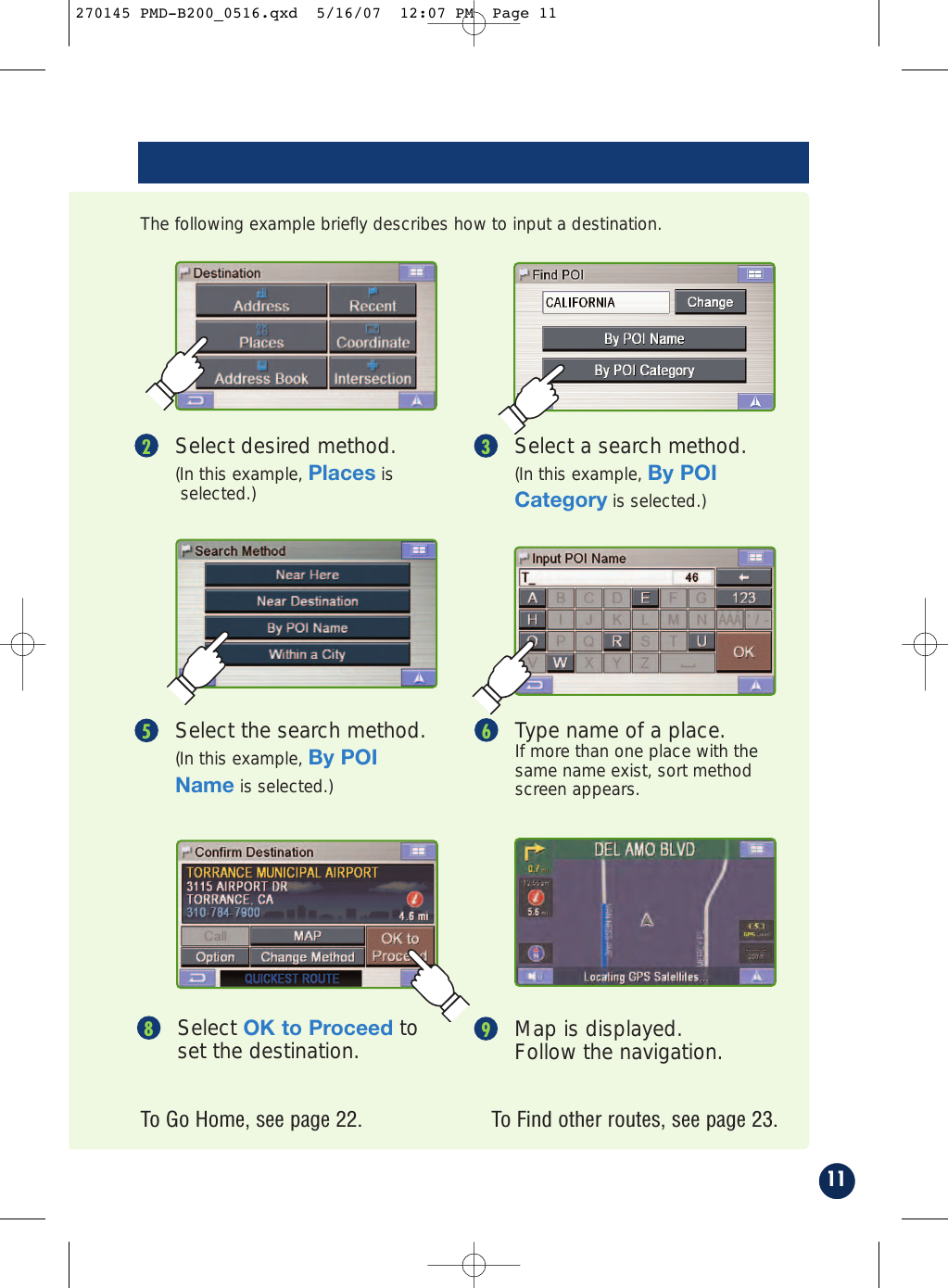
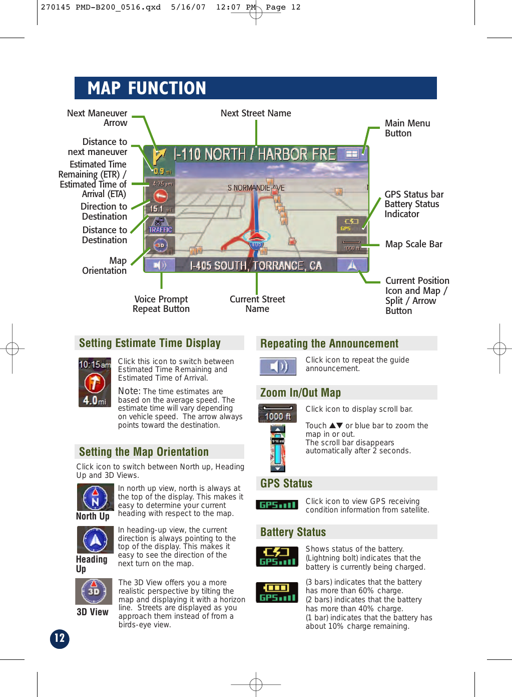
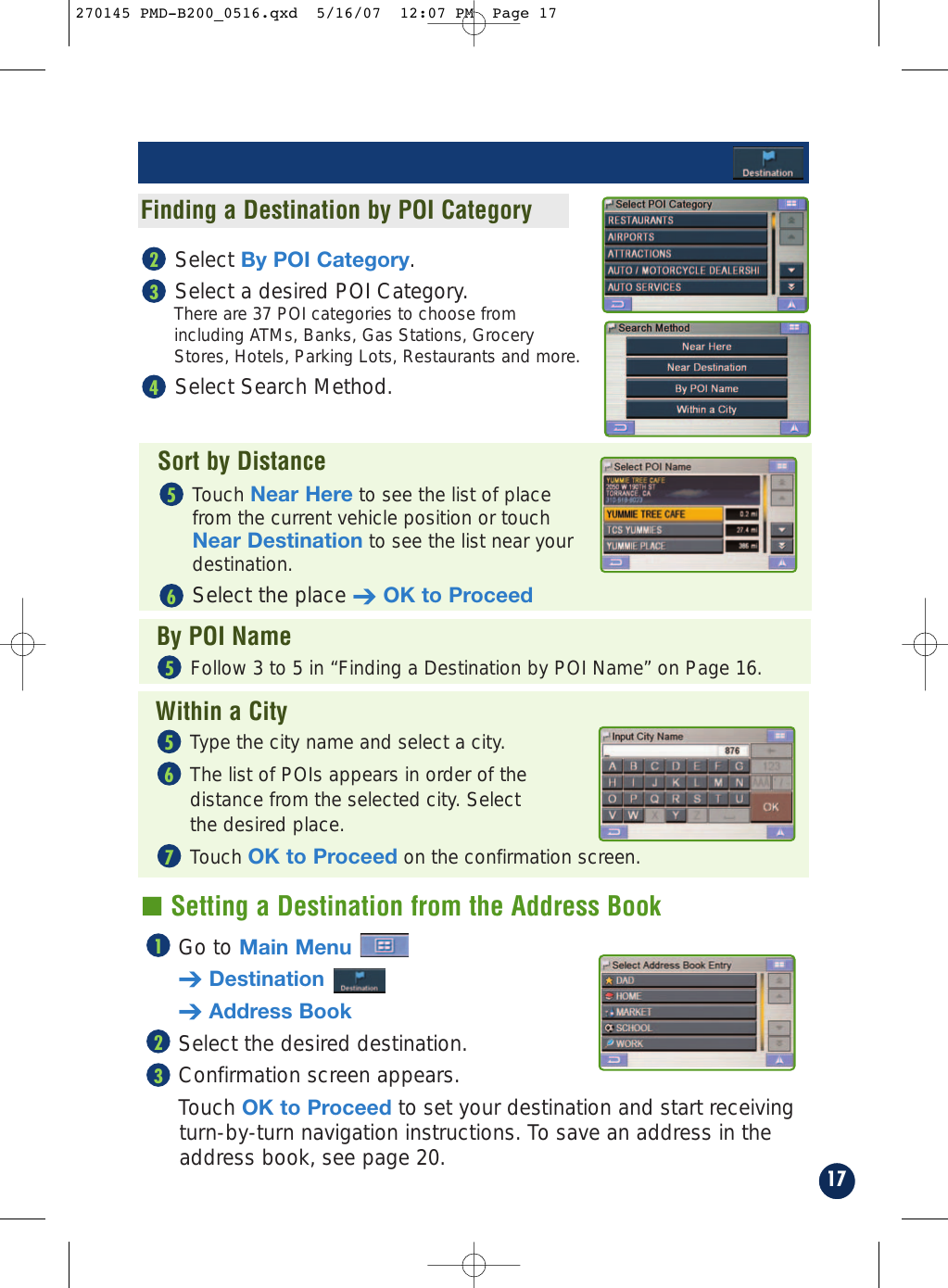
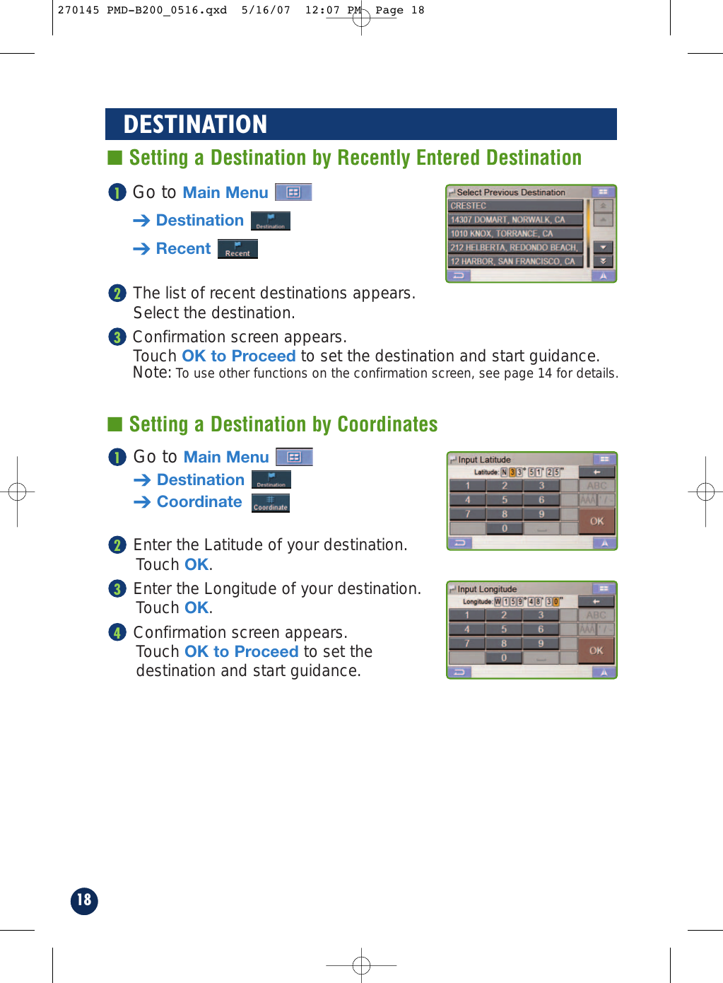
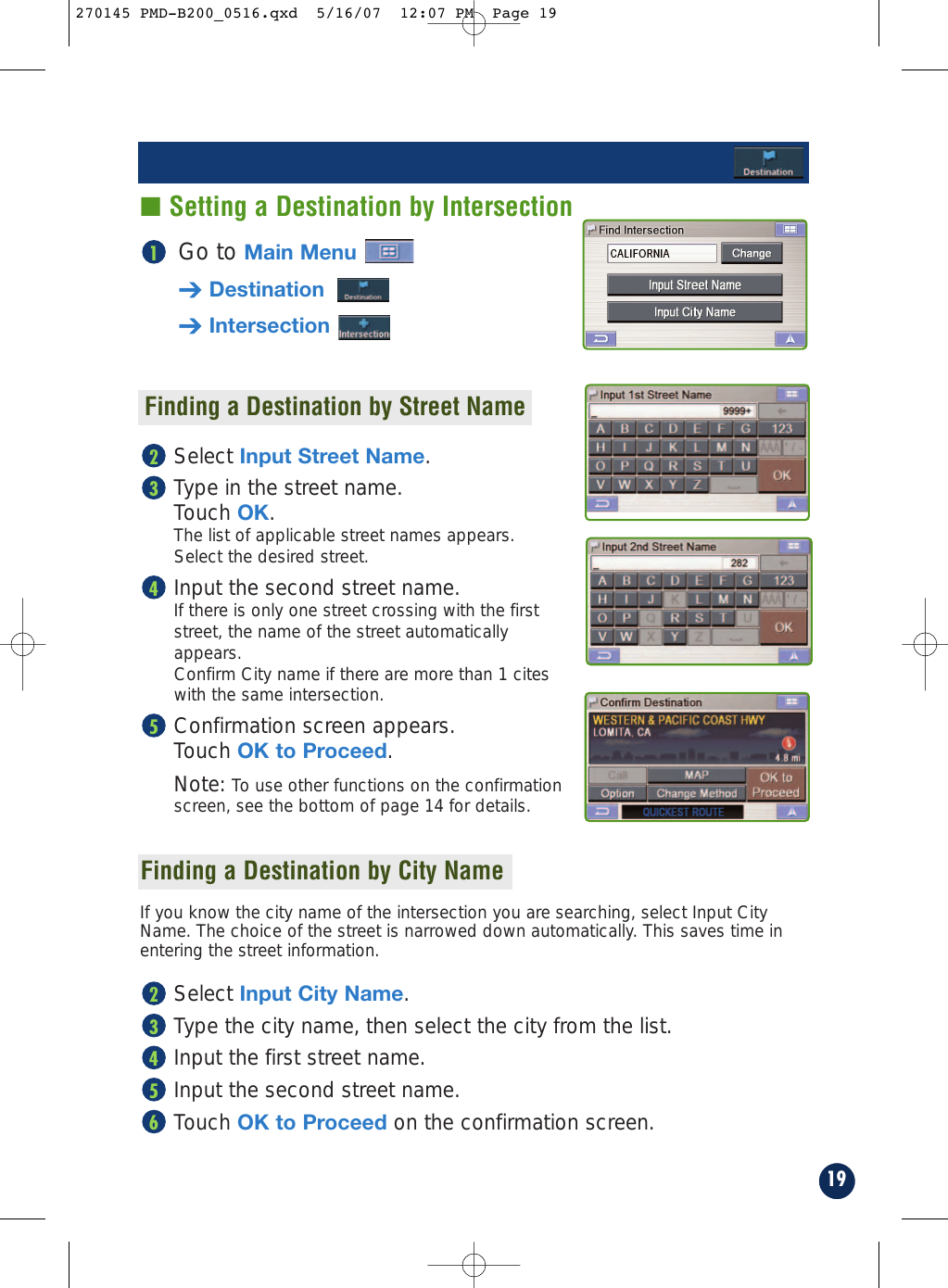
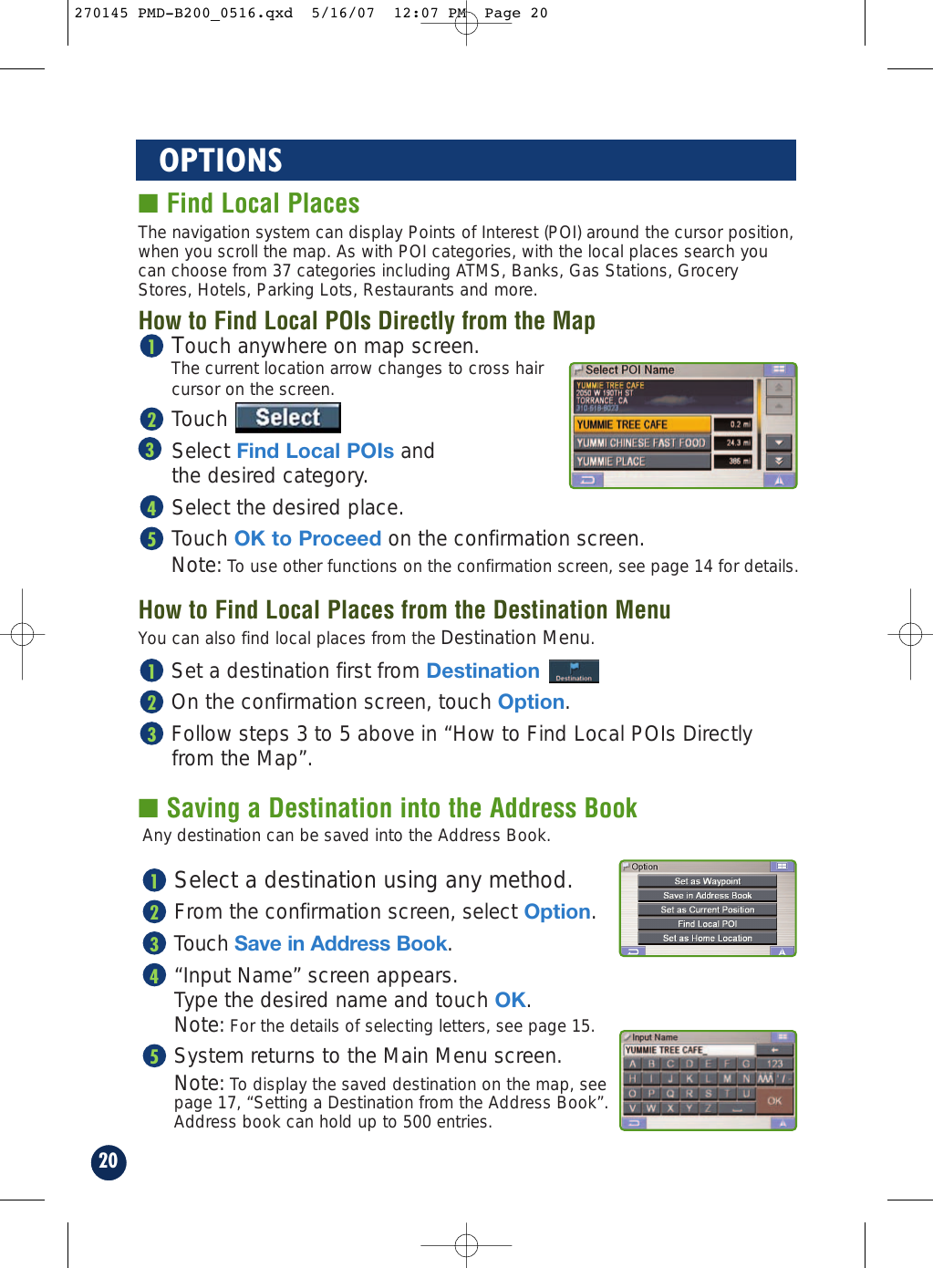
Leadtek Research LR9710X Cradle for Blackbird Portable Navigation System User Manual Print 270145 PMD B200 0515

Leadtek Research Inc Cradle for Blackbird Portable Navigation System Print 270145 PMD B200 0515

User Manual

PMD-B200Owner’s Manual270145 PMD-B200_0516.qxd  5/16/07  12:06 PM  Page 1
2PRECAUTIONS AND NOTICES■ Important InformationThis product is intended to provide turn by turninstructions to get you to a desired destination. Pleasemake certain that all persons using this navigationsystem carefully read these precautions and thefollowing instructions fully. 1) This product is not a substitute for your personaljudgment. Any route suggestions made by thisnavigation system may never supersede any localtraffic regulations or your personal judgmentand/or knowledge of safe driving practices. Do notfollow route suggestions if the navigation systeminstructs you to perform an unsafe or illegalmaneuver, places you in an unsafe situation, orroutes you into an area which you considerunsafe.2) Glance at the screen only when necessary andsafe to do so. If prolonged viewing of the screen isnecessary, pull over in a safe and legal mannerand location.3) Do not input destinations, change settings, oraccess any functions requiring a prolonged viewof the monitor and/or remote control while you aredriving. Pull over in a safe and legal manner andlocation before attempting to access the system.4) Do not use the navigation system to route you toemergency services. Not all locations ofemergency services such as police and firestations, hospitals and clinics are contained in thedatabase. Please use your own judgment and askfor directions in these situations.5) The map database used in the navigation systemis the most recent map data available at the timeof production. Because of changes in streets andneighborhoods, there may be situations where thenavigation system is not able to route you to yourdesired destination. In these cases, use your ownjudgment.6) The map database is designed to provide you withroute suggestions and does not take into accountthe relative safety of a suggested route or offactors which may affect the time required toreach your destination. The system does notreflect road closures or construction, roadcharacteristics (i.e. type of road surface, slope orgrade, weight or height restrictions, etc.), trafficcongestion, weather conditions, or any otherfactors which may affect the safety or timing ofyour driving experience. Use your own personaljudgment if the navigation system is unable toprovide you with an alternate route. 7) There may be situations where the navigationsystem displays the vehicle's location erroneously.Use your own driving judgment in this situation,taking into account current driving conditions.Please be aware that in this situation thenavigation system should correct the vehicle'sposition automatically. However, there may betimes where you may have to correct the positionyourself. If this is the case, pull over in a safe andlegal manner and location before attemptingoperation.8) Make certain that the volume level of thenavigation system is set to a level which stillallows you to hear outside traffic and emergencyvehicles.If there is anything in the manual about the operationof the navigation system which you are uncertainabout, please contact your local Alpine authorizednavigation dealer or Alpine at 1-888-NAV-HELP (1-888-628-4357) before using the navigation system.Blackbird has been tested and found to comply withthe limits for a Class B digital device, pursuant to part15 of the FCC Rules. These limits are designed toprovide more reasonable protection against harmfulinterference in a residential installation, and are morestringent than "outdoor" requirements.Operation is subject to the following two conditions:(1) This device may not cause harmful interference,and (2) this device must accept any interferencereceived, including interference that may causeundesired operation.This equipment generates, uses, and can radiate radiofrequency energy and, if not installed and used inaccordance with the instructions, may cause harmfulinterference to radio communications. However, thereis no guarantee that interference will not occur in aparticular installation. If this equipment does causeharmful interference to radio or television reception,which can be determined by turning the equipment offand on, you are encouraged to try to correct theinterference by one of the following measures:·Reorient or relocate the receiving antenna.·Increase the separation between the equipment andthe receiver.·Connect the equipment into an outlet on a circuitdifferent from that to which the receiver is connected.·Consult an experienced radio/TV technician.Please Read Carefully Before Using This Product.FCC Compliance Statement270145 PMD-B200_0516.qxd  5/16/07  12:06 PM  Page 2
3WARNINGSRead this manual carefully before using this system.It contains instructions on how to use this product ina safe and effective manner. Alpine cannot beresponsible for problems resulting from failure toobserve the instructions in this manual.This manual uses various pictorial displays to showyou how to use this product safely and to alert you topotential dangers resulting from improperconnections and operation. Following areexplanations of these pictorial displays. It isimportant to fully understand the meanings of thesepictorial displays in order to use this manual and thesystem properly.DO NOT OPERATE ANY FUNCTION THAT TAKES YOURATTENTION AWAY FROM SAFELY DRIVING YOUR VEHICLE.Any function that requires your prolonged attentionshould only be performed after coming to a completestop. Always stop the vehicle in a safe locationbefore performing these functions. Failure to do somay result in an accident.KEEP THE VOLUME AT A LEVEL WHERE YOU CAN STILLHEAR OUTSIDE NOISE WHILE DRIVING.Failure to do so may result in an accident.MINIMIZE DISPLAY VIEWING WHILE DRIVING.Viewing the display may distract the driver fromlooking ahead of the vehicle and cause an accident.DO NOT DISASSEMBLE OR ALTER.Doing so may result in an accident, fire or electricshock.USE THIS PRODUCT AS SPECIFIED.Use for other than its designed application may resultin fire, electric shock or other injury.KEEP SMALL OBJECTS SUCH AS BATTERIES OUT OF THEREACH OF CHILDREN.Swallowing them may result in serious injury. Ifswallowed, consult a physician immediately.DO NOT PLACE HANDS, FINGERS OR FOREIGN OBJECTSIN INSERTION SLOTS OR GAPS.Doing so may result in personal injury or damage tothe product.USE THE CORRECT AMPERE RATING WHEN REPLACINGFUSES.Failure to do so may result in fire or electric shock.DO NOT BLOCK VENTS OR RADIATOR PANELS.Doing so may cause heat to build up inside and mayresult in fire.HALT USE IMMEDIATELY IF A PROBLEM APPEARS.Failure to do so may cause personal injury or damageto the product. Return it to your authorized ALPINEdealer or the nearest ALPINE Service Center forrepairing.PRECAUTIONSTemperatureBe sure the temperature inside the vehicle is between+45°C (+113°F) and -0°C (+32°F) before turning yourunit on.Fuse ReplacementWhen replacing the fuse(s), the replacement must beof the same amperage as shown on the fuse holder.If the fuse(s) blows more than once, carefully checkall electrical connections for shorted circuitry. Alsohave your vehicle’s voltage regulator checked.Servicing the UnitIf you have problems, do not attempt to repair theunit yourself. Return it to your ALPINE dealer or thenearest ALPINE Service Station for servicing.Installation LocationMake sure the PMD-B200 will not be exposed to:• Direct sun and heat • Excessive dust• High humidity  • Excessive vibrationsCharacteristics of LCD Panel• After turning the system off, a slight ghost of theimage will remain temporarily. This is an effectpeculiar to LCD technology and is normal.• Under cold temperature conditions, the screenmay lose contrast temporarily. After a short warm-up period, it will return to normal.• The LCD panel is manufactured using an extremelyhigh precision manufacturing technology. Itseffective pixel ratio is over 99.99%. This meansthat 0.01% of the pixels could be either always ONor OFF.Using HeadphonesIf ACC or the monitor's power source is turned off, aloud noise may be produced through the headphonejack. Be sure to remove the headphones from yourears before you turn the monitor off.This symbol means important instructions.Failure to heed them can result in seriousinjury or death.WARNINGThis symbol means important instructions.Failure to heed them can result in injury ormaterial property damage.CAUTIONPoints to Observe for Safe Usage270145 PMD-B200_0516.qxd  5/16/07  12:06 PM  Page 3
4USER AGREEMENTIn using this Blackbird Portable Navigation System (hereinafter referred to as “System”), which includesAlpine Electronics, Inc. (“Alpine”) Specifications, Space Machine, Inc. ("Space Machine") Software andNAVTEQ North America, LLC. (“NAVTEQ”) Database, you are bound by the terms and conditions set forthbelow. By breaking the seal on the System and using your copy of the System, you have demonstrated youragreement to the terms and conditions of this Agreement. You should, therefore, make sure that you read andunderstand the following provisions.The System may not be copied, duplicated or otherwise modified, in whole or in part, without the expresswritten permission of Alpine, Space Machine and NAVTEQ.The System may not be transferred or sublicensed to any third party for profit, rent or loan or licensed forreuse in any manner.The System may not be decompiled, reverse engineered or otherwise disassembled, in whole or in part.The System may not be used in a network or by any other manner of simultaneous use in multiple systems.The System is intended solely for personal use (or internal use where the end-user is a business) by theconsumer.The System is not to be used for commercial purposes.Neither Alpine, Space Machine nor NAVTEQ guarantees to the customer that the System meet the specificobjectives of the user.Neither Alpine, Space Machine nor NAVTEQ shall be responsible for any damages caused by the use of theSystem to the actual user and to any third party.The warranty on the System shall not extend to an exchange or refund due to misspelling, omission of letters,or any other cosmetic discrepancy in layout found in the System.The right to use the System shall expire either when the user destroys this software, or when any of the termsfor use is violated and Alpine, Space Machine and/or NAVTEQ exercise the option to revoke the license touse this software.The terms and conditions hereof apply to all subsequent users and owners as well as to the originalpurchaser.The NAVTEQ Database may include or reflect data of licensors, including Her Majesty The Queen in right ofCANADA. Such data is licensed on an “AS IS” basis. The licensors, including Her Majesty The Queen, makeno guarantees, representations or warranties respecting such data, either express or implied, arising by lawor otherwise, accuracy or fitness for a particular purpose. The licensors, including Her Majesty The Queen, shall not be liable in respect of any claim, demand or action,irrespective of the nature of the cause of the claim, demand or action alleging any loss, injury or damages,direct or indirect, which may result from the use or possession of the data or the NAVTEQ database. Thelicensors, including Her Majesty The Queen, shall not be liable in any way for loss of revenues or contracts,or any other consequential loss of any kind resulting from any defect in the data or the NAVTEQ database.End User shall indemnify and save harmless the licensors, including Her Majesty The Queen and the minister,and their officers, employees and agents from and against any claim, demand or action, irrespective of thenature of the cause of the claim, demand or action, alleging loss, costs, expenses, damages or injuries(including injuries resulting in death) arising out of the use or possession of the data or the NAVTEQdatabase.270145 PMD-B200_0516.qxd  5/16/07  12:06 PM  Page 4
5TABLE OF CONTENTSPRECAUTIONS AND NOTICES  . . . . . . . . . . . . . . 2WARNINGS   . . . . . . . . . . . . . . . . . . . . . . . . . . 3USER AGREEMENT   . . . . . . . . . . . . . . . . . . . . . 4TABLE OF CONTENTS  . . . . . . . . . . . . . . . . . . . 5SYSTEM FEATURES   . . . . . . . . . . . . . . . . . . . . 6INSTALLATION   . . . . . . . . . . . . . . . . . . . . . . . . 8How to Mount Blackbird  . . . . . . . . . . . . . . 8How to Remove the Navigation System from the Cradle   . . . . . . . . . . . . . . . . . . . . . . 8Docking with IVA-W205   . . . . . . . . . . . . . . 9Removing Blackbird from IVA-W205  . . . . . . 9How to Reset Blackbird . . . . . . . . . . . . . . . .9BASIC OPERATIONS   . . . . . . . . . . . . . . . . . . . 10To Power On  . . . . . . . . . . . . . . . . . . . . . 10To Power Off  . . . . . . . . . . . . . . . . . . . . . 10Set a Destination and Go!   . . . . . . . . . . . . 10MAP FUNCTION   . . . . . . . . . . . . . . . . . . . . . . 12Setting Estimate Time Display  . . . . . . . . . 12Setting the Map Orientation   . . . . . . . . . . 12Repeating the Announcement   . . . . . . . . . 12Zoom In/Out Map  . . . . . . . . . . . . . . . . . . 12GPS Status   . . . . . . . . . . . . . . . . . . . . . . 12Battery Status  . . . . . . . . . . . . . . . . . . . . 12Setting a Destination Directlyfrom Map Display   . . . . . . . . . . . . . . . . 13Switching Map Display  . . . . . . . . . . . . . . 13DESTINATION  . . . . . . . . . . . . . . . . . . . . . . . . 14Setting a Destination by Address   . . . . . . . 14Confirm Destination Screen   . . . . . . . . . . 14Setting a Destination by POI . . . . . . . . . . . 16Setting a Destination from theAddress Book  . . . . . . . . . . . . . . . . . . . 17Setting a Destination by Recently Entered Destination   . . . . . . . . . . . . . . 18Setting a Destination by Coordinates   . . . . 18Setting a Destination by Intersection   . . . . 19OPTIONS  . . . . . . . . . . . . . . . . . . . . . . . . . 20Find Local Places   . . . . . . . . . . . . . . . . . 20Saving a Destination into the Address Book   . . . . . . . . . . . . . . . . 20Setting Waypoints  . . . . . . . . . . . . . . . . . 21HOME  . . . . . . . . . . . . . . . . . . . . . . . . . . 22Set Destination as Home   . . . . . . . . . . . . 22Finding Alternate Way to Go Home   . . . . . . 22One-Touch Go Home   . . . . . . . . . . . . . . . 22ROUTE  . . . . . . . . . . . . . . . . . . . . . . . . . . 23Recalling the Maneuver List during Guidance  . . . . . . . . . . . . . . . . . 23Finding Alternate Route   . . . . . . . . . . . . . 23Finding Detour   . . . . . . . . . . . . . . . . . . . 23Delete Route  . . . . . . . . . . . . . . . . . . . . . 23EDIT  . . . . . . . . . . . . . . . . . . . . . . . . . . .24Editing Home   . . . . . . . . . . . . . . . . . . . . 24Editing Address Book   . . . . . . . . . . . . . . . 25Deleting Previously Saved Destinations   . . 25TRAFFIC  . . . . . . . . . . . . . . . . . . . . . . . . . .26Viewing Traffic Incident List  . . . . . . . . . . . .26Viewing Traffic Incident Detail  . . . . . . . . . .26Viewing Incident Location  . . . . . . . . . . . . .26Calculating a Detour  . . . . . . . . . . . . . . . . .27Viewing Traffic Icon Legend  . . . . . . . . . . . .27MOBILE PHONE   . . . . . . . . . . . . . . . . . . . . . . 28Placing Calls . . . . . . . . . . . . . . . . . . . . . . 28Receiving Calls   . . . . . . . . . . . . . . . . . . . 29Call Option Menu  . . . . . . . . . . . . . . . . . . 29SETUP  . . . . . . . . . . . . . . . . . . . . . . . . . . .30Customizing Display  . . . . . . . . . . . . . . . . .30Customizing Guidance . . . . . . . . . . . . . . . .31Setting up the Clock  . . . . . . . . . . . . . . . . .31Changing Unit of Measure  . . . . . . . . . . . . .31Configuring System Settings  . . . . . . . . . . .31Customizing Traffic Information  . . . . . . . . .32MOBILE PHONE . . . . . . . . . . . . . . . . . . . . . . . 34Bluetooth Setup   . . . . . . . . . . . . . . . . . . 34INFORMATION . . . . . . . . . . . . . . . . . . . . . . . . 36Simulating Navigation . . . . . . . . . . . . . . . 36Viewing Trip Information  . . . . . . . . . . . . . 36Viewing GPS Status  . . . . . . . . . . . . . . . . 37Viewing System Information  . . . . . . . . . . 37ENTERTAINMENT . . . . . . . . . . . . . . . . . . . . . . 38Playing Music from Your Blackbird  . . . . . . 38How to Listen to Guidance and Music from Your Car Stereo  . . . . . . . . . 39How to Update the New Software and Map Database   . . . . . . . . . . . . . . . . . . 39IN CASE OF DIFFICULTY  . . . . . . . . . . . . . . . . . 40IN THE BOX   . . . . . . . . . . . . . . . . . . . . . . . . . . . . . 41Accessories   . . . . . . . . . . . . . . . . . . . . . 41Optional Accessories   . . . . . . . . . . . . . . . 41SPECIFICATIONS  . . . . . . . . . . . . . . . . . . . . . . 42INDEX  . . . . . . . . . . . . . . . . . . . . . . . . . 43    LIMITED WARRANTY   . . . . . . . . . . . . . . . . . . . 44270145 PMD-B200_0516.qxd  5/16/07  12:07 PM  Page 5
6SYSTEM FEATURESCurrent PositionButton FunctionMini USB ConnectorExternal GPSAntenna ConnectorDestinationVolumeControl Map Zoom InMusicMain Menu ButtonMap Zoom OutPower Button Headphone JackBattery Charging Status IndicatorRemote Sensorand AmbientLight SensorSD/MMC Card SlotBattery SlotSpeakerBlackbird Portable Navigation SystemCradle ConnectorReset ButtonCenter (Phone Key)Congratulations and thank you for purchasing the Alpine Blackbird PortableNavigation System. We hope you enjoy using this exciting product and trust that itwill make your driving experience more comfortable, stress-free, and entertaining.The Blackbird Portable Navigation System provides an easy-to-use user interface,clear, easy-to-understand spoken driving instructions, and award winning designall in a portable product. Blackbird is built upon Alpine's history of navigationsuccess in North America. Please read this manual carefully. If you have anyfurther questions about Blackbird’s operation, feel free to call Alpine at 1-888-NAV-HELP (628-4357) for technical assistance.270145 PMD-B200_0516.qxd  5/16/07  12:07 PM  Page 6
7Main MenuCradle with Cigarette Lighter ChargerGet back home fromanywhere.➔Page 22Set and saveDestinations. ➔Page 14Play music.➔Page 38View NavigationDemonstration andsystem information.➔Page 36Access your Bluetoothpaired mobile phone.➔Page 28Edit Home andAddress Book.➔Page 24Customize thenavigation system.➔Page 30Cradle Eject Lockout ScrewExternal GPS Antenna Input (SMA-type connector)External MicrophoneInputAMPS/NEC MountingHoles (x 4)Windshield Mount SlotThis illuminates when the system is being charged or requires charging. Thebattery will be typically charged fully in three hours.GREEN Battery is fully charged. RED Battery needs charging.AMBER Battery is charging.Battery Charging Status IndicatorAmplified ExternalSpeaker•Optional External GPS Antenna Accessory Available (Model # PMD-ANT1)Power CordRDS AntennaModify or choosealternate routes to adestination.➔Page 23270145 PMD-B200_0516.qxd  5/16/07  12:07 PM  Page 7
8INSTALLATION■ How to Mount Blackbird23421Find a spot suitable for the navigation system.Ensure that both the suction cup and windshieldarea are clean and free of dirt and grease beforeattaching it.Press the suction cup mount against the windshield.Turn the knob to activate the vacuum to lock theposition.Turn the knob counterclockwise to adjust up/downposition. Then turn clockwise to set the position.Turn the knob clockwise to adjust right/left position.Then turn counter clockwise to set the position.DEVICE SHOULD NOT BE INSTALLED SO THAT ITOBSTRUCTS THE DRIVER’S VIEW.Slide the navigation system into the cradle until youhear a click sound.Plug the cigarette lighter charger into the cigarettelighter socket.Improper installation may make the navigationsystem fall out from the cradle while driving. Pleasemake sure all locks and knobs are turned tight.Do not install the navigation while driving.NOTE: Local regulations may prohibit the placementof any object on windows or the dash. Refer to yourauthorized Alpine dealer for other installationoptions.Press and hold the eject button on the cradle.Grasp the navigation system behind the antenna and remove by sliding up and out of the cradle.■ How to Remove the Navigation System from the Cradle2132145WARNINGRemove the navigation system when you are awayfrom the vehicle to prevent theft.CAUTIONNote: The cradle consists of 2 separate parts that mustbe assembled before mounting.270145 PMD-B200_0516.qxd  5/16/07  12:07 PM  Page 8
9■ How to Reset BlackbirdIn the event the system requires a reset, pull over in a safe and legal manner beforedoing so. Press the reset button on the bottom for at least 1 second. Then, to restartthe system, press and hold the power button for 2 seconds. The system will re-start.■ Docking with IVA-W205■ Removing Blackbird from IVA-W205Touch Open on the screen.Press the eject button. Remove Blackbird from the head unit.321CLOSE12CLOSE12NOTE: If left idle for more than 5 seconds, thesystem will automatically return to the Blackbirdnavigation screen.Open IVA-W205 head unit monitor.Insert Blackbird into the unit with the screen facing up and the navigation wheel on the left. Press Blackbird firmly into place.Touch Close to close IVA-W205 face.Select Blackbird as a source.Additional On-Screen ButtonsWhen Blackbird is docked, two additional on-screen buttons allow you to conveniently access additionalsystem features. Touching this button will give you access to theA/V Head Unit’s display control.Touching this button will display Blackbird’s musicscreen. Refer to page 38 for more information on themusic functions.54321270145 PMD-B200_0516.qxd  5/16/07  12:07 PM  Page 9
Press and hold PowerButton for 2 seconds.Opening screen appears.Read carefully. Touch I Accept todisplay map.The last-known currentlocation is indicated onthe map.To Power OffPress and hold PowerButton for 2 seconds.To Power OnPower ButtonSelect the place withcorrect address.7For Map Function, see page 12.Touch Main Menu.Select Destinationfrom Main Menu, orpress Destination button.1Scroll the list. Select desired category. (In this example, AIRPORTS is selected.)410BASIC OPERATIONSet a Destination and Go!1234270145 PMD-B200_0516.qxd  5/16/07  2:19 PM  Page 10
Map is displayed.Follow the navigation.9Select OK to Proceed toset the destination.8To Find other routes, see page 23.To Go Home, see page 22.Select desired method.(In this example, Places isselected.)2Select a search method.(In this example, By POICategory is selected.)3The following example briefly describes how to input a destination.Select the search method.(In this example, By POIName is selected.)5Type name of a place. If more than one place with thesame name exist, sort methodscreen appears.611270145 PMD-B200_0516.qxd  5/16/07  12:07 PM  Page 11
12MAP FUNCTIONClick this icon to switch betweenEstimated Time Remaining andEstimated Time of Arrival.Note: The time estimates arebased on the average speed. Theestimate time will vary dependingon vehicle speed.  The arrow alwayspoints toward the destination.In north up view, north is always atthe top of the display. This makes iteasy to determine your currentheading with respect to the map.In heading-up view, the currentdirection is always pointing to thetop of the display. This makes iteasy to see the direction of thenext turn on the map.The 3D View offers you a morerealistic perspective by tilting themap and displaying it with a horizonline.  Streets are displayed as youapproach them instead of from abirds-eye view.Setting the Map OrientationSetting Estimate Time DisplayClick icon to repeat the guideannouncement.Click icon to display scroll bar.Touch ▲▼ or blue bar to zoom themap in or out.The scroll bar disappearsautomatically after 2 seconds.  Repeating the AnnouncementZoom In/Out MapGPS StatusBattery StatusClick icon to view GPS receivingcondition information from satellite.Shows status of the battery.(Lightning bolt) indicates that thebattery is currently being charged.  (3 bars) indicates that the batteryhas more than 60% charge.(2 bars) indicates that the batteryhas more than 40% charge.(1 bar) indicates that the battery hasabout 10% charge remaining.Distance tonext maneuverNext Street NameNext ManeuverArrowMapOrientationDistance toDestinationDirection toDestinationEstimated TimeRemaining (ETR) /Estimated Time ofArrival (ETA)GPS Status barBattery StatusIndicatorCurrent StreetNameVoice PromptRepeat ButtonCurrent PositionIcon and Map /Split / ArrowButtonMap Scale BarMain MenuButtonNorth UpHeadingUp3D ViewClick icon to switch between North up, HeadingUp and 3D Views.270145 PMD-B200_0516.qxd  5/16/07  12:07 PM  Page 12
Touch anywhere on map screen.The current location arrow changes to CrosshairCursor on the screen.Move the cursor to the new desiredstreet.Note: Use Map Scale Bar to zoom out the map if the destination is far from the current location.TouchSelect Set as Destination.Touch OK to Proceed on theconfirmation screen.Note: To use other functions on the confirmation screen, see page 14 for details.5432113■ Setting a Destination Directly from Map DisplayTo cancel, touchPrevious Screenicon.Touch the Current Position  to switch between Map and Arrowmodes.Switching Map DisplayArrow ModeDisplays three-successive arrowmaneuvers all theway to yourdestination whileproviding turn-by-turn guidanceprompts.Map ModeShows a full-screenmap of the area whileproviding turn-by-turnguidance prompts. Split Arrow/Map ModeDisplays a largearrow and largernext-street-namefont along side amap screen whileproviding turn-by-turn guidanceprompts.270145 PMD-B200_0516.qxd  5/16/07  12:07 PM  Page 13
14DESTINATION■ Setting a Destination by AddressFinding a Destination by Street Name FirstOK to ProceedSet the destination anddisplay a map.OptionFind Local POI➔P20Set as Waypoint➔P21Save in Address Book➔P20Change MethodFind an alternative way. (Refer to page 22.)Go to Main Menu➔Destination ➔Address1■ Confirm Destination ScreenSelect Input Street Name.Type the first characters of the street nameand touch OK.If there are unique matches, the system willautomatically display a short list of street names. Type only the name of the street. Prefix and suffix ofthe street are not necessary. The list of applicable street names appears. Select the desired street name from the list.Type the address number and touch OK.Select the desired city.If there are multiple matches, the system will list citiescontaining the street name and address number thatyou keyed in.Confirmation screen appears. See below for details.765432270145 PMD-B200_0516.qxd  5/16/07  12:07 PM  Page 14
15Call (Only available on POIs and address book)If the phone number is available, you can callthe selected location using your Bluetoothenable mobile phone.Finding a Destination by City Name FirstSelect Input City Name.Type the first few characters of the city name and press OK. If there are unique matches, the system willautomatically display a short list of city names.Select the desired city.Type the characters of the street name.Touch OK. The list of applicable street names appears. Selectthe desired street.Type the address number and touch OK.Confirmation screen appears. See below for details.65432Changing StateIf you want to choose a differentstate from the one shown on thescreen, touch Change toswitch to a different state.Selecting LettersDelete one letterSelectedcharactersare displayed.Add one spaceType numbersMapCheck the destination on themap. Touch to go back tothe confirmation screen.Type accentuatedcharactersType punctuationmarks270145 PMD-B200_0516.qxd  5/16/07  12:07 PM  Page 15
You can select from approximately 6 Million Point-of-Interest (POI) locations stored insideyour Blackbird Portable Navigation System. These destinations are sorted by POI Nameor by POI Category and are listed in order of distance from your current location.Finding a Destination by POI NameGo to Main Menu➔Destination ➔Places1Select By POI Name.Type the desired place name. Touch OK. A list of place names appears. Note: You can also perform a Keyword Search byentering a portion of your desired place name. The listof destinations that appears will include all placenames containing the keyword you entered.Use the arrows to the right of the list tomove the yellow highlight.This will show detailed address information and phone number (if available) for each entry in the Places database.Select the place with correct address.For emergency locations such as Police Stations,Hospitals, etc., please verify availability beforeproceeding to such locations.Confirmation screen appears. Touch OK toProceed to set the destination and startguidance.6543216DESTINATION■ Setting a Destination by POI270145 PMD-B200_0516.qxd  5/16/07  12:07 PM  Page 16
Select By POI Category.Select a desired POI Category. There are 37 POI categories to choose fromincluding ATMs, Banks, Gas Stations, GroceryStores, Hotels, Parking Lots, Restaurants and more.Select Search Method.43217Go to Main Menu➔Destination➔Address BookSelect the desired destination.Confirmation screen appears. Touch OK to Proceed to set your destination and start receivingturn-by-turn navigation instructions. To save an address in theaddress book, see page 20.321■ Setting a Destination from the Address BookFinding a Destination by POI CategorySort by DistanceBy POI NameWithin a CityTouch Near Here to see the list of placefrom the current vehicle position or touchNear Destination to see the list near yourdestination.Select the place ➔OK to Proceed65Follow 3 to 5 in “Finding a Destination by POI Name” on Page 16.5Type the city name and select a city.The list of POIs appears in order of the distance from the selected city. Select the desired place.Touch OK to Proceed on the confirmation screen.765270145 PMD-B200_0516.qxd  5/16/07  12:07 PM  Page 17
Go to Main Menu➔Destination➔CoordinateEnter the Latitude of your destination.Touch OK.Enter the Longitude of your destination. Touch OK.Confirmation screen appears. Touch OK to Proceed to set the destination and start guidance.4321Go to Main Menu➔Destination➔RecentThe list of recent destinations appears. Select the destination.Confirmation screen appears. Touch OK to Proceed to set the destination and start guidance.Note: To use other functions on the confirmation screen, see page 14 for details.32118DESTINATION■ Setting a Destination by Recently Entered Destination■ Setting a Destination by Coordinates270145 PMD-B200_0516.qxd  5/16/07  12:07 PM  Page 18
Go to Main Menu➔Destination➔Intersection1Finding a Destination by Street NameSelect Input Street Name.Type in the street name. Touch OK. The list of applicable street names appears. Select the desired street.Input the second street name.If there is only one street crossing with the firststreet, the name of the street automaticallyappears.Confirm City name if there are more than 1 citeswith the same intersection.Confirmation screen appears. Touch OK to Proceed.Note: To use other functions on the confirmationscreen, see the bottom of page 14 for details.5432If you know the city name of the intersection you are searching, select Input CityName. The choice of the street is narrowed down automatically. This saves time inentering the street information.Select Input City Name.Type the city name, then select the city from the list.Input the first street name.Input the second street name.Touch OK to Proceed on the confirmation screen.6543219■ Setting a Destination by IntersectionFinding a Destination by City Name270145 PMD-B200_0516.qxd  5/16/07  12:07 PM  Page 19
■ Saving a Destination into the Address Book20OPTIONS■ Find Local PlacesTouch anywhere on map screen.The current location arrow changes to cross hair cursor on the screen.TouchSelect Find Local POIs and the desired category.Select the desired place.Touch OK to Proceed on the confirmation screen.Note: To use other functions on the confirmation screen, see page 14 for details.54321The navigation system can display Points of Interest (POI) around the cursor position,when you scroll the map. As with POI categories, with the local places search youcan choose from 37 categories including ATMS, Banks, Gas Stations, GroceryStores, Hotels, Parking Lots, Restaurants and more.How to Find Local POIs Directly from the MapHow to Find Local Places from the Destination MenuSet a destination first from Destination On the confirmation screen, touch Option.Follow steps 3 to 5 above in “How to Find Local POIs Directlyfrom the Map”.321You can also find local places from the Destination Menu.Any destination can be saved into the Address Book.Select a destination using any method.From the confirmation screen, select Option.Touch Save in Address Book. “Input Name” screen appears. Type the desired name and touch OK.Note: For the details of selecting letters, see page 15.System returns to the Main Menu screen.Note: To display the saved destination on the map, see page 17, “Setting a Destination from the Address Book”.Address book can hold up to 500 entries.54321270145 PMD-B200_0516.qxd  5/16/07  12:07 PM  Page 20
21■ Setting WaypointsTouch anywhere on map screen.The current location arrow changes to cross hair cursor on the screen.Move the cursor to the desired waypoint.TouchSelect Set as Waypoint then selectRecalculate.When the route search is complete, the current location is displayed. The map navigates you to the first waypoint.54321How to Set a Waypoint from the Destination MenuHow to Set a Waypoint Directly from MapYou can set up to 10 waypoints between your current location and your destination. Thefinal destination must be set before entering any waypoints.You can also find local places from Destination Menu.Enter your desired destination by using the method on pages 14through 19 from Destination Menu.On the confirmation screen, select Option.Select Set as Waypoint and select Recalculate.321Enter in a destination from the Address Book. (see page 17)At the confirmation screen, touch Option ➔Set as Waypoint.Touch Recalculate to recalculate a route which includes yourwaypoint.321How to Set a Waypoint from the Address Book270145 PMD-B200_0516.qxd  5/16/07  12:07 PM  Page 21
Go to Main Menu➔HomeTouch OK to Proceedon the confirmation screen.Follow the map and go home.32122HOME■ Set Destination as Home■ Finding Alternate Way to Go HomeGo to Main Menu ➔Home ➔Change Method· Quickest Route, Maximize Freeway· Quickest Route, Minimize Freeway· Shortest Route · With/Without Ferry · With/Without Toll RoadTo edit theHome Address, See Page 24.You can get home from anywhere once the home address is set from Edit Menu.■ One-Touch Go HomeFor an even easier way to immediately get guidanceinstructions to your home, you can press and holdthe flag  on the circle key for 2 seconds. This willinstantly display the destination confirmation screenand guide you to your home location.270145 PMD-B200_0516.qxd  5/16/07  12:07 PM  Page 22
23ROUTE■ Recalling the Maneuver List during GuidanceGo to Main Menu➔RouteTouch Maneuver List.List of upcoming streets andturns appears on the screen.To preview a specific point, select a street name/maneuver on the list.To go back to Route List, Go to Main Menu➔RouteNote: For the details of setting Waypoints,see page 21.321■ Finding Alternate Route  ■ Finding DetourTouch Main Menu➔Route➔Change MethodYou can choose and re-calculate a differentroute based on Quickest Route withMaximize/Minimize Freeway, Shortest Route,with/without Ferry and/or Toll Road.Touch Main Menu➔Route➔DetourThe system automatically calculates and displays detour.■ Delete RouteGo to Main Menu ➔Route➔Delete ➔YesNote: After deleting the destination, you can notselect Route Menu until the next destination is set.To set up the destination, see Destination Menu onPage 14.You can view a list of street names and upcoming turns and streets.270145 PMD-B200_0516.qxd  5/16/07  12:07 PM  Page 23
24Edit Telephone ScreenDelete ScreenChange Icon ScreenEDIT■ Editing HomeGo to Main Menu➔EditTouch Edit Home.“Edit Home” screen appears.See below for details.321Locations and Home addresses saved in the Address Book can be edited for quickrecall. Also information including phone numbers and icons can be modified.Name Touch Name to change thedisplay name of the storedlocation.Note: For the details of selecting letters, see page 15.Tel Touch Tel to change thetelephone number of the storedlocation.Map Touch Map to preview thelocation on the map.To go back to Edit Menu, Main Menu ➔EditDelete Touch Delete to delete the storedlocation.Icon Touch Icon to change the icon ofthe stored location on the map.Input Name Screen270145 PMD-B200_0516.qxd  5/16/07  12:07 PM  Page 24
25Go to Main Menu ➔EditTouch Edit Address BookThe list of addresses appears.Select the destination you need to modify.“Edit Address Item” screen appears. See below for details.Note: Select DELETE ALL to delete all addresses saved in the address book.4321■ Editing Address Book■ Deleting Previously Saved DestinationsGo to Main Menu ➔EditTouch Delete Previous Destination.Select destination you need to delete.Touch YES to delete the destination on the confirmation screen.Note: Select DELETE ALL to delete all recently entered destinations.4321270145 PMD-B200_0516.qxd  5/16/07  12:07 PM  Page 25
26TRAFFIC■ Viewing Traffic Incident ListTo access the Traffic Incident List screenfrom the Main Menu, touch Informationand Traffic Info, or from the mapscreen, touch Traffic  located on theleft side of the screen.Traffic Incident List screen appears andprovides a list of traffic incidents in yourcurrent area or along your current route.You have a number of ways to use theinformation on this screen. These optionsare detailed below: Touch By Distance to view traffic incidentssorted by distance from your currentlocation. To sort the list by the type of trafficincident, select By Name. Select On Routeto display only those incidents occurringalong the current route to your destination.When an incident occurs on your route,traffic icon on the Map screen turns to red.If you have an activated subscription to the NAVTEQ traffic service, the Traffic IncidentList screen allows you to view traffic information in your current area, or along yourcurrent route.Note: Traffic feature is only available when Blackbird is placed in the suppliedcradle or the docking station. (The docking station is sold separately.)12Viewing Traffic Incident DetailTo view the details of a traffic incident, toucha specific traffic incident in the list.Note: The detail information may be identical to thesummary information.Viewing Incident LocationYou can display the location of a trafficincident on the map by touching thecrosshairs icon270145 PMD-B200_0516.qxd  5/16/07  12:07 PM  Page 26
27Calculating a DetourTo have the system analyze the traffic data within 30 miles of yourcurrent location, touch Detour in the route menu.  If an incidentoccurs along your route, a screen will appear where you can chooseto detour around either the traffic incident or the next street.Viewing Traffic Icon LegendYou can view a list of all icons related to atraffic incident by touching Legend. A listof icons and their definitions will bedisplayed.Note: If you have the system set to display trafficspeed and flow icons on the map (see Page 32),both the traffic incident icons and traffic speed andflow icons, with their definitions, will be displayed.270145 PMD-B200_0516.qxd  5/16/07  12:07 PM  Page 27
Note: You can continue to use Blackbird during an active call. Touch the icons tojump to the Map or Main Menu screens. Touch the red phone icon to return to thecall menu.28MOBILE PHONEMost Bluetooth enabled mobile phones can be synchronized to interface withBlackbird. Once you have paired and synchronized your mobile phone with Blackbird(see Setup on page 34) you can place and receive calls in addition to many otherconvenient functions. Some Bluetooth enabled phones may not be compatible andsome features may not be available even after synchronizing and pairing.Note: It may take a few minutes for information to transfer from your phone to theBlackbird.■ Placing CallsTouch Main Menu Touch Mobile Phone.Using the 12 key Dial PadTouch Dial.Enter the number and touch Call.Using your Phonebook (If your phone has been synchronized. See setup instructions on page 34.)Touch Phonebook.Begin entering the name of the contact you wish to call.A list will appear.Select the desired contact from the list.Confirmation screen appears with the contact’s detailed information. Touch Dial to place the call.Using Dialed, Missed, or Received Calls from your call historyTouch Dialed Calls, Missed Calls, or Received Calls.A list of your call history will appear.Select the desired contact from the list. Confirmation screenappears with the contact’s detailed information if available.Touch Dial to place the call.54365434321270145 PMD-B200_0516.qxd  5/16/07  12:07 PM  Page 28
29■ Receiving CallsWhen your mobile phone is actively paired with Blackbird, a popup window willappear when you have an incoming call. The caller ID number will be displayed whenavailable. Touch Answer to accept the call or Ignore to ignore it.■ Call Option MenuDuring an active call touch the red phone icon to access the Call Option Menu. Thismenu displays the Caller ID Name, Phone Number, and Call Duration. The followingoptions are also available from this menu:MuteThis allows you to temporarily mute the microphone so you can still hear the caller,but the caller cannot hear you.Transfer Call to PhoneYou can transfer the call from the Blackbird to your mobile phone for greater flexibility.Swapping CallsThis toggles between two calls if you have call waiting functionality with your mobilephone service provider.End CallThis ends the current phone call.Note: After ending a call you will automatically be returned to the previous menu.270145 PMD-B200_0516.qxd  5/16/07  12:07 PM  Page 29
30Go to Main MenuSelect SetupSetup screen appears.321SETUP■ Customizing DisplayBrightnessThe brightness of the screen can beadjusted.Setting the Map Color                     Day -  a bright tone screenNight - a dark tone screenAuto -  switches automatically betweenDay and Night modesMap Style1 -  Geographic features displayed inlight colors (Default)2 -  Geographic features displayed indark colorsDisplaying and Editing Icons on theMap             POI Icons, the Home Icon and Iconsused in the Address Book can be turnedon and off from the Display Setup Menu.You can also change these icons.TrailThe Trail feature allows you to turn onand off trail dots that appear whereverthe vehicle icon traverses. This isespecially helpful for off-roadenthusiasts.Background ColorYou can choose between gray or bluebackgrounds for all menu screens.Display AdjustmentThe Adjust button is active only whenBlackbird is docked.  It will allow youto make minor alignment adjustments(up/down/left/right) to the display ofthe docked image.You can customize Display, Guidance, Clock, Measuring Unit and FM frequencysettings from the Setup Menu.Go to Main Menu➔Setup➔Display270145 PMD-B200_0516.qxd  5/16/07  12:07 PM  Page 30
31■ Customizing GuidanceTurning Voice On and Off  This allows you to turn ON or OFF guidance voice prompts.Changing Navi Mix Volume                    This allows you to vary the volume of the voice prompts with respect to the music.Setting Estimate Time Display                  Estimated Time of Arrival (ETA) or Estimated Time Remaining (ETR) can be set here.You can also change between ETA and ETR directly in the map screen. See page 12. ■ Setting up the ClockYou can set the Time Zone and Daylight savingsetting to fit your region.■ Changing Unit of MeasureYou can choose the unit of measure between Milesand Kilometers.■ Configuring System SettingsFM Transmitter SetupWhen set to ON, the FM Transmitter broadcastsmusic and voice prompts (if set to ON) to an availablefrequency on your FM car radio. See page 39.Frequency  Allows you to change the frequency to find the best available station forbroadcasting audio to your FM radio. See page 39.270145 PMD-B200_0516.qxd  5/16/07  12:07 PM  Page 31
32SETUP■ Customizing Traffic InformationYou can choose the way your traffic and navigation information isdisplayed using the traffic information setup controls.Go to Main MenuSelect SetupSelect TrafficThe Traffic Setup menu appears and displaysthe system status and traffic setup options. Use the large arrow button at the bottom of the screen to view additionaloptions. All traffic setup options are detailed below:System StatusSystem Status displays the strength of the signal being received. To improve the signal strength, please see page 40.Traffic RerouteON: When a traffic incident occurs on theway to the destination, a pop-up windowwill appear on the screen and ask you ifyou want to take a different route.OFF: No action will be taken based upontraffic incidents and the current route willnot be effected.Displaying Traffic IconsWhen the system receives traffic incidentinformation it can display the informationon the map screen using icons in severalshapes and colors. To the right of Icon,touch Show or Hide to make yourselection.Show: The selected traffic incident icons will be displayed on the map.Hide: No traffic incident icons will be displayed on the map.321270145 PMD-B200_0516.qxd  5/16/07  12:07 PM  Page 32
33When Show is selected, you can choose which types of trafficincident icons are displayed: Touch Edit.An icon list appears. Traffic incident icons shown with a checkmarkwill be included on the map. You can select (or de-select) thetypes of traffic icons you wish to display.Touch Done to save your selections.Touch Default to display all traffic incident icons.Displaying Traffic Speed and Flow IconsYou can choose whether or not the system displays traffic speed andflow information as icons on the map screen when the information isreceived. To the right of Speed Flow, touch Show or Hide to makeyour selection.Show: Traffic flow icons will be displayed on the map when viewingat a scale of 2 miles/4 kilometers or less. Hide: No traffic flow icons will be displayed on the map.Note: Not all area has traffic flow information. Please check http://www.blackbirdtraffic.com for more detail.Activating SubscriptionYou will receive an activation code when you complete the trafficsubscription process. To the right of Activation Code, touch Enterthen input your activation code. To subscribe to NAVTEQ Traffic RDSServices, please visit: http://www.blackbirdtraffic.comViewing Subscription InformationYou can easily view how many days you have remaining on yourcurrent traffic subscription. To the right of Subscription Information,touch Info.321270145 PMD-B200_0516.qxd  5/16/07  12:07 PM  Page 33
■ Bluetooth SetupBluetooth enabled mobile phones can be paired to interface withBlackbird. You can customize this interface using the Bluetooth Setupcontrols.Go to Main MenuSelect SetupSelect Bluetooth.The Bluetooth Setup menu appears anddisplays the setup options. Use the largearrow button at the bottom of the screen toview additional options. All Bluetooth setupoptions are detailed below.Turning Bluetooth On and OffThis allows you to turn the Bluetooth functionality on or off.Starting Discover ModeDiscover Mode allows your mobile phone to pair with Blackbird.  Start Discovermode to begin the initial pairing process.  Follow your individual phone’s instructionsfor pairing.Auto ConnectTurning Auto Connect on will allow the last connected phone to automaticallyconnect with the Blackbird whenever they are in range and both have Bluetoothturned on.Auto AnswerThis allows Blackbird to automatically answer allincoming calls for you after the first ring.Changing Device NameBlackbird’s display name can be set here byselecting Change.34MOBILE PHONE123270145 PMD-B200_0516.qxd  5/16/07  12:07 PM  Page 34
Changing Device PasskeyThe passkey used to pair Blackbird with your mobilephone can be changed here.Bluetooth Indicator LightWhen Blackbird is seated in its cradle, or is being used in handheld mode, the smallerblue LED light surrounding the inner ring of the navigation wheel will indicate theBluetooth condition as follows:Pairing Your Bluetooth Enabled Mobile Phone Go to Bluetooth Setup and power on Bluetooth. Start Discover Mode. On your mobile phone, make sure Bluetooth is on, then search forBluetooh devices. Select Blackbird and enter the passkey shown on the Blackbirdscreen.The inner ring of the navigation wheel on your Blackbird shouldremain on, indicating your mobile phone is connected.5432135MOBILE PHONEDiscovery Mode When Discovery Mode is activated the light will flash for 30 seconds.Bluetooth Connected When Bluetooth is on and connected the light will remain on.Incoming Call Three quick flashes indicate an incoming call.Active Call The light will continue to slowly pulse during an active call.270145 PMD-B200_0516.qxd  5/16/07  12:07 PM  Page 35
36INFORMATION■ Simulating NavigationYou can watch a demonstration of the navigation system’s voice and screen guidance.Note: Set your destination first before using this function.To Start a DemonstrationTo Stop a DemonstrationGo to Main MenuSelect InformationSelect Stop Demo.The demonstration will end.4321The odometer displays the route distance andtime traveled.■ Viewing Trip InformationGo to Main Menu➔InformationSelect Trip Info.21Driving Average Average speed since Trip Info was reset.Overall Average Average speed since start of trip.Maximum Speed Maximum speed reached on this trip.Driving Time Time vehicle has been moving since the trip was reset.Idle Time Time vehicle has been stopped (not moving) since the trip was reset.Total Time Total elapsed time on the trip which is always the driving time plus idle timeSetup a route.Go to Main MenuSelect InformationSelect Start Demo.Demonstration starts.54321270145 PMD-B200_0516.qxd  5/16/07  12:07 PM  Page 36
37Go to Main Menu➔InformationSelect GPS Status.21You can view the dynamic location informationreceived from satellite such as signal strength,compass (direction information), latitude/longitude,approximate altitude, and speed. This featureallows you to view GPS satellite signal information.An explanation of the messages is shown below.“Locating GPS Satellites”: Blackbirdsearches the sky looking for GPS satellites.“Acquiring GPS Signal”:Blackbirdacquires positioning information transmittedfrom 1 to 3 tracked satellites whilesearching for more satellites (minimum 4needed).“Fixing GPS Position”:Blackbirdrequires continuous signals from 4 or moretracked satellites (for 30 seconds) in orderto accurately fix your position.“Temporary Poor GPS Coverage”:Thunderstorms, dense foliage orsurrounding tall buildings may causetemporary loss of position fix (acceptable ifunder 30 seconds).“Poor GPS Signal, Lost Position Fix”:You may have entered an area whereconsistently poor GPS signal (lasting 30seconds or more) makes it impossible tomaintain a position fix.“No Line of Sight, Lost GPS Tracking”:You are in an area where line of sight toGPS satellites has been blocked.Go to Main Menu➔InformationSelect System Info.21You can check software application, databaseversion, and other information in this screen.Make a note of this information and refer to itwhenever you communicate with Alpine TechSupport or your Alpine authorized dealer. ■ Viewing GPS Status■ Viewing System InformationThe following messages are displayed while the GPS receiver is tracking satellites:270145 PMD-B200_0516.qxd  5/16/07  12:07 PM  Page 37
38■ Playing Music from Your BlackbirdYou can play MP3 or WMA music files* from your SD or MMC card.Your music can be arranged in sub-folders for easy retrieval when usingyour Blackbird device.*Blackbird only supports MP3 and WMA files without DRM.Insert an SD or MMC card containing folders with music files in theSD/MMC slot. The system will scan for music.Touch Folder Search to search the memory card.Select a folder, then select a song to play. The music will startplaying the song you selected.321ENTERTAINMENTBack Play/PauseForward FolderUp FolderDownFolderSearchTouch REPEAT to repeat songs.Touch REPEAT again to cancel therepeat.Touch M.I.X. to shuffle songs.Touch M.I.X. again to cancel theshuffle.REPEATM.I.X.FolderNumberFileNumber PlayingTimeDisplaysSong Titlesand ArtistNames270145 PMD-B200_0516.qxd  5/16/07  12:07 PM  Page 38
39■ How to Update the New Software and Map DatabaseUsing your home PC, Blackbird can be updated with the latest mappingand Point of Interest information. Please refer to instructions includedwith the update software on how to upgrade your Blackbird system.For additional information on the update software, please contact Alpine.■ How to Listen to Guidance and Music from Your Car StereoTurning on the Transmitter and Playing Music from Your Radio You can setup Blackbird to broadcast music and navigation voice guidance directlyto an unused FM radio station.Plug the cradle into your vehicle’s cigarette lighter/power outlet.Insert Blackbird into the cradle (See page 8 for details).Turn on your radio. Find an FM frequency from the following that is broadcastingnothing but static:  88.1MHz, 88.3 MHz, 88.5 MHz, 88.7 MHz, 88.9 MHz,106.7MHz, 106.9 MHz, 107.1 MHz, 107.3 MHz, 107.5 MHz, 107.7 MHz, 107.9 MHz, (do this with Blackbird off at first).Turn on Blackbird.On Blackbird, go to Main Menu➔Setup➔System.The default broadcast frequency is 88.3 MHz.Turn the transmitter button ON in System Setup screen.Set Blackbird to that frequency and play music files on Blackbird. (Touch Main Menu➔Entertainment, or simply press Music button) Blackbirdprovides 12 frequencies to choose from. You may have to try a few frequenciesbefore you find one that works best in your vehicle.7654321Turning Off the TransmitterTurn off or turn down the volume of your radio first to avoid the static noise.On Blackbird, go to Main Menu➔Setup➔System.Turn the transmitter button OFF in System Setup screen.321270145 PMD-B200_0516.qxd  5/16/07  12:07 PM  Page 39
If you encounter a problem, please review the items in the following checklist. This guidewill help you isolate the problem if the unit is at fault. Otherwise make sure the rest of yoursystem is properly connected, batteries are completely charged and contact yourauthorized Alpine dealer or Alpine directly at 1-888-NAV-HELP (1-888-628-4357).Unable to play Music from SD card.Some SD card may be not compatible with Blackbird.Unable to use Phone feature.Some Bluetooth enabled phones may not be compatible and some features may not beavailable even after synchronizing and pairing.The vehicle’s position is erroneous.Reset the unit and drive the vehicle in an area of good GPS reception to allow the unitto recalibrate itself. Move to a location where strong GPS reception is possible.No operation· Moisture condensation ➔Allow enough time for the condensation to evaporate(about 1 hour).· Ambient temperature  ➔Lower the temperature in the vehicle to below 113°F (45°C)over 113°F (45°C)  by driving with the windows open or air conditioner on.· Blown fuse  ➔Replace with a fuse of the prescribed rating. (2A glass-typefuse located in the head of the cigarette lighter adapter)Unit does not work after removing from cradle or dock*Make sure battery is fully charged. Unit does not charge in cradle or dock while the caris not on.The unit is taking a long time to acquire GPS signal. It may take a long time for the unit to acquire GPS signal if it has been powered on inan area that is more than 200 miles from the area where it was last powered off.Following these steps will speed the process by resetting the GPS receiver:Go to GPS Statusscreen. (See instructions on page 37)Press and hold the Down Arrow (Map Zoom Out Button) for 2 seconds.A message appears to indicate that the GPS receiver is resetting.Low RDS Traffic Signal (for Traffic Service Users) In order to improve the RDS Traffic signal strength, you may need to separate the RDSantenna away from the power cord on the Cradle. Carefully follow these instructions:Power off the unit and unplug the Cigarette Lighter Charger.Identify the RDS antenna. It is the thin, black, insulated wire that runs the fulllength of the thicker power cord. (See diagramon page 7)Carefully cut the thin RDS antenna at the point where it enters the connector that attaches it to the Cigarette Lighter Charger. Be careful to ONLY cut the antenna, not the larger main power cable.Slowly peel the antenna away from the power cord to leave about 50 inches of the antenna separated and hanging free.Place antenna on the vehicle dashboard or for best results, mount the antenna to the windshield using the provided suction cups. (please see suction cup instructions for details)5432132140IN CASE OF DIFFICULTY270145 PMD-B200_0516.qxd  5/16/07  12:07 PM  Page 40
41IN THE BOX■ Optional Accessories■ AccessoriesCradle with CigaretteLighter ChargerAC AdapterUSB Cable Carrying CaseQuick ReferenceGuide• Dummy SD Card (Inside Main Unit)• Registration Card• Cradle Mounting Plate• External GPS Antenna• External MicrophoneOwner’s Manual CDThe following accessories are available from your authorized Alpine dealer.1. IVA-W205 –An Alpine AV head unit with a built-in dock to integrate yourBlackbird as a part of your vehicle.2. PMD-DOK2 –A Docking Station that allows you to connect and experienceBlackbird navigation and music player from your Alpine Multimedia Station orstand-alone display.3. PMD-KIT2 –A second car kit comprised of windshield mount, cradle, andhome AC charger.4. PMD-ANT1 –An external GPS antenna hard-wired to Blackbird used ininstances where you cannot normally receive GPS signals inside the car, dueto metallic window tint, etc.5. PMD-BAT2 – A 1100 mAh Li-Polymer battery for extra battery power on the go.6. RUE-4140 –A combination navigation and audio remote control that allowsyou to control most of Blackbird’s navigation features wirelessly.270145 PMD-B200_0516.qxd  5/16/07  12:08 PM  Page 41
42SPECIFICATIONSMain Unit Size 6.1” x 2.9” x 1.2” (145mm x 74mm x 29mm)Main Unit Weight 8 oz (227 g)CPU Centrality Atlas II ARM9 CPUGPS Embedded 16 channel GPS, Built-In Main Unit Antenna with Optional External AntennaConnectionStorage Media Built-In flash memory with Pre-Loaded Maps of US* and Canada and 6 Million Points ofInterest LocationsCard Slot Secure Digital (SD) or Multimedia Card (MMC) for playback of MP3 or WMA music filesAudio Integrated speaker in main unit, amplified speaker in cradle, stereo headphone jack,optional docking station audio output FM Transmitter Built-in cradle, up to 12 selectable frequenciesRDS-TMC Tuner Built-in main unit w/antenna in cradle power cableUSB Interface 2.0Power RequirementsHandheld Mode 5V @ 1A (via 1200 mAh Li-Polymer Battery, approximately 2 hours of continuous use)Cradle Mode 12 VDC @ 2A (via Cigarette Lighter Adapter)Fuse AGC/3AG -2AmpOperating Temp 32˚ to 140˚ F (0˚ to +60˚C)Storage Temp -13˚ F to 158˚ F (-25˚ to 70˚ C)Display Screen Size 4.0” diagonalResolution QWVGA 480 x 272 pixelsDisplay Type Digital TFT display with anti-glare touch screenBrightness 320 nits (typical) Note: Due to continuous product improvement, specifications are subject to change withoutnotice.270145 PMD-B200_0516.qxd  5/16/07  12:08 PM  Page 42
43INDEXAAccessories 41Address book 20Announcement 12BBackground Color 30Basic Operation 10BatteryStatus 12Bluetooth 28, 34Setup 34Brightness 30CCall 28, 29Ending 29Muting 29Placing 28Receiving 29Swapping 29Clock 31Confirm Destination Screen  14Coordinates 18Cradle 7, 8CustomizingDisplay 30Guidance 31Traffic Information 32DDeletingRoute 23Saved Destination 25DestinationSetting by Address  14Setting by Coordinates 18Setting by Intersection  19Setting by POI 16Setting by Previous Destination 18Setting from the Address Book 16Setting From Map Display 13Detour 23Calculating 27EEdit 24Address Book 25Deleting Saved Destination 25Home 24Entertainment 38Audio 38Guidance and Music from Car Stereo 39Playing Music 38Estimate Time Display 12, 31FFCC Compliance Statement 2FM Transmitter Setup 31Frequency 31GGPS Status 12, 37HHome 22Editing 24Finding a Way 22Finding Alternate Way 22One-Touch Go Home 22IIcon 25, 27In Case of Difficulty 40Incident Location 26Index 43Information 36GPS Status 37Simulating Navigation 36System Information 37Trip Information 36Installation 8MManeuver ListRecalling during Guidance 23Map Color 30Map Display 13Map Function 12Announcement 12Battery Status 12Estimate Time Display 12GPS Status 12Map Display 13Map Orientation 12Set a Destination 13Zoom In/Out Map 12Map Orientation 12Measuring Unit 31Mounting Blackbird 8OOne-Touch Go Home 22PPOI 16, 17 Local POI 20Power 10Precautions And Notices 2RRemote Control 31Repeating the Announcement 12Reset 9Route 23Alternate Route 23Delete Route 23Detour 23Recalling the Maneuver List duringGuidance 23SSaving a Destination into the AddressBook 20Set a Destination and Go! 10Setup 30Clock 31Display 30Guidance 31Measuring Unit 31System Settings 31Simulating Navigation 36Specifications 42Subscription 33SystemFeatures 6Information 33Settings 31Status 32TTable of Contents 5Traffic 26Icon Legend 27Icons 32Incident Detail 26Incident List 26Reroute 32Speed and Flow Icons 33Station 32Subscription 33Trail 30Trip Information 36Troubleshooting 40UUpdate 39User Agreement 4VVoice 31Volume 31WWarnings 3Warranty 44Waypoints 21ZZoom In/Out Map 12270145 PMD-B200_0516.qxd  5/16/07  12:08 PM  Page 43
●PRODUCTS COVERED:This Warranty covers Car Audio, Navigation Products andRelated Accessories ("the product"). Products purchased in theCanada are covered only in the Canada. Products purchased inthe U.S.A. are covered only in the U.S.A.●LENGTH OF WARRANTY:This Warranty is in effect for one year from the date of the firstconsumer purchase.●WHO IS COVERED:This Warranty only covers the original purchaser of the product,who must reside in the United States, Puerto Rico or Canada.●WHAT IS COVERED:This Warranty covers defects in materials or workmanship (partsand labor) in the product.●WHAT IS NOT COVERED:This Warranty does not cover the following:1 Damage occurring during shipment of the product to Alpinefor repair (claims must be presented to the carrier).2 Damage caused by accident or abuse, including burned voicecoils caused by over-driving the speaker (amplifier level isturned up and driven into distortion or clipping).Speaker mechanical failure (e.g. punctures, tears or rips).Cracked or damaged LCD panels. Dropped or damaged harddrives.3 Damage caused by negligence, misuse, improper operation orfailure to follow instructions contained in the Owner's manual.4 Damage caused by act of God, including without limitation,earthquake, fire, flood, storms or other acts of nature.Any cost or expense related to the removal or reinstallation ofthe product.5 Service performed by an unauthorized person, company orassociation.6 Any product which has the serial number defaced, altered orremoved.7 Any product which has been adjusted, altered or modifiedwithout Alpine's consent.8 Any product not distributed by Alpine within the United States,Puerto Rico or Canada.9 Any product not purchased from an Authorized Alpine Dealer.●HOW TO OBTAIN WARRANTY SERVICE:1 You are responsible for delivery of the product to anAuthorized Alpine Service Center or Alpine for repair and forpayment of any initial shipping charges. Alpine will, at itsoption, repair or replace the product with a new orreconditioned product without charge. If the repairs arecovered by the warranty, and if the product was shipped to anAuthorized Alpine Service Center or Alpine, Alpine will pay thereturn shipping charges.2 You should provide a detailed description of the problem(s) forwhich service is required.3 You must supply proof of your purchase of the product.4 You must package the product securely to avoid damageduring shipment. To prevent lost packages it is recommendedto use a carrier that provides a tracking service.●HOW WE LIMIT IMPLIED WARRANTIES:ANY IMPLIED WARRANTIES INCLUDING FITNESS FOR USEAND MERCHANTABILITY ARE LIMITED IN DURATION TO THEPERIOD OF THE EXPRESS WARRANTY SET FORTH ABOVE ANDNO PERSON IS AUTHORIZED TO ASSUME FOR ALPINE ANYOTHER LIABILITY IN CONNECTION WITH THE SALE OF THEPRODUCT.●HOW WE EXCLUDE CERTAIN DAMAGES:ALPINE EXPRESSLY DISCLAIMS LIABILITY FOR INCIDENTALAND CONSEQUENTIAL DAMAGES CAUSED BY THE PRODUCT.THE TERM "INCIDENTAL DAMAGES" REFERS TO EXPENSES OFTRANSPORTING THE PRODUCT TO THE ALPINE SERVICECENTER, LOSS OF THE ORIGINAL PURCHASER'S TIME, LOSSOF THE USE OF THE PRODUCT, BUS FARES, CAR RENTALS OROTHERS COSTS RELATING TO THE CARE AND CUSTODY OFTHE PRODUCT. THE TERM "CONSEQUENTIAL DAMAGES"REFERS TO THE COST OF REPAIRING OR REPLACING OTHERPROPERTY WHICH IS DAMAGED WHEN THIS PRODUCT DOESNOT WORK PROPERLY.THE REMEDIES PROVIDED UNDER THIS WARRANTY AREEXCLUSIVE AND IN LIEU OF ALL OTHERS.●HOW STATE/PROVINCIAL LAW RELATES TO THE WARRANTY:This Warranty gives you specific legal rights, and you may alsohave other rights which vary from state to state and province toprovince. In addition, some states/provinces do not allowlimitations on how long an implied warranty lasts, and some donot allow the exclusion or limitation of incidental orconsequential damages. Accordingly, limitations as to thesematters contained herein may not apply to you.●IN CANADA ONLY:This Warranty is not valid unless your Alpine car audio producthas been installed in your vehicle by an Authorized InstallationCenter, and this warranty stamped upon installation by theinstallation center.●HOW TO CONTACT CUSTOMER SERVICE:Should the product require service, please call the followingnumber for your nearest Authorized Alpine Service Center.Or visit our website at; http://www.alpine-usa.comLIMITED WARRANTYALPINE ELECTRONICS OF AMERICA, INC. AND ALPINE OF CANADA INC. ("Alpine"), are dedicated to quality craftsmanship and arepleased to offer this Warranty. We suggest that you read it thoroughly. Should you have any questions, please contact your Dealeror contact Alpine at one of the telephone numbers listed below.ALPINE ELECTRONICS OF AMERICA, INC.,19145 Gramercy Place, Torrance, California 90501, U.S.A.ALPINE ELECTRONICS OF CANADA, INC.,777 Supertest Road, Toronto, Ontario M3J 2M9, Canada Phone 1-416-736-6211Do not send products to these addresses.Call the toll free telephone number or visit the website to locate a service center.© 2006 NAVTEQ. All Rights Reserved.© 2006 Alpine Electronics of America, Inc. All Rights Reserved. The WTR Logo is a trademark of theConsumer Electronics Association.CAR AUDIO 1-800-ALPINE-1 (1-800-257-4631)NAVIGATION 1-888-NAV-HELP (1-888-628-4357)270145 PMD-B200_0516.qxd  5/16/07  12:08 PM  Page 44
 This device complies with part 15 of the FCC rules.    Operation is subject to the following two conditions. 1)  This device may not cause harmful interference, and 2)  This device must accept any interference received, including interference that may cause undesired operation.  Per FCC 15.21, you are cautioned that changes or modifications not expressly approved by the part responsible for compliance could void the user’s authority to operate the equipment.  “Operation is subject to the following two conditions:(1) this device may not cause interference, and (2) this device must accept any interference, including interference that may cause undesired operation of the device.”  This Class B digital apparatus complies with Canada RSS-210. Cet appareil numérique de la classe B est conforme à la norme CNR -210 du Canada  The abbreviation, IC, before the registration number signifies that registration was performed based on a Declaration of Conformity indicating that Industry   Canada technical specifications were met. It does not imply that Industry Canada approved the equipment.(DoC) The term “IC:” before the certification/registration number only signifies that the Industry Canada technical specifications were met.

Navigation menu