Magellans Gps Receiver 320 Users Manual 315/320 Cover
Magellan GPS 320 MANUAL000013645
2015-02-09
: Magellans Magellans-Magellans-Gps-Receiver-320-Users-Manual-552999 magellans-magellans-gps-receiver-320-users-manual-552999 magellans pdf
Open the PDF directly: View PDF ![]() .
.
Page Count: 78
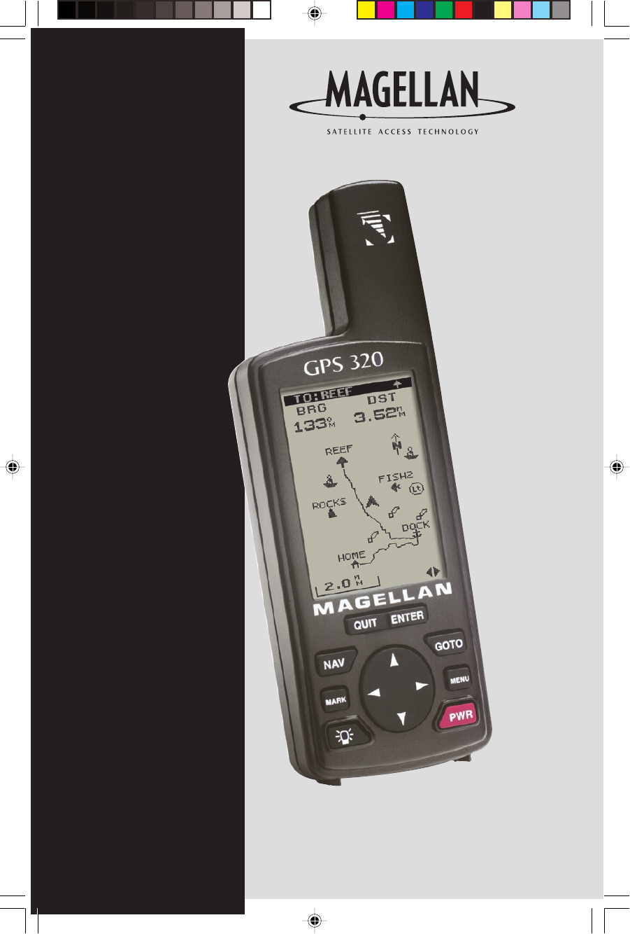
GPS 315/320
GPS 315/320
User Manual
WARNINGS
USE GOOD JUDGEMENT
This product is an excellent navigation aid, but does not replace the need for
careful orienteering and good judgement. Never rely solely on one device for
navigating.
USE CARE
The Global Positioning System (GPS) is operated by the U.S. Government, which is
solely responsible for the accuracy and maintenance of GPS.
The accuracy of position fixes can be affected by the periodic adjustments to GPS
satellites made by the U.S. Government and is subject to change in accordance
with the Department of Defense civil GPS user policy and the Federal
Radionavigation Plan. Accuracy can also be affected by poor satellite geometry.
USE PROPER ACCESSORIES
Use only Magellan cables and antennas; the use of non-Magellan cables and
antennas may severely degrade performance or damage the receiver, and will void
the warranty.
LICENSE AGREEMENT
Magellan grants you, the purchaser, the right to use the software supplied in and
with MAGELLAN GPS products (the "SOFTWARE") in the normal operation of the
equipment. You may make copies only for your own personal use and for use
within your organization.
The SOFTWARE is the property of MAGELLAN and/or its suppliers and is protected
by United States copyright laws and international treaty provisions; therefore, you
must treat this SOFTWARE like any other copyright material.
You may not use, copy, modify, reverse engineer or transfer this SOFTWARE
except as expressly provided in this license. All rights not expressly granted are
reserved by MAGELLAN and/or its suppliers.
* * *
No part of this handbook may be reproduced or transmitted in any form or by any
means, electronic or mechanical, including photocopying and recording, for any
purpose other than the purchaser's personal use without the prior written
permission of Magellan Corporation.
© 2000 by Magellan Corporation. All rights reserved.
Magellan™, GPS 315™, GPS 320™ and DataSend™ are trademarks of Magellan
Corporation.
630321 C

i
Table of Contents
Introduction ............................... 1
Conventions Used in this Manual ..............1
GPS 315/320 Receiver ...........................2
Getting Started .......................... 3
Receiver Accuracy...................................3
Installing the Batteries ..............................3
Proper Handling - Signal Reception ...........4
Power On ..............................................4
Initialize .................................................4
Initialize for First Time Use .................4
Selecting Primary Usage ..........................5
Getting a Fixed Position ...........................6
Saving Your Waypoint .............................6
Basic Operation ......................... 7
Entering Information ................................7
Navigation Screens .................................7
Using the Status Screen ............................8
Using the Position Screen .........................9
Viewing the Secondary Coordinate Screen 9
Using the NAV 1 Screen ........................10
Customizing the NAV 1 Screen ...............10
Using the Compass Screen .....................11
Customizing the Compass Screen............11

ii
Using the NAV 2 Screen ........................12
Customizing the NAV 2 Screen ...............12
Using the Plot Screen .............................13
Selecting PAN-N-SCAN .........................14
Setting Track History ..............................14
Clearing Track History ...........................14
Setting Up the Plotter ............................. 15
Setting Hide Data/Show Data ................16
Using the Road Screen...........................17
Customizing the Road Screen .................17
Using the Speed Screen .........................18
Resetting the Odometer ..........................18
Resetting the Trip Odometer....................19
Setting the Speed Average .....................19
Using the Time Screen ...........................20
Selecting Time Format ............................ 20
Resetting Elapsed Time........................... 21
Reference ................................ 22
Working with Waypoints........................23
Creating a User Waypoint .....................24
Editing a User Waypoint ........................ 24
Creating/Editing/Deleting a Message in a
User Waypoint .....................................25
Saving Changes to a Selected Waypoint .25
Deleting a User Waypoint ......................25
Finding a Non-UserWaypoint .................26
Sorting a Waypoint ............................... 26
Projecting a Waypoint ...........................26
DataSend™ CD (optional) ......................27

iii
Using DataSend™ ..........................27
Working with Routes ..............................28
Creating/Clearing a GOTO ...................28
Creating a GOTO on the Plotter Screen ...28
Creating a Man Over Board Route .......... 29
Creating a Backtrack Route ....................29
Creating a Multi-Leg Route ..................... 30
Viewing/Editing a Route .................31
Inserting a Leg ...............................31
Changing a Waypoint in a Route .....31
Adding a Waypoint at the End of
a Route .........................................32
Deleting a Waypoint in a Route........32
Saving a Route ............................... 32
Activating/Deactivating a Route .......32
Reversing a Route ........................... 33
Using Plot View in a Route ...............33
Deleting a Route .............................33
Working with TrackRoute........................34
Auxiliary Functions .................. 35
Working with Sun/Moon and Fish/Hunt ..35
Selecting the Simulate Mode...................36
Selecting Contrast .................................36
Selecting Alarm/Message ......................37
Accessing the Alarm/Message Menu ...... 37
Selecting Anchor Alarm .........................37
Selecting Arrival Alarm ..........................38
Selecting XTE Alarm ..............................38
Selecting Proximity Alarm .......................39

iv
Selecting GPS Fix Alarm ........................ 40
Viewing the Alarm/MSG Menu ..............40
Selecting Alarm Defaults ........................ 40
Clearing Alarm Defaults .........................40
Customizing ............................. 41
Selecting Setup ..................................... 41
Selecting Initialize .................................41
Disabling NAV Screens ..........................41
Selecting a Coordinate System ...............42
Selecting Map Datum ............................43
Selecting Elevation Mode ....................... 43
Selecting Time Format ............................ 44
Selecting NAV Units ..............................44
Selecting North Reference ......................44
Selecting Light Timer ..............................45
Selecting the Beeper ..............................45
Selecting Personalize ............................. 45
Selecting Clear Memory ........................46
Selecting NMEA ................................... 46
Selecting Baud Rate...............................47
Connecting to DGPS.............................. 48
Troubleshooting ....................... 49
Commonly Asked Questions ................... 50
Contacting Magellan ............................. 51
Shipping Your Receiver .......................... 51
NMEA Data Messages .............. 52

v
Available Datums .................... 58
Specifications ........................... 59
Attaching the Wrist Lanyard..... 60
Accessories .............................. 61
Glossary .................................. 62
Index....................................... 66

vi

Magellan GPS 315/GPS 320 1
Introduction
Congratulations on your purchase of the Magellan GPS 315/GPS 320
receiver. Since introducing the world’s first commercial, hand-held GPS
receiver in 1989, Magellan has led the way with innovative GPS
products to meet a wide range of positioning and navigation needs.
The receiver is designed to get you out into the “Great Outdoors”
rather than spending hours reading the user’s manual. In order to get
you outdoors quickly, the manual is designed with key sequences rather
than wordy sentences.
Before you begin, make sure that your package includes the items listed
on the box. If any of these items are missing, please contact your local
Magellan dealer or distributor.
Conventions Used in this Manual
The manual is divided into chapters: Introduction, Getting Started, Basic
Operation, Reference, Customizing, Troubleshooting and Glossary. There
are also subchapters that describe NMEA, Datums and Accessories.
It is very important that you read through the Getting Started chapter
first as it prepares your receiver for use and provides basic instruction.
The Basic Operation chapter describes the features found in your
receiver including step-by-step instructions on their use.
The Reference section contains information to help you navigate using
waypoints, routes and auxiliary functions. Following is the Customizing
chapter, that allows you to establish options you want set in the receiver.
The Troubleshooting chapter gives you a problem and answer series to
guide you. The final chapter, Glossary, defines terms that may be
unfamiliar to you.
The manual is to be used with either the GPS 315 or the GPS 320.
These differ in that the GPS 315 has a database of worldwide cities
consisting of major, large and medium cities. The GPS 320 has a
database of worldwide cities as well as lighthouses, fixed navaids, buoys,
large and medium cities for three different regions of the world (North/
Central/South America, Europe/Africa and Australia/Asia).
2Magellan GPS 315/GPS 320
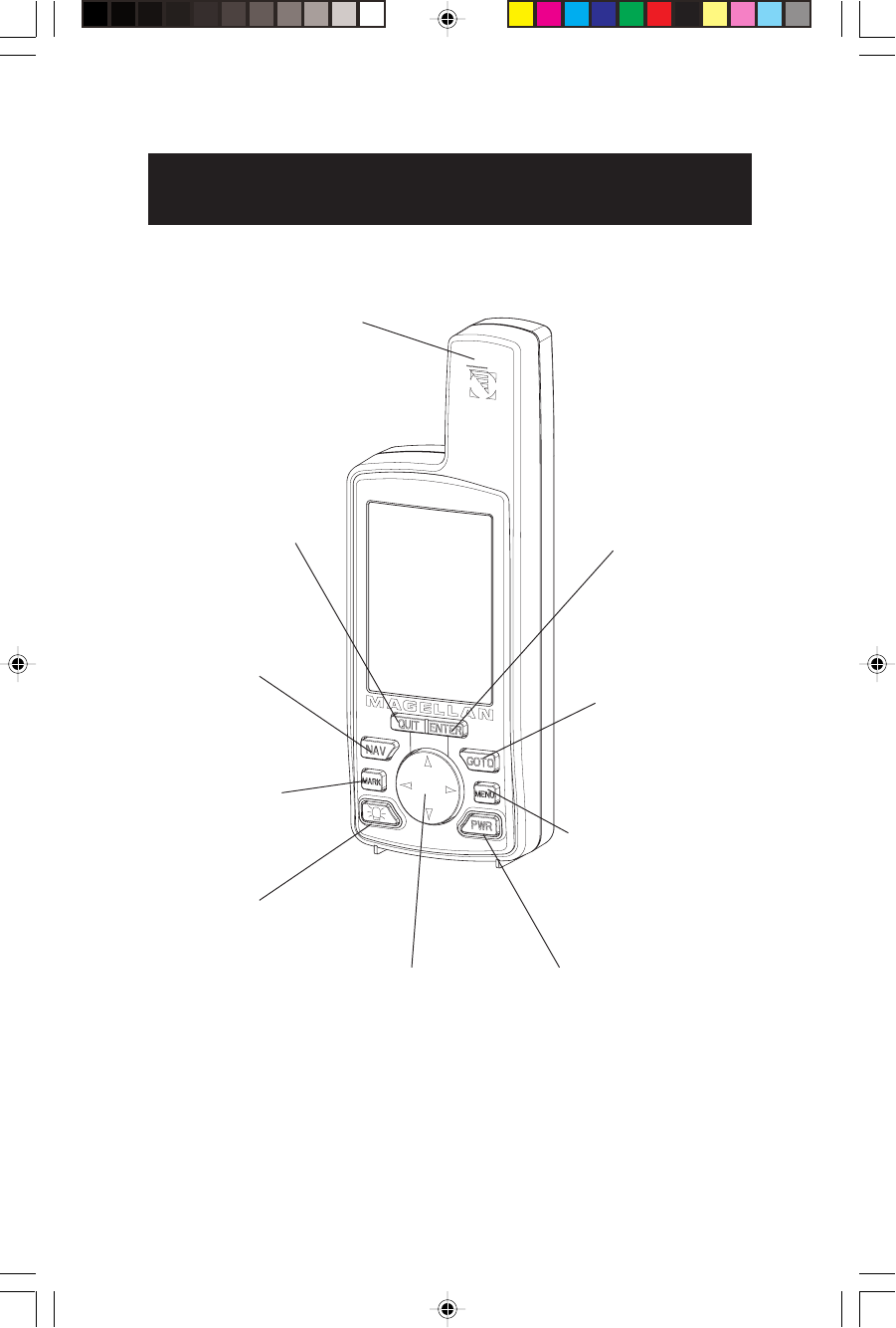
Quadrifilar antenna
The ENTER
key confirms
data entries or
menu selec-
tions.
The NAV key accesses
the navigation screens.
The QUIT key cancels
the operation of the last
key press and can be
used to back through
the NAV screens.
The MARK key
creates waypoints
and stores the
current position.
The LIGHT key turns
the light on and off.
The GOTO key
creates a direct
route to any
waypoint stored in
memory.
The MENU accesses
waypoint, route and
setup functions.
The PWR key turns the
receiver on and off.
The ARROWs enter
information and scroll
through menus.
GPS 315/320 Receiver
Magellan GPS 315/GPS 320 3
Getting Started
This section shows you how to use your receiver for the first time and
explains:
•Accuracy
•Battery Installation
•Primary Usage
•Getting a Fixed Position
Receiver Accuracy
The satellite constellation that provides the GPS information used by
the receiver is maintained by the Department of Defense (DoD). GPS
positioning, for general use, provides 25 meter RMS accuracy or better.
Since the signals generated by these satellites are publicly accessible, the
DoD has introduced errors in the satellite signals for security reasons.
These errors are referred to as Selective Availability (SA).
At present, your GPS position will be accurate within 100 meters
horizontally and 150 meters vertically. Due to these errors introduced
by SA, it is possible to get readings outside of these values at times.
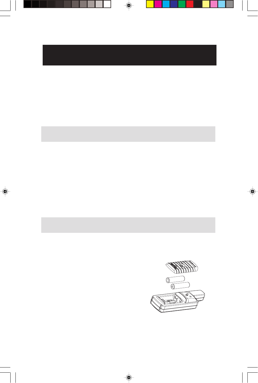
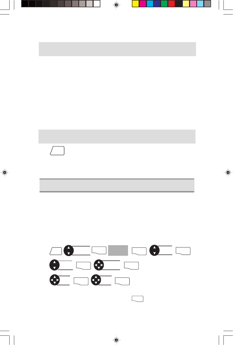
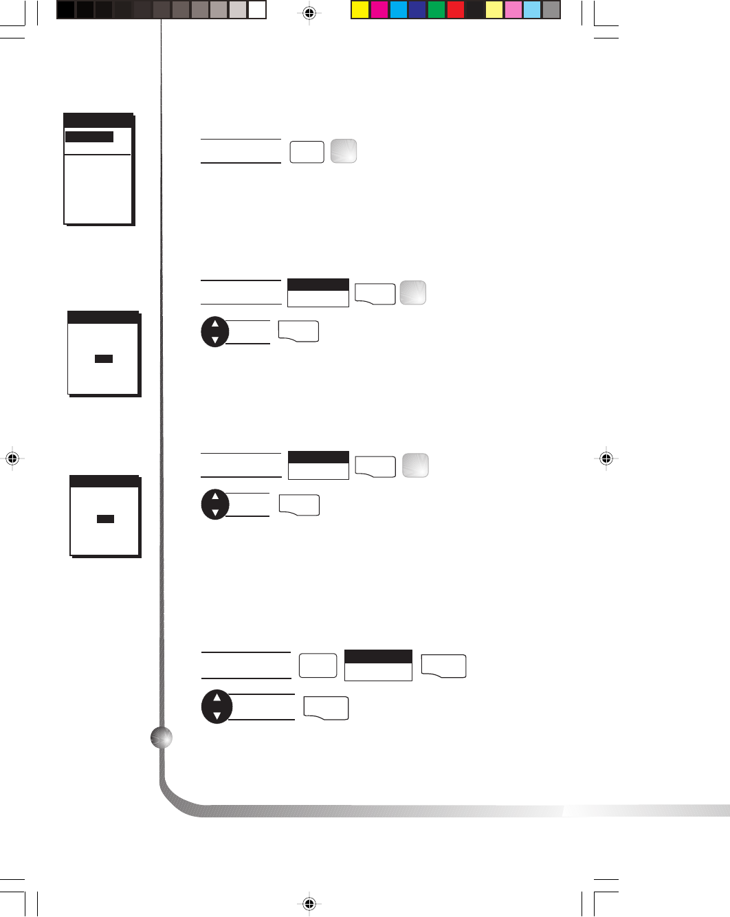
Installing the Batteries
The receiver uses two AA batteries that are installed at the back. To
remove the battery cover, turn the ring of the battery door screw
counter-clockwise until the battery
cover can be removed.
Insert the new batteries as shown, being
sure to respect the polarities, and replace
the cover.
Replace the screw and turn the ring
clockwise until the battery door is held
in place securely. Avoid overtightening
the battery door screw.
Once the batteries have been removed,
the receiver loses time and date after 20 minutes.
+
+-
-
4Magellan GPS 315/GPS 320
Proper Handling - Signal Reception
Clear View of the Sky. Because the receiver attains information it needs
from satellites orbiting the earth, the antenna needs to have a relatively
unobstructed view of the sky. This allows the receiver to choose from
all satellites currently available.
If the view of the sky is poor, (large cliffs or buildings, heavy foliage or
other obstructions) the satellite signals can be blocked and the receiver
may take longer to compute a position fix.
Holding the Receiver. The receiver is designed to fit comfortably in
your hand. Hold the receiver in the palm of your hand with the antenna
pointing towards the sky.
You do not need to initialize your receiver each time you use it unless the
memory has been cleared or if it has been transported more than 300 miles
while turned off.
Initialize for First Time Use
If the Initialize screen does not appear, then the receiver has already
been initialized. The other steps in this procedure are not required.
Initialize
* If you do not know your elevation, press
ENTER
.
Power On
PWR
If after powering the receiver on, you do not press ENTER within 10
seconds, the receiver will shut off automatically.
PWR ENTER
Select
region
ENTER
Select
area
ENTER
Enter
*
elevation
ENTER
INITIALIZE
screen
Enter
time
ENTER
Enter
date
ENTER
Select
language
ENTER
Magellan GPS 315/GPS 320 5
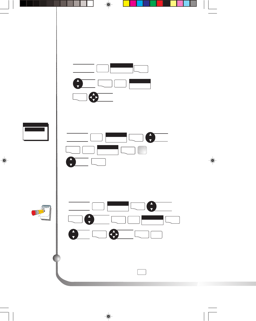
Selecting Primary Usage
A screen will be displayed asking your primary use for your receiver,
MARINE or LAND. The default is MARINE.
ENTER
You have completed the Initialization. The STATUS screen will appear
on your receiver.
The following chart shows the terminology that your receiver uses
while in land or marine mode. For purposes of this manual, it will be
assumed that the receiver is in the marine mode.
Land Marine
Speed SPD SOG
Bearing BRG BRG
Distance DST DST
Heading HDG COG
Velocity Made Good VMG VMG
Course To Steer CTS CTS
Estimated Time of Arrival ETA ETA
Time To Go TTG ETE
Cross Track Error XTE XTE
Recorded Position Landmark Waypoint
Units of Measure MILES/MPH NM/KNOTS
or KM/KPH
6Magellan GPS 315/GPS 320
Getting a Fixed Position
Now you should go outside in an area where you can get a clear view of
the sky. The receiver will begin acquiring data from the satellites in
view and will display the progress on the STATUS screen. Once the
receiver has computed a fixed position, the POSITION screen will be
displayed.
Saving Your Waypoint
Once the receiver has computed your current position, you may save
(MARK) this position as a waypoint.
Saving Your Position with a Receiver-Created
Name.
This is a fast way to save your position.
MARKMARK
Saving Your Position with a User-Created Name.
MARK ENTER Enter
data MARK
You can save up to 500 waypoints in your receiver and refer back to
them at any time.
Creating a GOTO
A GOTO is a route that guides you from your current position to any
waypoint in the receiver’s memory.
GOTO Select
waypoint ENTER
Select
category ENTER
This completes the Getting Started section.
The following Basic Operation section will familiarize
you with the NAV screens and more detailed
functions.
Magellan GPS 315/GPS 320 7
Basic Operation
Entering Information
Throughout this user manual there are some key presses that will be
used often, so please keep them in mind while setting up and navigat-
ing. When entering data...
• Use the for making selections and moving up or down.
• Use the to move the cursor to the left or right and page
through menus.
• Press
QUIT
to return to the previous screen and to exit a
screen or end a process.
Navigation Screens
The nine NAV (Navigation) screens (STATUS, POSITION, NAV 1,
COMPASS, NAV 2, PLOT, ROAD, SPEED and TIME) provide you
with necessary information you will need to use the receiver as a
navigational tool.
NAV screens can be viewed by pressing
NAV
from any screen. While
viewing any NAV screen, you can use the
NAV
or
QUIT
to step
through the sequence of NAV screens.
All screens, except STATUS and POSITION screens, can be disabled by
turning them off in the NAV SCREENS portion of SETUP. The
TIME screen default is off and can be turned on in SETUP as well.
8Magellan GPS 315/GPS 320
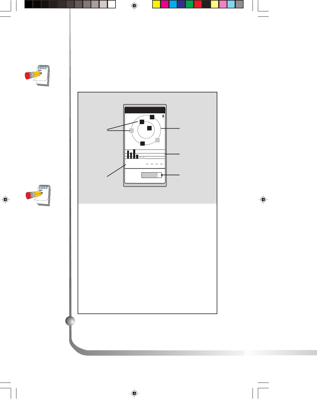
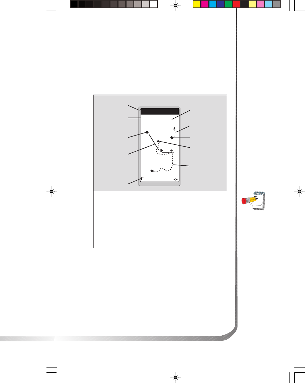
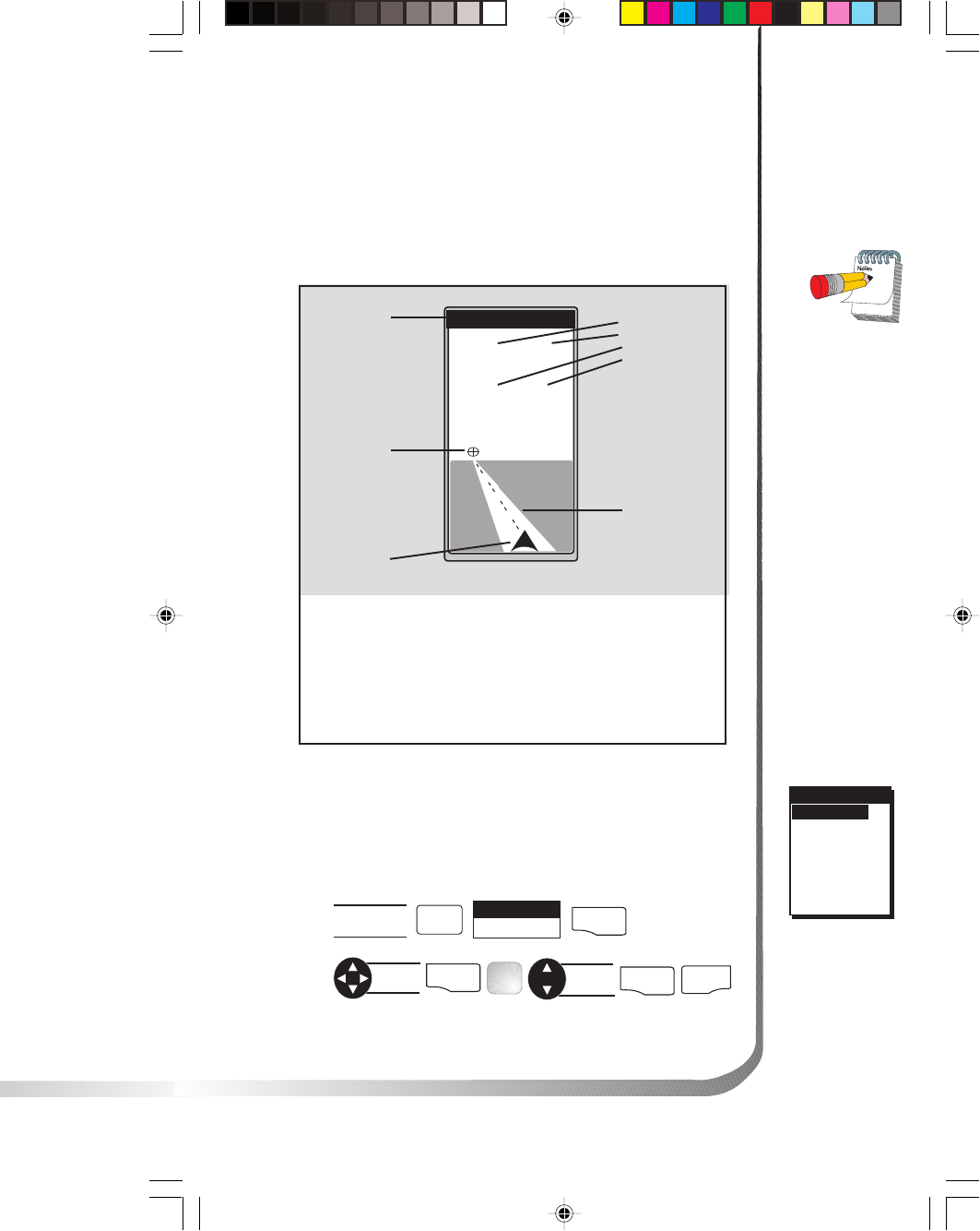
Using the Status Screen
The STATUS screen gives you the general well-being of your
receiver by showing you satellite status, signal strengths and
battery life.
Pic
Once the
receiver has
computed a
fixed position,
the STATUS
screen will be
replaced by the
POSITION
screen.
STATUS
3D
N
12
13
18
7
8
POWER
001112
782385
25
Satellite
Signal Chart
Satellite Position
Graph
Battery Life
Indicator
Satellite
Numbers
Satellite
Positions
Satellite Positions
Where the satellite is
located relative to your
position.
Satellite Numbers
Identifies the satellite
shown on the chart and
on the Satellite Position
Graph.
Battery Life Indica-
tor Shows approximate
remaining battery life for
batteries in the receiver.
Satellite Signal
Chart Displays satellite
signal strengths shown in
gray for weak signals and
black for strong signal.
When the receiver first
tracks a satellite, the
strength bar will not be
solid until ephemeris is
collected. This takes about
30 seconds if uninterrupted.
Satellite Position
Graph The two circles
indicate satellite elevation,
the outer circle represents
the horizon and the inner
circle represents 45ß from
the horizon. The center of
the circle is 90ß.
The Battery Life
Indicator was
designed to be
used with AA
alkaline batteries.
With AA lithium
batteries, you will
have more battery
life available than
shown on the
Battery Life
Indicator.
Magellan GPS 315/GPS 320 9
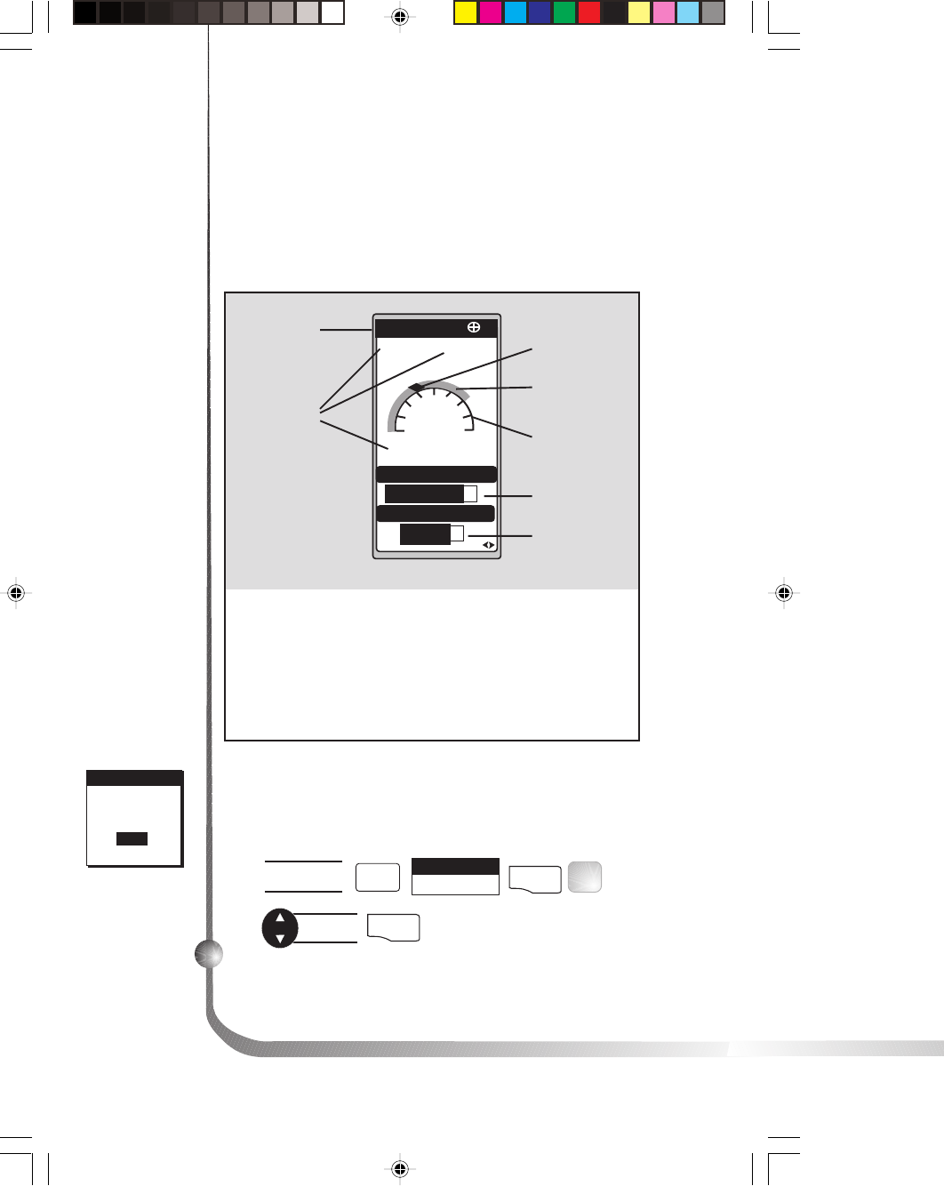
Using the Position Screen
The POSITION screen displays the coordinates of your last
computed position and basic navigation data. You also have
the option of viewing your position using another coordi-
nate system.
150
120 S
K
TN
M
M
POSITION
N
34
˚
06.52
117˚49.56W
ELEV 900 FT
11:23:35 PM
SPEED
5.38
EPE 112 FT
TRIP
238.8
COURSE 150
23JAN97
°
When you are
stationary, the
receiver begins the
averaging mode.
While averaging,
the receiver
continuously
takes fixes to
create an average.
Once you begin
moving, averaging
stops automati-
cally.
Position
Coordinates
Time
Estimated
Position Error
Distance
Traveled
Course
Second
Coordinate
System access
Elevation
Speed
Compass
Position Icon
Position Icon Your
current position on the
compass.
Estimated Position
Error May display the
estimated position error
value or DGPS if DGPS is
being fed to receiver, or
Simulate if simulate is on.
Second Coordi-
nate System
Access Displays
your present position in
a secondary coordi-
nate system. Datums
can be selected under
SETUP.
Date
Viewing the Secondary Coordinate Screen
From the POSITION screen, use the left/right ARROWs to
view the Second Coordinate System access screen.

10 Magellan GPS 315/GPS 320
Using the NAV 1 Screen
The NAV 1 screen displays your destination along with four
customizable navigation data and a graphical compass.
DST 50.2
SOG 8.2
XTE 3.80
R
VMG 7.2
BRG
COG 150
150
120 S
K
T
K
T
n
m
127
°
m
n
m
°
m
TO: FISH
Customizable
Navigation
Data
Destination
Name
Destination
Icon
Position Icon
Destination Icon This
icon represents where you
want to go.
Ideally, when you
are navigating, the
Position Icon and
the Destination
Icon should line
up, one above the
other.
When the bearing
to your destina-
tion cannot be
displayed within
the compass, an
arrow will be
displayed to
indicate the
steering direction
you should be
traveling.
Compass
Customizing the NAV 1 Screen
The NAV 1 screen can be changed to show the navigation
data that you prefer to view.
From NAV 1
screen
Select
CUSTOMIZE
ENTER
Choose
field
ENTER
Select
data type
ENTER
MENU
FIG
.
AQUIT
Customizable
Navigation Data You
can change the four
navigational fields. You
can choose from BRG,
DST, SOG, COG, VMG,
CTS, ETA, ETE, XTE,
TRN, ALT, TME and
blank.
Figure A. Select
the data field to
appear on the
NAV 1 screen.
WPT NAMES
OFF
ON
WPT NAMES
OFF
ON
WPT NAMESCUSTOMIZE
BRG 027°
m
DST 50.2
nm
SOG 8.2
KT
COG 056°
m
VMG 7.2
KT
CTS 028°
m
ETA 01:09P
ETE 02H24M
XTE L.2
nm
TRN L26°
ALT 83
TME 01:09P
BLANK
F
T
Magellan GPS 315/GPS 320 11
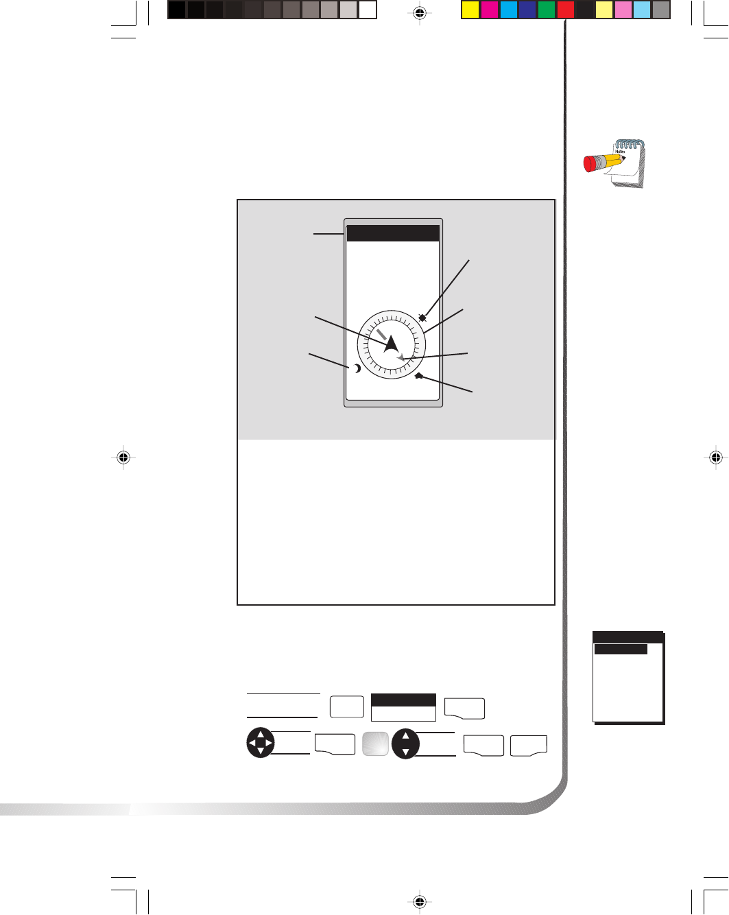
Using the Compass Screen
As well as displaying the customizable navigation data, the
COMPASS screen provides a pointer compass to help you
reach your destination.
Steering Indicator
Displays the bearing of
the destination relative
to the course over
ground.
Destination Icon
Shows the general
direction you should be
traveling.
COG Indicator Displays
direction you are traveling.
The COG indicator always
points up and the compass
rotates according to the COG.
When the COG
Indicator and the
Steering Indicator
point in the same
direction, you are
on course.
The
NorthFinder™
feature displays
sun and moon
icons, above the
horizon, for you
to determine the
direction of north
and your
destination. Align
the sun on the
COMPASS screen
with the sun in
the sky. When
aligned, the
Steering Indicator
will point you in
the direction you
should travel to
reach your
destination.
Customizing the Compass Screen
The COMPASS screen can be changed to show the naviga-
tion data that you prefer to view.
From COMPASS
screen
Select
CUSTOMIZE
ENTER
Choose
field
ENTER
Change
field
ENTER
MENU
FIG.
B
QUIT
WPT NAMESWPT NAMESWPT NAMESCUSTOMIZE
BRG ---°
m
DST ---
nm
SOG ---
KT
COG ---°
m
VMG ---
KT
CTS ---°m
BLANK
Figure B. Select
the data field to
appear on the
COMPASS
screen.
TO: HOME
E
N
WS
+
++
+
DST
3.52
m
I
SOG
2.7
m
H
BRG
127
m
°
COG
156
m
°
COG Indicator Compass
Destination
Icon
Sun Icon
Destination
Name
Steering
Indicator
Moon Icon
12 Magellan GPS 315/GPS 320
Using the NAV 2 Screen
The NAV 2 screen displays four customizable navigation
data. The NAV 2 screen is designed to help you see the
screen when your receiver is mounted at a distance from
you.
TO: CAMP
BRG
COG
SOG
DST
14.2˚
171˚
11.2
50.2
K
T
N
M
M
M
Destination
Name
Customizable
Navigation
Data
Customizable
Navigation Data.
You can change the
four navigational data
fields. You can
choose from BRG,
DST, SOG, COG,
WPT NAMES
OFF
ON
WPT NAMES
OFF
ON
WPT NAMESCUSTOMIZE
BRG 027°
m
DST 50.2
nm
SOG 8.2
KT
COG 056°
m
VMG 7.2
KT
CTS 028°
m
ETA 01:09P
ETE 02H24M
XTE L.2
nm
TRN L26°
ALT 83
TME 01:09P
BLANK
F
T
Customizing the NAV 2 Screen
The NAV 2 screen can be changed to show the
navigation data that you prefer to view.
Figure A. Select the
data field to appear
on the NAV 2
screen.
From NAV 2
screen
Select
CUSTOMIZE ENTER
Choose
field ENTER Change
field ENTER
MENU
FIG.
AQUIT
VMG, CTS, ETA, ETE,
XTE, TRN, ALT, TME and
blank.
Magellan GPS 315/GPS 320 13
Using the Plot Screen
The PLOT screen is a mini map that shows where you have
traveled and where you want to travel. You can view the
active route, your current position and the other waypoints
and destination in the PLOT screen.
TO: FISH
BRG
351
m
DST
3.52
m
I
2.0
m
I
N
HOME
FISH 2
FISH
DOCK
BUOY
°
Distance to
Destination
North Indicator
Waypoint Icon
Current Position
Icon
Track History
Plot Scale
Active Route
Destination Icon
Bearing to
Destination
Destination
Name
Active Route
Indicates the direction
required to reach your
destination.
Plot Scale Can be
changed by using the
left/right arrows. The
scale ranges from .1 to
200 miles.
PAN-N-SCAN, an
additional feature,
allows you to scroll
through the PLOT
screen enabling you
to create waypoints
and GOTOs.
Track History
Automatically records
where you have been.
14 Magellan GPS 315/GPS 320
The ARROWs can be used to move the cursor. If the cursor
is over the waypoint icon when MENU is pressed, the menu
will be displayed with WPT INFO added. Moving the
cursor over a waypoint brings up the name, bearing and
distance. Pressing MENU and selecting WPT INFO
displays full information.
In PAN-N-SCAN mode, you can zoom in by pressing the
ENTER key. Once the lowest scale is reached (0.1 mile),
pressing ENTER zooms out to the highest scale (200 miles).
Setting Track History
Using TRACK HISTORY records where you have been by
automatically storing locations, as “dropping bread crumbs”
from your starting point as you travel. This is useful when
you want to return to your starting point.
From PLOT
screen
MENU
Select
TRACK HIST
ENTER
Change
field
ENTER
Clearing Track History
From PLOT
screen
MENU
Select
CLR TRACK
ENTER
Select
ENTER
Selecting PAN-N-SCAN
By using PAN-N-SCAN, you can look ahead or review
where you have traveled according to waypoints, routes and
track history.
From PLOT
screen
MENU
Select
PAN-N-SCAN
ENTER
Magellan GPS 315/GPS 320 15
WPT NAMES
OFF
ON
WPT NAMESWPT NAMESORIENT
TRACK UP
COURSE UP
NORTH UP
Turning Plot Rings On or Off. You may want to estimate
the distance to a point on the plotter. To assist you, turn the
PLOT RINGS option on. The distance between each plot
ring is equal to the scale, therefore, at most you will see a
portion of 2 rings at one time.
From PLOT
screen MENU Select
PLOT SETUP ENTER
ENTER
Select
PLOT RINGS
Select
on or off ENTER
Setting Up Course Projection. You may want to know
where you will be after a specified period of time based on
your current speed and heading.
WPT NAMES
OFF
ON
WPT NAMESWPT NAMESPROJECTION
OFF
1 MINUTE
2 MINUTES
5 MINUTES
10 MINUTES
From PLOT
screen
MENU
Select
PLOT SETUP
ENTER
ENTER
Select
COURSEPROJ
Select
time
ENTER
FIG
.
B
From PLOT
screen MENU Select
PLOT SETUP ENTER
ENTER
Select
ORIENTATION
Select
orientation ENTER
FIG.
A
Figure A. You
can choose from
TRACK UP
(direction you
are moving at the
top of the
screen),
COURSE UP
(destination of
the current leg at
the top of the
screen) and
NORTH UP
(north at the top
of the screen).
Figure B. You
can choose
from OFF, 1, 2,
5 and 10
minutes.
Setting Plotter Orientation.
Setting Up the Plotter
This menu allows you to change the orientation, turn the
plot rings on or off, set the course projection and set the
plotter scale.
A solid black line will appear starting from your position
to the projected position.
16 Magellan GPS 315/GPS 320
Setting Hide Data/Show Data
You may want bearing and distance to be hidden. You can
choose to either hide these navigation data fields or have the
fields present. Under HIDE DATA/SHOW DATA, you
can turn these fields on or off.
From PLOT
screen MENU Select
HIDE DATA
or
SHOW DATA
ENTER
Depending on
which has been
selected previously,
you may need to
select SHOW
DATA to bring the
fields into view.
Setting Up Plot Scales. You can set up the maximum scales
at which the waypoints appear on the plotter screen.
From PLOT
screen MENU Select
PLOT SETUP
Select
category ENTER
ENTER
Select ENTER
Select
*
scale
FIG
.
A
ENTER
* Selecting OFF will turn the scales off. If you select either
ICONS ONLY or ICONS/NAMES, you will be prompted
to change the plot scales for a waypoint.
WPT NAMES
OFF
ON
WPT NAMES
PLOT SCALES
0.1
0.2
0.3
0.5
0.8
1
2
3
5
8
10
20
50
100
200
Figure A. You may
select the scale for
the waypoint to
appear on the
plotter. The
number you select
is the maximum
scale in which the
icon will appear.
Magellan GPS 315/GPS 320 17
Customizing the Road Screen
The ROAD screen can be changed to show the navigation
data that you prefer to view.
WPT NAMESWPT NAMESWPT NAMESCUSTOMIZE
BRG ---°
m
DST ---
nm
SOG ---
KT
COG ---°
m
VMG ---
KT
CTS ---°m
BLANK
Figure B. You can
choose from BRG,
DST, SOG, COG,
VMG, CTS and
blank.
From ROAD
screen MENU
Choose
field
ENTER
Select
CUSTOMIZE ENTER
Choose
field ENTER
FIG.
BQUIT
TO: FISH
BRG
127
°
DST
3.52
COG
156
°
SOG
2.7
m
m
n
m
K
T
Customizable
Navigation
Data
Desired
Route
Position
Icon
Destination
Icon
Destination
Name
Navigation Data
You can change the four
navigation data fields.
You can choose from
BRG, DST, SOG, COG,
VMG, CTS and blank.
Using the Road Screen
The ROAD screen displays four customizable navigation
data fields, at the top of the screen, and shows your
position on the desired route.
When the
destination icon
is straight ahead,
you are on
course. If you are
off course and
the destination
icon is off the
screen, an arrow
will appear to
point you in the
direction to get
back on course.
Desired Route The
direction to travel to
reach your destination.
18 Magellan GPS 315/GPS 320
Using the Speed Screen
While using the SPEED screen, you can view the
graphical speedometer, odometer and trip odometer as
well as the numerical bearing, course over ground and
speed over ground.
°
m
BRG COG
027m056
20
SOG 14.2 K
T
0
51015
ODOMETER
TO: CAMP
n
m
00542
2
3
n
m
054
2
3
m
TRIP
°°
Destination
Name
Navigation
Data
Average
Speed Icon
Instantaneous
Speed
Graphical
Speedometer
Odometer
Trip
Odometer
Resetting the Odometer
You may want to reset the Odometer field to zero.
From SPEED
screen
MENU
Select
ODOM RESET
ENTER
Select
yes or no
ENTER
FIG
.
A
WARNING
RESET
ODOMETER
TO 000?
YES
NO
Figure A. Select
“Yes” to reset the
odometer.
Graphical Speedom-
eter Scale can be
increased or decreased
by using the right/left
arrows.
Instantaneous Speed
A graphical representation
of speed over ground
(SOG).
Magellan GPS 315/GPS 320 19
Resetting the Trip Odometer
You may want to reset the Trip field to zero.
From SPEED
screen
MENU
Select
TRIP RESET
ENTER
Select
yes or no
ENTER
Setting the Speed Average
You may want to reset the Speed Average field in your
receiver.
From SPEED
screen MENU
Select
SPEED AVG ENTER
Select
time ENTER
FIG
.
B
The default is 30 seconds.
SPEED AVG
TRIP
5 SECONDS
30 SECONDS
1 MINUTE
5 MINUTES
1 HOUR
Figure B. You can
set the timing for
Speed Averaging.
You can choose
from TRIP, 5, 30
seconds, 1, 5
minutes or 1 hour.
TRIP option is for
averaging speed over
the entire trip.
20 Magellan GPS 315/GPS 320
Using the Time Screen
The TIME screen displays the current time, estimated
time enroute, time of arrival, and elapsed time in regards
to the route you are navigating in.
The default for
the TIME screen
is off.
03:54:21
01:09:24
02:24:56
04:34:20
P
M
P
M
ELAPSED
ETE
TIME
OF ARRIVAL
Time
Time of
Arrival
Elapsed
Time
Estimated
Time
Enroute
Time Can be custom-
ized to correct the
current time and to select
the time format.
Estimated Time
Enroute (ETE)
All data shown
on the TIME
screen applies to
the route you are
navigating in.
TIME FORMAT
LOCAL 24HR
LOCAL AM/PM
UTC
Selecting Time Format
You may need to correct the current time or change the
time format.
From TIME
screen
MENU
Select
FORMAT
ENTER
Select
format
ENTER
FIG
.
A
Change
fields
ENTER
If LOCAL 24HR or
LOCAL AM/PM
Time of Arrival (OF
ARRIVAL)
Elapsed Time
(ELAPSED)
Figure A. You can
choose from
LOCAL 24HR,
LOCAL AM/PM
and UTC.
If UTM is chosen you will not be prompted to make the
time change.
Magellan GPS 315/GPS 320 21
Resetting Elapsed Time
You may want to reset the elapsed time to zero.
From TIME
screen MENU
Select
RESET ELAP ENTER
You have completed the basic operation for
your receiver. From the information pro-
vided, you can now navigate from place to
place quickly and easily.
The following chapters provide you with
additional information on using your receiver
that build on what you have learned.

22 Magellan GPS 315/GPS 320
The Reference section contains information that will help
you navigate using your receiver. Now that you have read
the Basic Operation section, you have reviewed the basic
usage. The Reference section will cover waypoints, routes,
and auxiliary functions.
The Working with Waypoints section tells you how to
create, edit, delete, project and sort waypoints. These
functions will guide you in the uses of waypoints. You can
create your own waypoints (known as User waypoints) or
use the waypoints already in the receiver’s memory (Non-
User waypoints). You can store up to 500 user positions
which can be used to build routes for navigation.
As stated earlier in the user manual, the GPS 315 has a
database of worldwide cities and the GPS 320 has a
database of cities and marine navaids for three different
regions of the world: North/Central/South America,
Europe/Africa and Australia/Asia.
The Working with Routes section tells you of the four
different types of routes consisting of GOTO, BACK-
TRACK, MOB and MULTI-LEG ROUTE. A route is a
planned course of travel defined by a series of waypoints
saved in the receiver’s memory. The receiver holds 20
routes with 30 legs. The route function allows you to
create, activate/deactivate, view/edit or delete any one of
the 20 routes.
The Auxiliary Function section tells you how to select the
Sun/Moon and Fish/Hunt options, contrast, simulate
mode and the alarms and message functions. You can
choose from the Anchor alarm, Arrival alarm, XTE alarm,
Proximity alarm and GPS Fix alarm. These alarms can be
reset to the alarm default settings or can be cleared of
defaults.
Following, you will find the Customizing section. Cus-
tomizing allows you to use the Setup menu to establish
the options you would like to set in your receiver.
Reference
Magellan GPS 315/GPS 320 23
Working with Waypoints
This section tells you how to edit, delete, project and sort
waypoints. You can store up to 500 user positions which
can be used to build routes for navigation.
Waypoints consist of two types, User and Non-User. The
User types are made up of waypoints that you can save in
the receiver’s memory. You can edit and delete these
waypoints, if you wish. The Non-User types display
locations, their coordinates and a description. These are
permanently stored in the receiver’s memory and cannot be
deleted unless written over by waypoints downloaded from
the DataSend™ CD.
To help you understand the difference, the chart below
shows the functions of the User and Non-User waypoints.
You can store up to
10 Non-User
waypoint categories.
WPT Types Available Functions
User
Non-User
• Create
• Edit
• Delete
• Project
• Sort
• Find
• Project
• Sort
GPS 315 GPS 320
Worldwide major
cities
Worldwide large
and medium
cities
Worldwide major
cities
Regional large and
medium cities
Regional buoys,
lighthouses and
fixed navaids
The chart below shows the differences between the GPS 315
and GPS 320.
24 Magellan GPS 315/GPS 320
Editing a User Waypoint
Editing a Selected Waypoint
Editing Waypoint Fields. Follow the instructions on
selecting a waypoint and use the following to edit the
desired fields.
EDIT WPT
34˚06.56N
117˚49.60W
900FT
11:23:35PM
12JUN97
NO CAMP
FIRES
SAVE EDITS
CLEAR MSG
WPT003
MENU
EDIT WPT
SORT WPT
DELETE WPT
PROJECTION
WAYPOINTS
ROUTES
SETUP
SUN/MOON
FISH/HUNT
CONTRAST
ALARM/MSG
Figure A. This menu
allows you to select
the edit waypoint
mode. Only User
waypoints can be
edited.
Select
data field ENTER ENTER
Make
changes
FIG
.
B
From any
NAV screen MENU
Select
WAYPOINTS ENTER
Select
waypoint MENU
Select
EDIT WPT ENTER
FIG.
A
Select User
category
ENTER
Figure B. You may
change any of the
data fields in this
screen.
Creating a User Waypoint
A waypoint is a recorded position that can be used in a route
or a GOTO. You can save up to 500 user waypoints in your
receiver. You can create a waypoint with a receiver-generated
name (WPT001, WPT002, WPTxxx) by pressing:
MARKMARK
To create a waypoint with a name of your choice or if you wish
to change any data field while entering a waypoint, use the
following:
MARK ENTER
Select
data field MARK
Make
changes ENTER
As you are working with waypoints, you will notice that the
cities (non-user waypoints) are divided into categories. This
division is based on the population of the city using the
following guidelines:
Major city 500,000+
Large city 100,000 – 500,000
Medium city 20,000 – 100,000
Small city * Less than 20,000
* available in DataSend CD.
Magellan GPS 315/GPS 320 25
To create a message. Follow the instructions on selecting a
waypoint and use the following to create/edit/delete a
waypoint.
Select
CREATE MSG
ENTER
Make
changes
ENTER
To delete a message. Follow the instructions on selecting
a waypoint.
Select
CLEAR MSG
ENTER
To save your edits. Follow the instructions on selecting a
waypoint.
EDIT WPT
CAMP
34˚06.56N
117˚49.60W
900 FT
11:23:35PM
12JUN97
CREATE MSG
SAVE EDITS
Select
SAVE EDITS ENTER
FIG.
C
Figure C. Once
you have made
your changes, be
sure to select
SAVE EDITS.
Deleting a User Waypoint
You may find that you have saved waypoints that you no
longer use. If so, you can delete these unnecessary
waypoints.
Once these waypoints are deleted, you cannot
undo this process or retrieve these deleted
waypoints.
DELETE
DELETE
WPT023?
YES
NO
Figure D. This
screen prompts
you to select YES
or NO in
deleting the
waypoint named.
From any
NAV screen
ENTER
MENU
Select
WAYPOINTS
Select
category
ENTER MENU
Select
DELETE WPT
ENTER
Select
yes or no
ENTER
FIG
.
D
Select
waypoint
26 Magellan GPS 315/GPS 320
Sorting a Waypoint
You may want to change how the waypoints are sorted.
WPT SORT
ALPHABETIC
NEAREST
ICON/NAME
Figure A. You can
choose from
ALPHABETIC
(shows all
waypoints),
NEAREST
(shows closest 20
waypoints) and
ICON/NAME
(cannot sort Non-
User waypoints).
From any
NAV screen ENTER
MENU Select
WAYPOINTS
MENU Select
SORT WPT ENTER
Select ENTER
FIG
.
A
Select
category
ENTER
Finding a Non-User Waypoint
To simplify your search for a waypoint, you can find it using
the smart scroll function.
MENU
Select
FIND
From any
NAV screen
ENTER
MENU
Select
WAYPOINTS
Select
category
ENTER
ENTER
Find
waypoint
To find the
waypoint use the
ARROWs to
change the letters.
For example, to
find Dodger
Stadium, use the
ARROWs to
change the first
letter to “D”.
Then use the
ARROWs to find
the second letter,
“O”. Continue
until the name is
found.
Projecting a Waypoint
This function allows you to create a waypoint at a certain
distance and direction from an existing waypoint.
You can change any of the three sections in the PROJEC-
TION screen. Once you have the necessary information in
the data fields and the receiver has projected the position,
you can save the position by pressing
MARK
.
In the G.C. (Great
Circle) BRG/DST
field, you can
input the bearing
and distance into
the data fields in
order to compute
the projection.
You can also input
information into
the coordinate
fields.
From any
NAV screen
Select
waypoint
ENTER
MENU
Select
WAYPOINTS
ENTER MENU
Select
PROJECT
ENTER
Make
changes
ENTER
Select
category
ENTER
Select
field
ENTER MARK
Magellan GPS 315/GPS 320 27
DataSend™ CD (optional)
DataSend™ software contains a database of waypoints that
can be sent to your receiver and are broken down into
multiple categories. The software allows you to select a
geographical area and enable waypoint categories for that
location to be transferred into the receiver.
Using DataSend™
After you have installed DataSend™ you are ready to view
and send waypoints to the receiver. While running
DataSend™ you will see a background map of the world
that you can zoom in to see enabled waypoints.
If you want to send waypoints to your receiver, you must
select the geographic area first, then from the waypoint list
you can make your selection of waypoints to send. The
software will compute the amount of memory required and
whether your selection fits into your receiver. If it exceeds
the available receiver memory, either the geographic area, list
of waypoints selected, or both, can be decreased and the
memory requirements recomputed. The list of waypoints
selected in the specified geographic area can then be saved
under a project name you enter.
You can then send the waypoints to the receiver which
replace all waypoints in the receiver. The default waypoints
that came with the receiver can be restored at any time.
Don’t worry about
losing the
waypoints that
came with the
receiver, they are
available on the
CD for retrans-
mission to the
receiver.
28 Magellan GPS 315/GPS 320
Working with Routes
Creating/Clearing a GOTO
A GOTO is a route that guides you from your current
position to any waypoint in the receiver’s memory. As an
example, you can save a waypoint at your home. No matter
where you go, you will always be able to navigate back home
by using GOTO.
To create a GOTO
To clear a GOTO. The CLEAR GOTO function allows
you to delete an active GOTO route.
If there are no active GOTOs, the CLEAR
GOTO will not be displayed in the MENU.
ENTER
MENU Select
CLEAR GOTO
GOTO
Creating GOTO on the Plotter Screen
A GOTO route can be created by selecting a waypoint on
the plotter screen. While on the plotter screen, follow this
procedure to access PAN-N-SCAN and set a GOTO by:
Figure A. Your
menu may differ
depending the
waypoints in
memory.
GOTO
MOB
USER
STADIUM
GOLF COURSE
HALL
GOTO Select
waypoint ENTER
FIG
.
A
Select
category ENTER
By selecting the
GOTO destination
waypoint from the
plotter screen, you
can avoid selecting
the wrong
waypoint if its
name is shared
with another
waypoint.
ENTER
MENU
Select
PAN-N-SCAN
From PLOT
screen
Move
crosshair
GOTO ENTER
Select
yes or no
When the crosshair is over the waypoint icon, the
waypoint name is displayed at the top of the screen.
Magellan GPS 315/GPS 320 29
Creating a Backtrack Route
Backtrack creates a route that starts from the last point
recorded in track history using the “bread crumbs” saved, to
the first point recorded for track history. By following this
route, you “retrace your steps” back to the starting point.
A route will be created and given a name in the format of
BXXPxx. XX is the BACKTRACK number and xx is the
waypoint number ranging from 01 to 31. For example,
your first backtrack will read B01P01. The backtrack
waypoints will be listed in the menu just as other waypoints.
MOB waypoints will be created and titled MOB001,
MOB002 and so on. If a MOB already exists, the receiver
will give you the option of replacing the MOB.
ENTER
While in MOB
screen
MENU
Select
CLEAR MOB
MENU
Select
ROUTES
ENTER MENU
Select
BACKTRACK
ENTER
GOTO Select
MOB ENTER
Creating a Man Over Board (MOB) Route
Another type of route is a Man Over Board (MOB).
The MOB route is useful when you want to instantly
create and activate a route to the last computed
position.
To clear a MOB. The CLEAR MOB function allows you to
delete an active MOB route.
30 Magellan GPS 315/GPS 320
Select SAVE
ROUTE ENTER
or
MENU Select
SAVE ROUTE ENTER
FIG.
B
Figure B. Use this
menu as an option
for saving your
route.
To end the creation process:
The receiver will display the selected waypoint in the
starting location and will highlight the destination for leg 2.
Press
ENTER
for your next selection. Continue this process
until you have completed the route.
When selecting a navaid for a route, be sure
you are selecting the correct one because
there may be navaids with the same names
in different parts of the world.
MENU
INSERT
SAVE ROUTE
WAYPOINTS
ROUTES
SETUP
SUN/MOON
FISH/HUNT
CONTRAST
ALARM/MSG
Select
empty route
MENU
Select
ROUTES
ENTER
ENTER
Select
*
category
ENTER
FIG.
A
Select
waypoint
ENTER
ENTER
* You can combine waypoints of different categories in the
same route.
Creating a Multi-Leg Route
You may want to create a route with your saved
waypoints. For example, if you want to create a route
from your home, to a campsite and then to a favorite
fishing spot, you can create a route that would take you
to each place.
CREATE
n
m
DST
m
BRG
˚
LEG
SAVE ROUTE
Figure A.
Highlight the first
dotted line to
place the first
waypoint in the
multi-leg route.
Magellan GPS 315/GPS 320 31
Changing a Waypoint in a Route. Using your home to
campsite route, you want to go to the fishing spot on
the way to the campsite and not stop at the stream.
You can replace the stream waypoint with the fishing
spot.
While viewing
route Select
waypoint
ENTER
or
MENU
Select
REPLACE
ENTER
ENTER
Select
waypoint
Select
category
ENTER
ENTER
Select
waypoint
Select
category
ENTER
MENU
ENTER
Select
waypoint
ENTER
While viewing
route
Select
INSERT
Select
waypoint
FIG.
D
Select
category
ENTER
VIEW/EDIT
M
I
DST
m
BRG
˚
LEG
HOME
CAMP
10
30
SAVE ROUTE
Figure D. You
can add to an
already existing
route by
highlighting the
next available
dotted line.
Viewing/Editing a Route
MENU
ACTIVATE
VIEW/EDIT
REVERSE
DELETE
BACKTRACK
PLOT VIEW
WAYPOINTS
ROUTES
SETUP
SUN/MOON
FISH/HUNT
CONTRAST
ALARM/MSG
MENU
Select
ROUTES
ENTER
Select route
to edit
MENU
Select
VIEW/EDIT
ENTER
FIG
.
C
Figure C. To view
or edit a route,
highlight View/
Edit.
Inserting a Leg. With the route you have created, from
your home to a campsite, you can insert a leg in the
route. For example, on your way to the campsite, you
find a stream that you want to stop at on your way back.
You can add the waypoint for the stream to your route.
32 Magellan GPS 315/GPS 320
Activating/Deactivating a Route. While navigating in your
route from home to campsite, you may decide you want to
activate (turn on) the home to campsite route and begin
navigating.
MENU
ACTIVATE
VIEW/EDIT
REVERSE
DELETE
BACKTRACK
PLOT VIEW
WAYPOINTS
ROUTES
SETUP
SUN/MOON
FISH/HUNT
CONTRAST
ALARM/MSG
Figure C. The
menu may read
Deactivate,
depending on
which was chosen
previously.
Saving a Route. Once you have made changes to your
route, you may want to save those changes.
MENU
INSERT
DELETE
REPLACE
SAVE ROUTE
WAYPOINTS
ROUTES
SETUP
SUN/MOON
FISH/HUNT
CONTRAST
ALARM/MSG
Or
While viewing
route MENU
Select
SAVE ROUTE ENTER
MENU
Select
SAVE ROUTE ENTER
FIG.
B
Figure B. Use
this menu as an
option for
saving the
changes made to
your route.
MENU
Select
ROUTES
Select
route MENU
Select
ACTIVATE
FIG
.
C
ENTER
Deleting a Waypoint in a Route. On your next trip
navigating from the home to campsite route, you find the
campsite has closed. You may want to delete the campsite
leg from your route.
VIEW/EDIT
M
I
DST
m
BRG
˚
LEG
HOME
CAMP
10
30
SAVE ROUTE
While viewing
route
Select
waypoint MENU
Select
DELETE ENTER
FIG
.
A
Figure A.
Highlight the
waypoint you
want deleted.
Adding a Waypoint at the End of a Route. You may be
navigating using the home to campsite route and find a
great picnic spot. You would want to add this to the end of
your route.
While viewing
route Select first
dotted line ENTER
Select
waypoint ENTER
Select
category
ENTER
Magellan GPS 315/GPS 320 33
Using Plot View in a Route. While navigating in your
route, you can view the entire route in a small screen
overview with the use of Plot View.
MENU
ACTIVATE
VIEW/EDIT
REVERSE
DELETE
BACKTRACK
PLOT VIEW
WAYPOINTS
ROUTES
SETUP
SUN/MOON
FISH/HUNT
CONTRAST
ALARM/MSG
MENU Select
ROUTES ENTER Select
route
Select
PLOT VIEW ENTER
FIG.
E
MENU
Deleting a Route. After your last trip using your home
to campsite route, you decide you no longer want to
visit those sites. You can delete the route from your
receiver.
MENU Select
ROUTES ENTER Select
route
MENU Select
DELETE ENTER
Figure E. Use this
menu for
accessing Plot
View in a route.
While navigating in your route from home to campsite,
you may decide you want to deactivate (turn off) the
route and return to it later.
MENU
Select
ROUTES
Select
route
MENU
Select
DEACTIVATE
ENTER
Reversing a Route. Once you have reached the end
of your route, you can reverse the route to return
home. For example, Camp...Fish, goes from A to B
to C to D, reversed would read from D to C to B to
A and the title would read Fish...Camp.
MENU
Select
ROUTES
ENTER
Select
route
MENU
Select
REVERSE
ENTER
FIG.
D
ROUTE MENU
n
m
DISTANCE
0.00
LEGS
2
1 FISH
...CAMP
2 EMPTY
3 EMPTY
4 EMPTY
5 EMPTY
Figure D. The
route title will
change when you
reverse a route.
34 Magellan GPS 315/GPS 320
Working with TrackRoute
TrackRoute (previously called Map ‘N Track in the receiver)
consists of track points collected by the Track History
function. A track can be up to 1200 points in size.
Activating. By activating the TrackRoute at the top of the
ROUTE MENU, you can navigate from the first created
track point to the last track point, making a reverse BACK-
TRACK. This turns the Track History logging off to keep
from overwriting track points in memory. The top of the
navigation screens will indicate TO: LEGXXXX where
XXXX is between 0 to 1200. As you navigate with the
receiver and pass individual track points, the legs will switch
and countdown until you reach LEG 0 which is your final
destination.
Deactivate. When TrackRoute is deactivated, Track History
logging begins. The track points will be overwritten once
the receiver records new position fixes.
Reverse. This reverses the TrackRoute or the track in Track
History.
Delete. This erases the track points in Track History.
Backtrack. This activates BACKTRACK Route by saving
the Track History as a 30 leg route and activating it.
There may be
some track
points that are
close to each
other causing
the receiver to
skip 1 or more
of these legs.
Magellan GPS 315/GPS 320 35
Fish/Hunt
From any
NAV screen ENTER
MENU Select
FISH/HUNT
Change
location
ENTER ENTER Change
date
ENTER
FIG
.
B
SUN/MOON
AT: POS
ON: 23MAR98
FISH/HUNT
EXCELLENT
FROM 06:15AM
TO 07:45 AM
FROM 10:24PM
TO 11:58PM
GOOD
FROM 04:12PM
TO 07:40PM
FROM 06:37AM
TO 10:05AM
Figure B. You can
change the location
(AT) and/or the
date (ON) for the
calculation.
Auxiliary Functions
Working with Sun/Moon and Fish/Hunt
The Sun/Moon function displays solar and lunar calcula-
tions and the Fish/Hunt function displays times for
excellent and good Fishing/Hunting. The default will be
the current position unless the function is accessed from a
waypoint menu or waypoint information screen.
Sun/Moon
SUN/MOON
AT: POS
ON: 23MAR98
RISE/SET
SUN
RISE 06:55AM
SET 05:08PM
MOON
RISE 07:32PM
SET 01:49AM
PHASE
From any
NAV screen
ENTER
MENU
Select
SUN/MOON
Change
location
ENTER ENTER
Change
date
ENTER
FIG
.
A
Figure A. Yo u
can change the
location (AT)
and/or the date
(ON) for the
calculation.
36 Magellan GPS 315/GPS 320
Selecting the Simulate Mode
The Simulate mode will help you become familiar with your
receiver and how it works by generating artificial position
fixes. By utilizing Simulate, the receiver will create a route
and will continue until you end it. In order to end and
delete the created route, you can return to the window
(where you initiated the mode) and select OFF or power the
receiver off.
If your receiver is not computing a position fix
after exiting Simulate mode, you may need to
reset your present position by reinitializing.
This is due to the Simulated position being
more than 300 miles from your actual present
position.
Figure A. If USER
is selected, you will
be asked to input
SOG and COG.
Default setting: OFF
Selecting Contrast
You may want to change the contrast of your receiver. You
can adjust the brightness depending on your preference.
WPT NAMES
OFF
ON
WPT NAMESCONTRAST
From any
screen ENTER
MENU Select
SETUP
Select
SIMULATE ENTER Select
mode ENTER
FIG.
A
From any
screen
ENTER
MENU
Select
CONTRAST
Adjust
contrast
ENTER
FIG
.
B
Figure B. Use the
cursor to adjust
the screen to your
preference.
SIMULATE
OFF
AUTO
USER
Both AUTO and USER modes generate a route and
simulate navigation using that route. AUTO mode uses a
speed of 25 mph and automatically generates a COG to
follow the route. USER mode allows you to set the speed
and COG to values you enter.
Magellan GPS 315/GPS 320 37
Selecting Alarm/Message
Accessing the Alarm/Message Menu
While navigating, you may decide to set an alarm. The
receiver has five types of alarms: Anchor alarm, Arrival
alarm, XTE alarm, Proximity alarm and GPS Fix alarm. To
access the Alarm/MSG menu:
WPT NAMES
OFF
ON
WPT NAMES
WPT001 IS
WITHIN 100
ROCKS ON
LEFT
ATTENTION
F
T
P
From any
screen ENTER
MENU Select
ALARM/MSG
Select
alarm type ENTER
When the pop-up
window for an
alarm is displayed,
the distance and a
message, if there are
any messages, will
appear.
Selecting Anchor Alarm
The Anchor alarm will notify that you have moved from the
set position. For example, while boating, you can set your
Anchor alarm. Once anchored, your boat begins to drift
from the set position, a pop-up window will appear to
notify that you are moving.
WPT NAMES
OFF
ON
WPT NAMES
ANCHOR
OFF
100FT
250FT
500FT
The alarm will sound when the GPS position is at a distance
greater than the distance you have chosen. The alarm will
sound until turned off or the condition is corrected.
Default setting: OFF
While viewing
Alarm/Msg screen
Select
ANCHOR
ENTER
Select
range
ENTER
FIG.
C
Figure C. You can
choose from OFF,
100, 250 or 500
feet.

38 Magellan GPS 315/GPS 320
Selecting Proximity Alarm
The Proximity alarm will sound when you are within the
proximity of any waypoints you have chosen that are not on
the active route.
Selecting Arrival Alarm
The Arrival alarm will notify you when you are within the
arrival circle of the destination waypoint.
WPT NAMES
OFF
ON
WPT NAMES
ARRIVAL
OFF
100FT
250FT
500FT
0.2 MI
0.5 MI
1.0 MI
While viewing
Alarm/Msg screen
Select
ARRIVAL ENTER
Select
range ENTER
FIG
.
A
The alarm will sound and a pop-up window will appear
when the GPS position is within the arrival circle you have
chosen. The pop-up window will display the arrival circle
distance as well as any message you have inputted for the
waypoint. The alarm will sound until turned off.
Default setting: OFF
Selecting XTE Alarm
The XTE (Cross Track Error) alarm will notify you when
you have gone off your set course.
WPT NAMES
OFF
ON
WPT NAMES
XTE
OFF
100FT
250FT
500FT
0.2 MI
0.5 MI
1.0 MI
The alarm will sound when the GPS position is off your set
course by the distance you have chosen. The alarm will
sound until turned off or the condition is corrected.
Default setting: OFF
Figure A. You can
choose from OFF,
100, 250, 500 feet,
0.2, 0.5 and 1.0
miles.
Figure B. You can
choose from OFF,
100, 250, 500 feet,
0.2, 0.5 and 1.0
miles.
While viewing
Alarm/Msg screen
Select
XTE
ENTER
Select
range
ENTER
FIG.
B

Magellan GPS 315/GPS 320 39
PROX WPTS
REEF
ROCKS
WPT001
WPT002
* DELETE and REPLACE will be displayed only if you
select a used waypoint field.
The alarm will sound and a pop-up window will appear
when the GPS position is within the proximity distance you
have chosen. The pop-up window will display the proxim-
ity distance as well as any message you have inputted for the
waypoint. The alarm will sound until turned off.
Default setting: OFF
WPT NAMES
OFF
ON
WPT NAMESPROXIMITY
OFF
100FT
250FT
500FT
0.2 MI
0.5 MI
1.0 MI
While viewing
Alarm/Msg screen
Select
PROXIMITY
ENTER
Select
range
ENTER
Select
field
ENTER
Select
waypoint
ENTER
FIG
.
C
FIG.
D
Continue until
complete
ENTER
MENU
MENU SAVE WPTS
Select
Select
INSERT, DELETE
or REPLACE
*
Figure D. You can
select any saved
waypoint to list on
the Proximity
waypoint screen.
Figure C. You can
choose OFF, 100,
250, 500 feet, 0.2,
0.5 and 1.0 miles.
Due to government imposed Selective Availabil-
ity, alarm limit values under 100 feet may have
errors. Do not rely on this feature for precise
navigation.
While viewing
Alarm/Msg screen
Select
GPS FIX
ENTER
Select
on or off
ENTER
FIG.
E
Selecting GPS Fix Alarm
The GPS Fix alarm allows the Poor GPS alarm to be turned
off. Therefore, when the GPS reception is poor, you will
not be notified. Figure E. You can
choose from OFF
or ON.
GPS ALARM
OFF
ON
Default setting: OFF
40 Magellan GPS 315/GPS 320
Viewing the Alarm/MSG Menu
MENU
DEFAULTS
CLEAR MSG
WAYPOINTS
ROUTES
SETUP
SUN/MOON
FISH/HUNT
CONTRAST
ALARM/MSG
Selecting Alarm Defaults
After a memory clear, you may want to restore the alarm
default settings.
WPT NAMES
OFF
ON
WPT NAMES
DEFAULTS
RESTORE
DEFAULT
SETTINGS?
YES
NO
While viewing
Alarm/Msg screen
Select
DEFAULTS
ENTER
Select
yes or no
ENTER
FIG
.
B
Clearing Alarm Defaults
The message buffer may become cluttered with information.
You can use the CLEAR MSG to delete the messages.
WPT NAMES
OFF
ON
WPT NAMES
CLR MSG
CLEAR
ALL
MESSAGES?
YES
NO
While viewing
Alarm/Msg screen
Select
CLEAR MSG ENTER
Select
yes or no ENTER
FIG
.
C
While viewing
Alarm/Msg screen
MENU FIG
.
A
Figure A. You can
restore the default
settings or clear all
messages.
Figure B. The
screen verifies the
selection you
made.
Figure C. Once
cleared you cannot
retrieve this
information.
Selecting Language
Use the following steps to change the language (English,
Spanish, German, Italian or Swedish) of the GPS 315 or
GPS 320.
From any
navigation screen
Select
LANGUAGE ENTER
Select
language ENTER
MENU
Magellan GPS 315/GPS 320 41
Customizing
Selecting Setup
Setup allows you to initialize the receiver and set system
parameters to your preference.
MENU
COORD SYS
MAP DATUM
ELEV MODE
PROJECTION
TRIP RESET
WAYPOINTS
ROUTES
SETUP
SUN/MOON
FISH/HUNT
CONTRAST
ALARM/MSG
From any
NAV screen MENU
Select
SETUP ENTER
FIG.
E
Selecting Initialize
By initializing your receiver, you establish the initial position
for the receiver. This will enable the receiver to search the
sky for available satellites. You will need to reinitialize if you
have traveled more than 300 miles while the receiver is
turned off. To initialize:
Follow the steps requested to initialize, as done when the
receiver was initialized the first time (see Getting Started).
Disabling NAV Screens
You may find that you do not use one, or more, of the nine
NAV screens provided in the receiver. You have the option
to disable NAV screens, except for the STATUS and
POSITION screens.
The default for
the TIME screen
is off.
MENU
Select
SETUP
ENTER
Select
INITIALIZE
ENTER
FIG.
F
Figure E. Refer to
this screen
anytime you want
to access Setup.
SETUP
INITIALIZE
NAV SCREENS
COORD SYSTEM
MAP DATUM
ELEV MODE
TIME FORMAT
NAV UNITS
NORTH REF
LIGHT TIMER
BEEPER
PERSONALIZE
CLEAR MEMORY
NMEA
BAUD RATE
SIMULATE
Figure F. If you
need to initialize
again, make this
selection.
42 Magellan GPS 315/GPS 320
MENU
Select
SETUP ENTER
Select
NAV SCREENS
ENTER Select
on or off ENTER
FIG.
A
WPT NAMES
OFF
ON
WPT NAMES
OFF
ON
WPT NAMES
OFF
ON
NAV 1
OFF
ON
The COMPASS screen is displayed next with the same pop-
up menu. You will continue to be prompted for the other
NAV screens.
Selecting a Coordinate System
A coordinate system is provided for you. This option allows
you to select primary and secondary coordinates used for
entering and viewing position information. The most
common is LAT/LON.
MENU
Select
SETUP
ENTER
Select
COORD SYSTEM
ENTER
Select
system
ENTER
FIG.
B
Select
format
ENTER
FIG.
C
WPT NAMES
OFF
ON
WPT NAMES
OFF
ON
WPT NAMES
OFF
ON
COORD SYS
PRIMARY
SECONDARY
If a format is required for the coordinate system you have
chosen, a pop-up menu will be displayed.
WPT NAMES
OFF
ON
WPT NAMESWPT NAMESLAT/LON
DEG/MIN.MM
DEG/MIN.MMM
DEG/MIN/SEC
The default primary coordinate system will be Lat/Lon in
Degrees/Minutes and the default secondary coordinate
system will be UTM.
You will want the receiver to use position
coordinates in the same map datum that is used
by your maps.
Figure A. You can
turn NAV screens
on or off.
Figure B. You can
choose from LAT/
LON, UTM, TD,
OSGB, Irish,
Swiss, Swedish,
Finnish, German,
French, MGRS and
User Grid.
Figure C. You
can choose from
DEG/
MIN.MM,
DEGMIN.MMM
or DEG/MIN/
SEC. The
screen will be
different for
other coordinate
systems.
Magellan GPS 315/GPS 320 43
Selecting Map Datum
You can change the datum the receiver uses to compute
position coordinates. You will want your receiver’s datum to
match the datum on the map or chart you are using. Use
the map “legend” to determine the datum required for the
map or chart. If you are not using a map or chart or are
unsure which datum to use, select WGS84.
WPT NAMES
OFF
ON
WPT NAMES
OFF
ON
WPT NAMES
OFF
ON
MAP DATUM
PRIMARY
SECONDARY
MENU Select
SETUP ENTER Select
MAP DATUM
ENTER Select primary
or secondary ENTER
FIG.
D
Select
datum ENTER
Default setting: WGS84
Selecting Elevation Mode
You have the option of changing your elevation mode to 2D
(2-Dimensional) or 3D (3-Dimensional). You may find 2D
useful if you know the elevation of your position and the
elevation will not change. Your receiver will compute
elevation in 3D mode but will not in 2D mode.
MENU Select
SETUP ENTER
Select
ELEV MODE
ENTER Select
3D or 2D ENTER
FIG
.
E
WPT NAMES
OFF
ON
WPT NAMES
OFF
ON
WPT NAMES
OFF
ON
ELEV MODE
3D
2D
If you select 3D, the receiver will return to SETUP. If 2D is
selected, the receiver will ask for elevation.
WPT NAMES
OFF
ON
WPT NAMES
OFF
ON
WPT NAMES
OFF
ON
ELEVATION
0000FT
Input
elevation
ENTER
FIG
.
F
Default setting: 3D
Figure D. Be sure
the map datum
matches the datum
required for the
maps or charts you
are using.
Figure F. If you
are at sea level, you
can use 2D
because your
elevation is zero.
Figure E. You can
choose from 2D
or 3D.
44 Magellan GPS 315/GPS 320
Selecting Time Format
You have the option of changing the format for the time.
MENU Select
SETUP ENTER Select
TIME FORMAT
ENTER Select
value ENTER
FIG
.
A
FIG
.
B
Input
time ENTER
TIME FORMAT
LOCAL 24HR
LOCAL AM/PM
UTC
SETUP
INITIALIZE
NAV SCREENS
COORD SYSTEM
MAP DATUM
ELEV MODE
TIME FORMAT
NAV UNITS
NORTH REF
LIGHT TIMER
BEEPER
PERSONALIZE
CLEAR MEMORY
NMEA
BAUD RATE
SIMULATE
If UTC is selected, the receiver will return to SETUP. If
LOCAL 24HR or LOCAL AM/PM are selected, a pop-up
menu will be displayed prompting you to input the correct
time.
Default: Local AM/PM
Selecting NAV Units
You can choose the units of measure used by your receiver.
NAV UNITS
MILES/MPH
NM/KNOTS
KM/KPH
MENU
Select
SETUP
ENTER
Select
NAV UNITS
ENTER
Select
units
ENTER
FIG
.
C
Default setting is MILES/MPH for land use in the United
States and KM/KPH for land use outside the United States.
Default setting is NM/KNOTS for marine use.
Selecting North Reference
The receiver uses magnetic north as a default reference for
all navigation computation. You can change this to true
north (good, if you are using a map) or back to magnetic
north (default, good to use if you are using a compass), or
mils true or mils mag under SETUP.
MENU Select
SETUP ENTER
Select
NORTH REF ENTER
Select
reference ENTER
FIG.
D
Default setting: MAGNETIC
Figure A. You can
access Time Format
from this menu.
Figure B. You can
choose from
LOCAL 24HR,
LOCAL AM/PM or
UTC.
Figure C. You can
choose from
MILES/MPH,
NM/KNOTS and
KM/KPH.
Figure D. You can
choose from
TRUE, MAG-
NETIC, MILS
TRUE or MILS
MAG.
NORTH REF
° TRUE
° MAGNETIC
MILS TRUE
MILS MAG

Magellan GPS 315/GPS 320 45
Selecting Light Timer
The light timer is a power saving function that automati-
cally turns the light off.
WPT NAMES
OFF
ON
WPT NAMES
OFF
ON
WPT NAMES
OFF
ON
LIGHT TIMER
ALWAYS ON
15 SECONDS
30 SECONDS
1 MINUTE
2 MINUTES
4 MINUTES
MENU Select
SETUP ENTER ENTER
Select
time ENTER
FIG.
E
Select
LIGHT TIMER
Selecting the Beeper
You can select the options for when the beeper will sound.
MENU Select
SETUP ENTER
Select
BEEPER ENTER
Select
beeper ENTER
FIG.
F
BEEPER
OFF
KEYS ONLY
ALARM ONLY
KEYS /ALARM
Default setting: KEYS/ALARM
Selecting Personalize
With the personalize function, you have the option of
inputting your name into the receiver.
MENU
Select
SETUP
ENTER
Select
PERSONALIZE
ENTER
Select
on or off
ENTER
If ON is selected:
Figure E. Once the
timer turns the light
off, it can be turned
on with the next
key press. Suppose
you select the timer
setting for 30
seconds. Press the
light key to turn the
light on, it remains
lit. With the next
key press, the light
turns on again for
30 seconds. This
continues until you
turn the light or the
receiver off.
Enter
name
ENTER
Figure F. You can
choose from
OFF, KEYS
ONLY, ALARM
ONLY and
KEYS/ALARM.
Default setting: ALWAYS ON
46 Magellan GPS 315/GPS 320
Selecting Clear Memory
The Clear Memory function allows you to delete track
history, waypoints and routes as well as reset the settings to
the factory defaults. There is also an option to delete
everything in the receiver’s memory. Use caution when
accessing the Clear Memory function. Once you have
deleted, you cannot undo the process or retrieve this
deleted data.
If you clear all memory, the receiver will clear
everything and power itself off.
WPT NAMES
OFF
ON
WPT NAMESWPT NAMESCLEAR MENU
TRACK HIST
WPT/ROUTES
BACK WPTS
ROUTES
RESET DFALT
ALL
MENU
Select
SETUP
ENTER
Select
CLEAR MEMORY
ENTER
Select item
to clear
ENTER
FIG
.
A
Selecting NMEA
Your receiver can be set to output GPS data to interface
with your personal computer.
MENU Select
SETUP ENTER Select
NMEA ENTER
Select
NMEA ENTER
FIG.
B
WPT NAMES
OFF
ON
WPT NAMESWPT NAMESNMEA
OFF
V1.5 APA
V1.5 XTE
V2.1 GSA
Figure A. You can
choose from
TRACK HIST,
WPT/ROUTES,
BACK WPTS,
ROUTES,
RESET DFALT
and ALL.
Figure B. You can
choose from OFF,
V1.5 APA, V1.5
XTE and V2.1
GSA.
Default setting: OFF
Magellan GPS 315/GPS 320 47
WPT NAMES
OFF
ON
WPT NAMES
BAUD RATE
1200 BAUD
4800 BAUD
9600 BAUD
19200 BAUD
MENU Select
SETUP ENTER Select
BAUD RATE ENTER
Select
baud rate ENTER
FIG
.
C
Figure C. You can
choose from 1200,
4800, 9600 and
19200 baud.
Selecting Baud Rate
Connection to external devices requires that the baud rate of
the data being sent or received by the receiver be matched to
the baud rate of the external device.
Default: 4800 baud
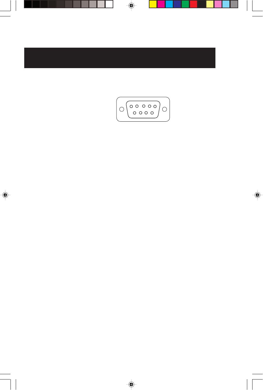
48 Magellan GPS 315/GPS 320
Connecting to DGPS
To use the PC interface cable to interface the GPS receiver with the DBR-2 or
DBR-3, you must use a null modem (Radio Shack P/N: 26-264A) and a gender
changer (Radio Shack P/N: 26-280A) to connect the GPS receiver properly. This
is due to the pinout being the opposite of the DB9 connector configuration for a
PC connection.
For the DBR (differential beacon receiver) that has a DB9 connector on the
housing, the pinout is:
9
51
6
Pin 2: Data out to GPS
Pin 3: Data in
Pin 5: Sig. GND

Magellan GPS 315/GPS 320 49
Troubleshooting
Receiver will not turn on:
1. Check to see if batteries are installed correctly.
2. Replace with two new AA alkaline or lithium batteries.
Takes more than 10 minutes to get a position fix:
1. If there are any obstacles nearby or overhead, move to a new
location.
2. Make sure that the antenna is pointing up, has a clear view of the
sky and is a reasonable distance away from your body.
3. Check Satellite Status to see where the satellites are and if the
receiver is acquiring data.
4. If the receiver still does not get a position fix within 10 minutes,
you may wish to repeat the initialization procedure.
Elevation jumps up and down:
1. Errors induced by the Department of Defense called Selective
Availability (SA) can cause the elevation values to fluctuate.
Battery life seems shorter than it should be:
1. Make sure that you are using two AA alkaline or lithium
batteries.
2. Shorter life span of the batteries can be due to excessive use of
the backlight. Turn the backlight off when not needed.
Position coordinates on your receiver do not match the location on
your map.
1. Make sure that your receiver is set up to use the same datum as
your map. The map datum is generally shown in the map
legend. See Map Datum under Reference for instructions on
selecting the map datum in your receiver.
2. Check your LAT/LON format. Make sure that the format
selected in COORDINATE SYSTEM (DEG/MIN/SEC or
DEG/MIN.MM) is in the same format as the map you are
using.

50 Magellan GPS 315/GPS 320
Commonly Asked Questions
Does the receiver adjust itself for daylight savings time?
No. You need to reset the time for changes in your area (see
Selecting Time Format).
Will my receiver function correctly in the year 2000?
Yes. Even though the last two digits of the year are displayed, the
full year designator is stored in memory.
Why won’t the receiver accept the coordinates I am inputting?
The most common cause is that you are trying to enter coordi-
nates that are in degrees/minutes while your receiver is set to
degrees/minutes/seconds. Because the last two digits in degrees/
minutes are in hundredths (00-99) and degrees/minutes/seconds
can be no higher than 59 (00-59), inputting a number higher
than 59 while in deg/min/sec results in an error and the receiver
does not accept the entry.
Can I use NiCad batteries in my receiver?
Yes. However, the battery life of your receiver will be diminished
as well as the possibility of an incorrect reading on the battery
life gauge with the use of NiCad batteries.
You say my receiver should work up to 15 hours on two batteries, but
mine doesn’t last that long?
There can be two reasons. The first, and most common, reason
is that you have the display backlight on. The light increases the
drain on the batteries causing the decrease in battery life. The
second reason is that you are using NiCad batteries. As men-
tioned, while your receiver will operate on NiCad batteries, the
battery life is diminished.
Why is the time and date incorrect after I replace the batteries?
If the batteries are removed for 20 minutes or more, the receiver
will lose the time and date. The receiver will collect time and
date soon after tracking a satellite.
Magellan GPS 315/GPS 320 51
Contacting Magellan
If after using the troubleshooting section, you are still unable to solve
your operation problems, please call Magellan’s Technical Service at
(800) 707-9971.
Representatives are available Monday through Friday from 7 AM to
5 PM, PST. Faxes can be sent to Customer Service at (909) 394-7070.
If necessary, you can also return your receiver to Magellan for repair
(please call for assistance first). If possible, please notify us before
shipping the receiver by Parcel Post or UPS and include a description of
the problem, your name, address and a copy of your sales receipt. If
your return ship address is different, please indicate.
Please return the enclosed registration card in order to have your
information on file.
With all correspondence, please state the model of your receiver and if
calling, please have your receiver with you.
Packages should be sent to:
Magellan Corporation
960 Overland Court
San Dimas, CA 91773
ATTN: Warranty/Repair
Shipping Your Receiver
When shipping your receiver by air, loosen the battery door screw by
turning the screw by 1/2 turn. This will prevent damage to the
receiver’s water seal during shipping due to pressure differences.

52 Magellan GPS 315/GPS 320
NMEA DATA MESSAGES
Your GPS receiver can be set to output GPS data in the NMEA 0183 version
1.5 or version 2.1 format to interface with other marine devices or equipment.
NMEA DATA MESSAGES. NMEA data is output at 4800 baud, 8, N, 1,
checksum off. These settings are acceptable to most equipment and software
applications. The baud rate can also be set to 1200, 9600 or 19200.
There are several NMEA output message sets, each with a slightly different
application. Check documentation for your external equipment to choose
the appropriate message set.
SET OUTPUT/USAGE
V1.5.APA BWC, APA, GLL, VTG
Remote displays, version 1.5 marine autopilots
V1.5 XTE XTE, BWC, GLL, VTG
Version 1.5 Marine autopilots
V2.1 GSA GSA, GSV, GLL, GGA, RMB, RMC and APB. Vers. 2.1
NMEA is recommended for navigation data, satellite
data and autopilots.
NMEA Message Definitions
APA Autopilot cross track error, direction to steer, status of GPS, route status,
destination waypoint name, and bearing from origin to destination
(old format).
APB Revised autopilot message contains all of the above plus: heading to
steer toward destination, bearing from the present position to the
destination (magnetic or true).
BWC Range and bearing to a waypoint.
GGA GPS position, time, fix quality, number of satellites used, HDOP
(Horizontal Dilution of Precision), differential reference information,
and age.
GLL GPS-derived latitude, longitude, and time of fix.
GSA GPS receiver operating mode, satellites used in the navigation solution
reported by the $--GGA sentence and DOP (Dilution of Precision)
values.
GSV Number of satellites in view, satellite numbers, elevation, azimuth, and
SNR value.
RMB Data status, cross track error, direction to steer, origin, destination
landmark, landmark location, bearing to destination, and velocity
toward the destination.
RMC Time, latitude, longitude, speed, heading, and date.
VTG Track (magnetic and true) and groundspeed (knots and KPH).

Magellan GPS 315/GPS 320 53
NMEA OUTPUT DATA FORMAT - VERSION 1.5
APA Autopilot Format A
1 2 3 4 5 6 7 8 9 10
APA,A,A,X.XX,L,N,A,A,XXX.,M,CCC
1 OR’ed Blink and SNR (A = valid, V = invalid)
2 Cycle Lock (A = valid, V = invalid)
3-5 Cross Track, Sense (L = steer left, R = steer Right), N.Mi.
Units
6-7 Arrival Circle, Arrival Perpendicular (crossing of the line
which is perpendicular to the course line and which passes
through the destination waypoint.
8-9 Bearing dest. WPT. from origin WPT., Magnetic
10 Dest WPT. identifier
BWC To Selected Waypoint, Great Circle
1 2 3 4 5 6 7 8 9 10 1112
BWC,XXXXXX,XXXX.XX,N,XXXXX.XX,W,XXX.,T,XXX.,M,XXX.X,N,CCCC
1 UTC of Bearing
2-3 Lat, N or S of waypoint
4-5 Long, E or W of waypoint
6-7 Bearing, True
8-9 Bearing, Magnetic
10-11Distance, naut. miles
12 Waypoint identifier
GLL Geographic Position — Latitude/Longitude
1 2 3 4 5 6
GLL,1111.11,a,yyyyy.yy,a,hhmmss.ss,A*hh
1-2 Latitude, N/S
2-3 Longitude, E/W
4 UTC of position
6 Status A = Data valid

54 Magellan GPS 315/GPS 320
VTG Actual Track and Ground Speed (SPD)
1 2 3 4 5 6 7 8
VTG,XXX.,T,XXX.,M,XX.X,N,XX.X,K
1-2 Track degrees, True
3-4 Track degrees, Magnetic
5-6 Speed, knots
7-8 Speed, kilometers/hour
XTE Cross Track Error
1 2 3 4 5
XTE, A,A,X.XX, L,N
1 Or’ed value Blink and SNR (A=Valid, V=Invalid)
2 Cycle Lock, (A=Valid, V=Invalid)
3 Cross Track Error
4 Steer Left of Right (L = Left, R = Right)
5 Units (N.Mi.)
NMEA 0183 VERSION 2.1
APB Autopilot Sentence “B”
1 2 3 4 5 6 7 8 9 10 11 12 13 14
APB,A,A,x.x,a,N,A,A,x.x,a,c—c,x.x,a,x.x,a*hh
1 Status:
A = Data valid
V = Loran-C Blink or SNR warning
V = general warning flag for other
navigation systems when a
reliable fix is not available.
2 Status: V = Loran-C cycle lock warning flag
A = OK or not used
3 Magnitude of XTE
4 Direction to steer (L, R)
5 XTE units, nautical miles
6 Status: A = arrival circle entered
7 Status: A = perpendicular passed at waypoint
8-9 Bearing origin to destination, M/T
10 Destination waypoint ID
11-12 Bearing, present position to destination, Magnetic or True
13-14 Heading to steer to destination waypoint, Magnetic or True

Magellan GPS 315/GPS 320 55
GGA Global Positioning System Fix Data
1 2 3 4 5 6 7 8 9 10 11
GGA,hhmmss.ss,1111.11,a,yyyyy.yy,a,x,xx,x.x,x.x,M,x.x,
12 13 14
M,x.x,xxxx*hh
1 UTC of Position
2-3 Latitude - N/S
4-5 Longitude - E/W
6 GPS Quality Indicator
0 = fix not available or invalid
1 = GPS SPS Mode, Fix valid
2 = Differential GPS, SPS Mode, fix valid
3 = GPS PPS Mode, fix valid
7 Number of satellites in use (00-12, may be different
from the number in view)
8 Horizontal dilution of precision
9 Antenna altitude above/below mean sea level
10 Units of antenna altitude, meters
11 Geoidal separation - difference between the WGS-84
earth ellipsoid and mean sea level (geoid), “-” =
mean sea level below ellipsoid
12 Units of geoidal separation, meters.
13 Age of Differential GPS data - Time in seconds since
last SC104 Type 1 or 9 update, null field when DGPS
is not used
14 Differential reference station ID, 0000-1023
GLL Geographic Position — Latitude/Longitude
1 2 3 4 5 6
GLL,1111.11,a,yyyyy.yy,a,hhmmss.ss,A*hh
1-2 Latitude, N/S
2-3 Longitude, E/W
4 UTC of position
6 Status A = Data valid
V = Data not valid

56 Magellan GPS 315/GPS 320
GSA GPS DOP and Active Satellites
GPS receiver operating mode, satelites used in the navigation
solution reported by the $--GGA sentence, and DOP values.
1 2 3 4 5 6 7
GSA,a,x,xx,xx,xx,xx,xx,xx,xx,xx,xx,xx,xx,xx,x.x,x.x,x.x*hh<CR><LF>,
1 Mode: M=Manual, forced to operate in 2D or 3D mode,
A=Automatic, allowed to automatically switch 2D/3D
2 Mode: 1= Fix not available, 2=2D, 3=3D
3-4 PRN numbers of satellites used in solution (null for unused
fields)
5 PDOP
6 HDOP
7 VDOP
GSV GPS Satellites in View
Number of satellites (SV) in view, PRN numbers, elevation,
azimuth and SNR value. Four satellites maximum per transmis-
sion, additional satellite data sent in second or their
message. Total number of messages being transmitted and the
number of messages being transmitted is indicated in the
first two fields.
1 2 3 4 5 6 7 8 9 10 11
GSV,x,x,xx,xx,xx,xxx,xx.........,xx,xx,xxx,xx*hh<CR><LF>
1 Total number of messages, 1 to 9
2 Message number, 1 to 9
3 Total numer of satellites in view
4 Satellite PRN number
5 Elevation, degrees, 90° maximum
6 Azimuth, degrees True, 000 to 359
7 SNR (C/No) 00-99 dB, null when not tracking
8-9 2nd-3rd SV
10-11 4th SV
Notes: 1) Satellite information may require the transmission
of multiple messages. The first field specifies the total
number of messages, minimum value 1. The second field identi-
fies the order of this message (message number), minimum
value 1.
2) A variable number of “PRN-Elevation-Azimuth-SNR” sets are
allowed up to a maximum of four sets per message. Null fields
are not required for unused sets when less than four sets are
transmitted.

Magellan GPS 315/GPS 320 57
RMB Generic Navigation Information (immediately follows RMC)
1 2 3 4 5 6 7 8 9 10 11 12 13 14
RMB,A,X.XX,a,c--c,c--c,1111.11,a,yyyyy.yy,a,x.x,x.x,x.x,A *hh
1 Data Status (A = valid, V = invalid)
2-3 XTE, naut. miles and direction to steer (L or R) [If XTE
exceeds 9.99 NM, display 9.99 in field 2.]
4 Origin waypoint ID
5 Destination waypoint ID
6-7 Destination Waypoint Latitude (N or S)
8-9 Destination Waypoint Longitude (E or W)
10 Range naut. miles, present fix to destination waypoint
Great Circle. [If range exceeds 999.9 nm, display 999.9.]
11 Bearing, True, Great Circle, Present fix to dest. waypoint
12 Closing velocity to destination, knots
13 Arrival (OR’ed arrival circle and crossing of line which is
perpendicular to the course line and which passes through
the destination waypoint.)
14 CHECKSUM (Mandatory in this sentence.)
RMC Transit Specific (to be followed by RMB)
1 2 3 4 5 6 7 8 9 10 11
RMC,hhmmss.ss,A,1111.11,a,yyyyy.yy,a,x.x,x.x,xxxxxx,x.x,aa*hh
1 Time, UTC of position fix
2 Status (A = valid, V = Navigation receiver warning)
3-4 Latitude at UTC time, N or S
5-6 Longitude at UTC time, E or W
7 Speed over ground, knots
8 Course over ground, degrees
9 Date (DDMMYY)
10 Magnetic variation, degrees (E or W)
11 Mode Indicator
The formats listed are NMEA formats and Magellan receivers may not
output all of the information listed for a particular format.
A complete copy of the NMEA specifications can be obtained from:
NMEA, PO Box 3435 New Bern, NC 28564-3435

58 Magellan GPS 315/GPS 320
Available Datums
IRELA Ireland 1965
KAUAI Kauai
KERTA Kertau 1948
KKJ KKJ (Finland)
LIBER Liberia 1964
LUZON Luzon
MASSA Massawa
MAUI Maui
MERCH Merchich
MINNA Minna
MONTJ
NAHRW Nahrwan, Saudi Arabia
OAHU Oahu
OEGYP Old Egyption
OHAWA Old Hawaiian
OMAN Oman
PITCA Pitcairn Astro 1967
QATAR Qatar National
QORNO Qornoq
RT90 RT90 (Sweden)
SAM56 Provisional So. Am.
1956
SAM69 South American 1969
SCHWA Schwarzeck
SICIL Sicily
SIERR
SWISS
TANAN Tananarive Observatory
1925
THAI Indian (Thailand,
Vietnam)
TIMBA Timbalai
TOKYO Tokyo
USER DEFINED
VOIRO
WGS72 World Geodetic System
1972
YACAR Yacare
ZANDE Zanderij
Datum Full Name Datum Full Name
WGS84 World Geodetic System
NAD27 North America 1927
NAD83 North American 1983
ADIND Adinda
ALASK Alaska
ARC50 Arc 1950
ARC60 Arc 1960
ASTRO Camp Area Astro
AUS66 Australian Geodetic 1966
AUS84 Australian Geodetic 1984
BOGOT Bogota Observatory
BUKIT Bukit Rimpah
CAMPO Campo Inchauspe
CANAD Canada
CAPE Cape
CARTH Carthage
CENAM Central America
CHATH Chatham 1971
CHUAA Chau Astro
CORRE Corrego Alegre
CYPRU Cyprus
DJAKA Djakarta (Batavia)
EGYPT Egypt
EUROP European 1950 (All of Europe)
EUR50 European 1950 (W. Europe)
EUR79 European 1979
GANDA Gandajika Base
GEO49 Geodetic Datum 1949
GHANA
GRB36 Ordinance Survey of GB, 1936
GUAM Guam
GUNSG G. Segara
GUNSR
HAWAI Hawaii
HERAT Herat North
HJORS Hjorsey 1955
HUTZU Hu-tzu-shan
INDIA Indian (India, Nepal)
IRAN Iran

Magellan GPS 315/GPS 320 59
Specifications
CHARACTERISTICS
Performance
Receiver: 12 parallel-channel technology, tracks up to
12 satellites to compute and update information
with quadrifilar antenna
Acquisition Times (under optimal conditions):
Warm Approximately 15 seconds
Cold Approximately 1 minute
Update Rate 1 second continuous
Accuracy:
Position 49 feet (15 meters) RMS (with Selective Availability
turned off)
Velocity 0.1 knot RMS steady state (with Selective Availability
turned off)
Limits:
Speed 951 mph
Altitude 17,500 meters
Physical:
Size 6.2” x 2.0” x 1.3” [h] x [w] x [d]
15.75 cm x 5.08 cm x 3.30 cm
Weight 7 ounces (198.45 grams) with 2 AA batteries installed
Display 2.2” x 1.33” [h] x [w]
5.59 cm x 3.38 cm
high contrast LCD with EL backlit display
Housing Waterproof (Battery compartment is splashproof)
Temp. Range:
Operating 14˚F to 140˚F to (-10˚C to 60˚C)
Storage -40˚F to 167˚F (-40˚C to 75˚C)
Power:
Source 2 AA alkaline or lithium batteries or 9-16 VDC with
power cable
Battery Life Up to 15 hours
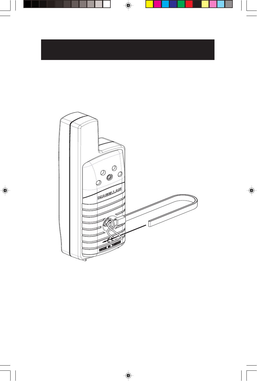
60 Magellan GPS 315/GPS 320
Attaching the Wrist Lanyard
The lanyard for your GPS receiver can be easily attached by inserting
the small loop of the lanyard through the ring provided on the battery
door locking screw and then looping the other end of the lanyard strap
through the small loop.

Magellan GPS 315/GPS 320 61
Accessories
Accessories for your receiver are available from your Magellan dealer or
you can order directly from Magellan using the order card supplied with
your receiver or call Magellan at (800) 669-4477 (press 3 twice to place
an order).
Swivel Mounting Bracket: Mounts the receiver on a surface, allowing
for hands-free operation.
Vehicle Mounting Bracket: Mounts the receiver on the windshield,
allowing for hands-free operation.
Nylon or Leather Carrying Case: The carrying case protects your
receiver from the elements and allows you to carry your receiver on your
belt.
Power/Data Cable (Bare Wires): Allows you to connect your receiver
to external power and data.
PC Interface Cable with Cigarette Lighter Adapter: Connects your
receiver to your PC for data transfer and to a cigarette lighter for
external power.
External Power Cable with Cigarette Lighter Adapter: Allows you to
connect the receiver to a cigarette lighter for external power.
DataSend™ CD-ROM: The software contains a database of points of
interest that can be sent to your receiver. You can select from a number
of geographical locations and download them into your receiver.
DataTrack Waypoint Management Software: Includes DataTrack 3.5
floppy disc GPS data management software.
Instructional Video: A video in VHS format that provides you with
instructions on how to use and operate your receiver.
Differential Beacon Receiver (DBR-3): Connects to your receiver to
receive differential corrections (DGPS) for 5-10 meter accuracy.

62 Magellan GPS 315/GPS 320
Glossary
Active Leg The segment of a route currently being traveled.
Altitude The current elevation above sea level.
BRG Bearing. The compass direction from your position
to a destination, measured to the nearest degree.
Buoy A navigation aid (usually found in marine charts) that
is floating in water. The position can vary due
to the magnitude and direction of the current.
COG Course Over Ground. The direction the receiver is
moving. COG can be reported in true or magnetic
north values.
Coordinates A unique numeric or alphanumeric description of the
position.
CTS Course to Steer. The direction you should be traveling
in order to return to the course while proceeding
towards the destination. It is a “compromise” course
bearing that projects from your current position to a
point on the courseline mid-way between a point
perpendicular to your position and the current leg
destination waypoint.
Datum Refers to the theoretical mathematical model of the
earth’s sea level surface. Map makers may use a
different model to chart their maps, so position
coordinates will differ from one datum to another. The
datum for the map you are using can be found in the
legend of the map. If you are unsure of which datum
to use, use WGS84.
Default The value or setting automatically chosen by the unit
unless otherwise directed. Can be changed in Setup.
DST Distance. Distance from position to destination.
Magellan GPS 315/GPS 320 63
Ephemeris The position and velocity of the satellites in the
sky. The receiver uses the ephemeris to calculate the
precise distance from the GPS receiver to the satellite.
ETA Estimated Time of Arrival. The estimated time of day
the leg’s destination waypoint will be reached.
ETE Estimated Time Enroute. The estimated time
remaining to reach the next waypoint in a route.
Fixed Navaid A navigation aid (usually found in marine charts) that
has a fixed position and can be found on land or water.
An example is a T.V. tower on land or a Greenday mark
in water.
HDG Heading. The direction you are facing, defined as an
angle from North.
Latitude The angular distance north or south of the equator
measured by lines encircling the earth parallel to the
equator from 0˚ to 90˚.
LAT/LON Coordinate system using latitude and longitude
coordinates to define a position on the earth.
Leg (Route) A segment of a route that has a starting (FROM)
waypoint and a destination (TO) waypoint. A route
may consist of 1 or more legs. A route that is from
waypoint A to waypoint B to waypoint C to waypoint
D has three legs with the first being from waypoint A to
waypoint B.
A
B
C
D
Leg 1
Leg 2
Leg 3

64 Magellan GPS 315/GPS 320
LMK Landmark. A location saved in the unit’s
memory which is obtained by entering data,
editing data, calculating data or saving a
current position. Used to create routes. Same
as a waypoint.
Longitude The angular distance east or west of the prime
meridian (Greenwich Meridian) as measured
by lines perpendicular to the parallels and
converging at the poles from 0˚to 180˚.
Magnetic North The direction relative to a magnetic compass
NMEA National Marine Electronics Association. A
professional organization that defines and
maintains the standard serial format used by
marine electronic navigation equipment and
computer interfaces.
OSGB A coordinate system describing only Great
Britain, similar to UTMs. Used with GRB36
datum.
Position fix Position coordinates as computed by the GPS
receiver.
SOG Speed Over Ground. The speed at which the
receiver is moving.
TRN Turn. Degrees or direction to turn.
True North The direction to North Pole from an
observer’s position. The north direction on
any geographical meridian.
TTG Time To Go. The measurement of how long
it will take you to arrive at your destination.
TTG is based on how fast you are moving
towards the destination and the distance
remaining.

Magellan GPS 315/GPS 320 65
UTC Universal Time Coordinated. Formerly
referred to as Greenwich Mean Time (GMT).
UTM Universal Transverse Mercator metric grid
system used on most large and intermediate
scale land topographic charts and maps.
VMG Velocity Made Good. The component of the
velocity that is in the direction of the destina-
tion.
Waypoint WPT. A location saved in the receiver’s
memory which is obtained by entering data,
editing data, calculating data or saving a
current position. Used to create routes.
XTE Cross Track Error. The distance, left or right,
of the desired courseline. The courseline is a
straight line from your present position to
your destination.

66 Magellan GPS 315/ GPS 320
Index
A
Accessories 60
Accuracy 3
Alarms 37
accessing 37; anchor 37;
arrival 38; clearing 40;
defaults 40; proximity 39;
selecting 37; viewing 40;
XTE 38
Anchor alarm 37
Antenna reception 4;
troubleshooting 49
Arrival alarm 38
Automatic Averaging 9
Auxiliary Functions 35
B
Backtrack creating 29
Batteries, installing 3;
life 8; troubleshooting 49, 50;
NiCad 50
Baud Rate 47
Bearing 10, 11, 12, 13, 16, 17,
18
Beeper 45
C
Cities category (based on
population) 1, 22, 23, 24
Clear Memory 46
Connecting to DGPS 48
Compass screen 11; customize
11
Coordinate System
selecting 42; viewing
secondary 9
Commonly Asked Questions 50
Contrast 36
Cross Track Error (XTE) 5, 10,
12, 16; alarm 38
Course over Ground (COG)
9, 10, 11, 12, 16, 17, 18;
Indicator 11
Course Projection 15
Cross Track Error alarm 38
Customer Service 51
Customize NAV Screens (see
Disabling NAV Screens)
Customizing 41
D
DataSend™ 23, 27
Date see Time and Date
Datums see Map Datums
Demo Mode see Simulate
DGPS 9
DGPS conection 48
Differences GPS 315/320 1
Disabling NAV Screens 41
E
Elapsed time 21
Elevation 9; 43
Entering Information 7
Estimated Position Error 9
F
Fish/Hunt 35
Fixed navaid 1, 62
Fixed Position 6

Magellan GPS 315/ GPS 320 67
G
Glossary 61
GOTO clearing 28; creating 28,
in the plotter screen 28
GPS fix alarm 40
H
Hide Data/Show Data 16
I
Initializing 4, 41
K
Keys 2
L
Landmark (LMK) 5
Lanyard strap instructions 60
LAT/LON 42;
troubleshooting 49
Light Timer 45
M
Magnetic North 44
Man Over Board (MOB)
clearing 29; creating 29
Map Datums available datums
58; selecting 43
Map ‘N Track Route 34
Memory clear 46
Message accessing 37;
viewing 37
Modes of operation
see Simulate mode; see 2D, 3D
Multi-Leg route, creating 30
N
Navigation screens 7; Compass
11; disabling 41; Nav 1 10;
Nav 2 12; Plot 13; Position 9;
Road 17; Speed 18; Status 8;
Time 20
Nav Units 44
NiCad batteries 50
NMEA 46; Data Messages
52-57
NorthFinder™ 11
North Reference 44
O
Odometer 18; resetting 18
P
PAN-N-SCAN 14
Personalize 45
Plot Rings 15
Plot Scales 16
Plot screen 13
Plotter 15
Population of cities 24
Position fix 6; troubleshooting
49
Position screen 9
Power On 4
Primary Usage 5
Projecting a Waypoint 25
Proximity alarm 39
R
Receiver size 59
Reception 4
Road screen 17; customize 17

68 Magellan GPS 315/ GPS 320
Route 28; activating/deactivat
ing a route 32; adding a
waypoint at the end of a route
32; changing a waypoint in a
route 31; deleting a waypoint in
a route 32; deleting a route 33;
editing 31; inserting a leg into
a route 31; reversing 33; using
Plot View in a route 33;
viewing 31
S
Satellite positions 8
Satellite signals 8
Setup 41
Shipping 51
Simulate Mode 9, 36
Sorting 26
Specifications 59
Speed screen 18; setting average
19
Status screen 8
Sun/Moon 35
T
2D 8, 43
3D 8, 43
Terminology 5
Time and Date setting 4
Time Format 44
Time screen 20; elapsed time 21
Track History 13, 14; clear 14,
46
TrackRoute 34
Trip Odometer, resetting 19
True North 44
Troubleshooting 49
W
Waypoint creating 24;
creating a message 25;
deleting a user waypoint 26;
deleting a message
25; editing a message 25;
finding a non-user waypoint
26; functions 23; naming 6;
saving 6, 25; sorting a
waypoint 26
Weight, receiver 59
X
XTE see Cross Track Error
XTE alarm see Cross Track
Error alarm
U
Universal Time Coordinated
(UTC) 20, 44


630321 D
960 Overland Court, San Dimas, CA 91773
(909) 394-5000
