Euroscope 3.1d Manual
EuroscopeManual
EuroscopeManual
User Manual: Pdf
Open the PDF directly: View PDF ![]() .
.
Page Count: 177 [warning: Documents this large are best viewed by clicking the View PDF Link!]
- Euroscope:Euroscope
- Euroscope:Credits for v3.1
- Euroscope:Credits for v3.0
- Euroscope:Credits for v2.9
- Euroscope:Quick Start
- Euroscope:Installation
- Euroscope:Where My Settings Are Saved
- Euroscope:Get Connected
- Euroscope:Connection Settings
- Euroscope:Voice Communication Setup
- Euroscope:Voice Hardware Test And Setup
- Euroscope:Download Sectorfiles
- Manually or Automatically Download Sectorfiles
- Setting up EuroScope
- The Automatic Download
- Publish sectorfiles
- Euroscope:Voice ATIS
- Euroscope:Voice Alias
- How to control text only aircrafts using voice recognition in EuroScope
- Euroscope:Connection Features
- Euroscope:Going Into Details
- Euroscope:Multiple Sectorfiles
- Euroscope:Sectors And Aircraft States
- Euroscope:Professional Radar Simulation
- Professional radar simulation in EuroScope
- Euroscope:Radar Screen
- Euroscope:The Menu Bar
- Menu Bar
- Menu Items
- Connection
- Controller login name
- Voice communication setup
- Primary frequency
- Voice ATIS
- Sector files
- Actual sector layout
- Selected aircraft
- Clock
- Other settings
- Quick settings
- Active airports/runways
- Leader line on/off
- Leader line type/length
- History trails
- Show standby aircraft
- Transition altitude
- Altitude filter
- Distance tool
- Separation tools
- Short METARs
- Send screen to the next desktop
- Minimize to taskbar
- Maximize/restore window
- Quit
- Euroscope:Basic Lists
- Euroscope:Advanced Lists
- Euroscope:Distance Separation Tools
- Euroscope:Chat Box
- Euroscope:Flight Strip
- Euroscope:The Command Line
- Euroscope:TAGs
- Euroscope:TAG Editor
- Euroscope:Settings
- Euroscope:Controller To Controller Communication
- Euroscope:General Settings
- Euroscope:Display Settings
- Euroscope:Symbology Settings
- Euroscope:Plug-Ins
- The user perspective of the plug-ins
- Euroscope:Sounds Setup
- Euroscope:Active Airports Runways
- Euroscope:Flight Plan Setting Dialog
- Euroscope:Message Dialog
- Euroscope:Short Term Conflict Alert Settings Dialog
- Euroscope:Extended Centerline Setup
- Euroscope:Sector Ownership Setup
- Euroscope:Non Standard Extensions
- Euroscope:Working with keyboard
- Working with keyboard and mouse
- Euroscope:Editing And Function Keys
- Editing and Function Keys
- Euroscope:Command Line Reference
- Euroscope:Built In Functions
- Euroscope:Built In Simulator
- Euroscope:Tower View
- Euroscope:Appendices
- Euroscope:ESE Files Description
- Euroscope:Scenario File
- Euroscope:Interaction with VRC/ASRC
- Euroscope:Plug In Environment
- Euroscope:FAQ
- Euroscope:Tutorial
- Euroscope:Positions definition
- Euroscope:SECTORLINE Definition
- Euroscope:SECTOR Definition

PDF erstellt mit Hilfe des OpenSource-Werkzeugs „mwlib“. Für weitere Informationen siehe http://code.pediapress.com/
PDF generated at: Tue, 19 Apr 2011 07:18:57 UTC
Euroscope 3.1d
Manual

Euroscope:Euroscope 1
Euroscope:Euroscope
Previous: No previous pages Actual: Euroscope:Euroscope Next: Euroscope:Credits for v3.1
About EuroScope
Version 3.0 was introduced more than a year ago in March 2008. Since then my team and myself never stopped
adding new ideas and implementing new features to EuroScope. As we were a bit uncontrolled on what should be
available in the next release we simply lost the momentum several time to become public for a favor of some new
functions. We are still full of ideas and requests, but finally we decided to make a stop and prepare the next public
release. If we were alone we would have fixed more things we would have added some more gadgets to the program.
Therefore the beta team feels this is not the final version. But we know that it if far more better then version 3.0, and
we would like to share the joy of controlling with EuroScope 3.1 with all the controllers of VATSIM.
Some highlights of the new features:
• Plug-in development environment: Probably the biggest innovation in this release. Using it you can create your
own DLLs that can be loaded into EuroScope. As a programmer you can access nearly all the information
available about planes, flight plans, controllers around. You are free to make code to add elements to a TAG,
draw your own graphics to the radar screen or simply create a complete new view of the traffic. Some plug-ins are
available as source code in the installer package.
• Professional radar simulation: The main idea is to forget some data we receive from the VATSIM servers and
simulate how the radar stations receive back data from the planes, how these data is correlated to the flight plans
sent. And if all work fine you can associate a radar position to a flight plan (actually a plane). You can define
antenna positions, hole areas, primary and secondary ranges, A+C and S mode transponder readouts. You also
have simulated flight plan track display.
• Complete new TAG types to follow the new possibilities:
• primary only
• uncorrelated A+C
• uncorrelated S
• correlated A+C
• correlated S
• flight plan track
• ground with S mode
• ground without radar
• New simulator features:
• Connect to SweatBox server
• More than 100 AC performance data is stored in EuroScope with the possibility to change them in the scenario
file
• Accurate handling of the AC in high flight levels (simulating IAS and Mach change)
• Integration with Craig Phillip's ASE editor [1] and scenario file repository (download scenario directly from
there)
• Local FSD support for simulation sessions
• Automatic sector file publication and download.
• Metric units.
• Full VATSIM server status check at startup.

Euroscope:Euroscope 2
• The possibility to individually confirm all message types.
• The voice aliases: It is a complete new (and I hope revolutionally) way to control text only aircraft. We combined
the Microsoft Speech Recognition SDK with a regular expression like grammar definition (with sounds like
capabilities). These items altogether make the voice recognition stable and precise enough to be used for text only
aircraft.
• Arrival and flight plan lists.
• Support of VRC's SCT2 format files.
• All symbols are now freely editable via the symbology settings dialog.
• The autotext messages are using aliases to allow changing them.
And many many more fixes and new features.
Have you ever imagined you could control virtual flights as real as it gets? Download the latest version of EuroScope
and see for yourself.
Previous: No previous pages Actual: Euroscope:Euroscope Next: Euroscope:Credits for v3.1
Referenzen
[1] http:/ / www. craig-phillips. co. uk/ ase
Euroscope:Credits for v3.1
Previous: Euroscope:Euroscope Actual: Euroscope:Credits for v3.1 Next: Euroscope:Credits for v3.0
Credits for v3.1
Once again the new release was a real team work. I should say thank you for all the members of the beta team. It is
really hard to pick individuals from the team. But surely there are some points:
• Stephan Boerner - Who updated extreme amount of pages of this documentation. Without it the release date
would not be in 2009.
• Craig Phillips - Who made the ASE repository available directly from EuroScope. He also modified the ASE
editor to use the new features EuroScope is offering in the scenario file.
• Arthur Bocaneanu - For creating the default sounds set.
Previous: Euroscope:Euroscope Actual: Euroscope:Credits for v3.1 Next: Euroscope:Credits for v3.0

Euroscope:Credits for v3.0 3
Euroscope:Credits for v3.0
Previous: Euroscope:Credits for v3.1 Actual: Euroscope:Credits for v3.0 Next: Euroscope:Credits for v2.9
Credits for v3.0
Without the help of several supporters EuroScope would never become a public VATSIM radar client. Therefore I
would like to thank this help to:
• Attila Ábrahám - He inspired me to work on the new features and most importantly the ongoing Coordination. He
always supplied me all the information that was necessary to have it as close to the real life system as possible.
And I have to say that (among others) Attila has the most rigorous eye on the functionality. He also created a full
featured ATIS interpreter.
• Todor Atanasov, Bernard Candela and Stephan Boerner - They helped me a lot to finalize the documentation you
are reading just now.
• Sami Ylismäki - for creating UNIAtis, the customizable ATIS interpreter (http:/ / www. uniatis. net/ ).
• Juha Holopainen - for collecting and converting all the aircraft data for EuroScope.
• Tobias Reimann - for creating a EuroScope extract function from his ICAO airlines database (http:/ / vatdb.
tr-media. org/ ).
• All the beta testers - Once again they helped me a lot to fix bugs, implement the right functions you need for
everyday controlling.
Previous: Euroscope:Credits for v3.1 Actual: Euroscope:Credits for v3.0 Next: Euroscope:Credits for v2.9

Euroscope:Credits for v2.9 4
Euroscope:Credits for v2.9
Previous: Euroscope:Credits for v3.0 Actual: Euroscope:Credits for v2.9 Next: Euroscope:Quick Start
Credits for v2.9
• Eric Bocaneanu - Who always believed that we can make a client that can be accepted by VATSIM governors. He
made all the discussions, advertisements to start the beta testing EuroScope. He also helped me a lot in testing,
writing documentation and making suggestions.
• Péter Selmeci - Who created the initial WEB site, redesigned my awful WEB pages. He helped in testing, writing
the documentation and also with lots of new ideas.
• Péter Selmeci and Iván Radó - For the name: EuroScope.
• Attila Ábrahám and Ádám Orbán - They made a really strong pressure on me to develop EuroScope to the good
direction. They also helped me a lot in testing.
• Dani Vértesy - To help me writing this page among others.
• Iván Nagy - Who registered euroscope.hu domain for me without any cost so far.
• Todor Atanasov - Who created the final WEB site.
• Ross Carlson and Ben Supnik - They helped me a lot how to make EuroScope VATSIM compatible. I received
immediate support when I had any technical question about the FSD protocol or VATSIM voice library. Ross
made the beta test possible and updated my beta test members regularly.
• Richard Stefan and Navigraph FMS Data Support - They allowed me to pack the FMS data with the installer of
EuroScope. If you need to update the AIRAC cycle visit http:/ / www. navigraph. com/ for the latest release.
Always download the version for FSNavigator 4.X.
• All beta test members - They tested EuroScope in different environments and surely in different ways. Many
things that I would have never thought were discovered by them. And they also helped me writing this
documentation.
• All VACCHUN members - Who was not part of the beta test team still helped me a lot on testing VRC and ASRC
compatibility questions.
Previous: Euroscope:Credits for v3.0 Actual: Euroscope:Credits for v2.9 Next: Euroscope:Quick Start

Euroscope:Quick Start 5
Euroscope:Quick Start
Previous: Euroscope:Credits for v2.9 Actual: Euroscope:Quick Start Next: Euroscope:Installation
Installation
The step by step instructions are available in the Euroscope:Installation page.
If You Have a Previous Release Installed
All versions after version 3.0 save all relevant data in individual files as opposed to the registry. The different
settings are split into categories and may be saved in one or several setting files (.txt format) depending on your
preferences. This enables you to use the same settings in multiple profiles on your computer. Ensure you read
Euroscope:Where My Settings Are Saved for a more complete overview.
What You See
•Profile file selection - When you start EuroScope for the first time it will ask for the profile file to be used. Use
the one for Hungarian Matias if you do not have any other or simply cancel it for an empty one. If you do not
select profile file or your profile does not have a reference to a sectorfile then your radar screen will be
completely empy. In that case load the sectorfile manually. Any ASRC or VRC SCT or SCT2 file can be used.
•Radar screen configuration - Normally EuroScope saves your display settings to files with *.ASR extensions.
When you start EuroScope it will load the last opened *.ASR file. But if you start it for the first time then
obviously no such file exists. In this case the default settings will be applied to your first screen. It will contain
only the VOR symbols, airport names, high airway lines and ARTCC boundaries. Be sure to open the Display
Settings dialog to switch on and off the individual items, modify the radar layout to your taste and save it into an
.ASR file for your next session. If yo do not like the default coloring or line styles just go to the
Euroscope:Symbology Settings dialog and change.
•VATSIM servers data - In the bottom message are you can see that EuroScope collects data about the available
servers in VATSIM. Every time you start EuroScope a random server will be selected to serve as server data feed
and as statistical data feed.
•VATSIM statistics data - As you start EuroScope just wait for 10-30 seconds. After that period of time the radar
screen comes alive and displays controllers and aircraft just as if you were connected and online. That is because
EuroScope incorporates with VATSIM statistics data. It downloads data about the online members and starts
simulating them while you are offline. But in this state you can start analyzing the traffic, see who is online, what
is next on VATSIM.
• Tip: Open Euroscope:Voice Communication Setup and select any position as primary frequency. The radar
screen will be displayed as if you were online with that callsign of the voice connection name and frequency.

Euroscope:Quick Start 6
What You Hear
Before going online you should go to Euroscope:Voice Communication Setup dialogue to define your voice
connections abd to access the Hardware setup button in order to configure your sound hardware with the
Euroscope:Voice Hardware Test And Setup dialogue. Without these steps you will not be able to listen to or talk to
anyone.
How To Use Existing Sector And Position Files
To be able to use all of the features of EuroScope one has to create a sector file extension. This can be real hard work
and needs special knowledge of the area you are controlling within. The ESE files should be created by the
appropriate staff members of your FIR. We are ready to support all ESE file related questions via the support e-mail.
But to be able to start quickly you should do the following modifications:
Edit the runway section in the .SCT file. Add the airport name or code to the end of each line. Original:
[RUNWAY]
13L 31R 130 310 N047.26.43.520 E019.15.27.180 N047.25.22.620 E019.17.37.880
Modified to:
[RUNWAY]
13L 31R 130 310 N047.26.43.520 E019.15.27.180 N047.25.22.620 E019.17.37.880 LHBP Ferihegy
To use your POF file simply rename it to the same name as your SCT file with the extension ESE (eg. You have
myfir.sct and mypos.pof then rename the mypos.pof to myfir.ese ). Then add a new line to the beginning of the file:
[POSITIONS]
In this way you will be able to use both the sector and the position file without hard modification.
Previous: Euroscope:Credits for v2.9 Actual: Euroscope:Quick Start Next: Euroscope:Installation

Euroscope:Installation 7
Euroscope:Installation
Previous: Euroscope:Quick Start Actual: Euroscope:Installation Next: Euroscope:Where My Settings Are Saved
If You Have A Previous Release Installed
The installer of the new release will execute an uninstall of the previous version. The uninstaller will delete all files
that were copied to your computer by the installer. It includes the original settings, the ICAO airlines and airports
files and also the FSNavigator database files. It also deletes the ASR files that were provided for the LHCC
sectorfile. If you have saved any configuration to these files, or updated them manually, or downloaded a newer
AIRAC database, then be sure to SAVE THEM to another place before running the installer.
Please keep in mind that since Euroscope 3.1 all personal setting are stored in "..\My Documents\Euroscope\"
directory instead of root as it was in preceding versions.
Installation
Installation of EuroScope is really easy. Just download the MSI file from any of the sites and run it. Then follow the
instructions of the installer. Well, the only thing you should specify is the folder you would like to put the files.
The main download site is the home of Euroscope. This server is located in Hungary. Thanks to Ross Carlson and
Metacraft Internet Services we have a mirror site. It is located in Dallas, Texas. The mirror site my not be available
until the installers are copied there.
• Download from EuroScope home server or
• Download from Mirror.
Euroscope:Installation 8
Prerequisites
The installer requires that you have .NET framework 2.0 installed on you computer. The MSI will prompt for if you
do not have.
Installation Process
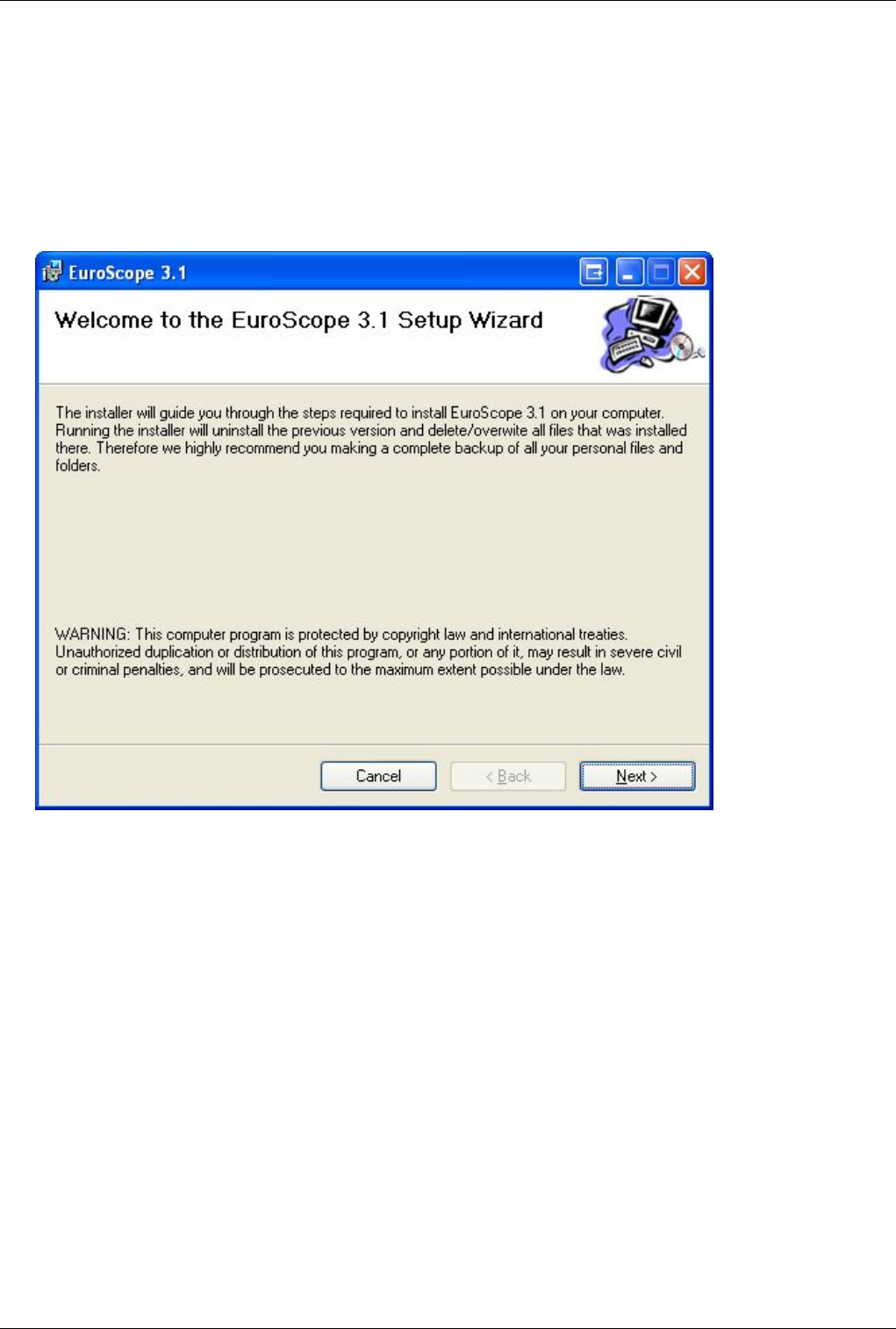
Download the MSI installer. When ready, simply start it. After some preparation seconds the installer Welcome
screen appears:
Just press Next to get to the location selector screen:
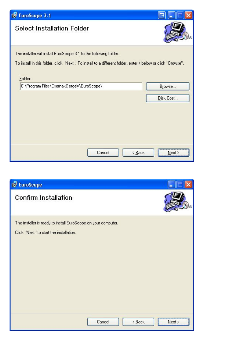
Euroscope:Installation 9
Select the appropriate folder where you would like to place EuroScope. Then press Next again to see the final
confirmation screen:
Simply press Next if you are sure to install EuroScope. The rest is automatic. The progress bar will go from 0 to
100% several times then the installation is ready:
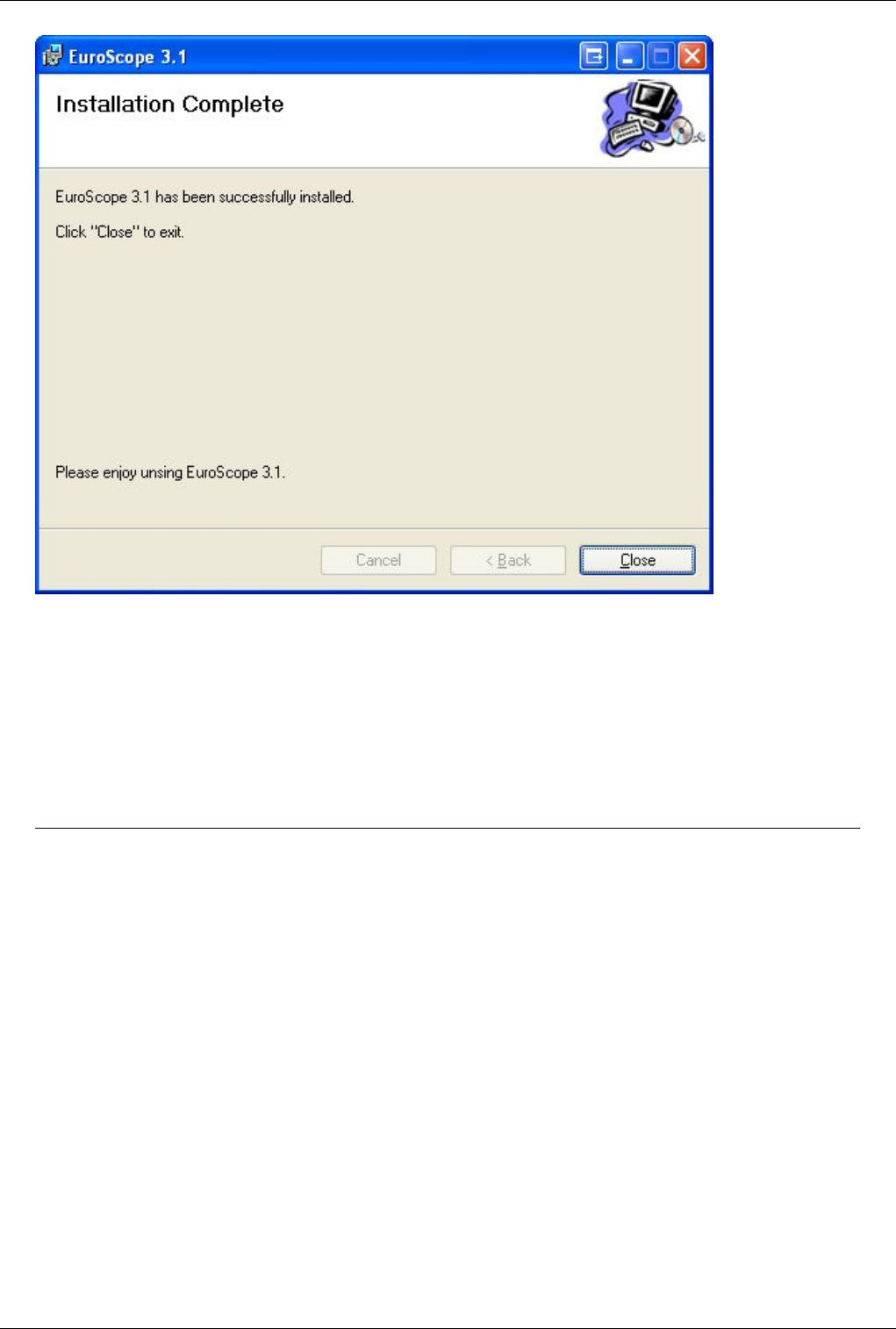
Euroscope:Installation 10
Press the close button and go to the Start menu and under Programs you will find EuroScope current version. Just
start and enjoy using it.
If it is the first time you have installed EuroScope be sure to follow Euroscope:Quick Start page instructions.
Another Important Note About TrueType Fonts
It seems that the in some cases (mostly on Vista or WIndows 7, depending on the user right) the installer is unable to
install or overwrite the font set that was installed before. That will cause some symbols missing in the new release. If
you experience this then go to the EuroScope installation folder and install the EuroScope.ttf font manually.
Previous: Euroscope:Quick Start Actual: Euroscope:Installation Next: Euroscope:Where My Settings Are Saved
Euroscope:Where My Settings Are Saved 11
Euroscope:Where My Settings Are Saved
Previous: Euroscope:Installation Actual: Euroscope:Where My Settings Are Saved Next: Euroscope:Get Connected
About Settings
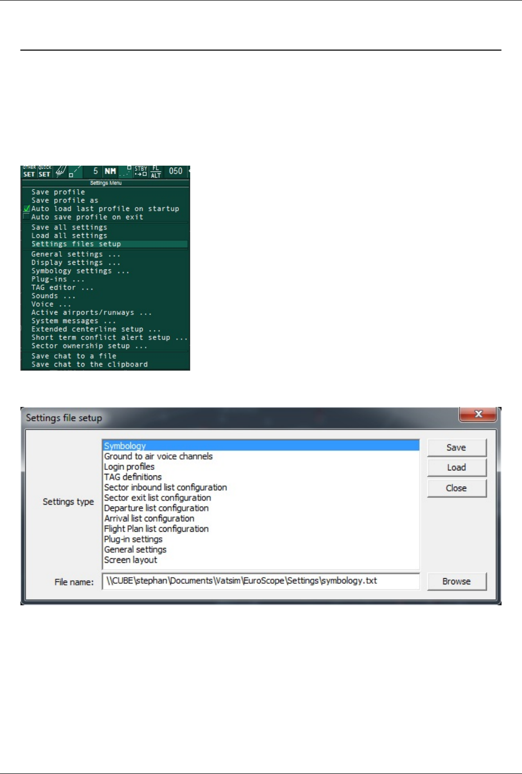
In EuroScope you can specify all files to store the indiviual settings in. The dialog for this is located in the Other
Settings menu.
In the dialog you can specify the files including the paths to the files. You can combine several settings into one file,
if you want them to be stored and loaded only in combination.
Euroscope:Where My Settings Are Saved 12
Settings Files
Those files contain several different kinds of settings. You can open them with a text editor to learn more since there
are many parameters, most of them being self explanatory.
You can specify individual files for the following settings:
• Symbology - Here you can find the values from the symbology settings dialog. It describes what colors, sizes, line
styles to be used for the map display.
• Ground to air voice channels - You frequencies / voice channels from voice communications setup dialog.
• Login profiles - The login profiles from the connect dialog. It contains the callsign, facility, range and ATIS lines.
• TAG definitions - The user defined TAG families.
• SIL, SEL, DEP, APP, FP lists configuration - The definition of the advanced AC lists.
• PlugIn settings - any plugin specific settings.
• General settings - All lines beginning with m_ are the general settings. You can change them via the Quick SET
menu or one of the settings dialogs. I suppose the names here are really readable.
• Screen layout - all settings related to the screen layout, which are not stored in the ASR-file.
You can also combine some of those settings into one file, for example you can create a screen layout including lists
by using the same file for list configurations and screen layout.
If you have a complete settings file from 3.0 then follow the steps to use them in 3.1:
• Open the Settings file setup dialog box
• Enter the file name where your settings are into EVERY group
• Press the LOAD button to load the values into memory
• Then you can save them to individual files (if you want to), or just keep all your settings in one file.
The Profile Files
The profile files are created to store all installation or workstation dependent information. They are not intending to
be moved from one workstation to another as there are full paths, video card size information there too. The profile
files are just plane textfiles (it is quite common for EuroScope) with the extension PRF. You can put them to any
place in your workstation.
The good thing about saving these data to a file instead of the registry is that you may have as many configurations
as you need. All profiles are completely independent from the others (except if they are referencing to the same
files). The name of the profile file can also be used as a command line parameter for EuroScope. In this way you can
setup as many shortcuts, desktop icons as you need, and start the right configuration with a doubleclick.
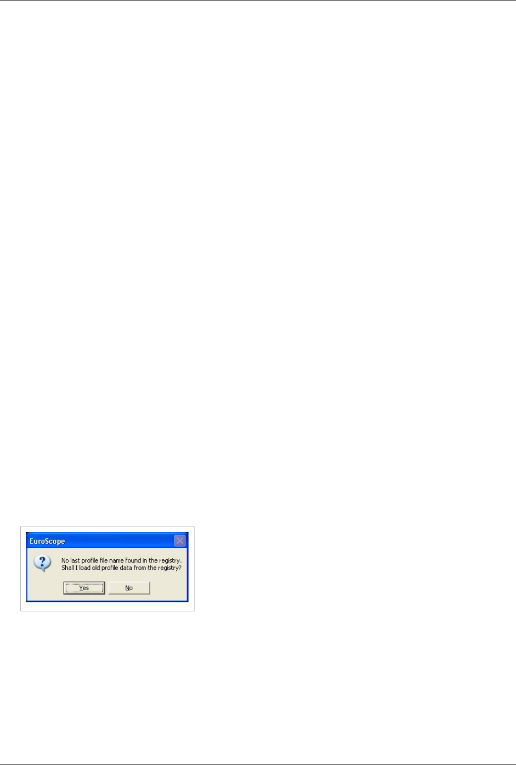
If you are version 2.9a user then you may noticed that several data is
stored in the registry (under My Computer \
HKEY_CURRENT_USER \ Software \ Csernak Gergely \ EuroScope
). From version 3.0 all this information is moved to a profile file. If you
run version 3.0 for the first time while you have saved data in the
registry EuroScope will detect and prompt to load the data saved in the
registry. If you accept then it reads the old data from the registry. Be
sure to save your newly loaded profile to a file just after loading it from the registry. If you decline then the default
values will be used instead. From this point only the name of the lastly used profile file and two flags (to indicate
auto load and auto save of the last profile) are stored in the registry. The rest may be removed.
Going into details about the profile file: As the data here came from the registry, it is structured like the registry
entries. First the section name after that the key itself. In the file the following information is stored:

Euroscope:Where My Settings Are Saved 13
• Last Session section - It contains data about your last EuroScope session. They are one by one related to the
filelds in the Euroscope:Connection Settings. The only exception is the ATIS airport and letter that is used in
Euroscope:Voice ATIS dialog.
• atis_airport - the airport served by voice ATIS
• atis_letter - the last time used ATIS letter in your airport
• atis2, atis3, atis4 - the text ATIS message lines (numbered from 2, as the first is always your voive channel
description)
• callsign - the connect callsign
• certificate - your VATSIM ID
• connecttype - a code how you connected last time
• facility - the facility of the last session
• password - the password entered - Important: your password is stored in this file without any encryption. Due
that you MUST NOT give your profile file to someone else.
• playback - the last playback file with full path name
• range - the visual range of the last session
• rating - your rating
• realname - your real name
• scenario - the last use simulation scenario file with full path
• server - the lastly connected VATSIM server
• Recent Files section - It is a simple numbered list of your lastly used ASR files. The files here will be displayed in
the SCT menu.
• Settings section - In this section there are data about how your environment are set up. What configuration files
do be loadedand what hardware elements do you use:
• aircraft - full path to the ICAO Aircraft file
• airlines - full path to the ICAO Airlines file
• airports - full path to the ICAO Airports file
• airways - full path to the FSNavigator database
• alias - full path to the alias file
• Asel Key - the aircraft select key code
• Atis Folder - full path to the voice ATIS description file
• Freq Key - the primary frequency key code
• ipaddr - full path to the VATSIM server descriptor file
• sector - the main sectorfile (as it is from the last session it may be better to put to the Last Session section)
• Settings Files - full path to the settings files (many installation independent data is stored there)
• Loaded PlugIns - full path to the dll files
• Sounds section - Full path of the file names used for voice messages. They are not self explanatory, just
numbered.
• Voice section - Here are the settings about your sound hardware configuration.
• bass_filter - enable or disable bass filtering
• input_hardware - the primary mike input device name
• input_hardware2 - the secondary mike input device name
• output_hardware - the primary speaker/headphone device name
• output_hardware2 - the secondary speaker/headphone device name
• PPPT - the primary push to talk button code
• SPPT - the secondary push to talk button code
• squelch - the value measured on primary mike

Euroscope:Where My Settings Are Saved 14
• squelch2 - the value measured on secondary mike
Important note: As you see from the above list, your last session user name and password is in the profile file. And
they are there without any encryption. Therefore be very careful and DO NOT give, send, share your profiles to
anyone else.
ASR Files
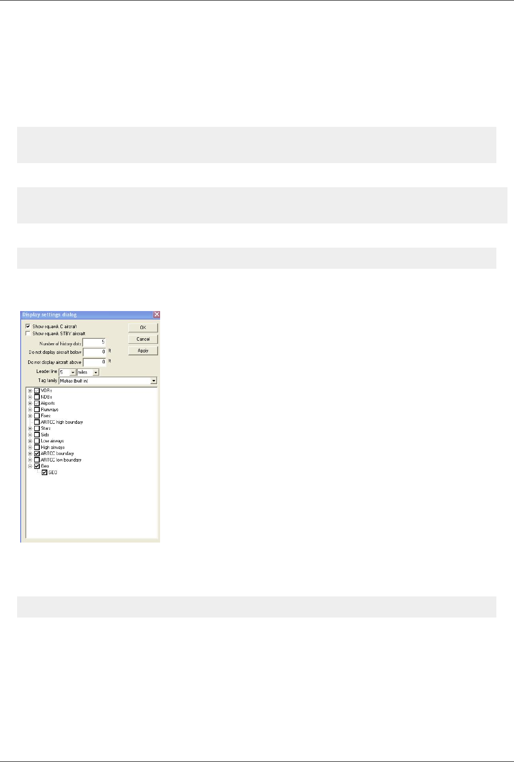
The .asr file contain your current Display Dialog settings. It describes what items are to be displayed from the
sectorfile. It also contains some screen dependent settings and the use of Euroscope:Professional Radar Simulation.
Once again without the complete description some notes about the lines inside:
• SECTORFILE - The path of your current sector file this ASR is used for. When you open an ASR it will look if
the sectorfile is loaded or not. If not then it loads the appropriate one.
• SECTORTITLE - Just a quick access to the title to show in the popup list.
• DisplayTypeName - The name of the screen type. The default value is 'Standard ES radar screen'. Other may be
created by the plug-ins.
• DisplayTypeNeedRadarContent - It indicates that background SCT file elements are drawn for the screen or not.
• DisplayTypeGeoReferenced - It indicates if coordiantes are lat/lon pairs or just pixels.
• SHOWC - (value if 1 if checked or 0 if unchecked) "Show squawk C aircraft" option.
• SHOWSB - "Show squawk STBY aircraft" option.
• BELOW - xxxxx. The value if you choose not to display aircrafts below xxxxx feet altitude (your floor level).
Zero indicates no filter at all.
• ABOVE - xxxxx. The value if you choose not to display aircrafts above xxxxx feet altitude (your ceiling level).
Zero indicates no filter at all.
• LEADER - The length of the leader line. Positive values are interpreted as NM, negaive as MIN.
• SHOWLEADER - Indicates if the leader line should be shown as default or not.
• TURNLEADER - It indicates a route following leader line.
• HISTORYDOTS - The number of history trails appearing for each aircraft.
• TAGFAMILY - The name of the tag family used (generaly MATIAS (built in)).
• WINDOWAREA - param1:param2:param3:param4 - The geographic coordinates in degrees of the bottom left
corner and of the top right corner of the scope. It is important that even if you do not change any settings, just
zoom in and out and pan, this value is most likely to be updated. In this way it is quite normal that you will be
prompted at nearly all ASR close to decide weather to save or cancel the update of the area.
• SIMULATION_MODE - The ID of the simulation mode (professional radar, easy radar and the two ground
modes).
• individual sectorfile elements - Then follows the list of all your checked items in the display dialog. You can not
save the SECTORLINE and SECTOR elements as they can be switched on just for debugging purposes and not
for next session display.
Euroscope:Where My Settings Are Saved 15
Sector Files
Sector files are the files which contain all information about the area you want to control. EuroScope can use the
same sector files as ASRC or VRC. There are two places where you should or can modify them:
The first is the Runway section. It is described in the Quick Start page too. You should modify this to be able to
display and use the runway data inside EuroScope.
Original:
[RUNWAY]
13L 31R 130 310 N047.26.43.520 E019.15.27.180 N047.25.22.620 E019.17.37.880
Modified to:
[RUNWAY]
13L 31R 130 310 N047.26.43.520 E019.15.27.180 N047.25.22.620 E019.17.37.880 LHBP Ferihegy
There is another option for the GEO section. In a ASRC/VRC sector file, GEO lines appear like that:
N036.58.51.798 E008.51.32.509 N036.58.50.305 E008.51.32.422 white
So in VRC, you can display GEO lines or not but always as a whole.
If you load a normal ASRC/VRC sector file in Euroscope, you see that:
You can display GEO lines or not, in the same manner than with VRC.
But EuroScope allows us to define sub-categories in GEO lines by adding a category name at the beginning of each
normal GEO line like the one below:
DTKA airport N036.58.51.798 E008.51.32.509 N036.58.50.305 E008.51.32.422 white
And when all lines have been modified (that's done very easily with Excel) the Display Dialog appears like that:
Euroscope:Where My Settings Are Saved 16
So, you can easily filter which kind of GEO lines appears on your screen, and this avoids overwhelming screen with
usefulness features.
NOTE: When sector files have been customized for EuroScope, they can't be used anymore with ASRC or VRC. So,
before customizing a sector file for EuroScope, don't forget to keep an original version for ASRC/VRC users.
In fact the name is only needed in front of the first line of each subsection. For example, the following [GEO]
section works fine:
[GEO]
Red triangle N000.00.00.000 E000.00.00.000 N000.00.00.000 E000.00.00.000
N060.00.00.000 E020.00.00.000 N070.00.00.000 E030.00.00.000 redcolor
N070.00.00.000 E030.00.00.000 N060.00.00.000 E030.00.00.000 redcolor
N060.00.00.000 E030.00.00.000 N060.00.00.000 E020.00.00.000 redcolor
Yellow triangle N000.00.00.000 E000.00.00.000 N000.00.00.000 E000.00.00.000
N062.00.00.000 E024.00.00.000 N066.00.00.000 E028.00.00.000 yellowcolor
N066.00.00.000 E028.00.00.000 N062.00.00.000 E028.00.00.000 yellowcolor
N062.00.00.000 E028.00.00.000 N062.00.00.000 E024.00.00.000 yellowcolor
In EuroScope you will get the two triangles selectable in the Display Settings. This section will also work with
ASRC and VRC. The N000.00.00.000 E000.00.00.000 coordinates in the lines where the names are would not be
needed for ES but since both ASRC and VRC seem to disregard those lines completely it's better to put coordinates
in there that aren't something you want to display.
If you pout the name in front of each line works in ES but it will not work with the other clients. But if you use the
above way, then the same SCT file could be used with the other clients without any problems.
The third extension is for the SCT2 files for the very same reason. If you have regions in your SCT2 file then they
can only be switched on/off all together. If you would like to use them individually add a new line before the start of
a new region:
REGIONNAME <the name of the region element>
These lines are simply ignored by VRC and can be used to name you region elements.

Euroscope:Where My Settings Are Saved 17
Sector File Extension Files
This section is here just to make this page complete. The content of the sector file extension is described in the
Euroscope:ESE Files Description page, and also there is a Euroscope:Tutorial about how to build an ESE file from
scratch.
Runway Files
The runway files are saved along the SCT files, with the same names and the RWY extensions. They are also TEXT
files. There you can find information about the acitve airports and runways of your last session when the SCT file
was used as main sectorfile.
ACTIVE_AIRPORT:LHBP:1
ACTIVE_AIRPORT:LHBP:0
ACTIVE_RUNWAY:LHBP:31R:0
ACTIVE_RUNWAY:LHBP:31L:1
ACTIVE_RUNWAY:LHBP:31L:0
There are two different kind of lines here:
• ACTIVE_AIRPORT - It describes if an airport was active in the last session. The last 0/1 digit means if it was
active for departure (1) or arrival (0).
• ACTIVE_RUNWAY - The same for runways. It describes if a RWY of an airport was active in the last session.
Of course here you also have the airport name and the final number means the same.
Server files
The standard file for the server adresses is ipaddr.txt. The ipaddr.txt file will be overwritten after successful data
download without further notification. Put all your local definitions to the myipaddr.txt file. The SweatBox server is
always added automatically.
Previous: Euroscope:Installation Actual: Euroscope:Where My Settings Are Saved Next: Euroscope:Get Connected

Euroscope:Get Connected 18
Euroscope:Get Connected
Previous: Euroscope:Where My Settings Are Saved Actual: Euroscope:Get Connected Next: Euroscope:Connection Settings
Connection Settings
To learn how to set up the connection parameters, how to use the main connect dialog, go to the
Euroscope:Connection Settings section.
Voice Communication Setup
Details about the voice setup is in the Euroscope:Voice Communication Setup section.
Voice ATIS
The Euroscope:Voice ATIS section describes how to set up your own voice atis station. How to record an play the
atis message.
Connection Features
Much more detailed why and how the connection works can be found in the Euroscope:Connection Features section.
What ports are to be opened, how to forward ports when behind a router.
Previous: Euroscope:Where My Settings Are Saved Actual: Euroscope:Get Connected Next: Euroscope:Connection Settings
Euroscope:Connection Settings 19
Euroscope:Connection Settings
Previous: Euroscope:Get Connected Actual: Euroscope:Connection Settings Next: Euroscope:Voice Communication Setup
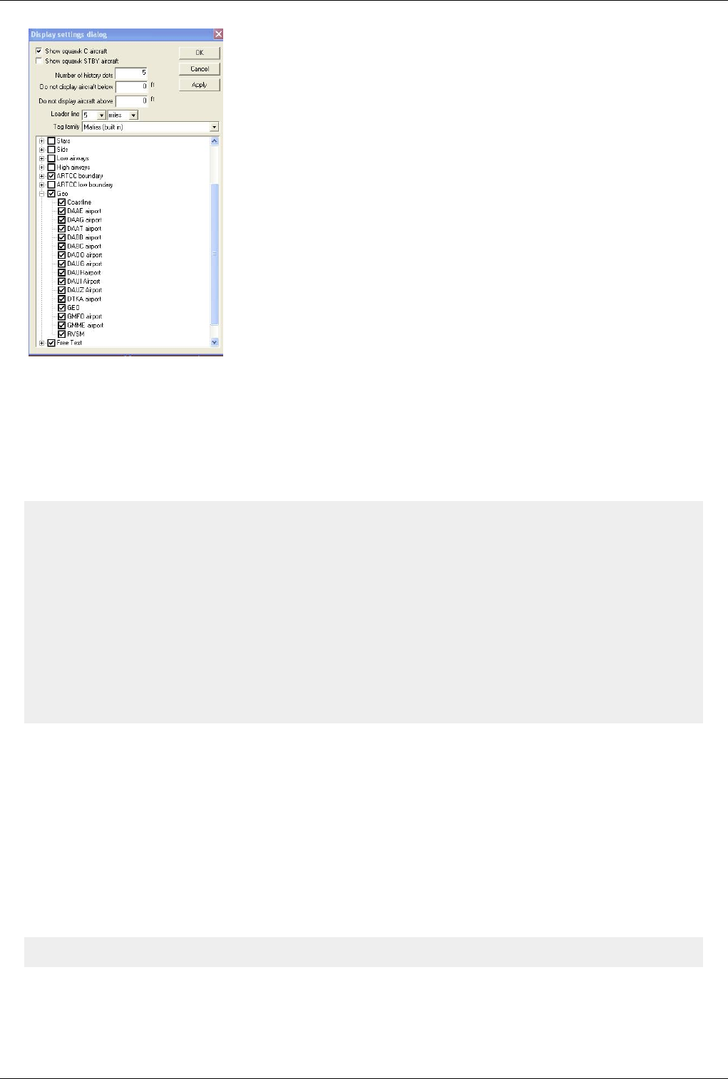
Connect Dialog
By clicking on CONNECT in the toolbar, the Connect dialog appears. Definitely, it seems more
complex than the ones we have been using so far, but shortly you will understand its advantages. Pay close attention,
because this is one of the most important chapters of this guide.
Select Connection
First of all you have to select a connection mode:
• Direct to VATSIM - connect to the VATSIM network
• To VATSIM via proxy - connect to the VATSIM using a proxy server
• Start simulator server - be the host of a simulator session
• Start simulator server via proxy - be the host of a simulator session via proxy
• Start Sweatbox simulator session - connect to Sweatbox training server
• Playback log file - playback a recorded ATC session
The rest of the connect dialog is divided into these 4 sections.
Euroscope:Connection Settings 20
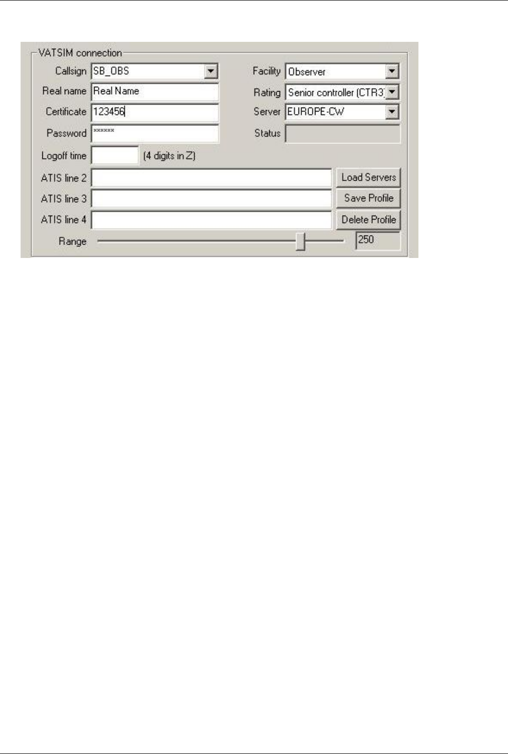
VATSIM Connection
This part of the window has fields that must sound familiar to you:
• Callsign - desired callsign (PETER_OBS, LHBP_TWR, EURE_E_FSS, etc.)
• Real name - your full name, as registered on VATSIM
• Certificate - your VATSIM controller ID (6 digit numeric)
• Password - your secret password
• Logoff time - your estimated logoff zulu-time (displayed in your controller info, format: 2000, the z is
automatically added to the value)
• Facility - category of ATC service you are to provide (Observer, Tower, Flight Service Station, etc.).
• Rating - your VATSIM controller rating (Student1, Controller3, Supervisor, etc.)
• Server - list of servers (VATSIM and simulator host IP addresses are read from ipaddr.txt), when joining to a
simulator session, simply the host IP has to be typed
• Status - once successfully connected "Connected to VATSIM" is shown
Understanding the rest of this section might require further explanation:
• ATIS line 2 - 4 - This refers to your controller information line, not the _ATIS frequency of each airport. Since
VATSIM limits the number of lines used for it, only 3 additional lines are available (your voice channel is
counted line 1). The same aliases can be used as in ASRC ($altim(ICAO), etc.).
• Load Servers - update your server list
Euroscope:Connection Settings 21
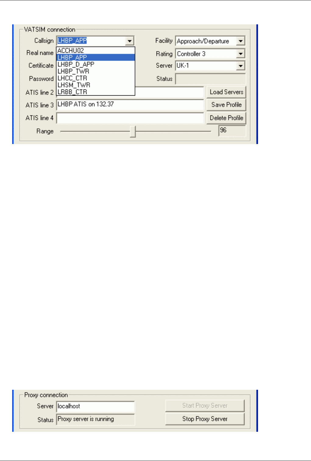
PROFILES
• Save Profile - This is something really cool! You can save various profiles, which store your callsign, facility,
range setting and ATIS information. So next time you come controlling, it will take a second to connect, you just
click the callsign you wish to be. (as shown in the picture below) Important: The changes in the profiles are not
saved automatically. On exit you will be prompted to save them, or call the Save all settings function to store the
profiles for your next session.
Note: Even accidentally its name is profile it has no relationship at all to the profile files. It is just a connection
profile. Actually the data is stored in the settings file not in the profile file.
• Delete Profile - delete selected profile
• Range - set your radar surveillance range from 1NM to 600NM but remember the limits: DEL/GND: 10NM,
TWR: 30NM, APP/DEP: 100NM, CTR: 300-600NM, FSS: 1500NM
EuroScope limits the maximum possible range setting based on the facility and the rating you are specifying. These
data are still higher than the values above:
• Observer - 300 NM
• Clearence/Delivery - 100 NM
• Ground - 100 NM
• Tower - 100 NM
• Approach/Departure - 200 NM
• Center - 600 NM
• Flight Service Station - 1500 NM
Supervisors are allowed to set 600 NM range, independently from the actual facility.
Important: when joining to a simulator session as a client (as trainee) the connection mode has to be Direct to
VATSIM - just like with a normal connection - and the simulator host has to be selected from the server list or its IP
address can be typed directly.
Proxy Connection
The proxy
connection is originally defined to allow multiple instances of EuroScope to be started in the same machine and
Euroscope:Connection Settings 22
share the VATSIM connection between them. On the other hand the implementation is general so there is no
restriction to one computer. The proxy connection needs two parties to be set up: one server and one client. To start a
server just press the Start Proxy Server. That will start listening the 6810 port in the local machine and accept
incoming connections. To connect to a proxy server from another instance of EuroScope select the To VATSIM via
proxy connection type, change the server if different from localhost and connect.
When connecting to a proxy server the secondary client does not need any authentication setup as it uses all the data
from the primary client. The primary client then can be connected to VATSIM and both clients will work with the
same rights with the same callisgn. When you have a proxy connection the two clients are sending special messages
to each other (e.g. when you type something in one client command editor it will appear in the second as well, when
you select an aircraft it will be selected in the other as well etc.). To disable this feature uncheck the Enable
advanced proxy communication menu item.
When you start the second instance of EuroScope on the same machine the voice subsystem will not be initialized. In
the toolbar you will see that the voice dialog icon is flagged by two red lines. That is because only one program can
listen the appropriate UDP port. The second instance will not be able to produce any voice related functionality (and
it is blocked by the code). Therefore always use the firstly started instance for voice setup.
In the new release you also have an option for Automatic proxy connection. This is really a handy tool. When your
first EuroScope instance starts then it will start the proxy server immediately. The furthermore instances will find
that the proxy is running and connect to it immediately. When you regularly use multiple instances (e.g. in a
munltimonitor environment) then it is really easy to connect them with this option.
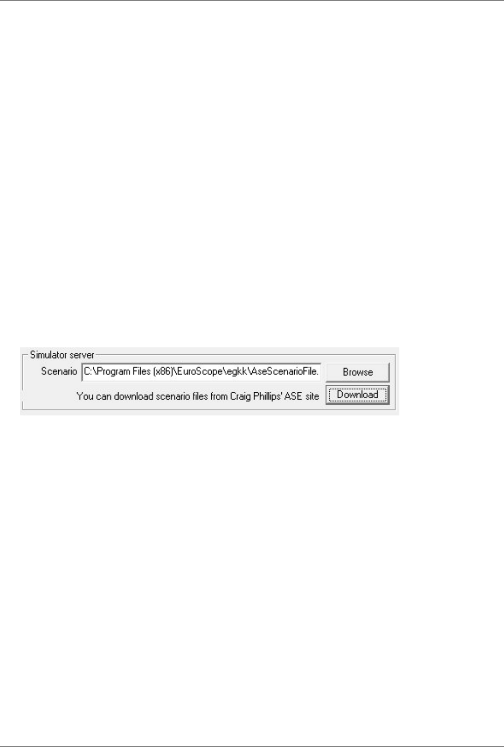
Simulator Server
To host a simulator session
1. Select connection mode: Start simulator server
2. Do one of the following
• Click Browse and Select a local scenario file
• Or click download to download a scenario from the Aircraft Situation Editor [1] scenario repository
Euroscope:Connection Settings 23
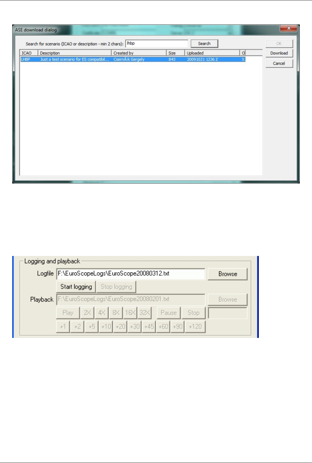
ASE Repository Download
1. Enter searchable text for possible ICAO, Description or Author in the textbox and click search.
2. Select the row of the scenario you wish to download.
3. Click Download. Save to your local system
4. Click OK. Notice the downloaded file is already selected in the local system box in the connection dialog.
For more detailed information see the Euroscope:Built In Simulator section.
Logging And Playback
To save your current session and play it back later is just as easy with EuroScope as pressing two buttons.
You can change the default log-folder by setting "ES_LOG_FOLDER" with the folder as value as a windows
environment variable.
Whenever you have an active session (direct or simulation) simple select a file name in the Logfile edit and press
Start logging. From that moment all data around your session is saved to the selected file. Even your primary voice
communication is saved to a file with the same name and an additional .vvl extension. When finished just press Stop
logging.
Important: Your authentication information is never stored in the file so that you can send it to others without
publishing your password. But everything else is stored there so all your private chat communications can be played
back later!
Euroscope:Connection Settings 24
If you have a saved session just select connection mode: Playback log file and select the file name to the Playback
edit box. When you press the Connect button the file will be played immediately. With the speed buttons you can
make the playback faster. You can pause and restart the playback with the Pause and Stop buttons.
The voice data is stored in the logfile in 30 seconds splits. Whenever a new split is to be played it is copied to a new
file and its playback is started. So that when the speed of the playback is not normal the voice will be played at
normal speed but parts of it will be missed.
The buttons are really self explanatory:
• Play - It starts playing a paused or stopped playback, and also returns to a normal 1x playback after fast forward.
• 2x-32x - It increases the playback speed.
• Pause - It suspends the playback. During the suspended playback the timeout checking is disabled even no
position update is coming from the planes.
• Stop - It stops the playback, and reverses the file pointer back to the beginning of the logfile.
• +1-+120 - This is another fast forward tool. Using it you can easily jump some minutes forward. Be patient when
jumping longer times. EuroScope still executes all lines from the file and computes all necessary data along with
it. In this way a one hour jump in a busy session may take a few minutes to skip.
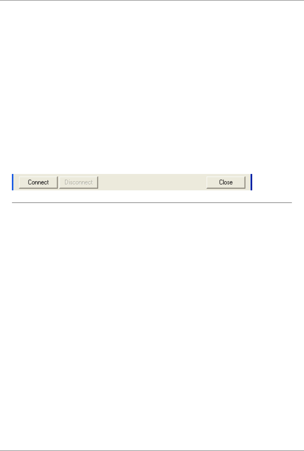
Connect / Disconnect / Close
Probably not necessary to write too much about these buttons.
Previous: Euroscope:Get Connected Actual: Euroscope:Connection Settings Next: Euroscope:Voice Communication Setup
Euroscope:Voice Communication Setup 25
Euroscope:Voice Communication Setup
Previous: Euroscope:Connection Settings Actual: Euroscope:Voice Communication Setup Next: Euroscope:Voice Hardware Test And Setup
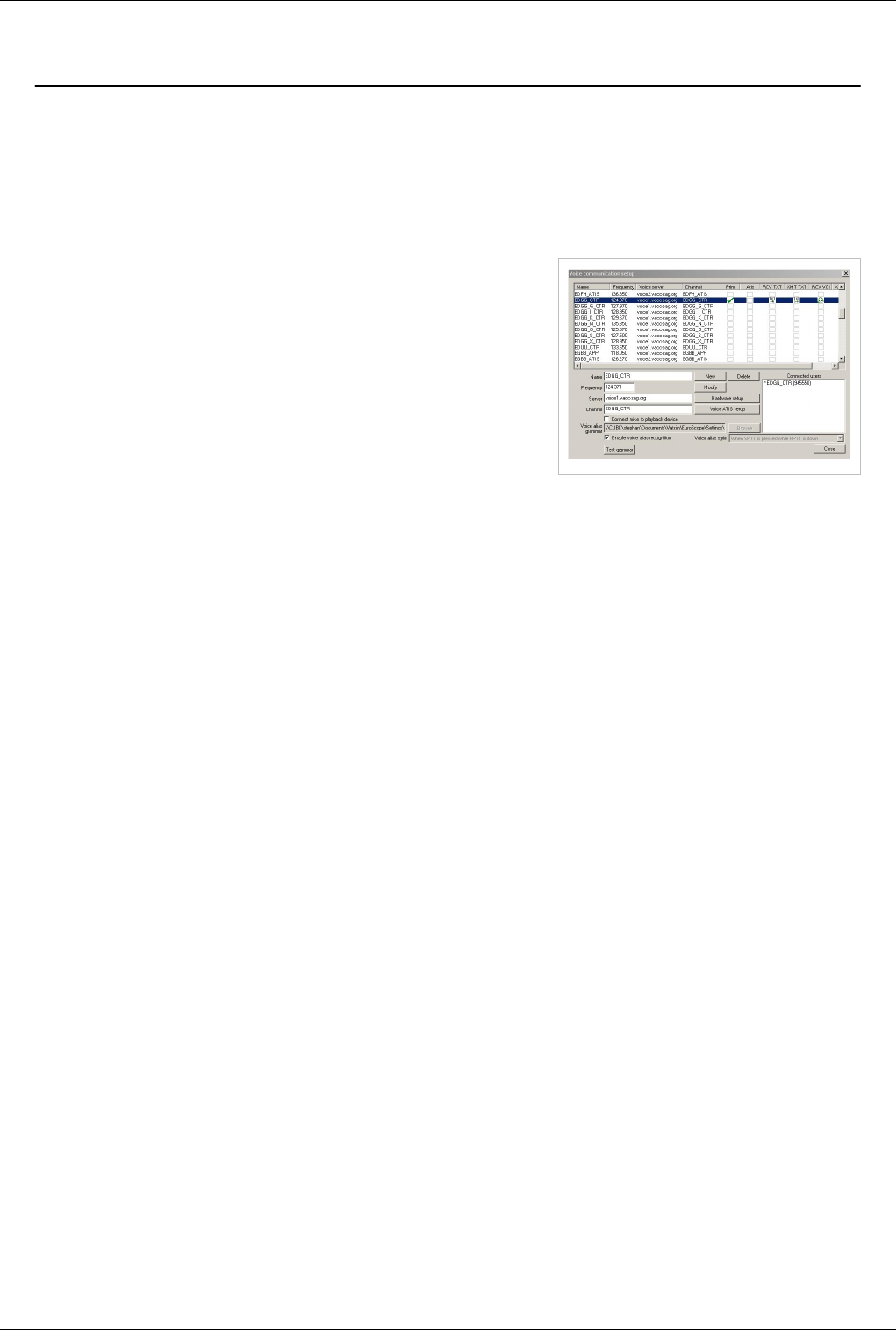
The Voice Communication Setup Dialog
All settings related to voice communication can be setup using the following dialog:
The main part of the dialog is the list on top. Every line here describes
one ground-to-air voice connection and also its status. The left four
columns (Name, Frequency, Voice server and Channel) are the
description part, while there are six check-box-like items on the right
(Prim, Atis, RCV TXT, XMT TXT, RCV VOI and XMT VOI) that can
be used to indicate and to modify the actual status of the voice
connection. When you select an item from the list its detailed
information will be displayed in the controls below, where you can
modify them. By clicking on the check-boxes you can change the
actual status.
Important: This dialog box never saves its modifications. You must call an explicit Save all settings or save on
closing EuroScope when asked for confirmation to save voice setup between sessions.
Also important: If you run EuroScope for the first time then before using this dialog to setup your voice
communication be sure to visit the Voice Hardware Test And Setup dialog to define your mike, speaker and
push-to-talk buttons.
Note: Here I used both voice1.vacc-sag.org and voice2.vacc-sag.org to indicate that you can use as many different
voice servers as you like. But remember that your vACC probably has its own preferred voice servers.
Dialogue Controls
• Name - In this textbox the actual name of the ground-to-air connection is displayed and can be modified. The
name is just a pure attribute not used for anything just for user information. Therefore it can be completely free
string like "Budapest Radar" or "Ferihegy Tower". But when you are offline and select a primary frequency it will
be used as your login callsign. And to be able to match the sectors associated with the callsign it is a good idea to
use the same name as the desired real callsign. E.g.: LHCC_CTR, LHBP_TWR. It is not necessary to have unique
names. As it is just a list you can define the values as you wish.
When you log in successfully with a callsign then EuroScope searches for the callsign here in the name fields
and also the channel name fields. Once a match is found then selects that voice communication setup as
primary frequency and connects to the voice server automatically.
• Frequency - Here you can define the associated primary frequency. The value entered here will be sent to the
network if the definition is selected as primary frequency.
• Server - The name or the IP address of the voice server. So far not possible to define ports.
• Channel - The voice channel name in the voice server. Once again this field is scanned after a successful logon to
set it as primary frequency if matching.
• New button - By pressing this button you can create a new entry to the ground-to-air communication list. All the
data will come from the edit controls, therefore they must be filled in.
• Modify button - With this button you can change the description of one communication line. This button is
enabled only if no communication is selected at all. You can not update a description if selected for anything.

Euroscope:Voice Communication Setup 26
• Delete button - It is used to delete one line from the descriptions. It is enabled at the same time when Modify
button is enabled.
• Hardware setup button - This button opens up the Voice Hardware Test And Setup dialog box where you can
setup the voice hardware configuration. Before you try to do anything with voice be sure to go there to specify
your hardware.
• Voice ATIS setup - As voice ATIS is closely related to this dialog it is available from here as well. It will open
the Voice ATIS dialog.
• Connect mike to playback device check-box - It is a funny test tool. It simply connects your primary and
secondary mike input to the speakers. When you press a PTT button and start talking your voice is extracted from
the mike device and directed to the speaker immediately. In this way you can listen back what you are talking.
And as it goes through all the encoding/decoding phases you will listen back exactly what others can hear from
you.
• Voice alias grammar / Browse - Here you can select your Euroscope:Voice Alias grammar file.
• Enable voice alias recognition - Activates the recognition of voice aliases.
• Voice alias style - This field has no use currently.
• Test grammar - Here you can activate a test mode for your voice aliases.
• Close - Just to be complete.
• Connected users list-box - This list box is filled with the users who are currently joined to the voice room of the
selected line. Your callsign will be flagged by an '*'.
The Check-boxes
In the top area there is a list control with all the ground-to-air communications definitions. Every line contains six
check-boxes. With them you can manage the status of your voice connections.
• Prim - as Primary frequency - By clicking any of the check-boxes in this row will select your primary frequency.
This frequency along with the voice channel definition will be populated via the network so pilots will ba able to
find your voice using this data. Important: By selecting the primary frequency you are not being connected to the
voice server. You should do it manually.
When you select your primary frequency the text send and receive check-boxes are set automatically and you
can not deselect them. If another primary frequency was selected before it will be cleared. You can deselect
your primary frequency by clicking on the check-box again (it will not deselect the text send and receive
flags).
The primary frequency description line is highlighted by yellow background even when not selected.
If you select your primary frequency when offline then EuroScope will assume that you are logged in as the
name of the voice communication and with the frequency. By that all the sectors defined to that position will
be assigned to you and you can see the offline simulated traffic arrival estimates.
• Atis - Same as primary frequency but it defines the primary frequency information of your secondary ATIS
connection (for more go to the Voice ATIS dialog). It is required by VATSIM that the channel name on the ATIS
primary voice server must be the same as the callsign of your ATIS connection. Therefore you can not select it
before connecting your ATIS user to the servers.
• RCV TXT - Receive text messages - By checking it you will receive text messages from this frequency. You can
not switch it off at primary. Important: When you are connecting to VATSIM via a proxy in the secondary client
you should set up the text receive in each client as they are independent from each other.
• XMT TXT - Transmit text messages - Your text messages will be sent to all frequencies that are checked. You
can not switch it off at primary.
• RCV VOI - Receive voice - It enables voice data to receive from this room. This check box also stands for the
connect and disconnect. When you press EuroScope will start to connect you to the server. In case of primary

Euroscope:Voice Communication Setup 27
frequency after a successful connect the send voice will be enabled automatically.
In the place of the check-box you can see the status of the voice channel. It changes the symbol from X to OK
when the connection is established and also indicates when voice is coming or sending via this channel.
When voice is being received or sent on the primary voice channel all secondary voice connections are muted.
That works quite well but notice that there may be certain situations when the communication ends, but the
program doesn't receive an end-message on the primary voice channel. In that case your secondary
connections are muted. To avoid this just press the secondary PTT for a while that will clear this flag and
enable secondary communications. (You can always check here if there is communication being sent/received
on the headphone icon.)
• XMT VOI - Transmit voice - It specifies if voice should be sent to this channel when pressing the PTT button or
not. When you press the primary PTT then the voice is sent to the primary channel only. When you press the
secondary PTT then your voice will be sent to all secondary channels simultaneously.
Previous: Euroscope:Connection Settings Actual: Euroscope:Voice Communication Setup Next: Euroscope:Voice Hardware Test And Setup
Euroscope:Voice Hardware Test And Setup
Previous: Euroscope:Voice Communication Setup Actual: Euroscope:Voice Hardware Test And Setup Next: Euroscope:Download Sectorfiles
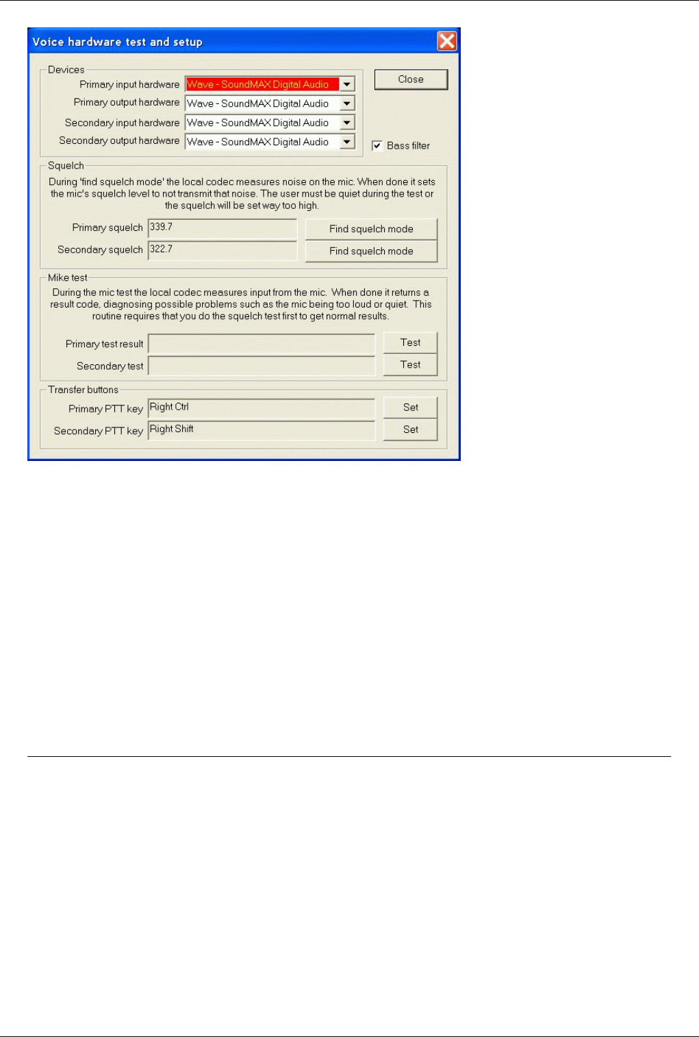
Voice Hardware Test And Setup
The voice hardware setup and test dialog is rarely used. At the very first time just select what voice hardware you
would like to use, test them and only come back here if something is changed in your system.
EuroScope has two independent voice hardware connections and each can be set up individually. It is possible to use
the same device for both setup but there is the possibility to use different (e.g. send the primary voice to headphone
while the secondary to the desktop speakers). As it comes from the names the primary connection has a some
priority over the secondary. It means that whenever a voice is transmitted over the primary voice channel the
secondary is muted.
In the following dialog you can change and test your hardware:
Euroscope:Voice Hardware Test And Setup 28
• Primary and secondary input hardware combo - Use this combo to select the primary and secondary microphone
to be used. They might be the same but can be different.
• Primary and secondary output hardware combo - Use this combo to select the primary and secondary headphone
or speaker to be used. They might be the same but can be different.
• Bass filter check-box - If checked the built in bass filter is enabled. Sometimes it sounds better, easier to
understand if only higher frequency voice is transmitted. But check it out yourself.
• Find squelch mode buttons - When you press the button keep silence for about 5 seconds. During that EuroScope
tests the background noise of your system. You should test your system squelch value before using voice
connection.
• Test buttons - After pressing the mike Test button speak normally for about 5 seconds. During this period
EuroScope tests the difference between your silent and normal speaking voice level. You might test to change the
volume level of your mike based on the test result.
• Set buttons - The Push To Talk buttons are used to transmit voice to the connected voice channels. It is not
necessary but highly recommended to set different buttons for primary and secondary voice transmit.
Previous: Euroscope:Voice Communication Setup Actual: Euroscope:Voice Hardware Test And Setup Next: Euroscope:Download Sectorfiles
Euroscope:Download Sectorfiles 29
Euroscope:Download Sectorfiles
Previous: Euroscope:Voice Hardware Test And Setup Actual: Euroscope:Download Sectorfiles Next: Euroscope:Voice ATIS
Manually or Automatically Download Sectorfiles
Publishing and downloading the latest up-to-date sectorfiles has always required searching around the vACC's
websites. With the new innovative sectorfile publication and download feature, it becomes far easier for controllers
to find the latest sectorfiles, but also for sectorfile creators to supply the users with the latest builds of the files. It
only takes a few steps to prepare the files to be downloaded via EuroScope, and to setup EuroScope for the
automatic download.
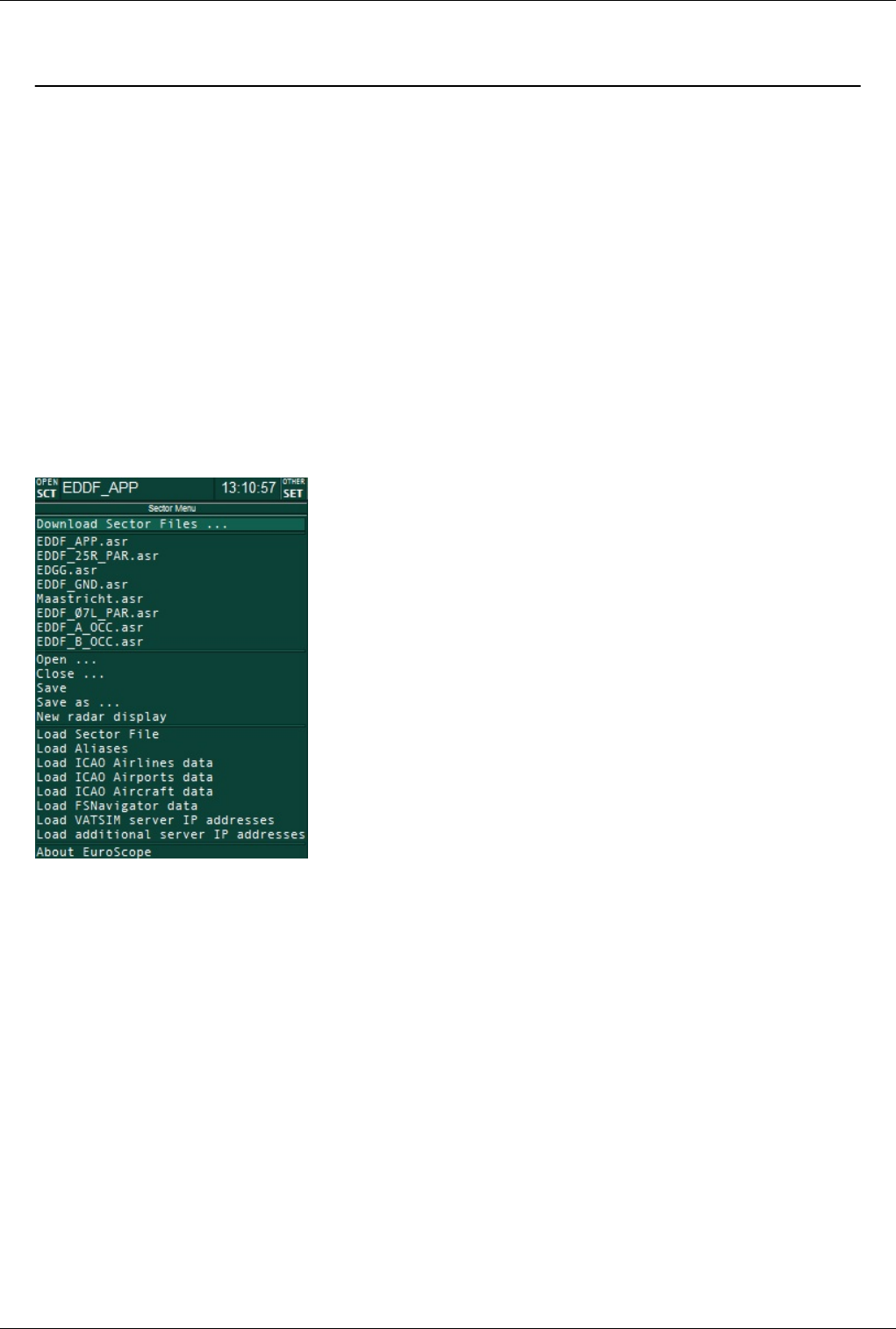
Setting up EuroScope
The settings for the automatic sectorfile download are located in the "Open SCT"-menu.
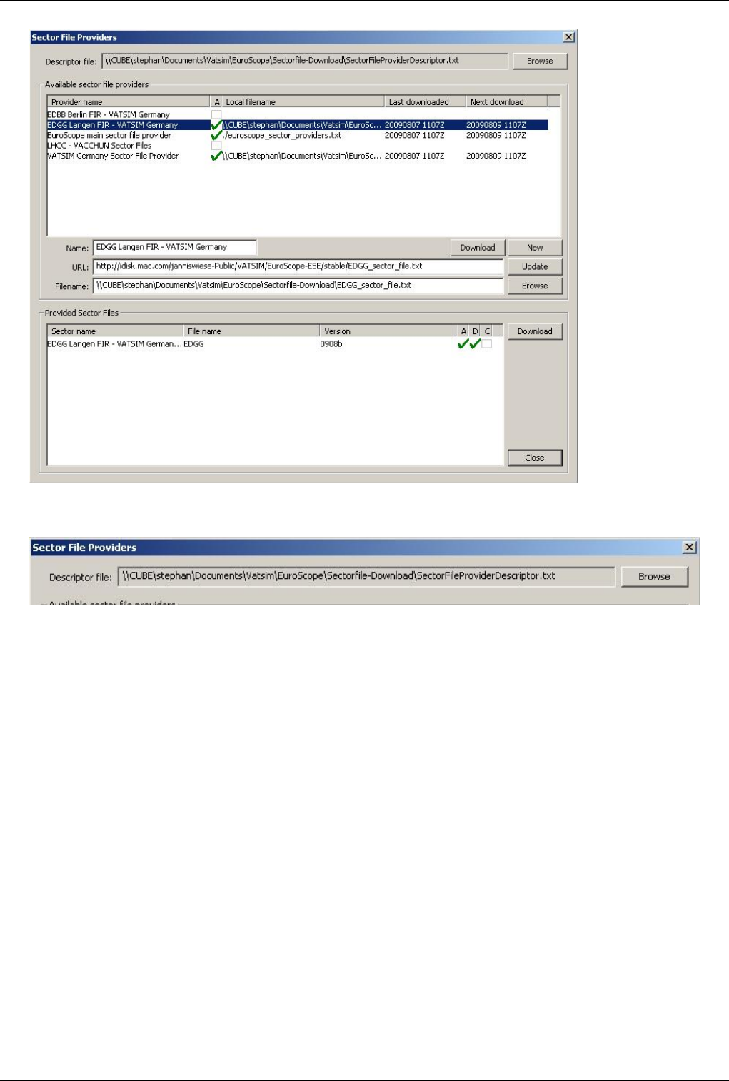
The "Download Sector Files ..." entry leads to the "Sector File Providers"-dialog.
Euroscope:Download Sectorfiles 30
The Descriptor File
The local data file for the automatic sector download is the descriptor file. It is loaded when You start EuroScope.
The file contains the information where the sector file provider files are located (URL and local filename) and what
provider data and what sector files are to be loaded automatically. Only data for active providers with a specified
local filename is stored here. The name of the descriptor file is stored in the profile. That means you may have
several completely different download lists of available sectorfiles if you use multiple profiles. However I think it is
better if all your profiles point to the same descriptor file.
When a profile is loaded without a specified descriptor file then a default ./SectorFileProviderDescriptor.txt file is
used. It is a relative path, therefore it works only if your startup directory is always the EuroScope root directory.
The content and the structure of the descriptor file is used only by EuroScope to store internal data. You do not have
to edit it manually, even it is a text file.
When the descriptor file is loaded and found to be completely empty, one default provider is added automatically
with the following attributes:
• Name: "EuroScope main sector file provider"
• URL: "http:/ / www. euroscope. hu/ sectorfile/ euroscope_sector_providers. txt"
• File name: "./euroscope_sector_providers.txt"
• Download automatically.
This is the default provider. I will try to maintain and add as many provider's data as possible. In this file I will
provide information about sector file providers, but never about specific sector files.
Euroscope:Download Sectorfiles 31
When you start EuroScope it loads the descriptor file. Using the data there it builds up a list of the known providers
and the available sector files in memory. In the Download Sector Files dialog, you can see the currently available
providers and the available sectorfiles:
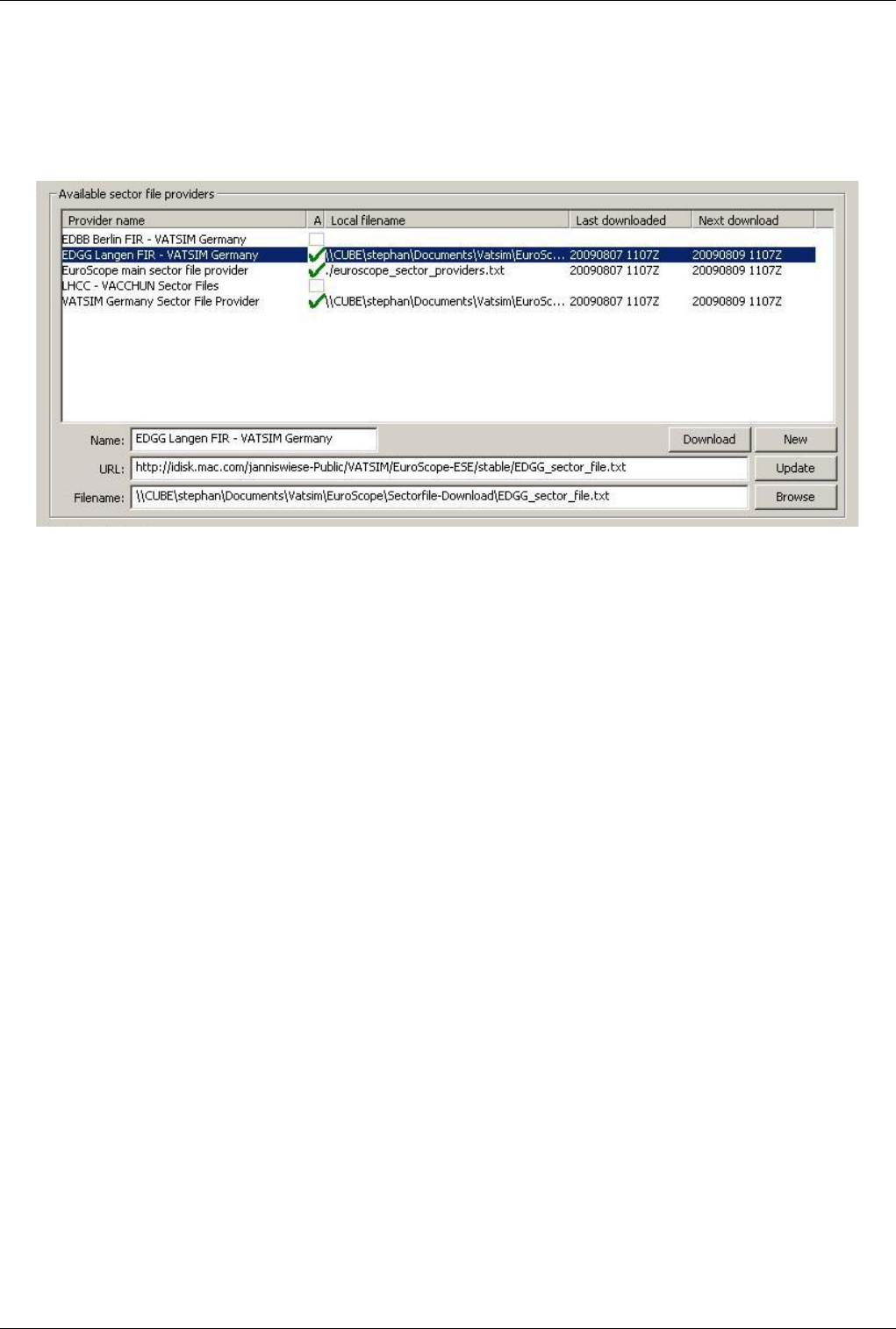
Sectorfile Providers
The sectorfile providers section shows all available sectorfile providers. The provider files (described in the next
chapter of this section) are published over the internet and downloaded by ES if activated. The files contain the
information of additional providers and available sectorfiles. To be activated, You need to specify a
download-location for each provider.
The individual fields in this section are:
•(Provider) Name: The name of the sectorfile provider
•A: The checkbox in the column activates the automatic download of the provider file.
•(Local) Filename: The local filename where the downloaded provider file is to be stored. It can be a relative or
absolute path. The sectorfiles of a provider are downloaded to the same path. Currently it is not possible to store
the downloaded files somewhere else than with the provider file. EuroScope will extract all files from to the
downloaded 7z file to the folder to this path. All files will be extracted and after that the SCT file is checked for
availability. If the packed SCT file does not match the <sector file name>_<sector version>.SCT naming
convention, then the extraction is treated as failed and the files will not be used.
•Last Download: The Last Download field indicates date and time of the last download of the provider file.
•Next Download: The Next Download fiels indicates date and time of the next planned download of the provider
file.
•URL: The URL field contains the web adress of the provider file. This is the identifier for the providers and must
be unique.
•Download: The Download button allows you to manually download the selected provider file.
•New: The New button creates a new entry for a provider that is not supplied by one of the other provider files. It
usually should not be necessary to manually create an entry as all files are supposed to be published via the
network.
•Update: The Update button allows you to update the selected provider entry.
•Browse: The Browse button allows you to browse to the local filename where the file is supposed to be saved.
If You want to delete an entry, uncheck the "A"-field and delete the Local Filename from the entry.
Euroscope:Download Sectorfiles 32
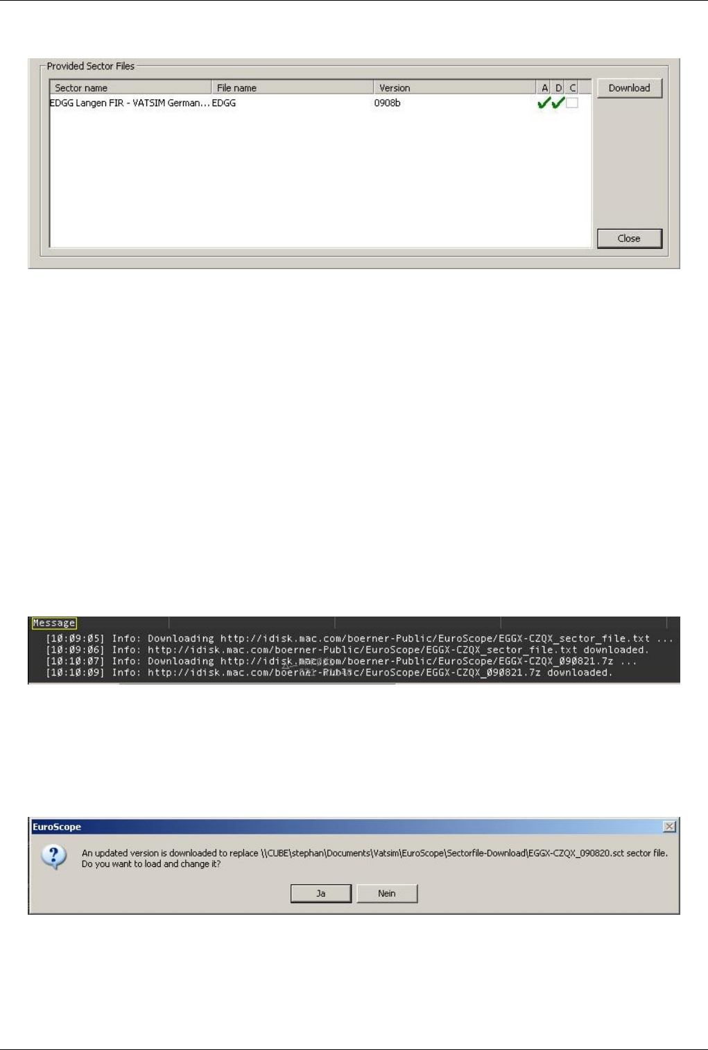
Provided Sectorfiles
The provided sectorfiles section displays the available sectorfiles for the selected provider.
•Sector Name: The Sector name field contains the description of the sectorfile.
•File name: The file name is the name of the sectorfile, but is only part of the actual filename.
•Version: The Version field displays the current version of the provided sectorfile. It is the second part of the
actual filename.
•A: The "A"-checkbox is used to activate the automatic download of the sectorfile.
•D: The "D"-checkbox indicates that the sectorfile has been downloaded.
•C: The "C"-checkbox indicates that you confirmed to replace all occurrences of the sectorfile with the latest
version without further questions.
•Download: The Download button allows you to manually download the selected sectorfile.
The sectorfiles are downloaded to the provider's local folder and are extracted there.
Once an ASR-file is linked to a versioned sectorfile, EuroScope can automatically detect links to outdated files and
correct them with the latest downloaded version.
The Automatic Download
Once everything is setup for automated download, EuroScope checks for updates on the files as scheduled in the
provider files. When a newer version of the sector file is downloaded (manually or automatically) (by definition its
name is different from the currently used file's one) EuroScope saves this information to the descriptor file. From
that point on, every attempt to use any prior file (all SCT files with name <download folder>/<sector name>_*.SCT
where * is smaller than the latest sector version) (attempts may come from last sector file from the profile, or sector
reference from an ASR) EuroScope will prompt you to use the newly downloaded version.
After the download is completed, EuroScope informs you about the update and asks if it should load the new file
instead of the old one.
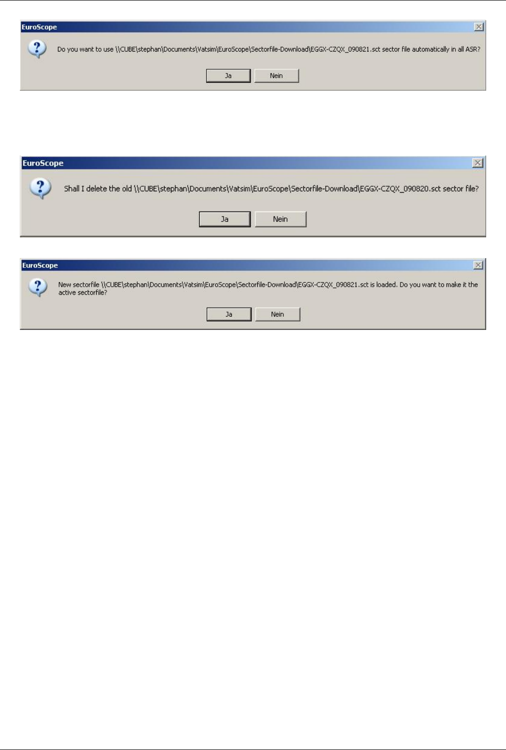
Euroscope:Download Sectorfiles 33
You can confirm to replace the old version in every ASR file (if the ASR is not open now, it will be replaced the
next time you load the ASR file). It is important to keep in mind, that EuroScope will change all the references in
memory only until explicitly saved. When you save the ASR or PRF you will be prompted to save the memory
update to the files.
At the end, EuroScope lets you confirm whether you want to delete or keep the old version of the file.
If the update happened while you were using a different profile not using the updated sectorfile, EuroScope asks you
on first start of the affected profile if it should use the new file as active sectorfile.
Publish sectorfiles
This chapter describes, who vACCs or Divisions can prepare their sectorfile to be published via the Download
Sectorfiles feature within EuroScope. Users who just want to use the feature will not have any benefit from reading
this chapter.
First make sure and keep in mind that txt files intended to be used by EuroScope must be encoded as ANSI (or
ANSII). UTF-8 encoding will cause errors loading the files.
The sector file provider files
The provider files contain the description about the sector files you are providing and also references to other sector
providers in your neighbourhood. Using this linking I hope we can build up a worldwide network of all available
EuroScope sector files.
The sector provider file is downloaded by EuroScope. The download can be automatic (when the user checks the
auto download flag) or manual (by pressing the download button). The file itself is downloaded and stored in the
local file system without any modification. The content is loaded into the memory after download and at every
startup.
The format of the file is the following:
• First line
• "EuroScope Sector File Provider File” – the first line must contain this text. It is used to identify a valid
provider file.
• Self description

Euroscope:Download Sectorfiles 34
• NAME:<the name of the provider> - it is just an update of the provider's name, for example the name of the
vACC.
• URL:<the URL of the provider file> - it is once again just an update as EuroScope can not download the file
without the URL. You can also use it to change the URL to another place.
• NEXTDOWNLOAD:20090720 – the next expected download time with the format YYYYMMDD. If set, the
automatic download will look for an update only after passing this date.
• DOWNLOADINTERVAL:48 – the regular download interval (if NEXTDOWNLOAD is not specified or
already passed). The value is in hours, the default value is 48.
Example:
NAME:LHCC - VACCHUN Sector Files
URL:http://www.vacchun.hu/es/vacchun_sector_files.txt
DOWNLOADINTERVAL:72
• Links to other providers - by linking to other provider files, you can build up a peer to peer network of provider
files, independent from the default provider file. Of course it is then imperative to keep those links up to date.
Otherwise, if an URL changed, an outdated link would create a duplicate of the provider file that would not be
working.
• PROVIDER_NAME:<the name of the provider>
• PROVIDER_URL:<the URL of the provider file>
Example:
PROVIDER_NAME:LHCC - VACCHUN Sector Files
PROVIDER_URL:http://www.vacchun.hu/es/vacchun_sector_files.txt
• Sector file descriptions
• SECTOR_NAME:<the user readable name of the sector file>
• SECTOR_FILE_NAME:<the base name of the sector file>
• SECTOR_VERSION:<the version number of the sector file> - be sure to make version numbers in a way that
the later version have an alphabetically bigger version number. And here “alphabetically” is important. Do not
forget that V3 is bigger than V21!!!
• SECTOR_URL:<the URL of the packed files> - see later about the packing
Example:
SECTOR_NAME:LHCC - Hungary (complete)
SECTOR_FILE_NAME:Hungary
SECTOR_VERSION:2009_05_08_v70
SECTOR_URL:http://www.vacchun.hu/es/Hungary_2009_05_08_v70.7z
How to pack a sector file
The EuroScope Installer contains the GNU public license 7-Zip command line utility (7za.exe). EuroScope uses this
program to uncompress the downloaded sector files. It is not necessary but highly suggested to use the very same
EXE for packing. This can avoid compatibility problems. EuroScope simply calls the 7za.exe without specifying the
full path. Therefore it is necessary to have this exe on the PATH or have it in the current working folder. If you start
EuroScope from the installer created shortcut then it is not a problem as it sets the current folder right. But if you
create your own links (e.g. using different profiles) then do not forget to set it.
Example:
7za a Hungary_2009_05_08_v70.7z Hungary_2009_05_08_v70.sct Hungary_2009_05_08_v70.ese

Euroscope:Download Sectorfiles 35
The SCT and the ESE file name MUST be <SECTOR_FILE_NAME>_<SECTOR_VERSION>.SCT/ESE. No other
file names are accepted as sector file.
You can define as many files to be put to the 7z archive as you like. The SCT is a MUST, the ESE is recommended.
After that you can put any additional files (like ESE or PRF files) if you need. They will be extracted to the client
machine but will not be used automatically. Only the SCT/ESE pair upgrade is programmed.
Previous: Euroscope:Voice Hardware Test And Setup Actual: Euroscope:Download Sectorfiles Next: Euroscope:Voice ATIS
Euroscope:Voice ATIS
Previous: Euroscope:Download Sectorfiles Actual: Euroscope:Voice ATIS Next: Euroscope:Voice Alias
Voice ATIS
Voice ATIS makes it possible for the pilot to listen to the actual information of the departure or arrival airport also
on voice rather than just reading it in few lines they used to receive when tuning in to a controller's frequency. This is
a major step to bring the simulation closer to real life. EuroScope is supporting this feature from the beginning.
To enable a second voice channel connection that can be tuned by pilots you need a second VATSIM connection
with its primary frequency set. Before setting up a voice ATIS station, make sure to read the relevant part of
VATSIM's Code of Conduct [1] or see the Member Policy change about duplicate connections at VATSIM forum [2].
This second connection is rather restricted. You can not specify your callsign freely. It is required to have <airport
ICAO code>_ATIS (eg. LHBP_ATIS ). Because of that restriction you can not define the whole callsign only the
airport code you are serving with voice ATIS. The _ATIS postfix will be added automatically by EuroScope. When
you select LHBP as the ATIS airport then your second VATSIM connection callsign will be LHBP_ATIS. There is
no way to alter this callsign and it is also required that the selected airport be defined in you sectorfile. When you
make a secondary ATIS connection you will probably see yourself back in the controller list as *_ATIS.
To set the primary frequency of the secondary connection go to the Euroscope:Voice Communication Setup dialog
and select the appropriate definition as ATIS frequency. It will define the primary frequency and the voice server
plus channel. There is one more restriction: the channel name must be the same as you secondary callsign. So if you
are going to serve LHBP with voice ATIS then be sure to define a connection that has LHBP_ATIS as channel
name. As in the primary connection by selecting the ATIS frequency and voice server you are not yet connected.
You should enable voice receive and transfer to the voice server. That makes you connected and also starts the voice
transfer when necessary. Do not be afraid of receiving voice from the channel it is never connected to your speaker
and will not disturb you.
Euroscope:Voice ATIS 36
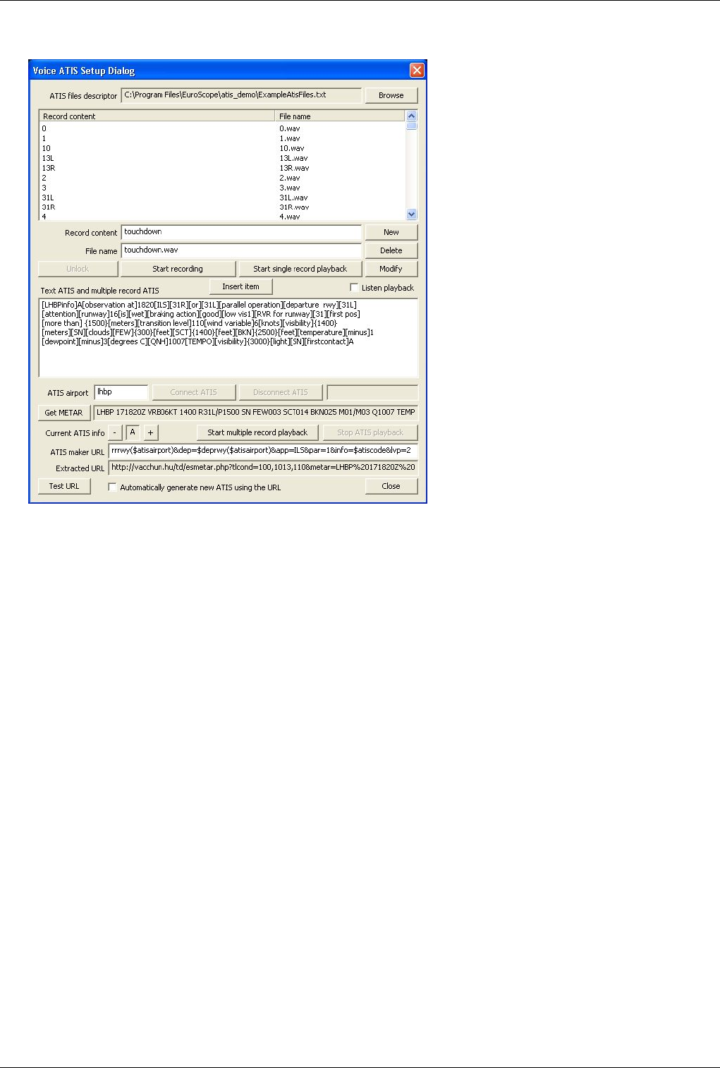
Common Setup
All the files necessary for the ATIS playback should be placed into one directory. At the top of the dialog box you
should specify the descriptor file. This file contains all the information about the records you have and also defines
the folder to be used. If you start the system at the first time it is possible that you receive the error message that the
atis descriptor file can not be opened. In this case create an empty folder and create the descriptor file there.
The voice atis setup is an exemption to the not saving anything rule. Any click in this dialog, any change in any data
will be saved immediately to the descriptor file.
The commonly usable controls:
• Browse - the descriptor file
This button opens a file create dialog box to specify a new folder and descriptor file. As normally you will
create new descriptor file this is a create file dialog. And so it will warn you to avoid file overwrite if you
select an existing file but it will open and read the content instead.
• Records list
The top list contains your records. The amount of records you need depends on the way you would like to use
the voice atis. When you select an item in the list the record content and the file name will be copied to the edit
boxes below where you can overwrite them.
• Record content edit
It is a free text that describes the content of your record. It is up to you what you write here but in some cases
it will be part of your text atis.
• File name edit
The name of the file to save the recorded voice. If the file extension is .wav then it will not be modified,
otherwise a .atis extension will be appended automatically.
• New button

Euroscope:Voice ATIS 37
If you press this button a new record description will be added to the list. Both the record content and the file
name should not be empty to create a new item. It is not necessary for the record content to be unique, but file
name should not be repeated.
• Delete button
It simply deletes the selected item from the records list. It also deletes the file associated.
• Modify button
It changes the selected item in the record list by the content of the edit boxes.
• Start recording/Stop recording button
When you have an item selected in the record list, just press the Start recording button to record the message
or part of it. When the recording is in progress then the title of the button changes to Stop recording. To stop
the recording press it again. If the dialog is reopened and the record file exists then this button is disable to
avoid accidental overwrite of you records. In this case press the Unlock to enable rerecording.
• Unlock button
This button is used to enable rerecording of files. See the previous button description.
• METAR station edit
Here you can ask for a METAR of a station. Type the station name here.
• Connect ATIS button
This is a new button here in this dialog. Originally it was on the Connect Dialog but we found it much more
convenient to to all voice ATIS related work here in this form. Therefore this button is used to make your
secondary VATSIM connection to serve as Voice ATIS controller. The button is enabled only in case you
have a live, direct connection to VATSIM. The ATIS airport in fromt will be used for the callsign.
• Disconnect ATIS button
Use it to disconnect the ATIS controller. It is available only when you are connected.
• ATIS connect status
Just next to the Disconnect ATIS button there is a status field. It shows the actulal status of the voice ATIS
connection.
• Get METAR button
This button gets the METAR of the selected station. If it is the first time you use it then nothing will happen
when you press it as it may take some seconds to receive the information back from the servers. So press i
again in some seconds.
• Current ATIS info and + and - buttons
The current ATIS letter is displayed in the toolbar of the main window. By pressing th + and - buttons you can
change it. These buttons are also scan the Text ATIS and multiple record ATIS and if the current atis letter is
found there in a separated place (separated means space-letter-space) then it will be replaced by the new letter.
• Stop ATIS playback
It stops the current ATIS playback.
• Listen playback check-box
If you check this box the the actual playback is sent to the secondary output. In this way you can check what is
sent to the voice server.
Euroscope:Voice ATIS 38
Voice ATIS Playback Modes
Before you start providing the voice ATIS you should decide which of the two methods you would like to use: single
or multiple record playback modes. That makes completely different how you can/should use the dialog. Therefore
there will be two descriptions even some buttons can be used for the same purpose.
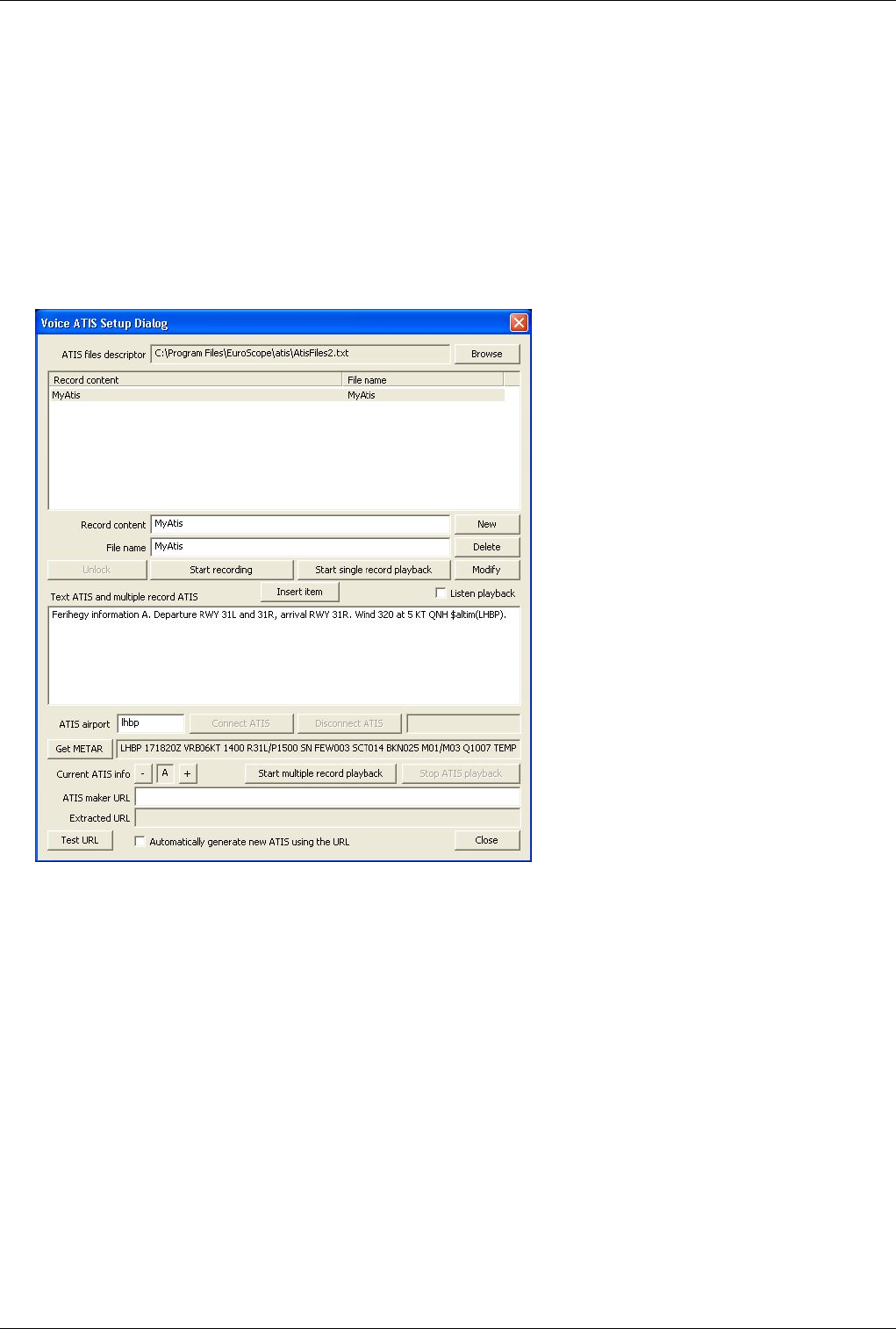
Single Record Playback Mode
This mode is the easier, more simple way to provide the voice atis. In this mode you simply record your atis message
into a file and EuroScope plays it back in a n endless loop.
A typical content of a single record playback mode looks like this:
In the top side list box you may have several records, but in this case only one ATIS record is necessary. Just define
a record by providing the description and the filename. Press the New button (if the list is empty) to register a new
record. Then press the Start recording button, tell your ATIS message. When ready press the Stop recording and
press Start single record playback to play your message in an endless loop. That is all. If you would like to change
the message just press again the Start recording and tell your new message. It is not necessary to stop the playback
before you record your new message. It can be done parallel. When you have the new message, stop the playback by
pressing the Stop ATIS playback and start your new message play.
Euroscope:Voice ATIS 39
Special controls
• Start single record playback button
It starts playing back the selected record in an endless loop.
• Text ATIS and multiple record ATIS edit
In this mode this edit box is "just" for a Text ATIS. Simply type your ATIS message and it will be sent to the
pilot who asks for it.
Multiple Record Playback Mode
I found that recording a complete atis message may take 20-30 seconds if you can do it at once without any error. At
peak times when you are alone in your sector you do not have so much time at all. Therefore a new way of atis
presentation was invented where the atis message is built up from prerecorded pieces. It might sound a little bit more
complicated at the beginning, but when it becomes a routine it requires less time and more importantly less silence in
the surrounding to setup your atis.
To be able to use this mode, first you should record all the possible pieces. You can do it in the same way as you
record the single records. You should however remember that concatenating records recorded here in this dialog is
not smooth enough. There will be too much silence between the pieces. To avoid that, EuroScope can handle WAVE
files. The best way is to record and trim your message parts in an external WAVE editor. There you can make more
precise trimmings. Then save and register the files in the record list. Do not forget to add the .wav extension to avoid
the automatic extension assignment. When using wave files the concatenation is far smoother and the result is really
close to a single record playback. Important: At this moment only 7350 Hz sample rate 16 bits signed mono PCM
files are accepted by EuroScope (do not ask why). It is not a big thing to convert the records to this format using any
wave editor.
Once you have all the recorded pieces you need, you can start building up your complete message from these. To
copy a recorded item just select it and press the Insert Item button or press ENTER. That will copy the record

Euroscope:Voice ATIS 40
content string to the Text ATIS and multiple record ATIS edit box and places it between [] squared brackets. If you
press the ENTER it will move the focus to the editor allowing you to edit the message immediately. You can copy as
many items from the records as you wish. To go back to the list just press the TAB key. When you are back in the
list you can start typing the record content and the item will be selected.
You can also enter free text to the edit box that will be compiled letter by letter. When you press the Start multiple
record playback EuroScope gets the content of the edit field. First it extracts and replaces all function calls. In this
way you can enter free texts like $altim(LHBP) and before playback it will be changed to the actual value. Then
EuroScope extracts the pieces from the string. When a piece in [] squared brackets are found then the part will be
searched in the record content fields of the record list. If one matches then the recorded file will be concatenated to
the ATIS message.
If there is a number between {} brackets then EuroScope will tell this number not by digits but a well formed
number. Eg. {1500} will result like [1][thousand][and][5][hundred]. To be able to add all possible numbers
EuroScope requires the following prerecorded files:
• Numbers from 0 to 19 - [0], [1], ... [10], [11], ... [18], [19].
• The ten numbers - [20], [30], ... [80], [90].
• Hundred and thousand - [hundred], [thousand].
• and - [and].
If the next part is not between [] nor {} brackets then it will be compiled letter by letter. Every letter will be searched
in the record content and the matching record file will be concatenated. Therefore it is highly recommended to have
record for every letter and every number. Finally the created file starts playing back in an endless loop.
As the content of the edit box is compiled just when pressing the button you are free to edit not only the free text
parts but the [] bracketed parts too. But be careful to provide a string that matches one of the records. If not you may
receive several error messages like: "No matching record item".
On the other hand the content of the Text ATIS and multiple record ATIS will be used as text ATIS message (just
the []s and {}s will be eliminated from it). In this way in one editor you can build you voice and text ATIS in one
single step.
The special controls once again
• Insert Item button
It copies the selected record item into the editor. It will be placed to the actual cursor position. If there is a
selection then it will be deleted.
• Start multiple record playback button
It examines the content of the edit box, concatenates the voice files and also starts the endless loop playback.
External ATIS Interpreter
A really new innovation in the voice ATIS is that EuroScope enables external ATIS interpreter tools to be used. To
use such a tool you should specify a well parameterized URL that will be called from EuroScope. The URL should
be entered to the ATIS maker URL filed. Here you can use all the functions, aliases to extract information from the
system necessary for the ATIS. We specifically added new functions and aliases for the ATIS maker:
• $atisairport - The ICAO code of the airport you are serving with voice ATIS. Actually the content of the ATIS
airport edit filed.
• $arrrwy(<ICAO code>) - This function lists all the runway names separated by commas that are flagged as active
for arrivel in the Active Airports Runways.
• $deprwy(<ICAO code>) - The same for the departure airports.

Euroscope:Voice ATIS 41
• $metar(<ICAO code>) - The long METAR of the selected airport.
• $atiscode - The current ATIS info set above.
The controls to be used
• ATIS maker URL edit
As said above you can enter the full parameterized URL to here. It will be saved along your settings.
• Extracted URL edit
It is just a debugging tool. When you press the Test URL button then EuroScope extracts the aliases and
functions from the base URL. The result will be shown here in a worm it is sent to the Internet. In this way you
can check if all the parameters are correct and how to fix invalid calls, missing parameters.
• Test URL button
When you press this button the original URL is extracted and the result is sent to the Internet. When
EuroScope receives the answer it is copied back to the Text ATIS and multiple record ATIS edit control.
There you have the chance to test or modify before it goes to the voice channel. This button will not start the
playback.
• Automatically generate new ATIS using the URL check box
If you check this box and a new METAR for the ATIS airport arrives to EuroScope, then it automatically stops
the current playback, increases the ATIS letter by one, sends the URL with the new METAR data to the
external interpreter, fills the result to the Text ATIS and multiple record ATIS and immediately start the
multiple playback. If you still has all the necessary prerecorded pieces then all works automatically without
any touch of a control.
By the time this documentation was created there are two external tool that can be used:
• The VACCHUN interpreter - It is built by Attila Ábrahám. You can find a complete set of wave files and also a
complete reference manual in the atis_demo folder of your EuroScope installation. Of course the wave files are
limited to LHBP only, but you are free to rerecord them to your area.
• UNIAtis by Sami Ylismäki - This is a really configurable ATIS interpreter. Currently it supports full METAR
decoding with the exception of remarks and every field can be customized to support a wide variety of formats. It
includes support for semi-freely customized fields in the ATIS. If you would like to join him and make your own
area specification contact him via the forum of UNIAtis at http:/ / www. uniatis. net/ .
Previous: Euroscope:Download Sectorfiles Actual: Euroscope:Voice ATIS Next: Euroscope:Voice Alias
Referenzen
[1] http:/ / www. vatsim. net/ library/ codeofconduct. pdf
[2] http:/ / forums. vatsim. net/ viewtopic. php?t=19500

Euroscope:Voice Alias 42
Euroscope:Voice Alias
Previous: Euroscope:Voice ATIS Actual: Euroscope:Voice Alias Next: Euroscope:Connection Features
How to control text only aircrafts using voice recognition in
EuroScope
About voice aliases
It is a quite long problem how to control text only aircrafts. There are aliases you can use for most cases, EuroScope
also offers the automatic text message generators. But a text only aircraft still needs more time to communicate with.
And probably the most difficult thing is that other planes are not aware that you are typing your text message and the
radio channel is silent just because of that and not because you are just waiting for a call.
The would-be solution is here for a longer period of time. It would solve our problem if we had a speech recognition
engine. Then we could speak to the text only aircrafts and then send the recognized message as chat. Unfortunately
as I found the current speech recognition technology is a little bit far to be reliable and precise for doing that. They
are able to recognize many words, but there are too many mistakes, misinterpretations. As I tested I was never be
able to reach more than 70-80 % of successfully recognized words. That is far less then suitable for our purpose. I
also found that some words (e.g. zero) I was simply unable to teach to be recognized. Without that we can not
control.
To achieve a better and usable level of recognition we have to reduce the possible words and sentences that the
program is to recognized. If we do this then even if some words are missed or misrecognized the final result would
be what we want to send to the pilot. For that I created a simply grammar (with regular expressions). You can define
words, one-ofs, repeats, sequences and (probably the most usable) sounds like statements. From these blocks you
have to create sentences. These sentences are the real aliases. EuroScope will try to understand only these sentences
and nothing more. The output text message can be only one of the sentences you defined.
The grammar file structure
As nearly everything in the EuroScope environment the grammar files are also simply text files. You can edit them
by a notepad. Every line is compiled on his own and contains a complete description.
The words
The basic elements of the voice alias are the words. You have to define all words you would like to use in your
aliases. It is also a help for the voice recognition engine that only these words are to be recognized. No word that is
not defined here will be ever recognized.
There are two word definitions. The first is the simple:
WORD:approach
WORD:runway
WORD:squawk
WORD:land
WORD:takeoff
WORD:taxi
These lines are simply word definitions.

Euroscope:Voice Alias 43
The second version is the word with replacement:
WORD:zero:0
WORD:one:1
WORD:two:2
WORD:alpha:A
WORD:bravo:B
WORD:charlie:C
WORD:thousand:000
WORD:hundred:00
In the second case if the engine recognizes the word it will enter the replacement string to the message. Here you
also can play with the spaces. When you have replacement string then no spaces are added around. On the other hand
if no replacement then there will be spaces around (multiple spaces are ignored later).
In this way "victor echo bravo oscar sierra" will be converted to "VEBOS", "squawk two six two two" is converted
to "squawk 2622". Also "one thousand" is "1000", "five hundred" is "500". There is only one extra tool inside the
compiler that "seven thousand five hundred" is converted to "7500" when the word "hundred" is recognized.
WORD:direct: proceed direct :
I also found that I was unable to make the "proceed" word to be recognized by the engine. So I added the "direct"
word to be changed to "proceed direct". It is just a trick.
The sounds like statements
There were words that were just unrecognizable by the engine. When I spoke them the engine found another word
from the list. To be able to cope with these regular misrecognitions you can use the sounds like statements. Using
that if the misrecognized word matches the regular expression then the good one will be used instead.
In the statement the first word is the one you are saying and you want to be recognized. While the second word is the
one the speech recognition engine understood. Only words defined before can be used in both places.
There are common sounds like words:
SOUNDS:four:for
SOUNDS:two:to
SOUNDS:descend:descent
SOUNDS:descent:descend
These can not be recognized without the rules at all. Then there are specific to the speaker:
SOUNDS:via:zero
SOUNDS:victor:zero
SOUNDS:gate:eight
Just try your words and if you receive another word regularly add a sounds like statement.

Euroscope:Voice Alias 44
Regular expressions
From now on I am talking about expressions not only words. An expression can be a word or an element defined by
one of the statements below. There are some simply general rules:
• In an expression only words and elements that are defined in advance can be used. So there is no way for
recursion (that avoids some endless loop).
• All names must be globally unique (you can not have same name expressions or words).
The one of statements
It is part of a regular expressions definition. Using this statement you can define an element that can be exactly one
of the listed expressions. The first string is the name of the expression while the next ones are the options.
ONEOF:number:zero:one:two:three:four:five:six:seven:eight:nine
Here I defined the "number" expression that can be any of the "one", "two" … "nine".
ONEOF:direction:left:right
When turning we can add the “direction” expression and then it can be "left" or "right"
The repeat statements
When you need the same type of element zero, one or more times then create a repeated expression. You can use it
for optional elements with minimum 0 maximum 1 occurrence. The first string is the name of the expression
followed by the minimum and the maximum occurrence.
REPEAT:two_numbers:number:2:2
REPEAT:three_numbers:number:3:3
REPEAT:four_numbers:number:4:4
REPEAT:optional_direction:direction:0:1
In these examples the "three_number" is good for heading, the "four_numbers" are good for squawk for example.
The "optional_direction" can be used as optional runway designator.
The sequence statements
To concatenate some expressions into one you can use the sequence statement. It is as simply as it looks like. The
first string is the name of the expression while the rest is the expressions to be used.
SEQUENCE:qnh_data:by:QNH:four_numbers
SEQUENCE:badov:bravo:alpha:delta:oscar:victor
SEQUENCE:wind_normal:wind:three_numbers:at:two_numbers:knots:optional_gusting

Euroscope:Voice Alias 45
The sentences
The sentences are the real voice aliases. From the technical part they are just nameless sequences. The alias matcher
code gets all the so far spoken words and selects the sentence that matches the best.
How to use it
Microsoft Speech Recognition engine
First of all you need to install the speech recognition engine. If you are using Windows XP, download the Speech
SDK 5.1 from http:/ / www. microsoft. com/ downloads/ details.
aspx?FamilyID=5e86ec97-40a7-453f-b0ee-6583171b4530& displaylang=en and install. You need the
SpeechSDK51.exe (ca. 70 MB). If you are using Windows Vista or Windows 7, the integrated speech recognition
should be sufficient.
EuroScope setup
In EuroScope open the voice setup dialog. In the bottom you can find the Voice Alias grammar. Put your grammar
file name here and press the Enable voice alias recognition check box. You may have the message dialog popping up
with all the problems in your grammar file. Fix and reload it again. You do not have to leave EuroScope to change
the grammar.
If the grammar file is OK, you can press the Test grammar button and start talking the words immediately. Say all
the words, test if the engine recognizes well. Where are the problematic words? Try adding sounds like statements to
make it more stable. And of course test all your sentences again and again. Be patient. To build up a usable grammar
file needs some time to practice. You can test your grammar without speaking. Just edit the content of the source edit
box to see what sentence is recognized (see the next chapter about it).
Use it in EuroScope
When the voice alias recognition is enabled you can use it in the following way:
• Press the primary PTT button. I expect to say the callsign of the text aircraft (I do suggest trying to recognize it).
• Then while the primary PTT is down, press the secondary PTT simultaneously. That will switch on the
recognition engine (and will not connect the secondary devices to the mike). When enabled, the bottom line
(prompt and message line) is hidden and two new read-write edit boxes are shown there. They are both empty.
• When you are talking the recognized words are put to the first edit box each after the other with space separated.
In the right place you can see the so far best matching alias. The matched words are shown without any sign, the
sounds like matches are flagged by {} around, while the non matches are flagged by [].
• When ready you can release the secondary PTT button. You can go and manually edit any of the edit boxes. If
you change the input edit, then for every keystroke the content is analyzed for a better sentence match. Here you
can use the replacement strings too (e.g. press just 2 instead of two, or A instead of alpha).
• If the result is OK, the press ENTER to copy the result to the command line. Or if you press the secondary PTT
again (when the result edit box is not empty) then the content is copied to the command editor and a new sentence
is going to be recognized. This can be used when multiple sentences are to be sent to the plane.
• Send the text message in the original normal way to the plane.

Euroscope:Voice Alias 46
The ESGrammar.txt
I packed an ESGrammar.txt file to the setup (Settings folder). It works for me well, but I guess you need to adopt the
file to your environment.
I hope it will make some more fun when controlling text only planes.
Previous: Euroscope:Voice ATIS Actual: Euroscope:Voice Alias Next: Euroscope:Connection Features
Euroscope:Connection Features
Previous: Euroscope:Voice Alias Actual: Euroscope:Connection Features Next: Euroscope:Going Into Details
Connection Features
There are just a few things to be set up to assure a successful connection to the network without any problem.
However, if you miss them, you will not be able to use all the features of EuroScope.
• Outgoing connection - When you are connecting directly to the VATSIM or any simulated session hosted by
EuroScope you will go out on port 6809. You should allow outgoing connection on this port to reach external
servers.
• Built-in Simulator - When you are hosting a simulator session then EuroScope binds the 6809 and waits for
incoming connections. In that case you should open this port to enable incoming calls. When you are behind a
router you should forward this port to your workstation. Note: The tower view feature uses this port too. If you
are to run the Flight Simulator on another machine you need to open this port.
• Ground to Air voice communication - When you are joining to a voice room the connection is made via UDP port
3291. This port should be opened for outgoing connections. When you are accepting landline voice calls you will
use this port as well.
• Ground to Ground voice communication - When you initiate a landline voice call and the remote controller
accepts it then the remote computer will try to reach your computer UDP port. Therefore to be able to initiate
landline calls you should open UDP port 3291 for incoming requests. When you are behind a router you should
forward this port to your workstation.
• Proxy server - Normally you use the proxy server for internal communication only. That does not need additional
settings. But if you would like to allow controller from an external machine to be connected open the port 6810
for incoming requests. When you are behind a router you should forward this port to your workstation.
• Proxy client - Once again normally you use it internally and you do not need additional settings. But if you would
like to join to an external proxy server open the port 6810 for outgoing requests.
• HTTP requests - Several features are using standard HTPP requests (eg. VATSIM servers, statistics data,
sectorfile downloads, ASE repository) - They need port 80 to be open for outgoing requests. Normally it should
work if you have a proxy server. But if the proxy needs an authentication EuroScope will fail so far (or it needs a
third party SW that makes it invisible for the clients).

Euroscope:Connection Features 47
Previous: Euroscope:Voice Alias Actual: Euroscope:Connection Features Next: Euroscope:Going Into Details
Euroscope:Going Into Details
Previous: Euroscope:Connection Features Actual: Euroscope:Going Into Details Next: Euroscope:Multiple Sectorfiles
Multiple Sectorfile Usage
The first public release 2.9a was unable to load more than one sectorfile at a time. An improvement is that in the new
release any number of sectorfiles can be loaded. But as several things in EuroScope depends on the sectorfile it is
extremely important to understand which file is used for what. It is described in the Euroscope:Multiple Sectorfiles
page.
Professional Radar Simulation
In the Euroscope:Professional Radar Simulation section you can read about how radar antennas, the non radar holes
are simulated. How you can correlate/uncorrelate radar positions with flight plans. How you can use the flight plan
tracks for radar invisible planes.
Sectors And Aircraft States
Before learning about how the software functions work, some basic principles must be understood. One of
EuroScope's main features is how it handles the sectors you are controlling and how the aircrafts are classified by
your sectors. All this is described in the Euroscope:Sectors And Aircraft States page.
Previous: Euroscope:Connection Features Actual: Euroscope:Going Into Details Next: Euroscope:Multiple Sectorfiles
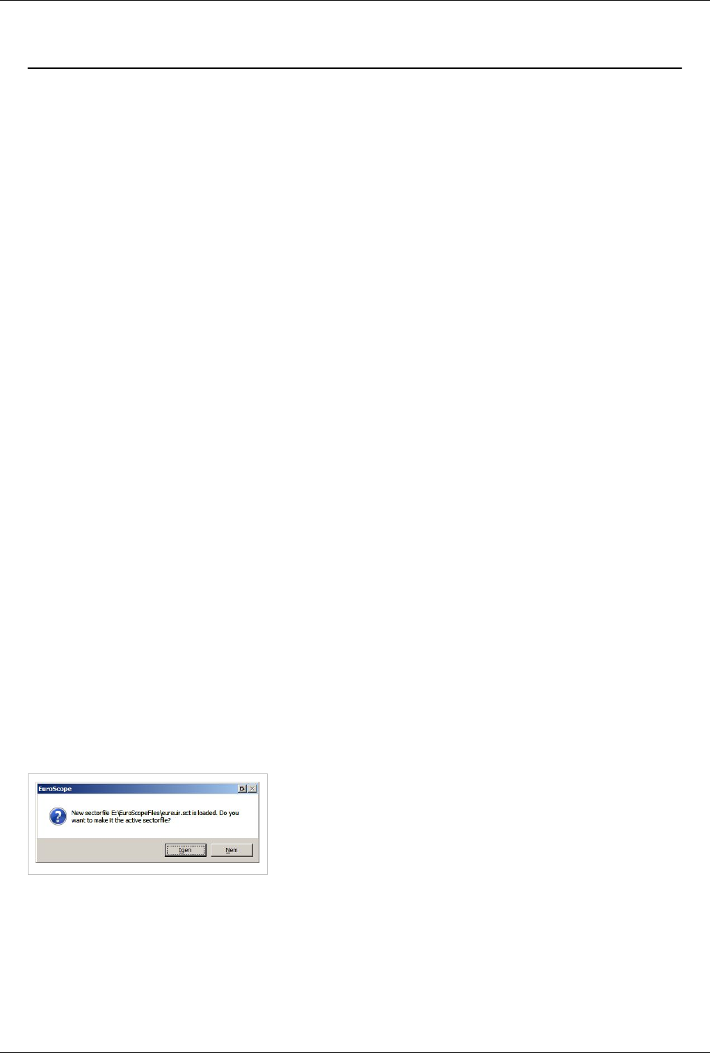
Euroscope:Multiple Sectorfiles 48
Euroscope:Multiple Sectorfiles
Previous: Euroscope:Going Into Details Actual: Euroscope:Multiple Sectorfiles Next: Euroscope:Sectors And Aircraft States
Multiple Sectorfiles
In the first public release v2.9a only one sectorfile was allowed to be loaded into one session. The cause of this
restriction was that the sectorfile itself and more the extension contains information that is global for a session. Such
information is the sector hierarchy and the automatic sector assignment. It would look quite awful if multiple screens
powered by different sectorfiles show completely different areas you are controlling and different active handoff
areas to the neighbor controllers.
Active Sectorfile
Actually the above statement is still true, we can have only one sectorfile that is used to extract these data. In this
way even it is allowed to load several sectorfiles there is one among them that is used more than the others. This is
the so called Active Sectorfile. When you start EuroScope it loads the last time active sectorfile before loading any
ASR files. If there is no information about the last active file or it does not exist the you will be prompted for the
sectorfile. Whenever you load a new sectorfile using the Open SCT/Load sectorfile command it becomes the active
immediately. One of the most visible information used from the sectorfile is the projection center point. This point is
where the display of the latitude/longitude coordinates are to most precise. You can easily notice that when you load
a new sectorfile the projection parameters of your screen might be changed and your active radar screen is stretched.
When you load a sectorfile then all already loaded ASR files referencing this sectorfile will be refreshed
automatically. But the ones not referencing it will not be changed at all. Therefore if you are loading a sectorfile that
is not referenced by the currently visible ASR then it is quite normal that you notice no change in the display at all.
ASR Files Are Connected To Sectorfiles
One change from 2.9a is that the ASR file itself holds a reference to the sectorfile (see the Euroscope:Where My
Settings Are Saved page for more about it). When you first time load an ASR file that was created by 2.9a and
therefore does not have the sectorfile reference will be connected to the active sectorfile automatically. When you
close the ASR you will be prompted to save this reference. When you load an ASR file it looks for the referenced
sectorfile. If the sectorfile is loaded then nothing will happen, it will use the already loaded information. If the
sectorfile is not loaded then EuroScope will load it automatically. After the successful load you will be prompted if
you wish to use the newly loaded sectorfile as active:
When you load an ASR that references to a sectorfile that does not
exist EuroScope will prompt you if you would like to use the active
sectorfile or if you would like to browse for the file manually:
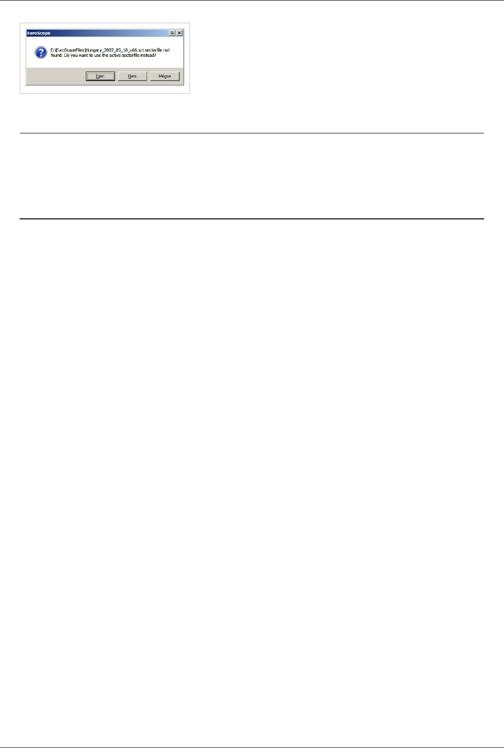
Euroscope:Multiple Sectorfiles 49
If you accept then the active sectorfile will be associated with the ASR.
If you refuse you have to browse and locate the sectorfile to be used
with the ASR.
Actually there is no function in EuroScope that allows you to change
the sectorfile reference of an ASR (except the situation if the file does
not exists). If you need to modify it, delete the reference using a
notepad, or rename the referenced sectorfile, then you will be prompted.
Previous: Euroscope:Going Into Details Actual: Euroscope:Multiple Sectorfiles Next: Euroscope:Sectors And Aircraft States
Euroscope:Sectors And Aircraft States
Previous: Euroscope:Multiple Sectorfiles Actual: Euroscope:Sectors And Aircraft States Next: Euroscope:Professional Radar Simulation
Sectors
What is a sector? A sector is a piece of airspace with a polygon boundary as lateral limits and with defined bottom
and top altitudes/levels as vertical limits. The airspace controlled by the controller is his/her sector. (e.g. LHBP_APP
sector covers the Budapest TMA, LHCC_CTR covers all Hungarian airspace, or after a division, LHCC_E_CTR can
cover the Eastern part of Hungary)
NEW in Euroscope: An important feature of Euroscope is that it can make the airspace you are controlling visually
appear, and on top of that, since it "knows" the vertical and horizontal limits of the airspace you own, it can handle
aircrafts differently. Suppose you log in to control the Netherlands as EHAA_CTR, the territory between the North
Sea to the German and Belgian borders (practically the "FIR") lights up. Further suppose that heavy traffic makes it
necessary to split up this sector and your colleague comes online as EHAA_W_CTR to deal with the London
inbounds in the Western part, that part of your earlier "lit-up" will "go blank", since it is not owned by you anymore.
Another nice example is controlling multiple-sector airspaces, like the VATSIM Eurocontrol positions: with
EuroScope the controller's work becomes much easier - it will be discussed below in details.
You may ask, how does Euroscope know all this? The programming is surely very sophisticated, but the division and
handling of sectors is always the competency of VACCs and controllers. So once they are agreed on (and most
VACCs have been smartly using airspaces), it has to be loaded to the software so that it knows all the vertical and
horizontal sector information. Since other VATSIM controller clients did not have this airspace handling capacity,
technically these sector definitions are put in a separate ESE file. (So EuroScope uses two files to determine your
sector: (1) the earlier used SCT files and (2) the new ESE files.) This may sound complicated, but don't get scared: it
is a one-time issue (or only at AIRAC changes), and in fact it makes life easier! The philosophy of EuroScope is to
integrate all airspace information of a VACC into one SCT and ESE file; if you switch controlled sector in your
VACC, a different airspace is lit up, and you don't have to reload SCT files! Therefore VACCs are expected to take
care of updating the sector information so that controllers can use them easily. The complete definition can be found
in the Airspace section of the Euroscope:ESE Files Description page. Please, consult it how you can define your
sectors.
You can define any number of sectors for one sectorfile. Each sector may have a hierarchy list that defines which
controller will control that individual sector. In this way every logged in controller will be assigned by one or more
sectors to be worked within. These are completely dynamic in EuroScope. When another controller logs in who has
higher priority for a sector, it will be reassigned immediately. On the other way a leaving controller's sectors may be
Euroscope:Sectors And Aircraft States 50
inherited by the online ones. The hierarchy makes it possible to define the sector e.g. for a tower with the hierarchy
list that assigns the sector first to the tower controller, then to the appropriate approach and finally the control. In this
way if tower is online the sector belongs to him even if approach is online. But if tower controller quits the sector
will be assigned to the approach immediately.
The sectors owned by you and not owned by you are displayed with different background colors. That way it is
really easy to notice where you are controlling. This feature probably helps best for the Euro Control position
controllers, who can see immediately when a FIR controller come online or leaves the system.
In this picture I am controlling the Eurocontrol East sectors from Poland to Bulgaria. No other controller is online
and the whole area belongs to me.
Here you see that Praha came online. Therefore his FIR no longer belongs to me. Its color is changed. And you also
can notice the red line indicating an active handoff area where I should pass the aircraft tracking by me to the next
controller.
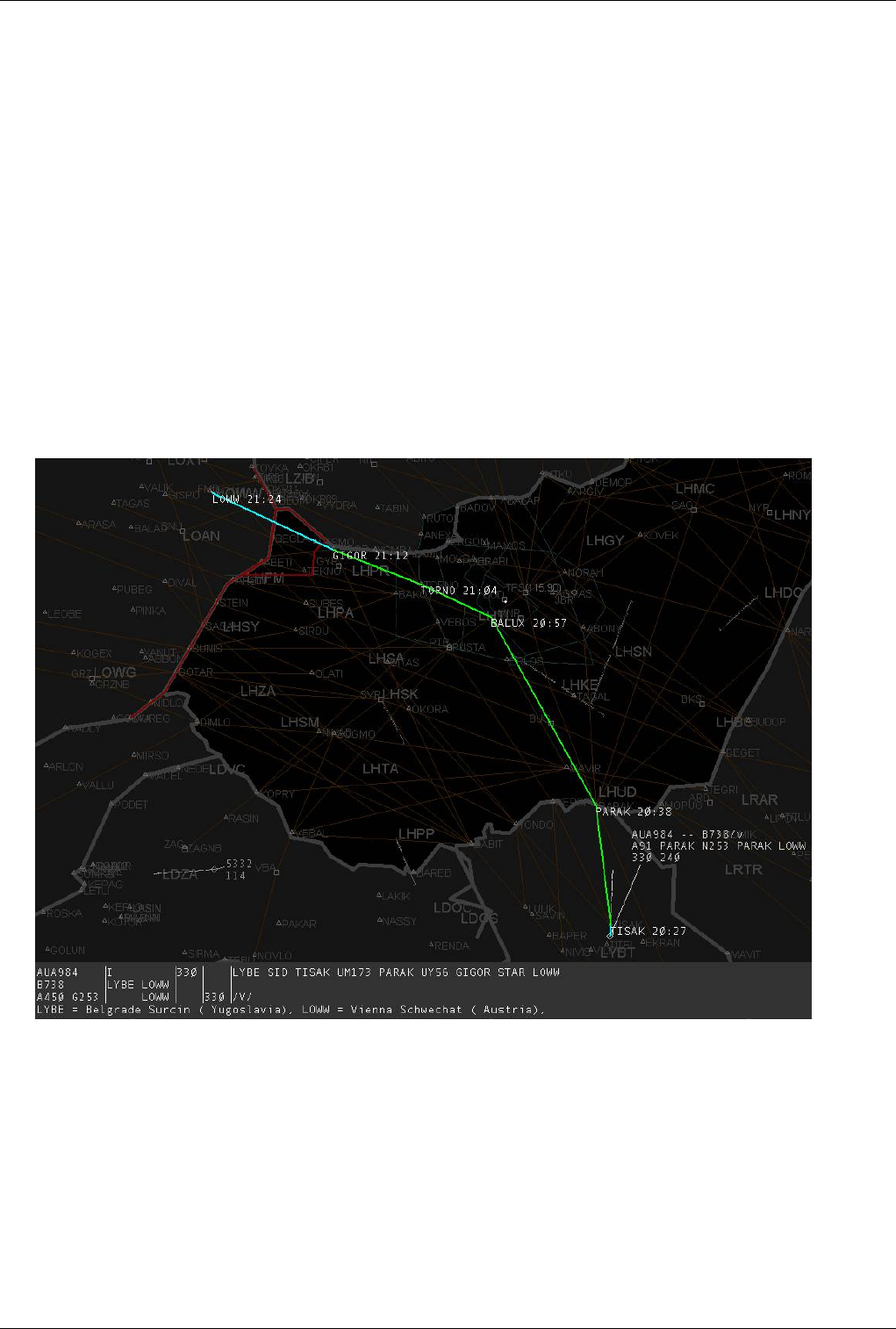
Euroscope:Sectors And Aircraft States 52
Flight Plan Extraction
We can say that EuroScope puts flight plan analysis into a new level. It incorporates the FSNavigator database and
uses all point and airway definition information to decide the exact route an aircraft will follow. (This requires pilots
to file valid flight plans (WAYPOINT (AIRWAY) WAYPOINT, e.g. TORNO Y56 GIGOR for a LHBP-LOWW
flight. EuroScope still can handles "slightly invalid" routings, but on the other hand we must see that since the route
section of the flight plan is a free text data, it is simply impossible for a software to understand all that a pilot have
filed if it is not a validated flightplan. That way the extraction of the route data works is good for 90% of the flight
plans - but there are still ones that are completely misunderstood. In these cases the controller can easily edit the
routings)
On top of the horizontal route data EuroScope extends it with a vertical profile. For that all the coordination point
(see again in the Euroscope:ESE Files Description page) descriptions are used and also a rough climb and descend
rate calculator is implemented. In this way a complete 3-dimensional flight route is calculated for each known
aircraft.
In this picture you can see that just from fixes and airway names the whole flight plan will be extracted point by
point.
It could happen that you or another controller gives a shortcut to a pilot. It can be very easily set through the TAG.
Once the waypoint is defined the extracted route is also changed (so does the distance-to-go calculation).
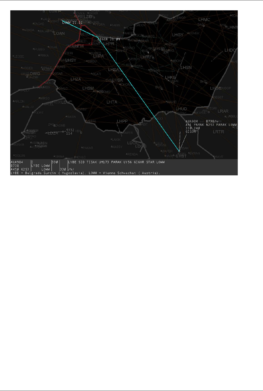
Euroscope:Sectors And Aircraft States 53
Aircraft States
Now, as we have this complete three dimensional flight route estimations, EuroScope can compare them with the
sector definitions. The result of this comparison is that EuroScope is able to classify the aircrafts to the following
categories:
• Non concerned - an aircraft that is not inside any of your sectors and (based on the flight plan) will never ever
enter there. Basically you will never control that aircraft.
This picture is really interesting. I am controlling Budapest Radar, Budapest approach is also online and
DLH3446 is coming to LHBP. But as the coordinated flight level at Budapest TMA entry point (RUTOL) is
FL190 and approach is controlling up to FL195 this aircraft never enters to my sector at all just to approach.
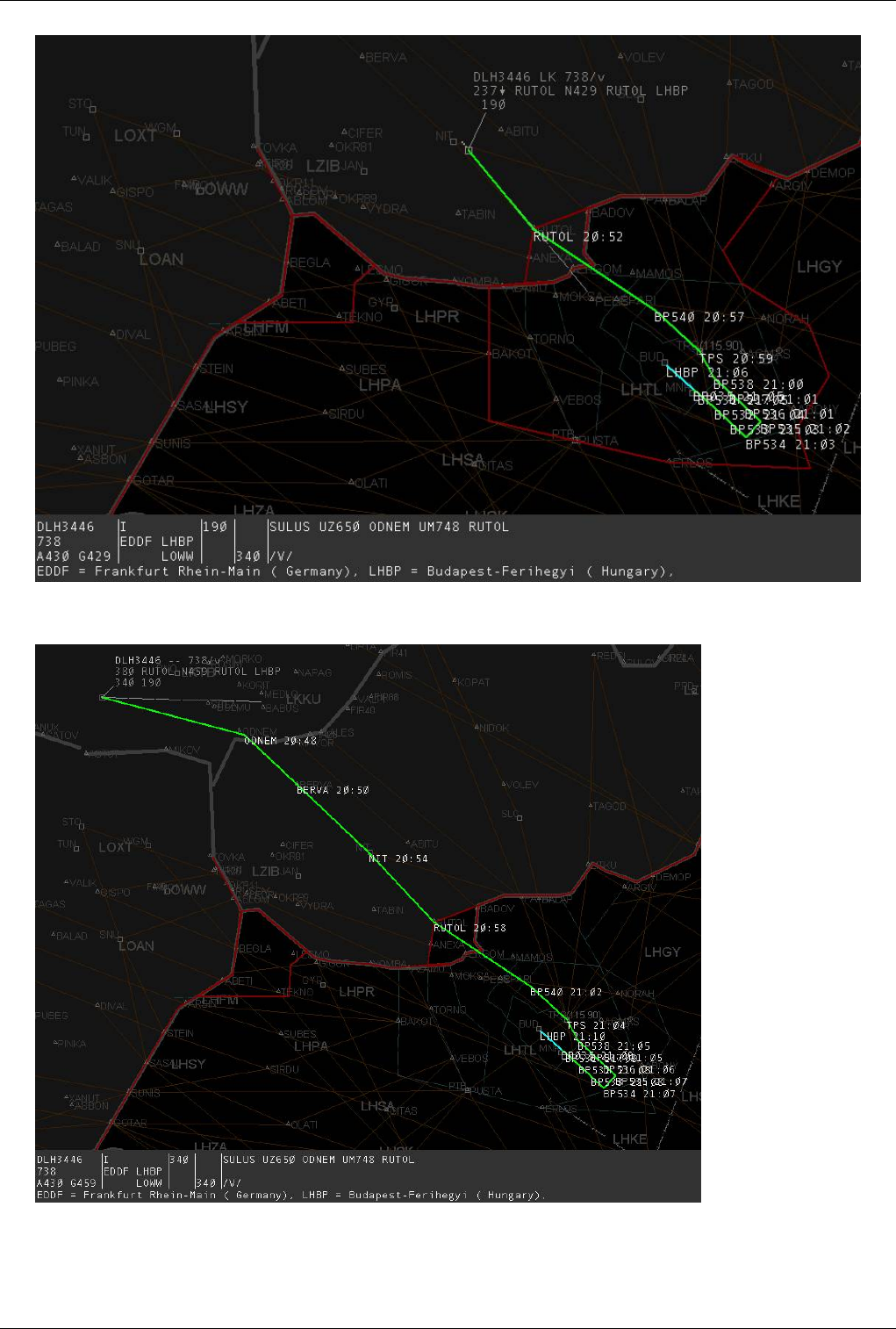
Euroscope:Sectors And Aircraft States 54
• Notified - an aircraft that is still far away but if follows the flight plan route will enter to your sector. Note that
approach has left, therefore I am controlling that sector too.
• Coordinated - in real world this is a very important state indicates that the neighbour controllers are agreed how
the AC will be handed off. As there are no such tools in VATSIM all Notified aircraft become Coordinated 15
minutes prior entering your sector.
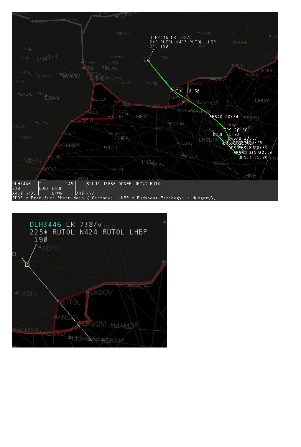
Euroscope:Sectors And Aircraft States 55
• Transfer to me initiated - another controller initiated a handoff to me.
• Assumed - you are controlling the aircraft. Note the sector indicator already indicating that the next controller I
will handoff the aircraft will be Ferihegy Tower (abbreviation used is FT ).
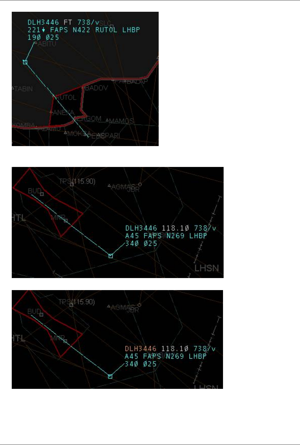
Euroscope:Sectors And Aircraft States 56
• As the aircraft is within 3 minutes time to the next controller the sector indicator automatically changes to display
the next controller frequency.
• Transfer from me initiated - when I initiated a handoff to the next controller.
• Redundant - when the aircraft is still inside your sector but the next controller is already tracking it.
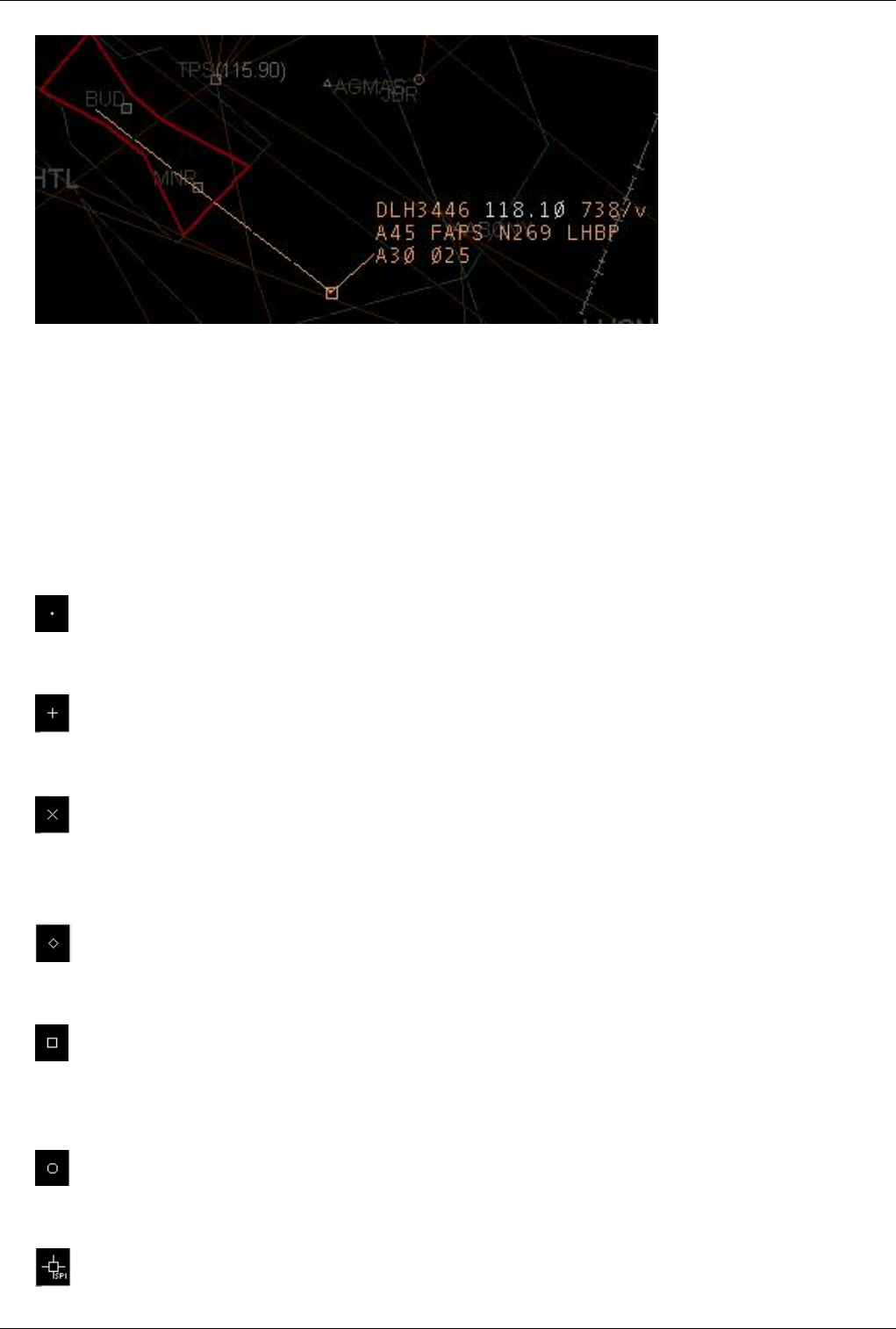
Euroscope:Sectors And Aircraft States 57
• Non concerned - just to close the sequence, as the aircraft leaves your sector and will not come back its state
changes to Non concerned again.
Image is to be created.
Radar Connection States
With v3.1, some new radar states for the aircraft's target symbol have been introduced, mainly related to the new
Euroscope:Professional Radar Simulation. All radar targets can be freely customized using the
Euroscope:Symbology Settings dialog. The available standard radar targets are:
• squawk stand-by - If an aircraft's transponder is on standby, there is only a small cross at the aircraft position.
• primary radar only - If you are receiving only a primary radar response of an aircraft, its position is indicated by a
larger cross (plus).
• Mode A/C secondary radar only - If an aircraft is squawking C (VATSIM mode) and you are receiving only a
secondary radar response, the aircraft's position is indicated by an X.
• Mode S secondary radar only - If an aircraft is squawking C (VATSIM mode), the aircraft is identified as being
equipped with a S transponder by the equipment code and you are receiving only a secondary radar response, the
aircraft's position is indicated by a diamond.
• Primary radar + mode A/C secondary radar - If an aircraft is squawking C (VATSIM mode) and you are receiving
the primary and the secondary radar response, the aircraft's position is indicated by a cube.
• Primary radar + mode S secondary radar - If an aircraft is squawking C (VATSIM mode), the aircraft is identified
as being equipped with a S transponder by the equipment code and you are receiving primary and the secondary
radar response, the aircraft's position is indicated by a circle.
• Primary radar + mode A/C secondary radar - Squawk Ident - If a mode C aircraft is squawking squawking IDENT
then this special "4-legged" icon with text saying: SPI (Special Position Identification) indicates its position.

Euroscope:Sectors And Aircraft States 58
• Primary radar + mode S secondary radar - Squawk Ident - If a mode S aircraft is squawking squawking IDENT
then this special "4-legged" icon with text saying: SPI (Special Position Identification) indicates its position.
• Flightplan track - the flightplan track's calculated positions are indicated by a triangle.
• Coasting - When there is no position update for 30 seconds, the target of the aircraft changes to #.
• History dot - The target's history trail is depicted by dots.
Previous: Euroscope:Multiple Sectorfiles Actual: Euroscope:Sectors And Aircraft States Next: Euroscope:Professional Radar Simulation
Euroscope:Professional Radar Simulation
Previous: Euroscope:Sectors And Aircraft States Actual: Euroscope:Professional Radar Simulation Next: Euroscope:Radar Screen
Professional radar simulation in EuroScope
Concepts
The main idea is to forget some data we receive from the VATSIM servers and to simulate how the radar stations
receive back data from the planes and how these data is correlated to the flightplans.
Basic elements of the simulation:
• Radar stations: There is a new section in the ESE file. You can define where radar stations are exactly positioned.
You can define the range where primary and secondary responses are visible for the radar. Also a linear slope can
be added to reduce the floor of the radar visibility in longer distances.
• As Hungary is one of the testing areas of the S-mode receivers the S-mode and A+C-mode transponders are
different in the simulation. They may be shown differently on the radar, but you can also disable S-mode if it is
not used in your area. S-mode transponders send more data than just the squawk code, therefore the correlation is
easier.
• Radar holes: You can also define radar hole areas, where no radar responses can be seen (even inside the range).
Those can for example simulate canyons and other areas with topographic conditions that make the receipt of
radar responses impossible.
• Complete separation of the radar response positions and the flight plans. They are maintained separately and will
be correlated only when certain criteria is fulfilled. You can manually correlate and uncorrelate the radar positions
and the flight plan tracks.
• Flight Plan tracks: All known flight plans are moved (just like statistical planes) if there are no correlated radar
positions. You can define estimates for uncorrelated flight plan tracks. That way they are moved back/forward
along their route.
There are already some improvements planned for future versions, so the current implementation is not what we
expect to be the final state of professional mode.

Euroscope:Professional Radar Simulation 59
How it is implemented
Enable/disable
It is not necessary to use the radar simulations. In the Euroscope:General Settings dialog you can configure several
aspects of the radar simulation:
• Correlation mode: With this setting you can define how the radar positions are correlated with the flight plans:
• Easy VATSIM: This is the old method used by older EuroScope versions and all other radar clients available.
In this case there is no way to uncorrelated the radar positions from the flight plan.
• A+C-mode: Only the squawk code is used for correlation. A radar position is correlated to a flight plan only in
case the pilot is squawking the assigned code (and the aircraft is within correlation distance to its flight plans
calculated position).
• S-mode: S-mode transponders send the callsign itself, so S-mode planes are correlated simply by matching the
callsign (but must be within correlation range), no matter what the pilot is squawking.
• Correlation distance: The distance between the radar position and the flight plan track for a successful correlation.
If the distance is bigger than that value, they will not be correlated even if callsigns or squawks match.
• S-mode transponders: As unfortunately there is no support for S-mode in VATSIM and most importantly in the
pilot clients, the only way to make a difference between the S and C mode transponders is to define what plane
capabilities are assumed to be S-mode. To do that, the equipment codes are used in the flight plan remark section.
Check the SB3/SB4 documentation about the codes. The default is “IEFGRWQ” that is nearly all RNAV capable
planes. Simply clear this box to disable S-mode simulations.
• Simulate radar coverage and outage: Check this to enable radar position simulation according to the data from the
ESE file.
Symbology dialog
This dialog is extended now. It contains an editor where you can draw your own symbols on the radar. Among others
there are several symbols for the aircraft positions:
• standby: It is used only in easy mode when you choose to show stand-by aircrafts, too.
• primary radar only: When a position is within the radar coverage area and the transponder is disabled.
• A+C mode secondary radar only: When the position is within the radar coverage area and it is too far out to
receive primary radar responses, but the transponder answers are detectable. When A+C-mode transponder
answer is received this symbol is used.
• S mode secondary radar only: Similar to the previous, but we receive an S-mode transponder response.
• primary and A+C mode secondary: When both, primary radar position is received along with a A+C-mode
transponder answer.
• primary and S mode secondary: Same as before, but we receive an S-mode transponder response.
• flight plan track: To display a position of an uncorrelated flight plan simulation.
• coasting: When no radar position (neither primary nor secondary) is received for 30 seconds up to 1 minute.
Whenever an aircraft is coasting within the last 10% of your visual range, after 1 minute the target is not deleted
but changed to be a flight plan track, which is used the very same way as all the other flight plan tracks
originating from statistical data.
• Ground aircraft: It is a new ground view, not related to the radar simulation.

Euroscope:Professional Radar Simulation 60
Display settings dialog
This dialog is also extended with a Simulation mode combo:
• Easy EuroScope mode: This is the original version. It works much more like the previous version of EuroScope.
The positions are always shown at the radar position and do not care if they are correlated with a FP or not.
• Professional radar: This is the real simulation mode. It can not be enabled if in the general settings you select
Easy EuroScope correlation mode. It displays:
• Flight plan tracks: for uncorrelated or no radar position aircrafts. This is used for the far away (statistical data)
traffic too.
• Primary only radar: Just TSSR and GS without any identification method.
• Secondary A+C or S mode: For secondary only positions.
• Primary and secondary: When both are received.
• Here there is no way to display stand-by aircrafts like it was possible before.
• Professional ground: This is a new funny radar screen. I tried to simulate what a controller can see from the tower.
Here the symbol is always put to the radar position and it is rotated to follow the aircraft heading. In the TAG you
can see the first three letter of the callsign (airline identifier – it can be visible from the painting) and the type of
the aircraft. If you enable S-mode simulations then the planes on the ground can show their callsign too. In this
mode you can not select anything on the screen. You must use the lists to manipulate the FP and the states.
TAGs
The list of the TAG types is extended:
• Untagged A+C-mode: This is the original untagged type. It is shown for primary + A+C-mode secondary radar
positions. If the position is not correlated to a flight plan, then you are unable to tag it up.
• Tagged: This is the original type, not too much change here.
• Detailed: Also no change.
• Primary only: The old Unidentified type. Used for primary only radar positions.
• Untagged S-mode: This is a new version of untagged type. It shows the callsign instead of the squawk code due to
the transponder answer.
• FP track: This is a third type of untagged type. When showing a plane just by using its FP estimation, we can
define some more information (like destination).
• Ground: To show the airline and the plane type.
• Ground with S-mode radar: To show the callsign with the plane type.
Whenever you select a TAG on the screen, the plane itself is selected. You can use the ASEL plane with many
functions. In the new version, when an unidentified TAG is selected (primary only or uncorrelated radar TAG) then
the plane itself is selected, but its data is not displayed. Nearly none of the functions will work with that kind of
ASEL. One important exception is the .contactme command. It is sent to unidentified planes, too.
In case of an unidentified radar TAG you can only see the untagged version. There is no way to tag it up. The flight
plan tracks can be tagged up, and even coordinated and be issued a or be accept as handoff. But it works only for
those flight plan tracks that have real data behind from VATSIM. The flight plans that are outside your range and are
only displayed from the statistical data can not be manipulated (even it is not easy to see the difference).

Euroscope:Professional Radar Simulation 61
The ESE file extension
There is a complete new section in the Euroscope:ESE Files Description: [RADAR].
In this section you can define the radar stations and radar holes.
Estimations
When there is no radar response and a plane is displayed by the flight plan track only, you may enter some
estimation when the plane will arrive to a certain waypoint. This is available as command line function, as TAG item
and in the flightplan dialog. The command itself is the following:
.est <waypoint> <time> ASEL
.est <waypoint> <time> <click on AC>
• waypoint: A waypoint along the route. It can be any waypoint, even one that was already passed. But only points
along the route can be selected.
• time: The zulu time in four letter format (e.g. 2235 for 22 hour 35 minutes). The time is limited. It must be in the
future and maximum two hours later.
Previous: Euroscope:Sectors And Aircraft States Actual: Euroscope:Professional Radar Simulation Next: Euroscope:Radar Screen
Euroscope:Radar Screen
Previous: Euroscope:Professional Radar Simulation Actual: Euroscope:Radar Screen Next: Euroscope:The Menu Bar
Layout Of The Screen
We might divide the screen into 3 sections:
• Menu bar - the upper menu bar is fixed, yet some of its items might be turned on/off.
• Main screen - the main screen is the operational part of the radar screen. Thus its layout can be modified to your
own taste.
• Command line - the lower command line is used as text input and 'single click' info bar.
Menu Bar
On top of the screen you can find Euroscope:The Menu Bar:
Main Screen
When mentioning main screen, we have to think about the radar screen itself. We are not going to go into details
concerning radar screen in this section, rather focus on parts of the screen, which are not related to the radar itself.
The documentation of those elements are divided into the separate functions of the main screen's elements:
• The Euroscope:Basic Lists - The lists similar to those already known from VRC
• The Euroscope:Advanced Lists - More advanced lists, containing all important information for the different states
of flight.
• The Euroscope:Distance Separation Tools
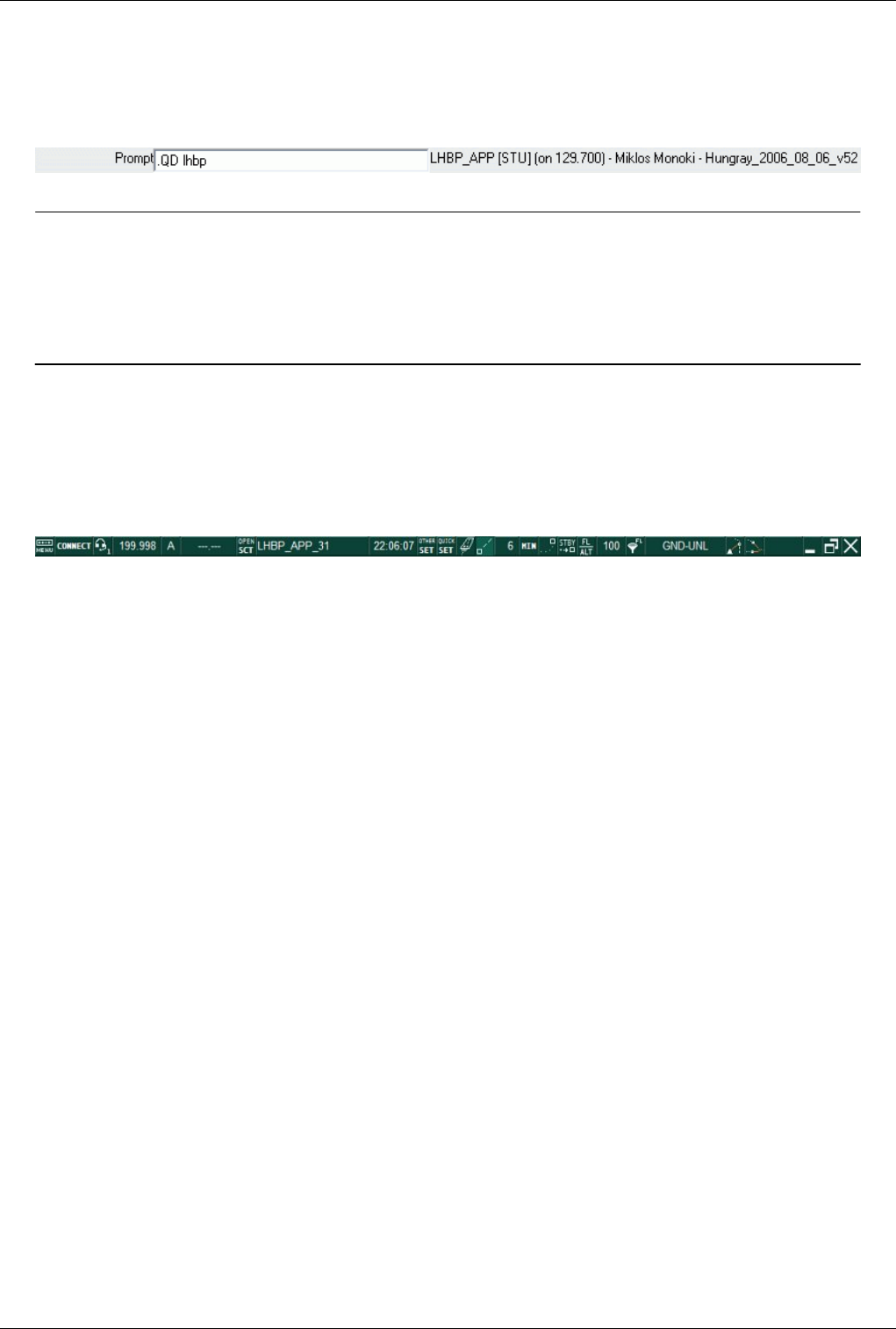
Euroscope:Radar Screen 62
• The Euroscope:Chat Box
• The traditional Euroscope:Flight Strip - as it is known from ASRC and VRC.
Command Line
The bottom bar is called Euroscope:The Command Line.
Previous: Euroscope:Professional Radar Simulation Actual: Euroscope:Radar Screen Next: Euroscope:The Menu Bar
Euroscope:The Menu Bar
Previous: Euroscope:Radar Screen Actual: Euroscope:The Menu Bar Next: Euroscope:Basic Lists
Menu Bar
On top of the screen you can find the menu bar:
Most of the menu items can be activated with left mouse button as usual, though there are some buttons where right
mouse button might be used, too.
Menu Items
Turn on/off some blocks of menu items, like:
• Show controller login name
• Show file name
• Show primary frequency
• Show ATIS frequency
• Show selected aircraft
• Show clock
• Show leader data
• Show transition altitude
• Show altitude filters
• Show METAR in title
Connection
Clicking here will take you to Euroscope:Connection Settings dialog. The icons with orange border will show you
the actual connection mode. These are:
• Unconnected state
• VATSIM connection
• SweatBox connection
• Simulator session hosted by me
• Proxy connection
• Playback logfile
• Non VATSIM server connected (local FSD for simulation)

Euroscope:The Menu Bar 63
Controller login name
During active connection the callsign and the your actual rating (in brackets) are shown.
Voice communication setup
Voice setup (similar to VSCS in ASRC). Select text/voice frequencies for receiving/transmitting. Voice hardware
setup (PTT selection), etc.
Primary frequency status is shown on the icon:
• Headphones are orange - receiving
• Microphone is orange - transmitting
• Red X - the voice subsystem is not initialized (mostly due that a second instance is started) and no voice function
is enabled
Primary frequency
Your primary frequency is displayed here. (To change it, go to the voice communication setup.) It turns orange,
when you issue a .break command, for a position relief. Clicking on the icon the Euroscope:Voice Communication
Setup is opened.
Voice ATIS
Your voice ATIS compiler can be found here. Letter of the actual ATIS will be shown here. Once your voice ATIS
is running, its frequency will be displayed on the right side of the ATIS designator. Clicking on the letter opens the
Euroscope:Voice ATIS dialog.
Sector files
• Download sectorfiles from providers
• Reopen your last opened sector layouts (.asr files)
• Open - open an existing .asr file
• Close - close the actual .asr file
• Save - save changes to the actual .asr file
• Save As - save the actual .asr file with a different name
• New - create a new .asr file - depending on the loaded plug-ins here you may have several new options to create
different type of screens
• Load Sector File - load your main .sct ASRC sector file
• Load Aliases - alias file (.txt), same format as ASRC alias files
• Load ICAO Airlines data - data file to decode ICAO airline codes (ICAO_Airlines.txt)
• Load ICAO Airports data - data file to decode ICAO airport codes (ICAO_Airports.txt)
• Load ICAO Aircraft data - data file to decode ICAO aircraft codes (ICAO_Aircraft.txt)
• Load FSNavigator data - FSNavigator data file for the actual AIRAC (AIRWAY.txt)
• Load VATSIM Server IP addresses - ipaddr.txt file (exported from Servinfo)
• Load additional Server IP addresses - myipaddr.txt file (your personal servers file)
• About EuroScope - current version of EuroScope

Euroscope:The Menu Bar 64
Actual sector layout
The name of the currently displayed sector layout is shown here, if you open more than one .asr files and switch
between them with [F7]' then the name of the actual one will here. Clicking on this item will let you manually select
another already opened layout.
Selected aircraft
The name of the currently selected aircraft will appear here.
Clock
Your system time is shown in UTC (zulu time).
Other settings
This is the main settings menu for deeper changes in your program.
• Save profile - To save the current configuration in the current profile file
• Save profile as - To save the current configuration in another profile file with another name
• Auto load last profile on startup - If this menu item is checked, EuroScope will load the lastly used profile file on
next startup
• Auto save profile on exit - If this menu item is checked, EuroScope will save the current profile file when exiting.
• Save all settings - To save parameters that are not saved in the settings file, call this item. Actually from version
3.0 it is not so important to do it manually as all settings change will be prompted on exit.
• Load all settings - Replace your settings with previously saved ones
• Settings file setup - It opens the dialog box to specify what settings groups are to be saved to what files (see
Euroscope:Where My Settings Are Saved)
• General settings - Some general settings such as ASEL and FREQ key, current squawk range (further details
under Euroscope:General Settings)
• Display settings - Select what to be displayed on your radar screen (further details under Euroscope:Display
Settings)
• Symbology settings - Set the colors, font sizes, line types and symbols used on the radar screen (further details
under Euroscope:Symbology Settings)
• Plug-ins - It opens a dialog box to manage your plugins and plug-in permissions. See the Euroscope:Plug-Ins
dialog.
• TAG editor - Create your own radar tags/labels using this editor (further details under Euroscope:TAG Editor)
• Sounds - Audio notifications can be configured here (further details under Euroscope:Sounds Setup)
• Voice - Voice communication setup (same as the one available through the icon, further details under
Euroscope:Voice Communication Setup)
• Active airports/runways - Select airports to be concerned in your traffic prediction lists, select active runways for
displaying default procedures (SID/STAR) and accurate distance calculation (further details under
Euroscope:Active Airports Runways)
• System messages - It simply opens the Messages tab in the chat area
• Extended centerline setup - EuroScope is able to draw enhanced runway centerlines on your radar screen. (Easy
configuration, neat result.)(further details under Euroscope:Extended Centerline Setup) To turn on runway
centerline items go to Euroscope:Display Settings.
• Short term conflict alert setup - You can setup when an alert is to be displayed (further details under
Euroscope:Short Term Conflict Alert Settings Dialog)

Euroscope:The Menu Bar 65
• Sector ownership setup - Here you can set up how the sector assignment should work (further details under
Euroscope:Sector Ownership Setup)
• Save chat to a file - Save the content of your current chat into a text file.
• Save chat to the clipboard - Copy the entire text of your current chat to the clipboard.
Quick settings
• Show sector inbound list - Show flight strip with all aircrafts incoming to the sector
• Show sector exit list - Show flight strip with all aircrafts exiting from the sector
• Show departure list - Show flight strip with all aircrafts departing from this position
• Show arrival list - Show flight strip with all aircrafts close to its destionation (if destination is selected as active
for arrivals)
• Show flight plan list - Show flight strip flight plans (many filters are available
• Show controller list - Show list of controllers (also observers, any connections with ATC clients).
• Show aircraft list - Show a list of predicted traffic that are to enter your airspace, or have already entered it.
• Show voice room list - Indicate the names of those, who are on your voice channel.
• Show METAR list - Display a floating bar showing all METAR requested if checked, otherwise not.
• Show ATIS letter in METAR list - Display the ATIS letter in the METAR list if checked, otherwise not.
• Connect SIL to Top messages - If checked, locks Sector Inbound List flight strip bay under the incoming
messages list, otherwise you can put that list anywhere you want on your screen.
• Connect SEL to SIL bottom - If checked, locks Sector Exit List flight strip bay under the Sector Inbound List
flight strip bay, otherwise you can put that list anywhere you want on your screen.
• Connect DEP to SEL bottom - If checked, locks Departure List flight strip bay under the Sector Exit List flight
strip bay, otherwise you can put that list anywhere you want on your screen.
• Show text messages - As we prefer voice communication, we might miss important text messages coming on our
primary frequency. With this option we can display the incoming messages (with time stamp) on top of the radar
screen, with double clicking we can hide them and go to answer them.
• Show STBY aircraft - This tool comes handy, when you would like to turn on the radar tags for aircraft that are
squawking STBY.
• Show simulated traffic - Traffic falling out of your range are also simulated. This way, you can have information
on flights that are not in your range yet. If this option is on when you are not connected to the network you can
see all aircrafts and controllers online based on VATSIM statistics data.
• Play sounds - Play sound files for certain events, like handoff, etc. Configuration is possible in Other Options ->
Sounds.
• Show magnetic north up - If this option is checked then the magnetic north will be displayed to the UP side of the
monitor. If unchecked then the true north.
• Enable advanced proxy communication - EuroScope is designed to be easily used in systems with two or more
monitors and displays. In this case you should start two instances of ES and connect the second to the main
program via proxy connection. In this case both clients will be a full station using only a single VATSIM
connection. If advanced communication is enabled then several messages are sent between the clients (e.g. the
selected screen item, the opened chat windows, the entered message to the command line etc.) With the help of it
you are able to write the command in one instance and click the aircraft in the second one and it will still work.
On the other hand when someone is connected to your proxy externally then it is not a good idea to see what
he/she is typing. This flag is set automatically. If a proxy connection is made to the "localhost" client then it is
enabled otherwise disabled as default.

Euroscope:The Menu Bar 66
Active airports/runways
Here you may select the airports to be concerned in your traffic prediction lists, select active runways for displaying
default procedures (SID/STAR) and accurate distance calculation. Clicking on the left side of the runway designator
will select the airport, in the right hand columns the departure and arrival runways can be ticked (further details
under Euroscope:Active Airports Runways).
Leader line on/off
Toggle the time/distance vector for all displayed aircraft. (Mind you, it is possible to toggle the leader line of a given
aircraft by right clicking on an empty section of the detailed tag.) Clicking with the right menu button a popup list
appears that allows a quick setting of the leader lines. In this popup you can select if the leader line is a straight one
or if it follows the route.
Leader line type/length
You may set the type of leader line, depending whether time or distance vector you prefer at the moment. Also, by
clicking on the numbered button (left click to increase, right mouse button to decrease) you can set an exact length
for the vectors.
History trails
Toggle history trails for all aircraft. (Small dots symbolize the previous positions of the aircraft.)
Show standby aircraft
This tool comes handy, when you would like to turn on the radar tags for aircraft that are squawking STBY.
Transition altitude
This is just a reminder of the actual transition altitude for you. Set the values with your left and right mouse buttons
(left click to increase, right click to decrease). Below FL100 the levels can be adjusted by 500 ft, above FL100 by
1000 ft.
Altitude filter
You may set an interval (open, or closed) in which you want traffic to be displayed. Default value is GND-UNL
which means that all traffic is shown on the radar.
Distance tool
A smart tool for measuring distance and time, checking radials, headings, coordinates, etc. This button calls the
.distance command, which can be followed by callsigns, fixes, etc. Selecting the points can be done either by typing
the points or by selecting them on the radar by a single mouse click.

Euroscope:The Menu Bar 67
Separation tools
Use separation tool if you are not sure whether two aircraft on converging tracks would require further attention in
order to keep the separation between them. With this you can predict what the minimum distance between these
planes would be, and when exactly this situation would happen.
Short METARs
To display the short metar of an airport press [F2] type the ICAO code of the airport and hit [ENTER] (this is
equivalent to command: .QD XXXX in the text input ). If a new METAR is received from the server, it will be shown
in orange to draw your attention. By cliking on it (acknowledging it) the color will change to white and also the
complete metar is displayed in the status bar. If the place is long enough to show the full metar string then it will be
displayed instead of the short version. If you have to display more station data at one time you may run out of space
for them (actually it is not a too big area). In this case with a right click you can loop over the displayed metar data.
A doubleclick will remove the clicked metar just as F2 and ICAO code.
Send screen to the next desktop
This button is hidden unless you have a multi-monitor system. Users with 2 monitors can send the screen to the other
monitor using this button.
Minimize to taskbar
The standard Windows minimize button.
Maximize/restore window
This is once again the standard maximize/restore Windows button. But a little bit limited behavior. As EuroScope
does not have a resizing frame around there is no meaning to make smaller than the screen. So the only difference
between maximized and restored state of the screen is that in maximized state even the taskbar is covered by the
radar. In restored state the taskbar is visible. My experience shows that when the screen is maximized MSN will
show your state *busy* but not in restored state. Clicking here with the right button a popup menu appears that
allows you to select the position of the window from a short list. You can split the screen vertically to two half and
horizontally to two half or three third. The selected position is used only if EuroScope is not maximized.
Quit
No real need to comment this function.
Previous: Euroscope:Radar Screen Actual: Euroscope:The Menu Bar Next: Euroscope:Basic Lists
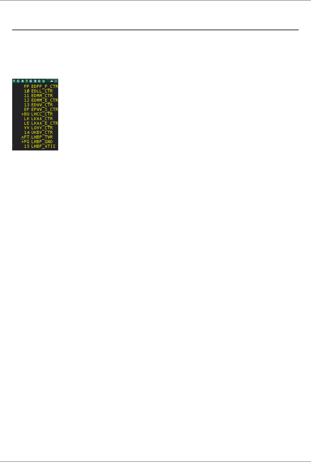
Euroscope:Basic Lists 68
Euroscope:Basic Lists
Previous: Euroscope:The Menu Bar Actual: Euroscope:Basic Lists Next: Euroscope:Advanced Lists
The Controller List
This floating bar can be set on any position on screen at user discretion. It displays some information about the
controllers in the area of your center.
The top bar allows you to filter which controller positions are displayed on screen by clicking on the buttons located
in left part of the floating bar.
•F - Displays FSS stations on line (Flight Service Stations).
•C - Displays CTR stations on line (Center positions).
•A - Displays APP stations on line (Approach positions).
•T - Displays TWR stations on line (Tower positions).
•G - Displays GND stations on line (Ground positions).
•S - Displays ATIS stations on line (ATIS positions).
•O - Displays OBS stations on line (Observers positions).
•U - Displays unidentified stations on line (Non identified positions).
For each position, the following items are displayed in the Controller list:
• Ground to ground communication status
• Ongoing coordination flag indicating that the controller uses radar client that is ready for ongoing coordination.
• The position identifier as defined in the ese file.
• The complete callsign.
The color of the controller means:
•yellow - normally;
•pink - when leaving shortly;
•white - when no position update in the last 30 seconds and they are assumed to be disconnected.
With a left single click on any position in the list a detailed data is copied to the message area. With a doubleclick
you can open a chat window with the controller.
With a right click a special popup menu appears that shows the following items:
•Listen to frequency - using this item a normal voice connection to the controller's frequency is added to the voice
dialog, where only voice receiving is selected. In addition you can set transmission manually.
•Leave frequency - to quickly disconnect from the controllers main frequency channel
•Get ATIS - this item calls for the actual ATIS of the controller, the answer will be shown as private message in
the chat area,
Euroscope:Basic Lists 69
•Intercom - it starts a bilateral communication, where your secondary input and output hardwares are used (for
transmission use your secondary PTT)
•Override - for the caller it works exactly like an intercom call (transmits on the secondary output device, with the
secondary PTT), for the receiving unit voice comes on his secondary output, to transmit there is no need to press
the PTT secondary voice input and the communication on the primary frequency is trasmitted to the other party.
•Monitor - listen to the selected controller's frequency, without having the opportunity to transmit on the
frequency
•Accept - to accept an external ground-to-ground communication call
•Refuse - to refuse an external ground-to-ground communication call
•Disconnect - to close the active landline connection
Note: At one time only one ground-to-ground communication can be opened to a specific controller.
EuroScope uses the following ground to ground communication status indicators:
- outgoing INTERCOM, not accepted yet
- incoming INTERCOM, not accepted yet
- successfully established INTERCOM connection
- outgoing OVERRIDE, not accepted yet
- incoming OVERRIDE, not accepted yet
- outgoing OVERRIDE, successfully established
- incoming OVERRIDE, successfully established
- outgoing MONITOR, not accepted yet
- incoming MONITOR, not accepted yet
- outgoing MONITOR, successfully established
- incoming MONITOR, successfully established
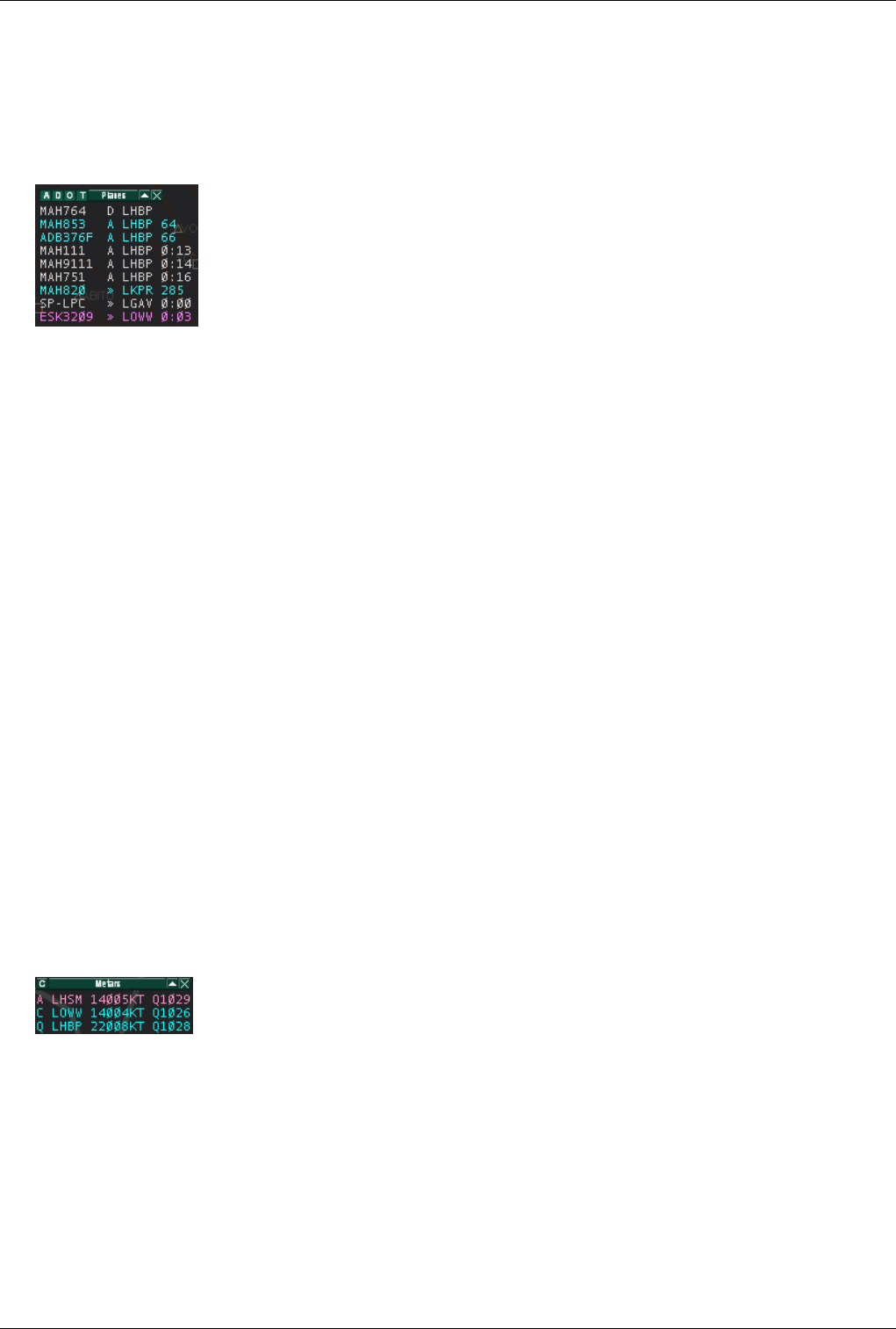
Euroscope:Basic Lists 70
The Aircraft List
This floating bar displays the aircrafts which are relevant for your position active position. Both the in range and the
simulated planes are here. Each line is colored depending on the aircraft state, according to the definition in the
datablock settings in symbology dialog. A left click on a line selects the aircraft - it can be used as a click on the
TAG itself, right click opens the flightplan editor.
• The first item is the aircraft callsign. With a handoff request in progress, a left click opens the handoff popup
menu.
• The second item can either be an A, D or >>.
•A - indicates the aircraft is an arrival for one of the users active airports.
•D - indicates the same for departures.
•>> - indicates the aircraft's destination is outside your sector and the aircraft is going to leave or enter your
sector.
• The third item is the aircraft departure or destination airport.
• The fourth item depends on the aircraft state. For departures it is the assigned squawk, for arrivals it is the
distance remaining to the destination airport. When the user is working an active sector which the aircraft is going
to enter, it is changed to the time left until entering the sector.
The list can be filtered by the header left letters:
•A - is for arrival planes,
•D - is for departures,
•O - is for overflights,
•T - is for tracked planes.
The Metar List
This floating bar displays the METAR stations requested by the controller. The user requests a METAR by typing
the F2 function key or by typing .QD then the ICAO code of the requested station. It appears in orange color in the
menu bar and in the METAR floating bar in short METAR format.
• Short format line: DAAG VRB03KT Q1029
• Long format line: DAAG 101030Z VRB03KT 9999 FEW020 14/04 Q1029
If the user clicks on an orange METAR, the change of the METAR is acknowledged, the color changes from orange
to blue and it is displayed in long METAR format in the right side of the command line. Using the C button on top
left of the floating bar, the user can acknowledge all METAR changes with one click.
Via Quick Settings You can add the current ATIS designator to the METAR lines.
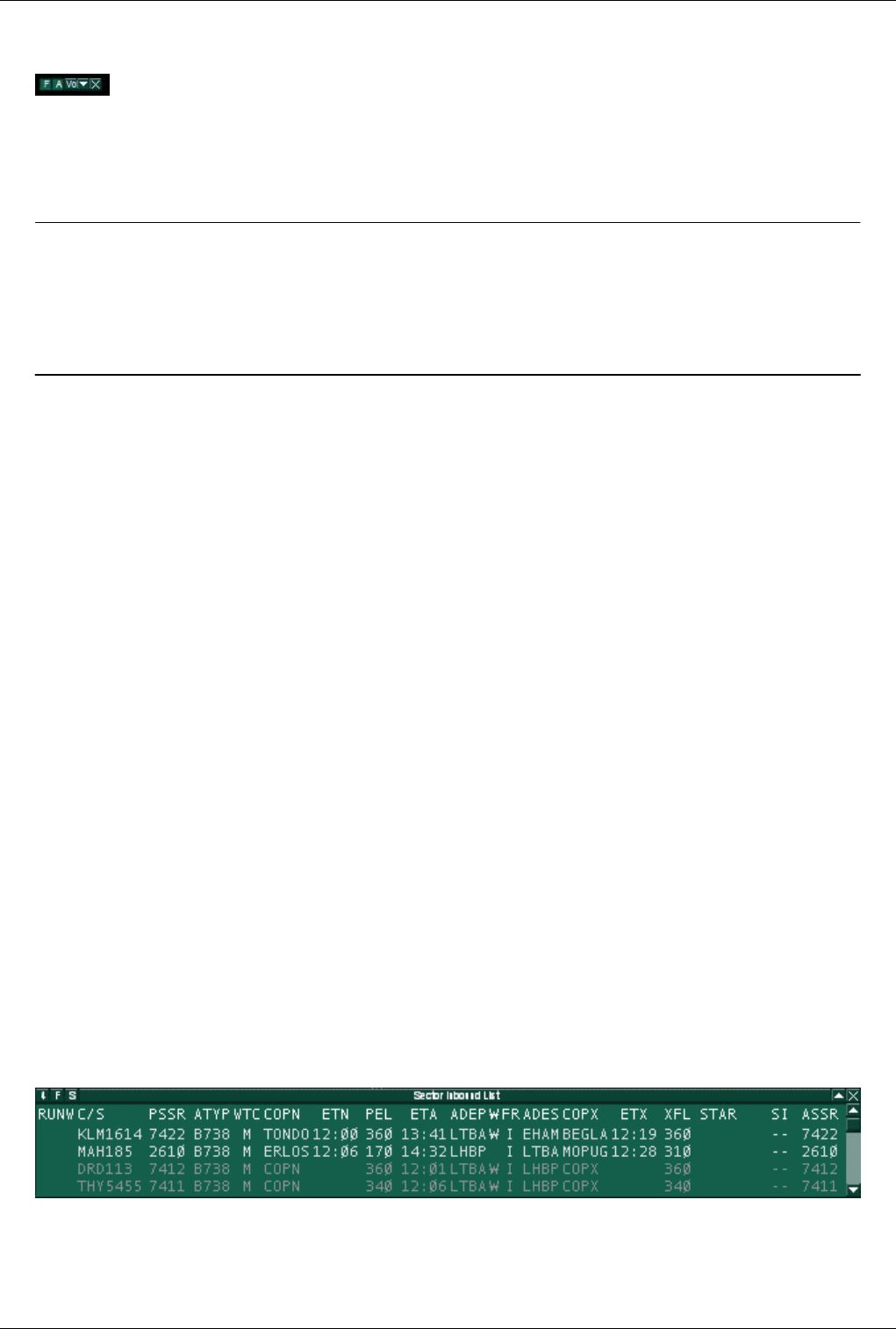
Euroscope:Basic Lists 71
The Voice List
This floating bar displays information about pilots connected on the controller primary frequency. Two buttons
allows filtering of frequencies:
•F - Displays pilots connected on PRIM frequency
•A - Displays pilots connected on ATIS frequency
Previous: Euroscope:The Menu Bar Actual: Euroscope:Basic Lists Next: Euroscope:Advanced Lists
Euroscope:Advanced Lists
Previous: Euroscope:Basic Lists Actual: Euroscope:Advanced Lists Next: Euroscope:Distance Separation Tools
Summary Of This Page
There are 5 different lists available in EuroScope. In addition to those standard lists, additional lists can be added by
plugins (for example the Holding List Plugin). All those lists have three small buttons located on the upper left
corner of the list window.
The first button on the left defines the size of the list window. The following options are available:
•unlimited - in that case, there is no limit to the number of lines in the list window. The lists shrinks or expands
according to the number of aircrafts.
•maximum nn - in that case, the window has a variable size according to the number of aircrafts and expands only
to the maximal size indicated by the nn parameter.
•fix nn - in that case, the window has a fixed length and displays the nn first items.
The second button allows you to define which items are to be displayed in the list window. Full details are described
below.
The third button opens the List Columns Setup Dialog to completely customize the lists up to your needs. Full
explanation is given at the end of this page.
By clicking on the header of a column in each list, the order of the aircrafts in the list can be changed. This can be
saved in the settings file.
The Sector Inbound List
The Sector Inbound List keeps track of all aircrafts that will enter your sector but are not currently inside. This strip
is mostly read only, You can use that list only for ongoing coordination (as described in Controller To Controller
Communication). The default order of this list is by the estimated sector entry time.
As default the following fields are available in that list:
•RUNW - Assigned runway
•C/S - Aircraft callsign
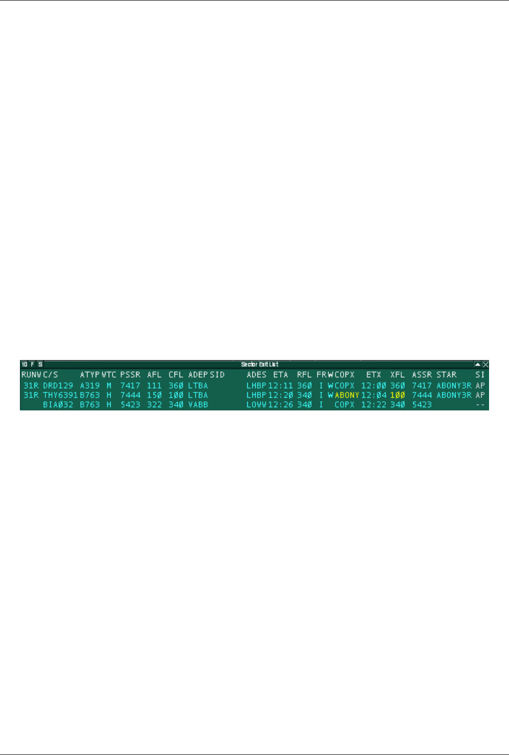
Euroscope:Advanced Lists 72
•PSSR - Current squawk number
•ATYP - Aircraft type
•WTC - Aircraft category
•COPN - Sector entry point name
•ETN - Sector planned entry time
•PEL - Sector planned entry level
•ETA - Expected time of arrival
•ADEP - Departure aerodrome
•W - RVSM indicator
•FR - Flight rule (can be I, V or S)
•ADES - Destination airport
•COPX - Sector exit point name
•ETX - Sector exit time
•XFL - Sector exit level
•STAR - Assigned STAR
•SI - Sector indicator (cant' be modified)
•ASSR - Assigned squawk number
The Sector Exit List
This list displays all information about the aircrafts which are inside your sector and tracked by you. You can modify
some of these parameters by clicking on it. In some cases, a popup menu appears like in the detailed TAG and allows
you to modify this parameter. The default order of this list is by the estimated sector exit time.
As default the following fields are available in that list:
•RUNW - Assigned runway
•C/S - Aircraft callsign
•ATYP - Aircraft type
•WTC - Aircraft category
•PSSR - Current squawk number
•AFL - Aircraft current altitude
•CFL - Aircraft temporary altitude
•ADEP - Departure airport
•SID - Assigned SID
•ADES - Destination airport
•ETA - Expected time of arrival
•RFL - Final or cruise altitude
•FR - Flight rule (can be I, V or S)
•W - RVSM indicator
•COPX - Sector exit point name
•ETX - Sector exit time
•XFL - Sector exit level
•ASSR - Assigned squawk number
•STAR - Assigned STAR
•SI - Sector indicator (cant' be modified)
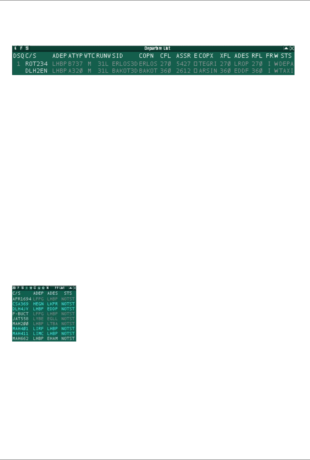
Euroscope:Advanced Lists 73
The Departure List
The departure list shows you all aircrafts currently on the ground on one of your active departure airports. In this list
You can assign all essential data for the aircrafts and keep annotations on their current clearance status.
As default the following fields are available in that list:
•DSQ - Assigned departure order
•C/S - Aircraft callsign
•ADEP - Departure airport
•ATYP - Aircraft type
•WTC - Aircraft category
•RUNW - Assigned runway
•SID - Assigned SID
•COPN - Sector entry point name
•CFL - Aircraft temporary altitude
•ASSR - Assigned squawk number
•E - Clearance receive flag
•COPX - Sector exit point name
•XFL - Sector exit level
•ADES - Destination airport
•RFL - Final or cruise altitude
•FR - Flight rule (can be I, V or S)
•W - RVSM indicator
•STS - Ground status
The FlightPlan List
The flighplan list displays all flightplans based on actual radar traffic and simulated traffic.
As default the following fields are available in that list:
•C/S - Aircraft callsign
•ADEP - Departure airport
•ADES - Destination airport
•STS - Flight status
• NOTST - not started
• SIMUL - simulated traffic
• TERM - terminated
You can filter what flight plans are to be shown. The filters are the followings:
•I - Show IFR flight plans
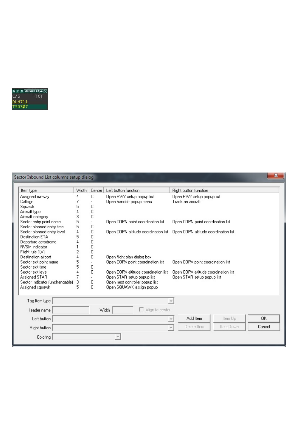
Euroscope:Advanced Lists 74
•V - Show VFR flight plans
•C - Show correlated flight plans
•U - Show uncorrelated flight plans
•O - Show concerned flight plans
•N - Show unconcerned flight plans
The Arrival List
The arrival list displays all traffic that arrived at an active airport.
As default the following fields are available in that list:
•C/S - Aircraft callsign
•TXT - Scratchpad
List Columns Setup Dialog
This dialog allows to the user to customize the way strips are reacting when the user clicks on an item.
There are four columns in this dialog:
•Item type - the user can choose in the Tag item type popup menu which characteristic applies to the selected
item.
•Header name - choosen abbreviation for the selected item
•Width - the width of the column in characters.
•Align to center - this parameter can be set with the "Align to center" checkbox to align to center text in the
column for the selected item.
•Left button function - this popup menu allows the user to choose in a list of preset actions to apply when the user
left clicks on an item in the strip.
Euroscope:Advanced Lists 75
•Right button function - this popup menu allows the user to choose in a list of preset actions to apply when the
user right clicks on an item in the strip.
•Coloring dropdown list - You can assign different colors to list items. Those colors match the relevant datablock
items in the Euroscope:Symbology Settings dialog.
The different buttons "Add item", "Item up", "Item down" and "Delete item" allows the user to add, move up or
down or delete an item in the dialog.
Previous: Euroscope:Basic Lists Actual: Euroscope:Advanced Lists Next: Euroscope:Distance Separation Tools
Euroscope:Distance Separation Tools
Previous: Euroscope:Advanced Lists Actual: Euroscope:Distance Separation Tools Next: Euroscope:Chat Box
The Distance Tool
It is located on the right side of the main menu bar. It allows to display the distance between two points.
These points can be an aircraft, a VOR, a NDB, or even a single geographic point. After clicking on the
distance separation tool icon, the user selects an aircraft by clicking on its TAG. After clicking has been
done, a white line is following the mouse and displays a tag above it showing distance and heading from the first
clicked point. If the user clicks on a second point, the line remains displayed on screen and the resulting information
is displayed in the upper left corner of the screen in the following format:
The first item is the first clicked point followed by the second clicked point, then the heading of the line joining both
points, the inverse heading and the distance in nautical miles between them.
When the user clicks on the icon the .distance command ins entered to the command line. The user have the option
to go down and write parameters manually. Two parameters can be entered that can be anything: fix, ndb, vor or
airport name, aircraft callsign or a geographical point in the following format: N046.39.34.935,E020.24.14.512 . The
user also have an option to change the .distance command to .distance2 . This command will show direction values
at both ends of the line.
The Separation Tool
It is located on the right side of the main menu bar. Use it if you think that two aircrafts are on
convergent tracks and need special attention to avoid a conflict. This tool indicates the minimum distance
between both aircrafts and the time from now when this situation will occur. It displays also for each
aircraft a bold white line from current position until minimum approach position. Here below, both
aircrafts are heading to LGAV.
Euroscope:Distance Separation Tools 76
The tag in the upper left corner is updated as both aircrafts situations evolve. Here below is the tag result few
minutes after.
Previous: Euroscope:Advanced Lists Actual: Euroscope:Distance Separation Tools Next: Euroscope:Chat Box
Euroscope:Chat Box
Previous: Euroscope:Distance Separation Tools Actual: Euroscope:Chat Box Next: Euroscope:Flight Strip
The Chat Box
On this picture you can see the message received from the server. You will have the list of names above the box,
with whom you are in conversation with. These names can be one of the followings:
•callsigns - pilot or controller to indicate private chats
•frequencies - to see text messages come and sent
•server - to see server messages (welcome and other notifications)
•Message - to see EuroScope system message (former message dialog)
•ATC - for ATC broadcast messages (not that you can not write here directly, just with the / command)
•Broadcast - to see supervisor broadcast messages
•SUP - for supervisory request messages
To change between them, simply click on the name. To collapse the chat bar, press [ESC] and to close it, double
click the name, whose chat you wish to close. To jump to your primary frequency, press [NUM STAR] (or if you
changed it your new primary frequency key). If you receive a new private message from a user, then its callsign will
turn blue in the list.
New in v3.1 that you can configure how the new incoming messages are shown in the chat area. You can simply
show them, use a highlight color to indicate unread messages, use flashing handlers for unread messages and even
requires a one-by-one confirmation of them. See the Euroscope:General Settings dialog second page about the

Euroscope:Chat Box 77
available options.
Previous: Euroscope:Distance Separation Tools Actual: Euroscope:Chat Box Next: Euroscope:Flight Strip
Euroscope:Flight Strip
Previous: Euroscope:Chat Box Actual: Euroscope:Flight Strip Next: Euroscope:The Command Line
Flight Strip
When you press the 'F6 button the flight strip is displayed here. The flight strip display is very similar to ASRC.
• In the first column you can see:
•callsign
•aircraft information - based on the flight plan data
•flight plan (A350) and current ground speed (G345)
• The second column:
•flight plan type - I stands for IFR while V for VFR plans
•departure and destination airport - you can see extended information about the airports in the bottom line
•alternate airport
• The third column:
•cleared altitude/flight level
• The fourth column:
•final cruising altitude/level
• The fifth column:
•route - the first two lines contain the flight plan route section
•remark - the flight plan remark section
• The flight strip annotations columns:
In these three columns you can see the flight strip annotations. For the annotation EuroScope uses the same
3x3 block layout that was invented in VRC. To edit any of the annotations simply click to the place and edit
the sting in place. When editing an annotation you can use the TAB key to move between the 9 fields. The
fight strip can be pushed to the next controller using the .SS (F1+u) command or by RIGHT click on the strip
itself. When you initiate a handoff to the next controller EuroScope automatically pushes the flight strip.
• The last column:
•assigned squawk - the top line contains the assigned squawk (it may be empty if no squawk is assigned by any
controller so far)
•actual squawk - in brackets; it is not displayed if the assigned and the current squawk equals
The last line contains some information about the selected aircraft, the origin and the destination.

Euroscope:Flight Strip 78
Previous: Euroscope:Chat Box Actual: Euroscope:Flight Strip Next: Euroscope:The Command Line
Euroscope:The Command Line
Previous: Euroscope:Flight Strip Actual: Euroscope:The Command Line Next: Euroscope:TAGs
Command Line
The bottom bar is called the command line. As already mentioned, it functions as text input bar. Anything you type
using your keyboard will appear down here. To send a message to your primary frequency hit the primary
frequency send key you defined in you Euroscope:General Settings and not [ENTER]. To send text messages or
give in commands use [ENTER] (further details under Euroscope:Working with keyboard)
The right side of this bar is an info bar. Clicking on screen items e.g.: aircraft, controller, ATIS, etc. you can get
detailed information. On the left side, the callsign of the currently selected aircraft is displayed. You can clear the
content of the command edit and if it already edit deselect the aircraft with the [ESC] key.
Previous: Euroscope:Flight Strip Actual: Euroscope:The Command Line Next: Euroscope:TAGs
Euroscope:TAGs
Previous: Euroscope:The Command Line Actual: Euroscope:TAGs Next: Euroscope:TAG Editor
TAGs in general
An aircraft is shown on the screen as a radar target and an associated TAG, that shows the controller relevant
information on the aircraft's situation and flight. In EuroScope, you always have the possibility to customize the
outlook and/or the behaviour of all TAG items. For further information an customizing the TAGs, see the
Euroscope:TAG Editor page.
Every TAG family has eight different TAG types:
• Primary only
• Uncorrelated A+C mode
• Uncorrelated S mode
• Correlated A+C mode
• Correlated S mode
• Flight plan track
• Ground S mode
• Ground no radar
The TAG types correlate with the radar identification state of the aircrafts. For further information on this topic, refer
to the Euroscope:Professional Radar Simulation page.
Every TAG type has three different states:
Euroscope:TAGs 79
• Detailed
• Tagged
• Untagged
Those TAG states correlate with the current usage state of the aircraft on the controller's system. For further
information on TAG states, refer to the Euroscope:TAG Editor page.
Default Matias TAGs
EuroScope comes with the default and unchangeable Matias TAG family. It really closely simulates the version used
by the real Hungarian ANS's system - Matias contains a very rich set of relevant information and is rather similar to
what is also used in other real-world workstations, e.g. on Eurocat models. Still, if you want to simulate a different
system, you are free to do so.
Detailed
The Detailed TAG comes visible when you move the mouse over a Tagged TAG. At one time only one TAG can be
detailed. And this type has many functions connected to special parts of it.
1. Callsign - It displays the callsign of the aircraft
When you are tracking the aircraft there is a popup menu available with left button that allows you to transfer it:
The first list comes up if there is a controller who is controlling the sector just after yours. The second list is missing
the transfer command when no next controller is detected. The functions are the followings:
•transfer - initiates a handoff to the controller next to your sector.
•manual transfer - pops up another list with all the available controllers; select one from the list and a handoff is
initiated to him/her.
•release - simple drops the aircraft.
When another controller has initiated a handoff to you then another popup menu is available (the first picture
displays the initiated handoff):
Euroscope:TAGs 80
•assume - accept handoff.
•refuse - refuse handoff.
2. Sector Indicator - indicates the current or the next sector controller
When you are not tracking the aircraft it simply indicates the controller who is tracking it. "--" means no controller
owns it. If no owner of the aircraft at all then a left click here starts tracking it.
When you are tracking the aircraft it indicates the controller of the next sector. If no online controller who is
controlling the next sector then a "--" will appear here. By right button click the controller short ID can be changed to
the primary frequency. EuroScope will change the ID to frequency automatically when the aircraft is within 3
minutes to the borderline.
You have the chance to override the next controller calculated by EuroScope. Click with the left button on the sector
indicator. It opens a popup menu with the reachable controllers. Select one from the list. It will be assumed as next
controller independently what sectors are next. The overridden controller is flagged by accepted ongoing
coordination color. Select reset to allow EuroScope to detect the next controller based on route and sectors. You also
have the possibility to delete next controller by selecting UNICOM.
3. Aircraft type - the type of the aircraft coming from the flight plan
By clicking on it with the right button you can toggle its display in the Tagged TAG. The type is followed by the
aircraft category sign (by default /H or /M or /L or /J ) and the communication type ( /r or /t or /? ) is here also. Note
that from version 3.0 EuroScope never displays the /v as voice is the default communication form on VATSIM and
we would like to save spaces. Only the different or unidentified types are flagged. To set the communication type
just click on the sign (there are to spaces in the detailed TAG for /v types that allows the mouse clicks). Then a
popup menu appears to select the right type.
4. Actual altitude/FL - the actual altitude or flight level of the aircraft Below transition altitude an "A" letter is
followed by two or three digits (the altitude value in 100 feet)( A50 or A05 or A115). Above transition altitude the
flight level is displayed with three digits ( 050 or 380). The actual altitude/flight level value may be followed by an
arrow pointing up or down. The arrow indicates the altitude change direction (climb or descent). With right button
click it toggles the route display of the aircraft.
5. Sector entry/exit point - the next coordination point along the route
The coordination points are defined in the EuroScope Sector Extension file (see: Euroscope:ESE Files Description).
If a controller owns both sectors of the coordination point then that one is ignored and the next one will be displayed.
In this picture I am Budapest Radar and no approach is online. Therefore the coordination point over ERLOS is not
Euroscope:TAGs 81
active as I control both sectors. Only the FIR exit point MOPUG is effective.
But in this picture Budapest Approach comes online. Therefore coordination point ERLOS becomes active.
By a left click on this piece you can start an entry or exit point coordination with the previous or the next sector
controller. Detailed information about the ongoing coordination can be found in the Euroscope:Controller To
Controller Communication page.
6. Ground speed - the ground speed of the aircraft
Euroscope:TAGs 82
The format is a letter "N" then the ground speed value. By clicking on it with the right button you can toggle its
display in the Tagged TAG.
7. FIR exit point - the coordination point along the route where the aircraft leaves the actual FIR
The definition of the FIR exit point is similar to the sector exit point. By clicking on it with the right button you can
toggle its display in the Tagged TAG.
8. Destination - the ICAO code of the destination airport
A left button click on this item opens the Euroscope:Flight Plan Setting Dialog where you can amend the flight plan.
By clicking on it with the right button you can toggle its display in the Tagged TAG.
9. Cleared altitude/FL - the altitude or flight level cleared to be reached
That is actually the temporary altitude in VATSIM. A left click on this item opens a popup menu with a list of the
altitudes and flight levels from ground to FL610. If the aircraft has cleared flight level then it will be selected. Just
select one and it will be assigned to the aircraft.
There are four special elements in this popup list:
•CL/APP - select this items to indicate that the AC is cleared for ILS approach.
•VAPP - select this items to indicate that the AC is cleared for a visual approach.
•--- - this selection clears the temporary altitude setting the final as cleared.
•RFL - this popup menu will open another popup menu that allows you to change the requested flight
level/altitude.
Important: When making a simulation session (alone or for a candidate) setting the cleared level via the popup
menu will drive the simulated aircraft to the specified altitude.
10. Exit altitude/FL from the sector - the coordinated altitude or flight level at the next coordination point
If no such point defined then the final cruising altitude. See the pictures again from the /sector exit point/ description.
In this picture no approach is online. Therefore the next coordination point is the FIR exit point MOPUG. The
coordination altitude is FL310 there.
Euroscope:TAGs 83
When approach is online then the coordination point is ERLOS and the coordination altitude is FL170.
Clicking on this item with left button the sector entry/exit point altitude popup opens up that allows a coordination
with the previous or the next sector controller. Detailed information about the ongoing coordination can be found in
the Controller To Controller Communication page.
11. Assigned speed - the speed assigned to the aircraft
If no speed is assigned then a static string ASP . If has an assigned IAS then a letter S then the assigned speed. If a
Mach number is set then a "M" then the assigned Mach. With a left click you can open a popup list with the available
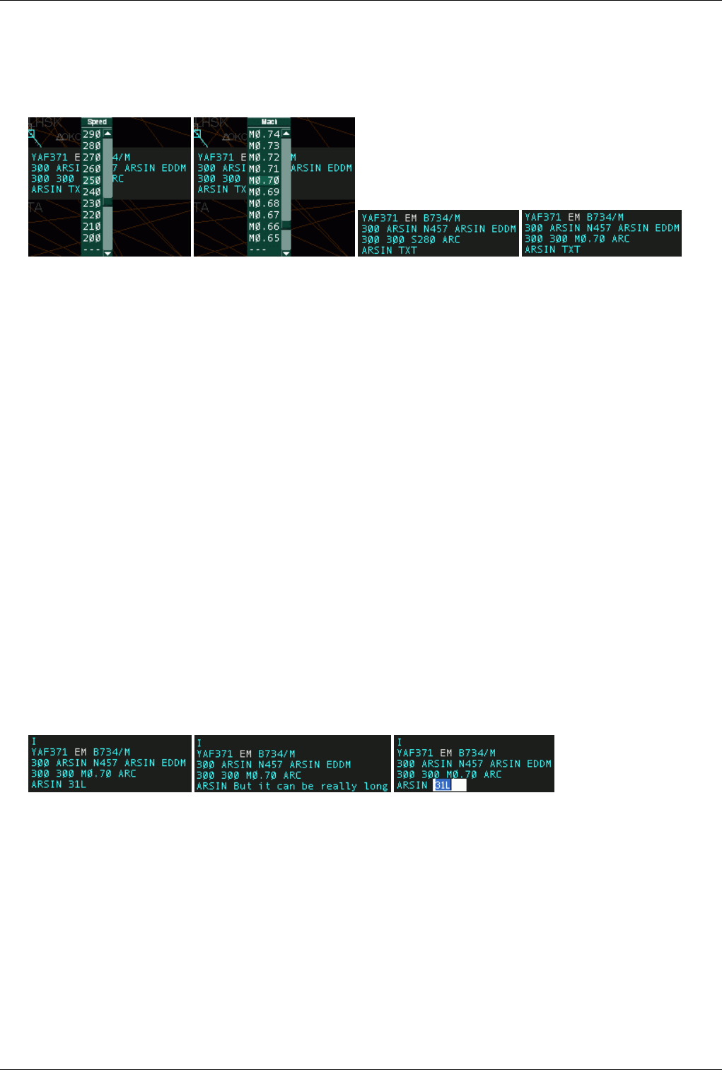
Euroscope:TAGs 84
values from 120-400. With a right click the Mach values are popped up from 0.60 to 1.00. Select the one to be used.
To clear it select the item with "--". Assigned speed/Mach number is propagated to other controllers via scratch pad
text in a form SXXX or MXXX. If the other controller uses EuroScope too this type of scratch pad text will be
recognized as assigned speed.
Important: When making a simulation session (alone or for a candidate) setting the assigned speed will drive the
simulated aircraft to the specified speed.
12. Assigned rate of climb/descend - the assigned rate of climb or descend to the aircraft.
If no rate is assigned then a static string *ARC* otherwise a letter "R" then the assigned rate. Similarly to the
assigned speed you can select the rate values from the popup list. Assigned rate is propagated to other controllers via
scratch pad text in a form RXXXX. If the other controller uses EuroScope too this type of scratch pad text will be
recognized as assigned rate.
13. Assigned heading - the assigned heading to the aircraft. If no heading is assigned then a static string *AHDG*
otherwise a letter "H" then the assigned heading. Similarly to the assigned speed you can select the rate values from
the popup list. Assigned heading is propagated to other controllers via scratch pad text in a form HXXX. If the other
controller uses EuroScope too this type of scratch pad text will be recognized as assigned rate. When the aircraft is
directed to a waypoint using the popup list from /sector exit point/ then the name of the point will be visible here.
Important: When making a simulation session (alone or for a candidate) setting the assigned heading will drive the
simulated aircraft to the specified heading. In this case it is really important to be able to turn the aircraft to the left
or to the right. For that the list contains the values from -360 degrees to +360 degrees from the actual heading.
14. Text message - the scratch pad
Note that if the scratch pad is recognized by EuroScope then the scratch pad remains empty and the appropriate other
item is changed. On the other hand if the scratch pad is not empty a static letter "I" is displayed over the first line.
The length of the scratch pad is limited to 60 chars only, but be careful with long texts as other radar clients are
limited to 3 or 4 characters only. By clicking on the scratch pad area in the TAG the message itself can be edited
there.
Tagged
The tagged TAG is similar to the detailed but contains less information. The following items are not visible at all:
• assigned speed
• assigned rate
• assigned heading - only if heading is assigned, but if a direct to waypoint is specified then it is visible
• scratch pad
There are also items that can be switched to be displayed or to be hidden. You can switch the following items by a
right click:
• aircraft type
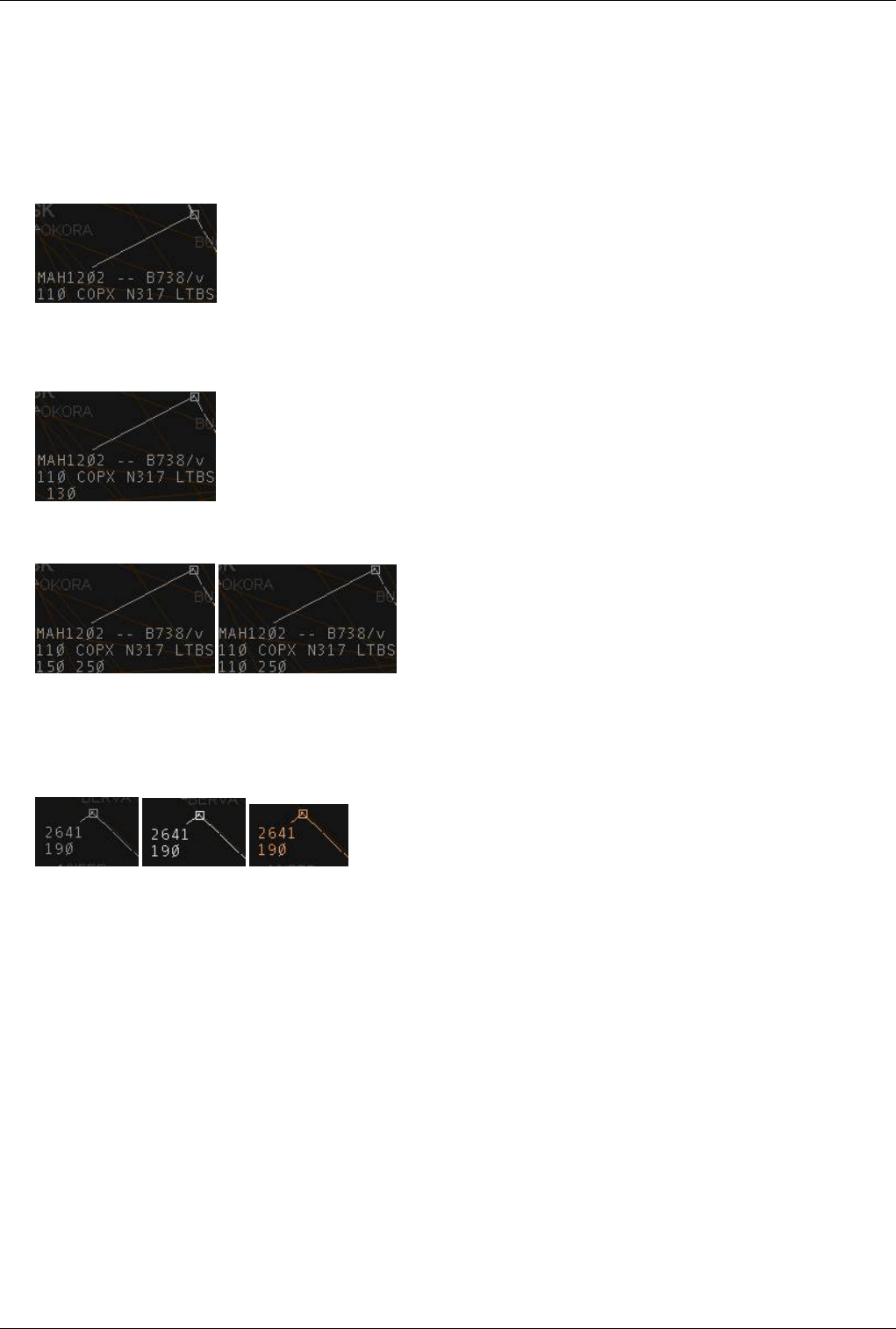
Euroscope:TAGs 85
• ground speed
• FIR exit point
• destination airport
The altitude display is also different. The logic behind is to display only the values that are different from the other
ones. In this way when all three values (actual, cleared/temporary and coordinated/final) are the same then only the
actual altitude is displayed.
When the cleared/temporary is not defined or equals to coordinated/final, then only the coordinated/final is
displayed. And to be easily visible the coordinated/final altitude is not displayed at the beginning of the line but one
letter to the right.
And finally of course if all three are different (or even if temporary and actual are the same) then all three values are
displayed.
Untagged
The untagged TAG is a really compressed with limited data available. Only the squawk code and the altitude is
visible. And also the color of the TAG can be different.
Here the order is: non concerned, notified and redundant.
Moving The TAGS
In EuroScope the position of the TAGs related to the plane is not restricted at all. You can freely move them around
the screen to any direction and to any distance. Just press with the LEFT button and move.
When you are moving the TAG and you press the RIGHT button before releasing it with the LEFT the TAG will
"stick" it on the screen in it's present position and will not move with the aircraft's target. Moving the TAG again
cancels the "sticking" state.

Euroscope:TAGs 86
Tag Up, Tag Down
You can tag up and down a tag by double clicking on the track symbol. To revert the tag back to the default position
you do the above.
Previous: Euroscope:The Command Line Actual: Euroscope:TAGs Next: Euroscope:TAG Editor
Euroscope:TAG Editor
Previous: Euroscope:TAGs Actual: Euroscope:TAG Editor Next: Euroscope:Settings
TAG Families
In EuroScope the TAGs are not fixed at all. It is up to the user what he/she would like to see on the radar screen.
To define your own TAG displays you should add and edit TAG families. You should define each member of the
family, then you can assign the whole family to the layout settings (ASR) files. TAG family is a set of four TAG
definitions. Each must be completely defined before using the family. The members are as follows:
•Untagged - This is used for aircrafts that are not considered by the controller. This type should be as compact as
possible, but should contain information enough to provide safe separation. In EuroScope a doubleclick on the
TAG will tag it up or down.
•Tagged - This is the normal TAG used for aircraft tracked or considered. It contains far more information
therefore needs a little bit more space. Yo can not tag down TAGs that are tracked by you or a handoff initiated to
you. All the rest can be down. In the real life Matias system even the concerned aircraft TAG can not be moved to
down, but as we have a smaller screen I let it be switched on or off. So if you are a real fun of Matias never let it
go down.
•Detailed - This is something really unique in EuroScope. Even if the /Tagged up/ TAGs can contain more
information still has something that is not necessary always but handy to have it very fast. For that a /Detailed/
TAG member is invented. When you are moving your mouse as you are over a /Tagged up/ TAG it will change to
/Detailed/ and you will see even more information about the aircraft. At one time only one TAG can be detailed.
And on a detailed TAG you can have several function connected to the part of the TAG.
How A TAG Is Built Up
Every TAG in EuroScope is built up from TAG items. The available TAG items are defined by the system. All such
item has a piece of code that calculates the actual string to be displayed every time. There are items that always have
content they are never empty but there can be ones that are sometimes empty display nothing. There is a special
item, the /Next line/ item that never displays anything but creates a new line. So that the only thing that you should
do is to make a list of these items and it will form a TAG that can be displayed. The following TAG items are
defined at this moment in EuroScope:
•Aircraft category - The weight turbulence category of the aircraft. The actual symbols can be modified via the
_General_Settings_ dialog.
•Aircraft category with slash - The same as the above one, but starts with a / letter.
•Aircraft type - The sort name of the aircraft type.
•Aircraft type - deprecated - The same as above but can be switched on/off in tagged up TAG. This function is
outdated and should no longer be used. It is kept only for compatibility with TAGs created using an old version.

Euroscope:TAG Editor 87
•Aircraft type/category combined - It is a combination of the type and the category separated by a slash. Use it if
you would like to hide/show them at once.
•Aircraft type/category combined - deprecated - The same as above but can be switched on/off in tagged up
TAG. This function is outdated and should no longer be used. It is kept only for compatibility with TAGs created
using an old version.
•Airline name - This item displays the 3 letters airline name according to the ICAO_Airlines datafile.
•Altitude - The actual altitude of the aircraft. Over the set transition level it displays the value in three digits (e.g.:
310, 050), below the transition level it assignes an A (for altitude) and displays two or three numbers (e.g.: A55,
A06, A110 ). The A can be switched off via the Euroscope:General Settings dialog.
•Assigned departure order - When the plane is assigned to be departed soon it receives a departure order number.
This number is displayed in the item (it is rarely used in the TAG itself, but on the advanced aircraft lists).
•Assigned heading - Assigned heading is an attribute of the aircraft. It indicates the heading given to it by the
controller. It can be set in EuroScope but not published via the network so far. If no heading is assigned then a
static string AHDG is displayed. Otherwise an H plus the heading in three digits (e.g.: H110). This item can also
display the content of the scratch pad in case the content is a waypoint along the route in the flight plan (from
2.8h version any valid waypoint)(e.g.: VEBOS)
•Assigned heading (if set) - The same as above but not shown if no heading is assigned.
•Assigned rate - Assigned rate is an attribute of the aircraft. It indicates the climb or descent rate give to it by the
controller. It can be set in EuroScope but not published via the network so far. If no rate is assigned then a static
string ARC is displayed. If rate is assigned than an R followed by the signed rate value is visible (e.g.: R1500).
•Assigned rate (if set) - The same as above but not shown if no rate is assigned.
•Assigned runway - The assigned departure or arrival runway. The runway can be assigned by the controller, but
can be calculated by EuroScope from route, SID/STAR and active runways.
•Assigned SID - The assigned standard departure route. The SID can be assigned by the controller, but can be
calculated by EuroScope from route and active runways.
•Assigned speed - Assigned speed is an attribute of the aircraft. It indicates the speed give to it by the controller. It
can be set in EuroScope but not published via the network so far. If no speed is assigned then a static string ASP
is displayed. If rate is assigned than an S followed by the value is visible (e.g.: S160).
•Assigned speed (if set) - The same as above but not shown if no speed is assigned.
•Assigned squawk - The squawk assigned by the controller.
•Assigned STAR - The assigned standard arrival route. The STAR can be assigned by the controller, but can be
calculated by EuroScope from route and active runways.
•Callsign - The callsign of the aircraft. It is never empty and most cases used as primary/main item (see later).
•CLAM warning - The stand alone Cleared Route Adherence Monitoring warning. A static CLAM string when
the pilot does not follow the altitude restrictions.
•Clearence received flag - It indicates if the plane has received the clearence flag or not.
•Collision alert indicator - This item is normally empty. But if short term conflict alert is switched on and there
are two aircraft too close to each other, then a CA is displayed by this item.
•Communication type - The type of the communication the aircraft is able. The well known /t or /r will be
displayed. Note that /v is never displayed by EuroScope as voice is the main form of communication in VATSIM.
If the plane is voiceable two SPACE chars are displayed to have a place to popup the communication type menu.
If the type can not be extracted from the remark field a /? is shown.
•Communication type (reduced) - The same as the above, but voice communication is really empty there. In that
case it will not be possible to popup the selection menu from this item. We suggest using it on the tagged type but
not in the detailed.
•Compound warning item - This item combines the following warning flags in this priority order:
• Emergency indicator

Euroscope:TAG Editor 88
• Radio failure indicator
• Hijack indicator
• Collision alert
• Squawk error
• Duplicated squawk flag
• CLAM/RAM warning
•Departure aerodrome - The departure airport extracted from the flight plan.
•Destination airport - The destination airport extracted from the flight plan.
•Destination airport - deprecated - The same as above but can be switched on/off in tagged up TAG. This
function is outdated and should no longer be used. It is kept only for compatibility with TAGs created using an
old version.
•Destination ETA - Estimated time of arrival to destination airport.
•Direct to point name - If a direct is given to the specified aircraft then the name of the point can be displayed by
this item.
•Duplicated squawk - If the assigned squawk is used by another aircraft then a static #DUPE# string. Otherwise
empty.
•Emergency indicator - If the aircraft is squawking 7700 then a static EMG string. Otherwise empty.
•Estimate - This item shows the estimate to the relevant waypoint if set.
•Estimate (always) - The same as above but it shows a fix EST if no estimation is set. It is planned for detailed
TAGs.
•Final altitude - The final cursing level/altitude defined by the flight plan and might be overwritten by the
controller.
•FIR exit point - deprecated - The same as subsequent but can be switched on/off in tagged up TAG. This
function is outdated and should no longer be used. It is kept only for compatibility with TAGs created using an
old version.
•FIR exit point name - The name of the next point from the flight plan route that is defined as FIR exit point in
the sector file extension. If no such point then it is empty.
•Flight Plan Track Status - This item displays the status of the flightplan track.
•Flight rule - The flight plan route I/V/S.
•Ground speed (with N) - The ground speed of the aircraft with an N letter in front.
•Ground speed (with N) - deprecated - The same as above but can be switched on/off in tagged up TAG. This
function is outdated and should no longer be used. It is kept only for compatibility with TAGs created using an
old version.
•Ground speed (without N) - The ground speed of the aircraft (just the numbers).
•Ground speed (without N) - deprecated - The same as above but can be switched on/off in tagged up TAG.
This function is outdated and should no longer be used. It is kept only for compatibility with TAGs created using
an old version.
•Ground status - The status of the aircraft in the departure sequence. The following values can be selected and
displayed here:
•PUSH - when pushback is approved
•TAXI - when the plane is taxiing
•DEPA - when the plane is about to be departing
•Handoff target ID - The ID of the controller who has is targeted by a handoff request. This item is used rarely
now as the Sector indicator does this work also.
•Hijack indicator - If the aircraft is squawking 7500 then a static HIJ string. Otherwise empty. It is inside the
code even this squawk is not permitted on VATSIM.

Euroscope:TAG Editor 89
•Holding List / Holding point name - This item is part of the Holding List Plugin and displays the name of
the holding fix.
•Holding List / Holding time - This item is part of the Holding List Plugin and displays the time the aircraft
is already holding over the holding fix.
•Holding List / Remaining holding time - This item is part of the Holding List Plugin and displays the
remaining planned holding time for the aircraft.
•Manual coordination flag - A telephone symbol, that indicates when something needs to be coordinated with an
adjacent controller who uses a client that does not support the ongoing coordination feature.
•Next line - It is a special item. It never displays anything but starts a new line in the TAG. TAGs are always left
justified.
•Next line if not empty - The same as the previous but it starts a new line only if the current line is not empty.
Using this you can be sure that no empty lines are displayed in the TAG.
•Non RVSM indicator - When an IFR plane that does not indicate RVS equipment in the plane type a static W is
displayed. Otherwise it is empty.
•Not cleared or not reached temporary altitude - This is the sector exit or (if not given) the final altitude. If
different from temporary, then displayed by three digits 150 or 050. If same as temporary but the aircraft is not at
this level then an extra space is added to the beginning. Otherwise empty.
•Not cleared sector entry/exit altitude - It is a combined tag item. If the plane is coming into your sector then
sector entry level/altitude is displayed. If inside your sector then the sector exit level/altitude. If the sector
entry/exit level is not defined then the requested level is displayed here. This item is changing the color on
coordinated values.
•Not reached temporary altitude - It is the temporary or if not set the final altitude. It is displayed only if it is
different from the actual level/altitude. If it is reached then empty.
•Radio failure indicator - If the aircraft is squawking 7600 then a static RDO string. Otherwise empty.
•RAM warning - If the aircraft is more than 5nm away from its calculated route, the RAM warning is shown.
RAM is not shown if the plane is on the ground or cleared for approach, has a direct to point or assigned heading.
And not shown for VFR plans.
•RVSM indicator - It indicates that the plane is equipped to be able to fly in RVSM airspace. The symbol is
strikethrough W. If the plane is non RVSM able then empty.
•Scratch pad filled indicator - If the aircraft scratch pad is not empty a static I string. Otherwise empty. Do not
forget that if the content of the scratch pad is a name of a waypoint then the scratch pad itself is considered as
empty.
•Scratch pad - The content of the scratch pad if not empty. Once again if the content of the scratch pad is a name
of a waypoint then the scratch pad itself is considered as empty.
•Scratch pad (always) - Same as above, but item is always visible. If empty then a static TXT is shown.
•Sector entry point name - The point name along the flight plan route of an aircraft where it should enter the
sector. The definition of the sector entry points is once again an extension to the original sector file.
•Sector entry/exit altitude - The altitude where the aircraft should be (as described by the standard procedures)
when entering or exiting the sector of the controller who is currently tracking. If no such point is defined in the
sector extension file then the final cruising altitude is displayed.
•Sector entry/exit point name - The point name along the flight plan route of an aircraft where it should enter or
leave the sector. The definition of the sector entry/exit points is once again an extension to the original sector file.
•Sector exit level - The flightlevel/altitude at which the aircraft is supposed to leave the sector.
•Sector exit point name - The point name along the flight plan route of an aircraft where it should leave the
sector. The definition of the sector exit points is once again an extension to the original sector file.
•Sector exit time - The estimated time over the sector exit point. Be careful if you coordinate a point that is far
from the sector border, this value might be different from the actual sector exit time.

Euroscope:TAG Editor 90
•Sector indicator - It is a compound item and can show several things. If the aircraft is not tracked by you then is
simply shows the current owner ID. "--" stands for a non-tracked aircraft. If the aircraft is tracked by you then it
calculates which sector is the next along the route and displays the ID of the next controller if he/she is online.
There can be "--" also if no next sector is defined or the next sector is not controlled (no controller online). When
the aircraft within three minutes time to the sector border the next controller ID is changed to the primary
frequency. E.g.: AP, BU, NED, 133.20, --.
•Sector indicator (unchangable) - Same as above, but can't be changed by the controller.
•Sector planned entry level - The flightlevel/altitude at which the aircraft is going to enter the sector based on the
flightplan.
•Sector planned entry time - The time at which the aircraft is over the planned entry point. Be careful if you
coordinate a point that is far from the sector border, this value might be different from the actual sector entry time.
•Squawk - The squawk code sending by the aircraft. As it is never empty it is once gain a good item to be primary.
•Squawk error indicator - This item is normally empty. But if the squawk sending by the aircraft differs from the
assigned squawk it displays an A then the assigned squawk. E.g.: A2602.
•Squawk/callsign - This item shows the squawk of an aircraft unless it is tracked. Then it changes to the callsign
of the aircraft. This is very handy to create tiny compact TAGs.
•Static string - It is up to the designer. If you need a static string in the TAG you can add an item like this and
specify the text itself. EuroScope does nothing with it just displays.
•Temporary altitude - The assigned temporary altitude. If not set then the assigned final altitude is displayed.
Above transition level it is displayed with 3 digits (e.g.: 170, 050), below the transition level it is displayed with
an A followed by two or three digits (e.g.: A50, A100).
•Temporary altitude (if set) - Same as above, but hidden if no temporary altitude is set.
•Temporary if different from sector exit - The temporary altitude if set and if different from the sector exit.
Otherwise it is empty.
•Tracking controller ID - It is the ID of the controller who is currently tracking the aircraft. It is no more used
since the /Sector indicator/ is developed.
•TSSR text - It is a simple static text but built in. For non-squawking aircraft display.
•Two letter assigned speed - Assigned speed is an attribute of the aircraft. It indicates the speed that were given to
it by the controller. It is published by a special scratch pad string, that can be interpreted by other EuroScope
clients. If no speed is assigned then a static string ASP is displayed. If speed is assigned than an S followed by the
first to digits of the value is visible (e.g.: S16 ).
•Two letter assigned speed (if set) - Same as above, but only visible if a speed is assigned.
•Two letter ground speed - The ground speed of the aircraft with only the first two digits indicated.
•Two letter ground speed - deprecated - The same as above but can be switched on/off in tagged up TAG. This
function is outdated and should no longer be used. It is kept only for compatibility with TAGs created using an
old version.
•Vertical speed - This is the actual vertical speed value. It is displayed only if climb rate or descending rate is
bigger than 100 f/m. It displays the absolute value without direction sign. The value is the 100th of the actual rate
displayed to zero decimal digit (e.g.: 1 - 100 f/m, 25 - 2500 f/m). Its value is really far from exact due to the
random position updates coming from the planes.
•Vertical speed indicator - It is a small arrow to the UP or DOWN depending on the vertical speed. It is displayed
only if the climb rate or descending rate is bigger than 100 f/m. If you do not have the right EuroScope font
installed you will see ^ and | in place of the arrow.
Note: If you have a plug-in loaded that supports additional TAG items, then these items will appear in the list too.

Euroscope:TAG Editor 91
Functions From TAG
You are able to change not only the outlook of the TAG but also the behavior. It can be done by assigning functions
to TAG items. Each TAG item may have a function associated with the left mouse button click or the right (works
for middle too) mouse click. The functions are available only on the detailed TAG. You can assign the following
functions:
•Accept manual coordination - This function needs to be assigned to the Manual coordination flag to confirm the
manual coordination and hide the manual coordination flag itself.
•Edit scratch pad string - This function adds a text entry box to change the text in the scratch pad. It is not
available if someone else is tracking the aircraft.
•Holding List / Holding name editor - This function is part of the Holding List plugin and allows you to change
the holding name for the aircraft.
•Holding List / Holding time popup - This function is part of the Holding List plugin and allows you to set the
expected holding time for the aircraft.
•Open assigned heading popup list - This function pops up a list with the possible heading values to be assigned.
It has no real meaning to add this function other than the assigned heading item. This function is not available if
someone else is tracking the aircraft.
•Open assigned MACH popup list - This function pops up a list with the possible mach numbers to be assigned.
It has no real meaning to add this function other than the assigned speed item. This function is not available if
someone else is tracking the aircraft.
•Open assigned rate popup list - This function pops up a list with the possible climb or descent rate values to be
assigned. It has no real meaning to add this function other than the assigned rate item. This function is not
available if someone else is tracking the aircraft.
•Open assigned speed popup list - This function pops up a list with the possible speed (IAS) values to be
assigned. It has no real meaning to add this function other than the assigned speed item. This function is not
available if someone else is tracking the aircraft.
•Open communication type popup - Assigned to the communication type item, this function allows you to
change the communication type of the aircraft as you would do it using [F9]. This function is not available if
someone else is tracking the aircraft.
•Open COPN altitude coordination list - This function is part of the ongoing coordination feature and allows
you to coordinate an altitude at which an aircraft shall enter your sector from the previous controller. This
function is not available if the plane is not coming to your sector or if it has no owner.
•Open COPN point coordination list - This function is part of the ongoing coordination feature and allows you to
coordinate a different routing an aircraft shall enter your sector with the previous controller. This works similar to
giving a direct, the only difference is, that the direct is a recommendation to the other controller that he accept or
refuse. This function is not available if the plane is not coming to your sector or if it has no owner.
•Open COPN/COPX altitude coordination list - This function is part of the ongoing coordination feature and
allows you to coordinate an altitude at which an aircraft shall enter or exit your sector with adjacent controllers.
You can use it to assign direct points within your sector. If the plane has owner ans is going to come to your
sector then it opens the COPN point list. If you are tracking the AC the it opens the COPX point list. In that list all
points are masked if it is going to start a coordination and with which controller or not.
•Open COPX altitude coordination list - This function is part of the ongoing coordination feature and allows
you to coordinate an altitude at which an aircraft shall leave your sector with adjacent controllers. This function is
not available if someone else is tracking the aircraft.
•Open COPX point coordination list - This function is part of the ongoing coordination feature and allows you to
coordinate a different routing an aircraft shall leave your sector on with adjacent controllers. This works similar to
giving a direct, the only difference is, that the direct is a recommendation to the other controller that he accept or
refuse. If you select the point with LEFT click it sets the direct or starts the coordination according with the flags.

Euroscope:TAG Editor 92
Using the RIGHT button you can assign direct point beyond the sector exit.
•Open correlate popup - This function is part of Professional Radar Mode and allows you to correlate a radar
track and a flightplan track.
•Open estimate popup - This function is part of Professional Radar Mode and allows you to set the estimate
crossing time for the aircraft over a waypoint. It is a free text box. The entered value must be in a <fix>/<time>
format, where the time is a 4 letter ZULU time. Eg. ARSIN/0322.
•Open final altitude popup list - This function pops up a list with the possible final altitude values to be assigned.
It has no real meaning to add this function other than the final altitude item. This function is not available if
someone else is tracking the aircraft.
•Open flight plan dialog box - This function opens up the flight plan setting dialog box. This function is always
available even if someone else is tracking the aircraft. But in that case you will not bale to save changes made in
the plan.
•Open FP track status popup - This function allows you to edit the state of the current flightplan track.
•Open ground status popup list - This function pops up a list with the possible ground states PUSH, TAXI, DEPA
to be assigned. It has no real meaning to add this function other than the ground status item.
•Open handoff popup menu - This function pops up a menu that allows you to start tracking, to drop track or
initiate a handoff to another controller. There are several cases when different items are displayed in this menu:
• The plane has no owner - In this case you can start tracking it by selecting Assume. Here Refuse has no
meaning.
• A handoff is initiated to you - In this case the menu contains items to Assume or to Refuse the handoff.
• You are tracking the AC - Then this popup menu the Drop track and the Manual handoff is always available.
Selecting the first item will drop the aircraft tracking while the second will pop up another list that contains all
online controllers within range. If the sector file extension is prepared and so the next sector can be detected
and the controller is online then a simple Handoff menu item appears that will initiate a handoff to the
controller calculated by EuroScope.
•Open next controller popup list - This function opens a list with the currently online active controllers, which
you can use to override the automatically selected next controller indicated in the Sector indicator item. This
function is not available if someone else is tracking the aircraft.
•Open next points popup list - This function opens the same point as the Open COPX point coordination list.
•Open RWY setup popup list - When the plane is on the ground at the departure airport then this function opens
a popup list that contains the list of the available runways of the airport. Otherwise the list contains the arrival
airport runway list. When you select an item here the FP is amended to hold information about the departure or
arrival RWY.
•Open SID setup popup list - It opens a popup menu with the available departure routes. If there is an assigned
departure runway then the list contains the SIDs connected to the runway only. When you select an item here the
FP is amended to hold information about the departure route.
•Open SQUAWK setup popup list - It opens a popup that holds two items. One is for automatic SQ assignment
and another for manual. In that case you can manually enter the SQ value.
•Open STAR setup popup list - It opens a popup menu with the available arrival routes. If there is an assigned
arrival runway then the list contains the STARs connected to the runway only. When you select an item here the
FP is amended to hold information about the arrival route.
•Open temporary altitude popup list - This function pops up a list with the possible temporary values to be
assigned. It has no real meaning to add this function other than the temporary altitude item. This function is not
available if someone else is tracking the aircraft.
•Set clearance received flag - This function sets or clears the clearance received flag. It has no real meaning to
add this function other than the clearance received item.
•Toggle item display - This function switches on/off the display of the respective item.
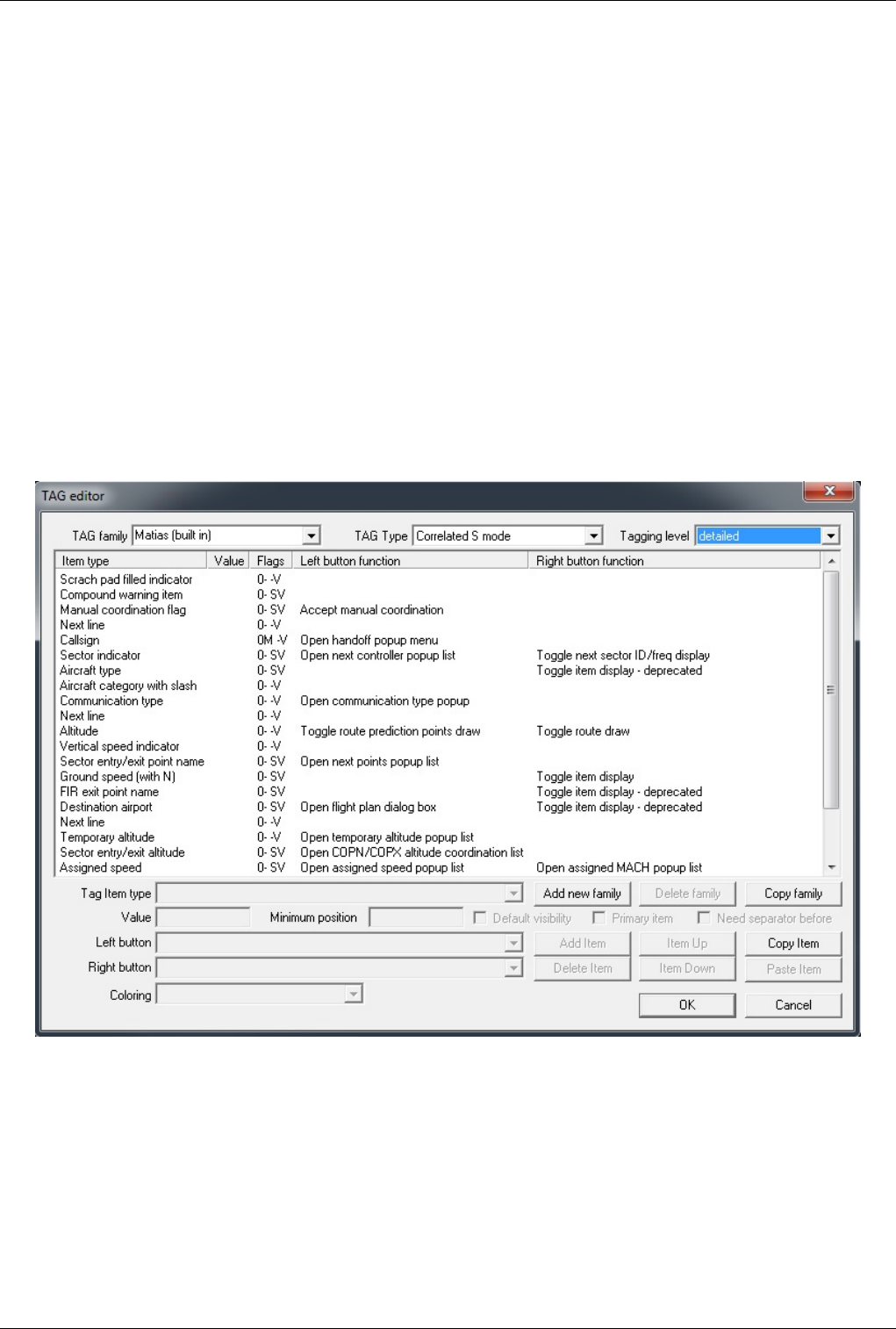
Euroscope:TAG Editor 93
•Toggle item display - deprecated - Those functions are old item specific switches that should no longer be used
and are only kept for compatibility with TAGs created under the old version.
•Toggle next sector ID/freq display - This function switches between the ID or the frequency of the next
controller. It has no real meaning to add this function other than the sector indicator item.
•Toggle route draw - This function switches on/off the display of the calculated route track of the aircraft. It also
displays the estimated time of arrival to each point.
•Toggle route prediction points draw - This function switches single/all/off the display point/altitude pairs
EuroScope is uses for sector prediction. Use this function as a debugger tool to see why a sector is indicated as
next. At first click it shows the points when the sector owner is changing. At second it shows all predicted points.
Third click hides the display.
•Track an aircraft - This is a quick start tracking of untracked aircraft.
Note: If you have a plug-in loaded that supports additional TAG functions, then these items will appear in the list
too.
Editing The TAGs
The following dialog box helps you creating new or modifying existing TAGs, TAG families.
The built in Matias family can not be modified. It is hard coded into EuroScope and will be rebuilt at every startup.
In reality when the system is up it works the very same way as a user defined family. To create your own TAGs you
always have to build a complete family. When ready and saved you can select your family in the Euroscope:Display
Settings dialog and save it to the ASR file. In this way the system will remember what TAGS to be used for what
display layout.
The elements and functions of the editor dialog box:
•TAG Family - In this dropdown list you can switch between your TAG families. It is also used to rename the
current family. You can edit the name of the built-in TAG, but it will be ignored on saving.

Euroscope:TAG Editor 94
•TAG Type - This dropdown list is used to toggle between the eight types of the TAGs in the family, dependent
on radar identification state. You should define all types to be able to save the family.
•Tagging level - With this dropdown list you can chose the tagging state to edit.
•The item list - Major part of the dialog box is the item list defined for the specified family ans type. If yo select
an item here then its data is copied to the controls below and you can change the data there. The order of the items
is extremely important as EuroScope will display them in the way it founds them in this list.
•Tag Item type - With this dropdon list you can change the selected item in the list.
•Value editor - This editor is available only if a free text item is selected. In this case you can write the string itsef
to here.
•Minimum position - You can define the minimum position of the TAG item, counting from the left border to the
right. Maximum value is 50.
•Default Visibility check-box - This settings triggers if the item should be visible by default.
•Primary item check-box - The primary item plays an important role in the TAG definition. The line from the
aircraft position will point to the center of this item. If the primary item is not visible then no way to connect the
TAG with the aircraft position and you will be lost. So select an item the is always visible (squawk, callsign,
TSSR etc.). Of course only one primary item can be defined for one TAG. It mark is an M (:)) letter in the Flags
column.
•Need separator before check-box - This check box indicates the a space will be added before this item if the
current line is not empty so far. That makes it a little bit easier to have some spacing between items.
•Left and Right button function dropdown list - With these combo boxes you can define the function you would
like to have when clicking on the item. It is available only for detailed TAGs.
•Coloring dropdown list - You can assign different colors to TAG items. Those colors match the relevant
datablock items in the Euroscope:Symbology Settings dialog.
•OK button - Nothing to say. Saves your edit and closes the dialog. Some tests are executed before saving the
TAGs and you may receive error message if something is wrong (e.g.: no primary item selected for a TAG).
•Cancel button - It closes the dialog and discards all changes yo have made.
•Add new family button - It inserts a completely empty family to the system. You can use it if you want to start
from a clean paper.
•Copy family button - It copies the content of the selected TAG family into a new name. You can use it if you
just want a family that is a little bit different from another.
•Delete family button - Stands for its name. It deletes a family. Of course the built-in family can not be deleted.
•Add Item button - It inserts a new item to the list. If no selected item then it is placed as last. If there is a selected
then it will be placed just before the selected. You can immediately start editing it by the bottom controls.
•Delete Item button - It simply deletes the selected item from the list.
•Item Up button - With it you can move your item one up in the list. Sorry I was lazy to write the real
drag-and-drop.
•Item Down button - With it you can move your item one down in the list. Sorry again I was lazy to write the real
drag-and-drop.
Previous: Euroscope:TAGs Actual: Euroscope:TAG Editor Next: Euroscope:Settings

Euroscope:Settings 95
Euroscope:Settings
Previous: Euroscope:TAG Editor Actual: Euroscope:Settings Next: Euroscope:Controller To Controller Communication
Controller To Controller Communications
A complete list (including the new ongoing coordination feature) of the different communication ways between
controllers are described at the Euroscope:Controller To Controller Communication page.
Display Settings
The Euroscope:Display Settings section describes how you can set up what to be displayed on the radar screen. Also
how to save and restore them with a single click.
Additional Display Features
The way you can customize what colors, line styles, font sizes, etc is attributed to items on the radar screen is
described in the Euroscope:Symbology Settings section.
Sounds Setup
Euroscope:Sounds Setup is about different warning messages from EuroScope.
Non Standard Extensions Used In EuroScope
We use some tricks to publish the unpublishable data. Read more about it at Euroscope:Non Standard Extensions
page.
Previous: Euroscope:TAG Editor Actual: Euroscope:Settings Next: Euroscope:Controller To Controller Communication

Euroscope:Controller To Controller Communication 96
Euroscope:Controller To Controller
Communication
Previous: Euroscope:TAG Editor Actual: Euroscope:Controller To Controller Communication Next: Euroscope:General Settings
Basic Communication
In this section you can find just a brief list of the communication types between controllers with a reference inside
the documentation. The basic communication is when you provide information that is available to all neighbor
controllers. In this cases you just spread out the data you have and you do not request any answer to them.
•Temporary altitude assignment - The cleared climb or descend flight level or altitude. You can do it using the
.QQ (F8) command or via the appropriate popup menu. In EuroScope there are special values to clear an aircraft
for ILS or visual approach, which disable the CLAM-warning.
•Final altitude assignment - Different final / cruising altitude assignment. It is important to notice that the .QZ
(F5) altitude assignment does not modify the flight plan. It is published using controller to controller messages
only.
•Scratch pad string - The free text area for adding notes up to 60 characters. In addition to that the scratchpad is
used more heavily inside EuroScope. For more about it see the Euroscope:Non Standard Extensions page.
•Squawk assignment - The squawk assignment is somewhat different. It is published between controller clients
but the servers are also storing some information about it.
Flight Plan Amendment
A little bit more advanced, but the flight plan amendment is still just a data propagation. There are two different
ways to do that:
•Simple FP editing - You can change all parts of the flight plan using the Euroscope:Flight Plan Setting Dialog.
•Automatic FP change - In EuroScope there are new functions that are using the flight plan amendment.
•SID/STAR assignment - When you assign a SID or STAR to an aircraft its flight plan route section is amended
to hold the information about it. It is visible to all controllers, but EuroScope clients will interpret it automatically.
•Departure/arrival runway assignment - Similarly the runway assignment amends the route section like the one
above. And once again EuroScope clients can interpret the modified route automatically.
Look at the Euroscope:Non Standard Extensions page to see how EuroScope will change the route section of the
flight plan when a runway or a SID/STAR is assigned via the popup menus.
Advanced Communication
We can say advanced communication when the two controllers are sending information to each other and in many
cases they need an answer for their messages. The following communications are here:
•Handoff - When you initiate handoff to the next controller he receives a message about it. Then he has the
possibility to accept or refuse it.
There are also two not really formalized communication form:
•Chat area - You can chat with all controllers. Even with the ones that are out of your area.
•Ground to ground voice - Using the G2G voice communication you can talk to each other without disturbing the
others. Actually this form of communication is sometimes not really easy to set up.
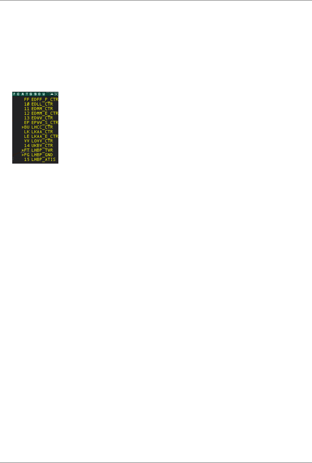
Euroscope:Controller To Controller Communication 97
The Ongoing Coordination
The ongoing coordination is a new advanced feature in EuroScope. It allows neighbor controller to offer, accept,
refuse points and altitudes the plane is expected. The coordination point may be just in the border of the sectors of
the controllers, but it is also possible to coordinate a point well ahead in the next sector. The ongoing coordination is
a brand new innovation in EuroScope, and at the time of writing this documentation EuroScope is the only controller
that are prepared for it. Unfortunately it has a back draw that you can not use this when the other party did not use
EuroScope. In this case some features are still available, but not all. To realize who is able to use the coordination
features look at the controller lists:
All controllers who are ready to answer is flagged by a >> sign. You can expect answers from them to your
coordination requests.
There are three different scenario when you can use ongoing coordination:
•Exit point/altitude coordination - when you are tracking an aircraft and you would like to suggest a different
point or altitude to the controller of the next sector.
•Entry point/altitude coordination - when you are expecting an aircraft to enter to your sector and you would
like to suggest a different point or altitude to the controller who is currently tracking it.
•Bypass coordination - when you are expecting an aircraft to enter to your sector, but for a too short time and you
are aware that it will does not require any instruction from you then simple offer a handoff to the controller after
you to the current owner.
From the above list it is visible that the first two cases are always in pairs. If you would like to coordinate the exit
point/altitude the it is a coordination of the entry point/altitude for the next controller. And opposite: an entry
point/altitude coordination for you is az exit point/altitude coordination for the current owner of the AC. The last one
is different, not symmetrical at all.
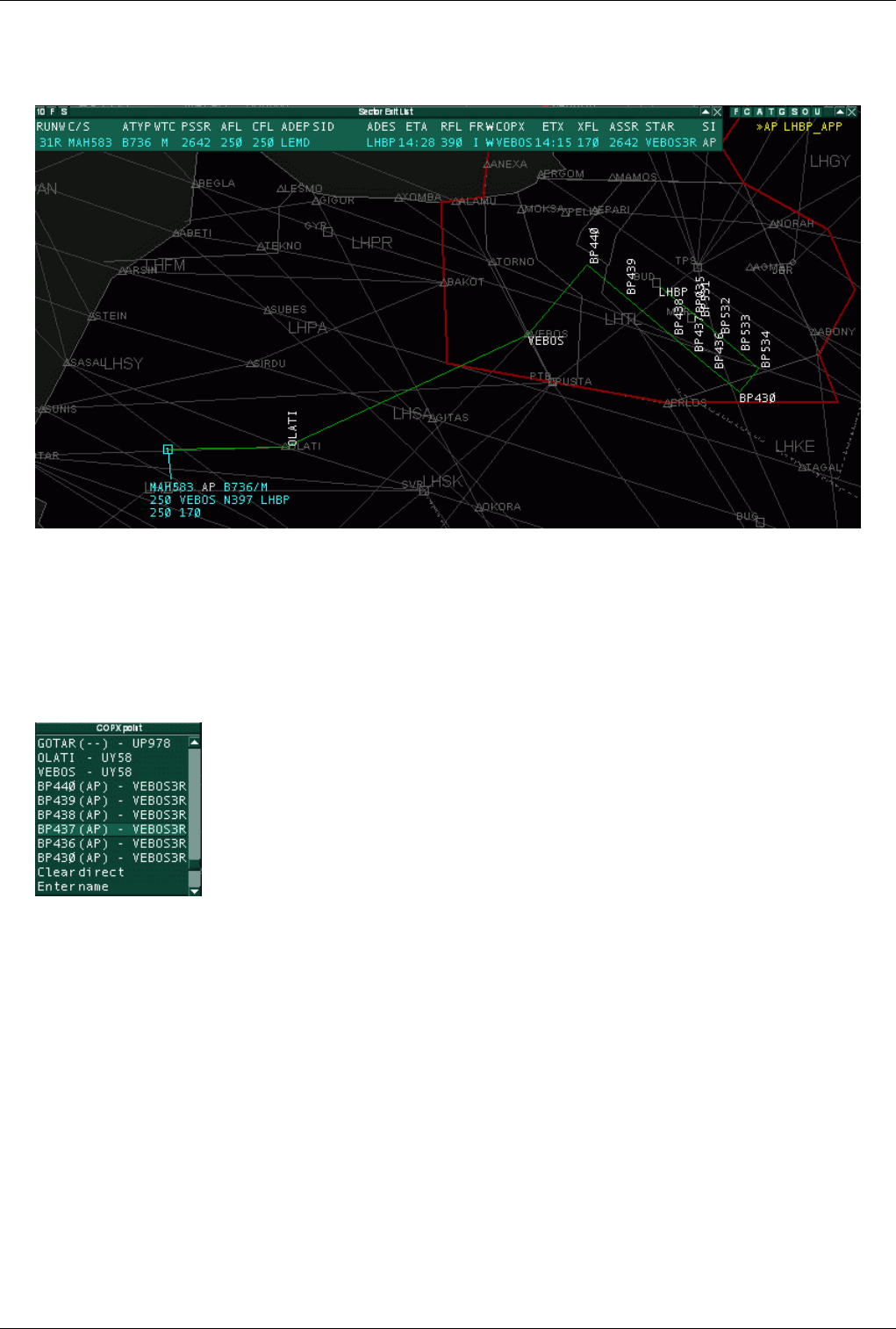
Euroscope:Controller To Controller Communication 98
Exit Point/Altitude Coordination
Probably the easiest way to describe the feature is to start with an example.
In this first example you see that I am controlling the Hungarian FIR as LHCC_CTR and approach for LHBP is
online too. See the >> indicating that he is able to do the coordination. I have a plane that is coming from the
southwest and destination is LHBP. In the TAG is is already indicating that the next controller will be Budapest
Approach. The route is plotted in the picture and it is visible that a real big turnaround is ahead the plane if he
follows the route to VEBOS point that is the normal handoff point between CTR and APP, and then follows the
VEBOS3R transition to RWY 31R. If the traffic allows it why not to give him a shortcut to a point that leads him to
the base immediately. To start a coordination request with APP I popup the next points list from the TAG:
Here in the list you can now see the points along the route and also a flag that indicates if a point is required a
coordination with another controller or not. You see that until the VEBOS point I am free to give any direct as the
plane will still go to VEBOS for the handoff. But the points after VEBOS are marked with the ID of Budapest
Approach (AP). These indicators mean that a direct needs a coordination with Approach, he has to accept my offer.
If I select th point BP437 a coordination request is sent to approach. For me the new point name is displayed with
different color. And also the route plot is showing the desired new route.
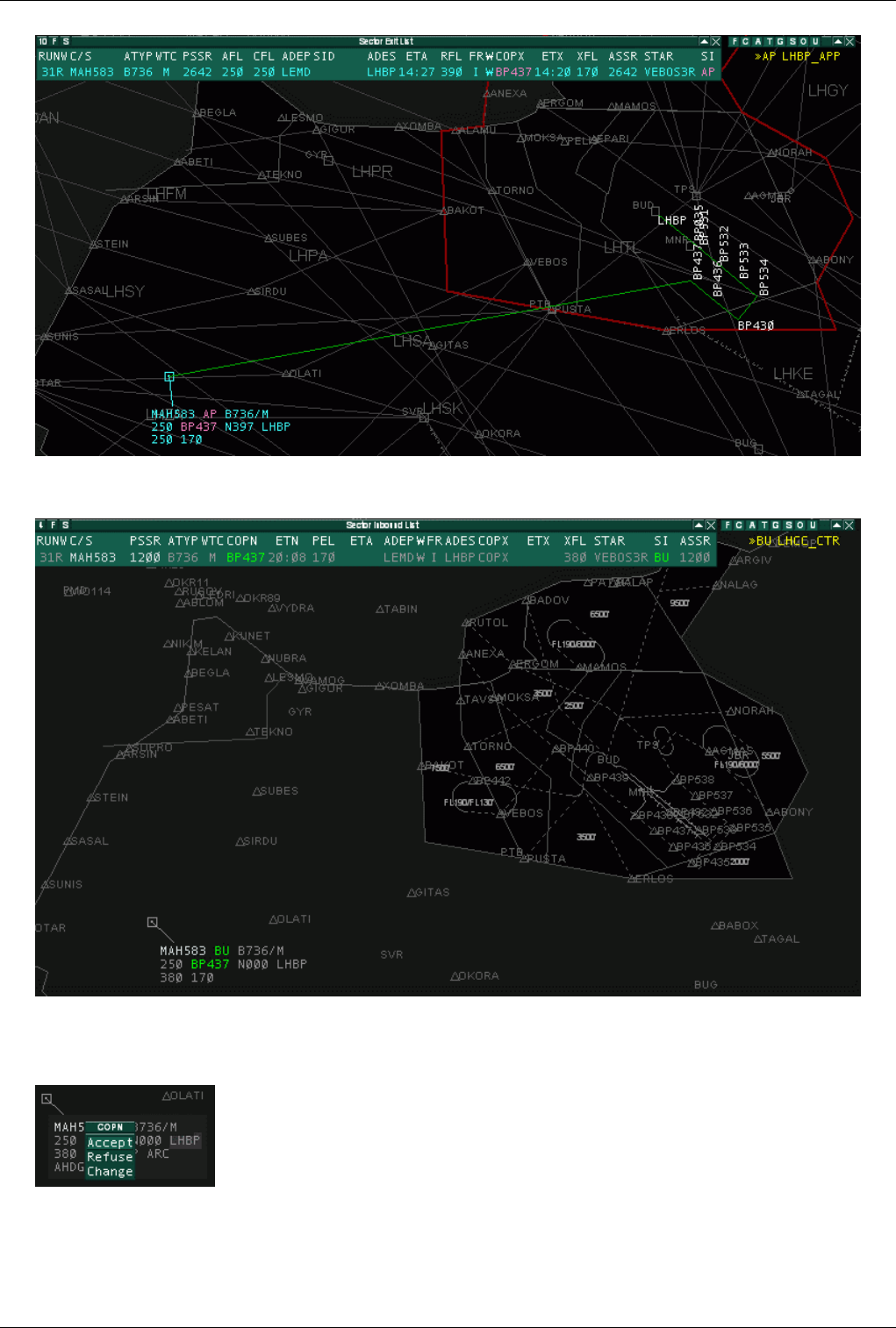
Euroscope:Controller To Controller Communication 99
On the approach side the owner and the desired destination point is colored to indicate the incoming request. There is
also a configurable audio warning about it.
If the plane itself is not inside the screen approach still can see the colored values in the sector entry list. This time
the approach has 90 seconds to decide what to do with the request. He can click on the desired new point to answer
to the call:
•Accept - To accept the coordination as it is. When accepted
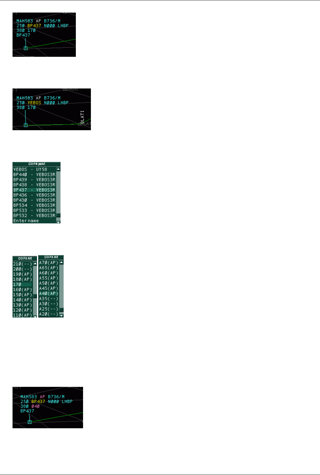
Euroscope:Controller To Controller Communication 100
•Refuse - To refuse the coordination at all. When the coordination is refused the values are turning back in both
sides to the original state. And depending on the symbology and settings it is once again flagged by a different
color.
•Change - When approach is ready for a shortcut, but the offered point is not the best for him, he can select the
Change option. Then a popup menu appears with the available other options. Selecting an item here will start a
new entry point coordination with CTR.
OK, we have completed the shortcut coordination. But you can still some pictures above that even the new point is
BP437 the coordination altitude remained FL170 that is far too high at that point. When CTR realizes it, it can offer
a lower level/altitude. He can click on the sector exit altitude item.
In the list there are the possible altitude values. All are followed by the ID of the controller that will be called for
coordination. You can see that FL170 is not flagged as it is the so far accepted value, and it does not need any
coordination. FL200 and above are not marked with AP as approach controls up to FL195 and a higher altitude will
not drive the plane to his sector at all. In this way it does not need any coordination. The same is visible if the
altitude is 3500ft or lower. In this case EuroScope detects a path from present position to BP437 that leaves CTR
sector before enters to APP sector (as CTR bottom level is FL100). Therefore no controller is indicated for
coordination. When the CTR selects the altitude it will start a coordination.
It is also indicated at approach like this:
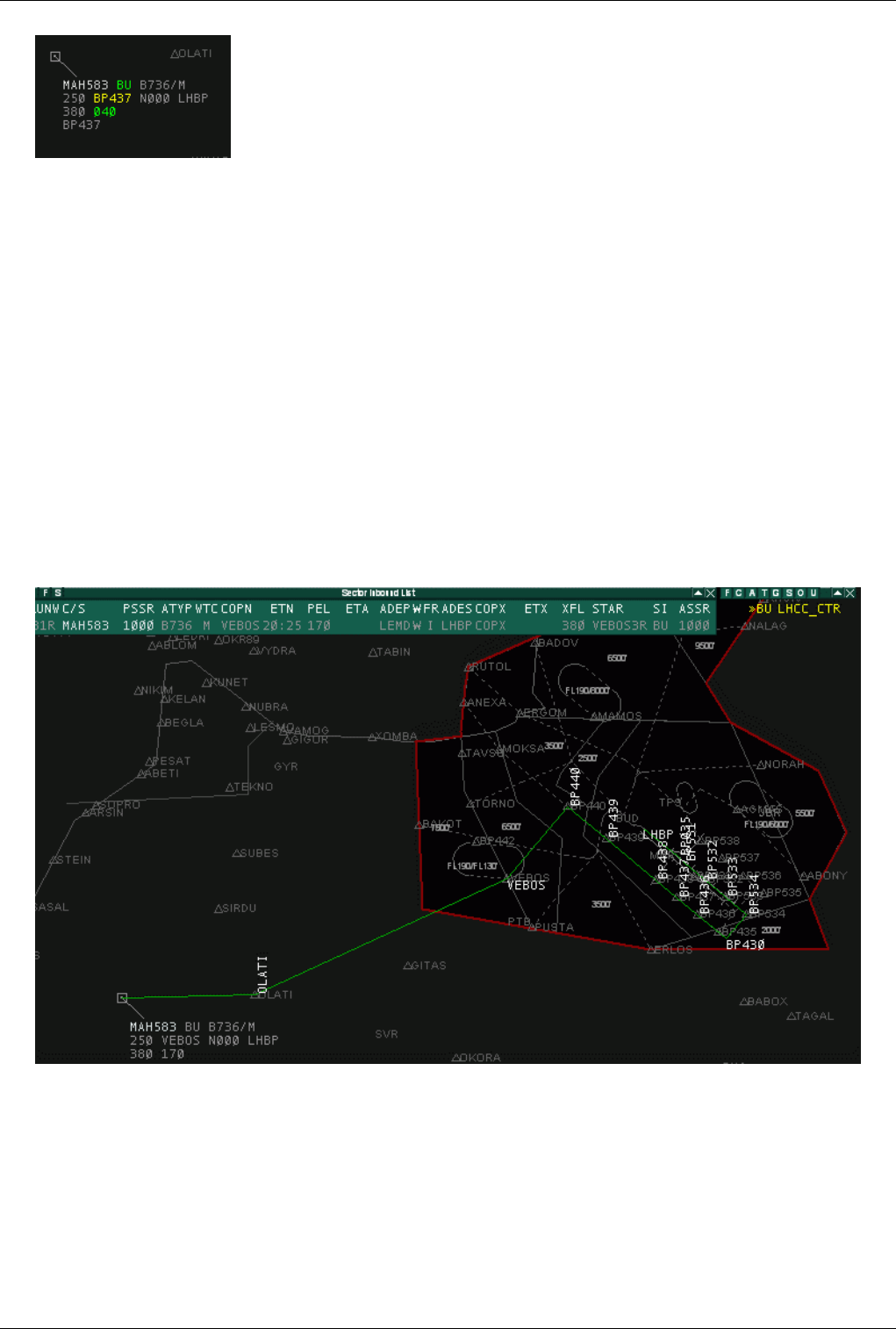
Euroscope:Controller To Controller Communication 101
The way to accept, refuse and change is the very same that was described at the next point coordination.
Some notes:
• If CTR decides that he do not want to coordinate but set the direct on his own discretion he can select the point
name in the list by a right mouse click. In that case it will set, but not coordinated.
• If the plane is still outside the visual range of the APP, the coordination will be refused immediately and a
generated message is sent to CTR: "LHBP_APP: ES generated - MAH583 is out of my range".
• When you start an exit point/altitude coordination EuroScope will connect the plane actual position with the
requested new position with a straight line. Along this line it will detect what sectors are crossed. And the first
that is outside the sectors of the current owner will be called for coordination.
• The controller who is tracking the AC has the right to change the next controller. Clicking on the sector indicator
item he can select the appropriate controller from the menu. If the next controller is forced in this way EuroScope
will start coordinating with that controller independently from the sectors detected.
Entry Point/Altitude Coordination
Let us now see the very same example from the approach point of view.
Now approach sees the arriving traffic that is currently tracked by CTR. For some reason it would be better for
approach to ask CTR to send the plane direct to BP437 point rather than VEBOS and also he wants it to descend to
4000ft altitude. First he opens the COPN point popup list on the TAG or on the sector entry list (whatever is the
easiest) and requests BP437.
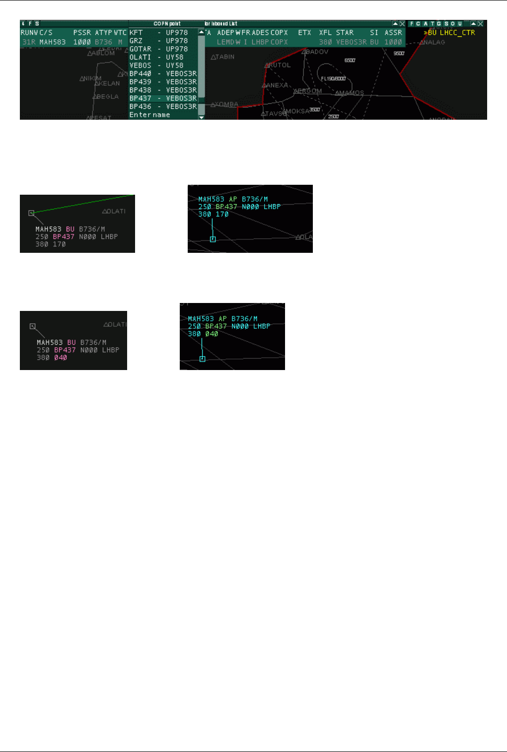
Euroscope:Controller To Controller Communication 102
A controller can open up the COPN coordination menus only if the plane is controlled by someone else and it is
going to enter to his sector later. Here you can see that there is no signal what controller will be called as an entry
point coordination is requested from the current tracker of the plane. Approach here selects BP437 and the value is
signaled in both clients.
- APP view, - CTR view
Now CTR has 90 seconds to respond. Let us change the scenario a little bit. Approach still has an option. To start the
altitude coordination before receiving the answer to the point request. He simply open up the COPN altitude list and
select a new requested altitude. Then both requests will be shown in both clients simultaneously:
- APP view, - CTR view
In this case CTR has the option to accept or refuse them with a single click.
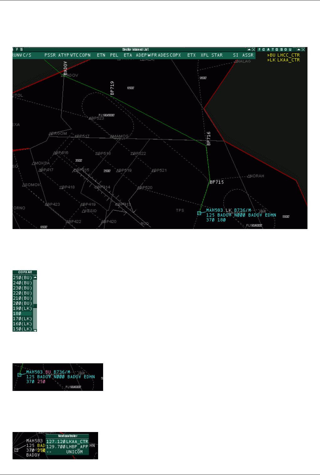
Euroscope:Controller To Controller Communication 103
Bypass Coordination
This is a little bit different scenario. It is not symmetric at all. We have now a departure from LHBP. The active
runway is 13L for departure. In this case the standard exit point for north bound departures BADOV at FL180.
As FL180 is below the top of approach sector the plane is not intend to leave the sector on the top to Budapest
Radar, but goes directly to Bratislava (normally controlled by Praha). But in case of RWY13 configuration it is quite
probably that the plane climbs much faster then necessary and reaches FL180 well advance BADOV. When
approach realizes it, he start an altitude coordination:
You can see in the popup list that up to FL190 Praha will be contacted for coordination, but at FL200 and above
Budapest Radar as in this case the plane will leave the sector on top. Let us assume that approach stats an exit
altitude coordination and Budapest Radar accepts it.
Even Budapest accepted the coordination and allowed the plane to climb above FL180 up to FL250 the plane will
just cross the section and will not spend there more than 1 or 2 minutes. As there is not other traffic in the area and
the plane does not need any command from Budapest Radar it is better to handoff to Praha from Approach skipping
Budapest. Therefore CTR opens a popup menu and sets Praha as next controller. It start a coordination with APP.
- CTR starts the coordination
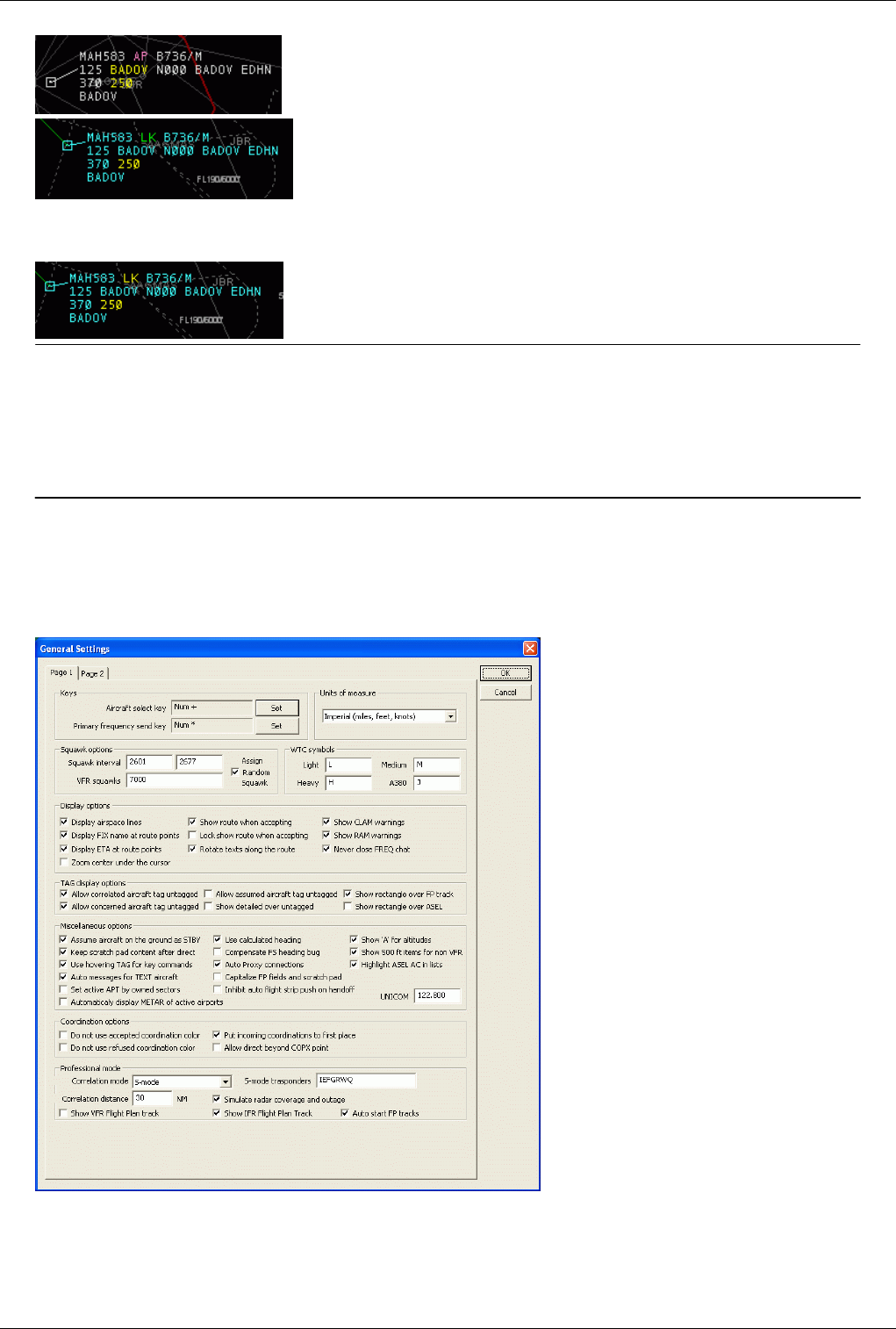
Euroscope:Controller To Controller Communication 104
- CTR point of view
- APP point of view
APP can accept and refuse the same way as and exit or entry point coordination. Once he has accepted the new next
controller is displayed in the sector indicator item.
Previous: Euroscope:TAG Editor Actual: Euroscope:Controller To Controller Communication Next: Euroscope:General Settings
Euroscope:General Settings
Previous: Euroscope:Controller To Controller Communication Actual: Euroscope:General Settings Next: Euroscope:Display Settings
General Settings Dialog Page 1
It is a very simple modal dialog to setup some non display related settings such as ASEL and FREQ keys and the
actual squawk range.
•Key options

Euroscope:General Settings 105
•Aircraft select key Set button - In the display field on the left you can read the actual name of the aircraft
select button. The default value is the numpad +. To change it press the Set button then the desired aircraft
select button.
•Primary frequency send key Set button - In the display field on the left you can read the actual name of the
primary frequency button. The default value is the numpad *. To change it press the Set button then the
desired aircraft select button.
•Units of measure
• In this dropdown menu, you can choose which system to use, the Imperial system or the Metric system.
•Squawk options
•Squawk interval textfields - The actual squawk range is displayed here. It is loaded from the ESE file based
on your active position. You also can override the range here, but if you change your position the squawk
range will be reloaded from the positions section of the ESE file and override your setting from the dialog.
•VFR squawk - Here you can specify a list of VFR squawks. Entering the VFR codes here will remove the
DUPE warning for VFR airplanes squawking that code. Separate different squawks by using the comma ','.
•Assign random squawks checkbox - if this box is checked, EuroScope assigns random squawk numbers in
the defined squawk range. If it is unchecked, EuroScope assigns squawk numbers from the beginning and
incrementing in sequential order. It checks if the next squawk number is free and if so, assigns it to the selected
aircraft.
•WTC symbols
•WTC four categories - Here are predefined symbols for different aircraft categories. The user can modify
them according to his needs.
•Display options
•Display airspace lines - Highlights the sector border according to the setting under Euroscope:Symbology
Settings where an adjacent sector is online.
•Display FIX name at route points - If that option is checked, every FIX name in the route appears near the
displayed route.
•Display ETA at route points - If that option is checked, the expected time of arrival at every FIX name in the
route appears near the displayed route.
•Zoom center under the cursor - With this option checked, zooming is based on the position of the mouse
cursor. Otherwise zooming is based on the center of the screen.
•Show route when accepting - If that option is checked, the route is displayed upon accepting a handoff.
•Lock show route when accepting - When accepting a handoff, the routing of the aircraft remains displayed.
•Rotate text along the route - If the route is closer to east-west than to south-north, the route annotations are
rotated by 90 degrees.
•Show CLAM warnings - CLAM stands for Cleared Level Adherence Monitoring. It indicates that the pilot
does not follow the cleared level. It is shown if the plane is outside the +-200 ft range of his temporary or final
altitude and his vertical speed does not indicate that he is trying to reach it. There are some exceptions:
1. - CLAM is not displayed on the ground.
2. - CLAM is not displayed if the AC is cleared for approach.
3. - CLAM is not displayed if no temporary altitude set and the plane is not tracked.
4. - CLAM is not displayed if AC is flying at final altitude but cleared for lower.
•Show RAM warnings - RAM stands for Route Adherence Monitoring. It is displayed when the AC is out of
the 5-5 NM (fixed value and no settings so far) range of the route calculated by EuroScope. Here are also some
exceptions:
1. - RAM is not displayed on the ground.

Euroscope:General Settings 106
2. - RAM is not displayed if the AC is cleared for approach.
3. - RAM is not displayed when a direct is set or has assigned heading.
•Never close FREQ chat - If this box is checked, to be completed
•TAG display options
•Allow correlated aircraft tag untagged - With this option unchecked, the TAG of a correlated aircraft cannot
be displayed as untagged.
•Allow concerned aircraft tag untagged - With this option unchecked, the TAG of a concerned aircraft cannot
be displayed as untagged.
•Allow assumed aircraft tag untagged - With this option unchecked, the TAG of an assumed aircraft cannot
be displayed as untagged.
•Show detailed over untagged - With this option checked, detailed TAGs are displayed over untagged TAGs.
•Show rectangle over FP track - This option displays a rectangular boundary around flightplan tracks.
•Show rectangle over ASEL - This option displays a rectangular boundary around the TAG of the currently
selected aircraft.
•Miscellaneous options
•Assume aircraft on the ground as STBY - Simulate STBY mode for all aircraft on ground, even if they are
squawking C.
•Keep scratch pad content after direct - For VRC ans ASRC compatibility EuroScope deletes he scratch pad
content after a direct is assigned, and the point name is stored there. With this option you can disable it and
keep the original content. This will cause that VRC and ASRC users will not see the assigned point.
•Use hovering TAG for key commands - If that option is checked, when the mouse is over a detailed TAG
and the controller types any command, that command is directly sent to the selected aircraft without any need
to press the Enter key.
•Auto messages for TEXT aircraft - When this option is checked whenever something is set via the TAG
menus then EuroScope generates a message to be sent via the frequency chat. It is placed into the command
editor but not sent automatically.
•Set active APT by owned sectors - This option automatically activates airports in the Euroscope:Active
Airports Runways dialog, if they are defined in the sector definition of the ESE file.
•Use calculated headings - If this option is checked then EuroScope will calculate the heading of the aircraft
based on the actual and the previous points received. In this case the leader line will show the actual track
heading. If this option is off then the true heading reported by the aircraft will be used to display the leader
line. In case of high winds that could be really different from the route.
•Compensate FS heading bug - During the professional ground mode we found that FS clients does not take
magnetic variation into account when sending the plane heading information to the servers. In special places
(eg. in Canada) the planes were deviated extremely. This option compensates this bug.
•Auto Proxy connections - The Proxy Connection is automatically activated. If used on the primary instance,
the Proxy Server is activated, any subsidiary instance is automatically connected to the primary instance (on
the same computer).
•Capitalize FP fields and scratch pad - With this option enabled, text in the flightplan and the scratch pad is
capitalized.
•Inhibit auto flight strip push on handoff - If this box is checked, the aircraft flight plan is not automatically
pushed to the next controller. It's up to the controller to push the flight plan using the .SS "controller ID"
command or with the popup menu on the flight strip.
•Automatically display METAR of active airports - The metar of active airports is automatically added to the
Metar List, if there are runways activated for those airports.
•Show 'A' for altitudes - Altitudes are preceded by A depending on the setting in Euroscope:The Menu Bar.

Euroscope:General Settings 107
•Show 500 ft items for non VFR - If this option is set then in the altitude assignment popup lists below 1000 ft
all 500 ft items are shown for all AC. If disabled, then for IFR planes only the 10000 ft items are displayed.
•Highlight ASEL AC in lists - If set then ASEL AC is shown with a different background color in the AC lists.
•UNICOM - Defines the frequency to be used for Unicom. Default is 122.800. However according to http:/ /
www. vatsim. net/ comms/ Temp_archives/ BOG04jan2009. pdf it was decided to forbid UNICOM
frequencies other than 122.800, but no action has been taken yet, so currently it should be allowed under
VATSIM regulations to use the correct UNICOM frequency for your area.
•Coordination options
•Do not use accepted coordination color - Indicates that accepted coordinations are to be displayed with
normal color and does not need a highlight.
•Do not use refused coordination color - Indicates that refused coordinations are to be displayed with normal
color and does not need a highlight.
•Put incoming coordinations to first place - Aircrafts with incoming coordination requests are moved to the
top of the Euroscope:Advanced Lists.
•Allow direct beyond COPX point - If set then no coordination is initiated if a point is selected beyound the
actual COPX.
•Professional mode
•Correlation mode - This pop menu allows the user to choose between Easy VATSIM Mode, S-Mode or
C-Mode. For more details about these modes go to Euroscope:Professional Radar Simulation.
•Correlation distance - This setting defines the range of automatic correlation of radar target and flightplan
track. The maximum value is 100nm.
•Show VFR flight plan track - With this option checked, flightplan tracks of VFR flights are displayed.
•Show IFR flight plan track - With this option checked, flightplan tracks of IFR flights are displayed.
•Simulate radar coverage and outage - With this option checked, the area of radar coverage and radar outages
are simulated, based on the entries in the ESE file. For more details, refer to the Euroscope:Professional Radar
Simulation page.
•Auto start FP tracks - With this option unchecked, flightplan track are not automatically started and therefore
their flightpath is not calculated.
•S-Mode transponders - In this field you can specify the aircraft equipment codes for which a mode S
transponder is assumed.
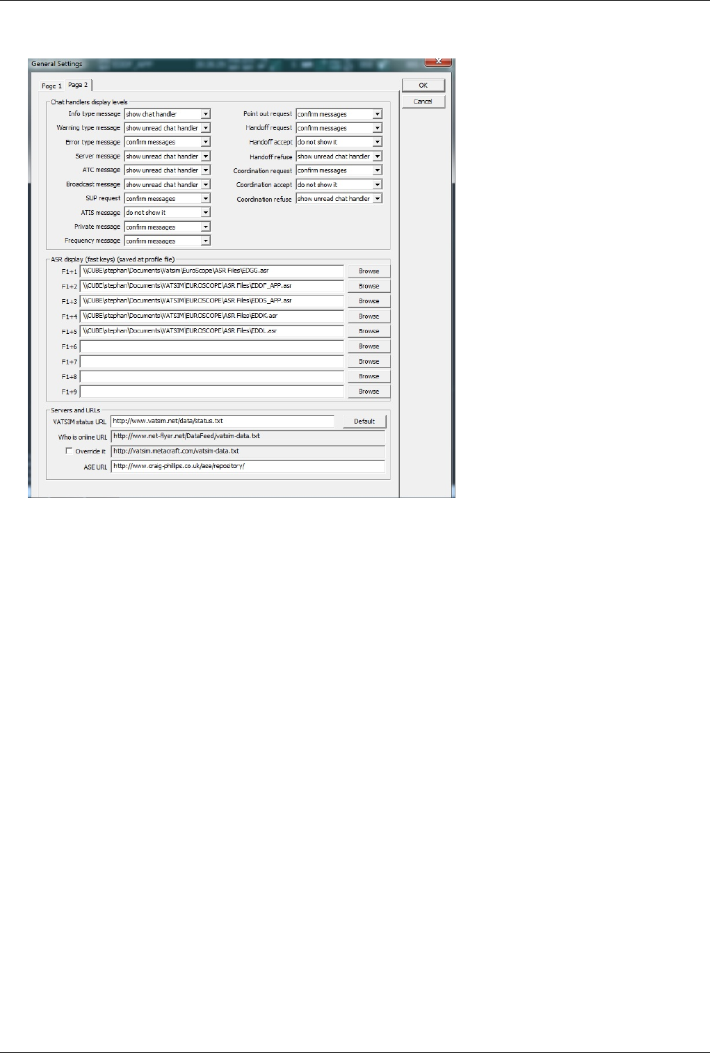
Euroscope:General Settings 108
General Settings Dialog Page 2
•Chat handlers display levels - These options drives how the new incoming messages are shown for you. With
the option buttons you can define the action for the following messages:
• Info type message
• Warning type message
• Error type message
• Server message
• ATC message
• Broadcast message
• SUP request
• ATIS message
• Private message
• Frequency message
• Point out request
• Handoff request
• Handoff accept
• Handoff refuse
• Coordination request
• Coordination accept
• Coordination refuse
For all the pop menus below, you have the following options:
• Do not show it - In this case even the appropriate message handler does not appear. Be careful with this option
as you may miss valuable information.
• Show chat handler - This options shows the message handler if new message arrives.

Euroscope:General Settings 109
• Show unread chat handler - With this option the message handler has different color when it contains an
unread messaged.
• Flash chat handler - With this option the message handler is flashing when it contains an unread messaged.
• Confirm messages - With this option the message handler is flashing when it contains an unread messaged and
you must confirm the individual messages. Until there are read but unconfirmed messages the handler is
displayed with a different color.
•ASR display (fast keys) - Using these options you can assign ASR files for different F1+<0..9> key combination.
Wen you press e.g. F6+6 then the ASR defined there will be selected as current. If the file is not yet loaded then it
will be so.
•Server and URLs - These URLs are used to obtain information about different servers and statistical data.
Normally you do not need to modify them.
•VATSIM status URL - This is the root URL that is asked about available servers.
•Who is online URL - Here you can specify the URL from where EuroScope can download VATSIM's data for
the Show simulated traffic function. Normally this value is different at every startup as it is selected randomly
for server load balancing. If the one selected is not working well just restart EuroScope for a different one. If
you can not do that you can manually enter one. Currently the following URLs are used:
• http:/ / vatsim. info/ servinfo/ satnet-data. txt
• http:/ / europe-cw. vatsim. net/ data/ satnet-data. txt
• http:/ / vatsim. metacraft. com/ satnet-data. txt
• Override it - You can override the default URLs using this checkbox.
• ASE URL - The URL to the Aircraft Situation Editor's repository. EuroScope can automatically download
scenario files from the repository. It is editable just for safety reason (to be able to follow if changed).
Previous: Euroscope:Controller To Controller Communication Actual: Euroscope:General Settings Next: Euroscope:Display Settings
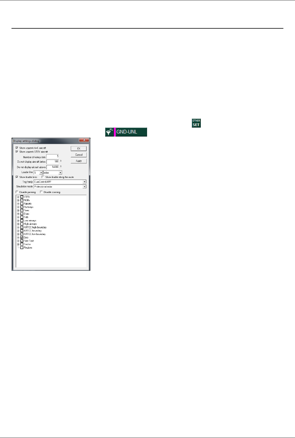
Euroscope:Display Settings 110
Euroscope:Display Settings
Previous: Euroscope:General Settings Actual: Euroscope:Display Settings Next: Euroscope:Symbology Settings
Display Settings Dialog
This is where you can customize the display settings, saved in the .asr files. EuroScope takes a big step forward from
previous radar clients by allowing users to switch on/off individual items on the radar screen. You may want to have
a clear view and switch off most navaids, but you need a given VOR or a FIX; you want to see a certain Runway or a
centerline, without having to see others making the screen confusing - this is the setup dialog for you! Earlier witty
.sct file creators used the SID/STAR settings to add adjustable little practical details to the screen - now with
EuroScope, there's no need for that anymore!
Open the Display Settings Dialog by clicking on the upper toolbar on OTHER SETTINGS > Display
Settings... or directly by clicking on the (Altitude filter/Display settings) icon.
•Show squawk A+C aircrafts - Display or hide targets with squawk mode Charlie
•Show squawk STBY aircrafts - Display or hide targets with transponder set to standby
•Number of history dots - Specify the number of history dots in the trails of the radar target.
•Do not display aircrafts below [ ] ft - Filters all targets below the given altitude in feets (a value of 0 means
filter is OFF)
•Do not display aircrafts above [ ] ft - Filters all targets above the given altitude in feets (a value of 0 means filter
is OFF)
•Leader line [ ] [MINUTES/MILES/KILOMETERS] - Set leader line to predict aircraft's position in given
minutes or nautical miles. Minutes or NM can take up values between 1-10.
•Show leader lines - Using this setting, you can diable the leader lines.
•Show leader along the route - Using this setting, the leader line follows the route of the aircraft.
•Tag family - Select presaved TAG settings from the list. Default TAG is the one used in the Matias system at
Budapest ACC/APP
•Simulation mode - Here you can specify the used radar mode for the current ASR.
•Easy EuroScope mode - The standard radar mode known from earlier versions.

Euroscope:Display Settings 111
•Professional Radar mode - For details on Professional mode, refer to the Euroscope:Professional Radar
Simulation page. It can not be used if the correlation mode in the Euroscope:General Settings dialog is set to
Easy EuroScope mode.
•Professional ground with S-mode radar - Ground mode with S-mode surface radar coverage.
•Professional ground without radar - Ground mode without radar identification of the aircraft.
•Disable panning - You can disable panning to prevent accidental changes to the screen display.
•Disable zooming - You can disable zooming to prevent accidental changes to the screen display.
•Check boxes - Now this is a real novelty of EuroScope: by ticking, you can not only switch all VORs, NDBs,
etc.s on/off, but by going into the tree, you can switch on/off practically all individual items on the radar screen!
(Data of course should previously have to be set up in the .sct and .ese files)
The hierarchy tree
Using this hierarchy tree it is quite easy to switch items on/off in groups. Clicking on the VOR check box all the
items below this one follow its state and will be switched on or off accordingly. That is quite straightforward. On the
other hand sometimes there is a need to change the settings on items grouped by their type. E.g. it is quite common
that you would like to see all VOR's symbol and name but not the frequency. With this hierarchy you should click
every frequency member one by one that is really boring. To speed up settings like this EuroScope offers the
doubleclick function. First select the item you would like to change (e.g. VOR's frequency), then set the state to the
desired at one item. Then make a doubleclick on that item and at once all items with the same name and level will
follow it.
It still can take time to create your finest working environment, but as a help, EuroScope can remember your settings
in the .asr files that can be saved and loaded.
•VORs - switch ON/OFF each symbol/name/frequency
•NDBs - switch ON/OFF each symbol/name/frequency
•Airports - switch ON/OFF each symbol/name
•Runways - switch ON/OFF the following items: centerline (=the runway)/name/extended centerline 1 (1st
direction extended centerline)/...left or right clicks (ticks every 1 nm on extended centerline between 5-20
nm)/...vectoring (draws a 30 degrees interception track for a 10 nm final)/...base (draws a base leg track line
leading to the interception tracks)
•Fixes - switch ON/OFF each symbol/name
•Stars - switch ON/OFF individual Stars (or elements of the STARs section)
•Sids - switch ON/OFF individual Sids (elements of the SIDs section)
•Low airways - switch ON/OFF each airway line/name
•High airways - switch ON/OFF each airway line/name
•ARTCC high boundary - switch ON/OFF sections of high sector boundary
•ARTCC boundary - switch ON/OFF sections of sector boundary
•ARTCC low boundary - switch ON/OFF sections of low sector boundary
•Geo - switch ON/OFF Geo data (coastlines, rivers, lakes, other lines of under the Geo section)
•Free text - switch ON/OFF free text label items (NEW in EuroScope: text labels can be programmed on the radar
screen, e.g. for min. sector altitudes or taxiway names
•Sector - switch ON/OFF SECTORLINEs and SECTORs included in the ese file. This feature is useful only for
those who develop an ese file and has no utility for the normal user.
•Regions - switch ON/OFF regions
In addition to allowing to switching the items ON/OFF, EuroScope also allows different attributes of each symbol
(color, font size, line width, line type, etc.) that users can set up - this will be shown in details in the
Euroscope:Symbology Settings section.
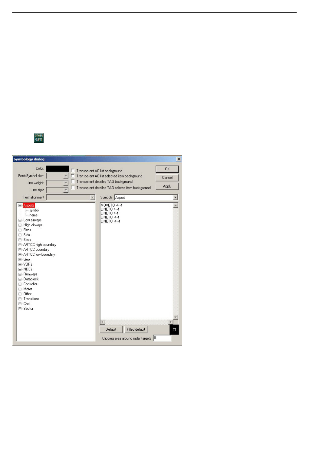
Euroscope:Display Settings 112
Previous: Euroscope:General Settings Actual: Euroscope:Display Settings Next: Euroscope:Symbology Settings
Euroscope:Symbology Settings
Previous: Euroscope:Display Settings Actual: Euroscope:Symbology Settings Next: Euroscope:Plug-Ins
Symbology Settings
Similar to Euroscope:Display Settings, the settings in the symbology settings window gives a controller some new
tools: EuroScope allows to have different colors, line width or fonts for every individual item on the radar screen.
Click on --> Symbology Settings...
The following dialog will appear:
The settings are quite straight forward, colors can be chosen from a palette, font size can be adjusted as required, .5
(values are also accepted), set line weight to a value of 0-10, select line style from values of solid, dash, dot,
dash-dot, dash-dot-dot, and select Text alignment for the elements
•Airports - set attributes for symbol/name
•Low airways - set attributes for line/name
•High airways - set attributes for line/name
•Fixes - set attributes for symbol/name
•Sids - set line attributes for each Sid (or elements of the SIDs section)
•Stars - set line attributes for each Star (or elements of the STARs section)
•ARTCC high boundary - set line attributes for each high sector boundary

Euroscope:Symbology Settings 113
•ARTCC boundary - set line attributes for each sector boundary
•ARTCC low boundary - set line attributes for each low sector boundary
•Geo - set line attributes for Geo data (coastlines, rivers, lakes, other lines of under the Geo section; NOTE: colors
are defined in the *.sct file)
•VORs - set attributes for each symbol/name/frequency
•NDBs - set attributes for each symbol/name/frequency
•Runways - set attributes for each runway centerline, extended centerline and name
•Datablock - set attributes for aircraft datablocks (tags) that are... non concerned/notified/assumed/transfer to me
initiated/redundant/information/emergency and detailed background/active item background
•Controller - set attributes for controllers in modes normal/breaking/timeout
•Metar - set attributes for normal/modified/timeout METAR info text
•Other - set attributes for wait/distance line/distance values/distance annotation/separation leader/find/valid
airway/bad direction airway/unconnected airway/direct no airway/route annotation/freetext
•Transitions - set attributes for individual transitions and transition grids
•Title - set attributes for items on the title line such as datafile/controller/primfreq normal/primfreq breaking/clock
•Chat - set attributes for items related to chat and chat windows, such as text/background/name normal/name
unread
•Sector - set attributes for sector line/active sector background/inactive sector background
There are also some check boxes to set some values on or off:
•Transparent AC list background - if selected, the background of the aircraft coordination lists (SIL,SEL,DEP)
is transparent.
•Transparent AC list selected item background - if selected, the currently selected aircraft won't be highlighted
in the lists.
•Transparent detailed TAG background - if selected, the background of detailed tags will be transparent.
•Transparent detailed TAG selected item background - if selected, the specific item within the detailed tags
won't be highlighted.
Every symbol can be customized in the right window using graphic commands. All coordinates are in pixels. They
are very simple:
• MOVETO <x> <y> - to move the cursor to the specified location
• LINETO <x> <y> - draw a straight line from the previous position
• POLYGON <x1> <y1> <x2> <y2> ... <xn> <yn> - to draw a freeform polygon (the number of coordinates are
limited to about 20)
• ARC <x> <y> <radius> <start angle> <end angle> - to draw part of a circle (angle values are in degrees)
• FILLARC <x> <y> <radius> <start angle> <end angle> - to draw a filled part of a circle
• SETPIXEL <x> <y> - to display an individual pixel
Pressing the Default or Filled default button the symbol changes the actual symbol description with the default one.
The Clipping area around radar targets textbox allows to define a squared area (in pixels) around every aircraft
where no information can be displayed and thus prevents the anchor line to run to the middle of the symbol. Its
maximum value is 50.
Previous: Euroscope:Display Settings Actual: Euroscope:Symbology Settings Next: Euroscope:Plug-Ins
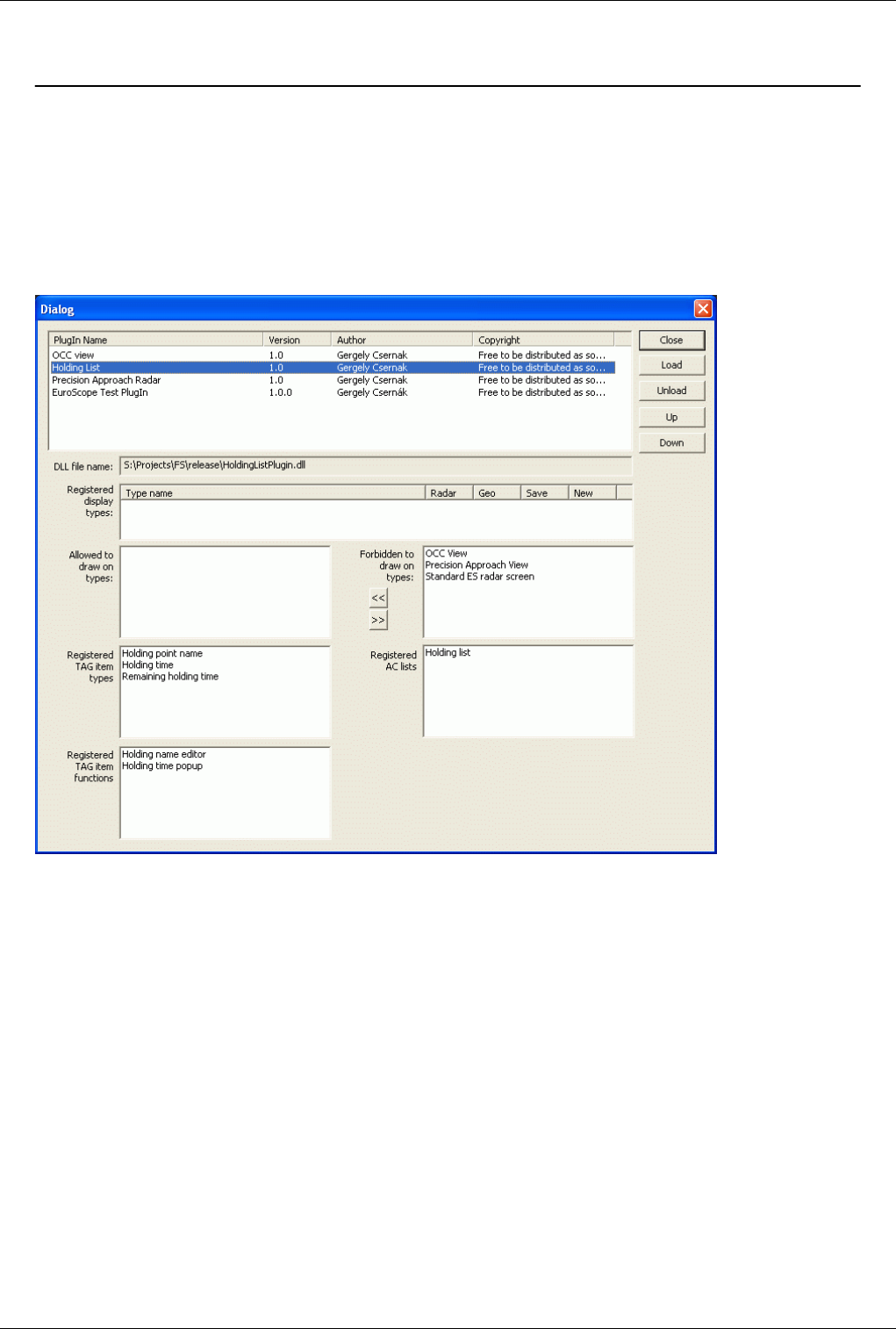
Euroscope:Plug-Ins 114
Euroscope:Plug-Ins
Previous: Euroscope:Symbology Settings Actual: Euroscope:Plug-Ins Next: Euroscope:Sounds Setup
The user perspective of the plug-ins
To setup the plug-ins you would like to use click on the Plug-ins item in the Settings menu. You will have the
following dialog box:
On the top area you can see the actually loaded plug-ins. You can check here the name, the version number, the
author and the copyright messages. Selecting an item in the list fills the detailed controls below.
You can use the right side buttons to manipulate the list:
•Close - Simply close the dialog a go back to the radar.
•Load - It opens a file browser where you can locate and select the plug-in DLL to be loaded.
•Unload - It unloads the selected plug-in DLL.
•Up and Down - With these buttons you can reorder the plug-ins. It may be important as this is the order they are
loaded and called for every event. It could be really interesting when they are drawing on the screen.
Below the list you can see the detailed controls. They are filled with values only in case you have a selected plug-in
in the list above.
•DLL file name - Full path to the DLL file that holds the plug-in.
•Registered display types - If the plug-in defines its own display type then you can find details about them. The
OCC and the Precision Approach plug-in define their own display types.
•Allowed to draw on types / Forbidden to draw on types - The two lists hold all defined screen types. You can
allow if a plug-in can display on top of that kind of screen or not. Use the arrow buttons (or doubleclick) to
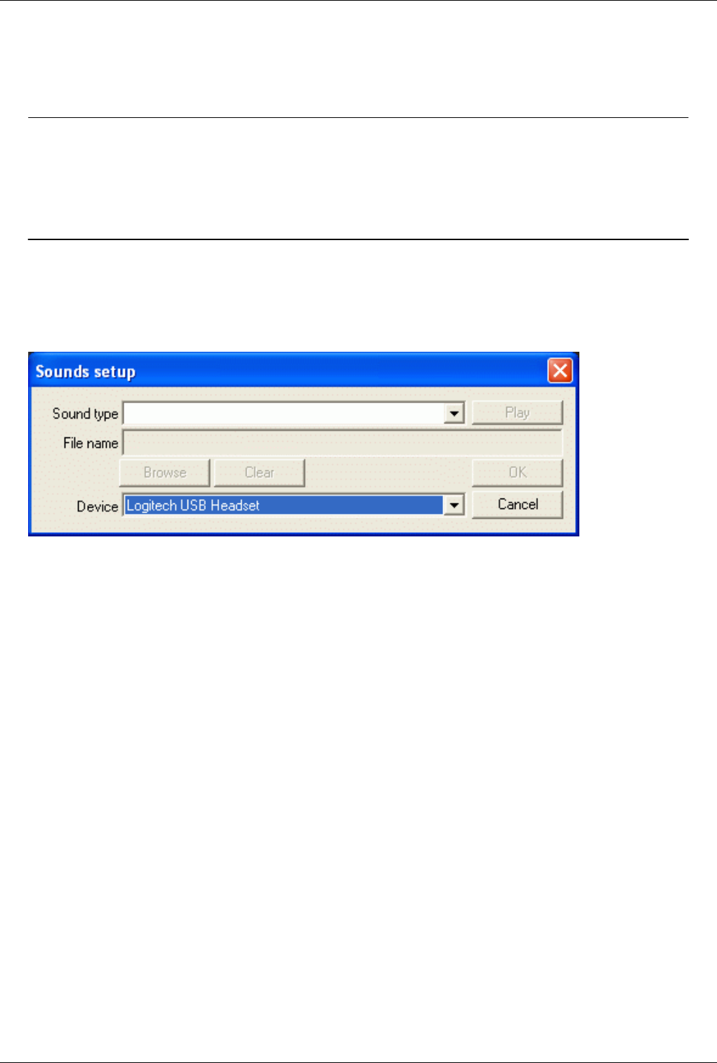
Euroscope:Plug-Ins 115
allow/forbid the drawings.
•Registered TAG item types - The items you can use in the TAGs and lists provided by the plug-in.
•Registered TAG item functions - The functions you can assign in the TAGs and lists provided by the plug-in.
•Registered AC lists - New AC lists provided by the plug-in.
Previous: Euroscope:Symbology Settings Actual: Euroscope:Plug-Ins Next: Euroscope:Sounds Setup
Euroscope:Sounds Setup
Previous: Euroscope:Plug-Ins Actual: Euroscope:Sounds Setup Next: Euroscope:Active Airports Runways
Sounds Setup
To define audio notifications to certain events go to Other Settings > Sounds in the menu. In a simple configuration
window you can assign any *.wav files to the following actions:
•Handoff request - sound is played upon receiving a handoff request
•Handoff accept - sound is played when a handoff is accepted by another controller
•Conflict alert - if the minimum separation is not kept, conflict alert notification will be played. Separation
minima can be configured in the Euroscope:Short Term Conflict Alert Settings Dialog
•Radio message - audio notification of incoming messages on your primary frequency
•Private message - audio notification of incoming private messages
•ATC message - audio notification of messages on the ATC board
•Broadcast message - audio notification of broadcast messages
•Landline request - audio notification for incoming landline calls (e.g. intercom)
•Supervisor call - audio notification of incoming supervisor messages
•Connected - sound is played when connection is established
•Disconnected - sound is played upon disconnection
•Ongoing coordination request - audio notification of incoming ongoing coordination requests
•Ongoing coordination accepted - audio notification of accepted ongoing coordination requests
•Ongoing coordination refused - audio notification of refused ongoing coordination requests
•Manual ongoing coordination - audio notification of manual ongoing coordination
•New ATIS message - sound is played whenever a new automated ATIS notification is received
•Handoff refused - sound is played when a handoff is refused by another controller
•Pointout - sound is played when a pointout of an aircraft is received
•Startup - sound is played during startup of EuroScope
IMPORTANT NOTE: User sounds will only be valid if its duration is one second or more.
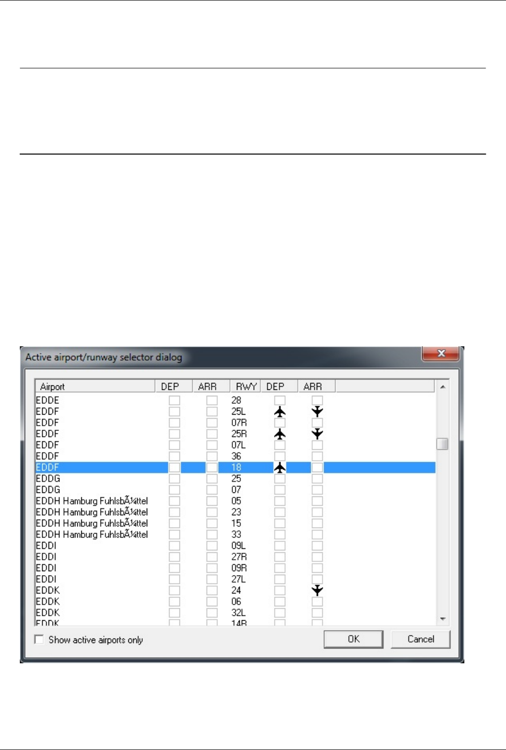
Euroscope:Sounds Setup 116
In the Device combo box you can define which sound device is to be used for the sounds. You can select from your
available devices or use the default Windows output one. All sounds will be played on the device selected here
except the startup sound. That is always sent to the default Windows device unit.
Previous: Euroscope:Plug-Ins Actual: Euroscope:Sounds Setup Next: Euroscope:Active Airports Runways
Euroscope:Active Airports Runways
Previous: Euroscope:Sounds Setup Actual: Euroscope:Active Airports Runways Next: Euroscope:Flight Plan Setting Dialog
Active Airports / Runways
Here you may select which airports are under your control, thus what flights should be listed in the aircraft and
departure list. You can activate arrival and departure funcionality for each airport separately. In the aircraft list, every
arrival or departing flights will be displayed in addition to aircrafts concerned by your sector. If defined in the ESE
file's sector definitions, active airports will be set automatically dependent on the sectors under your control.
You can also set the runways in use regardless of the active airports. The active runways are relevant for the SID and
STAR prediction, and optional also for the display of extended centerlines and the calculation of COPX points.
Optional the active airports with runways assigned can be automatically added to the metar list.
• To make an airport active click on the first two boxed columns next to the airport name. In this example only
EDDF Frankfurt is selected (both DEP and ARR)
• To select the active departure and arrival runways click the DEP and ARR columns for the given runway. In this
example departure runways 25L, 25R and 18 and arrival runways 25L and 25R are selected for EDDF Frankfurt.
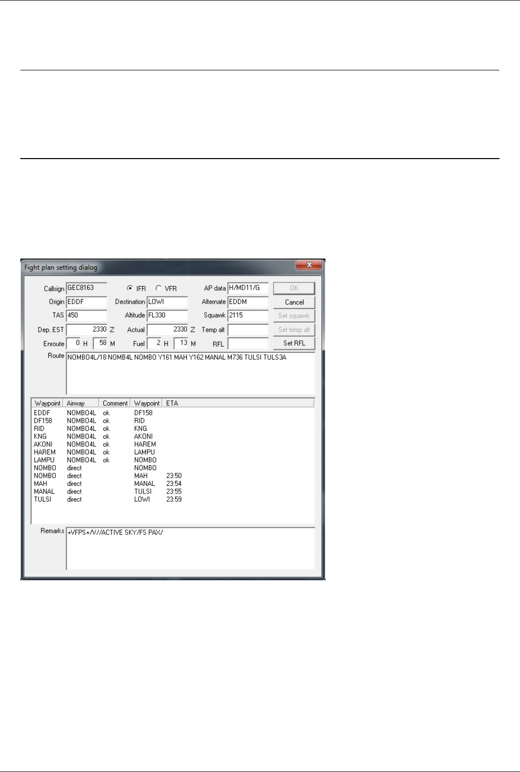
Euroscope:Active Airports Runways 117
In addition to that, for EDDK Cologne-Bonn runway 24 is selected to allow Euroscope the calculation of the
correct COPX points.
• You can reduce the list to show only the active airports.
Previous: Euroscope:Sounds Setup Actual: Euroscope:Active Airports Runways Next: Euroscope:Flight Plan Setting Dialog
Euroscope:Flight Plan Setting Dialog
Previous: Euroscope:Active Airports Runways Actual: Euroscope:Flight Plan Setting Dialog Next: Euroscope:Message Dialog
The Flight Plan Setting Dialog
The dialog looks like this:
Most part of the dialog is really straightforward and needs not too much explanation. It contains the most important
pieces (not all of them) of a flight plan and makes it possible to be modified. Just edit the values you would like to
modify then press OK to save or Cancel to forget it. You can open the flight plan dialog even if you are an observer
or someone else is tracking the aircraft but in this case you will not be able to save your modifications.
Probably the route section is a little bit more interesting then the others. It is a simple text edit box. The addition is
that for every single character modification the route is compiled from the string and the extracted point by point
route is displayed in the list control below. There you can see all waypoints the airway to that waypoint and a
comment about the airway usage. If the aircraft is flying then the estimated time of arrival is also calculated for every
point along the route.
There are three other buttons that works immediately and not when saving the dialog:
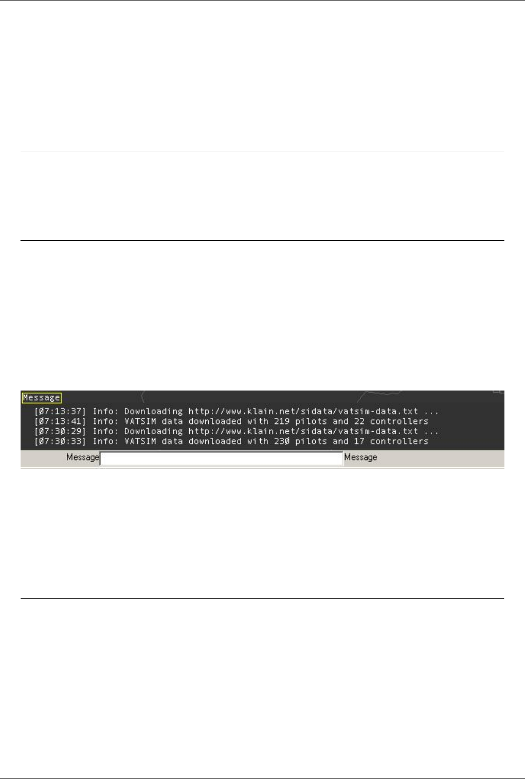
Euroscope:Flight Plan Setting Dialog 118
•Set squawk - It assigns the squawk value to the aircraft. If the field is empty the a new squawk is generated based
on the controller position.
•Set temp alt - It sets the temporary altitude.
•Set RFL - It sets the requested flightlevel. EuroScope makes a difference between the requested flightlevel
(RFL), which is the level the pilot originally requested when filing his flightplan, and the current or cleared
flightlevel (CFL) which is the level currently cleared by the control. CFL is the level accessed by the F5 key.
In Euroscope:Professional Radar Simulation mode, you can add an ETA for a waypoint directly in the waypoint list
in the ETA column.
Previous: Euroscope:Active Airports Runways Actual: Euroscope:Flight Plan Setting Dialog Next: Euroscope:Message Dialog
Euroscope:Message Dialog
Previous: Euroscope:Flight Plan Setting Dialog Actual: Euroscope:Message Dialog Next: Euroscope:Short Term Conflict Alert Settings Dialog
Message Dialog
With EuroScope v3.1, the old Message Dialog has been replaced by a message tab in the chat area. This tab shows
you whenever an error occurs on loading some necessary files or data, and other system informations. It will
automatically appear when loading a file fails.
In this example the VATSIM data feed that provides the data for simulated traffic has been loaded successfully.
With v3.1 a new message confirmation system is introduced. The messages are moved two chars to the right and
there are three different chars at the first column to indicate the message status:
SPACE – this message does not need to be confirmed (mostly the outgoing messages).
O – this message is not yet confirmed
* - this message is already confirmed
To confirm a single message click on the O. To confirm all messages of the tab click on the handler with right
button.
Some Common Error Messages
* Sector definition DAOO_TWR_SECTOR is missing in line xxxx
This message appears when you make a reference to a sector in a DISPLAY_SECTORLINE instruction and
you have forgotten to define the corresponding sector.
* Sectorline name not found in line xxxx
This message appears if you make a reference to a sectorline, and that you omit to define the corresponding
sectorline.
* Invalid line name in sector BORDER : DAOO_TWR_SECTOR / DAOO_TWR_SCL in line xxxx

Euroscope:Message Dialog 119
This message appears if you make a reference to a sectorline in the BORDER line of a sector definition, and
that you omit to define the corresponding sectorline.
* Invalid COORD in line xxxx
This error message is generally due to a syntax error (comma instead of colon). May occur when you paste
directly the coordinates copied after a .distance command and if you forget to replace the comma by a colon.
To avoid it, it's better to use the .sline command.
* Invalid keyword in line xxxx
This error message occurs if you type a keyword that EuroScope does not recognize. It happens also if you
have an empty line with a space character.
* Failed to load xxxxx.7z
This error message occurs if you download a sector file archive and EuroScope cannot find the associated
resource on the network.
* Failed to extract sector files from the xxxxx.7z archive
This error message occurs if you downloaded a sector file archive and EuroScope cannot extract the sector
files from the associated archive. This can be due to an incorrect archive file or a missing sct file in the archive
(EuroScope always verifies that a sct file is included in the archive, this is mandatory).
TIP: - For finding quickly the error line, one good idea is to load the ese file in Excel or in any other editor that
displays the line numbers, and it's easy to jump directly to it.
Previous: Euroscope:Flight Plan Setting Dialog Actual: Euroscope:Message Dialog Next: Euroscope:Short Term Conflict Alert Settings Dialog
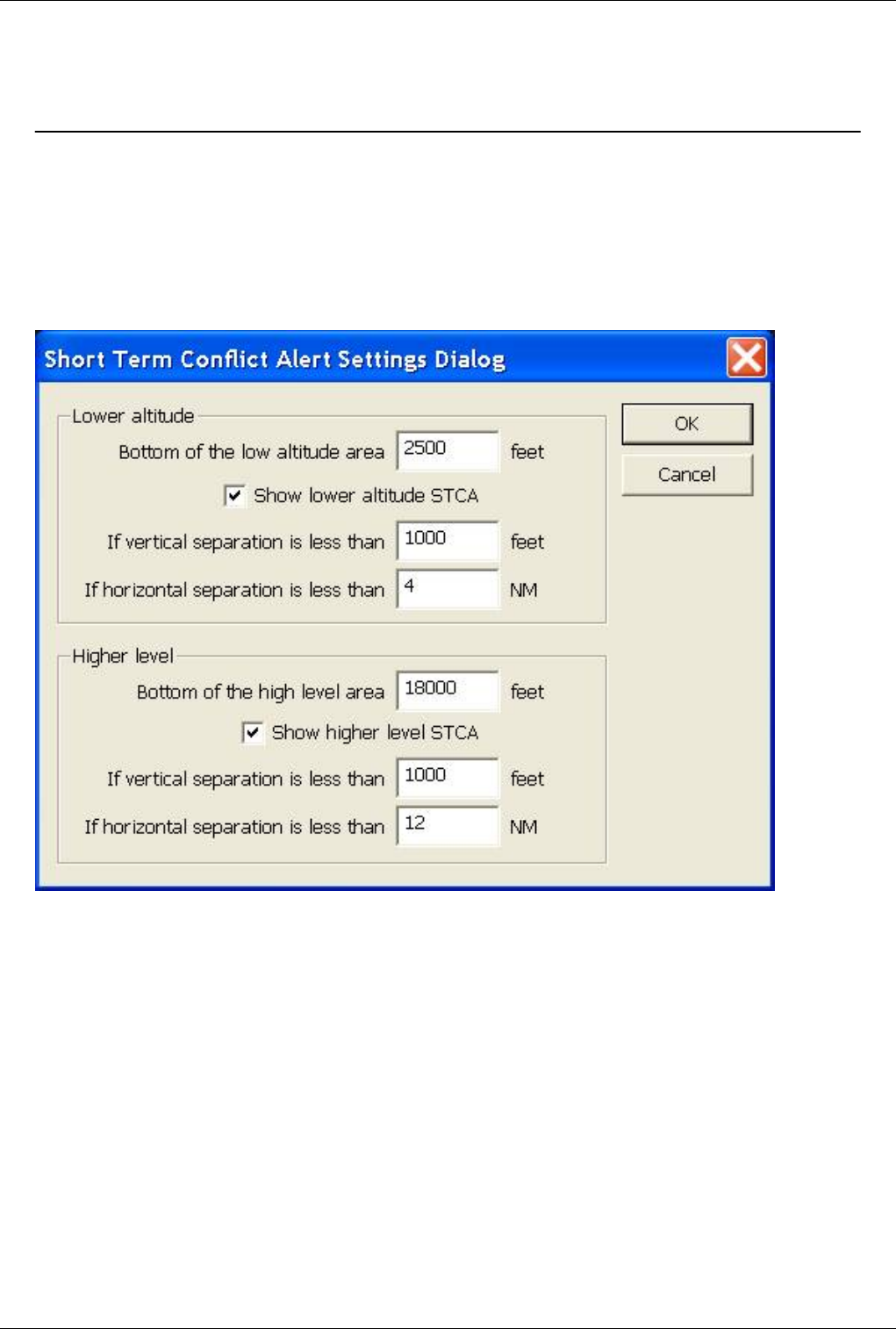
Euroscope:Short Term Conflict Alert Settings Dialog 120
Euroscope:Short Term Conflict Alert Settings
Dialog
Previous: Euroscope:Message Dialog Actual: Euroscope:Short Term Conflict Alert Settings Dialog Next: Euroscope:Extended Centerline Setup
The Short Term Conflict Alert Settings Dialog
In this dialog you can setup in which situation a conflict alert should be displayed (and also an warning sound to be
played).
The short term conflict alert detector divides the world into three sectors vertically.
• The first sector is from the ground until the bottom of the lower altitude area. In this are there are no conflict alert
detection at all.
• Between the bottom of the lower altitude area and the bottom of the higher level area. Conflicts in this area are
detected using the values from the Lower altitude box.
• From the bottom of the higher level area and up. Conflicts in this area are detected using the values from the
Higher level box.
The values you should specify for both areas are the same:
•Bottom of the ... area - The lower level/altitude of the area. The settings are used above this value.
•Show ... STCA - Indicates to detect conflicts at all or not. Switching them off no conflict alerts are ever fired.
•If vertical separation is less than - The minimum vertical separation for the alert. If the separation exactly the
number specified no alerts will be fired.
•If horizontal separation is less than - The minimum horizontal separation for the alert. It is advised to be higher
than the separation minimum to allow the controller to react to the alert.
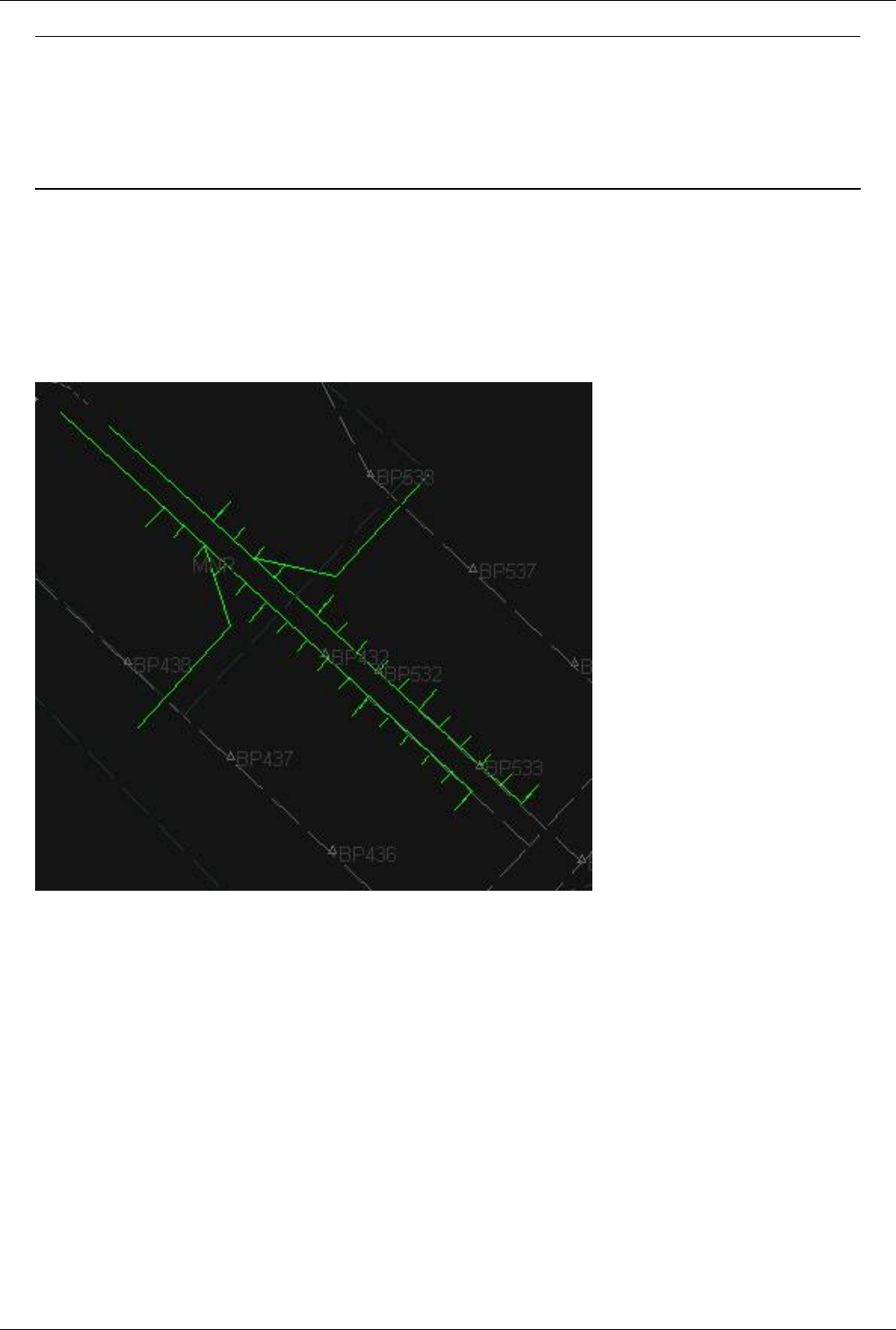
Euroscope:Short Term Conflict Alert Settings Dialog 121
Previous: Euroscope:Message Dialog Actual: Euroscope:Short Term Conflict Alert Settings Dialog Next: Euroscope:Extended Centerline Setup
Euroscope:Extended Centerline Setup
Previous: Euroscope:Short Term Conflict Alert Settings
Dialog
Actual: Euroscope:Extended Centerline
Setup
Next: Euroscope:Sector Ownership
Setup
The Result
Let us start from a picture with the result before going into details how you can configure the display:
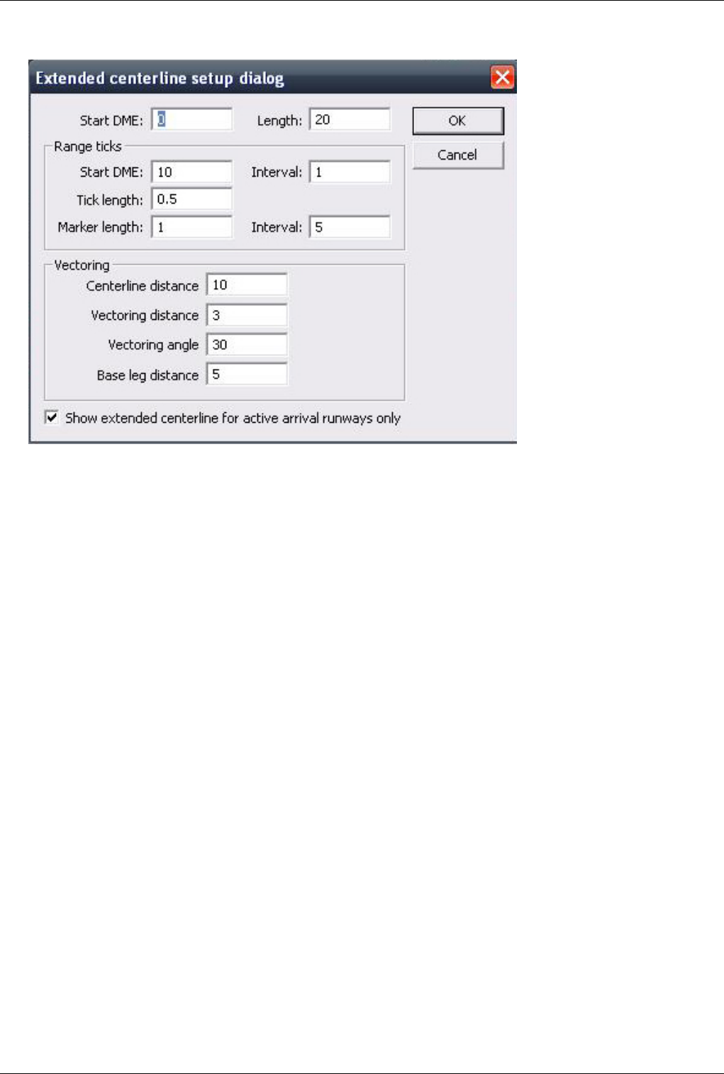
Euroscope:Extended Centerline Setup 122
The Setup Dialog
•Main centerline
•Start DME - The offset in NM the main line of the centerline will be started.
•Length - The length of the main line of the centerline. Note that the endpoint will be Start DME + Length
distance from the runway threshold.
•Range ticks
•Start DME - The first tick mark to be displayed distance in NM from the threshold. The tick marks will be
displayed from here until the end of the main line.
•Interval (after Start DME) - How often (in NM) a tick mark should be displayed.
•Tick length - The length of the tick marks (ortogonally to the main line).
•Marker length - The length of the marker tick marks (ortogonally to the main line).
•Interval (after Marker length) - How often in (NM) a marker tick mark should be displayed.
•Vectoring lines
•Centerline distance - The distance from the threshold of the end of the vectoring line in the main line (where
vectoring line touches the main line).
•Vectoring distance - The length of the vectoring line.
•Vectoring angle - The angle between the main line and the vectoring line.
•Base leg distance - The length of the base leg line (it always starts at the other end of the vectoring line).
•Show extended centerline for active arrival runways only - shows the centerlines of your active arrival
runways and hides all other centerlines.
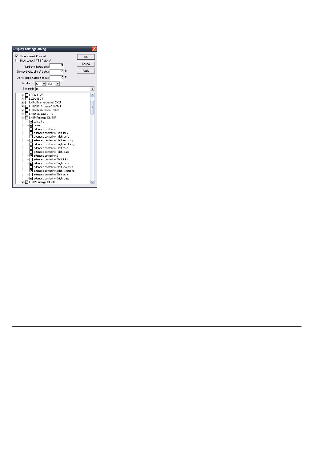
Euroscope:Extended Centerline Setup 123
How To Display Them
In this dialog you only can setup how the extended centerline pieces are built up. To display them you should go to
the Euroscope:Display Settings dialog. There you can switch on and off individual runway centerline pieces:
The centerline and the name are the main items to be displayed. They are not related to the extended setup anyhow.
In the sectorfile there is only one definition of a runway even it can be used from both directions and therefore has
two names. In this picture you can see LHBP second runway 13L-13R. To distinguish between the directions all
extended centerline items are duplicated and named as extended centerline 1 ... or extended centerline 2 ... where 1
refers to the first end (here 13L) and 2 refers to the other end (31R) of the runway. As the picture on top of this page
shows a 31 configuration only the 31R end of the runway extended lines are displayed.
It is also not necessary to display the ticks, vectoring lines and base lines on both sides of the extended centerline.
That is quite useful when you display them in a parallel runway airport. In the pictures you can see that in this case
only the right side items are switched on for runway 31R while only the left side items for 31L.
If You are using the "Show extended centerline for active arrival runways only" option, it is important to keep in
mind, that You need to setup all extended lines in the _Display_Settings_ regardless of which will be used in the
specific situation. When Euroscope automatically activates the centerlines for the arrival runways, it uses the display
settings. On the other hand, with this option activated, ES will not show an extended centerline for an inactive
runway , even though it is setup here.
Previous: Euroscope:Short Term Conflict Alert Settings
Dialog
Actual: Euroscope:Extended Centerline
Setup
Next: Euroscope:Sector Ownership
Setup
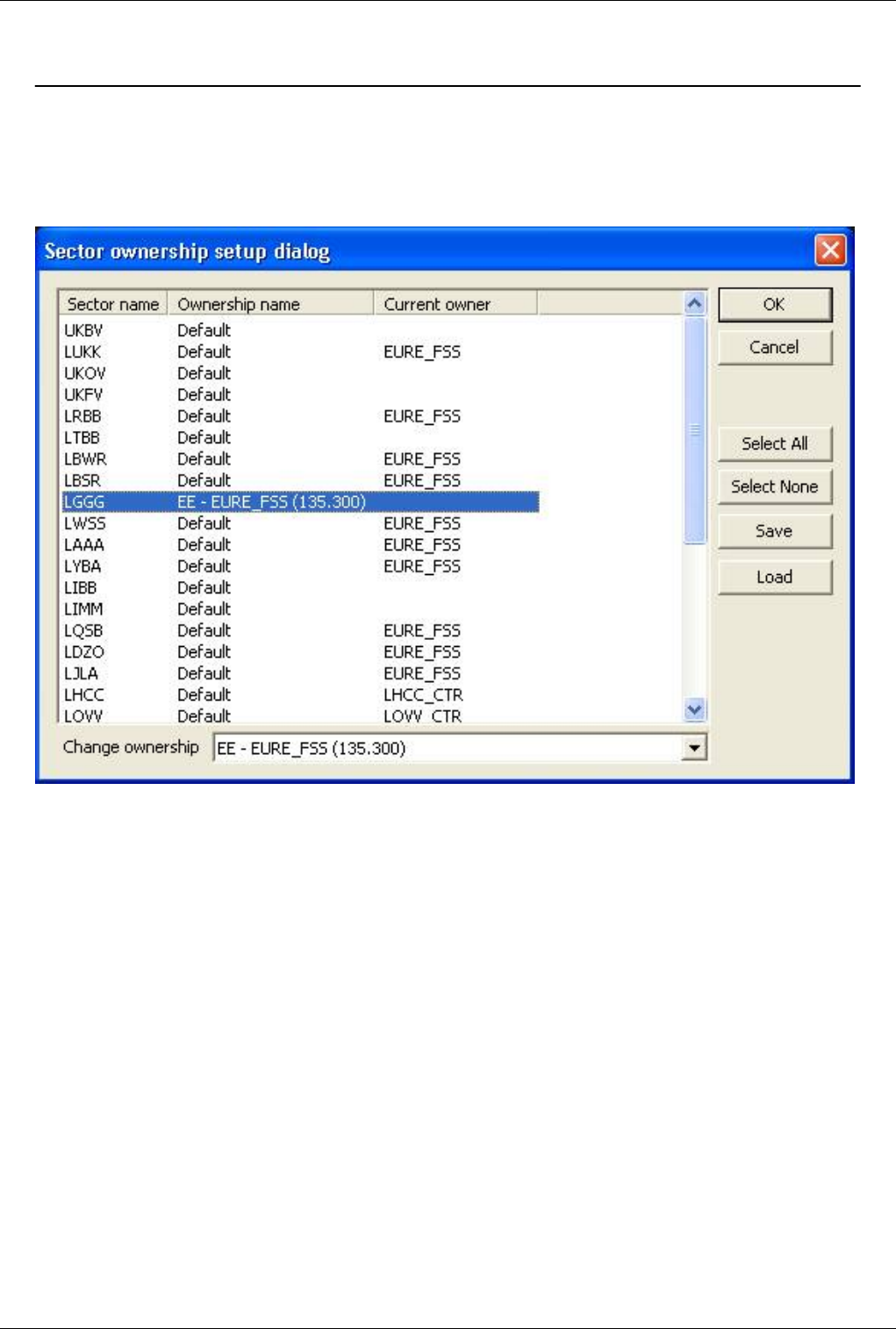
Euroscope:Sector Ownership Setup 124
Euroscope:Sector Ownership Setup
Previous: Euroscope:Extended Centerline Setup Actual: Euroscope:Sector Ownership Setup Next: Euroscope:Non Standard Extensions
Sector Ownership Setup Dialog
Using this dialog one can change how the sector allocation works. In the main list there are the sectors defined in the
ESE file. The first column is the sector name, the second is the ownership rule name while the last is the callsign of
the actual owner (this is the situation of the dialog open moment and is not updated while the dialog is opened).
The most important idea one can change here is the ownership rule. That drives EuroScope how it allocates the
sectors to the controllers. Each sector can have one of the following three roles for allocation:
•Default - The default role. In this case the #OWNER# line of the sector definition defines the hierarchy of the
controllers. The first controller in the list will own the sector.
•An alternate ownership name - If there are alternate ownership rules in the ESE file then it can be defined for
every sector. It works the very same way as Default except that it uses an alternate ownership hierarchy. If the
selected alternate name is not defined for a sector then the Default will be used instead.
•A position - It is also possible to assign a sector directly to a controller. In this case if the controller is online
he/she will own the sector but if off line there will be no alternate owner.
The controls can be used as follows:
•Sector list - It displays the actual assignment. One can select one or more sectors from the list. The combo box
bellow will follow the ownership name of the selected sectors. If different rules are assigned then there will be no
selection there.
•Change ownership combo - Using this combo it is possible to change the ownership role. The combo box
contains the Default, the Alternate role names and after them all Position definitions from the ESE file. The

Euroscope:Sector Ownership Setup 125
selected value will be assigned to all sectors.
•Select all - To select all sectors from the list.
•Select none - To deselect all sectors from the list.
•Save - Using this button you can save the ownership setup to a text file. This file can be published (e.g. for a
flyin) and reloaded later.
•Load - To load a previously saved configuration.
Previous: Euroscope:Extended Centerline Setup Actual: Euroscope:Sector Ownership Setup Next: Euroscope:Non Standard Extensions
Euroscope:Non Standard Extensions
Previous: Euroscope:Sector Ownership Setup Actual: Euroscope:Non Standard Extensions Next: Euroscope:Working with keyboard
Why Non Standard Extensions?
EuroScope needs to publish more information than possible in the current FSD version. Therefore some of them are
published using standard elements but in a special way. We tried the best to define an extension in a way that the
other controller who are not using EuroScope could use this information, but it will work the best only if both parties
are using EuroScope.
Scratch Pad Strings
One of the most significantly used element is the scratch pad message. In ASRC and VRC this area is just a place for
some short comments, but nothing more. In EuroScope some special formatted scratch pad strings are used to
communicate additional information:
•VOR, NDB, FIX name - When a point name like VOR, NDB or FIX is entered to the scratch pad it is compiled
as a direct to point assignment. The next route of the plane is updated accordingly. If you set a direct point using
the popup menu in the COPX tag item, the name of the point is also published via the scratch pad.
•HXXX - Scratch pad string formatted as H* followed by numbers is interpreted as if heading were assigned to the
plane. When you assign the heading using the popup menu then the appropriate *HXXX* format scratch pad
message is published. If you need a heading assignment that is not available via the popup menu, you can enter it
manually to the scratch pad (eg. H022). To avoid the real scratch pad data to be deleted, the original content is
sent just after the heading data.
•RXXXX - An R followed by numbers are interpreted as assigned climb/descend rating.
•SXXX - An S followed by numbers are interpreted as assigned speed in knots.
•MXXX - An M followed by numbers are interpreted as assigned speed in Mach number. Actually the value is
used as Mach number multiplied by 100. M75 is used for Mach .75.
•CLEA - Special scratch pad content to indicate clearance received flag.
•NOTC - Special scratch pad content to indicate clearance not received flag.
•PUSH - Special scratch pad content to indicate push back approved ground status.
•TAXI - Special scratch pad content to indicate taxiing ground status.
•DEPA - Special scratch pad content to indicate departure (take off) clearance.
•HOLD - Part of the Holding List Plugin; Special scratch pad content to be issued after a DCT to indicate a hold
over the DCT fix.

Euroscope:Non Standard Extensions 126
Temporary Altitude
Special values in the temporary altitude assignment:
•1 - If the temporary altitude is set to 1, EuroScope indicates that the plane is cleared for an ILS approach.
•2 - If the temporary altitude is set to 2, EuroScope indicates that the plane is cleared for a visual approach.
Flight Plan Route Section
The flight plan route section is free text are. It is not easy to interpret the content in all cases, but allows additional
information to be stored. The so called "standard" route elements like point names, airway names, EuroScope
interprets the following items:
•SID/STAR name - The name of the SID or STAR (with or without '+ sign) is interpreted as SID or STAR and if
found in the sectorfile extension then the points are added to the route.
•SID/<RWY name> or STAR/<RWY name> - If the SID or the STAR is followed by a slash then a RWY
designator then it is interpreted as the plane will depart/land on the specified runway and will follow the specified
SID/STAR. This format is important when the same SID/STAR name is used for different runways. This selects
the right SID/STAR from the extension file. When you assign a SID/STAR using a popup menu from the new
aircraft lists EuroScope will amend the flight plan adding this format to the beginning or to the end of the route
section. Assigned SID/STAR and RWY data can be shown in the aircraft lists or even in the TAG.
BADOV3D/31R - It indicates a BADOV3D departure from RWY 31R
VEBOS3R/31L - It indicates a VEBOS3R transition to RWY 31L
•AIRPORT/<RWY name> - If the route section start with the departure airport name followed by a slash then a
RWY designator then it is interpreted as departure RWY is assigned. Same if the destination airport is at the end
followed by the slash and the RWY. It is interpreted as RWY is assigned for arrival. If an aircraft has an assigned
RWY only the SIDs/STARs of this RWY will be used in the popup menu and in the route extraction.
•POINT/M085F320 (and M085F320/POINT) is accepted. The F320 is compiled as the requested level from the
next point. This value is used for the profile calculation and also used as the RFL (if no controller overrides it).
Previous: Euroscope:Sector Ownership Setup Actual: Euroscope:Non Standard Extensions Next: Euroscope:Working with keyboard

Euroscope:Working with keyboard 127
Euroscope:Working with keyboard
Previous: Euroscope:Sector Ownership Setup Actual: Euroscope:Working with keyboard Next: Euroscope:Editing And Function Keys
Working with keyboard and mouse
While EuroScope can be used by simple mouse clicking still there are a lot of things where keyboard makes our life
much easier. As they can speed up the work there are several keyboard tricks.
Editing, Function Keys And Other Key Shortcuts
The Euroscope:Editing And Function Keys page describes the meaning of several keyboard elements which behave
differently than a simple text editor. Many things come from ASRC, so if you have ever used ASRC, you will find
them familiar. However in some cases we changed the meaning of the key completely or made it work slightly
different.
Alias files are the same that you used for ASRC/VRC, but the extraction of the aliases are completely different.
Command Line Reference
The Euroscope:Command Line Reference page contains a complete list of the available commands an their usage.
Built In Functions
The Euroscope:Built In Functions page lists the functions you can use in aliases, METAR lines or just when typing
in things to the command line.
Previous: Euroscope:Sector Ownership Setup Actual: Euroscope:Working with keyboard Next: Euroscope:Editing And Function Keys

Euroscope:Editing And Function Keys 128
Euroscope:Editing And Function Keys
Previous: Euroscope:Working with keyboard Actual: Euroscope:Editing And Function Keys Next: Euroscope:Command Line Reference
Editing and Function Keys
Function Keys And Other Key Shortcuts
This paragraph describes the meaning of several keyboard elements which behave differently than a simple text
editor. Many things come from ASRC, so if you have ever used ASRC, you will find them familiar. However in
some cases we changed the meaning of the key completely or made it work slightly different.
•F1 key
As in EuroScope the TAG up and TAG down is available with a double click on the TAG this key has been freed up.
Its role is to accelerate issuing commands that are important, yet not so often used. When you first press the F1 key,
then *F1* will appear in the command line. Then there are some shortcuts:
•F1+1 to F1+9 - ASR fast load keys as defined in Euroscope:General Settings
•F1+0 - closed the current ASR file
•F1+a - changes to .am
•F1+c - changes to .chat
•F1+d - changes to .distance
•F1+f - changes to .find
•F1+i - changes to .inf
•F1+k - changes to .kill
•F1+s - changes to .sep
•F1+u - changes to .SS
•F1+w - changes to .wait
•F2 key
It simply places the .QD command to the command line to display METAR information on selected stations.
•F3 key
It places the .QT command to the command line to start tracking an aircraft or to accept handoff. Like
.contacme it also works on the aircraft that is under the cursor making it very simple to accept handoffs.
•F4 key
It places the .QX command to the command line to drop an aircraft or initiate handoff. Like .contacme it also
works on the aircraft that is under the cursor. Important .QX without parameter initiates a handoff to the next
controller (if available) instead of dropping target.
•Shift+F4 key
It places the .QY command to the command line to drop an aircraft. Like .contacme it also works on the
aircraft that is under the cursor.
•F5 key
It simply places the .QZ command to the command line to change the final altitude.
•F6 key
It displays the flight strip of the selected aircraft in the place of the standard CHAT window.
•Shift+F6 key

Euroscope:Editing And Function Keys 129
It places the .QU command to the command line to draw the route of an aircraft. It is very rarely used as this
function works far better from the TAG.
•F7 key
If you are using more than one radar layouts at a time press this key to switch between them.
•F8 key
It simply places the .QQ command to the command line to set or clear temporary altitude.
•F9 key
It places the .QB command to the command line to set squawk code or communication type (/t, /v, /r). For
aircraft that is under the mouse it assigns the next available squawk automatically.
•F11 key
This key zooms in the radar screen. This is a replacement of the mouse wheel zoom.
•F12 key
This key zooms out the radar screen. This is a replacement of the mouse wheel zoom.
•FREQ key (as default the numeric STAR keyboard)
First of all it opens your primary frequency chat window. If the command line is not empty (e.g.: a message to
a pilot is written in there) then it sends the command line content to the primary frequency, addressing the
message to the selected aircraft.
•ASEL key (as default the numeric PLUS keyboard)
This is the aircraft selector key. To use there should be some letters typed from the callsign. Pressing this
button the first callsign that matches the letters typed before will be selected. You can press the + key again to
select the next match. You can do it in a loop to see all callsigns matching.
•HOME
If the command line is not empty then it is the good old HOME key that moves the cursor to the beginning of
the line. But if the command line is empty then it places the .contactme command to the editor. Important, if
there is an aircraft which TAG is in detailed mode (the mouse is over it) then the command is executed
immediately.
•INS
The insert button places the .QS command to the command line to set or clear the scratch pad of an aircraft.
Like the HOME key it is executed immediately on the aircraft which has the mouse over its detailed TAG. In
this way you can clear the scratch pad fast.
•Left Click + Right Click
Using this combination on a TAG will "stick" it on the screen in it's present position and will not move with
the aircraft's target. Moving the TAG will cancel the "sticking" function.
Editing In The Command Line
Some buttons do not have a real function connected to but simple changes the content of the command line in some
way.
•TAB
The TAB key has two different meanings depending on the content of the command line:
• If the line is empty then it selects the next displayed chat window.
• If the line is not empty then it extracts the function names from the command line and selects next parameter.
See later in the Aliases section.
•ESC
The escape button has three different meanings:

Euroscope:Editing And Function Keys 130
• If the command line is not empty, then it simply clears it.
• If empty but has an aircraft selected then it deselects all aircraft. This way you can send messages on your
primary frequency to anyone, even if you are unable to select him/her.
• If empty and no aircraft is selected then it closes the chat window. You can open it again by a doubleclick on
any chat name or initiating a new chat (see command line functions).
•Ctrl+Up arrow
The Up key with Ctrl pressed gets the previous line from the CHAT window and puts it into the command
line. There you can reedit, copy part of it to the clipboard, etc.
•Ctrl+Down arrow
Like the previous but it goes to the next line.
•Shift+Up arrow
The Up key with Shift pressed gets the previously entered command to the command line.
•Shift+Down arrow
The Sown key with Shift pressed gets the next entered command to the command line.
•Up arrow
It scrolls the chat content one line down to see one more line on top.
•Down arrow
If scrolls the chat content one line up to see one more line on bottom.
•Page Up
It scrolls the chat content three lines down to see more lines on top.
•Down arrow
It scrolls the chat content three lines up to see more lines on bottom.
Note: The primary and the secondary PTT buttons are disabled in the chat window. If you select a key as PTT you
will not be able to use it in the command line.
Aliases
Alias files are the same that you used for ASRC. You can load them as they are and if the functions are implemented
in EuroScope as well then you can use them. The general format of one alias line is:
.<alias name> <alias value>'''
Where alias name is the short name you would like to type and the value is what should be inserted into the
command line as replacement. The alias value string can contain several function calls (see later), parameters $1, $2,
... $9 and of course free text. An alias value should not contain another alias name. Well it can, but it will not be
extended. The way you can use the aliases are completely different from ASRC. It replaces the alias name to value
as you type not only when you send it to somewhere. Just type your message as you like. Whenever a SPACE is
pressed EuroScope tests the last word typed and if it starts with a DOT and matches any alias name it will replace the
word immediately. It is not necessary to start the alias at the beginning of the line, it is not necessary to be at the end
of the line. Only to press a SPACE. This idea makes it possible to see the extracted message before sending it. As the
alias name is replaced immediately the parameter definition should work also differently. As the name replaced
EuroScope searches for the parameters. When it founds the first one it become selected in the command line. In this
way you just simply type the parameter and the selected portion of the text will be replaced as it works in a normal
edit box. When you finish with the parameter just press the TAB key to search for the next parameter place to be
selected. When the TAB is pressed EuroScope first test if the same parameter is used in the alias again or not. If used
then it will replace that occurrence with the newly typed value too. After that it tries to evaluate all the functions in
the line once again. In this way an alias parameter can be parameter of a function too. See the next example: The

Euroscope:Editing And Function Keys 131
original alias is:
.cont Contact $radioname($1) on frequency $freq($1)
After typing .cont and a space the command line will be extended to:
Contact $radioname($1) on frequency $freq($1)
and the first $1 will be selected. As you overwrite it with e.g. AP and press TAB key the line will be changed to:
Contact Budapest Approach on frequency 129.700
Using this method you should not memorize what parameters comes each after as you see the context before
specifying the value. One backward of the method is that it could not recognize if the same parameter is in the line
more than once. So in that case one should specify the same value several times.
Autotext messages
All "autotext" messages use built-in aliases now. If you want to change any of these, just put the respective entry in
your alias file. EuroScope will then use this entry instead of the built-in text. The default aliases are as following:
.autoproceed Proceed direct to $1
.autoclearedils Cleared ILS approach RWY $1
.autoclearedvisual Cleared visual approach RWY $1
.autoclimblevel Climb to FL $1
.autoclimbaltitude Climb to altitude $1 ft by QNH $altim($dep)
.autodescendlevel Descend to FL $1
.autodescendaltitude Descend to altitude $1 ft by QNH $altim($arr)
.autospeed Speed $1 KT indicated
.automach Mach number $1
.autonospeed Resume normal speed
.autoturnleft Turn left heading $1
.autoturnright Turn right heading $1
.autocontact Contact $1 on frequency $2. Have a good flight and landing. Bye.
.autosquawk Set squawk $1
Previous: Euroscope:Working with keyboard Actual: Euroscope:Editing And Function Keys Next: Euroscope:Command Line Reference

Euroscope:Command Line Reference 132
Euroscope:Command Line Reference
Previous: Euroscope:Editing And Function Keys Actual: Euroscope:Command Line Reference Next: Euroscope:Built In Functions
Command Line Functions
In alphabetical order.
•.am
This command opens the flightplan amendment dialog of an aircraft.
Syntax:
.am <click on a TAG or AC in the list>
.am <ASEL to use selected aircraft>
.am <aircraft callsign>
•.atis
This function asks the ATIS information of a specified controller. The answer will come as private chat
message. If no controller is specified then it wall send the query to the controller who's chat window is active.
Syntax:
.atis [<conroller callsign>]
•.break
Request for relief. It changes the status of the controller to "leaving soon".
Syntax:'
.break
•.busy
Signal that you are really to busy for private chats. In EuroScope there is only a one level simple busy status.
When set the followings are changed:
• No sounds for ATC messages,
• No sounds for Broadcast messages,
• An automatic "Sorry but I am busy, I may not read your message" answer for all incoming private messages.
And no sounds for them.
•.callsign
This function allows you to change the ICAO_Airlines.txt file from EuroScope. Enter the name of the airliner
then click on the TAG. EuroScope will replace the original entry in the file. Note: that when you download a
newer version of the ICAO_Airlines.txt your changes will be lost.
Syntax:
.callsign <airline name> <click on a TAG or AC in the list>
.callsign <airline name> <ASEL to use selected aircraft>
•.center
It moves the center of the view to the selected location. Location can be any object: vor, ndb, fix, airport,
controller callsign (in that case the center of the visibility area is used) or an aircraft callsign. Sending the

Euroscope:Command Line Reference 133
command without parameter will go back to the original center position (the one before the previous .center
command).
Syntax:
.center <any object name>
.center
•.chat
It opens a chat window to a specified controller or pilot.
Syntax:
.chat <controller or pilot callsign> [<callsign2>] [<callsign3>] ...
.chat <click on a TAG or AC in the list>
.chat <ASEL to use selected aircraft>
•.contactme - available via the HOME button if command line is empty
This command sends the "Please contact me on XXX.XXX." private message to the selected aircraft.
Syntax:
.contactme <click on a TAG or AC in the list>
.contactme <ASEL to use selected aircraft>
This command can be executed by pressing the HOME key when the command line is empty and the mouse is over
an opened TAG and therefore the detailed TAG is visible. In this case it is executed immediately no ENTER or click
on TAG is required.
•.dcenter
Use this command to override the default latitude/longitude aspect ratio center. As default EuroScope
calculates the length of one degree at the position defined in the sectorfile then uses it everywhere. That could
be quite incorrect if you are too far from the equator. By defining another point you can change the center
point of the display.
Syntax:
.dcenter <object>
Where object can be anything: vor, ndb, fix or coordinate. The coordinate can be defined by clicking in an empty
place by mouse.
•.distance - available as toolbar icon
The distance command shows distance between two objects or points on the radar screen. When this command
is active then pressing the mouse button on a TAG or on an AC in the list its callsign goes to the command line
as parameter. If you click to a position where nothing can be found than the coordinates are copied to the
command line. If the first parameter is specified then moving the mouse displays the distance data from the
selected point to the cursor. If the first selected object is an aircraft and the second is not then the distance and
the time needed for the distance will be displayed. Otherwise only the distance.
Syntax:
.distance <object1> <object2>
.distance <object1> <angle>/<distance>
Where object can be anything: aircraft, vor, ndb, fix or coordinate. In the second place not only an object but an
angle/distance pair also can be entered. In this case it will be calculated as relative to the first. The distance data is

Euroscope:Command Line Reference 134
also displayed on top of the screen. To remove a distance line make a doubleclick on this text line.
•.distance2
The same as before but displays the heading data too.
•.find
Using this command you can find an aircraft on the radar screen. It draws a wide white line from the center of
the radar screen to the aircraft specified as parameter. The line remains on the screen for 5 seconds.
Syntax:
.find <aircraft callsign>
.find <click on a TAG or AC in the list>
.find <ASEL to use selected aircraft>
•.ff, .fn, .fv, .fa, .fc, .fw
These commands are changing the display settings from the command line. The commands changes the
display of the following element types (in the same order): FIX, NDB, VOR, Airport, Low airways, High
airways.
All works in a way that looks for all the parameter names, tests if any of the components are displayed or not.
If any is displayed then the command hides them, otherwise it displays some of them. The following
components are tested and displayed using this command:
• FIX symbol and name,
• NDB symbol, name and frequency,
• VOR symbol, name and frequency,
• Airport symbol and name,
• Airways name and line.
•.fpquery
A supervisor only command. It sends an information request to the servers to query the controller who
modified the flight plan of the selected aircraft. The answer will come back as message to the "server" chat
window. The command needs a selected aircraft.
Syntax:
.fpquery <aircraft callsign>
.fpquery <click on a TAG or AC in the list>
.fpquery <ASEL to use selected aircraft>
•.getfp
It sends a request to the server to retrieve the flight plan of the selected aircraft. Use it if somehow you feel
that the FP is not updated correctly.
Syntax:
.getfp <aircraft callsign>
.getfp <click on a TAG or AC in the list>
.getfp <ASEL to use selected aircraft>
•.hl
You can control the Holding List Plugin using the command line.
• .hl show – to show the holding list
• .hl hide – to hide the holding list

Euroscope:Command Line Reference 135
• .hl add <point name> <callsign> - to add a plane to the list
• .hl del <callsign> - to remove the plane from the list
• .hl wait <minutes> <callsign> - to add a timer that counts down from <minutes> to 0.
•.inf
A supervisor only command. It sends an information request to the selected controller or aircraft. The answer
will come back as private message.
Syntax:
.inf <controller or aircraft callsign>
.inf <click on a TAG or AC in the list>
.inf <ASEL to use selected aircraft>
•.kill
A supervisor only command. It sends sends a disconnect message to the selected controller or aircraft and
disconnects him/her from the network immediately.
Syntax:
.kill <controller or aircraft callsign> [<a free text reason message>]
If the .kill message is active then clicking on a TAG will copy the callsign to the command line but never executes
the command automatically. Only an explicit ENTER will do that.
•.msg
It sends a private message to the selected pilot or controller.
Syntax:
.msg <controller or aircraft callsign> <free text>
•.nobreak
Request for relief is withdrawn. It changes the status of the controller back to normal.
Syntax:
.break
•.nobusy
It clears the busy status.
•.novis
It clears the visibility centers and sets only the default one. Note: that it is not an immediate function as there
is no way the call back you visibility centers from the server. It must be timed out. In that way it takes about
1-2 minutes to stop receiving position updates from the cleared area.
•.point
To pointout and aircraft to a controller. When an aircraft is pointed to you it is displayed in the AC list with an
arrow then the name of the controller who pointed out the aircraft.
Syntax:
.point <controller ID> <click on a TAG or AC in the list>
.point <controller ID> <ASEL to use selected aircraft>
•.qb - available by pressing F9

Euroscope:Command Line Reference 136
It sets the squawk code (manually or automatically) or the communication type of an aircraft. If no additional
parameter then an automatic squawk value is assigned. The available squawk range is coming from the
POSITION definition part of the ESE file (see Euroscope:ESE Files Description). If a 4 letter valid squawk is
specified, than that value will be assigned. If 'V', 'R' or 'T' letter is defined that it sets the communication type
to "voice", "receive only" or "text" respectively.
Syntax:
.qb <V or R or T> <click on a TAG or AC in the list>
.qb <V or R or T> <ASEL to use selected aircraft>
.qb [<valid squawk>] <click on a TAG or AC in the list>
.qb [<valid squawk>] <ASEL to use selected aircraft>
•.qd - available by pressing F2
It toggles the display of the metar of the specified stations.
Syntax:
.qd <station1> [<station2>] [<station3>] ...
•.qq v/i/1/2
It allows you to set the approach flag by text.
v or 2 for visual approach
i or 1 for instrument approach
Syntax:
.qq <v or i or 1 or 2> <click on a TAG or AC in the list>
.qq <v or i or 1 or 2> <ASEL to use selected aircraft>
•.qs - available by pressing the INS key
It sets or clears the scratch pad text of an aircraft. If no text is specified then it clears the previously set value.
In EuroScope there is no limit for the length of the scratch pad message (but probably your TAG will look like
awful). But only the first 5 characters of the text will be published to the servers and to the neighbor
controllers. There is also a trick in EuroScope that if the scratch pad text is a waypoint name along the route
(from 2.8h any named point not only from route) then it will change the calculated track of the aircraft as the
next point is the specified. The display of such scratch pad message is in the heading (AHDG) indicator in the
TAG.
Syntax:
.qs [<free text or waypoint name>] <click on a TAG or AC in the list>
.qs [<free text or waypoint name>] <ASEL to use selected aircraft>
•.qt - available by pressing F3
It accepts handoff initiated to me or starts tracking an untracked aircraft.
Syntax:
.qt <click on a TAG or AC in the list>
.qt <ASEL to use selected aircraft>
This command can be executed by pressing the F3 key when the mouse is over an opened TAG and therefore the
detailed TAG is visible. In this case it is executed immediately no ENTER or click on TAG is required.
•.qu - available by pressing Shift+F6

Euroscope:Command Line Reference 137
It simply deletes all displayed route line. It is an easy way to switch off all airplane route display if you have
shown too many.
Syntax:
.qu
•.qq - available by pressing F8
This function changes the temporary altitude of an aircraft. If no altitude data is specified then it clears the
previously set temporary altitude.
Syntax:
.qq [<altitude in 100 feets>] <click on a TAG or AC in the list>
.qq [<altitude in 100 feets>] <ASEL to use selected aircraft>
•.quit
This function leaves the system.
Syntax:
.quit
•.qx - available by pressing F4
It is used to drop track or initiate handoff to the next controller. Important that a simple .qx without any
additional parameter will drop the target as in ASRC but initiates a handoff to the next controller defined by
the sectors and the logged in controllers. If you would like to handoff the aircraft to a specific controller then
type the short (normally two letter) ID before defining the aircraft. If an aircraft is displayed as tracked by
someone but assumed that it is false type a /ok after .qx. In this way EuroScope will clear the owner flag of the
aircraft and asks the system if someone is tracking it. If it is so then it wil return to tracked state in a second.
Syntax:
.qx [/ok] [<controller id>] <click on a TAG or AC in the list>
.qx [/ok] [<controller id>] <ASEL to use selected aircraft>
This command can be executed by pressing the F4 key when the mouse is over an opened TAG and therefore the
detailed TAG is visible. In this case it is executed immediately no ENTER or click on TAG is required.
•.qy - available by pressing Shift+F4
It is used to drop track of the aircraft.
Syntax:
.qy <click on a TAG or AC in the list>
.qy <ASEL to use selected aircraft>
•.qz - available by pressing F5
This function changes the final altitude of an aircraft. Important that it does not change the flight plan, just
assigns a final altitude.
Syntax:
.qz <altitude in 100 feets> <click on a TAG or AC in the list>
.qz <altitude in 100 feets> <ASEL to use selected aircraft>
•.rcenter

Euroscope:Command Line Reference 138
Use this command to override the default range center position. The range position is claculated in EuroScope
as follows: The default value is the one defined in the sectorfile. But if the login name first four letters match
any airport name from the sectorfile, then the airport will be the center of the visible range (this way TWR
positions with small range values will surely see what they need). By defining another point you can change
the center of your visual range anytime. EuroScope needs some 10-15 seconds to publish the position and to
update the visible elements.
Syntax:
.rcenter <object>
Where object can be anything: vor, ndb, fix or coordinate. The coordinate can be defined by clicking in an empty
place by mouse.
•.seeall
A supervisor only command. It opens up all TAGs. Be careful! It just changes the display of the TAGs to be
the same as they were up. But it is only a display setting, and the TAGs remain down. You will see that
moving the mouse over a TAG like tis will not get the detailed TAG.
Syntax:
.seall
•.selcal
It sends a SELCAL call for the selected aircraft. You may enter code manually or allow EuroScope to detect it
from the flight plan remark section. When manually entered then no - can be entered, just the four letters
without separators. When the code is not explicitly specified then the remarks field is scanned for SEL or
SELCAL strings and extracts the code from the following letters. If EuroScope fails then an error message is
displayed.
Syntax:
.selcal [<CODE>] <click on a TAG or AC in the list>
.selcal [<CODE>] <ASEL to use selected aircraft>
•.sep - available as toolbar icon
It displays the separation tool between two aircraft. This function calculates the closest point of two
converging aircraft current path. It displays the minimum distance and the time they need to reach that point. If
the paths become diverging then the display shuts down automatically. The separation data is also displayed
on top of the screen and can be switched off by a doubleclick on that line.
Syntax:
.sep <aircraft1> <aircraft2>
•.sline
The most useful command for an ese file developer. It collects successive geographic coordinate points in the
clipboard in a ready to be pasted form in an ese file. To use it, type .sline in the command bar and Enter. Then
LEFT click on every point you want to be included in your definition. When you have finished collecting
points, just RIGHT click to end the command. You can now paste your resulting data everywhere you need
to. The data are formatted in a correct manner for direct insertion as COORD points.
•.showvis
It displays the current visibility centers and radiuses. Using it you can visualize the are of you range.
•.ss - available wia right click on the flight strip

Euroscope:Command Line Reference 139
Push flight strip annotation. It sends the flight strip annotation to another controller. When you initiate a
handoff it will be done automatically, you do not need to use this command.
Syntax:
.ss <controller ID> <click on a TAG or AC in the list>
.ss <controller ID> <ASEL to use selected aircraft>
•.vis, .vis1, .vis2, .vis3, .vis4
These commands set the multiple visibility centers of the current session. The .vis command may have 1-4
parameters to set all visibility centers in one command. The others may have only one.
Syntax:
.vis <center definition> [<center definition> [<center definition> [<center definition>]]]
.vis1 <center definition>
.vis2 <center definition>
.vis3 <center definition>
.vis4 <center definition>
The center definition can be one of the followings:
• A comma separated latitude longitude pair. The easiest way is to start the *.vis* command then click on the
screen. The coorinate will be copied to the command line.
• Angle/distance pair.
• An aircraft callsign.
• VOR, NDB, FIX or airport name
•.x
It closes the active chat.
•.wait
It adds a new entry to the wait or TODO list. The short message will be displayed on top of the screen with the
callsign of the selected aircraft. The long message is optional and will be displayed in the status line if you
click on the short message. To delete an item from the list just doubleclick it.
Syntax:
.wait <short message> [<long message>] <click on aircraft>
•.wall
A supervisor only command. It sends a broadcast message.
Syntax:
.wall <a free text message>
•.wallop
This function sends a message to all supervisors.
Syntax:
.wallop <a free text message>

Euroscope:Command Line Reference 140
Previous: Euroscope:Editing And Function Keys Actual: Euroscope:Command Line Reference Next: Euroscope:Built In Functions
Euroscope:Built In Functions
Previous: Euroscope:Command Line Reference Actual: Euroscope:Built In Functions Next: Euroscope:Built In Simulator
Available Functions
Functions are quite similar to aliases. There are some kind of string patterns that will be replaced by the system. The
real difference is that in one hand their names are fixed coming from the code not from a file, on the other hand the
result depends on the current session rather than a fixed value. A function may stand on its own or may have
parameters. Parameters can come from anywhere even it can be a result of another function or can be am alias
parameter. Functions are evaluated in the command line and in the ATIS message lines. And since version 2.8h the
letter-by-letter voice ATIS elements also use them. Aliases are not forgotten but as they are extracted by typing in
the command line the functions in them will be evaluated there as well.
•$aircraft
The callsign of the selected aircraft.
•$alt
The temporary, the sector entry/exit or the final altitude (if none of the preciouses are specified) of the selected
aircraft.
•$altim(station)
The altitude pressure value from the METAR of the station. For availability see $metar
•$arr
The destination airport of the selected aircraft.
•$arrrwy (airport ICAO code)
A comma separated list of the runways set as active for arrivals.
•$atccallsign [(handoffid)]
The callsig of the specified controller. If empty then the logged in controller callsign.
•$atisairport
The ICAO code of the airport selected to be served with voice ATIS in the Euroscope:Voice ATIS dialog.
•$atiscode
The actual ATIS letter specified in the _Voice_ATIS_ dialog.
•$bear(position)
It returns the bearing of the selected aircraft to the specified position. Position can be vor, ndb, fix or airport.
•$calt
The current altitude of the selected aircraft.
•$callsign
The login callsign of the controller.
•$com, $com1
The primary frequency of the controller. It will return 199.998 if no primary frequency is selected.
•$cruise

Euroscope:Built In Functions 141
The final cruise altitude of the selected aircraft.
•$dep
The departure airport of the selected aircraft.
•$deprwy (airport ICAO code)
A comma separated list of the runways set as active for departures.
•$dist(position)
It returns the distance of the selected aircraft to the specified position. Position can be vor, ndb, fix or airport.
•$freq[(controller id)]
If no parameter is given then it returns the primary frequency of the logged in controller (actually the same as
$com). If parameter is specified then it returns the primary frequency of the specified controller.
•$ftime(minutes)
The actual GMT time plus the specified minutes. Formatted to seconds.
•$lc(anything)
It simply makes the parameter to be lowercase.
•$metar(station)
The complete METAR string of the station. When you first call this function it may return an empty string. It
is because when the METAR is needed EuroScope asks for it from the servers, but the evaluation is not
suspended to wait for the result. Therefore and empty string will come, but next time as the METAR arrives it
will be displayed correctly.
•$myrealname
The real name of the controller. Actually the name you specified in the login dialog.
•$oclock(position)
It returns the relative bearing of the selected aircraft to the specified position based on the current heading of
the selected aircraft. Position can be vor, ndb, fix or airport.
•$radioname[(controller ID)]
If no parameter is specified then returns the radio name of the active controller. Otherwise it looks for the
controller based on the short ID. The radio names are defined in the POSITIONS section of the ESE file.
•$route
The route string from the flight plan of the selected aircraft.
•$squawk
The squawk of the selected aircraft.
•$temp
The temporary altitude of the selected aircraft.
•$time
The actual GMT time in seconds without the Z sign.
•$type [(callsign)]
The type of the selected aircraft.
•$uc(anything)
It simply makes the parameter to be uppercase.
•$wind [(airport)], $winds [(airport)]
The wind component of the METAR of the selected station. For availability see $metar. If no airport is
defined then looks for the selected aircraft. On the ground it displays the departure airport metar, otherwise the
destination airport.
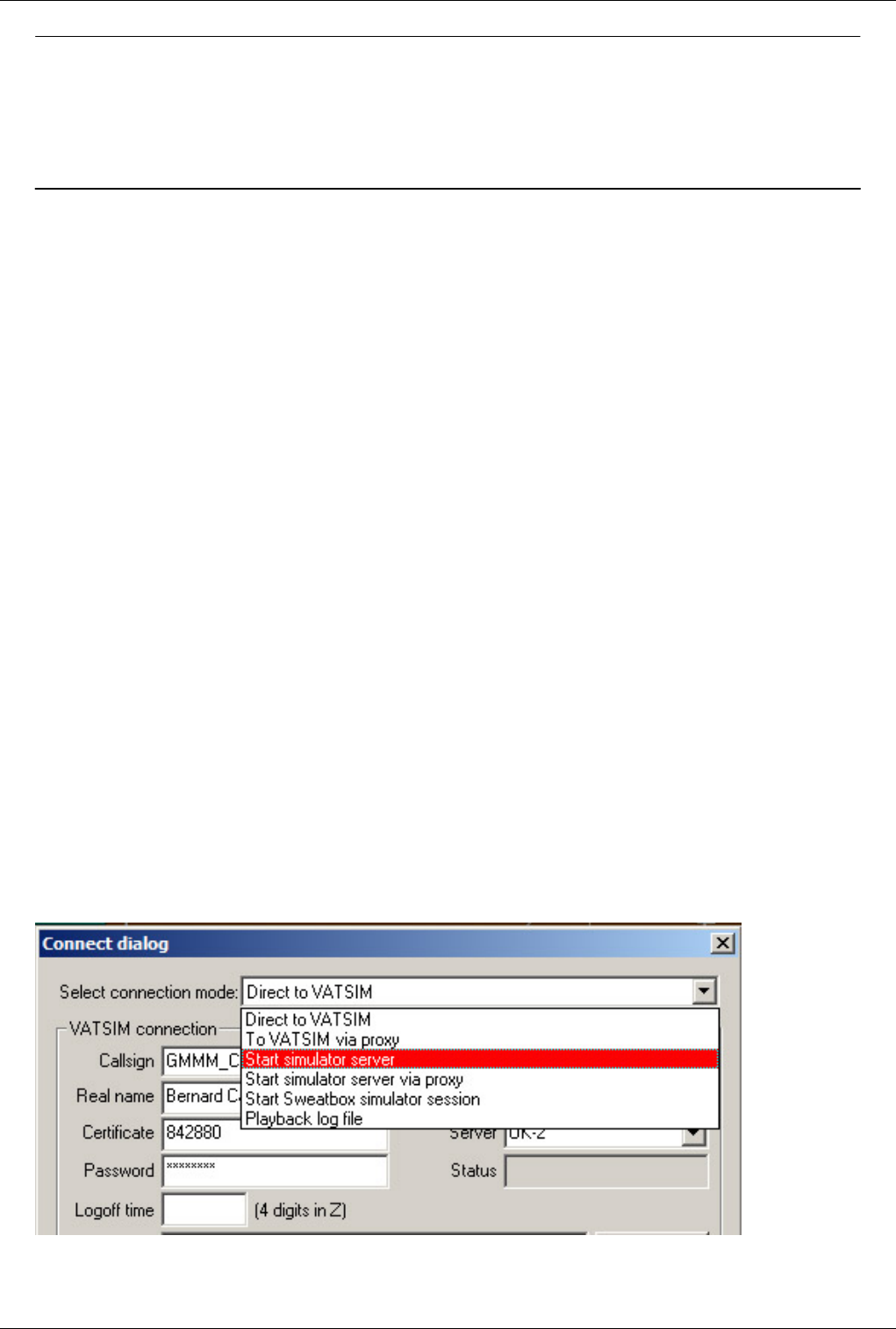
Euroscope:Built In Functions 142
Previous: Euroscope:Command Line Reference Actual: Euroscope:Built In Functions Next: Euroscope:Built In Simulator
Euroscope:Built In Simulator
Previous: Euroscope:Built In Functions Actual: Euroscope:Built In Simulator Next: Euroscope:Tower View
The Built In Simulator
EuroScope has a never seen before special feature, the built in ATC simulator, for the purpose of practice and
training. Here you don't need any connection for the VATSIM nor other servers, just sit down and take the control
over the traffic.
Also for the ATC training, from now it is much more easier to set up a traffic and see how the candidate can deal
with it. Prepare you EuroScope for a simulator session, share your IP with the student to let him be connected, and
do the training. So simple.
You can use the built-in simulator in two different ways:
• Trainer-candidate mode
• Self-training mode
Starting A Simulation Session
It does not matter what kind of session you are going to have you have to start the simulation session in the same
way. First of all, you have to set the connection mode as /Start simulator server/. In this mode, your computer going
to simulate a VATSIM server for you candidate or for yourself, and this server can be accessed by the method
described below.
Notice! If you would like to use VATSIM voice servers during your simulation session you must authenticate
yourself against the network. To do that you should first login to VATSIM (/Direct to VATSIM/ mode). In this way
your identity will be checked and you will be able to connect to any VATSIM voice server. We suggest to set up you
voice connection for a non-used channel, like: practice_lhbp . Then disconnect and start your simulator session.
When you disconnect your voice channel connection will remain for 30 seconds then disconnects. But if during this
period you start your simulator the voice channel connection will not be disconnected.
Then you have to set the scenario, you want to use for this session:
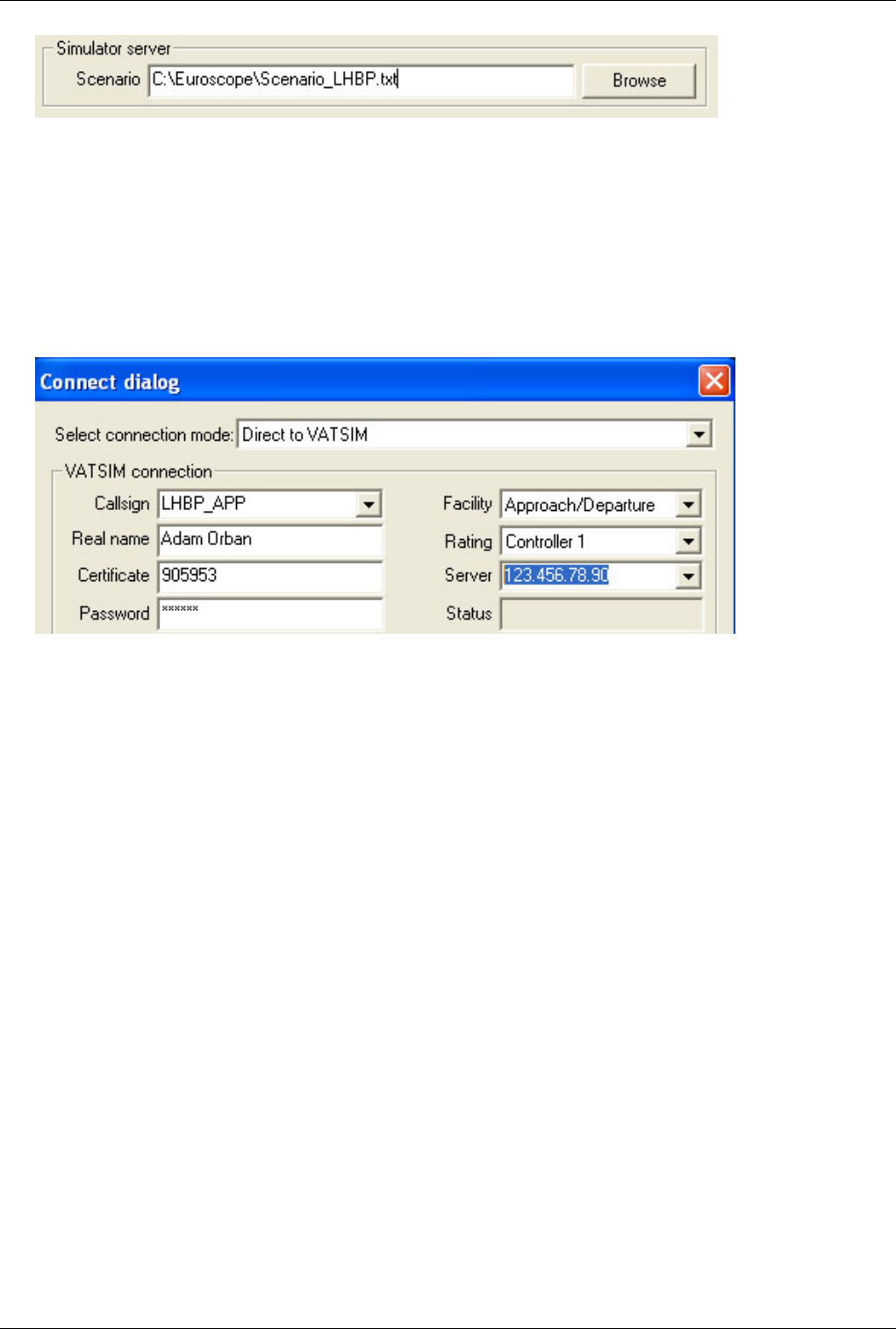
Euroscope:Built In Simulator 143
The scenario file contains the traffic for the simulation. The structure of the file is described in the
Euroscope:Scenario File page. Just hit Connect to start the server.
Notice! To allow the trainee to connect to your server you must open port 6809 for external access. If you are behind
a router you even have to forward this port to your computer.
The Trainer-Candidate Mode
'Candidate setup: Set up your connection just like the normal way to join to the VATSIM, but type your trainers IP
address as the server. /(You can also collect IP addresses and write down to the ipaddr.txt to have them in the list.)/
Hit Connect, set up you voice connection for a non-used channel, like: pracite_lhbp. Also be sure to setup your
primary frequency and connect to the voice channel. Be sure that the frequency of the voice channel is the same like
the corresponding ATC facility, you are going to practice. If you forgot to set it up, you could not use the features of
the EuroScope, connected to this setting.
The Self-training Mode
There is not too much to setup for a self-training mode. As in this case you are alone, you do not need ad voice
server connection. But to identify the station you are controlling select the appropriate voice description and set your
primary frequency. In this case the name of the voice communication will be used as your callsing. Therefore if you
would like to use all the features of EuroScope, select the right primary frequency.
The Traffic Control Panel
When you start the simulator session the main control panel pops up. The simulator is running as far as this dialog is
opened. When you close it, the session is over.
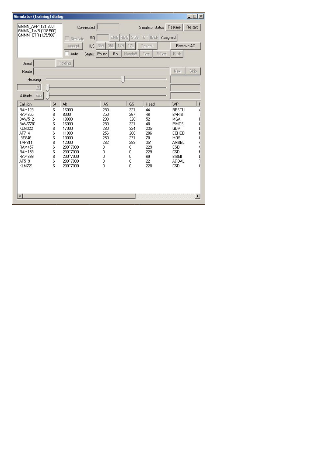
Euroscope:Built In Simulator 144
In the bottom area you can see the list of the aircraft currently simulating. Most of the controls (but surely not all)
displays or acts on the currently selected aircraft. They all become disabled if no aircraft is selected in the list below.
When you select a TAG in the radar screen it is also selected in the simulator dialog. In this way you can follow the
actions on the radar screen and just click sometimes in the controls. This feature makes the self-training mode
possible. In this way if you do not have a secondary monitor for the traffic control panel you can move out the whole
list from the screen and use the radar to select the aircraft.
There is a new feature from version 2.8m, the pilot delay. In this way the simulated pilots will not follow your
instructions immediately as you hit any of the control buttons, but will wait for a configurable random amount of
time. That makes the simulation much more real. You can tune the individual pilots how quickly they respond to an
order. On the dialog the new requests are shown immediately but in the plane status you can check if the pilot is
already following it or not.
Let us see all controls one by one (without grouping just from top to the bottom and from left to the right):
•SQ edit (it needs a selected AC) - The actual squawk of the aircraft. Simple type another value here and it will be
changed.
•EMG, RDO buttons (they need a selected AC) - These buttons are for fast squawk change. Press EMG to set the
squawk to 7700 and RDO to have 7600.
•StBy, "C", "IDEN" buttons (they need a selected AC) - Press them to change squawk to stand-by or to "C"
mode or to make aircraft identing.
•ILS buttons (they need a selected AC) - These buttons are forcing the aircraft to approach to the selected runway.
The number of runways can be used is limited to four. In this picture you can see the default LHBP configuration.
Here are two parallel runways and both directions can be used in one session. But if you have more runways to be
simulated or more airports then you are limited to four runways in one session.
For the simulation only ILS approach is implemented but of course you can communicate with the trainee any
kind of approach. It drives the airplane only. Yo can press the button anytime but if the aircraft is not in the
right position it will not be accepted. Right position means: distance is between 3 and 30 NM, heading in +-30

Euroscope:Built In Simulator 145
degrees to the runway heading and must be below a 3 degree glide slope.
•Resume/Pause button - It is a general button to stop and continue the simulation. When you press the Resume
button it starts simulating and changes the button title to *Pause*. When you press the /Pause/ button the
simulation stops and the button changes to Resume.
•Direct edit (it needs a selected AC) - This edit box contains the name of the fix the aircraft if proceeding to. You
can simply edit and write any point name from the sectorfile to drive the plane toward that point.
•Holding button (it needs a selected AC) - Pressing this button the you can drive the aircraft following the holding
pattern or leaving it. The available holding patterns can be defined in the _Scenario_File_ page. To enter an
aircraft to a holding pattern it should proceed to the main point of the pattern. Actually the point name should be
in the Direct edit box. When the aircraft is in the holding pattern you can press the /Holding/ button again to leave
it. In this case it gets back the next point from the route section and starts a direct to that point.
The holding pattern simulation is not the best at all. You can expect some non-standard movement. When
entering to the holding pattern the aircraft always proceeds direct to the main point. When the aircraft passes
the point start turning to the direction defined for the pattern (does not matter which direction the aircraft
came). It turns until reaches 60 degrees angle to outbound leg of the pattern. Then smoothly joins to the
outbound leg. When it reaches the end of the outbound leg it repeats the same for the main point. To be honest
the first turn can be very strange, after that the pattern is followed not too badly.
•Status string (it needs a selected AC) - It contains a readable description how the aircraft movement is
simulating. It is really self explanatory.
•Restart button - Just press it to restart the whole scenario.
•Route edit (it needs a selected AC) - This editor contains the waypoints the aircraft will follow. You can edit it
manually if the trainee orders a shortcut or defines a whole new route. When the aircraft reaches the next
waypoint it selects the next from the route and the point is removed from the route.
•Next button (it needs a selected AC) - Press this button if you would like to move the aircraft to the waypoint
next to the actual. Surely you can press several times if the desired point is later in the route.
•Skip button (it needs a selected AC) - This button deletes the next waypoint from the route string. It does not
change the actual course but makes a shortcut after it.
•Pause button (after the Ac status) (it needs a selected AC) - By pressing this button you can pause the movement
of an individual aircraft.
•Go button (it needs a selected AC) - By pressing this button you can start a paused aircraft.
•Handoff button (it needs a selected AC) - This button initiates a handoff to the trainee. To use the aircraft should
be tracked by one of the simulated controllers.
•Taxi button (it needs a selected AC) - The taxi button is a general purpose ground movement simulation. You
can use it to simulate taxi, pushback and line up instructions. When you press the button you will have a rubber
line following your mouse from the current aircraft position. Press the left mouse any number of times to define
all the points to follow on the ground. When you are ready press the right button. The aircraft will start taxiing
immediately.
•Fast taxi (it needs a selected AC) - Sometimes we need the aircraft to go on the ground a little bit faster then the
programmed taxi speeds (e.g. when it is still on the runway and you need it to vacate). In fast taxi mode it moves
much faster.
•Push button (it needs a selected AC) - Same as Taxi, but the aircraft pushes back according the rubber line
defined by the user.
•Takeoff buttons (it needs a selected AC) - Here you have the four runway buttons again. These buttons are for
the same runways as the ILS buttons. You can press one of the buttons to initiate a takeoff. There are some
requirements to be able to let an aircraft depart. The distance to the threshold defined must be less than 0.5 NM
and it must be in front of the aircraft. The angle difference between the aircraft-threshold line and the runway
heading must be within +-5 degrees.

Euroscope:Built In Simulator 146
•Remove AC button (it needs a selected AC) - This button deletes the selected aircraft from the simulation.
•Heading slider and display (it needs a selected AC) - Using this slider you can turn the aircraft to the left or to
the right. When the aircraft heading is the one that is desired the slider will always be in the middle. So this slider
is never absolute but always relative. Move it to the right to force the aircraft turning right and left for left. A click
to the right or left side makes a 5 degree turn request while you can move to any heading with dragging the slider.
When you have the aircraft list selected the #F1# directs a 5 degrees left, the F2 a 5 degrees right turn.
Right to the slider there is a read only edit box. It contains the actual and the requested heading. Between them
a > or < indicating the turn direction.
•IAS combo, slider and display (it needs a selected AC) - Using this slider you can change the speed of the
aircraft. Every aircraft has a built in logic what IAS it will use. The speed is directly connected to the altitude but
a +-20 KTS is added randomly. The /IAS combo/ defines how the speed will be assigned to the aircraft:
•IAS free - It means that the aircraft will define its speed as described above.
•IAS = - In this case the speed will be exactly the one defined by the slider.
•IAS >= - The same as above but it leaves the speed only when the free speed is higher.
The slider work the same way as heading. But here the position of the button is absolute. You can vary the
speed between 120 and 320 KTS. A click to the slider makes a 10 KTS change. You also can use the F3 and
F4 buttons to change the speed. After the slider you can see the actual and the desired speed. Between them a ^
and v indicates accelerating or slowing.
•Altitude slider and display (it needs a selected AC) - Using this slider you can drive the requested altitude of the
aircraft. Remember that we do not simulate air pressure. All the simulation works as there were standard pressure
all the way. Therefore all altitude values can be defined in feet. The slider itself works the very same way as
heading slider, but it is once again a fixed position slider that works between 0 and 41000 feet. A click to the
slider makes a 500 feet change. You also can use the F5 and F6 buttons to change the altitude. After the slider
you can see the actual and the desired altitude value. Between them a ^ and v signs indicate if the aircraft is
climbing or descending.
All aircraft will follow a predefined standard descend or climb rate. If you need a higher than that then press
the Exp button to expedite. When expediting the button changes to Norm to restore the normal rate. When
descending in expedite mode then the IAS will not be reduced.
•Simulated controllers - EuroScope can simulate any number of controllers as long as they are defined in the
scenario file. They appear in the top left window with callsign and frequency. To activate one controller just
select him in the list and check the simulate checkbox.
•Accept - Use this button to start tracking an aircraft by the simulated controller. You can track untracked aircraft
or accept handoff from the trainee.
•Auto check-box - This check box adds some extra automatic function. They are handy when you are making a
self-training mode. The following actions are automatic when the box is checked:
• When an AC has been landed it turns the transponder to stand-by and removes itself from the list.
• 3 minutes into the sector then a handoff is initiated automatically.
• When a departing aircraft shows itself for the simulation it is assigned to the second controller starts the
takeoff roll and initiates a handoff.
• When an arriving aircraft shows itself for the simulation it is assigned to the first controller.
•Aircraft list - Here in this list you can see nearly all the information about the all the aircraft. Most of the
columns are really self explanatory. Probably the second column St needs some comment. It shows the aircraft
status weather it is P paused or S simulated.
For a faster selection the list contains a hidden first column. Here only the numbers from the callsign is stored. The
list box can search for its first column data when you type letters or numbers. In the picture above if the list box is on
focus and you type 2254 the SWR2254 will be selected. After that you can use the buttons F1 and F6 for fast drive.
Euroscope:Built In Simulator 147
The Simulator Control Bar
During training it might be necessary to view the complete screen without having the Traffic Control Panel open
over the radar. To keep your view clear, you can minimize the panel to the top of the screen.
Not all, but nearly all functions are available here. Let us see the meaning of the buttons:
• - It shows the status of the selected plane.
• - The next waypoint along the route. You can click here to enter a new point as direct.
• - It sends the plane to a holding pattern over the next waypoint. The holding must be declared in the scenario
file.
• - It is the list of the next waypoints. Click here to edit the route inplace.
• - Jump to the next waypoint.
• - Skip next waypoint.
• - The SQ value sent by the plane. Click here to edit the value inplace or use the next buttons.
• - Squawk emergency.
• - Squawk radio failure.
• - Squawk the right, the controller assigned value.
• - Squawk stand-by.
• - Squawk "C" mode.
• - Squawk ident.
• - Cleared for approach for the selected runway.
• - Cleared for takeoff from the closest runway.
• - This area is an indicator and a button too. The icons indicate if the plane is climbing or
descending or does not change its level. It also indicates fast climb and fast descend. Clicking on the are will
change the fast to non fast and vice verse.
• - It is once again and indicator too. It shows the actual speed restriction. Clicking on the are will
change the restriction type in a loop.
• Free - the simulator decides the best speed
• Exact - the plane will follow the speed set by the trainer
• Less than - the plane will be slower then the set speed as far as the normal is above that but may reduce the
speed later
• More than - the plane will be faster then the set speed as far as the normal is below that but may increase the
speed later
• - It starts/stops the actually selected plane.
• - Handoff to the trainee.
• - Accept handoff from the trainee.
• - Start taxiing the plane.
• - Force a fast taxiing.
• - Start a pushback.
• - Delete the plane completely from simulation.
• - It starts/stops the simulation in general.
• - It closes the toolbar and reopens the original simulator dialog.

Euroscope:Built In Simulator 148
The Sweatbox Simulator Session
Instead of opening a local training session, you can also connect to sweatbox to host a training on the sweatbox
server. Have the trainee(s) connect to sweatbox as they would connect directly to VATSIM to perform training on
sweatbox.
• Like in the client mode any number of planes and controllers can be simulated. Your main connection as CTR is
independent from the trainee connection. You do not have to simulate the main CTR.
• Ongoing coordination works in the simulated environment. You can request any COPX coordination by the name
of the owner controller. You can initiate a COPN request by the name of the main controller only. You can accept
any incoming coordination. Do not try to coordinate between your main and one of the simulated CTR.
• Due to the SweatBox server the number of the trainees and the number of the simulator drivers are not limited.
All the normal operations between them are allowed.
• It is possible to hand over the simulation of individual aircrafts to another controller. As it is not possible to
disconnect the simulated plane from the server, the driver who started the plane will keep the connection to the
server and respond for several queries. The new driver sends only the position updates to the old using private
messages. The simulation can be passed back to the original driver. To pass a simulation press the F6 to see the
FP in the bottom and use a right click. Only the simulator driver callsigns will be available in the popup list. The
simulator drivers are marked with a * in the controller list. There is no accept/refuse protocol, the transfer is
immediate. The simulation transferred to you is indicated by drawing its route on the screen.
• You can also use your own FSD server. There might be problems using VRC with it.
Previous: Euroscope:Built In Functions Actual: Euroscope:Built In Simulator Next: Euroscope:Tower View
Euroscope:Tower View
Previous: Euroscope:Built In Simulator Actual: Euroscope:Tower View Next: Euroscope:Appendices
The Tower View
The tower view feature is inspired by the similar possibility of VRC by Ross Carlson. But actually the
implementation is totally different in EuroScope. Due to the built in simulator there is already a small FSD server
inside EuroScope. This server can be also used to be connected by an FSD pilot client like SB3 or FSInn. Using this
idea the tower view implemented in EuroScope is based on the FSD protocol rather than an FS multiplayer connect.
After some test and support request we decided to us FSInn (FSInn main website is no more available, but you may
find alternative ways to download it) as the FSD client for EuroScope tower view. There are some reasons why
FSInn was selected and SB3 is dropped:
• FSInn can be used in other networks not only on VATSIM. Because of that it did not need any kind of
modifications to connect to the built-in FSD server. On the other hand SB2 tests if the server has a valid VATSIM
ID and do not connect to other places (nor to EuroScope).
• When I asked for technical assistance for the feature Benjamin Fells immediately responded to me and advised
my all the information I needed. Unfortunately I have not receive even a negative answer from the SB3 team if
we can work together.
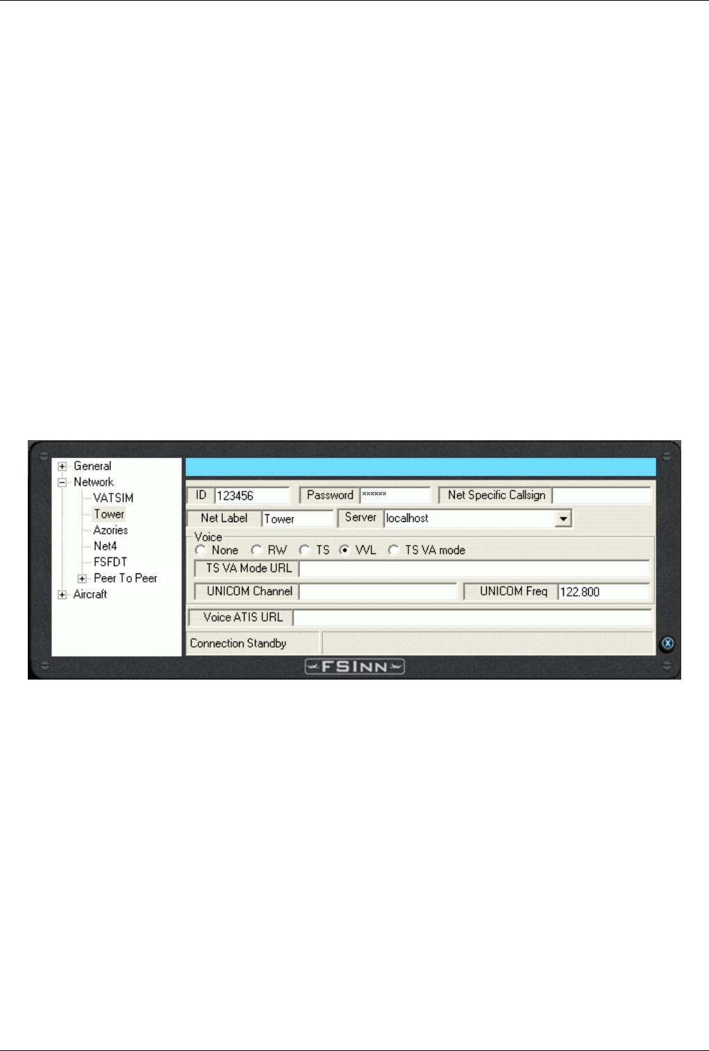
Euroscope:Tower View 149
Prepare EuroScope For Tower View
The only thing you should do before establishing a connection with FSInn, is to check if the ES's proxy is on (you
can select the option to be started automatically from the button Quick Set -> Enable advanced proxy communication
an on ES exit save that option). It automatically asks for the plane information that is necessary for the correct
display. It is asked even if no tower view is started. All this information is also sent to the LOG files. It makes it
possible to enable the tower view feature on online sessions and on playback sessions too.
In this way you really do not have to do anything. Just connect to VATSIM for an online session or start a playback
session. In both cases EuroScope automatically starts the built in FSD server and waits for an incoming connection
from FSInn. When the connection is established all plane information is sent to the FS client.
Prepare FSInn Fro Tower View
Be sure to download and install the following products from MDCU:
• FSCopilot 1.6 (FSInn main website is no more available, but you may find alternative ways to download it),
• FSInn 1.2 (FSInn main website is no more available, but you may find alternative ways to download it),
• The appropriate VIP package for you FS.
In Flight Simulator start the Copilot/Inn Control Panel menu. Click on the SET button, and navigate to the Network
settings. There are 5 slots (first is VATSIM but 4 are empty) that can be configured. Select a free one from there and
fill in the fields:
The ID and the Password fields here are not important, as you are already connected to VATSIM with EuroScope.
We suggest to use a name something like "Tower" or "Tower View". The only really important is to select the
server. If you are running FS on the same machine where EuroScope has been started just specify "localhost" here.
But you are free to start the tower view client on another computer in your local network. The rest of the fields are
once again not important.
When ready and EuroScope session is running (online or playback) just click on the newly named server and enjoy
the view.
Notes:
• If you disconnect from your EuroScope session the FSD server is also stopped. You need to reconnect after the
new session is started.
• You should not use PAUSE or SLEW mode in FS as in these cases the display of the moving aircrafts are really
jerky.
•Tower View is DISABLED in simulation sessions.

Euroscope:Tower View 150
Previous: Euroscope:Built In Simulator Actual: Euroscope:Tower View Next: Euroscope:Appendices
Euroscope:Appendices
Previous: Euroscope:Tower View Actual: Euroscope:Appendices Next: Euroscope:ESE Files Description
Sectorfile Modification
EuroScope uses the very same sectorfile as ASRC or VRC. If you have one just open it and use. All the extended
description of your sector all additions are put to the ESE file (see below). Only one little information was missing
from the original sectorfile that was not worth putting into the extension file. That is the airport code of the runway
items in the [RUNWAY] section.
The original line looks like this:
[RUNWAY]
13L 31R 130 310 N047.26.43.520 E019.15.27.180 N047.25.22.620 E019.17.37.880
But to be able to put the runway names into the hierarchy we needed the name of the airport to be defined too.
Therefore it is put to the end of the line like this:
[RUNWAY]
13L 31R 130 310 N047.26.43.520 E019.15.27.180 N047.25.22.620 E019.17.37.880 LHBP Ferihegy
That can be a free text not necessarily the airport code. This string will be used in the Euroscope:Display Settings
dialog and also it will collect the runways of the /same name/ airport into one subtree. As we tested this extension
will not cause any harm for ASRC and VRC users.
ESE File Description
What is the EuroScope Sector file Extension. Look after it in the Euroscope:ESE Files Description section.
Scenario File
The Euroscope:Scenario File section belongs to the Built in simulator.
Previous: Euroscope:Tower View Actual: Euroscope:Appendices Next: Euroscope:ESE Files Description

Euroscope:ESE Files Description 151
Euroscope:ESE Files Description
Previous: Euroscope:Appendices Actual: Euroscope:ESE Files Description Next: Euroscope:Scenario File
ESE SDK Documentation
The standard sector file and position file does not provide enough functionality so a new format has been developed,
called ESE. This file includes information about controller positions, callsings and frequencies in the POSITIONS
section, standard departure and arrival routing in the SIDSTAR S section, additional static map elements such as
FREETEXT and AIRSPACE section with the sector definition and auxiliary boundary information. This file is in
addition to other resource configuration files. This file may be edited and created with any text editor and saved as a
standard text file. It must then be renamed to the file name of the sector file plus the “.ese” extension. And it also
must be placed in the same folder where your “.sct” file is as in EuroScope you can load the “.sct” file only and the
“.ese” will be loaded automatically.
Freetext Section
This section provides additional map drawing elements. It provides the ability to display any ASCII character on the
radar video map. The freetext section must be prefixed by this line: “[FREETEXT]” (without the quote marks).
Freetext definition lines have the following format:
<latitude>:<Longitude>:[<group name>:]<characters>
The separator between each element is the “:” character. The coordinates of latitude and longitude are prefixed by the
letter of the hemisphere and then the geographical coordinate. The format for the coordinate may be either the
decimal format (eg. N013.32861) or in the degrees.minutes .seconds.decimals format (eg. N013.19.43.327). You can
group the free texts using the group name. If you omit the group name then a *Default group* will be used. The
character section may use any number of ASCII characters except carriage return. A finished line may look like this:
N044.34.6.524:E026.06.27.632:LROP texts:TORA-D/26L 2490m
A finished freetext section may look like this:
[FREETEXT]
N044.34.37.952:E026.05.53.935:LROP taxiways:W
N044.34.34.336:E026.05.28.289:LROP taxiways:O
N044.34.6.524:E026.06.27.632:LROP texts:TORA-D/26L 2490m
Terminal Routing Section
This section contains the routing for the standard terminal procedures such as SID and STAR. It also contains the
rules for assignment of those procedures by runways in use and the route end point/route start point. This section
must start with the following line: “[SIDSSTARS]” (without quotes). The format of a routing line is:
<type of route (SID/STAR)>:<airport of destination/departure condition>:<runway related to that route>:<routing name>:<route points>
The lines priority is from top to bottom. The topmost line has most priority. The first line that completes all
conditions will be chosen as the correct routing. The type of route can be SID or STAR and declares whether the
next condition, airport, should be the departure or the arrival airport for that aircraft. The airport is declared as the
full ICAO code for that airport. The next condition is the runway in use. Declare a new line for each runway that
uses that respective routing. The name will be the name of the SID/STAR with the discrete identifier. The route will

Euroscope:ESE Files Description 152
be declared by any FIX, VOR or NDB that makes part of the routing with spaces between each route element. An
example of a routing, below:
[SIDSSTARS]
STAR:LROP:08R:TUSET2E:TUSET BAREM MADIT OBELA OPW
STAR:LROP:08L:TUSET2E:TUSET AMETI ABATU DILAS OTL
STAR:LROP:26L:TUSET3F:TUSET FLR AMODA LEVTA OPE
STAR:LROP:26R:TUSET3F:TUSET FLR AMODA RARIT OTR
STAR:LROP:08R:VALPA1E:VALPA FLR OBELA OPW
STAR:LROP:08L:VALPA1E:VALPA FLR DILAS OTL
STAR:LROP:26L:VALPA2F:VALPA FLR AMODA LEVTA OPE
STAR:LROP:26R:VALPA2F:VALPA FLR AMODA RARIT OTR
SID:LROP:08R:VALPA1A:OPE BSE BSW MEGIK VALPA
SID:LROP:08L:VALPA1A:OTR BSE BSW MEGIK VALPA
SID:LROP:26L:VALPA1C:OPW FLR VALPA
SID:LROP:26R:VALPA1C:OTL FLR VALPA
SID:LROP:08R:NILOV1A:STJ NILOV
SID:LROP:08L:NILOV1A:STJ NILOV
SID:LROP:26L:NILOV1C:OPW NILOV
SID:LROP:26R:NILOV1C:OTL NILOV
The Positions Section
This section contains information about all recognized controller positions. It is used to recognize what controller is
what position using information from the callsign and the frequency. This is a slightly modified POF file used before
in ASRC and VRC. Users may simply copy that file and modify it accordingly. The format of the Position line is the
following:
<name of position>:<radio callsign>:<frequency>:<identifier>:<middle letter>:<prefix>:<suffix>:<not used>:<not used>:
<A code start of range>:<A code end of range>[:<VIS center1 latitude>:<VIS center1 longitude>[: ... ]]
The name of the position can be anything used to help in identifying the line inside the ESE file. Radio callsign shall
be the official radiotelephony callsign that shall be used for that station. Frequency shall be in full with “.” as decimal
separator. The identifier is used in many places in the software and may be as short as one character and as long as
required. It is recommended to use a standard length. In ASRC/VRC and FAA systems the length of that ID is 2
characters. Prefix and suffix are the first and last parts of the callsign used to identify the position. A code ranges are
used to preset the assignment A code ranges from which the system will assign the codes for a specific position.
Optionally there can be some visibility centers defined for the position. One center can be defined by two
parameters: latitude and longitude. There can be maximum 4 visibility centers defined (that is altogether 8 optional
elements in the line)
Some examples of a finished Position section below:
[POSITIONS]
ARGES_TOP:Bucharest Radar:121.170:AST:A:LRBB:CTR:-:-:5401:5477
ARGES_MID:Bucharest Radar:124.250:ASM:1:LRBB:CTR:-:-:5401:5477
NERDI_TOP:Bucharest Radar:122.020:NIT:N:LRBB:CTR:-:-:5401:5477

Euroscope:ESE Files Description 153
NERDI_MID:Bucharest Radar:125.150:NIM:4:LRBB:CTR:-:-:5401:5477
BUCHAREST_TMA:Bucharest Approach:118.250:TMA:-:LROP:APP:-:-:5401:5477
OTOPENI_S_CTR:Otopeni Tower:120.900:TOI:S:LROP:TWR:-:-:5401:5477
LHCC:Budapest Radar:133.200:BUD:-:LHCC:CTR:-:-::
LYBA:Beograd Radar:123.770:BEG:-:LYBA:CTR:-:-::
EUE:Eurocontrol East:135.300:EE:C:EURE:FSS:EURE:FSS:0200:0277:N050.54.1.002:E019.49.42.216:N042.40.42.169:E022.28.7.307
The Airspace Section
The airspace section is the section containing information about the sectors in the delegated area and auxiliary
boundary information. To understand the Airspace section one has to understand the functions of EuroScope well. It
has a first section prefix with SECTORLINE which defines actual broken line that is common for only two lateral
sectors. Then the sector is built by two or more of these lines and then additional boundary information is added such
as COP (Coordination Points).
Please also take a look to the Euroscope:Tutorial section that describes some steps how to define the sectors.
The Sectorline Subsection
Each sectorline piece is usually comprised of three sections. The first line/section is prefixed with SECTORLINE
then ‘:’ separator and the name of that respective sectorline.
SECTORLINE:MOPUG_LHCC
Then the declaration of that respective sectorline continues with an optional section prefixed with DISPLAY. It is
used to declare when that respective border will be highlighted. More exactly, what sectors must be covered
discretely by different controllers for that line to be highlighted.
DISPLAY:MGT:MGT:BUD
The prefix is DISPLAY with the ‘:’ separator. The next item is the sector you are covering. In this case, for this line
to be taken in account you must be covering MGT sector. NOTE: this sector is not from the POSITIONS section but
from the SECTOR section which will be described next. So it does not have to be your sole sector, and it does not
refer to your callsign. The next two items are the two SECTORs that are compared to have different owners for this
line to be highlighted. In this example the sectors MGT and BUD must be covered by a different controller and you
must be controlling sector MGT. NOTE: the compared sectors do not have to match the sector you are covering.
They usually do, but you can also display lines for nearby sector if you need them for reference.
Then the actual line must be declared using coordinates. Each coordinate point must be declared with the “COORD”
prefix then followed by the LATITUDE and then the LONGITUDE.
COORD:N047.59.23.032:E023.30.49.151
A new COORD line will be made for each point making up the respective SECTORLINE. Make sure the end point
of the SECTORLINE is common with the start point of the next SECTORLINE.
There is an easy way to create circle sectors without defining so many coordates that form a circle on the screen. Just
use the CIRCLE_SECTORLINE definition. Using that you can make a circular sector around any object (FIX, VOR,
airport), or a coordinate defined in the line. In the first version it needs three parameters: sector line name, center
point name, radius. In the second version it needs four parameters: sector line name, latitude, longitude, radius.
CIRCLE_SECTORLINE:LHBP_APP:LHBP:30
CIRCLE_SECTORLINE:LHBP_APP:N047.25.2.968:E019.21.31.221:30
Tips: A SECTORLINE is a border line which is common with only two lateral sectors.

Euroscope:ESE Files Description 154
SECTORLINE:BUDOP_LHCC
DISPLAY:BPT:BPT:BUD
DISPLAY:BPM:BPM:BUD
COORD:N046.37.12.101:E021.19.19.610
COORD:N047.29.04.510:E022.00.35.050
COORD:N047.57.13.950:E022.53.46.100
Translated this means: the SECTORLINE has been assigned a name of BUDOP_LHCC. It will be highlighted when
condition [you are controlling BPT AND BPT and BUD sectors are controlled by different controllers] or [you are
controlling BPM AND BPM and BUD sectors are controlled by different controllers]. The sector line is created by
two segments, created by 3 coordinates/points.
You have the possibility to define the sectorline display away from the sectorline definition. We found that
sometimes it is far easier to define this when defining the sectors. So whenever you need just add a
DISPLAY_SECTORLINE entry (after the sectorline definition). Its syntax is the same as DISPLAY except that you
have to define the sectorline name at the beginning.
DISPLAY_SECTORLINE:BUDOP_LHCC:BPM:BPM:BUD
The Sector Subsection
This is the subsection where you define the limits of a sector and controller assignments priorities.
SECTOR:MGT:34500:66000
OWNER:MGT:BPT:NIT:EUE
ALTOWNER:When no BPT:MGT:NIT:EUE
BORDER:MOPUG_LYBA:LOMOS_MOPUG:MOPUG_NERDI:BUDOP_MOPUG:MOPUG_LHCC
In the first line you declare the sector name and the vertical limits. Prefixed by SECTOR followed by the ‘:’ separator
then the assigned Sector Name (MGT) then followed by the lower altitude limit in feet (34500) then the upper
altitude limit in feet (66000). The next line is prefixed by OWNER and defines which controller will be recognized
ad controlling that respective sector and their priority. After the ‘:’ separator will follow a list of position identifiers
from the Positions section. The first has most priority and the last, the least priority. For example if MGT position is
identified as online by the Positions table, the MGT sector will be assigned to it. If not it will move on to the next
position, verify it and if it is open the sector will be assigned to the BPT sector. This line also defines which sector
you will be controlling when you are online as a specific position. The alternate owner line (ALTOWNER) makes it
possible to define an alternate setting of the sector ownership. The alternate rules can be selected at the
Euroscope:Sector_Ownership_Setup. Its syntax is the same as the OWNER line with an additional name after the
ALTOWNER tag. Next follows the Border sector in which you define which borderlines make up the sector. Make
sure a borderline and the next borderline have the end/start points common so it will be able to create a continuous
border. Also make sure that it is a closed border, that is, that the last line ends at the start point of the first line.
The order of the sectors in the file is extremely important. EuroScope will check if an airplane is inside a sector in
the order defined in the file. Therefore the first match will be used and the rest is not tested at all. You can use this
behavior and create overlapping sectors. But be sure that the smaller is earlier in the list.
ACTIVE:LROP:08R
All sectors are active by default and are used in your session. However you may define sectors that are not always
used but just in some runway configuration. After the ACTIVE keyword you should define the airport and runway
configuration. The sector will then be used only if the specified runway at the specified airport is active for arrival or
departure. An example is the Traffic Director in Hungary. He has the role to move the planes from downwind to the

Euroscope:ESE Files Description 155
final and is used only on real busy events. Because of its role he controls at the arrival end of the active runway. But
as the runways have two ends we defined two Traffic Director sectors, but only one of them should be used in one
session.
GUEST:APP:LROP:LROP
The GUEST line is a formal way to handle exceptions to the general roles. After the keyword you should define a
position a departure airport (or a * for all airports) and a destination airport (or a * for all airports). When an aircraft
is flying in this sector and its current owner is the controller defined in this line and the departure and the destination
airport match the flight plan then the sector owner will be the current controller. This may be a special solution to a
normal situation over Slovak airspace. Normally this area is controlled by Prague, but the arrivals from Austria is
passed to Budapest Radar even the route crosses this sector for a while and never enters to the sector of Budapest
Radar, but goes directly to the Approach. So the Bratislava sector has a guest controller, Budapest Radar. And all
arrival traffic to LHBP will accept it and EuroScope will not show the frequency of Prague indicating a necessary
handoff.
DEPAPT:LHBP:LHDC:LHNY
ARRAPT:LHBP:LHDC:LHNY
The DEPAPT and the ARRAPT can be used to activate airports for departure and for arrival depending on what
sectors belong to you. If there are airports defined for the sectors whenever you controlling sectors are changed the
active airports data is updated. And as a side effect the your METAR list might be changed also as they depend on
the active airports.
The Coordination Point Subsection
This section defines the COP (COordination Points) used for coordination with adjacent sectors and ACCs. Here you
can also add LOA (Letter of Agreement) details and EuroScope will show you’re the appropriate action based on the
LOA for each radar track.
COPX:DEP APT or FIX BEFORE:DEP RWY:FIX:ARR APT or FIX AFTER:ARR RWY:FROM SECTOR:TO SECTOR2:CLIMB TO XFL:DESCEND TO XFL:XNAME
FIR_COPX:*:*:BUDOP:LHBP:*:BPM:BUD:*:28000:BUDOP
FIR_COPX:*:*:NARKA:*:*:BPT:BUD:*:*:NARKA
FIR_COPX:*:*:NARKA:*:*:BUD:BPT:*:*:NARKA
COPX:*:*:NEPOT:*:*:BPT:NIT:*:*:NEPOT
COPX:*:*:NEPOT:*:*:NIT:BPT:*:*:NEPOT
Each line defines a different set of conditions for a LOA point to be recognized. The first section defines the time of
the COP you are declaring: a sector COP or a FIR COP. Use either the FIR_COPX or the COPX prefix. Next
follows a previous point/departure airport rule. You can put in there any preceding point you want to use to filter out
that COP line. Next is a departure runway rule. Next is the fix it applies on rule. Next is the next point or arrival
airport rule. Then is the arrival runway rule. For any rules you want to bypass replace it with the ‘*’ character. After
the routing rules comes a display rule: the preceding sector and the succeeding sector. If these two sectors are
controlled by the same controller then the COP code line will be bypassed. Next are the LOA instructions, either
descend to, or climb to altitude in feet. Lastly the name of the COP is declared as you want it to be shown, usually
the name of the COP. The COP lines have a priority from top to bottom. So the topmost line that verifies all rules
will be chosen even if lower is a more suitable line which should be chosen. Therefore place the lines with most
rules at the top and the lines with least rules at the bottom.
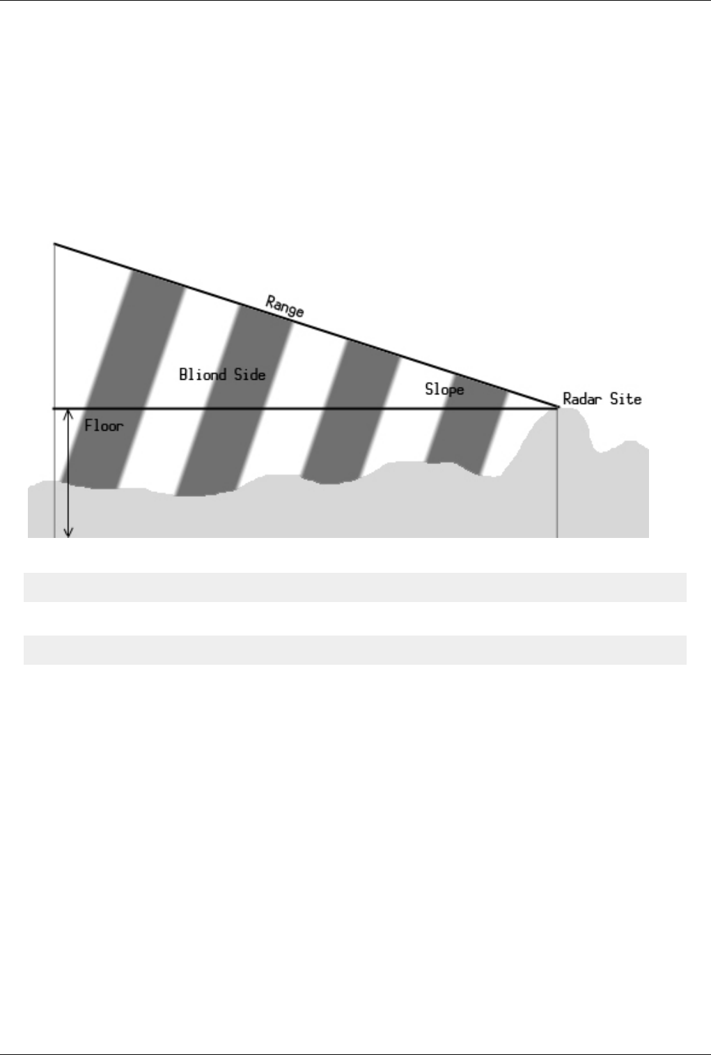
Euroscope:ESE Files Description 156
The Radar Subsection
This new subsection defines the radar coverage and radar outage areas used in Professional Mode by defining radar
stations and radar holes.
You need to define the stack by adding
[RADAR]
and then to define your radar stations
RADAR:<name>:<latitude>:<longitude>:<P range>:<P floor>:<P slope>:<S range>:<S floor>:<S slope><C range>:<C floor>:<C slope>
• Name: A user readable name of the station.
• Latitude and longitude: The position of the radar station.
• P range: The primary radar range.
• P floor: The minimal altitude of the radar positions. No plane below that will be seen as primary target.
• P slope: This a linear slope that levels the visibility floor up by the distance. The value itself is the feet to be
climbed in one NM. I used value 60 that levels the visibility floor from 2000ft to 11000 at 150 NM away.
• S range: The S-mode transponder range. Our experience shows that S-mode transponder answers can be seen
some 10-20% farer away than primer radar positions.
• S floor: The same as P floor, but for the S-mode transponders.
• S slope: The same as P slope, but for the S-mode transponders.
• C range: The C-mode transponder range. Once again from real word experience we found that C-mode
transponder answers can be seen nearly 200% the distance of the primer positions.
Some examples from Hungary:

Euroscope:ESE Files Description 157
RADAR:Püspökladány:N047.21.22.79:E021.02.39.55:140:2000:60:180:2000:60:250:1000:60
RADAR:Kőris-hegy:N047.17.40.08:E017.45.13.65:140:2000:60:180:2000:60:250:1000:60
RADAR:Ferihegy TAR:N047.25.36.182:E019.17.52.700:100:1000:60:120:0:0:150:0:0
HOLE:<P top>:<S top>:<C top>
• P top: The top of the radar hole for primer radar positions.
• S top: The top of the S-mode transponders.
• C top: The top of the C-mode transponders.
COORD:<latitude>:<longitude>
COORD:<latitude>:<longitude>
The COORD definition is identical to the one for SECTORLINEs.
Previous: Euroscope:Appendices Actual: Euroscope:ESE Files Description Next: Euroscope:Scenario File
Euroscope:Scenario File
Previous: Euroscope:ESE Files Description Actual: Euroscope:Scenario File Next: Euroscope:Interaction with VRC/ASRC
The File
The scenario file is a pure TEXT file. You can edit it with any text editor, or using a special editor like Aircraft
Situation Editor [1]. The file is processed line by line. There are no sections in this file you can mix all kind of
definition lines with the others. The only exception is that the aircraft position must precede the flight plan and route
description.
ILS/Runway Definitions
You can define four active runway for one session. It can be defined as an ILS:
ILS<runway name>:<threshold latitude>:<threshold longitude>:<runway heading>
The name of the runway will be shown in the four buttons. An example line:
ILS31r:N047.25.24.615:E019.17.35.260:310
Holding Definitions
You can define as many number of holding patterns as you need. The definition line is the following:
HOLDING:<fix name>:<inbound course>:<direction>
Where fix name can be anything (VOR, NDB, FIX) from the sectorfile. The direction can be 1 to indicate a right turn
and -1 for a left turn. Here are some examples:

Euroscope:Scenario File 158
HOLDING:AGMAS:310:1
HOLDING:MAMOS:130:-1
HOLDING:VEBOS:95:-1
HOLDING:TPS:160:-1
Airport Altitude
It is a single line definition:
AIRPORT_ALT:<altitude>
An example:
AIRPORT_ALT:550
Controllers Definitions
There can be an unlimited number of simulated controllers in the simulation session. They also can be configured in
the scenario file:
CONTROLLER:<callsign>:<frequency>
An example:
CONTROLLER:LHCC_CTR:133.2
CONTROLLER:LHBP_TWR:118.1
Aircraft Positions
You can define as many number of aircraft as you need for the session. Be aware that simulating an aircraft probably
needs more concentration than controlling them. To define an aircraft you should define the starting position and
altitude:
@<transponder flag>:<callsign>:<squawk code>:1:<latitude>:<longitude>:<altitude>:0:<heading>:0
Where
• transponder flag can be N for normal or S for stand by transponder mode
• latitude and longitude can be the format found in the sectorfile or simple double values
• do not forget the static 1 at the 4th position and the three static 0 values at the end (they are there for some
technical reasons only)
• the heading value is a bit complicated, use the requested heading in degrees and use the following formula to
decide the value to be put here: ((int) ( Heading * 2.88 + 0.5 )) << 2 ) - or if it is easier: ( Heading * 2.88 + 0.5 ) *
4.
Examples:
@N:MAH661:2622:1:N048.10.38.498:E018.10.36.537:15000:0:0:0
@N:MAH1501:2632:1:46.793880004674:17.795807317989:17000:312:4192376:450
@N:AZA525:2606:1:N047.26.41.961:E019.15.29.777:550:0:0:0

Euroscope:Scenario File 159
Flight Plans
Every aircraft position line should follow a flight plan line. Do not change the order as EuroScope can save the flight
plan only for aircraft with position. The flight plan line looks like this:
$FP<callsign>:*A:<flight plan type>:<aircraft type>:<true air speed>:<origin airport>:
<departure time EST>:<departure time ACT>:<final cruising altitude>:<destination airport>:
<HRS en route>:<MINS en route>:<HRS fuel>:<MINS fuel>:
<alternate airport>:<remarks>:<route>#
Where flight plan type can be I or V. Do not forget the static *A from the second place. I think that the rest stands for
the content. Examples:
$FPMAH661:*A:I:B736:370:EHAM:1720:1720:390:LHBP:1:40:2:23:LOWW:/V/:ARNEM UL620 BIRKA UZ21 OMELO UL620 KOPIT UM748 RUTOL
$FPMAH1501:*A:I:B738:430:GCTS:1730:1730:340:LHBP:1:20:2:0:LOWW:/V/:KORAL UG5 ESS UN871 VJF UN851 MHN UM603
ALG UL5 VALMA UL865 ANC UM986 KOPRY UY53 VEBOS
$FPAZA525:*A:I:MD87:430:LHBP:1730:1730:360:LIMC:1:20:2:0:LIRF:/V/:BAKOT UY52 SUNIS Q114 GRZ UP976 DETSA UM984 LUSIL
Route Description
After the flight plan you should place a route description. The route is a point by point list of the route the plane
should follow. It should not contain any information just the list of the waypoints. The original format is still
available:
$ROUTE:<callsign>:<point by point route>[:<start>][:<pilot minimum delay>][:<pilot maximum delay>][:<descend to waypoint>:<descend to altitude>]
The start value here is a wait time in minutes after that the aircraft will be added to the simulation. This is an
optional parameter. If you omit a 0 will be used that means join immediately. The delay is calculated on simulation
time only. When the whole simulation is paused then the delay time is not counted further down.
The pilot minimum and maximum delay determines how fast the pilot will respond to an order. For every order you
make in the simulation the aircraft will respond and start following it by random seconds of time between the
minimum and the maximum value. The minimum is between 1 and 30, the maximum is between 2 and 31 seconds. If
you omit these parameters then a minimum 12 and maximum 17 seconds will be used that were measured by
real-life controllers as average response time. The descend to waypoint and the descend to altitude parameters are
used to setup an initial descent for the arrival planes. That makes the trainer life easier as the initial values should not
be set for every plane. The planes with specified descend to values will reach the altitude at the given point.
Examples:
$ROUTE:MAH661:RUTOL BP523 MAMOS BP522 BP521 BP520 BP519 BP518 BP512 BP416 BP415 BP414 BP413 BP049
$ROUTE:MAH1501:VEBOS BP421 BP420 BP419 BP418 BP417 BP416 BP415 BP414 BP413 BP049:0:15:20
$ROUTE:AZA525:BP713 MNR BP612 BP610 BP614 BAKOT SIRDU SUNIS:10:5:10
$ROUTE:MAH663:RUTOL BP523 MAMOS BP522 BP521 BP520 BP519 BP518 BP512 BP416 BP415 BP414 BP413 BP049:10:5:10:RUTOL:19000
You can also split the ROUTE line into several lines. The callsign can be omitted and all the parameters from the
end of the line can be put in subsequent lines.
$ROUTE:ABONY AGMAS BP539 TPS BP538 BP537 BP536
START:2
DELAY:2:5
REQALT:ABONY:12000

Euroscope:Scenario File 160
Aircraft Performance Data
EuroScope already contains performance data file for several planes (A124, A30B, A306, A310, A318, A319, A320,
A321, A332, A333, A342, A343, A345, A346, A3ST, A748, AAS, AC11, AC6T, AC90, AC95, AEST, AJET,
AN12, AN24, AN26, AN72, AN74, AS32, ASTR, AT43, AT45, AT72, ATLA, ATP, B190B350, B461, B462,
B463, B52, B703, B712, B721, B722, B732, B733, B734, B735, B736, B737, B738, B739, B741, B742, B743,
B744, B74S, B752, B753, B762, B763, B764, B772, B773, BA11, BE10, BE20, BE30, BE33, BE36, BE40, BE50,
BE55, BE58, BE60, BE76, BE95, BE99, BE9L, BE9T, BN2, BN2P, BN2T, C5, C12, C17, C130, C135, C141,
C160, C172, C182, C206, C208, C210, C25A, C25B, C295, C303, C30J, C310, C340, C404, C414, C421, C425,
C441, C500, C501, C510, C525, C550, C551, C560, C56X, C650, C680, C72R, C750, CL30, CL60, CN35, CRJ1,
CRJ2, CRJ7, CRJ9, CVLT, D228, D328, DA42, DC3, DC6, DC85, DC86, DC87, DC9, DC93, DC94, DC10,
DHC6, DHC7, DH8A, DH8B, DH8C, DH8D, E3TF, E3CF, E6, E110, E120, E121, E135, E145, E170, E195, EC35,
F15, F16, F18, F117, F27, F28, F50, F70, F100, F406, FA10, FA20, FA50, F900, F2TH, G150, G159, G222, GA7,
GALX, GL5T, GLEX, GLF2, GLF3, GLF4, GLF5, GY80, HARR, HAWK, H25A, H25B, H25C, H47, IL62, IL76,
IL96, J328, JAGR, JS20, JS31, JS32, JS41, K35E, K35R, KC10, L101, L188, L410, LJ24, LJ31, LJ35, LJ45, LJ55,
LJ60, M20P, M20T, MD11, MD80, MD81, MD82, MD83, MD87, MD88, MD90, MU2, MU30, NIM, P3, P68,
P180, PA24, PA27, PA28, P28A, P28R, P28T, PA30, P31T, PA31, PA32, P32R, P32T, PA34, PA44, PA46, P46T,
PAY1, PAY2, PAY3, PAY4, PC7, PC9, PC12, PRM1, RJ70, RJ85, RJ1H, S601, SB20, SBR1, SF34, SH33, SH36,
SR20, SR22, SW2, SW3, SW4, T134, T154, T204, TBM7, TOR, TRIN, TRIS, TUCA, VC10, YK42) hidden in the
code.
But you are able to override the default values and define planes not listed above. Use the following lines. The first
line defines the type name. The next lines describe the capabilities. After the PERFLINE you must specify the
following values: flight level, climb IAS, cruise IAS, descent IAS, climb Mach, cruise Mach, descent Mach, max
climb rate, max descent rate.
PERFAC:B737
PERFLINE:030:230:230:210:0:0:0:3700:1600
PERFLINE:050:250:250:210:0:0:0:3600:1600
PERFLINE:100:250:250:250:0:0:0:3400:1600
PERFLINE:150:280:280:280:0:0:0:3000:1700
PERFLINE:200:280:280:280:0:0:0:2600:1800
PERFLINE:250:280:280:280:0:0:0:2300:2400
PERFLINE:300:0:0:0:078:079:078:1500:2400
PERFLINE:350:0:0:0:078:079:078:1100:2900
PERFLINE:400:0:0:0:078:079:078:800:2800
Previous: Euroscope:ESE Files Description Actual: Euroscope:Scenario File Next: Euroscope:Interaction with VRC/ASRC
Referenzen
[1] http:/ / www. craig-phillips. co. uk/ ase/

Euroscope:Interaction with VRC/ASRC 161
Euroscope:Interaction with VRC/ASRC
Previous: Euroscope:Scenario File Actual: Euroscope:Interaction with VRC/ASRC Next: Euroscope:Plug In Environment
Interaction
Since EuroScope introduced a new way of actively using flightplan data and scratchpad content, there can be quite
some disturbance and interference, when people using EuroScope and people using VRC/ASRC are working
together without being aware of it. Therefore we highly recommend you all to be aware of that, and if possible to
consider that when creating or reviewing your Letters of Agreement and Standard Operating Procedures. It is
possible to establish procedures, that - regardless of VRC's limitations - allow most features to be used also in mixed
environments, if VRC users respect some guidelines to follow.
EuroScope
EuroScope supports several predefined formats in the flightplan and in the scratchpad, that allow EuroScope to
recognize special points, terminal routings, states of flight or to calculate correct routings by amendment. The
supported entries can be found on Euroscope:Non Standard Extensions page. VRC users should try to stick to those
formats without using abbreviations.
One common example for misleading entries is the use of "L" or "R" in the scratchpad to indicate the runway on
airports with parallel runway configurations, or the use of "T" to indicate the use of transitions. If somewhere in the
sectorfile is a waypoint "L" or "R", it is miscalculated as a direct to that waypoint by EuroScope, which affects not
only the route calculation for the current controller, but also the flight prediction for other controllers.
Holding List PlugIn
The Holding List PlugIn works by combining an issued direct with the string "HOLD" in the scratchpad. That can be
simulated by VRC/ASRC users, so an ES users gets the aircraft listed in his holding list: first set the holding fix as
direct into the scratchpad (only VOR/NDB/FIX, no abbreviations). Then replace this with "HOLD" in the
scratchpad. ES will interprete this as a direct issued to the waypoint followed by the holding instruction and correctly
display the aircraft in the list. ES users can also add the estimated holding times to the aircrafts. Due to limitations in
VRC, where no SPACE is permitted in the scratchpad, this is not possible for VRC users.
Previous: Euroscope:Scenario File Actual: Euroscope:Interaction with VRC/ASRC Next: Euroscope:Plug In Environment
Euroscope:Plug In Environment 162
Euroscope:Plug In Environment
Previous: Euroscope:Interaction with VRC/ASRC Actual: Euroscope:Plug In Environment Next: Euroscope:FAQ
Plug In
So far this page is not fulfilled, use the Programmers Guide document that was copied to your computer with the
installer.
Previous: Euroscope:Interaction with VRC/ASRC Actual: Euroscope:Plug In Environment Next: Euroscope:FAQ
Euroscope:FAQ
Previous: Euroscope:Scenario File Actual: Euroscope:FAQ Next: Euroscope:Tutorial
FAQ for 3.1
Attention: the following questions and answers are mainly for 2.9 and 3.0. We are not yet sure what are real
important questions and answers about the new release. We will extend the list using the questions of the next
months.
FAQ
In section you will find the most frequently asked questions, raised by users on our support forum. We are planning
to extend this list of questions from time to time. Questions are grouped thematically.
Profiles
Do I always have to manually select a profile in EuroScope?
No, You can either activate the "auto load last profile" option in OTHER SETTINGS, or you can create windows
shortcuts (.lnk files) for your different profiles. The profile link does have to include the path to the EuroScope.exe
and the path to the profile, while dependent on your operation system the pathes might have to be surrounded by
quotation marks. For example:
"C:\Program Files (x86)\EuroScope\EuroScope.exe" "\\CUBE\stephan\Documents\Vatsim\EuroScope\Profiles\EDGG-Laptop.prf"
Is it possible to start a multi-session setup without starting every session individually?
You can use a batch file (.bat), if you created shortcuts for your sessions. For example:
start \\cube\Dokumente\Vatsim\EuroScope\Shortcuts\EDDF-Alien.lnk
timeout /T 15
start \\cube\Dokumente\Vatsim\EuroScope\Shortcuts\EDDF2-Alien.lnk
timeout /T 15
start \\cube\Dokumente\Vatsim\EuroScope\Shortcuts\EDDF3-Alien.lnk
In case the path or filename includes whitespaces, you need to use quotation marks:

Euroscope:FAQ 163
start "" "C:\Program Files (x86)\EuroScope\EDDF-Alien.lnk"
timeout /T 15
start "" "C:\Program Files (x86)\EuroScope\EDDF2-Alien.lnk"
timeout /T 15
start "" "C:\Program Files (x86)\EuroScope\EDDF3-Alien.lnk"
The first pair of quotation marks is necessary, since Windows expects a comment there (just leave them empty).
ASR File / ESE File / SCT File / POF File
Can I use my old SCT and POF files in EuroScope?
Yes you can, but you will need to make a few modifications to get them fully compatible with ES. These changes are
vital for the use of EuroScope's advanced features. For further details check the Euroscope:Quick Start section of the
users guide.
Can I use more SCT files at a time?
Yes, since v3.0 EuroScope supports using more than one SCT file at a time. For details check Euroscope:Multiple
Sectorfiles.
What can I do if I would like to use more than one SCT file?
We recommend using one complex SCT file, but if you prefer, you may load two instances of EuroScope, connect
them via proxy and load two different SCT files in the two instances that way you can switch between the two radars
using [ALT]+[TAB]. Click to the Euroscope:Connection Settings to learn more about connecting two instances of
EuroScope via proxy.
How can I create ASR files?
It is very simple. Go to OTHER SET -> Display settings and select/unselect items you need/do not need until you are
satisfied with the layout of the radar. Now you will have to save it. Go to OPEN SCT -> Save as and give your ASR
a file name. Then finally call a Save all settings in the OTHER SET menu. To open these saved layouts go to OPEN
SCT -> Open and remember, you can load more than just one of these ASR files. To switch between them use [F7].
When I load a new SCT it shows a blank screen. What's the problem with my SCT file?
There is nothing wrong with it. What happened is the following: the ASR file currently in use, does not belong to
your newly loaded SCT file. Your ASR file would like to show data not included in this SCT, so it does not show
anything useful. For proper use of your new SCT file go to OPEN SCT -> Close to close your current ASR. This will
open a new ASR for your which you can configure. Or if you already have an ASR for this sector load it via OPEN
SCT -> Load.
I get an error saying Failed to open sectorfile extension in the message dialog. Why is that?
You are missing a file that EuroScope would like to use. And looks like it is something you did not have before! This
error message should pop up when you load a SCT which does not have an ESE pair. ESE is a sector extension file
that works together with your SCT file. This file is very complex ( detailed description is available at Euroscope:ESE
Files Description), but you can build a simple version, which of course does not provide full access to EuroScope's
advanced features, but at least you will have one. You can use your old POF file for building your ESE file. For
further details check the Euroscope:Quick Start to see how to use existing sector and position files section of the
users guide.
I try to save my color and line style settings without success. Isn't it stored in the ASR files?
Symbology settings and TAG layouts are saved in your settings.txt (its name can be different, but it has to be a TXT
file) and not in your ASR files! Make sure you save symbology changes in the OTHER SET -> Save all settings.
I would like to build an ESE file, is there any tool for making it?

Euroscope:FAQ 164
For the time being making an ESE file is a bit inconvenient. You may find it hard at first sight, but the structure of it
is well described in the Euroscope:ESE Files Description section of the manual. Hopefully there will be some tools
to make life easier. The first one is a sector visualization tool (http:/ / fishu. kapsi. fi/ draw_ese. php) (made by Sami
Ylismaki) which does the following:
"It will display all pasted sectorline coordinates on the google map. It is possible to copy and paste a single block and
multiple sectorline blocks as long as the pasted sectorline blocks are preceded by "SECTORLINE:" and each
coordinate by "COORD:". Pretty much straight forward copy & pasting from an .ese file. I made this for my own use
but figured some others might like to see the sectorlines on a map.
An example of the proper format to be copy pasted into the utility:
SECTORLINE:RWY1_2
DISPLAY:TERM1:TERM1:RWY1
COORD:N047.25.46.561:E019.15.2.971
COORD:N047.25.49.211:E019.15.6.575
SECTORLINE:RWY1_3
DISPLAY:RWY1:RWY1:TERM2
DISPLAY:TERM2:RWY1:TERM2
COORD:N047.25.49.211:E019.15.6.575
COORD:N047.26.58.111:E019.13.14.847
It's possible to paste any number of such blocks and each will be drawn on the map. Beware that the coordinates are
not located on the map exactly in the same location as in Euroscope."
Other Issues
My menubar does not show completely
Well, there are more ways to cure this problem:
• Increase your screen resolution.
• Turn off some menu items you might not need using the first icon in the menuber on the left.
I cannot select active airports and runways. There is nothing listed in the dialog
You forgot to make some minor changes in your SCT file. That is: adding the airport codes and names to the
runways. A short description of what to with SCT file is available in the Quick Start How to use existing sector and
position files section of the users guide. But before jumping there via the link, let me share some good news with
you. Sami Ylismaki created a tool which helps you in changing these lines http:/ / fishu. kapsi. fi/ fixrunways_zjx.
php
"Just paste all the values below [runway] into it and it will reformat the runways. Once completed you'll only have to
copy & paste it back into the sector file. It's a very simple utility completed in couple of minutes and made just for
this. In fact writing this post will take longer. Should anyone else need help with similar reformatting the utility can
be easily changed to accept different input formats, as long as the airport is mentioned somewhere in conjuction with
the runway data. This is how it works:
The accepted format:
; EVB - NEW SMYRNA BEACH MUNI(AIRPORT)
02 20 000 000 N029.02.56.281 W080.56.59.021 N029.03.34.229 W080.56.46.140
06 24 000 000 N029.03.17.561 W080.57.28.789 N029.03.41.101 W080.56.39.232
11 29 000 000 N029.03.21.262 W080.57.13.460 N029.03.09.029 W080.56.26.830
Euroscope:FAQ 165
The output:
02 20 000 000 N029.02.56.281 W080.56.59.021 N029.03.34.229 W080.56.46.140 EVB - NEW SMYRNA BEACH MUNI
06 24 000 000 N029.03.17.561 W080.57.28.789 N029.03.41.101 W080.56.39.232 EVB - NEW SMYRNA BEACH MUNI
11 29 000 000 N029.03.21.262 W080.57.13.460 N029.03.09.029 W080.56.26.830 EVB - NEW SMYRNA BEACH MUNI
What it does: Each commented out line will trigger it to memorize the line and it will be copied to the end of each
runway input until the next commented out line. It will ignore short lines, like empty commented out lines. Once
done you can copy all the lines by pressing [CTRL]+[A] and then [CTRL]+[C]."
Why do pilots not receive my message (intended to be sent on my primary frequency)?
Most probably you are not sending it to your primary frequency. The reason being that primary frequency works a
little different in EuroScope. You should configure a PRIM FREQ key (primary frequency send key) in OTHER
SET -> General settings, by default it is num * (numeric star) using which you may send the message directly to
your primary frequency, no matter if a chat was open, or anything like that. So bear it in mind, send it with PRIM
FREQ key, [ENTER] works only in case your primary frequency chat window is selected We highly recommend to
use the PRIM FREQ key always as it does not have any prerequisites.
I have tried some VRC commands and I could not get them working in EuroScope.
It might be that some commands are either different or not yet implemented. We have received a few requests from
users asking for functions similar to those in VRC. We hope to have them programmed into the next release.
Can we expect further development of EuroScope?
Yes, definitely EuroScope will be developed further by its author, Gergely Csernák. With the help of users an initial
wishlist has been created and each request/bug report can be checked in our bug tracking system: http:/ / www.
euroscope. hu/ Mantis/ view_all_bug_page. php.
How can I group FREETEXT items? I see it is grouped in Default group now. I would prefer to toggle
them in several groups.
Default group appears when a line of FREETEXT is not named (in the ESE file) or the there is a typo.
Here is an example of the proper format:
N062.13.09.998:E028.03.56.002:VFR fixes:VUORI
N060.19.02.300:E024.57.18.000:EFHK taxiways:Z
LATITUDE:LONGITUDE:GROUP:FREETEXT
How can I get in contact with the author to report bugs, ask for help, etc. ?
Best way is to use the support forum, where not only the author, but member of the support team and many users
might lend a helping hand. Feel free to participate in the discussions at http:/ / forums. vatsim. net/ viewforum.
php?f=71.
In what time interval does EuroScope update simulated traffic (in offline mode, or for traffic outside radar
range)?
The position update for simulated aircraft (fully offline or outside visual range) is executed in every 60 seconds. The
planes are grouped and updated by this groups to avoid 1000 position update in a single second. The VATSIM
statistics data is downloaded in every 10 minutes. If it is older than 20 minutes then it is not used.
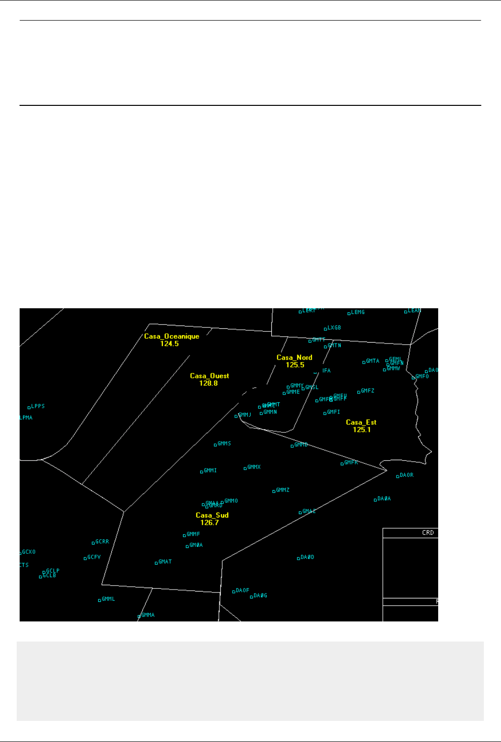
Euroscope:FAQ 166
Previous: Euroscope:Scenario File Actual: Euroscope:FAQ Next: Euroscope:Tutorial
Euroscope:Tutorial
Previous: Euroscope:FAQ Actual: Euroscope:Tutorial Next: Euroscope:Positions definition
Introduction To This Tutorial
In that tutorial, I’m going to explain in details, the important things to take in account for building an ese file. The
complete ese file can be downloaded at http:/ / www. vacc-morocco. org/ Tutorial_GMMM. ese if you want to try it
with EuroScope.
The Moroccan Fir
The Moroccan FIR is composed of five FIRs, here described below with their respective frequencies. I’ve chosen this
FIR, not only because I know it very well but mainly because of its composition which makes it a good example for
a tutorial.
So we’ll define the controller positions as following:
GMMM_CTR:CASABLANCA CONTROL:125.500:GMC:C:GMMM:CTR:-:-:4201:4277
GMMN_CTR:CASABLANCA CONTROL NORTH:125.600:GMMMN:C:GMMN:CTR:-:-:4201:4277
GMMM_CTR:CASABLANCA CONTROL EAST:125.100:GMMME:C:GMME:CTR:-:-:4201:4277
GMMM_CTR:CASASABLANCA CONTROL WEST:128.800:GMMMW:C:GMMW:CTR:-:-:4201:4277
GMMM_CTR:CASASABLANCA CONTROL SOUTH:126.700:GMMMS:C:GMMS:CTR:-:-:4201:4277

Euroscope:Tutorial 167
GMMM_CTR:CASABLANCA CONTROL OCEANIC:124.500:GMMMO:C:GMMO:CTR:-:-:4201:4277
As you can see, we have five FIRs and six lines in the POSITIONS for Casablanca. This is because, on VATSIM,
there are generally not enough controllers on line to man the five positions, and so Casablanca Control is controlling
the five FIRs together. In that case, it’s the first line with the 125.500 frequency which is used.
Previous: Euroscope:FAQ Actual: Euroscope:Tutorial Next: Euroscope:Positions definition
Euroscope:Positions definition
Previous: Euroscope:Tutorial Actual: Euroscope:Positions definition Next: Euroscope:SECTORLINE Definition
POSITIONS Definition
We are going to explain in details the different parameters of a POSITIONS line:
Example:
GMMM_CTR:CASABLANCA CONTROL OCEANIC:124.500:GMMMO:C:GMMO:CTR:-:-:4201:4277[:VIS center1 latitude:VIS center1 longitude[: ... ]]
• First parameter
The first parameter is there only to remember you the usage of the line. It can be anything and does not affect
any function. As you can see, I used the same name for different lines.
• Second parameter
The second parameter is the radio call sign, generally the official radiotelephony call sign to be used with that
station.
• Third parameter
The primary frequency of the station.
• Fourth parameter
The fourth parameter is the identifier. It can be one character long or as long as you want. We use a five
characters length one to make reading easier.
• Fifth parameter
This parameter is the character to be displayed in VRC or ASRC for identifying the controller. EuroScope
does not use it since the tracking controller is displayed in the detailed tag.
• Sixth parameter
The first part of the call sign. This parameter is used to identify the position.
• Seventh parameter
The suffix of the call sign. It is used in combination with the previous parameter. So, for the line of Casablanca
Oceanic Control, it will be GMMO_CTR. That identifier is used by EuroScope in simulation mode for the
simulated controllers.
• Eighth and ninth parameters
Not used.
• Tenth parameter
Start of code squawk range used for that position.
• Eleventh parameter
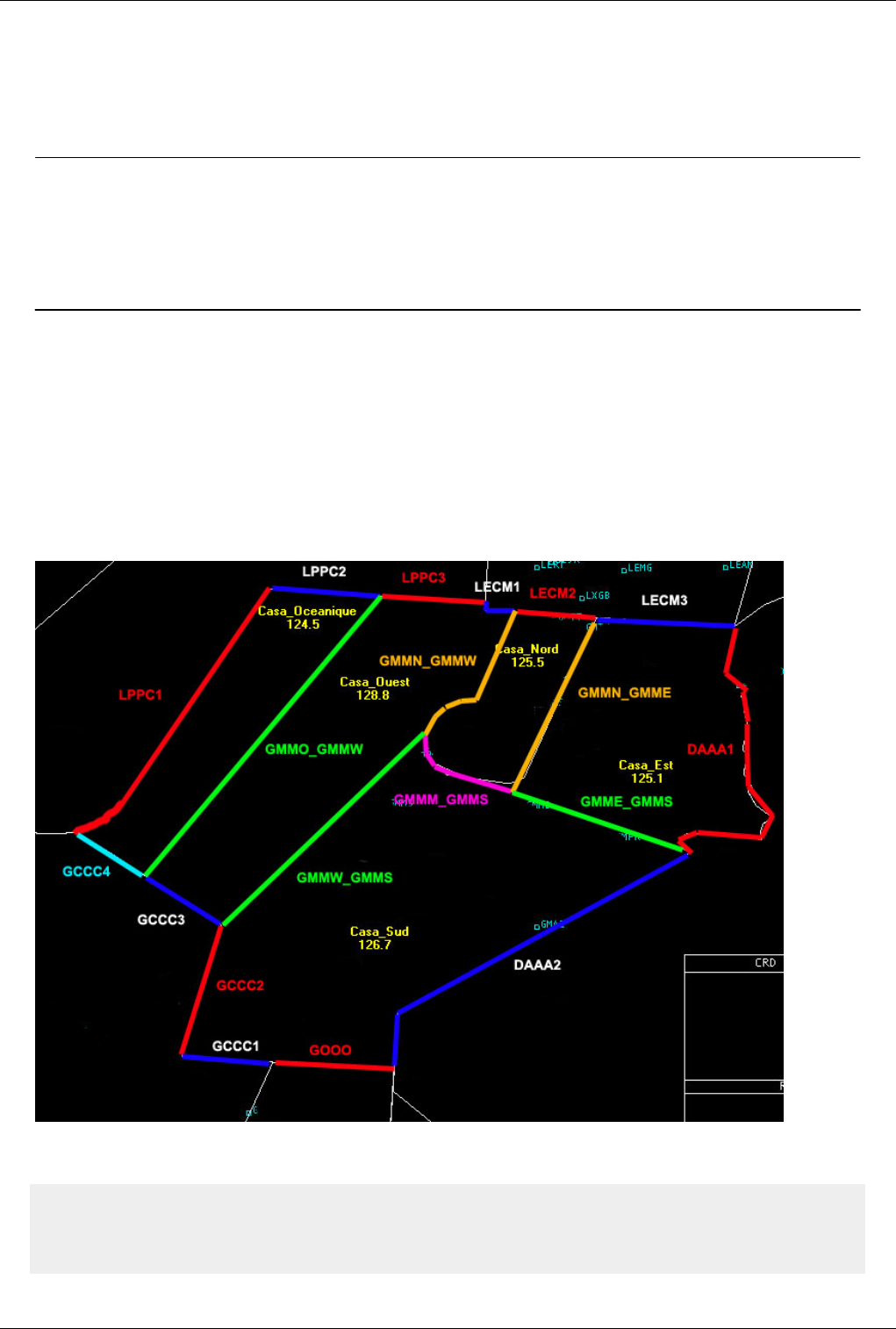
Euroscope:Positions definition 168
End of code squawk range used for that position.
• Twelfth and thirteenth parameter
Latitude and longitude of the first (optional) visibility centre.
There can be up to four visibility centres, that means up to eight optional parameters.
Previous: Euroscope:Tutorial Actual: Euroscope:Positions definition Next: Euroscope:SECTORLINE Definition
Euroscope:SECTORLINE Definition
Previous: Euroscope:Positions definition Actual: Euroscope:SECTORLINE Definition Next: Euroscope:SECTOR Definition
SECTORLINE Definition
Now we are going to define the different SECTORLINEs we will need in our area. We’ll make difference between
internal and external SECTORLINEs. An internal SECTORLINE is a SECTORLINE located inside GMMM area.
An external one is located on GMMM periphery and is adjacent with a neighboring FIR. So, on the picture below
you can see how we defined all these SECTORLINEs.
Let’s now see how a SECTORLINE is defined, and take the example of the separation line between Casablanca
Oceanic and Casablanca West.
SECTORLINE:GMMO_GMMW_SCL
DISPLAY:GMMM_O_CTR_SECT:GMMM_O_CTR_SECT:GMMM_W_CTR_SECT
DISPLAY:GMMM_W_CTR_SECT:GMMM_O_CTR_SECT:GMMM_W_CTR_SECT

Euroscope:SECTORLINE Definition 169
COORD:N030.48.17.299:W014.13.33.264
COORD:N035.57.32.923:W009.39.27.732
• The first line contains the name of the SECTORLINE. We had it the suffix _SCL to identify it immediately when
reading.
• The second line defines the conditions for this SECTORLINE to be displayed. Its general format is:
DISPLAY:param1:param2:param3
where all parameters are SECTORs and NOT identifiers from the POSITIONS section.
So the SECTORLINE will be displayed IF you are controlling param1 AND IF param2 AND param3 are
controlled by two different controllers.
And in our case the GMMO_GMMW SECTORLINE will be displayed if you are controlling GMMM_O_SECT and
GMMM_O_SECT and GMMM_W_SECT are controlled by two different controllers.
• The third line is the other condition for this line to be displayed and follows the same logic. And since this
SECTORLINE is a straight line, we only need two coordinate points to define it.
• The fourth line contains the geographical coordinates of the separation point between GCCC4 and GCCC3
SECTORLINEs. This is the starting point of the SECTORLINE.
• The fifth line contains the geographical coordinates of the separation point between LPPC2 and LPPC3
SECTORLINEs. This is the ending point of the SECTORLINE.
All SECTORLINEs follow the same rules, and are more or less complex according to their shape, so
GMMO_GMMW is a simple one with only two coordinate points and we can also have a SECTORLINE like
DAAA1 which is defined by 26 coordinate points.
All SECTORLINEs can be defined in any order.
Previous: Euroscope:Positions definition Actual: Euroscope:SECTORLINE Definition Next: Euroscope:SECTOR Definition
Euroscope:SECTOR Definition 170
Euroscope:SECTOR Definition
Previous: Euroscope:SECTORLINE Definition Actual: Euroscope:SECTOR Definition Next: No more pages
SECTOR definitions
Now, we are going to see how SECTORs are defined.
A sector definition is as following:
SECTOR:< sector name >:< lower altitude limit>:< upper altitude limit>
OWNER:< ID 1 >:< ID 2 >:…:< ID n >
BORDER:< SECTORLINE 1 >:< SECTORLINE 2 >:…:< SECTORLINE n >
The vertical limits are in feet. The identifiers are taken from the fourth parameter in the POSITIONS lines and are set
in hierarchical order in the controller positions. So we have the following hierarchy: GND, then TWR, then APP,
then TMA (if any), then CTR, then FSS.
Let’s take the example of Casablanca West. We’ll define the first line as following since this CTR is controlling from
surface to FL600.
SECTOR:GMMM_W_CTR_SECT:0:60000
OWNER:GMMMW:GMC:AFN
BORDER:GMMW_GMMS_SCL:GMMN_GMMW_SCL:LECM1_SCL:LPPC3_SCL:GMMO_GMMW_SCL:GCCC3_SCL
In the second line, we set Casablanca West Control, then Casablanca Control, then North Africa Control in that order
in the OWNER instruction. Then in the third line, we start from the most southern point, the separation point
between GCCC2 and GCCC3 SECTORLINEs, and we add all the SECTORLINEs in a counterclockwise manner (it
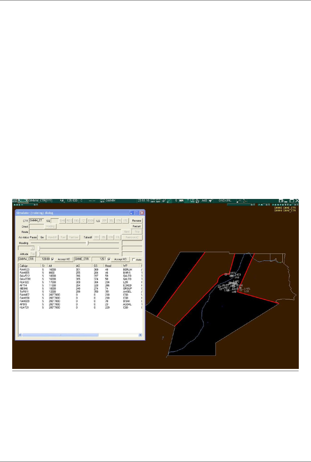
Euroscope:SECTOR Definition 171
will work same if we use a clockwise manner). So we have GMMW _GMMS_SCL, GMMN_GMMW_SCL,
LECM1_SCL, LPPC3_SCL, GMMO_GMMW_SCL and GCCC3_SCL. The loop is closed.
And we define all the other SECTORs in a same manner.
BUT BE CAREFUL All SECTORs MUST be defined from the smaller ones to the bigger ones since EuroScope is
searching if an aircraft is inside a SECTOR in the order defined in the ese file. As soon as he finds a matching one,
all other SECTORs are not tested at all. This property can be used to create overlapping SECTORs, but in that case,
you must be sure that the smaller one is the first in the list.
That is the reason why we have in the SECTOR part, the airports, then the five inner FIRs, then the neighboring
FIRs.
Note: the SECTORs for GMMM_CTR and North_Africa Control are not defined. There is no need to do it, since
they are deduced from the hierarchy of the other sectors.
EuroScope deduces the area of the bigger sectors by looking at the hierarchy in the OWNER instructions and by
adding or substracting sectors accordingly.
And here is how your scope looks like when GMMM_CTR is on line as well as GMMM_WEST_CTR and
GMMM_East_CTR. Note the two simulated controllers in the Simulator training dialog and how they appear in the
controller list in the top right corner of the screen. The two areas of GMMM_West_CTR and GMMM_East_CTR
have been substracted to the GMMM_CTR whole area (black active zone) when these two controllers went on line.
Note the red lines of handoff between the different zones. Note also the simulated aircrafts of the scenario file around
Casablanca airport.
Previous: Euroscope:SECTORLINE Definition Actual: Euroscope:SECTOR Definition Next: No more pages

Quelle(n) und Bearbeiter des/der Artikel(s) 172
Quelle(n) und Bearbeiter des/der Artikel(s)
Euroscope:Euroscope ‡Quelle: http://www.wikiflusi.de/wikiflusi/index.php?oldid=1858 ‡Bearbeiter: Gal2302
Euroscope:Credits for v3.1 ‡Quelle: http://www.wikiflusi.de/wikiflusi/index.php?oldid=1859 ‡Bearbeiter: Gal2302
Euroscope:Credits for v3.0 ‡Quelle: http://www.wikiflusi.de/wikiflusi/index.php?oldid=1860 ‡Bearbeiter: Gal2302
Euroscope:Credits for v2.9 ‡Quelle: http://www.wikiflusi.de/wikiflusi/index.php?oldid=1861 ‡Bearbeiter: Gal2302
Euroscope:Quick Start ‡Quelle: http://www.wikiflusi.de/wikiflusi/index.php?oldid=2200 ‡Bearbeiter: Gal2302
Euroscope:Installation ‡Quelle: http://www.wikiflusi.de/wikiflusi/index.php?oldid=2201 ‡Bearbeiter: Gal2302
Euroscope:Where My Settings Are Saved ‡Quelle: http://www.wikiflusi.de/wikiflusi/index.php?oldid=2204 ‡Bearbeiter: Gal2302
Euroscope:Get Connected ‡Quelle: http://www.wikiflusi.de/wikiflusi/index.php?oldid=1892 ‡Bearbeiter: Gal2302
Euroscope:Connection Settings ‡Quelle: http://www.wikiflusi.de/wikiflusi/index.php?oldid=2205 ‡Bearbeiter: Gal2302
Euroscope:Voice Communication Setup ‡Quelle: http://www.wikiflusi.de/wikiflusi/index.php?oldid=2206 ‡Bearbeiter: Gal2302
Euroscope:Voice Hardware Test And Setup ‡Quelle: http://www.wikiflusi.de/wikiflusi/index.php?oldid=1896 ‡Bearbeiter: Gal2302
Euroscope:Download Sectorfiles ‡Quelle: http://www.wikiflusi.de/wikiflusi/index.php?oldid=1897 ‡Bearbeiter: Gal2302
Euroscope:Voice ATIS ‡Quelle: http://www.wikiflusi.de/wikiflusi/index.php?oldid=2207 ‡Bearbeiter: Gal2302
Euroscope:Voice Alias ‡Quelle: http://www.wikiflusi.de/wikiflusi/index.php?oldid=1933 ‡Bearbeiter: Gal2302
Euroscope:Connection Features ‡Quelle: http://www.wikiflusi.de/wikiflusi/index.php?oldid=1934 ‡Bearbeiter: Gal2302
Euroscope:Going Into Details ‡Quelle: http://www.wikiflusi.de/wikiflusi/index.php?oldid=2208 ‡Bearbeiter: Gal2302
Euroscope:Multiple Sectorfiles ‡Quelle: http://www.wikiflusi.de/wikiflusi/index.php?oldid=1939 ‡Bearbeiter: Gal2302
Euroscope:Sectors And Aircraft States ‡Quelle: http://www.wikiflusi.de/wikiflusi/index.php?oldid=2211 ‡Bearbeiter: Gal2302
Euroscope:Professional Radar Simulation ‡Quelle: http://www.wikiflusi.de/wikiflusi/index.php?oldid=1967 ‡Bearbeiter: Gal2302
Euroscope:Radar Screen ‡Quelle: http://www.wikiflusi.de/wikiflusi/index.php?oldid=1968 ‡Bearbeiter: Gal2302
Euroscope:The Menu Bar ‡Quelle: http://www.wikiflusi.de/wikiflusi/index.php?oldid=2216 ‡Bearbeiter: Gal2302
Euroscope:Basic Lists ‡Quelle: http://www.wikiflusi.de/wikiflusi/index.php?oldid=1998 ‡Bearbeiter: Gal2302
Euroscope:Advanced Lists ‡Quelle: http://www.wikiflusi.de/wikiflusi/index.php?oldid=2217 ‡Bearbeiter: Gal2302
Euroscope:Distance Separation Tools ‡Quelle: http://www.wikiflusi.de/wikiflusi/index.php?oldid=2021 ‡Bearbeiter: Gal2302
Euroscope:Chat Box ‡Quelle: http://www.wikiflusi.de/wikiflusi/index.php?oldid=2218 ‡Bearbeiter: Gal2302
Euroscope:Flight Strip ‡Quelle: http://www.wikiflusi.de/wikiflusi/index.php?oldid=2029 ‡Bearbeiter: Gal2302
Euroscope:The Command Line ‡Quelle: http://www.wikiflusi.de/wikiflusi/index.php?oldid=2219 ‡Bearbeiter: Gal2302
Euroscope:TAGs ‡Quelle: http://www.wikiflusi.de/wikiflusi/index.php?oldid=2221 ‡Bearbeiter: Gal2302
Euroscope:TAG Editor ‡Quelle: http://www.wikiflusi.de/wikiflusi/index.php?oldid=2223 ‡Bearbeiter: Gal2302
Euroscope:Settings ‡Quelle: http://www.wikiflusi.de/wikiflusi/index.php?oldid=2224 ‡Bearbeiter: Gal2302
Euroscope:Controller To Controller Communication ‡Quelle: http://www.wikiflusi.de/wikiflusi/index.php?oldid=2225 ‡Bearbeiter: Gal2302
Euroscope:General Settings ‡Quelle: http://www.wikiflusi.de/wikiflusi/index.php?oldid=2228 ‡Bearbeiter: Gal2302
Euroscope:Display Settings ‡Quelle: http://www.wikiflusi.de/wikiflusi/index.php?oldid=2229 ‡Bearbeiter: Gal2302
Euroscope:Symbology Settings ‡Quelle: http://www.wikiflusi.de/wikiflusi/index.php?oldid=2230 ‡Bearbeiter: Gal2302
Euroscope:Plug-Ins ‡Quelle: http://www.wikiflusi.de/wikiflusi/index.php?oldid=2125 ‡Bearbeiter: Gal2302
Euroscope:Sounds Setup ‡Quelle: http://www.wikiflusi.de/wikiflusi/index.php?oldid=2231 ‡Bearbeiter: Gal2302
Euroscope:Active Airports Runways ‡Quelle: http://www.wikiflusi.de/wikiflusi/index.php?oldid=2129 ‡Bearbeiter: Gal2302
Euroscope:Flight Plan Setting Dialog ‡Quelle: http://www.wikiflusi.de/wikiflusi/index.php?oldid=2232 ‡Bearbeiter: Gal2302
Euroscope:Message Dialog ‡Quelle: http://www.wikiflusi.de/wikiflusi/index.php?oldid=2133 ‡Bearbeiter: Gal2302
Euroscope:Short Term Conflict Alert Settings Dialog ‡Quelle: http://www.wikiflusi.de/wikiflusi/index.php?oldid=2135 ‡Bearbeiter: Gal2302
Euroscope:Extended Centerline Setup ‡Quelle: http://www.wikiflusi.de/wikiflusi/index.php?oldid=2233 ‡Bearbeiter: Gal2302
Euroscope:Sector Ownership Setup ‡Quelle: http://www.wikiflusi.de/wikiflusi/index.php?oldid=2141 ‡Bearbeiter: Gal2302
Euroscope:Non Standard Extensions ‡Quelle: http://www.wikiflusi.de/wikiflusi/index.php?oldid=2143 ‡Bearbeiter: Gal2302
Euroscope:Working with keyboard ‡Quelle: http://www.wikiflusi.de/wikiflusi/index.php?oldid=2234 ‡Bearbeiter: Gal2302
Euroscope:Editing And Function Keys ‡Quelle: http://www.wikiflusi.de/wikiflusi/index.php?oldid=2235 ‡Bearbeiter: Gal2302
Euroscope:Command Line Reference ‡Quelle: http://www.wikiflusi.de/wikiflusi/index.php?oldid=2236 ‡Bearbeiter: Gal2302
Euroscope:Built In Functions ‡Quelle: http://www.wikiflusi.de/wikiflusi/index.php?oldid=2237 ‡Bearbeiter: Gal2302
Euroscope:Built In Simulator ‡Quelle: http://www.wikiflusi.de/wikiflusi/index.php?oldid=2238 ‡Bearbeiter: Gal2302
Euroscope:Tower View ‡Quelle: http://www.wikiflusi.de/wikiflusi/index.php?oldid=2180 ‡Bearbeiter: Gal2302

Quelle(n) und Bearbeiter des/der Artikel(s) 173
Euroscope:Appendices ‡Quelle: http://www.wikiflusi.de/wikiflusi/index.php?oldid=2239 ‡Bearbeiter: Gal2302
Euroscope:ESE Files Description ‡Quelle: http://www.wikiflusi.de/wikiflusi/index.php?oldid=2241 ‡Bearbeiter: Gal2302
Euroscope:Scenario File ‡Quelle: http://www.wikiflusi.de/wikiflusi/index.php?oldid=2185 ‡Bearbeiter: Gal2302
Euroscope:Interaction with VRC/ASRC ‡Quelle: http://www.wikiflusi.de/wikiflusi/index.php?oldid=2242 ‡Bearbeiter: Gal2302
Euroscope:Plug In Environment ‡Quelle: http://www.wikiflusi.de/wikiflusi/index.php?oldid=2187 ‡Bearbeiter: Gal2302
Euroscope:FAQ ‡Quelle: http://www.wikiflusi.de/wikiflusi/index.php?oldid=2244 ‡Bearbeiter: Gal2302
Euroscope:Tutorial ‡Quelle: http://www.wikiflusi.de/wikiflusi/index.php?oldid=2193 ‡Bearbeiter: Gal2302
Euroscope:Positions definition ‡Quelle: http://www.wikiflusi.de/wikiflusi/index.php?oldid=2194 ‡Bearbeiter: Gal2302
Euroscope:SECTORLINE Definition ‡Quelle: http://www.wikiflusi.de/wikiflusi/index.php?oldid=2195 ‡Bearbeiter: Gal2302
Euroscope:SECTOR Definition ‡Quelle: http://www.wikiflusi.de/wikiflusi/index.php?oldid=2197 ‡Bearbeiter: Gal2302

Quelle(n), Lizenz(en) und Autor(en) des Bildes 174
Quelle(n), Lizenz(en) und Autor(en) des Bildes
image:Install05.jpg ‡Quelle: http://www.wikiflusi.de/wikiflusi/index.php?title=Datei:Install05.jpg ‡Lizenz: unbekannt ‡Bearbeiter: Gal2302
image:Install06.jpg ‡Quelle: http://www.wikiflusi.de/wikiflusi/index.php?title=Datei:Install06.jpg ‡Lizenz: unbekannt ‡Bearbeiter: Gal2302
image:Install07.jpg ‡Quelle: http://www.wikiflusi.de/wikiflusi/index.php?title=Datei:Install07.jpg ‡Lizenz: unbekannt ‡Bearbeiter: Gal2302
image:Install08.jpg ‡Quelle: http://www.wikiflusi.de/wikiflusi/index.php?title=Datei:Install08.jpg ‡Lizenz: unbekannt ‡Bearbeiter: Gal2302
Image:SettingsFilesMenu.jpg ‡Quelle: http://www.wikiflusi.de/wikiflusi/index.php?title=Datei:SettingsFilesMenu.jpg ‡Lizenz: unbekannt ‡Bearbeiter: Gal2302
Image:SettingsFilesDialog.jpg ‡Quelle: http://www.wikiflusi.de/wikiflusi/index.php?title=Datei:SettingsFilesDialog.jpg ‡Lizenz: unbekannt ‡Bearbeiter: Gal2302
image:WhereMySettings01.jpg ‡Quelle: http://www.wikiflusi.de/wikiflusi/index.php?title=Datei:WhereMySettings01.jpg ‡Lizenz: unbekannt ‡Bearbeiter: Gal2302
image:WhereMySettings02.jpg ‡Quelle: http://www.wikiflusi.de/wikiflusi/index.php?title=Datei:WhereMySettings02.jpg ‡Lizenz: unbekannt ‡Bearbeiter: Gal2302
image:WhereMySettings03.jpg ‡Quelle: http://www.wikiflusi.de/wikiflusi/index.php?title=Datei:WhereMySettings03.jpg ‡Lizenz: unbekannt ‡Bearbeiter: Gal2302
image:ConnectDialog2.jpg ‡Quelle: http://www.wikiflusi.de/wikiflusi/index.php?title=Datei:ConnectDialog2.jpg ‡Lizenz: unbekannt ‡Bearbeiter: Gal2302
image:ConnectButton.jpg ‡Quelle: http://www.wikiflusi.de/wikiflusi/index.php?title=Datei:ConnectButton.jpg ‡Lizenz: unbekannt ‡Bearbeiter: Gal2302
image:Connectdialog-Selectconnection.jpg ‡Quelle: http://www.wikiflusi.de/wikiflusi/index.php?title=Datei:Connectdialog-Selectconnection.jpg ‡Lizenz: unbekannt ‡Bearbeiter: Gal2302
image:Connectdialog-Vatsimconnection.jpg ‡Quelle: http://www.wikiflusi.de/wikiflusi/index.php?title=Datei:Connectdialog-Vatsimconnection.jpg ‡Lizenz: unbekannt ‡Bearbeiter: Gal2302
image:connectdialog7.gif ‡Quelle: http://www.wikiflusi.de/wikiflusi/index.php?title=Datei:Connectdialog7.gif ‡Lizenz: unbekannt ‡Bearbeiter: Gal2302
image:connectdialog2.gif ‡Quelle: http://www.wikiflusi.de/wikiflusi/index.php?title=Datei:Connectdialog2.gif ‡Lizenz: unbekannt ‡Bearbeiter: Gal2302
image:ConnectDialog_SimServ.jpg ‡Quelle: http://www.wikiflusi.de/wikiflusi/index.php?title=Datei:ConnectDialog_SimServ.jpg ‡Lizenz: unbekannt ‡Bearbeiter: Gal2302
image:ConnectDialog_ASEDlg.jpg ‡Quelle: http://www.wikiflusi.de/wikiflusi/index.php?title=Datei:ConnectDialog_ASEDlg.jpg ‡Lizenz: unbekannt ‡Bearbeiter: Gal2302
image:connectdialog4.gif ‡Quelle: http://www.wikiflusi.de/wikiflusi/index.php?title=Datei:Connectdialog4.gif ‡Lizenz: unbekannt ‡Bearbeiter: Gal2302
image:connectdialog5.gif ‡Quelle: http://www.wikiflusi.de/wikiflusi/index.php?title=Datei:Connectdialog5.gif ‡Lizenz: unbekannt ‡Bearbeiter: Gal2302
image:VoiceCommSetup.jpg ‡Quelle: http://www.wikiflusi.de/wikiflusi/index.php?title=Datei:VoiceCommSetup.jpg ‡Lizenz: unbekannt ‡Bearbeiter: Gal2302
Image:VoceHardware1.gif ‡Quelle: http://www.wikiflusi.de/wikiflusi/index.php?title=Datei:VoceHardware1.gif ‡Lizenz: unbekannt ‡Bearbeiter: Gal2302
Image:Sectorfiledownload-Menu.jpg ‡Quelle: http://www.wikiflusi.de/wikiflusi/index.php?title=Datei:Sectorfiledownload-Menu.jpg ‡Lizenz: unbekannt ‡Bearbeiter: Gal2302
Image:Sectorfiledownload-Dialog.jpg ‡Quelle: http://www.wikiflusi.de/wikiflusi/index.php?title=Datei:Sectorfiledownload-Dialog.jpg ‡Lizenz: unbekannt ‡Bearbeiter: Gal2302
Image:Sectorfiledownload-Dialog-Descriptorfile.jpg ‡Quelle: http://www.wikiflusi.de/wikiflusi/index.php?title=Datei:Sectorfiledownload-Dialog-Descriptorfile.jpg ‡Lizenz: unbekannt
‡Bearbeiter: Gal2302
Image:Sectorfiledownload-Dialog-Providers.jpg ‡Quelle: http://www.wikiflusi.de/wikiflusi/index.php?title=Datei:Sectorfiledownload-Dialog-Providers.jpg ‡Lizenz: unbekannt ‡Bearbeiter:
Gal2302
Image:Sectorfiledownload-Dialog-Sectorfiles.jpg ‡Quelle: http://www.wikiflusi.de/wikiflusi/index.php?title=Datei:Sectorfiledownload-Dialog-Sectorfiles.jpg ‡Lizenz: unbekannt ‡Bearbeiter:
Gal2302
Image:Sectorfiledownload-Message.jpg ‡Quelle: http://www.wikiflusi.de/wikiflusi/index.php?title=Datei:Sectorfiledownload-Message.jpg ‡Lizenz: unbekannt ‡Bearbeiter: Gal2302
Image:Sectorfiledownload-downloaded-to-load-and-change.jpg ‡Quelle: http://www.wikiflusi.de/wikiflusi/index.php?title=Datei:Sectorfiledownload-downloaded-to-load-and-change.jpg
‡Lizenz: unbekannt ‡Bearbeiter: Gal2302
Image:Sectorfiledownload-use-in-all-ASR.jpg ‡Quelle: http://www.wikiflusi.de/wikiflusi/index.php?title=Datei:Sectorfiledownload-use-in-all-ASR.jpg ‡Lizenz: unbekannt ‡Bearbeiter: Gal2302
Image:Sectorfiledownload-confirm-delete-old.jpg ‡Quelle: http://www.wikiflusi.de/wikiflusi/index.php?title=Datei:Sectorfiledownload-confirm-delete-old.jpg ‡Lizenz: unbekannt ‡Bearbeiter:
Gal2302
Image:Sectorfiledownload-NewSectorfileLoaded.jpg ‡Quelle: http://www.wikiflusi.de/wikiflusi/index.php?title=Datei:Sectorfiledownload-NewSectorfileLoaded.jpg ‡Lizenz: unbekannt
‡Bearbeiter: Gal2302
Image:VoiceAtis1.jpg ‡Quelle: http://www.wikiflusi.de/wikiflusi/index.php?title=Datei:VoiceAtis1.jpg ‡Lizenz: unbekannt ‡Bearbeiter: Gal2302
Image:VoiceAtis0.jpg ‡Quelle: http://www.wikiflusi.de/wikiflusi/index.php?title=Datei:VoiceAtis0.jpg ‡Lizenz: unbekannt ‡Bearbeiter: Gal2302
Image:Sectorfile001.jpg ‡Quelle: http://www.wikiflusi.de/wikiflusi/index.php?title=Datei:Sectorfile001.jpg ‡Lizenz: unbekannt ‡Bearbeiter: Gal2302
Image:Sectorfile002.jpg ‡Quelle: http://www.wikiflusi.de/wikiflusi/index.php?title=Datei:Sectorfile002.jpg ‡Lizenz: unbekannt ‡Bearbeiter: Gal2302
image:astate01.jpg ‡Quelle: http://www.wikiflusi.de/wikiflusi/index.php?title=Datei:Astate01.jpg ‡Lizenz: unbekannt ‡Bearbeiter: Gal2302
image:astate02.jpg ‡Quelle: http://www.wikiflusi.de/wikiflusi/index.php?title=Datei:Astate02.jpg ‡Lizenz: unbekannt ‡Bearbeiter: Gal2302
image:astate03.jpg ‡Quelle: http://www.wikiflusi.de/wikiflusi/index.php?title=Datei:Astate03.jpg ‡Lizenz: unbekannt ‡Bearbeiter: Gal2302
image:astate04.jpg ‡Quelle: http://www.wikiflusi.de/wikiflusi/index.php?title=Datei:Astate04.jpg ‡Lizenz: unbekannt ‡Bearbeiter: Gal2302
image:astate05.jpg ‡Quelle: http://www.wikiflusi.de/wikiflusi/index.php?title=Datei:Astate05.jpg ‡Lizenz: unbekannt ‡Bearbeiter: Gal2302
image:astate08.jpg ‡Quelle: http://www.wikiflusi.de/wikiflusi/index.php?title=Datei:Astate08.jpg ‡Lizenz: unbekannt ‡Bearbeiter: Gal2302
image:astate06.jpg ‡Quelle: http://www.wikiflusi.de/wikiflusi/index.php?title=Datei:Astate06.jpg ‡Lizenz: unbekannt ‡Bearbeiter: Gal2302
image:astate07.jpg ‡Quelle: http://www.wikiflusi.de/wikiflusi/index.php?title=Datei:Astate07.jpg ‡Lizenz: unbekannt ‡Bearbeiter: Gal2302
image: astate09.jpg ‡Quelle: http://www.wikiflusi.de/wikiflusi/index.php?title=Datei:Astate09.jpg ‡Lizenz: unbekannt ‡Bearbeiter: Gal2302
image:astate10.jpg ‡Quelle: http://www.wikiflusi.de/wikiflusi/index.php?title=Datei:Astate10.jpg ‡Lizenz: unbekannt ‡Bearbeiter: Gal2302
image:astate11.jpg ‡Quelle: http://www.wikiflusi.de/wikiflusi/index.php?title=Datei:Astate11.jpg ‡Lizenz: unbekannt ‡Bearbeiter: Gal2302
image:astate12.jpg ‡Quelle: http://www.wikiflusi.de/wikiflusi/index.php?title=Datei:Astate12.jpg ‡Lizenz: unbekannt ‡Bearbeiter: Gal2302
image:astate13.jpg ‡Quelle: http://www.wikiflusi.de/wikiflusi/index.php?title=Datei:Astate13.jpg ‡Lizenz: unbekannt ‡Bearbeiter: Gal2302
Image:RadarTarget-standby.jpg ‡Quelle: http://www.wikiflusi.de/wikiflusi/index.php?title=Datei:RadarTarget-standby.jpg ‡Lizenz: unbekannt ‡Bearbeiter: Gal2302
image:RadarTarget-primary.jpg ‡Quelle: http://www.wikiflusi.de/wikiflusi/index.php?title=Datei:RadarTarget-primary.jpg ‡Lizenz: unbekannt ‡Bearbeiter: Gal2302
Image:RadarTarget-A-C-secondary-only.jpg ‡Quelle: http://www.wikiflusi.de/wikiflusi/index.php?title=Datei:RadarTarget-A-C-secondary-only.jpg ‡Lizenz: unbekannt ‡Bearbeiter: Gal2302
Image:RadarTarget-S-secondary-only.jpg ‡Quelle: http://www.wikiflusi.de/wikiflusi/index.php?title=Datei:RadarTarget-S-secondary-only.jpg ‡Lizenz: unbekannt ‡Bearbeiter: Gal2302
Image:RadarTarget-primary-A-C-secondary.jpg ‡Quelle: http://www.wikiflusi.de/wikiflusi/index.php?title=Datei:RadarTarget-primary-A-C-secondary.jpg ‡Lizenz: unbekannt ‡Bearbeiter:
Gal2302
Image:RadarTarget-primary-S-secondary.jpg ‡Quelle: http://www.wikiflusi.de/wikiflusi/index.php?title=Datei:RadarTarget-primary-S-secondary.jpg ‡Lizenz: unbekannt ‡Bearbeiter: Gal2302
Image:RadarTarget-primary-A-C-secondary-ident.jpg ‡Quelle: http://www.wikiflusi.de/wikiflusi/index.php?title=Datei:RadarTarget-primary-A-C-secondary-ident.jpg ‡Lizenz: unbekannt
‡Bearbeiter: Gal2302
Image:RadarTarget-primary-S-secondary-ident.jpg ‡Quelle: http://www.wikiflusi.de/wikiflusi/index.php?title=Datei:RadarTarget-primary-S-secondary-ident.jpg ‡Lizenz: unbekannt
‡Bearbeiter: Gal2302
Image:RadarTarget-flightplan.jpg ‡Quelle: http://www.wikiflusi.de/wikiflusi/index.php?title=Datei:RadarTarget-flightplan.jpg ‡Lizenz: unbekannt ‡Bearbeiter: Gal2302
image:RadarTarget-coasting.jpg ‡Quelle: http://www.wikiflusi.de/wikiflusi/index.php?title=Datei:RadarTarget-coasting.jpg ‡Lizenz: unbekannt ‡Bearbeiter: Gal2302
image:RadarTarget-history.jpg ‡Quelle: http://www.wikiflusi.de/wikiflusi/index.php?title=Datei:RadarTarget-history.jpg ‡Lizenz: unbekannt ‡Bearbeiter: Gal2302
Image:RadarScreen01.jpg ‡Quelle: http://www.wikiflusi.de/wikiflusi/index.php?title=Datei:RadarScreen01.jpg ‡Lizenz: unbekannt ‡Bearbeiter: Gal2302
Image:RadarScreen02.gif ‡Quelle: http://www.wikiflusi.de/wikiflusi/index.php?title=Datei:RadarScreen02.gif ‡Lizenz: unbekannt ‡Bearbeiter: Gal2302

Quelle(n), Lizenz(en) und Autor(en) des Bildes 175
Image:BasicList01.gif ‡Quelle: http://www.wikiflusi.de/wikiflusi/index.php?title=Datei:BasicList01.gif ‡Lizenz: unbekannt ‡Bearbeiter: Gal2302
Image:Comm1.jpg ‡Quelle: http://www.wikiflusi.de/wikiflusi/index.php?title=Datei:Comm1.jpg ‡Lizenz: unbekannt ‡Bearbeiter: Gal2302
Image:Comm2.jpg ‡Quelle: http://www.wikiflusi.de/wikiflusi/index.php?title=Datei:Comm2.jpg ‡Lizenz: unbekannt ‡Bearbeiter: Gal2302
Image:Comm7.jpg ‡Quelle: http://www.wikiflusi.de/wikiflusi/index.php?title=Datei:Comm7.jpg ‡Lizenz: unbekannt ‡Bearbeiter: Gal2302
Image:Comm3.jpg ‡Quelle: http://www.wikiflusi.de/wikiflusi/index.php?title=Datei:Comm3.jpg ‡Lizenz: unbekannt ‡Bearbeiter: Gal2302
Image:Comm4.jpg ‡Quelle: http://www.wikiflusi.de/wikiflusi/index.php?title=Datei:Comm4.jpg ‡Lizenz: unbekannt ‡Bearbeiter: Gal2302
Image:Comm8.jpg ‡Quelle: http://www.wikiflusi.de/wikiflusi/index.php?title=Datei:Comm8.jpg ‡Lizenz: unbekannt ‡Bearbeiter: Gal2302
Image:Comm9.jpg ‡Quelle: http://www.wikiflusi.de/wikiflusi/index.php?title=Datei:Comm9.jpg ‡Lizenz: unbekannt ‡Bearbeiter: Gal2302
Image:Comm5.jpg ‡Quelle: http://www.wikiflusi.de/wikiflusi/index.php?title=Datei:Comm5.jpg ‡Lizenz: unbekannt ‡Bearbeiter: Gal2302
Image:Comm6.jpg ‡Quelle: http://www.wikiflusi.de/wikiflusi/index.php?title=Datei:Comm6.jpg ‡Lizenz: unbekannt ‡Bearbeiter: Gal2302
Image:Comm10.jpg ‡Quelle: http://www.wikiflusi.de/wikiflusi/index.php?title=Datei:Comm10.jpg ‡Lizenz: unbekannt ‡Bearbeiter: Gal2302
Image:Comm11.jpg ‡Quelle: http://www.wikiflusi.de/wikiflusi/index.php?title=Datei:Comm11.jpg ‡Lizenz: unbekannt ‡Bearbeiter: Gal2302
Image:BasicList02.gif ‡Quelle: http://www.wikiflusi.de/wikiflusi/index.php?title=Datei:BasicList02.gif ‡Lizenz: unbekannt ‡Bearbeiter: Gal2302
Image:BasicList03.gif ‡Quelle: http://www.wikiflusi.de/wikiflusi/index.php?title=Datei:BasicList03.gif ‡Lizenz: unbekannt ‡Bearbeiter: Gal2302
Image:BasicList04.jpg ‡Quelle: http://www.wikiflusi.de/wikiflusi/index.php?title=Datei:BasicList04.jpg ‡Lizenz: unbekannt ‡Bearbeiter: Gal2302
Image:AdvancedLists01.gif ‡Quelle: http://www.wikiflusi.de/wikiflusi/index.php?title=Datei:AdvancedLists01.gif ‡Lizenz: unbekannt ‡Bearbeiter: Gal2302
Image:AdvancedLists02.gif ‡Quelle: http://www.wikiflusi.de/wikiflusi/index.php?title=Datei:AdvancedLists02.gif ‡Lizenz: unbekannt ‡Bearbeiter: Gal2302
Image:AdvancedLists03.gif ‡Quelle: http://www.wikiflusi.de/wikiflusi/index.php?title=Datei:AdvancedLists03.gif ‡Lizenz: unbekannt ‡Bearbeiter: Gal2302
Image:FlightplanList.jpg ‡Quelle: http://www.wikiflusi.de/wikiflusi/index.php?title=Datei:FlightplanList.jpg ‡Lizenz: unbekannt ‡Bearbeiter: Gal2302
Image:ArrivalList.jpg ‡Quelle: http://www.wikiflusi.de/wikiflusi/index.php?title=Datei:ArrivalList.jpg ‡Lizenz: unbekannt ‡Bearbeiter: Gal2302
Image:SILSetupDialog.jpg ‡Quelle: http://www.wikiflusi.de/wikiflusi/index.php?title=Datei:SILSetupDialog.jpg ‡Lizenz: unbekannt ‡Bearbeiter: Gal2302
Image:Distance1.jpg ‡Quelle: http://www.wikiflusi.de/wikiflusi/index.php?title=Datei:Distance1.jpg ‡Lizenz: unbekannt ‡Bearbeiter: Gal2302
Image:Distance2.jpg ‡Quelle: http://www.wikiflusi.de/wikiflusi/index.php?title=Datei:Distance2.jpg ‡Lizenz: unbekannt ‡Bearbeiter: Gal2302
Image:Separation1.jpg ‡Quelle: http://www.wikiflusi.de/wikiflusi/index.php?title=Datei:Separation1.jpg ‡Lizenz: unbekannt ‡Bearbeiter: Gal2302
Image:Separation2.jpg ‡Quelle: http://www.wikiflusi.de/wikiflusi/index.php?title=Datei:Separation2.jpg ‡Lizenz: unbekannt ‡Bearbeiter: Gal2302
Image:Separation3.jpg ‡Quelle: http://www.wikiflusi.de/wikiflusi/index.php?title=Datei:Separation3.jpg ‡Lizenz: unbekannt ‡Bearbeiter: Gal2302
Image:Chatbar.gif ‡Quelle: http://www.wikiflusi.de/wikiflusi/index.php?title=Datei:Chatbar.gif ‡Lizenz: unbekannt ‡Bearbeiter: Gal2302
Image:FlightStrip01.gif ‡Quelle: http://www.wikiflusi.de/wikiflusi/index.php?title=Datei:FlightStrip01.gif ‡Lizenz: unbekannt ‡Bearbeiter: Gal2302
Image:Commandbar.gif ‡Quelle: http://www.wikiflusi.de/wikiflusi/index.php?title=Datei:Commandbar.gif ‡Lizenz: unbekannt ‡Bearbeiter: Gal2302
image:tags01.jpg ‡Quelle: http://www.wikiflusi.de/wikiflusi/index.php?title=Datei:Tags01.jpg ‡Lizenz: unbekannt ‡Bearbeiter: Gal2302
image:tags06.gif ‡Quelle: http://www.wikiflusi.de/wikiflusi/index.php?title=Datei:Tags06.gif ‡Lizenz: unbekannt ‡Bearbeiter: Gal2302
image:tags07.gif ‡Quelle: http://www.wikiflusi.de/wikiflusi/index.php?title=Datei:Tags07.gif ‡Lizenz: unbekannt ‡Bearbeiter: Gal2302
image:tags08.gif ‡Quelle: http://www.wikiflusi.de/wikiflusi/index.php?title=Datei:Tags08.gif ‡Lizenz: unbekannt ‡Bearbeiter: Gal2302
image:tags09.gif ‡Quelle: http://www.wikiflusi.de/wikiflusi/index.php?title=Datei:Tags09.gif ‡Lizenz: unbekannt ‡Bearbeiter: Gal2302
image:tags10.gif ‡Quelle: http://www.wikiflusi.de/wikiflusi/index.php?title=Datei:Tags10.gif ‡Lizenz: unbekannt ‡Bearbeiter: Gal2302
image:tags11.gif ‡Quelle: http://www.wikiflusi.de/wikiflusi/index.php?title=Datei:Tags11.gif ‡Lizenz: unbekannt ‡Bearbeiter: Gal2302
image:tags12.gif ‡Quelle: http://www.wikiflusi.de/wikiflusi/index.php?title=Datei:Tags12.gif ‡Lizenz: unbekannt ‡Bearbeiter: Gal2302
image:tags13.gif ‡Quelle: http://www.wikiflusi.de/wikiflusi/index.php?title=Datei:Tags13.gif ‡Lizenz: unbekannt ‡Bearbeiter: Gal2302
image:tags14.gif ‡Quelle: http://www.wikiflusi.de/wikiflusi/index.php?title=Datei:Tags14.gif ‡Lizenz: unbekannt ‡Bearbeiter: Gal2302
image:tags15.gif ‡Quelle: http://www.wikiflusi.de/wikiflusi/index.php?title=Datei:Tags15.gif ‡Lizenz: unbekannt ‡Bearbeiter: Gal2302
image:tags15b.gif ‡Quelle: http://www.wikiflusi.de/wikiflusi/index.php?title=Datei:Tags15b.gif ‡Lizenz: unbekannt ‡Bearbeiter: Gal2302
image:tags15c.gif ‡Quelle: http://www.wikiflusi.de/wikiflusi/index.php?title=Datei:Tags15c.gif ‡Lizenz: unbekannt ‡Bearbeiter: Gal2302
image:tags15d.gif ‡Quelle: http://www.wikiflusi.de/wikiflusi/index.php?title=Datei:Tags15d.gif ‡Lizenz: unbekannt ‡Bearbeiter: Gal2302
image:tags16.jpg ‡Quelle: http://www.wikiflusi.de/wikiflusi/index.php?title=Datei:Tags16.jpg ‡Lizenz: unbekannt ‡Bearbeiter: Gal2302
image:tags17.jpg ‡Quelle: http://www.wikiflusi.de/wikiflusi/index.php?title=Datei:Tags17.jpg ‡Lizenz: unbekannt ‡Bearbeiter: Gal2302
image:tags20.gif ‡Quelle: http://www.wikiflusi.de/wikiflusi/index.php?title=Datei:Tags20.gif ‡Lizenz: unbekannt ‡Bearbeiter: Gal2302
image:tags20b.gif ‡Quelle: http://www.wikiflusi.de/wikiflusi/index.php?title=Datei:Tags20b.gif ‡Lizenz: unbekannt ‡Bearbeiter: Gal2302
image:tags21.gif ‡Quelle: http://www.wikiflusi.de/wikiflusi/index.php?title=Datei:Tags21.gif ‡Lizenz: unbekannt ‡Bearbeiter: Gal2302
image:tags21b.gif ‡Quelle: http://www.wikiflusi.de/wikiflusi/index.php?title=Datei:Tags21b.gif ‡Lizenz: unbekannt ‡Bearbeiter: Gal2302
image:tags21c.gif ‡Quelle: http://www.wikiflusi.de/wikiflusi/index.php?title=Datei:Tags21c.gif ‡Lizenz: unbekannt ‡Bearbeiter: Gal2302
image:tags21d.gif ‡Quelle: http://www.wikiflusi.de/wikiflusi/index.php?title=Datei:Tags21d.gif ‡Lizenz: unbekannt ‡Bearbeiter: Gal2302
image:tags22.gif ‡Quelle: http://www.wikiflusi.de/wikiflusi/index.php?title=Datei:Tags22.gif ‡Lizenz: unbekannt ‡Bearbeiter: Gal2302
image:tags22b.gif ‡Quelle: http://www.wikiflusi.de/wikiflusi/index.php?title=Datei:Tags22b.gif ‡Lizenz: unbekannt ‡Bearbeiter: Gal2302
image:tags22c.gif ‡Quelle: http://www.wikiflusi.de/wikiflusi/index.php?title=Datei:Tags22c.gif ‡Lizenz: unbekannt ‡Bearbeiter: Gal2302
image:tags23.jpg ‡Quelle: http://www.wikiflusi.de/wikiflusi/index.php?title=Datei:Tags23.jpg ‡Lizenz: unbekannt ‡Bearbeiter: Gal2302
image:tags24.jpg ‡Quelle: http://www.wikiflusi.de/wikiflusi/index.php?title=Datei:Tags24.jpg ‡Lizenz: unbekannt ‡Bearbeiter: Gal2302
image:tags25.jpg ‡Quelle: http://www.wikiflusi.de/wikiflusi/index.php?title=Datei:Tags25.jpg ‡Lizenz: unbekannt ‡Bearbeiter: Gal2302
image:tags26.jpg ‡Quelle: http://www.wikiflusi.de/wikiflusi/index.php?title=Datei:Tags26.jpg ‡Lizenz: unbekannt ‡Bearbeiter: Gal2302
image:tags03.jpg ‡Quelle: http://www.wikiflusi.de/wikiflusi/index.php?title=Datei:Tags03.jpg ‡Lizenz: unbekannt ‡Bearbeiter: Gal2302
image:tags04.jpg ‡Quelle: http://www.wikiflusi.de/wikiflusi/index.php?title=Datei:Tags04.jpg ‡Lizenz: unbekannt ‡Bearbeiter: Gal2302
image:tags05.jpg ‡Quelle: http://www.wikiflusi.de/wikiflusi/index.php?title=Datei:Tags05.jpg ‡Lizenz: unbekannt ‡Bearbeiter: Gal2302
Image:TagEditor.jpg ‡Quelle: http://www.wikiflusi.de/wikiflusi/index.php?title=Datei:TagEditor.jpg ‡Lizenz: unbekannt ‡Bearbeiter: Gal2302
Image:Controller.gif ‡Quelle: http://www.wikiflusi.de/wikiflusi/index.php?title=Datei:Controller.gif ‡Lizenz: unbekannt ‡Bearbeiter: Gal2302
image:example1.gif ‡Quelle: http://www.wikiflusi.de/wikiflusi/index.php?title=Datei:Example1.gif ‡Lizenz: unbekannt ‡Bearbeiter: Gal2302
image:example2.gif ‡Quelle: http://www.wikiflusi.de/wikiflusi/index.php?title=Datei:Example2.gif ‡Lizenz: unbekannt ‡Bearbeiter: Gal2302
image:example3.gif ‡Quelle: http://www.wikiflusi.de/wikiflusi/index.php?title=Datei:Example3.gif ‡Lizenz: unbekannt ‡Bearbeiter: Gal2302
image:example4.gif ‡Quelle: http://www.wikiflusi.de/wikiflusi/index.php?title=Datei:Example4.gif ‡Lizenz: unbekannt ‡Bearbeiter: Gal2302
image:example5.gif ‡Quelle: http://www.wikiflusi.de/wikiflusi/index.php?title=Datei:Example5.gif ‡Lizenz: unbekannt ‡Bearbeiter: Gal2302
image:example7.gif ‡Quelle: http://www.wikiflusi.de/wikiflusi/index.php?title=Datei:Example7.gif ‡Lizenz: unbekannt ‡Bearbeiter: Gal2302
image:example6.gif ‡Quelle: http://www.wikiflusi.de/wikiflusi/index.php?title=Datei:Example6.gif ‡Lizenz: unbekannt ‡Bearbeiter: Gal2302
image:example8.gif ‡Quelle: http://www.wikiflusi.de/wikiflusi/index.php?title=Datei:Example8.gif ‡Lizenz: unbekannt ‡Bearbeiter: Gal2302

Quelle(n), Lizenz(en) und Autor(en) des Bildes 176
image:example9.gif ‡Quelle: http://www.wikiflusi.de/wikiflusi/index.php?title=Datei:Example9.gif ‡Lizenz: unbekannt ‡Bearbeiter: Gal2302
image:example10.gif ‡Quelle: http://www.wikiflusi.de/wikiflusi/index.php?title=Datei:Example10.gif ‡Lizenz: unbekannt ‡Bearbeiter: Gal2302
image:example11.gif ‡Quelle: http://www.wikiflusi.de/wikiflusi/index.php?title=Datei:Example11.gif ‡Lizenz: unbekannt ‡Bearbeiter: Gal2302
image:example12.gif ‡Quelle: http://www.wikiflusi.de/wikiflusi/index.php?title=Datei:Example12.gif ‡Lizenz: unbekannt ‡Bearbeiter: Gal2302
image:example13.gif ‡Quelle: http://www.wikiflusi.de/wikiflusi/index.php?title=Datei:Example13.gif ‡Lizenz: unbekannt ‡Bearbeiter: Gal2302
image:example14.gif ‡Quelle: http://www.wikiflusi.de/wikiflusi/index.php?title=Datei:Example14.gif ‡Lizenz: unbekannt ‡Bearbeiter: Gal2302
image:example15.gif ‡Quelle: http://www.wikiflusi.de/wikiflusi/index.php?title=Datei:Example15.gif ‡Lizenz: unbekannt ‡Bearbeiter: Gal2302
image:example16.gif ‡Quelle: http://www.wikiflusi.de/wikiflusi/index.php?title=Datei:Example16.gif ‡Lizenz: unbekannt ‡Bearbeiter: Gal2302
image:example17.gif ‡Quelle: http://www.wikiflusi.de/wikiflusi/index.php?title=Datei:Example17.gif ‡Lizenz: unbekannt ‡Bearbeiter: Gal2302
image:example18.gif ‡Quelle: http://www.wikiflusi.de/wikiflusi/index.php?title=Datei:Example18.gif ‡Lizenz: unbekannt ‡Bearbeiter: Gal2302
image:example19.gif ‡Quelle: http://www.wikiflusi.de/wikiflusi/index.php?title=Datei:Example19.gif ‡Lizenz: unbekannt ‡Bearbeiter: Gal2302
image:example20.gif ‡Quelle: http://www.wikiflusi.de/wikiflusi/index.php?title=Datei:Example20.gif ‡Lizenz: unbekannt ‡Bearbeiter: Gal2302
image:example21.gif ‡Quelle: http://www.wikiflusi.de/wikiflusi/index.php?title=Datei:Example21.gif ‡Lizenz: unbekannt ‡Bearbeiter: Gal2302
image:example22.gif ‡Quelle: http://www.wikiflusi.de/wikiflusi/index.php?title=Datei:Example22.gif ‡Lizenz: unbekannt ‡Bearbeiter: Gal2302
image:example23.gif ‡Quelle: http://www.wikiflusi.de/wikiflusi/index.php?title=Datei:Example23.gif ‡Lizenz: unbekannt ‡Bearbeiter: Gal2302
image:example24.gif ‡Quelle: http://www.wikiflusi.de/wikiflusi/index.php?title=Datei:Example24.gif ‡Lizenz: unbekannt ‡Bearbeiter: Gal2302
image:example25.gif ‡Quelle: http://www.wikiflusi.de/wikiflusi/index.php?title=Datei:Example25.gif ‡Lizenz: unbekannt ‡Bearbeiter: Gal2302
Image:General settings.gif ‡Quelle: http://www.wikiflusi.de/wikiflusi/index.php?title=Datei:General_settings.gif ‡Lizenz: unbekannt ‡Bearbeiter: Gal2302
Image:GeneralSettings - Page2.jpg ‡Quelle: http://www.wikiflusi.de/wikiflusi/index.php?title=Datei:GeneralSettings_-_Page2.jpg ‡Lizenz: unbekannt ‡Bearbeiter: Gal2302
image:menu8.gif ‡Quelle: http://www.wikiflusi.de/wikiflusi/index.php?title=Datei:Menu8.gif ‡Lizenz: unbekannt ‡Bearbeiter: Gal2302
image:menu16.gif ‡Quelle: http://www.wikiflusi.de/wikiflusi/index.php?title=Datei:Menu16.gif ‡Lizenz: unbekannt ‡Bearbeiter: Gal2302
image:DisplaySettings.jpg ‡Quelle: http://www.wikiflusi.de/wikiflusi/index.php?title=Datei:DisplaySettings.jpg ‡Lizenz: unbekannt ‡Bearbeiter: Gal2302
image:symbology.gif ‡Quelle: http://www.wikiflusi.de/wikiflusi/index.php?title=Datei:Symbology.gif ‡Lizenz: unbekannt ‡Bearbeiter: Gal2302
image:Plugin.gif ‡Quelle: http://www.wikiflusi.de/wikiflusi/index.php?title=Datei:Plugin.gif ‡Lizenz: unbekannt ‡Bearbeiter: Gal2302
image:soundsetup.gif ‡Quelle: http://www.wikiflusi.de/wikiflusi/index.php?title=Datei:Soundsetup.gif ‡Lizenz: unbekannt ‡Bearbeiter: Gal2302
image:RunwayDialog.jpg ‡Quelle: http://www.wikiflusi.de/wikiflusi/index.php?title=Datei:RunwayDialog.jpg ‡Lizenz: unbekannt ‡Bearbeiter: Gal2302
image:FlightplanSettings.jpg ‡Quelle: http://www.wikiflusi.de/wikiflusi/index.php?title=Datei:FlightplanSettings.jpg ‡Lizenz: unbekannt ‡Bearbeiter: Gal2302
image:MessageChat.jpg ‡Quelle: http://www.wikiflusi.de/wikiflusi/index.php?title=Datei:MessageChat.jpg ‡Lizenz: unbekannt ‡Bearbeiter: Gal2302
image:Stca01.jpg ‡Quelle: http://www.wikiflusi.de/wikiflusi/index.php?title=Datei:Stca01.jpg ‡Lizenz: unbekannt ‡Bearbeiter: Gal2302
image:ext01.jpg ‡Quelle: http://www.wikiflusi.de/wikiflusi/index.php?title=Datei:Ext01.jpg ‡Lizenz: unbekannt ‡Bearbeiter: Gal2302
image:ext02.jpg ‡Quelle: http://www.wikiflusi.de/wikiflusi/index.php?title=Datei:Ext02.jpg ‡Lizenz: unbekannt ‡Bearbeiter: Gal2302
image:ext03.jpg ‡Quelle: http://www.wikiflusi.de/wikiflusi/index.php?title=Datei:Ext03.jpg ‡Lizenz: unbekannt ‡Bearbeiter: Gal2302
image:SectOwn01.jpg ‡Quelle: http://www.wikiflusi.de/wikiflusi/index.php?title=Datei:SectOwn01.jpg ‡Lizenz: unbekannt ‡Bearbeiter: Gal2302
image:simserver_start.jpg ‡Quelle: http://www.wikiflusi.de/wikiflusi/index.php?title=Datei:Simserver_start.jpg ‡Lizenz: unbekannt ‡Bearbeiter: Gal2302
image:scenario_select.jpg ‡Quelle: http://www.wikiflusi.de/wikiflusi/index.php?title=Datei:Scenario_select.jpg ‡Lizenz: unbekannt ‡Bearbeiter: Gal2302
image:connect_candidate.jpg ‡Quelle: http://www.wikiflusi.de/wikiflusi/index.php?title=Datei:Connect_candidate.jpg ‡Lizenz: unbekannt ‡Bearbeiter: Gal2302
image:szimpanel02.jpg ‡Quelle: http://www.wikiflusi.de/wikiflusi/index.php?title=Datei:Szimpanel02.jpg ‡Lizenz: unbekannt ‡Bearbeiter: Gal2302
Image:Simtool01.gif ‡Quelle: http://www.wikiflusi.de/wikiflusi/index.php?title=Datei:Simtool01.gif ‡Lizenz: unbekannt ‡Bearbeiter: Gal2302
Image:Simtool02.gif ‡Quelle: http://www.wikiflusi.de/wikiflusi/index.php?title=Datei:Simtool02.gif ‡Lizenz: unbekannt ‡Bearbeiter: Gal2302
Image:simtool03.gif ‡Quelle: http://www.wikiflusi.de/wikiflusi/index.php?title=Datei:Simtool03.gif ‡Lizenz: unbekannt ‡Bearbeiter: Gal2302
Image:simtool04.gif ‡Quelle: http://www.wikiflusi.de/wikiflusi/index.php?title=Datei:Simtool04.gif ‡Lizenz: unbekannt ‡Bearbeiter: Gal2302
Image:simtool05.gif ‡Quelle: http://www.wikiflusi.de/wikiflusi/index.php?title=Datei:Simtool05.gif ‡Lizenz: unbekannt ‡Bearbeiter: Gal2302
Image:simtool06.gif ‡Quelle: http://www.wikiflusi.de/wikiflusi/index.php?title=Datei:Simtool06.gif ‡Lizenz: unbekannt ‡Bearbeiter: Gal2302
Image:simtool07.gif ‡Quelle: http://www.wikiflusi.de/wikiflusi/index.php?title=Datei:Simtool07.gif ‡Lizenz: unbekannt ‡Bearbeiter: Gal2302
Image:simtool08.gif ‡Quelle: http://www.wikiflusi.de/wikiflusi/index.php?title=Datei:Simtool08.gif ‡Lizenz: unbekannt ‡Bearbeiter: Gal2302
Image:simtool09.gif ‡Quelle: http://www.wikiflusi.de/wikiflusi/index.php?title=Datei:Simtool09.gif ‡Lizenz: unbekannt ‡Bearbeiter: Gal2302
Image:simtool10.gif ‡Quelle: http://www.wikiflusi.de/wikiflusi/index.php?title=Datei:Simtool10.gif ‡Lizenz: unbekannt ‡Bearbeiter: Gal2302
Image:simtool11.gif ‡Quelle: http://www.wikiflusi.de/wikiflusi/index.php?title=Datei:Simtool11.gif ‡Lizenz: unbekannt ‡Bearbeiter: Gal2302
Image:simtool12.gif ‡Quelle: http://www.wikiflusi.de/wikiflusi/index.php?title=Datei:Simtool12.gif ‡Lizenz: unbekannt ‡Bearbeiter: Gal2302
Image:simtool13.gif ‡Quelle: http://www.wikiflusi.de/wikiflusi/index.php?title=Datei:Simtool13.gif ‡Lizenz: unbekannt ‡Bearbeiter: Gal2302
Image:simtool14.gif ‡Quelle: http://www.wikiflusi.de/wikiflusi/index.php?title=Datei:Simtool14.gif ‡Lizenz: unbekannt ‡Bearbeiter: Gal2302
Image:simtool15.gif ‡Quelle: http://www.wikiflusi.de/wikiflusi/index.php?title=Datei:Simtool15.gif ‡Lizenz: unbekannt ‡Bearbeiter: Gal2302
Image:simtool16.gif ‡Quelle: http://www.wikiflusi.de/wikiflusi/index.php?title=Datei:Simtool16.gif ‡Lizenz: unbekannt ‡Bearbeiter: Gal2302
Image:simtool17.gif ‡Quelle: http://www.wikiflusi.de/wikiflusi/index.php?title=Datei:Simtool17.gif ‡Lizenz: unbekannt ‡Bearbeiter: Gal2302
Image:simtool18.gif ‡Quelle: http://www.wikiflusi.de/wikiflusi/index.php?title=Datei:Simtool18.gif ‡Lizenz: unbekannt ‡Bearbeiter: Gal2302
Image:simtool19.gif ‡Quelle: http://www.wikiflusi.de/wikiflusi/index.php?title=Datei:Simtool19.gif ‡Lizenz: unbekannt ‡Bearbeiter: Gal2302
Image:simtool20.gif ‡Quelle: http://www.wikiflusi.de/wikiflusi/index.php?title=Datei:Simtool20.gif ‡Lizenz: unbekannt ‡Bearbeiter: Gal2302
Image:simtool21.gif ‡Quelle: http://www.wikiflusi.de/wikiflusi/index.php?title=Datei:Simtool21.gif ‡Lizenz: unbekannt ‡Bearbeiter: Gal2302
Image:simtool22.gif ‡Quelle: http://www.wikiflusi.de/wikiflusi/index.php?title=Datei:Simtool22.gif ‡Lizenz: unbekannt ‡Bearbeiter: Gal2302
Image:simtool23.gif ‡Quelle: http://www.wikiflusi.de/wikiflusi/index.php?title=Datei:Simtool23.gif ‡Lizenz: unbekannt ‡Bearbeiter: Gal2302
Image:simtool24.gif ‡Quelle: http://www.wikiflusi.de/wikiflusi/index.php?title=Datei:Simtool24.gif ‡Lizenz: unbekannt ‡Bearbeiter: Gal2302
Image:simtool25.gif ‡Quelle: http://www.wikiflusi.de/wikiflusi/index.php?title=Datei:Simtool25.gif ‡Lizenz: unbekannt ‡Bearbeiter: Gal2302
Image:simtool26.gif ‡Quelle: http://www.wikiflusi.de/wikiflusi/index.php?title=Datei:Simtool26.gif ‡Lizenz: unbekannt ‡Bearbeiter: Gal2302
Image:simtool27.gif ‡Quelle: http://www.wikiflusi.de/wikiflusi/index.php?title=Datei:Simtool27.gif ‡Lizenz: unbekannt ‡Bearbeiter: Gal2302
image:InnSetup.gif ‡Quelle: http://www.wikiflusi.de/wikiflusi/index.php?title=Datei:InnSetup.gif ‡Lizenz: unbekannt ‡Bearbeiter: Gal2302
Image:ES_radars.jpg ‡Quelle: http://www.wikiflusi.de/wikiflusi/index.php?title=Datei:ES_radars.jpg ‡Lizenz: unbekannt ‡Bearbeiter: Gal2302
image:Questionicon.gif ‡Quelle: http://www.wikiflusi.de/wikiflusi/index.php?title=Datei:Questionicon.gif ‡Lizenz: unbekannt ‡Bearbeiter: Gal2302
Image:Tutorial01.jpg ‡Quelle: http://www.wikiflusi.de/wikiflusi/index.php?title=Datei:Tutorial01.jpg ‡Lizenz: unbekannt ‡Bearbeiter: Gal2302
Image:Sectorline01.jpg ‡Quelle: http://www.wikiflusi.de/wikiflusi/index.php?title=Datei:Sectorline01.jpg ‡Lizenz: unbekannt ‡Bearbeiter: Gal2302
Image:GMMM1.JPG ‡Quelle: http://www.wikiflusi.de/wikiflusi/index.php?title=Datei:GMMM1.JPG ‡Lizenz: unbekannt ‡Bearbeiter: Gal2302
