Microsoft Frost_Nelson_Br_Temp_x Frost Pilot Assessment Of Stream Temp
User Manual: Pdf Frost-Pilot-Assessment-of-Stream-Temp
Open the PDF directly: View PDF ![]() .
.
Page Count: 6
4/13/2017
1
Pilot Assessment of Stream Temperature
for an Impaired Waterway
Bill Frost, PE, D.WRE, Sr Water Resources Engineer, KCI Technologies, Inc.
Andy Becker, Project Scientist, KCI Technologies, Inc.
National Stormwater and Watershed Conference
Linthicum, MD
April 4, 2017
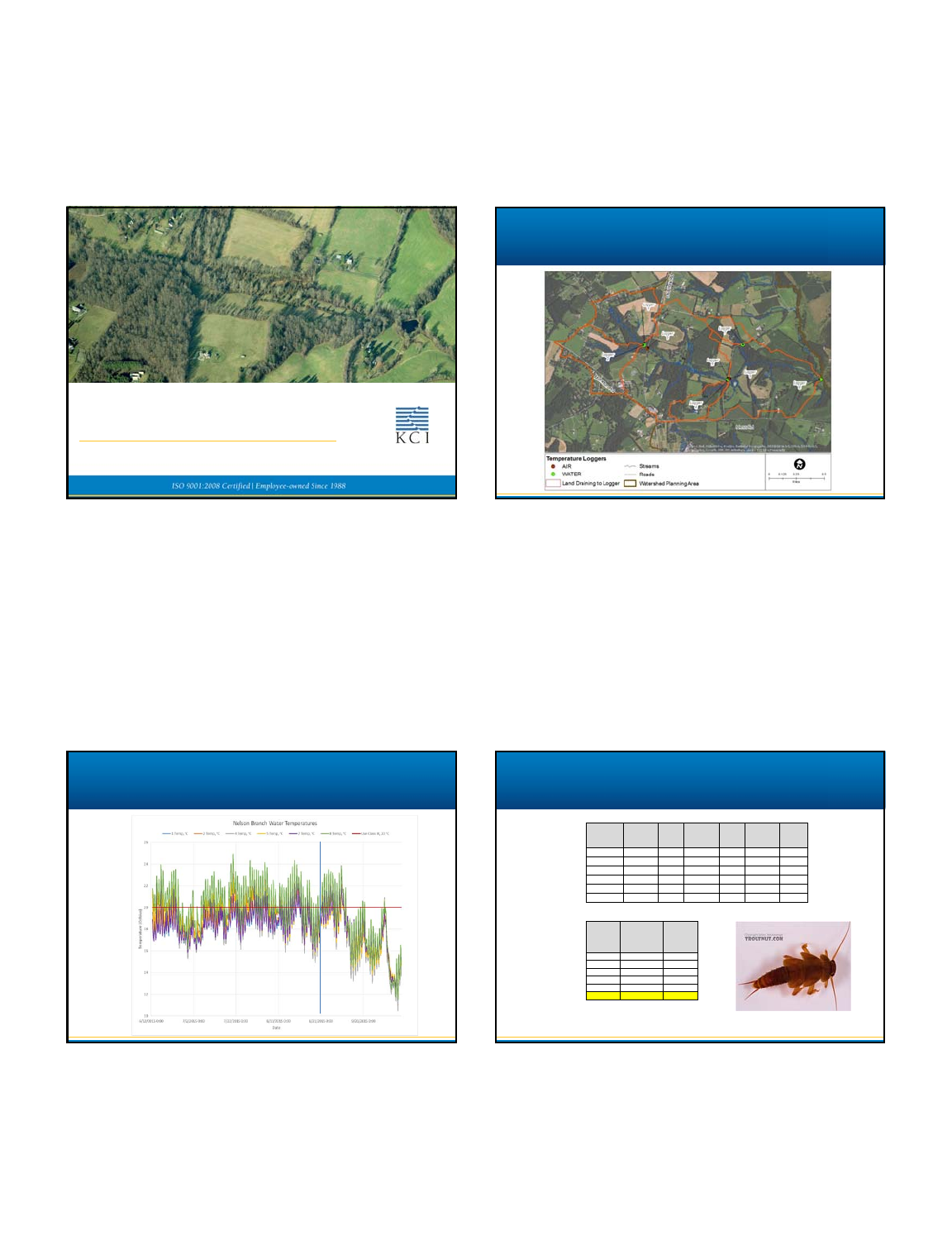
Pictrometry Bird’sEye©Pictrometry InternationalCorp
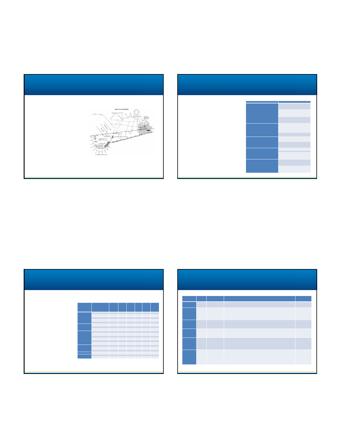
Nelson Branch Data Loggers
Temperature Records Temperature Data from Nelson Branch
Logger
Number*
Maximum
Recorded
Water
Temperature Date of
Maximum
1 21.3 9/9/2016
2 23.1 7/20/2016
4 22.5 6/16/2016
5 22.6 7/20/2016
7 22.9 8/19/2016
8 24.9 7/20/2016
Logger
Number*
%
Exceeding
20C %
Forest %
Agriculture %
Urban %
Impervious
Drainage
Area
(acres)
18% 22.6% 65.9% 11.5% 3.4% 155.2
233% 27.2% 48.6% 24.2% 6.3% 152.4
415% 46.5% 45.9% 7.7% 3.1% 59.2
521% 28.9% 57.1% 14.0% 4.2% 762.6
714% 17.6% 73.7% 8.8% 1.4% 41.2
850% 28.6% 60.6% 10.9% 3.3% 1,109.5
•Loggers 3 and 6 were air temperature loggers and are not displayed in this table
•WQ criteria allow up to 10% exceedance
24to27istheupperlethaltemperatureforBrookTrout

4/13/2017
2
Temperature – Causes?
Land Cover
Type Slope p-value R2
Forest 0.026 0.938 0.002
Urban 0.130 0.514 0.113
Impervious 0.035 0.504 0.119
No apparent correlation
between temperature
exceedance and watershed
land use
•Forest
•Urban
•Impervious
Other possible causes
•Lack of stream shading
•Low summer instream
flows
•Increased width to depth
ratio of streams
•Warm water from ponds
•Heated run off during rain
events
Relatewatershedcharacteristicsto
streamtemperatureforbothNelson
Branchandinthefutureforother
Countywatersheds–
•Determineandquantifycausesof
increasedtemperature
•Forecasttemperaturereduction
basedonpotentialimprovements
Modeling Goals
Statistical/Stochastic
•Correlationorregressionanalysis
ormodelingofrandomvariables
•Usuallyuniquetotheregion
wheretheyweredeveloped
•Mayrequirealongtimeseriesof
measurementsinorderto
describeawiderangeof
conditions
Types of Models Types of Models
Deterministic
•Physically‐basedwithan
energybudgetapproach
•Heattransferandfluidflow
equations
•Generallycapableof
simulatingconditionsthat
maynotbepresentinthe
existingwatershed
•Morecomplexandrequire
moreinputdata
4/13/2017
3
Deterministic
•Physically‐basedwithan
energybudgetapproach
•Heattransferandfluidflow
equations
•Generallycapableof
simulatingconditionsthat
maynotbepresentinthe
existingwatershed
•Morecomplexandrequire
moreinputdata
Types of Models
Capabilitytoassessof
sourcesofimpairments
Typesofmanagement
measurestobemodeled
Availabilityofinputdata
Resources,complexity,
andexpertiserequired
Modelsupport
Selection Criteria
SourceofImpairment PossibleRemediation
Lackofstreamshading
Restorenativeriparianvegetation;
increasecanopycoverandforestheightto
castlongeranddensershadows.
Protectriparianareafromunnatural
disturbances;removenon‐native
vegetation
Controllivestockaccesstothestreamvia
fencingandrestoringnativeriparian
vegetation
Lowsummerinstreamflows
Restoreheadwaterwatershedfeatures
thatretainmoistureandallowincreased
infiltration;e.g.wetlands,wideriparian
buffers.
Implementstormwaterandagricultural
BMPstopromoteinfiltrationofrunoff.
Increasedwidthtodepthratioofstreams
Stabilizestreammorphologytoreduce
incisionandwidening.
Implementstreamrestorationprojectsto
createdeeper,widerbaseflow channels
andconnectstreamswithfloodplains.
Warmwaterfromponds
Convertpondsintowetlands
Removeinlinepondconnection
Wherefeasibleretrofitpondwithbottom
releasestructuretoallowforcooler
bottomwatertoreachthestream
Heatedrunoffduringrainevents
ImplementstormwaterBMPssuchas
infiltration,bioretention,swales,andrain
gardenstopromoteinfiltration.
Disconnectrunoffbyredirectingitaway
fromimperviousareastoturforforested
landcover.
Capabilitytoassessof
sourcesofimpairments
Typesofmanagement
measurestobemodeled
Availabilityofinputdata
Resources,complexity,
andexpertiserequired
Modelsupport
Selection Criteria
Inputdataelement
Nelson
Branch
data
loggers
County
GIS
layers
LGF
WQMP
SHA
RWIS
data
County
rain
gages
NOAA
climate
data
Meteorology
Airtemperature x x
Cloudcover x
Windspeedx
Humidity x
Precipitation x
Hydrology
Flowvolume x
Ponds/reservoirs x
Watertemperature x
Channel
Morphology
Reachlength x x
Width/depth x
Slope x x
Gradient/sinuosity x
Substrate x
Elevation x
Topography
Streamaspect x
Latitude x
Elevation x
Shading Riparianvegetation x x
Watershed Imperviouscover x
Forestcover x
Model Sponsor
Hydrodynamics
/TimeStep Description InfoSource
CEQUAL‐RIV1 USACE Continuous,Sub‐
Daily
Hydrodynamicandwaterqualitymodelfornutrients,sediment,metals,
bacteria,effectsofalgaeandmacrophytesinadditiontotemperature.
Deasand
Lowney(2000)
HSPF USGS Continuous,Sub‐
Daily
Hydrologicandwaterqualitymodel;simulateswatershedprocesseson
perviousandimpervioussurfaces.Alongwithtemperature,output
includeswaterbudget,andpollutantloading.Reachandreservoir
nutrientcycleandbiologicaltransformationsarealsomodeled.
Deasand
Lowney(2000)
QUAL2E USEPA Sub‐Daily ReceivingwaterqualitymodelintendedforTMDLdevelopment.
Hydrologic,temperature,andpollutantmassbalanceiscalculatedfor
eachsubreach.
Deasand
Lowney(2000)
SNTEMP USGS Steadystate,
Dailytomonthly
Heattransportmodelthatpredictsdailymeanandmaximum
temperaturebasedonstreamdistanceandheatfluxfromradiation,
convection,conduction,shading,andgroundwaterinflow.
Deasand
Lowney(2000)
SSTEMP USGS/
FWS
Steadystate,
Dailytomonthly
ScaleddownversionofSNTEMPwhichhandlessinglestreamreachesfor
asingletimeperiodperrun.Predictsmeanandmaximumtemperatures
basedonheatfluxprocesses:convection,conduction,evaporation,air
temperature,solarradiation,andshading.
UserManual
HEATSOURCE Oregon
DEQ
Continuous,Sub‐
Daily
Themodelsimulatesdynamicopenchannelhydraulics,flowrouting,heat
transfer,effectiveshadeandstreamtemperature.Processesincludemass
transfers,groundwaterinflows,landscaperadiation,adiabaticcooling,
radiationmodeling,evaporation,hydrodynamicroutingwithhyporheic
exchangewithinthesubstrate.
UserManual
Deterministic Models

4/13/2017
4
Model Description Selection
CEQUAL‐RIV1 Developedprimarilyforwater
qualitymodeling.Tem p era t ure
modelingisanelementof
waterquality.
•Moredataintensive.
•Pollutantloadinginput
required.
•Morecomplex.
HSPF
QUAL2E
HEATSOURCE
Developedsolelyformodeling
streamtemperature.
•Dataintensive
•Required GISanalysisof
remotesensingdata
•Couldbeconsideredfora
futuremodeling
SNTEMP •Streamnetwork
temperaturemodel
•Couldbeconsideredfor
futuremodelingwitha
hydrologic flowmodel
SSTEMP •Singlereachmodel
•Lesscomplex version of
SNTEMP
•Inputdatawereavailable
Deterministic Models
•Capabilitytoassessof
sourcesofimpairments
•Typesofmanagement
measurestobemodeled
•Availabilityofinputdata
•Resources,complexity,and
expertiserequired
•Modelsupport
Onemodelidentifiedthrough
literaturesearch:
•ThermalUrbanRunoffModel
(TURM)
•DaneCounty,WI
•BasedonExcelspreadsheet
•Site‐levelmodelratherthana
watershedmodel
Predictstemperaturechangesin
runofffromnewdevelopmentthat
addsimperviouscover
Runoff Modeling
Sensitivity
•Whichvariableswouldhavethe
greatesteffectontemperature
Calibration
•Varyinginputdatasomodelresults
matchfieldmeasurements
•Resultsforfourreaches
ChangedTotalShadeinput
Threeoffourcouldbe
calibrated
SSTEMP – Sensitivity and Calibration
Description CalibrationChange
Mainstem betweenLoggers1and5Shadefrom65.5to77
Mainstem betweenLoggers5and8Shadefrom50.7to45
TributarytoLogger4Shadefrom67.6to100
TributarytoLogger2Shadefrom65to87
InstreamImprovements
•Takingpondsoffline
Trialsweremadevaryingtheassumptionthatupstream
pondswerepresent.Therewasnoeffectonthemean
temperature.
•Streamrestoration
Trialsweremadevaryingthewidthparameters.Mean
temperaturesvariedbylessthanonepercent,indicating
thatthisisnotasignificantfactorinthiswatershed,or
thatSSTEMP’salgorithmsdonotmodelvariationsin
streamwidthoroverwidening well.
•Addingriparianbuffer/shade
Increasingbuffershadinghadapositiveeffecton
temperature.
SSTEMP – Instream Results
4/13/2017
5
Modeling
•Possiblesunwasincreasedto
100%toshowtheworstcase
scenarioforunshadedstreams.
•Percentofshadewasincreased
withthegoalofmeetinga
meantemperatureof20oC
Cost
•KingandHagan(2011)
estimated$33,000/ac,or
approximately$150pertreeif
plantedat200treesperacre.
SSTEMP – Riparian Buffer Results
Reach Measured
100%
Sun Shaded
Changein
Shading Ac. Cost
Mainstem
between
Loggers1and5
19.98 20.26 19.98 77%to81% 1.1 $36,300
Mainstem
between
Loggers5and8
21.80 22.41 19.97 45%to80% 8.3 $273,900
Tributaryto
Logger221.02 21.26 20.06 87%to
100% 1.7 $56,100
Modeling
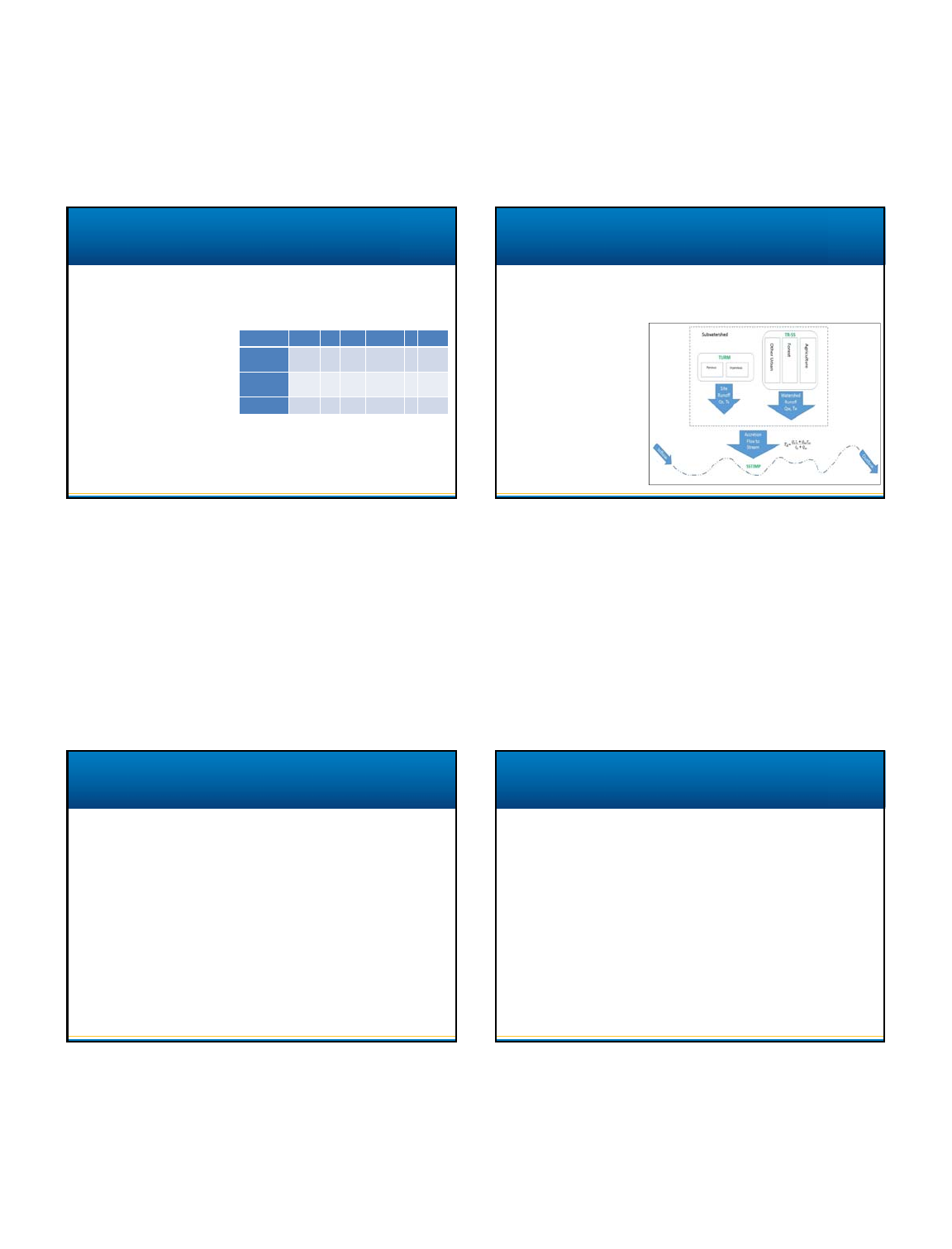
•TURMwasrunforonesubwatershed ofNelsonBranch.
•HeadwatersofthestreamdrainingtoLogger#2‐ theonlyareawithconcentratedimpervious
coveratSt.JamesAcademy
TURM – Procedure
Procedure
•RunTURMtofindthe
temperaturefromthe
urbanizedsite.
•RunTR‐55tofindthevolume
offlowforthesiteandthe
remainderofthewatershed,
thencalculateaweighted
averageforrunoff
temperature.
•Calculateaweightedaccretion
temperatureforthestream.
•Calculatechangeinstream
temperatureusingSSTEMP.
Site
•22.0oC Rainfall
•46.4oC Runofffromconnectedimperviousarea
•36.2oC Runofffromsite
Subwatershed
•22.0oC Undisturbedwatershed(assumedsameas
rainfall)
•36.2oC Runofffromsite
•24.8 oC Subwatershed weightedbyflowvolume
Stream
•21.0 oC Withoutsiterunoff
•24.8 oCWithsiterunoff
TURM – Results
Temperat u reincrease:
Approximately10%
Bothmodelswererelativelyeasytouseanddidnothaveextensivedata
requirements.
•Useofthetwomodelswasfeasibleforrunoffheatingbutlimitedbythelack
ofagoodlinkagebetweenthewatershedandstream.
TURMdidnotprovideamoduletotestimprovementsfromurbanBMPs
suchasinfiltration,imperviousdisconnection,grasschannels,orlevel
spreaders.
SSTEMPdidnotmodelchangeswellfromstreamwideningorshallow
waterdepth.
Neithermodelcouldsuccessfullyestimatetemperaturechangesfrom
heatedwaterinponds.
Model Summary

4/13/2017
6
ForfutureanalysesusingSSTEMP:
•Weatherdata
Instreamandairtemperature
Dewpointtemperatureorrelative
humidity
Cloudcover,atleastdaily
•Streamdata
Frequentflowmeasurementsatevery
datalogger
Averagereachwidthanddepth
Additionaltemperaturereadingsat
upstreamponddischarges
•DetailedRiparianVegetationData
Height
Crown
Offset
Density
Future Work
Testothermodels:
•Statistical/Stochastic
Maryland‐basedempiricalmodel
includingseasonaland
urbanizationeffects(Nelsonand
Palmer,2007)
•Deterministic
SNTEMPstreamnetworkwith
watershedhydrologicmodel
(Krauseetal,2004)
HEATSOURCEwithorwithout
ThermalInfraredImagery
Pictrometry Bird’sEye©Pictrometry InternationalCorp
Questions and Comments
