Suunto 21071 Outdoor GPS watch, with functionality for multi-POD environment User Manual User Guide
Suunto Oy Outdoor GPS watch, with functionality for multi-POD environment User Guide
Suunto >
Contents
- 1. Users Manual
- 2. Users Guide
Users Guide

Suunto Ambit
User Guide
en
1 Welcome ...................................................................... 6
2 Display icons and segments ................................................. 7
3 Using buttons ................................................................ 8
3.1 Using backlight and button lock ................................. 9
4 Getting started .............................................................. 10
5 Customizing Suunto Ambit ................................................. 11
5.1 Connecting to web .............................................. 11
5.2 Updating Suunto Ambit ......................................... 12
5.3 Custom modes ................................................... 13
5.4 Vertical speed .................................................... 13
5.5 Inverting display ................................................. 14
6 Using time mode ............................................................ 15
6.1 Changing time settings .......................................... 15
7 Navigation ................................................................... 18
7.1 Using GPS ........................................................ 18
7.1.1 Getting GPS signal .................................... 18
7.1.2 GPS datum and location formats .................... 19
7.1.3 FusedSpeed ........................................... 20
7.2 Checking your location .......................................... 21
7.3 Adding waypoints ............................................... 22
7.4 Navigating to a waypoint ....................................... 22
8 Using Alti & Baro mode ..................................................... 24
8.1 How Alti & Baro works ........................................... 24
8.1.1 Getting correct readings ............................. 24
8.1.2 Getting incorrect readings ........................... 25
2

8.2 Matching profile to activity ...................................... 26
8.2.1 Setting profiles ....................................... 26
8.2.2 Setting reference values ............................. 27
8.3 Using Altimeter profile ......................................... 27
8.3.1 Recording altitude .................................... 27
8.4 Using Barometer profile ........................................ 28
8.5 Using Automatic profile ........................................ 29
9 Using compass .............................................................. 30
9.1 Calibrating compass ............................................. 30
9.2 Setting declination value ........................................ 31
10 Using exercise modes ..................................................... 33
10.1 Exercise modes ................................................. 33
10.2 Additional options in exercise modes ......................... 34
10.3 Using HR belt ................................................... 35
10.4 Putting on HR belt .............................................. 36
10.5 Setting exercise parameters ................................... 37
10.6 Starting exercise ................................................ 38
10.6.1 Recording track logs ................................ 39
10.7 During exercise ................................................. 40
10.7.1 Making laps .......................................... 40
10.8 After exercise ................................................... 41
10.8.1 After exercise with HR belt .......................... 41
10.8.2 After exercise without HR belt ...................... 42
10.8.3 After exercise with GPS ............................. 42
11 Adjusting settings ......................................................... 43
3
en
PERSONAL settings ................................................... 43
GENERAL settings ..................................................... 43
ALTI-BARO settings ................................................... 44
PAIR settings ......................................................... 44
11.1 Sleep mode ..................................................... 45
11.2 Changing language ............................................ 45
12 Pairing POD/HR belt ....................................................... 46
Example: Pairing Suunto Dual Comfort Belt ........................ 46
Troubleshooting ..................................................... 47
12.1 Calibrating POD ................................................ 47
13 Icons ........................................................................ 49
Icons .................................................................. 49
Waypoint icons ...................................................... 49
14 Terminology ............................................................... 51
15 Care and maintenance .................................................... 53
15.1 Water resistance ................................................ 53
15.2 Charging the battery ........................................... 53
15.3 Replacing HR belt battery ...................................... 54
16 Technical specifications ................................................... 56
General ............................................................... 56
Memory .............................................................. 56
Transmission ......................................................... 56
Barometer ............................................................ 57
Altimeter ............................................................. 57
Thermometer ........................................................ 57
4

Chronograph ........................................................ 57
Compass ............................................................. 57
GPS ................................................................... 57
16.1 Trademark ...................................................... 57
16.2 FCC compliance ................................................ 58
16.3 CE ............................................................... 58
16.4 ICES ............................................................. 58
16.5 Copyright ....................................................... 58
16.6 Patent notice ................................................... 59
16.7 Warranty ........................................................ 59
Index .......................................................................... 63
5
en
1 WELCOME
It’s in our nature to explore. Whether you’re hiking, running a trail or skiing a
mountain, the new Suunto Ambit has all the functions you need for your
expeditions. Full-featured GPS, unique 3D Compass and in-built Baro / Alti
sensor keep you informed of your location, accurate altitude and weather
conditions. Patented HiAccGPSTM accelometer fused GPS gives you accurate
and highly responsive pace, speed and distance. All packed into a robust
BuiltToLastTM casing.
6

3 USING BUTTONS
Suunto Ambit has five buttons that allow you to access various features.
KUVA: BUTTONS!
[Start Stop]:
●access the start menu
●pause or resume an exercise
●keep pressed to stop and save an exercice
●increase a value or move up in the settings
[Next]:
●change between the displays
●keep pressed to access/exit the settings
●keep pressed to access/exit the additional exercise options in the exercise
modes
●accept a setting
[Light Lock]:
●activate the backlight
●keep pressed to lock/unlock the buttons
●decrease a value or move down in the settings
[View]:
●change views in TIME mode and during exercise
●keep pressed to invert the display colours
[Back Lap]:
●return to the previous step
●add a lap during exercise
8
TIP: When scrolling the options in a menu, keep the [Start Stop] or [Light Lock]
button pressed to increase the speed of scrolling.
3.1 Using backlight and button lock
Press [Light Lock] to activate the backlight. The backlight stays on for five
seconds. For information on the backlight settings, see Chapter 11 Adjusting
settings on page 43.
Keep [Light Lock] pressed to lock or unlock the buttons. When the buttons are
locked, is shown on the display.
TIP: Lock the buttons to avoid accidentally starting or stopping your stopwatch.
When the buttons are locked, you can still activate the backlight by pressing [Light
Lock], change between the displays by pressing [Next] and views by pressing [View].
9
en

4 GETTING STARTED
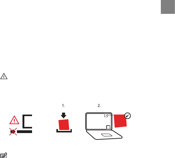
Start by charging the battery. The device wakes up automatically when you
attach it to your computer with a USB cable, or start charging it with a
USB-compatible wall charger. The USB cable is included in the device package,
whereas the charger is available as a separate accessory.
Charging the battery takes about 2 hours. During charging the buttons are
locked.
NOTE: Do not remove the cable until the battery has been fully charged. Battery
full notification is shown on the display when the charging is complete.
10
5 CUSTOMIZING SUUNTO AMBIT
5.1 Connecting to web
Movescount.com is an online sports community that offers you a rich set of
tools to manage your daily activities and create engaging stories about your
experiences. It also allows you to customize your Suunto Ambit to best meet
your training needs.
Transfer your recorded logs with Suunto Movestick Mini to Movescount.com.
Download settings and customized plans from Movescount.com to your Suunto
Ambit.
CAUTION: Do not plug in Movestick Mini before installing Moveslink!
To install Moveslink:
1. Go to www.movescount.com/moveslink.
2. Download, install, and activate Moveslink.
M
MAC
PC
M
www.movecount.com/moveslink
NOTE: A Moveslink icon is visible on your computer's display when Moveslink
is active.
11
en
NOTE: Moveslink is compatible with PC (Windows XP, Windows Vista, Windows
7) and MAC (Intel-based, running OS X version 10.5 or later).
To register to Movescount:
1. Go to www.movescount.com.
2. Create your account.
+
Movescount
com
.
NOTE: The first time Suunto Ambit is connected to Movescount.com, all
information (including the device settings) is transferred from Suunto Ambit to
Movescount. The next time you connect Suunto Ambit to Movescount.com, the
changes in settings and exercise modes you made in Movescount.com and in the
device will be synchronized.
5.2 Updating Suunto Ambit
You can update your Suunto Ambit automatically in Movescount.
12

To get your device updated:
1. Install the Moveslink application in Movescount.
2. Connect Suunto Ambit to your computer with a USB cable. The Moveslink
application will automatically check for updates. If an update is available,
your device will be updated.
NOTE: You can use the Moveslink application without registering to
Movescount. However, Movescount extends the usability, personalization and
settings options of Suunto Ambit. It also visualizes the recorded tracks and other
data of your activities, and therefore joining Movescount is needed to utilize the
full potential of the device.
5.3 Custom modes
In addition to the default exercise modes stored in the device (see Section 10.1
Exercise modes on page 33), you can create and edit custom exercise modes in
Movescount. A custom mode can contain 1 to 8 different exercise mode
displays. You can select the variables to be shown on each display.
You can transfer up to eight different custom modes created in Movescount
to your device. Only one custom mode can be active during the exercise.
ADD USE EXAMPLE!
5.4 Vertical speed
To be added.
13
en
5.5 Inverting display
You can invert the display colour of your Suunto Ambit from light to dark or
vice versa by keeping [View] pressed. You can also invert the display in the
settings.
To invert the display from the settings:
1. Keep [Next] pressed to enter the settings.
2. Press [Next] to enter the GENERAL settings.
3. Press [Next] to enter Tones/display.
4. Scroll to Invert display with [Start Stop] and accept with [Next].
14

6 USING TIME MODE
TIME mode includes time measurement functions.
Press [View] to scroll through the following views:
●Time and date: current date, time and weekday
●Seconds: seconds as numbers
●Dual time: time in another time zone
●Stopwatch: sport timer
●Countdown timer: alarm goes off after a set duration
6.1 Changing time settings
To access the time settings:
1. Keep [Next] pressed to enter the settings.
2. In the settings, press [Next] to enter GENERAL.
3. Scroll to Time/date using [Start Stop] and enter with [Next].
Setting time
The current time is shown in the middle of the the TIME mode display.
To set the time:
1. In the settings, go to GENERAL, then to Time/date and Time.
2. Change the hour, minute and second values with [Start Stop] and [Light
Lock] and accept with [Next].
3. Go back to the settings with [Back Lap], or keep [Next] pressed to exit the
settings.
15
en
Setting date
The current date is shown on the top row of the display.
To set the date:
1. In the settings, go to GENERAL, then to Time/date and Date.
2. Change the year, month and day values with [Start Stop] and [Light Lock]
and accept with [Next].
3. Go back to the settings with [Back Lap], or keep [Next] pressed to exit the
settings.
Setting dual time
Dual time allows you to keep track of the current time in a second time zone,
for example, when traveling. Dual time is displayed on the third row on the
TIME mode display.
To set the dual time:
1. In the settings, go to GENERAL, then to Time/date and Dual time.
2. Change the hour and minute values with [Start Stop] and [Light Lock] and
accept with [Next].
3. Go back to the settings with [Back Lap], or keep [Next] pressed to exit the
settings.
Setting alarm
You can use Suunto Ambit as an alarm clock.
To access the alarm clock and set the alarm:
1. In the settings, go to GENERAL, then to Time/date and Alarm.
2. Set the alarm on or off with [Start Stop] and [Light Lock] and accept with
[Next].
16

3. Set the hours and minutes with [Start Stop] and [Light Lock] and accept
with [Next].
4. Go back to the settings with [Back Lap], or keep [Next] pressed to exit the
settings.
When the alarm is switched on, the alarm symbol is shown on the display.
When the alarm sounds, you can:
●Select Snooze by pressing [Light Lock]. The alarm stops and restarts every
5 minutes until you stop it. You can snooze up to 12 times for a total of 1
hour.
●Select Stop by pressing [Start Stop]. The alarm stops and restarts the same
time the following day.
17
en

7 NAVIGATION
7.1 Using GPS
Suunto Ambit uses Global Positioning System (GPS) in determining your current
position. GPS incorporates a set of satellites that orbit the Earth at the altitude
of 20,000 km at the speed of 4 km/s.
The built-in GPS receiver in Suunto Ambit is extremely sensitive and can pick
up even the faintest signals. It is optimized for a wrist unit use and receives
data from a very wide angle.
7.1.1 Getting GPS signal
Suunto Ambit activates the GPS automatically when you select an exercise
mode, determine your location, or start navigating to a waypoint.
NOTE: When you activate the GPS for the first time, it will take longer than
usual since the GPS has no reference to its current location. This may also happen
if the GPS has not been used for a long time. Subsequent GPS starts will take less
time.
TIP: To minimize the GPS initiation time, hold the unit steady in one position
with the display facing up and make sure you are located in an open area so that
the unit has a clear view to the sky.
18

Troubleshooting: No GPS signal
●For an optimal signal, point the upper part of the device upwards. The best
signal can be received in an open area with a clear view to the sky.
●The GPS receiver usually works well inside tents and other thin covers.
However, objects, buildings, dense vegetation or cloydy weather can cause
problems to the GPS signal reception.
●GPS signal does not penetrate any solid constructions or water. Therefore
do not try to activate the GPS for example inside buildings, caves or under
water.
●To recover from GPS failures, put the device into sleep mode (see Section
11.1 Sleep mode on page 45). When the device is in the sleep mode, wait
for 5 minutes and then wake up the device by pressing any button. This
restarts the GPS and clears all GPS data.
CAUTION: Do not use the GPS RESET function, as it will make the device
inoperable.
7.1.2 GPS datum and location formats
Location format is the way the GPS receiver's position is displayed on the device.
All the formats relate to the same location, they only express it in a different
way. To help you decide which format to use, check your map datum and use
the same location format.
You can select from the following location formats:
●latitude/longitude (WGS84) is the most commonly used coordinate format
and consists of degrees that can be further broken into minutes and
seconds:
○Hddd.ddddd°: degrees and decimal degrees
19
en

○Hddd°mm.mmm’: degrees, minutes and decimal minutes
○Hddd°mm’ss.s”: degrees, minutes, seconds and decimal seconds
●UTM (Universal Transverse Mercator) gives a two-dimensional horizontal
position presentation.
●MGRS (Military Grid Reference System) is an extension of UTM and consists
of a grid zone designator, 100,000-meter square identifier and a numerical
location.
7.1.3 FusedSpeed
FusedSpeed is a unique combination of GPS and wrist acceleration sensor
readings for measuring your running speed more accurately. The GPS signal
is adaptively filtered based on wrist acceleration, giving more accurate readings
at steady running speeds and a quicker response to changes in speed. Fused
speed is suitable for measuring running and walking speed.
FusedSpeed will benefit you the most, when you need highly reactive speed
readings during training, for example, when running on uneven terrain or
during interval training. If you temporarily lose the GPS signal, for example,
due to buildings blocking the signal, Suunto Ambit is able to continue showing
accurate speed with the help of the GPS calibrated accelometer.
NOTE: Fused speed is meant for exercises that mainly contain walking or
running.
FusedSpeed is used as default in the following exercise modes:
●trail running
●triathlon
●running
20

●soccer
●orienteering
●multisport
●floorball
●football
The rest of the exercise modes use the basic GPS speed.
NOTE: When you change from running to biking, the FusedSpeed system
notices that the wrist acceleration is not giving valid speed readings. The device
deactivates FusedSpeed and only uses the GPS speed in biking. When you change
to running after biking, the system notices it and activates FusedSpeed again.
7.2 Checking your location
Suunto Ambit shows your current location in multiple coordinate systems,
including military grids (see Section 7.1.2 GPS datum and location
formats on page 19). For information on changing the coordinate format, see
Chapter 11 Adjusting settings on page 43.
To check your location:
1. Press [Start Stop] to enter the start menu.
2. Scroll to NAVIGATION using [Start Stop] and enter with [Next].
3. Enter Location with [Next].
4. The device starts searching for a GPS signal and shows the message GPS
found on the display, once the signal has been found. After that your current
coordinates are shown on the display.
21
en

7.3 Adding waypoints
You can save your location as a waypoint. Suunto Ambit allows you to store
up to 100 waypoints. You can select the waypoint type from a pre-defined list,
or create new waypoint names in Movescount. The pre-defined icons are listed
in Chapter 13 Icons on page 49.
To save a location as a waypoint:
1. Press [Start Stop] to enter the start menu.
2. Scroll to NAVIGATION using [Start Stop] and enter with [Next].
3. Enter Location with [Next].
4. The device starts searching for a GPS signal and shows the message GPS
found on the display, once the signal has been found. After that your current
coordinates are shown on the display.
5. Press [Start Stop] to save your location as a waypoint.
6. Scroll the waypoint types with [Start Stop] or [Light Lock] and select a
suitable waypoint type with [Next].
7. Click [Start Stop] to save the waypoint.
TIP: You can create waypoints in Movescount by selecting them on a digital
map or inserting the coordinates. Waypoints in the device and in Movescount are
always synchronized when you connect your Suunto Ambit to Movescount.
7.4 Navigating to a waypoint
Suunto Ambit includes GPS navigation with a Find back functionality that
allows you to navigate to a pre-defined destination, a waypoint.
To navigate to a waypoint:
1. Press [Start Stop] to enter the start menu.
22

2. Scroll to NAVIGATION using [Start Stop] and enter with [Next].
3. Scroll to Waypoints with [Light Lock] and enter with [Next]. The number
of saved waypoints and free space available for new waypoints is shown
on the display.
4. Scroll to the waypoint to which you want to navigate with [Start Stop] or
[Light Lock] and select with [Next].
5. Select Navigate with [Next]. The device starts searching for a GPS signal
and shows the message GPS found on the display, once the signal has
been found.
6. Start navigating to the waypoint. Suunto Ambit shows you the following
information:
●arrow pointing to the the direction of your destination (turn left/right
indicator)
●your distance from the destination
●your deviation from the heading in degrees (0° is the correct heading),
or alternatively your current heading in cardinal and half-cardinal points
7. About 50 meters before the waypoint location the device informs you that
you are arriving at your destination.
23
en

8 USING ALTI & BARO MODE
In ALTI & BARO mode you can view the current altitude or barometric pressure.
It offers three profiles: Automatic, Barometer and Altimeter. For information
on setting profiles, see Section 8.2.1 Setting profiles on page 26.
You can access different views depending on which profile is activated when
you are in the ALTI & BARO mode.
8.1 How Alti & Baro works
To get correct readings with ALTI & BARO mode, it is important to understand
how Suunto Ambit calculates altitude and sea level air pressure. Suunto Ambit
constantly measures absolute air pressure. Based on this measurement and
reference values, it calculates altitude or sea level air pressure.
CAUTION: Keep the area around the sensor free of dirt and sand. Never insert
any objects into the sensor openings.
8.1.1 Getting correct readings
If you are engaged in an outdoor activity that requires you to know the air
pressure, you need to enter the altitude reference value for your location. This
is found on most topographic maps. Your Suunto Ambit will now give you the
correct readings.
To get the correct altitude readings, you need to enter the sea level air pressure
reference value. The sea level air pressure reference value relevant to your
location can be found in the weather section of the local newspaper or on the
websites of national weather services.
24

Absolute air pressure is measured constantly
Absolute air pressure + altitude reference = Sea level air pressure
Absolute air pressure + sea level air pressure reference = Altitude
Changes in local weather conditions will affect altitude readings. If local weather
changes often, it is advisable to reset the current altitude reference value
frequently, preferably before starting your journey when the reference values
are available. If local weather is stable, you do not need to set reference values.
8.1.2 Getting incorrect readings
ALTIMETER profile + standing still + weather change
If your Altimeter profile is on for an extended period of time with the device
in a fixed location while the local weather changes, the device will give incorrect
altitude readings.
ALTIMETER profile + altitude moving + weather change
If your Altimeter profile is on and the weather changes frequently while you
climb in altitude or go down in altitude, the device will give you incorrect
readings.
BAROMETER profile + altitude moving
If the Barometer profile is on for an extended period of time as you climb in
altitude or go down in altitude, the device assumes that you are standing still
and interprets your changes in altitude as changes in sea level air pressure. It
will therefore give you incorrect sea level air pressure readings.
25
en
Possible real life situation: Setting the altitude reference value
You’re on the second day of your two-day hike. You realize that you forgot to switch
from the Barometer profile to the Altimeter profile when you started moving in
the morning.You know that the current altitude readings given by your Suunto
Ambit are wrong. So, you hike to the nearest location shown on your topographic
map for which an altitude reference value is provided. You correct your Suunto
Ambit altitude reference value accordingly. Your altitude readings are correct
again.
8.2 Matching profile to activity
The Altimeter profile should be selected when your outdoor activity involves
changes in altitude (e.g. hiking in hilly terrain). The Barometer profile should
be selected when your outdoor activity does not involve changes in altitude
(e.g. soccer, floorball). To get correct readings, you need to match the profile
to your activity. You can either let Suunto Ambit decide a suitable profile for
the activity, or choose a profile yourself.
8.2.1 Setting profiles
To set the ALTI & BARO profile:
1. Keep [Next] pressed to enter the settings.
2. In the settings, scroll to ALTI-BARO using [Light Lock] and enter with [Next].
3. Select Profile with [Next].
4. Scroll the profile options (Automatic, Altimeter, Barometer) with [Start
Stop] and select a profile with [Next].
26

8.2.2 Setting reference values
To set the seal level pressure and altitude reference values:
1. Keep [Next] pressed to enter the settings.
2. In the settings, scroll to ALTI-BARO using [Light Lock] and enter with [Next].
3. Go to Altitude or Sea level with [Light Lock] and enter the setting with
[Next].
4. Set the known reference value using [Start Stop] and [Light Lock].
8.3 Using Altimeter profile
The Altimeter profile calculates altitude based on the reference values. The
reference value can either be sea level air pressure value or altitude reference
value. When the Altimeter profile is activated, the altimeter icon is shown on
the display. For information on setting the profile, see Section 8.2.1 Setting
profiles on page 26.
When the Altimeter profile is activated, you can access the following views
with [View]:
●your current altitude
●altitude information on a 12-hour timeline in graph form
●current time, or alternatively the temperature
8.3.1 Recording altitude
The log recorder stores all your movements in altitude between the start and
stop times. If you are engaged in an activity in which your altitude changes,
you can record the altitude changes and view the stored information later. You
can also set altitude marks (laps), allowing you to view the duration and
27
en
ascent/descent height between your previous mark and current mark. Your
marks are stored in the device memory and you can access them later.
To record altitude:
1. Make sure that the Altimeter (or Automatic?) profile is activated.
2. Press [Start Stop] to enter the start menu.
3. Scroll to EXCERCISE with [Start Stop] or [Light Lock] and enter with [Next].
4. Scroll the exercise options with [Start Stop] or [Light Lock] and select a
suitable option with [Next].
5. Wait for the device to notify that the HR and/or GPS signal have been found
and press [Start Stop] to start recording the log.
To start recording the log without HR and/or GPS signal, press [Start Stop]
while the device is searching for the signal. Press [Start Stop] again to start
recording the log.
8.4 Using Barometer profile
The Barometer profile shows the current sea level air pressure. This is based
on the reference values added in the settings and the constantly measured
absolute air pressure. For information on setting the reference values, see
Section 8.2.2 Setting reference values on page 27.
Changes in the sea level air pressure are presented graphically in the middle
of the display. The display shows the recording of the last 27 hours with a
recording interval of 1 hour.
When the Barometer profile is activated, the barometer icon is shown on the
display. For information on setting the ALTI & BARO profile, see Section 8.2.1
Setting profiles on page 26.
28

When the Barometer profile has been activated, Suunto Ambit shows you the
following barometric information:
●the current sea level air pressure
●a graph showing the changes in the sea level pressure during the last 27 h
(1 h recording interval) in EXERCISE or TIME mode
●the current temperature, or alternatively the altitude reference value
8.5 Using Automatic profile
The Automatic profile switches between the Altimeter and Barometer profiles
according to your movements. When the Automatic profile is active, the device
will automatically switch between interpreting changes in air pressure as
changes in altitude or changes in weather.
Depending on which profile is active, you can access the Altimeter or
Barometer profile views with [View].
29
en

9 USING COMPASS
Suunto Ambit includes a compass that allows you to orient yourself in relation
to the magnetic North. The tilt-compensated compass gives you accurate
readings even if the compass is tilted.
COMPASS mode includes the following information:
●icon indicator showing the bearing?
●compass heading in degrees
●alternatively the current heading in cardinal and half-cardinal points, or
the current time
The compass will switch itself to power saving mode after a minute. Reactivate
it with [Start Stop].
9.1 Calibrating compass
You can start the compass calibration in COMPASS mode, if the compass has
not been calibrated. If you have already calibrated the compass and want to
re-calibrate it, you can start the calibration in the settings.
NOTE: The compass calibration includes two sequences. The sequences follow
each other automatically, so read all the instructions before starting the calibration.
To access the compass calibration settings:
1. Keep [Next] pressed to enter the settings.
2. In the settings, go to GENERAL using [Light Lock] and enter with [Next].
3. Go to Compass using [Start Stop] or [Light Lock] and enter with [Next].
4. Press [Next] to select Calibration.
30

To calibrate the compass:
1. Keep the device level and rotate the compass until the outer rim segments
of the display are filled and you hear a sound confirming the calibration
was successful. The text Level is blinking on the display when the device
is not leveled.
2. The tilt calibration starts automatically after a successful level calibration.
Keep the device tilted 90º until you hear the confirmation sound. The text
Calibration successful is shown on the display.
If the calibration does not succeed, the text Calibration failed is shown on
the display. To retry the calibration, press [Start Stop].
TIP: To ensure that the device is level, place it on a table, or against a wall to
ensure it is tilted 90º.
9.2 Setting declination value
To ensure correct compass readings, set an accurate declination value.
Paper maps point to true North. Compasses, however, point to magnetic North
– a region above the Earth where the Earth’s magnetic fields pull. Because
magnetic North and true North are not at the same location, you must set the
declination on your compass. The angle in between magnetic and true north
is your declination.
The declination value appears on most maps. The location of magnetic North
changes yearly, so the most accurate and up-to-date declination value can be
obtained from the internet (for example the National Geophysical Data Center
for the USA).
31
en
Orienteering maps, however, are drawn in relation to magnetic North. This
means that when you are using orienteering maps you need to turn the
declination correction off by setting the declination value to 0 degrees.
To set the declination value:
1. Keep [Next] pressed to enter the settings.
2. In the settings, go to GENERAL using [Light Lock] and enter with [Next].
3. Go to Compass using [Start Stop] or [Light Lock] and enter with [Next].
4. Press [Next] to select Declination.
5. Turn the declination off or choose W (west) or E (east).
6. Set the declination value with [Start Stop] or [Light Lock].
7. Press [Next] to accept the setting.
32

10 USING EXERCISE MODES
Use the exercise modes to record exercise logs and view various information
during your exercise.
You can access the exercise modes by pressing [Start Stop] in the TIME or ALTI
& BARO mode, or in the COMPASS mode after the compass has been calibrated.
10.1 Exercise modes
You can select a suitable exercise mode from predefined custom modes
Mountain biking, Mountaineering, Trail running and Trekking. Depending
on the sport, different information is shown on the display during exercise.
In addition, you can create more custom exercise modes in Movescount and
download them to your device.
Mountain biking
The following information is displayed during exercise with the Mountain
biking exercise mode:
●log timer
●your current heart rate
●altitude, or alternatively average heart rate
ADD USE EXAMPLE!
Mountaineering
The following information is displayed during exercise with the
Mountaineering exercise mode:
●current time
33
en
●altitude
●log timer, or alternatively temperature
ADD USE EXAMPLE!
Trail running
The following information is displayed during exercise with the Trail running
exercise mode:
●distance
●pace
●altitude, or alternatively average pace
ADD USE EXAMPLE!
Trekking
The following information is displayed during exercise with the Trekking
exercise mode:
●time
●distance
●log timer, or alternatively average speed
ADD USE EXAMPLE!
10.2 Additional options in exercise modes
While in the exercise mode, keep [Next] pressed to access additional
functionalities to be used during your exercise.
●Select HR LIMITS to set the HR limits on or off. To specify the HR limits, go
to Movescount.
34

●Select NAVIGATION to check your location, add a waypoint or navigate to a
waypoint. For more information about navigation, see Chapter 7
Navigation on page 18.
●Select ALTI-BARO to set the altitude or sea level pressure value, or set the
ALTI-BARO profile. For more information, see Chapter 8 Using Alti & Baro
mode on page 24.
10.3 Using HR belt
The HR belt can be used during exercise. When you use an HR belt, Suunto
Ambit gives you more information about your activities.
With HR belt you will get the following information during exercise:
●heart rate in real time
●average heart rate in real time
●heart rate in graph form
●calories consumed during exercise
●(guidance to exercise within defined hear rate limits)
●(Peak Training Effect)
With HR belt you will get the following information after exercise:
●calories burned during exercise
●average heart rate
●peak heart rate
●(recovery time)
Troubleshooting: No HR signal
If you lose the HR signal, try the following:
●Check that you are wearing the HR belt correctly.
35
en
●Check that the electrode areas of the HR belt are moist.
●Replace the battery of the HR belt, if problems persist.
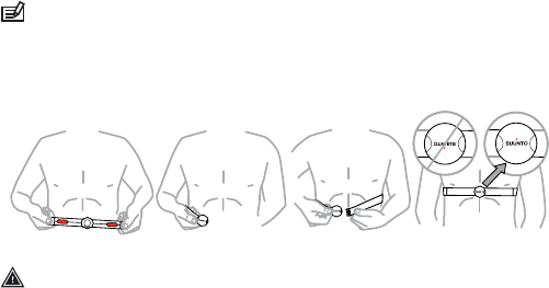
10.4 Putting on HR belt
NOTE: Suunto Ambit is compatible only with Suunto Dual Comfort Belt.
Adjust the strap length so that the HR belt is tight but still comfortable. Moisten
the contact areas with water or gel and put on the HR belt. Ensure the HR belt
is centered on your chest and the red arrow is pointing up.
1 2 34
WARNING: People who have a pacemaker, defibrillator, or other implanted
electronic device use the HR belt at their own risk. Before starting the initial use of
the HR belt, we recommend an exercise test under a doctor’s supervision. This
ensures the safety and reliability of the pacemaker and HR belt when being used
simultaneously. Exercise may include some risk, especially for those who have been
inactive. We strongly advise you to consult your doctor prior to beginning a regular
exercise program.
36

NOTE: HR belts with ANT icon ( ) are compatible with ANT compatible Suunto
wristop computers and with Suunto ANT Fitness Solution, while HR belts with IND
icon ( ) are compatible with most exercise equipment with inductive heart rate
reception. Your Suunto Dual Comfort Belt is both IND and ANT compatible.
NOTE: Suunto Ambit cannot receive the HR belt signal under water.
TIP: Machine-wash the heart rate belt regularly after use to avoid unpleasant
odor.
10.5 Setting exercise parameters
Setting HR limits
Go to Movescount to specify your upper and lower HR limits. Transfer the
settings to your device.
Peak Training Effect
Peak Training Effect is a parameter that indicates the impact of an exercise on
your maximal aerobic performance (VO2max).
Go to Movescount to select it to be displayed during your exercise. After you
have selected Peak Training Effect to be displayed, you can see the estimated
effect of the session on your peak performance on a scale of 1 to 5, from minor
to overreaching, during exercise.
NOTE: Peak Training Effect works best in medium to high intensity training at
a constant intensity level. It is not ideal for quantifying low intensity workouts. Base
37
en
endurance training, regardless of how long and tiring the session is, will have a
low Peak Training Effect.
EPOC
EPOC (Excess Post-exercise Oxygen Consumption) indicates the amount of
extra oxygen that your body needs to recover after exercise. Your body
consumes more oxygen after exercise than during rest. The higher the EPOC,
the more strenuous the exercise. EPOC is most useful in measuring the exercise
load in endurance sports, such as running and cycling.
To view the EPOC value of your exercise, go to Movescount after the exercise.
10.6 Starting exercise
To start exercising:
1. Moisten the contact areas and put on the HR belt (optional).
2. Press [Start Stop] to enter the exercise menu.
3. Press [Next] to enter EXERCISE.
4. Scroll the exercise mode options with [Start Stop] or [Light Lock] and select
a suitable mode with [Next]. (For more information about the exercise mode
options, see Section 10.1 Exercise modes on page 33.)
5. The device automatically starts searching for an HR belt signal. Wait for the
device to notify that the signal has been found, or press [Start Stop] to
exercise without an HR belt.
38

After the HR signal the device automatically starts searching for a GPS signal.
Wait for the device to notify that the GPS signal has been found, or press
[Start Stop] to exercise without GPS.
6. Press [Start Stop] to start recording your exercise. To access additional
exercise options, keep [Next] pressed (see Section 10.2 Additional options
in exercise modes on page 34).
10.6.1 Recording track logs
You can record a track log by using a GPS signal during your exercise.
Depending on the exercise mode you have selected, Suunto Ambit shows you
different information during the exercise. When you are recording a track log,
the recording icon and the GPS icon are shown on the upper part of the display.
Viewing saved tracks logs
To view a saved track log, press [View] after the exercise to view the summary.
To view the summary of your previous track log later:
1. Press [Start Stop] to enter the start menu.
2. Scroll to PREVIOUS EXERCISE with [Light Lock] and enter with [Next].
3. Scroll the summary views with [View].
NOTE: The content of the summary depends on the custom mode in use and
whether PODs or an HR belt have been used during the exercise.
Add use example!
39
en
10.7 During exercise
Suunto Ambit gives you additional information during your exercise. You can
define what information you want to see on the display. For information about
customizing the displays, see Chapter 5 Customizing Suunto Ambit on page 11.
Here are some ideas on how to use the device during exercise:
●Press [Next] to see additional information in real time.
●Press [View] to see additional views during exercise.
●To avoid accidentally stopping your stopwatch, lock the buttons by keeping
[Light Lock] pressed.
●Press [Start Stop] to pause recording. To resume recording, press [Start
Stop] again.
The additional information varies depending on the exercise type you have
selected, see Section 10.1 Exercise modes on page 33. You will also get more
information, if you use an HR belt and a GPS during the exercise.
10.7.1 Making laps
During your exercise, you can make laps either manually, or automatically by
setting the autolap interval in Movescount. When you are making laps
automatically, Suunto Ambit records the laps based on the distance you have
specified in Movescount.
To make laps manually, press [Back Lap] during the exercise. Suunto Ambit
shows you the split time in the first row, the lap number in the second row and
the lap time in the third row of the display.
40

NOTE: The exercise summary always shows at least one lap, your exercise from
start to finish. The laps you have made during the exercise are shown as additional
laps.
Add use example!
10.8 After exercise
To stop recording and view the summary information:
1. Keep [Start Stop] pressed to stop and save the exercise.
Alternatively, you can press [Start Stop] to pause the recording and press
[Back Lap] to stop the log recorder. Press [Start Stop] to save the exercise
log. If you do not want to save the log, press [Light Lock].
2. Press [View] to view the exercise summary.
To view the summary of your previous exercise later:
1. Press [Start Stop] to enter the start menu.
2. Scroll to PREVIOUS EXERCISE with [Light Lock] and enter with [Next].
3. Scroll the summary views with [View].
10.8.1 After exercise with HR belt
When you use an HR belt during the exercise, the summary includes the
following information:
●start time and date of the log
●duration
●number of laps
●average heart rate
●maximum heart rate
41
en
●heart rate graph
●calories burned
●recovery time
●Peak Training Effect
10.8.2 After exercise without HR belt
When you exercise without an HR belt, the summary includes the following
information:
●start time and date of the log
●duration
●number of laps
●distance (exercise with GPS)
●average speed (exercise with GPS)
●ascent
●descent
10.8.3 After exercise with GPS
When you use a GPS during the exercise, the summary includes the following
information:
●start time and date of the log
●duration
●number of laps
●distance
●average speed
42

11 ADJUSTING SETTINGS
To access and adjust the settings:
1. Keep [Next] pressed to enter the settings menu.
2. Scroll the settings menu with [Start Stop] and [Light Lock].
3. Press [Next] to enter a setting.
4. Press [Start Stop] and [Light Lock] to adjust the setting values.
5. Press [Back Lap] to return to the previous view in the settings, or keep [Next]
pressed to exit the settings.
You can adjust the following settings:
PERSONAL settings
●Weight
●Max HR
GENERAL settings
Formats:
●Unit system: metric, imperial, advanced
●Time format: 12 h or 24 h
●Date format: dd.mm.yy, mm/dd/yy
Time/date:
●Dual time: hours and minutes
●Alarm: on/off, hours and minutes
●Time: hours and minutes
●Date: year, month, day
Tones/display:
●Invert display: inverts the display colours
43
en
●Tones:
○All tones on: button tones and system tones are activated
○Button tones off: only system tones are activated
○All tones off: all tones are off
●Backlight:
○Mode: normal, night, off
○Brightness: adjust backlight brightness (in percentages)
Compass:
●Calibration: start compass calibration
●Declination: set the compass declination value
Location format:
●Hddd.ddddd°
●Hddd°mm.mmm’
●Hddd°mm’ss.s”
●UTM
●MGRS
ALTI-BARO settings
●Profile: Altimeter, Barometer, Automatic
●Reference: altitude, sea level
PAIR settings
●Bike POD: pair a Bike POD
●HR belt: pair a HR belt
●Cadence POD: pair a Cadence POD
44

11.1 Sleep mode
To put the device into sleep mode:
1. Keep [Start Stop] and [Light Lock] pressed simultaneously untill the device
enters the service menu.
2. Scroll to ACTION with [Light Lock] and enter with [Next].
3. Press [Next] to select Sleep mode.
4. Press [Start Stop] to confirm.
5. Press any button to activate the device again.
11.2 Changing language
The default language in Suunto Ambit is English. To change the language,
connect the device to your computer and download additional language packs
from Movescount. The available languages are French, Spanish and German.
45
en
12 PAIRING POD/HR BELT
Pair Suunto Ambit with optional Suunto PODs (Suunto Bike POD, HR belt or
Cadence POD) to receive additional speed and distance information during
training. Suunto Ambit is compatible with Suunto Dual Comfort Belt.
The HR belt and/or POD included in your Suunto Ambit package are already
paired. Pairing is required only if you want to use a new HR belt or a speed POD
with the device.
You can pair up to three Suunto speed and distance PODs with Suunto Ambit.
If you pair more than three PODs, only the latest three will be paired.
To pair a POD/HR belt:
1. Keep [Next] pressed to enter the settings.
2. Scroll to PAIR with [Light Lock] and enter with [Next].
3. Scroll the accessory options Bike POD, HR belt and Cadence POD with
[Start Stop] and [Light Lock].
4. Press [Next] to select the POD or HR belt and start pairing.
5. Turn on your POD or HR belt (see the instructions below). See the POD
manual for more information. Hold the POD/HR belt close to the device
and wait for the device to notify that the POD/HR belt has been paired.
If the pairing fails, press [Start Stop] to retry, or [Light Lock] to return to the
pairing setting.
Example: Pairing Suunto Dual Comfort Belt
1. Remove the HR belt battery.
2. Reset the HR belt by inserting the battery positive side down.
3. In your Suunto Ambit, follow the steps 1-4 from the instructions above.
46

4. Re-insert the belt battery positive side up and close the belt cover. Wait for
the device to notify that the POD/HR belt has been paired.
5. If the pairing fails, press [Start Stop] to retry, or [Light Lock] to return to the
pairing setting.
Troubleshooting
If the HR belt pairing fails, try the following:
1. Remove the battery from the belt.
2. Re-insert the battery upside down to reset the HR belt and remove the
battery again.
3. Scroll to the device's pairing option.
4. Insert the battery in the HR belt the right side up.
12.1 Calibrating POD
Calibrate Suunto Foot POD Mini or Suunto Bike POD with Suunto Ambit for
accurate speed and distance measurement. Perform the calibration on an
accurately measured distance, for instance, on a 400 m running track.
To calibrate Suunto Foot POD Mini with Suunto Ambit:
1. Attach Suunto Foot POD Mini to your shoe. For more information, see
Suunto Foot POD Mini Quick Guide.
2. Select an exercise mode to connect Suunto Ambit with Suunto Foot POD
Mini.
3. Start running at your usual pace. When you cross the starting line, press
[Start Stop] to start recording.
4. Run a distance of 800–1000 meters (about 0.500–0.700 miles) at your usual
pace (for example two laps on a 400 m track).
5. Keep [Start Stop] pressed when you reach the finish line.
47
en
6. Scroll with [Next] through the summary views, until you reach the distance
summary. Adjust the distance shown on the display to the actual distance
you ran with [Start Stop] and [Light Lock]. Confirm with [Next].
7. Confirm the POD calibration by pressing [Start Stop]. Your Foot POD Mini
has now been calibrated. You can also calibrate your Suunto Bike POD in
a similar way.
To calibrate Suunto Bike POD in Movescount, set the bike tire circumference
in Movescount. Movescount calculates a calibration factor. The default
calibration factor is 1.0, which stands for a 26” cross-country bike tire.
48

13 ICONS
Icons
The following icons are displayed in Suunto Ambit:
●Barometer
●altimeter
●chronograph
●settings
●signal strength
●pairing
●heart rate
●excercise mode
●alarm
●button lock
●battery
●current screen
●button indicators
●up/increase
●next/confirm
●down/decrease
Waypoint icons
The following waypoint icons are available in Suunto Ambit:
●building/home
●car/parking
●camp/camping
●food/restaurant/cafe
49
en
●lodging/hostel/hotel
●water/river/lake/coast
●mountain/hill/valley/cliff
●forest
●crossroad
●sight
●begin
●end
●geocache
●waypoint
●road/trail
●rock
●meadow
●cave
50

14 TERMINOLOGY
With AUTOLAP, you can define laps in distance instead of time
(interval training).
Autolap
A datum is a mathematically defined reference surface that
approximates the shape of the earth, and enables calculations
such as position and area to be carried out in a consistent and
accurate manner. Every map has a datum or metric grid. You
have to set your Suunto Ambit to the correct datum/grid for
it to function properly with the map.
Datum
The way in which the GPS receiver's position will be displayed
on the wrist unit. Commonly displayed as latitude/longitude
in degrees and minutes, with options for degrees, minutes and
seconds, degrees only, or one of several grid formats.
Format
FusedSpeed is a unique combination of GPS and acceleration
sensor readings for more accurate running speed. The GPS
signal is adaptively filtered based on acceleration, giving a
more accurate reading at steady running speeds and a quicker
response to changes in speed. FusedSpeed is meant for running
and walking, not for other types of sports.
FusedSpeed
A grid system is a set of lines that cross each other at right
angles on a map. Grid systems allow you to locate or report
on a specific point on the map.
Grid
Interval timer enables you to set and follow different timed
intervals.
Interval timer
51
en
Peak Training Effect is a parameter that indicates the impact
of a training session on your maximal aerobic performance
(VO2max).
Peak Training
Effect
Traveling between two locations on a route with knowledge
of the current position in relation to the route.
Navigation
Exact map coordinates of a given position.Position
Route consists of a set of waypoints and can be created in
Movescount and transferred to the wrist unit.
Route
Overall time at any given point during the activity.Split time
Track is the path traversed by the user.Track
Position coordinates on a course stored in Suunto Ambit
memory.
Waypoint
52

15 CARE AND MAINTENANCE
Handle the unit with care – do not knock or drop it.
Under normal circumstances the device will not require servicing. After use,
rinse it with fresh water, mild soap, and carefully clean the housing with a moist
soft cloth or chamois.
Do not try to repair the unit yourself. Contact an authorized Suunto service,
distributor or retailer for any repair. Use only original Suunto accessories -
damage caused by non-original accessories is not covered by warranty.
15.1 Water resistance
Suunto Ambit is water resistant. Its water resistance is tested to 100m/330ft
according to ISO 2281 standard (www.iso.ch). This means that you can use
Suunto Ambit for swimming or other water sports activities but it should not
be used for scuba diving or freediving.
NOTE: Never push the buttons while swimming or in contact with water.
Pressing the buttons while the unit is submerged could cause the unit to
malfunction.
15.2 Charging the battery
Battery lifetime depends on how Suunto Ambit is used. Battery lifetime ranges
from 15 to 50 hours or more. With basic watch the battery lifetime can be up
to 30 days. For more information on battery life, see Chapter 16 Technical
specifications on page 56.
53
en
TIP: If the device is taking GPS fix each second, the battery lasts at least 15
hours. If the device is taking GPS fix only every 60 seconds, the battery duration is
50 hours.
The battery icon indicates the charge level of the battery. When the battery
level is less than 10 %, the battery icon blinks for 30 seconds. When the battery
level is less than 2 %, the battery icon blinks continuously.
KUVA: CHARGE LEVEL INDICATOR?
Charge the battery by attaching it to your computer with a USB cable, or charge
with a USB-compatible wall charger or solar panel charger. It takes
approximately 2 hours to charge an empty battery.
TIP: Go to Movescount to activate the power save function in GPS mode to
save battery life.
15.3 Replacing HR belt battery
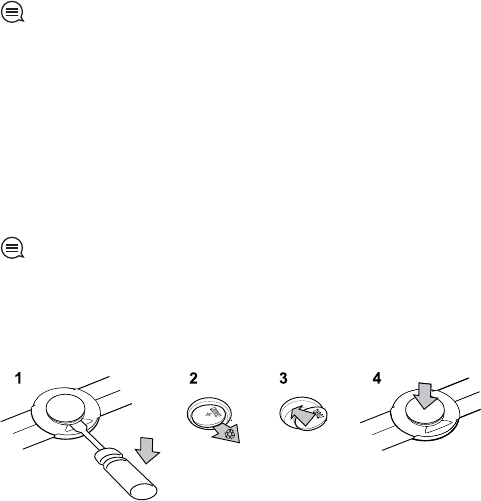
Replace the battery as illustrated here:
54

NOTE: Suunto recommends that the battery cover and the O ring are changed
simultaneously with the battery to ensure that the HR belt remains clean and water
resistant. Replacement covers are available with replacement batteries from your
authorized Suunto dealer or web shop.
55
en
16 TECHNICAL SPECIFICATIONS
General
●operating temperature: -20° C to +60° C/-5° F to +140° F
●battery charging temperature: 0° C to +35° C/+32° F to +95° F
●storage temperature: -30° C to +60° C/-22° F to +140° F
●weight: 76 g/2.68 oz
●water resistance (device): 100 m/328 ft (ISO 2281)
●water resistance (HR belt): 20 m/66 ft (ISO 2281)
●lens: Mineral crystal glass
●power: Rechargeable lithium-ion battery
●battery life
○~ 4.5 years (1 hour per day)
○~ 4 weeks (training without GPS)
○~ 1 week (45min training per day with GPS)
○~ 8 hours (constant training with GPS)
Memory
●routes: 50 routes (50 waypoints per route)
●waypoints: max. 500
●tracks: 25 tracks (max. 26000 track points)
●log time: max. 20 h
Transmission
●comfort belt: 2,465 GHz Suunto ANT compatible
●range: ~2 m/6 ft
56

Barometer
●display range: 300 to 1100 hPa/8.90 to 32.40 inHg
●resolution: 1 hPa/0.05 inHg
Altimeter
●display range: -500 m to 9000 m/-1500 ft to 29500 ft
●resolution: 1 m/3 ft
Thermometer
●display range: -20° C to +60° C /-4° F to +140° F
●resolution: 1° C/1° F
Chronograph
●resolution: 0.1 seconds accuracy
Compass
●resolution: 1 degree/18 mils
GPS
●technology: SiRF star IV
●resolution: 1 m/3 ft
●channels: 12
16.1 Trademark
Suunto Ambit, its logos, and other Suunto brand trademarks and made names
are registered or unregistered trademarks of Suunto Oy. All rights are reserved.
57
en
16.2 FCC compliance
This device complies with Part 15 of the FCC Rules. Operation is subject to the
following two conditions: (1) this device may not cause harmful interference,
and (2) this device must accept any interference received, including interference
that may cause undesired operation. Repairs should be made by authorized
Suunto service personnel. Unauthorized repairs will void warranty. This product
has been tested to comply with FCC standards and is intended for home or
office use.
16.3 CE
The CE mark is used to mark conformity with the European Union EMC directives
89/336/EEC and 99/5/EEC.
16.4 ICES
This Class [B] digital apparatus complies with Canadian ICES-003.
16.5 Copyright
Copyright © Suunto Oy 2012. All rights reserved. Suunto, Suunto product
names, their logos and other Suunto brand trademarks and names are
registered or unregistered trademarks of Suunto Oy. This document and its
contents are proprietary to Suunto Oy and are intended solely for the use of
clients to obtain knowledge and information regarding the operation of Suunto
products. Its contents shall not be used or distributed for any other purpose
and/or otherwise communicated, disclosed or reproduced without the prior
written consent of Suunto Oy. While we have taken great care to ensure that
information contained in this documentation is both comprehensive and
58

accurate, no warranty of accuracy is expressed or implied. This document
content is subject to change at any time without notice. The latest version of
this documentation can be downloaded at www.suunto.com.
16.6 Patent notice
This product is protected by pending patent applications and their
corresponding national rights: US 11/432,380, US 11/169,712, US 12/145,766,
US 7,526,840, US 11/808,391, USD 603,521, USD 29/313,029. Additional patent
applications have been filed.
16.7 Warranty
SUUNTO LIMITED WARRANTY
Suunto warrants that during the Warranty Period Suunto or a Suunto Authorized
Service Center (hereinafter Service Center) will, at its sole discretion, remedy
defects in materials or workmanship free of charge either by a) repairing, or b)
replacing, or c) refunding, subject to the terms and conditions of this Limited
Warranty. This Limited Warranty is only valid and enforceable in the country
of purchase, unless local law stipulates otherwise.
Warranty Period
The Limited Warranty Period starts at the date of original retail purchase. The
Warranty Period is two (2) years for display devices. The Warranty Period is one
(1) year for accessories including but not limited to PODs and heart rate
transmitters, as well as for all consumable parts.
59
en
Exclusions and Limitations
This Limited Warranty does not cover:
1. a) normal wear and tear, b) defects caused by rough handling, or c) defects
or damage caused by misuse contrary to intended or recommended use;
2. user manuals or any third-party items;
3. defects or alleged defects caused by the use with any product, accessory,
software and/or service not manufactured or supplied by Suunto;
4. replaceable batteries.
This Limited Warranty is not enforceable if item:
1. has been opened beyond intended use;
2. has been repaired using unauthorized spare parts; modified or repaired by
unauthorized Service Center;
3. serial number has been removed, altered or made illegible in any way, as
determined at the sole discretion of Suunto;
4. has been exposed to chemicals including but not limited to mosquito
repellents.
Suunto does not warrant that the operation of the Product will be uninterrupted
or error free, or that the Product will work with any hardware or software
provided by a third party.
Access to Suunto warranty service
You must have proof of purchase to access Suunto warranty service. For
instructions how to obtain warranty service, visit www.suunto.com/warranty,
contact your local authorized Suunto retailer, or call Suunto Help Desk +358
2 2841160 (national or premium rates may apply).
60

Limitation of Liability
To the maximum extent permitted by applicable mandatory laws, this Limited
Warranty is your sole and exclusive remedy and is in lieu of all other warranties,
expressed or implied. Suunto shall not be liable for special, incidental, punitive
or consequential damages, including but not limited to loss of anticipated
benefits, loss of data, loss of use, cost of capital, cost of any substitute
equipment or facilities, claims of third parties, damage to property resulting
from the purchase or use of the item or arising from breach of the warranty,
breach of contract, negligence, strict tort, or any legal or equitable theory, even
if Suunto knew of the likelihood of such damages. Suunto shall not be liable
for delay in rendering warranty service.
61
en
62
Index
A
after exercise, 41, 42
GPS, 42
with HR belt, 41
without HR belt, 42
alarm, 16
Alti & Baro mode, 24
Altimeter profile, 27
Automatic profile, 29
Barometer profile, 28
correct readings, 24
incorrect readings, 25
profiles, 26
recording altitude, 27
reference value, 26
reference values, 27
altitude reference value, 27
B
backlight, 9
battery
charging, 53
button lock, 9
buttons, 8
C
calibrating
compass, 30
PODs, 47
charging the battery, 10
compass, 30
calibrating, 30
declination value, 31
connecting to web, 11
customizing, 11
custom modes, 13
D
dual time, 16
during exercise, 40
E
EPOC, 38
Exercise mode
after exercise, 41, 42
during exercise, 40
starting exercise, 38
63
exercise modes, 33
additional options, 34
F
FusedSpeed, 20
G
GPS, 18
troubleshooting, 19
H
heart rate belt, 35, 36
HR belt
pairing, 46
I
icons, 49
waypoint, 49
inverting display, 14
L
language, 45
laps, 40
location, 21
location formats, 19
M
Movescount, 11
N
navigating, 22
troubleshooting, 19
P
pairing, 46
Peak Training Effect, 37
PODs
calibrating, 47
pairing, 46
PTE, 37
R
recording altitude, 27
S
sea level pressure value, 27
service menu, 45
settings, 43
alarm, 16
date, 16
dual time, 16
time, 15
sleep mode, 45
starting exercise, 38
64