Teletrac BTLTRC GSM / GPRS Vehicle Tracking Unit User Manual Unit Five
Teletrac Inc GSM / GPRS Vehicle Tracking Unit Unit Five
Teletrac >
Contents
- 1. Users Manual 1
- 2. Users Manual 2
- 3. Users Manual 3
- 4. Users Manual 4
- 5. Users Manual 5
Users Manual 3

Teletrac, Inc. - Prism TM2 Information and Installation Guide
--------------Unit Two--------------
THE GPS AND GPRS SYSTEMS
There are two systems that the Prism TM2 uses outside of the Teletrac system. One is the
Global Positioning System, more commonly called GPS and the other is the General Packet
Radio System otherwise known as GPRS. The following pages will give you a basic introduction
to where these systems came from as well as how they work. At the end of this section will be a
summary of how Teletrac uses these two systems together to get the location of a vehicle.
GLOBAL POSITIONING SYSTEMS (GPS)
The following information was taken from information posted to the Teletrac Intranet. Included
here is the abridged version of GPS. The full text appears in Appendix A at the end of this
Information Guide.
AN INTRODUCTION TO GLOBAL POSITIONING SATELLITE SYSTEMS
Global Positioning Systems
GPS uses "man-made stars" or satellites as reference points to calculate positions on Earth
accurate to within meters. In fact, with advanced forms of GPS you can make measurements to
better than a centimeter. In a sense, it's like giving every square meter on the planet a unique
address.
Since GPS receivers have been miniaturized to just a few integrated circuits and have become
very economical, the technology has become increasingly accessible.
Here's how GPS works in five logical steps:
Here is a summary of each of the steps involved with GPS in order to determine a location. This
is the first part of Teletrac finding the locations of vehicles using a Prism TM2. Once a location is
determined then it is sent via another system. We'll explain each of the following points in the
next five sections.
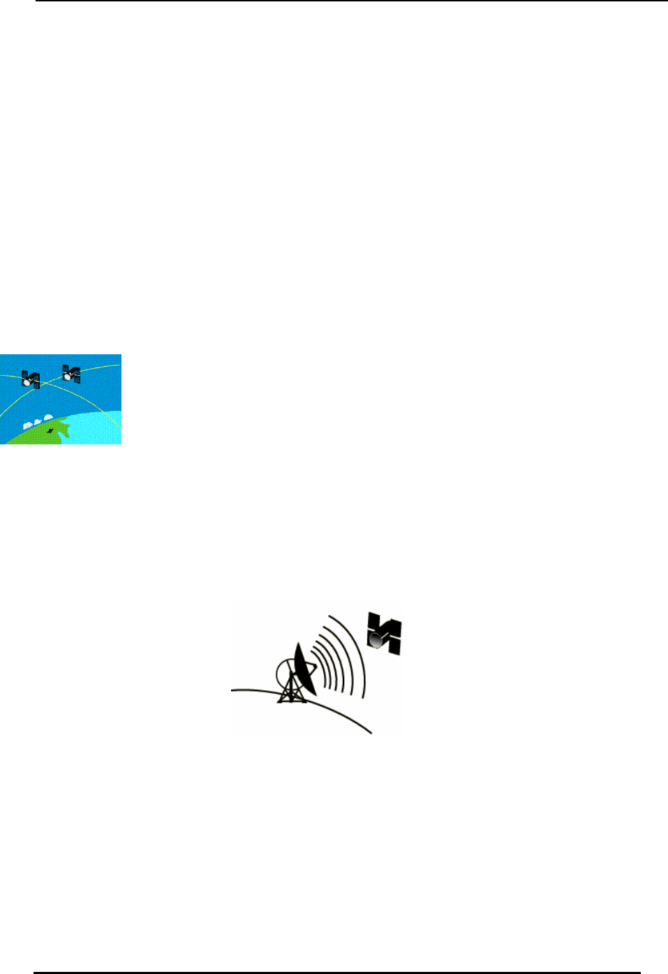
1. The basis of GPS is "triangulation" from satellites.
2. To "triangulate," a GPS receiver measures distance using the travel time of radio
signals.
3. To measure travel time GPS needs very accurate timing, which it achieves with
some tricks.

Teletrac, Inc. - Prism TM2 Information and Installation Guide
4. Along with distance, you need to know exactly where the satellites are in space.
High orbits and careful monitoring are the secret.
5. Finally you must correct for any delays the signal experiences as it travels
through the aTM2osphere.
Step 1: Triangulating from Satellites
Improbable as it may seem, the whole idea behind GPS is to use satellites in space as reference
points for locations here on earth. That's right, by very, very accurately measuring our distance
from three satellites we can "triangulate" our position anywhere on earth.
Step 2: Measuring Distance from a Satellite
But how can you measure the distance to something that's floating around in space? We do it by
timing h arrive at our receiver.
a s se the le thing boils down to those "velocity times travel time" math problems we did
es 60 miles per hour for two hours, how far does it
f GPS we're measuring a radio signal so the velocity is going to be the speed of
ng the travel time of a radio signal is the key to GPS, then our stop watches had better
because if their timing is off by just a thousandth of a second, at the speed of light,
n locate a point in 3-dimensional space, then four
ow long it takes for a signal sent from the satellite to
THE BIG IDEA, MATHEMATICALLY
In en , who
in high school. Remember the old: "If a car go
travel.?"
Velocity (60 mph) x Time (2 hours) = Distance (120 miles)
In the case o
light, or roughly 186,000 miles per second.
Step 3: Getting Perfect Timing
If measuri
be darn good
that translates into almost 200 miles of error!
The secret to perfect timing is to make an extra satellite measurement.
That's right, if three perfect measurements ca
imperfect measurements can do the same thing.
1622-0300 B2-5 05 2006 2
Teletrac, Inc. - Prism TM2 Information and Installation Guide
EXTRA MEASUREMENT CURES TIMING OFFSET
If everything were perfect (i.e. if our receiver's clocks were perfect) then all of our satellite ranges
uld intersect at a sing ur position). But with imperfect clocks, a fourth
ct with the first three.
ceiver looks for a
to all the rest of its measurements, and now we've got
wing Where a Satellite is in Space
all GPS receivers have an almanac programmed into their computers that tells
the sky each satellite is, moment by moment.
tes are constantly
onitored by the DeparTM2ent of Defense.
They use very precise radar to ch s exact altitude, position and speed.
wo le point (which is o
measurement, done as a cross-check, will NOT interse
So the receiver's computer says "Uh-oh! There is a discrepancy in my measurements. I must not
be perfectly synced with universal time."
Since any offset from universal time will affect all of our measurements, the re
single correction factor that it can subtract from all its timing measurements that would cause
them all to intersect at a single point.
That correction brings the receiver's clock back into sync with universal time, and bingo! - you've
got atomic accuracy time right in the palm of your hand.
Once it has that correction it applies
precise positioning.
Step 4: Kno
On the ground
them where in
CONSTANT MONITORING ADDS PRECISION
The basic orbits are quite exact but just to make things perfect, the GPS satelli
m
eck each satellite'
1622-0300 B2-5 05 2006 3
Teletrac, Inc. - Prism TM2 Information and Installation Guide
GETTING THE MESSAGE OUT
Once the DoD has measured a satellite's exact position, they relay that information back up to the
satellite itself. The satellite then includes this new corrected position information in the timing
signals it's broadcasting.
Step 5: Correcting Errors
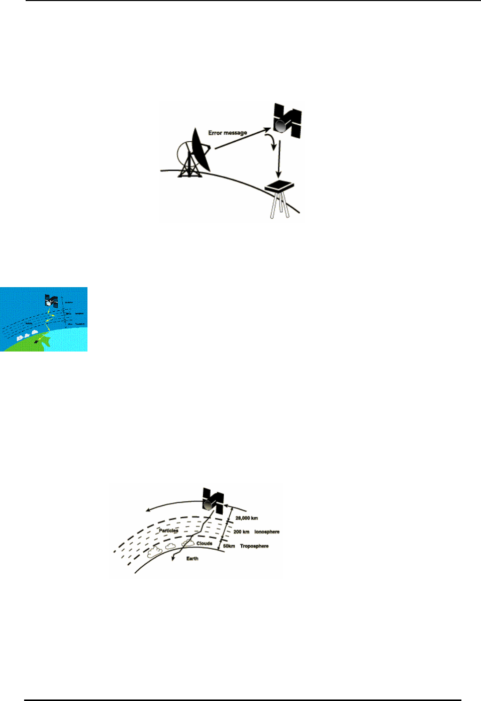
ROUGH TRIP THROUGH THE ATM2OSPHERE
First, one of the basic assumptions we've been using throughout this tutorial is not exactly true.
We've been saying that you calculate distance to a satellite by multiplying a signal's travel time by
the speed of light. But the speed of light is only constant in a vacuum.
As a GPS signal passes through the charged particles of the ionosphere and then through the
water vapor in the troposphere it gets slowed down a bit, and this creates the same kind of error
as bad clocks.
1622-0300 B2-5 05 2006 4
Teletrac, Inc. - Prism TM2 Information and Installation Guide
ROUGH TRIP ON THE GROUND
Trouble for the GPS signal doesn't end when it gets down to the ground. The signal may bounce
off various local obstructions before it gets to our receiver.
This is called multipath error and is similar to the ghosting you might see on a TV. Good receivers
use sophisticated signal rejection techniques to minimize this problem.
PROBLEMS AT THE SATELLITE
The atomic clocks they use are very, very precise but they're not perfect. Minute discrepancies
can occur, and these translate into travel time measurement errors.
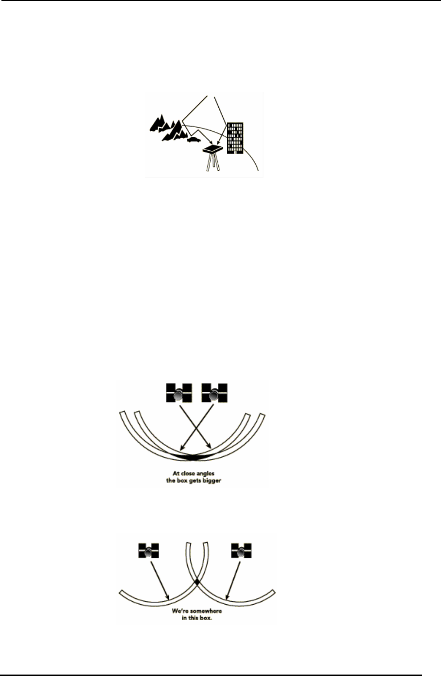
SOME ANGLES ARE BETTER THAN OTHERS
There are usually more satellites available than a receiver needs to fix a position, so the receiver
picks a few and ignores the rest.
If it picks satellites that are close together in the sky the intersecting circles that define a position
will cross at very shallow angles. That increases the gray area, or error margin, around a position.
Commonly refered to as HDOP.
If it picks satellites that are widely separated, the circles intersect at almost right angles and that
minimizes the error region.
1622-0300 B2-5 05 2006 5

Teletrac, Inc. - Prism TM2 Information and Installation Guide
Intentional Errors!
As hard , the same government that spent $12 billion to develop the most
accurate he world can cause errors by intentionally degrading its accuracy.
htly erroneous orbital
e a decryption key to remove the SA errors and so they're much more accurate.
as it may be to believe
navigation system in t
The policy is called "Selective Availability" or "SA" and the idea behind it is to make sure that no
hostile force or terrorist group can use GPS to make accurate weapons.
Basically the DoD introduces some "noise" into the satellite's clock data which, in turn, adds noise
(or inaccuracy) into position calculations. The DoD may also be sending slig
data to the satellites which they transmit back to receivers on the ground as part of a status
message.
Together these factors make SA the biggest single source of inaccuracy in the system. Military
receivers us
Note: As of Spring 2000, the DoD eliminated the intentional error in the calculation, however, this
may come back at any time.
The Bottom Line
Fortuna uracies still don't add up to much of an error, and a form of GPS
called "Differential GPS" can significantly reduce these problems.
PRS
nd system used by the Prism TM2 is the General Packet Radio System, more
called GPRS. This system is meant to be an invisible link from a mobile unit, such as
M2l
tely, all of these inacc
G
The seco
commonly
a wireless modem, to land line systems. The next few pages will give you an introduction to
GPRS and how it works to transmit information.
The following information was taken from information posted to
http://www.rysavy.com/Articles/GPRS2/gprs2.hT and
http://www.geocities.com/mobile4g/gprs.hTM2l.
AN INTRODUCTION TO GENERAL PACKET RADIO SERVICE
What is GPRS?
GPRS o d connections to data networks via mobile technology. It is designed
to allow ternet access with continuous connectivity, and enables applications
How does GPRS work?
GPRS t bile devices and packet networks. Packets can be IP or
X.25, though with the Internet's popularity, operators and device vendors will probably emphasize
P
ffers packet-switche
faster and easier In
including multimedia messaging, wireless corporate intranet, remote control and maintenance of
appliances. It is also considered part of the migration to third generation (3G) mobile networks.
The advantages of GPRS technology allows users to stay connected to the Internet by using
packet switching technology, providing faster downloads as no time is spent attempting to access
a dial-up connection.
ransports packets between mo
IP. Mobile devices will have an IP address, either static or dynamic, and, once on the network, I
packets can originate from mobile devices and travel to external networks, such as the Internet or
privately connected intranets. IP packets from external networks will reach mobile devices, even
1622-0300 B2-5 05 2006 6
Teletrac, Inc. - Prism TM2 Information and Installation Guide
when moving. GPRS doesn't care what protocols operate above IP. This indifference enables all
standard Internet protocols to operate, including TCP, UDP, HTTP, Secure Sockets Layer (SSL),
and IPSec.
GPRS uses two essential new infrastructure elements, the Serving GPRS Support Node (SGSN)
and Gateway GPRS Support Node (GGSN). The SGSN, which connects to base-station
ay to s
o users actually connect to the network and send
data, and how does the network keep track of users as they move around? When users turn on
s requests using a packet random-access
channel. Channels are logical data paths consisting of predefined time slots in select GPRS radio
s
w base station's
coverage range. If the user travels out of one SGSN's coverage to another, then the old SGSN
ill
HE OVERALL TELETRAC PICTURE
GPS and GPRS, let’s talk about how Teletrac uses these
d messaging services to our customers. In Unit One we
ent
controllers, tracks the mobile station's location and sends data packets to and from the mobile
station. It forwards packets using a tunneling protocol to the GGSN, which acts as a gatew
external networks, such as the Internet or private intranets. An operator will have multiple SGSN
for different service areas, but needs only one GGSN for each external network it interconnects
with. The GGSN assigns IP addresses to mobile stations, and IP packets from external networks
route to the GGSN, which tunnels them to the appropriate SGSN for delivery to the mobile
station.
Architecture and protocols are fine, but how d
the GPRS device (GPRS PC Card modem) in a GPRS coverage area, the device first registers
with the network and then requests a Packet Data Protocol (PDP) context. The PDP context
activates an IP address for the device, generally a dynamic address assigned by the GGSN. At
this stage the device can send and receive data.
To actually send a packet of data, the device make
channels, and are the primary mechanism in the MAC layer. The network responds by assigning
a data-traffic channel for a temporary period sufficient to send the data packet. GPRS networks
use 200KHz radio channels, with each channel divided into eight time slots. Each time slot can
support 13Kbits/sec of throughput in today's networks (though options exist to increase data rate
to over 20Kbits/sec), and so actual user throughput will depend on the number of time slots a
user's device can handle and the particular service options from the carrier.
To support mobility, the GPRS device informs the SGSN when it's within a ne
and the new SGSN must collaborate and inform the GGSN of the user's new location. Users w
also be able to roam into networks operated by other GPRS carriers.
T
Now that you have an understanding of
systems in order to provide location an
talked about the components that make up the Prism TM2, now let’s talk about how those
components work together.
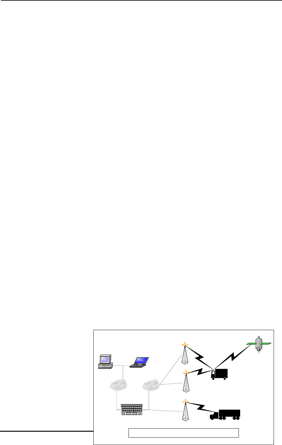
As shown in the diagram, a
computer running eCli
connects to the Teletrac NCC
via the Internet. The NCC is
where all the customer
databases are stored and
where customer location
requests are processed. From
there, the NCC contacts the
customer’s vehicles via the
Internet. The vehicles that use
GPS Satellite
GPRS Site
eClient
eClient
CDPD Site
Radio Tower
Teletrac NCC
Internet Internet
1622-0300 B2-5 05 2006 7
The three types of location systems Teletrac uses
VLUplus or VLU-G
RF VLU
Teletrac, Inc. - Prism TM2 Information and Installation Guide
GPS to determine their location send that information directly to the NCC and it is in turn sent
back to the eClient workstation.
The GPS receiver built into the Prism TM2 works to determine the location of itself. As long as
the receiver is able to see enough satellites it can tell the Prism TM2 where it is. If a vehicle
drives into an underground garage, inside a warehouse or even under an overpass, the receiver
may not be able to see enough, if any, satellites to determine it’s location. Since the signals
coming from the satellites to the receiver are very low they can easily be blocked, even dense
cloud cover can reduce the actual signal.
The GPS receiver will determine its
location every few seconds and store the
information. When the Prism TM2
Controller is contacted through the GPRS
modem, the Controller contacts the GPS
receiver and a request is made for its
location at a certain time. Once the
Controller receives the location information
from the GPS receiver, it relays the locate
to the Teletrac NCC via the GPRS modem.
Even if the GPRS modem cannot be
contacted by the NCC, the GPS receiver is
still collecting the information on where it is
located. When the GPRS modem is able
to communicate with the NCC, the Prism
TM2 will download the location information
that the GPS receiver has been providing.
GPRS Communication to NCC
Satellite
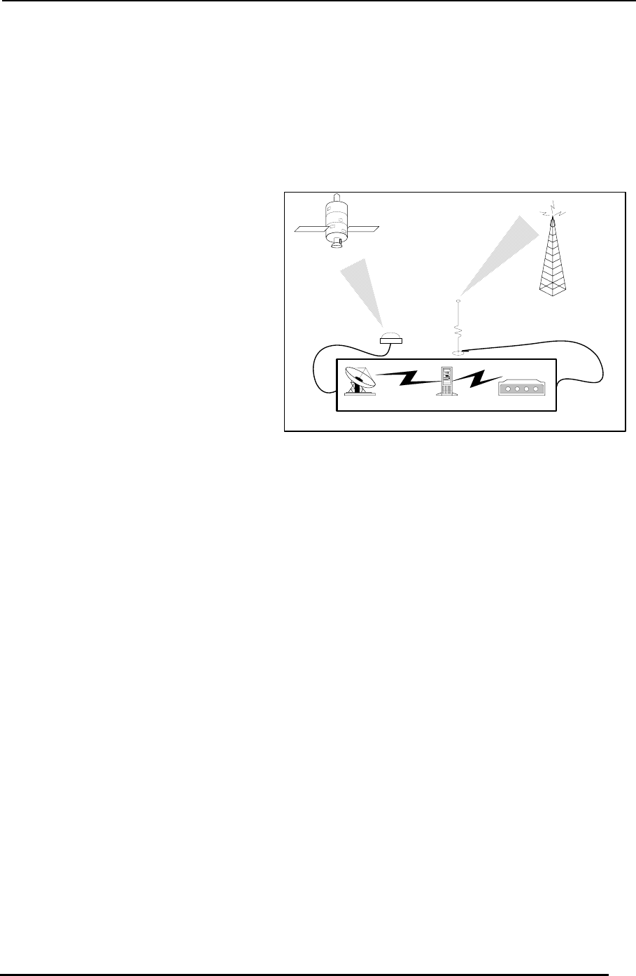
GPRS ModemControl BoardGPS Receiver
Location Unit
Now, lets say your driver is taking a lunch break under the awning of a drive-up restaurant. In
this location the GPS receiver probably cannot see enough satellites to determine it’s location. In
this event, when the controller requests a locate from the GPS receiver, the last known location
will be used. Since the receiver takes it’s own readings every few seconds the last known
location is probably just outside the restaurant awning. When it’s time to send in a locate to the
NCC, the Prism TM2 can still “pick up” the GPRS modem and contact the NCC. But, the only
location that will be returned is the last known location reported to the Prism TM2 Controller,
which was probably just outside the awning. This location will be reported as a poor quality
locate and display as the last known location.
Even though the GPS receiver is blocked, a dispatcher can still send messages to a driver. Since
the messages travel over the GPRS system they will be sent to the Prism TM2 and simply a poor
locate (last known location) will be returned to the dispatcher.
Lastly, the Prism TM2 can be set up to store events such as ignition on/off, messages and
location information when the GPRS modem is out of it’s coverage area. The events, messages
and locations can be stored in a memory buffer and later transmitted once the modem is able to
communicate. See the following chart to help explain what happens when each system is able to
operate or is blocked.
1622-0300 B2-5 05 2006 8