TranSystem 971260101 GPS Trip Recorder User Manual UserMan
TranSystem GPS Trip Recorder UserMan
UserMan
P/N:8029712601A
i-Blue747A+ Quick Installation Guide
[Notes and Warning] If you have recorded more than 150,000 way points in your serial Flash, it
may take an entire resource of your computer to show all the logged data in Google Earth.
Therefore, with not enough RAM capacity the computer may hang up (a system frozen).
Minimum Configuration Recommended Configuration
- Windows 2000, or XP
- Pentium 3, 500Mhz
- 128M RAM
- 400MB disk space
- Network speed: 128Kbits/sec
- 3D-capable video card with 16Mbytes of VRAM
- 1024x768, "16-bit High Color" screen
- Windows XP, or Vista
- Pentium 4 2.4GHz+ or AMD 2400xp+
- 1G RAM
- 2 GB of free disk space
- Network speed: 768 Kbits/sec or better (DSL/Cable)
- 3D-capable video card with 32 MB of VRAM or greater
- 1280x1024, "32-bit True Color" screen
Thank you for purchasing iBT-GPS 66-Channel Bluetooth GPS Data Logger. It provides capability up to
150,000 recorded data and supports Smart Power control for prolonged operation time.
a. Features
● Dual mode for both Data record and Navigation
● Push button to record interesting point manually.
● User can record the date by setting the interval of time,
distance and speed.
● 150,000 waypoints
●Semi indoor
●AGPS available
●Fuzzy Auto On/Off
●Phototagger software
b. Package content
● Bluetooth GPS Data Logger - iBT-GPS x 1
● USB to mini-USB cable x 1
● DC cigarette lighter adapter x 1
●Lithium rechargeable battery x 1
●CD Tool x 1 (user manual, software utility)
●Quick start guide x 1
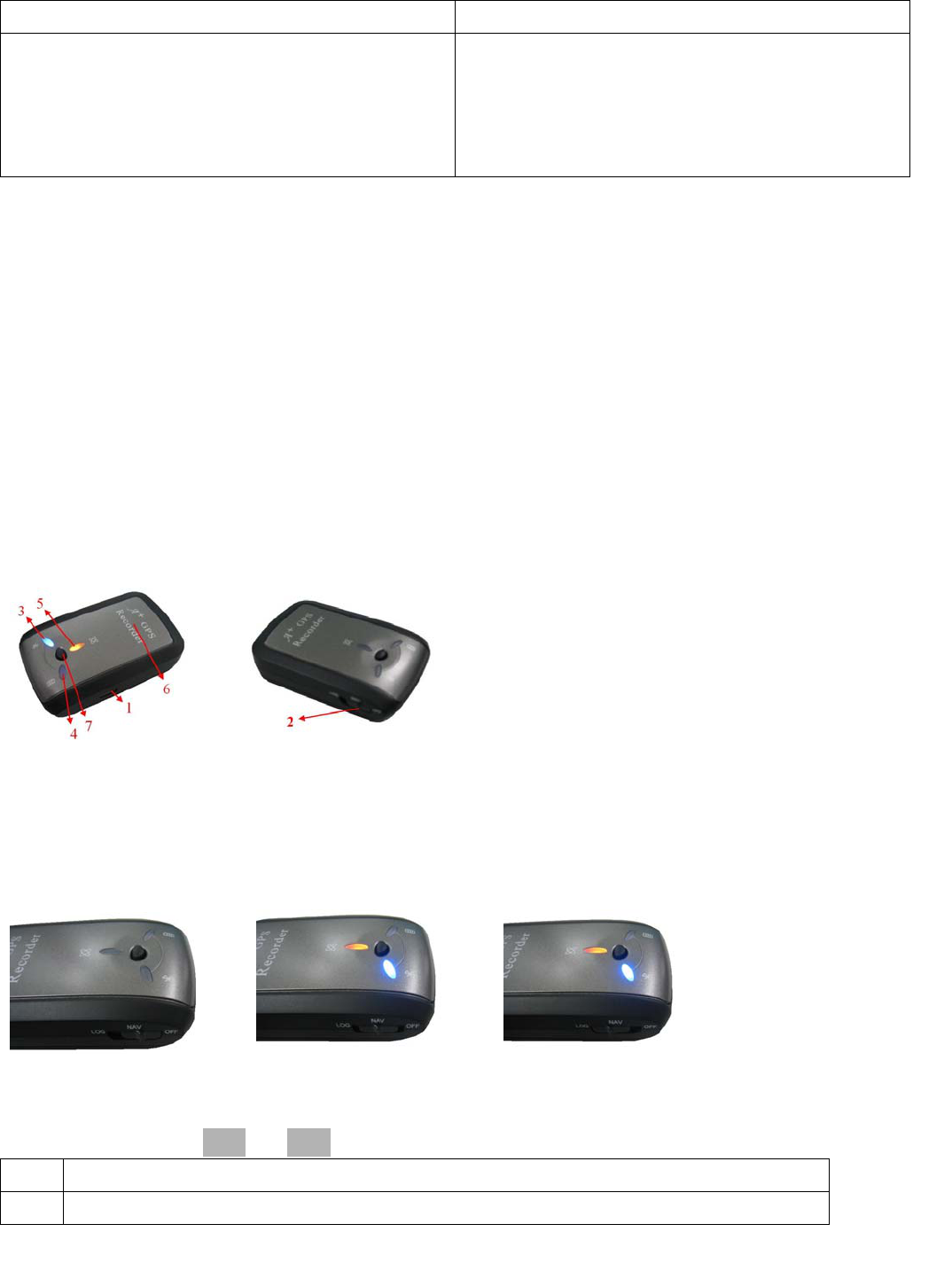
c. Appearance
1. DC jack (mini USB type)
2. Mode switch (Power off/ Navigation/ Navigation&log)
3. Bluetooth status LED (blue)
4. Battery status LED (red/green)
5. GPS status LED (orange) / Push to log LED (red)
6. Internal GPS antenna
7. Push Button
d. Getting Started
Step 1. Fully charge the battery when using at the first time
(When the green Power LED is off, the battery is fully charged.)
Step 2. Turning on the power switch
Power off Navigation Navigation & Data record
※Difference between NAV and LOG:
NAV Working as a Bluetooth GPS receiver.
LOG Both of navigation and logging functions are enabled.

P/N:8029712601A
Step 3. Connecting your handheld device with iBT-GPS
Step 4 Loading your GPS mapping or routing software
Step 5 Starting the application
e. How to connect the iBT-GPS to your PC (Playback your route)
Step 1. Google Earth installation (Download from http://earth .google.com/)
Step 2. Execute software utility --- GPS Photo Tagger and USB drivers installation (Refer to CD)
Step 3. For software utility how to use in detail--- Refer to Help > User Manual
Step 4. Build a connection between your PC and iBT-GPS data logger, see below:
Please press the Auto Scan button to build a connection. Or select correct COM Port, and set Baud Rate
at a fixed 115200. Then click on “Reconnect” to build a connection.
[Note] To display the track points on Google Earth, your PC must have the Internet connection
enabled.
f. Helpful tips
● It’s better to turn off the iBT-GPS when you don’t use it, otherwise it might still keep
recording data if you leave it in the log state.
● Some vehicles having heavy metallic sun protecting coating on windshields may affect GPS
signal receptions.
● Driving in and around high buildings may affect GPS signal receptions.
● Driving in tunnels or indoor park garage may affect signal receptions.
● In general, any GPS receiver performs best in open space where it can see clear sky. Also
weather will affect GPS reception – rain & snow contribute to worse sensitivity.
● Low battery of a PDA or of an iBT-GPS may affect signal receptions.
● Please check the correct “COM” and “Baud Rate” of your PDA to secure the Bluetooth
connection between iBT-GPS & PDA.
● iBT-GPS outputs data every second, therefore the actual position and the position shown in
your map may have slight time delay. This may happen when you drive at higher speed or
make a turn around a corner.
● For the 1st time you use the iBT-GPS, it will take 1 to 3 minutes to obtain the satellite
constellation information and fix your position, this is called “Cold Start”. If you replace the
battery, iBT-GPS will do Cold Start again.
● If your iBT-GPS can’t fix your position for more than 20 minutes, we suggest you change to
another spot with open space and then try again.
*Google Earth is a trademark of Google.
[Note] When you use AGPS function, we suggest use GpsView to download the AGPS data via USB
cable
This equipment also should be installed and operated with minimum distance 20cm between
the radiator & your body.