Raymarine A65hd A Series Brochure 12 Pgs User Manual 9a98b9cd Dd39 4adc B4fe D32737763622
User Manual: raymarine a65hd Raymarine Marine GPS System A65HD User Guide |
Open the PDF directly: View PDF ![]() .
.
Page Count: 4
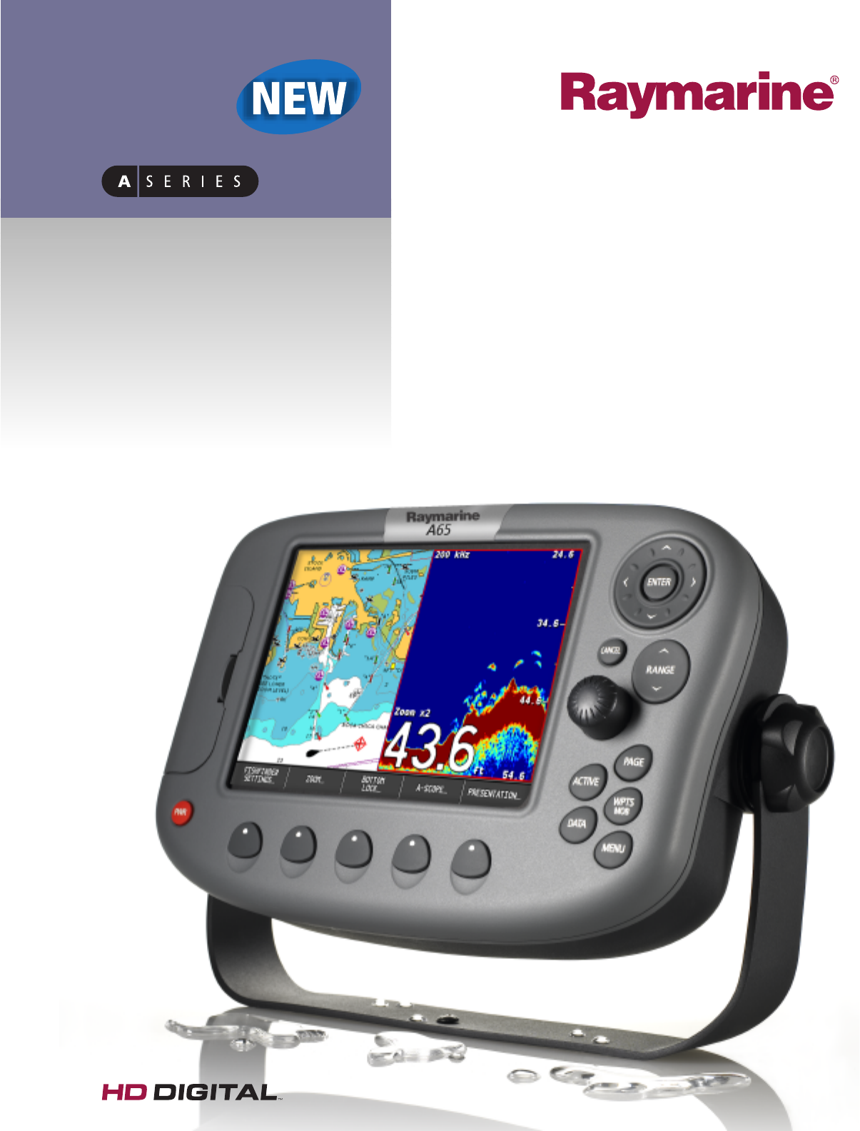
A65
HD Digital Dual Function
Chartplotter/Fishfinder
• 6.5” Sunlight Viewable display
• Patented HD Digital™fishfinder technology
• Charts included: Navionics®Silver continental
U.S. coverage on a single CompactFlash card
A65 DUAL FUNCTION DISPLAY
A compact, yet powerful navigation system, the A65 Dual Function
display combines simplicity with advanced chartplotting and HD
Digital™fishfinder technology. A direct sunlight viewable display
and rugged submersible construction make the A65 the perfect
choice for center consoles and open cockpits.
KEY DISPLAY FEATURES
• 6.5” Sunlight Viewable color display
• High resolution 640 x 480 pixels (VGA)
• Prismatic light enhancing display with a wide viewing angle
• Rugged submersible construction (IPX-7 standard)
• RS12 12 Channel Satellite Differential GPS receiver (WAAS/EGNOSS)
• NMEA 0183 Input and Output
• Plug and Play DSM25 Digital Sounder Module option
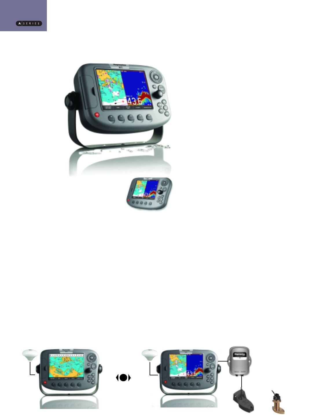
DUAL FUNCTION
Choose the A65 as a chartplotter or as a chartplotter/fishfinder.
Each A65 is supplied with the highly accurate RS12 GPS
antenna/receiver for navigation and chartplotting. The Dual Function
chartplotter/fishfinder package also includes the powerful DSM25
digital sounder module for HD Digital™fishfinder functionality.
Bracket Mount
Optional Flush Mount
or
A65 Chartplotter System
HD Digital Ready
A65 Dual Function
Chartplotter/Fishfinder System
A65 DUAL FUNCTION FISHFINDER/CHARTPLOTTER
Optional Transducer
Optional thru-hull and in-hull transducers
available.Visit our website
www.raymarine.com to learn more.
Complete system includes A65 display,
RS12 GPS sensor, DSM25 digital sounder
module,and transom transducer
A65 DUAL FUNCTION FISHFINDER/CHARTPLOTTER
CHARTPLOTTER
Each A65 is supplied with Navionics®Silver coastal cartography for the
continental US (including Great Lakes). Simply place the high capacity
Navionics®Silver CompactFlash card in the A65 and detailed marine
charts of the entire U.S. are at your fingertips. Seamless chart
technology ensures a clutter free,yet detailed chart presentation with
tides, currents, shaded depth contours, navigation aids, spot soundings
and more.
KEY CHARTPLOTTER FEATURES
• Ready-to-go Navionics®Silver coastal chart coverage for the continental
US on a single CompactFlash card (US version only)
• Navionics XL3 Gold chart and Hot Maps compatible
• High speed chart redraw
• 1,000 waypoints and 50 routes with unlimited waypoint and route
storage using optional CompactFlash memory cards
• Chart rotation modes (Head up,Course up and North Up)
• Chart screen offset for a maximum “look ahead” chart display
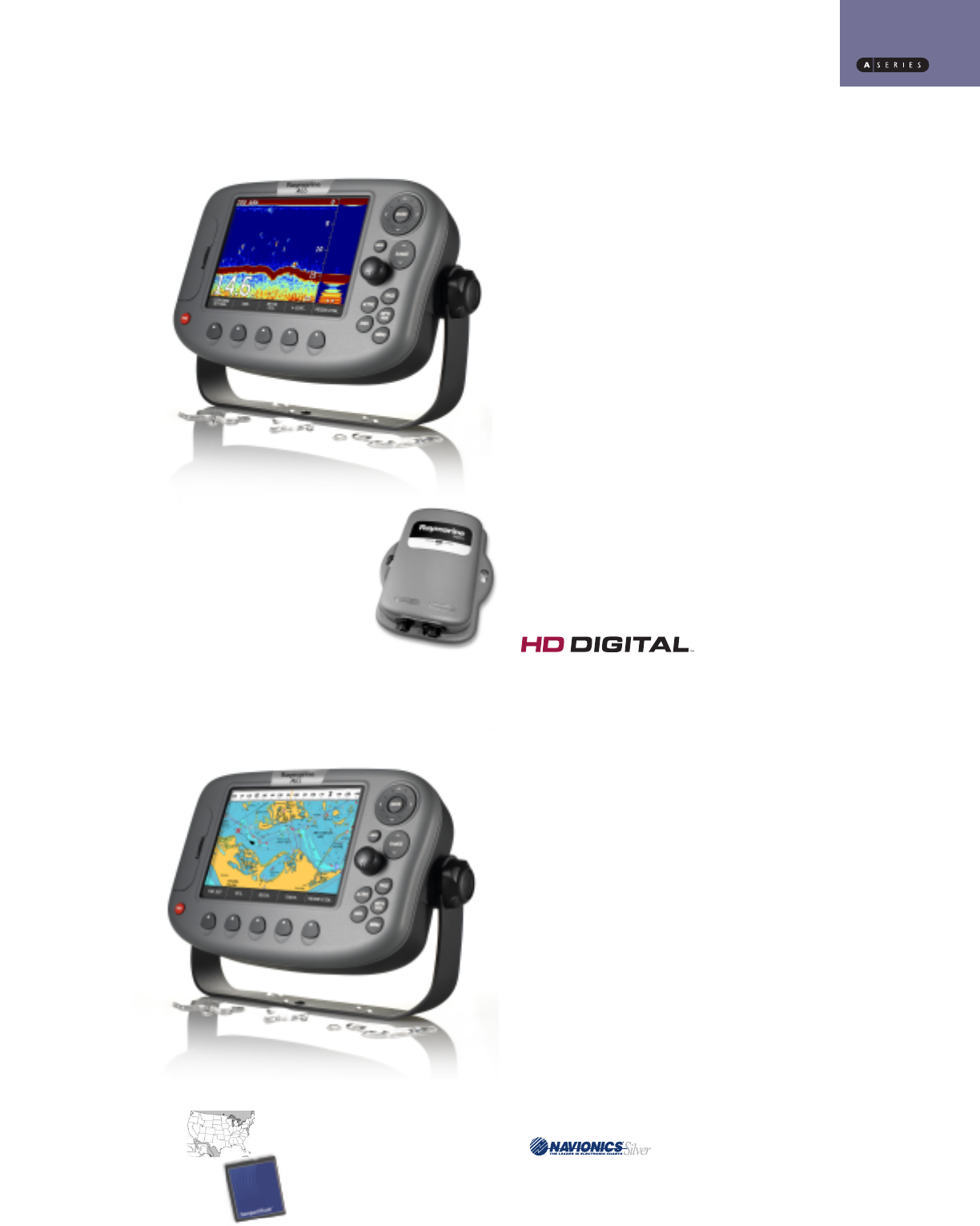
HD DIGITAL FISHFINDER
Harnessing the power of Raymarine’s HD Digital™fishfinder technology,
the A65 and the DSM25 digital sounder module offer unmatched
fishfinder clarity and precision. Raymarine’s patented HD Digital™
technology enables the DSM25 to instantly adapt to changing water
and seabed conditions, delivering a dramatically clearer picture than
ordinary analog fishfinders. Plus HD Digital™technology enables true
“hands-free” automatic operation for an optimal fishfinder display at
all times.
KEY FISHFINDER FEATURES
• Enhanced fishfinder performance using the remotely mounted
DSM25 Digital Sounder Module
• 500 Watts RMS output power
• Dual frequency (50/200 kHz) for excellent inshore and offshore
performance
• Hands-free HD Digital™technology automatically adjust more than
220 sonar parameters per second and virtually eliminates clutter
• HD Digital™adaptive receiver technology precisely targets fish and
bottom structure with amazing clarity
• Transom, In-Hull, Trolling motor and thru-hull transducer options
B&W version (Navionics = 100% Black) (’Silver’ = 30% Black)
4/C version (’Navionics’ = PMS#281) (’Silver’ = PMS#7543)
Banner 4/C version (’Navionics’ = white) (’Silver’ = PMS#7543)
Charts Included!
The A65 is supplied with coastal chart coverage
for the continental United States on a single
CompactFlash card.
DSM25
A65
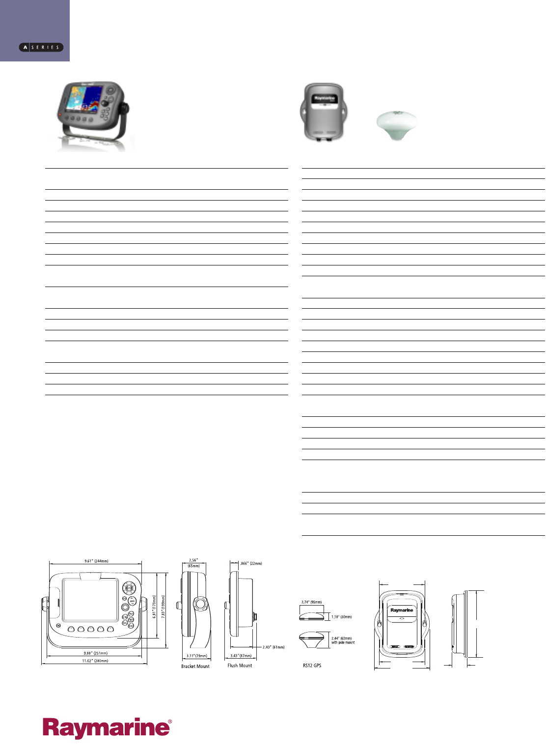
Dimensions (W x H x D) 9.61 x 6.81 x 2.40 in. (244 x 173 x 61mm), dash mounted
11.0 x 7.83 x 3.11 in (280 x 199 x 79 mm), bracket mounted
Weight 2.25 lbs (1.02 kg), dash mounted 3.09 lbs (1.40 kg), bracket mounted
Mounting Bracket with flush mount option
Power External 10.7 - 32 VDC required, 13.8 VDC nominal
Consumption with full brightness: 9 W
Waterproofing IPX-7; suitable for external mounting
Display 6.5 in Color TFT LCD 640 x 480 pixels (VGA)
Display Windows Chart, Fishfinder and Data
Languages UK English, US English, Danish, Dutch, Finnish, French, German, Icelandic,
Italian, Norwegian, Portuguese, Russian, Spanish, Swedish
System Alarms Alarm clock, Anchor, Arrival, Deep depth, MOB, Offtrack,
Shallow depth, Temperature, Timer
Interfaces RS12 GPS Antenna
DSM25 Sounder NMEA0183, receive and transmit
CompactFlash card slot
Cartography Navionics Silver coastal chart coverage for the continental United States
on a single CompactFlash card
Chart of the world built in
Modes Head up, Course up or North up (selectable True or Magnetic)
Relative or True Motion
DSM 25
Dimensions (W x H x D): 6.77 x 8.19 x 1.85 in (172 x 208 x 47 mm)
Weight 13.7 oz (0.388 kg)
Mounting Bulkhead
Power Supplied by A65
Waterproofing IPX-7 Submersible
Output Power Adjustable to 500 watts RMS
Frequency Dual 50 kHz and 200 kHz
Pulse Length 100 µsec to 4 msec
Max. Trans-mit Rate 1580 pulses / min. @ 50’ range
Gain: Auto/manual
RS 12 GPS
Dimensions Diameter: 3.7 in (95 mm)
Height 1.2 in (30 mm); 2.4 in (62 mm) with pole mount kit
Weight 15.3 oz (0.435 kg)
Waterproofing CFR46
Receiver type SD-GPS, WAAS/EGNOS/MSAS ready, 12 parallel channels
Frequency 1575.42 MHz ±1 MHz (C/A code), L1
Sensitivity Tracking sensitivity: -152 dBm
Acquisition sensitivity: -139dBm
Signal acquisition:Automatic
Time to first fix (TTTF): Hot start < 6 seconds (typical); Warm start < 40
seconds (typical), Cold start < 60 seconds (typical)
Position accuracy 2DRMS ~ 2 m 95%
Speed accuracy 0.1 kts RMS
Geodetic datum WGS-84
Cable length 10 m (33 ft)
ORDERING INFORMATION
Order Number
E33020 A65 Chartplotter System with RS12 GPS (HD Digital Ready)
E63070 DSM25 Digital Sounder Module for the A65 (transducer sold separately)
E33023 A65 Dual Function Chartplotter/Fishfinder System Pack (includes A65, RS12
GPS,and transom mount transducer)
D7739-1
5.54 in (140.6 mm)
5.55 in (141 mm)
8.19 in
(208 mm)
1.85 in
(47 mm)
6.77 in (172 mm)
SPECIFICATIONS
Raymarine Incorporated
21 Manchester Street
Merrimack, NH 03054
USA
Tel: 603.881.5200
Fax: 603.864.4756
www.raymarine.com
Raymarine UK Limited plc
Quay Point, Northarbour Road
Portsmouth, Hampshire PO6 3TD
England
Tel: +44 (0)23 9269 3611
Fax: +44 (0)23 9269 4642
www.raymarine.com
Product specifications subject to change without notice.
