Garmin 01748 LOW POWER TRANSMITTER (2400-2483.5 MHz) User Manual
Garmin International Inc LOW POWER TRANSMITTER (2400-2483.5 MHz) Users Manual
Garmin >
Users Manual
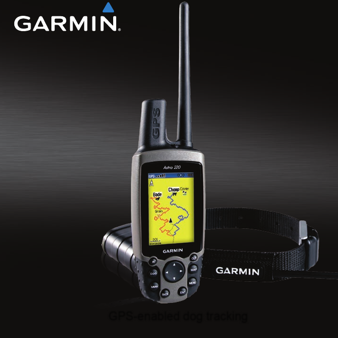
GPS-enabled dog tracking
Astro®
and DC™ 40
draft owner’s manual
New cover and
photo requested...

© 2010 Garmin Ltd. or its subsidiaries
All rights reserved. Except as expressly provided
herein, no part of this manual may be reproduced,
copied, transmitted, disseminated, downloaded
or stored in any storage medium, for any purpose
without the express prior written consent of Garmin.
Garmin hereby grants permission to download a
single copy of this manual onto a hard drive or
other electronic storage medium to be viewed and
to print one copy of this manual or of any revision
hereto, provided that such electronic or printed copy
of this manual must contain the complete text of
this copyright notice and provided further that any
unauthorized commercial distribution of this manual
or any revision hereto is strictly prohibited.
Information in this document is subject to change
without notice. Garmin reserves the right to change
or improve its products and to make changes in the
content without obligation to notify any person or
organization of such changes or improvements. Visit
the Garmin Web site (www.garmin.com) for current
updates and supplemental information concerning
the use and operation of this and other Garmin
products.
Garmin
®
, the Garmin logo, AutoLocate
®
, TracBack
®
,
BlueChart
®
g2, MotionBased
®
, City Navigator
®
, and
MapSource
®
are registered trademarks and Astro
™
is a trademark of Garmin Ltd. or its subsidiaries and
may not be used without the express permission of
Garmin.
This product includes technology owned by SiRF
Technology, Inc. SiRF’s technology is protected
by U.S. and foreign patents pending and issued.
SiRF, SiRFstar and the SiRF logo are registered
trademarks of SiRF Technology, Inc. SiRFstarIII and
SiRF Powered are trademarks of SiRF Technology,
Inc.
Windows
®
is a registered trademark of Microsoft
Corporation in the United States and/or other
countries. Macintosh
®
is a registered trademarks
of Apple Computer, Inc. microSD
™
is a trademark
of The SD Card Association. TransFlash
™
is
a trademark of SanDisk Corporation. Other
trademarks and trade names are those of their
respective owners.

Astro and DC 40 Owner’s Manual i
Table of Contents
Table of Contents
Introduction ............................ i
Tips and Shortcuts ........................ i
Product Registration ..................... i
Contact Garmin ............................ i
myGarmin ..................................... i
DC 40 Battery Warnings ............. iv
Getting Started ...................... 1
Unit Overview .............................. 1
Installing the Batteries in the
Astro ..........................................2
Using the Astro Keypad
Functions .................................. 3
Turning the Astro On ................... 4
Charging the DC 40 ..................... 4
Acquiring GPS Satellite Signals .. 5
Calibrating the Astro Compass .... 6
Operating the Astro...................... 6
Manual Conventions .................... 7
On-Screen Messages .................. 7
Dog Tracking ......................... 8
Communicating with the DC 40 ... 8
Tracking a Dog .......................... 10
Main Menu ........................... 14
Mark Location ..................... 15
Averaging a Marked Location .... 16
Projecting a Location ................. 16
Map Page ............................. 17
Map Page Options ..................... 17
Data Fields ................................ 18
Measuring Distance ................... 19
Find Features ...................... 20
Item Information Page Options .. 22
Using Optional Detailed Maps ... 22
POI Loader and Custom Points
of Interest ................................ 23
GPS Applications ............... 24
Using the Trip Computer............ 24
Using the Compass Page .......... 25
Using the Altimeter Page ........... 28
Using Tracks .............................. 30

ii Astro and DC 40 Owner’s Manual
Table of Contents
Creating Routes......................... 34
Using the Highway Page ................
37
Using Proximity Locations ......... 37
Using Turn Preview ................... 38
Using Active Route .................... 39
Using the Satellite Page ............ 39
Accessories ........................ 41
Calendar .................................... 41
Calculator .................................. 42
Stopwatch .................................. 42
Sunrise/Sunset .......................... 42
Hunting Almanac ....................... 43
Games ....................................... 43
Settings ............................... 44
System Setup ............................ 44
Dog List Setup ........................... 45
Dog Alerts Setup........................ 45
Display Setup ............................ 45
Tones Setup............................... 46
Main Menu Setup ...................... 46
Map Setup ................................. 46
Routing Setup ............................ 49
Geocache Setup ........................ 51
Marine Alarms Setup ................. 51
Time Setup ................................ 51
Units Setup ................................ 52
Heading Setup ........................... 52
Calibration Setup ....................... 53
Altimeter Setup .......................... 53
Appendix ............................. 54
Specications ............................ 54
Optional Accessories ................. 56
Transferring Data ....................... 56
Caring for the Astro System....... 60
Software License Agreement..... 61
Index .................................... 64
Astro and DC 40 Owner’s Manual 1
Introduction
Introduction
WARNING
See the Important Safety and Product
Information on page XX for product
warnings and other important
information.
Setting Up the Device
Whenusingyourdevicetherst
time, follow the setup instructions
in the Quick Start Manual.
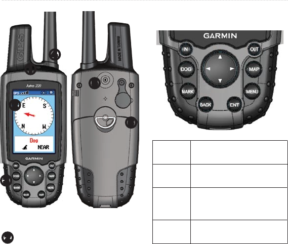
Device Overview
➊
Power key
➋
Display
➌
Keypad
➍
Belt clip button
➎
Wrist strap attachment slot
➏
Battery compartment
➐
microSD card tray under batteries
➑
VHF antenna
➒
GPS antenna
➓
USB port (under weather cap)
2 Astro and DC 40 Owner’s Manual
Introduction
➊
➋
➌
➍
➎
➏
➋
Battery charging port
Keypad
DOG Press to view the Dog
Tracker page.
MARK Press to mark your current
location.
BACK Press to cancel data entry or
return to the previous menu
or page.
MAP Press to view the map.

Astro and DC 40 Owner’s Manual 3
Introduction
MENU Press to open the menu for
the active page.
Press twice to open the main
menu.
ENT
(ENTER)
Press to select
options and acknowledge
messages.
Rocker Press to select options and
to move the map cursor.
IN Press to zoom in on
the map.
OUT Press to zoom out on
the map.
Battery life Tips go in the appendix?
To extend battery life of the Astro,
turn the unit off when you are not
using it, and decrease the level of
the display backlight (page 4).
To extend the DC 40 battery life,
turn the unit off when you are not
tracking a dog, or decrease the
update rate (page 11).
•
•
Turning the Astro On
Manual Conventions
Press Use the keys on the device.
Select Use the Rocker to select an
option or a button, and press
ENTER.
Field The location on a page
where data is entered or an
option appears. A highlighted
eld appears yellow.
Scroll
bar
A bar that appears on the
right side of a list that is too
long to t on the screen. Use
the Rocker to scroll through
a list. Press IN or OUT to
scroll a set of items.
Default The original factory settings.
You can customize the
settings, but you can
always revert back to the
factory settings by selecting
Restore Defaults.
•
4 Astro and DC 40 Owner’s Manual
Introduction
Wizard An on-screen guide to
performing functions that
require multiple steps and
options.
>The small arrows indicate
that you should select a
series of items in order, for
example, “Select Delete >
Yes.”
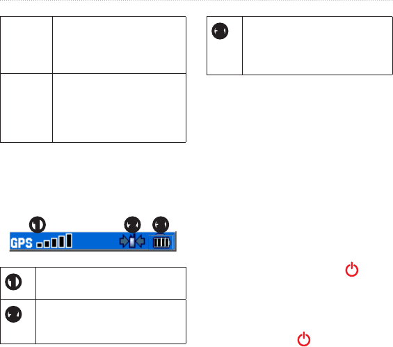
Status Bar Icons
The status bar at the top of each Astro
page provides status information.
➋ ➌➊
➊
Indicates the satellite signal
strength.
➋
Blinks when the unit detects a
signal (for example, a DC 40) on
the channel it is receiving.
➌
Indicates the remaining battery
power.
Indicates the Astro is powered by
an external source.
On-Screen Messages
When an on-screen message appears,
you can press ENTER to acknowledge
the message and close the window.
Messages also indicate temporary
conditions, such as “Calculating
Route.” The message window closes
as soon as the process is complete.
Adjusting the Backlight
1. Press and quickly release .
2. Use the Rocker to adjust the
brightness levels.
TIP: You can also press and
quickly release to cycle through
the brightness levels.

Astro and DC 40 Owner’s Manual 5
Introduction
3. Press ENTER to select a
brightness level and close the
menu.
6 Astro and DC 40 Owner’s Manual
Dog Tracking
Dog Tracking
This section describes communications
between the DC 40 and the Astro,
tracking dogs on the map, and adding
dogs to the Dog List.
Communicating with the
DC 40
The DC 40 that was packaged with
your Astro System was linked with the
Astro at the factory. If you are using
a DC 40 that you ordered separately,
follow the instructions for adding
a new dog on page 10 to establish
communications with the Astro.
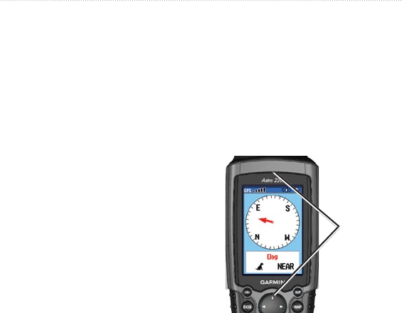
Viewing the Dog Status
Press DOG to view the Dog
Tracker page.
NOTE: The DC 40 does not transmit
its location to the Astro, and the Astro
will not indicate the location of the
DC 40, until both units have acquired
satellite signals.
When communicating with the DC 40,
the Dog Tracker page indicates the
direction of the dog, the distance away
from you, and the status of the dog.
The Astro can keep track of ten dogs.
Use the Rocker to scroll through the
list of dogs.
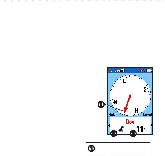
➊
➋ ➌
➊
Dog pointer
(direction to the dog)
Astro and DC 40 Owner’s Manual 7
Dog Tracking
➋
Dog status icon
➌
Distance to the dog
Viewing Dog Details
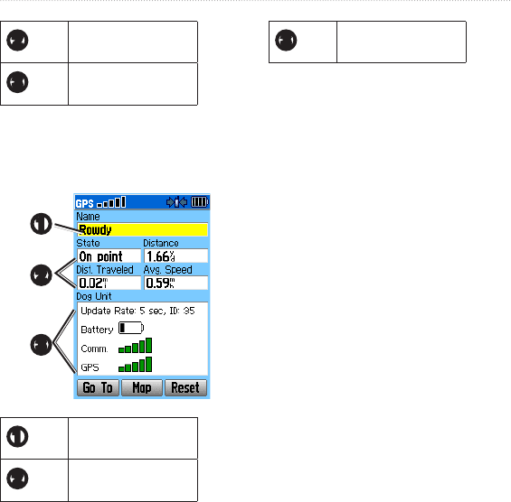
From your Dog Tracker page, press
ENTER.
➊
➋
➌
➊
Dog name
➋
Dog status
information
➌
DC 40 status
infomation
Naming the Dog
The Astro assigns a default name such
as Dog or Dog 1 to every dog (DC 40)
linked to it.
Changing the Name of the Dog
1. On the Dog Information page,
highlighttheNameeldandpress
ENTER.
2. Use the Rocker and ENTER to
spell the name of the dog.
3. Select OK > ENTER when you
arenished.
Using Go To, Map, and Reset
Select Go To to navigate to your
dog.
Select Map to view the location
and movement of your dog.
Select Reset to reset the dog
statistics and the track log
•
•
•

8 Astro and DC 40 Owner’s Manual
Dog Tracking
(page 34) for that dog.
Dog Information Page Options
On the Dog Information page, press
MENU to access additional dog
information options.
Stop (or Start) Tracking–stops (or
starts) tracking the dog.
Identify Dog Unit–displays the
DC 30 software version on the
Astro and causes the DC 30 LEDs
to blink rapidly for ten seconds.
Change Comm. Settings–allows
you to assign a new ID number
(page 11) to a dog to avoid
conictingsignalsand/ortherate
of reporting (5, 10, or 30 seconds).
Transfer Dog Unit Track–
transfers detailed tracks from the
DC 40 to a computer (page 71).
Delete Dog Unit Track–deletes the
track log for the dog.
Change Dog Unit Type–allows
•
•
•
•
•
•
you to identify the dog type so that
the appropriate dog status symbols
are shown. Choose from Auto,
Pointing Dog, Treeing Dog, or Pet.
Upgrade Dog Unit–downloads
software updates to the DC 40
(page 70).
Tracking a Dog
Attach the DC 40 with the collar to
your dog’s neck with the VHF antenna
(page 1) pointing up.
Tracking a Dog on the Dog
Tracker Page
The Dog Tracker page shows the
direction and distance of the dog from
the Astro, and the status of the dog.
To view the Dog Tracker page:
Press DOG.
Thedogyouaretrackingisidentied
and the dog pointer indicates its
direction from you. The dog pointer
•
Astro and DC 40 Owner’s Manual 9
Dog Tracking
is most accurate when you are holding
the Astro level and the dog is farther
than 30 feet (9.1 meters) away. At less
than that distance, a NEAR message
appears, and the dog pointer is
shortened. When you are close to the
dog, the dog pointer may be inaccurate.
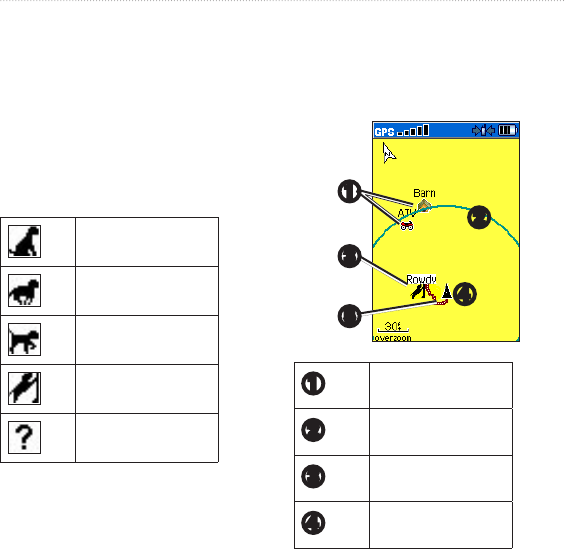
Dog Status Icons
Sitting
Running
On Point
Treed
Unknown
The Unknown status symbol [?],
indicates that the DC 40 has not
acquired a satellite signal and that the
Astro cannot determine the location of
the dog.
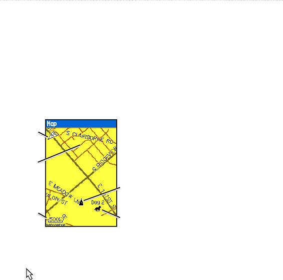
Tracking a Dog on the Map
Press MAP.
➍
➋
➎
➌
➊
➊
Marked locations on
the map
➋
Accuracy circle
➌
Dog location
➍
Your location

10 Astro and DC 40 Owner’s Manual
Dog Tracking
➎
Dog track
NOTE: When the Map page is in the
Track Up orientation mode, objects
on the map appear to rotate around
your position. As you move, the entire
map reorients in the direction you are
facing. To stabilize the objects, set the
orientation to North Up (page 53).
For more information about the Map
page features and custom settings,
refer to page 53.
Dog Tracker Page Options
Menu
On the Dog Tracker page, press
MENU.
Show Info–opens the Dog
Information page for the selected
dog.
Pause (or Resume) All Tracking–
pauses tracking of all dogs.
Calibrate Compass–calibrates the
•
•
•
compass
(page 5).
View Dog List–opens the Dog List
to add or remove dogs.
Small Numbers (or Big
Numbers)–changes the size of
the dog descriptions on the Dog
Tracker page. Press the left or right
arrows on the Rocker to scroll
through multiple dogs in the Big
Numbers mode.
Multiple Dogs
If you purchase additional DC 40
units, you can link them to the Astro
using the setup wizard in the Dog
List. To link, the Astro must be close
enough to the DC 40 to touch it, or you
must know the DC 40 ID number.
Adding a New Dog
1. On the Dog Tracker page, press
MENU > Dog List > <Add New>
> ENTER to open the setup
wizard.
•
•

Astro and DC 40 Owner’s Manual 11
Dog Tracking
2. Use the Rocker and ENTER to
selectandconrmoptions.By
default, the new dog is named
“Dog” and an ID number is
randomly assigned.
NOTE: The setup wizard may indicate
thatthereisaconictwiththeID
number of another dog. To resolve the
conict,followtheinstructionsinthe
setupwizardandin“ConictingDog
Signals.”
Conicting Dog Signals
Each dog you track has its own ID
number. If two dogs within range of
the Astro have the same ID, the Astro
warnsyouofaconictingIDsignal.It
then opens a setup wizard to guide you
through the process of resolving the
conict.
If necessary, you can manually assign
a new ID number to a dog. When
possible, you should allow the Astro to
automatically assign IDs.
Resolving the Dog Signal
Conict.
You must assign a new ID number to
the dog and change the update rate.
1. On the Dog Information page,
press MENU > Change Comm.
Settings.
2. Select an unassigned and
nonconictingID>OK.
3. Change the update rate, if desired.
Both 10-second and 30-second
updates reduce battery drain, but
they create a less-detailed dog track
and collected statistics.
4. Ensure that the Astro is within a
few feet of the DC 40.
5. Complete the setup wizard
instructions.
Tips for Successful Tracking
Use a fully charged DC 40. A
fully charged DC 40 operates for
approximately 17 hours when using
•

12 Astro and DC 40 Owner’s Manual
Dog Tracking
5-second interval reporting.
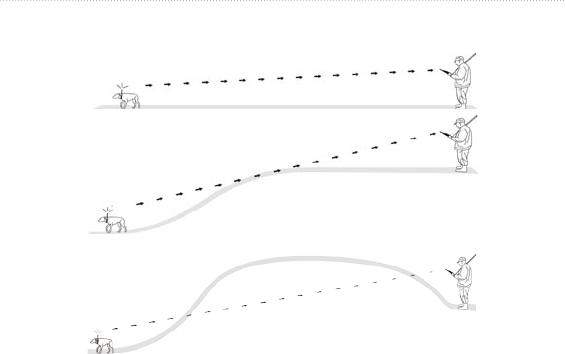
Use line-of-sight radio
communication. The Astro
and DC 40 use radio signals to
communicate. Objects in the
path of radio signals degrade the
quality of the signals. Keeping
an unobstructed line of sight
between you and your dog’s DC 40
produces the best communication
signal. Obstructed radio waves
result in a poor signal. To achieve
the best line-of-sight conditions,
move to the highest elevation point
in your area (for example, on the
top of a hill).
Not sure where this should go.
Starting a new hunt?
Start New Hunt–resets dog statistics
•
•
and track logs, and marks your starting
location.
Astro and DC 40 Owner’s Manual 13
Dog Tracking
Line-of-Sight Radio Communication
BEST
GOOD
POOR
Line-of-Sight Radio Communication

14 Astro and DC 40 Owner’s Manual
Mark Location
Mark Location
Locations are landmarks that you
record and store in your Astro.
Marking Your Vehicle Location
From the main menu, select Start
New Hunt (page 12) while you
are near your vehicle to mark the
location. After the hunt, you can
use your Astro to navigate back to
your starting location.
To mark your current location:
1. Press MARK > New to view the
Mark Location page.
2. Select OK to mark the location.
To mark a specic hunting
location:
1. Press MARK.
2. Select a name and hunting-related
symbol to describe the location,
and press ENTER.
NOTE: The Mark Covey option allows
you to enter the estimated number of
birdsushedandthenumbertaken.
3. To edit location information,
selecttheappropriateeld,and
press ENTER to open the on-
screen keypad. After entering and
conrmingyourchanges,select
OK (on the keypad).
4. Select OK to mark the location.
To mark a location using the
Map page:
1. Press MAP. Use the Rocker
to move the map pointer to the
map item you want to mark as a
location.
2. Press ENTER. If the map item
selected contains no information, a
“No map information at this point.
Do you want to mark a location
here?” message appears. Select
Yes.

Astro and DC 40 Owner’s Manual 15
Mark Location
3. To edit location information,
selecttheappropriateeld,and
press ENTER to open the on-
screen keypad. After entering and
conrmingyourchanges,select
OK (on the keypad).
4. Select OK to mark the location.
Navigating to a Marked
Location
from settings...
Go To Marked Location–provides
directions to a location you have
marked (page 14).
Editing a Marked Location
1. Press MENU > MENU.
2. Select Advanced > Find >
Marked Locations.
3. Select the location you want to edit.
4. Enter your changes using the on-
screen keypad.
Moving a Marked Location on
the Map
1. Press MENU > MENU.
2. Select Advanced > Find >
Marked Locations.
3. Select the marked location you
want to edit.
4. Select Map to show the marked
location on the map.
5. Press ENTER to place a MOVE
marker next to the marked location.
6. Use the Rocker to move the
marked location to a new location
on the map.
7. Press ENTER.
Averaging a Marked
Location
You can average a marked location
for more accuracy. When averaging,
the Astro takes several readings at the
same location and uses the average

16 Astro and DC 40 Owner’s Manual
Mark Location
value to provide more accuracy.
To calculate your current
average location:
1. Press MARK > New > Avg to
begin averaging.
2. WhentheEstimatedAccuracyeld
reaches the level of accuracy you
want, select Save > OK.
Projecting a Location
You can create a new location by
projecting the distance and bearing
from a marked location to a new
location.
To project a location:
1. Press MENU > MENU >
Advanced > Find > Marked
Locations.
2. Select the location > MENU >
Project Location.
3. Enter the bearing and distance
to the projected location in the
appropriateeldsatthebottom
of the page. To navigate to the
location, select Go To.
Map
The Astro includes a preloaded
basemap that includes cities,
interstates, state and county highways,
exit information, and lake and river
outlines. The standard basemap can be
enhanced using MapSource® detailed
mapping data as shown below.
Map orientation
arrow
Map scale
Your current
location
Dog location
Map details from
Garmin MapSource
City Navigator
®
North America NT
Map Page
Press MAP to display the Map page.
Use the Rocker to move the map
pointer away from your current
location. As you pan past the edge of
the current map display, the screen
scrolls to provide continuous map
coverage.
Press IN and OUT to change the map
scale. An accuracy circle represents the
area containing your current location.
Map Options
Customize the Map page using the
Map page Options menu. On the Map
page press MENU.
Stop (or Resume) Navigation–
stops or resumes navigation.
Recalculate–recalculates an
automotive route while navigating.
Data Fields–conguresuptofour
dataeldsatthetopofthepage
(page 18).
Change Data Fields–changes the
type of data displayed in the data
elds(page 18).
•
•
•
•
Astro and DC 40 Owner’s Manual 17
Map
Map
The Astro includes a preloaded
basemap that includes cities,
interstates, state and county highways,
exit information, and lake and river
outlines. The standard basemap can be
enhanced using MapSource® detailed
mapping data as shown below.
Map orientation
arrow
Map scale
Your current
location
Dog location
Map details from
Garmin MapSource
City Navigator
®
North America NT
Map Page
Press MAP to display the Map page.
Use the Rocker to move the map
pointer away from your current
location. As you pan past the edge of
the current map display, the screen
scrolls to provide continuous map
coverage.
Press IN and OUT to change the map
scale. An accuracy circle represents the
area containing your current location.
Map Options
Customize the Map page using the
Map page Options menu. On the Map
page press MENU.
Stop (or Resume) Navigation–
stops or resumes navigation.
Recalculate–recalculates an
automotive route while navigating.
Data Fields–conguresuptofour
dataeldsatthetopofthepage
(page 18).
Change Data Fields–changes the
type of data displayed in the data
elds(page 18).
•
•
•
•

18 Astro and DC 40 Owner’s Manual
Map
Guidance Text–displays useful
information on the screen above
the map when navigating to a
destination.
Setup Map–customizes the map to
your preferences (page 53).
Measure Distance (or Stop
Measuring)–measures or stops
measuring the distance (page 18)
from your location to the map
pointer.
Turn Declutter On (or Off)–
eliminates or restores the display
of items on the map that block road
details.
Restore Defaults–returns map
settings to the default settings.
Data Fields
When navigating on the Map page,
youcandisplayuptofourdataelds
at the top of the page to provide travel
and navigational information.
•
•
•
•
•
Showing Data Fields on the
Map
1. On the map, press MENU > Data
Fields.
2. Selectthenumberofdataelds.
Changing the Data Fields
1. Press MENU > Change Data
Fields.
2. Use the Rockertoselectaeld.
Alistofdataeldoptionsappears.
3. Select an option.
Measuring Distance
You can use the Astro to measure the
distance between two points.
1. On the Map page, press MENU >
Measure Distance.
An arrow appears on the map at
your current location.
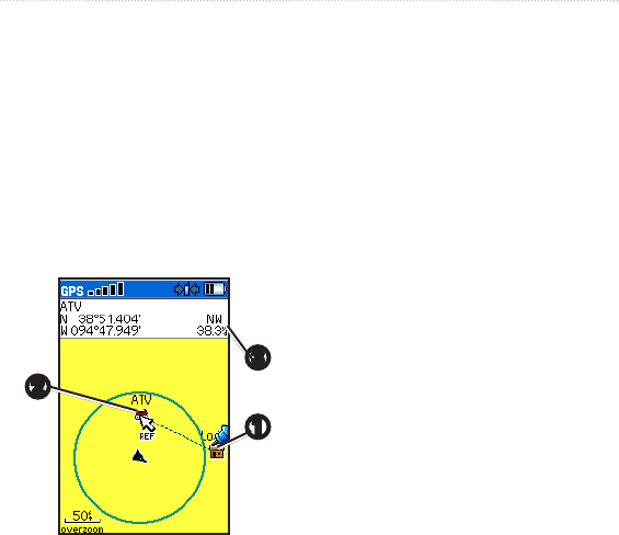
Astro and DC 40 Owner’s Manual 19
Map
2. Move the arrow to the point you
want to measure from and press
ENTER.
A push pin marks the beginning
point ➀.
3. Move the arrow to another point.
REF marks the ending point ➁.
The distance between the two
points appears ➂.
➋
➌
➊
20 Astro and DC 40 Owner’s Manual
Find Features
Find Features
Use the Find menu to search for
marked locations, cities, and exits
included in the Astro basemap.
Additional categories appear
depending on the optional MapSource-
compatible detailed maps or BlueChart
g2 data loaded in the unit. When you
open a Find category, it contains only
those items near your current location
or the map pointer (if active).
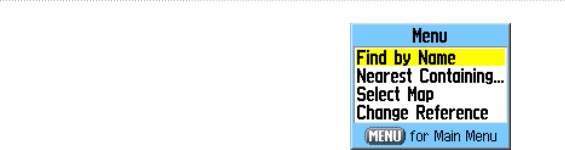
Finding a Location by Name
1. Press MENU > MENU >
Advanced > Find.
2. Select the type of item you want to
nd.
3. Press MENU > Find by Name.
4. Enter the name of the location.
When the Find list contains a
match, select OK.
5. Select an option:
Select Save to save the item as
a location.
Select Map to display the item
as a location.
Select Go To to create a route
to the location.
Finding Recently Found
Locations
1. Press MENU > MENU >
Advanced > Find > Recent Finds.
2. Select an item.
•
•
•

Astro and DC 40 Owner’s Manual 21
Find Features
To nd an item near another
item:
1. On the Information page of a
location, press MENU > Find Near
Here. The Find menu opens.
2. Select a category > ENTER to
display a list of items near the
location.
To nd an item from another
location on the map:
1. On the Information page of a
location, press MENU > Change
Reference. The Map page opens.
2. Use the Rocker to move the map
pointer to the map location you
want, and press ENTER to show
a list of items near the new map
location.
To nd a marked location:
1. Press MENU > MENU >
Advanced > Find > Marked
Locations.
2. Select a location.
To nd a geocache:
1. Press MENU > MENU >
Advanced > Find > Geocache.
2. Select a geocache to open the
information page.
3. Select Go To to navigate to the
geocache location.
When a geocache is found, the Astro
marks the cache as found, logs an entry
into the calendar, and shows the nearest
cache.
Go to my.garmin.com, log on, and
click Go Geocaching for details and
how to download geocache locations
from the Internet.
To nd a city:
1. Press MENU > MENU >
Advanced > Find > Cities. A list
of cities near your current location
appears.

22 Astro and DC 40 Owner’s Manual
Find Features
2. Select a city from the list.
OR
If the city you want is not listed,
press MENU > select a search
method.
Finding an Interstate Exit
1. Press MENU > MENU >
Advanced > Find > Exits. A list
of exits near your current location
appears.
2. Select an exit. The exit description,
a list of services near the exit, and
the distance and bearing from the
exit to the highlighted service are
shown.
3. Select a service from the list >
ENTER for more information
about the service.
Item Information Page
Options
The Options menu for each information
page contains options for using a Find
item as a tool for navigation.
To use the Options menu:
1. On the Information page, press
MENU.
2. Select an option > ENTER:
Average Location–averages
your current location (page 15).
Project Location–projects the
distance and bearing to a new
location (page 16).
Find Near Here–ndsanitem
near another item (page 21).
Change Reference–ndsan
item from another location on
the map (page 21).
Set Proximity–programs an
alarm to sound when you are
withinaspeciedradiusofan
item
(page 42).
•
•
•
•
•

Astro and DC 40 Owner’s Manual 23
Find Features
Add To Route–adds the item
on the information page to a
route (page 38).
View Sunrise/Sunset–displays
Sunrise/Sunset tables for this
location (page 51).
View Hunting Almanac–
displays Hunting tables for this
location (page 51).
Reposition Here–changes the
location of the item to your
current location.
Using Optional Detailed
Maps
If you have detailed mapping data, you
canndlocationsusingaddressesor
intersections. Select the All Points of
Interest category to locate a nearby
restaurant, lodging, landmark, or other
public building.
•
•
•
•
To nd an address or
intersection:
1. Press MENU > MENU >
Advanced > Find > Addresses (or
Intersections).
IfyourunithasaGPSx,the
<ENTER Region>eldis
populated with your current region.
2. Select <ENTER Number>.
3. Enter the street number using the
on-screen keypad > OK (on the
keypad).
4. Select <ENTER Street Name> to
open the street list.
5. Use the on-screen keypad to enter
the street name > OK.
6. Select the best address match.
Follow these same basic steps when
searching for an intersection.

24 Astro and DC 40 Owner’s Manual
Find Features
To nd a point of interest:
1. Press MENU > MENU >
Advanced > Find > All Points of
Interest. A list of points of interest
near your current location appear.
2. Press MENU to narrow your
search.
3. Select the item you want from
the list > ENTER to open the
information page for the item.
POI Loader and Custom
Points of Interest
Create your own category for points
of interest by using the Garmin POI
Loader utility, downloadable from the
Garmin Web site: www.garmin.com/
products/poiloader. Follow the Help
instructions to use POI Loader.
Astro and DC 40 Owner’s Manual 25
GPS Applications
GPS Applications
GPS Applications (MENU > MENU
> Advanced > GPS Applications)
providesoptionsforconguringthe
following GPS functions:
Trip Computer (page 25)
Compass (page 26)
Altimeter (page 31)
Tracks (page 34)
Routes (page 38)
Highway (page 41)
Proximity (page 42)
Turn Preview (page 43)
Active Route (page 44)
Satellite (page 44)
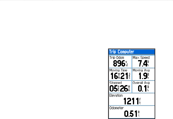
Using the Trip Computer
The Trip Computer page provides
travel data such as current speed,
distance traveled, and other statistics
•
•
•
•
•
•
•
•
•
•
that can be useful when navigating a
long distance.
Press MENU > MENU >
Advanced > GPS Applications >
Trip Computer.
Trip Computer Page
Customizing the Trip
Computer
1. On the Trip Computer page, press
MENU.
2. Select an option > ENTER:
26 Astro and DC 40 Owner’s Manual
GPS Applications
Reset–clears the trip computer.
Big Numbers–displays fewer
dataeldswithlargernumbers.
Change Data Fields–changes
the type of data on the trip
computer.
Restore Defaults–restores
thedataeldstothedefault
settings.
To change the type of data on
the trip computer:
1. On the Trip Computer page, press
MENU > Change Data Fields.
2. Use the Rockertoselectaeld.
3. Press ENTER > select an option >
ENTER.
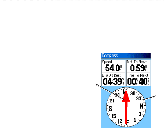
Using the Compass Page
The Compass page guides you to your
destination with a compass display and
a bearing or course pointer.
It also provides navigation data such
•
•
•
•
as current speed, distance to the next
point on the route, and estimated
arrival time.
Press MENU > MENU >
Advanced > GPS Applications >
Compass.
Compass Page
The compass
ring moves to
indicate North
orientation.
Bearing
pointer
Hold the compass level when
navigating to ensure maximum
accuracy.
Astro and DC 40 Owner’s Manual 27
GPS Applications
Reset–clears the trip computer.
Big Numbers–displays fewer
dataeldswithlargernumbers.
Change Data Fields–changes
the type of data on the trip
computer.
Restore Defaults–restores
thedataeldstothedefault
settings.
To change the type of data on
the trip computer:
1. On the Trip Computer page, press
MENU > Change Data Fields.
2. Use the Rockertoselectaeld.
3. Press ENTER > select an option >
ENTER.
Using the Compass Page
The Compass page guides you to your
destination with a compass display and
a bearing or course pointer.
It also provides navigation data such
•
•
•
•
as current speed, distance to the next
point on the route, and estimated
arrival time.
Press MENU > MENU >
Advanced > GPS Applications >
Compass.
Compass Page
The compass
ring moves to
indicate North
orientation.
Bearing
pointer
Hold the compass level when
navigating to ensure maximum
accuracy.
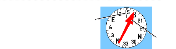
Using the Course Pointer or
the Bearing Pointer
The bearing pointer indicates the
direction to your destination, and
the course pointer indicates your
relationship to a course line leading to
the destination.
The bearing pointer points to the
destination, regardless of the direction
you are moving. If the bearing pointer
is pointing in your direction of travel,
you are traveling directly toward your
destination. If the bearing pointer
points any other direction, turn toward
that direction until the bearing pointer
is pointing ahead.
Direction you
are currently
traveling
Bearing to
destination
Bearing Pointer
28 Astro and DC 40 Owner’s Manual
GPS Applications
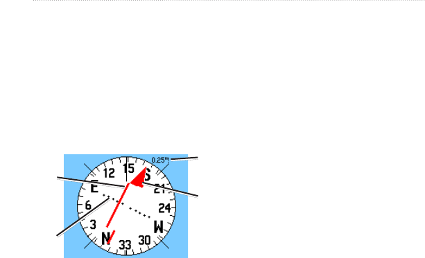
The course pointer provides an
indication of drift (right or left)
according to the scale shown at the
edge of the compass ring. The scale
refers to the distance between dots on
the course deviation indicator. The
course line to your destination is based
on your original starting point.
Scale
Course Pointer
Course
line to
destination Bearing to
destination
Course
deviation
indicator
Move back to the “course line to
destination” to compensate for
deviation and to get back on course.
This is most useful if you are
navigating on water or where there
are no major obstacles in your path. It
also helps you avoid hazards to either
side of the course, such as shoals or
submerged rocks.
Changing Compass Settings
To change Compass settings:
1. On the Compass page, press
MENU.
2. Select an option > ENTER:
Sight ‘N Go–allows you to
navigate to an object within
your sight by pointing the unit
at it (page 29).
Stop (or Resume) Navigation–
stops or resumes your current
navigation.
Recalculate–recalculates the
path to a destination.
Course or Bearing Pointer–
auto routes between the course
pointer and the bearing pointer.
•
•
•
•
Astro and DC 40 Owner’s Manual 29
GPS Applications
Data Fields–species2,3or
4dataeldsthatappearonthe
Compass page.
Change Data Fields–selects the
type of data you want to show
inthedataelds(page 29).
Calibrate Compass–opens the
Compass Calibration page for
calibrating the compass
(page 5).
Restore Defaults–restores
compass settings to the default
settings.
To change the type of data on
the compass:
1. On the Compass page, press
MENU > Change Data Fields.
2. Use the Rockertoselectaeld.
3. Press ENTER > select an option >
ENTER.
•
•
•
•
To use Sight ‘N Go to navigate:
1. On the Compass page, press
MENU > Sight ‘N Go. The bearing
pointer points to the top of the
compass.
2. Hold the unit at eye level and line
up the two sighting marks with a
distant object.
Sighting
marks
30 Astro and DC 40 Owner’s Manual
GPS Applications
3. Press ENTER to lock the direction
and open the Sighting page.
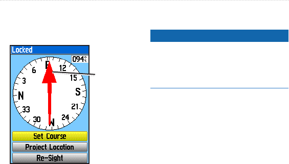
Sighting Page
Bearing
pointer
4. Select Set Course to open the
Compass page and navigate to the
distant object (select Re-Sight to
set course on a different object).
OR
Select Project Location (page 16).
Calibrating the Compass
notice
Calibrate the electronic compass
outdoors. Do not stand near objects that
inuencemagneticelds,suchascars,
buildings, or overhead power lines.
Calibrate the Astro electronic compass
thersttimeyouuseit,afterlong
periods of storage, after you install new
batteries, or when the unit has been
exposed to temperature changes of
greater than 20°F (11°C).
You should calibrate the compass after
moving long distances, experiencing
temperature changes, or changing the
batteries.[from 62]
1. From the dog tracker page, press
MENU.
2. Select Calibrate Compass > Start.
3. Follow the on-screen instructions.
Astro and DC 40 Owner’s Manual 31
GPS Applications
Hold the unit
level and turn
slowly.
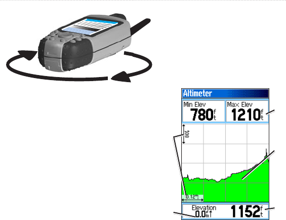
Using the Altimeter Page
The Altimeter page displays the
current elevation, the rate of your
ascent or descent, elevation changes
over distance or time, or pressure
changes over time.
To open the Altimeter page:
Press MENU > MENU >
Advanced > GPS Applications >
Altimeter.
Altimeter Page
Current
elevation
Customizable
data elds
Rate of ascent
or descent
Range grid
measurement
Elevation
prole

32 Astro and DC 40 Owner’s Manual
GPS Applications
Theeldatthebottomofthepage
shows your current elevation and
your rate of ascent (or descent) when
moving.
Viewing Points on the Altimeter
Plot
Select individual points on an elevation
plot or a pressure plot to view the
elevation (or pressure) reading, the
time of day, and the date when the
point was recorded.
To view points on a plot:
On the Altimeter page, press left
or right on the Rocker to display
crosshairs and scroll the crosshairs
across the plot.
To view altitude points on the
Map page:
1. On the Altimeter page, use the
Rocker to move the red crosshairs
to the point you want to view on the
map.
2. Press ENTER. The point is marked
by the map pointer with location
coordinates, the compass bearing,
and the distance from your current
location.
Changing Altimeter Settings
To change altimeter settings:
1. On the Altimeter page, press
MENU.
2. Select an option > ENTER:
Plot Over Time (or Plot Over
Distance)–plots time or distance
against elevation. (This option
is available only when you are
plotting elevation. Pressure is
plotted only against time.)
View Elevation Plot (or View
Pressure Plot)–selects either an
elevation plot or a barometric
pressure plot for a set period of
time.
•
•

Astro and DC 40 Owner’s Manual 33
GPS Applications
Zoom Ranges–selects zoom
ranges for elevation, distance,
and time for the View Elevation
Plot (page 33).
Change Data Fields–selects
the type of data shown on the
Altimeter page (page 31).
Reset–resets the elevation
and maximum elevation data
(page 33).
Calibrate Altimeter–calibrates
the altimeter if you know the
elevation or pressure at your
current location (page 34).
Restore Defaults–clears
recorded altimeter data and
begins recording new data.
To set the zoom ranges for the
altimeter plot:
1. On the Altimeter page, press
MENU > Zoom Ranges.
OR
Press up or down on the Rocker.
•
•
•
•
•
2. Press up or down on the Rocker to
set the zoom range on the vertical
axis.
3. Press left or right on the Rocker
to set the zoom range on the
horizontal axis.
To change the type of data on
the altimeter page:
1. On the Altimeter page (page 31),
press MENU > Change Data
Fields.
2. Use the Rockertoselectaeld.
3. Press ENTER > select an option >
ENTER.
To reset the elevation and
maximum elevation elds:
1. On the Altimeter page, press
MENU > Reset....
2. Use the Rocker and press ENTER
to place a check mark next to the
items you want to reset.
34 Astro and DC 40 Owner’s Manual
GPS Applications
3. Select Apply > OK to reset the
selected options.
Calibrating the Altimeter
1. Go to a location where the
elevation or barometric pressure is
known
2. On the Altimeter page, press
MENU > Calibrate Altimeter.
3. Select Yes if you know the
elevation, select No > Yes if you
know the barometric pressure.
4. Enter the elevation or barometric
pressure > OK.
Using Tracks
A track is a recording of your path and
of the path of your dogs. The track
log contains information about points
along the recorded path, including
time, location, and elevation for each
point.
The percentage of memory used by the
current track log appears at the top of
the Tracks page. After you clear the
track log, it shows 0%.
To open the Tracks page:
Press MENU > MENU >
Advanced > GPS Applications >
Tracks.
Tracks Page Track Log Setup
Page
To clear the track log:
On the Track page, select Clear >
Yes.

Astro and DC 40 Owner’s Manual 35
GPS Applications
To set up a track log:
On the Track page, select Setup.
Wrap When Full–replaces the
oldest data with new data when
the track log is full.
Record Method–Distance
records track points after a
specieddistanceistraveled.
Time records track points after
aspeciedtimehaselapsed.
Auto can record more points
or fewer points. Selecting more
points creates a more accurate
track,butllsupthetracklog
faster.
Interval–speciesadistance,a
time, or a frequency.
Color–selects the color of the
track. To change the color of a
dog’s track, use the color option
on the Saved Track page.
•
•
•
•
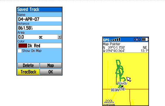
To save the entire track log:
On the Tracks page, select Save
> Yes. The Saved Track page
appears.
Use the Saved Track page to rename
the track and view the track distance,
the calculated area, and the color for
the track on the Map page. You can
change the track color and the units for
the calculated area. Changing the color
of a dog’s saved track also changes the
dog pointer color on the Dog Tracker
page.
36 Astro and DC 40 Owner’s Manual
GPS Applications
To save a portion of the track
log:
1. On the Tracks page, select Save >
No. The entire track is shown.
2. Use the Rocker to move the map
pointer to the beginning point and
press ENTER.
3. Use the Rocker to move the map
pointer to the ending point and
press ENTER > OK.
To view a track on the map:
On the Tracks page, select Save >
Yes > Map. The track appears on
the map.
Saved Track on the Map
To calculate the area of a track:
1. On the Tracks page, press MENU
> Area Calculation > ENTER to
start the area calculation. When
you begin to move, a Stop button
appears.

Astro and DC 40 Owner’s Manual 37
GPS Applications
2. Whenyouarenished,selectStop.
3. SelecttheAreaeldtochangethe
units of measurement.
4. Select Save.
Track Proles
After you save a track, you have a
record of the path you traveled and a
trackaltitudeprole.
To view a track prole:
1. On the Saved Track page, press
MENU > Prole.
The beginning and the end of the
trackaremarkedbyaag.Press
left or right on the Rocker to scroll
acrossthetrackprole.
As you scroll, the elevation for
each point appears at the top of
the page, and the distance from
the Begin point and the End point
appear at the bottom.
2. While scrolling, press ENTER to
show the highlighted point on the
map.
To set the zoom ranges for the
track prole:
1. On the Saved Track page, press
MENU > Prole.
2. Press up or down on the Rocker to
set the zoom range on the vertical
axis.
3. Press left or right on the Rocker
to set the zoom range on the
horizontal axis.
Using DEM (Digital Elevation
Models) Maps
You can create a track elevation
prole,fromDEMmaps,thatincludes
elevation data. When these types of
maps are available, a Use Map Data
- Use Track Data option appears
when you select Prole. Refer to
the Garmin Web site www.garmin.
com/cartography/ontheTrail/ for more

38 Astro and DC 40 Owner’s Manual
GPS Applications
information about MapSource U.S.
Topo maps.
Navigating a Saved Track
You can save your track log to use
later as a TracBack® that will take
you back to the oldest stored track log
point.
To use the TracBack feature:
1. On the Tracks page or the Saved
Tracks page, select TracBack.
2. Use the Rocker to move the map
pointer to the point on the map you
want to backtrack to.
3. Press ENTER.
4. Select Follow Road to navigate
back to the selected point using
available roadways, or Follow
Track to retrace your original path
of travel.
To mark a location on a saved
track:
1. With a saved track shown on the
map, move the map pointer to the
location on the track that you want
to mark.
2. Press MARK to open the Mark
Location page.
3. To edit location information,
selecttheappropriateeld,and
press ENTER to open the on-
screen keypad. After entering and
conrmingyourchanges,select
OK (on the keypad).
4. Select OK to mark the location.
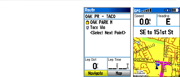
Creating Routes
You can create and store up to 50
routes with up to 250 points each.
To set routing options, see Routing
Setup on page 55.
Astro and DC 40 Owner’s Manual 39
GPS Applications
To open the Routes page:
Press MENU > MENU >
Advanced > GPS Applications >
Routes.
To create and navigate a new
route:
1. On the Routes page, select New.
2. Select the <Select Next Point>
eldandpressENTER to open the
Find menu.
3. Select one of the Find menu
categoriesfortherstpointonthe
route.
4. Selecttherstpointontheroute.
5. Select Use.
6. To add more points to the route,
repeat steps 2 through 5.
7. Select Navigate.
Route on the Map
Page
Route Page
To navigate a saved route:
1. On the Routes page, select a saved
route.
2. Select Navigate.
3. To stop navigating, press MENU >
Stop Navigation.
Editing a Route
After you create a route, use the Route
page to edit the route, change the route
name, and review route points.

40 Astro and DC 40 Owner’s Manual
GPS Applications
To change the name of the
route:
1. On the Routes page, select a saved
route.
2. Select the route name to open the
on-screen keypad.
3. After entering your changes, select
OK (on the keypad).
To review and save individual
route points:
1. On the Routes page, select a saved
route.
2. Select a point on the route.
3. Select Review to open the
information page for that route
point.
Save–saves the point as a
location.
Map–shows the point on the
Map page.
Go To–navigates to the point.
•
•
•
To delete a route:
On the Routes page, select a saved
route > Delete.
To delete all routes:
On the Routes page, press MENU
> Delete All Routes.
To select the off-road transition
for a route:
1. On the Routes page, press MENU.
2. Select Off Road Transition.
3. Select the method to use when
advancing to the next point.
Auto–When you reach
your next point, you are
automatically routed to the
following point.
Distance–Enter a radius. When
youarewithinthatspecied
distance to your next point,
you are routed to the following
point.
•
•
Astro and DC 40 Owner’s Manual 41
GPS Applications
Manual–When routing to
your next point, press OUT to
begin routing to the following
point. Press IN to route to the
previous point.
Setting Route Page Options
To set route page options for a
specic route:
On the Routes page, select a route
> MENU.
Remove All–removes all
locations from a saved route.
Reverse Route–reverses the
order of the points in the saved
route.
Prole–createsaverticalprole
of the route when MapSource
DEM U.S. Topo map data is
used.
Copy Route–makes a copy of
the route.
Delete Route–deletes the route.
•
•
•
•
•
•
Change Data Fields–selects
different values for the two data
eldsatthebottomofthepage.
Restore Defaults–restores
route settings to the default
settings.
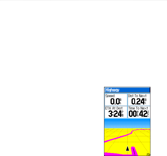
Using the Highway Page
When navigating a route on roads, the
Highway page provides up to four data
eldsthatdisplaytravelinformation.
Highway Page
•
•

42 Astro and DC 40 Owner’s Manual
GPS Applications
To open the Highway page
while navigating:
Press MENU > MENU >
Advanced > GPS Applications >
Highway.
Your course is represented by a center
line down the middle of the screen.
Press IN or OUT to zoom in or out on
the map.
To change Highway settings:
1. On the Highway page, press
MENU.
2. Select an option > ENTER.
Stop (or Resume) Navigation–
stops or resumes your current
navigation.
Recalculate–recalculates the
path to a destination.
Data Fields–selects 2, 3, or 4
dataeldsthatappearonthe
Highway page.
•
•
•
Change Data Fields–selects
the type of data you want to
showinthedataelds.
Restore Defaults–restores
highway settings to the default
settings.
Using Proximity
Locations
Use the Proximity Locations page to
deneanalarmradiusaroundastored
location. An alarm sounds when you
enter within the designated radius.
To open the Proximity page:
Press MENU > MENU >
Advanced > GPS Applications >
Proximity.
To add a proximity location:
1. On the Proximity page, select an
empty line > ENTER to open the
Find menu.
•
•
Astro and DC 40 Owner’s Manual 43
GPS Applications
2. Select one of the Find menu
categories to open the information
page for the item.
3. Select Use to add the location to
the Proximity page.
4. Select Radius to enter the value.
To select alarm tones and turn
proximity alarms off:
1. On the Proximity page, select
Proximity Alarm Tones.
2. Selectanalarmeldtoviewthe
list of tones.
3. Select the desired tone > ENTER.
4. Select Proximity Alarms to activate
the alarm.
Speed Alerts are obtained by using
POI Loader (page 24).
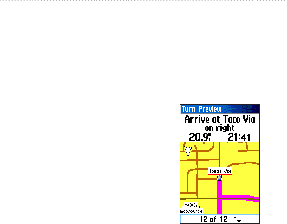
Using Turn Preview
To preview the turns on a map
while navigating a route:
1. While navigating a route on the
Map page, press MENU > MENU
> Advanced > GPS Applications
> Turn Preview.
Turn Preview Page
44 Astro and DC 40 Owner’s Manual
GPS Applications
2. To scroll through all turn previews,
press up or down on the Rocker.
Press ENTER to view an
individual turn.
Using Active Route
To preview a list of the turns
while navigating a route:
1. While navigating a route on the
Map page, press MENU > MENU
> Advanced > GPS Applications
> Active Route.
2. Select a turn to view an individual
turn.
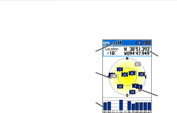
Using the Satellite Page
The Satellite page shows the receiver
status, the satellite locations, the
satellite signal strength, and your
current location when the unit receives
signals from at least three satellites.
To open the Satellite page:
Press MENU > MENU >
Advanced > GPS Applications >
Satellite.
Heading bug
(indicates your
direction of
movement)
Satellite
signal
strength
Your
location
Receiver
status
Satellite Page
Satellite
location
To change satellite options:
On the Satellite page, press
MENU.
Use With GPS Off (or
On)–turns the GPS receiver off
or on.
•

Astro and DC 40 Owner’s Manual 45
GPS Applications
Track Up (or North Up)–
orients North or your current
heading at the top of the
display.
Multicolor (or Single
Color)–selects whether each
satellite appears in a different
color or the same color.
New Location–select if you
have moved the unit more than
600 miles and you are having
trouble locking onto satellite
signals.
GPS Elevation–displays your
current elevation.
•
•
•
•

46 Astro and DC 40 Owner’s Manual
Accessories
Accessories
The Accessories menu (MENU >
MENU > Advanced > Accessories)
provides the following applications:
Calendar (page 46)
Calculator (page 47)
Stopwatch (page 47)
View Sunrise/Sunset (page 51)
View Hunting Almanac (page 51)
Games (page 48)
Calendar
The calendar can record locations
onspecicdaysandprovidesunrise,
sunset, and hunting-almanac
information.
Opening the Calendar
Press MENU > MENU >
Advanced > Accessories >
Calendar. The current week
appears.
•
•
•
•
•
•
Adding a Location to the
Calendar
1. Use the Rocker to select a day.
2. Press MENU
3. Select Add Point.
4. Select one of the categories
(page 20).
5. Select Use.
The location is added to the day.

Astro and DC 40 Owner’s Manual 47
Accessories
Deleting Locations from the
Calendar
1. From the calendar, use the Rocker
to select a day.
2. Select the location.
3. Select Delete.
4. Press MENU.
5. Select Remove Points.
6. Select an option.
Viewing Sunrise/Sunset or
Hunting Almanac Information
1. From the calendar, use the Rocker
to select a day.
2. Press MENU.
2. Select View Sunrise/Sunset or
View Hunting Almanac.
Calculator
The Astro has a standard calculator and
ascienticcalculator.
Using the Calculators
The device also has two calculator
applications.
1. Press MENU > MENU >
Advanced >Accessories >
Calculator.
2. Use the Rocker and the ENTER
key to enter calculations.
To use the scientic calculator:
On the Calculator page, press
MENU > Scientic.
Stopwatch
To open the Stopwatch:
Press MENU > MENU >
Advanced > Accessories >
Stopwatch.
To time a lap by distance or by
button press:
On the Stopwatch menu, press
MENU > Lap by Distance (or Lap
by Button Press).

48 Astro and DC 40 Owner’s Manual
Accessories
To set a lap distance value:
1. Press MENU to open the Options
menu. Select Set Lap Distance.
2. Use the Rockertoselecttheeld
you want to change. Enter the new
value, and press ENTER. When
done, select OK.
Sunrise/Sunset
You can view the time of sunrise,
sunset, moonrise, and moonset, and
current relative positions of the sun
and moon.
Customizing the Date or
Location
1. Press MENU > MENU > View
Sunrise/Sunset.
2. Select an option:
Select Date to change the date.
The on-screen keypad appears.
Select Location to change the
location.
•
•
Select Time to view positions
of the sun and moon at a
different time.
Hunting Almanac
You can view the predicted best times
forhuntingandshingforaspecic
date and location.
Customizing the Date or
Location
1. Press MENU > MENU > View
Hunting Almanac.
2. Select an option:
Select Date to change the date.
The on-screen keypad appears.
Select Location to change the
location.
Games
The Astro contains six games
(Memory Race, Virtual Maze,
GekoSmak, Nibbons, Gekoids, and
•
•
•

Astro and DC 40 Owner’s Manual 49
Accessories
Beast Hunt). Some games use GPS
during the game. Most games contain
a tutorial.
To open the Games list:
Press MENU > MENU >
Advanced > Accessories >
Games.

50 Astro and DC 40 Owner’s Manual
Settings
Settings
The Settings menu (MENU > MENU
> Advanced > Settings) customizes
the operation of your Astro.
System Setup
To open the System page:
Press MENU > MENU >
Advanced > Settings > System.
GPS–sets the unit to operate in
Normal mode, Battery Saver
mode, GPS Off, or Demo
Mode.
WAAS/EGNOS–enables or
disables WAAS (Wide Area
Augmentation System) in the
U.S., or EGNOS (European
Geostationary Navigation
Overlay Service).
Battery Type–selects the
battery type (alkaline, NiMH, or
lithium).
•
•
•
External Power Lost–selects
whether the Astro stays on or
turns off when external power is
removed.
Proximity Alarms–turns all
proximity alarms on or off.
To restore system defaults and
view system information:
On the System page, press MENU.
Restore Defaults–restores
system settings to the default
settings.
View Card Info–displays the
microSD card status.
Mass Storage Mode–allows
you to use the microSD card as
a data-storage device
Software Version–displays
the Astro software version, the
GPS SW version, and the unit
identicationnumber.
NOTE: View Card Info and Mass
•
•
•
•
•
•

Astro and DC 40 Owner’s Manual 51
Settings
Storage Mode are available only when
a microSD card is installed.
Dog List Setup
To open the Dog List page:
Press MENU > MENU >
Advanced > Settings > Dog List.
To view the Dog Info page,
move the dog on the list, or
remove the dog from the list:
Select a dog on the list > ENTER.
Dog Alerts Setup
To turn Dog Alerts on or off:
1. Press MENU > MENU >
Advanced > Settings > Dog
Alerts.
2. Use the Rocker to select an alert >
ENTER > Off (or On).
On-Point Alert–indicates that
the dog is on-point.
•
Treed Alert–indicates that the
dog has treed quarry and has
conneditsownmovementsto
a small area for 60 seconds.
GPS Lost Alert–indicates that
the dog’s DC 40 has lost GPS
satellite signals.
Lost Communication
Alert–the Astro is not receiving
the signals from the DC 40.
Display Setup
To congure the Astro screen
settings:
Press MENU > MENU >
Advanced > Settings > Display.
Display Mode–sets the display
to Day, Night, or Auto mode.
Select Auto to automatically
switch to night mode at sunset
and to day mode at sunrise.
•
•
•
•

52 Astro and DC 40 Owner’s Manual
Settings
Daytime Color Scheme–sets
the color scheme used in Day
mode.
Nighttime Color Scheme–sets
the color scheme used in Night
mode.
Backlight Timeout–sets the
backlight to time out after a
period of time has elapsed (to
save battery power) or to stay
on.
Backlight Level–increases
or decreases the backlight
intensity.
Tones Setup
To select tones:
Press MENU > MENU >
Advanced > Settings > Tones.
1. Select a tone > ENTER.
2. Select an option. The tone sounds.
3. Press ENTER to select the tone.
•
•
•
•
Main Menu Setup
You can move, delete, or add items to
the main menu.
Reordering or Deleting Items
on the Main Menu
1. From any page, press MENU >
MENU > Advanced > Settings >
Main Menu.
2. Select a menu item.
3. Select an option:
Select Move and then use the
Rocker to move the item.
Select Delete to remove the
item from the list.
Adding an Item to the Main
Menu
1. From any page, press MENU >
MENU > Advanced > Settings >
Main Menu.
2. Select <Add Page>.
•
•

Astro and DC 40 Owner’s Manual 53
Settings
3. Select the item you want to add to
the Main Menu.
Map Setup
Use the Map Setup page to customize
the Map page (page 17).
To open the Map Setup page:
1. Press MENU > MENU >
Advanced > Settings > Map.
2. Use the Rocker left or right to
move from icon to icon when
selecting a Map Setup category.
Map Setup – General PageGeneral Page
On the Map Setup page, highlight the
General icon.
Orientation–orients North or your
current heading (Track Up) at the
top of the display.
Below–sets the map scale at which
Track Up is used. At scales above
the setting, map orientation is set to
North Up.
•
•
Auto Zoom–sets the map scale to
include the beginning and ending
points of a route.
Detail–selects the degree of map
detail.
Lock On Road–locks the position
pointer to the nearest road.
Map Setup – Tracks Page
On the Map Setup page (page 53),
highlight the Tracks icon.
Saved Tracks–sets the maximum
zoom at which saved tracks are
shown.
Track Log–sets the maximum
zoom at which active track logs are
shown.
Track Points–sets the maximum
number of track points used to
record a track.
Go To Line–selects either
a bearing line or course line
(page 27) to navigate a track.
•
•
•
•
•
•
•

54 Astro and DC 40 Owner’s Manual
Settings
Map Setup – Points Page
On the Map Setup page (page 53),
highlight the Points icon. Set the
maximum zoom (Auto, Off, or a
speciczoomlevel)atwhichMap
Points, Marked Location, Street
Label, and Land Cover appear on the
Map page.
Map Setup – Text Page
On the Map Setup page (page 53),
highlight the Text icon. Set the text size
(None, Small, Medium, or Large) for
descriptions of map items on the Map
page.
Map Setup – Information Page
On the Map Setup page
(page 53), highlight the Information
icon. Downloaded detailed maps such
as topographic, marine charts, and
MapSource maps appear. Use the
Rocker > ENTER to show the detailed
map on the map display or turn it off.
Press MENU to select options for
hiding or showing maps.
Map Setup – Marine Page
On the Map Setup page (page 53),
highlight the Marine icon. Use the
Map Setup – Marine page to customize
settings for marine colors, spot
soundings, light sectors, and symbol
sets when using downloaded marine
charts (MapSource BlueChart g2
marine mapping data).
Marine Colors–turns marine colors
On or Off on the Map page.
Spot Soundings–turns spot
soundings that indicate depth
measurements On or Off on the
Map page.
Light Sectors–turns navigational
light locations Off, Auto (location
shown when map pointer passes
over), or On.
Symbol Set–selects the map
•
•
•
•

Astro and DC 40 Owner’s Manual 55
Settings
symbol set (Auto, GARMIN,
NOAA, International).
Routing Setup
To open the Routing Setup
page:
Press MENU > MENU >
Advanced > Settings > Routing.
To select the guidance method
your Astro uses to calculate
routes:
On the Routing Setup page, select
Guidance Method.
Prompted–asks you to select a
routing method before the route
is calculated.
Follow Road–creates a route
that overlays the roads on the
map.
Off Road–creates a direct line
from your current location to
your destination.
•
•
•
To select the method your
Astro uses to calculate road
routes:
On the Routing Setup page, select
Follow Road Method.
Prompted–asks you to select a
follow-road method before the
route is calculated.
Faster Time–calculates routes
that are faster to drive but can
be longer in distance.
Shorter Distance–calculates
routes that are shorter in
distance but can take more time
to drive.
To turn the Next Turn Pop-up
on or off:
On the Routing Setup page, select
Next Turn Pop-up.
•
•
•

56 Astro and DC 40 Owner’s Manual
Settings
To select whether the Astro
recalculates if you depart from
the original route:
On the Routing Setup page, select
Follow Road Options (bottom
of the page). Select Off Route
Recalculation.
Prompted–asks if you want the
Astro to recalculate.
Automatic–recalculates
automatically.
Off–turns recalculation off.
To select how the Astro
calculates a route:
On the Routing Setup page, select
Follow Road Options (bottom
of the page). Select Calculation
Method.
Quickest Calculation–
calculates the route the quickest,
but it might not produce the best
route.
•
•
•
•
Quick Calculation–takes more
time to calculate but generates a
better quality route.
Better Route–generates an even
better quality route but uses a
longer calculation time.
Best Route–generates the best
route but takes the longest time
to calculate.
To optimize the route for your
vehicle type:
1. On the Routing Setup page, select
Follow Road Options (bottom of
the page). Select Calculate Routes
for.
2. Select your vehicle type.
To avoid certain road types on
your route:
1. On the Routing Setup page, select
Follow Road Options (bottom of
the page).
•
•
•

Astro and DC 40 Owner’s Manual 57
Settings
2. In the Avoideld,selectthetypes
of roads you want to avoid.
Geocache Setup
Use the Geocache Setup page to
ndandrecordgeocaches.Goto
my.garmin.com, login, and click
Go Geocaching for geocaching
information and to download geocache
locations.
To setup Geocaching:
1. Press MENU > MENU >
Advanced > Settings > Geocache.
2. Select Find or Found. Select a
symbol for caches that you are
looking for or have found.
3. Select Calendar Entry When
Found > Yes to make an entry
on the calendar (page 46) when a
cache is found.
Marine Alarms Setup
To open the Marine Setup
page:
Press MENU > MENU >
Advanced > Settings > Marine
Alarms.
Anchor Drag Alarm–sets
an alarm to sound when
youexceedaspecieddrift
distance.
Off Course Alarm–sets an
alarm to sound when you
areoffcoursebyaspecied
distance.
Time Setup
To open the Time Setup page:
Press MENU > MENU >
Advanced > Settings > Time.
Time Format–sets 12-hour or
24-hour format.
•
•
•

58 Astro and DC 40 Owner’s Manual
Settings
Time Zone–selects your
time zone. Select Other to
enter a UTC (Universal Time
Coordinate) offset.
UTC Offset–speciestheoffset
from UTC (when Time Zone
is Other).
Daylight Saving Time–selects
Daylight Saving Time (Yes),
Standard Time (No) or
automatically change (Auto).
Units Setup
To open the Units Setup page:
Press MENU > MENU >
Advanced > Settings > Units.
Position Format–speciesthe
coordinate system to use for
location readings.
•
•
•
•
Map Datum–sets the
coordinate system in which a
given location reading appears.
Do not change the map datum
unless you are using a map or
chartthatspeciesadifferent
position format.
Distance/Speed–sets the unit of
measure for distance and speed
readings.
Elevation (Vert. Speed)–sets
the unit of measure for your
rate of ascent or descent.
Depth–sets the unit of measure
for depth.
Pressure–sets the unit of
measure for gauge and
atmospheric pressure readings.
Heading Setup
TheHeadingSetuppagespeciesthe
type of heading display and the type
of North reference used to calculate a
•
•
•
•
•

Astro and DC 40 Owner’s Manual 59
Settings
heading.
NOTE: Unless you have a good
understanding of headings and North
referencing, use the default values.
To open the Heading Setup
page:
Press MENU > MENU >
Advanced > Settings > Heading.
Display–sets the units used to
calculate a heading (Cardinal
Letters, Degrees, or Mils).
North Reference–provides
headings based on a true,
magnetic,grid,orspecicuser
value.
Switch to compass heading
when below–sets the speed to
switch to a compass heading
when for more than time is
exceeded.
for more than–sets the time to
switch to a compass heading.
•
•
•
•
Calibration Setup
Redundancy?
To calibrate the compass:
1. Press MENU > MENU >
Advanced > Settings >
Calibration.
2. Select Compass and follow the
on-screen instructions. For more
details on compass calibration, see
page 5.
To calibrate the Altimeter:
Select Altimeter and follow the
on-screen instructions. For more
details on altimeter calibration, see
page 34.
Altimeter Setup
Use the Altimeter Setup page to
self-calibrate the altimeter each time
you turn the unit on, to function as a
barometer, or to manually calibrate
the altimeter when you have accurate

60 Astro and DC 40 Owner’s Manual
Settings
elevation or pressure data.
To set the altimeter to self-
calibrate each time you turn
the Astro on:
1. Press MENU > MENU >
Advanced > Settings > Altimeter.
2. Select Auto Calibration >
ENTER > On. When On,
elevation is corrected by the GPS
receiver.
To set the altimeter to function
as a standard barometer:
1. Press MENU > MENU >
Advanced > Settings > Altimeter.
2. Select Barometer Mode > Fixed
Elevation (used when stationary,
allowing the altimeter to function
as a standard barometer). Trip
data is not recorded when in Fixed
Elevation mode.
To calibrate the altimeter:
Select Altimeter, and follow the
on-screen instructions. For more
details on altimeter calibration, see
page 34.

Astro and DC 40 Owner’s Manual 61
Appendix
Appendix
Getting More Information
Youcanndmoreinformationabout
this product on the Garmin Web site.
www.garmin.com/products/astro
www.garmin.com/astro (tutorial)
Registering Your Device
Help us better support you by
completing our online registration
today.
Go to http://my.garmin.com.
Keep the original sales receipt, or a
photocopy, in a safe place.
Contacting Garmin Product
Support
You can contact Garmin Product
Support if you have any questions
about this product.
In the USA, go to www.garmin
•
•
•
•
•
.com/support, or contact Garmin
USA by phone at (913) 397.8200
or (800) 800.1020.
In the UK, contact Garmin
(Europe) Ltd. by phone at 0808
2380000.
In Europe, go to www.garmin.com
/support and click Contact Support
for in-country support information,
or contact Garmin (Europe) Ltd. by
phone at +44 (0) 870.8501241.
myGarmin
Go to www.my.garmin.com to access
the latest services for your Garmin
products.
Buying Optional Accessories
Go to http://buy.garmin.com, or
contact your Garmin dealer for
information about optional accessories,
preloaded map data cards, tness
accessories, and replacement parts.
•
•
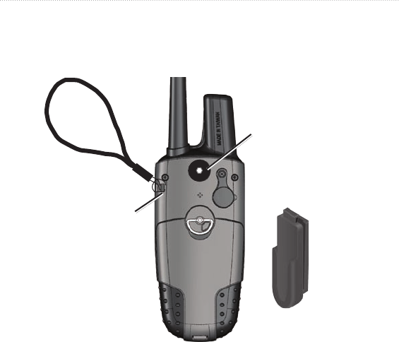
62 Astro and DC 40 Owner’s Manual
Appendix
To install the wrist strap:
1. Place the small loop of the wrist strap through the slot on the back of the unit.
2. Route the strap through the loop and pull the end of the strap.
Belt clip button
installation (tighten
the button securely
by turning it
clockwise)
Belt clip
Wrist strap
installation
See page 74 to install or remove the microSD data card in the battery
compartment.

Astro and DC 40 Owner’s Manual 63
Appendix
Specications
[table]
Physical
Size: Astro: 2.25 in. W × 6.25 in. H ×
1.25 in. D
(57 × 159 × 32 mm)
DC 40: 1.5 in. W × 1.9 in. H ×
3.7 in. D
(38 × 48 × 94 mm)
Weight: Astro: 6.5 oz. (185 g)
without batteries.
DC 40: 7.5 oz. (213 g) with
batteries and antenna and collar.
4.7 oz. (133 g) without collar.
Display: 1.5 in. W × 2.2 in. H (38.1 ×
55.9 mm),
256-color, high resolution,
transreective
(160 × 240 pixels) with
backlighting.
Water resistance: Both the Astro
and the DC 40 are water resistant
IEC-529, IPX7
Temperature Range: Astro:
from -4°F to 158°F
(from -20°C to 70°C)
DC 40: from -4°F to 140°F
(from -20°C to 60°C)
DC 40 charging temperature:
from 32°F to 113°F
(from 0°C to 45°C)
Warning: The temperature
rating of the Astro System may exceed
the usable range of certain batteries.
Certain batteries can rupture at high
temperatures.
GPS Performance
Receiver: WAAS enabled
Acquisition Times: average, for a
stationary receiver with an open sky
view.
Warm: 15 seconds
Cold: 45 seconds
AutoLocate: 2

64 Astro and DC 40 Owner’s Manual
Appendix
minutes
Update Rate: 1/second, continuous
Antenna: Astro: Built-in
quad helix
DC 40: Built-in
patch
Accuracy
GPS: < 33 ft. (10 m) 95%
DGPS: 10–16 ft. (3–5 m) 95%
typical
(WAAS accuracy in North
America)
Velocity: 0.164 ft./sec. (0.05 m/sec)
steady state
Miscellaneous
Compass: Accuracy (when
calibrated); ± 2 degrees,
resolution; 1 degree
Altimeter: Accuracy (when
calibrated): ± 10 ft. (3 m)
Resolution: 1 ft. (0.3 m)
Range: from -2,000 ft. to
30,000 ft. (from -610 to
9144 m)
Interfaces: USB for computer
interface
Data Storage Life: Indenite;no
memory battery required
Map Storage: microSD card
capacity (a small portion
of the card capacity is
used for formatting)
Power
Source: Astro: Two 1.5 volt AA
batteries, vehicle power adapter,
USB data cable
DC 40: Internal rechargeable
lithium-ion battery, vehicle power
adapter, AC charger
Battery Life: Astro: Up to
24 hours (typical use). Alkaline
batteries lose capacity as
temperature decreases. Use
lithium batteries when operating
in below-freezing conditions.

Astro and DC 40 Owner’s Manual 65
Appendix
DC 40: from 17 to 36 hours.
Recharging takes approximately
4½ hours.
Radio
MURS (Multi-use Radio Service)
Frequency:
151.82 MHz
151.88 MHz
151.94 MHz
154.57 MHz
154.60 MHz
Range: Up to 7 miles (11.2 km) - line
of sight
Output power: DC 40: 2 watts
Optional Accessories
To obtain replacements for Astro
accessories and for optional
accessories, contact your Garmin
dealer, Garmin Product Support
(page 61), or visit the Garmin Web site
at www.garmin.com/products/astro/.
Transferring Data
Before connecting your Astro to a
computer, install the USB drivers
contained in the MapSource Trip
and Waypoint Manager software
that came with your Astro. Follow
the instructions for installation and
operation provided with the software.
Information about USB Drivers
The USB drivers are installed when
you install the MapSource Trip and
Waypoint Manager software. When
you initially connect the Astro to
a USB port, your computer might
prompt you to locate the destination
of the drivers for the device. After the
drivers are installed to your computer,
your computer detects your Astro each
time you connect it to a USB port.
Periodically check www.garmin.com
for updated drivers.

66 Astro and DC 40 Owner’s Manual
Appendix
To connect your Astro to your
computer:
1. Insert the smaller connector on the
USB cable into the USB port on
the back of your Astro.
2. Connect the other cable end to a
USB port on your computer.
Transferring Data to a microSD
Card
Some Astro navigation features
require detailed mapping data, and you
may decide to purchase and transfer
detailed maps. A microSD card (not
included) can be loaded with detailed
maps from optional MapSource disks
to enhance your Astro. With detailed
MapSource mapping data, you can
view listings of nearby restaurants,
lodging, shopping centers, and
entertainment, and you can retrieve
addresses and phone numbers for
any listed location. To achieve the
best terrain details when hunting, use
Garmin U.S. Topo maps.
The amount of data transferable is
limited to the capacity of the microSD
card.
In order to transfer map data to a
microSD card, you must install the
Trip and Waypoint Manager software
and the USB cable. To transfer other
data to the microSD card, use the USB
mass storage feature explained on
page 68.
To transfer tracks, see page 70.
Purchase microSD cards from an
electronics supplier or purchase
preloaded MapSource detailed map
data cards from your Garmin dealer.
Go to
www.garmin.com/cartography/ for
compatible MapSource products.
Installing a microSD Card
You can purchase microSD memory
cards from an electronics supplier,
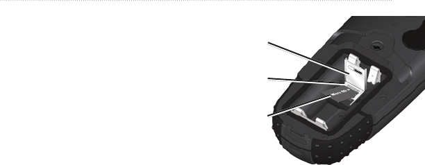
Astro and DC 40 Owner’s Manual 67
Appendix
or purchase preloaded detailed map
data cards from your Garmin dealer.
In addition to map and data storage,
the memory cards can be used to
storelessuchasimages,cartridges,
geocaches, routes, waypoints, and
custom POIs.
1. Remove the battery cover by
turning the D-ring 1/4 turn
counterclockwise and pulling up.
2. Slide up and pull out the metal
cover.
3. Align the metal contacts, and place
the card in the slot.
MicroSD card cover
Astro with Batteries
Removed
MicroSD card
MicroSD card tray
4. Push in and slide down the metal
cover.
5. Replace the batteries and the battery
cover.
Removing a microSD
Card
1. Slide up and pull out the metal
cover.
2. Remove the card from the slot.

68 Astro and DC 40 Owner’s Manual
Appendix
3. Push in and slide down the metal
cover.
To transfer Garmin MapSource
map data to the microSD card:
Follow the instructions provided
with the MapSource map data disk.
To use the USB mass storage
mode:
1. Connect the Astro to a computer
using the USB cable provided.
2. Press MENU > MENU >
Advanced > Settings > System >
MENU > Mass Storage Mode.
3. Observe an Eject icon shown
on a Windows® computer system
tray or a storage-device icon for
the microSD on a Macintosh®
computer.
4. Double-click on My Computer
(Windows computer) to observe a
new Removable Disk Drive listed.
NOTE: If you have several network
drives mapped to your computer,
Windowsmayexperiencedifculty
assigning a drive letter for your
Astro microSD card. Either log on
without connecting to the network
or, from Windows Explorer, click
Tools > Map Network Drive
and remap a drive letter for the
Astro removable storage device.
For more information, refer to the
Windows Help system.
If you are using a Macintosh
computer, double-click on the icon
toviewthedirectoryofles.
To view information for the
microSD card:
Prior to downloading data to the
microSD card, press MENU >
View Card Info to view data-card
storage information.

Astro and DC 40 Owner’s Manual 69
Appendix
To transfer les to the microSD
card:
1. Browseyourcomputerforthele
you want to copy.
2. Highlightthele,andselectEdit >
Copy.
3. Openthedriveorvolumeidentied
with the Astro.
4. Select Edit > Paste.
To eject and unplug the USB
cable:
1. Whenyouarenishedtransferring
les,clicktheEject icon
in your system tray, or drag the
volume icon to the Trash on
Macintosh computers.
2. Unplug your Astro from your
computer.
Updating Astro software
To update software on the
Astro:
1. Install Garmin MapSource Trip
and Waypoint Manager. Follow
the instructions for installation
and operation provided with the
software.
2. Connect the Astro to a computer
using the USB cable provided.
Turn the Astro on.
3. Go to www.garmin.com/products/
Astro. Click on Updates &
Downloads.
4. Follow the instructions for using
WebUpdater or click Download
(located under Unit Software) and
follow the instructions. (If Unit
Software is not listed on the Web
site, there are no updates.)
NOTE: To avoid data corruption, do
not turn the Astro off or the DC 40 off
during data transfer.

70 Astro and DC 40 Owner’s Manual
Appendix
Updating DC 40 Software
The DC 40 uses your Astro as
a wireless transfer device when
transferring software updates and
detailed dog tracks.
1. Install Garmin MapSource Trip
and Waypoint Manager. Follow
the instructions for installation
and operation provided with the
software.
2. Connect the Astro to a computer
using the USB cable provided.
Turn the Astro on.
3. Turn the DC 40 on and place it
within 12 inches of the Astro.
4. Go to www.garmin.com/products/
Astro. Click on Updates &
Downloads.
5. Open the Dog Information page
(page 7) on the Astro.
6. Press MENU > Upgrade Dog Unit
and follow on-screen instructions.
7. Follow the instructions for using
WebUpdater or click Download
(located under Unit Software) and
follow the instructions. (If Unit
Software is not listed on the Web
site, there are no updates.)
Transferring Tracks from the
Astro to MapSource on Your
Computer
To transfer tracks:
1. Open Garmin MapSource Trip
and Waypoint Manager. Select the
Tracks tab on the left side of the
MapSource page.
2. Click Receive from Device from
the Transfer menu.
Transferring More-Detailed
Dog Tracks from a DC 40 to
MapSource
The dog tracks saved on your Astro
are detailed enough for most users to
view the movements of their dog. The
DC 40 does, however, store more-

Astro and DC 40 Owner’s Manual 71
Appendix
detailed tracks of the dog’s movements.
These tracks can be transferred to
MapSource on your computer using the
Astro as a wireless transfer device to a
computer.
To transfer dog unit (DC 40)
tracks:
1. Open Garmin MapSource Trip and
Waypoint Manager.
2. Connect the Astro to a computer
using the USB cable provided. Turn
the Astro on.
3. Turn the DC 40 on and place it
within 12 inches of the Astro.
4. Open the Dog Information page on
the Astro (page 7).
5. Press MENU > Transfer Dog Unit
Track > ENTER. Wait until the
track data is buffered in to your
Astro and “Ready to communicate
with PC” appears.
6. Go to MapSource, and click the
Tracks tab on the left side of the
screen.
7. Click Receive from Device from
the Transfer menu in MapSource.
8. Check Tracks in the Receive from
Device window and click Receive.
9. When “The Data was successfully
received” appears, click OK in
MapSource.
10. Press ENTER on the Astro.
Caring for the Astro
System
Cleaning the Case
Clean the outer casing of each unit
(except for the Astro screen) using a
cloth dampened with a mild detergent
solution, and then wipe it dry. Avoid
cleaners that may damage the plastic
components.

72 Astro and DC 40 Owner’s Manual
Appendix
Cleaning the Astro Screen
Clean the Astro screen using a soft,
clean, lint-free cloth. Use water,
isopropyl alcohol, or eyeglass lens
cleaner. Apply the liquid to the cloth,
and then gently wipe the screen with
the moistened cloth.
Cleaning the Dog Collar
Hand wash the collar using a mild
detergent solution, rinse it, and then let
it air dry. Avoid chemical cleaners that
may damage the material.
Water Immersion
The Astro and DC 40 are waterproof
to IEC Standard 60529 IPX7. They
can withstand immersion in 1 meter
of water for 30 minutes. Prolonged
submersion can cause damage to the
units. After immersion, be certain to
wipe and air dry the units before using
or charging.
Storage
Do not store the Astro or DC 40 where
prolonged exposure to temperature
extremes may occur, because
permanent damage may result.
Battery Information
WARNING
See the Important Safety and Product
Information on page x for product
warnings and other important
information. The temperature rating for
the device may exceed the usable range
of some batteries. Alkaline batteries
can rupture at high temperatures.
Alkalinebatteriesloseasignicant
amount of their capacity as temperature
decreases. Use lithium batteries when
operating the device in below-freezing
conditions.
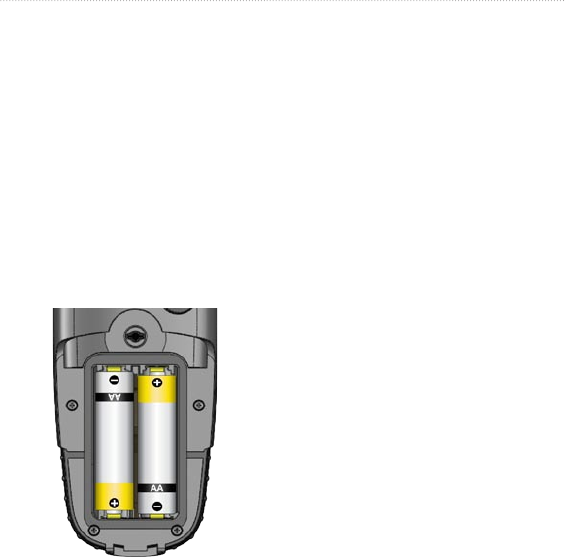
Astro and DC 40 Owner’s Manual 73
Appendix
Replacing the Batteries in
the Astro
The Astro operates on two AA alkaline,
lithium or NiMH batteries (not
included). See page 50 for information
on setting the battery type.
1. Remove the battery cover by
turning the D-ring 1/4 turn
counterclockwise and pulling up.
2. Insert the batteries, observing
polarity.
3. Replace the battery cover.
Selecting the Battery Type
1. Press MENU twice to open the
main menu.
2. Select Advanced > Settings >
System > Battery Type.
2. Select Alkaline, Lithium, or
Rechargeable NiMH.
Long-Term Storage
When you do not plan to use the
device for several months, remove the
batteries. Stored data is not lost when
batteries are removed.
Important Product and
Safety Information
NOTICE REGARDING LEGAL
RESTRICTIONS; SPECIAL NOTICE
TO USERS IN CALIFORNIA AND
ALASKA:
State law in California prohibits the use
of GPS dog collars for the pursuit of

74 Astro and DC 40 Owner’s Manual
Appendix
mammals. Alaska law prohibits guides
from using GPS devices to assist in
the taking of big game animals. This
is not intended to be an exhaustive list
of applicable laws and ordinances, and
Garmin makes no such guarantees or
warranties that this list is complete.
Check your state and local laws
and ordinances to ensure you fully
understand any restrictions applicable
to this product in your jurisdiction prior
to purchase and/or use. Garmin does
not assume any responsibility for any
nes,penalties,ordamagesthatmay
be incurred as a result of any state or
local law or ordinance relating to use
of the product.
DC 40 Battery Warnings
If these guidelines are not followed,
the internal lithium-ion battery may
experience a shortened life span or may
present a risk of damage to the DC 40,
re,chemicalburn,electrolyteleak,or
injury.
Contact your local waste
department to properly dispose of
the unit/battery.
Do not leave the unit exposed to a
heat source or in a high-temperature
location, such as in the sun in an
unattended vehicle on a hot day. To
prevent damage, remove the unit
from the vehicle or store it out of
direct sunlight, such as in the glove
box.
Do not incinerate the DC 40 or the
battery.
When storing the unit for a limited
length of time, store within the
following temperature range:
from-4˚Fto104˚F(from-20˚to
40˚C).Whenstoringtheunitfor
an extended time, store within the
following temperature range: from
32˚Fto77˚F(from0˚to25˚C).
Do not operate the unit outside of
the following temperature range:
•
•
•
•
•

Astro and DC 40 Owner’s Manual 75
Appendix
from-4˚to140˚F(from-20˚to
60˚C).
Recharge the unit within the
following temperature range: from
32˚Fto113˚F(from0˚to45˚C).
The DC 30 contains a replaceable,
rechargeable lithium-ion battery, the
following warnings also apply:
Do not recharge the battery outside
of the unit or disassemble the
battery.
Keep the used battery away from
children. Do not disassemble,
puncture, or damage the battery.
Replace the battery with a Garmin
lithium-ion battery pack. Using
another battery presents a risk
ofreorexplosion.Topurchase
a replacement battery, see your
Garmin dealer or the Garmin Web
site (www.garmin.com). Do not
leave the DC 30 where a dog may
•
•
•
•
attempt to chew on it. If the battery
cell is punctured, electrolyte can
be released that can be harmful to
the dog.
Long-Term DC 40 Battery
Storage
The normal long-term decrease in
the charging capacity of lithium-
ion batteries can be accelerated by
exposure to elevated temperatures.
Storing a fully charged battery for more
than three months in a location that
exposes it to high temperatures (above
70°For21°C)cansignicantlyreduce
its recharging capacity. Before storage,
charge the battery to approximately
50% of capacity and store it in a cool,
dry location where temperatures are not
expected to exceed typical household
levels. Do not store a fully depleted
battery because it may not recharge
after an extended period of storage.
After storage, fully charge the battery
again before using the DC 40.

76 Astro and DC 40 Owner’s Manual
Appendix
Software License
Agreement
BY USING THE Astro SYSTEM,
YOU AGREE TO BE BOUND BY
THE TERMS AND CONDITIONS
OF THE FOLLOWING SOFTWARE
LICENSE AGREEMENT. PLEASE
READ THIS AGREEMENT
CAREFULLY.
Garmin grants you a limited license
to use the software embedded in this
device (the “Software”) in binary
executable form in the normal
operation of the product. Title,
ownership rights, and intellectual
property rights in and to the Software
remain in Garmin.
You acknowledge that the Software
is the property of Garmin and is
protected under the United States
of America copyright laws and
international copyright treaties. You
further acknowledge that the structure,
organization, and code of the Software
are valuable trade secrets of Garmin
and that the Software in source code
form remains a valuable trade secret of
Garmin. You agree not to decompile,
disassemble, modify, reverse assemble,
reverse engineer, or reduce to human
readable form the Software or any part
thereof or create any derivative works
based on the Software. You agree not
to export or re-export the Software to
any country in violation of the export
control laws of the United States of
America.
FCC Compliance
This device complies with part 15 of
the FCC Rules. Operation is subject
to the following two conditions: (1)
this device may not cause harmful
interference, and (2) this device must
accept any interference received,
including interference that may cause
undesired operation.

Astro and DC 40 Owner’s Manual 77
Appendix
This equipment has been tested and
found to comply with the limits for
a Class B digital device, pursuant to
part 15 of the FCC rules. These limits
are designed to provide reasonable
protection against harmful interference
in a residential installation. This
equipment generates, uses, and can
radiate radio frequency energy and
may cause harmful interference to
radio communications if not installed
and used in accordance with the
instructions. However, there is no
guarantee that interference will not
occur in a particular installation. If
this equipment does cause harmful
interference to radio or television
reception, which can be determined by
turning the equipment off and on, the
user is encouraged to try to correct the
interference by one of the following
measures:
Reorient or relocate the receiving
antenna.
•
Increase the separation between the
equipment and the receiver.
Connect the equipment into an
outlet that is on a different circuit
from the GPS device.
Consult the dealer or an
experienced radio/TV technician
for help.
This product does not contain any
user-serviceable parts. Repairs should
only be made by an authorized Garmin
service center. Unauthorized repairs or
modicationscouldresultinpermanent
damage to the equipment, and void
your warranty and your authority
to operate this device under Part 15
regulations.
Industry Canada Compliance
Category I radiocommunication
devices comply with Industry Canada
Standard RSS-210. Category II
radiocommunication devices comply
with Industry Canada Standard RSS-
•
•
•

78 Astro and DC 40 Owner’s Manual
Appendix
310.
IMPORTANT WARNINGS: READ
THIS INFORMATION BEFORE
USING YOUR ASTRO DOG
TRACKING SYSTEM:
Exposure to Radio Frequency
Signals–Your product is a low power
radio transmitter and receiver. When
it is on, it receives and also sends out
radio frequency (RF) signals. In August
1996, The Federal Communications
Commissions (FCC) adopted RF
exposure guidelines with safety levels
for handheld wireless radios. Those
guidelines are consistent with safety
standards previously set by both U.S.
and international standards bodies:
American National Standards Institute
(ANSI) IEEE. C95.1-1992; National
Council on Radiation Protection
and Measurements (NCRP) Report
86; International Commission on
Non-Ionizing Radiation Protection
(ICNIRP) 1996. Those standards were
based on comprehensive and periodic
evaluationsoftherelevantscientic
literature. For example, over 130
scientists, engineers, and physicians
from universities, government health
agencies, and industry reviewed the
available body of research to develop
the ANSI Standard (C95.1). The design
of your radio complies with the FCC
guidelines (and those standards).
For body-worn and face-held
operation, this radio demonstrates
compliance and meets the FCC RF
exposure guidelines for uncontrolled
exposure (general population) when
used with approved accessories
supplied with or designed for this
product. Use of other accessories may
not ensure compliance with FCC RF
exposure guidelines.
Antenna Care–Use only the supplied
antenna. Unauthorized antennas,

Astro and DC 40 Owner’s Manual 79
Appendix
modications,orattachmentscould
damage the radio and may violate
FCC regulations. Warning: Do not
use any radio that has a damaged
antenna, because if it comes into
contact with your skin, a minor burn
can result.
Electronic Devices–Most modern
electronic equipment is shielded
from RF signals. However, certain
equipment may not be shielded against
the RF signals from your wireless
radio.
Pacemakers–The Health Industry
Manufacturers Association (HIMA)
recommends that a minimum
separation of six inches (6”) be
maintained between a handheld
wireless radio and a pacemaker to
avoid potential interference with the
pacemaker. These recommendations
are consistent with the independent
research by and recommendations
of Wireless Technology Research.
Persons with pacemakers should
ALWAYS keep the radio more than
six inches from their pacemaker
when the radio is turned on, should
not carry the radio in a breast pocket,
should use the ear opposite the
pacemaker to minimize the potential
for interference, and should turn the
radio off immediately if you have any
reason to suspect that interference is
taking place.
Hearing Aids–Some digital wireless
radios may interfere with some hearing
aids. In the event of such interference,
you may want to consult your
hearing aid manufacturer to discuss
alternatives.
Other Medical Devices–If you use
any other personal medical device,
consult the manufacturer of your
device to determine if it is adequately
shielded from external RF energy.

80 Astro and DC 40 Owner’s Manual
Appendix
Your physician may be able to assist
you in obtaining this information.
Turn your radio OFF in health care
facilities when any regulations posted
in these areas instruct you to do so.
Hospitals or health care facilities may
be using equipment that could be
sensitive to external RF energy.
Vehicles–RF signals may affect
improperly installed or inadequately
shielded electronic systems in motor
vehicles. Check with the manufacturer
or its representative regarding your
vehicle. You should also consult the
manufacturer of any equipment that
has been added to your vehicle.
Posted Facilities–Turn your radio OFF
in any facility where posted notices so
require.
Commercial Aircraft–Many
commercial airlines prohibit the use of
FRS/GMRS radios on board. Switch
OFF your radio before boarding an
aircraft or check the airline rules.
Blasting Areas–To avoid interfering
with blasting operations, turn your
radio OFF when in a “blasting area”
or in areas posted: “Turn off two-way
radio.” Obey all signs and instructions.
Potentially Explosive Atmospheres–
Turn your radio OFF and do not
remove your battery when you are in
any area with a potentially explosive
atmosphere. Obey all signs and
instructions. Sparks from your battery
in such areas could cause an explosion
orreresultinginbodilyinjuryoreven
death.
Areas with a potentially explosive
atmosphere are often, but not always
clearly marked. They include fueling
areas such as gasoline stations, below
deck on boats, fuel or chemical transfer
or storage facilities; vehicles using

Astro and DC 40 Owner’s Manual 81
Appendix
liqueedpetroleumgas(suchas
propane or butane); areas where the
air contains chemicals or particles,
such as grain, dust, or metal powders;
and any other area where you would
normally be advised to turn off your
vehicle engine.

82 Astro and DC 40 Owner’s Manual
Index
Index
Symbols
? symbol 11
A
accessories 41, 56
accuracy, GPS 55
active route 39
adding dogs to the dog
list 12
addresses 22
alarms
marine 51
proximity 37, 44
alarm tones 38
alert
GPS lost 45
lost communication 45
on-point 45
altimeter
settings 29
setup 53
altimeter page 28
zoom ranges 30
anchor drag alarm 51
area calculation 32
auto calibration 53
auto zoom 47
averaging 16
avoid 50
B
backlight level 4, 45
backlight timeout 45
barometer mode 53
battery
installation 2
life 55
power remaining 7
type 44
warnings iv
bearing pointer 26
below 47
belt clip 2
big numbers
dog tracker page 12
trip computer page 25
C
calculation method 50
calculator 42
calendar 41
calendar entry when found
51
calibration
altimeter 30
compass 6
setup 53
change comm. settings
10, 13
changedataelds
altimeter 30
map page 18
trip computer page 25
change dog unit type 10
change reference 20
charging the DC 30 4
city,nding21
cleaning 60
color
dog pointer 11
scheme 45
track 31
communicating with the
DC 30 8

Astro and DC 40 Owner’s Manual 83
Index
compass
calibrating 6
page 25
compass settings
changing 27
highway page 37
conictingdogsignals12
course pointer 26
D
data card storage
information 58
dataelds
compass 27
map page 18
daylight saving time 51
delete dog unit track 10
DEM maps 33
depth units 52
detail 47
detailed maps 22, 56
display mode 45
display setup 45
distance, measuring 19
distance/speed 52
dog alerts 45
dog information page 9
dog list setup 45
dog status 11
dog tracker page 8
dog tracks, transferring 59
E
EGNOS 44
elevation (vert. speed) 52
elevation, GPS 40
ENTER key 3
exits,nding21
external power lost 44
F
faster time 50
nd20
ndbynamemenu20
ndnearhere20
xedelevation53
follow road 34, 49
follow road options 50
follow track 34
G
games 43
geocache
nding21
setup 51
go to 9, 20
go to marked location 14
GPS
applications 24
lost alert 45
mode 44
guidance method 49
guidance text 17
H
heading setup 52
highway page 37
I
identify dog unit 10
IN/OUT Zoom keys 3
interval 31
K
keypad 3

84 Astro and DC 40 Owner’s Manual
Index
L
lap by button press 42
lap by distance 42
light sectors 49
locations
averaging a location
16
marking 15
moving 16
projecting 16
lock on road 47
lost communication alert
45
M
Main Menu 14
adding items 46
deleting 46
reordering 46
setup 46
manual conventions 7
map 9, 20
datum 52
orientation 47
map page 17
mapdataelds18
measuring distance 19
options menu 17
map setup
general page 47
information page 48
marine page 49
points page 48
text page 48
tracks page 47
MapSource 57
marine
alarms setup 51
colors 49
setup 51
marked location
adding 15
averaging 16
editing 16
moving 16
projecting 16
marking a location - map
page 15
markinghunting-specic
locations 15
MARK key 3, 15
mass storage mode 44
measuring distance 19
MENU key 3
microSD card 56, 57
moonrise 14
moonset 14
moving a marked location
16
multicolor 39
MURS frequencies 55
N
naming the dog 9
NEAR message 11
new location 40
next turn pop-up 50
north reference 52
north up 39
O
off course alarm 51
off road 49
off road transition 36
off route recalculation 50
on-point alert 45

Astro and DC 40 Owner’s Manual 85
Index
P
pause all tracking 12
plot over distance 29
plot over time 29
points of interest 23
POIs 23
position format 52
power key 5
powerspecications55
pressure setup 52
prole33
projecting a location 16
prompted
follow road method 49
guidance method 49
off route recalculation
50
proximity
alarm tones 38
locations 37
Q
QUIT key 3
R
radio 55
recalculate 17
recentnds20
record method 31
registration i
remove points 42
reset
altimeter 30
trip computer 25
restore defaults
system settings 44
trip computer page 25
resume all tracking 12
resume navigation 17
rocker key 3
route points 35
routes 34
copying 36
creating 34
deleting 35
editing 35
route page options 36
turn previews 38, 39
routing setup 49
S
satellite page 39
save 20
selecting options 7
setup
altimeter 53
calibration 53
heading 52
main menu 46
map 46
routing 49
time 51
units 52
setup map 17
shorter distance 50
show info 12
sight ‘n go 27
single color 39
small numbers 12
software version 44
specications54
spot soundings 49
start new hunt 14
start tracking 10
status bar 7

86 Astro and DC 40 Owner’s Manual
Index
stop
measuring 19
navigation 17
tracking 10
stopwatch 42
storage 61
sunrise 14
sunset 14
symbol set 49
T
time setup 51
tones setup 46
TracBack 33
tracking a dog 10
track log 31
trackprole,zooming33
tracks 30
calculating area 32
proles33
tracks page 31
track up 39
transferring data to a
microSD card 57
transferring dog tracks 59
trip computer page 24
turn preview page 38
U
units of measure 52
units setup 52
updating software
Astro 58
DC 30 59
upgrade dog unit 10
USB drivers 56
use map data 33
use track data 33
use with GPS on or off 39
UTC offset 51
V
version 44
view card info 44, 58
view elevation plot 29
view hunting almanac 14
view pressure plot 29
view sunrise/sunset 14
W
WAAS 44
water immersion 61
wrap when full 31
wrist strap 2
Z
zoom
altimeter 30
auto 47
highway page 37
trackprole33
zoom ranges
altimeter 30

For the latest free software updates (excluding map data) throughout the
life of your Garmin products, visit the Garmin Web site at www.garmin.com.
© 2010 Garmin Ltd. or its subsidiaries
Garmin International, Inc.
1200 East 151st Street, Olathe, Kansas 66062, USA
Garmin (Europe) Ltd.
Liberty House, Hounsdown Business Park, Southampton, Hampshire, SO40 9LR UK
Garmin Corporation
No. 68, Jangshu 2nd Road, Sijhih, Taipei County, Taiwan
www.garmin.com
Part Number 190-01237-00 Rev. A