Garmin 01824 LOW POWER TRANSMITTER (2400-2483.5 MHz) User Manual
Garmin International Inc LOW POWER TRANSMITTER (2400-2483.5 MHz) Users Manual
Garmin >
Users Manual
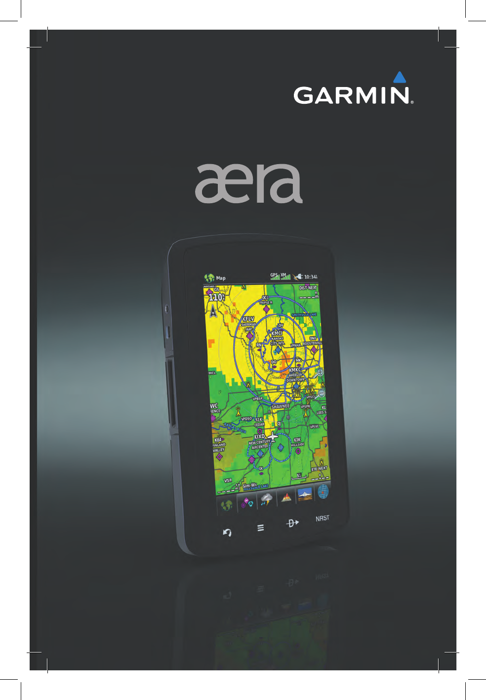
models: 795 and 796
™
Quick Reference Guide


OVERVIEW
GPS NAVIGATION
FLIGHT PLANNING
HAZARD AVOIDANCE
UTILITIES
APPENDIX
INDEX

Copyright © 2011 Garmin Ltd. or its subsidiaries. All rights reserved.
This manual reflects the operation of System Software version 0002.0 or later. Some differences
in operation may be observed when comparing the information in this manual to earlier or later
software versions.
Garmin International, Inc., 1200 East 151st Street, Olathe, Kansas 66062, U.S.A.
Tel: 913/397.8200 Fax: 913/397.8282
Garmin AT, Inc., 2345 Turner Road SE, Salem, OR 97302, U.S.A.
Tel: 503/391.3411 Fax 503/364.2138
Garmin (Europe) Ltd, Liberty House, Bulls Copse Road, Hounsdown Business Park,
Southampton, SO40 9RB, U.K.
Tel: 44/0870.8501241 Fax: 44/0870.8501251
Garmin Corporation, No. 68, Jangshu 2nd Road, Shijr, Taipei County, Taiwan
Tel: 886/02.2642.9199 Fax: 886/02.2642.9099
Web Site Address: www.garmin.com
Except as expressly provided herein, no part of this manual may be reproduced, copied, transmitted,
disseminated, downloaded or stored in any storage medium, for any purpose without the express
written permission of Garmin. Garmin hereby grants permission to download a single copy of this
manual and of any revision to this manual onto a hard drive or other electronic storage medium to
be viewed for personal use, provided that such electronic or printed copy of this manual or revision
must contain the complete text of this copyright notice and provided further that any unauthorized
commercial distribution of this manual or any revision hereto is strictly prohibited.
Garmin
®
and SafeTaxi
®
are registered trademarks of Garmin Ltd. or its subsidiaries. aera
™
is
a trademark of Garmin Ltd. or its subsidiaries. These trademarks may not be used without the
express permission of Garmin.
Jeppesen
®
is a registered trademark of Jeppesen, Inc.
Sirius XM
®
is a registered trademark of Sirius XM Satellite Radio, Inc.
June 2011 190-01194-01 Rev. A Printed in the United States or Taiwan
Garmin aera 795/796 Quick Reference Guide
190-01194-01 Rev. A
Warnings, Cautions & Notes
WARNING: When installing the aera
™
795/796, place the unit so it does not
obstruct the field of view or interfere with operating controls.
WARNING: The indicators represented on the Panel are based on GPS-derived
data and may differ from the instruments in the aircraft.
WARNING: Navigation and terrain separation must NOT be predicated upon
the use of the terrain function. The aera 795/796
Terrain Proximity feature
is NOT intended to be used as a primary reference for terrain avoidance
and does not relieve the pilot from the responsibility of being aware of
surroundings during flight. The Terrain Proximity feature is only to be used
as an aid for terrain avoidance and is not certified for use in applications
requiring a certified terrain awareness system. Terrain data is obtained from
third party sources. Garmin is not able to independently verify the accuracy
of the terrain data.
WARNING: The displayed minimum safe altitudes (MSAs) are only advisory
in nature and should not be relied upon as the sole source of obstacle and
terrain avoidance information. Always refer to current aeronautical charts
for appropriate minimum clearance altitudes.
WARNING: The altitude calculated by aera 795/796 GPS receivers is geometric
height above Mean Sea Level and could vary significantly from the altitude
displayed by pressure altimeters. Always use pressure altitude displayed by
the aircraft altimeter when determining or selecting aircraft altitude.
WARNING: Do not use outdated database information. Databases used in
the aera 795/796 system must be updated regularly in order to ensure that
the information remains current. Pilots using any outdated database do so
entirely at their own risk.
WARNING: SiriusXM Weather should not be used for hazardous weather
penetration. Weather information is approved only for weather avoidance,
not penetration.
WARNING: NEXRAD weather data is to be used for long-range planning
purposes only. Due to inherent delays in data transmission and the relative
age of the data, NEXRAD weather data should not be used for short-range
weather avoidance.
Garmin aera 795/796 Quick Reference Guide
190-01194-01 Rev. A
Warnings, Cautions & Notes
WARNING: The illustrations in this guide are only examples. Never use the
aera 795/796 to attempt to penetrate a thunderstorm. Both the FAA Advisory
Circular, Subject: Thunderstorms, and the Aeronautical Information Manual
(AIM) recommend avoiding “by at least 20 miles any thunderstorm identified
as severe or giving an intense radar echo.”
WARNING: To reduce the risk of unsafe operation, carefully review and
understand all aspects of the aera 795/796 Pilot’s Guide documentation and
the Pilot’s Operating Handbook of the aircraft. Thoroughly practice basic
operation prior to actual use. During flight operations, carefully compare
indications from the aera 795/796 to all available navigation sources, including
the information from other NAVAIDs, visual sightings, charts, etc. For safety
purposes, always resolve any discrepancies before continuing navigation.
WARNING: The Garmin aera 795/796 has a very high degree of functional
integrity. However, the pilot must recognize that providing monitoring and/or
self-test capability for all conceivable system failures is not practical. Although
unlikely, it may be possible for erroneous operation to occur without a fault
indication shown by the aera 795/796. It is thus the responsibility of the pilot
to detect such an occurrence by means of cross-checking with all redundant
or correlated information available in the cockpit.
WARNING: For safety reasons, aera 795/796 operational procedures must
be learned on the ground.
WARNING: The United States government operates the Global Positioning
System and is solely responsible for its accuracy and maintenance. The GPS
system is subject to changes which could affect the accuracy and performance
of all GPS equipment. Portions of the Garmin aera 795/796 utilize GPS as a
precision electronic NAVigation AID (NAVAID). Therefore, as with all NAVAIDs,
information presented by the aera 795/796 can be misused or misinterpreted
and, therefore, become unsafe.
WARNING: The data contained in the terrain and obstacle databases comes
from government agencies. Garmin accurately processes and cross-validates
the data, but cannot guarantee the accuracy and completeness of the data.
Garmin aera 795/796 Quick Reference Guide
190-01194-01 Rev. A
Warnings, Cautions & Notes
WARNING: Do not use basemap (land and water data) information for
primary navigation. Basemap data is intended only to supplement other
approved navigation data sources and should be considered as an aid to
enhance situational awareness.
BATTERY WARNINGS:
If these guidelines are not followed, the internal lithium-ion battery may
experience a shortened life span or may present a risk of damage to the
GPS device, fire, chemical burn, electrolyte leak, and/or injury.
•
Do not leave the device exposed to a heat source or in a high-
temperature location, such as in the sun in an unattended vehicle. To
prevent damage, remove the device from the vehicle or store it out of
direct sunlight, such as in the glove box.
•
Do not puncture or incinerate the device or battery.
•
When storing the device for an extended time, store within the
following temperature range: from 32˚ to 77˚F (from 0˚ to 25˚C)
•
Do not operate the device outside of the following temperature range:
from -4˚ to 131˚F (from -20˚ to 55˚C).
•
Contact your local waste disposal department to dispose of the
device/battery in accordance with applicable local laws and
regulations.
Additional User-Replaceable Battery Warnings:
•
Do not use a sharp object to remove the battery.
•
Keep the battery away from children.
•
Do not disassemble, puncture, or damage the battery.
•
If using an external battery charger, only use the Garmin accessory
approved for your product.
•
Only replace the battery with the correct replacement battery. Using
another battery presents a risk of fire or explosion. To purchase a
replacement battery, see your Garmin dealer or the Garmin Web site.
Additional Non-User-Replaceable Battery Warning:
•
Do not remove or attempt to remove the non-user-replaceable battery.
CAUTION: Avoid using any chemical or abrasive cleaners on the touchscreen
and/or plastic casing. Clean the touchscreen with a soft, clean, lint-free cloth.
Use water, isopropyl alcohol, or eyeglass cleaner, if needed.
Garmin aera 795/796 Quick Reference Guide
190-01194-01 Rev. A
Warnings, Cautions & Notes
CAUTION: The Garmin aera 795/796 does not contain any user-serviceable
parts. Repairs should only be made by an authorized Garmin service center.
Unauthorized repairs or modifications could void both the warranty and the
pilot’s authority to operate this device under FAA/FCC regulations.
NOTE: All visual depictions contained within this document, including screen
images of the aera 795/796 panel and displays, are subject to change and
may not reflect the most current aera 795/796 system and aviation databases.
Depictions of equipment may differ slightly from the actual equipment.
NOTE: This product, its packaging, and its components contain chemicals
known to the State of California to cause cancer, birth defects, or reproductive
harm. This notice is being provided in accordance with California’s Proposition
65. If you have any questions or would like additional information, please
refer to our web site at www.garmin.com/prop65.
NOTE: Interference from GPS repeaters operating inside nearby hangars can
cause an intermittent loss of attitude and heading displays while the aircraft
is on the ground. Moving the aircraft more than 100 yards away from the
source of the interference should alleviate the condition.
NOTE: Use of polarized eyewear may cause the flight displays to appear dim
or blank.
NOTE: Temporary Flight Restriction (TFR) data is provided by the FAA and
may not be updated outside of normal business hours. Confirm data currency
through alternate sources and contact your local FSS for interpretation of TFR
data.

Garmin aera 795/796 Quick Reference Guide
190-01194-01 Rev. A i
Table of Contents
Section 1 Overview ........................................................................................ 1
1.1 Unit Overview ............................................................................................................ 1
1.2 Getting Started .........................................................................................................2
Battery Installation ............................................................................................................... 2
Charging the Battery ............................................................................................................ 4
GPS Receiver Status ............................................................................................................. 4
Display Orientation ............................................................................................................... 4
1.3 Operation ...................................................................................................................5
Dedicated Icons .................................................................................................................... 5
Page Buttons ....................................................................................................................... 5
Main Menu .......................................................................................................................... 6
Basic Touchscreen Operation .............................................................................................. 10
1.4 Menus and Data Entry ............................................................................................11
Option Menus .................................................................................................................... 11
Data Entry .......................................................................................................................... 12
1.5 Using Map Displays .................................................................................................13
Map Panning ..................................................................................................................... 13
Map Range ........................................................................................................................ 15
Map Overlays ..................................................................................................................... 15
Section 2 GPS Navigation ............................................................................ 17
2.1 Flight Data ...............................................................................................................17
Data Fields ......................................................................................................................... 17
Numeric Flight Data ........................................................................................................... 17
2.2 HSI/Panel ..................................................................................................................18
Setting the Bug Indicator .................................................................................................... 18
Manually Setting a Course .................................................................................................. 18
2.3 Vertical Navigation (VNAV) ....................................................................................19
Using the VNAV Feature ..................................................................................................... 19
2.4 Waypoints ................................................................................................................20
Nearest Information ........................................................................................................... 21
Weather Information (aera 796) ......................................................................................... 21
User Waypoints .................................................................................................................. 21
2.5 Direct-to Navigation ...............................................................................................22
Section 3 Flight Planning ............................................................................. 25
3.1 Flight Plan Data Fields ............................................................................................ 25
3.2 Flight Plan Creation ................................................................................................25
3.3 Adding Flight Plan Waypoints ................................................................................ 26
3.4 Flight Plan Storage .................................................................................................27
3.5 Flight Plan Activation .............................................................................................28
3.6 Flight Plan Deletion ................................................................................................28
3.7 Approaches ..............................................................................................................29

Garmin aera 795/796 Quick Reference Guide
190-01194-01 Rev. A
ii
Table of Contents
Section 4 Hazard Avoidance ......................................................................... 31
4.1 S
irius
XM® Weather (aera 796) .................................................................................31
4.2 Terrain ......................................................................................................................31
4.3 Traffic Information Service (TIS) ............................................................................32
Section 5 Utilities .......................................................................................... 33
5.1 Flight Log .................................................................................................................33
5.2 Track Log ..................................................................................................................33
5.3 E6B Calculator .........................................................................................................34
5.4 Aircraft Profile .........................................................................................................35
5.5 Weight & Balance ....................................................................................................36
Section 6 Appendix ...................................................................................... 37
Miscellaneous Message Advisories ...................................................................................... 37
Airspace Messages ............................................................................................................. 38
Data Field & Numeric Data Options .................................................................................... 39
Aural Alerts ........................................................................................................................ 41
Loss of GPS Position ........................................................................................................... 41
Hazard Display with Loss of GPS Position ............................................................................ 41
License Agreement and Warranty ........................................................................................ 42
AOPA Airport Directory Notice ............................................................................................ 43
S
irius
XM Satellite Radio Service Agreement ........................................................................ 44
Weather Data Warranty ...................................................................................................... 44
FCC Compliance................................................................................................................. 45
Industry Canada Compliance .............................................................................................. 45
Garmin aera 795/796 Quick Reference Guide
190-01194-01 Rev. A 1
Overview
Overview GPS Navigation Flight Planning Hazard Avoidance Utilities Appendix Index
SECTION 1 OVERVIEW
1.1 UNIT OVERVIEW
The purpose of this document is to provide a resource with which to find operating
instructions on the major features of the aera 795/796 more easily. This Quick
Reference Guide is not intended to be a comprehensive operating guide. Refer to the
aera 795/796 Pilot’s Guide for complete operating procedures and warnings.
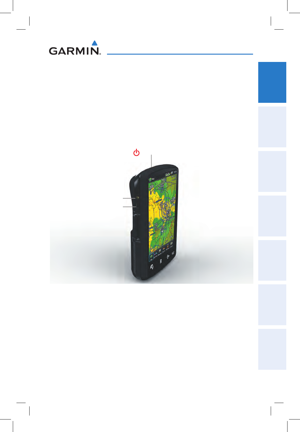
Unit Overview (Left Side)
External Antenna Connector
Power Button
USB Connector
Garmin aera 795/796 Quick Reference Guide
190-01194-01 Rev. A
2
Overview
OverviewGPS NavigationFlight PlanningHazard AvoidanceUtilitiesAppendixIndex
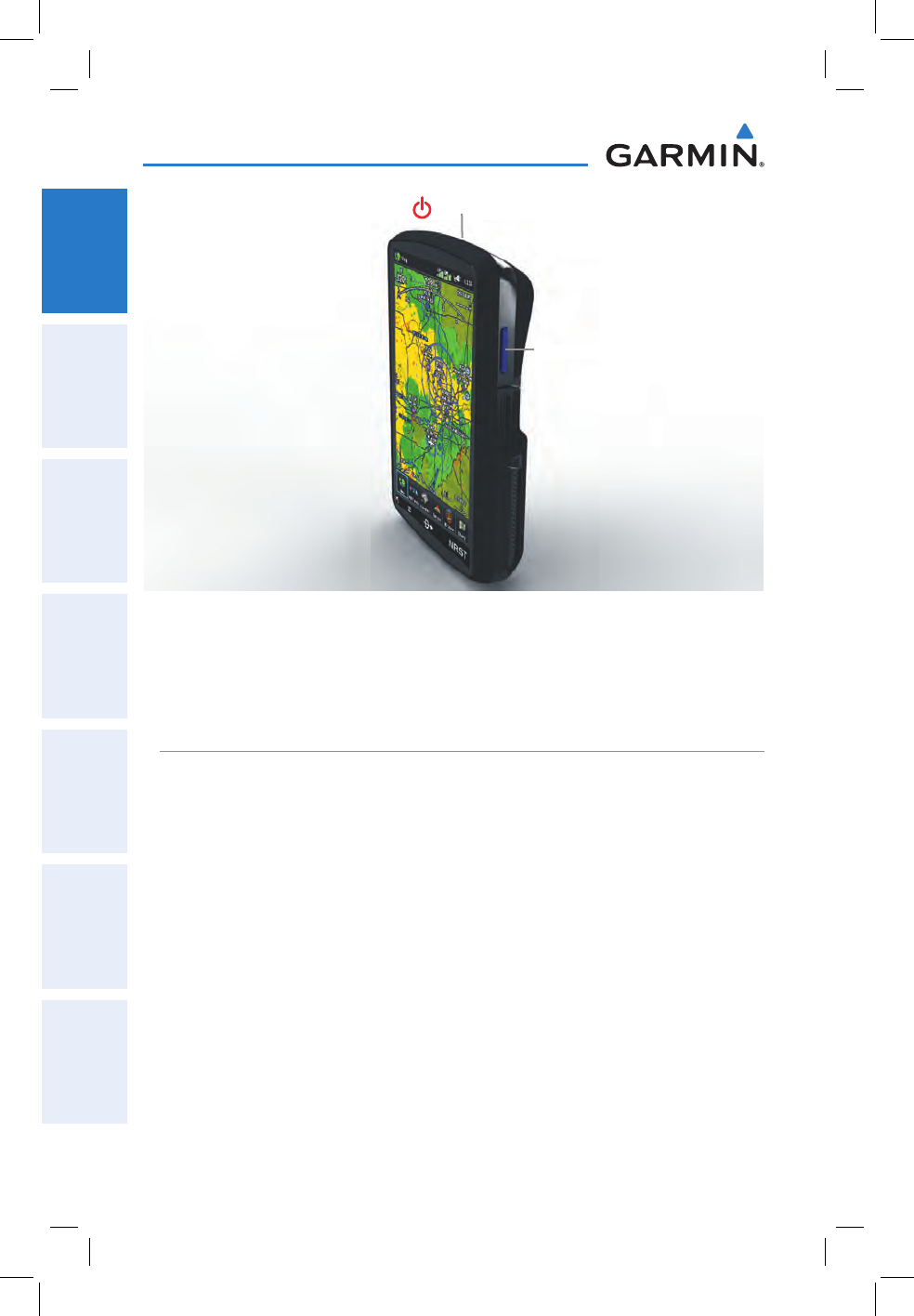
SD Card Slot
Unit Overview (Right Side)
Power Button
1.2 GETTING STARTED
BATTERY INSTALLATION
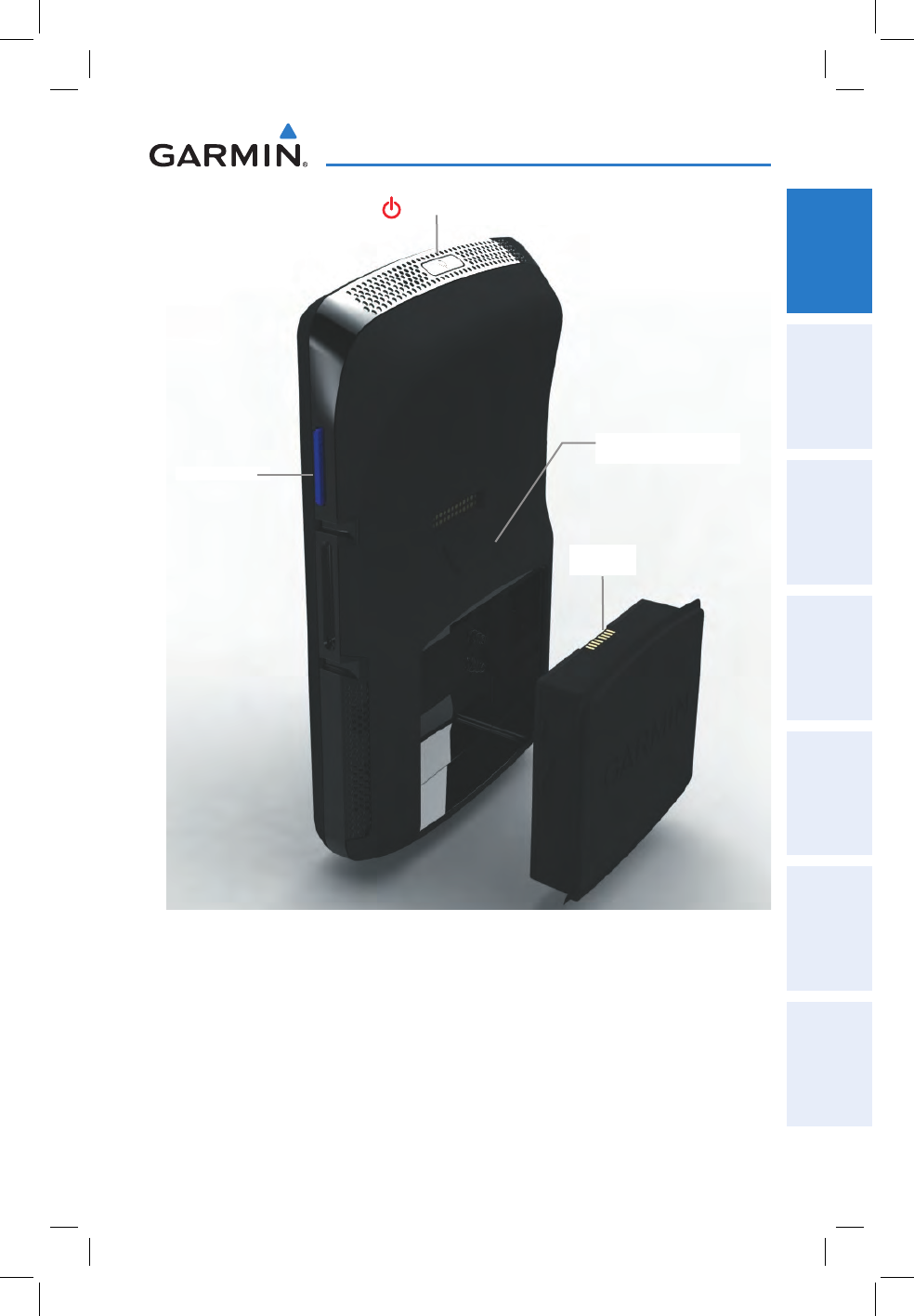
Installing the battery:
1)
Locate the lithium-ion battery that came in the product box.
2)
Locate the metal contacts on the end of the lithium-ion battery.
3)
Insert the battery so that the metal contacts on the battery line-up with the
metal contacts inside the battery compartment as shown below.
4)
Insert the battery into the battery compartment, and push until it clicks into
place.
Garmin aera 795/796 Quick Reference Guide
190-01194-01 Rev. A 3
Overview
Overview GPS Navigation Flight Planning Hazard Avoidance Utilities Appendix Index
Battery Release: Push
to remove the battery
Unit Overview (Back - Battery Out)
Power Button
SD Card Slot
Battery
Contacts

Garmin aera 795/796 Quick Reference Guide
190-01194-01 Rev. A
4
Overview
OverviewGPS NavigationFlight PlanningHazard AvoidanceUtilitiesAppendixIndex
CHARGING THE BATTERY
NOTE: While in Charge Mode, the unit draws a current from the aircraft. To
avoid discharging the aircraft’s battery, disconnect the external power cable
from the unit when not in use for several days.
Charging the unit’s battery using the aircraft's power outlet:
1)
Mount the aera 795/796 in the aircraft (refer to the aera 795/796 Pilot's
Guide), and connect the power cable to the aircraft power outlet (cigarette
lighter receptacle).
2)
Route the power cable so that it does not interfere with aircraft operation.
The unit begins charging as soon as external power is applied.
GPS RECEIVER STATUS
The bars located at the top of the screen indicate the GPS signal strength.
Viewing the GPS status:
From the Main Menu, touch Tools > GPS Status.
DISPLAY ORIENTATION
The aera 795/796 can be view in either Portrait or Landscape Mode.
Changing the display orientation:
1)
From the Main Menu, touch Tools > Setup > Display
Or
:
Press the Power Button once quickly.
2)
Touch the 'Display Orientation' datafield to select Portrait or Landscape.
Garmin aera 795/796 Quick Reference Guide
190-01194-01 Rev. A 5
Overview
Overview GPS Navigation Flight Planning Hazard Avoidance Utilities Appendix Index
1.3 OPERATION
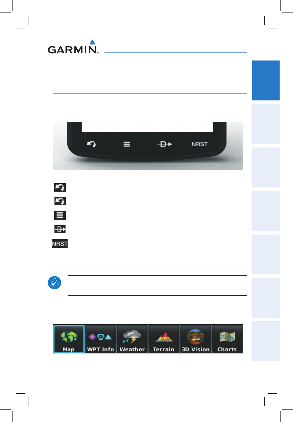
DEDICATED ICONS
Located on the bezel (below the touchscreen) are four dedicated touch icons.
Touch or touch and hold the following icons to perform the associated function:
Dedicated Icons
Back Returns to previous screen. Cancels the map
pointer.
Main Menu (Shortcut) Touch and hold to display the Main Menu.
Menu Displays the context sensitive option menu.
Direct-to Displays the Direct-to function.
NRST Displays the Nearest Icons.
PAGE BUTTONS
NOTE: The aera 795/796 Page Buttons are User Configurable. Refer to the
aera 795/796 Pilot's Guide for more information.
Six different configurable Page Buttons are located above the Dedicated Icons. The
Page Buttons default to (Map, WPT Info, Weather (aera 796), Terrain, 3D Vision,
and Charts).
Page Buttons

Garmin aera 795/796 Quick Reference Guide
190-01194-01 Rev. A
6
Overview
OverviewGPS NavigationFlight PlanningHazard AvoidanceUtilitiesAppendixIndex
Configuring the Page Buttons:
1)
Main Menu, touch Tools > Setup > Display > Choose Buttons
2)
From the available Page Buttons at the top half of the screen, touch the
new Page Button that will replace one of the current Page Buttons.
3)
From the current Page Buttons along the bottom of the screen, touch the
Page Button that will be replaced by the new page button. The current
Page Button is now replaced by the new Page Button.
4)
Touch Save.
MAIN MENU
Touch and hold the
icon at any time to display the Main Menu.
MAIN MENU ICONS
Touch the following icons to display the associated function:
Map Displays the Map View.
Terrain Displays the Terrain View.
3D Vision Displays 3D Vision.
WPT Info Displays the Waypoint Information.
FPL List Displays the Flight Plan List.
Active FPL Displays the Active Flight Plan.
Numbers Displays flight data.
Doc Viewer Displays the document viewer.
Charts Displays the VFR or IFR charts.
Weather Displays second-level Weather Icons (aera 796).
SiriusXM Displays SiriusXM Radio (aera 796).
Tools Displays second-level Tools Icons.
Garmin aera 795/796 Quick Reference Guide
190-01194-01 Rev. A 7
Overview
Overview GPS Navigation Flight Planning Hazard Avoidance Utilities Appendix Index
NEAREST ICONS
Touch the
icon at any time to access the second-level Nearest icons.
Touch the following icons to display the associated function:
Airport Displays nearest airports.
Airport WX Displays nearest airport weather.
VOR Displays nearest VORs.
NDB Displays nearest NDBs.
Intersection Displays nearest intersections.
VRP Displays nearest Visual Reporting Point (VRP) (Atlantic).
User WPT Displays nearest user waypoints.
City Displays nearest cities.
ARTCC Displays nearest ARTCCs.
FSS Displays nearest Flight Service Stations (FSS).
Airspace Displays nearest airspace.
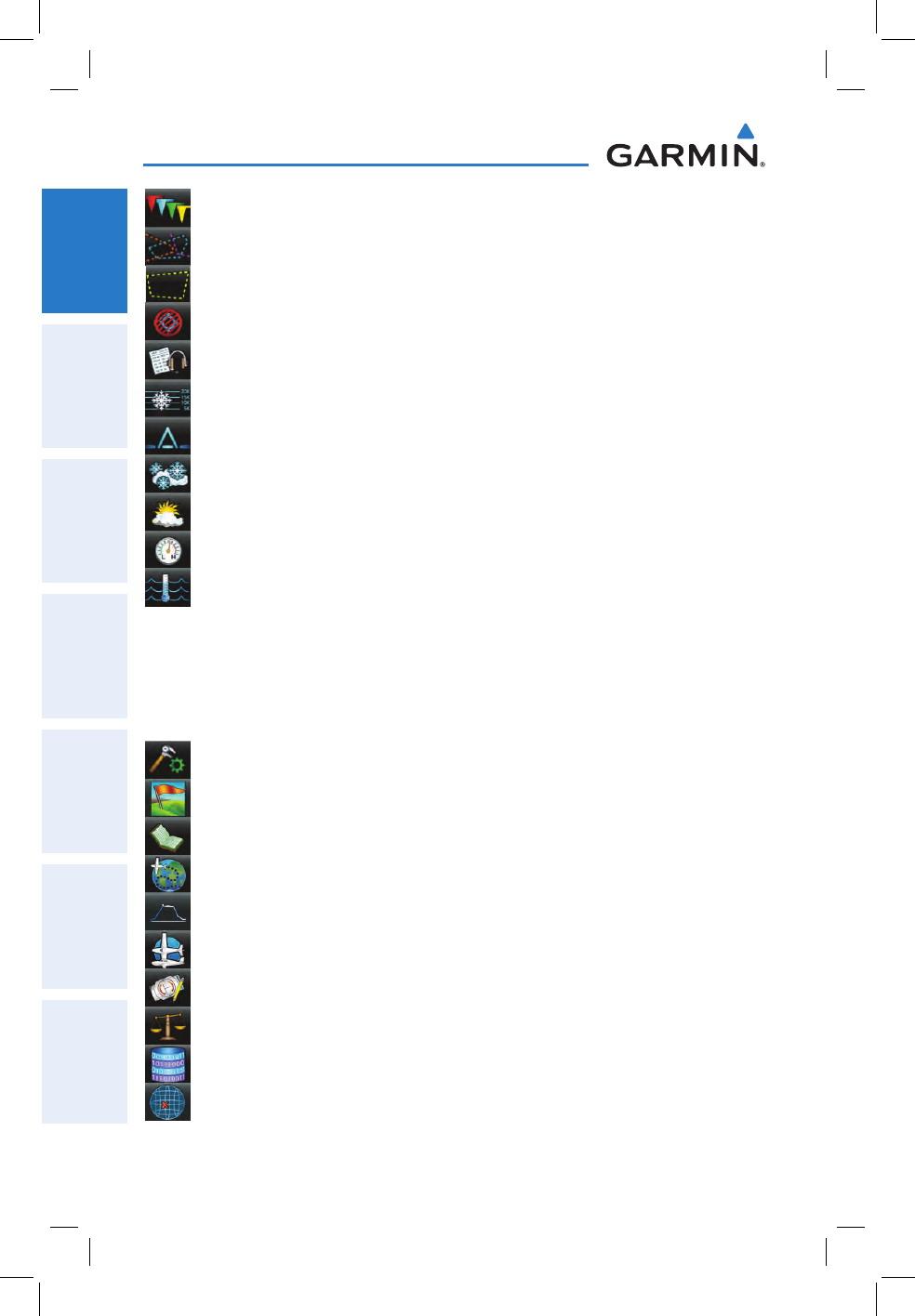
WEATHER ICONS (aera 796)
From the Main Menu, touch the
Weather icon to access the second-level Weather
Icons.
Touch the following second-level Icons to display the weather product:
NEXRAD Displays NEXRAD (NEXt-generation RADar).
Satellite Displays Satellite Mosaic cloud cover.
Echo Tops Displays Echo Tops.
Winds Displays Winds Aloft.
Lightning Displays Lightning.
Storm Cells Displays Storm Cells.
Garmin aera 795/796 Quick Reference Guide
190-01194-01 Rev. A
8
Overview
OverviewGPS NavigationFlight PlanningHazard AvoidanceUtilitiesAppendixIndex
METAR Displays METARs.
AIRMET Displays AIRMETs.
SIGMET Displays SIGMETs.
TFR Displays TFRs (Temporary Flight Restrictions).
PIREP Displays PIREPs.
Freeze Lvl Displays Freezing Levels.
Turb Fcst Displays the Turbulence Forecast.
Icing Fcst Displays the Icing Forecast.
WX Frst Displays Forecast Information (current, 12hr, 24hr, 36hr, & 48hr).
Pressure Displays Surface Pressure.
Sea Temp Displays Water Temperature.
TOOLS
From the Main Menu, touch the
Tools Icon to access the second-level Tools icons.
Touch the following second-level icons to display the associated function:
Setup Displays third-level Setup Icons.
User WPT Displays User Waypoints and Proximity Waypoints.
Flight Log Displays Flight Logs.
Track Log Displays Track Logs.
VNAV Displays Vertical Navigation.
Profile Displays Aircraft Profiles.
E6B Calc Displays the E6B Calculator.
Weight/Bal Displays the Weight & Balance.
Database Displays database and software version information.
Position Displays the aircraft's Present Position.
Garmin aera 795/796 Quick Reference Guide
190-01194-01 Rev. A 9
Overview
Overview GPS Navigation Flight Planning Hazard Avoidance Utilities Appendix Index
Checklists Displays the checklists if available.
Scratchpad Displays the scratchpad.
GPS Status Displays GPS status information.
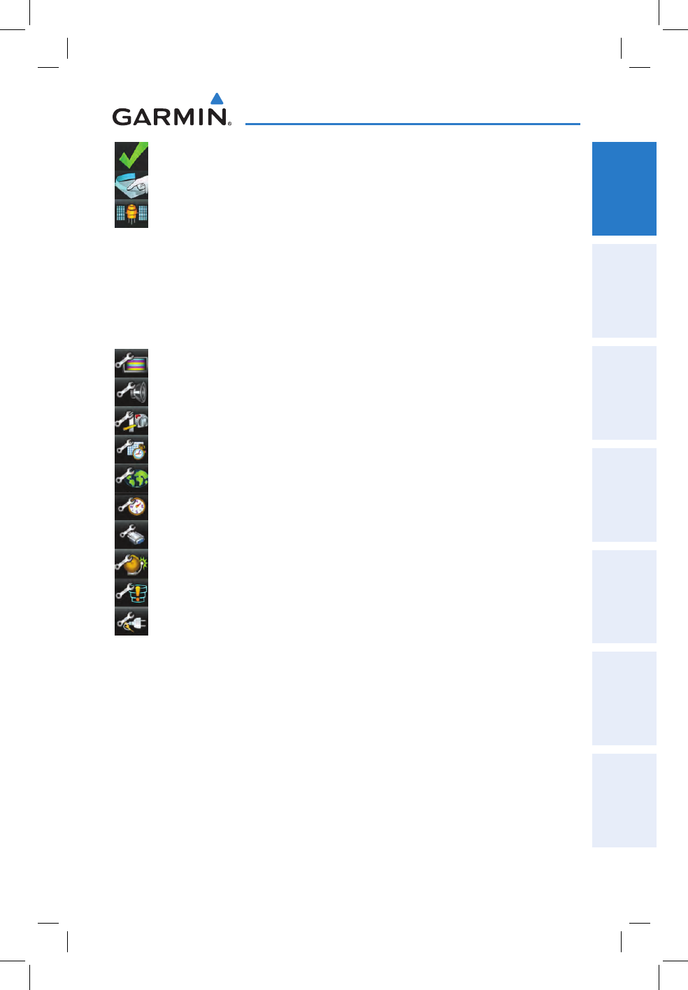
Setup IconS
From the Main Menu, touch the Tools >
Setup to access the third-level Setup
Icons.
Touch the following third-level icons to perform the associated function:
Display Displays backlight intensity/timeout and color mode settings.
Sound Displays sound settings.
Units Displays unit settings.
Date/Time Displays date & time settings.
Map Displays Navigation Map settings.
Position Displays position settings.
Interface Displays interface settings.
Alarms Displays alarm settings.
SUA Alarms Displays Special Use Airspace alarm settings.
Power Displays power settings
Garmin aera 795/796 Quick Reference Guide
190-01194-01 Rev. A
10
Overview
OverviewGPS NavigationFlight PlanningHazard AvoidanceUtilitiesAppendixIndex
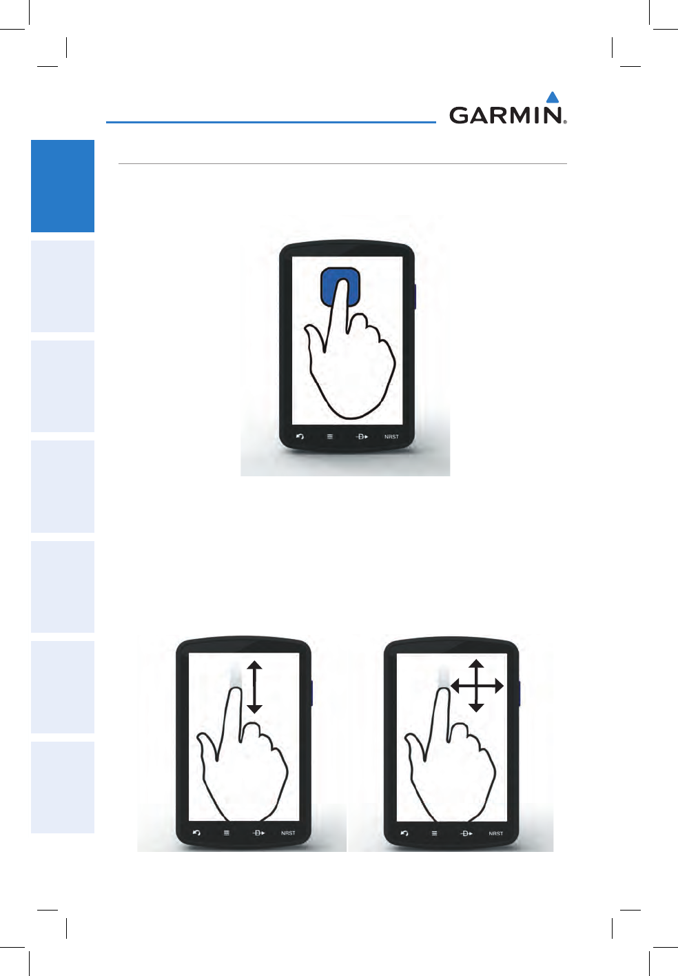
BASIC TOUCHSCREEN OPERATION
Touch the desired selection. The icon, view, menu option, datafield, etc, will
momentarily turn blue when selected.
Basic Touchscreen Operation
SCROLLING AND PANNING
Scrolling and panning on the touchscreen:
Drag up or down to scroll menus, documents, etc.
Or:
Drag in any direction to pan maps or charts.
Scrolling Panning
Garmin aera 795/796 Quick Reference Guide
190-01194-01 Rev. A 11
Overview
Overview GPS Navigation Flight Planning Hazard Avoidance Utilities Appendix Index
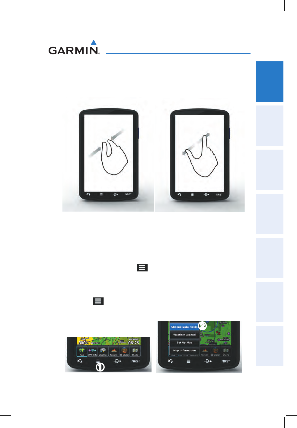
ZOOMING
Zooming in and out on the touchscreen map displays:
Pinch fingers together (zoom in), or pull fingers apart (zoom out).
Zoom In Zoom Out
1.4 MENUS AND DATA ENTRY
OPTION MENUS
The aera 795/796 has a dedicated Icon that displays a context-sensitive list of
menu options available.
Navigating the option menu:
➊
T
ouch the Icon
➋
T
ouch the desired menu option.
➊
➋
Garmin aera 795/796 Quick Reference Guide
190-01194-01 Rev. A
12
Overview
OverviewGPS NavigationFlight PlanningHazard AvoidanceUtilitiesAppendixIndex
DATA ENTRY
DATA ENTRY ICONS
The following icons are displayed on the data entry screen.
OK Exits the keypad function and the accepts
changes.
BKSP Erases the current data.
Numeric/
Alpha/Symbol
Displays the numeric, alpha, or symbol keypad.
Cancel Cancels a value that has been edited.
Entering alphanumeric data:
➊
W
hen alphanumeric data can be entered, a keypad will appear after
touching the desired datafield.
➋
T
ouch the keypad to enter the desired data.
➌
T
ouch OK.
➊➋
➌
Garmin aera 795/796 Quick Reference Guide
190-01194-01 Rev. A 13
Overview
Overview GPS Navigation Flight Planning Hazard Avoidance Utilities Appendix Index
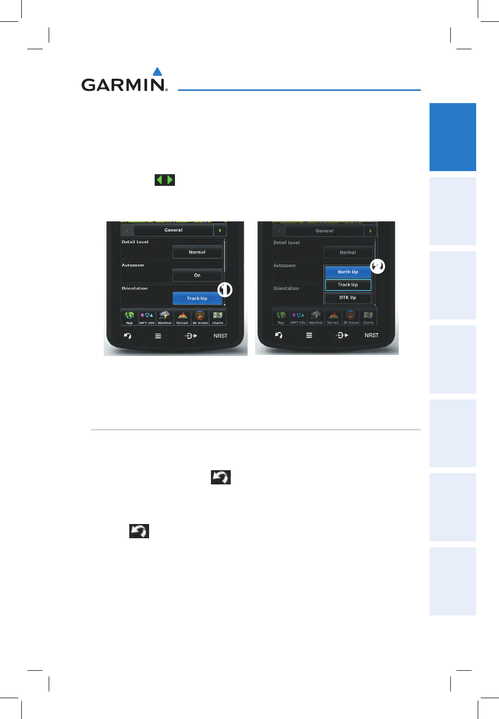
Entering predetermined data options:
➊
T
ouch the Data Option Button to display a vertical list of data options (if
applicable), or to toggle two data options
(i.e., On/Off)
.
Or
:
To
uch the buttons to cycle through a horizontal list (if more than two
data options are available).
➋
I
f using the vertical list, touch the desired data option from the list.
➊
➋
1.5 USING MAP DISPLAYS
MAP PANNING
Activating the map pointer:
While viewing a Map Display, touch anywhere on the map to activate the
map pointer.
Touch the
icon to cancel the map pointer
.
Panning the map:
While viewing a Map Display, touch anywhere on the map and drag.
Touch
the
icon to cancel the map pointer
.
Garmin aera 795/796 Quick Reference Guide
190-01194-01 Rev. A
14
Overview
OverviewGPS NavigationFlight PlanningHazard AvoidanceUtilitiesAppendixIndex
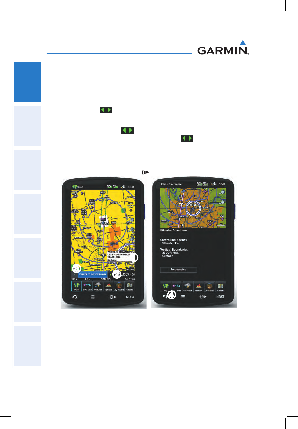
Reviewing information for a map feature:
➊
W
hile viewing a Map Display, touch anywhere on the map to activate the
map pointer. When the Map Pointer is over a map feature, the map feature
is highlighted, an information box appears on the map, and the highlighted
map feature is displayed on the Map Feature Button (the button located
between the buttons). If multiple features are present at the Map
Pointer position, green arrows will appear on the Map Feature Button.
➋
I
f necessary, touch the buttons to cycle through the list of map
features present at that position. Touching the buttons changes the
highlight and description.
➌
T
ouch the Map Feature Button to review information for the Map Feature.
➍
I
f desired touch the Direct-to Icon to navigate to the map feature.
➊
➋
➌
➍
Garmin aera 795/796 Quick Reference Guide
190-01194-01 Rev. A 15
Overview
Overview GPS Navigation Flight Planning Hazard Avoidance Utilities Appendix Index
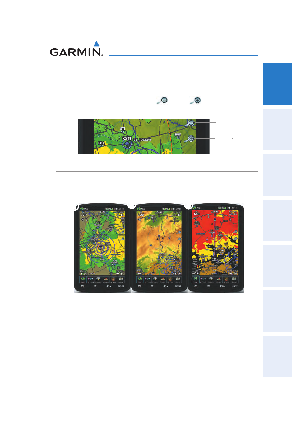
MAP RANGE
There are 23 different map ranges available, from 200 feet to 800 nm. The current
map range is indicated in the lower right. The scale bar represents the map scale. To
change the map range on any map, use the (out) or (in) icons to zoom ‘out’
(increasing), or zoom ‘in‘ (decreasing).
Zoom Out
Zoom In
MAP OVERLAYS
The
➊
Weather,
➋
Topography, and
➌
Terrain map overlays can be displayed or
removed.
➊
➋➌
Displaying/removing map overlays:
1)
From the Main Menu, touch Map > Menu > Show/Hide.
2)
Touch the 'Show/Hide' Data Option Button for the desired overlay.

Garmin aera 795/796 Quick Reference Guide
190-01194-01 Rev. A
16
Overview
OverviewGPS NavigationFlight PlanningHazard AvoidanceUtilitiesAppendixIndex
Blank Page

Garmin aera 795/796 Quick Reference Guide
190-01194-01 Rev. A 17
GPS Navigation
Overview GPS Navigation Flight Planning Hazard Avoidance Utilities Appendix Index
SECTION 2 GPS NAVIGATION
2.1 FLIGHT DATA
DATA FIELDS
Changing the information shown in the data fields:
1)
From the Main Menu, touch the Map Icon or touch the Map View Icon at
the bottom of the screen.
2)
Touch the Menu Icon.
3)
Touch the 'Change Data Fields' menu option.
4)
Touch the desired Data Field to change. A list of available Data Field
Options is displayed.
5)
Touch the desired Data Field Option.
6)
Touch the OK Icon.
NUMERIC FLIGHT DATA
The numeric flight data can be independently configured by the user.
Accessing numeric flight data:
From the Main Menu, touch Numbers.
Changing numeric flight data fields:
1)
From the Main Menu, touch Numbers.
2)
Touch the desired data field to change. The available data fields are
displayed.
3)
Touch the desired data field.
4)
Touch OK.
Restoring default numeric flight data:
From the Main Menu, touch Numbers > Menu > Restore Default.

Garmin aera 795/796 Quick Reference Guide
190-01194-01 Rev. A
18
GPS Navigation
OverviewGPS NavigationFlight PlanningHazard AvoidanceUtilitiesAppendixIndex
2.2 HSI/PANEL
SETTING THE BUG INDICATOR
The Bug Indicator can be set from the Map option menu.
Setting the Bug Indicator:
1)
From the Main Menu, touch Map > Menu > Set Bug Indicator.
2)
Touch the desired menu option ('User Selected', 'Bearing', 'Course to
Steer', or 'Off').
MANUALLY SETTING A COURSE
Use the ‘Set OBS and Hold’ menu option to manually set your course to the
destination.
Manually setting a course to the destination waypoint:
1)
From the Main Menu, touch the Map icon or the Active FPL Icon.
2)
Touch the Menu Icon
3)
Touch the ' Set OBS and Hold' menu option (only available when
navigating a Direct To or Flight Plan).
4)
Touch the '+' or '-' Buttons to increase/decrease the value
Or
:
Touch the Radial Button to enter the desired radial using the keypad and
touch the OK Icon.
Returning to automatic sequencing of route waypoints:
1)
From the Main Menu, touch the Map Icon or the Active FPL Icon.
2)
Touch the Menu Icon
3)
Touch the 'Release Hold' menu option (only available when navigating a
Direct To or Flight Plan).

Garmin aera 795/796 Quick Reference Guide
190-01194-01 Rev. A 19
GPS Navigation
Overview GPS Navigation Flight Planning Hazard Avoidance Utilities Appendix Index
2.3 VERTICAL NAVIGATION (VNAV)
USING THE VNAV FEATURE
NOTE: The Panel must be displayed on the Navigation Map for the following
menu options to appear.
Enabling/disabling the VNAV indicator:
1)
From the Main Menu, touch the Map Icon or touch the Map View Icon at
the bottom of the screen.
2)
Touch the Menu Icon
3)
Touch the 'Enable VNAV Indicator' or 'Disable VNAV Indicator' menu
option (only available when navigating a Direct To or Flight Plan).
Capturing/cancelling VNAV profile:
1)
Enter a valid VNAV profile (see 'Configuring a VNAV Profile' below) and
begin navigation.
2)
From the Main Menu, touch the Map Icon or touch the Map View Icon at
the bottom of the screen.
3)
Touch the 'Capture VNAV Profile' or 'Cancel Capture' menu option
(only available when navigating a Direct To or Flight Plan).
Configuring a VNAV profile:
1)
From the Main Menu, touch Tools > VNAV
2)
Touch the desired fields ('Profile', 'Altitude', etc) to enter the VNAV
profile.
3)
Touch and hold the Back Icon to return to the Main Menu.
Garmin aera 795/796 Quick Reference Guide
190-01194-01 Rev. A
20
GPS Navigation
OverviewGPS NavigationFlight PlanningHazard AvoidanceUtilitiesAppendixIndex
2.4 WAYPOINTS
Selecting an airport for review by identifier, facility name, or city:
1)
From the Main Menu, touch WPT Info > Info Tab (if necessary).
2)
Touch the Waypoint Identifier Button (top of page).
3)
Enter the desired waypoint:
a)
Touch the buttons to 'Search by Identifier', 'Search by
Facility Name', or 'Search by City' using the keypad.
b)
Enter the desired waypoint.
c)
Touch the OK Icon.
Or
:
a)
Touch the buttons to cycle through the waypoint categories
('Flight Plan Waypoints', 'Nearest Airports', or 'Recent
Waypoints'.)
b)
Touch the desired waypoint from the list.
Selecting a runway for review by identifier, facility name, or city:
1)
From the Main Menu, touch WPT Info > Info Tab.
2)
Touch the Waypoint Identifier Button.
3)
Enter the desired waypoint:
a)
Touch the buttons to 'Search by Identifier', 'Search by
Facility Name', or 'Search by City' using the keypad.
b)
Enter the desired waypoint.
c)
Touch the OK Icon.
Or:
a)
Touch the buttons to cycle through the waypoint categories
('Flight Plan Waypoints', 'Nearest Airports', or 'Recent
Waypoints'.)
b)
Touch the desired waypoint from the list.
4)
Touch the desired Runway Button.
Se
lecting additional information for a frequency:
1)
From the Main Menu, touch WPT Info > Freq Tab.
2)
Touch the frequency denoted with an *.
Garmin aera 795/796 Quick Reference Guide
190-01194-01 Rev. A 21
GPS Navigation
Overview GPS Navigation Flight Planning Hazard Avoidance Utilities Appendix Index
NEAREST INFORMATION
Viewing nearest information:
1)
Touch the icon to display the second level Nearest Icons.
2)
Touch the desired Nearest Icon (Airport, Airport WX, VOR, NDB,
Intersection, User WPT, City, ARTCC, FSS, or Airspace).
3)
Touch the desired nearest option from the list for additional information.
Or
:
If viewing Nearest ARTCCs or FSSs, touch the buttons to cycle
through the list.
4)
If desired, touch Menu > Show Map (except for ARTCC, FSS, or Airspace).
5)
Touch the Back Icon to return to the second level Nearest Icons.
Or
:
Touch the Direct-to Icon (if applicable), then the Activate Button to
navigate Direct-to the selected waypoint.
WEATHER INFORMATION (AERA 796)
Viewing airport weather information:
1)
From the Main Menu, touch the WPT Info Icon.
2)
Touch the Waypoint Identifier Button to enter the desired waypoint
identifier.
3)
Touch the WX Tab.
USER WAYPOINTS
Creating user waypoints:
1)
Touch the desired point on the map.
2)
Touch Menu > Create Waypoint
3)
Enter the desired user waypoint name (up to 10 characters). Refer to the
Overview Section on 'Data Entry' for more information.
4)
Touch the OK Icon.
Garmin aera 795/796 Quick Reference Guide
190-01194-01 Rev. A
22
GPS Navigation
OverviewGPS NavigationFlight PlanningHazard AvoidanceUtilitiesAppendixIndex
2.5 DIRECT-TO NAVIGATION
Entering a waypoint identifier, facility name, or city as a direct-to
destination:
1)
Touch the Direct To Icon.
2)
Touch Menu > Resume Navigation.
Or
:
a)
Touch the 'Search by Identifier', 'Search by Facility Name', or
'Search by City' fields.'.
b)
Enter the desired Identifier, Facility Name, or City using the keypad.
Refer to the Overview Section on 'Data Entry' for more information.
c)
Touch the OK Icon.
Or
:
a)
Touch 'More...'.
b)
Touch the buttons to view 'Flight Plan Waypoints', 'Nearest
Airports', or 'Recent Waypoints'.
c)
Touch the desired waypoint from the list.
4)
Touch the Activate Icon (if necessary).
Selecting a nearby airport as a direct-to destination:
1)
Touch the icon to display the second level Nearest Icons.
2)
Touch Airport.
3)
Touch the desired nearest airport.
4)
Touch the Direct To Icon.
5)
Touch the Activate Icon.

Garmin aera 795/796 Quick Reference Guide
190-01194-01 Rev. A 23
GPS Navigation
Overview GPS Navigation Flight Planning Hazard Avoidance Utilities Appendix Index
Selecting a waypoint as a direct-to destination using the pointer:
1)
With a map displayed, activate the map pointer by touching the desired
waypoint. If no airport, NAVAID, or User Waypoint exists at the desired
location, a temporary waypoint named 'MAP' is automatically created at
the location of the map pointer.
2)
Touch the Direct Icon.
3)
Touch the Activate Icon.
Cancelling a direct-to:
1)
Touch the Direct To Icon..
Or
:
Fr
om the Main Menu, touch the Active FPL Icon.
2)
Touch the Menu Icon.
3)
Touch 'Stop Navigation'.

Garmin aera 795/796 Quick Reference Guide
190-01194-01 Rev. A
24
GPS Navigation
OverviewGPS NavigationFlight PlanningHazard AvoidanceUtilitiesAppendixIndex
Blank Page
Garmin aera 795/796 Quick Reference Guide
190-01194-01 Rev. A 25
Flight Planning
Overview GPS Navigation Flight Planning Hazard Avoidance Utilities Appendix Index
SECTION 3 FLIGHT PLANNING
3.1 FLIGHT PLAN DATA FIELDS
The Active and Saved Flight Plan Data Fields can be changed by touching the Data
Field Buttons at the top of the flight plan.
Changing the information shown in the flight plan data fields:
1)
From the Main Menu, touch the Active FPL Icon.
Or
:
a)
From the Main Menu, touch FPL List.
b)
Touch the desired Saved Flight Plan from the list. An option menu
appears.
c)
Touch the 'Review Flight Plan' menu option.
2)
Touch the desired Data Field Button at the top of the Flight Plan.
3)
Touch the desired Data Field. The currently selected Data Field is outlined
blue.
4)
Touch the OK Icon.
5)
If desired, repeat Steps 2-4 for the remaining Data Field.
3.2 FLIGHT PLAN CREATION
The active flight plan is the flight plan to which the aera 795/796 is currently
providing guidance, and is shown on the navigation maps. Stored flight plans are
flight plans available for activation (becomes the active flight plan).
Creating an active flight plan:
1)
From the Main Menu, touch the Active FPL Icon.
2)
Touch the 'Touch to add Waypoint' Button.
3)
Enter the desired waypoint:
a)
Touch the buttons to 'Search by Identifier', 'Search by
Facility Name', or 'Search by City' using the keypad.
b)
Enter the desired waypoint.
Garmin aera 795/796 Quick Reference Guide
190-01194-01 Rev. A
26
Flight Planning
OverviewGPS NavigationFlight PlanningHazard AvoidanceUtilitiesAppendixIndex
c)
Touch the OK Icon.
Or
:
a)
Touch the buttons to cycle through the waypoint categories
('Flight Plan Waypoints', 'Nearest Airports', or 'Recent
Waypoints'.)
b)
Touch the desired waypoint from the list.
4)
If duplicate entries exist for the entered facility name or location, duplicate
waypoints are displayed. Touch the desired waypoint from the list.
5)
Repeat Steps 2-5 to enter each additional waypoint.
Creating a stored flight plan:
1)
From the Main Menu, touch FPL List > Menu > New Flight Plan.
2)
Touch the 'Touch to add Waypoint' Button.
3)
Enter the desired waypoint:
a)
Touch the buttons to 'Search by Identifier', 'Search by
Facility Name', or 'Search by City' using the keypad.
b)
Enter the desired waypoint.
c)
Touch the OK Icon.
Or
:
a)
Touch the buttons to cycle through the waypoint categories
('Flight Plan Waypoints', 'Nearest Airports', or 'Recent
Waypoints'.)
b)
Touch the desired waypoint from the list.
4)
If duplicate entries exist for the entered facility name or location, duplicate
waypoints are displayed. Touch the desired waypoint from the list.
5)
Repeat Steps 2-5 to enter each additional waypoint.
3.3 ADDING FLIGHT PLAN WAYPOINTS
Adding a waypoint to an active or stored flight plan:
1)
With an active or saved flight plan displayed, touch the desired point
of insertion. The new waypoint will be added in front of the selected
waypoint. An option menu will appear.
2)
Touch the 'Insert Waypoint' menu option.

Garmin aera 795/796 Quick Reference Guide
190-01194-01 Rev. A 27
Flight Planning
Overview GPS Navigation Flight Planning Hazard Avoidance Utilities Appendix Index
3)
Enter the desired waypoint:
a)
Touch the buttons to 'Search by Identifier', 'Search by
Facility Name', or 'Search by City' using the keypad.
b)
Enter the desired waypoint.
c)
Touch the OK Icon.
Or:
a)
Touch the buttons to cycle through the waypoint categories
('Flight Plan Waypoints', 'Nearest Airports', or 'Recent
Waypoints'.)
b)
Touch the desired waypoint from the list.
4)
If duplicate entries exist for the entered facility name or location, duplicate
waypoints are displayed. Touch the desired waypoint from the list.
Loading an approach procedure into a stored flight plan:
1)
With an active or saved flight plan displayed, touch the Menu Icon
2)
Touch the 'Select Approach' menu option. A vertical list of available
approaches is displayed.
3)
Touch the desired approach. The designated transition waypoints are
added to the flight plan.
3.4 FLIGHT PLAN STORAGE
Viewing information about a stored flight plan:
1)
From the Main Menu, touch FPL List
2)
Touch the desired saved flight plan. An option menu is displayed.
3)
Touch the 'Review Flight Plan' menu option.
Storing an active flight plan:
1)
With the Active Flight Plan displayed, touch the Menu Icon.
2)
Touch the 'Save Flight Plan' menu option. A confirmation window
appears.
3)
Touch Yes. A copy of the flight plan is stored in the next available position
in the Flight Plan List.

Garmin aera 795/796 Quick Reference Guide
190-01194-01 Rev. A
28
Flight Planning
OverviewGPS NavigationFlight PlanningHazard AvoidanceUtilitiesAppendixIndex
3.5 FLIGHT PLAN ACTIVATION
Activating a stored flight plan:
1)
From the Main Menu, touch FPL List
2)
Touch the desired saved flight plan. An option menu is displayed.
3)
Touch the 'Activate Flight Plan' menu option. A confirmation window
appears.
4)
Touch Yes.
Activating a Flight Plan Leg:
1)
From the Main Menu, touch the Active FPL Icon.
2)
While navigating an active flight plan, touch the desired leg to be activated.
An option menu automatically appears.
3)
Touch the 'Activate Leg' menu option.
4)
Touch Yes.
3.6 FLIGHT PLAN DELETION
Deleting a stored flight plan:
With the desired Stored Flight Plan displayed, touch the Menu > Delete
Flight Plan > Yes
Or
:
With the Flight Plan List displayed, touch the desired flight plan to delete,
and touch Delete Flight Plan > Yes.
Deleting all stored flight plans:
From the Main Menu, touch FPL List > Menu > Delete All > Yes.

Garmin aera 795/796 Quick Reference Guide
190-01194-01 Rev. A 29
Flight Planning
Overview GPS Navigation Flight Planning Hazard Avoidance Utilities Appendix Index
3.7 APPROACHES
WARNING: The aera 795/796 is not designed to be independently used for
flight into instrument meteorological conditions (IMC) or other conditions in
which aircraft control is based solely upon flight instruments. The approaches
provided are for monitoring purposes only. Only the final course segment
(final approach fix (FAF) to missed approach point (MAP)) of the published
approach is available for monitoring.
An approach can be selected using the Direct-to, Active Flight Plan, and the Saved
Flight Plan functions.
Selecting an approach from the active or saved flight plan:
1)
From the Main Menu, touch the Active FPL Icon.
Or
:
a)
From the Main Menu, touch the FPL List Icon.
b)
Touch the desired Saved Flight Plan from the list. An option menu
appears.
c)
Touch the 'Review Flight Plan' menu option.
2)
With the flight plan displayed, touch the Menu Icon.
3)
Touch the 'Select Approach' menu option (only available if the
destination airport has a published approach). A vertical list of available
approaches is displayed.
4)
Touch the desired approach. The 'Vectors to Final?' window appears.
5)
Touch 'Yes' or 'No'. The procedure is added to the end of the flight plan.
If activating an approach from the Active Flight Plan, the aera 795/796
immediately begins to provide guidance to the first waypoint in the
approach.
Selecting an approach using the Direct-To function:
1)
Touch the Direct To Icon.
2)
Touch the Menu Icon.
3)
Touch the 'Select Approach' menu option (only available when
navigating a flight plan. A vertical list of available approaches is displayed.
4)
Touch the desired approach. The 'Vectors to Final?' window appears.

Garmin aera 795/796 Quick Reference Guide
190-01194-01 Rev. A
30
Flight Planning
OverviewGPS NavigationFlight PlanningHazard AvoidanceUtilitiesAppendixIndex
5)
Touch 'Yes' or 'No'. The procedure is added to the end of the flight plan.
If activating an approach from the Active Flight Plan, the aera 795/796
immediately begins to provide guidance to the first waypoint in the
approach.
Resuming the Flight Plan after selecting an approach:
Whenever an approach is selected the aera 795/796 automatically activates the
approach. The procedure is added to the end of the flight plan and immediately begins
to provide guidance to the first waypoint in the approach. Follow the steps below to
resume the flight plan after activating the approach.
1)
From the Main Menu, touch the Active FPL Icon.
Or
:
Touch the Direct To Icon.
2)
With a flight plan and an approach loaded, touch the Menu Icon.
3)
Touch the 'Resume Flight Plan' menu option.
Removing an approach:
1)
From the Main Menu, touch the Active FPL Icon.
Or
:
a)
From the Main Menu, the FPL List Icon.
b)
Touch the desired Saved Flight Plan from the list. An option menu
appears.
c)
Touch the 'Review Flight Plan' menu option.
2)
Press the Menu Icon.
3)
Touch the 'Remove Approach' menu option (only available if an
approach is loaded).
Activating/Cancelling Vectors-to-Final:
1)
From the Main Menu, touch the Active FPL Icon.
2)
While navigating an Active Flight Plan (with an approach activated), touch
the Menu Icon.
3)
Touch the 'Activate Vectors-to-Final' or 'Cancel Vectors-to-Final'
menu option.
Garmin aera 795/796 Quick Reference Guide
190-01194-01 Rev. A 31
Hazard Avoidance
Overview GPS Navigation Flight Planning Hazard Avoidance Utilities Appendix Index
SECTION 4 HAZARD AVOIDANCE
4.1 S
irius
XM® WEATHER (aera 796)
Viewing SiriusXM Weather products on the Navigation Map:
1)
Touch the Map Icon.
2)
Touch the Menu Icon.
3)
Touch the 'Show/Hide...' menu option.
4)
Touch the Weather 'Show/Hide' Button.
Viewing SiriusXM Weather products on the Weather Map:
1)
From the Main Menu touch the Weather Icon.
2)
Touch the desired second-level Weather Icon.
3)
If necessary, touch the buttons to scroll through the list of available
altitudes, AIRMET types, or forecast times.
4)
Touch the desired weather product to get abbreviated information about
the selected weather product (if available).
5)
With the desired weather product highlighted, touch the Map Feature
Button to get detailed information (if available).
4.2 TERRAIN
Enabling/Disabling Terrain Shading on the Navigation Map:
1)
Touch the Map Icon.
2)
Touch the Menu Icon.
a)
Touch the 'Show/Hide...' menu option.
b)
Touch the Terrain 'Show/Hide' Button to toggle the terrain overlay
on/off.
Or:
a)
Touch the 'Set Up Map' menu option.
b)
Touch the buttons until the 'Map' Category is displayed.
c)
Touch the Terrain Shading On/Off Button.
Garmin aera 795/796 Quick Reference Guide
190-01194-01 Rev. A
32
Hazard Avoidance
OverviewGPS NavigationFlight PlanningHazard AvoidanceUtilitiesAppendixIndex
Enabling/Disabling terrain alerts:
1)
Touch the Terrain Icon.
2)
Touch the Menu Icon.
3)
Touch the 'Enable Alerts' or 'Disable Alerts' menu option.
4.3 TRAFFIC INFORMATION SERVICE (TIS)
NOTE: Refer to the aera 795/796 Pilot's Guide for information on configuring
TIS.
Adjusting TIS audio:
1)
From the Main Menu, touch Tools > Setup > Sound.
2)
Touch the Alerts buttons to select an alert volume (0-10).
Adjusting TIS settings on the navigation map:
1)
Touch Map > Menu > Set Up Map.
2)
Touch the buttons to select the Map Category.
3)
Touch the TIS Traffic buttons to select the desired settings ('Off',
'Auto', or range settings).
Displaying TIS information using the map pointer:
With traffic displayed on the Navigation Map, touch the desired TIS symbol
on the map. The traffic range and altitude separation are displayed.
TRAFFIC WARNING WINDOW
When a traffic threat is imminent, the Traffic Warning Window is shown. The Traffic
Warning Window shows a small pop-up thumbnail map in the lower left corner. The
Range Rings on the pop-up alert are spaced every whole mile/kilometer/nautical mile.
Touch the Traffic Warning Window to acknowledge and remove it.

Garmin aera 795/796 Quick Reference Guide
190-01194-01 Rev. A 33
Utilities
Overview GPS Navigation Flight Planning Hazard Avoidance Utilities Appendix Index
SECTION 5 UTILITIES
5.1 FLIGHT LOG
Viewing details for a flight:
1)
From the Main Menu, touch Tools > Flight Log.
2)
Touch the desired flight log. Route, date, hours, distance, and the flight
path are displayed.
Deleting flight records:
1)
From the Main Menu, touch Tools > Flight Log.
2)
Touch the desired flight log (if applicable).
3)
Touch Menu.
4)
Touch 'Delete Flight' or 'Delete All'.
5)
Touch Yes.
5.2 TRACK LOG
Showing/hiding the track log on the Navigation Map:
1)
From the Main Menu, touch Map > Menu > Set Up Map.
2)
Touch the buttons to display the 'Line' Category.
3)
Touch Track Log.
4)
Touch the Show/Hide Button.
Changing track log settings:
1)
From the Main Menu, touch Map > Menu > Set Up Map.
2)
Touch the buttons to display the 'Line' Category.
3)
Touch Track Record Mode, Track Interval, or Track Color.
4)
Touch the desired setting.
Clearing the track log:
1)
From the Main Menu, touch Tools > Track Log.
2)
Touch the desired track log (if applicable).

Garmin aera 795/796 Quick Reference Guide
190-01194-01 Rev. A
34
Utilities
OverviewGPS NavigationFlight PlanningHazard AvoidanceUtilitiesAppendixIndex
3)
Touch Menu.
4)
Touch 'Delete Saved Track' or 'Delete All Saved Tracks'.
5)
Touch Yes.
Saving a track log:
1)
From the Main Menu, touch Tools > Track Log > Menu > Save
Active Track.
2)
Touch the buttons to select 'Entire Active Track', 'Past 24 Hours',
'Past 7 Days', or 'Specific Dates'.
3)
Touch OK.
Editing a track log:
1)
From the Main Menu, touch Tools > Track Log.
2)
Touch the desired track log.
3)
Touch desired field to edit (Track Name, Show On Map, or Color).
5.3 E6B CALCULATOR
The E6B Calculator calculates Density Altitude, True Airspeed, Tail Wind, Wind From,
and Wind Speed, based on information you enter.
Accessing the E6B calculator:
Fr
om the Main Menu, touch Tools > E6B Calc.
Calculating true airspeed and density altitude:
1)
From the Main Menu, touch Tools > E6B Calc, enter the altitude shown
on the altimeter into the ‘Indicated Altitude’ field.
2)
Repeat for ‘Calibrated Airspeed’, ‘Baro Pressure’, and ‘Total Air
Temperature’ fields. (For Calibrated Airspeed, use the speed shown on
the airspeed indicator. Use the current altimeter setting for Baro Pressure.
Total Air Temperature is the temperature of the outside air including the
heating effect caused by speed. For most aircraft, this is the temperature
reading on a standard outside air temperature gauge.) The calculated
figures for True Airspeed and Density Altitude are shown in the designated
fields.
Garmin aera 795/796 Quick Reference Guide
190-01194-01 Rev. A 35
Utilities
Overview GPS Navigation Flight Planning Hazard Avoidance Utilities Appendix Index
Calculating winds aloft:
1)
From the Main Menu, touch Tools > E6B Calc, calculate or enter the true
airspeed into the ‘True Airspeed’ field.
2)
Enter the aircraft heading shown on the directional gyro or compass into
the ‘Heading’ field. Tail Wind, Wind From, and Wind Speed are calculated.
NOTE:
If True North is selected as the heading reference, a heading referenced
to True North must be used to calculate winds accurately.
Restoring E6B calculator defaults:
Fr
om the Main Menu, touch Tools > E6B Calc > Menu > Restore
Default.
5.4 AIRCRAFT PROFILE
Accessing the aircraft profile:
Fr
om the Main Menu, touch Tools > Profile
Entering an aircraft profile:
1)
From the Main Menu, touch Tools > Profile > Menu > New
2)
Enter the Aircraft Name using the keypad, and touch OK.
3)
Enter the Cruise Speed, Maximum Speed, or Fuel Flow using the +/-
buttons or the keypad.
4)
Touch Map Symbol datafield.
a)
Touch the buttons to cycle through the available symbols.
b)
Touch OK.
Selecting a saved aircraft profile:
1)
From the Main Menu, touch Tools > Profile
2)
Touch the Aircraft Name Button to access a vertical list of saved profiles.
3)
Touch the desired profile from the list.

Garmin aera 795/796 Quick Reference Guide
190-01194-01 Rev. A
36
Utilities
OverviewGPS NavigationFlight PlanningHazard AvoidanceUtilitiesAppendixIndex
Renaming a saved aircraft profile:
1)
From the Main Menu, touch Tools > Profile
2)
Touch the Aircraft Name Button to access a vertical list of saved profiles.
3)
Touch the desired profile from the list.
4)
Touch Menu > Rename
5)
Enter the new Aircraft Name using the keypad, and touch OK.
Deleting a saved aircraft profile:
1)
From the Main Menu, touch Tools > Profile
2)
Touch the Aircraft Name Button to access a vertical list of saved profiles.
3)
Touch the desired profile from the list.
4)
Touch Menu > Delete
5)
Touch Yes.
5.5 WEIGHT & BALANCE
NOTE:
This information is only for flight planning purposes. Consult the
aircraft’s pilot operating handbook for the official weight and balance data.
To perform weight and balance calculations:
1)
From the Main Menu, touch Tools > Weight/Bal
2)
Touch the fields to enter the desired weights and arms (or “stations”). The
calculated moment, weight, and CG figures appear at the bottom of the
screen. Keep in mind that the “Aircraft” (empty weight/arm) figures must
be entered as a reference to calculate a valid moment, weight, and CG.
3)
To empty the aircraft, touch Menu > Empty Aircraft.
Garmin aera 795/796 Quick Reference Guide
190-01194-01 Rev. A
Appendix
37
Overview GPS Navigation Flight Planning Hazard Avoidance Utilities Appendix Index
SECTION 6 APPENDIX
MISCELLANEOUS MESSAGE ADVISORIES
Message Comments
Approaching Target Altitude
Within 200 feet of final VNAV target altitude.
Approaching VNAV Profile
The aircraft is within one minute of reaching the
initial VNAV decent point.
Arriving at XXX
The aircraft is nearing the destination.
Battery Low
The battery needs to be recharged.
Can’t Unlock Maps
No applicable unlock code for one or more maps
was found. All MapSource maps are not accessible.
Check XM Antenna
Internal problem with the GXM antenna. Contact
Garmin Product Support.
Database Error
Internal problem with the system. Contact your
dealer or Garmin Product Support to have the unit
repaired.
Fuel Tank
A reminder for switching fuel tanks. The reminder
message repeats at the specified interval after the
beginning of each trip.
GPS antenna shorted to
ground
The GPS antenna connection detects the GPS
antenna RF connector is shorted to ground.
Lost Satellite Reception
The system is unable to receive satellite signals.
Memory Full
System memory is full, no further data can be saved.
Near Proximity Point
You have reached the distance set for a proximity
waypoint.
Next DTK XXX
The aircraft is nearing a turn in a route.
Proximity Memory Full
No additional proximity waypoints can be saved.
Proximity Radius Overlaps
The radius of two proximity waypoints overlap.
Route Already Exists
A route name that already exists has been entered.
Route Memory Full
No additional routes can be saved.
Garmin aera 795/796 Quick Reference Guide
190-01194-01 Rev. A
Appendix
38
OverviewGPS NavigationFlight PlanningHazard AvoidanceUtilitiesAppendixIndex
MISCELLANEOUS MESSAGE ADVISORIES (CONT.)
Message Comments
Route Truncated
Uploaded route from another device has more
than 300 waypoints.
Route Waypoint Memory Full
No additional route waypoints can be saved.
Steep Turn Ahead
Approaching a turn that requires a bank angle
in excess of 25 degrees to stay on course.
Track Already Exists
A saved track with the same name already
exists.
Track Log Full
The track log is full and track recording was
turned off. To record more track points, you
need to clear the track log and turn track
recording on.
Track Memory Full
No more track data can be stored. Delete the
old track data to store the new data.
Track Truncated
A complete uploaded track will not fit in
memory. The oldest track log points have been
deleted.
VNAV Cancelled
VNAV function has been cancelled due to a
change in the active route.
Waypoint Already Exists
A waypoint with the same name already exists.
Waypoint Memory Full
The unit has stored the maximum number of
waypoints.
AIRSPACE MESSAGES
Message Comments
Inside Airspace
Inside the boundaries of the airspace.
Airspace Near and Ahead
Within two nautical miles of an airspace and your
current course takes you inside the airspace.
Airspace Ahead, Within 10
Minutes
The projected course takes you inside an airspace
within the next 10 minutes or less.
Airspace Near, Within 2 nm
Within two nautical miles of an airspace but not
projected to enter it.

Garmin aera 795/796 Quick Reference Guide
190-01194-01 Rev. A
Appendix
39
Overview GPS Navigation Flight Planning Hazard Avoidance Utilities Appendix Index
DATA FIELD & NUMERIC DATA OPTIONS
Data Field/Numeric Data Definition
Accuracy
The current accuracy of the GPS determined
location.
Altitude
The current altitude in geometric height above
Mean Sea Level (MSL).
Bearing
The compass direction from the present position
to a destination waypoint.
Course to Steer
The recommended direction to steer in order
to reduce cross-track error and return to the
course line.
Crosstrack Error
The distance the aircraft is off a desired course
in either direction, left or right.
Desired Track
The desired course between the active “from”
and “to” waypoints.
Distance (Destination)
The distance to the destination waypoint in the
Active Flight Plan
Distance (Next)
The distance to the next waypoint in the Active
Flight Plan.
En Route Safe Altitude
The recommended minimum altitude within ten
miles left or right of the desired course on a
active flight plan or direct-to.
Flight Timer
Total time in-flight (HH:MM).
Fuel Timer
Elapsed time since the Fuel Tank Reminder
Alarm was last issued (HH:MM).
Glide Ratio
The estimated distance an aircraft will move
forward for any given amount of lost altitude.
Ground Speed
The velocity that the aircraft is traveling relative
to a ground position.
Ground Track
The direction of aircraft movement relative to a
ground position.
Garmin aera 795/796 Quick Reference Guide
190-01194-01 Rev. A
Appendix
40
OverviewGPS NavigationFlight PlanningHazard AvoidanceUtilitiesAppendixIndex
DATA FIELD & NUMERIC DATA OPTIONS (CONT.)
Data Field/Numeric Data Definition
Minimum Safe Altitude
Uses Grid MORAs to determine a safe altitude
within ten miles of the aircraft’s present position.
Next Waypoint
The next waypoint in the flight plan or direct-to
route.
Sunrise
The time at which the sun rises on this day (current
location).
Sunset
The time at which the sun sets on this day (current
location).
Estimated Time En Route
(Destination)
The estimated time it takes to reach the destination
waypoint from the present position, based upon
current ground speed.
Estimated Time En Route
(Next)
The estimated time it takes to reach the next
waypoint form the present position, based upon
current ground speed.
Estimated Time of Arrival
(Destination)
The estimated time at which the aircraft should
reach the destination waypoint, based upon current
speed and track.
Estimated Time of Arrival
(Next)
The estimated time at which the aircraft should
reach the next waypoint, based upon current speed
and track.
Estimated Time to VNAV
The estimated time it takes to reach the VNAV
waypoint form the present position, based upon
current ground speed.
Time of Day (Local)
The current time and date in 12-hour or 24-hour
format.
Time (UTC)
The current time and date in Universal (UTC) time.
Vertical Speed
The rate of climb or descent (GPS-derived).
Vertical Speed Required
The vertical speed necessary to decend/climb from
a current position and altitude to the previously
selected VNAV position and altitude, based upon
current groundspeed.

Garmin aera 795/796 Quick Reference Guide
190-01194-01 Rev. A
Appendix
41
Overview GPS Navigation Flight Planning Hazard Avoidance Utilities Appendix Index
DATA FIELD & NUMERIC DATA OPTIONS (CONT.)
Data Field/Numeric Data Definition
Weather (Altimeter) (aera 796)
The altimeter setting at the nearest METAR
reporting station.
Weather (Dew Point) (aera 796)
The dew point at the nearest weather reporting
station.
Weather (Rel. Humidity) (aera
796)
The relative humidity at the nearest weather
reporting station.
Weather (Temperature) (aera
796)
The temperature at the nearest weather
reporting station.
Weather (Wind) (aera 796)
The wind speed and direction at the nearest
weather reporting station.
AURAL ALERTS
Refer to Hazard Avoidance Section.
LOSS OF GPS POSITION
When the
aera 795/796 loses the GPS signal for any reason, the following will
occur:
• A blinking red question mark will appear over the airplane icon on the map.
• The ‘Lost Satellite Reception’ message will display.
• Any GPS dependent data fields will not be available.
HAZARD DISPLAY WITH LOSS OF GPS POSITION
If the Terrain function doesn’t have at least a 3D fix (i.e. altitude unknown),
a Red X will be displayed.

Garmin aera 795/796 Quick Reference Guide
190-01194-01 Rev. A
Appendix
42
OverviewGPS NavigationFlight PlanningHazard AvoidanceUtilitiesAppendixIndex
LICENSE AGREEMENT AND WARRANTY
CONTACT GARMIN
Contact Garmin if you have any questions while using your aera 795/796. In the USA contact Garmin Product
Support by phone: (913) 397-8200 or (800) 800-1020, Monday–Friday, 8 AM–5 PM Central Time; or go to www.
garmin.com/support.
In Europe, contact Garmin (Europe) Ltd. at +44 (0) 870.8501241 (outside the UK) or 0808 2380000 (within
the UK).
SOFTWARE LICENSE AGREEMENT
BY USING THE aera 795/796, YOU AGREE TO BE BOUND BY THE TERMS AND CONDITIONS OF THE FOLLOWING
SOFTWARE LICENSE AGREEMENT. PLEASE READ THIS AGREEMENT CAREFULLY.
Garmin grants you a limited license to use the software embedded in this device (the “Software”) in binary
executable form in the normal operation of the product. Title, ownership rights, and intellectual property rights in
and to the Software remain with Garmin.
You acknowledge that the Software is the property of Garmin and is protected under the United States of America
copyright laws and international copyright treaties. You further acknowledge that the structure, organization, and
code of the Software are valuable trade secrets of Garmin and that the Software in source code form remains
a valuable trade secret of Garmin. You agree not to decompile, disassemble, modify, reverse assemble, reverse
engineer, or reduce to human readable form the Software or any part thereof or create any derivative works
based on the Software. You agree not to export or re-export the Software to any country in violation of the export
control laws of the United States of America.
LIMITED WARRANTY
This Garmin product is warranted to be free from defects in materials or workmanship for one year from the
date of purchase. Within this period, Garmin will, at its sole option, repair or replace any components that fail in
normal use. Such repairs or replacement will be made at no charge to the customer for parts or labor, provided
that the customer shall be responsible for any transportation cost. This warranty does not cover failures due to
abuse, misuse, accident, or unauthorized alteration or repairs. In addition, Garmin reserves the right to refuse
warranty claims against products or services that are obtained and/or used in contravention of the laws of any
country.
This product is intended to be used only as a travel aid and must not be used for any purpose requiring precise
measurement of direction, distance, location, or topography. Garmin makes no warranty as to the accuracy or
completeness of map data in this product.
THE WARRANTIES AND REMEDIES CONTAINED HEREIN ARE EXCLUSIVE AND IN LIEU OF ALL OTHER
WARRANTIES EXPRESS, IMPLIED, OR STATUTORY, INCLUDING ANY LIABILITY ARISING UNDER ANY WARRANTY
OF MERCHANTABILITY OR FITNESS FOR A PARTICULAR PURPOSE, STATUTORY OR OTHERWISE. THIS WARRANTY
GIVES YOU SPECIFIC LEGAL RIGHTS, WHICH MAY VARY FROM STATE TO STATE.

Garmin aera 795/796 Quick Reference Guide
190-01194-01 Rev. A
Appendix
43
Overview GPS Navigation Flight Planning Hazard Avoidance Utilities Appendix Index
IN NO EVENT SHALL GARMIN BE LIABLE FOR ANY INCIDENTAL, SPECIAL, INDIRECT, OR CONSEQUENTIAL
DAMAGES, WHETHER RESULTING FROM THE USE, MISUSE, OR INABILITY TO USE THIS PRODUCT OR FROM
DEFECTS IN THE PRODUCT. SOME STATES DO NOT ALLOW THE EXCLUSION OF INCIDENTAL OR CONSEQUENTIAL
DAMAGES, SO THE ABOVE LIMITATIONS MAY NOT APPLY TO YOU.
Garmin retains the exclusive right to repair or replace the unit or software or offer a full refund of the purchase
price at its sole discretion. SUCH REMEDY SHALL BE YOUR SOLE AND EXCLUSIVE REMEDY FOR ANY BREACH OF
WARRANTY.
To obtain warranty service, contact your local Garmin authorized dealer or call Garmin Product Support for
shipping instructions and an RMA tracking number. Securely pack the unit and a copy of the original sales receipt,
which is required as the proof of purchase for warranty repairs. Write the tracking number clearly on the outside
of the package. Send the unit, freight charges prepaid, to any Garmin warranty service station.
Online Auction Purchases: Products sold through online auctions are not eligible for rebates or other special offers
from Garmin. Online auction confirmations are not accepted for warranty verification. To obtain warranty service,
an original or copy of the sales receipt from the original retailer is required. Garmin will not replace missing
components from any package purchased through an online auction.
International Purchases: A separate warranty is provided by international distributors for units purchased outside
the United States. This warranty is provided by the local in-country distributor and this distributor provides local
service for your unit. Distributor warranties are only valid in the area of intended distribution. Units purchased in
the United States or Canada must be returned to the Garmin service center in the United Kingdom, the United
States, Canada, or Taiwan for service.
AOPA AIRPORT DIRECTORY NOTICE
AOPA MEMBERSHIP PUBLICATIONS, INC. AND ITS RELATED ORGANIZATIONS (HEREINAFTER COLLECTIVELY
“AOPA”) EXPRESSLY DISCLAIM ALL WARRANTIES, WITH RESPECT TO THE AOPA INFORMATION INCLUDED
IN THIS DATA, EXPRESS OR IMPLIED, INCLUDING, BUT NOT LIMITED TO, THE IMPLIED WARRANTIES OF
MERCHANTABILITY AND FITNESS FOR A PARTICULAR PURPOSE. THE INFORMATION IS PROVIDED “AS IS”
AND AOPA DOES NOT WARRANT OR MAKE ANY REPRESENTATIONS REGARDING ITS ACCURACY, RELIABILITY,
OR OTHERWISE. UNDER NO CIRCUMSTANCES INCLUDING NEGLIGENCE, SHALL AOPA BE LIABLE FOR ANY
INCIDENTAL, SPECIAL OR CONSEQUENTIAL DAMAGES THAT RESULT FROM THE USE OR INABILITY TO USE
THE SOFTWARE OR RELATED DOCUMENTATION, EVEN IF AOPA OR AN AOPA AUTHORIZED REPRESENTATIVE
HAS BEEN ADVISED OF THE POSSIBILITY OF SUCH DAMAGES. USER AGREES NOT TO SUE AOPA AND, TO THE
MAXIMUM EXTENT ALLOWED BY LAW, TO RELEASE AND HOLD HARMLESS AOPA FROM ANY CAUSES OF
ACTION, CLAIMS OR LOSSES RELATED TO ANY ACTUAL OR ALLEGED INACCURACIES IN THE INFORMATION
ARISING OUT OF GARMIN’S USE OF THE INFORMATION IN THE DATASETS. SOME JURISDICTIONS DO NOT
ALLOW THE LIMITATION OR EXCLUSION OF IMPLIED WARRANTIES OR LIABILITY FOR INCIDENTAL OR
CONSEQUENTIAL DAMAGES SO THE ABOVE LIMITATIONS OR EXCLUSIONS MAY NOT APPLY TO YOU.

Garmin aera 795/796 Quick Reference Guide
190-01194-01 Rev. A
Appendix
44
OverviewGPS NavigationFlight PlanningHazard AvoidanceUtilitiesAppendixIndex
S
irius
XM SATELLITE RADIO SERVICE AGREEMENT
Sirius XM Satellite Radio Inc.
Hardware and required monthly subscription sold separately. Subscription fee is consumer only. Other fees and
taxes, including a one-time activation fee may apply. All programming fees and weather data subject to change.
Sirius XM WX weather data displays and individual product availability vary by hardware equipment. Reception of
the Sirius XM signal may vary depending on location. Subscriptions subject to Customer Agreement included with
the Sirius XM Welcome Kit and available at xmradio.com. Available only in the 48 contiguous United States. Sirius
XM WX is a trademark of Sirius XM Radio Inc.
Contact Sirius XM Radio by phone at 800.985.9200 to subscribe to Sirius XM WX Weather and/or Sirius XM
Radio.
WEATHER DATA WARRANTY
THE WEATHER DATA SOFTWARE PRODUCT IS PROVIDED “AS IS.” ALL OTHER WARRANTIES, EXPRESSED OR
IMPLIED, INCLUDING ANY WARRANTY OF MERCHANTABILITY OR FITNESS FOR A PARTICULAR PURPOSE OR OF
NON-INFRINGEMENT ARE HEREBY EXCLUDED.
USER SAFETY
If you use Sirius XM Services it is your responsibility to exercise prudent discretion and observe all safety measures
required by law and your own common sense. You assume the entire risk related to your use of the Services.
Sirius XM and Garmin assume no responsibility for accidents resulting from or associated with use of the Services.
Your Radio Service includes traffic and weather information, and you acknowledge that such information is not
for “safety for life”, but is merely supplemental and advisory in nature, and therefore cannot be relied upon
as safety-critical in connection with any aircraft, sea craft or automobile usage. This information is provided
“as is” and Sirius XM and Garmin disclaim any and all warranties, express and implied, with respect thereto
or the transmission or reception thereof. Sirius XM and Garmin further do not warrant the accuracy, reliability,
completeness or timeliness of the traffic and weather information disclosed on the Radio Service. In no event will
Sirius XM and Garmin, their data suppliers, service providers, marketing/distribution, software or Internet partners
or hardware manufacturers be liable to you or to any third party for any direct, indirect, incidental, consequential,
special, exemplary or punitive damages or lost profits resulting from use of or interruptions in the transmission or
reception of the Services.
LIMITS ON OUR RESPONSIBILITY
a) DISCLAIMERS.
EXCEPT AS EXPRESSLY PROVIDED HEREIN, WE MAKE NO WARRANTY OR REPRESENTATION, EITHER EXPRESS
OR IMPLIED, REGARDING THE RADIO SERVICE. YOUR USE OF THE SERVICE IS AT YOUR SOLE RISK. THE CONTENT
AND FUNCTIONALITY OF THE SERVICE IS PROVIDED “AS IS” WITHOUT ANY WARRANTY OF ANY KIND, EXPRESS
OR IMPLIED. ALL SUCH WARRANTIES OR REPRESENTATIONS (INCLUDING, WITHOUT LIMITATION, THE IMPLIED
WARRANTIES OF MERCHANTABILITY, FITNESS FOR A PARTICULAR PURPOSE, TITLE AND NON-INFRINGEMENT)
ARE HEREBY DISCLAIMED.
b) LIMITATIONS OF LIABILITY.
WE ARE NOT RESPONSIBLE FOR ANY SPECIAL, INCIDENTAL, OR CONSEQUENTIAL DAMAGES OR LOSSES
RELATING TO THE USE OF THE RADIO SERVICE, WHETHER BASED ON NEGLIGENCE OR OTHERWISE. OUR TOTAL
LIABILITY TO YOU AND ANY OTHER PERSONS RECEIVING OUR SERVICES, REGARDLESS OF THE CAUSE, WILL IN
NO EVENT EXCEED THE AMOUNTS THAT YOU HAVE PAID TO US FOR THE SERVICE THAT YOU RECEIVED DURING
THE SIX (6) MONTH PERIOD IMMEDIATELY PRIOR TO THE SPECIFIC EVENT THAT GAVE RISE TO THE APPLICABLE
DAMAGE OR LOSS. THIS ALLOCATION OF RISK IS REFLECTED IN OUR PRICES. YOU MAY HAVE GREATER RIGHTS

Garmin aera 795/796 Quick Reference Guide
190-01194-01 Rev. A
Appendix
45
Overview GPS Navigation Flight Planning Hazard Avoidance Utilities Appendix Index
THAN DESCRIBED ABOVE UNDER YOUR STATE’S LAWS
This product was developed using DAFIF™, a product of the National Geospatial-Intelligence Agency.
This product has not been endorsed or otherwise approved by the National Geospatial-Intelligence Agency, or the
United States Department of Defense (10 U.S.C. 425)
a. Under 10 U.S.C. 456, no civil action may be brought against the United States on the basis of the content
of a navigational aid prepared or disseminated by either the former Defense Mapping Agency (DMA), National
Imagery and Mapping Agency (NIMA), or the National Geospatial-Intelligence Agency (NGA).
b. The DAFIF™ product is provided “as is,” and no warranty, express or implied, including, but not limited to the
implied warranties of merchantability and fitness for particular purpose or arising by statute or otherwise in law or
from a course of dealing or usage in trade, is made by NGA as to the accuracy and functioning of the product.
c. Neither NGA nor its personnel will be liable for any claims, losses, or damages arising from or connected with
the use of this product. The user agrees to hold harmless the United States National Geospatial-Intelligence
Agency. The user’s sole and exclusive remedy is to stop using the DAFIF product.
FCC COMPLIANCE
This device complies with part 15 of the FCC Rules. Operation is subject to the following two conditions: (1) this
device may not cause harmful interference, and (2) this device must accept any interference received, including
interference that may cause undesired operation.
This equipment has been tested and found to comply with the limits for a Class B digital device, pursuant to
part 15 of the FCC rules. These limits are designed to provide reasonable protection against harmful interference
in a residential installation. This equipment generates, uses, and can radiate radio frequency energy and may
cause harmful interference to radio communications if not installed and used in accordance with the instructions.
However, there is no guarantee that interference will not occur in a particular installation. If this equipment does
cause harmful interference to radio or television reception, which can be determined by turning the equipment off
and on, the user is encouraged to try to correct the interference by one of the following measures:
• Reorient or relocate the receiving antenna.
• Increase the separation between the equipment and the receiver.
• Connect the equipment into an outlet that is on a different circuit from the GPS unit.
• Consult the dealer or an experienced radio/TV technician for help.
This product does not contain any user-serviceable parts. Repairs should only be made by an authorized Garmin
service center. Unauthorized repairs or modifications could result in permanent damage to the equipment, and
void your warranty and your authority to operate this device under Part 15 regulations.
INDUSTRY CANADA COMPLIANCE
Category I radio communication devices comply with Industry Canada Standard RSS-210.
LE PRéSENT APPAREIL EST CONFORME AUX CNR D'INDUSTRIE CANADA APPLICABLES AUX APPAREILS RADIO
EXEMPTS DE LICENCE. L'EXPLOITATION EST AUTORISéE AUX DEUX CONDITIONS SUIVANTES : (1) L'APPAREIL NE
DOIT PAS PRODUIRE DE BROUILLAGE, ET (2) L'UTILISATEUR DE L'APPAREIL DOIT ACCEPTER TOUT BROUILLAGE
RADIOéLECTRIQUE SUBI, MêME SI LE BROUILLAGE EST SUSCEPTIBLE D'EN COMPROMETTRE LE FONCTIONNEMENT.

Garmin aera 795/796 Quick Reference Guide
190-01194-01 Rev. A
Appendix
46
OverviewGPS NavigationFlight PlanningHazard AvoidanceUtilitiesAppendixIndex
Blank Page

Garmin aera 795/796 Quick Reference Guide
190-01194-01 Rev. A
Index
Index-1
Overview GPS Navigation Flight Planning Hazard Avoidance Utilities Appendix Index
A
Aircraft Profile 35
Airspace Messages 38
Approaches 29
Aural Alerts 41
B
Battery
Charging 4
Installation 2
BKSP 12
Bug Indicator 18
C
Charging, the battery 4
Course, setting 18
D
Data Entry 12
Alphanumeric Data 12
Predetermined Data Option 13
Data Fields 17, 39
Dedicated Icons 5
Direct-to 5, 22
Cancelling 23
Display Orientation 4
E
E6B Calculator 34
F
Flight Log 33
Flight Plan
Activation 28
Adding Waypoints 26
Creation 25
Data Fields 25
Deletion 28
Storage 27
G
GPS Navigation 17
GPS Receiver Status 4
H
Hazard Display 41
HSI/Panel 18
L
Loss of GPS Position 41
M
Map
Overlays 15
Panning 13
Range 15
Map Feature
Information 14
Message Advisories 37
N
Nearest 7, 21
Numeric Data Options 39
Numeric Flight Data 17
O
Option Menu 11
Overlay
Terrain 15
Topography 15
Weather 15
Overlays
Displaying/removing 15

Garmin aera 795/796 Quick Reference Guide
190-01194-01 Rev. A
Index
Index-2
OverviewGPS NavigationFlight PlanningHazard AvoidanceUtilitiesAppendixIndex
P
Panel 18
Panning 10
R
Red X 41
Runways 20
S
Scrolling 10
T
Terrain 31
Tools 8
Touchscreen 10
Track Log 33
Traffic Information Service (TIS) 32
Symbology 32
U
User Waypoints
Creating 21
V
Vectors-to-Final 30
Vertical Navigation (VNAV) 19
Profile 19
W
Warranty 42
Waypoints 20
Weather 21
Weight & Balance 36
X
XM
Weather 31, 33, 34, 35, 36
Z
Zooming 11

Garmin aera 795/796 Quick Reference Guide
190-01194-01 Rev. A
Index
Index-3
Overview GPS Navigation Flight Planning Hazard Avoidance Utilities Appendix Index

Garmin International, Inc.
1200 East 151st Street
Olathe, KS 66062, U.S.A.
Toll free: 800.800.1020 or
866.739.5687
p: 913.397.8200
f: 913.397.8282
Garmin AT, Inc.
2345 Turner Road SE
Salem, OR 97302, U.S.A.
Toll free: 800.525.6726
p: 503.391.3411
f: 503.364.2138
Garmin (Europe) Ltd
Liberty House, Bulls Copse Road
Hounsdown Business Park
Southampton, SO40 9RB, U.K.
Toll free (within U.K.) 0808.2380000
p: 44/0870.8501241
f: 44/0870.8501251
Garmin Corporation
No. 68, Jangshu 2nd Road
Shijr, Taipei County, Taiwan
p: 886/2.2642.9199
f: 886/2.2642.9099
www.garmin.com
190-01194-01 Rev. A
© 2011 Garmin Ltd. or its subsidiaries