Users Manual
model: 660
™
Quick Reference Guide
Draft
Copyright © 2015 Garmin Ltd. or its subsidiaries. All rights reserved.
This manual reflects the operation of System Software version 1.0 or later. Some differences in
operation may be observed when comparing the information in this manual to earlier or later
software versions.
Garmin International, Inc., 1200 East 151st Street, Olathe, Kansas 66062, U.S.A.
Tel: 913/397.8200 Fax: 913/397.8282
Garmin AT, Inc., 2345 Turner Road SE, Salem, OR 97302, U.S.A.
Tel: 503/391.3411 Fax 503/364.2138
Garmin (Europe) Ltd, Liberty House, Bulls Copse Road, Hounsdown Business Park,
Southampton, SO40 9RB, U.K.
Tel: 44/0370.8501243 Fax: 44/0870.8501251
Garmin Corporation, No. 68, Jangshu 2nd Road, Shijr, Taipei County, Taiwan
Tel: 886/02.2642.9199 Fax: 886/02.2642.9099
Web Site Address: www.garmin.com
Except as expressly provided herein, no part of this manual may be reproduced, copied, transmitted,
disseminated, downloaded or stored in any storage medium, for any purpose without the express
written permission of Garmin. Garmin hereby grants permission to download a single copy of this
manual and of any revision to this manual onto a hard drive or other electronic storage medium to
be viewed for personal use, provided that such electronic or printed copy of this manual or revision
must contain the complete text of this copyright notice and provided further that any unauthorized
commercial distribution of this manual or any revision hereto is strictly prohibited.
Garmin
®
, FliteCharts
®
, SafeTaxi
®
, and MapSource
®
are registered trademarks of Garmin Ltd. or its
subsidiaries. aera
™
is a trademark of Garmin Ltd. or its subsidiaries. These trademarks may not be
used without the express permission of Garmin.
Jeppesen
®
is a registered trademark of Jeppesen, Inc.
NavData
™
is a trademark of Jeppesen, Inc.
SiriusXM
®
is a registered trademark of SiriusXM Satellite Radio, Inc.
AC-U-KWIK
®
is a registered trademark of Penton Business Media, Inc.
November, 2015 190-02017-10 Rev. A Printed in the United States or Taiwan
Draft

Garmin aera 660 Quick Reference Guide
190-02017-10 Rev. A 1
Overview
Overview GPS Navigation Flight Planning Hazard Avoidance Utilities Appendix Index
SECTION 1 OVERVIEW
1.1 UNIT OVERVIEW
The purpose of this document is to provide a resource with which to find operating
instructions on the major features of the aera 660 quickly and easily. This Quick
Reference Guide is not intended to be a comprehensive operating guide. Refer to the
aera 660 Pilot’s Guide for complete operating procedures and warnings.
Power Button
USB Ports
Unit Overview
External Antenna Connector
Power Button
USB Connector
Micro SD Card Slot
Draft
Garmin aera 660 Quick Reference Guide
190-02017-10 Rev. A
2
Overview
OverviewGPS NavigationFlight PlanningHazard AvoidanceUtilitiesAppendixIndex
1.2 GETTING STARTED
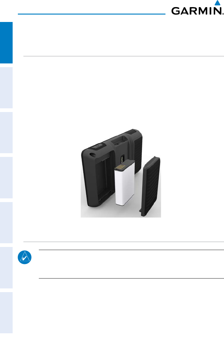
BATTERY INSTALLATION
Installing the battery:
1)
Locate the lithium-ion battery that came in the product box.
2)
Locate the metal contacts on the end of the lithium-ion battery.
3)
Insert the battery so that the metal contacts on the battery line-up with the
metal contacts inside the battery compartment.
4)
Insert the battery into the battery compartment, and push until it clicks into
place.
Unit Overview - Battery
CHARGING THE BATTERY
NOTE: While in Charge Mode, the unit draws a current from the aircraft. To
avoid discharging the aircraft’s battery, disconnect the external power cable
from the unit when not in use for several days.
Charging the unit’s battery using the aircraft's power outlet:
1)
Mount the aera 660 in the aircraft and connect the power cable to the
aircraft power outlet (cigarette lighter receptacle).
2)
Route the power cable so that it does not interfere with aircraft operation.
The unit begins charging as soon as external power is applied.
Draft
Garmin aera 660 Quick Reference Guide
190-02017-10 Rev. A 3
Overview
Overview GPS Navigation Flight Planning Hazard Avoidance Utilities Appendix Index
GPS RECEIVER STATUS
The bars located at the top of the screen indicate the GPS signal strength.
Viewing the GPS status:
From the Main Menu, touch Info > Satellite Status
tab
.
DISPLAY ORIENTATION
The aera 660 can be viewed in either Portrait or Landscape Mode.
Changing the display orientation:
1)
From the Main Menu, touch Tools > Setup > Display
Or
:
Press the Power Button once quickly.
1.3 OPERATION
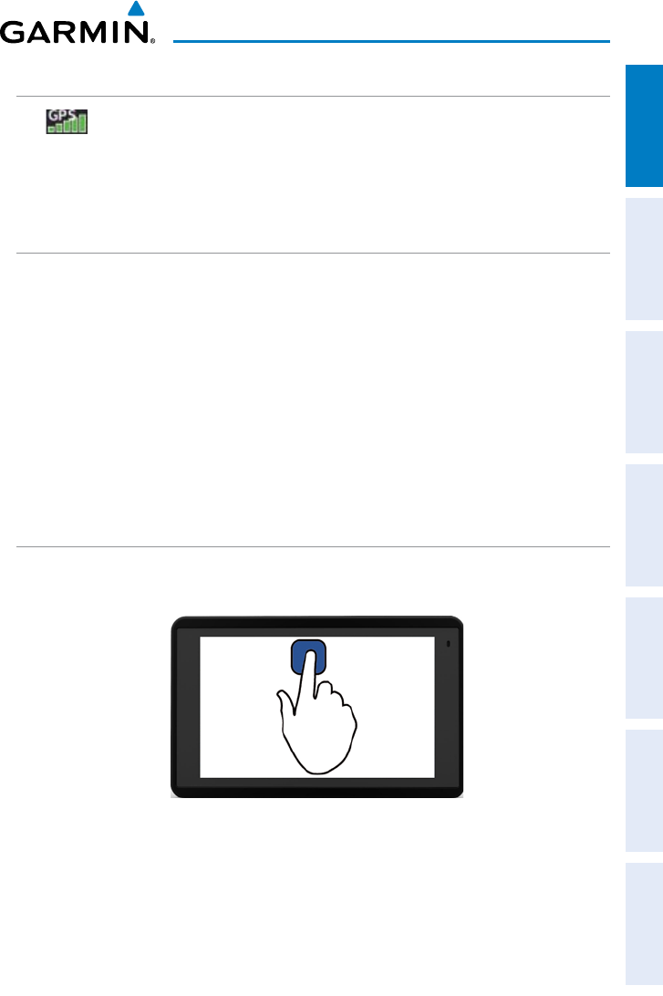
BASIC TOUCHSCREEN OPERATION
Touch the desired selection. The icon, menu option, etc., will momentarily
turn blue when selected.
Basic Touchscreen Operation
Draft
Garmin aera 660 Quick Reference Guide
190-02017-10 Rev. A
4
Overview
OverviewGPS NavigationFlight PlanningHazard AvoidanceUtilitiesAppendixIndex
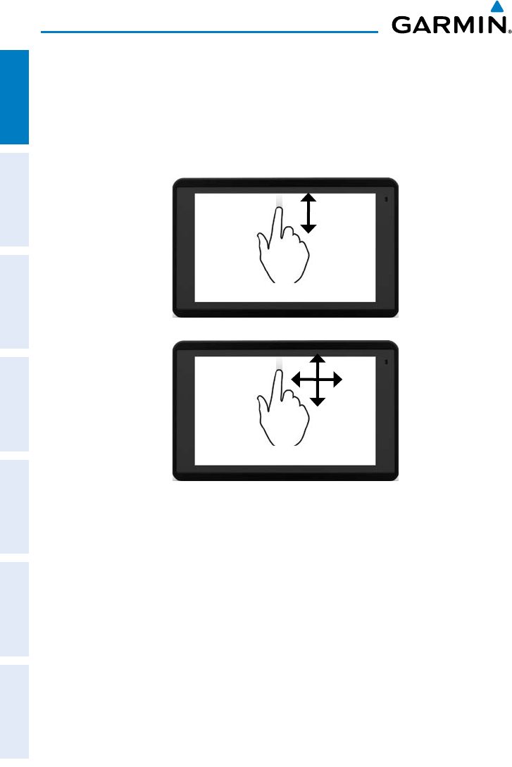
SCROLLING AND PANNING
Scrolling and panning on the touchscreen:
Drag up or down to scroll menus, documents, etc.
Or:
Drag in any direction to pan maps or charts.
Scroll
Pan
Draft
Garmin aera 660 Quick Reference Guide
190-02017-10 Rev. A 5
Overview
Overview GPS Navigation Flight Planning Hazard Avoidance Utilities Appendix Index
ZOOMING
Zooming in and out on the touchscreen map displays:
Pinch fingers together (zoom out), or pull fingers apart (zoom in).
Zoom Out
Zoom In
Draft
Garmin aera 660 Quick Reference Guide
190-02017-10 Rev. A
6
Overview
OverviewGPS NavigationFlight PlanningHazard AvoidanceUtilitiesAppendixIndex
DEDICATED PAGE ICONS
Dedicated Page Icons are located vertically on the right side of the screen in
landscape mode or horizontally along the bottom of the screen in portrait mode.
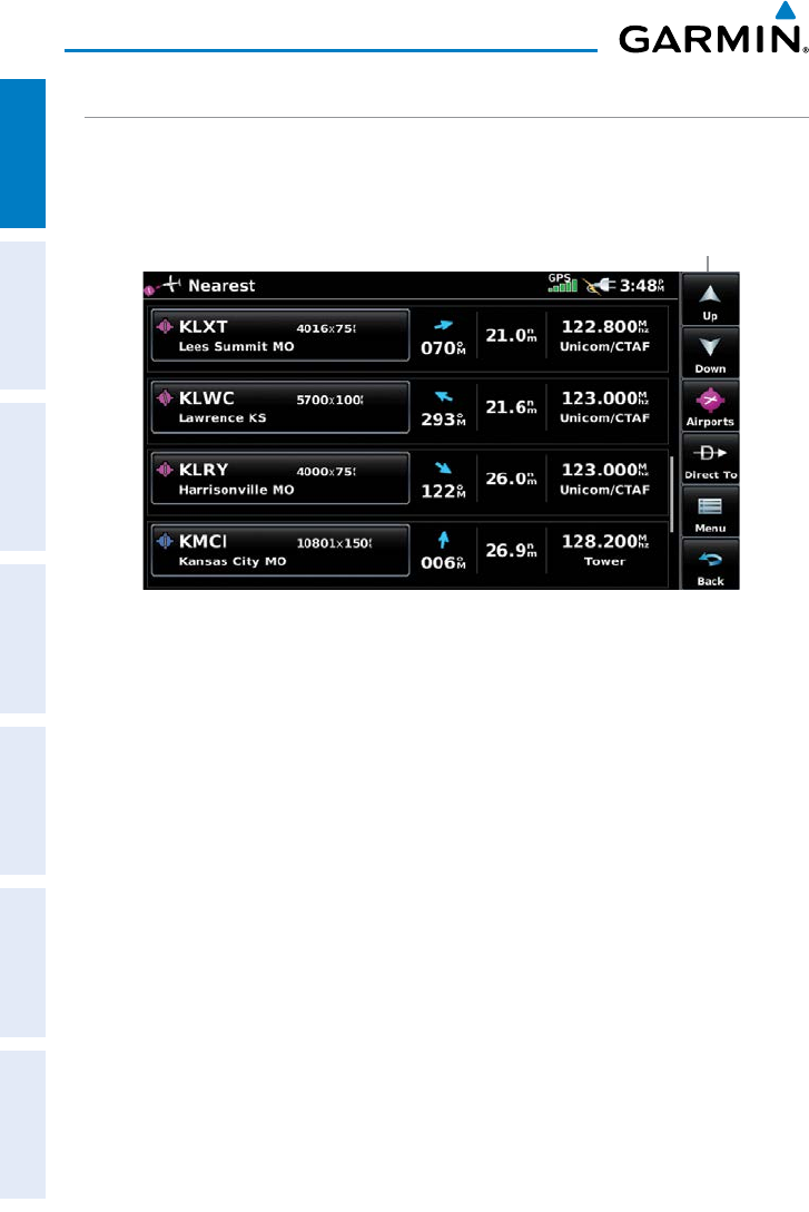
Nearest Airports Page
Dedicated
Page Icons
Draft
Garmin aera 660 Quick Reference Guide
190-02017-10 Rev. A 7
Overview
Overview GPS Navigation Flight Planning Hazard Avoidance Utilities Appendix Index
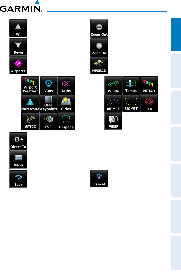
Scroll up OR Returns to previous
screen.
Scroll down OR Touch and hold to
display the Main Menu.
Nearest Group Icons
(Nearest Page Only) OR Weather Group Icons
(Weather Page Only)
OR
Direct-to function.
Page menu
• Previous Screen
• Main Menu (Touch
and Hold)
OR Cancel map pointer
Draft
Garmin aera 660 Quick Reference Guide
190-02017-10 Rev. A
8
Overview
OverviewGPS NavigationFlight PlanningHazard AvoidanceUtilitiesAppendixIndex
MAIN MENU
Touch and hold the
icon at any time to display the Main Menu.
MAIN MENU ICONS
Touch the following icons to display the associated page or menu:
Map Displays the Map View.
Charts Displays the VFR or IFR charts.
3D Vision Displays 3D Vision.
Nearest Displays the Nearest Page
Waypoint Displays the Waypoint Information.
Active Flight Plan Displays the Active Flight Plan.
Traffic Displays the dedicated Traffic Page.
3D Vision Displays 3D Vision Page
Terrain Displays the Terrain View.
Weather
Displays second-level Weather Icons
GPS Info Displays current position, satellite status, and data fields.
Draft
Garmin aera 660 Quick Reference Guide
190-02017-10 Rev. A 9
Overview
Overview GPS Navigation Flight Planning Hazard Avoidance Utilities Appendix Index
MAIN MENU
Touch and hold the
icon at any time to display the Main Menu.
MAIN MENU ICONS
Touch the following icons to display the associated page or menu:
Map Displays the Map View.
Charts Displays the VFR or IFR charts.
3D Vision Displays 3D Vision.
Nearest Displays the Nearest Page
Waypoint Displays the Waypoint Information.
Active Flight Plan Displays the Active Flight Plan.
Traffic Displays the dedicated Traffic Page.
3D Vision Displays 3D Vision Page
Terrain Displays the Terrain View.
Weather
Displays second-level Weather Icons
GPS Info Displays current position, satellite status, and data fields.
Tools Displays second-level Tools Icons.
NEAREST ICONS
From the Main Menu, touch the
icon to access the Nearest Page.
Touch the following Nearest Group Icons to display the associated function:
Airport Displays nearest airports.
Airport WX Displays nearest airport weather.
VOR Displays nearest VORs.
NDB Displays nearest NDBs.
Intersection Displays nearest intersections.
VRP Displays nearest Visual Reporting Point (VRP) (Atlantic).
User WPT Displays nearest user waypoints.
City Displays nearest cities.
ARTCC Displays nearest ARTCCs (Air Route Traffic Control Centers).
FSS Displays nearest Flight Service Stations (FSS).
Airspace Displays nearest airspace.
WEATHER ICONS (GDL 39)
From the Main Menu, touch the
Weather icon to access the Weather Page.
Touch the following Weather Group Icons to display the weather product:
NEXRAD Radar Displays NEXRAD (NEXt-generation RADar).
Winds Aloft Displays Winds Aloft.
Temps Aloft Displays Temperatures Aloft.
METAR Displays METARs.
AIRMET Displays AIRMETs.
Draft
Garmin aera 660 Quick Reference Guide
190-02017-10 Rev. A
10
Overview
OverviewGPS NavigationFlight PlanningHazard AvoidanceUtilitiesAppendixIndex
SIGMET Displays SIGMETs.
TFR Displays TFRs.
Pilot Reports Displays PIREPs.
TOOLS
From the Main Menu, touch the
Tools Icon to access the second-level Tools icons.
Touch the following second-level icons to display the associated function:
Setup Displays third-level Setup Icons.
User WPT Displays User Waypoints and Proximity Waypoints.
Flight Log Displays Flight Logs.
Track Log Displays Track Logs.
FPL List Displays the Flight Plan List.
VNAV Displays Vertical Navigation.
Profile Displays Aircraft Profiles.
E6B Displays the E6B Calculator.
Weight/Bal Displays the Weight & Balance.
Data Link Displays Data Link Information.
User Timer Displays User Timer.
Database Displays database and software version information.
VIRB Displays VIRB Remote Page.
Draft
Garmin aera 660 Quick Reference Guide
190-02017-10 Rev. A 11
Overview
Overview GPS Navigation Flight Planning Hazard Avoidance Utilities Appendix Index
Setup IconS
From the Main Menu, touch the Tools >
Setup to access the third-level Setup
Icons.
Touch the following third-level icons to perform the associated function:
Display Displays backlight intensity/timeout and color mode settings.
Sound Displays sound settings.
Units Displays unit settings.
Time Displays time settings.
Map Displays Navigation Map settings.
Position Displays position settings.
Interface Displays interface settings.
Alarms Displays alarm settings.
Airspace Displays Special Use Airspace alarm settings.
Data Link Displays Data Link Information.
Weather Displays Weather source settings.
Bluetooth
®
Displays Bluetooth connection settings
Power Displays Power Loss Warning settings.
Draft
Garmin aera 660 Quick Reference Guide
190-02017-10 Rev. A
20
Overview
OverviewGPS NavigationFlight PlanningHazard AvoidanceUtilitiesAppendixIndex
BLUETOOTH
®
Connecting/Pairing GDL 39 via Bluetooth:
1)
From the Main Menu, touch Tools > Setup > Bluetooth.
2)
Ensure the Bluetooth on the GDL 39 is in Pairing Mode. Press and hold the
power button on the GDL 39 to enter pairing mode (the blue LED will flash
on the GDL 39 when in pairing mode).
3)
Touch On.
4)
Touch Not Paired next to the GDL Device. A Bluetooth Passkey window
with open.
5)
Touch OK. The GDL 39 is now connected.
Draft
Garmin aera 660 Quick Reference Guide
190-02017-10 Rev. A
Appendix
46
OverviewGPS NavigationFlight PlanningHazard AvoidanceUtilitiesAppendixIndex
LICENSE AGREEMENT AND WARRANTY
CONTACT GARMIN
Contact Garmin if you have any questions while using your aera 660. In the USA, contact Garmin Product
Support by phone: (913) 397-8200 or (866) 739-5687, Monday–Friday, 7 AM–7 PM Central Time; or go to https://
fly.garmin.com/fly-garmin/support.
In Europe, contact Garmin (Europe) Ltd. at +44 (0) 870.8501241 (outside the UK) or 0808 2380000 (within
the UK).
SOFTWARE LICENSE AGREEMENT
BY USING THE aera 660, YOU AGREE TO BE BOUND BY THE TERMS AND CONDITIONS OF THE FOLLOWING
SOFTWARE LICENSE AGREEMENT. PLEASE READ THIS AGREEMENT CAREFULLY.
Garmin grants you a limited license to use the software embedded in this device (the “Software”) in binary
executable form in the normal operation of the product. Title, ownership rights, and intellectual property rights in
and to the Software remain with Garmin.
You acknowledge that the Software is the property of Garmin and is protected under the United States of America
copyright laws and international copyright treaties. You further acknowledge that the structure, organization, and
code of the Software are valuable trade secrets of Garmin and that the Software in source code form remains
a valuable trade secret of Garmin. You agree not to decompile, disassemble, modify, reverse assemble, reverse
engineer, or reduce to human readable form the Software or any part thereof or create any derivative works
based on the Software. You agree not to export or re-export the Software to any country in violation of the export
control laws of the United States of America.
LIMITED WARRANTY
This Garmin product is warranted to be free from defects in materials or workmanship for one year from the
date of purchase. Within this period, Garmin will, at its sole option, repair or replace any components that fail in
normal use. Such repairs or replacement will be made at no charge to the customer for parts or labor, provided
that the customer shall be responsible for any transportation cost. This warranty does not cover failures due to
abuse, misuse, accident, or unauthorized alteration or repairs. In addition, Garmin reserves the right to refuse
warranty claims against products or services that are obtained and/or used in contravention of the laws of any
country.
This product is intended to be used only as a travel aid and must not be used for any purpose requiring precise
measurement of direction, distance, location, or topography. Garmin makes no warranty as to the accuracy or
completeness of map data in this product.
THE WARRANTIES AND REMEDIES CONTAINED HEREIN ARE EXCLUSIVE AND IN LIEU OF ALL OTHER
WARRANTIES EXPRESS, IMPLIED, OR STATUTORY, INCLUDING ANY LIABILITY ARISING UNDER ANY WARRANTY
OF MERCHANTABILITY OR FITNESS FOR A PARTICULAR PURPOSE, STATUTORY OR OTHERWISE. THIS WARRANTY
GIVES YOU SPECIFIC LEGAL RIGHTS, WHICH MAY VARY FROM STATE TO STATE.
IN NO EVENT SHALL GARMIN BE LIABLE FOR ANY INCIDENTAL, SPECIAL, INDIRECT, OR CONSEQUENTIAL
DAMAGES, WHETHER RESULTING FROM THE USE, MISUSE, OR INABILITY TO USE THIS PRODUCT OR FROM
DEFECTS IN THE PRODUCT. SOME STATES DO NOT ALLOW THE EXCLUSION OF INCIDENTAL OR CONSEQUENTIAL
DAMAGES, SO THE ABOVE LIMITATIONS MAY NOT APPLY TO YOU.
Draft

Garmin aera 660 Quick Reference Guide
190-02017-10 Rev. A
Appendix
47
Overview GPS Navigation Flight Planning Hazard Avoidance Utilities Appendix Index
Garmin retains the exclusive right to repair or replace the unit or software or offer a full refund of the purchase
price at its sole discretion. SUCH REMEDY SHALL BE YOUR SOLE AND EXCLUSIVE REMEDY FOR ANY BREACH OF
WARRANTY.
To obtain warranty service, contact your local Garmin authorized dealer or call Garmin Product Support for
shipping instructions and an RMA tracking number. Securely pack the unit and a copy of the original sales receipt,
which is required as the proof of purchase for warranty repairs. Write the tracking number clearly on the outside
of the package. Send the unit, freight charges prepaid, to any Garmin warranty service station.
Online Auction Purchases: Products sold through online auctions are not eligible for rebates or other special offers
from Garmin. Online auction confirmations are not accepted for warranty verification. To obtain warranty service,
an original or copy of the sales receipt from the original retailer is required. Garmin will not replace missing
components from any package purchased through an online auction.
International Purchases: A separate warranty is provided by international distributors for units purchased outside
the United States. This warranty is provided by the local in-country distributor and this distributor provides local
service for your unit. Distributor warranties are only valid in the area of intended distribution. Units purchased in
the United States or Canada must be returned to the Garmin service center in the United Kingdom, the United
States, Canada, or Taiwan for service.
AOPA AIRPORT DIRECTORY NOTICE
AOPA MEMBERSHIP PUBLICATIONS, INC. AND ITS RELATED ORGANIZATIONS (HEREINAFTER COLLECTIVELY
“AOPA”) EXPRESSLY DISCLAIM ALL WARRANTIES, WITH RESPECT TO THE AOPA INFORMATION INCLUDED
IN THIS DATA, EXPRESS OR IMPLIED, INCLUDING, BUT NOT LIMITED TO, THE IMPLIED WARRANTIES OF
MERCHANTABILITY AND FITNESS FOR A PARTICULAR PURPOSE. THE INFORMATION IS PROVIDED “AS IS”
AND AOPA DOES NOT WARRANT OR MAKE ANY REPRESENTATIONS REGARDING ITS ACCURACY, RELIABILITY,
OR OTHERWISE. UNDER NO CIRCUMSTANCES INCLUDING NEGLIGENCE, SHALL AOPA BE LIABLE FOR ANY
INCIDENTAL, SPECIAL OR CONSEQUENTIAL DAMAGES THAT RESULT FROM THE USE OR INABILITY TO USE
THE SOFTWARE OR RELATED DOCUMENTATION, EVEN IF AOPA OR AN AOPA AUTHORIZED REPRESENTATIVE
HAS BEEN ADVISED OF THE POSSIBILITY OF SUCH DAMAGES. USER AGREES NOT TO SUE AOPA AND, TO THE
MAXIMUM EXTENT ALLOWED BY LAW, TO RELEASE AND HOLD HARMLESS AOPA FROM ANY CAUSES OF
ACTION, CLAIMS OR LOSSES RELATED TO ANY ACTUAL OR ALLEGED INACCURACIES IN THE INFORMATION
ARISING OUT OF GARMIN’S USE OF THE INFORMATION IN THE DATASETS. SOME JURISDICTIONS DO NOT
ALLOW THE LIMITATION OR EXCLUSION OF IMPLIED WARRANTIES OR LIABILITY FOR INCIDENTAL OR
CONSEQUENTIAL DAMAGES SO THE ABOVE LIMITATIONS OR EXCLUSIONS MAY NOT APPLY TO YOU.
AC-U-KWIK LICENSE AGREEMENT
AC-U-KWIK AND ITS RELATED ORGANIZATIONS (HEREINAFTER COLLECTIVELY “AC-U-KWIK ORGANIZATIONS”)
EXPRESSLY DISCLAIM ALL WARRANTIES WITH RESPECT TO THE AC-U-KWIK INFORMATION INCLUDED IN THIS DATA,
EXPRESS OR IMPLIED, INCLUDING, BUT NOT LIMITED TO, THE IMPLIED WARRANTIES OF MERCHANTABILITY AND
FITNESS FOR A PARTICULAR PURPOSE. THE INFORMATION IS PROVIDED “AS IS” AND AC-U-KWIK ORGANIZATIONS
DO NOT WARRANT OR MAKE ANY REPRESENTATIONS REGARDING ITS ACCURACY, RELIABILITY, OR OTHERWISE.
LICENSEE AGREES NOT TO SUE AC-U-KWIK ORGANIZATIONS AND, TO THE MAXIMUM EXTENT ALLOWED BY LAW, TO
RELEASE AND HOLD HARMLESS AC-U-KWIK ORGANIZATIONS FROM ANY CAUSES OF ACTION, CLAIMS OR LOSSES
RELATED TO ANY ACTUAL OR ALLEGED INACCURACIES IN THE INFORMATION ARISING OUT OF GARMIN’S USE OF
THE INFORMATION IN THE DATASETS. SOME JURISDICTIONS DO NOT ALLOW THE LIMITATION OR EXCLUSION OF
IMPLIED WARRANTIES OR LIABILITY FOR INCIDENTAL OR CONSEQUENTIAL DAMAGES SO THE ABOVE LIMITATIONS OR
EXCLUSIONS MAY NOT APPLY TO LICENSEE.
Draft
Garmin aera 660 Quick Reference Guide
190-02017-10 Rev. A
Appendix
49
Overview GPS Navigation Flight Planning Hazard Avoidance Utilities Appendix Index
WE ARE NOT RESPONSIBLE FOR ANY SPECIAL, INCIDENTAL, OR CONSEQUENTIAL DAMAGES OR LOSSES
RELATING TO THE USE OF THE RADIO SERVICE, WHETHER BASED ON NEGLIGENCE OR OTHERWISE. OUR TOTAL
LIABILITY TO YOU AND ANY OTHER PERSONS RECEIVING OUR SERVICES, REGARDLESS OF THE CAUSE, WILL IN
NO EVENT EXCEED THE AMOUNTS THAT YOU HAVE PAID TO US FOR THE SERVICE THAT YOU RECEIVED DURING
THE SIX (6) MONTH PERIOD IMMEDIATELY PRIOR TO THE SPECIFIC EVENT THAT GAVE RISE TO THE APPLICABLE
DAMAGE OR LOSS. THIS ALLOCATION OF RISK IS REFLECTED IN OUR PRICES. YOU MAY HAVE GREATER RIGHTS
THAN DESCRIBED ABOVE UNDER YOUR STATE’S LAWS
This product was developed using DAFIF™, a product of the National Geospatial-Intelligence Agency.
This product has not been endorsed or otherwise approved by the National Geospatial-Intelligence Agency, or the
United States Department of Defense (10 U.S.C. 425)
a. Under 10 U.S.C. 456, no civil action may be brought against the United States on the basis of the content
of a navigational aid prepared or disseminated by either the former Defense Mapping Agency (DMA), National
Imagery and Mapping Agency (NIMA), or the National Geospatial-Intelligence Agency (NGA).
b. The DAFIF™ product is provided “as is,” and no warranty, express or implied, including, but not limited to the
implied warranties of merchantability and fitness for particular purpose or arising by statute or otherwise in law or
from a course of dealing or usage in trade, is made by NGA as to the accuracy and functioning of the product.
c. Neither NGA nor its personnel will be liable for any claims, losses, or damages arising from or connected with
the use of this product. The user agrees to hold harmless the United States National Geospatial-Intelligence
Agency. The user’s sole and exclusive remedy is to stop using the DAFIF product.
FCC COMPLIANCE
This device complies with part 15 of the FCC Rules. Operation is subject to the following two conditions: (1) this
device may not cause harmful interference, and (2) this device must accept any interference received, including
interference that may cause undesired operation.
This equipment has been tested and found to comply with the limits for a Class B digital device, pursuant to
part 15 of the FCC rules. These limits are designed to provide reasonable protection against harmful interference
in a residential installation. This equipment generates, uses, and can radiate radio frequency energy and may
cause harmful interference to radio communications if not installed and used in accordance with the instructions.
However, there is no guarantee that interference will not occur in a particular installation. If this equipment does
cause harmful interference to radio or television reception, which can be determined by turning the equipment off
and on, the user is encouraged to try to correct the interference by one of the following measures:
• Reorient or relocate the receiving antenna.
• Increase the separation between the equipment and the receiver.
• Connect the equipment into an outlet that is on a different circuit from the GPS unit.
• Consult the dealer or an experienced radio/TV technician for help.
This product does not contain any user-serviceable parts. Repairs should only be made by an authorized Garmin
service center. Unauthorized repairs or modifications could result in permanent damage to the equipment, and
void your warranty and your authority to operate this device under Part 15 regulations.
Draft

Garmin aera 660 Quick Reference Guide
190-02017-10 Rev. A
Appendix
50
OverviewGPS NavigationFlight PlanningHazard AvoidanceUtilitiesAppendixIndex
INDUSTRY CANADA COMPLIANCE
Category I radio communication devices comply with Industry Canada Standard RSS-210, RSS-247.
LE PRÉSENT APPAREIL EST CONFORME AUX CNR D'INDUSTRIE CANADA APPLICABLES AUX APPAREILS RADIO
EXEMPTS DE LICENCE. L'EXPLOITATION EST AUTORISÉE AUX DEUX CONDITIONS SUIVANTES : (1) L'APPAREIL NE
DOIT PAS PRODUIRE DE BROUILLAGE, ET (2) L'UTILISATEUR DE L'APPAREIL DOIT ACCEPTER TOUT BROUILLAGE
RADIOÉLECTRIQUE SUBI, MÊME SI LE BROUILLAGE EST SUSCEPTIBLE D'EN COMPROMETTRE LE FONCTIONNEMENT.
Draft

Garmin International, Inc.
1200 East 151st Street
Olathe, KS 66062, U.S.A.
Toll free: 800.800.1020 or
866.739.5687
p: 913.397.8200
f: 913.397.8282
Garmin AT, Inc.
2345 Turner Road SE
Salem, OR 97302, U.S.A.
Toll free: 800.525.6726
p: 503.391.3411
f: 503.364.2138
Garmin (Europe) Ltd
Liberty House, Bulls Copse Road
Hounsdown Business Park
Southampton, SO40 9RB, U.K.
Toll free (within U.K.) 0808.2380000
p: 44/0370.8501243
f: 44/0870.8501251
Garmin Corporation
No. 68, Jangshu 2nd Road
Shijr, Taipei County, Taiwan
p: 886/2.2642.9199
f: 886/2.2642.9099
www.garmin.com
190-02017-10 Rev. A
© 2015 Garmin Ltd. or its subsidiaries
Draft
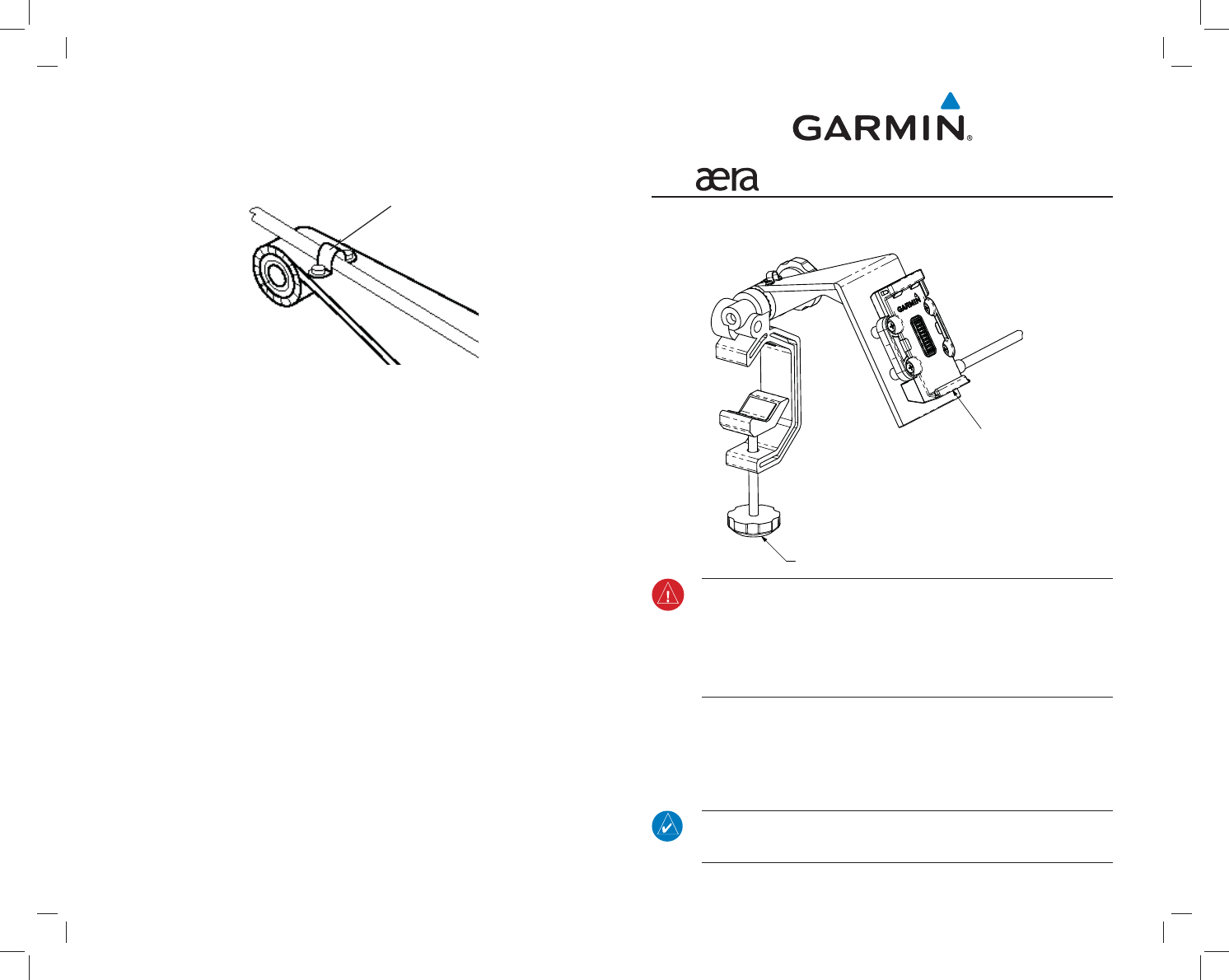
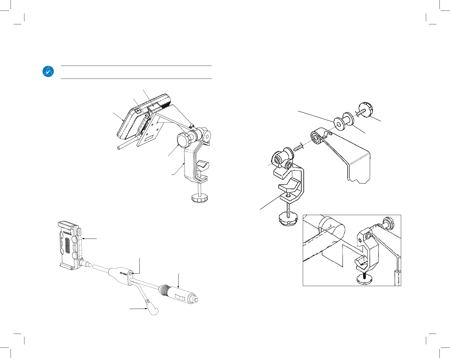
™ YOKE MOUNT INSTALLATION INSTRUCTIONS
The aera yoke mount comes fully assembled as shown below. The yoke mount is
GHVLJQHGWR¿WWKHPDMRULW\RIFRQYHQWLRQDODLUFUDIW\RNHVand center column controls.
Clamp Adjustment Knob
aera Cradle
WARNING: It is the sole responsibility of the owner/operator of the aera to place
this mount and secure the unit so that it will not interfere with the aircraft’s operating
FRQWUROVDQGVDIHW\GHYLFHVRUFDXVHGDPDJHRUSHUVRQDOLQMXU\LQWKHHYHQWRIDQ
accident or turbulence. Do not mount the aera where the pilot or passengers are
OLNHO\WRLPSDFWLWLQDQDFFLGHQWFROOLVLRQRUWXUEXOHQFH7KHPRXQWLQJKDUGZDUH
SURYLGHGE\*DUPLQLVQRWZDUUDQWHGDJDLQVWWXUEXOHQFHFROOLVLRQGDPDJHRUUHODWHG
consequences.
Attach the yoke mount to yoke shaft or control arm:
1) Open the clamp by turning the Clamp Adjustment Knob until it can be easily
placed over the yoke shaft or control arm. Install the yoke mount as far from the
panel as is practical.
2) When in place, tighten the Clamp Adjustment Knob to secure the yoke mount to
the yoke shaft or control arm.
NOTE: $IWHULQVWDOODWLRQYHULI\ÀLJKWFRQWUROVDUHIUHHDQGFOHDUSHUWKHÀLJKWPDQXDO
of the applicable aircraft and that the aera yoke mount and wiring do not cause any
LQWHUIHUHQFHZLWKWKHÀLJKWFRQWUROV
14
Secure the cable on the top of the yoke mount:
1) Remove the screws securing the cable clamp.
2) Orient the cable and secure the clamp with the screws.
Cable Clamp
Remove the yoke mount from the yoke shaft (or control arm):
1) Disconnect the cable connectors from the aircraft.
2) Loosen the clamp by turning the Clamp Adjustment Knob until the clamp
assembly can be easily removed from the yoke shaft or control arm.
&RS\ULJKW*DUPLQ/WGRULWVVXEVLGLDULHV
*DUPLQ,QWHUQDWLRQDO,QF
(DVWVW6WUHHW2ODWKH.DQVDV86$
*DUPLQ(XURSH/WG
*DUPLQ(XURSH/WG/LEHUW\+RXVH+RXQVGRZQ%XVLQHVV3DUN6RXWKDPSWRQ+DPSVKLUH62/58.
*DUPLQ$VLD&RUSRUDWLRQ
1R-DQJVKXQG5RDG6KLMU7DLSHL&RXQW\7DLZDQ
www.garmin.com
3ULQWHGLQ7DLZDQ3DUW1XPEHU5HY&
32
3) Loosen the Cradle Adjustment Knob, then orient the aera as desired.
4) Tighten the Cradle Adjustment Knob to hold the aera in place.
5) Connect power/data cables.
NOTE: 5HDGMXVWWKHSRVLWLRQRIWKHDHUDWRSURYLGHWKHEHVWYLHZRIWKHGLVSOD\VFUHHQ
as lighting conditions change.
Attach the aera to the
yoke mount:
1) Fit the bottom of the
aera into the cradle.
2) Tilt the aera back until it
snaps into place.
Remove the aera from
the yoke mount:
1) Press the Release
Button on the side of
the mount to release the
aera.
2) Lift out the aera.
Connect the cable:
Make all applicable cable connections per the below drawing.
5HFRQ¿JXUHWKH\RNHPRXQWIRUFHQWHUFROXPQ\RNHV
1) Loosen and remove the Cradle Adjustment Knob, spacer, and rubber washer.
2) Rotate the clamp assembly 90o so that the clamp opening faces away from you.
3) Secure the clamp assembly to the rest of the yoke mount using the Cradle
Adjustment Knob, spacer, and rubber washer. Adjust the clamp angle before
fully tightening the Cradle Adjustment Knob.
<RNH0RXQWLQ)RUZDUG)DFLQJ&RQ¿JXUDWLRQ
<RNH0RXQWLQ&RQYHQWLRQDO&RQ¿JXUDWLRQ
Rubber Washer
Spacer
Clamp Assembly
Cradle Adjusment Knob
aera Cradle
Release Button
Cradle Adjustment Knob
aera
Yoke Mount Assembly
3.5mm Headphone/Audio Jack
Power Plug (3A Fuse)
Mini-USB Connector
to XM Receiver
(XM version only)
Cradle
SPECIFICATION
CONTROL
DRAWING
NOTES:
1. DESCRIPTION: Product Documentation - ISPI, Aviation, aera 660 (ML)
2. SIZE:
Trimmed: Width = 8.3” Height = 5.5”. Finished, Folded: Width = 8.3”, Height = 5.5”.
3. TOLERANCE:
±0.0787” (±2 mm)
4. PAGINATION:
24 pages
5. MATERIAL:
80-lb woodfree. Approved Equivalents Allowed
6. COLOR: 4-color process. Approved equivalents allowed.
7. BINDERY:
Saddle-stitched. Approved Equivalents Allowed
8. LANGUAGES: English, French, Italian, German, Spanish, Portuguese.
9. ELECTRONIC ARTWORK: Shall Conform to Garmin Archive 190-02017-00_0B.zip.
10. COMPLIANCE: This part shall comply with Garmin Banned & Restricted Substances List (Garmin P/N 001-00211-00).
Filename File Contents
The following les have been archived under the above ARCHIVE FILENAME.
190-02017-00_0B.indd InDesign CS for PC, Formatted manual
190-02017-00_0B_spec.indd InDesignCSforPC,DocumentSpecications
Links Document Illustrations (eps, bitmap, etc.)
Document Fonts Document Fonts
190-02017-00_0B.pdf Portable Document Format, for print
190-02017-00_0B_web.pdf Portable Document Format, for online
REVISIONS
REV. DATE DESCRIPTION ECO NO.
Drafter:
Checker:
Project Engineer:
Released By: Scale:
SIZE
A
REV.
N/A Sht. of
TITLE:
PART NO.
Garmin Ltd. or its subsidiaries
c/o Garmin International, Inc.
1200 E. 151st Street
Olathe, Kansas 66062 U.S.A.
CONFIDENTIAL
ThisdrawingandthespecicationscontainedhereinarethepropertyofGarmin
Ltd. or its subsidiaries and may not be reproduced or used in whole or in part as
the basis for manufacture or sale of products without written permission.
Trimmed dimensions
5.5"
8.3"16.6"
Trimmed and bound dimensions
Binding CoverSpread layout
Cover
Cover
Dimensions and drawings for reference only. Drawings are not to scale.
Date:
A 11/30/15 Initial Release --------
ISPI, Aviation, aera 660, ML
190-02017-00 B
DRB 11/30/2015
On File On File
On File On File
On File On File 1 25
B 1/27/16 Added multiple languages and updated layout 138580
Important Safety and Product Information 2
Informations importantes sur le produit et la sécurité 6
Informazioni importanti sulla sicurezza e sul prodotto 9
Wichtige Sicherheits- und Produktinformationen 13
Información importante sobre el producto y tu seguridad 17
Informações Importantes de Segurança e do Produto 20
EN
FR
IT
DE
ES
PT
NL
DA
FI
NO
SV
PL
RU
HR
EL
ZH-CH
CS-CZ
®model: 660
2
Important Safety and Product Information
Refer to the applicable Pilot’s Guide and Installation Manual (available at www.garmin.com) for complete
operating and installation procedures.
The information provided in this document may not apply to all system configurations. It is the responsibility
of the Pilot to consult the appropriate Pilot’s Guide in determining applicability of the safety information to
their specific configuration.
WARNINGS, CAUTIONS, & NOTES
WARNING: Navigation and terrain separation must NOT be predicated upon the
use of the terrain function. The Terrain Proximity feature is NOT intended to be used
as a primary reference for terrain avoidance and does not relieve the pilot from the
responsibility of being aware of surroundings during flight. The Terrain Proximity
feature is only to be used as an aid for terrain avoidance and is not certified for
use in applications requiring a certified terrain awareness system. Terrain data is
obtained from third party sources. Garmin is not able to independently verify the
accuracy of the terrain data.
WARNING: The displayed minimum safe altitudes (MSAs) are only advisory in nature
and should not be relied upon as the sole source of obstacle and terrain avoidance
information. Always refer to current aeronautical charts for appropriate minimum
clearance altitudes.
WARNING: The altitude calculated by the GPS and GLONASS receivers is geometric
height above Mean Sea Level and could vary significantly from the altitude displayed
by pressure altimeters.
WARNING: Do not use outdated database information. Databases used must be
updated regularly in order to ensure that the information remains current. Pilots
using any outdated database do so entirely at their own risk.
WARNING: Do not use basemap (land and water data) information for primary
navigation. Basemap data is intended only to supplement other approved navigation
data sources and should be considered as an aid to enhance situational awareness.
WARNING: Do not rely solely upon the display of traffic information for collision
avoidance maneuvering. The traffic display does not provide collision avoidance
resolution advisories and does not under any circumstances or conditions relieve
the pilot’s responsibility to see and avoid other aircraft.
WARNING: Do not rely solely upon the display of traffic information to accurately
depict all of the traffic within range of the aircraft. Due to lack of equipment, poor
signal reception, and/or inaccurate information from aircraft or ground stations,
traffic may be present that is not represented on the display.
WARNING: Do not use data link weather information for maneuvering in, near
or around areas of hazardous weather. Information contained within data link
weather products may not accurately depict current weather conditions.
WARNING: Do not use the indicated data link weather product age to determine
the age of the weather information shown by the data link weather product. Due
to time delays inherent in gathering and processing weather data for data link
transmission, the weather information shown by the data link weather product
may be significantly older than the indicated weather product age.
3
WARNING: Because of variation in the earth’s magnetic field, operating the system
within the following areas could result in loss of reliable attitude and heading indi
-
cations. North of 72° North latitude at all longitudes. South of 70° South latitude
at all longitudes. North of 65° North latitude between longitude 75° W and 120°
W. (Northern Canada). North of 70° North latitude between longitude 70° W and
128° W. (Northern Canada). North of 70° North latitude between longitude 85°
E and 114° E. (Northern Russia). South of 55° South latitude between longitude
120° E and 165° E. (Region south of Australia and New Zealand).
WARNING: The system has a very high degree of functional integrity. However,
the pilot must recognize that providing monitoring and/or self-test capability for all
conceivable system failures is not practical. Although unlikely, it may be possible
for erroneous operation to occur without a fault indication shown by the system.
It is thus the responsibility of the pilot to detect such an occurrence by means of
cross-checking with all redundant or correlated information available in the cockpit.
WARNING: The government entities operating the satellite-based navigation
systems (GPS/GLONASS) are solely responsible for their accuracy and maintenance.
The satellite-based navigation systems are subject to changes which could affect
the accuracy and performance of all GPS/GLONASS equipment. Portions of the
system utilize GPS/GLONASS as a precision electronic NAVigation AID (NAVAID).
Therefore, as with all NAVAIDs, information presented by the system can be misused
or misinterpreted and, therefore, become unsafe.
WARNING: For safety reasons, operational procedures of the system must be learned
on the ground.
WARNING: To reduce the risk of unsafe operation, carefully review and understand
all aspects of the applicable Pilot’s Guide documentation and the Pilot’s Operating
Handbook of the aircraft. Thoroughly practice basic operation prior to actual use.
During flight operations, carefully compare indications from the system to all
available navigation sources, including the information from other NAVAIDs, visual
sightings, charts, etc. For safety purposes, always resolve any discrepancies before
continuing navigation.
WARNING: The data contained in the terrain and obstacle databases comes from
government agencies. Garmin accurately processes and cross-validates the data,
but cannot guarantee the accuracy and completeness of the data.
WARNING: Do not rely solely on the navigation information presented on the
aera 660 3D Vision Page. The navigation information displayed is derived from
satellite data and may be different than the navigation information on the primary
navigation instruments.
WARNING: Never use the aera 660 to attempt to penetrate a thunderstorm. Both
the FAA Advisory Circular, Subject: Thunderstorms, and the Aeronautical Information
Manual (AIM) recommend avoiding “by at least 20 miles any thunderstorm identified
as severe or giving an intense radar echo.”
WARNING: Do not use the approach information provided by the VFR navigation
database residing within the aera 660 as a means of navigating any instrument
approach. The aera 660 VFR navigation database is limited to present only the
waypoints for the final approach leg of a published procedure. These waypoints
and associated course line are made available for monitoring purposes only.
4
CAUTION: The display uses a lens coated with a special coating that is very sensitive
to abrasive cleaners. AVOID CHEMICAL CLEANERS AND SOLVENTS THAT WILL HARM
THE SPECIAL COATING. It is very important when cleaning the touchscreen to use
a clean, lint-free cloth (lightly dampened with water, if necessary).
CAUTION: The system does not contain any user-serviceable parts. Repairs should
only be made by an authorized Garmin service center. Unauthorized repairs or
modifications could void both the warranty and the pilot’s authority to operate
this device under FAA/FCC regulations.
NOTE: This product, its packaging, and its components contain chemicals known
to the State of California to cause cancer, birth defects, or reproductive harm. This
notice is being provided in accordance with California’s Proposition 65. If you have
any questions or would like additional information, please refer to our web site at
www.garmin.com/prop65.
NOTE: Interference from satellite repeaters operating inside nearby hangars can
cause an intermittent loss of attitude and heading displays while the aircraft is on
the ground. Moving the aircraft more than 100 yards away from the source of the
interference should alleviate the condition.
NOTE: Use of polarized eyewear may cause the flight displays to appear dim or
blank.
NOTE: Temporary Flight Restriction (TFR) data is provided by the FAA and may
not be updated outside of normal business hours. Confirm data currency through
alternate sources and contact your local FSS for interpretation of TFR data.
PRODUCT ENVIRONMENTAL PROGRAMS
Information about Garmin’s product recycling program and WEEE, RoHS, REACH, and other
compliance programs can be found at www.garmin.com/aboutGarmin/environment.
DECLARATION OF CONFORMITY
Hereby, Garmin, declares that this product is in compliance with the essential requirements and
other relevant provisions of Directive 1999/5/EC. To view the full Declaration of Conformity, go to
www.garmin.com/compliance.
INDUSTRY CANADA COMPLIANCE
Category I radiocommunication devices comply with Industry Canada Standard RSS-210,
RSS-247. Category II radiocommunication devices comply with Industry Canada Standard
RSS-310. This device complies with Industry Canada license-exempt RSS standard(s). Operation
is subject to the following two conditions: (1) this device may not cause interference, and (2)
this device must accept any interference, including interference that may cause undesired
operation of the device.
Le présent appareil est conforme aux CNR d’Industrie Canada applicables aux appareils radio
exempts de licence. L’exploitation est autorisée aux deux conditions suivantes : (1) l’appareil
ne doit pas produire de brouillage, et (2) l’utilisateur de l’appareil doit accepter tout brouillage
radioélectrique subi, même si le brouillage est susceptible d’en compromettre le fonctionnement.
RADIO FREQUENCY EXPOSURE
This device is a mobile transmitter and receiver that uses its antenna to send and receive low
levels of radio frequency (RF) energy for voice and/or data communications. The device emits
RF energy below the published limits when operating in its maximum output power mode and
when used with Garmin authorized accessories. To comply with FCC RF exposure compliance
requirements, the device should be mounted per the installation instructions only. The device
should not be used in other configurations. The device must be mounted a minimum of 20 cm
away from the body of the user. This device must not be co-located or operated in conjunction
with any other transmitter or antenna.
FCC COMPLIANCE
This product has been tested and found to comply with Part 15 of the FCC interference limits for Class
B digital devices FOR HOME OR OFFICE USE. These limits are designed to provide more reasonable
protection against harmful interference in a residential installation, and are more stringent than “outdoor”
requirements.
Operation of this device is subject to the following conditions: (1) this device may not cause harmful
interference, and (2) this device must accept any interference received, including interference that may cause
undesired operation.

5
This equipment generates, uses, and can radiate radio frequency energy and may cause harmful interference
to radio communications if not installed and used in accordance with the instructions. However, there is no
guarantee that interference will not occur in a particular installation. If this equipment does cause harmful
interference to radio or television reception, which can be determined by turning the equipment off and on,
the user is encouraged to try to correct the interference by one of the following measures:
• Reorient or relocate the receiving antenna.
• Increase the separation between the equipment and the receiver.
• Connect the equipment into an outlet that is on a different circuit from the GPS device.
• Consult the dealer or an experienced radio/TV technician for help.
This product does not contain any user-serviceable parts. Repairs should only be made by an authorized
Garmin service center. Unauthorized repairs or modifications could result in permanent damage to the
equipment, and void your warranty and your authority to operate this device under Part 15 regulations.
LIMITED WARRANTY
The aera 660 is warranted to be free from defects in materials or workmanship for one year from the date
of purchase. Within the specified period, Garmin will, at its sole option, repair or replace any components
that fail in normal use. Such repairs or replacement will be made at no charge to the customer for parts and
labor, provided that the customer shall be responsible for any transportation cost. This warranty does not
cover failures due to abuse, misuse, accidents, or unauthorized alterations or repairs.
THE WARRANTIES AND REMEDIES CONTAINED HEREIN ARE EXCLUSIVE AND IN LIEU OF ALL OTHER
WARRANTIES EXPRESS OR IMPLIED OR STATUTORY, INCLUDING ANY LIABILITY ARISING UNDER ANY
WARRANTY OF MERCHANTABILITY OR FITNESS FOR A PARTICULAR PURPOSE, STATUTORY OR OTHERWISE.
THIS WARRANTY GIVES YOU SPECIFIC LEGAL RIGHTS, WHICH MAY VARY FROM STATE TO STATE.
IN NO EVENT SHALL GARMIN BE LIABLE FOR ANY INCIDENTAL, SPECIAL, INDIRECT OR CONSEQUENTIAL
DAMAGES, WHETHER RESULTING FROM THE USE, MISUSE, OR INABILITY TO USE THIS PRODUCT OR FROM
DEFECTS IN THE PRODUCT. Some states do not allow the exclusion of incidental or consequential damages,
so the above limitations may not apply to you.
Garmin retains the exclusive right to repair or replace the unit or software, or to offer a full refund of the
purchase price, at its sole discretion. SUCH REMEDY SHALL BE YOUR SOLE AND EXCLUSIVE REMEDY FOR
ANY BREACH OF WARRANTY.
Products sold through online auctions are not eligible for rebates or other special offers from Garmin. Online
auction confirmations are not accepted for warranty verification. To obtain warranty service, an original copy
of the sales receipt from the original retailer is required. Garmin will not replace missing components from
any package purchased through an online auction.
To obtain warranty service, contact your local Garmin Authorized Service Center. For assistance in locating a
Service Center, visit the Garmin website at www.garmin.com or contact Garmin Customer Service at one of
the numbers listed below.
Garmin International, Inc., 1200 East 151st Street, Olathe, Kansas 66062, U.S.A.
Toll free: 800/800.1020 Tel: 913/397.8200 Fax: 913/397.8282
Garmin AT, Inc., 2345 Turner Road SE, Salem, OR 97302, U.S.A.
Toll free: 800/525.6726 Tel: 503/391.3411 Fax: 503/364.2138
Garmin (Europe) Ltd. Liberty House, Hounsdown Business Park, Southampton, Hampshire SO40 9LR U.K.
Tel:44 (0) 37 0850 1243 Fax:44 (0) 23 8052 4004 Aviation Support:44 (0) 37 0850 1243
© Copyright 2016 Garmin Ltd. or its subsidiaries
Garmin International, Inc.
1200 East 151st Street, Olathe, Kansas 66062, U.S.A.
Garmin (Europe) Ltd.
Liberty House, Hounsdown Business Park, Southampton, Hampshire SO40 9LR U.K.
Garmin (Asia) Corporation
No. 68, Jangshu 2nd Road, Shijr, Taipei County, Taiwan
www.garmin.com
6
Informations importantes sur le produit et la
sécurité
Les procédures d’utilisation et d’installation figurent dans le Guide du pilote et dans le Manuel d’installation cor-
respondants (disponibles sur www.garmin.com).
Les informations présentées dans ce document ne s’appliquent pas nécessairement à toutes les configurations sys-
tème. Le Pilote doit consulter le Guide du pilote correspondant afin de déterminer dans quelle mesure les informations
de sécurité s’appliquent à sa configuration spécifique.
AVERTISSEMENTS, MISES EN GARDE ET AVIS
AVERTISSEMENT : la navigation et l’espacement du terrain ne doivent PAS s’appuyer sur
la fonction de terrain. La fonction Proximité du terrain ne doit PAS être utilisée comme
référence principale d’évitement de terrain et le pilote doit rester en permanence attentif
à l’environnement dans lequel il évolue. La fonction Proximité du terrain doit être utilisée
comme une simple assistance pour l’évitement de terrain et son utilisation avec les
applications exigeant un système de repérage du terrain certifié n’est pas garantie. Les
données de terrain proviennent de sources appartenant à des tiers. Garmin n’a pas les
moyens de vérifier de manière indépendante l’exactitude des données de terrain.
AVERTISSEMENT : les altitudes minimales de sécurité (MSA) affichées ont un caractère
strictement indicatif et ne doivent jamais être considérées comme une source unique
d’informations d’évitement d’obstacles et de terrain. Pour établir des altitudes de sécurité
minimales exactes, utilisez toujours des cartes aéronautiques à jour.
AVERTISSEMENT : l’altitude GPS calculée par les récepteurs GPS et GLONASS correspond
à la hauteur géométrique au-dessus du niveau moyen de la mer et peut varier sensiblement
de l’altitude affichée par des altimètres basés sur la pression.
AVERTISSEMENT : n’utilisez jamais de bases de données obsolètes. Les bases de données
doivent être régulièrement mises à jour afin de garantir la validité des informations qu’elles
contiennent. L’utilisation de bases de données obsolètes constitue une prise de risque
assumée par le pilote.
AVERTISSEMENT : n’utilisez pas les données du fond cartographique (relatives à la terre
et l’eau) pour la navigation principale. Les données du fond cartographique constituent
uniquement une source complémentaire aux autres sources de données de navigation
approuvées et doivent être considérées comme une aide pour améliorer la visibilité de la
situation.
AVERTISSEMENT : les manœuvres de prévention des collisions ne doivent pas se
baser uniquement sur l’affichage des informations sur le trafic. Cet affichage ne produit
pas de communiqués d’évitement des collisions et ne saurait dégager le pilote de ses
responsabilités d’observation et d’évitement des autres avions, quelles que soient les
circonstances ou conditions de navigation.
AVERTISSEMENT : l’affichage des informations sur le trafic ne permet pas à lui seul de
représenter avec exactitude l’ensemble du trafic à proximité de l’avion. L’absence de certains
équipements, une mauvaise réception du signal ou l’inexactitude des informations émises
par des avions ou des stations au sol peuvent empêcher l’affichage à l’écran d’informations
relatives à des avions en vol.
AVERTISSEMENT : n’utilisez pas d’informations météorologiques de liaison de données
pour toutes manœuvres à l’intérieur, à proximité ou autour des zones présentant des
conditions météorologiques dangereuses. Les informations présentées dans les produits
météo de liaison de données ne représentent pas forcément de manière précise les
conditions météorologiques actuelles.
AVERTISSEMENT : l’ancienneté du produit météo de liaison de données tel qu’il est indiqué
ne permet pas d’établir l’ancienneté des informations météorologiques affichées par le
produit météo de liaison de données. Les temps de collecte et de traitement des données
météorologiques transmises par liaison de données créent des retards qui expliquent que
les informations météorologiques affichées par le produit de liaison de données sont parfois
sensiblement plus anciennes que l’ancienneté indiquée sur le produit météo.
7
AVERTISSEMENT: du fait de la variation du champ magnétique terrestre, l’utilisation du
système dans les zones suivantes peut provoquer une perte de données d’attitude et de
cap fiables. Au Nord de 72° de latitude Nord à toutes les longitudes. Au Sud de 70° de
latitude Sud à toutes les longitudes. Au Nord de 65° de latitude Nord entre 75° W et 120°
W de longitude. (Nord Canada). Au Nord de 70° de latitude Nord entre 70° W et 128° W
de longitude. (Nord Canada). Au Nord de 70° de latitude Nord entre 85° E et 114° E de
longitude. (Nord Russie). Au Sud de 55° de latitude Sud entre 120° E et 165° E de longitude.
(Région Sud de l’Australie et de la Nouvelle Zélande).
AVERTISSEMENT : le système présente une intégrité fonctionnelle très élevée. Cependant,
il n’est clairement pas possible, concrètement, de proposer une surveillance et/ou des
fonctions d’autotest pour toutes les défaillances possibles du système. Il peut donc arriver
dans des cas rarissimes que, pour certains dysfonctionnements, le système n’affiche pas
de message d’erreur. Dans ces situations, il appartient au pilote de recouper toutes les
informations redondantes ou associées fournies par ses instruments.
AVERTISSEMENT : les autorités publiques qui exploitent les systèmes de navigation
satellite (GPS/GLONASS) sont uniquement tenues de garantir leur précision et leur
maintenance. Les systèmes de navigation satellite sont sujets à des modifications pouvant
influer sur la précision et la performance de tous les équipements GPS/GLONASS. Certaines
parties du système utilisent GPS/GLONASS comme aide à la navigation (NAVigation AID
- NAVAID) électronique de précision. Ainsi, comme pour toutes les aides à la navigation,
les informations fournies par le système peuvent être utilisées ou interprétées de manière
erronée, et dès lors, présenter un danger.
AVERTISSEMENT : pour des raisons de sécurité, les procédures opérationnelles du système
doivent être étudiées au sol.
AVERTISSEMENT : pour réduire le risque d’utilisation dangereuse, vous devez étudier et
assimiler tous les détails de la documentation du Guide du pilote et du Manuel de pilotage
de l’avion. Avant d’utiliser l’appareil en situation réelle, entraînez-vous consciencieusement
à ses fonctions de base. Pendant des opérations aériennes, comparez attentivement les
indications du système à toutes les sources de navigation disponibles, notamment les
informations provenant d’autres aides à la navigation, les signaux visuels, les cartes, etc.
Pour votre sécurité, cherchez à résoudre tout dysfonctionnement avant de poursuivre la
navigation.
AVERTISSEMENT : les données présentes dans les bases de données de terrain
et d’obstacles proviennent des agences gouvernementales. Garmin traite et valide
minutieusement les données et les soumet à une validation croisée, mais nous ne pouvons
garantir leur précision et leur exhaustivité.
AVERTISSEMENT : ne vous contentez pas des seules informations de navigation présentées
sur la Page 3D Vision de l’aera 660. Les informations de navigation affichées sont tirées
des données satellites et peuvent différer des informations de navigation fournies par les
instruments de navigation primaires.
AVERTISSEMENT : l’aera 660 ne doit pas être utilisé pour tenter de pénétrer dans une
zone d’orage. Les circulaires consultatives de la FAA, Sujet : Orages, et l’Aeronautical
Information Manual - AIM (manuel d’information aéronautique) recommandent d’éviter
« d’au moins 20 miles tout orage identifié comme important ou produisant un écho radar
intense ».
AVERTISSEMENT : n’utilisez pas les données d’approche figurant dans la base de données
de navigation VFR qui se trouve dans l’aera 660 pour procéder à une approche aux
instruments. La base de données de navigation VFR de l’aera 660 présente uniquement
les waypoints correspondant au segment d’approche final d’une procédure publiée. Ces
waypoints et les lignes d’itinéraire associées sont proposés uniquement à des fins de
surveillance.
8
ATTENTION : l’écran utilise un objectif doté d’un revêtement spécial très sensible aux
produits nettoyants abrasifs. EVITEZ LES NETTOYANTS CHIMIQUES ET LES SOLVANTS
CAR ILS RISQUENT D’ENDOMMAGER CE REVETEMENT SPECIAL. L’écran tactile doit
impérativement être nettoyé à l’aide d’un chiffon non pelucheux propre (légèrement
humidifié à l’eau, si nécessaire).
ATTENTION : le système ne contient aucune pièce pouvant être entretenue par l’utilisateur.
Seul un atelier de réparation agréé Garmin est habilité à effectuer les réparations
nécessaires. La pratique de réparations ou de modifications non agréées peut annuler la
garantie et l’autorisation du pilote à utiliser cet appareil conformément à la réglementation
de la FAA/FCC.
AVIS : ce produit, son emballage et ses composants contiennent des produits chimiques
considérés par l’Etat de Californie comme pouvant provoquer des cancers, des anomalies
congénitales ou des troubles de la reproduction. Cet avis est fourni conformément à la
Proposition 65 de l’Etat de Californie. Pour toute question ou pour plus d’informations,
consultez notre site Web à l’adresse www.garmin.com/prop65.
AVIS : toute interférence avec des répéteurs satellites utilisés dans des hangars situés à
proximité peut provoquer une perte intermittente de l’affichage de l’altitude et du cap
lorsque l’avion est au sol. Ce défaut doit disparaître lorsque l’avion s’éloigne de plus de
100 yards de cette source d’interférence.
AVIS : l’utilisation de lunettes à verres polarisés peut atténuer voire supprimer la perception
des écrans de vol.
AVIS : les données de restrictions temporaires de vol (TFR) sont fournies par la FAA et ne
sont pas mises à jour en dehors des heures ouvrables normales. Confirmez que les don-
nées sont à jour par d’autres sources et contactez votre FSS local pour l’interprétation des
données TFR.
PROGRAMMES ENVIRONNEMENTAUX
Des informations relatives au programme Garmin de recyclage des produits ainsi qu’aux directives DEEE
et RoHS, à la réglementation REACH et aux autres programmes de conformité sont disponibles à l’adresse
www.garmin.com/aboutGarmin/environment.
DÉCLARATION DE CONFORMITÉ
Par la présente, Garmin déclare que ce produit est conforme aux principales exigences et autres clauses
pertinentes de la directive européenne 1999/5/CE. Pour prendre connaissance de l’intégralité de la
déclaration de conformité, rendez-vous sur le site
www.garmin.com/compliance.
CONFORMITÉ AUX NORMES D’INDUSTRIE CANADA
Les périphériques de radiocommunication de catégorie I sont conformes à la norme RSS-210, RSS-247
d’Industrie Canada. Les périphériques de radiocommunication de catégorie II sont conformes à la norme
RSS-310 d’Industrie Canada. Cet appareil est conforme aux normes RSS sans licence d’Industrie Canada.
Son fonctionnement est soumis aux deux conditions suivantes : (1) ce périphérique ne doit pas causer
d’interférences et (2) doit accepter toute interférence, y compris les interférences pouvant entraîner un
fonctionnement indésirable de l’appareil.
Le présent appareil est conforme aux CNR d’Industrie Canada applicables aux appareils radio exempts de
licence. L’exploitation est autorisée aux deux conditions suivantes : (1) l’appareil ne doit pas produire de
brouillage, et (2) l’utilisateur de l’appareil doit accepter tout brouillage radioélectrique subi, même si le
brouillage est susceptible d’en compromettre le fonctionnement.
EXPOSITION AUX RADIOFRÉQUENCES
Cet appareil est un transmetteur/récepteur mobile qui envoie et reçoit des champs de radiofréquences
de faible puissance par le biais de son antenne lors des communications de voix et/ou de données.
Les champs de radiofréquences émis par l’appareil lorsqu’il fonctionne au maximum de sa puissance
et qu’il est utilisé avec des accessoires approuvés par Garmin ne dépassent pas les limites fixées par
la réglementation. Pour être conforme aux exigences d’exposition aux radiofréquences définies par la
réglementation FCC, l’appareil doit être monté conformément aux instructions d’installation uniquement.
L’appareil ne doit être utilisé dans aucune autre configuration. L’appareil doit être installé à au moins
20 cm du corps de l’utilisateur. Cet appareil ne doit pas être placé ou utilisé en conjonction avec d’autres
antennes ou émetteurs.
CONFORMITE AVEC LA REGLEMENTATION FCC
Ce produit a été testé et s’est révélé conforme aux limites définies pour les appareils numériques de classe B POUR
USAGE A DOMICILE OU AU BUREAU, conformément à la section 15 des dispositions de la FCC. Ces limites sont
conçues pour apporter une protection raisonnable contre les interférences nuisibles survenant chez les particuliers et
sont plus contraignantes que les conditions d’utilisation « en extérieur ».
Le fonctionnement de cet appareil est soumis aux deux conditions suivantes : (1) cet appareil ne doit pas causer
d’interférences nuisibles et (2) doit accepter toute interférence reçue, y compris les interférences pouvant entraîner un
fonctionnement indésirable.
9
Ce matériel génère, utilise et peut émettre de l’énergie sous forme de fréquences radio et, s’il n’est pas installé
conformément aux instructions, peut provoquer des interférences perturbant les communications radio. Il est
cependant impossible de garantir l’absence totale d’interférence dans une installation donnée. Si l’équipement
engendre des interférences nuisant à la réception radio ou télévisuelle (ce qui peut être déterminé en le mettant hors
tension, puis en le remettant sous tension), vous êtes encouragé à tenter d’y remédier en ayant recours à l’une des
mesures suivantes :
• Réorientez ou déplacez l’antenne de réception.
• Augmentez la distance entre l’équipement et le récepteur.
• Branchez l’équipement sur une prise placée sur un circuit différent de celui de l’appareil GPS.
• Contactez votre revendeur ou un technicien radio/TV qualifié pour obtenir de l’aide.
Ce produit ne contient aucune pièce pouvant être entretenue par l’utilisateur. Seul un atelier de réparation agréé
Garmin est habilité à effectuer les réparations nécessaires. Des réparations ou modifications non autorisées pourraient
causer des dommages permanents à l’appareil et annuler votre garantie et votre droit à utiliser ce dispositif selon la
Section 15.
GARANTIE LIMITEE
L’area 660 est garanti contre tout défaut de matériel et de fabrication pendant un an à compter de sa date d’achat.
Durant cette période, Garmin pourra, à son entière discrétion, réparer ou remplacer tout composant qui s’avérerait
défectueux dans le cadre d’un usage normal. Ce type de réparation ou de remplacement ne sera pas facturé au client,
qu’il s’agisse des composants ou de la main-d’œuvre, à condition que le client prenne en charge les frais de port.
Cette garantie ne couvre pas les défaillances dues à une utilisation abusive, une utilisation incorrecte, un accident ou à
l’exécution de modifications ou de réparations non autorisées.
LES GARANTIES ET RECOURS CONTENUS DANS LES PRESENTES SONT EXCLUSIFS ET REMPLACENT TOUTE AUTRE
GARANTIE EXPLICITE OU IMPLICITE OU STATUTAIRE, INCLUANT TOUTE RESPONSABILITE PROVENANT D’UNE GA-
RANTIE IMPLICITE DE QUALITE MARCHANDE OU D’ADAPTATION A UN USAGE PARTICULIER, STATUTAIRE OU AUTRE.
CETTE GARANTIE VOUS OCTROIE DES DROITS PARTICULIERS, QUI PEUVENT VARIER D’UN ETAT A L’AUTRE.
GARMIN NE SAURAIT EN AUCUN CAS ETRE TENU RESPONSABLE DES DOMMAGES SPECIAUX, INDIRECTS, ACCES-
SOIRES OU CONSECUTIFS, QU’ILS RESULTENT DE L’UTILISATION NORMALE OU ABUSIVE OU DE L’IMPOSSIBILITE
D’UTILISER LE PRODUIT OU ENCORE D’UNE DEFECTUOSITE DU PRODUIT. Certains Etats interdisant l’exclusion ou la
restriction des dommages particuliers ou accessoires, les restrictions susmentionnées pourront ne pas vous concerner.
Garmin se réserve le droit exclusif de réparer ou de remplacer l’appareil ou le logiciel ou de proposer le rembourse-
ment intégral du prix d’achat, à son entière discrétion. CE TYPE DE RECOURS SERA VOTRE RECOURS UNIQUE ET
EXCLUSIF POUR TOUTE RUPTURE DE GARANTIE.
Les produits vendus au cours d’enchères en ligne ne peuvent faire l’objet de rabais ou d’autres offres spéciales
proposés par Garmin. Les confirmations de vente aux enchères en ligne ne sont pas acceptées dans le cadre d’une
vérification sous garantie. Pour bénéficier d’un service sous garantie, une copie originale de la facture dressée par le
premier revendeur doit être présentée. Garmin ne procédera à aucun remplacement de composant manquant sur tout
produit acheté dans le cadre d’enchères en ligne.
Pour bénéficier d’un service sous garantie, veuillez contacter votre centre d’assistance local agréé Garmin. Pour une
aide à la recherche d’un Centre d’assistance, rendez-vous sur le site Internet Garmin à l’adresse suivante : www.
garmin.com ou contactez l’assistance client Garmin en composant un des numéros ci-dessous.
Garmin International, Inc., 1200 East 151st Street, Olathe, Kansas 66062, Etats-Unis.
Appel gratuit : 800/800.1020 Tél. : 913/397.8200 Télécopie : 913/397.8282
Garmin AT, Inc., 2345 Turner Road SE, Salem, OR 97302, Etats-Unis
Appel gratuit : 800/525.6726 Tél. : 503/391.3411 Télécopie : 503/364.2138
GARMIN (Europe) Ltd. Liberty House, Hounsdown Business Park, Southampton, Hampshire, SO40 9LR, Royaume-Uni
Tél. : 44 (0) 37 0850 1243 Télécopie : 44 (0) 23 8052 4004 Assistance aviation : 44 (0) 37 0850 1243
Informazioni importanti sulla sicurezza e sul
prodotto
Consultare la Guida del pilota e il Manuale di installazione (disponibile sul sito Web www.garmin.com) per le
procedure di installazione e utilizzo complete.
Le informazioni fornite in questo documento potrebbero non applicarsi a tutte le configurazioni del sistema. È
responsabilità del pilota consultare la Guida appropriata per determinare l’applicabilità delle informazioni di
sicurezza alla configurazione specifica utilizzata.
AVVERTENZE, AVVISI E NOTE
AVVERTENZA: la navigazione e la separazione dal terreno NON devono basarsi sull’uso
della funzione Terreno. La funzione Prossimità terreno NON deve essere utilizzata come
riferimento primario per evitare il terreno e non solleva il pilota dalla responsabilità di
prestare attenzione all’ambiente circostante durante il volo. La funzione Prossimità
terreno deve essere utilizzata esclusivamente come ausilio e non è certificata per l’uso
in applicazioni che richiedono un sistema certificato di rilevamento del terreno. I dati sul
terreno sono forniti da terze parti. Garmin non è in grado di verificare autonomamente
la precisione dei dati sul terreno.
10
AVVERTENZA: le quote minime di sicurezza (MSA) visualizzate fungono esclusivamente
da rifermento generico e non devono essere utilizzate come unica fonte di informazioni
per ostacoli o altri elementi del terreno da evitare. Consultare sempre le carte
aeronautiche correnti per conoscere le quote minime di sicurezza.
AVVERTENZA: la quota calcolata dai ricevitori GPS e GLONASS è l’altezza geometrica
sopra il livello medio del mare e può variare considerevolmente dalla quota visualizzata
dagli altimetri di pressione.
AVVERTENZA: non utilizzare informazioni di database obsoleti. I database utilizzati
devono essere aggiornati regolarmente affinché lo siano anche le informazioni da essi
fornite. I piloti che utilizzano database obsoleti effettuano tale operazione a proprio
rischio e pericolo.
ATTENZIONE: non utilizzare le informazioni della mappa base (dati relativi al terreno
e all’acqua) come dati principali per la navigazione. I dati della mappa base fungono
esclusivamente da supplemento ad altre fonti di dati di navigazione approvate e devono
essere considerati come aiuto ad aumentare la consapevolezza della situazione.
AVVERTENZA: per effettuare manovre anticollisione, non fare affidamento
esclusivamente sulle informazioni sul traffico visualizzate. La schermata del traffico non
fornisce avvisi anticollisione e in nessuna circostanza né condizione solleva il pilota dalla
responsabilità di rilevare ed evitare altri velivoli.
AVVERTENZA: non fare affidamento alla sola schermata delle informazioni sul traffico
per delineare la situazione del traffico intorno al velivolo. In caso di strumenti mancanti,
scarsa ricezione del segnale e/o informazioni imprecise dal velivolo o dalle stazioni di
terra, è possibile che il traffico presente non venga visualizzato sullo schermo.
AVVERTENZA: non utilizzare informazioni meteo data link per le manovre in prossimità
di condizioni meteo pericolose. Le informazioni contenute all’interno dei prodotti meteo
data link potrebbero non rappresentare con precisione le condizioni meteo effettive.
AVVERTENZA: non utilizzare la data indicata sul prodotto meteo data link per stabilire
la data delle informazioni meteo mostrate sul prodotto meteo data link. A causa di
ritardi dovuti alla raccolta e all’elaborazione dei dati meteo per la trasmissione data
link, le informazioni meteo mostrate dal prodotto meteo data link potrebbero essere
notevolmente antecedenti alla data indicata dal prodotto meteo.
AVVERTENZA: a causa della variazione del campo magnetico della Terra, il
funzionamento del sistema all’interno delle seguenti aree potrebbe causare indicazioni
di assetto e direzione imprecise. A nord di 72° di latitudine nord a tutte le longitudini.
A sud di 70° di latitudine sud a tutte le longitudini. A nord di 65° di latitudine nord tra
75° W e 120° W di longitudine (Canada settentrionale). A nord di 70° di latitudine nord
tra 70° W e 128° W di longitudine (Canada settentrionale). A nord di 70° di latitudine
nord tra 85° E e 114° E di longitudine (Russia settentrionale). A sud di 55° di latitudine
sud tra 120° E e 165° E di longitudine (Regione a sud dell’Australia e Nuova Zelanda).
AVVERTENZA: il sistema ha un grado molto alto di integrità funzionale. Tuttavia, il
sistema non è in grado di monitorare né testare tutti i guasti possibili al sistema. Sebbene
sia improbabile, è possibile che si verifichi un malfunzionamento senza indicazione da
parte del sistema. Pertanto è responsabilità del pilota rilevare tale malfunzionamento
incrociando tutte le informazioni correlate e disponibili nella cabina di pilotaggio.
11
AVVERTENZA: gli enti governativi che gestiscono il funzionamento dei sistemi di
navigazione satellitare (GPS/GLONASS) sono responsabili esclusivamente della relativa
precisione e manutenzione. I sistemi di navigazione satellitare sono soggetti a modifiche
che potrebbero influire sulla precisione e sulle prestazioni di tutti gli apparecchi GPS/
GLONASS. Alcune porzioni del sistema utilizzano GPS/GLONASS come ausilio alla
navigazione elettronico di precisione (NAVAID). Pertanto, come tutti i NAVAID, le
informazioni presentate dal sistema possono essere utilizzate in modo improprio o
errato e divenire insicure.
AVVERTENZA: per ragioni di sicurezza, è necessario apprendere le procedure operative
del sistema a terra.
AVVERTENZA: per ridurre il rischio di utilizzo non sicuro, esaminare attentamente e
comprendere tutti gli aspetti della documentazione della Guida del pilota e del Manuale
d’uso del velivolo. Fare pratica con le funzioni di base prima di utilizzarlo sul campo.
Durante le operazioni di volo, confrontare con attenzione le indicazioni fornite dal
sistema con tutte le fonti di navigazione disponibili, incluse le informazioni di altri ausili
di navigazione, rilevamenti visivi, mappe, ecc. Per ragioni di sicurezza, risolvere sempre
eventuali discrepanze prima di continuare la navigazione.
AVVERTENZA: i dati contenuti nei database del terreno e degli ostacoli provengono
da agenzie governative. Garmin elabora e convalida i dati, ma non può garantire la
precisione e la completezza degli stessi.
AVVERTENZA: non fare affidamento esclusivamente alle informazioni di navigazione
presentate nella pagina di visualizzazione 3D di aera 660. Le informazioni di navigazione
visualizzate provengono da dati satellitari e potrebbero essere diverse dalle informazioni
di navigazione fornite dagli strumenti di navigazione primari.
AVVERTENZA: non utilizzare mai aera 660 per attraversare un temporale. La FAA
Advisory Circular, Subject: Thunderstorms e l’Aeronautical Information Manual (AIM)
consigliano di evitare “di almeno 20 miglia qualsiasi temporale identificato come forte
o che restituisce un eco radar intenso.”
AVVERTENZA: non utilizzare le informazioni di avvicinamento fornite dal database di
navigazione VFR all’interno dell’aera 660 per l’avvicinamento strumentale. Il database
di navigazione VFR di aera 660 si limita a presentare esclusivamente i waypoint della
tratta di avvicinamento finale di una procedura pubblicata. Tali waypoint e la linea di
rotta associata vengono resi disponibili ai soli scopi di monitoraggio.
ATTENZIONE: il display è rivestito di una lente speciale che è molto sensibile ai detergenti
aggressivi. EVITARE L’USO DI DETERGENTI CHIMICI E DI SOLVENTI CHE DANNEGGIANO
IL RIVESTIMENTO. La pulizia del touchscreen deve essere effettuata con un panno pulito
privo di lanugine (leggermente inumidito in acqua, se necessario)C
AVVISO: il sistema non contiene parti destinate alla manutenzione da parte dell’utente.
Gli interventi di riparazione devono essere eseguiti esclusivamente presso i centri di
assistenza Garmin autorizzati. Le riparazioni o le modifiche non autorizzate potrebbero
invalidare sia la garanzia sia l’autorizzazione del pilota a utilizzare questo dispositivo
in base alle normative FAA/FCC.
NOTA: questo prodotto, la confezione e i componenti contengono sostanze chimiche
note alle autorità californiane per la potenziale cancerogenità, mutagenesi e tossicità
riproduttiva. Queste informazioni sono conformi alla normativa Proposition 65 della
California. In caso di domande o per ulteriori informazioni, fare riferimento al nostro
sito Web all’indirizzo www.garmin.com/prop65.
NOTA: le interferenze create dai ripetitori satellitari in uso all’interno degli hangar
vicini possono impedire temporaneamente la visualizzazione dei dati sull’assetto e la
direzione quando il velivolo è a terra. Allontanare il velivolo di oltre 100 iarde dalla
sorgente dell’interferenza dovrebbe alleviare il problema.
12
NOTA: i display di volo potrebbero apparire offuscati o bianchi se si indossano occhiali
con lenti polarizzate.
NOTA: i dati di restrizione temporanea al volo (TFR) sono forniti dal FAA e potrebbero
non essere aggiornati al di fuori dei normali orari lavorativi. Verificare l’attualità dei dati
confrontando diverse fonti e contattare l’FSS locale per l’interpretazione dei dati TFR.
PROGRAMMI AMBIENTALI PER I PRODOTTI
Le informazioni sul programma di riciclo dei prodotti Garmin, sulle direttive RAEE, RoHS, REACH
e su altri programmi di conformità sono disponibili sul sito Web www.garmin.com/aboutGarmin/
environment.
DICHIARAZIONE DI CONFORMITÀ
Con il presente documento, Garmin dichiara che questo prodotto è conforme ai requisiti essenziali e
alle altre disposizioni in materia previste dalla Direttiva 1999/5/CE. Per visualizzare la versione integrale
della Dichiarazione di conformità, visitare il sito Web www.garmin.com/compliance.
CONFORMITÀ ALLA NORMATIVA CANADESE
I dispositivi di radiocomunicazione di Categoria I sono conformi alla normativa Industry Canada
Standard RSS-210, RSS-247. I dispositivi di radiocomunicazione di Categoria II sono conformi alla
normativa Industry Canada Standard RSS-310. Questo dispositivo è conforme agli standard esenti da
licenza RSS della Industry Canada. L’uso è soggetto alle seguenti due condizioni: (1) il dispositivo non
deve causare interferenze e (2) deve accettare qualsiasi interferenza, comprese quelle che possono
causare anomalie nel funzionamento del dispositivo.
Le présent appareil est conforme aux CNR d’Industrie Canada applicables aux appareils radio exempts
de licence. L’exploitation est autorisée aux deux conditions suivantes : (1) l’appareil ne doit pas
produire de brouillage, et (2) l’utilisateur de l’appareil doit accepter tout brouillage radioélectrique subi,
même si le brouillage est susceptible d’en compromettre le fonctionnement.
ESPOSIZIONE ALLE RADIOFREQUENZE
Questo dispositivo è un trasmettitore e ricevitore mobile che utilizza la propria antenna per inviare e
ricevere bassi livelli di energia in radiofrequenza (RF) per comunicazioni vocali e/o di dati. Il dispositivo
emette una quantità di energia RF inferiore ai limiti pubblicati durante il funzionamento al massimo
livello di potenza e quando si utilizzano accessori Garmin autorizzati. Per rispettare i requisiti di
conformità all’esposizione RF dell’FCC, il dispositivo deve essere montato attenendosi esclusivamente
alle istruzioni di installazione. Non è possibile utilizzare il dispositivo in altre configurazioni. Il
dispositivo deve essere montato a una distanza minima di 20 cm dal corpo dell’utente. Questo
dispositivo deve essere posizionato o funzionare in combinazione con un’altra antenna o trasmettitore.
CONFORMITÀ FCC
Dai test eseguiti, il prodotto risulta conforme al Part15 dei limiti FCC in materia di interferenza per i dispositivi digitali
di Classe B PER USO DOMESTICO O USO UFFICIO. Tali limiti intendono fornire una più adeguata protezione dalle
interferenze nocive nelle installazioni domestiche e risultano più severi rispetto ai requisiti applicati alle installazioni
esterne.
L’uso di questo dispositivo è soggetto alle seguenti condizioni: (1) il dispositivo non deve causare interferenze nocive e
(2) deve accettare qualsiasi interferenza, comprese quelle che possono causare anomalie nel funzionamento.
Questo dispositivo genera, utilizza e può irradiare energia in radiofrequenza, nonché causare interferenze con le
comunicazioni radio in caso di installazione e utilizzo non corretti. Non è tuttavia possibile garantire la totale assenza di
interferenze in un’installazione specifica. Qualora il presente dispositivo generi interferenze alla ricezione radiotelevisiva,
evento che può essere accertato spegnendo e riaccendendo l’apparecchio, è possibile risolvere il problema eseguendo
una delle operazioni indicate di seguito:
• Modificare l’orientamento o la posizione dell’antenna.
• Allontanare il dispositivo dal ricevitore.
• Collegare il dispositivo a una presa elettrica diversa rispetto a quella a cui è collegato il dispositivo GPS.
• Per assistenza, rivolgersi al rivenditore o a un tecnico radiotelevisivo esperto.
Questo prodotto non contiene parti destinate alla manutenzione da parte dell’utente. Gli interventi di riparazione
devono essere eseguiti esclusivamente presso i centri di assistenza Garmin autorizzati. Interventi di riparazione o
modifica non autorizzati possono danneggiare in modo permanente il dispositivo, con conseguente annullamento della
garanzia e della facoltà di utilizzo del dispositivo in conformità alle normative della Parte 15.
GARANZIA LIMITATA
aera 660 è privo di difetti nei materiali e di fabbricazione per un periodo di due anni dalla data di acquisto. Durante
questo periodo, Garmin provvederà, a sua esclusiva discrezione, a riparare o sostituire i componenti danneggiati in
condizioni di normale utilizzo. Il costo delle parti o della manodopera per gli interventi di riparazione e sostituzione non
sarà a carico del cliente, a cui verranno invece addebitati i costi di spedizione. La presente garanzia non copre i danni
imputabili a utilizzo improprio o scorretto, incidenti o interventi di riparazione e modifica da parte di personale non
autorizzato.
LA PRESENTE GARANZIA E I RELATIVI RIMEDI SONO ESCLUSIVI E SOSTITUTIVI DI QUALSIASI GARANZIA ESPRESSA,
IMPLICITA O DI LEGGE, COMPRESE EVENTUALI RESPONSABILITÀ IMPUTABILI A GARANZIE DI COMMERCIABILITÀ O
IDONEITÀ PER UNO SCOPO SPECIFICO, DI LEGGE O DI ALTRO TIPO. LA PRESENTE GARANZIA DÀ LUOGO A SPECIFICI
DIRITTI LEGALI, CHE POSSONO VARIARE DA STATO A STATO.
IN NESSUN CASO GARMIN POTRÀ ESSERE RITENUTO RESPONSABILE DI EVENTUALI DANNI ACCIDENTALI, SPECIALI,
INDIRETTI O CONSEQUENZIALI IMPUTABILI A UN UTILIZZO SCORRETTO, IMPROPRIO O NON AUTORIZZATO DEL
PRODOTTO O A DIFETTI DELLO STESSO. In alcune giurisdizioni, non è consentita l’esclusione di danni incidentali o
consequenziali, pertanto le limitazioni di cui sopra non verranno applicate.
13
Garmin mantiene il diritto esclusivo di riparare o sostituire l’unità o il software e di offrire, a sua esclusiva discrezione, il
rimborso totale del prezzo di acquisto. IN CASO DI VIOLAZIONE DELLA GARANZIA, SI APPLICHERÀ ESCLUSIVAMENTE
TALE RIMEDIO.
Acquisti tramite aste online: i prodotti venduti tramite aste online non sono soggetti a sconti od offerte speciali da parte
di Garmin. La conferma di acquisto tramite asta online non costituisce certificato di garanzia. Per ottenere l’assistenza
in garanzia, viene richiesta una copia originale della ricevuta di acquisto fornita dal rivenditore. Garmin non provvederà
al reintegro di parti mancanti per i prodotti acquistati tramite aste online.
Per ottenere assistenza in garanzia, contattare il Centro assistenza autorizzato Garmin locale. Per reperire un Centro
assistenza, visitare il sito Web Garmin www.garmin.com o contattare l’Assistenza clienti Garmin tramite i riferimenti
indicati di seguito.
Garmin International, Inc.1200 East 151st Street, Olathe, Kansas 66062, Stati Uniti
Numero verde: 800/800.1020 Tel: 913/397.8200 Fax: 913/397.8282
Garmin AT, Inc., 2345 Turner Road SE, Salem, OR 97302, Stati Uniti
Numero verde: 800/525.6726 Tel: 503/391.3411 Fax: 503/364.2138
Garmin (Europe) Ltd. Liberty House, Hounsdown Business Park, Southampton, Hampshire, SO40 9LR, Regno Unito
Tel:44 (0) 37 0850 1243 Fax:44 (0) 23 8052 4004 Servizio di assistenza aeronautica:44 (0) 37 0850 1243
Wichtige Sicherheits- und Produktinformationen
Die vollständigen Anweisungen für Betrieb und Installation finden Sie in dem jeweiligen Piloten- und Installations-
handbuch (erhältlich unter
www.garmin.com).
Die in diesem Dokument dargestellten Informationen lassen sich unter Umständen nicht auf alle Systemkonfigurati-
onen anwenden. Es obliegt der Verantwortung des Piloten, im entsprechenden Pilotenhandbuch nachzulesen, ob die
Sicherheitsinformationen für ihre spezifischen Konfigurationen anwendbar sind.
WARNUNGEN, VORSICHTSHINWEISE & HINWEISE
WARNUNG: Navigation und Geländestaffelung dürfen NICHT auf Nutzung der Gelände-
funktion basieren. Die Funktion Geländeannäherung ist NICHT dafür ausgelegt, als Primär-
referenz für die Abstandsmeldung verwendet zu werden und entbindet den Piloten nicht
von der Verantwortung, die Umgebung während des Flugs wahrzunehmen. Die Funktion
Geländeannäherung darf nur als Hilfe zur Abstandseinhaltung verwendet werden und ist
nicht für Anwendungen zertifiziert, die ein zertifiziertes Bodengeländeannäherungssystem
(TAWS, Terrain Awareness System) erfordern. Die Geländedaten stammen von Drittanbietern.
Garmin ist nicht in der Lage, die Genauigkeit der Geländedaten zu verifizieren.
WARNUNG: Die angezeigten minimalen sicheren Höhen (MSA) sind prinzipiell nur als
Ratschläge anzusehen und dürfen nicht als alleinige Informationsquelle für den Hindernis-
und Bodenkollisionsschutz verwendet werden. Überprüfen Sie die angemessene minimale
Flughöhe stets mithilfe aktueller Flugkarten.
WARNUNG: Die von den GPS- und GLONASS-Empfängern berechnete Höhe ist die
geometrische Höhe über Normalnull und kann erheblich von der von Druckmessgeräten
angezeigten Höhe abweichen.
WARNUNG: Verwenden Sie keine Informationen aus veralteten Datenbanken. Die
verwendeten Datenbanken müssen regelmäßig aktualisiert werden, um zu gewährleisten,
dass die Informationen aktuell bleiben. Wenn Piloten eine veraltete Datenbank verwenden,
tun sie dies auf eigene Gefahr.
WARNUNG: Verwenden Sie Informationen der Basiskarte (Land- und Wasserdaten) nicht
für die Hauptnavigation. Daten der Basiskarte dienen lediglich als Ergänzung zu anderen
zugelassenen Quellen für Navigationsdaten und sollten als Hilfe zum Verbessern des
Situationsbewusstseins angesehen werden.
14
WARNUNG: Verlassen Sie sich für Flugmanöver zur Kollisionsvermeidung nicht
alleinig auf die Anzeige von Verkehrsinformationen. Das Verkehrsdisplay bietet keine
Reaktionsempfehlungen für die Kollisionsvermeidung und entbindet den Piloten unter
keinen Umständen und Bedingungen von seiner Verantwortung, andere Flugzeuge
wahrzunehmen und zu vermeiden.
WARNUNG: Verlassen Sie sich zur genauen Wiedergabe des gesamten Verkehrsaufkommens
innerhalb der Reichweite des Flugzeugs nicht alleinig auf die Anzeige der Verkehrsinfor-
mationen. Aufgrund mangelnder Ausrüstung, schlechten Signalempfangs bzw. ungenauer
Informationen von Stationen in Flugzeugen oder Bodenstationen kann auch Flugverkehr
vorhanden sein, der nicht auf dem Display dargestellt wird.
WARNUNG: Nutzen Sie die Wetterinformationen der Datenanbindung nicht, um in oder
nahe Bereichen mit gefährlichen Witterungsverhältnissen zu fliegen bzw. um diese zu
umfliegen. Die über Datenanbindung zu Wetterdiensten enthaltenen Informationen können
unter Umständen die aktuellen Witterungsverhältnisse nicht korrekt wiedergeben.
WARNUNG: Ermitteln Sie die Aktualität der Wetterinformationen des verbundenen
Wetterdienstes nicht anhand der über die Datenanbindung erhaltenen Angaben des
Wetterdienstes. Aufgrund der zur Erfassung und Verarbeitung von Wetterdaten für die
Übertragung per Datenanbindung inhärenten Verzögerungen können die von dem per
Datenanbindung erhaltenen Wetterinformationen wesentlich älter sein als vom Wetterdienst
angegeben.
WARNUNG: Durch Änderungen des Erdmagnetfelds kann der Betrieb des Systems in
folgenden Bereichen zu einem Verlust von zuverlässigen Daten zu Körperlage und Fahrtrich-
tung führen. Nördlich 72° nördlicher Breite auf allen Längengraden. Südlich 70° südlicher
Breite auf allen Längengraden. Nördlich 65° nördlicher Breite zwischen den Längengraden
75° W und 120° W. (Nordkanada). Nördlich 70° nördlicher Breite zwischen den Längen-
graden 70° W und 128° W. (Nordkanada). Nördlich 70° nördlicher Breite zwischen den
Längengraden 85° O und 114° O. (Nordrussland). Südlich 55° südlicher Breite zwischen
den Längengraden 120° O und 165° O. (Bereich südlich Australiens und Neuseelands).
WARNUNG: Das System bietet eine sehr hohe Funktionsintegrität. Der Pilot muss jedoch
verstehen, dass eine Überwachung bzw. Selbsttestfähigkeit für alle denkbaren Systemfehler
praktisch nicht durchführbar ist. Auch wenn es sehr unwahrscheinlich ist, können Fehler im
Betrieb auftreten, ohne dass dies vom System angezeigt wird. Aus diesem Grund obliegt
es der Verantwortung des Piloten, einen solchen Fall durch Abgleich mit allen im Cockpit
verfügbaren redundanten oder korrelierten Informationen zu erkennen.
WARNUNG: Die staatlichen Einrichtungen, die die satellitenbasierten Navigationssysteme
(GPS/GLONASS) betreiben, sind alleinig für ihre Genauigkeit und Instandhaltung
verantwortlich. Die satellitenbasierten Navigationssysteme unterliegen Veränderungen, die
die Genauigkeit und Leistungsfähigkeit aller GPS/GLONASS-Ausrüstungen beeinträchtigen
können. Teile des Systems nutzen GPS/GLONASS als präzisionselektronische Navigationshilfe
(NAVAID). Daher können wie bei allen NAVAIDs die vom System dargestellten Informationen
falsch genutzt oder falsch interpretiert werden und aus diesem Grund unsicher werden.
WARNUNG: Aus Sicherheitsgründen müssen die Betriebsabläufe des Systems am Boden
erlernt werden.
15
WARNUNG: Lesen und verstehen Sie zur Minimierung jeglicher Risiken durch
unsicheren Betrieb sorgfältig alle Aspekte der anwendbaren Dokumentation der
Pilotenanweisungen sowie das Pilotenbetriebshandbuch. Machen Sie sich eingehend mit
der grundlegenden Bedienung vertraut, bevor Sie das Gerät verwenden. Vergleichen Sie
während des Flugbetriebs aufmerksam die Anzeigen des Systems mit allen verfügbaren
Navigationsquellen, u. a. den Informationen von anderen Navigationshilfen, visuell
erkennbaren Gegebenheiten, Karten usw. Aus Sicherheitsgründen sollten Sie eventuelle
Diskrepanzen stets klären, bevor Sie die Navigation fortsetzen.
WARNUNG: Die in den Gelände- und Hindernisdatenbanken enthaltenen Daten werden
von staatlichen Einrichtungen bezogen. Garmin verarbeitet und überprüft die Daten zwar
sorgfältig, kann aber ihre Genauigkeit und Vollständigkeit nicht garantieren.
WARNUNG: Verlassen Sie sich nicht ausschließlich auf die Navigationsinformationen,
die auf der 3D-Ansichtsseite des aera 660 angezeigt werden. Die angezeigten
Navigationsinformationen werden von Satellitendaten abgeleitet und können von den
Navigationsinformationen der primären Navigationsinstrumente abweichen.
WARNUNG: Nutzen Sie nie das aera 660, um ein Gewitter zu durchfliegen. Zum Thema
Gewitter empfiehlt sowohl das Grundlagendossier der amerikanischen FAA als auch
das amerikanische Aeronautical Information Manual (AIM) „jegliche Gewitter, die als
schwer identifiziert werden oder ein intensives Radarecho abgeben, um mindestens
20 Meilen zu umfliegen“.
WARNUNG: Nutzen Sie die von der im aera 660 angesiedelten VFR-Navigationsdatenbank
gelieferten Höhendaten nicht zur Bestimmung der Entscheidungshöhe. Die VFR-
Navigationsdatenbank des aera 660 ist darauf beschränkt, lediglich Wegpunkte für den
Endanflug eines veröffentlichten Verfahrens zu bieten. Diese Wegpunkte und zugehörigen
Kurslinien werden nur zu Überwachungszwecken bereitgestellt.
VORSICHT: Die Displaylinse ist mit einer Spezialbeschichtung versehen, die höchst
empfindlich gegenüber Scheuermitteln ist. VERMEIDEN SIE CHEMISCHE REINIGUNGS- UND
LÖSUNGSMITTEL, DIE DIESE SPEZIALBESCHICHTUNG BESCHÄDIGEN. Zur Reinigung des
Touchscreens muss ein sauberes, flusenfreies (und gegebenenfalls leicht befeuchtetes)Tuch
verwendet werden.
VORSICHT: Dieses Produkt enthält keine Teile, die vom Benutzer gewartet werden können.
Reparaturen dürfen nur von einem Garmin-Vertragshändler vorgenommen werden.
Unberechtigte Reparaturen oder Modifikationen können nach Vorschriften der FAA/FCC
zum Erlöschen der Garantie und der Berechtigung des Piloten, dieses Gerät zu bedienen,
führen.
HINWEIS: Die Verpackung und die Komponenten dieses Produkts enthalten Chemikalien,
die im US-Bundesstaat Kalifornien als krebserregend, frucht- bzw. fortpflanzungsschädigend
klassifiziert sind. Dieser Hinweis wird gemäß der kalifornischen Proposition 65 gegeben.
Falls Sie Fragen haben oder zusätzliche Informationen wünschen, besuchen Sie unsere
Website unter www.garmin.com/prop65.
HINWEIS: Interferenzen von Satellitenverstärkern, die im Hangar oder in seiner Nähe
betrieben werden, können, solange sich das Luftfahrzeug am Boden befindet, zu
einem intermittierenden Ausfall der Anzeige von Körperlage und Fahrtrichtung führen.
Dieser Zustand bessert sich, wenn das Luftfahrzeug über 90 Meter (100 Yards) von der
Interferenzquelle entfernt wird.
HINWEIS: Das Tragen polarisierter Sonnenbrillen kann das Display verblasst oder leer
erscheinen lassen.
HINWEIS: Zeitweilige Flugbeschränkungsdaten (TFR) werden von der FAA bereitgestellt
und unter Umständen außerhalb der normalen Geschäftszeiten nicht aktualisiert. Bestätigen
Sie die Aktualität der Daten über alternative Quellen, und setzen Sie sich zur Interpretation
der TFR-Daten mit ihrem lokalen Flugdienst in Verbindung.

16
UMWELTSCHUTZPROGRAMME FÜR DAS PRODUKT
Informationen zum Produktrecyclingprogramm von Garmin sowie zur WEEE-, RoHS- und REACH-Richtlinie
und zu anderen Programmen zur Einhaltung von Richtlinien finden Sie unter www.garmin.com/aboutGarmin/
environment.
KONFORMITÄTSERKLÄRUNG
Garmin erklärt hiermit, dass dieses Produkt den wesentlichen Anforderungen und weiteren relevanten
Vorschriften der Direktive 1999/5/EG entspricht. Sie finden die vollständige Konformitätserklärung unter www.
garmin.com/compliance.
INDUSTRY CANADA, EINHALTUNG VON BESTIMMUNGEN
Funkkommunikationsgeräte der Kategorie I erfüllen Standard RSS-210, RSS-247 von Industry Canada.
Funkkommunikationsgeräte der Kategorie II erfüllen Standard RSS-310 von Industry Canada. Dieses Gerät erfüllt
die RSS-Normen von Industry Canada für Geräte, die ohne Lizenz betrieben werden dürfen. Der Betrieb dieses
Geräts unterliegt den folgenden zwei Bedingungen: (1) Das Gerät darf keine Störungen verursachen; (2) das
Gerät muss Störungen aufnehmen, einschließlich Störungen, die zu einem unerwünschten Betriebszustand des
Geräts führen können.
Le présent appareil est conforme aux CNR d›Industrie Canada applicables aux appareils radio exempts de licence.
L’exploitation est autorisée aux deux conditions suivantes: (1) l’appareil ne doit pas produire de brouillage, et (2)
l’utilisateur de l’appareil doit accepter tout brouillage radioélectrique subi, même si le brouillage est susceptible
d’en compromettre le fonctionnement.
STRAHLENBELASTUNG
Bei diesem Gerät handelt es sich um einen mobilen Sender und Empfänger, der zum Senden und Empfangen von
geringen Mengen an Hochfrequenzenergie für die Sprach- bzw. Datenübertragung eine Antenne verwendet. Beim
Betrieb des Geräts mit maximaler Ausgangsleistung und bei der Verwendung mit dem von Garmin genehmigten
Zubehör liegt die von diesem Produkt ausgestrahlte Hochfrequenzenergie unter den offiziellen Grenzwerten.
Zur Einhaltung der von der FCC festgelegten Grenzwerte für die Strahlenbelastung darf die Antenne nur
entsprechend der Installationsanweisungen montiert werden. Das Gerät sollte nicht in anderen Konfigurationen
verwendet werden. Das Gerät muss in einem Abstand von mindestens 20 cm zum Körper des Benutzers
montiert werden. Das Gerät darf sich nicht am gleichen Ort wie andere Sender oder Antennen befinden oder in
Verbindung mit anderen Sendern oder Antennen betrieben werden.
FCC-BESTIMMUNGEN
Dieses Produkt wurde getestet und entspricht Teil 15 der FCC-Störgrenzwerte für Digitalgeräte der Klasse B FÜR DEN
GEBRAUCH IN WOHNUNGEN ODER BÜROS. Diese Grenzwerte sollen vertretbaren Schutz gegen Störungen bei Installation in
einem Wohngebiet bieten und sind strenger als die Anforderungen für den Einsatz „im Freien“.
Der Betrieb dieses Geräts unterliegt den folgenden Bedingungen: (1) dieses Gerät darf keine Störungen verursachen, und
(2) dieses Gerät muss empfangene Störungen aufnehmen, einschließlich Störungen, die zu unerwünschtem Betrieb führen
können.
Dieses Gerät erzeugt und verwendet Hochfrequenzenergie und strahlt diese ab. Wenn es nicht gemäß der Anleitung installiert
wird, kann es schädliche Funkstörungen verursachen. Es wird jedoch nicht garantiert, dass bei einer bestimmten Installation
keine Störungen auftreten. Sollte dieses Gerät den Radio- und Fernsehempfang stören, was sich durch Ein- und Ausschalten
des Geräts nachprüfen lässt, sollten Sie zunächst versuchen, die Störung mithilfe einer der folgenden Maßnahmen zu
beheben:
• Richten Sie die Empfangsantenne neu aus, oder ändern Sie deren Standort.
• Vergrößern Sie den Abstand zwischen Gerät und Empfänger.
• Schließen Sie das Gerät an eine Netzsteckdose eines anderen Stromkreises als den des GPS-Geräts an.
• Wenden Sie sich an einen Händler oder einen erfahrenen Radio-/Fernsehtechniker.
Dieses Produkt enthält keine Teile, die vom Benutzer gewartet werden können. Reparaturen dürfen nur von einem Garmin-
Vertragshändler vorgenommen werden. Unberechtigte Reparaturen oder Modifikationen können das Gerät dauerhaft
beschädigen, führen zum Erlöschen der Garantie und der Berechtigung, dieses Gerät gemäß Teil 15 der FCC-Vorschriften zu
betreiben.
EINGESCHRÄNKTE GEWÄHRLEISTUNG
Das aera 660 hat für ein Jahr ab Kaufdatum eine Garantie auf Material- und Verarbeitungsfehler. Innerhalb des
angegebenen Zeitraums repariert oder ersetzt Garmin nach eigenem Ermessen alle bei ordnungsgemäßer Verwendung
ausgefallenen Komponenten. Diese Reparatur- und Austauscharbeiten sind für den Kunden in Bezug auf Teile und
Arbeitszeit unter der Voraussetzung kostenlos, dass dieser die Transportkosten übernimmt. Diese Garantie gilt nicht für
Fehler aufgrund von Missbrauch, unsachgemäßer Verwendung, Unfällen oder nicht autorisierten Veränderungen oder
Reparaturarbeiten.
DIE HIERIN AUFGEFÜHRTEN GARANTIEN UND MASSNAHMEN ZUR FEHLERBEHEBUNG GELTEN EXKLUSIV
UND SCHLIESSEN JEGLICHE AUSDRÜCKLICHEN, STILLSCHWEIGENDEN ODER GESETZLICHEN GARANTIEN AUS,
EINSCHLIESSLICH JEGLICHER GESETZLICHEN ODER ANDERWEITIGEN HAFTUNG HINSICHTLICH DER GARANTIE FÜR
HANDELSTAUGLICHKEIT ODER EIGNUNG FÜR EINEN BESTIMMTEN ZWECK. DIESE GARANTIE GEWÄHRT IHNEN
BESTIMMTE GESETZLICHE RECHTE, DIE VON LAND ZU LAND VARIIEREN KÖNNEN.
IN KEINEM FALL HAFTET GARMIN WEDER FÜR ZUFÄLLIGE, SPEZIELLE ODER INDIREKTE SCHÄDEN NOCH FÜR
FOLGESCHÄDEN, DIE DURCH DIE SACH- ODER UNSACHGEMÄSSE VERWENDUNG, DIE NICHTVERWENDBARKEIT
DIESES PRODUKTS ODER DEFEKTE DES PRODUKTS ENTSTEHEN. In einigen Ländern ist der Ausschluss von zufälligen
oder Folgeschäden nicht gestattet. In einem solchen Fall treffen die vorgenannten Ausschlüsse nicht auf Sie zu.
Garmin behält sich das ausschließliche Recht vor, das Gerät oder die Software nach eigenem Ermessen zu reparieren
oder den vollständigen Kaufpreis zu erstatten. DIESE RECHTSMITTEL SIND DIE EINZIGEN IHNEN IM FALLE EINES
GARANTIEANSPRUCHS ZUR VERFÜGUNG STEHENDEN RECHTSMITTEL.
17
Für über Onlineauktionen verkaufte Produkte werden von Garmin keine Rabatte oder Sonderangebote gewährt.
Online-Auktionsbestätigungen werden für Garantieansprüche nicht akzeptiert. Für Garantieansprüche ist das
Original des Kaufbelegs des ursprünglichen Händlers erforderlich. Garmin ersetzt keine fehlenden Komponenten bei
Paketsendungen, die über Online-Auktionen erworben wurden.
Kontaktieren Sie für Garantieansprüche Ihren lokalen Garmin Vertragshändler. Weitere Hilfe zur Ermittlung eines
Vertragshändlers erhalten Sie auf der Garmin Webseite unter www.garmin.com, oder kontaktieren Sie den Garmin
Kundendienst über eine der unten aufgelisteten Nummern.
Garmin International, Inc. 1200 East 151st Street, Olathe, Kansas 66062, USA
Gebührenfreie Rufnummer: +1 800 8001020 Tel.: +1 913 3978200 Fax: +1 913 3978282
Garmin AT, Inc., 2345 Turner Road SE, Salem, OR 97302, USA
Gebührenfreie Rufnummer: +1 800 5256726 Tel.: +1 503 3913411 Fax: +1 503 3642138
GARMIN (Europe) Ltd. Liberty House, Hounsdown Business Park, Southampton, Hampshire, SO40 9LR, Vereinigtes Königreich
Tel.:+44 (0) 37 08501243 Fax: +44 23 80524004 Luftfahrtunterstützung: +44 37 08501243
Información importante sobre el producto y tu
seguridad
Consulta la guía del piloto y el manual de instalación correspondientes (disponibles en www.garmin.com) para
obtener información sobre los procedimientos de instalación y el funcionamiento.
Es posible que la información que se proporciona en este documento no se aplique a todas las configuraciones del
sistema. Es responsabilidad del piloto consultar la guía del piloto correspondiente para determinar la aplicabilidad de
la información de seguridad a su configuración específica.
AVISOS, ADVERTENCIAS Y NOTAS
AVISO: la separación del terreno y la navegación NO se deben basar en el uso de la función
de terreno. La función Terrain Proximity NO está diseñada para su uso como referencia
principal para evitar la aproximación al suelo y no exime al piloto de la responsabilidad
de estar atento al entorno durante el vuelo. La función Terrain Proximity solo se debe
utilizar como ayuda para evitar la aproximación al suelo y no se ha certificado su uso en
aplicaciones que requieran un sistema de aviso de aproximación al suelo certificado. La
información sobre el terreno se obtiene de fuentes externas. Garmin no puede verificar
independientemente la precisión de los datos del terreno.
AVISO: las altitudes mínimas de seguridad (AMS) mostradas son de carácter meramente
consultivo y no se deben utilizar como única fuente de información para evitar la
aproximación a obstáculos o al suelo. Consulta siempre las cartas aeronáuticas actuales
para obtener las altitudes de separación mínima adecuadas.
AVISO: la altitud calculada por los receptores de GPS y GLONASS representa la altura
geométrica por encima del nivel medio del mar y puede variar considerablemente respecto
a la altitud indicada por altímetros de presión.
AVISO: no utilices información de bases de datos desactualizadas. Las bases de datos
utilizadas se deben actualizar regularmente para garantizar que la información permanece
actualizada. Los pilotos que utilicen cualquier base de datos desactulizada lo harán
enteramente por su cuenta y riesgo.
AVISO: no utilices información de mapa base (datos relativos a la tierra y el agua) para
la navegación principal. La información de mapa base se ha creado exclusivamente para
complementar otras fuentes de datos de navegación aprobadas y debe considerarse como
una ayuda para obtener un mejor conocimiento de la situación.
AVISO: no debes confiar exclusivamente en la pantalla de información de tráfico para las
maniobras de prevención de colisiones. La pantalla de tráfico no proporciona avisos de
resolución de prevención de colisiones y bajo ninguna circunstancia o condición exime al
piloto de la responsabilidad de avistar y esquivar otras aeronaves.
AVISO: no debes confiar exclusivamente en la pantalla de información de tráfico para
representar de forma precisa todo el tráfico dentro de la zona de alcance de la aeronave.
Debido a la falta de equipo, la recepción deficiente de señal o la información imprecisa de
la aeronave o las estaciones terrestres, puede existir tráfico que no esté representado en
la pantalla.
18
AVISO: no utilices la información meteorológica de enlaces de datos para realizar
maniobras en áreas de condiciones meteorológicas peligrosas o sus proximidades.
Es posible que la información contenida en los productos meteorológicos de enlace
de datos no represente de forma precisa las condiciones meteorológicas actuales.
AVISO: no utilices la antigüedad indicada del producto meteorológico de enlace de datos
para determinar la antigüedad de la información meteorológica mostrada en dicho producto.
Debido a los retrasos de tiempo inherentes a la recopilación y el procesamiento de los datos
meteorológicos para la trasmisión mediante enlace de datos, la información meteorológica
mostrada en el producto meteorológico de enlace de datos puede ser considerablemente
anterior a la antigüedad indicada del producto meteorológico.
AVISO: debido a la variación del campo magnético terrestre, poner en funcionamiento el
sistema dentro de las siguientes áreas podría causar la pérdida de indicaciones fiables de
altitud y rumbo. Al norte de 72° de latitud norte en todas las longitudes. Al sur de 70° de
latitud sur en todas las longitudes. Al norte de 65° de latitud norte entre las longitudes
de 75° oeste y 120° oeste. (Norte de Canadá). Al norte de 70° de latitud norte entre las
longitudes de 70° oeste y 128° oeste. (Norte de Canadá). Al norte de 70° de latitud norte
entre las longitudes de 85° este y 114° este. (Norte de Rusia). Al sur de 55° de latitud sur
entre las longitudes de 120° este y 165° este. (Región sur de Australia y Nueva Zelanda).
AVISO: el sistema tiene un nivel muy alto de integridad funcional. Sin embargo, el piloto
debe reconocer que proporcionar capacidad de monitorización o autoevaluación para
todos los fallos concebibles del sistema no resulta práctico. Aunque es poco probable, es
posible que se produzca un fallo de funcionamiento pero que el sistema no muestre una
indicación de error. Por tanto, es responsabilidad del piloto detectar dichos fallos mediante
el cotejo con toda la información relevante o correlacionada disponible en la cabina.
AVISO: las entidades gubernamentales que operan los sistemas de navegación basados en
satélites (GPS/GLONASS) son exclusivamente responsables de su precisión y mantenimiento.
Los sistemas de navegación basados en satélites están sujetos a cambios que podrían
afectar a la precisión y el rendimiento de todo el equipo GPS/GLONASS. Partes del sistema
utilizan GPS/GLONASS como ayuda a la navegación electrónica de precisión. Por lo tanto,
como con todos los sistemas de ayuda a la navegación, la información presentada por
el sistema se puede utilizar de forma errónea o malinterpretar y, por tanto, dejar de ser
segura.
AVISO: por motivos de seguridad, los procedimientos de funcionamiento del sistema se
deben aprender antes de emprender el vuelo.
AVISO: para prevenir el uso no seguro del dispositivo, lee detenidamente todas las secciones
de la guía del piloto y del manual de funcionamiento de la aeronave, y asegúrate de que las
comprendes. Familiarízate con las operaciones básicas antes de utilizar el dispositivo en una
situación real. Durante las operaciones de vuelo, compara minuciosamente las indicaciones
proporcionadas por el sistema con la información de todas las fuentes de navegación
disponibles, incluida la que provenga de otros sistemas de ayuda a la navegación, señales,
cartas, etc. Por motivos de seguridad, soluciona siempre cualquier discrepancia antes de
continuar con la navegación.
AVISO: los datos contenidos en las bases de datos de terreno y obstáculos provienen de
agencias gubernamentales. Garmin procesa y contrasta los datos minuciosamente, pero
no garantiza que estos sean precisos o estén completos.
AVISO: no debes confiar exclusivamente en la información de navegación presentada
en la página de visión 3D del aera 660. La información de navegación mostrada
se deriva de los datos de satélite y puede ser diferente a la información de los
instrumentos de navegación principales.
19
AVISO: no utilices nunca el dispositivo aera 660 para intentar entrar en una
tormenta. Tanto la circular consultiva sobre tormentas (Advisory Circular, Sujetc:
Thunderstorms) como el manual de información aeronáutica (Aeronautical
Information Manual, AIM) de la FAA recomiendan evitar a una distancia de al menos
32 kilómetros (20 millas) cualquier tormenta que se identifique como severa o que
devuelva una señal de radar intensa.
AVISO: no utilices la información de aproximación proporcionada en la base de datos de
navegación VFR que se incluye en el aera 660 como método de navegación en cualquier
aproximación instrumental. La base de datos de navegación VFR del aera 660 presenta los
waypoints únicamente para la fase de aproximación final de un procedimiento publicado.
Estos waypoints y las líneas de trayecto asociadas están disponibles únicamente para fines
de monitorización.
ADVERTENCIA: la pantalla utiliza una lente con un recubrimiento especial que es muy
sensible a los limpiadores abrasivos. EVITA LOS DISOLVENTES Y LOS LIMPIADORES
QUÍMICOS, PUESTO QUE DAÑARÍAN EL RECUBRIMIENTO ESPECIAL. Para limpiar la
pantalla táctil, es muy importante utilizar un paño limpio que no suelte pelusa (ligeramente
humedecido con agua, si es necesario).
ADVERTENCIA: el sistema no incluye ninguna pieza que pueda reparar el usuario. Todas
las reparaciones deberán efectuarse en un centro de reparaciones autorizado por Garmin.
Las reparaciones o modificaciones no autorizadas pueden anular tanto la garantía como
la autoridad del piloto para operar este dispositivo según las regulaciones de la FAA/FCC.
NOTA: este producto, su embalaje y sus componentes contienen productos químicos que
en el estado de California se consideran cancerígenos o susceptibles de provocar defectos
congénitos o de resultar perjudiciales para la reproducción. Este aviso se proporciona de
acuerdo con la Proposition 65 de California. Si tienes cualquier duda o deseas información
adicional, visita nuestra página web en www.garmin.com/prop65.
NOTA: las interferencias de los repetidores de satélite que funcionan dentro de los hangares
cercanos pueden causar pérdidas intermitentes de las pantallas de altitud y rumbo mientras
la aeronave está en tierra. Mover la aeronave a más de 91 metros (100 yardas) de distancia
de la fuente de interferencias debe minimizar esta condición.
NOTA: el uso de lentes polarizadas puede hacer que las pantallas de vuelo se vean oscuras
o en blanco.
NOTA: los datos de restricción de vuelo temporal (Temporary Flight Restriction, TFR) se
obtienen de la FAA y no se pueden actualizar fuera del horario laboral normal. Confirma
la vigencia de los datos a través de fuentes alternativas y ponte en contacto con tu FSS
local para interpretar los datos de TFR.
PROGRAMAS MEDIOAMBIENTALES PARA EL PRODUCTO
Puedes consultar información acerca del programa de reciclado de productos de Garmin y la directiva
WEEE, RoHS y REACH, así como de otros programas de cumplimiento en www.garmin.com/aboutGarmin/
environment.
DECLARACIÓN DE CONFORMIDAD
Por la presente, Garmin declara que este producto cumple con los requisitos esenciales y otras
disposiciones relevantes de la Directiva 1999/5/EC. Para ver la Declaración de conformidad completa, visita
www.garmin.com/compliance.
CUMPLIMIENTO CON LA NORMATIVA DE INDUSTRY CANADA
Los dispositivos de comunicaciones por radio de Categoría I cumplen con el estándar RSS-210, RSS-247
de Industry Canada. Los dispositivos de comunicaciones por radio de Categoría II cumplen con el estándar
RSS-310 de Industry Canada. Este dispositivo cumple con los estándares exentos de licencia RSS de
Industry Canada. Su funcionamiento está sujeto a las dos condiciones siguientes: (1) este dispositivo no
puede ocasionar interferencias y (2) este dispositivo debe aceptar cualquier interferencia, incluidas
aquellas interferencias que puedan provocar un funcionamiento no deseado del dispositivo.
Le présent appareil est conforme aux CNR d’Industrie Canada applicables aux appareils radio exempts de
licence. L’exploitation est autorisée aux deux conditions suivantes : (1) l’appareil ne doit pas produire de
brouillage, et (2) l’utilisateur de l’appareil doit accepter tout brouillage radioélectrique subi, même si le
brouillage est susceptible d’en compromettre le fonctionnement.

EXPOSICIÓN A RADIOFRECUENCIA
Este dispositivo es un transmisor y receptor móvil que utiliza su antena para enviar y recibir niveles bajos
de energía de radiofrecuencia (RF) para comunicaciones de voz y datos. El dispositivo emite energía de
radiofrecuencia por debajo de los límites especificados cuando funciona a su potencia de salida máxima
y cuando se utiliza con accesorios autorizados de Garmin. Para cumplir los requisitos de exposición a
radiofrecuencia de la FCC, el montaje del dispositivo se debe realizar únicamente según las instrucciones
de instalación. No debe utilizarse el dispositivo en otras configuraciones. El dispositivo se debe instalar a
una distancia de 20 cm como mínimo del cuerpo del usuario. Este transmisor no debe situarse o funcionar
junto con cualquier otra antena o transmisor.
CUMPLIMIENTO CON LA FCC
Este producto ha sido sometido a pruebas para comprobar que cumple con la Parte 15 de los límites de interferencia
estipulados por la FCC para dispositivos digitales de clase B QUE SE UTILIZAN EN EL HOGAR O LA OFICINA. Estos
límites están diseñados para proporcionar una protección más razonable contra interferencias perjudiciales en una
instalación residencial y son más estrictos que los requisitos para uso en el exterior.
El uso de este dispositivo está sujeto a las siguientes condiciones: (1) este dispositivo no puede ocasionar
interferencias perjudiciales y (2) este dispositivo debe aceptar cualquier interferencia recibida, incluidas aquellas
interferencias que puedan provocar un funcionamiento no deseado.
Este equipo genera, usa y puede emitir energía de radiofrecuencia y puede ocasionar interferencias perjudiciales en
radiocomunicaciones si no se instala y utiliza como se indica en las instrucciones. No obstante, no hay garantía de
que no se vayan a producir interferencias en una instalación determinada. Si este equipo ocasionara interferencias
perjudiciales en la recepción de señales de radio o televisión, lo cual puede comprobarse apagando y encendiendo el
equipo, sugerimos al usuario que intente corregir la interferencia con una de las siguientes medidas:
• Cambia la orientación o la posición de la antena receptora.
• Aumenta la separación entre el equipo y el receptor.
• Conecta el equipo a una toma de corriente conectada a un circuito distinto al de la unidad GPS.
• Pide ayuda al distribuidor o a un técnico de radio/televisión experimentado.
Este producto no incluye ninguna pieza que pueda reparar el usuario. Todas las reparaciones deberán efectuarse en un
centro de reparaciones autorizado por Garmin. Las reparaciones o modificaciones no autorizadas podrían ocasionar
daños irreparables en el equipo, así como anular su garantía y su autoridad para usar este equipo conforme a lo
estipulado en las normas de la Parte 15.
GARANTÍA LIMITADA
El aera 660 está garantizado frente a defectos de materiales o mano de obra durante un año a partir de la fecha de
compra. En el periodo especificado, Garmin puede, según su criterio, reparar o sustituir cualquier componente que no
funcione correctamente. Estas reparaciones o sustituciones se realizarán sin coste alguno para el cliente en concepto
de piezas y mano de obra, siempre y cuando el cliente se haga responsable de los gastos de envío. Esta garantía no
cubre fallos de funcionamiento resultado de un uso inadecuado, accidente o un cambio o reparación no autorizado.
LAS GARANTÍAS Y RECURSOS AQUÍ EXPRESADOS SON EXCLUSIVOS Y SUSTITUYEN A CUALESQUIERA OTRAS
GARANTÍAS, YA SEAN EXPRESAS, IMPLÍCITAS O REGLAMENTARIAS, INCLUIDAS LAS RESPONSABILIDADES
ORIGINADAS POR CUALQUIER GARANTÍA DE COMERCIABILIDAD O IDONEIDAD PARA UN FIN DETERMINADO, YA
SEAN REGLAMENTARIAS O DE OTRO TIPO. ESTA GARANTÍA PROPORCIONA DERECHOS LEGALES ESPECÍFICOS QUE
PUEDEN VARIAR SEGÚN LA REGIÓN.
BAJO NINGÚN CONCEPTO GARMIN SE HARÁ RESPONSABLE POR DAÑOS IMPREVISTOS, ESPECIALES, INDIRECTOS
O EMERGENTES, TANTO SI SON RESULTADO DE LA UTILIZACIÓN, MALA UTILIZACIÓN O DESCONOCIMIENTO DEL
MANEJO DE ESTE PRODUCTO, COMO SI LO SON POR DEFECTOS EN ESTE. En algunos estados no se permite la ex-
clusión de daños imprevistos o emergentes. En ese caso, las limitaciones antes mencionadas podrían ser no aplicables
en tu caso.
Garmin se reserva, a su entera discreción, el derecho exclusivo de reparación y sustitución de la unidad o del software,
así como el reembolso completo del precio de compra. ESTE RECURSO SERÁ ÚNICO Y EXCLUSIVO EN CASO DE
INCUMPLIMIENTO DE LA GARANTÍA.
Los productos que se venden a través de subastas en línea no pueden formar parte de los descuentos u otras ofertas
especiales por parte de Garmin. No se aceptan las confirmaciones de subasta en línea como comprobante de garantía.
Para recibir asistencia dentro del periodo de garantía, se necesita una copia original de la factura del establecimiento
de compra original. Garmin no sustituirá componentes que falten de cualquier caja que se compre a través de una
subasta en línea.
Para recibir asistencia dentro del periodo de garantía, ponte en contacto con tu centro local de reparaciones
autorizado por Garmin. Si necesitas ayuda para localizar un centro de servicio, visita la página web de Garmin www.
garmin.com o ponte en contacto con el departamento de atención al cliente de Garmin con uno de los números que
se enumeran a continuación.
Garmin International, Inc., 1200 East 151st Street, Olathe, Kansas 66062, EE. UU.
Número gratuito: 800/800.1020 Tel.: 913/397.8200 Fax: 913/397.8282
Garmin AT, Inc., 2345 Turner Road SE, Salem, OR 97302, EE. UU.
Número gratuito: 800/525.6726 Tel.: 503/391.3411 Fax: 503/364.2138
Garmin (Europe) Ltd. Liberty House, Hounsdown Business Park, Southampton, Hampshire SO40 9LR Reino Unido
Tel.:44 (0) 37 0850 1243 Fax:44 (0) 23 8052 4004 Asistencia de aviación:44 (0) 37 0850 1243
Informações Importantes de Segurança e do Produto
Consulte o Guia do Piloto e o Manual de Instalação aplicáveis (disponível em www.garmin.com) para informações
completas para operação e procedimentos de instalação.
As informações fornecidas neste documento podem não ser aplicáveis a todas as configurações de sistema. É de
responsabilidade do Piloto consultar o Manual do Piloto adequado ao determinar aplicabilidade das informações
de segurança respectivas a suas configurações específicas.
21
AVISOS, ADVERTÊNCIAS & NOTAS
AVISO: navegação e distinção do terreno NÃO devem ser baseadas na utilização da
função de terreno. O recurso Proximidade do Terreno NÃO se destina a ser utilizado
como principal referência para se evitar um terreno, nem dispensa a responsabilidade
do piloto de ter conhecimento da área durante o voo. O recurso Proximidade do Terreno
deve ser utilizado apenas como uma ajuda para se evitar um terreno, e não é certificado
para utilização em aplicativos que requerem uma certificação do sistema percepção
do terreno. Os dados do terreno são obtidos por fontes terceiras. A Garmin não pode
verificar de forma independente a precisão dos dados do terreno.
AVISO: as altitudes mínimas de segurança (MSAs) apresentadas são apenas para caráter
consultivo e não devem ser utilizadas como fonte única de informações para obstáculos
e para se evitar terrenos. Consulte sempre os gráficos aeronáuticos para as altitudes de
liberação mínimas adequadas.
AVISO: a altitude calculada pelos receptores GPS e GLONASS é a altura geométrica
acima nível médio do mar, e pode variar significativamente na altitude exibida pelos
altímetros de pressão.
AVISO: não utilize informações em bancos de dados desatualizados. Bancos de dados
utilizados devem ser atualizados regularmente para garantir que as informação
permaneçam atualizadas. Os pilotos que usam bancos de dados desatualizados podem
fazê-lo inteiramente à sua conta e risco.
AVISO: não utilize informações de mapa de base (dados terrestres e aquáticos) para
navegação primária. Os dados de mapa de base destinam-se apenas a complementar
outras fontes de dados navegação aprovadas e devem ser consideradas como um auxílio
para melhorar a percepção situacional.
AVISO: não conte apenas com a exibição de informações de trânsito para executar
manobras de prevenção de colisão. A exibição do tráfego não oferece avisos anticolisão
e, sob nenhuma circunstâncias ou condições, isenta a responsabilidade do piloto de ver
e desviar de outras aeronaves.
AVISO: não confie apenas na exibição de informações de tráfego para apresentar preci-
samente todo o tráfego dentro do alcance da aeronave. Devido à falta de equipamento,
recepção de sinal fraca e/ou informação imprecisas das aeronaves ou estações de solo,
o tráfego pode não ser representado no visor.
AVISO: não utilize informações meteorológicas da conexão de dados para efetuar
manobras em, próximas a ou ao redor de áreas com condições meteorológicas perigosas.
As informações contidas em produtos de condições meteorológicas com conexões de
dados podem não apresentar de forma precisa as condições meteorológicas atuais.
AVISO: não utilize a idade do produtos de condições meteorológicas com conexões
de dados indicada para determinar a idade das informações meteorológicas exibidas
pelo produto de condições meteorológicas com conexões de dados. Devido aos atrasos
inerentes à coleta e processamento de dados meteorológicos para transmissão da
conexão de dados, as informações meteorológicas exibidas pelo produto podem ser
significativamente mais antiga do que a idade indicada.
AVISO: devido à variação do campo magnético da terra, operar o sistema nas seguintes
áreas poderá resultar em perda de atitude e indicações de direção confiáveis. Norte de
72° de latitude Norte em todas as longitudes. Sul de 70° de latitude Sul em todas as
longitudes. Norte de 65° de latitude Norte entre as longitudes 75° W e 120° W. (Norte
do Canadá). Norte de 70° de latitude Norte entre as longitudes 70° W e 128° W. (Norte
do Canadá). Norte de 70° de latitude Norte entre as longitudes 85° E e 114° E. (Norte
da Rússia). Sul de 55° de latitude Sul entre as longitudes 120° E e 165° E. (Região sul
da Austrália e Nova Zelândia).
22
AVISO: o sistema tem um grau muito elevado de integridade funcional. No entanto,
o piloto deve reconhecer que não é prático fornecer monitoramento e/ou recursos de
autoavaliação para todas as possíveis falhas do sistema. Embora improvável, pode ser
que ocorra erros na operação sem nenhuma indicação de falha pelo sistema. Portanto,
é responsabilidade do piloto detectar este tipo de falha, cruzando todas as informações
redundantes ou relacionadas disponíveis no cockpit.
AVISO: as entidades governamentais operando sistemas de navegação com base em
satélite (GPS/GLONASS) são unicamente responsáveis pela precisão e manutenção
destes sistemas. Os sistemas de navegação com base satélite estão sujeitos a mudanças
que podem afetar a precisão e desempenho de todos os equipamentos GPS/GLONASS.
Partes do sistema utilizam GPS/GLONASS como um AUXILIAR de navegação eletrônico
de precisão (NAVAID). Portanto, como com todos os assistentes de navegação, as
informações apresentadas pelo sistema estão sujeitas a erros de uso ou interpretação
e, assim sendo, de se tornarem perigosos.
AVISO: por razões de segurança, os procedimentos operacionais do sistema devem ser
aprendidas ainda em terra.
AVISO: para reduzir o risco de operação perigosa, reveja atentamente e entenda todos
os aspectos da documentação do guia para piloto aplicável e o manual operacional
da aeronave. Pratique cuidadosamente as operações básicas antes da utilização real.
Durante operações de voo, compare cuidadosamente as indicações do sistema com
todas as fontes de navegação disponíveis, incluindo informações de outras assistentes
de navegação, marcos visuais, gráficos etc. Por razões de segurança, esclareça todas as
discrepâncias antes de continuar a navegação.
AVISO: os dados presentes nos bancos de dados para terreno obstáculos são provenientes
de agências federais. A Garmin processa e valida os dados de forma precisa, mas não
garante sua exatidão e integridade.
AVISO: não confie somente nas informações de navegação apresentada na página de
visão 3D do aera 660. As informações de navegação exibidas são proveniente de dados
de satélite e podem ser diferentes das informações de navegação fornecidas pelos
principais instrumentos de navegação.
AVISO: nunca utilize o aera 660 para enfrentar uma tempestade. Tanto o FAA Advisory
Circular, Subject: Thunderstorms quanto o Aeronautical Information Manual (AIM)
recomendam evitar em, pelo menos, 20 milhas, qualquer tempestade identificada como
grave ou que emita eco intenso no radar.”
AVISO: não utilize as informações de aproximação fornecidas pelo banco de dados de
navegação VFR no alcance do 660 como meio de navegação para qualquer instrumento
de aproximação. O banco de dados de navegação do aera 660 VFR está limitado a
apresentar somente os pontos de parada para a aproximação na perna final de um
procedimento publicado. Estes pontos de parada e linha de rumo associados são
disponibilizados apenas para efeitos de monitoramento.
CUIDADO: o visor utiliza uma lente com um revestimento especial muito sensível a
limpeza com produtos abrasivos. EVITE PRODUTOS DE LIMPEZA QUÍMICOS E SOLVENTES
QUE POSSAM PREJUDICAR O REVESTIMENTO ESPECIAL. Quando limpar a tela sensível ao
toque, é muito importante utilizar um pano limpo e sem pelos (ligeiramente umedecido
com água, se necessário).
CUIDADO: o sistema não contém nenhuma peça que possa ser reparada pelo usuário.
As tarefas de reparação apenas deverão ser levadas a cabo por um centro de reparações
Garmin autorizado. Reparos ou modificações não autorizados poderão invalidar a
garantia e a autorização do piloto para utilizar este dispositivo sob as normas da FCC/
FAA.
23
NOTA: este produto, a sua embalagem e seus componentes contêm produtos químicos
conhecidos pelo Estado da Califórnia como causadores de câncer, deficiências congênitas
ou danos ao sistema reprodutor. Este aviso é fornecido conforme exigido pela Proposta
65 do Estado da Califórnia. Em caso de dúvidas ou informações adicionais, consulte o
nosso site www.garmin.com/prop65.
NOTA: a interferência dos repetidores satélite operando dentro de hangares nas
proximidades pode causar uma perda intermitente da exibição de atitude e direção
enquanto a aeronave ainda está em terra. Mover a aeronave mais de 100 jardas da
fonte da interferência deverá reduzir a condição.
NOTA: a utilização de óculos polarizados pode fazer com que o conteúdo nos visores
apareça fraco ou em branco.
NOTA: os dados para restrição temporária de voo (TFT) são fornecidos pela FAA e podem
não ser atualizados fora do horário comercial normal. Confirmar eliminação da moeda
de banco de dados, mediante fontes alternativas e entre em contato com o FSS local
para interpretação dos dados TFR.
PROGRAMAS AMBIENTAIS DO PRODUTO
Informações sobre o programa de reciclagem de produtos da Garmin e WEEE, RoHS, REACH
e sobre outros programas de conformidade podem ser consultadas em www.garmin.com/
aboutGarmin/environment.
DECLARAÇÃO DE CONFORMIDADE
Por meio da presente, a Garmin declara que este produto está em conformidade com os requisitos
essenciais e outras provisões relevantes da Diretiva 1999/5/EC. Para conferir a Declaração de
Conformidade completa, acesse
www.garmin.com/compliance.
CUMPRIMENTO DA LEGISLAÇÃO DA INDÚSTRIA DO CANADÁ
Os dispositivos de radiocomunicações de Categoria I cumprem a Norma RSS-210, RSS-247 do
Ministério da Indústria do Canadá. Os dispositivos de radiocomunicações de Categoria II
cumprem a Norma RSS-310 do Ministério da Indústria do Canadá. Este dispositivo está em
conformidade com a(s) norma(s) RSS sobre dispensas de licença do Ministério da Indústria do
Canadá. O uso deste dispositivo encontra-se sujeita às duas seguintes condições: (1) este
dispositivo não deverá causar interferência; e (2) este dispositivo deverá aceitar quaisquer
interferências, inclusive aquelas que possam prejudicar o seu funcionamento.
Le présent appareil est conforme aux CNR d’Industrie Canada applicables aux appareils radio
exempts de licence. L’exploitation est autorisée aux deux conditions suivantes : (1) l’appareil
ne doit pas produire de brouillage, et (2) l’utilisateur de l’appareil doit accepter tout brouillage
radioélectrique subi, même si le brouillage est susceptible d’en compromettre le fonctionnement.
EXPOSIÇÃO À RADIOFREQUÊNCIA
Este dispositivo é um transmissor e receptor móvel que utiliza a sua antena para enviar e
receber baixos níveis de energia de radiofrequência (RF) para comunicações de voz e/ou dados.
O dispositivo emite energia de RF abaixo dos limites divulgados quando utilizado no modo de
potência máxima de saída e com acessórios autorizados Garmin. Para cumprir os requisitos
de exposição de RF da FCC, o dispositivo deve ser instalado de acordo com as instruções de
instalação apenas. O dispositivo não deve ser utilizado com outras configurações. O dispositivo
deve ser instalado a, no mínimo, 20 cm do corpo do usuário. Este dispositivo não deve ser
reposicionado ou operado em conjunto com qualquer outro transmissor ou antena.
CONFORMIDADE COM AS NORMAS FCC
Este produto foi testado e encontra-se em conformidade com a seção 15 dos limites de interferência da FCC, para
Classe B de dispositivos digitais PARA UTILIZAÇÃO RESIDENCIAL E CORPORATIVA. Esses limites destinam-se a
oferecer uma proteção mais eficaz contra interferências prejudiciais em uma instalação residencial, sendo mais
rigorosos do que os requisitos para ambientes abertos.
A utilização deste dispositivo está sujeito às seguintes condições: (1) este dispositivo não deverá causar
interferências prejudiciais; e (2) este dispositivo deverá aceitar quaisquer interferências recebidas, incluindo as que
possam prejudicar o seu funcionamento.
Este equipamento gera, usa e pode irradiar energia de radiofrequência, além de poder causar interferências
prejudiciais às comunicações de rádio, se não for instalado e usado de acordo com as respetivas instruções.
No entanto, não é possível garantir que não ocorrerão interferências numa determinada instalação. Se este
equipamento causar interferências prejudiciais à recepção de rádio ou televisão (sendo a sua existência
determinada desligando e ligando o equipamento), recomenda-se que o usuário procure corrigir a interferência de
uma das seguintes formas:
• Voltar a orientar ou posicionar a antena receptora.
• Aumentar a distância entre o equipamento e o receptor.
• Ligar o equipamento a uma tomada diferente daquela a que se encontra ligada a unidade de GPS.
• Obter ajuda do fornecedor Garmin ou de um técnico de rádio/TV experiente.
Este produto não contém qualquer peça passível de reparação pelo usuário. As tarefas de reparação apenas
deverão ser levadas a cabo por um centro de reparações Garmin autorizado. Reparos ou modificações não
autorizados poderão resultar em danos permanentes ao equipamento, e invalidar a garantia e autorização do
usuário para utilizar este dispositivo, nos termos da normas expostas na Seção 15ª.
24
GARANTIA LIMITADA
O aera 660 encontra-se garantido contra defeitos de materiais ou de fabrico durante um ano a partir da data de
compra. Dentro o período especificado, a Garmin irá, por opção própria, reparar ou substituir qualquer componen-
te que apresente falha durante o uso normal. Tais reparos ou substituição será feito sem custo para o cliente com
relação a peças e trabalho, desde que o cliente se responsabilize por qualquer custo de transporte. Esta garantia
não cobre falhas resultantes do uso abusivo, incorreto, acidentes ou alterações ou reparos não autorizados.
AS GARANTIAS E OS RECURSOS NA PRESENTE SÃO EXCLUSIVOS E SUBSTITUEM QUALQUER OUTRA GARANTIA
TÁCITA, ESCRITA, EXPLÍCITA, IMPLÍCITA OU ESTATUTÁRIA, INCLUSIVE, ENTRE OUTRAS, QUALQUER RESPONSA-
BILIDADE RESULTANTE DE QUALQUER GARANTIA DE COMERCIABILIDADE OU ADEQUAÇÃO PARA UM DETERMI-
NADO FIM, ESTATUTÁRIO OU DE OUTRO MODO. ESTA GARANTIA LHE CONCEDE DIREITOS LEGAIS ESPECÍFICOS,
OS QUAIS PODEM VARIAR DE ACORDO COM ESTADO.
A GARMIN NÃO SERÁ RESPONSÁVEL, EM QUAISQUER CIRCUNSTÂNCIAS, POR DANOS INCIDENTAIS, ESPECIAIS,
INDIRETOS OU CONSEQUENTES, CAUSADOS PELA UTILIZAÇÃO, MÁ UTILIZAÇÃO OU INCAPACIDADE DE UTILIZAR
ESTE PRODUTO OU POR DEFEITOS NO MESMO. Alguns estados não permitem a exclusão de danos incidentais ou
consequenciais, portanto, as restrições acima podem não se aplicar a você.
A Garmin se reserva o direito exclusivo de reparar ou substituir a unidade ou software, ou oferecer um reembolso
total do preço de compra, por sua decisão exclusiva. TAL RECURSO CONSTITUIRÁ SEU ÚNICO E EXCLUSIVO
RECURSO PARA QUALQUER VIOLAÇÃO DE GARANTIA.
Os produtos comprados em leilões on-line não são passíveis de abatimento ou outra oferta especial da cobertura
de garantia da Garmin. Confirmações de compra em leilões on-line não são aceitas para verificação da garantia.
Para obter o serviço de garantia, é necessária a nota de venda original do distribuidor original. A Garmin não
substituirá componentes ausentes em qualquer pacote adquirido por meio de leilões on-line.
Para obter serviços de garantia, entre em contato com a Central de atendimento autorizado da Garmin. Para obter
ajuda para localizar uma Central de atendimento, acesse o site da Garmin em www.garmin.com ou entre em
contato com a Assistência ao cliente da Garmin em um dos números indicados abaixo.
Garmin International, Inc., 1200 East 151st Street, Olathe, Kansas 66062, U.S.A.
Número gratuito: 800/800.1020 Tel: 913/397.8200 Fax: 913/397.8282
Garmin AT, Inc., 2345 Turner Road SE, Salem, OR 97302, U.S.A.
Número gratuito: 800/525.6726 Tel: 503/391.3411 Fax: 503/364.2138
Garmin (Europe) Ltd. Liberty House, Hounsdown Business Park, Southampton, Hampshire SO40 9LR U.K.
Tel:44 (0) 37 0850 1243 Fax:44 (0) 23 8052 4004 Suporte para aviação: 44 (0) 37 0850 1243
www.garmin.com © 2016 Garmin Ltd. or its subsidiaries
January 2016 190-02017-00_0B Printed in Taiwan
Part Information
Item Attribution 1 of 1 Item: 190-02017-00 Rev:B ECO#138580 Creation Date: 29-Jan-2016 04:52 AM CST
GPN: 190-02017-00
Description: ISPI, Aviation, aera 660, ML
Part Type: Manuals / Printed Literature
Lifecycle Phase: Production
Rev: B ECO#138580
Item Attribution
Document Review Required:
Item Notes:
Preferred Rating:
ESD Sensitive:
Moisture Sensitive:
Limited Shelf Life:
Magnetic Sensitive: