Garmin 03321 Digital Transmission System 2412-2462 MHz User Manual 1
Garmin International Inc Digital Transmission System 2412-2462 MHz 1
Garmin >
Contents
- 1. User Manual
- 2. User Manual 1
- 3. User Manual 2
- 4. User Manual 3
User Manual 1

Viewing Previous Routes and Destinations
Before you can use this feature, you must enable the travel
history feature (Device and Privacy Settings, page 20).
You can view your previous routes and places you have stopped
on the map.
Select Apps > Where I've Been.
dēzl Settings
Map and Vehicle Settings
Select Settings > Map & Vehicle.
Vehicle: Sets the vehicle icon that represents your position on
the map.
Driving Map View: Sets the perspective on the map.
Map Detail: Sets the level of detail on the map. More detail may
cause the map to draw slower.
Map Theme: Changes the color of the map data.
Map Tools: Sets the shortcuts that appear in the map tools
menu.
Map Layers: Sets the data that appears on the map page
(Customizing the Map Layers, page 10).
Auto Zoom: Automatically selects the zoom level for optimal
use of your map. When disabled, you must zoom in or out
manually.
myMaps: Sets which installed maps the device uses.
Enabling Maps
You can enable map products installed on your device.
TIP: To purchase additional map products, go to
http://buy.garmin.com.
1Select Settings > Map & Vehicle > myMaps.
2Select a map.
Navigation Settings
Select Settings > Navigation.
Route Preview: Shows a preview of the major roads in your
route when you start navigation.
Calculation Mode: Sets the route calculation method.
Break Planning: Shows suggested break times based on your
drive time.
Avoidances: Sets road features to avoid on a route.
Custom Avoidances: Allows you to avoid specific roads or
areas.
Toll Roads: Sets preferences for avoiding toll roads.
Tolls and Fees: Sets preferences for avoiding toll roads and toll
stickers.
NOTE: This feature is not available in all areas.
Environmental Zones: Sets the avoidance preferences for
areas with environmental or emissions restrictions that may
apply to your vehicle.
Restricted Mode: Disables all functions that require significant
operator attention.
GPS Simulator: Stops the device from receiving a GPS signal,
and saves battery power.
Calculation Mode Settings
Select Settings > Navigation > Calculation Mode.
The route calculation is based on road speeds and vehicle
acceleration data for a given route.
Faster Time: Calculates routes that are faster to drive but can
be longer in distance.
Shorter Distance: Calculates routes that are shorter in distance
but can take more time to drive.
Off Road: Calculates a direct line from your location to your
destination.
Setting a Simulated Location
If you are indoors or not receiving satellite signals, you can use
the GPS simulator to plan routes from a simulated location.
1Select Settings > Navigation > GPS Simulator.
2From the main menu, select View Map.
3Tap the map twice to select an area.
The address of the location appears at the bottom of the
screen.
4Select the location description.
5Select Set Location.
Wireless Network Settings
The wireless network settings allow you to manage Wi‑Fi®
networks, paired Bluetooth devices, and Bluetooth features.
Select Settings > Wireless Networks.
Wireless Networks: Enables Bluetooth wireless technology.
Paired Device Name: The names of paired Bluetooth devices
appear in the menu. You can select a device name to change
Bluetooth feature settings for that device.
Search for Devices: Searches for nearby Bluetooth devices.
Friendly Name: Allows you to enter a friendly name that
identifies your device on other devices with Bluetooth
wireless technology.
Wi-Fi: Enables the Wi‑Fi radio.
Saved Networks: Allows you to edit or remove saved networks.
Search for Networks: Searches for nearby Wi‑Fi networks
(Connecting to a Wi
‑
Fi Network, page 21).
Driver Assistance Settings
Select Settings > Driver Assistance.
Audible Driver Alerts: Enables an audible alert for each type of
driver alert (Driver Awareness Features and Alerts, page 2).
Fatigue Warning: Alerts you when you have been driving for a
long period without a break.
Proximity Alerts: Alerts you when you are near custom points
of interest or red light cameras.
NOTE: You must have custom points of interest (POIs)
loaded for proximity points alerts to display. This feature is
not available in all areas.
Backup Camera Settings
The backup camera settings allow you to manage paired
Garmin backup cameras and camera settings. This menu
appears on your navigation device only when the device is
connected to a wireless camera receiver cable. See the owner's
manual for your backup camera for detailed information about
pairing cameras and camera settings. Go to garmin.com
/backupcamera to purchase a Garmin backup camera.
Select Settings > Backup Camera, and select a paired camera.
Unpair: Removes the paired camera. You must pair the camera
again before you can view it using this device and cable.
Rename: Allows you to rename the paired camera.
Guidance Lines: Shows or hides guidance lines and allows you
to adjust the position of the guidance lines.
Display Settings
Select Settings > Display.
dēzl Settings 19
NOTE: If a map update is too large for the internal storage of
the device, the software may prompt you to install a microSD®
card in your device to add storage space (Installing a
Memory Card for Maps and Data, page 23).
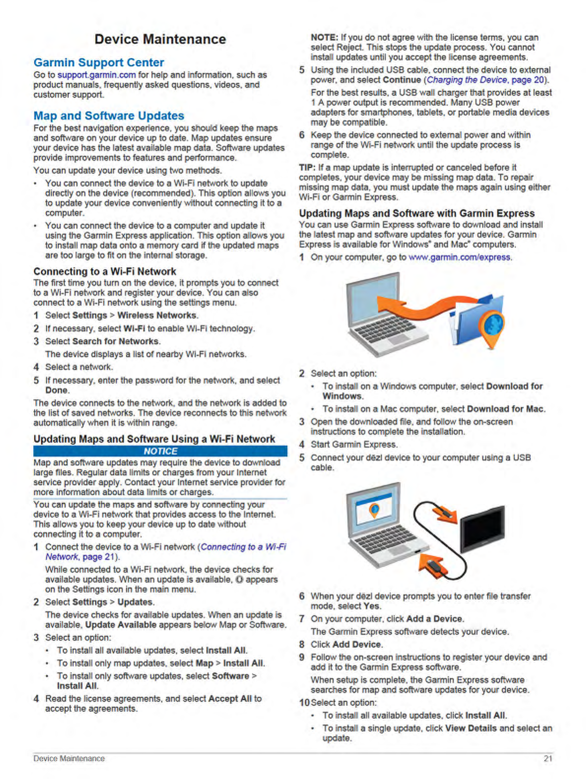
The Garmin Express software downloads and installs the
updates onto your device. Map updates are very large, and this
process may take a long time on slower Internet connections.
Device Care
NOTICE
Avoid dropping your device.
Do not store the device where prolonged exposure to extreme
temperatures can occur, because it can cause permanent
damage.
Never use a hard or sharp object to operate the touchscreen, or
damage may result.
Do not expose the device to water.
Cleaning the Outer Casing
NOTICE
Avoid chemical cleaners and solvents that can damage plastic
components.
1Clean the outer casing of the device (not the touchscreen)
using a cloth dampened with a mild detergent solution.
2Wipe the device dry.
Cleaning the Touchscreen
1Use a soft, clean, lint-free cloth.
2If necessary, lightly dampen the cloth with water.
3If using a dampened cloth, turn off the device and disconnect
the device from power.
4Gently wipe the screen with the cloth.
Avoiding Theft
• Remove the device and mount from sight when not in use.
• Remove the residue left on the windshield by the suction cup.
• Do not keep your unit in the glove compartment.
• Register your device using the Garmin Express software
(garmin.com/express).
Resetting the Device
You can reset your device if it stops functioning.
Hold the power key for 12 seconds.
Removing the Device, Mount, and Suction
Cup
Removing the Device from the Mount
1Press the release tab or button on the mount.
2Tilt the bottom of the device upward, and lift the device from
the mount.
Removing the Mount from the Suction Cup
1Turn the device mount to the right or left.
2Apply pressure until the socket on the mount releases the
ball on the suction cup.
Removing the Suction Cup from the Windshield
1Flip the lever on the suction cup toward you.
2Pull the tab on the suction cup toward you.
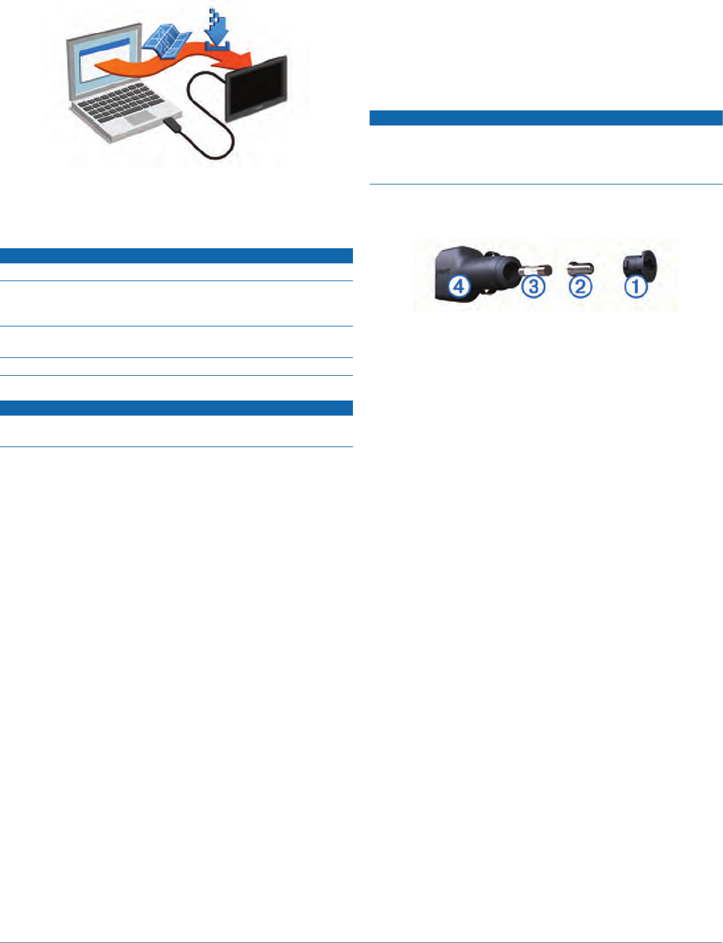
Changing the Fuse in the Vehicle Power
Cable
NOTICE
When replacing the fuse, do not lose any of the small pieces
and make sure they are put back in the proper position. The
vehicle power cable does not work unless it is assembled
correctly.
If your device does not charge in your vehicle, you may need to
replace the fuse located at the tip of the vehicle adapter.
1Rotate the end piece À counter clockwise to unlock it.
TIP: You may need to use a coin to remove the end piece.
2Remove the end piece, the silver tip Á, and the fuse Â.
3Insert a new fast-blow fuse that has the same current, such
as 1 A or 2 A.
4Place the silver tip in the end piece.
5Push in the end piece and rotate it clockwise to lock it back
into the vehicle power cable Ã.
Troubleshooting
The suction cup will not stay on my
windshield
1Clean the suction cup and windshield with rubbing alcohol.
2Dry with a clean, dry cloth.
3Mount the suction cup (Mounting and Powering the dēzl
Device in Your Vehicle, page 1).
My device is not acquiring satellite signals
• Verify the GPS simulator is turned off (Navigation Settings,
page 19).
• Take your device out of parking garages and away from tall
buildings and trees.
• Remain stationary for several minutes.
The device does not charge in my vehicle
• Check the fuse in the vehicle power cable (Changing the
Fuse in the Vehicle Power Cable, page 22).
• Verify the vehicle is turned on and is supplying power to the
power outlet.
• Verify the interior temperature of the vehicle is within the
charging temperature range indicated in the specifications.
• Verify the fuse is not broken in the vehicle power outlet.
My battery does not stay charged for very
long
• Decrease the screen brightness (Display Settings, page 19).
• Shorten the display timeout (Display Settings, page 19).
22 Troubleshooting

Purchasing Accessories
Go to garmin.com/accessories.
24 Appendix

Index
Symbols
2-D map view 11
3-D map view 11
A
accessories 24
active lane guidance 4
addresses, finding 8
alerts
audio 19
proximity points 19
answering calls 13
audio, proximity points 19, 20
automatic volume, enabling 2
avoidances 5
area 6
deleting 6
disabling 6
road 6
road features 5
tolls 5
B
backup camera 19
battery
charging 1, 20, 22
maximizing 22
problems 22
Bluetooth technology 11, 12, 23
disconnecting a device 14
pairing a phone 11
settings 19
Bluetooth Technology 11
disabling calls 13
managing phones 13
break planning 15
brightness 2
C
calls 12, 13
answering 13
contacts 12
dialing 12
history 13
home 13
placing 12
cameras
backup 19
red light 3
speed 3
changing the search area 7
charging the device 1, 20, 22
cleaning the device 22
cleaning the touchscreen 22
computer, connecting 23
connecting 21
coordinates 8
current location 8, 9
D
deleting
paired Bluetooth device 14
service categories 16
service records 16
trips 18
destinations 19. See locations
arriving 4
detours 5
device care 22
dialing 12
directions 4
disconnecting, Bluetooth device 14
Dispatch and Track 15
display settings 19
driver alerts 2, 3
driving directions 4
E
editing, saved trips 18
emergency services 8
EULAs 20
exporting
jurisdiction summaries 16
trip reports 16
F
files, transferring 23
finding locations. 6–8, 12 See also locations
addresses 8
categories 6
cities 8
coordinates 8
intersections 8
Foursquare 8
fuel, stations 8
fuel data 15, 16
fuse, changing 22
G
Garmin Connect 11
Garmin Express, updating software 21
Garmin Live Services 11
subscribing to 11
geocaching 8
going home 3
GPS 1, 23
H
hands-free phone calls 11, 13
home
calling 13
editing location 4
going 3
phone number 13
I
icons, status bar 1
ID number 20
International Fuel Tax Agreement (IFTA) 15
exported summaries and reports 16
fuel data 15, 16
jurisdiction summary 16
trip reports 16
intersections, finding 8
J
jurisdiction summary 16
K
keyboard
language 20
layout 20
L
language
keyboard 20
voice 20
latitude and longitude 8
location 7
locations 8, 19
calling 12
current 8, 9
recently found 8
saving 9
searching for 6, 8
simulated 19
venues 7
M
map layers, customizing 10
map view
2-D 11
3-D 11
maps 3, 9, 10, 19
data field 4, 10
detail level 19
layers 10
purchasing 23
symbols 4
theme 19
tools 9, 10
truck 17
updating 21
viewing routes 4
memory card 1, 23
installing 23
microSD card 1, 23
mount, removing 22
mounting the device
automobile 1
removing from mount 22
suction cup 1, 22
muting, audio 17
myTrends, routes 5
N
navigation 4, 7
off-road 6
settings 19
next turn 4
notifications 11–13
O
off-road navigation 6
on-screen buttons 2
owner's manual 17
P
pairing
disconnecting 14
phone 11, 23
parking 4, 7, 8
last spot 4
phone
disconnecting 14
pairing 11, 23
phone book 12
phone calls 12
answering 13
dialing 13
muting 13
voice dial 13
photoLive 18
points of interest (POI) 6–8
venues 7
power cables 20
changing the fuse 22
vehicle 1
power key 1
product support 17
profiles
activating 2
truck 2
proximity points alerts, settings 20
Q
Quick Search 6
R
recently found locations 8
red light cameras 3
removing mount 22
reports, trip 16
resetting
device 22
trip data 10
restoring settings 20
restrictions, vehicle 2
road conditions, weather 17
routes 3
adding a point 4, 18
calculating 5
calculation mode 18, 19
myTrends 5
shaping 5
starting 3, 7
stopping 5
suggested 5
viewing on the map 4
Index 25

S
satellite signals
acquiring 1
viewing 23
saved locations 18
categories 9
deleting 9
editing 9
saving, current location 9
screen, brightness 2
screenshots 19
search bar 6
service history
categories 16
deleting 16
editing 16
records 16
settings 19, 20
shaping a route 5
sharing, Dispatch and Track 15
shortcuts
adding 9
deleting 9
simulated locations 19
sleep mode 1
Smartphone Link 11–14
connecting 11, 13
disabling calls 13
software
updating 21
version 20
specifications 20
speech recognition 16
speed cameras 3
subscriptions, Garmin Live Services 11
suction cup 22
T
theft, avoiding 22
time settings 20
timer 15
tolls, avoiding 5
tools, maps 9, 10
traffic 10, 14, 20
adding subscriptions 14
alternate route 5
cameras 18
incidents 10, 14
map 10, 14
receiver 14
searching for delays 10, 14
traffic cameras, viewing 18
travel history 20
trip information 10
resetting 10
viewing 10
trip log, viewing 10
trip planner 18
editing a trip 18
shaping points 18
TripAdvisor 8
troubleshooting 22, 23
truck
map 17
profiles 2
trailer 2
turn list 4
U
unit ID 20
up ahead 10
customizing 10
updating
maps 21
software 21
USB, disconnecting 23
V
vehicle power cable 1
vehicle profile, truck 2
venues 7
voice command 16
activating 17
navigating with 17
tips for using 17
wakeup phrase 16
voice control 17
tips 17
volume, adjusting 2
W
weather 17
radar 17
road conditions 17
Where Am I? 8, 9
Wi‑Fi 19, 21
wireless camera 19
26 Index