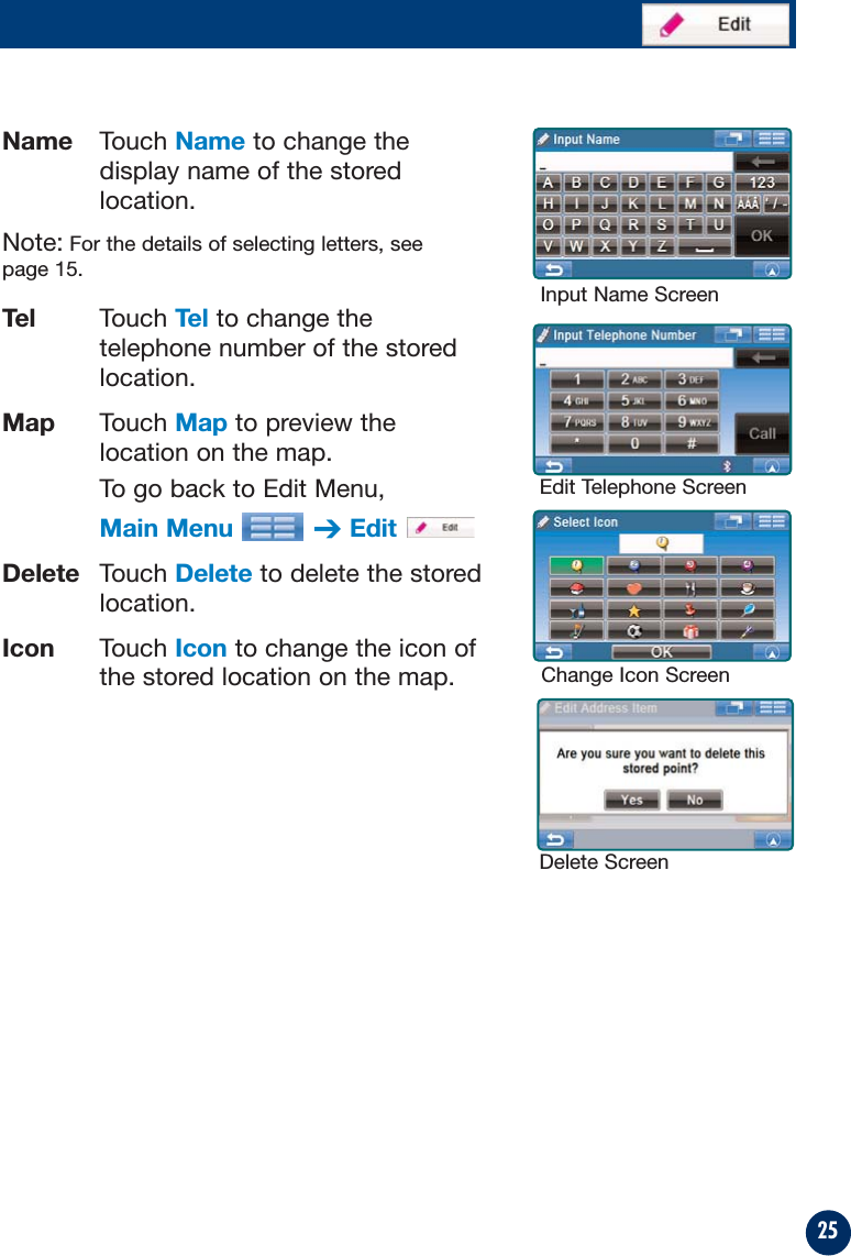
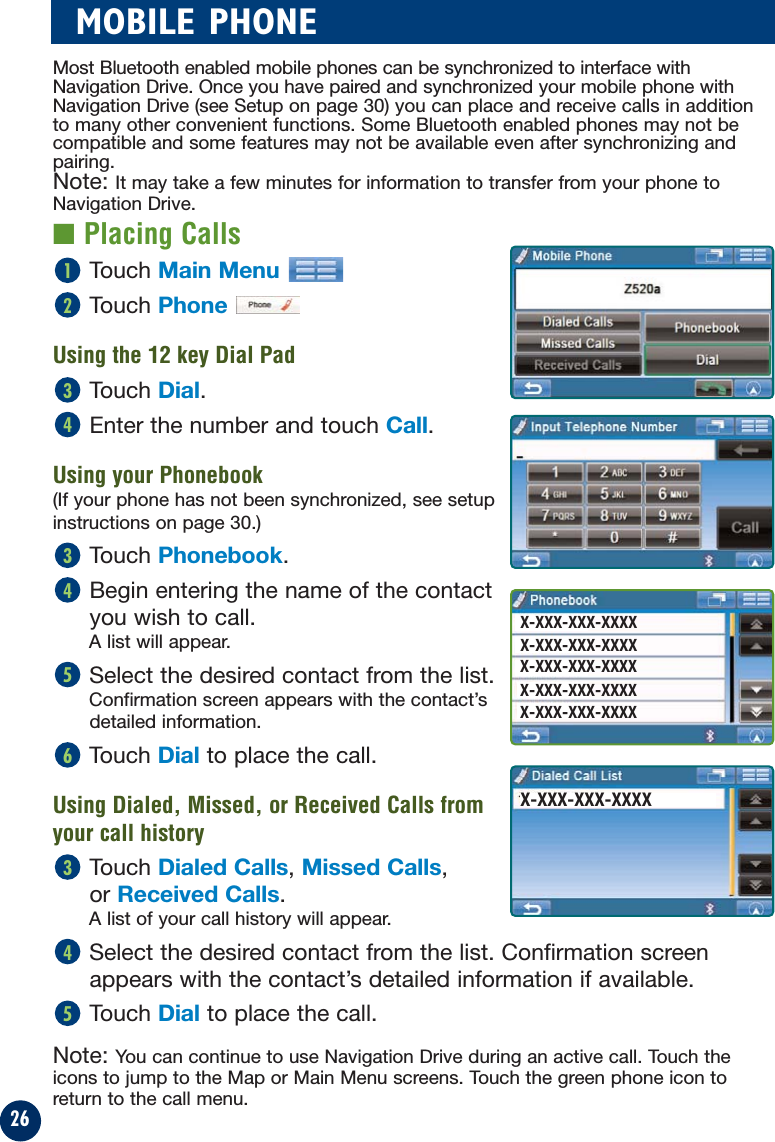
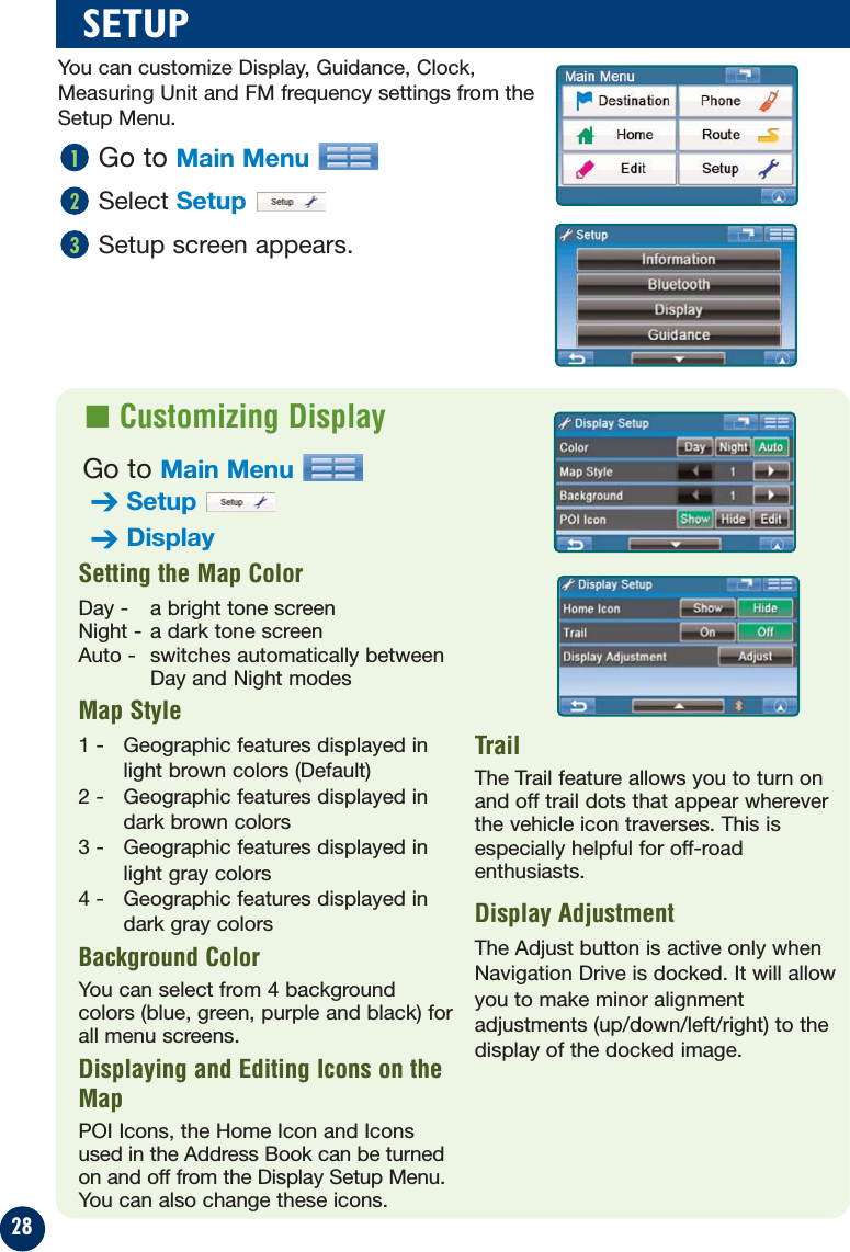
Leadtek Research LR9705 REMOVABLE NAVIGATION DRIVE User Manual 280987 NVE P1 r13

Leadtek Research Inc REMOVABLE NAVIGATION DRIVE 280987 NVE P1 r13

User manual

NVE-P1Removable Navigation DriveOwner’s Manual
2PRECAUTIONS AND NOTICES■ Important InformationThis product is intended to provide turn by turninstructions to get you to a desired destination. Pleasemake certain that all persons using this navigationsystem carefully read these precautions and thefollowing instructions fully. 1) This product is not a substitute for your personaljudgment. Any route suggestions made by thisnavigation system may never supersede any localtraffic regulations or your personal judgmentand/or knowledge of safe driving practices. Do notfollow route suggestions if the navigation systeminstructs you to perform an unsafe or illegalmaneuver, places you in an unsafe situation, orroutes you into an area which you considerunsafe.2) Glance at the screen only when necessary andsafe to do so. If prolonged viewing of the screen isnecessary, pull over in a safe and legal mannerand location.3) Do not input destinations, change settings, oraccess any functions requiring a prolonged viewof the monitor and/or remote control while you aredriving. Pull over in a safe and legal manner andlocation before attempting to access the system.4) Do not use the navigation system to route you toemergency services. Not all locations ofemergency services such as police and firestations, hospitals and clinics are contained in thedatabase. Please use your own judgment and askfor directions in these situations.5) The map database used in the navigation systemis the most recent map data available at the timeof production. Because of changes in streets andneighborhoods, there may be situations where thenavigation system is not able to route you to yourdesired destination. In these cases, use your ownjudgment.6) The map database is designed to provide you withroute suggestions and does not take into accountthe relative safety of a suggested route or offactors which may affect the time required toreach your destination. The system does notreflect road closures or construction, roadcharacteristics (i.e. type of road surface, slope orgrade, weight or height restrictions, etc.), trafficcongestion, weather conditions, or any otherfactors which may affect the safety or timing ofyour driving experience. Use your own personaljudgment if the navigation system is unable toprovide you with an alternate route. 7) There may be situations where the navigationsystem displays the vehicle's location erroneously.Use your own driving judgment in this situation,taking into account current driving conditions.Please be aware that in this situation thenavigation system should correct the vehicle'sposition automatically. However, there may betimes where you may have to correct the positionyourself. If this is the case, pull over in a safe andlegal manner and location before attemptingoperation.8) Make certain that the volume level of thenavigation system is set to a level which stillallows you to hear outside traffic and emergencyvehicles.If there is anything in the manual about the operationof the navigation system which you are uncertainabout, please contact your local Alpine authorizednavigation dealer or Alpine at 1-888-NAV-HELP (1-888-628-4357) before using the navigation system.NVE-P1 has been tested and found to comply withthe limits for a Class B digital device, pursuant to part15 of the FCC Rules. These limits are designed toprovide more reasonable protection against harmfulinterference in a residential installation, and are morestringent than "outdoor" requirements.Operation is subject to the following two conditions:(1) This device may not cause harmful interference,and (2) this device must accept any interferencereceived, including interference that may causeundesired operation.This equipment generates, uses, and can radiate radiofrequency energy and, if not installed and used inaccordance with the instructions, may cause harmfulinterference to radio communications. However, thereis no guarantee that interference will not occur in aparticular installation. If this equipment does causeharmful interference to radio or television reception,which can be determined by turning the equipment offand on, you are encouraged to try to correct theinterference by one of the following measures:·Reorient or relocate the receiving antenna.·Increase the separation between the equipment andthe receiver.·Connect the equipment into an outlet on a circuitdifferent from that to which the receiver is connected.·Consult an experienced radio/TV technician.Please Read Carefully Before Using This Product.FCC Compliance Statement
3WARNINGSRead this manual carefully before using this system.It contains instructions on how to use this product ina safe and effective manner. Alpine cannot beresponsible for problems resulting from failure toobserve the instructions in this manual.This manual uses various pictorial displays to showyou how to use this product safely and to alert you topotential dangers resulting from improperconnections and operation. Following areexplanations of these pictorial displays. It isimportant to fully understand the meanings of thesepictorial displays in order to use this manual and thesystem properly.DO NOT OPERATE ANY FUNCTION THAT TAKES YOURATTENTION AWAY FROM SAFELY DRIVING YOUR VEHICLE.Any function that requires your prolonged attentionshould only be performed after coming to a completestop. Always stop the vehicle in a safe locationbefore performing these functions. Failure to do somay result in an accident.KEEP THE VOLUME AT A LEVEL WHERE YOU CAN STILLHEAR OUTSIDE NOISE WHILE DRIVING.Failure to do so may result in an accident.MINIMIZE DISPLAY VIEWING WHILE DRIVING.Viewing the display may distract the driver fromlooking ahead of the vehicle and cause an accident.DO NOT DISASSEMBLE OR ALTER.Doing so may result in an accident, fire or electricshock.USE THIS PRODUCT AS SPECIFIED.Use for other than its designed application may resultin fire, electric shock or other injury.KEEP SMALL OBJECTS SUCH AS BATTERIES OUT OF THEREACH OF CHILDREN.Swallowing them may result in serious injury. Ifswallowed, consult a physician immediately.DO NOT PLACE HANDS, FINGERS OR FOREIGN OBJECTSIN INSERTION SLOTS OR GAPS.Doing so may result in personal injury or damage tothe product.USE THE CORRECT AMPERE RATING WHEN REPLACINGFUSES.Failure to do so may result in fire or electric shock.DO NOT BLOCK VENTS OR RADIATOR PANELS.Doing so may cause heat to build up inside and mayresult in fire.HALT USE IMMEDIATELY IF A PROBLEM APPEARS.Failure to do so may cause personal injury or damageto the product. Return it to your authorized ALPINEdealer or the nearest ALPINE Service Center forrepairing.PRECAUTIONSTemperatureBe sure the temperature inside the vehicle is between+45°C (+113°F) and -0°C (+32°F) before turning yourunit on.Fuse ReplacementWhen replacing the fuse(s), the replacement must beof the same amperage as shown on the fuse holder.If the fuse(s) blows more than once, carefully checkall electrical connections for shorted circuitry. Alsohave your vehicle’s voltage regulator checked.Servicing the UnitIf you have problems, do not attempt to repair theunit yourself. Return it to your ALPINE dealer or thenearest ALPINE Service Station for servicing.Installation LocationMake sure the NVE-P1 will not be exposed to:• Direct sun and heat • Excessive dust• High humidity  • Excessive vibrationsCharacteristics of LCD Panel• After turning the system off, a slight ghost of theimage will remain temporarily. This is an effectpeculiar to LCD technology and is normal.• Under cold temperature conditions, the screenmay lose contrast temporarily. After a short warm-up period, it will return to normal.• The LCD panel is manufactured using an extremelyhigh precision manufacturing technology. Itseffective pixel ratio is over 99.99%. This meansthat 0.01% of the pixels could be either always ONor OFF.Using HeadphonesIf ACC or the monitor's power source is turned off, aloud noise may be produced through the headphonejack. Be sure to remove the headphones from yourears before you turn the monitor off.This symbol means important instructions.Failure to heed them can result in seriousinjury or death.WARNINGThis symbol means important instructions.Failure to heed them can result in injury ormaterial property damage.CAUTIONPoints to Observe for Safe Usage
4USER AGREEMENTIn using this Removable Navigation Drive, NVE-P1 (hereinafter referred to as “System”), which includes AlpineElectronics, Inc. (“Alpine”) Specifications, Space Machine, Inc. ("Space Machine") Software and NAVTEQNorth America, LLC. (“NAVTEQ”) Database, you are bound by the terms and conditions set forth below. Bybreaking the seal on the System and using your copy of the System, you have demonstrated your agreementto the terms and conditions of this Agreement. You should, therefore, make sure that you read andunderstand the following provisions.The System may not be copied, duplicated or otherwise modified, in whole or in part, without the expresswritten permission of Alpine, Space Machine and NAVTEQ.The System may not be transferred or sublicensed to any third party for profit, rent or loan or licensed forreuse in any manner.The System may not be decompiled, reverse engineered or otherwise disassembled, in whole or in part.The System may not be used in a network or by any other manner of simultaneous use in multiple systems.The System is intended solely for personal use (or internal use where the end-user is a business) by theconsumer.The System is not to be used for commercial purposes.Neither Alpine, Space Machine nor NAVTEQ guarantees to the customer that the System meet the specificobjectives of the user.Neither Alpine, Space Machine nor NAVTEQ shall be responsible for any damages caused by the use of theSystem to the actual user and to any third party.The warranty on the System shall not extend to an exchange or refund due to misspelling, omission of letters,or any other cosmetic discrepancy in layout found in the System.The right to use the System shall expire either when the user destroys this software, or when any of the termsfor use is violated and Alpine, Space Machine and/or NAVTEQ exercise the option to revoke the license touse this software.The terms and conditions hereof apply to all subsequent users and owners as well as to the originalpurchaser.The NAVTEQ Database may include or reflect data of licensors, including Her Majesty The Queen in right ofCANADA. Such data is licensed on an “AS IS” basis. The licensors, including Her Majesty The Queen, makeno guarantees, representations or warranties respecting such data, either express or implied, arising by lawor otherwise, accuracy or fitness for a particular purpose. The licensors, including Her Majesty The Queen, shall not be liable in respect of any claim, demand or action,irrespective of the nature of the cause of the claim, demand or action alleging any loss, injury or damages,direct or indirect, which may result from the use or possession of the data or the NAVTEQ database. Thelicensors, including Her Majesty The Queen, shall not be liable in any way for loss of revenues or contracts,or any other consequential loss of any kind resulting from any defect in the data or the NAVTEQ database.End User shall indemnify and save harmless the licensors, including Her Majesty The Queen and the minister,and their officers, employees and agents from and against any claim, demand or action, irrespective of thenature of the cause of the claim, demand or action, alleging loss, costs, expenses, damages or injuries(including injuries resulting in death) arising out of the use or possession of the data or the NAVTEQdatabase.
5TABLE OF CONTENTSPRECAUTIONS AND NOTICES  . . . . . . . . . . . . . . . 2WARNINGS   . . . . . . . . . . . . . . . . . . . . . . . . . . 3USER AGREEMENT   . . . . . . . . . . . . . . . . . . . . . 4TABLE OF CONTENTS  . . . . . . . . . . . . . . . . . . . 5SYSTEM FEATURES   . . . . . . . . . . . . . . . . . . . . . 6IN THE BOX   . . . . . . . . . . . . . . . . . . . . . . . . . . 8Accessories  . . . . . . . . . . . . . . . . . . . . . . . 8Optional Accessories  . . . . . . . . . . . . . . . . . 8INSTALLATION   . . . . . . . . . . . . . . . . . . . . . . . . 9Docking with IVA-W203 and IVA-W505  . . . . . 9Removing NVE-P1 from IVA-W203 and IVA-W505  . . . . . . . . . . . . . . . . . . . . . 9How to Reset NVE-P1  . . . . . . . . . . . . . . . . .9BASIC OPERATIONS   . . . . . . . . . . . . . . . . . . . . 10To Power On   . . . . . . . . . . . . . . . . . . . . . 10To Power Off   . . . . . . . . . . . . . . . . . . . . . 10Set a Destination and Go!   . . . . . . . . . . . . 10MAP FUNCTION  . . . . . . . . . . . . . . . . . . . . . . . 12Setting Estimate Time Display   . . . . . . . . . 12Setting the Map Orientation   . . . . . . . . . . . 12Repeating the Announcement  . . . . . . . . . . 12Zoom In/Out Map   . . . . . . . . . . . . . . . . . . 12GPS Status   . . . . . . . . . . . . . . . . . . . . . . 12Accessing Head Unit    . . . . . . . . . . . . . . . 12Setting a Destination Directlyfrom Map Display   . . . . . . . . . . . . . . . . . 13Switching Map Display   . . . . . . . . . . . . . . 13DESTINATION   . . . . . . . . . . . . . . . . . . . . . . . . 14Setting a Destination by Address   . . . . . . . 14Confirm Destination Screen   . . . . . . . . . . . 15Setting a Destination by POI  . . . . . . . . . . . 16Setting a Destination from theAddress Book   . . . . . . . . . . . . . . . . . . . . 17Setting a Destination by Recently Entered Destination   . . . . . . . . . . . . . . . . 18Setting a Destination by Coordinates  . . . . . 18Setting a Destination by Intersection   . . . . . 19OPTIONS  . . . . . . . . . . . . . . . . . . . . . . . . . . 20Find Local Places   . . . . . . . . . . . . . . . . . . 20Saving a Destination into the Address Book   . . . . . . . . . . . . . . . . . 20Setting Waypoints  . . . . . . . . . . . . . . . . . . 21HOME  . . . . . . . . . . . . . . . . . . . . . . . . . . . 22Set Destination as Home   . . . . . . . . . . . . . 22Finding Alternate Way to Go Home   . . . . . . 22ROUTE  . . . . . . . . . . . . . . . . . . . . . . . . . . 23Recalling the Maneuver List during Guidance   . . . . . . . . . . . . . . . . . . 23Finding Alternate Route   . . . . . . . . . . . . . . 23Finding Detour   . . . . . . . . . . . . . . . . . . . . 23Deleting Route  . . . . . . . . . . . . . . . . . . . . 23EDIT  . . . . . . . . . . . . . . . . . . . . . . . . . . .24Editing Home   . . . . . . . . . . . . . . . . . . . . . 24Editing Address Book   . . . . . . . . . . . . . . . 24Deleting Previously Saved Destinations   . . . 24MOBILE PHONE  . . . . . . . . . . . . . . . . . . . . . . . 26Placing Calls . . . . . . . . . . . . . . . . . . . . . . 26Receiving Calls   . . . . . . . . . . . . . . . . . . . 27Call Option Menu   . . . . . . . . . . . . . . . . . . 27SETUP  . . . . . . . . . . . . . . . . . . . . . . . . . . .28Customizing Display  . . . . . . . . . . . . . . . . .28Customizing Guidance . . . . . . . . . . . . . . . .29Setting up the Clock  . . . . . . . . . . . . . . . . .29Changing Unit of Measure  . . . . . . . . . . . . .29Configuring System Settings  . . . . . . . . . . .29Bluetooth Setup   . . . . . . . . . . . . . . . . . . . 30Viewing Information . . . . . . . . . . . . . . . . . 32Simulating Navigation  . . . . . . . . . . . 32Viewing Trip Information   . . . . . . . . . 32Viewing GPS Status  . . . . . . . . . . . . . 33Viewing System Information  . . . . . . . 33IN CASE OF DIFFICULTY   . . . . . . . . . . . . . . . . . 34SPECIFICATIONS   . . . . . . . . . . . . . . . . . . . . . . 35INDEX  . . . . . . . . . . . . . . . . . . . . . . . . . . 36LIMITED WARRANTY   . . . . . . . . . . . . . . . . . . . 37
6SYSTEM FEATURESMini USB ConnectorExternal GPSAntenna ConnectorReset ButtonPower ButtonVolumeControlHead UnitConnectorRemovable Navigation Drive, NVE-P1Congratulations and thank you for purchasing the Alpine Removable NavigationDrive, NVE-P1. We hope you enjoy using this exciting product and trust that it willmake your driving experience more comfortable, stress-free, and entertaining. TheRemovable Navigation Drive, NVE-P1 provides an easy-to-use user interface,clear, easy-to-understand spoken driving instructions, and award winning designall in a portable product. NVE-P1 is built upon Alpine's history of navigationsuccess in North America. Please read this manual carefully. If you have anyfurther questions about NVE-P1’s operation, feel free to call Alpine at 1-888-NAV-HELP (628-4357) for technical assistance.
7Main MenuGet back home fromanywhere.➔Page 22Set and saveDestinations.➔Page 14Access your Bluetoothpaired mobile phone.➔Page 26Edit Home andAddress Book.➔Page 24Customize thenavigation system.➔Page 28Modify or choosealternate routes to adestination.➔Page 23
8IN THE BOX■ Optional Accessories■ AccessoriesUSB Cable Quick Reference GuideOwner’s Manual CDThe following accessories are available from your authorized Alpine dealer.1. IVA-W203 and IVA-W505 –An Alpine AV head unit with a built-in dock tointegrate your Navigation Drive as a part of your vehicle.3. PMD-KIT2 –A second car kit comprised of windshield mount, cradle, andhome AC charger.4. PMD-ANT1 –An external GPS antenna hard-wired to Navigation Drive usedin instances where you cannot normally receive GPS signals inside the car,due to metallic window tint, etc.6. RUE-4140 –A combination navigation and audio remote control that allowsyou to control most of the navigation features wirelessly.• Registration Card• External GPS Antenna• External Microphone
9INSTALLATION■ How to Reset NVE-P1In the event the system requires a reset, pull over in a safe and legal manner beforedoing so. Press the reset button on the Navigation Drive for at least 1 second. Then,to restart the system, press and hold the power button for 2 seconds. The systemwill re-start.Note: NVE-P1 is not compatible with IVA-W205.■ Docking with IVA-W203 or IVA-W505■ Removing NVE-P1 from IVA-W203 and IVA-W505Touch Open on the screen.Press the eject button. Remove Navigation Drive from the head unit.321CLOSE12Open head unit monitor.Insert into the unit with the Alpine logo facingup and the reset button on the right.Press firmly into place.Touch Close to close head unit face.Select Navigation as a source.54321CLOSE12
Opening screen appears.Read carefully. Touch IAccept to display map.The last-known currentlocation is indicated onthe map.To Power OffPress and hold Power Buttonof Head Unit for 2 seconds.To Power On123410Select desired method.(In this example, Placesis selected.)2Select a search method.(In this example, By POICategory is selected.)3For Map Function, see page 12.Touch Main Menu.Select Destinationfrom Main Menu.1BASIC OPERATIONSet a Destination and Go!Select Navigation onthe Head Unit screenConfirmation screenappears if a destinationwas set prior to the lastshutdown. Click OK tocontinue to the previousdestination.5
11Map is displayed.Follow the navigation.9Select OK to Proceed toset the destination.8To Find other routes, see page 23.To Go Home, see page 22.Select the search method.(In this example, By POIName is selected.)5Type name of a place. If more than one place with thesame name exist, sort methodscreen appears.6Select the place withcorrect address.7Scroll the list. Select desired category. (In this example, ATTRACTIONSis selected.)4The following example briefly describes how to input a destination.
12Click this icon to switch betweenEstimated Time Remaining andEstimated Time of Arrival.Note: The time estimates arebased on the average speed. Theestimate time will vary dependingon vehicle speed. The arrow alwayspoints toward the destination.In north up view, north is always atthe top of the display. This makes iteasy to determine your currentheading with respect to the map.In heading-up view, the currentdirection is always pointing to thetop of the display. This makes iteasy to see the direction of thenext turn on the map.The 3D View offers you a morerealistic perspective by tilting themap and displaying it with a horizonline. Streets are displayed as youapproach them instead of from abirds-eye view.Setting the Map OrientationSetting Estimate Time DisplayClick icon to repeat the guideannouncement.Click icon to display scroll bar.Touch ▲▼ or blue bar to zoom themap in or out.The scroll bar disappearsautomatically after 2 seconds. Repeating the AnnouncementZoom In/Out MapGPS StatusClick icon to view GPS receivingcondition information from satellite.Distance tonext maneuverNext Street NameNext ManeuverArrowMapOrientationDirection toDestinationEstimated TimeRemaining (ETR) /Estimated Time ofArrival (ETA)GPS Status barCurrent StreetNameVoice PromptRepeat ButtonCurrent PositionIcon and Map /Split / ArrowButtonMap Scale BarMain MenuButtonNorth UpHeadingUp3D ViewClick icon to switch between North up, HeadingUp and 3D Views.Accessing the Head UnitClick icon to access the A/V HeadUnit’s display control.Note: If left idle for more than 5 seconds, thesystem will automatically return to the navigationscreen.BluetoothStatus Icon(See page 31)
13Touch anywhere on map screen.The current location arrow changes to CrosshairCursor on the screen.Move the cursor to the new desiredstreet.Note: Use Map Scale Bar to zoom out the map if the destination is far from the current location.Touch Select.Select Set as Destination.Touch OK to Proceed on theconfirmation screen.Note: To use other functions on the confirmation screen, see page 15 for details.54321■ Setting a Destination Directly from Map DisplayTo cancel, touchPrevious Screenicon.Touch the Current Position  to switch between Map and Arrowmodes.Switching Map DisplayArrow ModeDisplays three-successive arrowmaneuvers all theway to yourdestination whileproviding turn-by-turn guidanceprompts.Map ModeShows a full-screenmap of the area whileproviding turn-by-turnguidance prompts.Split Arrow/Map ModeDisplays a largearrow and largernext-street-namefont along side amap screen whileproviding turn-by-turn guidanceprompts.
14Select Input City Name.Note: You can avoid typing the city name byselecting Recent Cities.A list of recently entered city names will display.Select the desired city.Type the first few characters of the city name and press OK.If there are unique matches, the system willautomatically display a short list of city names.Select the desired city.Type the characters of the street name.Touch OK.The list of applicable street names appears. Selectthe desired street.Type the address number and touch OK.Confirmation screen appears. See page 15 for details.65432DESTINATION■ Setting a Destination by AddressGo to Main Menu➔Destination ➔Address1
15Call (Only available on POIs and address book)If the phone number is available, you can callthe selected location using your Bluetoothenable mobile phone.Changing StateIf you want to choose a differentstate from the one shown on thescreen, touch Change toswitch to a different state.Selecting LettersDelete one letterSelectedcharactersare displayed.Add one spaceType numbersMapCheck the destination on themap. Touch to go back tothe confirmation screen.Type accentuatedcharactersType punctuationmarksOK to ProceedSet the destination anddisplay a map.OptionFind Local POI➔P20Set as Waypoint➔P21Save in Address Book➔P20Change MethodFind an alternative way. (Refer to page 22.)■ Confirm Destination Screen
16You can select from approximately 1.3 Million Point-of-Interest (POI) locations storedinside your Removable Navigation Drive, NVE-P1. These destinations are sorted by POIName or by POI Category and are listed in order of distance from your current location.Destination by POI NameGo to Main Menu➔Destination ➔Places1Select By POI Name.Type the desired place name. Touch OK.A list of place names appears. Note: You can also perform a Keyword Search byentering a portion of your desired place name. The listof destinations that appears will include all placenames containing the keyword you entered.Use the arrows to the right of the list tomove the yellow highlight.This will show detailed address information and phone number (if available) for each entry in the Places database.Select the place with correct address.For emergency locations such as Police Stations,Hospitals, etc., please verify availability beforeproceeding to such locations.Confirmation screen appears. Touch OK toProceed to set the destination and startguidance.65432DESTINATION■ Setting a Destination by POI
17Select By POI Category.Select a desired POI Category. There are 37 POI categories to choose fromincluding ATMs, Banks, Gas Stations, GroceryStores, Hotels, Parking Lots, Restaurants and more.Select Search Method.432Go to Main Menu➔Destination➔Address BookSelect the desired destination.Confirmation screen appears. Touch OK to Proceed to set your destination and start receivingturn-by-turn navigation instructions. To save an address in theaddress book, see page 20.321■ Setting a Destination from the Address BookDestination by POI CategorySort by DistanceBy POI NameWithin a CityTouch Near Here to see the list of placesfrom the current vehicle position or touchNear Destination to see the list near yourdestination.Select the place ➔OK to Proceed65Follow 3 to 5 in “Finding a Destination by POI Name” on Page 16.5Type the city name and select a city.The list of POIs appears in order of the distance from the selected city. Select the desired place.Touch OK to Proceed on the confirmation screen.765
18Go to Main Menu➔Destination➔CoordinateEnter the Latitude of your destination.Touch OK.Enter the Longitude of your destination. Touch OK.Confirmation screen appears. Touch OK to Proceed to set the destination and start guidance.4321Go to Main Menu➔Destination➔RecentThe list of recent destinations appears. Select the destination.Confirmation screen appears. Touch OK to Proceed to set the destination and start guidance.Note: To use other functions on the confirmation screen, see page 15 for details.321DESTINATION■ Setting a Destination by Recently Entered Destination■ Setting a Destination by Coordinates
19Go to Main Menu➔Destination➔Intersection1Select Input City Name.Note: You can skip typing the city name byselecting Recent Cities.It displays a list of recent city names previouslyentered.Type the city name, then select the cityfrom the list.Type the first street name. Touch OK.The list of applicable street names appears. Select the desired street.Input the second street name.If there is only one street crossing with the firststreet, the name of the street automaticallyappears.Confirm City name if there are more than 1 citeswith the same intersection.Confirmation screen appears. Touch OK to Proceed.Note: To use other functions on the confirmationscreen, see the bottom of page 15 for details.65432■ Setting a Destination by Intersection
20■ Saving a Destination into the Address BookOPTIONS■ Find Local PlacesTouch anywhere on map screen.The current location arrow changes to cross hair cursor on the screen.Touch Select.Select Find Local POIs andthe desired category.Select the desired place.Touch OK to Proceed on the confirmation screen.Note: To use other functions on the confirmation screen, see page 15 for details.54321The navigation system can display Points of Interest (POI) around the cursor position,when you scroll the map. As with POI categories, with the local places search youcan choose from 37 categories including ATMS, Banks, Gas Stations, GroceryStores, Hotels, Parking Lots, Restaurants and more.How to Find Local POIs Directly from the MapHow to Find Local Places from the Destination MenuSet a destination first from Destination On the confirmation screen, touch Option.Follow steps 3 to 5 above in “How to Find Local POIs Directlyfrom the Map”.321You can also find local places from the Destination Menu.Any destination can be saved into the Address Book.Select a destination using any method.From the confirmation screen, select Option.Touch Save in Address Book.“Input Name” screen appears. Type the desired name and touch OK.Note: For the details of selecting letters, see page 15.System returns to the Main Menu screen.Note: To display the saved destination on the map, see page 17, “Setting a Destination from the Address Book”.Address book can hold up to 500 entries.54321
21■ Setting WaypointsTouch anywhere on map screen.The current location arrow changes to cross hair cursor on the screen.Move the cursor to the desired waypoint.Touch Select.Select Set as Waypoint then selectRecalculate.When the route search is complete, the current location is displayed. The map navigates you to the first waypoint.54321How to Set a Waypoint from the Destination MenuHow to Set a Waypoint Directly from MapYou can set up to 10 waypoints between your current location and your destination. Thefinal destination must be set before entering any waypoints.You can also find local places from Destination Menu.Enter your desired destination by using the method on pages 14through 19 from Destination Menu.On the confirmation screen, select Option.Select Set as Waypoint and select Recalculate.321Enter in a destination from the Address Book. (see page 17)On the confirmation screen, touch Option ➔Set as Waypoint.Touch Recalculate to recalculate a route which includes yourwaypoint.321How to Set a Waypoint from the Address BookSet a waypoint by following the process above.On the waypoint screen, select Edit.Change the order of waypoints by touching the arrow button on thebutton of the navigation screen.Touch Delete to remove the waypoint.Touch Calculate to calculate a route which includes your waypoint.4321How to Edit a Waypoint
22Go to Main Menu➔HomeTouch OK to Proceed on theconfirmation screen.Follow the map and go home.321HOME■ Set Destination as Home■ Finding Alternate Way to Go HomeGo to Main Menu ➔Home ➔Change Method· Maximize Highway· Minimize Highway· Shortest Route · With/Without Ferry · With/Without Toll RoadTo edit theHome Address, See Page 24.You can get home from anywhere once the home address is set fromDestination Menu.Set the destination using any desiredmethod.On the confirmation screen, touchOption.Touch Set as Home Location.321■ Going Home
23ROUTE■ Recalling the Maneuver List during GuidanceGo to Main Menu➔RouteTouch Maneuver List.List of upcoming streets andturns appears on the screen.To preview a specific point, select a street name/maneuver on the list.To go back to Route List, Go to Main Menu➔RouteNote: For the details of setting Waypoints,see page 21.321■ Finding Alternate Route  ■ Finding DetourTouch Main Menu➔Route➔Change MethodYou can choose and re-calculate a differentroute based on Quickest Route withMaximize/Minimize Highway, Shortest Route,with/without Ferry and/or Toll Road.Touch Main Menu➔Route➔DetourThe system automatically calculates and displays detour.■ Deleting RouteGo to Main Menu ➔Route➔Delete ➔YesNote: After deleting the destination, you can notselect Route Menu until the next destination is set.To set up the destination, see Destination Menu onPage 14.You can view a list of street names and upcoming turns and streets.
24Go to Main Menu ➔EditTouch Edit Address BookThe list of addresses appears.Select the destination you need to modify.“Edit Address Item” screen appears. See page 25 for details.Note: Select DELETE ALL to delete all addresses saved in the address book.4321■ Editing Address Book■ Deleting Previously Saved DestinationsGo to Main Menu ➔EditTouch Delete Previous Destination.Select destination you need to delete.Touch YES to delete the destination on the confirmation screen.Note: Select DELETE ALL to delete all recently entered destinations.4321EDIT■ Editing HomeGo to Main Menu➔EditTouch Edit Home.“Edit Home” screen appears.See page 25 for details.321Locations and Home addresses saved in the Address Book can be edited for quickrecall. Also information including phone numbers and icons can be modified.
25Edit Telephone ScreenDelete ScreenChange Icon ScreenName Touch Name to change thedisplay name of the storedlocation.Note: For the details of selecting letters, see page 15.Tel Touch Tel to change thetelephone number of the storedlocation.Map Touch Map to preview thelocation on the map.To go back to Edit Menu, Main Menu ➔EditDelete Touch Delete to delete the storedlocation.Icon Touch Icon to change the icon ofthe stored location on the map.Input Name Screen
26MOBILE PHONEMost Bluetooth enabled mobile phones can be synchronized to interface withNavigation Drive. Once you have paired and synchronized your mobile phone withNavigation Drive (see Setup on page 30) you can place and receive calls in additionto many other convenient functions. Some Bluetooth enabled phones may not becompatible and some features may not be available even after synchronizing andpairing.Note: It may take a few minutes for information to transfer from your phone toNavigation Drive.■ Placing CallsTouch Main Menu Touch PhoneUsing the 12 key Dial PadTouch Dial.Enter the number and touch Call.Using your Phonebook (If your phone has not been synchronized, see setup instructions on page 30.)Touch Phonebook.Begin entering the name of the contact you wish to call.A list will appear.Select the desired contact from the list.Confirmation screen appears with the contact’s detailed information. Touch Dial to place the call.Using Dialed, Missed, or Received Calls from your call historyTouch Dialed Calls,Missed Calls,or Received Calls.A list of your call history will appear.Select the desired contact from the list. Confirmation screenappears with the contact’s detailed information if available.Touch Dial to place the call.Note: You can continue to use Navigation Drive during an active call. Touch theicons to jump to the Map or Main Menu screens. Touch the green phone icon toreturn to the call menu.54365434321X-XXX-XXX-XXXXX-XXX-XXX-XXXXX-XXX-XXX-XXXXX-XXX-XXX-XXXXX-XXX-XXX-XXXXX-XXX-XXX-XXXX
27■ Receiving CallsWhen your mobile phone is actively paired with Navigation Drive, a pop-up windowwill appear when you have an incoming call. The caller ID number will be displayedwhen available. Touch Answer to accept the call or Ignore to ignore it.■ Call Option MenuDuring an active call touch the green phone icon  to access the Call OptionMenu. This menu displays the Caller ID Name, Phone Number, and Call Duration.The following options are also available from this menu:MuteThis allows you to temporarily mute the microphone so you can still hear the caller,but the caller cannot hear you.Transfer Call to PhoneYou can transfer the call from Navigation Drive to your mobile phone for greaterflexibility.End CallThis ends the current phone call.Note: After ending a call you will automatically be returned to the previous menu.
28Go to Main MenuSelect SetupSetup screen appears.321SETUP■ Customizing DisplaySetting the Map Color   Day -  a bright tone screenNight - a dark tone screenAuto -  switches automatically betweenDay and Night modesMap Style1 -  Geographic features displayed inlight brown colors (Default)2 -  Geographic features displayed indark brown colors3 -  Geographic features displayed inlight gray colors4 -  Geographic features displayed indark gray colorsBackground ColorYou can select from 4 backgroundcolors (blue, green, purple and black) forall menu screens.Displaying and Editing Icons on theMapPOI Icons, the Home Icon and Iconsused in the Address Book can be turnedon and off from the Display Setup Menu.You can also change these icons.TrailThe Trail feature allows you to turn onand off trail dots that appear whereverthe vehicle icon traverses. This isespecially helpful for off-roadenthusiasts.Display AdjustmentThe Adjust button is active only whenNavigation Drive is docked. It will allowyou to make minor alignmentadjustments (up/down/left/right) to thedisplay of the docked image.You can customize Display, Guidance, Clock,Measuring Unit and FM frequency settings from theSetup Menu.Go to Main Menu➔Setup➔Display
29■ Customizing GuidanceTurning Voice On and Off This allows you to turn ON or OFF guidance voice prompts.Changing Navi Mix VolumeThis allows you to vary the volume of the voice prompts with respect to the music.Setting Estimate Time DisplayEstimated Time of Arrival (ETA) or Estimated Time Remaining (ETR) can be set here.You can also change between ETA and ETR directly in the map screen. See page 12. ■ Setting up the ClockYou can set the Time Zone and Daylight Savingsetting to fit your region.■ Changing Unit of MeasureYou can choose the unit of measure between Milesand Kilometers.■ Configuring System SettingsReset All SettingsThis allows you to delete all stored information anddefault back to the original factory settings.
30■ Bluetooth SetupBluetooth enabled mobile phones can be paired to interface with Navigation Drive.You can customize this interface using the Bluetooth Setup controls.Go to Main MenuSelect SetupSelect Bluetooth.The Bluetooth Setup menu appears and displaysthe setup options. Use the large arrow buttonat the bottom of the screen to view additionaloptions. All Bluetooth setup options aredetailed below.Turning Bluetooth On and OffThis allows you to turn the Bluetooth functionality on or off.Starting Discover ModeDiscover Mode allows your mobile phone to pair with Navigation Drive. StartDiscover mode to begin the initial pairing process. Follow your individual phone’sinstructions for pairing.Auto ConnectTurning Auto Connect on will allow the last connected phone to automaticallyconnect with the Navigation Drive whenever they are in range and both haveBluetooth turned on.Auto AnswerThis allows Navigation Drive to automatically answerall incoming calls for you after the first ring.PhonebookThis allows to store your phone address intoNavigation Drive.Changing Device NameNavigation Drive’s display name can be set here by selecting Change.123
31Changing Device PasskeyThe passkey used to pair Navigation Drive with yourmobile phone can be changed here.Bluetooth IndicatorThe following icons indicate the Bluetooth status:No Icon When Bluetooth is OFF, the icon does not appear.When Bluetooth is on, but not paired, the gray icon appears.By pressing the icon, “Discover Mode” screen appears.When Bluetooth is on and connected, the blue icon appears.By pressing the icon, “Call” screen appears.When a phone call is active, a green phone icon appears.Pairing Your Mobile Phone with Navigation Drive Go to Bluetooth Setup and turn on Bluetooth. Start Discover Mode. On your mobile phone, make sure Bluetooth is on, then searchfor Bluetooh devices. Select Navigation Drive name and enter the passkey shown onthe Navigation screen.The bluetooth icon appears in blue, indicating your mobile phoneis connected.54321
32■ Viewing InformationSimulating NavigationYou can watch a demonstration of the navigation system’s voice and screen guidance.Note: Set your destination first before using this function.To Start a DemonstrationTo Stop a DemonstrationFollow 2 through 4 of "To Start aDemonstration".Select Stop Demo.The demonstration will end.321Viewing Trip InformationThe odometer displays the route distanceand time traveled.Go to Main MenuGo to SetupSelect Information.Select Trip Info.4321Driving Average Average speed since Trip Info was reset.Overall Average Average speed since start of trip.Maximum Speed Maximum speed reached on this trip.Driving Time Time vehicle has been moving since the trip was reset.Idle Time Time vehicle has been stopped (not moving) since the trip was reset.Total Time Total elapsed time on the trip which is always the driving time plus idle timeSetup a route.Go to Main Menu Go to SetupSelect Information.Select Start Demo.Demonstration starts.654321
33Go to Main MenuGo to SetupSelect Information.Select GPS Status.4321You can view the dynamic location informationreceived from satellite such as signal strength,compass (direction information), latitude/longitude,approximate altitude, and speed. This featureallows you to view GPS satellite signal information.An explanation of the messages is shown below.“Locating GPS Satellites”: NavigationDrive searches the sky looking for GPSsatellites.“Acquiring GPS Signal”:Navigation Driveacquires positioning information transmittedfrom 1 to 3 tracked satellites whilesearching for more satellites (minimum 4needed).“Fixing GPS Position”:Navigation Driverequires continuous signals from 4 or moretracked satellites (for 30 seconds) in orderto accurately fix your position.“Temporary Poor GPS Coverage”:Thunderstorms, dense foliage orsurrounding tall buildings may causetemporary loss of position fix (acceptable ifunder 30 seconds).“Poor GPS Signal, Lost Position Fix”:You may have entered an area whereconsistently poor GPS signal (lasting 30seconds or more) makes it impossible tomaintain a position fix.“No Line of Sight, Lost GPS Tracking”:You are in an area where line of sight toGPS satellites has been blocked.Go to Main MenuGo to SetupSelect Information.Select System Info.4321You can check software application, databaseversion, and other information in this screen.Make a note of this information and refer to itwhenever you communicate with Alpine TechSupport or your Alpine authorized dealer. Viewing GPS StatusViewing System InformationThe following messages are displayed while the GPS receiver is tracking satellites:
34If you encounter a problem, please review the items in the following checklist. This guidewill help you isolate the problem if the unit is at fault. Otherwise make sure the rest of yoursystem is properly connected, batteries are completely charged and contact yourauthorized Alpine dealer or Alpine directly at 1-888-NAV-HELP (1-888-628-4357).Unable to use Phone feature.Some Bluetooth enabled phones may not be compatible and some features may not beavailable even after synchronizing and pairing.The vehicle’s position is erroneous.Reset the unit and drive the vehicle in an area of good GPS reception to allow the unitto recalibrate itself. Move to a location where strong GPS reception is possible.No operation· Moisture condensation ➔Allow enough time for the condensation to evaporate(about 1 hour).· Ambient temperature  ➔Lower the temperature in the vehicle to below 113°F (45°C)over 113°F (45°C)  by driving with the windows open or air conditioner on.· Blown fuse  ➔Replace with a fuse of the prescribed rating. (2A glass-typefuse located in the head of the cigarette lighter adapter)Unit does not work after removing from cradle or dock*Make sure battery is fully charged. Unit does not charge in cradle or dock while the caris not on.The unit is taking a long time to acquire GPS signal. It may take a long time for the unit to acquire GPS signal if it has been powered on inan area that is more than 200 miles from the area where it was last powered off.Following these steps will speed the process by resetting the GPS receiver:Go to GPS Statusscreen. (See instructions on page 34)Press and hold the Down Arrow (Map Zoom Out Button) for 2 seconds.A message appears to indicate that the GPS receiver is resetting.■ How to Update the New Software and Map DatabaseUsing your home PC, Navigation Drive can be updated with the latestmapping and Point of Interest information. Please refer to instructionsincluded with the update software on how to upgrade your NavigationDrive.For additional information on the update software, please contact Alpine.321IN CASE OF DIFFICULTY
35SPECIFICATIONSMain Unit Size 6.1” x 2.9” x 1.0” (145mm x 73mm x 26mm)Main Unit Weight 4.4 oz (120 g)CPU Centrality Atlas III ARM9 CPUGPS Embedded 16 channel GPS, Built-In Main Unit Antenna with Optional External AntennaConnectionStorage Media Built-In memory with Pre-Loaded Maps of US* and Canada and 1.3 Million Points ofInterest LocationsUSB Interface 2.0Power Requirements 5V 1AOperating Temp 14˚F to 158˚F (-10˚C to +70˚C)Storage Temp 4˚F to 185˚F (-20˚C to 85˚C)Resolution QWVGA 400 x 234 pixelsNote: Due to continuous product improvement, specifications are subject to change withoutnotice.
36INDEXAAccessories 8Address book 20Announcement 12BBackground Color 28Basic Operation 10Bluetooth 30Setup 26, 30CCall 26, 27Ending 27Muting 27Placing 26Receiving 27Clock 29Confirm Destination Screen  15Coordinates 18CustomizingDisplay 28Guidance 29DDeletingRoute 23Saved Destination 25DestinationSetting by Address  14Setting by Coordinates 18Setting by Intersection  19Setting by POI 16Setting by Previous Destination 18Setting from the Address Book 17Setting From Map Display 13Detour 23EEdit 24Address Book 24Deleting Saved Destination 24Home 24Estimate Time Display 12, 29FFCC Compliance Statement 2GGPS Status 12, 33HHome 22Editing 24Finding a Way 22Finding Alternate Way 22IIcon 24, 27In Case of Difficulty 34Index 36Information 32GPS Status 33Simulating Navigation 32System Information 33Trip Information 32Installation 9MManeuver ListRecalling during Guidance 23Map Color 28Map Display 13Map Function 12Announcement 12Battery Status 12Estimate Time Display 12GPS Status 12Map Display 13Map Orientation 12Set a Destination 13Zoom In/Out Map 12Map Orientation 12Measuring Unit 29OPPOI 16, 17 Local POI 20Power 10Precautions And Notices 2RRepeating the Announcement 12Reset 9Route 23Alternate Route 23Delete Route 23Detour 23Recalling the Maneuver List duringGuidance 23SSaving a Destination into the AddressBook 20Set a Destination and Go! 10Setup 28Clock 29Display 28Guidance 29Measuring Unit 29System Settings 29Simulating Navigation 32Specifications 35SystemFeatures 6Information 33Settings 29TTable of Contents 5Trail 28Trip Information 32Troubleshooting 34UUpdate 34User Agreement 4VVoice 29Volume 29WWarnings 3Warranty 37Waypoints 21ZZoom In/Out Map 12
●PRODUCTS COVERED:This Warranty covers Car Audio, Navigation Products andRelated Accessories ("the product"). Products purchased in theCanada are covered only in the Canada. Products purchased inthe U.S.A. are covered only in the U.S.A.●LENGTH OF WARRANTY:This Warranty is in effect for one year from the date of the firstconsumer purchase.●WHO IS COVERED:This Warranty only covers the original purchaser of the product,who must reside in the United States, Puerto Rico or Canada.●WHAT IS COVERED:This Warranty covers defects in materials or workmanship (partsand labor) in the product.●WHAT IS NOT COVERED:This Warranty does not cover the following:1 Damage occurring during shipment of the product to Alpinefor repair (claims must be presented to the carrier).2 Damage caused by accident or abuse, including burned voicecoils caused by over-driving the speaker (amplifier level isturned up and driven into distortion or clipping).Speaker mechanical failure (e.g. punctures, tears or rips).Cracked or damaged LCD panels. Dropped or damaged harddrives.3 Damage caused by negligence, misuse, improper operation orfailure to follow instructions contained in the Owner's manual.4 Damage caused by act of God, including without limitation,earthquake, fire, flood, storms or other acts of nature.Any cost or expense related to the removal or reinstallation ofthe product.5 Service performed by an unauthorized person, company orassociation.6 Any product which has the serial number defaced, altered orremoved.7 Any product which has been adjusted, altered or modifiedwithout Alpine's consent.8 Any product not distributed by Alpine within the United States,Puerto Rico or Canada.9 Any product not purchased from an Authorized Alpine Dealer.●HOW TO OBTAIN WARRANTY SERVICE:1 You are responsible for delivery of the product to anAuthorized Alpine Service Center or Alpine for repair and forpayment of any initial shipping charges. Alpine will, at itsoption, repair or replace the product with a new orreconditioned product without charge. If the repairs arecovered by the warranty, and if the product was shipped to anAuthorized Alpine Service Center or Alpine, Alpine will pay thereturn shipping charges.2 You should provide a detailed description of the problem(s) forwhich service is required.3 You must supply proof of your purchase of the product.4 You must package the product securely to avoid damageduring shipment. To prevent lost packages it is recommendedto use a carrier that provides a tracking service.●HOW WE LIMIT IMPLIED WARRANTIES:ANY IMPLIED WARRANTIES INCLUDING FITNESS FOR USEAND MERCHANTABILITY ARE LIMITED IN DURATION TO THEPERIOD OF THE EXPRESS WARRANTY SET FORTH ABOVE ANDNO PERSON IS AUTHORIZED TO ASSUME FOR ALPINE ANYOTHER LIABILITY IN CONNECTION WITH THE SALE OF THEPRODUCT.●HOW WE EXCLUDE CERTAIN DAMAGES:ALPINE EXPRESSLY DISCLAIMS LIABILITY FOR INCIDENTALAND CONSEQUENTIAL DAMAGES CAUSED BY THE PRODUCT.THE TERM "INCIDENTAL DAMAGES" REFERS TO EXPENSES OFTRANSPORTING THE PRODUCT TO THE ALPINE SERVICECENTER, LOSS OF THE ORIGINAL PURCHASER'S TIME, LOSSOF THE USE OF THE PRODUCT, BUS FARES, CAR RENTALS OROTHERS COSTS RELATING TO THE CARE AND CUSTODY OFTHE PRODUCT. THE TERM "CONSEQUENTIAL DAMAGES"REFERS TO THE COST OF REPAIRING OR REPLACING OTHERPROPERTY WHICH IS DAMAGED WHEN THIS PRODUCT DOESNOT WORK PROPERLY.THE REMEDIES PROVIDED UNDER THIS WARRANTY AREEXCLUSIVE AND IN LIEU OF ALL OTHERS.●HOW STATE/PROVINCIAL LAW RELATES TO THE WARRANTY:This Warranty gives you specific legal rights, and you may alsohave other rights which vary from state to state and province toprovince. In addition, some states/provinces do not allowlimitations on how long an implied warranty lasts, and some donot allow the exclusion or limitation of incidental orconsequential damages. Accordingly, limitations as to thesematters contained herein may not apply to you.●IN CANADA ONLY:This Warranty is not valid unless your Alpine car audio producthas been installed in your vehicle by an Authorized InstallationCenter, and this warranty stamped upon installation by theinstallation center.●HOW TO CONTACT CUSTOMER SERVICE:Should the product require service, please call the followingnumber for your nearest Authorized Alpine Service Center.Or visit our website at; http://www.alpine-usa.comLIMITED WARRANTYALPINE ELECTRONICS OF AMERICA, INC. AND ALPINE OF CANADA INC. ("Alpine"), are dedicated to quality craftsmanship and arepleased to offer this Warranty. We suggest that you read it thoroughly. Should you have any questions, please contact your Dealeror contact Alpine at one of the telephone numbers listed below.ALPINE ELECTRONICS OF AMERICA, INC.,19145 Gramercy Place, Torrance, California 90501, U.S.A.ALPINE ELECTRONICS OF CANADA, INC.,777 Supertest Road, Toronto, Ontario M3J 2M9, Canada Phone 1-416-736-6211Do not send products to these addresses.Call the toll free telephone number or visit the website to locate a service center.© 2006 NAVTEQ. All Rights Reserved.© 2006 Alpine Electronics of America, Inc. All Rights Reserved.The WTR Logo is a trademark of theConsumer Electronics Association.CAR AUDIO 1-800-ALPINE-1 (1-800-257-4631)NAVIGATION 1-888-NAV-HELP (1-888-628-4357)
This device complies with part 15 of the FCC rules.    Operation is subject to the following two conditions. 1)  This device may not cause harmful interference, and 2)  This device must accept any interference received, including interference that may cause undesired operation. Per FCC 15.21, you are cautioned that changes or modifications not expressly approved by the part responsible for compliance could void the user’s authority to operate the equipment. ϘOperation is subject to the following two conditions:(1) this device may not cause interference, and (2) this device must accept any interference, including interference that may cause undesired operation of the device.” This Class B digital apparatus complies with Canada RSS-210. Cet appareil numérique de la classe B est conforme à la norme CNR -210 du Canada The abbreviation, IC, before the registration number signifies that registration was performed based on a Declaration of Conformity indicating that Industry   Canada technical specifications were met. It does not imply that Industry Canada approved the equipment.(DoC) The term “IC:” before the certification/registration number only signifies that the Industry Canada technical specifications were met. FCC RF Radiation Exposure Statement:1. This Transmitter must not be co-located or operating in conjunction with any other antenna or transmitter.

Navigation menu