Leica Geosystems WORCS GPS Positioning System User Manual GS20 V1 0 en
Leica Geosystems, Inc. GPS Positioning System GS20 V1 0 en
User Manual
Leica Geosystems GS20
User Manual
Version 1.0
English

Leica Geosystems GS20 User Manual-1.0.0en
2
Leica Geosystems GS20
Congratulations on your purchase of a new Leica
Geosystems System GS20.
This manual contains important safety
directions (refer to chapter "Safety
directions") as well as instructions for
setting up the product and operating it.
Read carefully through the User Manual before you switch
on the product.
Product identification
The model and the serial number of your product are indi-
cated on the typeplate.
Enter the model and serial number in your manual and
always refer to this information when you need to contact
your agency or authorized service workshop.
GPS Receiver Type: _______Serial No.: _______
Software-Version V: _______Build: _______
External Antenna Type: _______Serial No.: _______
Symbols used in this manual
The symbols used in this User Manual have the following
meanings:
ƽDANGER:
Indicates an imminently hazardous situation which,
if not avoided, will result in death or serious injury.
ƽWARNING:
Indicates a potentially hazardous situation or an
unintended use which, if not avoided, could result in
death or serious injury.
ƽCAUTION:
Indicates a potentially hazardous situation or an
unintended use which, if not avoided, may result in
minor or moderate injury and / or appreciable mate-
rial, financial and environmental damage.
)Important paragraphs which must be adhered to in
practice as they enable the product to be used in a
technically correct and efficient manner.

3
Leica Geosystems GS20 User Manual-1.0.0en
View of chapters
Introduction......................................................................................... 5
Description of the System ................................................................. 7
Getting Started with the new GIS equipment................................. 12
Care and Transport .......................................................................... 14
Safety Directions .............................................................................. 15
Technical Data .................................................................................. 25

Leica Geosystems GS20 User Manual-1.0.0en
4
Contents
Introduction................................................................ 5
The Leica Geosystems GS20..................................... 6
Overview of the User Manual ..................................... 6
Description of the System ................................... 7
Unpacking................................................................... 7
GPS Receiver............................................................. 8
Receiver Hardware ..................................................... 8
Charge the Batteries.............................................. 9
Set Up the Equipment ......................................... 11
Post-processing software .................................... 11
Getting Started with the new GIS
equipment................................................................. 12
Introduction............................................................... 12
Receiver Hardware ................................................... 13
Leica Geosystems GS20 Sensor ........................ 13
Care and Transport............................................... 14
Transport .................................................................. 14
Storage ..................................................................... 14
Cleaning and drying.................................................. 14
Safety Directions ................................................... 15
Intended use of product ........................................... 15
Permitted uses .................................................... 15
Prohibited uses ................................................... 15
Limits of use ............................................................. 16
Responsibilities ........................................................ 16
Hazards of use ......................................................... 17
Main hazards of use............................................ 17
Electromagnetic Compatability (EMC) ..................... 22
FCC statement (applicable in U.S.).......................... 24
Technical Data........................................................ 25

Introduction
5
Leica Geosystems GS20 User Manual-1.0.0en
Introduction
For decades, Leica Geosystems has enjoyed a worldwide
technological lead in the manufacture of classical
surveying instruments and systems. Starting in 1987, Leica
Geosystems established a close business relationship with
Magnavox's commercial GPS business unit for the design
and construction of GPS surveying sensors. This culmi-
nated into Leica Geosystems acquisition of the Magnavox
GPS business unit in 1994. With this purchase, the
unbroken chain of impressive "firsts" now incorporated the
field of satellite navigation and positioning technology.
Magnavox was one of the first pioneers in this arena,
playing a leading role in the development of GPS and its
predecessors. Further acquisition of the Philips Ap Navi-
gator business in 1997 widened Leica Geosystems
product palette to an even greater extent.
In May 1999, Leica Geosystems entered the GIS/GPS
data collection market with the introduction of the Leica
Geosystems GS50 GPS sensor and Leica Geosystems
GIS DataPRO office software. With the integration of
ERDAS and LH Systems in 2001, Leica Geosystems has
expanded its product areas to offer four ranges of GIS and
mapping solutions - airborne data acquisition, geographic
imaging, GPS/GIS, and land information systems. Leica
Geosystems' airborne sensors, field data collectors, work-
stations and software help customers create and update
GIS databases rapidly, accurately and cost effectively.
Leica Geosystems is the first choice for geographic data
acquisition systems, 2D and 3D image processing and
visualization, and mapping solutions. To find out more
about the how Leica Geosystems products and solutions
can benefit you, visit our website at
www.leica-geosystems.com

Introduction Leica Geosystems GS20 User Manual-1.0.0en
6
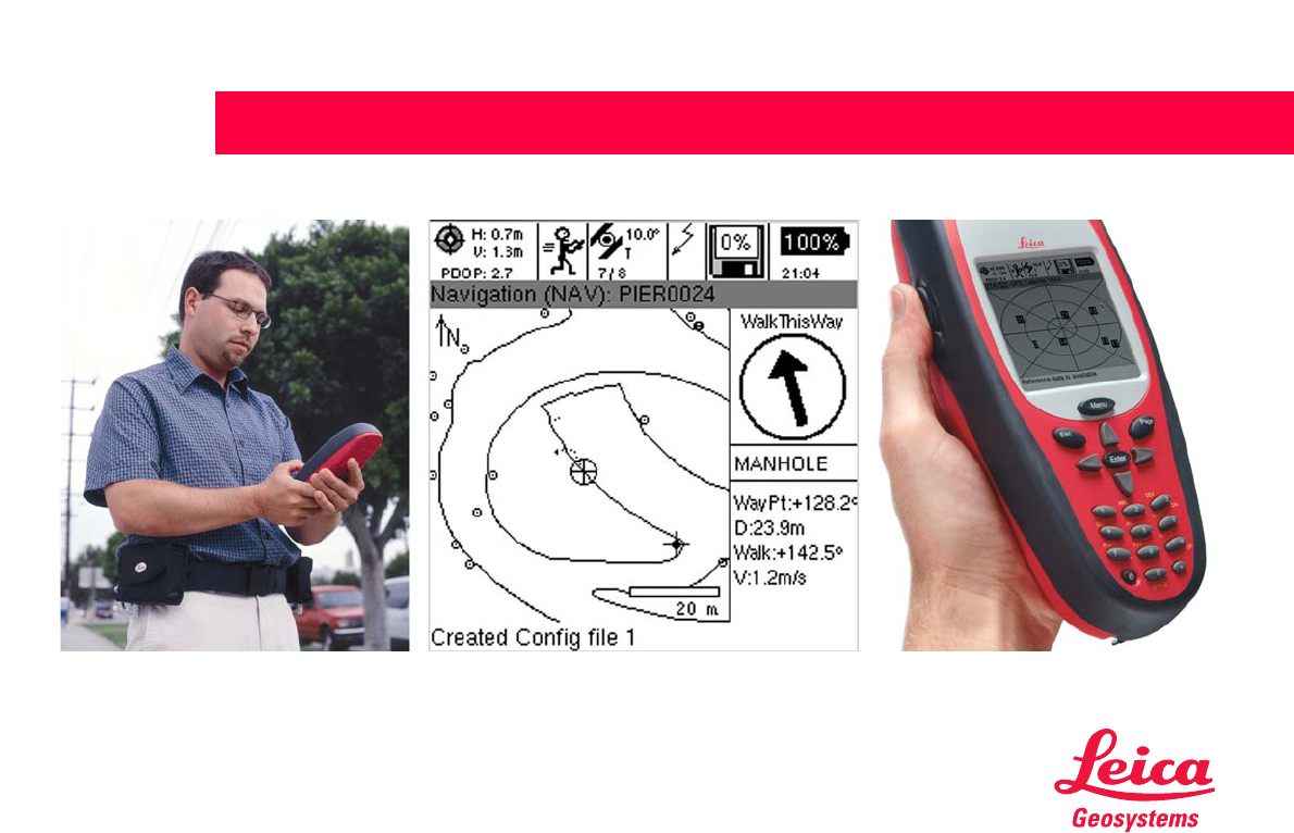
The Leica Geosystems GS20
The Leica Geosystems GS20 PDM was conceived to
provide the GIS community with a GPS data collection
device that combined the simplicity of a recreational GPS
handheld with the power and flexibility of a professional
grade mapping system. The Leica Geosystems GS20
represents a true turnkey GPS/GIS mapping solution by
integrating the GPS receiver and antenna within the
chassis of handheld data collector. Add to this the built-in
efficiency of Bluetooth wireless technology and you only
need add power and sky; the rest is up to you.
Overview of the User Manual
The User Manual is intended to provide information
concerning safety, storage and technical data of the Leica
Geosystems GS20 and accessories. For additional infor-
mation on the use and operation of Leica Geosystems
GS20, please refer the GS20 Field Guide (provided sepa-
rately). For information concerning the use and interaction
between Leica Geosystems GIS DataPRO and the Leica
Geosystems GS20, please refer to the GIS DataPRO
Manual, found in the documentation directory of installa-
tion, as well as the GIS DataPRO installation CD.
Description of the System
7
Leica Geosystems GS20 User Manual-1.0.0en
Description of the System
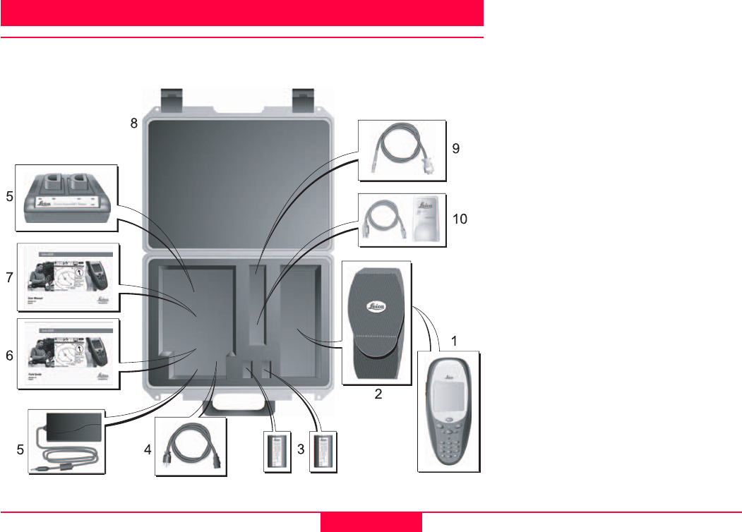
Unpacking
Take the product out of the transport case and check that it is complete:
1 GS20 Handheld GPS Receiver
(724705)
2 GS20 Soft Case (731774)
3 GEB90 Battery, Li-Ion, 7.2V
(724117)
4 US Power Cord for Dual Bay
Charger (731772)
5 GKL24 Dual Bay Battery Charger
(731771)
6 Leica Geosystems GS20 Field
Guide
7 Leica Geosystems GS20 User
Manual
8 GS20 Case (731775)
9 Data Transfer Cable, GS20 to
RS232 (731354)
10 USB Bluetooth Module (731784)

Description of the System Leica Geosystems GS20 User Manual-1.0.0en
8
GPS Receiver
The GPS Receiver receives the GPS signal from the
NAVSTAR satellites and calculates a range to all visible
satellites.
The Leica Geosystems GS20 is a 12 L1 channels, code
and phase handheld GPS receiver for professional data
mapping (PDM).
See section "Technical Data".
Receiver Hardware
In most cases, a short introduction in the use of the
Receiver will be provided by the local Leica representative.
If this is not the case proceed as outlined in the following
sections.
Alternatively refer to the FieldGuide PDF-manual available
on the GISDataPro Installation CD.

Description of the System
9
Leica Geosystems GS20 User Manual-1.0.0en
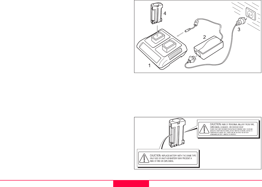
Charge the Batteries
Your Leica Geosystems GS20 is powered by a recharge-
able 7.2 V, Li-Ion battery.
Note that a new battery's full performance is achieved only
after two or three complete charge and discharge cycles.
The battery can be charged and discharged hundreds of
times but it will eventually wear out. When the operation
time is noticeably shorter than normal, it is time to buy a
new Leica Geosystems GEB90 Li-Ion Battery.
The Leica Geosystems GEB90 Li-Ion, 7.2 V, batteries may
be charged using the Leica Geosystems GKL24 Dual Bay
Battery Charger. Please find more information about your
Leica Geosystems Dual Bay Battery Charger in the GKL24
Chargers User Manual.
One batteries, fully charged, will power the GS20 for about
7 hours continuously. Operating times will be shorter when
working in cold weather.
ƽCAUTION:
Replace Battery with the same type only. Use of an-
other Battery may present a risk of personal injury
from fire, explosion, leakage, or excess heat.
Precautions:
Use only the Leica Geosystems GEB90 Battery to power
the GS20 or WoRcs.
ƽCAUTION:
Charge only with Leica Geosystems GKL24
Charger. Use of another charger may present risk of
personal injury from fire, explosion, leakage, or
excess heat.
Precautions:
When charging Leica Geosystems GEB90 Batteries make
sure to use only the Leica Geosystems GKL24 Charger.
ƽCAUTION:
Never carry a Leica Geosystems GEB90 Battery
loose. It can be affected by temperature extremes,
accidental short circuit, shock and vibration. This
may present a risk of personal Injury from fire, explo-
sion, leakage or excess heat.
Precautions:
Always carry it in its case and secure it. When transporting
the Leica Geosystems GEB90 Battery by road vehicle, rail,
air or ship, always use the complete original packaging
(case and cardboard box), or its equivalent, to protect it
against temperature extremes, short circuit shock and
vibration.
ƽCAUTION:
Do not dispose of battery in fire. Disposing in fire
may present a risk of personal injury from fire, explo-
sion, leakage, or excess heat.
Precautions:
Dispose Leica Geosystems GEB90 Batteries only
according to local regulations (e.g. recycling).
Description of the System Leica Geosystems GS20 User Manual-1.0.0en
10
ƽWARNING:
The battery chargers are intended for indoor use
only. Use a battery charger in a dry room only, never
outdoors. Charge batteries only at an ambient
temperature between 10°C and 30°C (50°F to 86°F).
We recommend a temperature of 0°C to +20°C
(32°F to 68°F) for storing the batteries. Exposing
batteries above 70 °C may present a risk of personal
injury from fire, explosion, leakage, or excess heat.
ƽWARNING:
Do not short-circuit the battery. Accidental short cir-
cuiting can occur when a metallic object (coin, clip or
pen) causes direct connection of the + and - termi-
nals of the battery. Short circuiting the terminals may
present a risk of personal injury from fire, explosion,
leakage, or excess heat.
ƽWARNING:
Use of open, damaged or worn out batteries may
present a risk of personal injury from fire, explosion,
leakage or excess heat.
)The battery contains toxic material and must be dis-
posed of in an environmentally friendly manner. Do
not dispose of the battery in normal household or of-
fice waste.
1 GKL24 Dual Bay Battery Charger including
2 AC/DC Converter
3 Power Cord for GKL24
4 GEB90 Battery, Li-Ion, 7.2V

Description of the System
11
Leica Geosystems GS20 User Manual-1.0.0en
Set Up the Equipment
For best performance GPS surveys require undisturbed
satellite signal reception. This means that GPS Receivers
work best in locations which are free of obstructions.
Press and release the Power Button located on lower left
of the keyboard. The unit will reply with an audible tone,
then proceed to a splash screen and then to the Main
Menu.
Your Leica Geosystems GS20 is now fully ready for oper-
ation.
When you consider to work in wireless real time the Leica
Geosystems "WoRCS", Wireless Real-time Corrections
System, for the DGPS is needed.
The Leica Geosystems "WoRCS" consists of a belt-
mounted communication hub, power supply and differen-
tial module and gives you everything you need to become
a self-contained mobile data collection system for real
time.
With built-in Bluetooth communications technology, you'll
have the ability to make wireless connections to external
devices such as DGPS, cellular phones, Laser Range-
finders and PDAs.
Please find the full settings in the Field Guide.
The Leica Geosystems "WoRCS" Belt includes
• Beacon receiver (Satellite correction module or custom
RTCM solutions also available)
• Bluetooth communication hub
• "Smart" power supply
Post-processing software
The Post-processing software is used to process the
observations taken by the Receiver in order to compute
baselines and coordinates.
Leica Geosystems GISDataPro Static Kinematic software
is the standard post-processing software for Leica Geosys-
tems receivers.
Please refer to the GISDataPro Software reference manual
to get detailed description.
Getting Started with the new GIS equipment Leica Geosystems GS20 User Manual-1.0.0en
12
Getting Started with the new GIS equipment
Introduction
“Getting Started with New GIS Equipment” is designed to
help get the beginning user up and running with their new
Leica Geosystems GS20.
For more information about setup, features and operations
of the Leica Geosystems GS20, please refer to the “GS20
FieldManual".
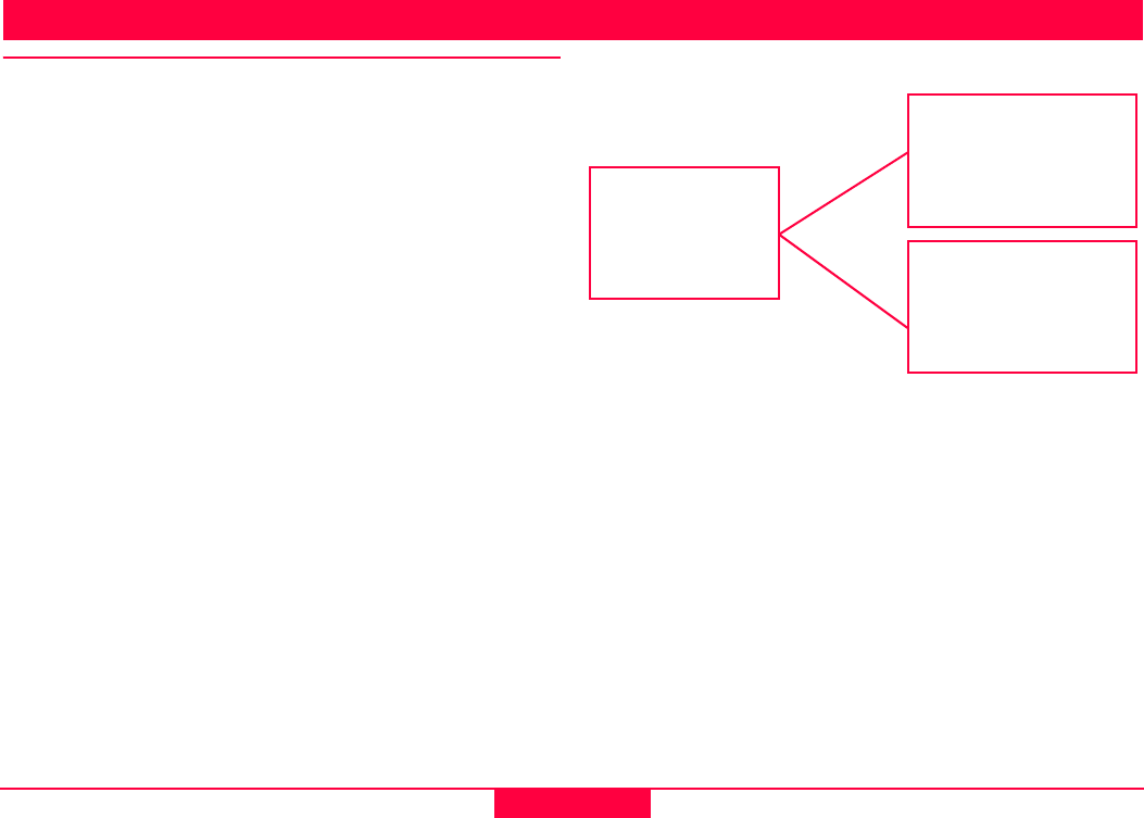
The Leica Geosystems GIS DataPRO system is composed
of both hardware and software components.
The hardware consists of the Leica Geosystems GS20
sensor. This is used in the field to collect and record spatial
(position) and non-spatial attributes.
The Leica Geosystems GIS DataPRO office software is
comprised of a GPS post-processing system and data
editing functionality which works in the native ESRI shape-
file format.
Hardware
Leica GS20
Antenna
Software
Leica GIS DataPRO
Leica GIS
Solution

Getting Started with the new GIS equipment
13
Leica Geosystems GS20 User Manual-1.0.0en
Leica Geosystems GIS DataPRO Post-processing soft-
ware
Leica Geosystems GIS DataPRO is used for data collec-
tion preparation and data post processing. Please refer to
the “Getting Started with the GIS DataPRO Office Soft-
ware” User Manual for more details.
To install the GIS DataPRO software:
1 Insert the CD-ROM into the CD drive of your PC.
2 Execute the “Setup” command.
3 Follow the instructions that appear on the screen.
Both a hardware and software user manual can be found
on the CD in PDF format. The software itself contains a
comprehensive online Help System.
After the data is collected in the field, the GIS DataPRO
office software allows you to import, edit and export the
data to your GIS. The software can also be used to design
codelists which allow you to customize the field data collec-
tion process to suit your needs. To learn more about the
Leica Geosystems GIS DataPRO office software, please
consult the “Getting Started with the GIS DataPRO Office
Software" User Manual.
Receiver Hardware
Leica Geosystems GS20 Sensor
The Leica Geosystems GS20 is a handheld GPS receiver
for professional data mapping. With the position and the
field data the user is capable to collect Data for his needs
in his GIS application. The GPS receiver receives the GPS
signal from the NAVSTAR satellites and calculates a range
to the satellites that are visible.
The Leica Geosystems GS20 is a 12-channel L1 code and
phase GPS receiver. The standard Leica Geosystems
GS20 does record phase measurements for post
processing purposes. Phase measurements are used
internally to smooth pseudorange measurements for
higher code positioning. Phase measurement recording for
post processing is available.
There are three antennas available with the Leica Geosys-
tems GS20:
• AT501 – tracks L1 only.
• RTB Combined Antenna - tracks L1 and RTCM differ-
ential signal from public and private beacon infastruc-
ture.
• RTS Combined Antenna - tracks L1 and differential
signals from Racal DGPS Satellite systems.
Please refer to the Field Guide for the use of your Leica
Geosystems GS20 equipment.

Care and Transport Leica Geosystems GS20 User Manual-1.0.0en
14
Care and Transport
Transport
)When dispatching the product, always use the
complete original Leica Geosystems packaging
(case and cardboard box).
When transporting the equipment in the field, always make
sure that you:
• either carry the product in its original transport case
• or carry the tripod with its legs splayed across your
shoulder, keeping the attached product upright.
Never carry the product loose in a road vehicle. It can be
affected by shock and vibration. Always carry it in its case
and secure it.
When transporting the product by rail, air or ship, always
use the complete original Leica Geosystems packaging
(case and cardboard box), or its equivalent, to protect it
against shock and vibration.
Storage
)Temperature limits
(-40°C to +70°C / -40°F to +158°F)
Respect the temperature limits when storing the
equipment, particularly in summer if the equipment
is inside a vehicle.
)Damp products must be unpacked. Dry the product,
the case, the foam inserts and the accessories at not
more than 40°C / 108°F and clean them. Do not
repack until everything is completely dry.
Cleaning and drying
)Use only a clean, soft, lint-free cloth for cleaning.
If necessary, moisten the cloth with pure alcohol.
Use no other liquids; these may attack the polymer compo-
nents.
)Cables and plugs
Keep plugs clean and dry. Blow away any dirt lodged
in the plugs of the connecting cables. Unplugging
connecting cables or removing the memory card
during the measurement may cause loss of data.
Always switch off the product before removing the
cables or the memory card.

Safety Directions
15
Leica Geosystems GS20 User Manual-1.0.0en
Safety Directions
The following directions should enable the person respon-
sible for the product, and the person who actually uses the
equipment, to anticipate and avoid operational hazards.
The person responsible for the product must ensure that all
users understand these directions and adhere to them.
Intended use of product
Permitted uses
The product is intended for the following applications:
• Measuring and computing coordinates using P-code
and/or C/A-code signals from NAVSTAR GPS satellites
• Carrying out measurement tasks using various GPS
measuring techniques
• Recording GPS and point related data
• Computation and evaluation by means of software
• Datatransfer via internal radio (BLUETOOTH) for real-
time surveys
• Datatransfer via internal radio (BLUETOOTH) for up
and download of projects, coordinate systems, and
configurations
Prohibited uses
• Use of the product without instruction
• Use outside of the intended limits
• Disabling safety systems
• Removal of hazard notices
• Opening the product using tools (screwdriver, etc.),
unless this is specifically permitted for certain functions
• Modification or conversion of the product
• Use after misappropriation
• Use with accessories from other manufacturers without
the prior express approval of Leica Geosystems
• Inadequate safeguards at the measuring station (e.g.
when measuring on roads)
ƽWARNING:
Adverse use can lead to injury, malfunction and
damage. It is the task of the person responsible for
the equipment to inform the user about hazards and
how to counteract them. The product is not to be
operated until the user has been instructed how to
work with it.

Safety Directions Leica Geosystems GS20 User Manual-1.0.0en
16
Limits of use
See chapter "Technical Data".
Environment:
Suitable for use in an atmosphere appropriate for perma-
nent human habitation: not suitable for use in aggressive or
explosive environments.
External Antenna:
Use in rain is permissible. After long term use in this envi-
ronment the External Antenna must be checked by a Leica
Geosystems service technician.
ƽDANGER:
Local safety authorities and safety experts must be
contacted before working in hazardous explosive
areas, near to electrical installations or in extreme
environment conditions by the person in charge of
the product.
Responsibilities
Area of responsibility for the manufacturer of the orig-
inal equipment Leica Geosystems AG, CH-9435 Heer-
brugg (hereinafter referred to as Leica Geosystems):
Leica Geosystems is responsible for supplying the product,
including the User Manual and original accessories, in a
completely safe condition.
)Responsibilities of the manufacturers of non-
Leica Geosystems accessories:
The manufacturers of non-Leica Geosystems accessories
for product are responsible for developing, implementing
and communicating safety concepts for their products, and
are also responsible for the effectiveness of those safety
concepts in combination with the Leica Geosystems
product.

Safety Directions
17
Leica Geosystems GS20 User Manual-1.0.0en
Responsibilities of the person in charge of the equip-
ment:
ƽWARNING:
The person responsible for the equipment must
ensure that it is used in accordance with the instruc-
tions. This person is also accountable for the training
and deployment of personnel who use the equip-
ment and for the safety of the equipment when in
use.
The person in charge of the product has the following
duties:
• To understand the safety instructions on the product
and the instructions in the User Manual.
• To be familiar with local regulations relating to accident
prevention.
• To inform Leica Geosystems immediately if the equip-
ment becomes unsafe.
Hazards of use
Main hazards of use
ƽWARNING:
The absence of instruction, or the inadequate
imparting of instruction, can lead to incorrect or
adverse use, and can give rise to accidents with far-
reaching human, material, financial and environ-
mental consequences.
Precautions:
All users must follow the safety directions given by the
manufacturer and the directions of the person responsible
for the product.
ƽWARNING:
The charger must not be used under damp or
inclement conditions. If moisture penetrates these
devices, the user may receive an electric shock.
Precautions:
Use the charger only indoors, in dry rooms. Protect them
from damp. If the devices are damp, do not use them.
ƽWARNING:
If you open the charger, either of the following
actions may cause you to receive an electric shock:
• Touching live components
• Using the charger after incorrect attempts to carry out
repairs

Safety Directions Leica Geosystems GS20 User Manual-1.0.0en
18
Precautions:
Do not open the charger yourself. Only a Leica Geosys-
tems-approved service technician is entitled to repair it.
ƽCAUTION:
Watch out for erroneous measurements if the
product has been dropped or has been misused,
modified, stored for long periodes or transported.
Precautions:
Periodically carry out test measurements and perform the
field adjustments indicated in the user manual, particularly
after the product has been subjected to abnormal use and
before and after important measurements.
ƽWARNING:
If computers intended for use indoors are used in
the field there is a danger of electric shock.
Precautions:
Adhere to the instructions given by the computer manufac-
turer with regard to field use in conjunction with Leica
Geosystems products.
ƽCAUTION:
If the accessories used with the equipment are not
properly secured and the equipment is subjected to
mechanical shock (e.g. blows, falling), the equip-
ment may be damaged or people may sustain injury.
Precautions:
When setting-up the equipment, make sure that the acces-
sories (e.g. tripod, tribrach, connecting cables) are
correctly adapted, fitted, secured, and locked in position.
Avoid subjecting the equipment to mechanical shock.
ƽCAUTION:
The product uses the GPS P-Code signal, which by
U.S. policy, may be switched off without notice.
ƽWARNING:
Inadequate securing of the survey site can lead to
dangerous situations, for example in traffic, on
building sites and at industrial installations.
Precautions:
Always ensure that the survey site is adequately secured.
Adhere to the regulations governing accident prevention
and road traffic.
ƽDANGER:
Because of the risk of electrocution, it
is very dangerous to use poles and
extensions in the vicinity of electrical
installations such as power cables or electrical railways.
Precautions:
Keep at a safe distance from electrical installations. If it is
essential to work in this environment, first contact the
safety authorities responsible for the electrical installations
and follow their instructions.
ƽCAUTION:
During the transport or disposal of charged batteries
it is possible for inappropriate mechanical influences
to constitute a fire hazard.

Safety Directions
19
Leica Geosystems GS20 User Manual-1.0.0en
Precautions:
Before dispatching the equipment or disposing of it,
discharge the batteries by running the product until they
are flat.
ƽWARNING:
If an External Antenna is not properly fitted to vehi-
cles or any other means for transportation it can be
torn off by mechanical shock, vibration or wind,
possibly causing accident and injury.
Precautions:
Attach the External Antenna professionally. The External
Antenna must be secured additionally, e.g. by use of a
safety cord. Ensure that the mounting device is correctly
mounted and able to safely carry the weight of the External
Antenna (>1kg).
ƽWARNING:
If the equipment is improperly disposed of, the
following can happen:
• If polymer parts are burnt, poisonous gases are
produced which may impair health.
• If batteries are damaged or are heated strongly, they
can explode and cause poisoning, burning, corrosion or
environmental contamination.
• By disposing of the equipment irresponsibly you may
enable unauthorized persons to use it in contravention
of the regulations, exposing themselves and third
parties to the risk of severe injury and rendering the
environment liable to contamination.
Precautions:
Dispose of the equipment appropriately in accordance with
the regulations in force in your country. Always prevent
access to the equipment by unauthorized personnel.
ƽDANGER:
If the product is used in exposed locations (e.g. on
masts, mountains or buildings), it is at risk from light-
ning. Danger from high voltages also exists near
power lines. Lightning, voltage peaks, or the
touching of power lines can cause damage, injury
and death.
Precautions:
• Do not use the product in a thunderstorm as you may
increase the risk of being struck by lightning.
• Be sure to remain at a safe distance from electrical
installations. Do not use the product directly under or in
close proximity to power lines. If it is essential to work in
such an environment contact the local statutory regula-
tory bodies responsible for electrical installations and
follow their instructions.
• If the product has to be permanently mounted in an
exposed location, it is advisable to provide a lightning
conductor system. A suggestion on how to design a
lightning conductor for the product is given hereinafter.
• Always follow the regulations in force in your country
with regard to grounding Antennas and masts. These
installations must be carried out by an authorised
specialist.

Safety Directions Leica Geosystems GS20 User Manual-1.0.0en
20
• To prevent damages due to indirect lightning strikes
(voltage spikes) cables (antenna, power source,
modem, ...) should be protected with appropriate
protection elements (lightning arrestor). These installa-
tions must be carried out by an authorized, local
specialist.
• Additional protection against lightning:
If there is a risk of a thunderstorm, or if the equipment is
to remain unused and unattended for a long period,
protect your product additionally by unplugging all
systems components and disconnecting all connecting
cables and supply cables (e.g. Receiver - Antenna).
Suggestion for design of a Lightning Conductor for a
GPS System
1. On non-metallic structures
Protection by Air Terminals is recommended. An Air
Terminal is a pointed solid or tubular rod of conducting
material with proper mounting and connection to a
conductor. The position of 4 Air Terminals should be
uniformly distributed around the Antenna at a distance
equal to the height of the Air Terminal.
The Air Terminal diameter should be 12mm for copper or
15mm for aluminium. The height of the Air Terminals
should be 25 to 50cm. All Air Terminals should be
connected to the down conductors. The diameter of the Air
Terminal should be kept to a minimum to reduce GPS
signal shading.
2. On metallic structures
Protection is as described for non-metallic structures, but
the Air Terminals can be connected directly to the
conducting structure without the need for down conduc-
tors.

Safety Directions
21
Leica Geosystems GS20 User Manual-1.0.0en
Air Terminal arrangement (plan view)
1 GPS Antenna
2 Support-Structure
3 Air Terminal
Grounding the Receiver/Antenna
1 Lightning Conductor Array
2 GPS Antenna
3 Antenna/Receiver Connection
4 Metallic Mast
5 Connection to Earth

Safety Directions Leica Geosystems GS20 User Manual-1.0.0en
22
Electromagnetic Compatability (EMC)
The term "electromagnetic compatability" is taken to mean
the capability of the product to function smoothly in an envi-
ronment where electromagnetic radiation and electrostatic
discharges are present, and without causing electromag-
netic disturbances to other equipment.
ƽWARNING:
Electromagnetic radiation can cause disturbances in
other equipment.
Although the Leica Geosystems GPS meets the strict regu-
lations and standards which are in force in this respect,
Leica Geosystems cannot completely exclude the possi-
bility that other equipment may be disturbed.
ƽCAUTION:
There is a risk that disturbances may be caused in
other equipment if the product is used in conjunction
with accessories from other manufacturers, e.g. field
computers, personal computers, walkie-talkies, non-
standard cables, external batteries.
Precautions:
Use only the equipment and accessories recommended by
Leica Geosystems. When combined with the product, they
meet the strict requirements stipulated by the guidelines
and standards.
When using computers and walkie-talkies, pay attention to
the information about electromagnetic compatability
provided by the manufacturer.
ƽCAUTION:
Disturbances caused by electromagnetic radiation
can result in the tolerance limits for measurements
being exceeded.
Although the product meets the strict regulations and
standards which are in force in this connection, Leica
Geosystems cannot completely exclude the possibility that
the product may be disturbed by very intense electromag-
netic radiation, e.g. near radio transmitters, walkie-talkies,
diesel generators.
Check the plausibility of results obtained under these
conditions.
ƽWARNING:
If the product is operated with connecting cables
attached at only one of their two ends (e.g. external
supply cables, interface cables), the permitted level
of electromagnetic radiation may be exceeded and
the correct functioning of other products may be
impaired.
Precautions:
While the product is in use, connecting cables (e.g. product
to external battery, product to computer) must be
connected at both ends.

Safety Directions
23
Leica Geosystems GS20 User Manual-1.0.0en
Use of the product with internal (BLUETOOTH) and
external Radio devices:
ƽWARNING:
Electromagnetic radiation can cause disturbances in
other equipment, in installations (e.g. medical ones
such as pacemakers or hearing aids) and in aircraft.
It can also affect humans and animals.
Precautions:
Although the product meets in combination with internal
(BLUETOOTH) and external Radio devices the strict regu-
lations and standards which are in force in this respect,
Leica Geosystems cannot completely exclude the possi-
bility that other equipment may be disturbed or that
humans or animals may be affected.
• Do not operate the product with internal (BLUETOOTH)
and external Radio devices in the vicinity of filling
stations or chemical installations, or in other areas
where an explosion hazard exists.
• Do not operate the product with internal (BLUETOOTH)
and external Radio devices near to medical equipment.
• Do not operate the product with internal (BLUETOOTH)
and external Radio devices in aircraft.
• Do not operate the product with internal (BLUETOOTH)
and external Radio devices for long periods with it
immediately next to your body.
ƽWARNING:
This Bluetooth transmitter must not be operating in
conjunction with any other transmitter or transmitting
antenna.
Safety Directions Leica Geosystems GS20 User Manual-1.0.0en
24
FCC statement (applicable in U.S.)
ƽWARNING:
This equipment, including GS20 and WoRCS
(BLUETOOTH), has been tested and found to
comply with the limits for a Class B digital device,
pursuant to part 15 of the FCC Rules.
These limits are designed to provide reasonable protection
against harmful interference in a residential installation.
This equipment generates, uses and can radiate frequency
energy and, if not installed and used in accordance with the
instructions, may cause harmful interference to radio
communications.
However, there is no guarantee that interference will not
occur in a particular installation.
If this equipment does cause harmful interference to radio
or television reception, which can be determined by turning
the equipment off and on, the user is encouraged to try to
correct the interference by one or more of the following
measures:
• Reorient or relocate the receiving antenna.
• Increase the separation between the equipment and
receiver.
• Connect the equipment into an outlet on a circuit
different from that to which the receiver is connected.
• Consult the dealer or an experienced radio/TV techni-
cian for help.
ƽWARNING:
Changes or modifications not expressly approved by
Leica Geosystems for compliance could void the
user's authority to operate the equipment.
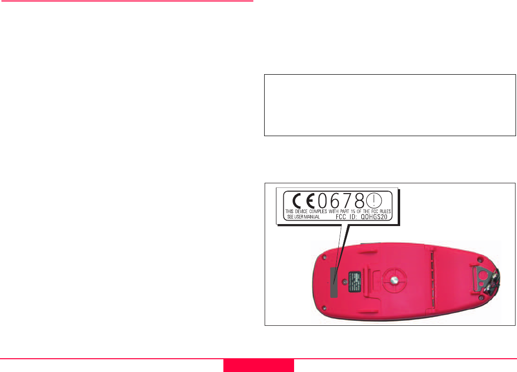
Product Labeling:
The label indicator is placed on the backside of the device
in the center above the battery case.
This device complies with part 15 of the FCC Rules. Oper-
ation is subject to the following two conditions: (1) This
device may not cause harmful interference, and (2) this
device must accept any interference received, including
interference that may cause undesired operation.

Technical Data
25
Leica Geosystems GS20 User Manual-1.0.0en
Technical Data
Tracking Characteristics
•Satellite Reception
Single frequency
•Receiver channels
12 L1 continuous tracking
•L1 channels
Carrier phase, C/A narrow code
•L1 Carrier Tracking
Reconstructed carrier phase via C/A code
•L1 Code Measurements
Carrier phase smoothed C/A code measurements
•Satellites Tracked
Up to 12 simultaneously on L1
Time to first phase measurement typically 30 seconds.
GPS Antennas
•AT575 Internal
Microstrip L1 antenna with build in groundplane
•AT501
Microstrip L1 antenna with built in groundplane
•RTB
Combined GPS L1/ beacon antenna
•RTS
Combined GPS L1/ L-Band antenna
Interface
•Port 1
Conformable with RS232
Lemo 7 Pin
•BLUETOOTH Specification
1. Radio:
Taiyo Yuden Class 2 Bluetooth module EYSF2SSXX
Nominal transmit ............ 0dBm with included antenna
Frequency range .................... from 2402 to 2480 MHz
Transmission power ......................... < 2.5 mW (e.r.p.)
Operating range .......................................... within 10m
2. Other Characteristics
Baudrate........................................................115.2 kps
•Baudrate
300/1200/2400/4800/7200/9600/19200/38400/57600/
115200 bps
•Data Format
Parity ....................................................none/odd/even
Data Bit ................................................................. 7;8
Stop Bits.................................................................. 1;2
Flow Control .................................................. RTC/CTS
................................................................... XON/XOFF
Technical Data Leica Geosystems GS20 User Manual-1.0.0en
26
Equipment weights
•Receivers
Leica Geosystems GS20.................................. 0.55 kg
•Antennas
AT501 ................................................................. 0.4 kg
Power
•Supply Voltage
All equipment:................................... Nominal 7.2V DC
External: .......................................................... 12V DC
Environmental Specifications
•Humidity
Up to 99%, non-condensing
•Weather
Will withstand rain, snow, dust, sand etc.
Separation distances
•Leica Geosystems GS20 to AT501 RTB or RTS
Antenna
Supplied cables:................................................... 1.2m
Longer cables available on request.
Baseline precision
The following specifications are based on measurements
processed using Leica Geosystems GISDataPro software
and are given as baseline rms (root mean square).
• Differential Phase
• Differential Code
)Baseline precision is dependent upon various
factors including the number of satellites tracked,
constellation geometry, observation time, ephemeris
accuracy, ionospheric disturbance, multipath and
resolved ambiguities.
Instrument Operation Storage
Leica Geosystems
GS20
-20°C to +55°C
(-4°F to 131°F)
-40°C to +70°C
(-40°F to 158°F)
AT501 -40°C to +75°C
(-40°F to 167°F)
-40°C to + 75°C
(-40°F to 167°F)
Leica Geosystems
PC-cards, all sizes
-20°C to +75°C
(-4°F to 167°F)
-40°C to +75°C
(-40°F to 167°F)
Operation Static Rapid Static Kinematic
10mm + 2ppm 10mm + 2ppm 20mm + 2ppm
Operation Post Processing Realtime DGPS
Static 30 cm 40 cm
Kinematic 30 cm 40 cm

Technical Data
27
Leica Geosystems GS20 User Manual-1.0.0en
Conformity to national regulations
• FCC part 15 (applicable in U.S.)
• European directive 1999/5/EC on radio equipment and
telecommunications terminal equipment (see CE
Conformity Declaration).
• The conformity for countries with other national regula-
tions not covered by FCC part 15 or European direc-
tives 1999/5/EC has to be approved prior to use and
operation.

Leica Geosystems AG
CH-9435 Heerbrugg
(Switzerland)
Phone +41 71 727 31 31
Fax +41 71 727 46 73
www.leica-geosystems.com
Leica Geosystems AG, Heerbrugg,
Switzerland, has been certified as
being equipped with a quality system
which meets the International
Standards of Quality Management and
Quality Systems (ISO standard 9001)
and Environmental Management
Systems (ISO standard 14001).
733603-1.0.0en
Printed in Switzerland - Copyright Leica Geosystems AG,
Heerbrugg, Switzerland 2003
Original text
Total Quality Management-
Our commitment to total
customer satisfaction.
Ask your local Leica agent for
more information about our TQM
program.