TomTom 4BA63 GPS Navigation System with WLAN and BT/BLE User Manual TomTom GO Basic
TomTom International BV GPS Navigation System with WLAN and BT/BLE TomTom GO Basic
TomTom >
User Manual

TomTom GO Basic
User Manual
17.5

2
Contents
Welcome to navigation with TomTom 6
What's new 7
New in this release ................................................................................................ 7
Video workshops ................................................................................................... 7
Get going 9
Installing in your car .............................................................................................. 9
Positioning the device ............................................................................................ 9
Switching on and off .............................................................................................. 9
Setting up ......................................................................................................... 10
GPS reception .................................................................................................... 10
Sending information to TomTom .............................................................................. 10
Device not starting .............................................................................................. 11
Charging your device ............................................................................................ 11
Finding the memory card slot ................................................................................. 11
Caring for your TomTom GO ................................................................................... 11
What's on the screen 12
The map view..................................................................................................... 12
The guidance view ............................................................................................... 14
The route bar ..................................................................................................... 15
Distances and the route bar ............................................................................... 16
The quick menu .................................................................................................. 16
Navigation buttons............................................................................................... 17
Main Menu smaller buttons and symbols ..................................................................... 18
Volume control ................................................................................................... 20
Using gestures .................................................................................................... 20
Changing the text and button size ............................................................................ 21
Reordering the Main Menu buttons ........................................................................... 21
Syncing using TomTom MyDrive 22
About TomTom MyDrive ........................................................................................ 22
Logging in to your TomTom account ......................................................................... 22
Finding and syncing locations using MyDrive ................................................................ 22
Syncing My Places locations with MyDrive ................................................................... 23
Importing a community POI list - MyDrive - NOT CONNECTED ........................................... 23
Deleting a community POI list ................................................................................. 23
Importing a track GPX file...................................................................................... 23
Deleting a track GPX file ....................................................................................... 24
Saving and restoring your personal navigation information .............................................. 24
Using step by step search 25
About search ...................................................................................................... 25
Entering search terms ........................................................................................... 25
Working with search results ................................................................................... 26
About postcodes ................................................................................................. 27
List of POI type icons ............................................................................................ 28

3
Planning a route using step by step search 32
Planning a route to an address ................................................................................ 32
Planning a route to a POI ....................................................................................... 33
Planning a route to a city centre ............................................................................. 35
Planning a route to a POI using online search .............................................................. 37
Planning a route using the map ............................................................................... 38
Planning a route using My Places ............................................................................. 40
Planning a route using coordinates using step by step search ........................................... 41
Planning a route in advance ................................................................................... 42
Finding a car park ............................................................................................... 43
Finding a petrol station ......................................................................................... 45
Changing your route 48
The Current Route menu ....................................................................................... 48
Avoiding a blocked road ........................................................................................ 50
Avoiding part of a route ........................................................................................ 50
Types of route .................................................................................................... 51
Avoiding an incident or route feature using the route bar ............................................... 51
Adding a stop to your route from the current route menu ............................................... 52
Adding a stop to your route using the map ................................................................. 52
Deleting a stop from your route ............................................................................... 52
Skipping the next stop on your route ........................................................................ 52
Reordering stops on a route ................................................................................... 52
My Routes 54
About My Routes ................................................................................................. 54
About GPX and ITN files ........................................................................................ 54
Saving a route .................................................................................................... 55
Navigating using a saved route ................................................................................ 56
Navigating to a stop on a saved route ....................................................................... 56
Adding a stop to a saved route using the map .............................................................. 58
Recording a track ................................................................................................ 59
Navigating using a track ........................................................................................ 59
Deleting a route or a track from My Routes ................................................................. 60
Finding the memory card slot ................................................................................. 60
Exporting tracks to a memory card ........................................................................... 60
Importing routes and tracks from a memory card ......................................................... 61
Map Share 62
About Map Share ................................................................................................. 62
Creating a map change report ................................................................................. 62
Creating a map change report from a marked location ................................................... 63
Types of map change ............................................................................................ 64
Traffic 66
About RDS-TMC ................................................................................................... 66
The route bar ..................................................................................................... 66
Looking at traffic on the map ................................................................................. 67
Looking at traffic on your route ............................................................................... 68
Traffic incidents ................................................................................................. 68
Approaching a traffic jam warning ........................................................................... 69
Avoiding a traffic jam on your route ......................................................................... 70
Advanced Lane Guidance ....................................................................................... 70
4
Time-dependent speed limits ................................................................................. 71
Speed Cameras 72
About speed cameras ........................................................................................... 72
Crossing into another area or country ....................................................................... 72
Speed camera warnings ......................................................................................... 72
Changing the way you are warned ............................................................................ 73
Updating locations for cameras and hazards ............................................................... 74
Danger Zones 75
About danger zones ............................................................................................. 75
Crossing into another area or country ....................................................................... 75
Danger zone warnings ........................................................................................... 75
Changing the way you are warned ............................................................................ 76
Updating locations for danger zones ......................................................................... 76
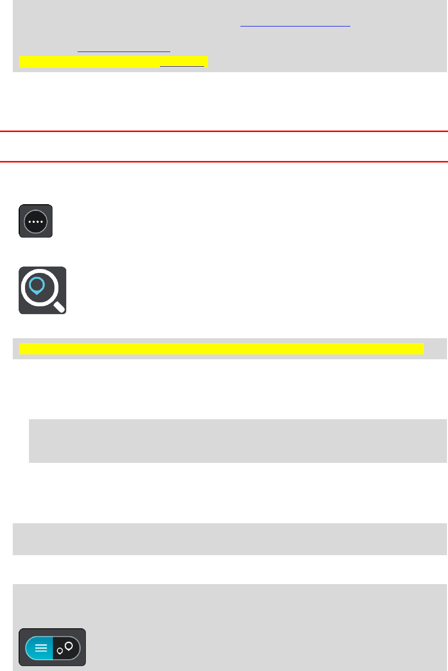
My Places 77
About My Places .................................................................................................. 77
Setting your home or work location .......................................................................... 77
Changing your home location .................................................................................. 78
Adding a location from My Places ............................................................................. 79
Add a location to My Places from the map .................................................................. 79
Adding a location to My Places using search ................................................................ 79
Adding a location to My Places by marking ................................................................. 80
Deleting a recent destination from My Places .............................................................. 80
Deleting a location from My Places ........................................................................... 80
Settings 81
Appearance ....................................................................................................... 81
Display ......................................................................................................... 81
Route Bar ...................................................................................................... 82
Guidance view ................................................................................................ 83
Automatic Zoom.............................................................................................. 83
Motorway exit previews .................................................................................... 83
Voices .............................................................................................................. 84
Maps ................................................................................................................ 85
Route Planning ................................................................................................... 85
Sounds and Warnings ............................................................................................ 86
Language and Units .............................................................................................. 87
System ............................................................................................................. 87
Help ................................................................................................................ 88
Getting Help 89
Help ................................................................................................................ 89
Product certification 90
Finding product certification information on your device ................................................ 90
Updating using MyDrive Connect 91
About MyDrive Connect ......................................................................................... 91

6
This User Manual explains all you need to know about your new TomTom GO Basic navigation
device.
To learn about getting started with your device and installing it in your vehicle, we recommend that
you read the Get going chapter.
After that, you will probably want to learn about Quick Search and you can read all about that in
the Using Quick Search chapter.
For information about what you see on the device itself, go to What's on the screen.
To plan your first route, go to Planning a route.
Tip: There are also frequently asked questions (FAQs) at tomtom.com/support. Select your
product model from the list or enter a search term.
We hope you enjoy reading about and, most importantly, using your new navigation device!
Welcome to navigation with TomTom

7
New in this release
Version 17.1
Advanced Lane Guidance in a split screen
As you approach motorway exits and junctions you can now view map guidance and lane guidance
side-by-side in a split screen.
To learn more go to Advanced Lane Guidance in this User Manual.
Quick search and Step by step search
You can now choose between two different ways of searching for an address or a POI.
To learn more go to Choosing which search to use in this User Manual.
Read aloud traffic messages
Your device now reads aloud traffic messages about traffic events on your route.
To learn more go to Sounds and Warnings in Settings in this User Manual.
Using community POI lists
You can now show your imported community POI lists permanently on the map.
To learn more go to Using community POI lists in this User Manual.
Other bug fixes and improvements
Various performance improvements and bug fixes have been implemented.
Video workshops
You can find many videos on our YouTube channel to help you learn about your new TomTom GO
Basic and other TomTom products. Visit www.youtube.com/user/TomTomOfficial/videos to find out
more!
Tip: Look on the TomTom YouTube Channel for videos in your own language.
Here are links to some videos that you might find interesting:
TomTom GO - playlist of English videos
https://www.youtube.com/playlist?list=PLSoQAVympWk79NpmQgjFgigup-UgowFxE
Using MyDrive
UK English:
https://www.youtube.com/watch?v=PIs5tGFhQIA
French (France):
https://www.youtube.com/watch?v=lYpPDxxXSwk
Spanish (Spain):
https://www.youtube.com/watch?v=HkZqdD5MkHI
German:
https://www.youtube.com/watch?v=Skg6PWMbRxI
What's new

9
Installing in your car
Use the supplied mount to install your TomTom GO Basic in your vehicle. Read the instructions
about positioning your device before you install your TomTom GO.
To install your TomTom GO, do the following:
1. Connect the supplied USB cable to the mount. If the mount is integrated into your TomTom GO,
connect the USB cable to the device.
Note: Use ONLY the USB cable supplied with your TomTom GO. Other USB cables may not
work.
2. Connect the USB cable to the USB car charger and plug this into the power supply on your
dashboard.
3. Choose the best smooth location, on your windscreen or side window, to mount your TomTom
GO Basic.
Tip: If the mount is integrated into your TomTom GO, you can easily change the rotation of
your device. Release the mount from the TomTom GO using the thumb indent. Turn the mount
around and clip it back onto the device until you hear it click.
4. Make sure that both the suction cup on the mount and your windscreen are clean and dry.
5. Press the suction cup of the mount firmly against your windscreen.
6. Turn the rubber grip near the base of the mount in a clockwise direction until you feel it lock.
7. If your mount is not integrated into your TomTom GO, place your TomTom GO in the mount,
making sure that it clicks into place.
Dashboard adhesive disks are available as part of a range of accessories for your TomTom GO. For
more information, go to tomtom.com/accessories.
Positioning the device
Be careful where you install your TomTom GO. The TomTom GO shouldn't block or interfere with
any of the following:
Your view of the road.
The controls in your vehicle.
Your rear-view mirrors.
The airbags.
You should be able to reach your TomTom GO easily without leaning or stretching. In a car, you can
attach your TomTom GO to the windscreen or side window or you can use a Dashboard Mount Disk to
attach the mount to your dashboard.
Switching on and off
Switching your device on
Press the On/Off button until your device starts. If the device was off you see the map view. If your
device was sleeping you see the last screen you were looking at.
Get going
10
Sending your device to sleep
To send your navigation device to sleep, press the On/Off button and then release it.
You can also press the On/Off button for more than 2 seconds until you see the Sleep and Turn Off
buttons. Select Sleep to make the device sleep.
Tip: To send your navigation device to sleep when the USB cable is unplugged or whenever it is
removed from the mount, go to Battery settings in the Settings menu.
Switching your device off completely
To switch off your navigation device completely, you can do one of the following:
Press and hold the On/Off button for more than 2 seconds until you see the Sleep and Turn Off
buttons. Select Turn Off to switch off the device. Select the "back" button if you don't want to
switch your device off.
Press and hold the On/Off button for more than 5 seconds until the device switches off.
Setting up
Note: The language you choose will be used for all text on the screen. You can always change the
language later in Language and Units in the Settings menu.
When you first switch on your TomTom GO Basic, you have to answer a few questions to set it up.
Answer the questions by touching the screen.
GPS reception
When you first start your TomTom GO Basic, it may need a few minutes to determine your position.
In future, your position will be found much faster.
To ensure good satellite reception, use your TomTom GO outdoors and keep it upright. Large
objects such as tall buildings can sometimes interfere with reception.
Important: QuickGPSfix contains information about satellite positions which helps your TomTom GO
find your position faster. QuickGPSfix information is sent to Always Connected devices in real time
and to Smartphone Connected devices when connected to TomTom services using your smartphone.
You can also update QuickGPSfix using MyDrive.
Sending information to TomTom
When you first start navigating or you have reset your TomTom GO, your TomTom GO asks for
permission to collect some information about your use of the navigation device. The information is
stored on your TomTom GO until we retrieve it. We use it anonymously to improve our products and
services. If you use our services, we will also use your location information to deliver the services to
you.
You can change whether you send this information with us at any time by doing the following:
1. In the Main Menu, select the Settings button.
2. Select System.
3. Select Your information & privacy.
4. Select the button to turn sending of information on or off.
Note: If you choose not to send location information to us, you will no longer receive our
services. This is because services need to send the location of your device to TomTom in order to
receive the traffic information related to where you are. The end date of your subscription
remains the same, even if you do not send this information to us.
You can find current and more detailed information at tomtom.com/privacy.
11
Device not starting
In rare cases, your TomTom GO device may not start correctly or may stop responding to your taps.
First, check that the battery is charged. To charge the battery, connect your TomTom GO device to
the car charger. It can take 3 - 5 hours to fully charge the battery depending on the type of device.
Important: Do not charge your device using your vehicle's own USB port because it is not powerful
enough.
If this does not solve the problem, you can perform a reset. To do this, press and hold the On/Off
button until your TomTom GO begins to restart.
Charging your device
The battery in your TomTom GO Basic charges when you connect it to your TomTom vehicle
charger, to your computer or to a USB Home Charger.
Important: Do not charge your device using your vehicle's own USB port because it is not powerful
enough.
You are warned when the battery level is low or critical. You lose your connection to some TomTom
services when the battery level is low or critical. When the battery is empty, your TomTom GO goes
into sleep mode.
Important: On device models START 42/52, START 40/50/60, and GO 51/61, the screen intentional-
ly dims when you connect your device to your computer. The screen also dims if you use a
non-TomTom charger that does not provide enough power when charging.
Note: Use ONLY the USB cable supplied with your TomTom GO. Other USB cables may not work.
Finding the memory card slot
The memory card slot is under the mount.
To insert a memory card, release the mount from the TomTom GO using the thumb indent. Insert
the memory card into the slot. Clip the mount back onto the device until you hear it click.
Caring for your TomTom GO
It is important to take care of your device:
Do not open the casing of your device under any circumstances. Doing so may be dangerous and
will invalidate the warranty.
Wipe or dry the screen of your device using a soft cloth. Do not use any liquid cleaners.
12
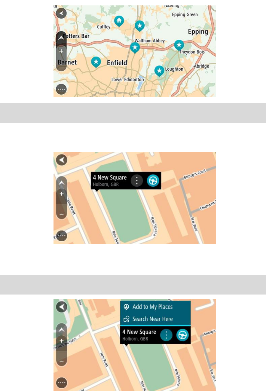
The map view
The map view is shown when you have no planned route. Your actual location is shown as soon as
your TomTom GO has found your GPS location.
You can use map view in the same way as you might look at a traditional paper map. You can move
around the map using gestures, and zoom using the zoom buttons.
Important: Everything on the map is interactive including the route and the map symbols - try
selecting something and see what it does!
Tip: To open a pop-up menu for an item on the map, for example a route or a POI, select the
item to open the menu. To select a location on the map, select and hold the location until the
pop-up menu opens.
The map shows your current location and many other locations such as your My Places locations.
If you have not planned a route the map is zoomed out to show the area around your location.
If you have planned a route, your complete route is shown on the map. You can add stops to your
route directly from the map. When you start to drive, the guidance view is shown.
What's on the screen
13
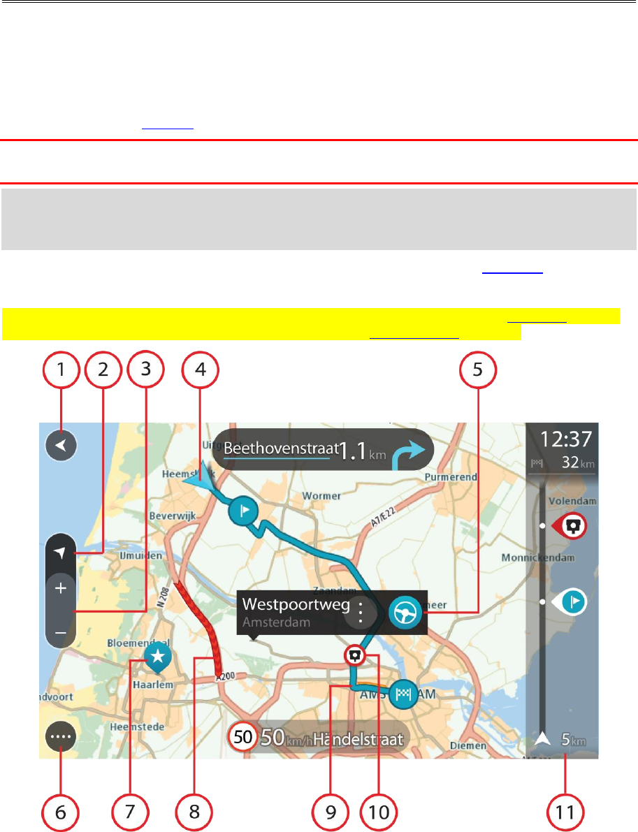
1. Back button. This button returns the map to an overview of your whole route or, if no route is
planned, moves the map to put your current location at the centre.
2. Switch view button. Select the switch view button to change between the map view and the
guidance view. When in map view, if you are driving, the small arrow rotates to indicate your
direction of travel relative to north, with north being up.
3. Zoom buttons. Select the zoom buttons to zoom in and out.
4. Current location. This symbol shows your current location. Select it to add it to My Places or
search near your current location.
Note: If your TomTom GO cannot find your location the symbol appears grey.
Note: You cannot change the current location symbol.
5. Selected location. Press and hold to select a location on the map. Select the pop-up menu
button to show options for the location, or select the Drive/Ride button to plan a route to the
location.
6. Main Menu button. Select the button to open the Main Menu.
7. Map symbols. Symbols are used on the map to show your destination and your saved places:
Your destination.
Your home location. You can set your home location in My Places.
Your work location. You can set your work location in My Places.
A stop on your route.
A location saved in My Places.
A marked location.
When a search for POIs near destination is done and the results are shown on the
map, less important POIs are shown as black pins with white crosses.
Symbols to show your community POI locations.
Select a map symbol to open the pop-up menu, then select the menu button to see a list of
actions you can take.
8. Traffic information. Select the traffic incident to display information about the traffic delay.
Note: Traffic information is only available if your TomTom GO Basic has TomTom Traffic.
9. Your route, if you have planned a route. Select the route to clear it, change the route type, add
a stop or save changes to your route.
1. Speed cameras or danger zones on your route. Select the speed camera or danger zone symbol
to display more information.
14
2. Route bar. The route bar is shown when you have planned a route.
The guidance view
The guidance view is used to guide you along the route to your destination. The guidance view is
shown when you start driving. You see your current location and details along your route, including
3D buildings in some cities.
Note: 3D buildings in guidance view are not available on all devices.
The guidance view is normally in 3D. To show a 2D map with the map moving in your direction of
travel, change the 2D and 3D default settings.
Tip: When you have planned a route and the 3D guidance view is shown, select the switch view
button to change to the map view and use the interactive features.
When your TomTom GO starts after sleeping and you have a route planned, you are shown the
guidance view with your current location.
1. Switch view button. Select the switch view button to change between the map view and the
guidance view. When in guidance view, if you are driving, the small arrow rotates to indicate
your direction of travel relative to north, with north being up.
2. Zoom buttons. Select the zoom buttons to zoom in and out.
Tip: On some devices you can also pinch to zoom in and out.
3. Instruction panel. This panel shows the following information:
The direction of your next turn.
The distance to your next turn.
15
The name of the next road on your route.
Lane guidance at some junctions.
Note: Select the instruction panel to see a list of turn-by-turn text instructions for your
planned route.
4. Route symbols. Symbols are used on your route to show your starting location, your stops, and
your destination.
5. Main Menu button. Select the button to show the Main Menu.
6. Speed panel. This panel shows the following information:
The speed limit at your location.
Your current speed. If you drive more than 5 km/h or 3 mph over the speed limit the speed
panel turns red. If you drive less than 5 km/h or 3 mph over the speed limit the speed panel
turns orange.
The name of the street you are driving on.
The speed camera or risk zone report button.
7. Current location. This symbol shows your current location. Select the symbol or the speed panel
to open the quick menu.
Note: If your TomTom GO cannot find your location the symbol appears grey.
Note: You cannot change the current location symbol.
8. Route bar. The route bar is shown when you have planned a route.
Important: To see a wider route bar showing additional route information, change the setting
for Route Information.
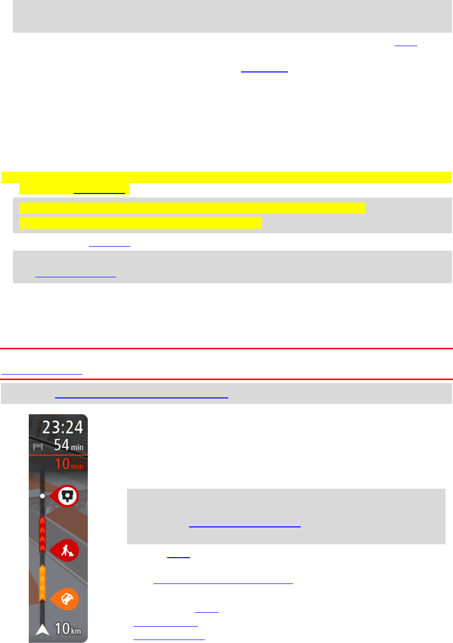
The route bar
The route bar is shown when you have planned a route. It has an arrival information panel at the
top, and a bar with symbols underneath.
Important: To see a wider route bar showing additional route information, change the setting for
Route Information.
Note: The distance ahead shown by the route bar depends on the overall length of your route.
The arrival information panel shows the following information:
The estimated time that you will arrive at your destination.
The length of time to drive to the destination from your current
location.
A parking button is shown near the destination flag when parking is
available near your destination.
Tip: If your destination is in a different time zone, you see a plus
(+) or a minus (-) sign and the time difference in hours and half
hours in the arrival information panel. The estimated time of arrival
is the local time at your destination.
If you have stops on your route, select this panel to change between
information about the next stop and your final destination.
You can choose the information you see on the arrival information panel.
The bar uses symbols to show the following information:
The next two stops on your route.
Petrol stations that are directly on your route.
TomTom Traffic.

16
TomTom Speed Cameras and Danger Zones.
Rest stops directly on your route.
You can choose the information you see on your route.
The symbols are in the order that they occur on your route. For traffic
incidents, the symbol for each incident alternates between showing the
type of incident and the delay in minutes. Select a symbol to see more
information about a stop, an incident or a speed camera. If a symbol is
shown on top of another symbol, selecting the symbols zooms in on the
route bar to show each symbol separately. You can then select a symbol.
The total time delay due to traffic jams and other incidents on your
route, including information provided by IQ Routes, is shown above the
symbols.
For a complete list of incident types, see Traffic incidents.
The bottom of the route bar represents your current location and shows
the distance to the next incident on your route.
Note: To make the route bar more readable some incidents may not be shown. These incidents
will always be of minor importance and only cause short delays.
The route bar also shows status messages, for example Finding fastest route or Playing route
preview.
Distances and the route bar
The distance ahead shown on the route bar depends on the length of your route, or the distance
remaining on your route.
For remaining distances longer than 50 km (31 miles), only the next 50 km (31 miles) is shown.
The destination icon is not shown.
Tip: You can scroll the route bar to see your whole route (not available on iOS).
For remaining distances between 10 km (6 miles) and 50 km (31 miles), the complete distance is
shown. The destination icon is shown fixed at the top of the route bar.
For remaining distances of less than 10 km (6 miles) the complete distance is shown. The
destination icon moves down towards the chevron symbol as you get nearer to your destination.
The top half of the route bar shows twice the distance of the bottom half, as shown in the following
examples:
A remaining distance of 50 km on the route bar is split into 34 km (21 miles) at the top and 16
km (9 miles) at the bottom.
A remaining distance of 10 km on the route bar is split into 6.6 km (4 miles) at the top and 3.3
km (2 miles) at the bottom.
The route bar is constantly updated as you drive.
The quick menu
To open the quick menu, select the current location symbol or the speed panel in the guidance
view.
You can then do any of the following:
Mark a location
Change a speed limit
Avoid a blocked road
See your current location or your latitude/longitude if not on a named road.
17
Navigation buttons
On the map view or guidance view, select the Main Menu button to open the Main Menu.
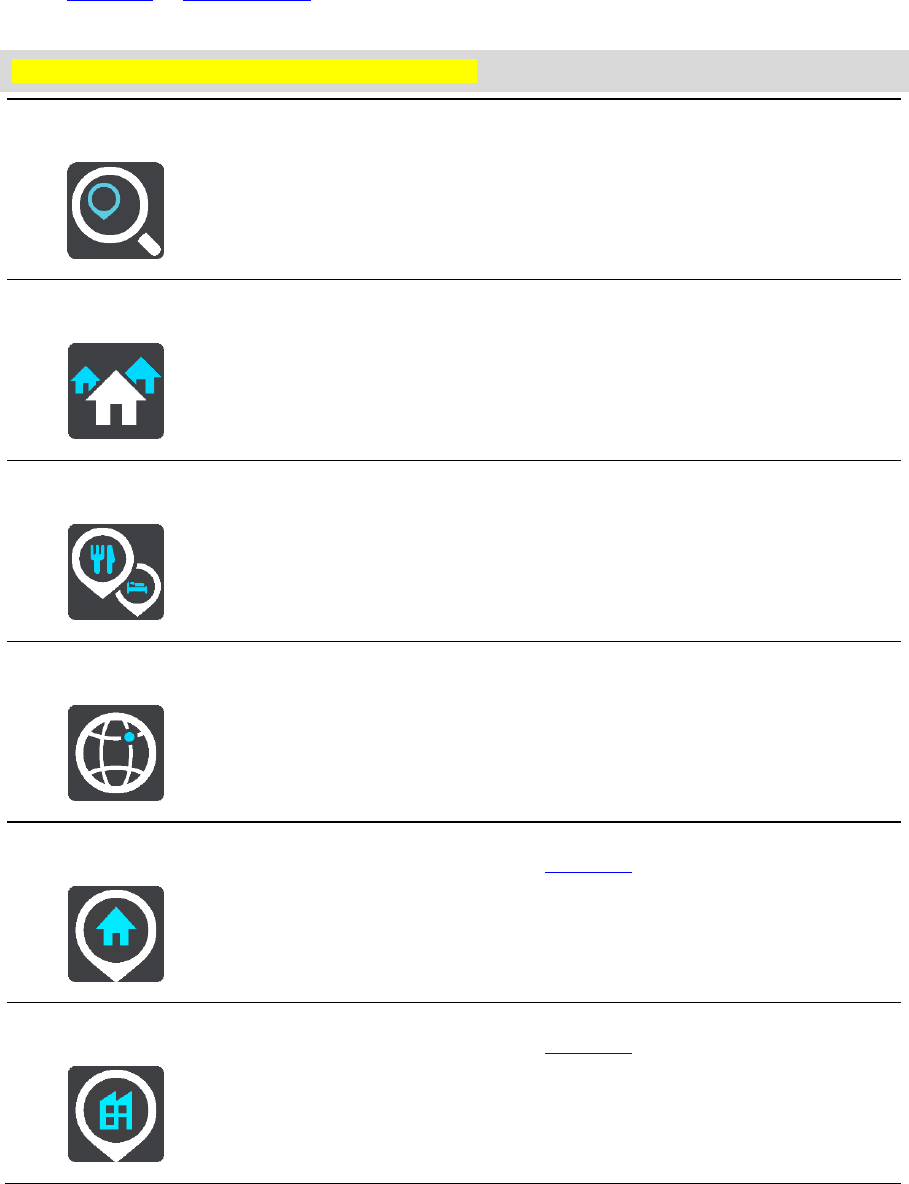
The following navigation buttons are available in the Main Menu:
Note: Not all features are supported on all devices.
Drive To
Select this button to open the Drive To menu to search for an address, a
Point of Interest or a latitude-longitude coordinate, then plan a route to
that location.
Address
In the Drive To menu, select this button to search for an address then
plan a route to that location.
Point of Interest
In the Drive To menu, select this button to search for a point of interest,
then plan a route to that location.
Latitude Longitude
In the Drive To menu, select this button to search for a lati-
tude-longitude coordinate, then plan a route to that location.
Drive Home
Select this button to drive to your home location. If this button is not
included in your main menu, go to My Places to set up you home
location.
Drive to Work
Select this button to drive to your work location. If this button is not
included in your main menu, go to My Places to set up your work
location.
18
Recent Destination
Select this button to open the list of your recent destinations. Select a
recent destination to plan a route to that destination.
Current Route
Select this button to clear or change your planned route.
My Places
Select this button to show your saved places.
My Routes
Select this button to show your saved routes.
Parking
Select this button to find car parks.
Petrol Station
Select this button to find petrol stations.
Start Recording
Select this button to start or stop recording a track.
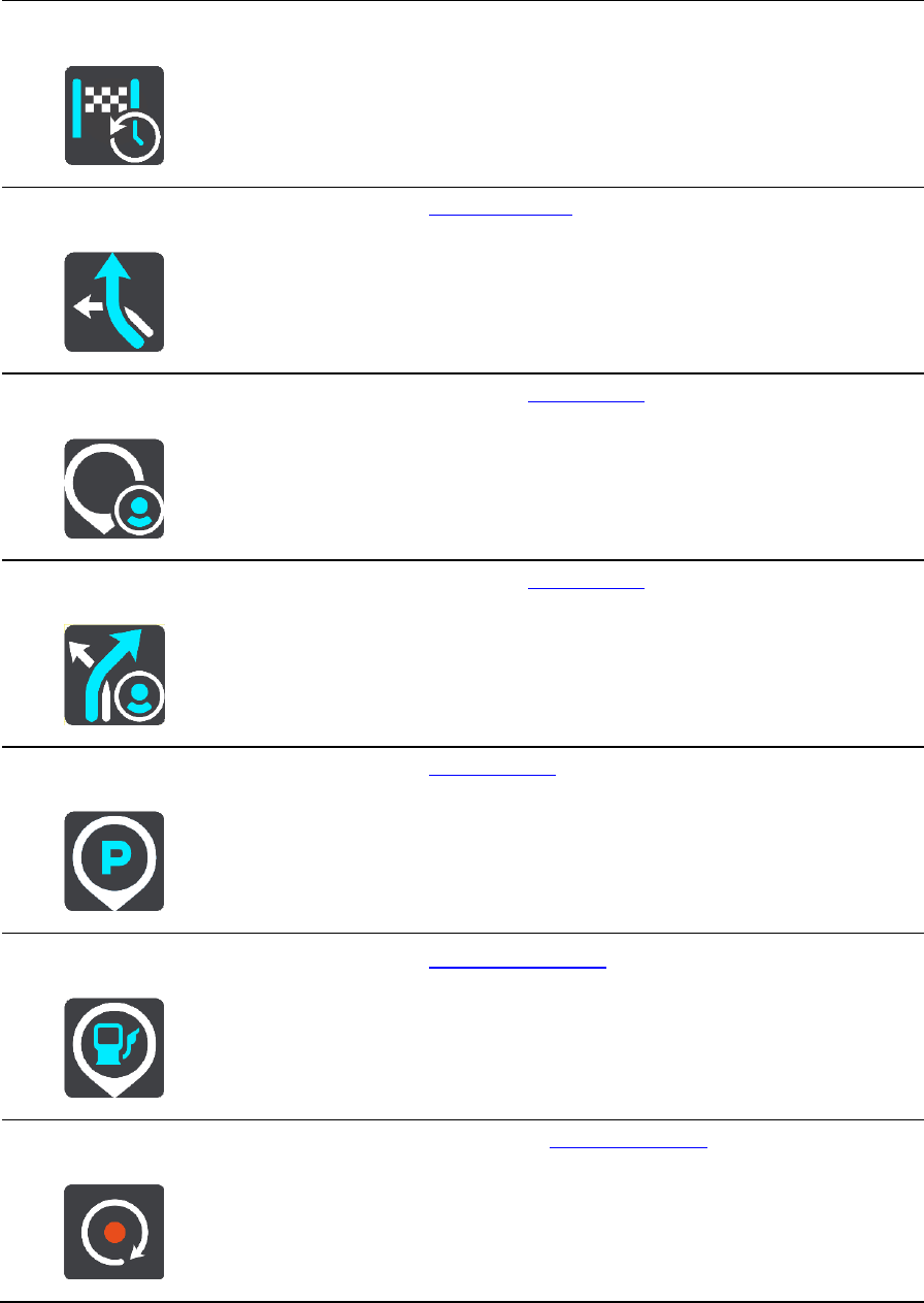
Main Menu smaller buttons and symbols
On the map or guidance view, select the Main Menu button to open the Main Menu.
19
The following buttons are available in the Main Menu screen, in addition to the navigation buttons:
Select this button to open the Settings Menu.
Select this button to open the Help Menu. The Help Menu contains
information about your TomTom GO, for example, map version, device
serial number and legal information.
Select this button to reorder the buttons in the Main Menu.
Select this button to return to the previous screen.
Select this button to return to the map view or guidance view.
This symbol shows the power level of the battery in your device.
This symbol shows that your TomTom GO is connected to your TomTom
account.
This symbol shows that your TomTom GO is not connected to your
TomTom account.
This button shows that you will hear voice instructions. Select this button
to switch off voice instructions. You will no longer hear spoken route
instructions but you will still hear information such as traffic information
and warning sounds.
Tip: You can select the types of instructions you want to hear. Select
Voices in the Settings Menu and select the instructions you want to
hear.
This button shows that you will not hear voice instructions. Select this
button to switch on voice instructions.
This button shows that the display is using day colours. Select the button
to reduce the brightness of the screen and display the map in darker
colours.
When driving at night or when driving through a dark tunnel, it is easier to
view the screen and less distracting for the driver if the brightness of the
screen is dimmed.
Tip: Your device automatically switches between day and night colours
depending on the time of day. To switch off this feature, select
20
Appearance in the Settings menu and switch off Switch to night colours
when dark.
This button shows that the display is using night colours. Select the button
to increase the brightness of the screen and display the map in brighter
colours.
Select this button to refresh your screen.
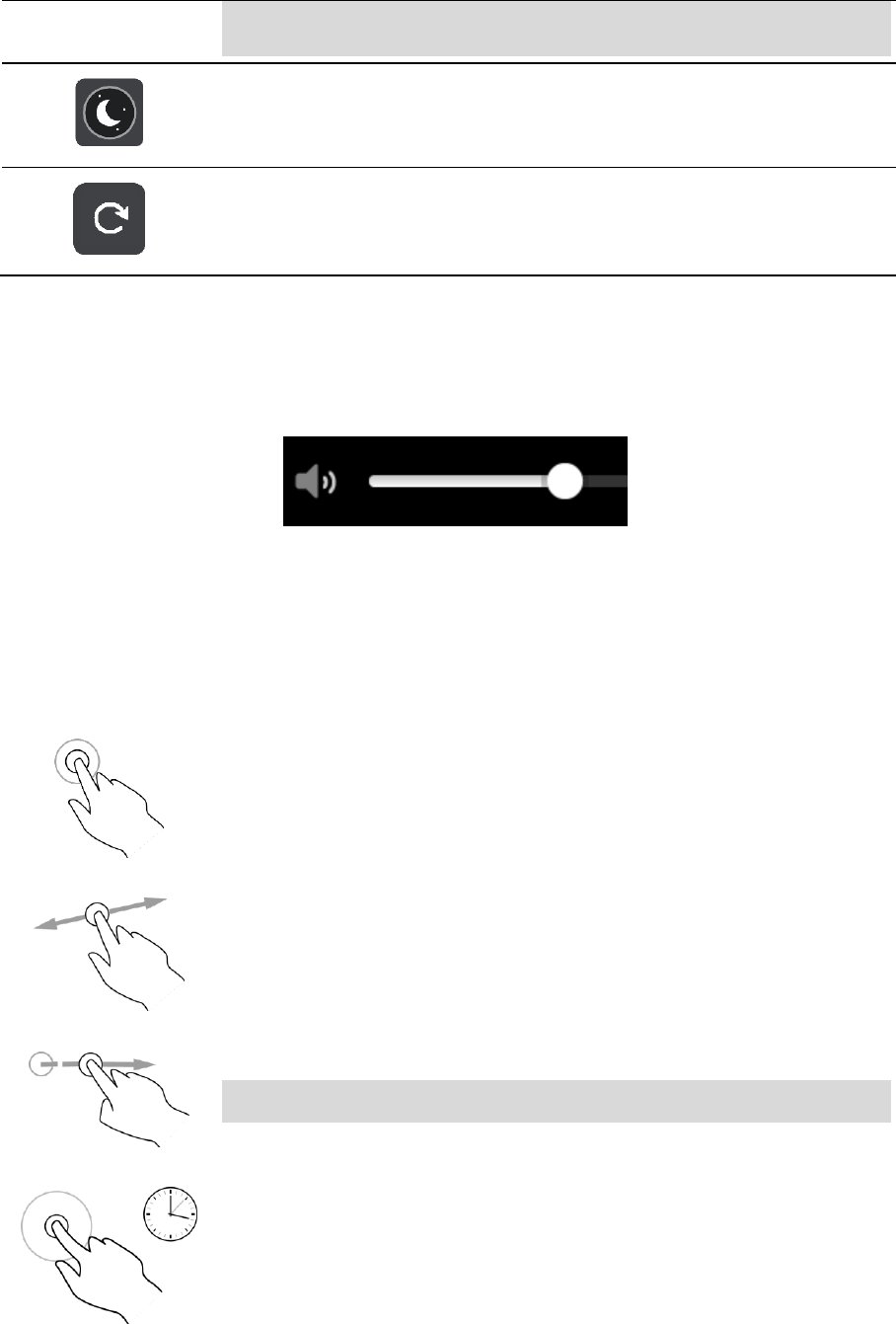
Volume control
On the map or guidance view, select the Main Menu button to open the Main Menu.
Select and slide the volume control to change the volume of voice instructions and warnings. If the
voice instructions are switched off, the volume control will still change the volume of the warnings.
Using gestures
You use gestures to control your TomTom GO.
In this User Manual, you learn how to use gestures to control your TomTom GO. Below is an
explanation of each gesture.
Double tap
Touch one finger on the screen twice in rapid succession.
Example of when to use this: Zooming in on the map.
Drag
Put one finger on the screen and move it across the screen.
Example of when to use this: Scrolling around in the map.
Flick
Flick the tip of a single finger across the screen.
Example of when to use this: Scrolling a big distance on the map.
Tip: Flick isn't available on all devices.
Press and hold
Put one finger on the screen for more than 0.5 second.
Example of when to use this: Opening the pop-up menu for a place on the
map.
21
Pinch to zoom
Touch the screen with your thumb and a finger. Move them apart to zoom
in or move them together to zoom out.
Example of when to use this: Zooming in and out on the map.
Tip: Pinch to zoom isn't available on all devices. If pinch to zoom isn't
available, use the zoom buttons to zoom in and out.
Tap or select
Tap a single finger on the screen.
Example of when to use this: Selecting an item in the Main Menu.
Changing the text and button size
You can change the size of the text and the buttons you see on the screen, for example to make the
text easier to read and the buttons easier to use.
Note: This feature is only available on devices with a 6 inch / 15 cm or larger screen.
To change the size of the text and the buttons, select the Settings button in the Main Menu, then
select Appearance, then select Size of text and buttons. Your device must restart to apply the
change.
Reordering the Main Menu buttons
To reorder the buttons in the Main Menu to suit your preference, do the following:
1. Select the Main Menu button to open the Main Menu.
2. Press and hold the button you want to move for two seconds.
Tip: Alternatively, select the Edit button in the Main Menu.
The menu button is shown with left and right arrows.
3. Press the left or right arrow on the menu button to move the button to a new position in the
menu.
4. Select and move other buttons to the order you want.
5. Select Done.

22
About TomTom MyDrive
TomTom MyDrive is the easy way to import community POI files on your TomTom GO Basic.
Logging in to your TomTom account
You must log in to MyDrive to sync to your TomTom account. When you log in to your TomTom
account from your navigation device or when using a web browser, syncing with your account
happens automatically.
Logging in to MyDrive on your TomTom GO
1. Connect your TomTom GO to your computer using MyDrive Connect.
2. In the Main Menu on your device, select TomTom Services.
3. Select MyDrive.
4. Enter the email address and password you use for your TomTom account.
5. Select Log In.
Your TomTom GO connects to your TomTom account.
6. Return to the map view.
Your TomTom GO automatically saves your personal navigation information to your TomTom
account.
Logging in to MyDrive using a web browser
Log in using your TomTom account email address and password. When you are logged in, you can
see your personal navigation information from your navigation devices, and you can select
destinations and create Places to sync with your navigation devices.
Finding and syncing locations using MyDrive
When you are logged in to TomTom MyDrive, you can find locations in MyDrive and sync them with
your TomTom GO My Places locations.
1. Connect your TomTom GO to your computer using MyDrive Connect.
2. In a web browser, log in to your TomTom account.
3. On the map, select a destination.
Tip: You can search for a destination or you can move the map and select a destination. You
can also select a destination from your My Places list.
4. Click on the location, then open the pop-up menu and select Add to My Places.
The location is shown in the Favourites list in the MyDrive My Places menu.
5. Log in to MyDrive on your TomTom GO.
Your TomTom GO syncs with your TomTom account and receives the new Favourites location.
The location is stored in My Places.
Syncing using TomTom MyDrive

23
Syncing My Places locations with MyDrive
When you are logged in to MyDrive on your TomTom GO, the locations you have added to My Places
are automatically synced with your TomTom account. You can see your My Places locations and the
POI place lists when you are logged in to MyDrive in a web browser.
Importing a community POI list - MyDrive - NOT CONNECTED
You can find collections of community POIs on the Internet and upload them to My Places using
MyDrive in a web browser. A POI collection might contain, for example, campsites or restaurants for
the area you are travelling in, and provides an easy way to select a location without the need to
search for the location each time.
Your TomTom GO uses .OV2 files for POI collections.
To upload an .OV2 file to your TomTom GO, do the following:
1. Connect your TomTom GO to your computer using MyDrive Connect.
2. In MyDrive, select Import POI File and browse to your .OV2 file.
Tip: The name of the places list in My Places will be the same as the name of the .OV2 file.
Edit the name of the file so that you can easily recognise it in My Places.
3. Upload the POI list to your TomTom GO.
Your new POI list is shown in the Places list.
4. In My Places, select your new POI list.
Your new POI list opens showing all the POIs in the list. Select the map view to see the POIs on
the map.
Deleting a community POI list
You can only delete an uploaded POI list when your TomTom GO is connected to your computer
using MyDrive Connect.
To delete a POI list, do the following:
1. Connect your TomTom GO to your computer using MyDrive Connect.
2. In MyDrive, select the POI file you want to delete, then select Delete.
The POI list is removed from your My Places list.
Importing a track GPX file
GPX files (GPS exchange format)
GPX files contain a very detailed recording of a route, including any off-road locations. A GPX file
might contain, for example, a tourist route or a preferred fixed route. You can find collections of
.GPX files on the Internet and upload them to My Routes using MyDrive in a web browser. GPX files
become tracks after import.
Tracks have a beginning and an end but no stops, and there's a fixed map-dependent route between
these points. Your device follows this fixed route as closely as possible. You can edit tracks using
MyDrive.
Using GPX files
You use MyDrive on your computer to import .GPX track files to your TomTom device. The tracks are
saved in the My Routes menu. Your device will navigate along the GPX track exactly and will not
offer to replan your route, even if a faster route is available.

24
Importing a track GPX file
Note: Your TomTom GO needs at least 400 MB free space before it can import .OV2 and .GPX
files. If you see the message You need more space, make space available by deleting unwanted
.OV2 or .GPX files using MyDrive, or deleting device content, for example delete a map you don't
use.
To import a .GPX file using MyDrive, do the following:
1. Connect your TomTom GO to your computer using MyDrive Connect.
2. In MyDrive, select My Routes.
3. Select Import a GPX File and browse to your .GPX track file.
Tip: The name of the track file in My Routes will be the same as the name of the .GPX file.
Edit the name of the file so that you can easily recognise it in My Routes.
Your new track is shown in the My Routes list.
4. Wait for the track file to upload to your TomTom GO.
5. Open My Routes.
Your imported track is shown in your My Routes list.
Deleting a track GPX file
You can only delete an uploaded track GPX file when your TomTom GO is connected to your
computer using MyDrive Connect.
To delete a POI list, do the following:
1. Connect your TomTom GO to your computer using MyDrive Connect.
2. In MyDrive, select My Routes.
3. Select the track file you want to delete, then select Delete.
The track is removed from your My Routes list.
Saving and restoring your personal navigation information
When you are logged in to MyDrive on your TomTom GO, and your TomTom GO is connected to your
computer, your personal navigation information is continuously and automatically saved to your
TomTom account.
If you reset your TomTom GO, or log in to MyDrive on a different device, your saved personal
navigation information is restored to your TomTom GO or the different device.
The following personal navigation information is saved to your TomTom account:
MyDrive destinations.
All saved locations in My Places.
All imported POI place lists.
All imported tracks.
Tip: MyDrive also syncs your locations in My Places with your TomTom account. You can see your
My Places locations and the POI place lists you have imported in MyDrive on a web browser or on
the MyDrive app.
Make sure that there is at least 400 MB of free space on your device before syncing your device with
MyDrive. If there is not enough space, your MyDrive information will not be synced. You can check
the amount of available space by going to About in the Help menu on your device.
Note: Syncing a lot of information to your device may take some time.
25
About search
STEP BY STEP SEARCH ONLY
You use the Drive To menu to find addresses and Points of Interest (POI) and then navigate to them.
You must first choose the country or state you want to search in, then enter the address or the POI
type or name.
In Address, you can search for the following:
A specific address in a town or city.
A postcode, for example, type in W1D 1LL for Oxford Street, London.
A city to navigate to a city centre, for example, type in London.
In Points of Interest, you can search for the following:
A POI (Point of Interest), for example type in museum.
In Latitude Longitude, you can search for the following:
Latitude and longitude coordinates, for example, type in:
N 51°30′31″ W 0°08′34″.
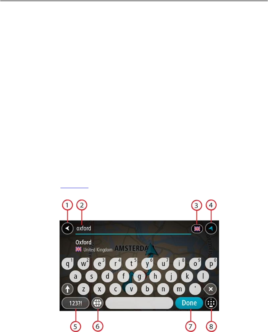
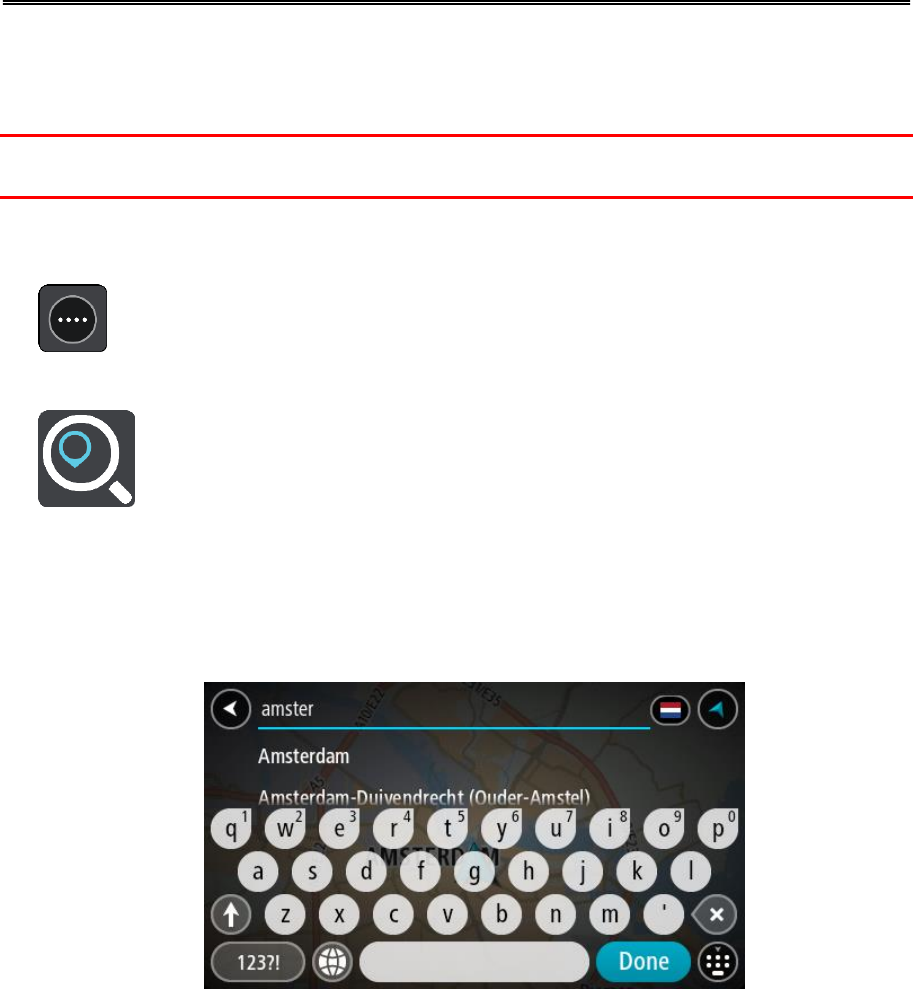
Entering search terms
STEP BY STEP SEARCH ONLY
Select Drive To in the Main Menu, then select Address or Point of Interest. The search screen
shows the keyboard and the following buttons:
1. Back button
Select this button to go back to the previous screen.
2. Search input box
Using step by step search
26
Enter your search term here. As you type, matching addresses or POIs are shown.
Tip: If you press and hold a letter key on the keyboard, you get access to extra characters if
they are available. For example, press and hold the letter "e" to access characters 3 e è é ê ë
and more.
Tip: To edit, select a word you have already typed to place the cursor. You can then insert or
delete characters.
3. Country or state selector
Select the country or state you want to search.
4. View button
Select this button to return to the map view or guidance view.
5. 123?! button
Select this button to use numbers and symbols on your keyboard. Select the =\< button to
toggle between the numbers and more symbols. Select the ABC button to go back to the general
keyboard.
6. Keyboard layout button
Select this button to change your keyboard layout to another language. You can choose up to
four layouts from the list. If you have more than one layout selected, selecting the keyboard
layout button opens a pop-up so you can quickly swap between your selected keyboard layouts.
Press and hold this button to go directly to the list of all the layouts.
7. Done button
Select this button to hide the keyboard.
8. Show/hide keyboard button
Select this button to show or hide the keyboard.
Tip: Select the Shift key once to make the next letter you type upper case. Double tap the Shift
key to use Caps-Lock where all the letters you type are upper case. Select the Shift key once to
quit Caps-Lock.
Tip: To cancel a search, select the map/guidance view button in the top right-hand corner of the
screen.
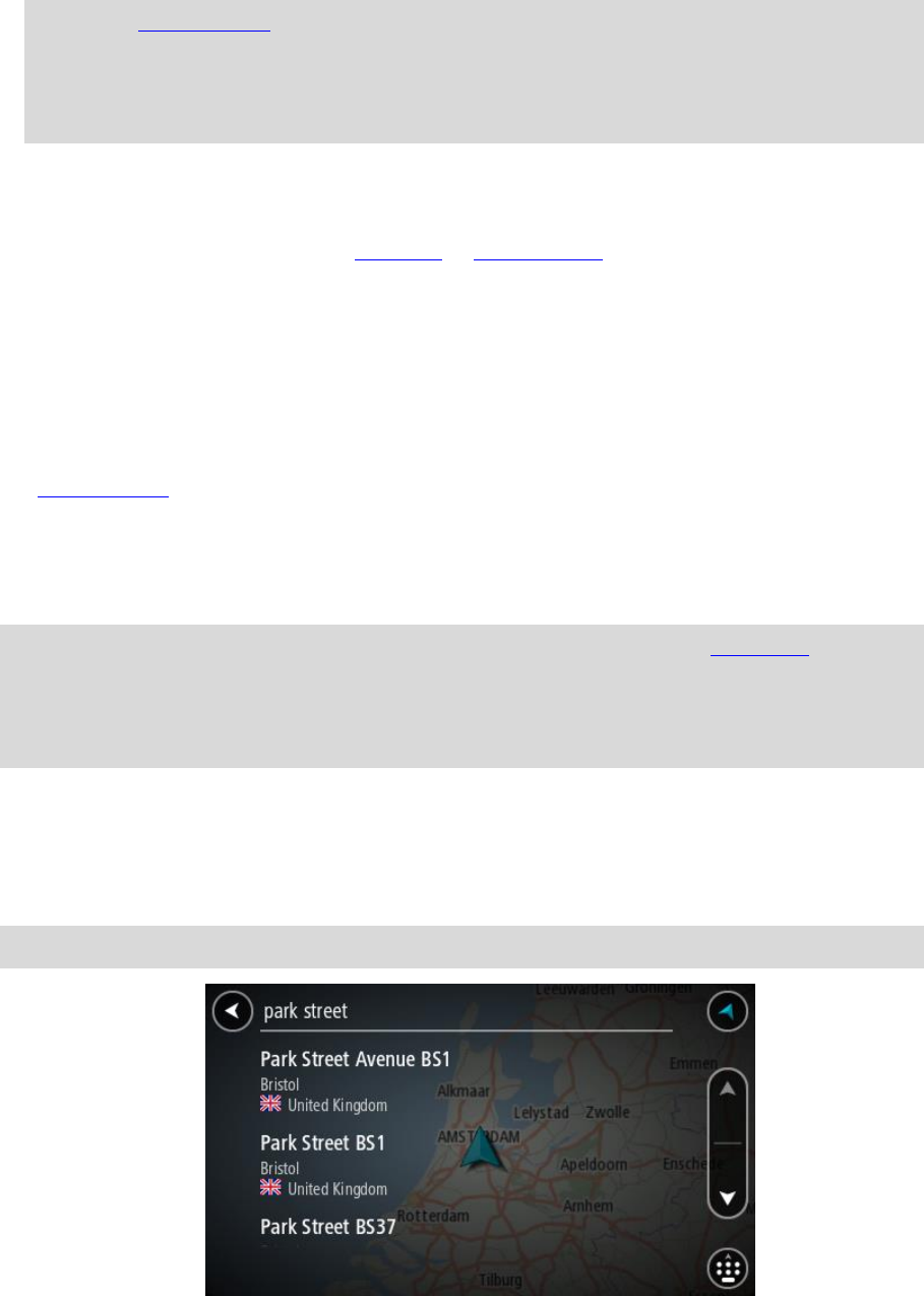
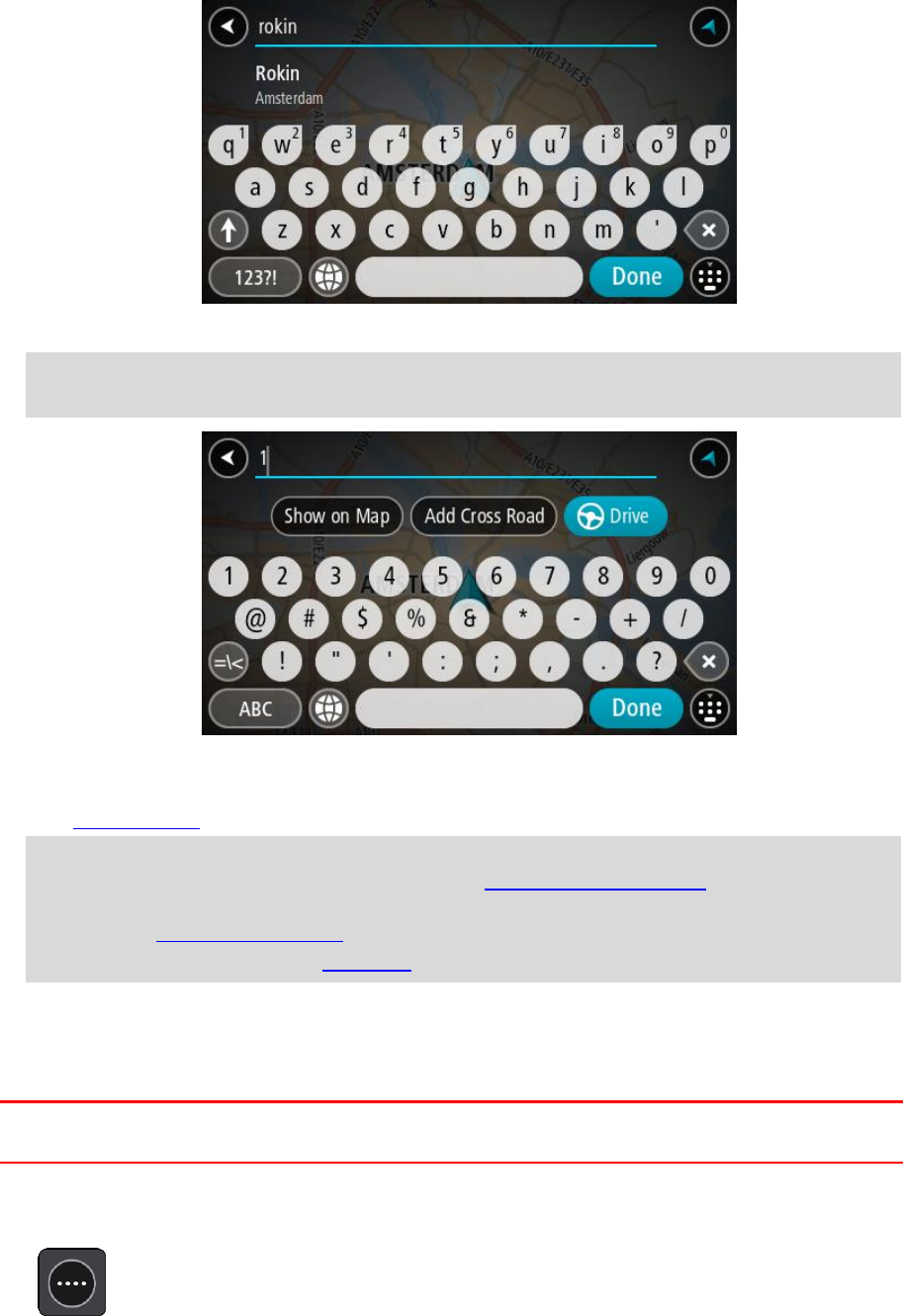
Working with search results
STEP BY STEP SEARCH ONLY
Your Address or Point of Interest search results are shown in a list.
Tip: To see more results, hide the keyboard or scroll down the results list.
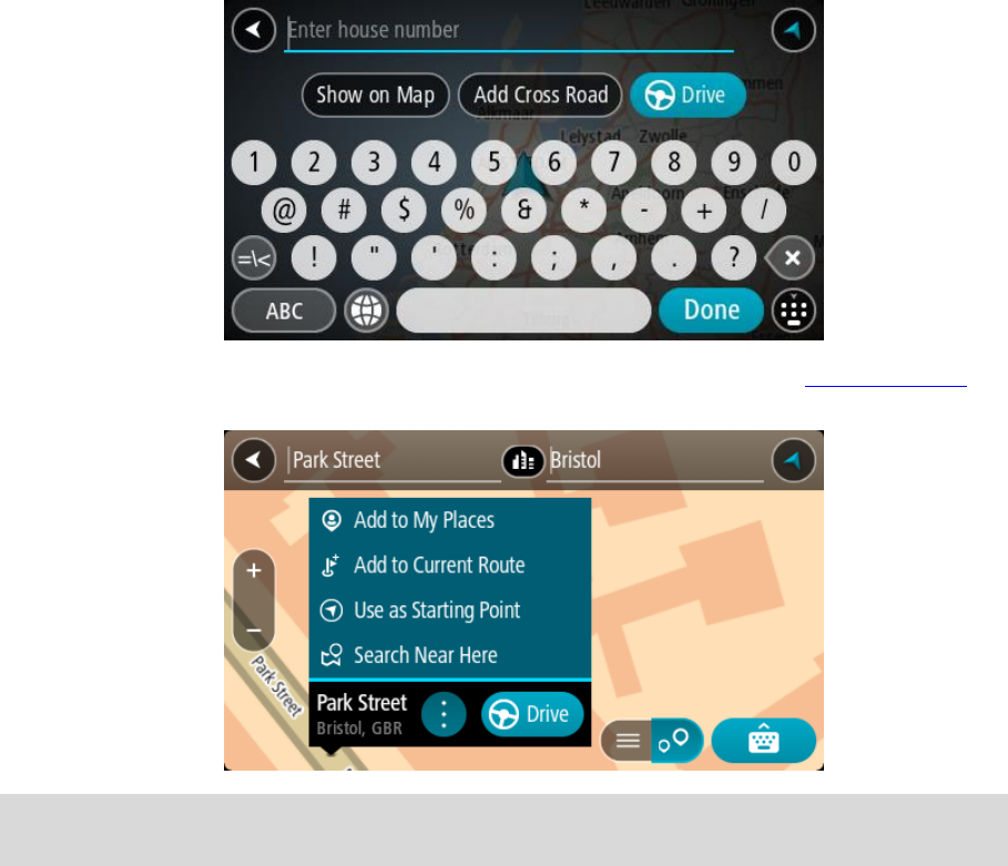
27
When you select an address from the list of search results, you can choose to show it on the map,
add a cross road or plan a route to that chosen location. To get an exact address you can add the
house number. When you select a POI from the list of search results, it is shown on the map.
When you show the address or POI on the map, you can use the pop-up menu to add the location to
My Places. If a route is already planned, you can add the location to your current route.
Note: The best search results are shown on the map. When you zoom in, the lower ranked search
results are gradually shown.
About postcodes
When searching using a postcode, your results depend on the type of postcode used in the country
that you are searching in.
The following types of postcodes are used:
Postcodes that navigate you to a street or part of a street.
Postcodes that navigate you to an area comprising, for example, a single town, several villages
in a rural area or a district in a large city.
Postcodes for streets
Countries such as the Netherlands and the United Kingdom use this type of postcode. When you
search using this type of postcode, enter the postcode, then leave a space and then optionally enter
the house number. For example, "1017CT 35". Your device then plans a route to a specific house or
building on a specific street.
28
Postcodes for areas
Countries such as Germany, France and Belgium use this type of postcode. If you search using a
postcode for an area, your results include all the streets in a city district, the whole town, or the
villages within that postcode.
When using quick search, you may get results from multiple countries if you enter a postcode for an
area.
Note: If you search using a postcode for an area, you will not get a specific address in your
results.
This type of postcode is still very useful in reducing the number of search results. For example, a
search for Neustadt in Germany returns a long list of possible results. Adding a space followed by
the postcode for an area narrows the results down to the Neustadt that you are looking for.
As another example, if you want to search in a city, enter a postcode for an area and select the city
centre you are searching for from the results.
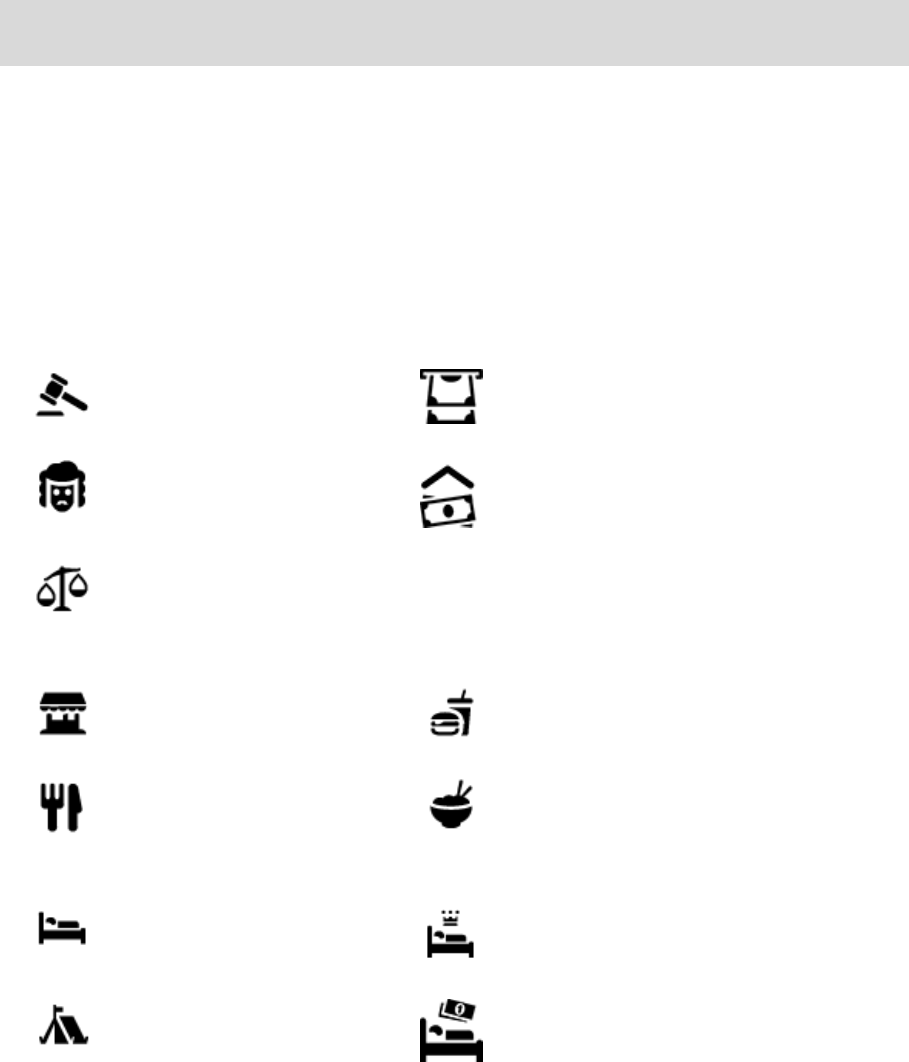
List of POI type icons
Legal and financial services
Court house
Cash dispenser
Legal - Solicitors
Financial institution
Legal - other services
Food services
Convenience store
Fast food restaurant
Restaurant
Chinese restaurant
Accommodation
Hotel or motel
Luxury hotel
Camping ground
Economy chain hotel
Emergency services
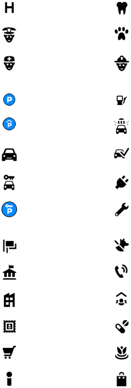
29
Hospital or polyclinic
Dentist
Police station
Veterinarian
Doctor
Fire station
Car-related services
Outside parking
Petrol station
Parking garage
Car wash
Car dealer
Vehicle inspection centre
Rental car facility
Electrical car charging
point(s)
Rental car parking
Car repair facility
Other services
Embassy
Pet services
Government office
Telecommunication
Company
Community service
Post office
Pharmacy
Shopping centre
Beauty services
Tourist information office
Shop
30
Education
College or university
School
Library
Convention centre
Leisure
Casino
Winery
Theatre
Tourist attraction
Cinema
Zoo
Concert hall
Amusement park
Museum
Exhibition centre
Opera
Cultural centre
Nightlife
Leisure centre
Children's Farm
Sport
Playing field
Swimming pool
Mountain peak
Water sports
Beach
Tennis court
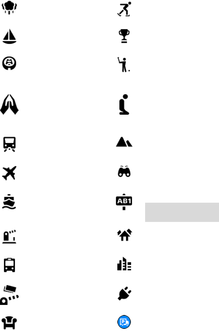
31
Park or recreation area
Ice skating rink
Yacht basin or marina
Sports centre
Stadium
Golf course
Religion
Church
Place of worship
Travel
Railway station
Mountain pass
Airport
Scenic or panoramic view
Ferry terminal
Postcode
Note: Not used in all
countries.
Border crossing
Residential area
Bus station
City centre
Toll gate
Electrical car charging
stations
Rest area
Truck stop
32
Planning a route to an address
STEP BY STEP SEARCH ONLY
Important: In the interest of safety and to avoid distractions while you are driving, you should
always plan a route before you start driving.
To plan a route to an address, do the following:
1. Select the Main Menu button to open the Main Menu.
2. Select Drive To.
3. Select Address.
You can change the country or state setting by selecting the flag before you select a city.
4. Enter the town or city name, or the postcode.
Towns with similar names are shown in the list while you type.
When the correct city or town appears in the list, select the name.
5. Enter the street name.
Streets with similar names are shown in the list while you type.
Planning a route using step by step
search
33
When the correct street name appears in the list, select the name.
6. Enter the house number.
Tip: If the house number does not exist then it appears red. The nearest house number is then
shown in the Drive to button.
7. Select Drive/Ride depending on which device you are using.
A route is planned and then guidance to your destination begins. As soon as you start driving,
the guidance view is shown automatically.
Tip: If your destination is in a different time zone, you see a plus (+) or a minus (-) sign and
the time difference in hours and half hours in the arrival information panel. The estimated
time of arrival is the local time at your destination.
Tip: You can add a stop to a route that you have already planned.
Tip: You can save a route using My Routes.
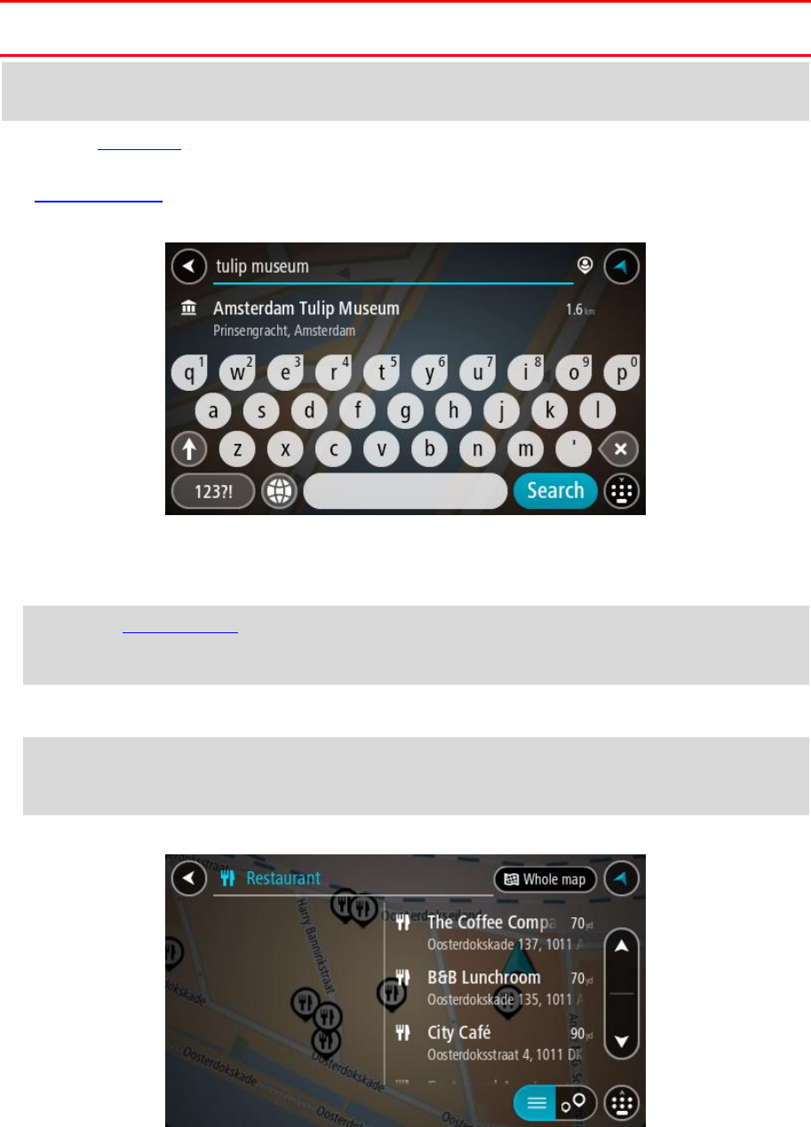
Planning a route to a POI
STEP BY STEP SEARCH ONLY
Important: In the interest of safety and to avoid distractions while you are driving, you should
always plan a route before you start driving.
To plan a route to a POI type or a specific POI using search, do the following:
1. Select the Main Menu button to open the Main Menu.
34
2. Select Drive To.
3. Select Point of Interest.
You can change the country or state setting by selecting the flag before you select a city.
4. Choose where to search. You can select from one of the following options:
- Near me.
- In town or city.
- Along route if you have planned a route.
- Near destination if you have planned a route.
- Near point on map if you have selected a point on the map.
- Near departure point if you have planned a route or a track.
5. Enter the name of the place you want to plan a route to.
Tip: If you press and hold a letter key on the keyboard, you get access to extra characters if
they are available. For example, press and hold the letter "e" to access characters 3 e è é ê ë
and more.
You can search for a POI (Point of Interest) type, such as a restaurant or tourist attraction.
Alternatively, you can search for a specific POI, for example "Rosie's Pizzeria".
As you type, suggestions based on what you have entered are shown.
6. Select a POI type or an individual POI. If you selected a POI type, select a POI.
The location is shown on the map.
35
7. To see more information about the POI, select the POI on the map and then select the pop-up
menu button. Select More Information on the pop-up menu.
You see more information about the POI such as the phone number, full address and email.
8. To plan a route to this destination, select Drive/Ride depending on which device you are using.
A route is planned and then guidance to your destination begins. As soon as you start driving,
the guidance view is shown automatically.
Tip: If your destination is in a different time zone, you see a plus (+) or a minus (-) sign and
the time difference in hours and half hours in the arrival information panel. The estimated
time of arrival is the local time at your destination.
Tip: You can add a stop to a route that you have already planned.
Tip: You can save a route using My Routes.
Planning a route to a city centre
STEP BY STEP SEARCH ONLY
Important: In the interest of safety and to avoid distractions while you are driving, you should
always plan a route before you start driving.
To plan a route to a city centre, do the following:
1. Select the Main Menu button to open the Main Menu.
2. Select Drive To.
3. Select Address.
You can change the country or state setting by selecting the flag before you select a city.
4. Enter the town or city name.
Towns with similar names are shown in the list while you type.
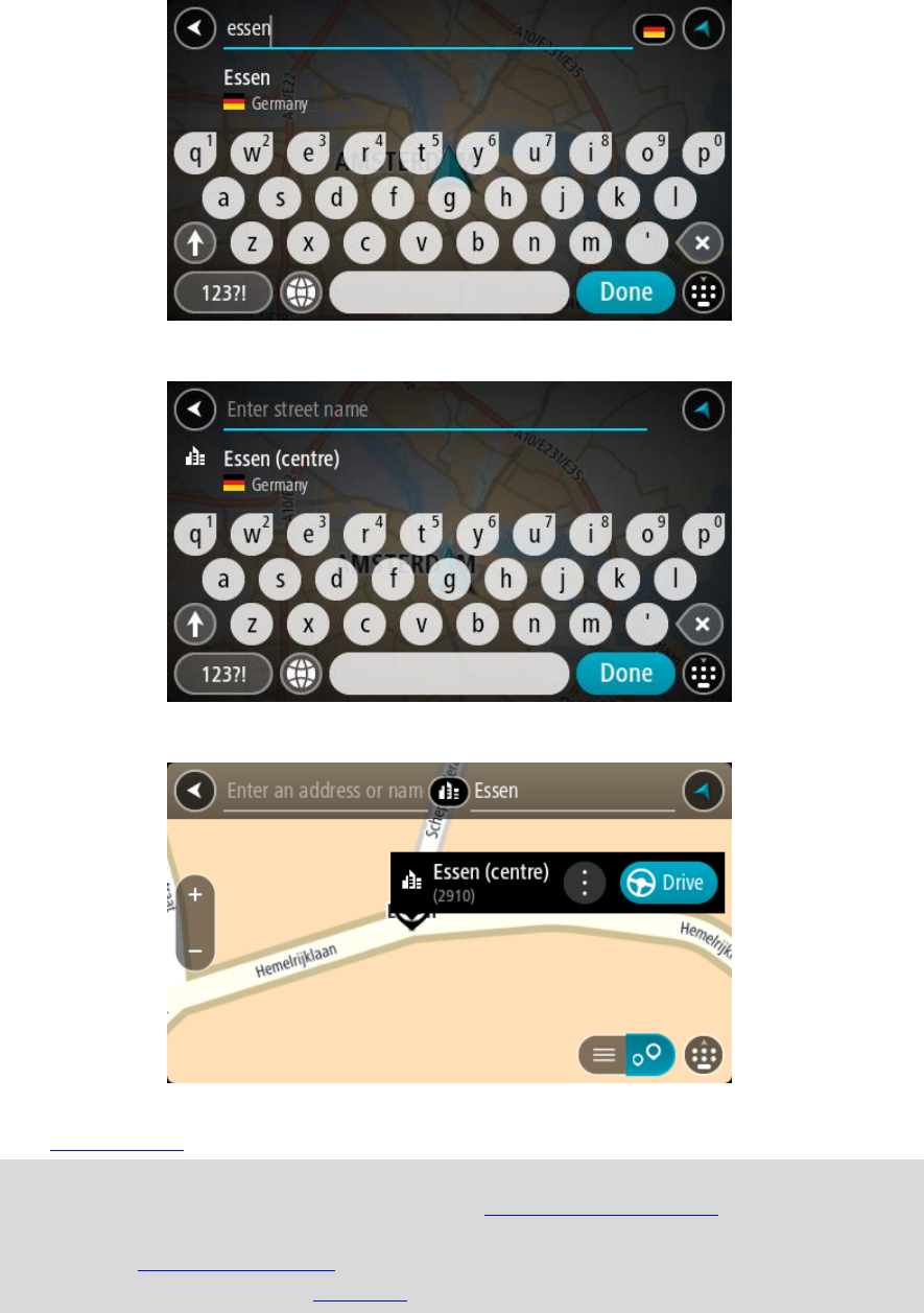
36
When the correct city or town appears in the list, select the name.
5. Select the city centre POI.
6. Select Drive/Ride depending on which device you are using.
A route is planned and then guidance to your destination begins. As soon as you start driving,
the guidance view is shown automatically.
Tip: If your destination is in a different time zone, you see a plus (+) or a minus (-) sign and
the time difference in hours and half hours in the arrival information panel. The estimated
time of arrival is the local time at your destination.
Tip: You can add a stop to a route that you have already planned.
Tip: You can save a route using My Routes.
37
Planning a route to a POI using online search
STEP BY STEP SEARCH ONLY
Important: In the interest of safety and to avoid distractions while you are driving, you should
always plan a route before you start driving.
Note: Searching online is only available on connected devices. To search online on your TomTom
GO, you must be connected to TomTom services.
If you did a POI search but could not find the POI you were looking for, you can search TomTom
Places online. To find POIs by searching online, do the following:
1. Search for a POI using Drive to in the Main Menu.
The search results are shown in a list.
2. Scroll to the bottom of the list and select Search Places Online.
3. Use the keyboard to enter the name of the POI you want to find, then press the Search button
on the keyboard.
Tip: If you press and hold a letter key on the keyboard, you get access to extra characters if
they are available. For example, press and hold the letter "e" to access characters 3 e è é ê ë
and more.
You can search for a POI (Point of Interest) type, such as a restaurant or tourist attraction.
Alternatively, you can search for a specific POI, for example "Rosie's Pizzeria".
Note: When searching, you can search near your current location, in a town or city, or near
your destination. If you want to change how the search is done, select the button to the right
of the search box.
The search results are shown in a column.
38
Tip: To see more results, hide the keyboard or scroll down the results list.
Tip: You can switch between seeing the results on the map or in a list by selecting the
list/map button:
4. Select an individual POI from the list.
The location is shown on the map.
5. To see more information about the POI, select the POI on the map and then select the pop-up
menu button. Select More Information on the pop-up menu.
You see more information about the POI such as the phone number, full address and email.
6. To plan a route to this destination, select Drive/Ride depending on which device you are using.
A route is planned and then guidance to your destination begins. As soon as you start driving,
the guidance view is shown automatically.
Tip: If your destination is in a different time zone, you see a plus (+) or a minus (-) sign and
the time difference in hours and half hours in the arrival information panel. The estimated
time of arrival is the local time at your destination.
Tip: You can add a add a stop to a route that you have already planned.
Tip: You can save a route using My Routes.
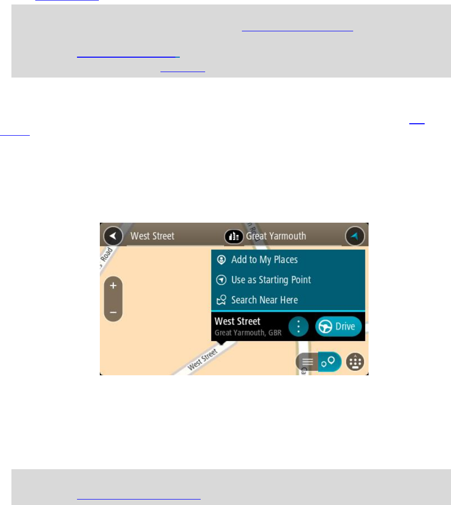
Planning a route using the map
Important: In the interest of safety and to avoid distractions while you are driving, you should
always plan a route before you start driving.
To plan a route using the map, do the following:
39
1. Move the map and zoom in until you can see the destination that you want to navigate to.
Tip: You can also select a map symbol to open the pop-up menu, then select the Drive/Ride
button to plan a route to that location.
2. When you have found your destination on the map, select it by pressing and holding the screen
for about one second.
A pop-up menu shows the nearest address.
3. To plan a route to this destination, select Drive/Ride depending on which device you are using.
A route is planned and then guidance to your destination begins. As soon as you start driving,
the guidance view is shown automatically.
Tip: You can use the location you selected in other ways, such as adding it to My Places, by
selecting the pop-up menu button.
40
Tip: If your destination is in a different time zone, you see a plus (+) or a minus (-) sign and
the time difference in hours and half hours in the arrival information panel. The estimated
time of arrival is the local time at your destination.
Tip: You can add a stop to a route that you have already planned.
Tip: You can save a route using My Routes.
Planning a route using My Places
To navigate to one of My Places from your current location, do the following:
1. Select the Main Menu button to open the Main Menu.
2. Select My Places.
A list of all your Places opens.
3. Select the Place you want to navigate to, for example Home.
Your chosen Place is shown on the map with a pop-up menu.
4. To plan a route to this destination, select Drive/Ride depending on which device you are using.
A route is planned and then guidance to your destination begins. As soon as you start driving,
the guidance view is shown automatically.
41
Tip: If your destination is in a different time zone, you see a plus (+) or a minus (-) sign and
the time difference in hours and half hours in the arrival information panel. The estimated
time of arrival is the local time at your destination.
Tip: You can add a stop to a route that you have already planned.
Tip: You can save a route using My Routes.
Planning a route using coordinates using step by step search
STEP BY STEP SEARCH ONLY
Important: In the interest of safety and to avoid distractions while you are driving, you should
always plan a route before you start driving.
To plan a route using a pair of coordinates, do the following:
1. Select the Main Menu button to open the Main Menu.
2. Select Drive To.
3. Select Latitude Longitude.
Tip: The example coordinates shown on the screen are your current latitude and longitude.
4. Type in your pair of coordinates. You can enter any of these coordinate types:
Decimal values, for example:
N 51.51000 W 0.13454
51.51000 -0.13454
Tip: For decimal values you don't have to use a letter to indicate the latitude and longi-
tude. For locations west of the 0 meridian and locations south of the equator, use a minus
sign (-) before the coordinate.
Degrees, minutes and seconds, for example:
N 51°30′31″ W 0°08′34″
GPS standard coordinates, for example:
N 51 30.525 W 0 08.569
Note: The bar below the coordinates goes red if you enter coordinates that are not recognised
by your TomTom GO.
5. As you type in the coordinates, suggestions are shown based on what you have entered. You can
continue typing or select a suggestion.
Tip: To see more results, hide the keyboard or scroll down the results list.
Tip: You can switch between seeing the results on the map or in a list by selecting the
list/map button:
42
6. Select a suggestion for your destination.
The location is shown on the map.
7. To plan a route to this destination, select Drive/Ride depending on which device you are using.
A route is planned and then guidance to your destination begins. As soon as you start driving,
the guidance view is shown automatically.
Tip: If your destination is in a different time zone, you see a plus (+) or a minus (-) sign and
the time difference in hours and half hours in the arrival information panel. The estimated
time of arrival is the local time at your destination.
Tip: You can add a stop to a route that you have already planned.
Tip: You can save a route using My Routes.
Planning a route in advance
You can plan a route in advance before you drive it. You can save the route as part of your My
Routes list.
To plan a route in advance, do the following:
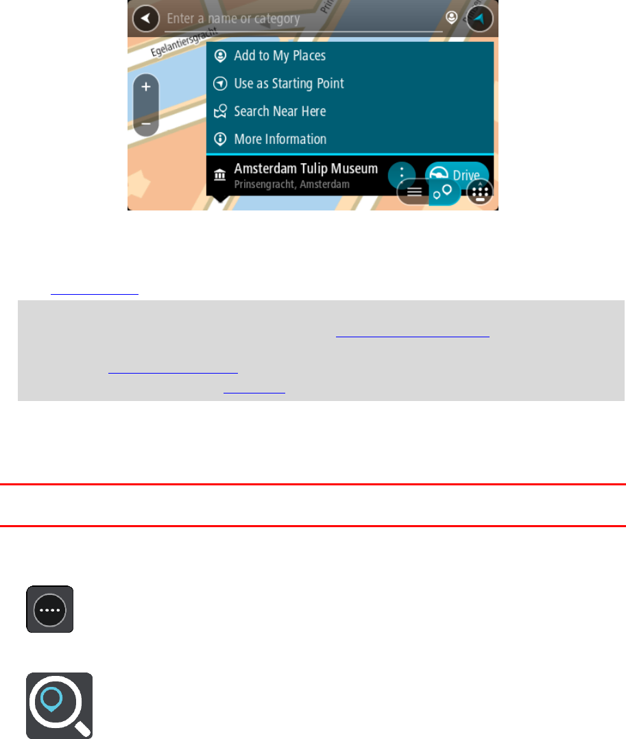
1. Search for the location you want to use as a starting point.
2. Select Show on Map.
3. Select the pop-up menu button.
A pop-up menu shows a list of options.
4. Select Use as Starting Point.
5. Search for the location you want to use as your destination.
6. Select Show on Map.
7. Select Drive/Ride in the pop-up menu.
Your route is planned using your chosen starting point and destination. The estimated journey
time is shown at the top of the route bar.
Tip: Stops, POIs and Places can all be selected as starting points using their pop-up menus.
Tip: You can save the route in My Routes.
8. To drive to the starting point, select Drive/Ride at the top of the screen.
The starting point of the route is converted to your first stop and then the route is planned.
Guidance to your destination begins from your current location. As soon as you start driving, the
guidance view is shown automatically.
Changing the starting point to be your current location
1. Select the starting point of the route in the map view.
2. Select the pop-up menu button.
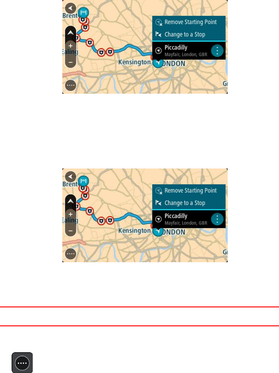
43
A pop-up menu shows a list of options.
3. Select Remove Starting Point.
Your route is replanned with your current location as the starting point. The original starting
point is removed from your route.
Changing the starting point into a stop
1. Select the starting point on the route in the map view.
2. Select the pop-up menu button.
A pop-up menu shows a list of options.
3. Select Change to a Stop.
Your route is replanned with the starting point changed into a stop.
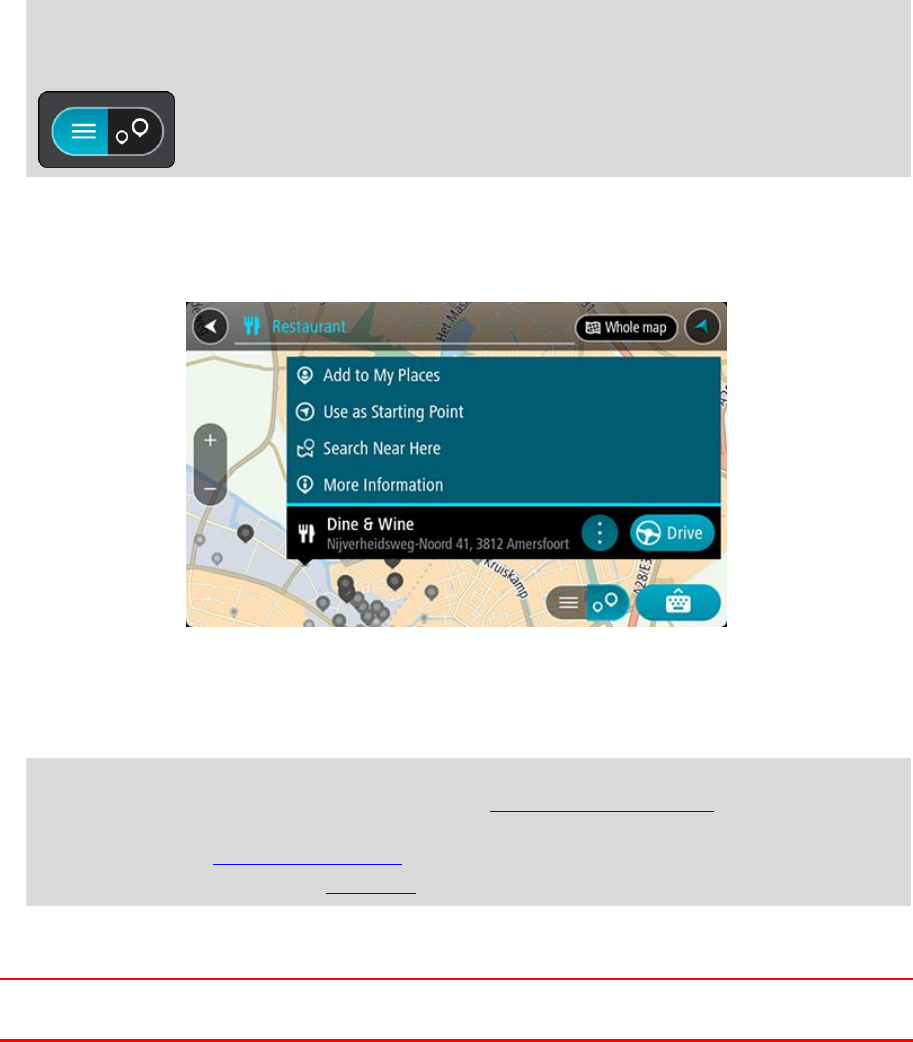
Finding a car park
Important: In the interest of safety and to avoid distractions while you are driving, you should
always plan a route before you start driving.
To find a car park, do the following:
1. Select the Main Menu button to open the Main Menu.
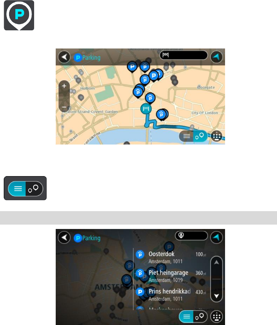
44
2. Select Parking.
The map opens showing the locations of car parks.
If a route is planned, the map shows car parks near your destination. If a route isn't planned,
the map shows car parks near your current location.
You can change the screen to show a list of car parks by pressing this button:
You can select a car park from the list to locate it on the map.
Tip: You can scroll down the list of results using the scroll bar on the right side of the screen.
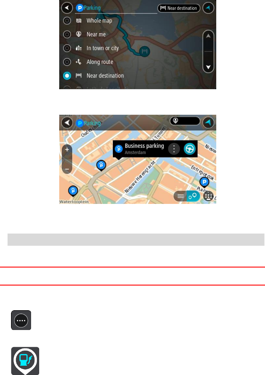
45
If you want to change how the search is done, select the button to the right of the search box.
You can then change where the search is carried out, for example, to search near you or the
whole map.
3. Select a car park from the map or the list.
A pop-up menu opens on the map showing the name of the car park.
4. Select Drive/Ride depending on which device you are using.
A route is planned and then guidance to your destination begins. As soon as you start driving,
the guidance view is shown automatically.
Tip: You can add a car park as a stop on your route by using the pop-up menu.
Finding a petrol station
Important: In the interest of safety and to avoid distractions while you are driving, you should
always plan a route before you start driving.
To find a petrol station, do the following:
1. Select the Main Menu button to open the Main Menu.
2. Select Petrol Station.
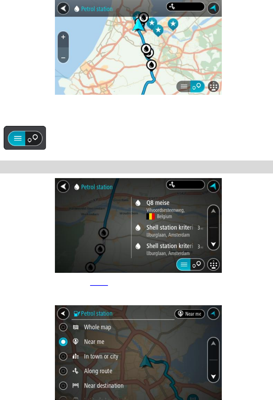
46
The map opens showing the locations of petrol stations.
If a route is planned, the map shows petrol stations along your route. If a route isn't planned,
the map shows petrol stations near your current location.
You can change the screen to show a list of petrol stations by pressing this button:
You can select a petrol station from the list to locate it on the map.
Tip: You can scroll down the list of results using the scroll bar on the right side of the screen.
If you want to change how the search is done, select the button to the right of the search box.
You can then change where the search is carried out, for example, to search near you or the
whole map.
3. Select a petrol station from the map or the list.
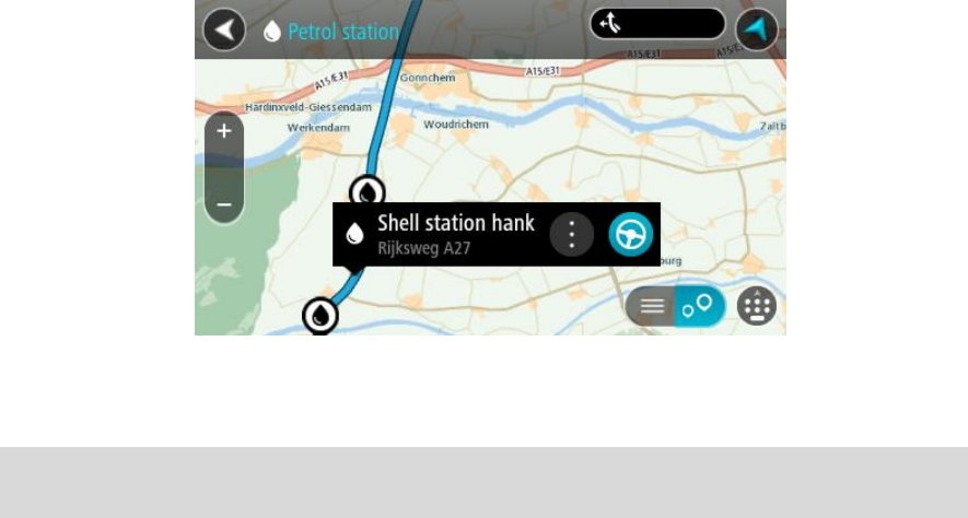
47
A pop-up menu opens on the map showing the name of the petrol station.
4. Select Drive/Ride depending on which device you are using.
A route is planned and then guidance to your destination begins. As soon as you start driving,
the guidance view is shown automatically.
Tip: You can add a petrol station as a stop on your route by using the pop-up menu. A petrol
station that is a stop on your route has a blue icon.
48
The Current Route menu
When you have planned a route or track, select the Current Route or Current Track button in the
Main Menu to open the Current Route or Current Track Menu.
The following buttons are available in the menu:
Clear Route / Clear
Track
Select this button to clear the currently planned route or track.
The Current Route Menu closes and you return to the map view.
Skip Next Stop
Select this button to skip the next stop on your route.
Find Alternative
You see this button when you have planned a route. Select this button to
show up to three alternative routes on the map view.
Avoid Blocked Road
Select this button to avoid an unexpected obstacle that is blocking the
road on your route.
Avoid Part of Route
Select this button to avoid part of a route.
Avoid Toll Roads
and More
Select this button to avoid some types of route features that are on your
currently planned route. These include ferries, toll roads and unpaved
roads.
You can also avoid route features using the route bar.
Changing your route
49
Show Instructions
Select this button to see a list of turn-by-turn text instructions for your
planned route.
The instructions include the following:
Your current location.
Street names.
Up to two road numbers shown in road shields whenever available.
An instruction arrow.
An instruction description.
The distance between two consecutive instructions.
Exit number.
The full addresses of stops on your route.
Tip: Select an instruction to see a preview of that section of the route
in the map view.
You can also select the instruction panel in the guidance view to see
turn-by-turn text instructions.
Add Stop to Route
Select this button to add a stop to your currently planned route. You can
also add a stop to your route directly from the map.
Add to My Routes
If you plan a new route that has not already been saved, you see this
button. Select this button to save this route as part of your My Routes list.
Save Changes to
Route
If you make a change to a My Route, you see this button. Select this
button to save the changes.
Change Route Type
Select this button to change the type of route used to plan your route.
Your route will be recalculated using the new route type.
Reorder Stops
Select this button to see the lists of stops for your current route. You can
then change the order of the stops on your route.
50
Drive to Route or
Track
Select Drive to Route to plan a route from your current location to the
starting point of a My Route. The starting point is converted to a stop.
Drive to Track plans a route to the nearest point of the track from your
current position.
Drive to Starting
Point
On the Current Track menu, select this button to plan a route to the
starting point of the track. The starting point is converted to a stop. For
more information, see Navigating using a track.
Share Track
On the Current Track menu, select this button to export the current track
as a GPX file and save it on a memory card for sharing with other users.
Play Route or
Track Preview
Select this button to watch a preview of your planned route or track.
Stop Route or
Track Preview
Select this button to stop the preview of your planned route or track.
Avoiding a blocked road
If there is a blocked road on your route you can change your route to avoid it.
1. In the guidance view, select the current location symbol or the speed panel.
Tip: The speed panel is only shown when you have started driving on your route.
2. Select Avoid Blocked Road.
A new route is found that avoids the blocked road. You may get shown up to two alternatives
depending on the road network between you and your destination.
The new route is shown on the map view with the difference in travel time in a balloon.
Note: It may not be possible to find an alternative route around the blocked road if none
exists.
3. Select the new route by selecting the time balloon.
Guidance to your destination resumes avoiding the blocked road. As soon as you start driving,
the guidance view is shown automatically.
Avoiding part of a route
If part of a road is blocked or you wish to avoid part of a route, you can select a specific section of
a route to avoid.
51
1. Select the Main Menu button to open the Main Menu.
2. Select Current Route.
3. Select Avoid Part of Route.
A screen opens showing a list of the sections that comprise your current route.
4. Select the section of the route that you want to avoid.
A preview shows you the section you have chosen on the map.
5. Select Avoid.
A new route is found that avoids your chosen route section. The new route is shown on the map
view.
Note: It may not be possible to find an alternative route around the route section if none
exists.
Guidance to your destination resumes avoiding your chosen route section. As soon as you start
driving, the guidance view is shown automatically.
Types of route
Select Change Route Type to change the type of route planned to your current destination. Your
route is recalculated using the new route type.
You can select the following types of route:
Fastest route - the fastest route to your destination. Your route is constantly checked taking
into account the traffic conditions.
Shortest route - the shortest route to your destination. This may take much longer than the
fastest route.
Most eco-friendly route - the most fuel-efficient route.
Avoid motorways - this type of route avoids all motorways.
Winding route - the route with the most turns.
Note: Winding routes are only available for TomTom Rider navigation devices.
You can set the default route type in the Settings Menu.
Avoiding an incident or route feature using the route bar
You can avoid an incident or route feature that is on your route.
Note: It may not be possible to find an alternative route around the incident or route feature if
none exists.
1. In the route bar, select the symbol for the route feature you want to avoid.
52
2. The route feature is shown on the map together with the pop-up menu.
3. Select Avoid in the pop-up menu.
A new route is found that avoids the route feature.
Adding a stop to your route from the current route menu
1. In the Main Menu, select Current Route.
2. Select Add Stop to Route.
The map view is shown.
3. To select a stop, do one of the following steps:
Zoom in on the map, then press and hold to select a location. In the pop-up menu, select
Add.
Select Search and search for a location. When you have found a location, select Add.
Your route is recalculated to include your stop.
Adding a stop to your route using the map
1. Press the switch view button to show the map.
Your complete route is shown on the map.
2. Zoom in on the map, then press and hold to select a location.
3. Select the pop-up menu button.
4. Select Use in Route.
5. Select Add to Current Route.
Your route is recalculated to include your stop.
Deleting a stop from your route
1. In the route bar, press the stop you want to delete.
The map zooms in to the stop and shows a pop-up menu.
Tip: If you select the wrong stop press the back button to return to the map.
2. Select Delete This Stop.
The stop is deleted and your route is recalculated.
Skipping the next stop on your route
1. In the Main Menu, select Current Route.
2. Select Skip Next Stop.
The map view is shown. The next stop on your route is deleted and your route is recalculated.
Reordering stops on a route
1. In the Main Menu, select Current Route.
2. Select Reorder Stops.
The map view is shown with the route cleared. The starting point, destination and all the stops
are shown.
3. Select the stops one by one in the order you wish to drive them.
53
The symbols change to a flag as you select each stop. The last stop you select becomes your
destination.
Your route is recalculated with the stops in the changed order.
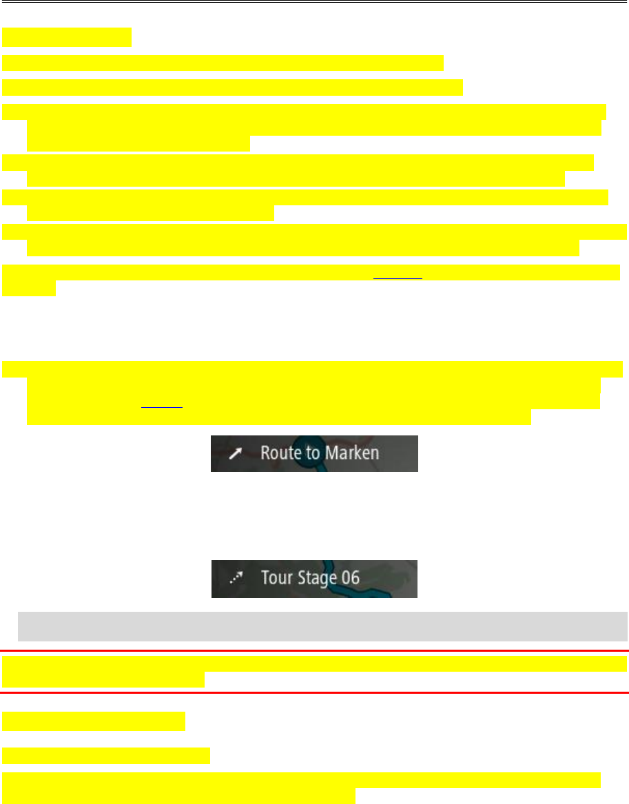
54
About My Routes
My Routes provides an easy way to save and retrieve routes and tracks.
You may want to use My Routes in one or more of the following situations:
While working - Your job involves driving several routes with multiple stops on a daily basis.
Your routes can change and you need to be flexible and be able to change the order of your
stops or change the planned route.
While on holiday - You are going on holiday and want to plan and save a route. Your route
includes scenic roads, stops at various hotels, and other places like tourist attractions.
While touring - You want to follow a tour you have downloaded from the Internet, or drive a
route another user has shared with you.
While commuting to work - You want to add one or two regular stops between home and work.
Your route back home in the evening is the reverse of your route to work in the morning.
Routes can be created and saved on your TomTom GO or in MyDrive. You can also edit routes using
MyDrive.
About routes and tracks
The term "route" includes two types of route from one place to another:
Routes have a starting point and a destination, and perhaps some stops. Your device calculates
your preferred type of route between all these points, for example, the fastest or most eco-
nomical, and uses Traffic. You can edit a route by, for example, adding stops or moving the
starting point. Routes can be imported but cannot be exported from your device.
Tracks also have a starting point and a destination, but have no stops. Your route follows the
track as closely as possible, ignoring your preferred type of route and traffic conditions, and any
traffic on the route. You can edit tracks using MyDrive. Tracks can be imported and exported
from your device.
Tip: Tracks have a dotted arrow!
Important: Routes and tracks cannot be stored on the same memory card as maps because different
memory card formatting is used.
About GPX and ITN files
GPX files (GPS exchange format)
GPX files contain a very detailed recording of where you have been on your track, including any
off-road locations. GPX files become tracks after import.
My Routes
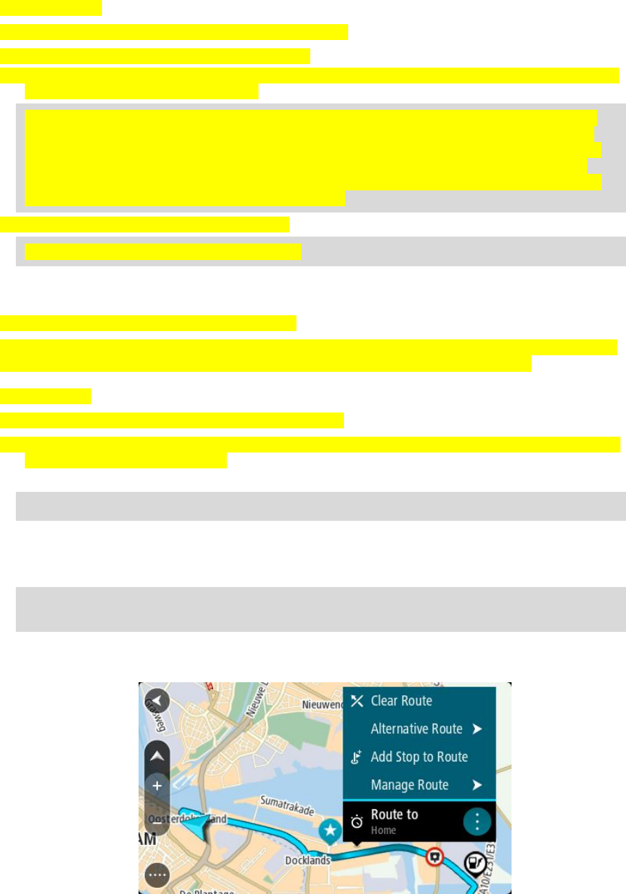
55
Using GPX files
There are several things you can do with your GPX file:
Use TomTom MyDrive to view your track file.
Export to a memory card or directly to your computer, then use your computer to view the file
using software such as Google Earth.
Note: While viewing your recording, you may notice that the recorded GPS locations do not
always correspond with the roads. This can happen for several reasons. Firstly, your device
tries to keep the files small and this can cause a slight loss of data precision. Secondly, your
device records the actual data from the GPS chip for an accurate representation of where
you’ve been, rather than what you see on your screen. Thirdly, the software with which you
view the recording may have the maps misaligned.
Share the file with others by exporting it.
Note: Tracks can be imported and exported.
ITN files (TomTom's own Itinerary file format)
An ITN file contains less detail than a GPX file. An ITN file can contain a maximum of 255 locations
which is enough to recreate a route accurately. ITN files become routes after import.
Using ITN files
There are several things you can do with your ITN file:
You can import an ITN file onto your TomTom GO Basic so you can travel that same route again
and get navigation instructions.
Use TomTom MyDrive to view your route.
Note: Routes can be imported but cannot exported.
Saving a route
1. Plan a route using the steps described in Planning a route.
Tip: If you cannot see your planned route on the map view, select the back button to show
your route.
2. Select the route.
3. Select the pop-up menu button to open the menu.
4. Select Manage Route, then Add to My Routes.
The name of the route is shown in the edit screen.
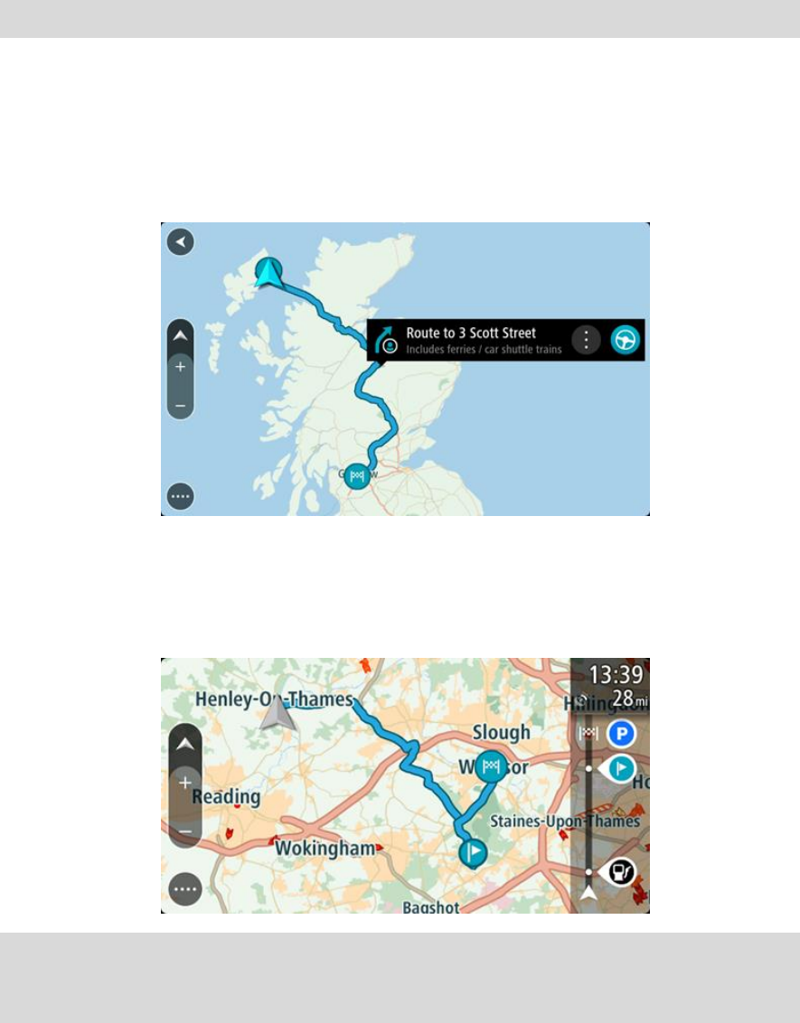
56
5. Edit the name of the route so that you can easily recognise it.
6. Save your route in the My Routes list.
Tip: You can also save a route using the Add to My Routes button in the Current Route menu.
Navigating using a saved route
To navigate using a previously saved route, do the following:
1. In the Main Menu, select My Routes.
2. Select a route from your list.
The route is shown on the map view.
3. To navigate to the start of the saved route, select Drive/Ride depending on which device you
are using.
The starting point of the saved route is converted to your first stop and then the route is
planned. Guidance to your destination begins from your current location. As soon as you start
driving, the guidance view is shown automatically.
Tip: There are two other ways to navigate using a saved route:
Select the starting point of the route. When the pop-up menu opens, select Change to a Stop.
Alternatively, select Drive to Route or Ride to Route in the Current Route menu.
Navigating to a stop on a saved route
You can navigate from your current location to a stop on your saved route instead of to the start of
the saved route. The stop is changed to the start of your route. Your new starting point might be
one closer to your current location, or you might just want to make your route shorter.
57
Note: The route from the original starting point up to the new starting point is removed from the
route.
Note: Your original route in My Routes is not changed. If you want to see the whole route, select
the route again in My Routes.
1. In the Main Menu, select My Routes.
2. Select a route from your list.
The route is shown on the map view.
3. Select the stop that you want to use as your starting point, then select the pop-up menu button
to open the menu.
4. Select Start Route From Here.
Your route is calculated from the new starting point.
5. Select Drive/Ride.
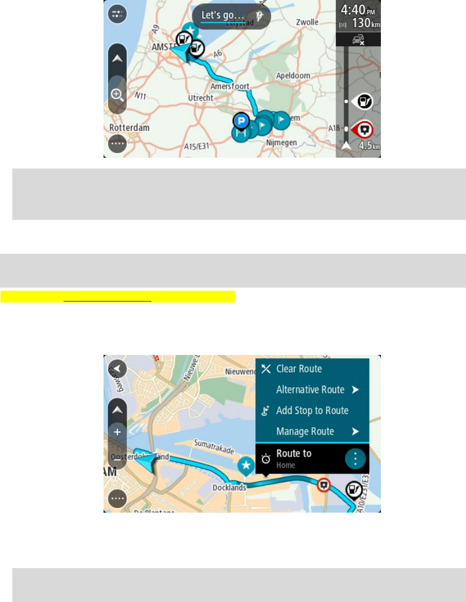
58
The starting point of your route is converted to your first stop and then the route is planned
from your current location. Guidance to your destination begins. As soon as you start driving,
the guidance view is shown automatically.
Tip: There are two other ways to navigate using a saved route:
Select the starting point of the route. When the pop-up menu opens, select Change to a Stop.
Alternatively, select Drive to Route or Ride to Route in the Current Route menu.
Adding a stop to a saved route using the map
Note: You can also press and hold a location on the map and select Add to Current Route from
the pop-up menu.
1. Press the switch view button to show the map.
Your complete route is shown on the map.
2. Select the route.
3. Select the pop-menu button to open the menu.
4. Select Manage Stops.
5. Select Add Stop to Route.
6. Select your new stop on the map.
Tip: If you know the name of your new stop, you can use Search to select your stop instead of
using the map.
7. Select the Add Stop button to add this location as a stop.
Your route is recalculated to include your stop.
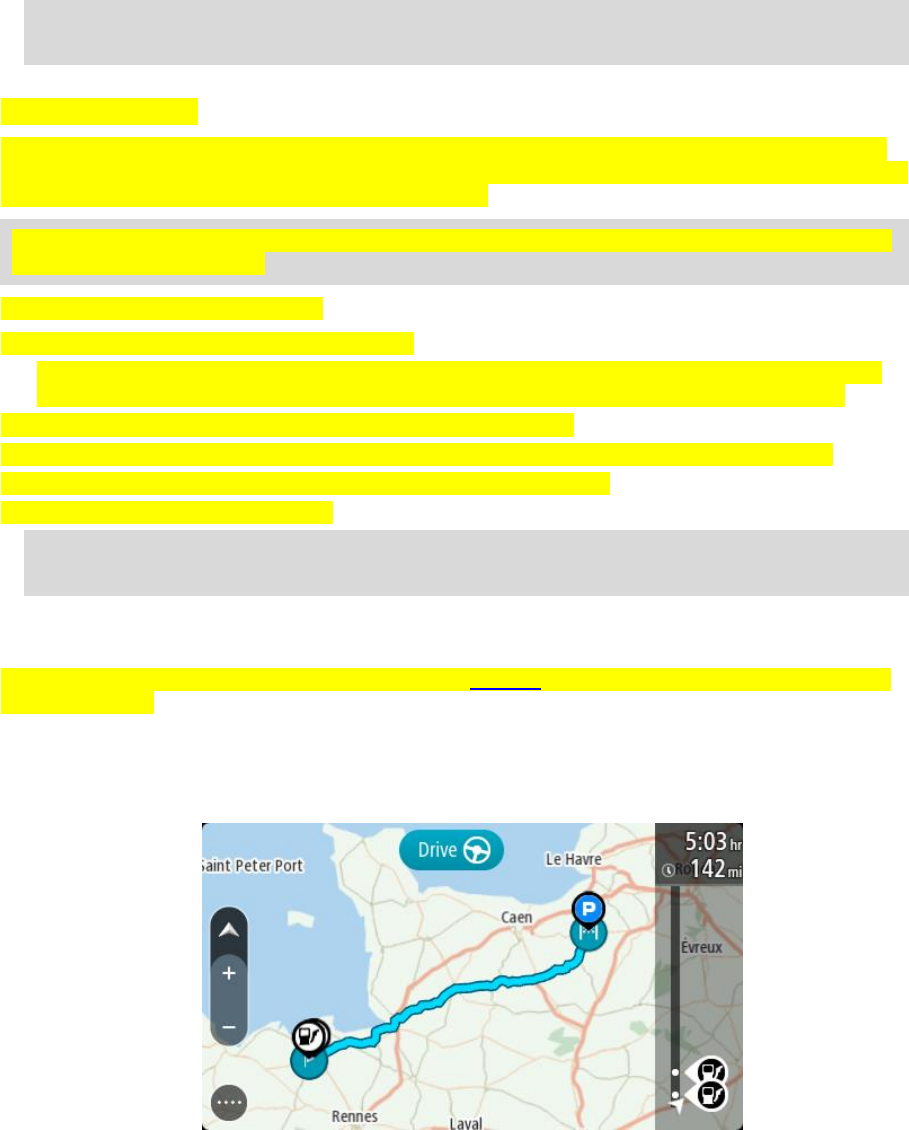
59
Tip: To update the saved route in your My Routes list with the changes, select the route om
the map then select Save Changes to Route in the pop-up menu.
Recording a track
You can record a track while you drive, with or without a route planned. After recording, you can
then export your track so that you can share it with others. Alternatively, you view it using TomTom
MyDrive if you’re logged in to MyDrive on your device.
Tip: When logged in to MyDrive on your device, the recorded route on your device will be synced
with the MyDrive website.
To record a track, do the following:
1. In the Main Menu, select Start Recording.
A red dot appears in the lower right-hand corner of the screen and initially flashes 3 times to
show that you are now recording. The dot remains on the screen until you stop recording.
2. To stop recording, select Stop Recording in the Main Menu.
3. Enter a name for your track or you can leave it at the suggested date-time combination.
4. Select Add or Finished, depending on the device you are using.
5. Your track is saved in My Routes.
Note: You can export tracks as GPX files and save them on a memory card for sharing with
others.
Navigating using a track
You can import tracks on to your TomTom GO using MyDrive. To navigate using an imported track,
do the following:
1. In the Main Menu, select My Routes.
2. Select a track from your list.
The track route is shown on the map view.
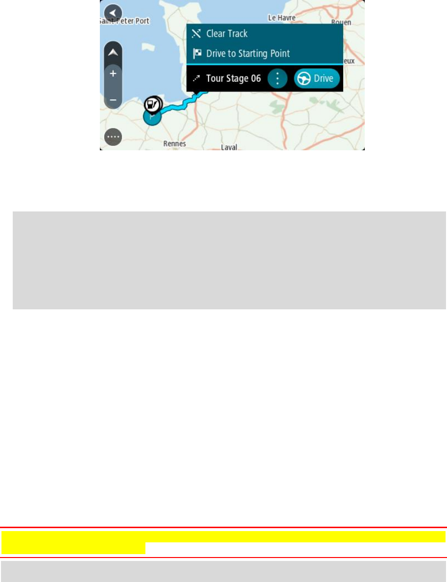
60
3. Select the track, then select the pop-up menu.
4. Select Drive to Starting Point.
The starting point of the track is converted to your first stop and then the route is planned.
Guidance to your destination begins from your current location. As soon as you start driving, the
guidance view is shown automatically.
Note: You see two different colours on the map for your route and track. You see one colour
for the route from your current location to the starting point, and another second colour for
the track.
Tip: There are two other ways to navigate using a saved route:
Select the starting point of the route. When the pop-up menu opens, select Drive to Starting
Point.
Alternatively, select Drive to Starting Point or Ride to Route in the Current Track menu.
Deleting a route or a track from My Routes
1. In the Main Menu, select My Routes.
2. Select Edit List.
3. Select the routes you want to delete.
4. Select Delete.
Finding the memory card slot
The memory card slot is under the mount.
To insert a memory card, release the mount from the TomTom GO using the thumb indent. Insert
the memory card into the slot. Clip the mount back onto the device until you hear it click.
Exporting tracks to a memory card
You can export tracks as GPX files and save them on a memory card for sharing with other users.
Important: Routes and tracks cannot be stored on the same memory card as maps because different
memory card formatting is used.
Note: Currently, you can export only tracks from your TomTom GO.
To export one or more tracks, do the following:
1. In the Main Menu, select My Routes.
2. Select Share Tracks.

61
Tip: Alternatively, when in map view, select a track and select Share Track from the pop-up
menu.
3. Select one or more tracks from your list for export.
Tip: To select or deselect all routes for export, select the pop-up menu button.
4. Select Share then select Export to Memory Card.
You see the message Saving.
Tip: If there is not enough space on your memory card or your card is not formatted correctly,
you get on-screen help to fix the problem.
5. When you see a message that your tracks have been exported successfully, remove your memory
card to share your tracks with other users.
Note: Each exported route is saved as a GPX file in the TomTom Routes folder on your
memory card.
Importing routes and tracks from a memory card
You can import two types of files from a memory card:
GPX files - these become tracks after import.
ITN files - these become routes after import.
ITN files are TomTom itinerary files. Other users can record itinerary files and share them with you,
or you can download both ITN and GPX files from TomTom MyDrive.
To import one or more routes and tracks from a memory card, do the following:
1. Insert a memory card into the card slot on your TomTom GO Basic.
If routes are found on your memory card, a message confirms this.
2. Select Import Routes.
3. Select one or more routes from the list on your memory card for import.
4. Select Import.
You see the message Importing tracks. Your routes are imported onto your device.
5. When you see a message that your routes have been imported successfully, remove your
memory card.
6. To view your imported routes and tracks, select My Routes in the Main Menu.
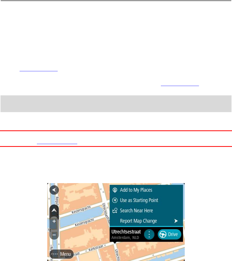
62
About Map Share
You can report map changes using Map Share. These map changes are then shared with other
TomTom device users when they receive a map update.
There are two ways to report a map change:
Select a location on the map and create the change report immediately.
Mark a location and create the change report later.
To send your map change reports to TomTom, you must connect your TomTom GO to your computer
and use MyDrive Connect.
All map changes are verified by TomTom. These verified changes are then available as part of the
next map update which you can get when you connect your device to MyDrive Connect using a USB
connection.
Tip: If a road closure is reported using Map Share, the closure is verified and immediately shown
by TomTom Traffic.
Creating a map change report
Important: For safety reasons, do not enter the full details of a map change while you are driving.
You can always mark the location and create the report later.
To create a map change report, do the following:
1. Press and hold to select the location of the map change on the map view.
2. Select the pop-up menu button to open the menu.
3. Select Report Map Change from the pop-up menu.
4. Select the type of map change you want to apply.
Map Share
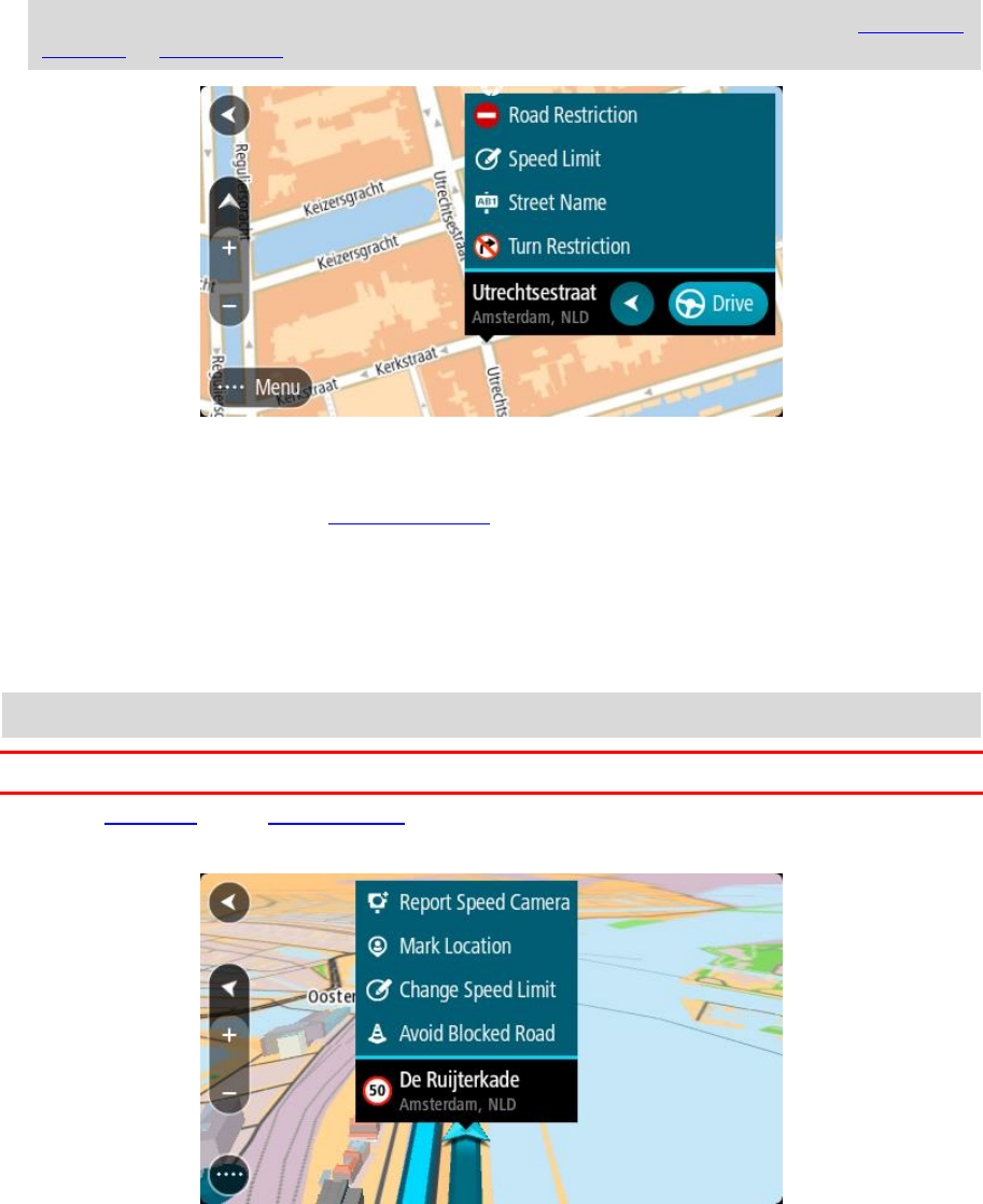
63
Note: If you want to report a map change of a type not shown in the menu, use the Map Share
Reporter at tomtom.com.
5. Follow the instructions for your chosen type of map change.
6. Select Report.
7. Connect your TomTom GO to MyDrive Connect to send your map change report to TomTom and
receive map changes from other TomTom users.
Creating a map change report from a marked location
If you see a map inconsistency while you are driving, you can mark the location so you can report
the change later.
Tip: You can mark your current location even when you are driving.
Important: Do not report map changes while you are driving.
1. In the map view or the guidance view, select the current location symbol or the speed panel.
The Quick Menu opens.
2. Select Mark Location.
The marked location is stored in My Places with the date and time you saved the location.
3. In the Main Menu, select My Places.
4. Open the Marked locations folder and select the marked location.
The marked location is shown on the map.
5. Select Report Map Change from the pop-up menu.
6. Select the type of map change you want to apply.
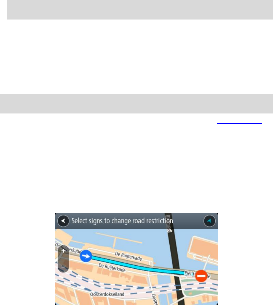
64
Note: If you want to report a map change of a type not shown in the menu, use the Map Share
Reporter at tomtom.com.
7. Follow the instructions for your chosen type of map change.
8. Select Report.
The marker for the marked location is removed from the map.
9. Connect your TomTom GO to MyDrive Connect to send your map change report to TomTom and
receive map changes from other TomTom users.
Types of map change
There are several types of map change available.
Note: If you want to report a map change of a type not described below, use the Map Share
Reporter at tomtom.com.
For all map changes described below, you need to connect your TomTom GO to MyDrive Connect to
send your map changes report to TomTom and receive map changes from other TomTom users.
Road Restriction
Select this option to block or unblock a road. You can block or unblock the road in one or both
directions by doing the following:
1. Press and hold to select the location of the map change on the map view.
2. Select the pop-up menu button to open the menu.
3. Select Report Map Change from the pop-up menu.
4. Select Road Restriction.
Select the road sign at either end of the road to change it from open to closed or vice versa.
5. Select Report.
Street Name
Select this option to correct an incorrect street name.
1. Press and hold to select the location of the map change on the map view.
2. Select the pop-up menu button to open the menu.
3. Select Report Map Change from the pop-up menu.
4. Select Street Name.
5. Enter the correct street name.
6. Select Report.
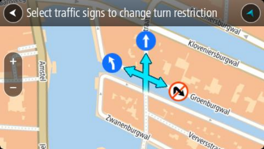
65
Turn Restriction
Select this option to report incorrect road turn restrictions.
1. Press and hold to select the location of the map change on the map view.
2. Select the pop-up menu button to open the menu.
3. Select Report Map Change from the pop-up menu.
4. Select Turn Restriction.
5. If the incorrect junction is shown, select Select another junction.
6. Select the approach direction.
The map rotates so that the direction you are coming from is shown at the bottom of the
screen.
7. Select the traffic signs in turn to change the turn restrictions for each road at the junction.
8. Select Report.
Speed Limit
Select this option to correct the speed limit on the map.
1. Press and hold to select the location of the map change on the map view.
2. Select the pop-up menu button to open the menu.
3. Select Report Map Change from the pop-up menu.
4. Select Speed Limit.
5. Select the correct speed limit.
If the correct limit is not shown, scroll left or right through the available speed limits.
6. Select Report.
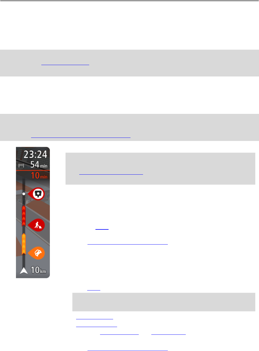
66
About RDS-TMC
The Traffic Message Channel (TMC), also known as RDS-TMC, transmits traffic information as a radio
signal and is available free of charge in many countries.
TMC is not a TomTom service, but is available when using the TomTom RDS-TMC Traffic Receiver.
Note: TMC is not available in all countries. To check the availability of TMC services in your
country, go to tomtom.com/5826.
TomTom is not responsible for the availability or quality of traffic information provided by TMC.
The route bar
The route bar is shown when you have planned a route. It has an arrival information panel at the
top, and a bar with symbols underneath.
Tip: You can also choose to see a wider route bar showing additional route information (not
available on all devices or apps).
Note: The distance ahead shown by the route bar depends on the overall length of your route.
The arrival information panel shows the following information:
Tip: If your destination is in a different time zone, you see a plus (+)
or a minus (-) sign and the time difference in hours and half hours in
the arrival information panel. The estimated time of arrival is the
local time at your destination.
The estimated time that you will arrive at your destination.
The length of time to drive to the destination from your current
location.
A parking button is shown near the destination flag when parking is
available near your destination.
If you have stops on your route, select this panel to change between
information about the next stop and your final destination.
You can choose the information you see on the arrival information panel.
Traffic status - if your TomTom GO isn't receiving any traffic infor-
mation, a symbol showing traffic with a cross appears underneath the
arrival information panel.
The bar uses symbols to show the following information:
A faster route, if there is traffic on your route.
The stops on your route.
Tip: To quickly remove a stop, select it in the route bar and use the
pop-up menu.
Petrol stations that are directly on your route.
TomTom Traffic incidents.
TomTom Speed Cameras and Danger Zones.
Rest stops directly on your route.
You can choose the information you see on your route.
Traffic
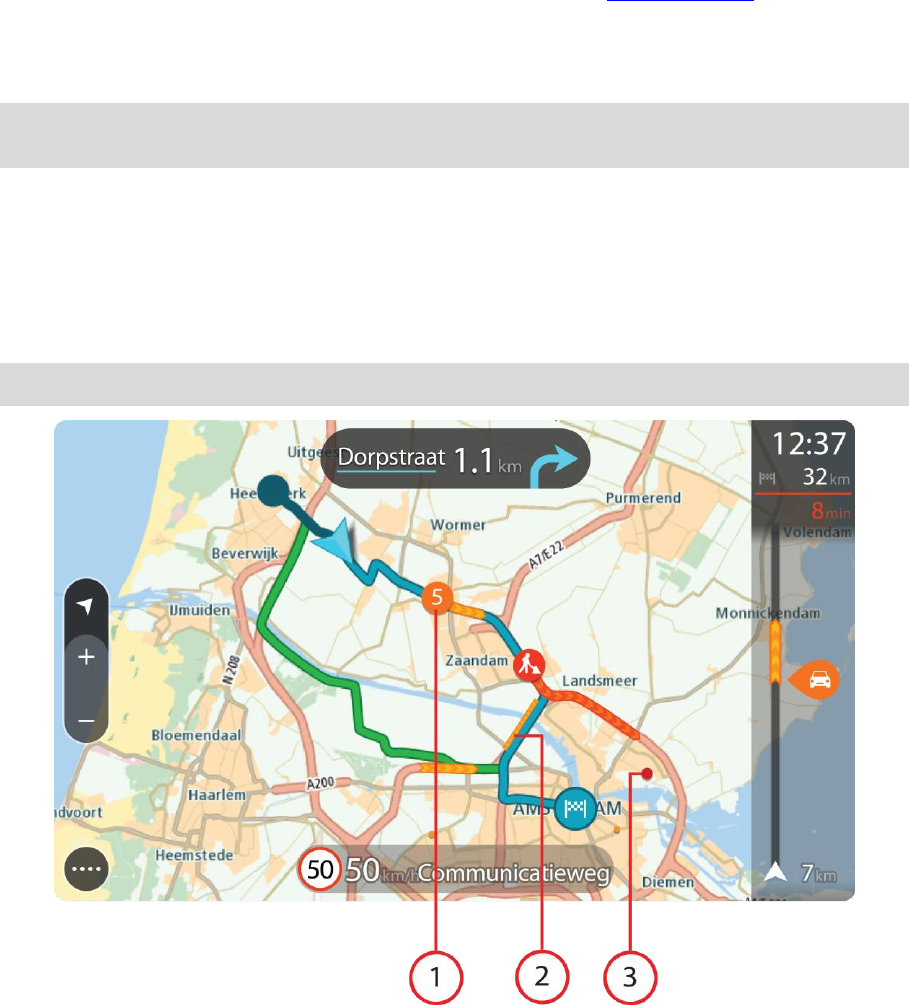
67
The symbols are in the order that they occur on your route. For traffic
incidents, the symbol for each incident alternates between showing the
type of incident and the delay in minutes. Select a symbol to see more
information about a stop, an incident or a speed camera. If a symbol is
shown on top of another symbol, selecting the symbols zooms in on the
route bar to show each symbol separately. You can then select a symbol.
The total time delay due to traffic jams, weather, and other incidents on
your route, including information provided from historical road usage, is
shown above the symbols.
For a complete list of incident types, see Traffic incidents.
The bottom of the route bar represents your current location and shows
the distance to the next incident on your route. In addition, you can
choose to see the current time if you switch the setting on.
Note: To make the route bar more readable some incidents may not be shown. These incidents
will always be of minor importance and only cause short delays.
The route bar also shows status messages, for example Finding fastest route or Playing route
preview.
Looking at traffic on the map
Traffic incidents are shown on the map. If several traffic incidents overlap the highest priority
incident is shown - for example, a road closure is higher priority than road works or a closed lane.
Tip: Select an incident on the map to see more detailed information.
1. Traffic incident that affects your route in your direction of travel.
A symbol or number at the start of the incident shows the type of incident or the delay in
minutes, for example 5 minutes.
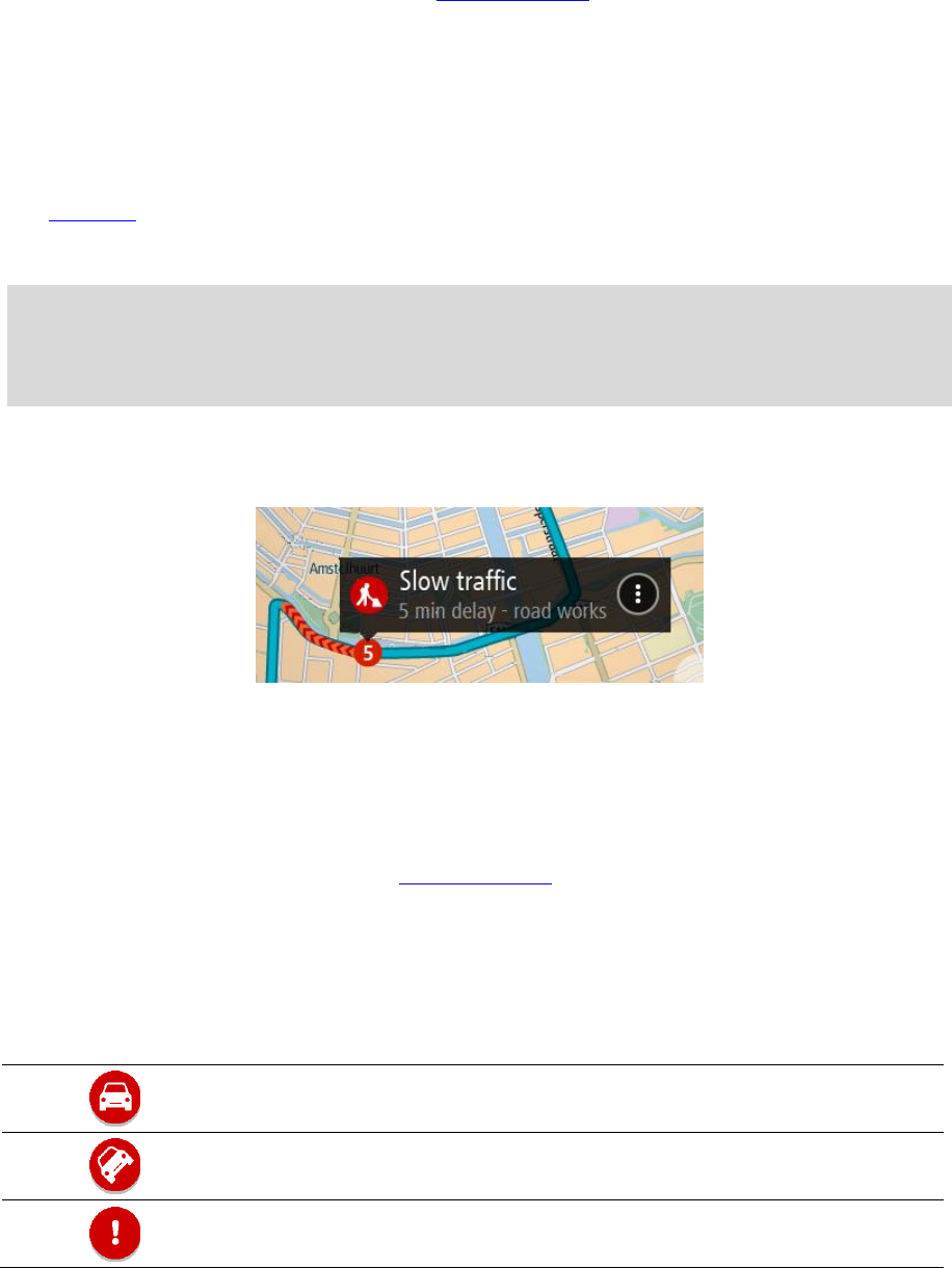
68
The colour of the incident indicates the speed of traffic relative to the maximum allowed speed
at that location, with red being the slowest. The stripes on the traffic jam are also animated to
show the speed of the traffic, where appropriate.
For a complete list of incident types, see Traffic incidents.
2. Traffic incident on your route but in the opposite direction of travel.
3. Traffic incidents on roads that are not visible at your current zoom level.
Looking at traffic on your route
Information about traffic incidents on your route is shown in the route bar on the right-hand side of
the map and guidance views.
The route bar tells you about traffic delays while you are driving, using symbols to show you where
each traffic incident is located on your route. When using the map view, you can also select symbols
on the map itself.
Note: If your TomTom GO isn't receiving any traffic information, a symbol showing traffic with a
cross appears underneath the arrival information panel.
Note: To make the route bar more readable some incidents may not be shown. These incidents
will always be of minor importance and only cause short delays.
To get more information about an incident, select an incident in the route bar. The map opens
zoomed in on the incident and an information panel opens showing detailed information about the
traffic incident.
The information shown includes:
The cause of the traffic incident - for example accident, road works, lane closure, or weather.
The severity of the incident - slow traffic, queuing traffic or stationary traffic.
The delay time.
The length of the incident.
For a complete list of incident types, see Traffic incidents.
Select the back button to go back to the guidance view.
Traffic incidents
The following traffic incident symbols are used in the map view and in the route bar to show the
cause of a traffic jam:
Traffic
Accident
Dangerous conditions
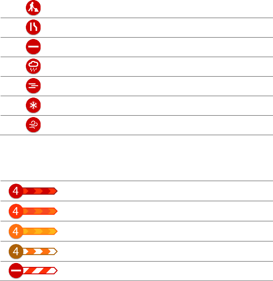
69
Roadworks
Lane closure
Road closure
Rain
Fog
Ice or snow
Wind
The symbol or number at the start of the incident shows the type of incident or the delay in
minutes, for example 4 minutes.
The colour of the incident indicates the speed of traffic relative to the maximum allowed speed at
that location, with red being the slowest. The stripes on the traffic jam are also animated to show
the speed of the traffic, where appropriate.
Traffic speed is 0% to 20% of the allowed speed.
Traffic speed is 20% to 40% of the allowed speed.
Traffic speed is 40% to 100% of the allowed speed.
Traffic speed is normal.
Road closed, no traffic.
Approaching a traffic jam warning
A warning is given as you approach a traffic jam. You are warned in several ways:
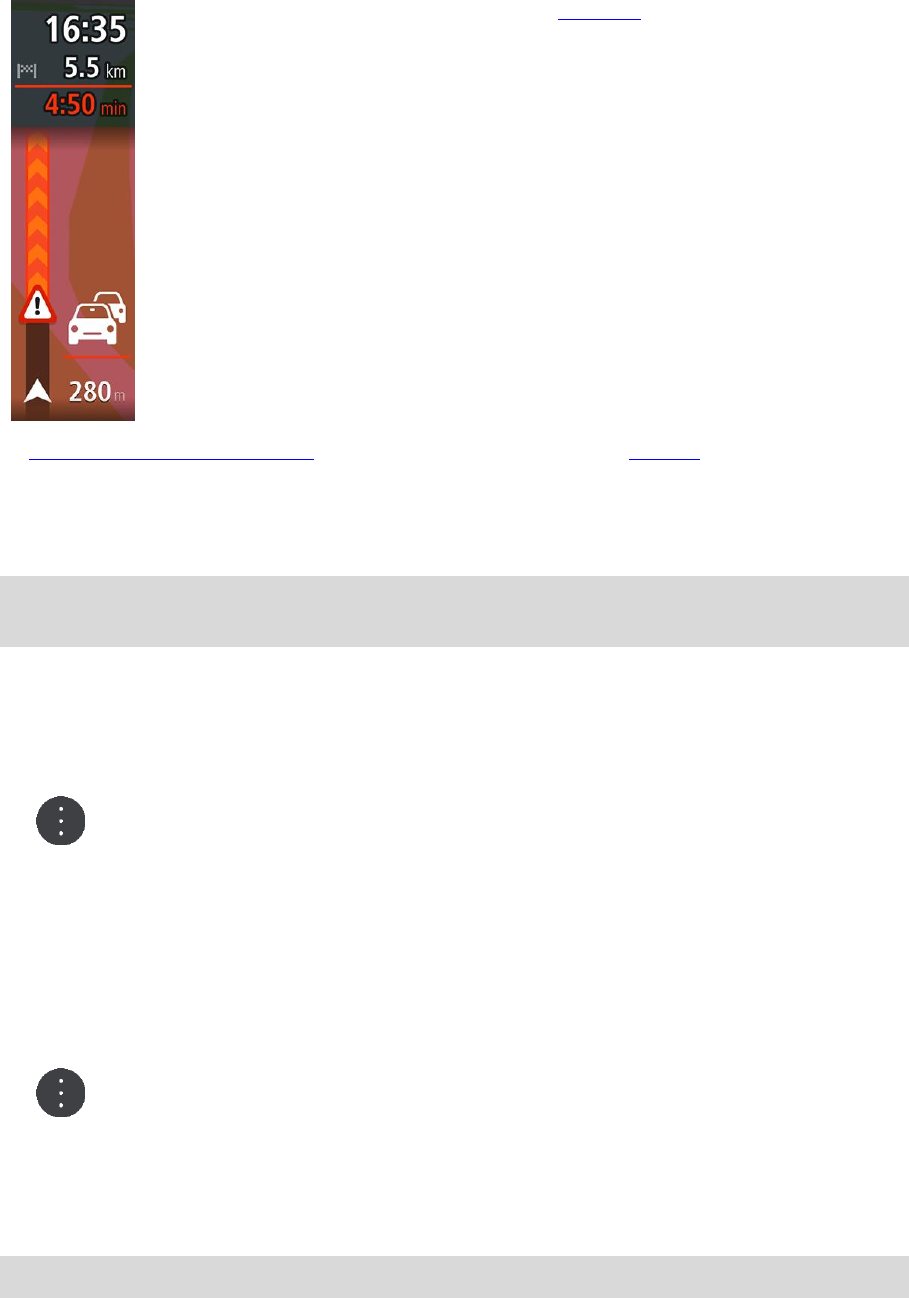
70
A warning symbol is shown in the route bar.
The route bar zooms in to the start of the traffic jam.
Your distance to the start of the traffic jam is shown in the route bar.
The colour of the road on the route bar changes to orange or red,
depending on the severity of the traffic jam.
The background colour of the route bar background changes to red if
you are driving too fast towards the traffic jam.
You hear a warning sound.
To change the way you are warned, select Sounds & Warnings in the Settings menu.
Avoiding a traffic jam on your route
You can avoid a traffic jam that is on your route.
Note: Sometimes the quickest route is still the route that has the traffic jam.
Note: It may not be possible to find an alternative route around the traffic jam if none exists.
Avoiding a traffic jam using the route bar
1. In the route bar, select the symbol for the traffic jam you want to avoid.
The traffic jam is shown on the map.
2. Select the pop-up menu button.
3. Select Avoid in the pop-up menu.
A new route is found that avoids the traffic jam.
Avoiding a traffic jam using the map
1. On the map view, zoom in and select the traffic jam that is on your route.
The traffic jam with an information panel is shown on the map.
2. Select the pop-up menu button.
3. Select Avoid.
A new route is found that avoids the traffic jam.
Advanced Lane Guidance
Note: Lane guidance is not available for all junctions or in all countries.
Advanced Lane Guidance helps you prepare for motorway exits and junctions by showing the correct
driving lane for your planned route.
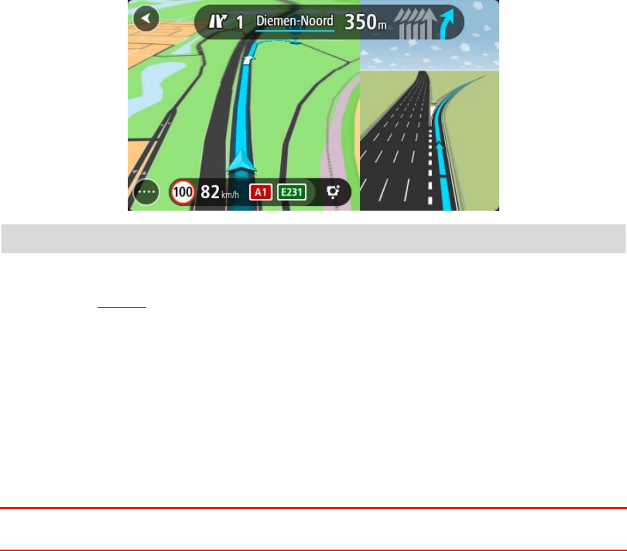
71
As you approach an exit or junction, the lane you need is shown on the screen.
Tip: To close the lane image, select anywhere on the screen.
You can choose to see a split screen with the Guidance view on the left and lane guidance on the
right, or a full screen with only lane guidance. You can also switch off lane guidance. Go to
Appearance in Settings to change the Motorway exit previews setting.
Time-dependent speed limits
Some speed limits change depending on the time of day. For example, you may see the speed limit
near schools decrease to 40 km/h or 25 mph in the morning between 08.00 - 09.00 and in the
afternoon between 15.00 - 16.00. Where possible, the speed limit shown in the speed panel changes
to show these variable speed limits.
Some speed limits change depending on driving conditions. For example, the speed limit will
decrease if there is heavy traffic, or the weather conditions are bad. These variable speed limits are
not shown in the speed panel. The speed shown in the speed panel is the maximum speed limit
allowed in good driving conditions.
Important: The speed limit shown in the speed panel is only an indication. You must always obey
the actual speed limit for the road you are on and the conditions you are driving in.
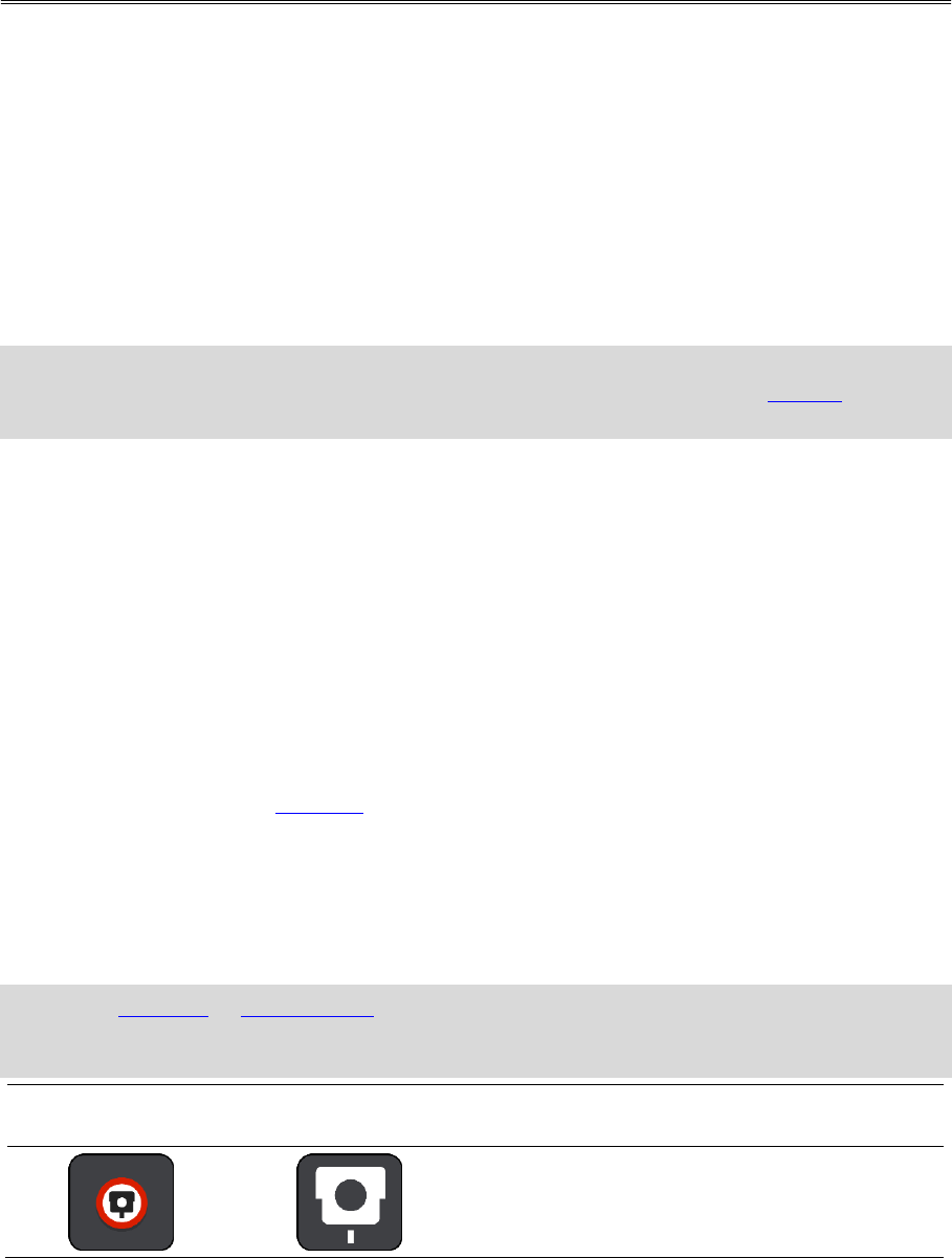
72
About speed cameras
The Speed Cameras service warns you about the following camera locations:
Fixed speed camera locations.
Average speed camera locations.
Speed enforcement zones.
Red light camera locations.
Traffic restriction cameras.
The Speed Cameras service also warns you about the following safety hazards:
Accident blackspot locations.
Note: Your new TomTom GO Basic comes pre-loaded with speed camera locations. To keep these
camera and hazard locations up-to-date, connect your TomTom GO to TomTom MyDrive
frequently.
Crossing into another area or country
When you drive into an area or country that does not permit speed camera warnings, your TomTom
GO switches the speed cameras service off. You will not receive speed cameras warnings in those
areas or countries.
Some areas or countries permit limited speed camera warnings, for example only warnings for fixed
cameras, or warnings for risk zones. Your TomTom GO automatically switches to give limited
warnings when you cross into those areas or countries.
Speed camera warnings
Warnings are given as you approach a speed camera. You are warned in several ways:
A symbol is shown in the route bar and on your route on the map.
Your distance to the speed camera is shown in the route bar.
The speed limit at the camera location is shown in the route bar.
You hear a warning sound as you get near the camera.
While you are approaching a camera or driving in an average speed check area, your speed is
monitored. If you drive more than 5 km/h or 3 mph over the speed limit the route bar turns red.
If you drive less than 5 km/h or 3 mph over the speed limit the route bar turns orange.
Tip: In the map view or guidance view, you can select a speed camera symbol in the route bar to
see the type of camera, the maximum speed and also the length of an average speed check area.
In the map view, you can also select a speed camera that is shown on your route.
Symbol shown on
map
Symbol shown in
route bar
Description
Fixed speed camera - this type of camera
checks the speed of passing vehicles and is fixed
in one place.
Speed Cameras
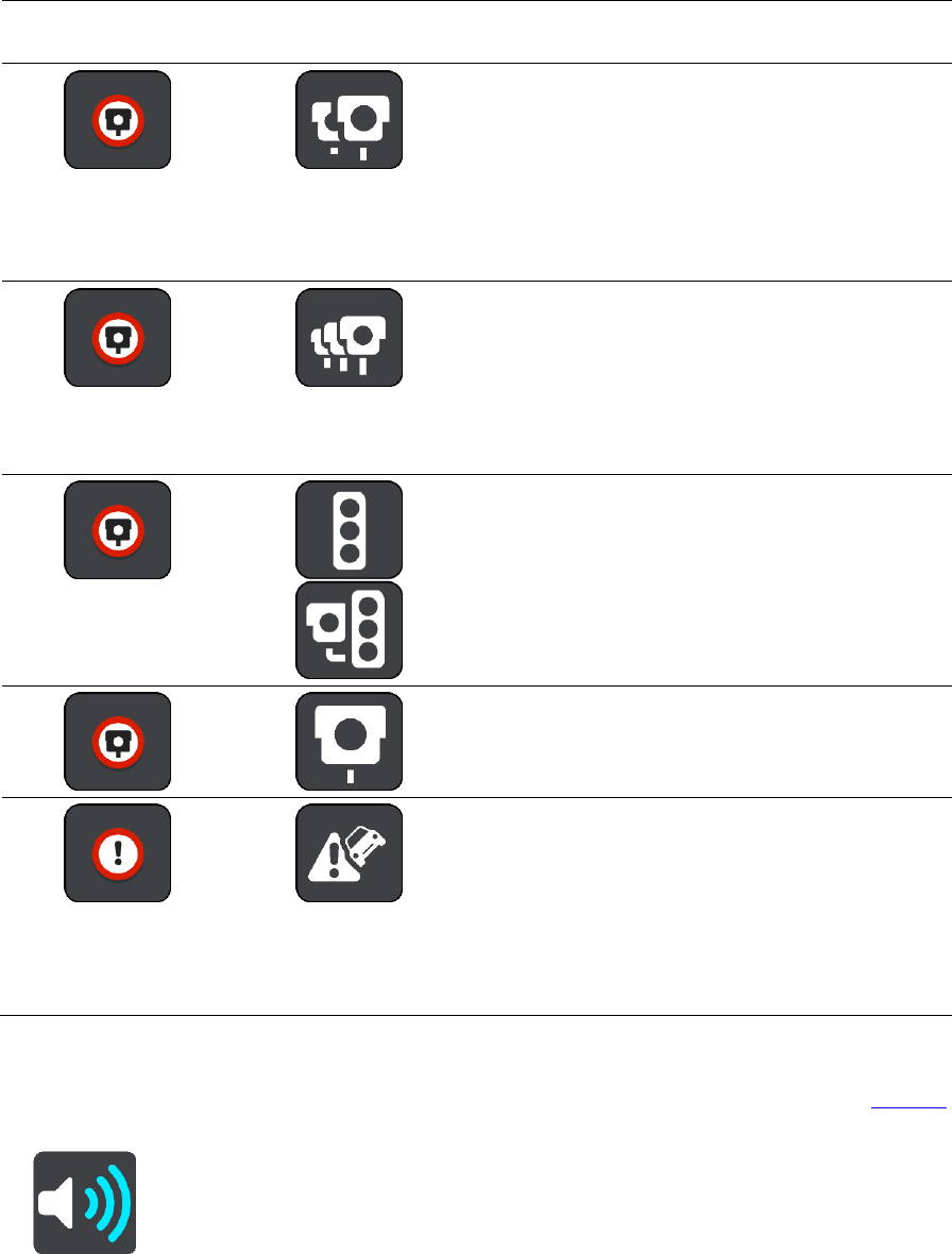
73
Symbol shown on
map
Symbol shown in
route bar
Description
Average speed cameras - these types of
cameras measure your average speed between
two points. You are warned at the start and end
of the average speed check area.
While you are driving in an average speed check
area, your average speed is shown, instead of
your current speed. The distance to the end of
the area is shown in the route bar.
Speed enforcement zones - these zones can
contain multiple speed cameras.
You are warned at the start and end of a speed
enforcement zone. While you are driving in a
speed enforcement zone, your current speed is
shown, and the visual warning is shown in the
route bar.
Red light camera - this type of camera checks
for vehicles breaking traffic rules at traffic
lights. There are two types of traffic light
camera - those which check if you drive through
a red light and those which check for driving
through a red light together with speeding.
Traffic restriction - this type of warning warns
you about restricted roads.
Accident blackspot - this type of warning is
given for a place where road traffic accidents
have historically been concentrated.
You are warned at the start and end of the
accident blackspot. While you are driving in an
accident blackspot, your current speed is shown.
When you are in the blackspot, the visual
warning continues to be shown in the route bar.
Changing the way you are warned
To change the way you are warned about speed cameras, select Sounds & Warnings in the Settings
menu.
You can then set how you want to be warned for the different types of cameras and safety hazards.
You can choose to be warned, warned only if you are speeding, or never warned.
To switch off all warnings, switch off Speed cameras & hazards.

74
Updating locations for cameras and hazards
The locations of speed cameras can change frequently. New cameras can also appear without
warning and the locations for other hazards, such as accident blackspots, may also change.
Your new TomTom GO Basic comes pre-loaded with speed camera locations. To keep these camera
and hazard locations up-to-date, connect your TomTom GO to TomTom MyDrive frequently.
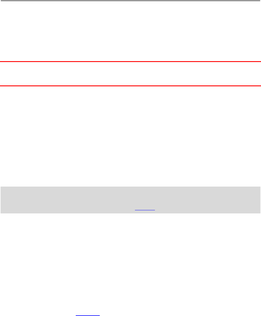
75
About danger zones
The Danger Zones service warns you about danger zones on your route when you are in France.
Since 3rd January 2012, it has been illegal to receive warnings about the position of fixed or mobile
speed cameras when you are driving in France. To be compliant with this change in French law,
speed camera locations are no longer reported but instead areas of danger are indicated as danger
zones.
Important: Outside of France, you receive warnings about speed cameras. Inside France, you
receive warnings about danger zones. When you cross the border, the type of warning you receive
changes.
A danger zone is a zone specified by French law. The Danger Zones service warns you about danger
zones.
Danger zones may or may not contain one or more speed cameras or a range of other driving
hazards:
Specific locations are not available and a danger zone icon is shown instead as you approach the
zone.
The minimum length of the zone depends on the road type and is 300 m for roads in built-up
areas, 2000 m (2 km) for secondary roads and 4000 m (4 km) for motorways.
The location of one or more speed cameras, if any, can be at any point within the zone.
If two danger zones are close to each other, the warnings can be merged into a single longer
zone.
Information about the location of zones is continually updated by TomTom and other users.
Note: You cannot remove a danger zone.
Note: Your new TomTom GO Basic comes pre-loaded with zone locations. To keep these zones
up-to-date, connect your TomTom GO to TomTom MyDrive frequently.
Crossing into another area or country
When you drive into an area or country that does not permit speed camera warnings, your TomTom
GO switches the speed cameras service off. You will not receive speed cameras warnings in those
areas or countries.
Some areas or countries permit limited speed camera warnings, for example only warnings for fixed
cameras, or warnings for risk zones. Your TomTom GO automatically switches to give limited
warnings when you cross into those areas or countries.
Danger zone warnings
Warnings are given 10 seconds before you reach a danger zone. You are warned in several ways:
A symbol is shown in the route bar and on your route on the map.
Your distance to the start of the zone is shown in the route bar.
The speed limit in the zone is shown in the route bar.
You hear a warning sound as you get near the start of the zone.
Danger Zones
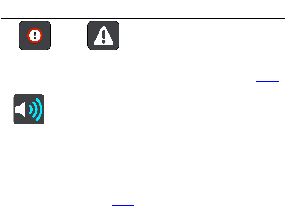
76
While you are approaching a zone or driving in a zone, your speed is monitored. If you drive
more than 5 km/h or 3 mph over the speed limit the route bar turns red. If you drive less than 5
km/h or 3 mph over the speed limit the route bar turns orange.
While you are driving in a zone your distance to the end of the zone is shown in the route bar.
Warning sounds are played for these types of zones:
Symbol shown on
map
Symbol shown in
route bar
Description
Danger zone - this type of warning is only given in
France.
You are warned at the start and end of the danger
zone.
Changing the way you are warned
To change the way you are warned about danger zones, select Sounds & Warnings in the Settings
menu.
You can then set how you want to be warned for the different types of zones. You can choose to be
warned, warned only if you are speeding, or never warned.
To switch off all warnings, switch off Danger zones & hazards.
Updating locations for danger zones
The locations of danger zones can change frequently. New zones can also appear without warning.
Your new TomTom GO Basic comes pre-loaded with zone locations. To keep these zones up-to-date,
connect your TomTom GO to TomTom MyDrive frequently.
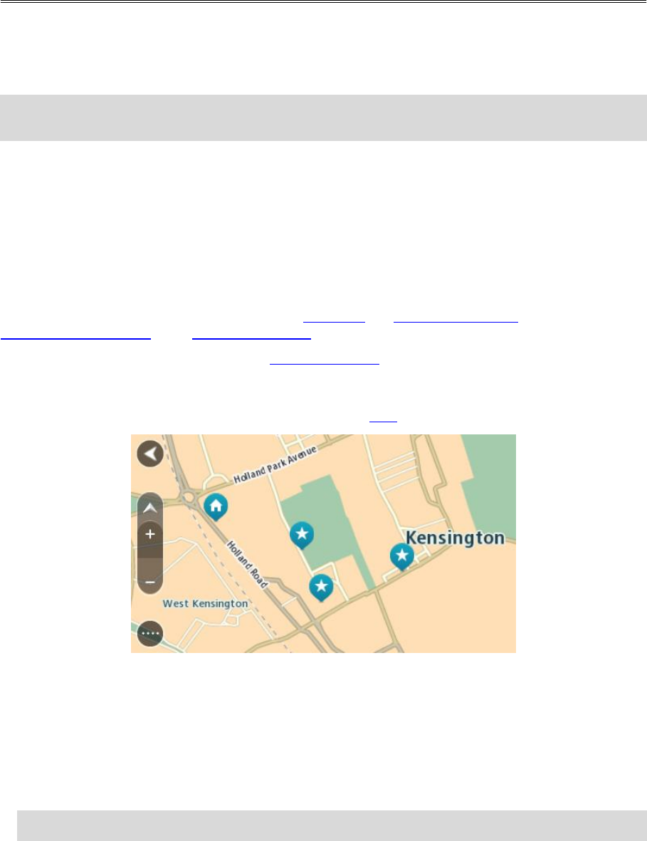
77
About My Places
My Places provides an easy way to select a location without the need to search for the location each
time. You can use My Places to create a collection of useful or favourite addresses.
Tip: The terms "favourite" and "place" mean the same thing - favourites are places that you go to
often.
The following items are always in My Places:
Home - Your home location can be your home address or somewhere you often visit. This
feature provides an easy way to navigate there.
Work - Your work location can be your workplace address or somewhere you visit often. This
feature provides an easy way to navigate there.
Recent destinations - Select this button to select your destination from a list of locations you
have recently used as destinations. These also include your stops.
Marked locations - You can mark a location and temporarily add it to My Places.
You can add a location to My Places directly in My Places, by selecting a location from the map, by
searching for a location or by marking a location.
You can upload community POI lists using TomTom MyDrive and choose to show the POI locations on
the map.
Your home location, work location, marked locations and the locations that you have added appear
in a list in My Places and are shown with a marker on the map.
Setting your home or work location
You can set your home or work locations in the following ways:
Setting your home or work location using My Places
1. In the Main Menu, select My Places.
2. Select Add Home or Add Work.
Tip: To set your home location, you can also select Add Home from the main menu.
3. To select a location for home or work, do one of the following:
My Places
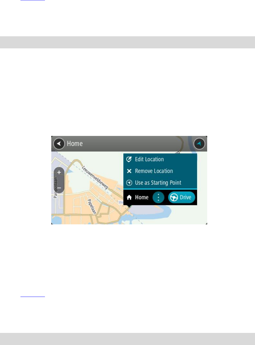
78
Zoom in on the map at the location you want to select. Press and hold to select the loca-
tion, then select Set.
Select the Search button and search for a location. Select a location to set as home or work,
then select Set.
Setting your home or work location using the map
1. In the Map View, move the map and zoom in until you can see your home or work location.
2. Press and hold to select the location.
A pop-up menu shows the nearest address.
1. Open the pop-up menu and select Add to My Places.
2. In the name bar, enter the name "Home" or "Work".
Note: "Home" must have a capital letter H and "Work" must have a capital letter W.
3. Save the location.
Your home or work location is shown on the map.
Changing your home location
You can change your home location in the following ways.
Changing your home location using My Places
1. In the Main Menu, select My Places.
2. Select Home.
Your home location is shown on the map, with a pop-up menu.
3. Select Edit Location.
4. To select a new home location, do one of the following:
Zoom in on the map at the location you want to select. Press and hold to select the loca-
tion, then select the home location symbol.
Select the Search button and search for a location. Select a location to set as home. Select
Set home location.
Changing your home location using the map
1. In the Map View, move the map and zoom in until you can see your new home location.
2. Select the location by pressing and holding the screen for about one second.
A pop-up menu shows the nearest address.
1. Open the pop-up menu and select Add to My Places.
2. In the name bar, enter the name "Home".
Note: "Home" must have a capital letter H.
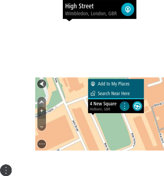
79
3. Select Add.
Your home location is changed to the new location.
Adding a location from My Places
1. In the Main Menu, select My Places.
2. Select Add a new place.
3. To select a location, do one of the following:
Zoom in on the map at the location you want to select. Press and hold to select the loca-
tion, then select the add location symbol.
Search for a location. Select Show on Map, then select the add location symbol.
The name of the location appears in the edit screen.
4. Edit the name of the location so you can easily recognise it.
5. Select Done to save your location in the My Places list.
Add a location to My Places from the map
1. Move the map and zoom in until you can see the destination that you want to navigate to.
2. Press and hold to select the location.
3. Select the pop-up menu button.
4. Select Add to My Places.
The name of the location is shown in the edit screen.
5. Edit the name of the location so you can easily recognise it.
6. Select Done to save your location in the My Places list.
The location you added is shown with a marker on the map.
Adding a location to My Places using search
1. Search for a location.
2. Select the location then select Show on map.

80
3. When the map view shows the location, select the pop-up menu button.
4. Select Add to My Places.
The name of the location appears in the edit screen.
5. Edit the name of the location so you can easily recognise it.
6. Select Done to save your location in the My Places list.
Adding a location to My Places by marking
To mark a location and temporarily add it to My Places, do the following:
1. Make sure that your current location is the location you want to mark.
2. Select the current location symbol or the speed panel in the guidance view to open the quick
menu.
3. Select Mark Location.
4. Once marked, the location is saved in My Places in the Marked Locations list.
If you want to permanently save a marked location, add it My Places by doing the following:
1. In the Main Menu, select My Places.
2. Select Marked Locations and choose your location from the list.
The marked location is shown on the map.
3. Select Add to My Places from the pop-up menu.
The name of the location appears in the edit screen.
4. Edit the name of the location so you can easily recognise it.
5. Select Add.
Deleting a recent destination from My Places
1. In the Main Menu, select My Places.
2. Select Recent Destinations.
3. Select Edit List.
4. Select the destinations you want to delete.
5. Select Delete.
Deleting a location from My Places
1. In the Main Menu, select My Places.
2. Select Edit List.
3. Select the locations you want to delete.
4. Select Delete.
81
Appearance
Select Settings in the Main Menu, then select Appearance.
On this screen, you can change these settings:
Display
Select Display to change the appearance of the display.
Route bar
Select Route bar to change the information you see in the route bar.
Show POI lists on map
Select Show POI lists on map to choose which POI lists you want to show on the map.
Note: Show POI lists on map is not available on all TomTom navigation devices or apps.
Guidance view
Select Guidance view to change the information you see in the guidance view.
Automatic zoom
Select Automatic Zoom to change how you view a junction as you drive.
Motorway exit previews
Select Motorway exit previews to change how you view motorway exits or junctions on your
route.
Automatic map view switching
By default, automatic changing of views is on. This means, for example, that your TomTom GO
shows the map view when an alternative route is being suggested, along with several other sets
of circumstances. Also, for example, that your TomTom GO shows the guidance view when you
start driving and you start to accelerate. Select this setting if you want to turn off automatic
changing between guidance view and map view.
Display
Select Settings in the Main Menu, then select Appearance.
Theme colour
Select Theme colour to change the colour used in the menus, buttons and icons, and on the map.
Tip: The current location symbol and route also change to the selected colour. You can always
change back to the original colour.
Settings
82
Brightness
Select Brightness to change the following settings:
Day brightness
Move the slider to adjust the brightness level of the screen during the day.
Night brightness
Move the slider to adjust the brightness level of the screen during the night.
Select Switch to night colours when dark to automatically switch to night colours when it gets
dark.
Size of text and buttons
Select Size of text and buttons to change the size of the text and the buttons you see on the
screen.
Note: This feature is only available on devices with a 6 inch / 15 cm or larger screen.
Drag the slider to change the text and button size to small, medium or large, then select Apply this
change. Your TomTom GO restarts and applies the change.
Route Bar
In Route Bar you can change these settings:
Tip: To find out where the different panels are in the guidance view or map view, see What's on
the screen.
Select Arrival information to change the information shown in the arrival information panel:
Show remaining distance
Select this setting to show the remaining distance left to travel.
Show remaining time
Select this setting to show the remaining time left to travel.
Switch between distance and time automatically
Select this setting to continuously switch between remaining distance and remaining time.
Show arrival information for
Select this setting to show the arrival time for your final destination or your next stop.
Select Route information to choose the POIs and route information you want to see in the route
bar.
Select Show current time to show the current time at the bottom of the route bar.
Show wide route bar if possible
The wide route bar is not shown by default. You can select this setting to switch on the wide route
bar in the guidance view.
Note: The wide route bar can only be shown if the screen is wide enough.
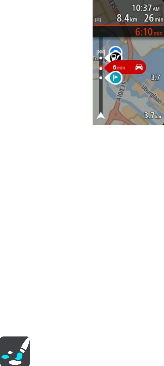
83
When the wide route bar is shown, you see more information about your route. For example, you
see time and distance to traffic queues and more.
Guidance view
In Guidance view you can change these settings:
Show current street name
This setting displays name of the street you are driving along.
Guidance view style
Select this setting to choose from 3D or 2D versions of the guidance view. Both the 2D and 3D
guidance views move in your direction of travel.
Automatic Zoom
Select Automatic zoom to change settings for the automatic zoom in Guidance view when you
approach a turn or a junction. Zooming in can make the turn or junction easier to drive.
Zoom in to next turn
All the turns and junctions on your route are shown zoomed in to the maximum level.
Based on road type
The turns and junctions on your route are shown zoomed in to the standard level for the type of
road you are on.
None
None of the turns and junctions on your route are shown zoomed in.
Motorway exit previews
Select Settings in the Main Menu, then select Appearance.
Select Motorway exit previews to change settings for the Guidance view as you approach a
motorway exits or junctions.
Show map and preview
84
A split screen is shown with the Guidance view on the left and lane guidance on the right.
Show preview only
Only lane guidance is shown.
Off
Only the Guidance view is shown.
Voices
Select Settings in the Main Menu, then select Voices.
Choosing a voice
Select Choose a voice to change the voice that gives spoken directions and other route instructions.
A wide range of voices are available. There are computer voices which can read street names and
other information directly from the map and there are recorded voices which have been recorded
by actors.
Note: Computer voices are not available in all languages.
If you need a computer voice and your language is unavailable, then you are asked to choose from
a list of installed computer voices available for the country you are in.
Instruction settings
Read aloud arrival time
Use this setting to control whether your arrival time is read aloud.
Read aloud early instructions
For example, if you switch on this setting, you could hear early instructions such as "'After 2 km
take the exit right" or "Ahead, turn left".
Note: When a recorded voice is chosen, you see only this setting because recorded voices
cannot read out road numbers, road signs, etc.
Read aloud road numbers
Use this setting to control whether road numbers are read aloud as part of navigation instruc-
tions. For example, when road numbers are read aloud, you hear "Turn left onto A100".
Read aloud road sign information
Use this setting to control whether road sign information is read aloud as part of navigation
instructions. For example, "Turn left onto A302 Bridge Street towards Islington."
Read aloud street names
Use this setting to control whether street names are read aloud as part of navigation instruc-
tions. For example, when street names are read aloud, you hear "Turn left Graham Road to-
wards Hackney."
Read aloud foreign street names
Use this setting to control whether foreign street names are read aloud as part of navigation
instructions, such as "Turn right onto Champs Élysées". For example, an English computer voice
can read and pronounce French street names but pronunciation may not be completely accu-
rate.
85
Maps
Select Settings in the Main Menu, then select Maps.
Changing the map
Select Change map to change the map that you are using.
You can choose from maps stored either in internal memory or memory cards if your TomTom GO
has a memory card slot.
Important: Routes and tracks cannot be stored on the same memory card as maps because different
memory card formatting is used.
Note: Although you can store more than one map on your TomTom GO, you can only use one map
at a time for planning and navigation.
Route Planning
Select Settings in the Main Menu, then select Route Planning.
Suggest destinations
When no route is planned, your device can learn your daily driving habits to saved favourite Places
and also predict destinations when you start the device from sleep mode, for example driving to
Work in the morning.
Switch on to receive destination suggestions or switch this feature off if you don't want destination
suggestions.
Note: You must switch on Keep journey history on this device for optional features in Settings
> System > Your information and privacy to see this feature.
When a faster route is available
If a faster route found while you are driving, TomTom Traffic can replan your journey to use the
faster route. Select from the following options:
Always take the fastest route - the fastest route will always be chosen for you.
Ask me so I can choose - you will be asked if you want to take the faster route. You can
manually select the faster route or you can select the route by steering towards it.
Don't ask me - your device will not find faster routes for you.
Always plan this type of route
The types of route you can choose from are as follows:
Fastest route - the route which takes the least time.
Shortest route - the shortest distance between the locations you set. This may not be the
quickest route, especially if the shortest route is through a town or city.
Most eco-friendly route - the most fuel-efficient route for your journey.
Winding route - the route with the most turns.
86
Note: Winding route is not available on all TomTom navigation devices or apps.
Avoid motorways - this type of route avoids all motorways.
Walking route - a route designed for making the journey on foot.
Bicycle route - a route designed for making the journey on a bicycle.
Avoid on every route
You can choose to avoid ferries and car shuttle trains, toll roads, carpool lanes, and unpaved roads.
Set how your TomTom GO should manage each of these road features when the device calculates a
route.
Carpool lanes are sometimes known as High Occupancy Vehicle Lanes (HOV) and are not present in
every country. To travel on these lanes, you may need to have more than one person in the car, for
example, or the car may need to use environmentally-friendly fuel.
Sounds and Warnings
Select Settings in the Main Menu, then select Sounds & Warnings.
On this screen, you can change sound and warning settings.
Warning type
You can choose how you want to be warned:
Read aloud
Hear spoken warnings and warnings sounds.
Sounds
Hear only warning sounds.
Visual only
No warning sounds are given.
Warnings
You can set how you want to be warned for different types of cameras, danger zones and safety
hazards. You can choose to be always warned, warned only if you are speeding, or never warned.
Speed Cameras & hazards
You can choose to switch off all speed camera, danger zone and hazard warnings. When Speed
Cameras & hazards is switched on, you can switch off the warnings for each type of speed camera,
danger zone and hazard.
Additional settings
Traffic jam ahead
Traffic jam warnings in the route bar are part of TomTom Traffic. You can choose never to be
warned or to always be warned when approaching a jam too quickly.
When speeding
This warning is given as soon as you exceed the speed limit by more than 5 km/h or 3 mph.
When you are speeding, the speed panel also turns red in the guidance view.
Screen touch sounds
Switch on Screen touch sounds to hear a click when you select an item or touch a button. The
click sound means that your selection or touch has been understood.

87
Language and Units
Select Settings in the Main Menu, then select Language & Units.
On this screen, you can change the following settings:
Language
You can see your currently selected language on this screen. Select this setting to change the
language used for all buttons and messages that you see on your TomTom GO.
When you change the language setting, the voice automatically changes and units are set to
automatic.
Country
You can see your currently selected country on this screen. Select this setting to change the
country. When you change the country, the time/date format, distance units and voice are
changed automatically. The list includes the countries from the maps currently installed on your
device.
Keyboards
Select this setting to choose from a list of available keyboards.
You use the keyboard to enter names and addresses, such as when you plan a route or search
for the name of a town or a local restaurant.
Units
Select this setting to choose the units used on your device for features such as route planning. If
you want the units to be set to those used in your current location, select Automatic.
Time and date
The time and date are automatically set by satellite clocks but you can change the format of
both the time and date using these settings.
System
Select Settings in the Main Menu, then select System.
On this screen, you can change these settings:
About
This screen shows you all sorts of useful information about your model of TomTom device. This
information is useful during calls to Customer Support and when renewing subscriptions using
the TomTom web shop.
Some of the information shown here includes:
Your service subscriptions - select a service to see how long your subscription has to run
before expiry.
Serial number.
Installed maps.
Free memory space.
Format memory card
If your device has a memory card slot, you can format a memory card so it can be used for
TomTom maps and other TomTom content.

88
Reset device
Select this setting to delete all your saved places and settings and restore the standard factory
settings to your TomTom GO Basic. This includes the language, voice settings, warning settings
and theme. The contact book from your phone is also deleted.
This is not a software update and will not affect the version of the software application in-
stalled on your TomTom GO.
Battery settings
Select this setting to control power saving options on your TomTom GO.
Your information & privacy
Some features require information to be sent to TomTom or stored on your device. You are
asked the following questions:
Keep journey history
If you agree, your device suggests destinations if the feature is supported by your device. If
you disagree at a later time, your historical route information is removed. This means that if
you want to receive suggested destinations again at a later time, the feature has to relearn
your driving patterns before it can start suggesting destinations.
Help
Select Help from the Main Menu or the Settings menu.
On this screen, you can see the following information:
Guided tour
Select this option to get a short tutorial on how to use your navigation device, if supported by
your device.
About
See System.
More help
You can get further help by going to tomtom.com/support.
For warranty and privacy information, go to tomtom.com/legal.
89
Help
Select Help from the Main Menu or the Settings menu.
On this screen, you can see the following information:
Guided tour
Select this option to get a short tutorial on how to use your navigation device, if supported by
your device.
About
See System.
More help
You can get further help by going to tomtom.com/support.
For warranty and privacy information, go to tomtom.com/legal.
Getting Help

90
Finding product certification information on your device
To find product certification information, such as the ICASA-approved certification number, do the
following on your TomTom GO:
1. Select Settings in the Main Menu.
2. Select System.
3. Select About.
4. Select Legal information.
5. Select Certificates.
6. You then see the relevant product certification information for your TomTom GO, for example,
ICASA.
Product certification
91
About MyDrive Connect
MyDrive Connect is a desktop-based application that helps you manage the content and services of
your TomTom GO Basic. For example, you can use MyDrive Connect to get map updates, software
updates or manage your TomTom account.
You can also manage your the devices associated with your account using MyDrive Connect.
Note: You can associate up to ten TomTom devices with one TomTom account.
It is a good idea to frequently connect your TomTom GO to MyDrive Connect to ensure you always
have the latest updates.
Important: On device models START 42/52, START 40/50/60, and GO 51/61, the screen intentional-
ly dims when you connect your device to your computer.
Tip: We recommend using a broadband internet connection whenever you connect your TomTom
GO to MyDrive Connect.
Tip: If you have a compatible navigation device, you can also use TomTom MyDrive to set a
destination, share locations and favourites, and save your personal navigation information.
TomTom account
To download content and to use TomTom services, you need a TomTom account.
You can create an account using your computer in one of the following ways:
By selecting the Create account button at tomtom.com.
By selecting the green MyTomTom button at tomtom.com.
By going to tomtom.com/getstarted.
Important: Take care when choosing a country during account creation. The correct country is
needed if you make a purchase from the TomTom shop and it cannot be changed after the account
has been created.
Note: If you have more than one TomTom navigation device in use, you need a separate account
for each device.
Setting up MyDrive Connect
To get ready to use MyDrive Connect for the first time, do the following:
On your computer, open a web browser and go to tomtom.com/getstarted.
1. Click Get Started.
2. Click Download MyDrive Connect.
3. Follow the instructions on the screen.
4. When prompted, connect your TomTom GO to your computer using the USB cable supplied, then
switch your TomTom GO on.
Note: Use ONLY the USB cable supplied with your TomTom GO. Other USB cables may not
work.
Updating using MyDrive Connect
92
Note: For devices with a separate mount, you cannot use the mount to connect your TomTom
GO to your computer.
Note: You should plug the USB cable directly into a USB port on your computer and not into a
USB hub or USB port on a keyboard or monitor.
5. Enter the requested information for account creation, including your country.
When set-up is complete, a TomTom account is created and your TomTom GO is linked to that
account.
You can now access MyDrive Connect from the notification area on your desktop.
MyDrive Connect starts automatically after the account is created.
Tip: When you connect your TomTom GO to your computer, MyDrive Connect tells you if there
are any updates for your TomTom GO.

93
Important Safety Notices and Warnings
Global Positioning System (GPS) and Global Navigation Satellite System (GLONASS)
The Global Positioning System (GPS) and Global Navigation Satellite System (GLONASS) systems are
satellite-based systems that provide location and timing information around the globe. GPS is
operated and controlled by the Government of the United States of America, which is solely
responsible for its availability and accuracy. GLONASS is operated and controlled by the Government
of Russia, which is solely responsible for its availability and accuracy. Changes in GPS or GLONASS
availability and accuracy, or in environmental conditions, may impact the operation of this device.
TomTom disclaims any liability for the availability and accuracy of GPS or GLONASS.
Safety messages
Important! Read before use!
Death or serious injury could result from failure or partial failure to follow these warnings and
instructions. Failure to properly set up, use, and care for this device can increase the risk of serious
injury or death, or damage to the device.
Use with care warning
It is your responsibility to use best judgment, due care and attention when using this device. Don't
allow interaction with this device to distract you while driving. Minimise the time spent looking at
the device screen while driving. You are responsible for observing laws that limit or prohibit the use
of mobile phones or other electronic devices, for example, the requirement to use hands-free
options for making calls when driving. Always obey applicable laws and road signs, especially
those relating to your vehicle’s dimensions, weight and payload type. TomTom does not
guarantee the error-free operation of this device nor the accuracy of route suggestions provided and
shall not be liable for any penalties arising from your failure to comply with applicable laws and
regulations.
Notice for oversized/commercial vehicles
Devices without a truck map installed will not provide appropriate routes for oversized/commercial
vehicles. If your vehicle is subject to weight, dimension, speed, route, or other restrictions on a
public road then you must only use a device that has a truck map installed. Your vehicle specifica-
tions must be entered accurately on the device. Use this device as a navigation aid only. Do not
follow navigation instructions which may put you or other road users in danger. TomTom accepts no
liability for damages resulting from your failure to observe this notice.
Proper mounting
Do not mount the device in a way that may obstruct your view of the road or your ability to control
the vehicle. Do not place the device in an area that may obstruct the deployment of an airbag or of
any other safety feature of your vehicle.
Addendum
94
Pacemakers
Pacemaker manufacturers recommend that a minimum of 15cm / 6 inches be maintained between a
handheld wireless device and a pacemaker to avoid potential interference with the pacemaker.
These recommendations are consistent with independent research and recommendations by
Wireless Technology Research.
Guidelines for people with pacemakers:
You should ALWAYS keep the device more than 15cm / 6 inches from your pacemaker.
You should not carry the device in a breast pocket.
Other medical devices
Please consult your physician or the manufacturer of the medical device, to determine if the
operation of your wireless product may interfere with the medical device.
Warning for Australia
The user needs to switch off the device when exposed to areas with potentially explosive
atmospheres such as petrol stations, chemical storage depots and blasting operations.
Device care
It is important to take care of your device:
Do not open the casing of your device under any circumstances. Doing so may be dangerous
and will invalidate the warranty.
Wipe or dry the screen of your device using a soft cloth. Do not use any liquid cleaners.
Rating: DC5V, 1.2A
Environmental and Battery information
Your device
Do not disassemble, crush, bend, deform, puncture, or shred your device. Do not use it in a humid,
wet and/or corrosive environment. Do not put, store or leave the device in a high temperature
location, in direct sunlight, in or near a heat source, in a microwave oven or in a pressurised
container, and do not expose it to temperatures over 50°C (122°F) or below -20°C (-4°F).
Avoid dropping the device. If the device is dropped and you suspect damage, please contact
customer support. Use the device only with the chargers, mounts or USB cables provided. For
TomTom approved replacements, go to tomtom.com.
Operating temperature
This device will remain fully operational within the temperature range 32°F / 0°C to 113°F / 45°C.
Prolonged exposure to higher or lower temperatures can cause damage to your device and is
therefore advised against.
Temperatures: Standard operation: 32°F / 0°C to 113°F / 45°C; short period storage: -4°F / -20°C
to 122°F / 50°C; long period storage: -4°F / -20°C to 95°F / 35°C.
Important: Before you switch on the device, let the device acclimatise to the standard operation
temperature range for at least 1 hour. Do not use the device outside of this temperature range.
Device battery (Non-replaceable)
This product contains a lithium polymer battery.
95
Do not modify or re-manufacture the battery. Do not attempt to insert foreign objects into the
battery, or immerse or expose to water or other liquids. Do not expose the battery to fire, explosion
or other hazard.
Do not short circuit a battery or allow metallic conductive objects to contact battery terminals.
Do not attempt to replace or remove the battery yourself unless the user manual clearly indicates
that the battery is user replaceable.
User replaceable batteries must only be used in systems for which they are specified.
Caution: Risk of explosion if the battery is replaced by an incorrect type.
If you have a problem with the battery, please contact TomTom Customer Support.
The stated battery life is the maximum possible battery life which is based on an average usage
profile and can only be achieved under specific atmospheric conditions. To prolong the battery life,
keep the device in a cool, dry place and follow the tips specified in this FAQ:
tomtom.com/batterytips. Charging will not occur at temperatures below 32°F / 0°C or over 113°F /
45°C.
Failure to follow these guidelines may cause the battery to leak acid, become hot, explode or ignite
and cause injury and/or damage. Do not attempt to pierce, open or disassemble the battery. If the
battery leaks and you come into contact with the leaked fluids, rinse thoroughly with water and
seek medical attention immediately.
WEEE – e-waste disposal
In the EU/EEA, this product is marked with the wheelie bin symbol on its body and/or packaging as
required by Directive 2012/19/EU (WEEE). This product shall not be treated as household waste or
be disposed of as unsorted municipal waste. You can dispose of this product by returning it to the
point of sale or bringing it to your local municipal collection point for recycling.
Outside of the EU/EEA, the wheelie bin symbol may not have the same meaning. More information
about national recycling options can be requested from a responsible local authority. It is the
responsibility of the end user to comply with local law when disposing of this product.
Triman logo
Declarations of Conformity (EU)
To view the Declarations of Conformity for all TomTom products, see:
http://www.tomtom.com/en_gb/legal/declaration-of-conformity/

96
Certification for Australia
This product displays the Regulatory Compliance Mark (RCM) to show that it complies with relevant
Australian regulations.
Warning for Australia
The user needs to switch off the device when exposed to areas with potentially explosive
atmospheres such as petrol stations, chemical storage depots and blasting operations.
Certification for New Zealand
This product displays R-NZ to show it complies with relevant New Zealand regulations.
Customer support contact (Australia and New Zealand)
Australia: 1300 135 604
New Zealand: 0800 450 973
Customer support contact (Asia)
Malaysia 1800815318
Singapore 8006162269
Thailand 0018006121008
Indonesia 0018030612011
TomTom MyDrive app
This device is compatible with the TomTom MyDrive mobile application which may be downloaded
from tomtom.com/mydrive-app. The use of the TomTom MyDrive mobile application on your
smartphone and any integration with your product will require that your smartphone has a wireless
data service plan provided by a third party wireless service carrier. The procurement of and all
charges associated with such a connectivity plan are your responsibility. TomTom shall not be liable
for any costs or expenses associated with such network connectivity plan (such as the data charges
or possible tethering fees which may be imposed by your carrier). Any changes to the availability or
reliability of the network connection may impact the operation of certain TomTom services which
may be offered on this device.
Legal terms
For information regarding how TomTom uses your data and personal information, visit
tomtom.com/privacy. Please see tomtom.com/legal for general terms and conditions including the
limited warranty, end user licence agreements and additional copyrights applying to this product,
embedded software and services. The software included in this product contains copyrighted
software that is licensed under the GPL. A copy of that licence can be viewed in the Third Party
Licences section. You can obtain the complete corresponding source code from us for a period of
three years after our last shipment of this product. For more information, visit tomtom.com/gpl or
contact your local TomTom customer support team at tomtom.com/support. Upon request, we will
send you a CD with the corresponding source code.
97
Great care was taken in preparing this document. Constant product development may mean that
some information is not entirely up to date. The information in this document is subject to change
without notice. TomTom reserves the right to update, change and improve its products and
materials without obligation of notice. For updated and additional information, please visit the
TomTom website at tomtom.com.
TomTom shall not be liable for technical or editorial errors or omissions contained herein, nor for
incidental or consequential damages resulting from the performance or use of this document.
This document contains information protected by copyright. No part of this document may be
photocopied or reproduced in any form without prior written consent from TomTom N.V.
Model numbers
TomTom GO Basic: 4BA53, 4BA63
CE mark and Radio Equipment Directive for TomTom GO
This device can be used in all EU Member States. The frequency bands and the maximum radio
frequency emission power in which this device operates are as follows:
Model
Frequency band
(Bluetooth)
(MHz)
Maximum radio
frequency
emission power
(dBm)
Frequency band (WiFi)
(MHz)
Maximum radio
frequency
emission power
(dBm)
4BA53
2402 - 2480
5.5
2412 – 2472
19
4BA63
2402 - 2480
5.5
2412 – 2472
19
Hereby, TomTom declares that the radio equipment type TomTom GO Basic GPS Navigation system
is in compliance with Directive 2014/53/EU. The full text of the EU declaration of conformity is
available at the following internet address:
http://www.tomtom.com/en_gb/legal/declaration-of-conformity/
THIS WIRELESS DEVICE MODEL MEETS GOVERNMENT REQUIREMENTS FOR EXPOSURE TO RADIO WAVES
WHEN USED AS DIRECTED IN THIS SECTION
This GPS Navigation System is a radio transmitter and receiver. It is designed and manufactured not
to exceed the emission limits for exposure to radio frequency (RF) energy set by the Council of the
European Union.
The SAR limit recommended by The Council of the European Union is 2.0W/kg averaged over 10
grams of tissue for the body (4.0 W/kg averaged over 10 grams of tissue for the extremities - hands,
wrists, ankles and feet). Tests for SAR are conducted using standard operating positions specified
by the EU council with the device transmitting at its highest certified power level in all tested
frequency bands.

98
Important Safety Notices and Warnings
Global Positioning System (GPS) and Global Navigation Satellite System (GLONASS)
The Global Positioning System (GPS) and Global Navigation Satellite System (GLONASS) systems are
satellite-based systems that provide location and timing information around the globe. GPS is
operated and controlled by the Government of the United States of America, which is solely
responsible for its availability and accuracy. GLONASS is operated and controlled by the Government
of Russia, which is solely responsible for its availability and accuracy. Changes in GPS or GLONASS
availability and accuracy, or in environmental conditions, may impact the operation of this device.
TomTom disclaims any liability for the availability and accuracy of GPS or GLONASS.
Safety messages
Important! Read before use!
Death or serious injury could result from failure or partial failure to follow these warnings and
instructions. Failure to properly set up, use, and care for this device can increase the risk of serious
injury or death, or damage to the device.
Use with care warning
It is your responsibility to use best judgment, due care and attention when using this device. Don't
allow interaction with this device to distract you while driving. Minimise the time spent looking at
the device screen while driving. You are responsible for observing laws that limit or prohibit the use
of mobile phones or other electronic devices, for example, the requirement to use hands-free
options for making calls when driving. Always obey applicable laws and road signs, especially
those relating to your vehicle’s dimensions, weight and payload type. TomTom does not
guarantee the error-free operation of this device nor the accuracy of route suggestions provided and
shall not be liable for any penalties arising from your failure to comply with applicable laws and
regulations.
Notice for oversized/commercial vehicles
Devices without a truck map installed will not provide appropriate routes for oversized/commercial
vehicles. If your vehicle is subject to weight, dimension, speed, route, or other restrictions on a
public road then you must only use a device that has a truck map installed. Your vehicle specifica-
tions must be entered accurately on the device. Use this device as a navigation aid only. Do not
follow navigation instructions which may put you or other road users in danger. TomTom accepts no
liability for damages resulting from your failure to observe this notice.
Proper mounting
Do not mount the device in a way that may obstruct your view of the road or your ability to control
the vehicle. Do not place the device in an area that may obstruct the deployment of an airbag or of
any other safety feature of your vehicle.
Addendum

99
Pacemakers
Pacemaker manufacturers recommend that a minimum of 15cm / 6 inches be maintained between a
handheld wireless device and a pacemaker to avoid potential interference with the pacemaker.
These recommendations are consistent with independent research and recommendations by
Wireless Technology Research.
Guidelines for people with pacemakers:
You should ALWAYS keep the device more than 15cm / 6 inches from your pacemaker.
You should not carry the device in a breast pocket.
Other medical devices
Please consult your physician or the manufacturer of the medical device, to determine if the
operation of your wireless product may interfere with the medical device.
Device care
It is important to take care of your device:
Do not open the casing of your device under any circumstances. Doing so may be dangerous
and will invalidate the warranty.
Wipe or dry the screen of your device using a soft cloth. Do not use any liquid cleaners.
Special Note Regarding Driving in California, Minnesota and Other States
California Vehicle Code Section 26708 which applies to those driving within the State of California
restricts the mounting of a navigation device on the windshield to a seven-inch square in the lower
corner of the windshield farthest removed from the driver or in a five-inch square in the lower
corner of the windshield nearest to the driver and outside of an airbag deployment zone, if the
system is used only for door-to-door navigation while the motor vehicle is being operated. Drivers in
California should not mount the device on their side or rear windows.
Minnesota State Legislature Statutes Section 169.71, subdivision 1, section 2 restricts any person
driving within the State of Minnesota from driving with a device suspended between the driver and
the windshield.
Many other states have enacted laws which restrict the placement of any object or material on the
windshield, side or rear window that obstructs a driver's clear view of the road. It is incumbent upon
the driver to be aware of all applicable laws and to place the device in such a manner that will not
interfere with his/her driving.
TomTom Inc. bears no responsibility for and hereby disclaims all liability for any fines, penalties or
damage incurred by a driver for violations of the law. While driving in any state with windshield
mounting restrictions, TomTom recommends using the supplied Adhesive Mounting Disk or
purchasing an alternative mounting system (e.g. dashboard or air vents). See tomtom.com for more
information about these mounting options.
Rating: DC5V, 1.2A
How TomTom uses your information
Information regarding the use of personal information can be found at: tomtom.com/privacy.
100
Environmental and Battery information
Your device
Do not disassemble, crush, bend, deform, puncture, or shred your device. Do not use it in a humid,
wet and/or corrosive environment. Do not put, store or leave the device in a high temperature
location, in direct sunlight, in or near a heat source, in a microwave oven or in a pressurised
container, and do not expose it to temperatures over 50°C (122°F) or below -20°C (-4°F).
Avoid dropping the device. If the device is dropped and you suspect damage, please contact
customer support. Use the device only with the chargers, mounts or USB cables provided. For
TomTom approved replacements, go to tomtom.com.
Operating temperature
This device will remain fully operational within the temperature range 32°F / 0°C to 113°F / 45°C.
Prolonged exposure to higher or lower temperatures can cause damage to your device and is
therefore advised against.
Temperatures: Standard operation: 32°F / 0°C to 113°F / 45°C; short period storage: -4°F / -20°C
to 122°F / 50°C; long period storage: -4°F / -20°C to 95°F / 35°C.
Important: Before you switch on the device, let the device acclimatise to the standard operation
temperature range for at least 1 hour. Do not use the device outside of this temperature range.
Device battery (Non-replaceable)
This product contains a lithium polymer battery.
Do not modify or re-manufacture the battery. Do not attempt to insert foreign objects into the
battery, or immerse or expose to water or other liquids. Do not expose the battery to fire, explosion
or other hazard.
Do not short circuit a battery or allow metallic conductive objects to contact battery terminals.
Do not attempt to replace or remove the battery yourself unless the user manual clearly indicates
that the battery is user replaceable.
User replaceable batteries must only be used in systems for which they are specified.
Caution: Risk of explosion if the battery is replaced by an incorrect type.
If you have a problem with the battery, please contact TomTom Customer Support.
The stated battery life is the maximum possible battery life which is based on an average usage
profile and can only be achieved under specific atmospheric conditions. To prolong the battery life,
keep the device in a cool, dry place and follow the tips specified in this FAQ:
tomtom.com/batterytips. Charging will not occur at temperatures below 32°F / 0°C or over 113°F /
45°C.
Failure to follow these guidelines may cause the battery to leak acid, become hot, explode or ignite
and cause injury and/or damage. Do not attempt to pierce, open or disassemble the battery. If the
battery leaks and you come into contact with the leaked fluids, rinse thoroughly with water and
seek medical attention immediately.
WEEE e-waste disposal
This product is marked with the crossed-out wheeled-bin symbol on its body and/or packaging to
show that it shall not be treated as household waste or be disposed of as unsorted municipal waste.
Please dispose of this product by making use of local e-waste collection point or other recycling
facility or by returning it to the point of sale. More information about national recycling options can
be requested from the responsible local authority in your country.

101
USA Specific Absorption Rate (SAR) compliance
THIS WIRELESS DEVICE MODEL MEETS GOVERNMENT REQUIREMENTS FOR EXPOSURE TO RADIO WAVES
WHEN USED AS DIRECTED IN THIS SECTION
This GPS Navigation System is a radio transmitter and receiver. It is designed and manufactured not
to exceed the emission limits for exposure to radio frequency (RF) energy set by the Federal
Communications Commission (FCC) of the U.S. Government, Industry Canada of the Canadian
Government (IC).
The SAR limit recommended by the Federal Communications Commission (FCC) of the U.S.
Government, Industry Canada of the Canadian Government (IC) is 1.6W/kg averaged over 1 gram of
tissue for the body (4.0 W/kg averaged over 10 grams of tissue for the extremities - hands, wrists,
ankles and feet). Tests for SAR are conducted using standard operating positions specified by FCC/IC
with the device transmitting at its highest certified power level in all tested frequency bands.
FCC information for the user
THE DEVICE COMPLIES WITH PART 15 OF THE FCC RULES
Federal Communications Commission (FCC) Statement
This equipment radiates radio frequency energy and if not used properly - that is, in strict
accordance with the instructions in this manual - may cause interference to radio communications
and television reception.
Operation is subject to the following two conditions: (1) this device may not cause harmful
interference and (2) this device must accept any interference, including interference that may
cause undesired operation of the device.
This device has been tested and found to comply with the limits for a Class B digital device,
pursuant to part 15 of the FCC rules. These limits are designed to provide reasonable protection
against harmful interference in a residential installation. This equipment generates, uses and can
radiate radio frequency energy and, if not installed and used in accordance with the instructions,
may cause harmful interference to radio communications. However, there is no guarantee that
interference will not occur in a particular installation. If this equipment does cause harmful
interference to radio or television reception, which can be determined by turning the equipment off
and on, the user is encouraged to try to correct the interference by one or more of the following
measures:
Reorient or relocate the receiving antenna.
Increase the separation between the equipment and receiver.
Connect the equipment into an outlet on a circuit different from that to which the receiver
is connected.
Consult the dealer or an experienced radio/TV technician for help.
Changes or modifications not expressly approved by the party responsible for compliance could void
the user's authority to operate the equipment.
102
Important
This equipment was tested for FCC compliance under conditions that included the use of shielded
cables and connectors between it and the peripherals. It is important that you use shielded cable
and connectors to reduce the possibility of causing radio and television interference. Shielded
cables, suitable for the product range, can be obtained from an authorized dealer. If the user
modifies the equipment or its peripherals in any way, and these modifications are not approved by
TomTom, the FCC may withdraw the user’s right to operate the equipment. For customers in the
USA, the following booklet prepared by the Federal Communications Commission may be of help:
"How to Identify and Resolve Radio-TV Interference Problems". This booklet is available from the US
Government Printing Office, Washington, DC 20402. Stock No 004-000-00345-4.
FCC ID: S4L4BA53, S4L4BA63
IC: 5767A-4BA53, 5767A-4BA63
FCC RF Radiation Exposure Statement
The transmitters within this device must not be co-located or operating in conjunction with any
other antenna or transmitter.
ISED RF Exposure Guidance Statement (in English)
In order to comply with FCC / ISED RF exposure requirements, this device must be installed at least
20 cm away from the human body at all times.
ISED RF Exposure Guidance Statement (in French)
Afin de se conformer aux exigences d'exposition RF FCC / ISED, cet appareil doit être installé pour
fournir au moins 20 cm de séparation du corps humain en tout temps.
FCC Country Code Selection
The Country Code Selection feature is disabled for products marketed in the US or Canada. Per FCC
regulations, all Wi-Fi products marketed in US must be fixed to US operation channels only.
Location of FCC ID and IC ID information on your device
The FCC ID and IC ID can be found on the bottom of your device.
Exposure limits
This device complies with radiation exposure limits set forth for an uncontrolled environment. In
order to avoid the possibility of exceeding the radio frequency exposure limits, human proximity to
the antenna shall not be less than 20 cm (8 inches) during normal operation.
Limites d'exposition
Cet équipement est conforme aux limites d'exposition aux rayonnements définies pour un
environnement non contrôlé. Afin d'éviter tout dépassement potentiel des limites d'exposition aux
frèquences radio, tout être humain doit rester éloigné d'au moins 20cm (8 puces) de l'antenne dans
le cadre d'un fonctionnement normal.
Emissions information for Canada
This device complies with Industry Canada license-exempt RSS standard(s). Operation is subject to
the following two conditions:
This device may not cause interference.
This device must accept any interference, including interference that may cause undesired
operation of the device.
Operation is subject to the condition that this device does not cause harmful interference.
This Class B digital apparatus complies with Canadian ICES-003. CAN ICES-3(B)/NMB-3(B)

103
The Country Code Selection feature is disabled for products marketed in the US or Canada.
Equipment is certified to the requirements of RSS-247 for 2.4-GHz.
Informations relatives aux émissions au Canada
Son fonctionnement est soumis aux deux conditions suivantes :
Cet appareil ne doit pas creér d'interférences nuisibles.
Cet appareil doit tolérer les interférences reçues, notamment celles susceptibles de
provoquer un fonctionnement indésiable.
Son utilisation est autorisée dans la mesure où l'appareil ne provoque pas d'interférences nuisibles.
Cet appareil numérique de classe B est conforme aux règlements canadiens ICES-003.
La fonction de sélection du code de pays est désactivée pour les produits distribués aux États-Unis
ou au Canada.
L'équipement est certifié conforme aux exigences de la norme RSS-210 pour le 2,4 GHz.
IMPORTANT NOTE
IC Radiation Exposure Statement:
This equipment complies with IC RSS-102 radiation exposure limits set forth for an uncon-
trolled environment.
This device and its antenna(s) must not be co-located or operating in conjunction with any
other antenna or transmitter.
End users must follow the specific operating instructions for satisfying RF exposure compli-
ance. To maintain with IC RF exposure compliance requirements please follow operation in-
struction as documented in this manual.
REMARQUE IMPORTANTE
Déclaration d'exposition aux rayonnements IC :
Cet équipement est conforme aux limites d'exposition aux rayonnements définies par la
norme IC RSS-102 pour un environnement non contrôlé.
Cet appareil et son ou ses antenne(s) ne doivent pas être placés à proximité d'un autre
émetteur ou d'une autre antenne, ou manipulés simultanément avec ces derniers.
Additional information
TomTom MyDrive app
This device is compatible with the TomTom MyDrive mobile application which may be downloaded
from tomtom.com/mydrive-app. The use of the TomTom MyDrive mobile application on your
smartphone and any integration with your product will require that your smartphone has a wireless
data service plan provided by a third party wireless service carrier. The procurement of and all
charges associated with such a connectivity plan are your responsibility. TomTom shall not be liable
for any costs or expenses associated with such network connectivity plan (such as the data charges
or possible tethering fees which may be imposed by your carrier). Any changes to the availability or
reliability of the network connection may impact the operation of certain TomTom services which
may be offered on this device.
Responsible party in North America
TomTom, Inc., 2400 District Avenue, Burlington, MA 01803, Tel: 866 486-6866 option 1
(1-866-4-TomTom)

104
Terms and Conditions: Limited warranty and EULA
Our terms and conditions, including our limited warranty and end user licence terms apply to this
product. Visit tomtom.com/legal.
This document
Great care was taken in preparing this document. Constant product development may mean that
some information is not entirely up to date. The information is subject to change without notice.
TomTom shall not be liable for technical or editorial errors or omissions contained herein, nor for
incidental or consequential damages resulting from the performance or use of this document. This
document may not be copied without the prior written consent from TomTom N.V.
Model numbers
TomTom GO Basic: 4BA53, 4BA63
Accessories supplied with this device
Magnetic Mount
Car charger with TMC traffic receiver if applicable to your country
USB cable
Quick Start Guide
105
© 1992 - 2018 TomTom. All rights reserved. TomTom and the "two hands" logo are registered
trademarks of TomTom N.V. or one of its subsidiaries.
The software included in this product contains copyrighted software that is licensed under the GPL.
A copy of that licence can be viewed in the Licence section. You can obtain the complete
corresponding source code from us for a period of three years after our last shipment of this
product. For more information, visit tomtom.com/gpl or contact your local TomTom customer
support team at tomtom.com/support. Upon request, we will send you a CD with the corresponding
source code.
The Bluetooth® word mark and logos are registered trademarks owned by Bluetooth SIG, Inc. and
any use of such marks by TomTom is under licence. Other trademarks and trade names are those of
their respective owners.
Wi-Fi® is a registered trademark of Wi-Fi Alliance®.
Apple, the Apple logo and Siri are trademarks of Apple Inc. registered in the U.S. and other
countries. App Store is a service mark of Apple Inc. registered in the U.S. and other countries.
Google Now, Google Play and the Google Play logo are trademarks of Google LLC.
microSD Logo is a trademark of SD-3C, LLC.
Copyright notices