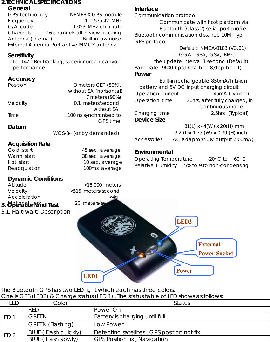
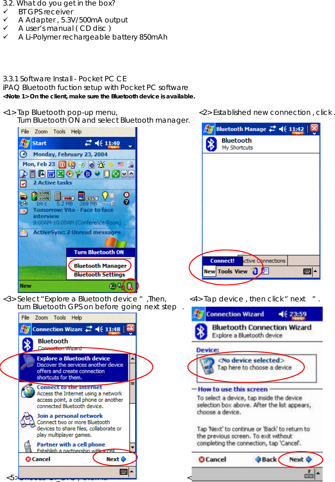
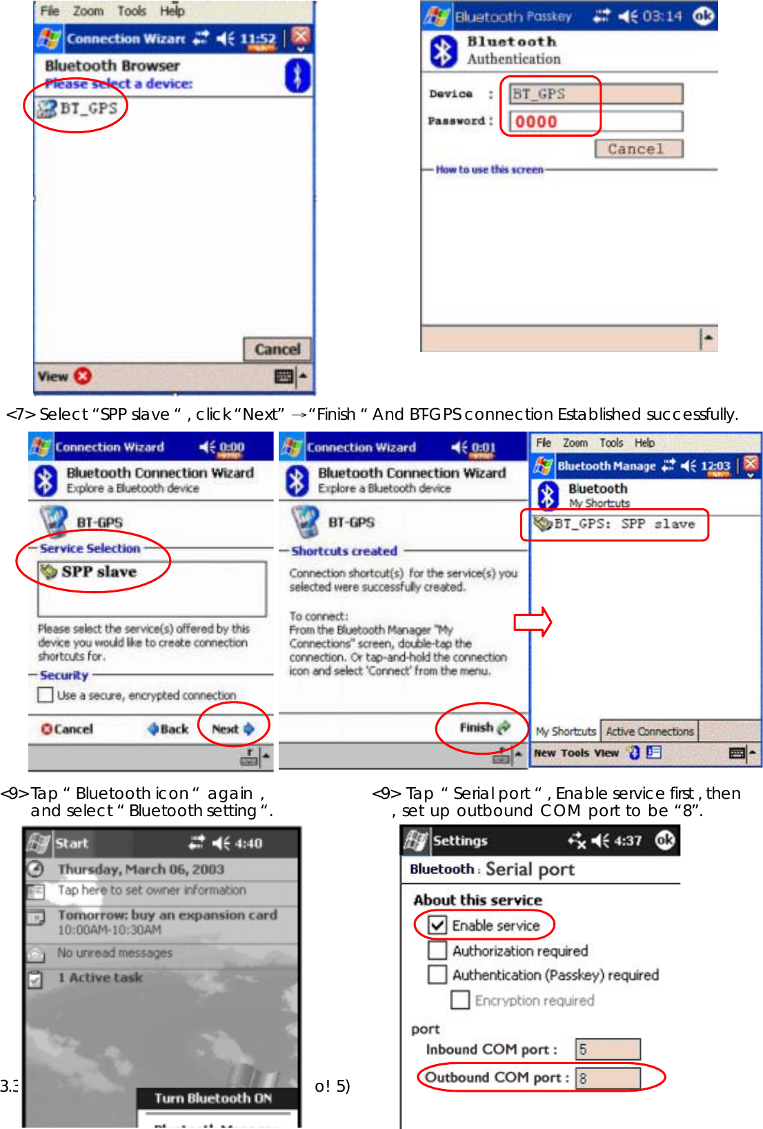
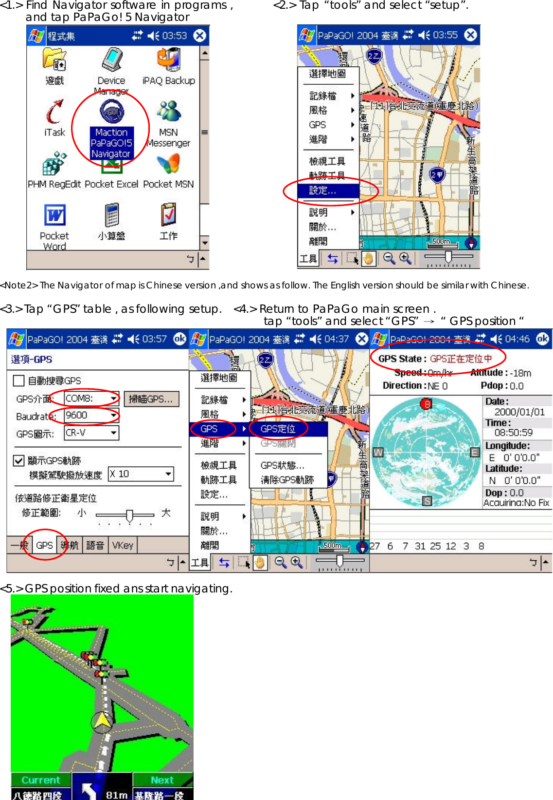
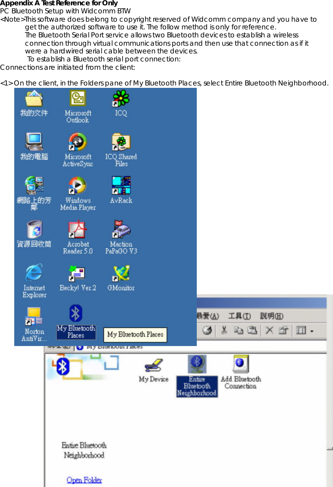
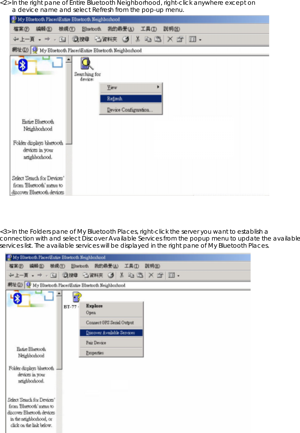
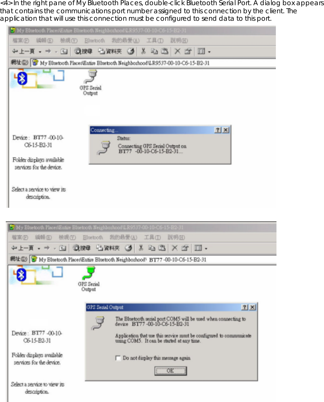
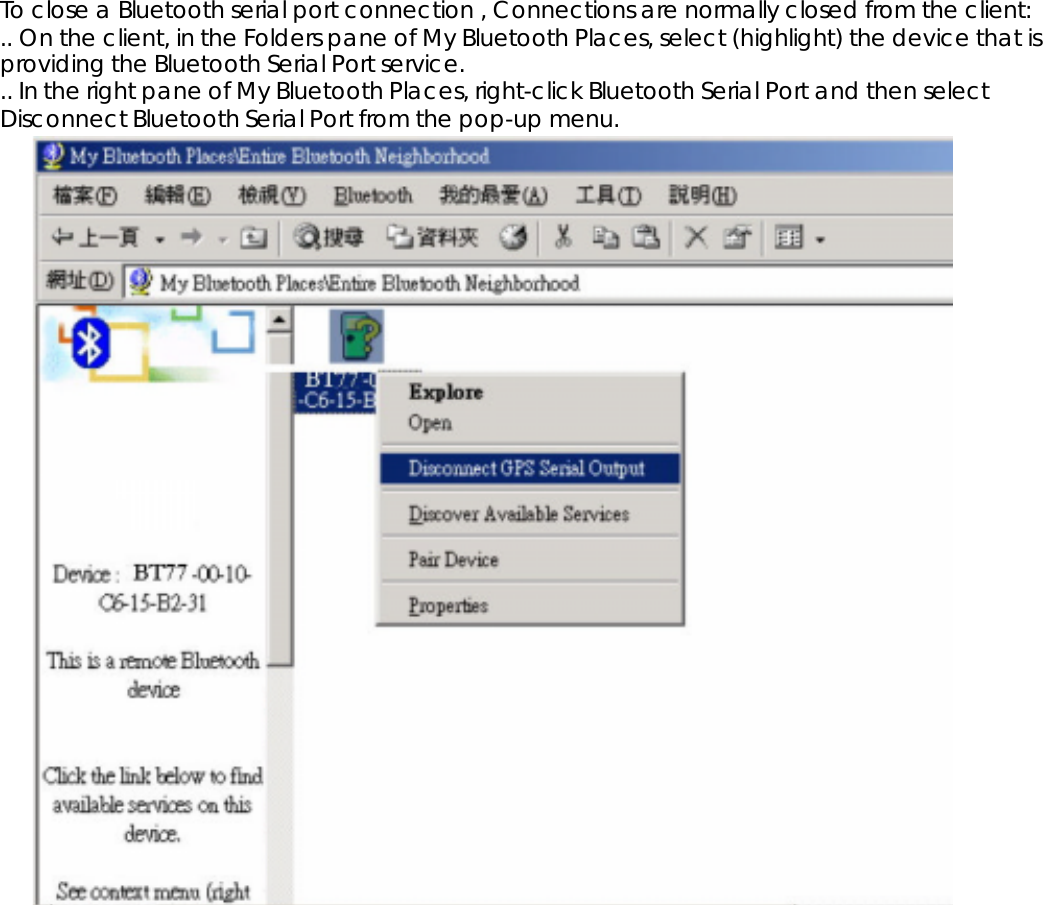
Wonde Proud Technology WPBT77X BLUETOOTH GPS RECEIVER User Manual USERS MANUAL

Wonde Proud Technology Co., Ltd. BLUETOOTH GPS RECEIVER USERS MANUAL

USERS MANUAL

***  USER’S MANUAL  ***FCC ID : SRKWPBT77X
The Federal Communication Commission StatementThis equipment has been tested and found to comply with the limits for a Class B Digital Device,pursuant to Part 15 of the FCC rules.  These limits are designed to provide reasonable protection against harmful interference in a residential installation.  This equipment generates, uses and canradiate radio frequency energy and, if not installed and used in accordance with the instruction, may cause harmful interference to radio communication.  However, there is no guarantee thatinterference will not occur in a particular installation.  If this equipment does cause harmfulinterference to radio or television reception, which can be determined by turning the equipment off and on, the user is encouraged to try to correct the interference by one of more of the following measures: --Reorient or relocate the receiving antenna.-Increase the separation between the equipment and receiver.-Connect the equipment into an outlet on a circuit different from that to which the receiveris connected.-Consult the dealer or an experienced Radio/TV technician for help.Use only shielded cables to connect I/O devices to this equipment.  You are cautioned that change or modifications not expressly approved by the party responsible for compliance could void yourauthority to operate the equipment.THIS DEVICE COMPLIES WITH PART 15 OF FCC RULES.  OPERATION IS SUBJECT TO THEFOLLOWING TWO CONDITIONS: -1. This device may not cause harmful interference and2. This device must accept any interference received, including interference that may causeundesired operation.
Bluetooth GPS ReceiverContents1. INTRODUCTION..........................................................................................................................1 1.1. OVERVIEW ...............................................................................................................................1 1.2. MAIN FEATURES.......................................................................................................................12. TECHNICAL SPECIFICATIONS .................................……............................................................ 23. OPERATION AND TEST.................................................................................................................33.1. HARDWARE DESCRIPTION........................................................................................................4 3.2. WHAT DO YOU GET IN THE BOX?..............................................................................................53.3. SOFTWARE INSTALL .................................................................................................................5 4. APPENDIX A TEST REFERENCE FOR ONLY..............................................................................10
1. Introduction 1.1. Overview The BT-77 Bluetooth GPS receiver is a Global Position System Receiver with Bluetooth wireless technology. This BT GPS receiver allows you to receive GPS data on mobile handhelds wirelessly. By sending GPS position data over Bluetooth, you can position the receiver for the best possible reception all without wires. The advent of Bluetooth GPS receiver will become the next level of GPS receivers. The BT GPS receiver integrates Bluetooth module into GPS device. It shows the high performance, low power consumption, easily portable, rechargeable & removable battery function and wireless data transmission. If you have a Pocket PC or other portable devices enabled with Bluetooth function, for example ASUS-620, iPAQ 2210, HPand Palm , you can take advantage of your device’s Bluetooth capability to wirelessly add GPS positioning technology. When you choose suitable navigation software, you can apply to personal, vehicle tracking, and marine navigation. If you use this Bluetooth GPS receiver, you will ignore the messy cords and antenna and add the portability of your Pocket PC. In addition, This Bluetooth GPS receiver can change the exhausted battery to full battery like battery of mobile phone. 1.2. Main Features16 Channels “All-In-View” TrackingCold/Warm/Hot Start Time: 45/38/10 Seconds : Reacquisition Time: 0.1 secondsSupport Standard NMEA-0183 at 9600 bps baund rateCompatible with Bluetooth devices with Serial Port Profile (SPP)Small, sleek, and lightweight design easily fits in your handTwo LEDs at the top of the device show Bluetooth and GPS. & On/off push buttonFleet management/Asset trackingPersonal/Portable Navigation (PDA, Pocket PC etc.)Location Based Services enabled devicesUltra low power-up to 16 hours after fully charged (850mA Li-ion Battery)High sensitivity-147dBm Integrated GPS receiver, Active antenna, and Bluetooth transceiver
2.TECHNICAL SPECIFICATIONS3. Operation and Test3.1. Hardware Description The Bluetooth GPS has two LED light which each has three colors. One is GPS (LED2) & Charge status (LED 1) . The status table of LED shows as follows: LED Color StatusRED Power OnGREEN Battery is charging until fullLED 1 GREEN (Flashing) Low PowerBLUE ( Flash quickly) Detecting satellites , GPS position not fix.LED 2 BLUE ( Flash slowly) GPS Position fix , NavigationLED1LED2PowerExternalPower SocketGeneralGPS technology NEMERIX GPS moduleFrequency                    L1, 1575.42 MHzC/A code               1.023 MHz chip rateChannels 16 channels all in view trackingAntenna (internal)            Built-in low noise External Antenna Port active MMCX antennaSensitivityto -147 dBm tracking, superior urban canyon performanceAccuracyPosition   3 meters CEP (50%), without SA (horizontal)  7 meters (90%)Velocity                   0.1 meters/second, without SATime ±100 ns synchronized to GPS timeDatum WGS-84 (or by demanded)Acquisition RateCold start   45 sec, averageWarm  start   38 sec, averageHot start   10 sec, averageReacquisition 100ms, averageDynamic ConditionsAltitude                       <18,000 metersVelocity                 <515 meters/secondAcceleration                           <4gMotional Jerk              20 meters/secondInterfaceCommunication protocolCommunicate with host platform viaBluetooth (Class 2) serial port profileBluetooth communication distance 10M. Typ.GPS protocol Default: NMEA-0183 (V3.01)—GGA, GSA, GSV, RMC,the update interval 1 second (Default)Band rate  9600 bps(Data bit : 8,stop bit : 1)Power Built-in rechargeable 850mA/h Li-ionbattery and 5V DC input charging circuitOperation current 45mA (Typical)Operation  time 20hrs, after fully charged, in Continuous modeCharging time                 2.5hrs. (Typical)Device Size 81(L) x 44(W) x 20(H) mm3.2 (L)x 1.75 (W) x 0.79 (H) inchAccessories AC adaptor(5.3V output ,500mA)EnvironmentalOperating Temperature -20°C to + 60°CRelative Humidity 5% to 90% non-condensing
3.2. What do you get in the box? 9BT GPS receiver 9A Adapter , 5.3V/500mA output9A user’s manual ( CD disc )9A Li-Polymer rechargeable battery 850mAh3.3.1 Software Install - Pocket PC CEiPAQ Bluetooth fuction setup with Pocket PC software <Note 1> On the client, make sure the Bluetooth device is available.<1> Tap Bluetooth pop-up menu,  <2> Established new connection , click .Turn Bluetooth ON and select Bluetooth manager. <3> Select “Explore a Bluetooth device “ ,Then, <4> Tap device , then click “ next “ .turn Bluetooth GPS on before going next step  . <5>Choose BT_GPS , click it.                         <6> Enter passkey “ 0000”. Enter.
 <7> Select “SPP slave “ , click “Next” Ш“Finish “ And BT-GPS connection Established successfully.<9> Tap “ Bluetooth icon “ again ,               <9> Tap “ Serial port “ , Enable service first , thenand select “ Bluetooth setting “.         , set up outbound COM port to be “8”.3.3.2 Software setup – Navigator (PaPaGo! 5)
<1.> Find Navigator software in programs ,         <2.> Tap “tools” and select “setup”.and tap PaPaGo! 5 Navigator <Note2> The Navigator of map is Chinese version ,and shows as follow. The English version should be similar with Chinese. <3.> Tap “GPS” table , as following setup.   <4.> Return to PaPaGo main screen . tap “tools” and select “GPS” Ш“ GPS position “<5.> GPS position fixed ans start navigating.
Appendix A Test Reference for Only PC Bluetooth Setup with Widcomm BTW <Note>This software does belong to copyright reserved of Widcomm company and you have to get the authorized software to use it. The follow method is only for reference. The Bluetooth Serial Port service allows two Bluetooth devices to establish a wireless connection through virtual communications ports and then use that connection as if itwere a hardwired serial cable between the devices. To establish a Bluetooth serial port connection: Connections are initiated from the client: <1> On the client, in the Folders pane of My Bluetooth Places, select Entire Bluetooth Neighborhood.
<2> In the right pane of Entire Bluetooth Neighborhood, right-click anywhere except on a device name and select Refresh from the pop-up menu. <3> In the Folders pane of My Bluetooth Places, right-click the server you want to establish a connection with and select Discover Available Services from the popup menu to update the available services list. The available services will be displayed in the right pane of My Bluetooth Places.
<4> In the right pane of My Bluetooth Places, double-click Bluetooth Serial Port. A dialog box appears that contains the communications port number assigned to this connection by the client. The application that will use this connection must be configured to send data to this port.
To close a Bluetooth serial port connection , Connections are normally closed from the client: .. On the client, in the Folders pane of My Bluetooth Places, select (highlight) the device that is providing the Bluetooth Serial Port service. .. In the right pane of My Bluetooth Places, right-click Bluetooth Serial Port and then select Disconnect Bluetooth Serial Port from the pop-up menu.

Navigation menu