Flir BelgiumBA DP4KW Light Marine Navigational Radar User Manual E Series Networked Display Ref Manual Part 1

Raymarine UK Ltd. Light Marine Navigational Radar E Series Networked Display Ref Manual Part 1

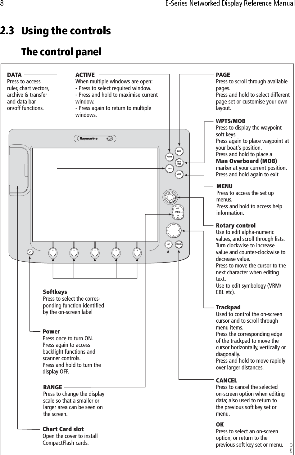
E Series Guide Part 1
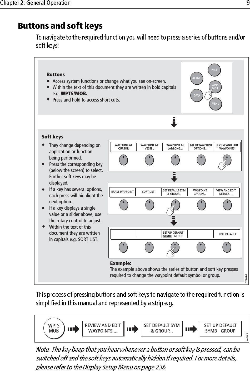
            (1)(2)
•••••
1.1 What will my E-Series integrate with? ...........................................................11.2 What can the E-Series Display do? .................................................................21.3 The Simulator .................................................................................................52.1 Introduction  ....................................................................................................72.2 Powering the display ON/OFF .......................................................................72.3 Using the controls ...........................................................................................8The control panel ...................................................................................... 8Buttons and soft keys ................................................................................ 9The cursor ............................................................................................... 102.4 Displaying applications ............................................................................... 102.5 Additional screen information ......................................................................112.6 Initial setup procedures ................................................................................ 15Selecting the data master (Networked E-Series only) ............................ 15Setting the language, date/time format and units of measurement ......... 15Selecting a page set ................................................................................. 16Selecting an application page ................................................................. 16Selecting an application window ............................................................ 17Adjusting the display lighting  ................................................................ 182.7 Using CompactFlash cards .......................................................................... 19Cautions .................................................................................................. 19What are CompactFlash cards used for? ................................................ 19Inserting a card ....................................................................................... 20Removing a card ..................................................................................... 202.8 Managing data ............................................................................................. 21Writing/retrieving data to a CompactFlash card ..................................... 21Sending and receiving information using a PC  ...................................... 25Password protecting your waypoints  ..................................................... 252.9 Operating a networked E-Series Display ..................................................... 28What does a networked system do? ........................................................ 28Controlling a network ............................................................................. 28Functions only affecting the display in use ............................................. 29
2.10 Emergencies and warnings .......................................................................... 30Man Overboard (MOB) .......................................................................... 30Alarms .................................................................................................... 313.1 What is a waypoint? ..................................................................................... 333.2 How are waypoints represented? ................................................................. 343.3 Placing a waypoint ....................................................................................... 353.4 Navigating to a waypoint ............................................................................. 36Start navigating to a waypoint ................................................................ 36Stop navigating to a waypoint ................................................................ 373.5 Viewing waypoint information .................................................................... 373.6 Editing a waypoint ....................................................................................... 38Changing waypoint details ..................................................................... 39Moving a waypoint ................................................................................. 39Erasing a waypoint(s) ............................................................................. 40Changing the default symbol or group ................................................... 413.7 Sorting the waypoint list .............................................................................. 423.8 Organising waypoints into groups ............................................................... 42Displaying the waypoint group list ......................................................... 42Making a new waypoint group ............................................................... 43Moving waypoints between groups  ....................................................... 43Renaming an existing group ................................................................... 44Erasing a group ....................................................................................... 453.9 Controlling waypoint display ...................................................................... 45Show/hide waypoint names  ................................................................... 45Showing/hiding waypoint symbols ........................................................ 46Showing/hiding waypoint groups .......................................................... 464.1 Important  ..................................................................................................... 47Navionics support ................................................................................... 47Safety ...................................................................................................... 47Chart functionality  ................................................................................. 47Chart cards .............................................................................................. 48
4.2 Uses of the chart application ........................................................................ 484.3 Viewing the chart ......................................................................................... 504.4 The chart display .......................................................................................... 504.5 Where am I on the chart?  ............................................................................. 514.6 Moving around the chart .............................................................................. 514.7 Additional information on the chart ............................................................. 52Displaying details of objects and features .............................................. 53Finding nearby features and services  ..................................................... 53Animated tides and currents ................................................................... 54Displaying details of tides ...................................................................... 57Displaying details of currents ................................................................. 57Displaying details of port services .......................................................... 58Pilot book information  ........................................................................... 60Displaying panoramic photos ................................................................. 62Displaying details of business services & points of interest ................... 63Displaying an aerial photo overlay ......................................................... 64Displaying vessel identity (AIS) ............................................................ 664.8 Measuring distances and bearings ............................................................... 67... from your boat .................................................................................... 67... between two points on your chart ....................................................... 674.9 Navigating to a specific point  ...................................................................... 68Go to an existing waypoint ..................................................................... 69Resetting cross track error (XTE) ........................................................... 69Arriving at your target waypoint ............................................................ 69Stop navigating to your target waypoint ................................................. 70Maintaining a view of your navigation ................................................... 704.10 Building and following a route .................................................................... 71What is a route? ...................................................................................... 71What can I do with a route?  .................................................................... 71Building a route ...................................................................................... 72Following a route .................................................................................... 76Resetting cross track error (XTE) ........................................................... 78Viewing details of routes ........................................................................ 794.11 Editing routes ............................................................................................... 80Selecting a route for editing .................................................................... 80Editing the selected route  ....................................................................... 81
4.12 Monitoring where you are going .................................................................. 86... using chart vectors .............................................................................. 86... using the Course Deviation Indicator (CDI) ....................................... 874.13 Warnings of potential dangers ..................................................................... 874.14 Using the radar with the chart ...................................................................... 88Synchronizing the chart with radar range ............................................... 88Viewing MARPA targets on the chart  .................................................... 88Distinguishing between fixed and moving objects  ................................ 894.15 Recording where you have been .................................................................. 90What is a track?  ...................................................................................... 90How can I use tracks? ............................................................................. 91Creating a track ....................................................................................... 91Creating a route from a track .................................................................. 924.16 Editing tracks ............................................................................................... 93Selecting a track for editing .................................................................... 93Editing the selected track ........................................................................ 944.17 Defining how the chart windows are presented ........................................... 95Working with multiple chart views  ........................................................ 95Setting the orientation of the chart  ......................................................... 96Setting the motion mode ......................................................................... 974.18 Altering the level of chart detail displayed  .................................................. 98Range rings ............................................................................................. 99Navionics combined data cards .............................................................. 99To display bathymetric information ....................................................... 99Showing or hiding waypoints/waypoint information  ............................ 99Showing or hiding a route or a track ..................................................... 101Showing or hiding cartographic features .............................................. 1024.19 Setting up your chart and its cartography ................................................... 103Chart Setup ........................................................................................... 103Cartography Setup ................................................................................ 1064.20 Chart layers ................................................................................................ 107Radar overlay ....................................................................................... 108Synchronizing chart scale with radar range .......................................... 108Viewing MARPA targets on the chart  .................................................. 109AIS  ....................................................................................................... 109Range rings ............................................................................................110
5.1 Important  ....................................................................................................1113D Chart functionality ...........................................................................111Safety .....................................................................................................1115.2 An introduction ...........................................................................................1115.3 What can I use the 3D Chart Application for?  ............................................1125.4 The 3D chart display ...................................................................................1125.5 Where am I on the 3D chart? .......................................................................1135.6 Moving around the 3D chart .......................................................................1135.7 Other 3D controls ........................................................................................114Soft keys ................................................................................................1145.8 Changing the mode .....................................................................................115Active motion mode ..............................................................................115Planning mode .......................................................................................1155.9 Changing the view ......................................................................................116View options ..........................................................................................116Multiple views .......................................................................................117Vessel offset ...........................................................................................1175.10 Aerial photo overlay ...................................................................................1185.11 Making the view clearer ..............................................................................118Exaggeration .........................................................................................118Declutter ................................................................................................1195.12 Using 2D and 3D charts together ............................................................... 1203D view locator .................................................................................... 120Chart synchronization .......................................................................... 121
5.13 Using the 3D chart with a fishfinder .......................................................... 1225.14 Navigating with 3D charts ......................................................................... 1225.15 Setting up the 3D Chart .............................................................................. 1236.1 The fishfinder display ................................................................................ 1256.2 Background information  ........................................................................... 1256.3 Operating the fishfinder ............................................................................. 1266.4 Explaining the readout ............................................................................... 1266.5 Factors influencing the readout  ................................................................. 1276.6 Display mode settings ................................................................................ 128Adjusting the position of the zoomed area  ........................................... 129Bottom lock and bottom shift ............................................................... 130Using A-Scope to view a live image ..................................................... 130The A-SCOPE softkey ......................................................................... 130Changing the range ............................................................................... 131Range shift ............................................................................................ 1326.7 Presentation toolbar ................................................................................... 1326.8 Adjusting gain and power .......................................................................... 132Auto gain settings ................................................................................. 132Manually-set gain levels ....................................................................... 133Power setting ........................................................................................ 1346.9 Measuring depth and distance  ................................................................... 134Measuring depth and distance with VRM ............................................ 135Adjusting the scroll mode and speed .................................................... 136Pausing scroll  ....................................................................................... 136Viewing frequencies within a preset ..................................................... 137Placing waypoints  ................................................................................ 1376.10 Fishfinder alarms ....................................................................................... 1376.11 Editing presets  ........................................................................................... 137Manual frequency selection  ................................................................. 138Automatic frequency selection ............................................................. 1386.12 Fishfinder configuration ............................................................................ 139DSM and transducer setup  ................................................................... 140
7.1 Introduction  ............................................................................................... 1437.2 What is radar? ............................................................................................ 143Detecting targets ................................................................................... 143Maximum radar range .......................................................................... 144Factors impairing a radar picture .......................................................... 1447.3 Powering on/off the various scanner operating modes .............................. 1487.4 The radar picture ........................................................................................ 1497.5 Marking a position on the radar screen ...................................................... 1507.6 Changing what you see in the radar window  ............................................. 150Setting the orientation of the radar ........................................................ 150Setting the motion mode ....................................................................... 152Showing or hiding the range rings ........................................................ 154Changing the bearing mode for EBLs .................................................. 1547.7 Getting the best picture .............................................................................. 154Using the GAIN functions .................................................................... 154Using the enhance echoes functions ..................................................... 1567.8 Changing the displayed range .................................................................... 159Radar range and chart scale synchronization  ....................................... 1597.9 Measuring distances, ranges and bearings ................................................. 160... Using the range rings ........................................................................ 160... Using the cursor ................................................................................ 160... Using VRMs and EBLs .................................................................... 161... Using floating VRMs/EBLs ............................................................. 1637.10 Using radar to avoid a collision .................................................................. 164Guard Zones ......................................................................................... 164MARPA ................................................................................................ 167Setting up MARPA ............................................................................... 170Acquiring a target to track .................................................................... 171Cancelling targets ................................................................................. 171Displaying vessel identity (AIS) .......................................................... 172
7.11 Setting up your radar .................................................................................. 1727.12 Warnings of potential dangers ................................................................... 1748.1 Radar setup  ................................................................................................ 175Select scanner ....................................................................................... 175Scanner setup ........................................................................................ 1758.2 Radar alarms .............................................................................................. 1778.3 Powering on/off the various scanner operating modes .............................. 1778.4 Radar status ................................................................................................ 1778.5 Radar range and image quality  .................................................................. 177Range .................................................................................................... 178Image quality ........................................................................................ 179Side lobes  ............................................................................................. 179Indirect echoes ...................................................................................... 180Multiple echoes .................................................................................... 180Blind sectors ......................................................................................... 180Sea clutter ............................................................................................. 181Rain or snow clutter .............................................................................. 181Mutual radar interference ..................................................................... 1818.6 Radar window overview ............................................................................ 182Your position ........................................................................................ 182Operation modes .................................................................................. 182Other vessels or objects ........................................................................ 182Factors affecting echo strength ............................................................. 1838.7 Using waypoints with the radar  ................................................................. 1838.8 Radar display options  ................................................................................ 183Orientation ............................................................................................ 184Heading-Up (H-UP) ............................................................................. 184North-Up (N-UP) ................................................................................. 184Course-Up (C-UP)  ............................................................................... 185Setting the motion mode ....................................................................... 185Relative motion (RM) with optional vessel offset ................................ 186True Motion (TM) ................................................................................ 186Changing the bearing mode for EBLs .................................................. 187
8.9 Dual range .................................................................................................. 1878.10 Tuning the radar display: GAIN  ................................................................ 187Gain presets .......................................................................................... 187Manually adjusting gain ....................................................................... 188Rain clutter ........................................................................................... 188Sea clutter ............................................................................................. 188Super HD adjustments .......................................................................... 1898.11 Tuning the radar display: ENHANCE ECHOES  ...................................... 189Interference rejection  ........................................................................... 189Expansion ............................................................................................. 190Wakes ................................................................................................... 190Scan to scan .......................................................................................... 1908.12 Radar range ................................................................................................ 191Synchronizing radar range and chart scale ........................................... 1918.13 Measuring distance, range and bearing ...................................................... 192Range rings ........................................................................................... 192Bearing and range ................................................................................. 192The Variable Range Marker (VRM) and Electronic Bearing Line (EBL)  ..193Variable Range Marker ......................................................................... 193Electronic Bearing Marker ................................................................... 194Combined range and bearing ................................................................ 194Tracking a target with a VRM or EBL .................................................. 194Floating VRM and EBL ....................................................................... 1958.14 Using radar to track objects ........................................................................ 196Guard zones .......................................................................................... 196MARPA ................................................................................................ 197Displaying vessel identity (AIS) .......................................................... 2019.1 Introduction  ............................................................................................... 2039.2 Selecting a data application  ....................................................................... 2039.3 Selecting the data for display ..................................................................... 204Pre-configured data panels ................................................................... 204Customize the panels ............................................................................ 205Emergency disengage  .......................................................................... 209
10.1 Enabling and engaging the autopilot  ......................................................... 209To enable autopilot control ................................................................... 209To engage the autopilot in normal operation ........................................ 209To engage the autopilot from the Setup Menu ...................................... 210To disengage the autopilot in normal operation .................................... 210Emergency disengage  .......................................................................... 210Autopilot Status Indicator  .....................................................................21110.2 The autopilot control screen  .......................................................................21110.3 Waypoint arrival ........................................................................................ 212…when there are more waypoints in your route ................................... 212…when you reach the last waypoint in your route  ............................... 21211.1 Introduction  ............................................................................................... 21511.2 Setting up the video application ................................................................. 215Displaying a video application ............................................................. 215Customizing the video application ....................................................... 216Adjusting the image .............................................................................. 21912.1 Introduction  ............................................................................................... 22112.2 The CDI screen .......................................................................................... 221Steering instructions ............................................................................. 22212.3 Selecting the CDI application .................................................................... 22212.4 Modifying the CDI application .................................................................. 22213.1 Introduction  ............................................................................................... 22313.2 Displaying and setting up the engine monitor ............................................ 22313.3 The engine monitor display ....................................................................... 22513.4 Configuring the engine panels. .................................................................. 22513.5 What should I do when an alarm is triggered? ........................................... 22514.1 Overview  ................................................................................................... 22714.2 Important information  ............................................................................... 227Disclaimer ............................................................................................ 227
14.3 Setting up the weather application ............................................................. 227Pre-requisites for using the weather application  .................................. 228Adding a weather application ............................................................... 228Specifying the weather elements .......................................................... 22814.4 The weather display ................................................................................... 22914.5 Moving around the weather map ............................................................... 22914.6 Placing waypoints ...................................................................................... 22914.7 Weather graphics ....................................................................................... 230Precipitation (NOWRad)  ..................................................................... 231Storm Cast ............................................................................................ 231Sea surface temperature (SST) ............................................................. 232Canadian radar ...................................................................................... 232Tracking storms .................................................................................... 232Lightning .............................................................................................. 233Surface observation stations ................................................................. 233City forecasts ........................................................................................ 234Wind ..................................................................................................... 235Waves ................................................................................................... 235Surface pressure ................................................................................... 236Viewing data at a particular location  .................................................... 23614.8 Animated weather graphics ....................................................................... 236Setting up animation ............................................................................. 236Running animation ............................................................................... 23714.9 Viewing weather reports ............................................................................ 237Tropical statements  .............................................................................. 237Marine warnings ................................................................................... 238Marine zone forecasts ........................................................................... 23814.10Watchbox warnings ................................................................................... 239Watchbox warning alerts ...................................................................... 239Displaying marine watchboxes ............................................................ 240Displaying watchbox data .................................................................... 24014.11Weather application setup  ......................................................................... 241Selecting the Weather Setup Menu ....................................................... 241Weather Setup options .......................................................................... 241Showing/hiding marine watchboxes and zone boundaries .................. 241
14.12Troubleshooting ........................................................................................ 24215.1 To start using Sirius Radio ......................................................................... 24315.2 Tuning to a channel .................................................................................... 24415.3 Browsing channels ..................................................................................... 244Filtering categories from the browse .................................................... 245To filter categories ................................................................................ 24515.4 Scanning channels ..................................................................................... 245To scan channels ................................................................................... 24515.5 Hiding or showing channels and categories ............................................... 245To hide or show a channel or category .................................................. 24515.6 Presets ........................................................................................................ 246To assign a channel to a preset .............................................................. 246To delete a channel from a preset .......................................................... 246To move a channel to a new preset  ....................................................... 24615.7 Parental locking ......................................................................................... 246To enable blocking  ............................................................................... 247To set up a password ............................................................................. 247To change an existing password ........................................................... 247To block a channel ................................................................................ 247To enter a password .............................................................................. 24815.8 Favourite song alerts .................................................................................. 248To enable favourite alerts  ..................................................................... 248To set up a song or artist alert ................................................................ 24816.1 Overview  ................................................................................................... 24916.2 Setting up Navtex weather ......................................................................... 24916.3 Incoming message alerts ............................................................................ 24916.4 Viewing messages  ..................................................................................... 250Displaying the Navtex Message List .................................................... 250Displaying and scrolling through a message ........................................ 25016.5 Managing Navtex messages ...................................................................... 250Selecting message alert categories ....................................................... 250Sorting the message list ........................................................................ 251
17.1 Introduction  ............................................................................................... 25317.2 What is AIS? .............................................................................................. 253Classes of AIS data ............................................................................... 25317.3 What do I need to run AIS? ........................................................................ 25517.4 Selecting the AIS function ......................................................................... 255AIS status  ............................................................................................. 25517.5 How is AIS data displayed? ....................................................................... 256AIS Target symbols .............................................................................. 256Viewing target information  .................................................................. 25717.6 Using AIS for collision avoidance ............................................................. 259Safe zones ............................................................................................. 259MARPA and AIS options ..................................................................... 260Safety messages  ................................................................................... 26017.7 AIS Alarms ................................................................................................ 260Local AIS alarms .................................................................................. 261Active alarm list  ................................................................................... 26117.8 Simulator  ................................................................................................... 26217.9 AIS Layer Setup Menu .............................................................................. 26218.1 Introduction  ............................................................................................... 26318.2 Maintenance procedures ............................................................................ 263Servicing and Safety ............................................................................. 263Routine checks ..................................................................................... 264Cleaning the display ............................................................................. 26418.3 Resetting the Display ................................................................................. 264Settings reset ......................................................................................... 264Settings and data reset  .......................................................................... 26518.4 Troubleshooting your Display ................................................................... 266Common problems and how to solve them  .......................................... 26618.5 Getting Technical Support ......................................................................... 269Help us to help you ............................................................................... 270World wide web .................................................................................... 271Contacting Raymarine in the US .......................................................... 271Contacting Raymarine in Europe ......................................................... 272
For Navionics cartography ................................................................... 272For Sirius weather ................................................................................. 27219.1 Changing the data master ........................................................................... 27319.2 Customizing the page sets .......................................................................... 273Graphical engine data ........................................................................... 273Reconfiguring the application and page layout .................................... 275Rename a page set  ................................................................................ 275Return to default setting  ....................................................................... 27619.3 Changing the databar ................................................................................. 277Databar position ................................................................................... 277Data bar size ......................................................................................... 27719.4 Compass bar  .............................................................................................. 278Turning the compass bar on and off ...................................................... 279Compass bar setup ................................................................................ 279Customizing the contents of the data bar .............................................. 28019.5 Changing the set up menu options ............................................................. 283Application specific  ............................................................................. 283External equipment menus ................................................................... 283System-wide menus ............................................................................. 283
            CANCELOKRANGEINOUTPAGEACTIVEWPTSMOBMENUDATACANCELOKRANGEINOUTPAGEACTIVEWPTSMOBMENUDATADVD 23.47VIDEO23.47DVDVideoMENUCHOK16/9 HI/LOSCAN WATCHSQRAY240WX11.18.02Radar scannerWeather receiverGPSM1500 or monitor Remote keyboardPersonal ComputerFishfinder DSM 400 &  300SeaTalkHSswitchInstrumentsAutopilotAIS receiverDSC VHFE-Series displayE-Series additional displaysCamerasD7514_3Digital radar scanner
                                    0.5nm North-Up (Relative Motion) LocalD7363_2      Locate where you are.      Interpret your surroundings.      Monitor where you are going.      Record where you have been.      Navigate to a specified position (waypoint).      Build and navigate routes.      View details of nearby features & services.      View details of boats equipped with AIS.      Distinguish between fixed and moving objects.      Measure distances and bearings.D8702_1Display a 3D view of land, sea & features.Locate where you are. Interpret your surroundings.Monitor where you are going.Go to an existing waypoint.Navigate a route.Synchronize with the 2D chart.Identify fishing spotsDraftD7377-1Build a picture of what is below your vessel.Locate & distinguish underwater objects & targets.Distinguish the seabed and its texture.Obtain information about water depth, temperature.Mark a point of interest, fishing spot etc.Determine depths and distances of targets.TRANSDUCERSETTINGS… ZOOM… BOTTOM LOCK… A-SCOPE… PRESENTATION…200kHz: Auto Range: Auto
                                                Detect landmasses & navigation markers.Detect and measure the range and distance of other vessels.Acquire targets and track them for collision avoidance.Navigate to a specified position (waypoint).View details of boats equipped with AIS.VRM/EBL... GAIN... TARGETSDISPLAY... PRESENTATION...TARGETTRACKING...6nm North-Up (Relative Motion) Rings  1nmD7375-2D7376-1View data generated by the system or by instruments available on NMEA 0183, NMEA 2000 and SeaTalk or SeaTalk2.D7378-1View video images from on-board CCTV cameras, DVD or video player.DraftD7379-1View real-time display of your vessel on a 'rolling road' in 3D perspective.Give details of any correction required to steer your vessel along a given course.View data about the distance and time to go until you reach a specified point.3nm North-Up Relative Motion Local
            T                        D7497-1View engine data e.g. engine temperature, oil pressure, fuel level etc from up to three engines on a compatible engine system.D8701-1Only available for the US.Superimpose historical and forecasted weather graphics on a world map.Determine conditions in your vicinity or at a particular location.View weather reports.D8728-1Automatic broadcast of localised Maritime Safety Information (MSI)Receive navigational and meteorological warnings, and search and rescue information.Draft
                        D6577-1
            PAGEACTIVEWPTSMOBMENUDATACANCELOKRANGEINOUTOKPress to select an on-screen option, or return to the previous soft key set or menu.DATAPress to access ruler, chart vectors, archive & transfer and data bar on/off functions.TrackpadUsed to control the on-screen cursor and to scroll through menu items.Press the corresponding edge of the trackpad to move the cursor horizontally, vertically or diagonally.Press and hold to move rapidly over larger distances.CANCELPress to cancel the selected on-screen option when editing data; also used to return to the previous soft key set or menu.MENUPress to access the set up menus.Press and hold to access help information.ACTIVEWhen multiple windows are open:- Press to select required window.- Press and hold to maximise current window.- Press again to return to multiple windows.PAGEPress to scroll through available pages.Press and hold to select different page set or customise your own layout.WPTS/MOBPress to display the waypoint soft keys.Press again to place waypoint at your boat's position.Press and hold to place aMan Overboard (MOB)marker at your current position.  Press and hold again to exit RANGEPress to change the display scale so that a smaller or larger area can be seen on the screen.PowerPress once to turn ON.Press again to access backlight functions and scanner controls. Press and hold to turn the display OFF.Chart Card slotOpen the cover to install CompactFlash cards.SoftkeysPress to select the corres-ponding function identified by the on-screen labelD7517_1Rotary controlUse to edit alpha-numeric values, and scroll through lists.Turn clockwise to increase value and counter-clockwise to decrease value.Press to move the cursor to the next character when editing text. Use to edit symbology (VRM/EBL etc).
                        WAYPOINT ATCURSORWAYPOINT ATVESSELWAYPOINT ATLAT/LONG...GO TO WAYPOINTOPTIONS…REVIEW AND EDITWAYPOINTSERASE WAYPOINT SORT LIST SET DEFAULT SYM& GROUP...WAYPOINTGROUPS...VIEW AND EDITDETAILS…EDIT DEFAULTSET UP DEFAULT SYMB    GROUPD7364-2WPTSMOBPAGEACTIVEMENUDATAExample:The example above shows the series of button and soft key presses required to change the waypoint default symbol or group.Access system functions or change what you see on-screen.Within the text of this document they are written in bold capitals e.g. WPTS/MOB.Press and hold to access short cuts.They change depending on application or function being performed.Press the corresponding key (below the screen) to select.Further soft keys may be displayed.If a key has several options, each press will highlight the next option.If a key displays a single value or a slider above, use the rotary control to adjust.Within the text of this document they are written in capitals e.g. SORT LIST.ButtonsSoft keysWPTSMOBD7365-2REVIEW AND EDITWAYPOINTS ...SET DEFAULT SYM& GROUP...SET UP DEFAULTSYMB   GROUP
                                    Notes: (1) For a full list of cursor labels and their meanings, please see Appendix C(2) For details of how to temporarily hide the cursor, please see page 236.            D7366_3D7368_2D7369-2WPTPage setPage(consists of 1, 2, 3 or 4 windowsin various configurations)WindowD9025_1CDI 2D ChartWeather 3D ChartVideoEnginemonitorFishfinder Data Radar
            3nm Head-Up Relative Motion Rings  ½nmACKNOWLEDGEStatus iconsConfirm status of DSM, GPS and scanner.Status bar  Gives information specific to    each application.  Cannot be edited or moved.Gives information associated   withyour boat or the environment.Customisable content* Vertical or horizontal format*Display or hide*.Normal or large size*.Data barD7456_1Contain information you have added to the display's memory e.g. waypoints.Highlight an entry with trackpad or rotary control to display related information.Editable using soft keys.Dialog boxesEnable data to be edited or entered into a store/list e.g. editing a waypoint.Alert you to a situation e.g. alarm, function not available.Not editable.May require a response e.g. press ACKNOWLEDGE to silence alarms. Pop-up messagesMARPA ALARMTarget lost (on screen)Data base lists Menus (see next page)Used to configure system to your particular needs.3nm Head-Up Relative Motion Rings  ½nmACKNOWLEDGEStatus iconsConfirm status of DSM, GPS, AIS and scanner.Status barD7456_2Status bar  Gives information specific to    each application.  Cannot be edited or moved.  Gives information specific to    each application.  Cannot be edited or moved.Gives information associated   withyour boat or the environment.Customisable content* Vertical or horizontal format*Display or hide*.Normal or large size*.Data barContain information you have added to the display's memory e.g. waypoints.Highlight an entry using trackpad or rotary control to display related information.Editable using soft keys.Dialog boxesEnable data to be edited or entered into a store/list e.g. editing a waypoint.Alert you to a situation e.g. alarm, function not available.Not editable.May require a response e.g. press ACKNOWLEDGE to silence alarms. Pop-up messagesMARPA ALARMTarget lost (on screen)Data base lists Menus (see next page)Used to configure system to your particular needs.
            0                                    D6582-1MENUMENUD7370_2Menus for the active applicationExternal equipment/ instrumentsSystem-wide menusSetupRadar Setup ...GPS Status...Compass Setup...AIS Layer Status...System Setup...Alarm Setup...Display Setup...Databar Set...Select Page Setup...System Diagnostics...Remove CF Card D8500_1SetupChart Setup...GPS Status...Compass Setup...Cartography Setup...MENUCartography Setup MenuChart Display          DetailedChart Grid            OnChart Text            OnChart Boundaries         ONSpot Soundings          ON1.  Highlight item, using:Rotary control2.  Select item, using:Trackpad (right)Trackpad (up/down)or1.  Highlight item, using:Rotary control2.  Select item, using:Trackpad (right)Trackpad (up/down)orD8501_1Cartography Setup MenuChart Display  DetailedChart Grid  OnChart Text  OnChart Boundary  ONSpot Soundings         ONDepth Contour  ALLNav. Marks  ONHighlight or change value to new setting, using:Safety Contour          66ftOFF7ft10ft20ft33ft66ft16ftOKTrackpad (up/down)orRotary control
                        Notes: (1) Character text can be entered in upper or lower case. (although the system is not case sensitive e.g. WAYPOINT 1, Waypoint 1are con-sidered to be the same name).(2) If you need to use special or accented characters (e.g. ~ ` ´), the Extended Character Set should be switched to ON in the System Setup Menu (see page 228).D8502-1Highlight field to be edited e.g. waypoint nameMy WaypointsNameSymbolGroupCommentWaypoint1EDIT NAMEe.g.D8503-1OKaypoint1My WaypointsNameSymbolGroupCommentWaTo change character or selection, use:e.g.,orTo move to next character for editing, use:orPressTurn
                                                            oD6892-3(animated icon)D6893-2(static icon)D6894-2(static icon)D8929_1
                                    SetupSystem Setup...Alarm Setup...System Setup MenuDate/Time Setup...Units Setup...System Integration Setup...Waypoint Password Setup...Position Made Lat/Lon...D8504-1HighlightSystem SetupEnter System SetupHighlight requiredsettingEnter settingMENUD8505-1Change value as requiredOKorTime Format      12hrLocal Time Offset   UTCDate/Time Setup Menudd/mm/yymm/dd/yyDateFormat mm/dd/yye.g.
                        D8511-1Press & holdHighlight appropriate pre-configured page setPAGE OKD8512-1Press until required page displayedOr:Press soft key of required pagePAGEPAGE
                                                Active window highlightedSoft keys associated with active windowD8516_1D8513-1Press to move active windowe.g.ACTIVEActivewindowActivewindowD8514-1Press andholdACTIVEMultiple windows Single windowD8515_1ACTIVEMultiple windowsSingle window
                        D6802-3Toggle as required OKPALETTEDAY      NIGHTD8517_1Backlight LevelChange the level as required  OK
                        D7215_2NarrowGrooveLipSetupSystem Diagnostics...Remove CF CardD8518-1HighlightRemove CF CardSelect Remove CF CardMENUCF Card RemovalYou may now safely remove your compact flash card.Press OK or CANCEL when finished.
                                    ARCHIVE ANDTRANSFER SAVE TO CARDDATAD8070_1Insert cardToggle to required  listD8655_1Contents for selected list displayedSELECT LISTWPT   RTE   TRKROUTE LIST Route 2Route 3Route1e.g.D8520_1Follow on-screen instructionsto remove cardSave Route SAVE ALLSAVE ROUTEOrTo save all items in list to card:To save individual items:Highlight itemfor savinge.g.e.g.ROUTE LIST Route 2Route 3Route 1
                                    ARCHIVE ANDTRANSFERRETRIEVE FROMCARDDATAD9094_1Insert cardToggle to required  listD8655_1Contents for selected list displayedSELECT LISTWPT   RTE   TRKROUTE LIST Route 2Route 3Route1e.g.D8656_1Follow on-screen instructionsRetrieve Route RETRIEVE ROUTEOrTo retrieve all selected database items:To retrieve individual items:Highlight item forretrievinge.g.RETRIEVE ALLROUTE LIST Route 2Route 3Route1
                                                ARCHIVE ANDTRANSFERERASE FROMCARDDATAD8168_1Insert cardToggle to required  listD8655_1Contents for selected list displayedSELECT LISTWPT   RTE   TRKROUTE LIST Route 2Route 3Route1e.g.D8657_1YESERASE ALLERASE ROUTEOrTo delete all  items:To delete individual items:Highlight item fordeletinge.g.ROUTE LIST Route 2Route 3Route 1
                        Note: DATA ARCHIVE ANDTRANSFERTRANSFER ONNMEA...D8638_1SEND WPTS ONNMEASEND RTES ONNMEA RECEIVE ON NMEAD6808-2STOP TRANSFER
                                                Note: MENUD8954_1Highlight requiredSystem Setup MenuSelect System SetupMenuHighlight WaypointPassword SetupSelect WaypointPassword SetupSystem Setup MenuSystem IntegrationWaypoint Password SetupSetupRadar Setup...GPS Status...Compass Setup...System Setup...OKD8962_1Select ON.Select EnablePasswordWaypoint Password SetupChange Password... Enable PasswordONRead and acceptthe warningSetting Password Protection required a password to access your waypoint and route databases.If you forget your password you will lose your waypoints and routesRaymarine recommends that you archive your waypoints and routesYESD8957_1Enter a password(1-16 characters)and/or:Edit PasswordPassword:Confirm Password:Hint:Choose a word that will help you to remember your passwordRepeat to confirmthe passwordand/or:OKCarrotEdit PasswordPassword:Confirm Password:Hint:Choose a word that will help you to remember your passwordCarrotCarrote.g. e.g.OK
            Note:                         D8958_1Add a hint word(0-16 characters)Read and accept the warningand/or:Edit PasswordPassword:Confirm Password:Hint:Choose a word that will help you to remember your passwordOKCarrotCarrotRabbite.g.YESYour password has been accepted.  If you continue your waypoints and routes will be protected.If you forget your password you will lose your waypoints and routesRaymarine recommends that you archive your waypoints and routesDo you want to continue?MENUD8960_1SetupHighlight requiredSystem Setup MenuSelect WaypointPassword Setup.Select System SetupMenuHighlight Waypoint Password SetupSystem Setup MenuSystem IntegrationWaypoint Password SetupRadar Setup...GPS Status...Compass Setup...System Setup...OK OKD8961_1Select OFFSelect Enable PasswordEnter passwordWaypoint Password SetupChange Password... Enable Password OFFEnter PasswordPassword: Carrot
            MENUD8652_1Highlight System SetupEnter System SetupSetupRadar Setup...GPS Status...Compass Setup...System Setup...
            Postion ModeTD Setup                        Simulator            Bearing Mode              MOB Data Type             Variation Source            Manual Variation        Langauge                      Extended Charactor set   Ground Trip Reset.....Settings Reset......Settings and Data Reset.....Date/Time Setup......Units Setup.....y gLat/LongONONPositionAuto (01oE)00oEEnglish (US)OFFSystem Setup MenuUnits Setup.....System integration.....DSC MessageSeatalk AlarmsBrigdge NMEA HeadingsONEnabledONOFFSystem Integration Setup Menu    Highlight Data MasterEnter Data MasterHighlight SystemIntegrationEnter System IntegrationD8653_1ONData MasterPostion ModeTD Setup                        Simulator            Bearing Mode              MOB Data Type             Variation Source            Manual Variation        Langauge                      Extended Charactor set   Ground Trip Reset.....Settings Reset......Settings and Data Reset.....Date/Time Setup......Units Setup.....y gLat/LongONONPositionAuto (01oE)00oEEnglish (US)OFFSystem Setup MenuUnits Setup.....System integration.....DSC MessageSeatalk AlarmsBrigdge NMEA HeadingsONEnabledONOFFSystem Integration Setup Menu    Highlight Data MasterEnter Data MasterHighlight SystemIntegrationEnter System IntegrationD8653_1ONData Master
                         WPTSMOBD6652-3Press and holduntil alarm soundsD9101_1
            WPTSMOBD8231_1Press and hold for 4 seconds
            Note: Note: Waypoint symbolsD8696_1
                                                                        Note: Active waypointWaypoint 1 Default waypoint  Alternative symbolD8694_1D8698_1D8697_1WPTWPTWPT
                                                WPTSMOBWAYPOINT ATCURSORD7457-2OKMove cursor to required position for waypoint Accepts defaultOrWait 4 secsWAYPOINT ATVESSELWPTSMOBD7458_2WPTSMOB x2OKAccepts defaultWait 4 secsOrOrWPTSMOBWAYPOINT ATLAT/LON...50'.838N01o06'.331WPosition:Place Waypoint50D7459_2OKEnter position x 2
                                                D8285_1GO TO WAYPOINTD7461_4WPTPosition cursor over waypoint to go to.D6559-3WPTS/MOBGOTO WAYPOINTOPTIONS ... GOTO WAYPOINTSelect required waypoint   Waypoint ListGO TO ...D7503_2Select required waypointGOTO WAYPOINTOrGOTO CURSORGOTO WAYPOINTOPTIONS...   Waypoint List
                        Note: Note: D7505-1WPTS/MOBGOTO WAYPOINTOPTIONS...  STOP GOTOWPTOr:Position cursor over active waypoint. STOP GOTOD7505-2WPTS/MOBGOTO WAYPOINTOPTIONS...  STOP GOTOOrPosition cursor over active waypoint. STOP GOTOWPTEDIT WAYPOINTD7506_2Waypoint details displayedPosition cursorover waypointOKTo exit way-point listWPTEdit Waypoint
                                    D6560-2   Waypoint ListD7507-2WPTS/MOBREVIEW AND EDITWAYPOINTS...Select required waypointOKTo exit way-point listD6561-1D6561-2

Navigation menu