Flir BelgiumBA DP4KW Light Marine Navigational Radar User Manual E Series Networked Display Ref Manual Part 1
Raymarine UK Ltd. Light Marine Navigational Radar E Series Networked Display Ref Manual Part 1
Contents
E Series Guide Part 1

(1)
(2)
•
•
•
•
•


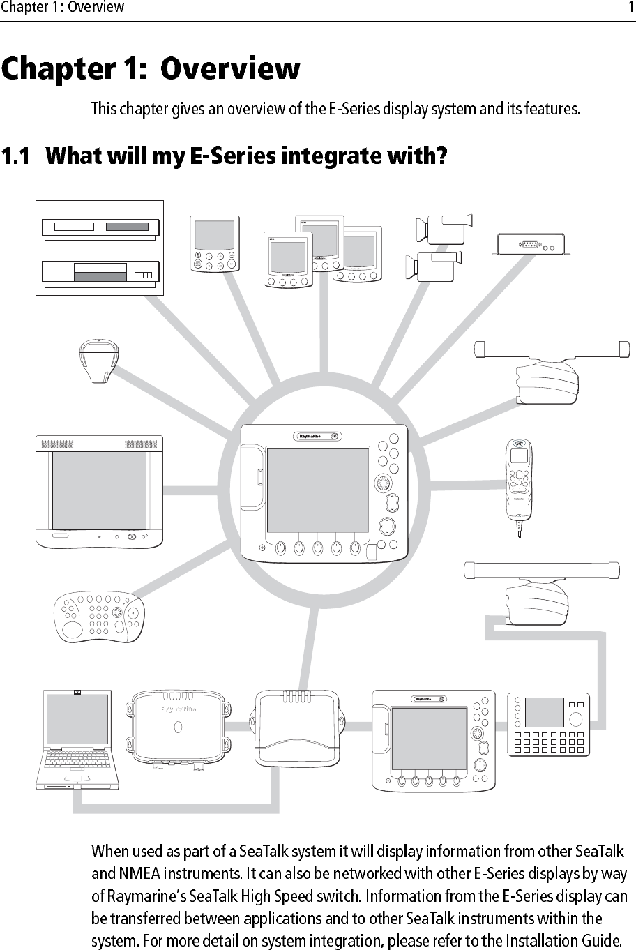
1.1 What will my E-Series integrate with? ...........................................................1
1.2 What can the E-Series Display do? .................................................................2
1.3 The Simulator .................................................................................................5
2.1 Introduction ....................................................................................................7
2.2 Powering the display ON/OFF .......................................................................7
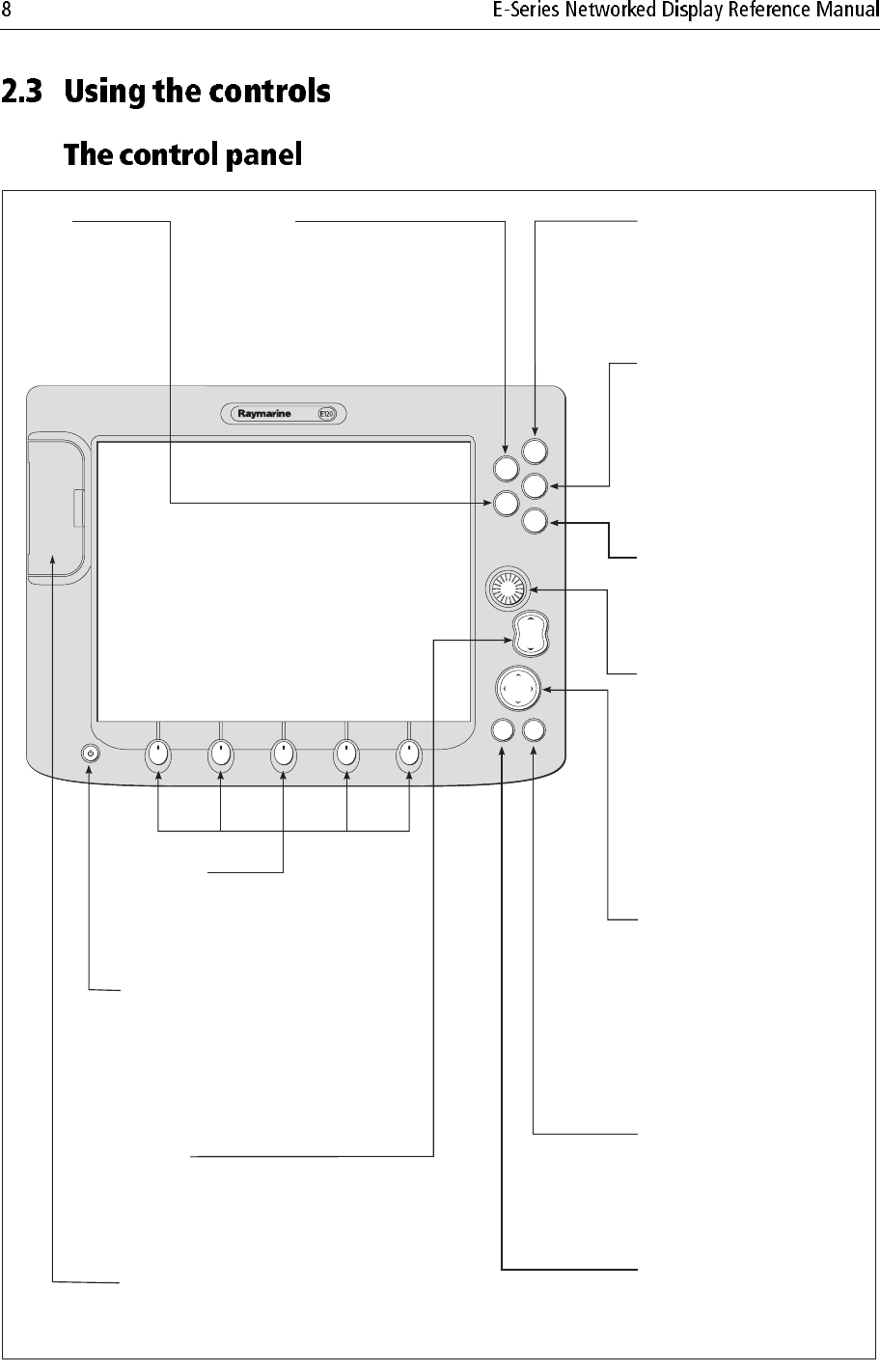
2.3 Using the controls ...........................................................................................8
The control panel ...................................................................................... 8
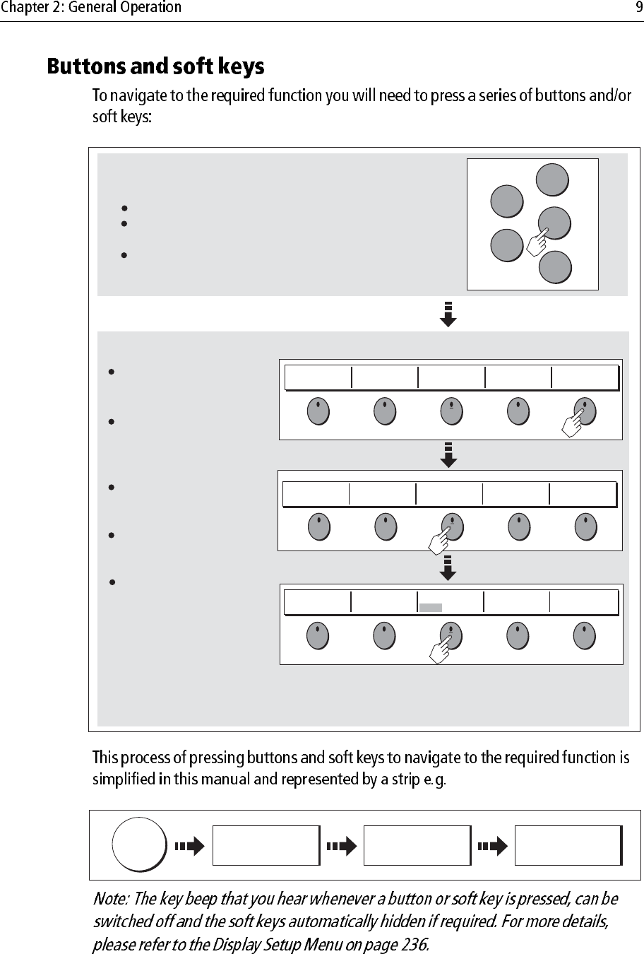
Buttons and soft keys ................................................................................ 9
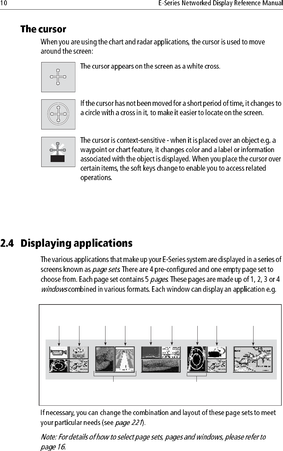
The cursor ............................................................................................... 10
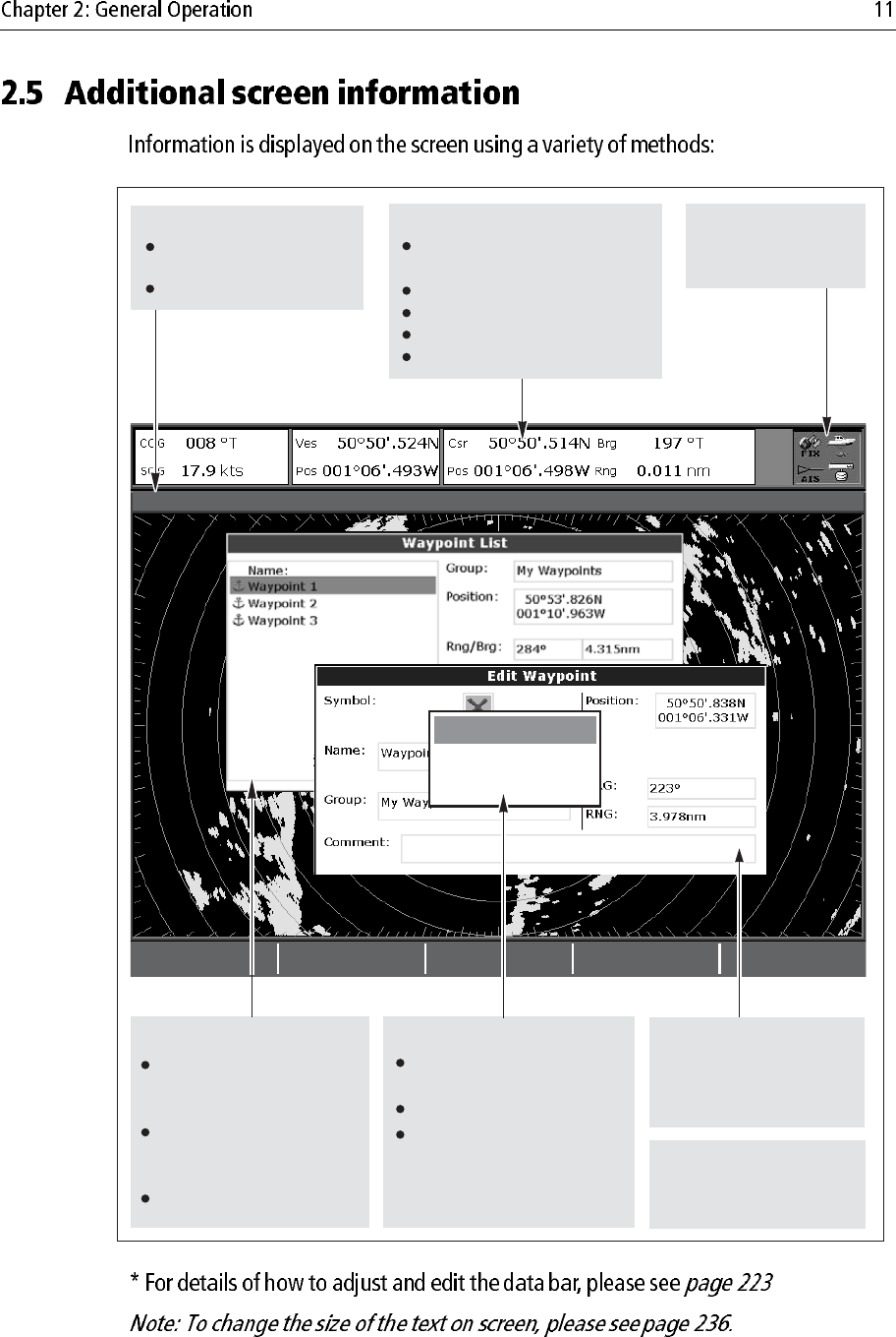
2.4 Displaying applications ............................................................................... 10
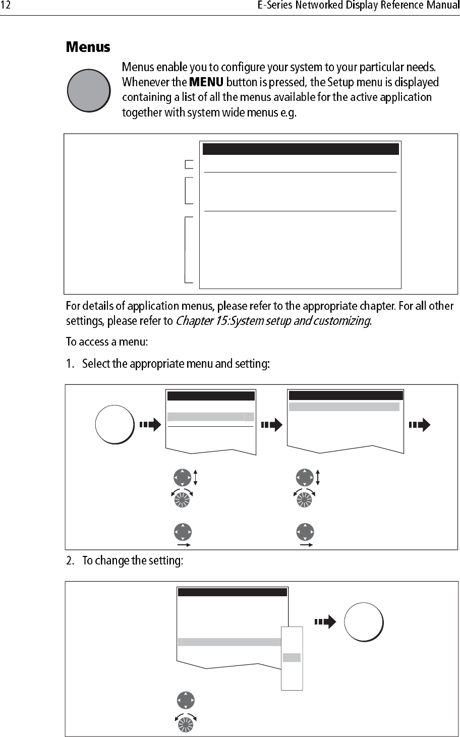
2.5 Additional screen information ......................................................................11
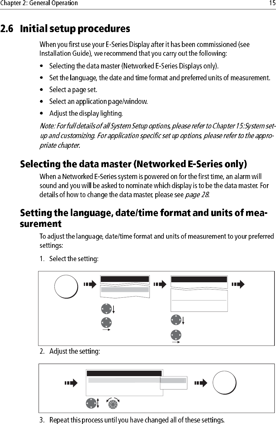
2.6 Initial setup procedures ................................................................................ 15
Selecting the data master (Networked E-Series only) ............................ 15
Setting the language, date/time format and units of measurement ......... 15
Selecting a page set ................................................................................. 16
Selecting an application page ................................................................. 16
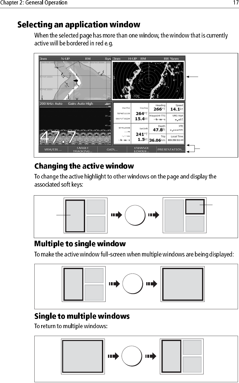
Selecting an application window ............................................................ 17
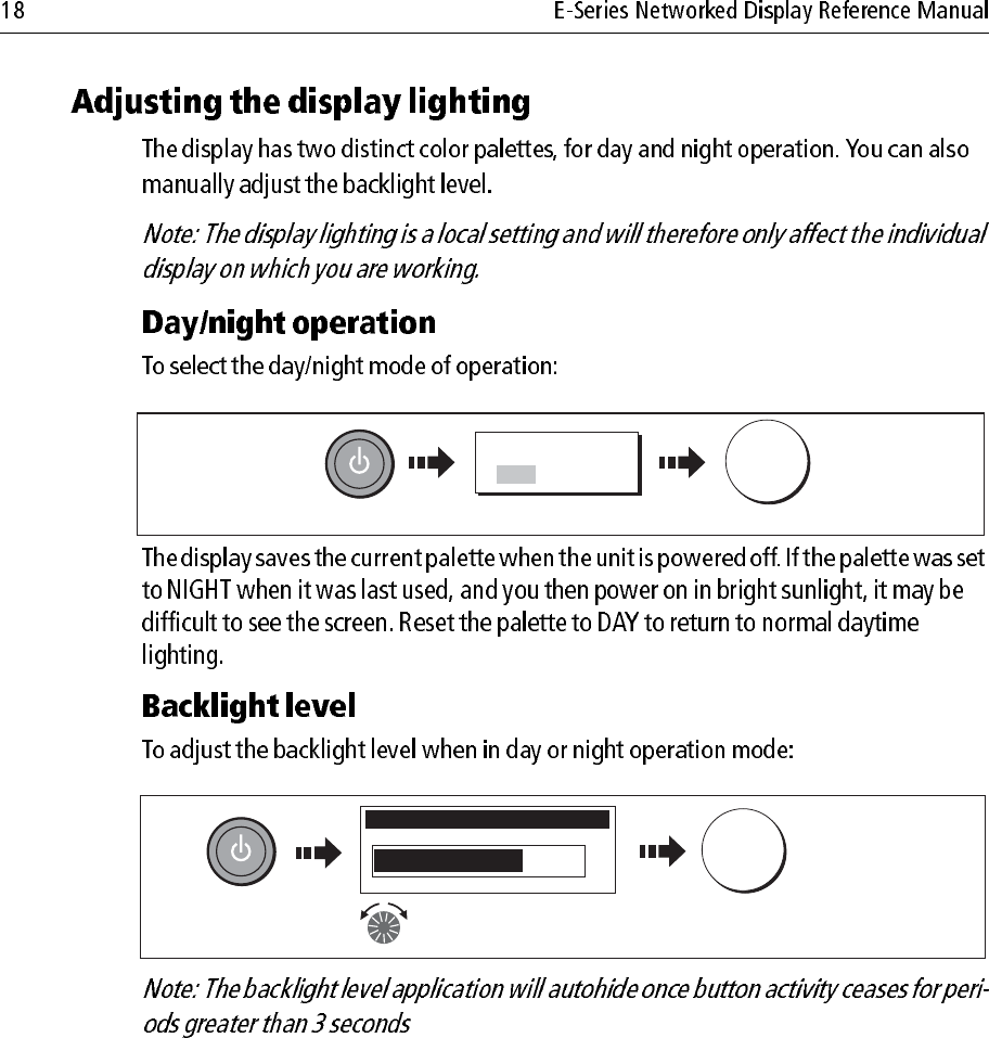
Adjusting the display lighting ................................................................ 18
2.7 Using CompactFlash cards .......................................................................... 19
Cautions .................................................................................................. 19
What are CompactFlash cards used for? ................................................ 19
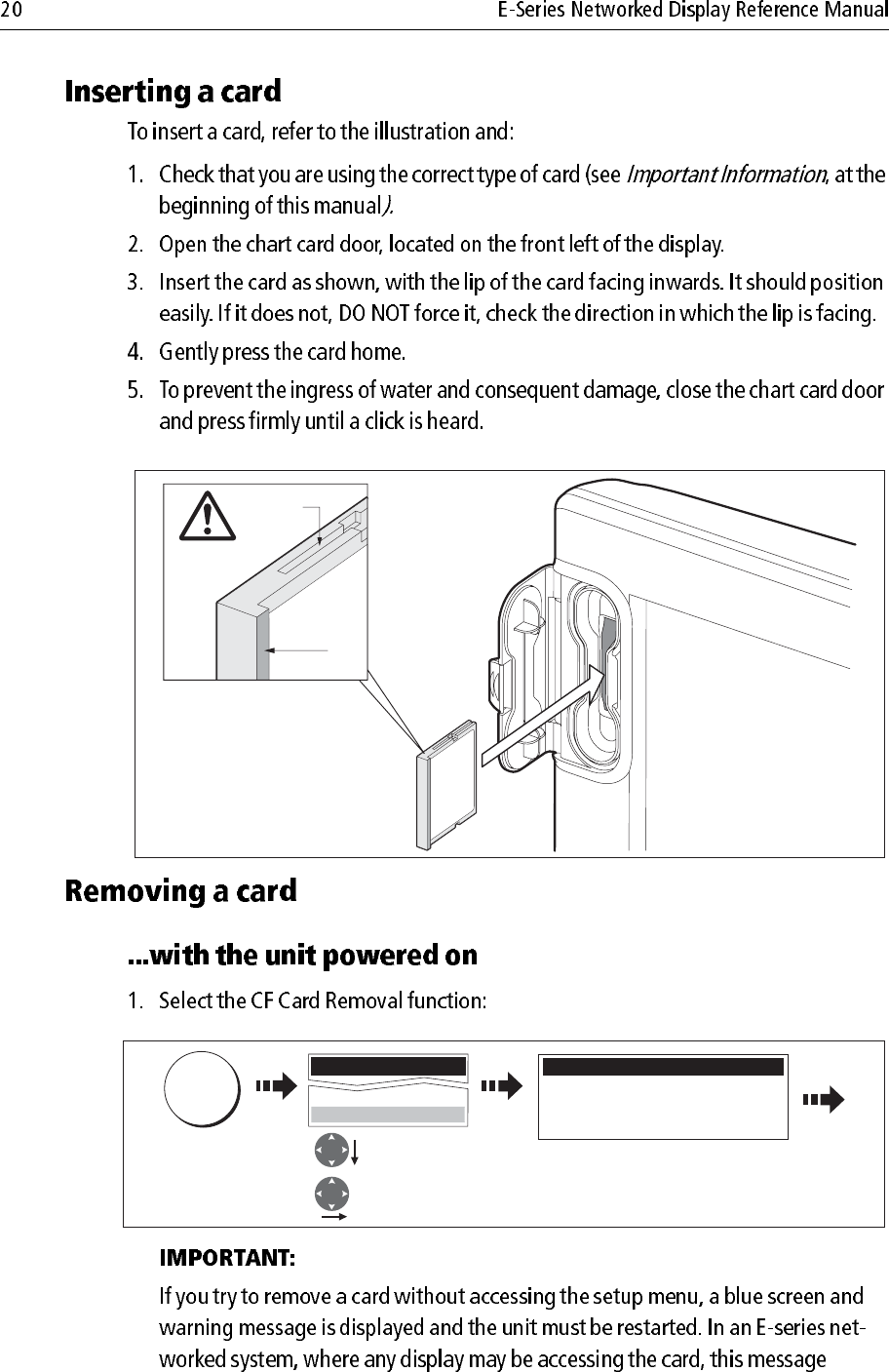
Inserting a card ....................................................................................... 20
Removing a card ..................................................................................... 20
2.8 Managing data ............................................................................................. 21
Writing/retrieving data to a CompactFlash card ..................................... 21
Sending and receiving information using a PC ...................................... 25
Password protecting your waypoints ..................................................... 25
2.9 Operating a networked E-Series Display ..................................................... 28
What does a networked system do? ........................................................ 28
Controlling a network ............................................................................. 28
Functions only affecting the display in use ............................................. 29

2.10 Emergencies and warnings .......................................................................... 30
Man Overboard (MOB) .......................................................................... 30
Alarms .................................................................................................... 31
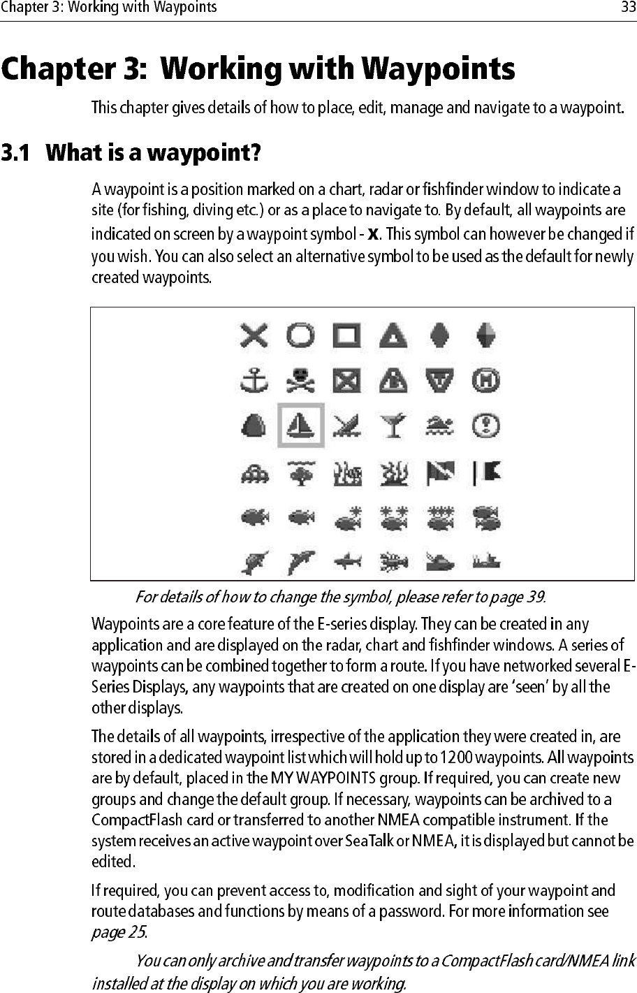
3.1 What is a waypoint? ..................................................................................... 33
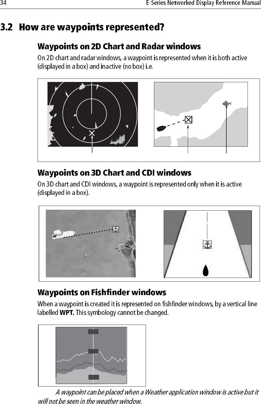
3.2 How are waypoints represented? ................................................................. 34
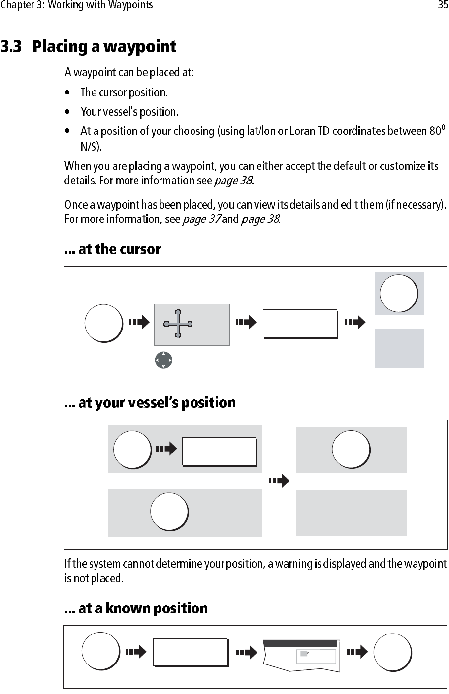
3.3 Placing a waypoint ....................................................................................... 35
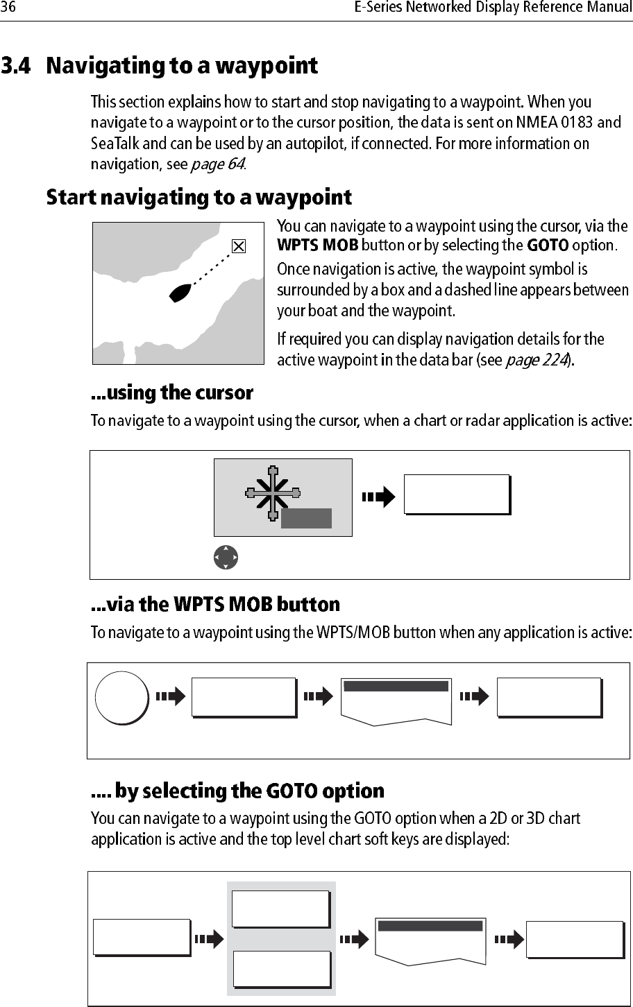
3.4 Navigating to a waypoint ............................................................................. 36
Start navigating to a waypoint ................................................................ 36
Stop navigating to a waypoint ................................................................ 37
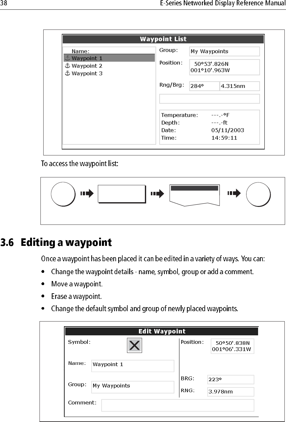
3.5 Viewing waypoint information .................................................................... 37
3.6 Editing a waypoint ....................................................................................... 38
Changing waypoint details ..................................................................... 39
Moving a waypoint ................................................................................. 39
Erasing a waypoint(s) ............................................................................. 40
Changing the default symbol or group ................................................... 41
3.7 Sorting the waypoint list .............................................................................. 42
3.8 Organising waypoints into groups ............................................................... 42
Displaying the waypoint group list ......................................................... 42
Making a new waypoint group ............................................................... 43
Moving waypoints between groups ....................................................... 43
Renaming an existing group ................................................................... 44
Erasing a group ....................................................................................... 45
3.9 Controlling waypoint display ...................................................................... 45
Show/hide waypoint names ................................................................... 45
Showing/hiding waypoint symbols ........................................................ 46
Showing/hiding waypoint groups .......................................................... 46
4.1 Important ..................................................................................................... 47
Navionics support ................................................................................... 47
Safety ...................................................................................................... 47
Chart functionality ................................................................................. 47
Chart cards .............................................................................................. 48

4.2 Uses of the chart application ........................................................................ 48
4.3 Viewing the chart ......................................................................................... 50
4.4 The chart display .......................................................................................... 50
4.5 Where am I on the chart? ............................................................................. 51
4.6 Moving around the chart .............................................................................. 51
4.7 Additional information on the chart ............................................................. 52
Displaying details of objects and features .............................................. 53
Finding nearby features and services ..................................................... 53
Animated tides and currents ................................................................... 54
Displaying details of tides ...................................................................... 57
Displaying details of currents ................................................................. 57
Displaying details of port services .......................................................... 58
Pilot book information ........................................................................... 60
Displaying panoramic photos ................................................................. 62
Displaying details of business services & points of interest ................... 63
Displaying an aerial photo overlay ......................................................... 64
Displaying vessel identity (AIS) ............................................................ 66
4.8 Measuring distances and bearings ............................................................... 67
... from your boat .................................................................................... 67
... between two points on your chart ....................................................... 67
4.9 Navigating to a specific point ...................................................................... 68
Go to an existing waypoint ..................................................................... 69
Resetting cross track error (XTE) ........................................................... 69
Arriving at your target waypoint ............................................................ 69
Stop navigating to your target waypoint ................................................. 70
Maintaining a view of your navigation ................................................... 70
4.10 Building and following a route .................................................................... 71
What is a route? ...................................................................................... 71
What can I do with a route? .................................................................... 71
Building a route ...................................................................................... 72
Following a route .................................................................................... 76
Resetting cross track error (XTE) ........................................................... 78
Viewing details of routes ........................................................................ 79
4.11 Editing routes ............................................................................................... 80
Selecting a route for editing .................................................................... 80
Editing the selected route ....................................................................... 81

4.12 Monitoring where you are going .................................................................. 86
... using chart vectors .............................................................................. 86
... using the Course Deviation Indicator (CDI) ....................................... 87
4.13 Warnings of potential dangers ..................................................................... 87
4.14 Using the radar with the chart ...................................................................... 88
Synchronizing the chart with radar range ............................................... 88
Viewing MARPA targets on the chart .................................................... 88
Distinguishing between fixed and moving objects ................................ 89
4.15 Recording where you have been .................................................................. 90
What is a track? ...................................................................................... 90
How can I use tracks? ............................................................................. 91
Creating a track ....................................................................................... 91
Creating a route from a track .................................................................. 92
4.16 Editing tracks ............................................................................................... 93
Selecting a track for editing .................................................................... 93
Editing the selected track ........................................................................ 94
4.17 Defining how the chart windows are presented ........................................... 95
Working with multiple chart views ........................................................ 95
Setting the orientation of the chart ......................................................... 96
Setting the motion mode ......................................................................... 97
4.18 Altering the level of chart detail displayed .................................................. 98
Range rings ............................................................................................. 99
Navionics combined data cards .............................................................. 99
To display bathymetric information ....................................................... 99
Showing or hiding waypoints/waypoint information ............................ 99
Showing or hiding a route or a track ..................................................... 101
Showing or hiding cartographic features .............................................. 102
4.19 Setting up your chart and its cartography ................................................... 103
Chart Setup ........................................................................................... 103
Cartography Setup ................................................................................ 106
4.20 Chart layers ................................................................................................ 107
Radar overlay ....................................................................................... 108
Synchronizing chart scale with radar range .......................................... 108
Viewing MARPA targets on the chart .................................................. 109
AIS ....................................................................................................... 109
Range rings ............................................................................................110

5.1 Important ....................................................................................................111
3D Chart functionality ...........................................................................111
Safety .....................................................................................................111
5.2 An introduction ...........................................................................................111
5.3 What can I use the 3D Chart Application for? ............................................112
5.4 The 3D chart display ...................................................................................112
5.5 Where am I on the 3D chart? .......................................................................113
5.6 Moving around the 3D chart .......................................................................113
5.7 Other 3D controls ........................................................................................114
Soft keys ................................................................................................114
5.8 Changing the mode .....................................................................................115
Active motion mode ..............................................................................115
Planning mode .......................................................................................115
5.9 Changing the view ......................................................................................116
View options ..........................................................................................116
Multiple views .......................................................................................117
Vessel offset ...........................................................................................117
5.10 Aerial photo overlay ...................................................................................118
5.11 Making the view clearer ..............................................................................118
Exaggeration .........................................................................................118
Declutter ................................................................................................119
5.12 Using 2D and 3D charts together ............................................................... 120
3D view locator .................................................................................... 120
Chart synchronization .......................................................................... 121

5.13 Using the 3D chart with a fishfinder .......................................................... 122
5.14 Navigating with 3D charts ......................................................................... 122
5.15 Setting up the 3D Chart .............................................................................. 123
6.1 The fishfinder display ................................................................................ 125
6.2 Background information ........................................................................... 125
6.3 Operating the fishfinder ............................................................................. 126
6.4 Explaining the readout ............................................................................... 126
6.5 Factors influencing the readout ................................................................. 127
6.6 Display mode settings ................................................................................ 128
Adjusting the position of the zoomed area ........................................... 129
Bottom lock and bottom shift ............................................................... 130
Using A-Scope to view a live image ..................................................... 130
The A-SCOPE softkey ......................................................................... 130
Changing the range ............................................................................... 131
Range shift ............................................................................................ 132
6.7 Presentation toolbar ................................................................................... 132
6.8 Adjusting gain and power .......................................................................... 132
Auto gain settings ................................................................................. 132
Manually-set gain levels ....................................................................... 133
Power setting ........................................................................................ 134
6.9 Measuring depth and distance ................................................................... 134
Measuring depth and distance with VRM ............................................ 135
Adjusting the scroll mode and speed .................................................... 136
Pausing scroll ....................................................................................... 136
Viewing frequencies within a preset ..................................................... 137
Placing waypoints ................................................................................ 137
6.10 Fishfinder alarms ....................................................................................... 137
6.11 Editing presets ........................................................................................... 137
Manual frequency selection ................................................................. 138
Automatic frequency selection ............................................................. 138
6.12 Fishfinder configuration ............................................................................ 139
DSM and transducer setup ................................................................... 140

7.1 Introduction ............................................................................................... 143
7.2 What is radar? ............................................................................................ 143
Detecting targets ................................................................................... 143
Maximum radar range .......................................................................... 144
Factors impairing a radar picture .......................................................... 144
7.3 Powering on/off the various scanner operating modes .............................. 148
7.4 The radar picture ........................................................................................ 149
7.5 Marking a position on the radar screen ...................................................... 150
7.6 Changing what you see in the radar window ............................................. 150
Setting the orientation of the radar ........................................................ 150
Setting the motion mode ....................................................................... 152
Showing or hiding the range rings ........................................................ 154
Changing the bearing mode for EBLs .................................................. 154
7.7 Getting the best picture .............................................................................. 154
Using the GAIN functions .................................................................... 154
Using the enhance echoes functions ..................................................... 156
7.8 Changing the displayed range .................................................................... 159
Radar range and chart scale synchronization ....................................... 159
7.9 Measuring distances, ranges and bearings ................................................. 160
... Using the range rings ........................................................................ 160
... Using the cursor ................................................................................ 160
... Using VRMs and EBLs .................................................................... 161
... Using floating VRMs/EBLs ............................................................. 163
7.10 Using radar to avoid a collision .................................................................. 164
Guard Zones ......................................................................................... 164
MARPA ................................................................................................ 167
Setting up MARPA ............................................................................... 170
Acquiring a target to track .................................................................... 171
Cancelling targets ................................................................................. 171
Displaying vessel identity (AIS) .......................................................... 172

7.11 Setting up your radar .................................................................................. 172
7.12 Warnings of potential dangers ................................................................... 174
8.1 Radar setup ................................................................................................ 175
Select scanner ....................................................................................... 175
Scanner setup ........................................................................................ 175
8.2 Radar alarms .............................................................................................. 177
8.3 Powering on/off the various scanner operating modes .............................. 177
8.4 Radar status ................................................................................................ 177
8.5 Radar range and image quality .................................................................. 177
Range .................................................................................................... 178
Image quality ........................................................................................ 179
Side lobes ............................................................................................. 179
Indirect echoes ...................................................................................... 180
Multiple echoes .................................................................................... 180
Blind sectors ......................................................................................... 180
Sea clutter ............................................................................................. 181
Rain or snow clutter .............................................................................. 181
Mutual radar interference ..................................................................... 181
8.6 Radar window overview ............................................................................ 182
Your position ........................................................................................ 182
Operation modes .................................................................................. 182
Other vessels or objects ........................................................................ 182
Factors affecting echo strength ............................................................. 183
8.7 Using waypoints with the radar ................................................................. 183
8.8 Radar display options ................................................................................ 183
Orientation ............................................................................................ 184
Heading-Up (H-UP) ............................................................................. 184
North-Up (N-UP) ................................................................................. 184
Course-Up (C-UP) ............................................................................... 185
Setting the motion mode ....................................................................... 185
Relative motion (RM) with optional vessel offset ................................ 186
True Motion (TM) ................................................................................ 186
Changing the bearing mode for EBLs .................................................. 187

8.9 Dual range .................................................................................................. 187
8.10 Tuning the radar display: GAIN ................................................................ 187
Gain presets .......................................................................................... 187
Manually adjusting gain ....................................................................... 188
Rain clutter ........................................................................................... 188
Sea clutter ............................................................................................. 188
Super HD adjustments .......................................................................... 189
8.11 Tuning the radar display: ENHANCE ECHOES ...................................... 189
Interference rejection ........................................................................... 189
Expansion ............................................................................................. 190
Wakes ................................................................................................... 190
Scan to scan .......................................................................................... 190
8.12 Radar range ................................................................................................ 191
Synchronizing radar range and chart scale ........................................... 191
8.13 Measuring distance, range and bearing ...................................................... 192
Range rings ........................................................................................... 192
Bearing and range ................................................................................. 192
The Variable Range Marker (VRM) and Electronic Bearing Line (EBL) ..
193
Variable Range Marker ......................................................................... 193
Electronic Bearing Marker ................................................................... 194
Combined range and bearing ................................................................ 194
Tracking a target with a VRM or EBL .................................................. 194
Floating VRM and EBL ....................................................................... 195
8.14 Using radar to track objects ........................................................................ 196
Guard zones .......................................................................................... 196
MARPA ................................................................................................ 197
Displaying vessel identity (AIS) .......................................................... 201
9.1 Introduction ............................................................................................... 203
9.2 Selecting a data application ....................................................................... 203
9.3 Selecting the data for display ..................................................................... 204
Pre-configured data panels ................................................................... 204
Customize the panels ............................................................................ 205
Emergency disengage .......................................................................... 209
10.1 Enabling and engaging the autopilot ......................................................... 209
To enable autopilot control ................................................................... 209
To engage the autopilot in normal operation ........................................ 209
To engage the autopilot from the Setup Menu ...................................... 210
To disengage the autopilot in normal operation .................................... 210
Emergency disengage .......................................................................... 210
Autopilot Status Indicator .....................................................................211
10.2 The autopilot control screen .......................................................................211
10.3 Waypoint arrival ........................................................................................ 212
…when there are more waypoints in your route ................................... 212
…when you reach the last waypoint in your route ............................... 212
11.1 Introduction ............................................................................................... 215
11.2 Setting up the video application ................................................................. 215
Displaying a video application ............................................................. 215
Customizing the video application ....................................................... 216
Adjusting the image .............................................................................. 219
12.1 Introduction ............................................................................................... 221
12.2 The CDI screen .......................................................................................... 221
Steering instructions ............................................................................. 222
12.3 Selecting the CDI application .................................................................... 222
12.4 Modifying the CDI application .................................................................. 222
13.1 Introduction ............................................................................................... 223
13.2 Displaying and setting up the engine monitor ............................................ 223
13.3 The engine monitor display ....................................................................... 225
13.4 Configuring the engine panels. .................................................................. 225
13.5 What should I do when an alarm is triggered? ........................................... 225
14.1 Overview ................................................................................................... 227
14.2 Important information ............................................................................... 227
Disclaimer ............................................................................................ 227

14.3 Setting up the weather application ............................................................. 227
Pre-requisites for using the weather application .................................. 228
Adding a weather application ............................................................... 228
Specifying the weather elements .......................................................... 228
14.4 The weather display ................................................................................... 229
14.5 Moving around the weather map ............................................................... 229
14.6 Placing waypoints ...................................................................................... 229
14.7 Weather graphics ....................................................................................... 230
Precipitation (NOWRad) ..................................................................... 231
Storm Cast ............................................................................................ 231
Sea surface temperature (SST) ............................................................. 232
Canadian radar ...................................................................................... 232
Tracking storms .................................................................................... 232
Lightning .............................................................................................. 233
Surface observation stations ................................................................. 233
City forecasts ........................................................................................ 234
Wind ..................................................................................................... 235
Waves ................................................................................................... 235
Surface pressure ................................................................................... 236
Viewing data at a particular location .................................................... 236
14.8 Animated weather graphics ....................................................................... 236
Setting up animation ............................................................................. 236
Running animation ............................................................................... 237
14.9 Viewing weather reports ............................................................................ 237
Tropical statements .............................................................................. 237
Marine warnings ................................................................................... 238
Marine zone forecasts ........................................................................... 238
14.10Watchbox warnings ................................................................................... 239
Watchbox warning alerts ...................................................................... 239
Displaying marine watchboxes ............................................................ 240
Displaying watchbox data .................................................................... 240
14.11Weather application setup ......................................................................... 241
Selecting the Weather Setup Menu ....................................................... 241
Weather Setup options .......................................................................... 241
Showing/hiding marine watchboxes and zone boundaries .................. 241

14.12Troubleshooting ........................................................................................ 242
15.1 To start using Sirius Radio ......................................................................... 243
15.2 Tuning to a channel .................................................................................... 244
15.3 Browsing channels ..................................................................................... 244
Filtering categories from the browse .................................................... 245
To filter categories ................................................................................ 245
15.4 Scanning channels ..................................................................................... 245
To scan channels ................................................................................... 245
15.5 Hiding or showing channels and categories ............................................... 245
To hide or show a channel or category .................................................. 245
15.6 Presets ........................................................................................................ 246
To assign a channel to a preset .............................................................. 246
To delete a channel from a preset .......................................................... 246
To move a channel to a new preset ....................................................... 246
15.7 Parental locking ......................................................................................... 246
To enable blocking ............................................................................... 247
To set up a password ............................................................................. 247
To change an existing password ........................................................... 247
To block a channel ................................................................................ 247
To enter a password .............................................................................. 248
15.8 Favourite song alerts .................................................................................. 248
To enable favourite alerts ..................................................................... 248
To set up a song or artist alert ................................................................ 248
16.1 Overview ................................................................................................... 249
16.2 Setting up Navtex weather ......................................................................... 249
16.3 Incoming message alerts ............................................................................ 249
16.4 Viewing messages ..................................................................................... 250
Displaying the Navtex Message List .................................................... 250
Displaying and scrolling through a message ........................................ 250
16.5 Managing Navtex messages ...................................................................... 250
Selecting message alert categories ....................................................... 250
Sorting the message list ........................................................................ 251
17.1 Introduction ............................................................................................... 253
17.2 What is AIS? .............................................................................................. 253
Classes of AIS data ............................................................................... 253
17.3 What do I need to run AIS? ........................................................................ 255
17.4 Selecting the AIS function ......................................................................... 255
AIS status ............................................................................................. 255
17.5 How is AIS data displayed? ....................................................................... 256
AIS Target symbols .............................................................................. 256
Viewing target information .................................................................. 257
17.6 Using AIS for collision avoidance ............................................................. 259
Safe zones ............................................................................................. 259
MARPA and AIS options ..................................................................... 260
Safety messages ................................................................................... 260
17.7 AIS Alarms ................................................................................................ 260
Local AIS alarms .................................................................................. 261
Active alarm list ................................................................................... 261
17.8 Simulator ................................................................................................... 262
17.9 AIS Layer Setup Menu .............................................................................. 262
18.1 Introduction ............................................................................................... 263
18.2 Maintenance procedures ............................................................................ 263
Servicing and Safety ............................................................................. 263
Routine checks ..................................................................................... 264
Cleaning the display ............................................................................. 264
18.3 Resetting the Display ................................................................................. 264
Settings reset ......................................................................................... 264
Settings and data reset .......................................................................... 265
18.4 Troubleshooting your Display ................................................................... 266
Common problems and how to solve them .......................................... 266
18.5 Getting Technical Support ......................................................................... 269
Help us to help you ............................................................................... 270
World wide web .................................................................................... 271
Contacting Raymarine in the US .......................................................... 271
Contacting Raymarine in Europe ......................................................... 272

For Navionics cartography ................................................................... 272
For Sirius weather ................................................................................. 272
19.1 Changing the data master ........................................................................... 273
19.2 Customizing the page sets .......................................................................... 273
Graphical engine data ........................................................................... 273
Reconfiguring the application and page layout .................................... 275
Rename a page set ................................................................................ 275
Return to default setting ....................................................................... 276
19.3 Changing the databar ................................................................................. 277
Databar position ................................................................................... 277
Data bar size ......................................................................................... 277
19.4 Compass bar .............................................................................................. 278
Turning the compass bar on and off ...................................................... 279
Compass bar setup ................................................................................ 279
Customizing the contents of the data bar .............................................. 280
19.5 Changing the set up menu options ............................................................. 283
Application specific ............................................................................. 283
External equipment menus ................................................................... 283
System-wide menus ............................................................................. 283
CANCELOK
RANGE
IN
OUT
PAGE
ACTIVE
WPTS
MOB
MENU
DATA
CANCELOK
RANGE
IN
OUT
PAGE
ACTIVE
WPTS
MOB
MENU
DATA
DVD 23.47
VIDEO
23.47
DVD
Video
MENU
CH
OK
16/9 HI/LO
SCAN WATCH
SQ
RAY240
WX
11.18.02
Radar scanner
Weather receiver
GPS
M1500 or monitor
Remote keyboard
Personal Computer
Fishfinder
DSM 400 & 300
SeaTalkHS
switch
Instruments
Autopilot
AIS receiver
DSC VHF
E-Series display
E-Series additional displays
Cameras
D7514_3
Digital radar scanner
0.5nm North-Up (Relative Motion) Local
D7363_2
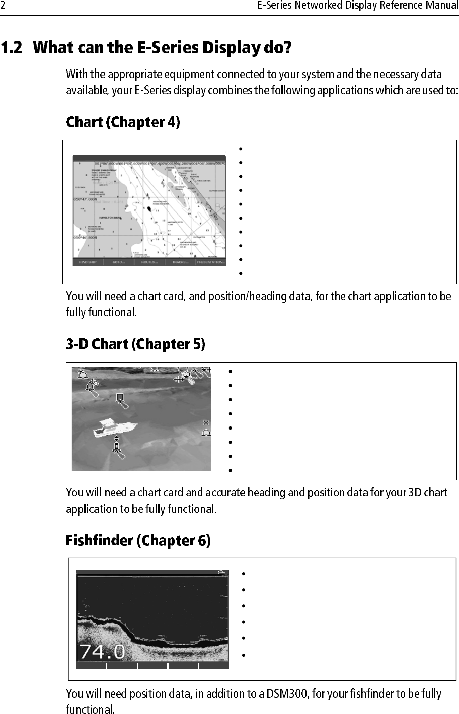
Locate where you are.
Interpret your surroundings.
Monitor where you are going.
Record where you have been.
Navigate to a specified position (waypoint).
Build and navigate routes.
View details of nearby features & services.
View details of boats equipped with AIS.
Distinguish between fixed and moving objects.
Measure distances and bearings.
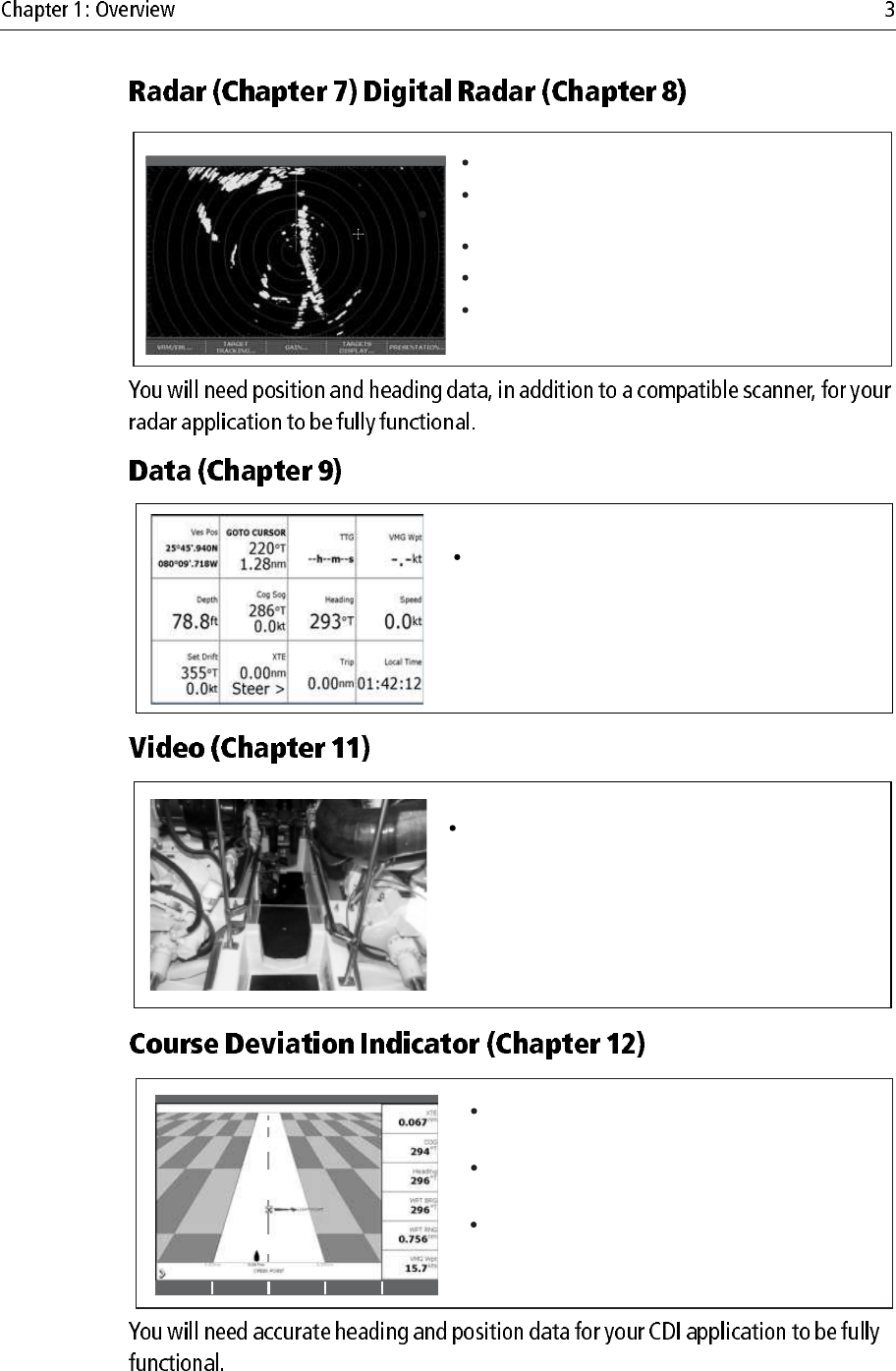
D8702_1
Display a 3D view of land, sea & features.
Locate where you are.
Interpret your surroundings.
Monitor where you are going.
Go to an existing waypoint.
Navigate a route.
Synchronize with the 2D chart.
Identify fishing spots
Draft
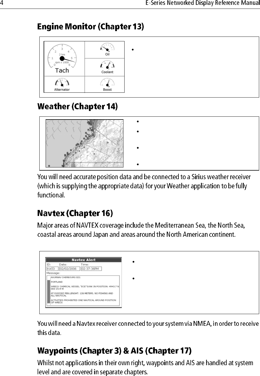
D7377-1
Build a picture of what is below your vessel.
Locate & distinguish underwater objects & targets.
Distinguish the seabed and its texture.
Obtain information about water depth, temperature.
Mark a point of interest, fishing spot etc.
Determine depths and distances of targets.
TRANSDUCER
SETTINGS… ZOOM… BOTTOM LOCK… A-SCOPE… PRESENTATION…
200kHz: Auto Range: Auto
Detect landmasses & navigation markers.
Detect and measure the range and distance of other
vessels.
Acquire targets and track them for collision avoidance.
Navigate to a specified position (waypoint).
View details of boats equipped with AIS.
VRM/EBL... GAIN... TARGETS
DISPLAY... PRESENTATION...
TARGET
TRACKING...
6nm North-Up (Relative Motion) Rings 1nm
D7375-2
D7376-1
View data generated by the system or by instruments
available on NMEA 0183, NMEA 2000 and SeaTalk or
SeaTalk2.
D7378-1
View video images from on-board CCTV cameras, DVD or
video player.
Draft
D7379-1
View real-time display of your vessel on a 'rolling
road' in 3D perspective.
Give details of any correction required to steer your
vessel along a given course.
View data about the distance and time to go until
you reach a specified point.
3nm North-Up Relative Motion Local
T
D7497-1
View engine data e.g. engine temperature, oil pressure,
fuel level etc from up to three engines on a compatible
engine system.
D8701-1
Only available for the US.
Superimpose historical and forecasted weather graphics
on a world map.
Determine conditions in your vicinity or at a particular
location.
View weather reports.
D8728-1
Automatic broadcast of localised Maritime Safety
Information (MSI)
Receive navigational and meteorological warnings, and
search and rescue information.
Draft

D6577-1
PAGE
ACTIVE
WPTS
MOB
MENU
DATA
CANCELOK
RANGE
IN
OUT
OK
Press to select an on-screen
option, or return to the
previous soft key set or menu.
DATA
Press to access
ruler, chart vectors,
archive & transfer
and data bar
on/off functions.
Trackpad
Used to control the on-screen
cursor and to scroll through
menu items.
Press the corresponding edge
of the trackpad to move the
cursor horizontally, vertically or
diagonally.
Press and hold to move rapidly
over larger distances.
CANCEL
Press to cancel the selected
on-screen option when editing
data; also used to return to
the previous soft key set or
menu.
MENU
Press to access the set up
menus.
Press and hold to access help
information.
ACTIVE
When multiple windows are open:
- Press to select required window.
- Press and hold to maximise current
window.
- Press again to return to multiple
windows.
PAGE
Press to scroll through available
pages.
Press and hold to select different
page set or customise your own
layout.
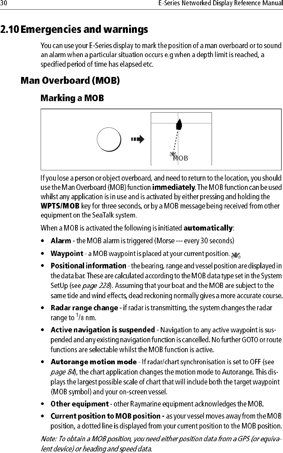
WPTS/MOB
Press to display the waypoint
soft keys.
Press again to place waypoint at
your boat's position.
Press and hold to place a
Man Overboard (MOB)
marker at your current position.
Press and hold again to exit
RANGE
Press to change the display
scale so that a smaller or
larger area can be seen on
the screen.
Power
Press once to turn ON.
Press again to access
backlight functions and
scanner controls.
Press and hold to turn the
display OFF.
Chart Card slot
Open the cover to install
CompactFlash cards.
Softkeys
Press to select the corres-
ponding function identified
by the on-screen label
D7517_1
Rotary control
Use to edit alpha-numeric
values, and scroll through lists.
Turn clockwise to increase
value and counter-clockwise to
decrease value.
Press to move the cursor to the
next character when editing
text.
Use to edit symbology (VRM/
EBL etc).
WAYPOINT AT
CURSOR
WAYPOINT AT
VESSEL
WAYPOINT AT
LAT/LONG...
GO TO WAYPOINT
OPTIONS…
REVIEW AND EDIT
WAYPOINTS
ERASE WAYPOINT SORT LIST SET DEFAULT SYM
& GROUP...
WAYPOINT
GROUPS...
VIEW AND EDIT
DETAILS…
EDIT DEFAULT
SET UP DEFAULT
SYMB GROUP
D7364-2
WPTS
MOB
PAGE
ACTIVE
MENU
DATA
Example:
The example above shows the series of button and soft key presses
required to change the waypoint default symbol or group.
Access system functions or change what you see on-screen.
Within the text of this document they are written in bold capitals
e.g. WPTS/MOB.
Press and hold to access short cuts.
They change depending on
application or function
being performed.
Press the corresponding key
(below the screen) to select.
Further soft keys may be
displayed.
If a key has several options,
each press will highlight the
next option.
If a key displays a single
value or a slider above, use
the rotary control to adjust.
Within the text of this
document they are written
in capitals e.g. SORT LIST.
Buttons
Soft keys
WPTS
MOB
D7365-2
REVIEW AND EDIT
WAYPOINTS ...
SET DEFAULT SYM
& GROUP...
SET UP DEFAULT
SYMB GROUP
Notes: (1) For a full list of cursor labels and their meanings, please see
Appendix C
(2) For details of how to temporarily hide the cursor, please see
page 236.
D7366_3
D7368_2
D7369-2
WPT
Page set
Page
(consists of 1, 2, 3 or 4 windows
in various configurations)
Window
D9025_1
CDI 2D Chart
Weather 3D Chart
Video
Engine
monitor
Fishfinder Data Radar
3nm Head-Up Relative Motion Rings ½nm
ACKNOWLEDGE
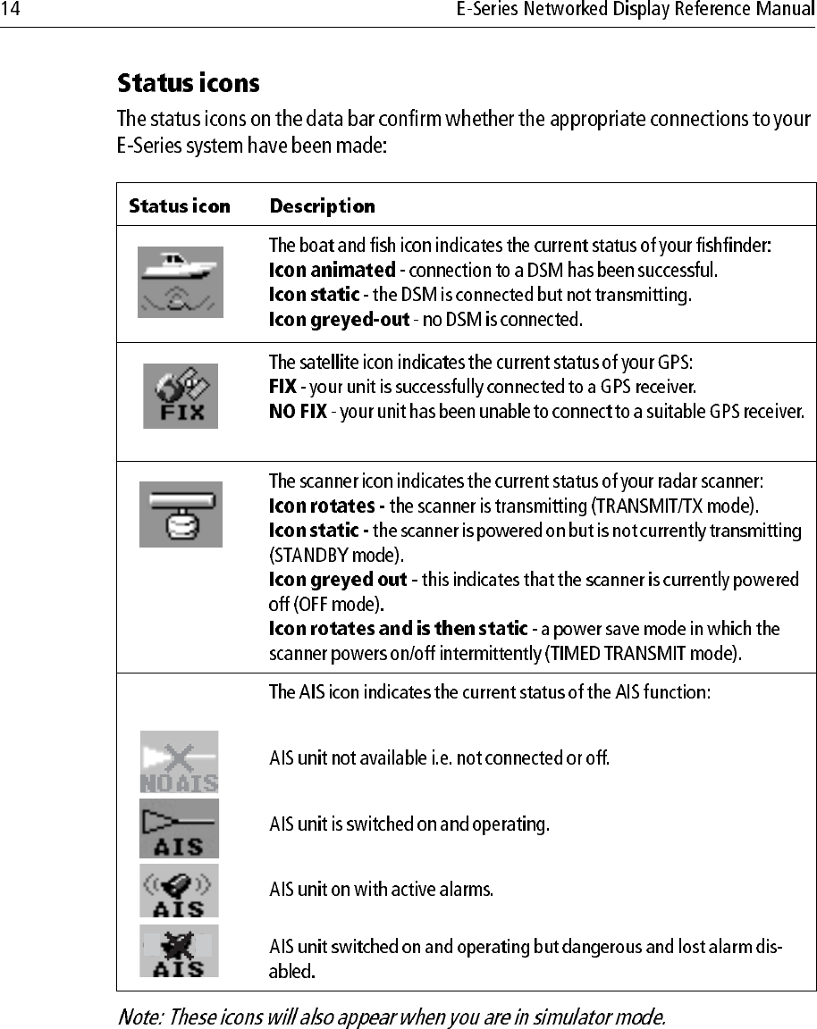
Status icons
Confirm status of DSM,
GPS and scanner.
Status bar
Gives information specific to
each application.
Cannot be edited or moved.
Gives information associated with
your boat or the environment.
Customisable content*
Vertical or horizontal format*
Display or hide*.
Normal or large size*.
Data bar
D7456_1
Contain information you
have added to the display's
memory e.g. waypoints.
Highlight an entry with
trackpad or rotary control to
display related information.
Editable using soft keys.
Dialog boxes
Enable data to be edited or
entered into a store/list
e.g. editing a waypoint.
Alert you to a situation e.g.
alarm, function not available.
Not editable.
May require a response e.g.
press ACKNOWLEDGE to
silence alarms.
Pop-up messages
MARPA ALARM
Target lost (on screen)
Data base lists
Menus (see next page)
Used to configure system
to your particular needs.
3nm Head-Up Relative Motion Rings ½nm
ACKNOWLEDGE
Status icons
Confirm status of DSM,
GPS, AIS and scanner.
Status bar
D7456_2
Status bar
Gives information specific to
each application.
Cannot be edited or moved.
Gives information specific to
each application.
Cannot be edited or moved.
Gives information associated with
your boat or the environment.
Customisable content*
Vertical or horizontal format*
Display or hide*.
Normal or large size*.
Data bar
Contain information you have
added to the display's memory
e.g. waypoints.
Highlight an entry using
trackpad or rotary control to
display related information.
Editable using soft keys.
Dialog boxes
Enable data to be edited or
entered into a store/list e.g.
editing a waypoint.
Alert you to a situation e.g.
alarm, function not available.
Not editable.
May require a response e.g.
press ACKNOWLEDGE to
silence alarms.
Pop-up messages
MARPA ALARM
Target lost (on screen)
Data base lists
Menus (see next page)
Used to configure system to
your particular needs.
0
D6582-1
MENU
MENU
D7370_2
Menus for the active
application
External equipment/
instruments
System-wide menus
Setup
Radar Setup ...
GPS Status...
Compass Setup...
AIS Layer Status...
System Setup...
Alarm Setup...
Display Setup...
Databar Set...
Select Page Setup...
System Diagnostics...
Remove CF Card
D8500_1
Setup
Chart Setup...
GPS Status...
Compass Setup...
C
artography Setup..
.
MENU
Cartography Setup Menu
Chart Display Detailed
Chart Grid On
Chart Text On
Chart Boundaries ON
Spot Soundings ON
1. Highlight item, using:
Rotary control
2. Select item, using:
Trackpad (right)
Trackpad (up/down)
or
1. Highlight item, using:
Rotary control
2. Select item, using:
Trackpad (right)
Trackpad (up/down)
or
D8501_1
Cartography Setup Menu
Chart Display Detailed
Chart Grid On
Chart Text On
Chart Boundary ON
S
pot Soundings O
N
Depth Contour ALL
Nav. Marks ON
Highlight or change value to
new setting, using:
S
a
f
et
y
Contour 66
ft
OFF
7ft
10ft
20ft
33ft
66ft
16f
t
OK
Trackpad (up/down)
or
Rotary control
Notes: (1) Character text can be entered in upper or lower case. (although the
system is not case sensitive e.g. WAYPOINT 1, Waypoint 1are con-
sidered to be the same name).
(2) If you need to use special or accented characters (e.g. ~ ` ´), the
Extended Character Set should be switched to ON in the System
Setup Menu (see page 228).
D8502-1
Highlight field to be edited
e.g. waypoint name
My Waypoints
Name
Symbol
Group
Comment
Wa
yp
oint
1
EDIT NAME
e.g.
D8503-1
OK
ayp
oint
1
My Waypoints
Name
Symbol
Group
Comment
W
a
To change
character or
selection, use:
e.g.
,or
To move to next
character for
editing, use:
or
Press
Turn
o
D6892-3
(animated icon)
D6893-2
(static icon)
D6894-2
(static icon)
D8929_1
Setup
System Setup...
Alarm Setup...
System Setup Menu
Date/Time Setup...
Units Setup...
System Integration Setup...
Waypoint Password Setup...
Position Made Lat/Lon...
D8504-1
Highlight
System Setup
Enter System
Setup
Highlight required
setting
Enter setting
MENU
D8505-1
Change value as
required
OK
or
Time Format 12hr
Local Time Offset UTC
Date/Time Setup Menu
dd/mm/yy
m
m
/dd/
y
y
D
ate
F
ormat mm
/dd/
y
y
e.g.

D8511-1
Press &
hold
Highlight appropriate pre-configured page set
PAGE OK
D8512-1
Press until required
page displayed
Or:
Press soft key of
required page
PAGE
PAGE
Active window
highlighted
Soft keys
associated with
active window
D8516_1
D8513-1
Press to move
active window
e.g.
ACTIVE
Active
window
Active
window
D8514-1
Press and
hold
ACTIVE
Multiple windows Single window
D8515_1
ACTIVE
Multiple windowsSingle window
D6802-3
Toggle as required
OK
PALETTE
DAY NIGHT
D8517_1
Backlight Level
Change the level as required
OK
D7215_2
Narrow
Groove
Lip
Setup
System Diagnostics...
Remove CF Card
D8518-1
Highlight
Remove CF Card
Select Remove
CF Card
MENU
CF Card Removal
You may now safely remove your
compact flash card.
Press OK or CANCEL when finished.
ARCHIVE AND
TRANSFER SAVE TO CARD
DATA
D8070_1
Insert card
Toggle to required
list
D8655_1
Contents for selected list displayed
SELECT LIST
WPT RTE TRK
ROUTE LIST
Route 2
Route 3
R
oute
1
e.g.
D8520_1
Follow on-screen instructions
to remove card
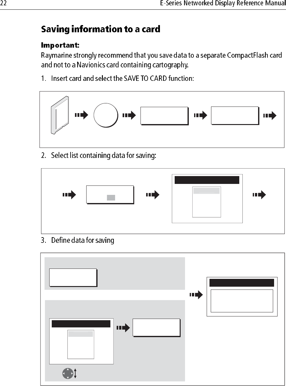
Save Route
SAVE ALL
SAVE ROUTE
Or
To save all items in list to card:
To save individual items:
Highlight item
for saving
e.g.
e.g.
ROUTE LIST
Route 2
Route 3
R
oute 1
ARCHIVE AND
TRANSFER
RETRIEVE FROM
CARD
DATA
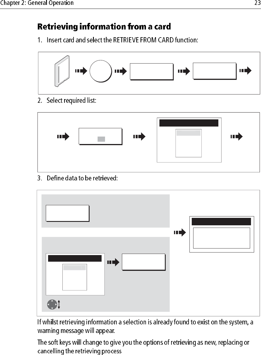
D9094_1
Insert card
Toggle to required
list
D8655_1
Contents for selected list displayed
SELECT LIST
WPT RTE TRK
ROUTE LIST
Route 2
Route 3
R
oute
1
e.g.
D8656_1
Follow on-screen instructions
Retrieve Route
RETRIEVE ROUTE
Or
To retrieve all selected database items:
To retrieve individual items:
Highlight item for
retrieving
e.g.
RETRIEVE ALL
ROUTE LIST
Route 2
Route 3
Route
1
ARCHIVE AND
TRANSFER
ERASE FROM
CARD
DATA
D8168_1
Insert card
Toggle to required
list
D8655_1
Contents for selected list displayed
SELECT LIST
WPT RTE TRK
ROUTE LIST
Route 2
Route 3
R
oute
1
e.g.
D8657_1
YES
ERASE ALL
ERASE ROUTE
Or
To delete all items:
To delete individual items:
Highlight item for
deleting
e.g.
ROUTE LIST
Route 2
Route 3
Route 1
Note:
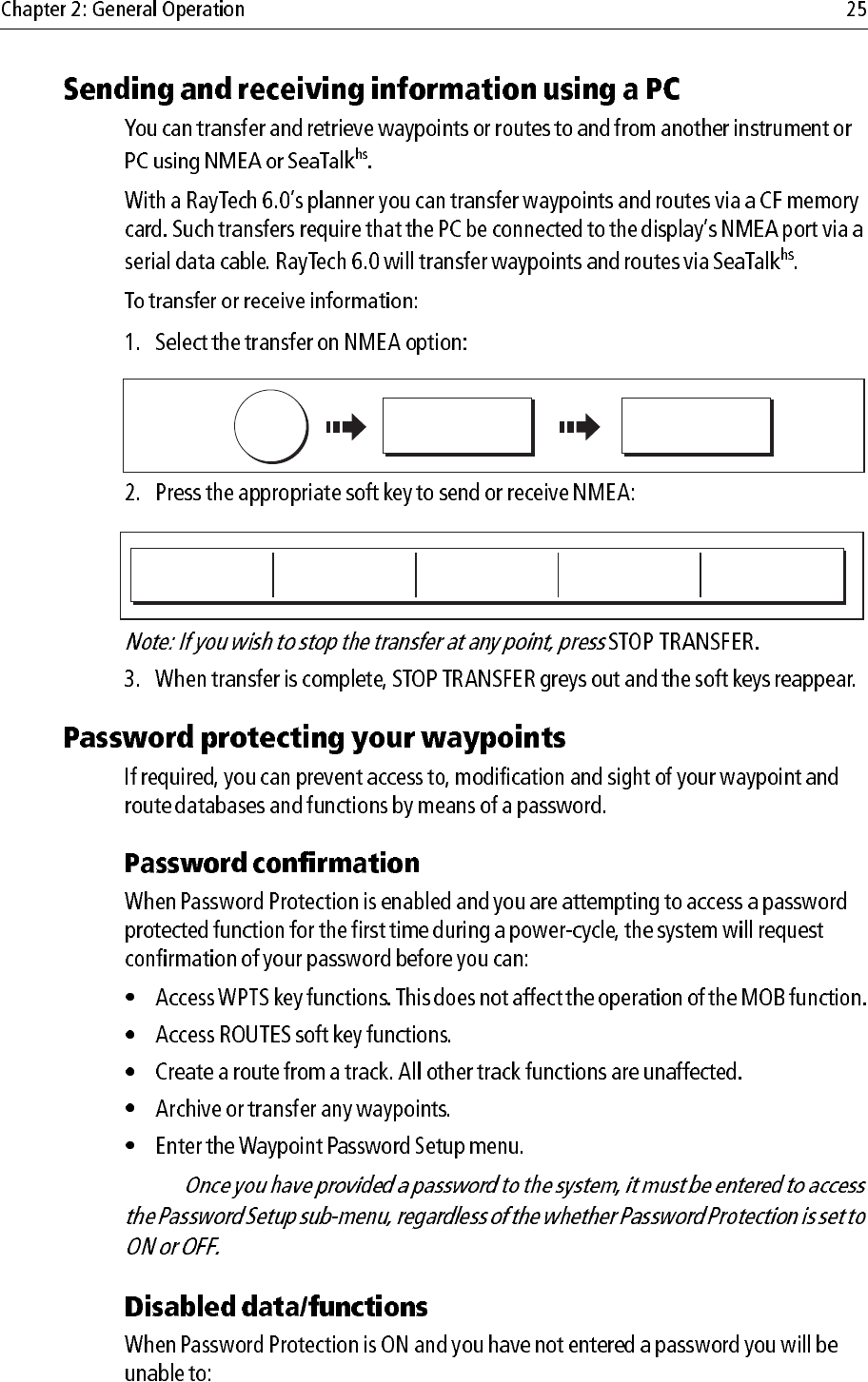
DATA ARCHIVE AND
TRANSFER
TRANSFER ON
NMEA...
D8638_1
SEND WPTS ON
NMEA
SEND RTES ON
NMEA RECEIVE ON NMEA
D6808-2
STOP TRANSFER
Note:
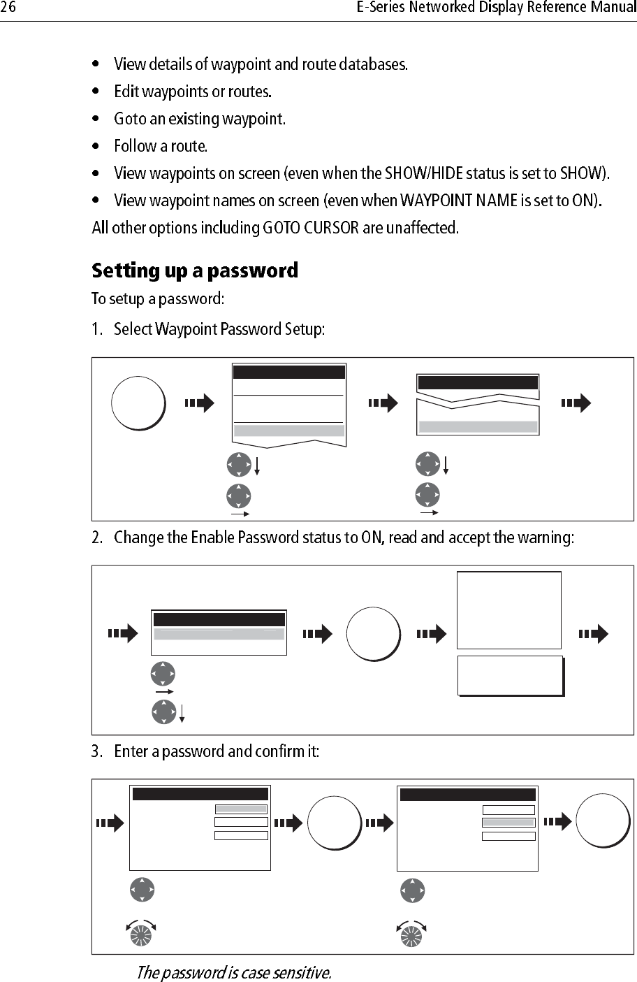
MENU
D8954_1
Highlight required
System Setup Menu
Select System Setup
Menu
Highlight Waypoint
Password Setup
Select Waypoint
Password Setup
System Setup Menu
System Integration
Waypoint Password Setup
Setup
Radar Setup...
GPS Status...
Compass Setup...
System Setup...
OK
D8962_1
Select ON.
Select Enable
Password
Waypoint Password Setup
Change Password...
Ena
bl
e Passwor
d
O
N
Read and accept
the warning
Setting Password Protection
required a password to access
your waypoint and route
databases.
If you forget your password you
will lose your waypoints and
routes
Raymarine recommends that you
archive your waypoints and
routes
YES
D8957_1
Enter a password
(1-16 characters)
and/or:
Edit Password
Password:
Confirm Password:
Hint:
Choose a word that will help you
to remember your password
Repeat to confirm
the password
and/or:
OK
Carrot
Edit Password
Password:
Confirm Password:
Hint:
Choose a word that will help you
to remember your password
Carrot
Carrot
e.g. e.g.
OK
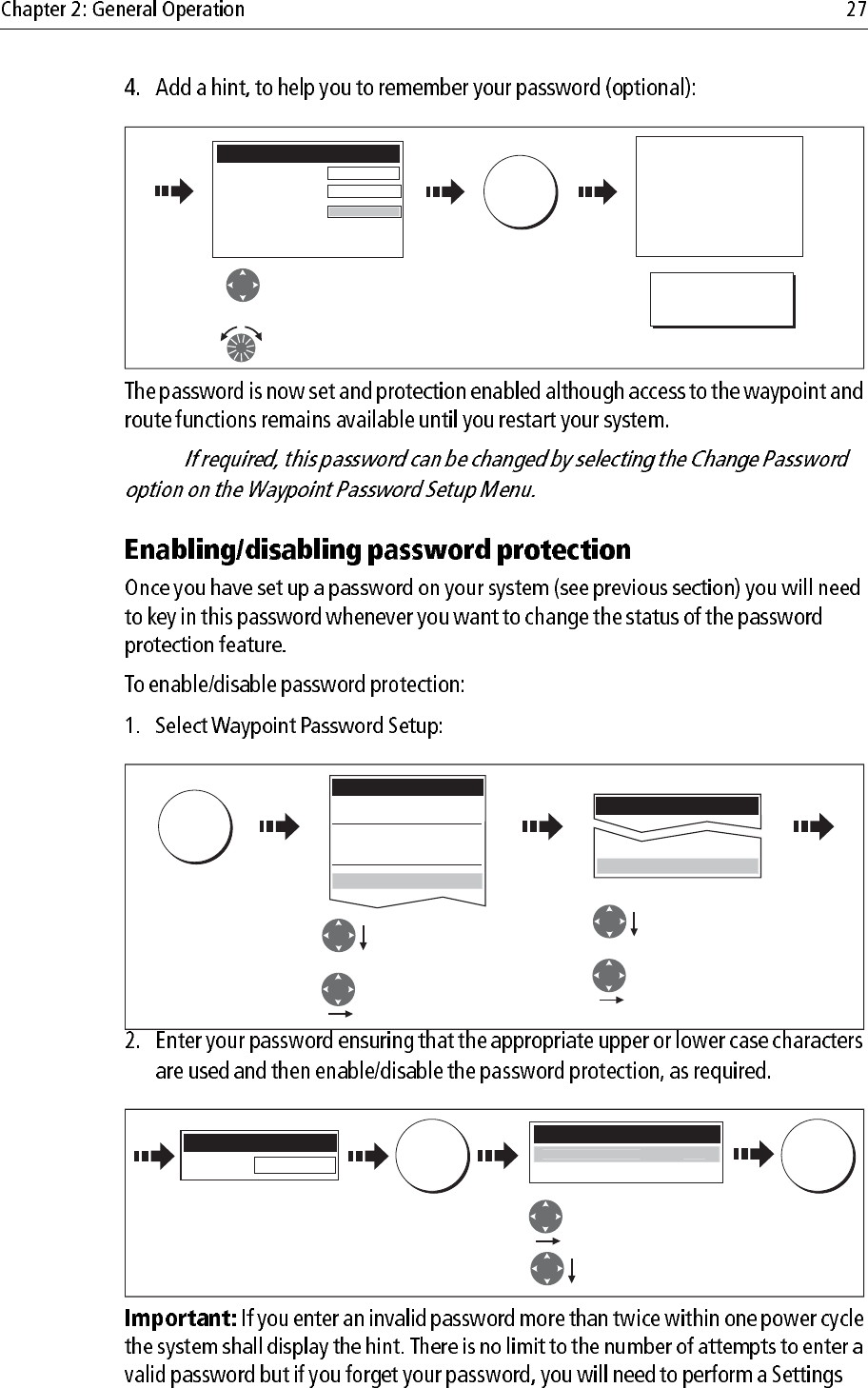
Note:
D8958_1
Add a hint word
(0-16 characters)
Read and accept the warning
and/or:
Edit Password
Password:
Confirm Password:
Hint:
Choose a word that will help you
to remember your password
OK
Carrot
Carrot
Rabbit
e.g.
YES
Your password has been accepted.
If you continue your waypoints
and routes will be protected.
If you forget your password you
will lose your waypoints and
routes
Raymarine recommends that you
archive your waypoints and routes
Do you want to continue?
MENU
D8960_1
Setup
Highlight required
System Setup Menu
Select Waypoint
Password Setup.
Select System Setup
Menu
Highlight Waypoint
Password Setup
System Setup Menu
System Integration
Waypoint Password Setup
Radar Setup...
GPS Status...
Compass Setup...
System Setup...
OK OK
D8961_1
Select OFF
Select Enable Password
Enter password
Waypoint Password Setup
Change Password...
Enable Password OF
F
Enter Password
Password: Carrot
MENU
D8652_1
Highlight System Setup
Enter System Setup
Setup
Radar Setup...
GPS Status...
Compass Setup...
System Setup...
Postion Mode
TD Setup
Simulator
Bearing Mode
MOB Data Type
Variation Source
Manual Variation
Langauge
Extended Charactor set
Ground Trip Reset.....
Settings Reset......
Settings and Data Reset.....
Date/Time Setup......
Units Setup.....
y g
Lat/Long
ON
ON
Position
Auto (01oE)
00oE
English (US)
OFF
System Setup Menu
Units Setup.....
Sy
stem inte
g
ration....
.
DSC Message
Seatalk Alarms
Brigdge NMEA Headings
ON
Enabled
ON
OFF
System Integration Setup Menu
Highlight Data Master
Enter Data Master
Highlight System
Integration
Enter System Integration
D8653_1
ON
D
ata Maste
r
WPTS
MOB
D6652-3
Press and hold
until alarm sounds
D9101_1
WPTS
MOB
D8231_1
Press and hold
for 4 seconds

Note:
Note:
Waypoint symbols
D8696_1
Note:
Active waypoint
Waypoint 1
Default waypoint Alternative symbol
D8694_1
D8698_1
D8697_1
WPT
WPT
WPT
WPTS
MOB
WAYPOINT AT
CURSOR
D7457-2
OK
Move cursor to
required position
for waypoint Accepts default
Or
Wait 4 secs
WAYPOINT AT
VESSEL
WPTS
MOB
D7458_2
WPTS
MOB x2
OK
Accepts default
Wait 4 secs
Or
Or
WPTS
MOB
WAYPOINT AT
LAT/LON...
50'.838N
01o06'.331W
Position:
Place Waypoint
50
D7459_2
OK
Enter position x 2
D8285_1
GO TO WAYPOINT
D7461_4
WPT
Position cursor over
waypoint to go to.
D6559-3
WPTS/
MOB
GOTO WAYPOINT
OPTIONS ... GOTO WAYPOINT
Select required waypoint
Waypoint List
GO TO ...
D7503_2
Select required waypoint
GOTO WAYPOINT
Or
GOTO CURSOR
GOTO WAYPOINT
OPTIONS...
Waypoint List
Note:
Note:
D7505-1
WPTS/
MOB
GOTO WAYPOINT
OPTIONS... STOP GOTO
WPT
Or:
Position cursor over
active waypoint.
STOP GOTO
D7505-2
WPTS/
MOB
GOTO WAYPOINT
OPTIONS... STOP GOTO
Or
Position cursor over
active waypoint.
STOP GOTO
WPT
EDIT WAYPOINT
D7506_2
Waypoint details displayed
Position cursor
over waypoint
OK
To exit way-
point list
WPT
Edit Waypoint
D6560-2
Waypoint List
D7507-2
WPTS/
MOB
REVIEW AND EDIT
WAYPOINTS...
Select required waypoint
OK
To exit way-
point list
D6561-1
D6561-2