Robert Bosch Car Multimedia 52R0 Car radio & infotainment system User Manual Part 5
Robert Bosch Car Multimedia GmbH Car radio & infotainment system Users Manual Part 5
Contents
Users Manual_Part 5
en | 45
64 65 696360 61 62 716766 7068
72737475
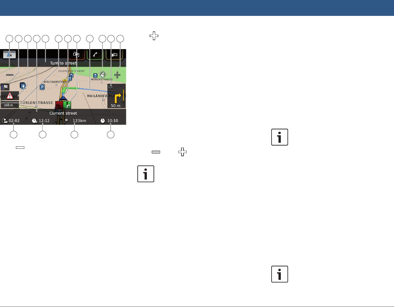
o button: Increase map scale
p Switch between the route overview map
and the map of the area around the vehi-
cle
q TMC message
r Name of the current road
s Name of the next road (only when
approaching)
t Current map scale
u Vehicle position
v Lane guidance
w Current route
x Compass
y Distance to the next driving manoeuvre,
visual driving recommendations (The
driving manoeuvre is displayed symboli-
cally as you approach it.)
z button: Decrease map scale
{ Clock time
| Distance to the destination
! Estimated arrival time
" Estimated time to the destination
8.7.3 Repeating the current naviga-
tion announcement
fDuring active route guidance, tap the driving
manoeuvre symbol in the map view y.
8.7.4 Changing the map scale
To increase or decrease the map scale when in
map view,
ftap o or z.
Note:
If automatic zoom is enabled (see the
section entitled “Enabling automatic
zoom” (page 49)): If you manually
change the map scale, the automatic
zoom function is suspended for around
30 seconds.
8.7.5 Changing the map view mode
You can choose whether
fthe map aligns with north (in this case, north
always appears at the top in map view),
fthe map always aligns with your heading (in
this case, the area that lies ahead of the
vehicle always appears at the top in map
view),
and whether
fa 2D map is shown or
fa 3D map is shown.
fIn the map view, tap the compass x to
switch between these modes:
– 3D map aligned with the driving direction
– 2D map aligned with north
– 2D map aligned with the driving direction
Notes:
fYou can also change the map orien-
tation in the navigation and map
settings (see the section entitled
“Selecting the map orientation”
(page 48)).
fYou can also activate the 3D map
view in the navigation and map
settings (see the section entitled
“3D map view – on/off” (page
49)).
8.7.6 Displaying TMC messages
fIn the map view, tap the TMC symbol q.
A list containing the current TMC messages is
displayed.
Note:
While a route guidance session is
active, you have these options:
Navigation

46 | en
fTap On route to display only mes-
sages that concern your current
route.
fTap All to display all current mes-
sages.
fTap on a message to display details about this
message.
8.7.7 Changing the displayed sec-
tion of the map
During active route guidance, you can choose
whether
fthe map should show the entire route or
whether
fthe map should show the area around the
vehicle.
fIn the map view, tap the button p to switch
between the modes.
8.7.8 Selecting a destination or
waypoint from the map
You can pick a location shown on the map as a
destination or waypoint.
fLong tap the location on the map.
If a route guidance session is active, you can
freplace the current destination,
fset the location as a waypoint.
To do so,
ftap Replace destination or Add as way-
point.
If no route guidance session is active, you can
set the location as your destination.
fTap Set as destination.
The system calculates the route to the new
destination.
8.7.9 Viewing details of a location
on the map
fTap the location on the map.
fTap Details.
The details view of the location is displayed (see
the section entitled “Location details view”
(page 42)).
8.7.10 Selecting a point of interest
from the map
You can select a point of interest from the map
or search for points of interest near a location on
the map. Then you can view the details of a point
of interest and set it as your destination, if
desired.
To view details of a particular point of interest,
ftap the symbol of the point of interest on the
map.
The details view of the location is displayed (see
the section entitled “Location details view”
(page 42)).
Note:
If you tap a point on the map where
several symbols overlap, a list of the
corresponding points of interest is
displayed. Select the desired point of
interest from the list.
To search for points of interest near a location
on the map,
ftap the location on the map.
fTap POIs around.
The available point of interest categories are
displayed. Continue reading the section entitled
“Selecting a point of interest and starting route
guidance” (page 41).
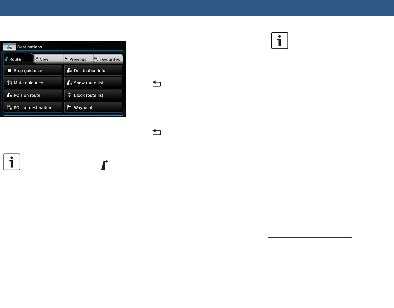
8.8 Route guidance settings in the
Route menu
8.8.1 Opening the Route menu
Note:
The Route menu is only available when
a route guidance session is active.
fTap in the Home menu.
or:
fTap in the map view.
or:
fTap the Route tab in the Destinations menu.
Navigation
en | 47
The Route menu is displayed:
For the available settings and options, please
refer to the following sections.
Note:
In the Destinations menu, tap to
return to the map view.
8.8.2 Cancelling route guidance
fIn the Route menu, tap Stop guidance.
The currently active route guidance session is
cancelled and the map of the area around the
vehicle is displayed.
8.8.3 Muting navigation announce-
ments
fIn the Route menu, tap Mute guidance or
Unmute guidance to activate or cancel mute
respectively.
8.8.4 Displaying destination infor-
mation
fIn the Route menu, tap Destination info.
Your current destination is displayed in the
details view (see the section entitled “Location
details view” (page 42)).
fTap to return to the Destinations menu.
8.8.5 Displaying the route list
fIn the Route menu, tap Show route list.
The route sections up ahead on your journey are
displayed.
fTap to return to the Destinations menu.
8.8.6 Displaying the list of way-
points
fIn the Route menu, tap Waypoints.
The waypoints and destination of the active
route guidance session are displayed.
fTap an item to view the details for the respec-
tive waypoint/destination (see the section
entitled “Location details view” (page
42)).
8.8.7 Searching for a point of inter-
est on the route or near the
destination
During an active route guidance session, you
can select a point of interest on your route or
near your destination as the destination.
Note:
If your current route goes directly to
the ultimate destination, you can add
the new point of interest as a waypoint
or replace the ultimate destination with
the new point of interest.
If your current route already goes via a
waypoint to the ultimate destination,
you can either replace the waypoint or
the ultimate destination with the new
point of interest.
fIn the Route menu, tap POIs at destination
or POIs on route.
The available point of interest categories are
displayed. Continue reading the section entitled
“Selecting a point of interest and starting route
guidance” (page 41).
8.8.8 Blocking route sections
You can block route sections that lie up ahead
on your route and thus exclude them from the
route. The navigation system automatically
calculates a suitable alternative route.
Selecting route sections to block
fIn the Route menu, tap Block route list.
The route sections up ahead on your journey are
displayed.
Navigation
48 | en
Note:
You can block an individual route sec-
tion or several consecutive route sec-
tions.
fTap the desired route section.
Or:
If you want to block several route sections:
fTap the first route section you want blocked.
fTap the final route section you want blocked.
All route sections between the two selected
sections are blocked.
fTap Recalculate route.
The route is recalculated and displayed in the
map view.
Note:
Tap to cancel the operation. You
will return to the Destinations menu.
Unblocking blocked route sections
You can unblock route sections that you previ-
ously blocked.
fIn the Route menu, tap Unblock route list.
The route is recalculated and displayed in the
map view.
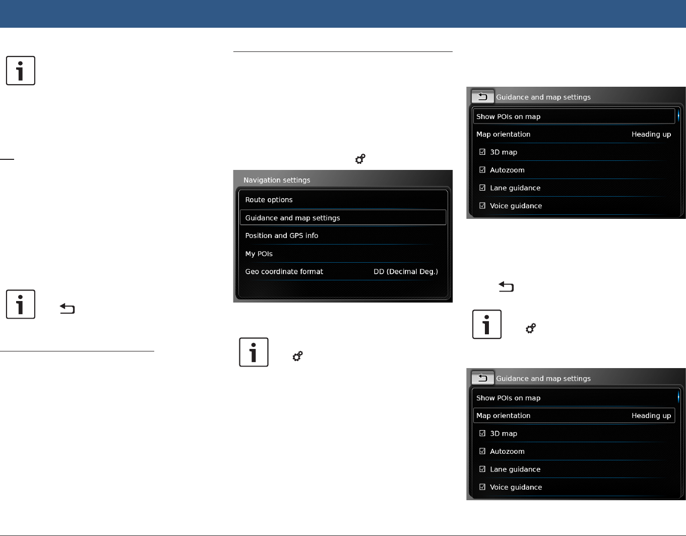
8.9 Specifying guidance and map
settings
With the guidance and map settings you can
specify route guidance and map view options.
8.9.1 Opening the guidance and
map settings
fIn navigation mode, tap 6.
fTap Guidance and map settings.
Note:
Tap 6 to close the options display.
8.9.2 Displaying points of interest
on the map
fTap Show POIs on map.
fTap the desired categories.
The map shows points of interest from the cat-
egories whose checkbox contains a check mark.
fTap .
Note:
Tap 6 to close the options display.
8.9.3 Selecting the map orientation
Navigation
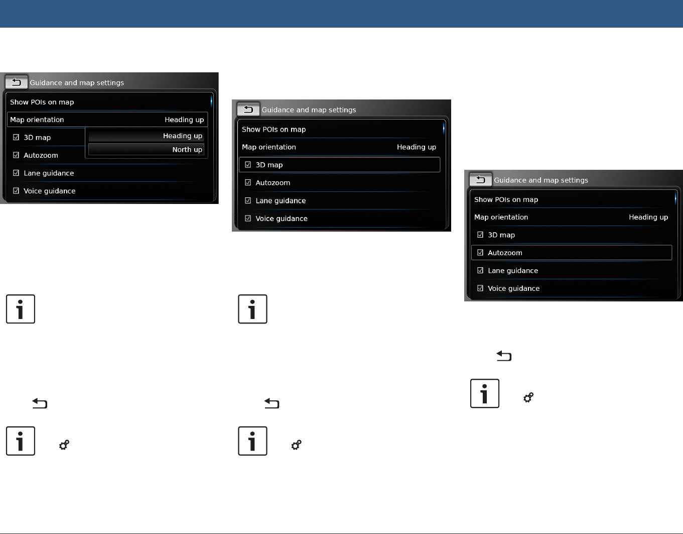
en | 49
fTap Map orientation.
fTap the relevant item:
fHeading up:
Map aligned with your heading
fNorth up:
Map aligned with north
Notes:
fYou can also change the map orien-
tation while in the map view (see
the section entitled “Changing the
map view mode” (page 45)).
fIf the North up option is selected,
3D map view is not available.
fTap .
Note:
Tap 6 to close the options display.
8.9.4 3D map view – on/off
Instead of the normal view from above, the 3D
map view displays a perspective view.
fTap 3D map.
3D map view is activated when the check mark
is displayed in the checkbox.
Notes:
fYou can also activate 3D map view
while in the map view (see the
section entitled “Changing the map
view mode” (page 45)).
fIf 3D map view is activated, the
North up option is not available.
fTap .
Note:
Tap 6 to close the options display.
8.9.5 Enabling automatic zoom
When automatic zoom is enabled, the navigation
system automatically adapts the map scale to
the route conditions (e.g. it zooms into the map
in urban areas or when approaching a junction
or a pending driving manoeuvre and zooms out
of the map on long straight-ahead stretches of
motorway).
fTap Autozoom.
Automatic zoom is enabled when the check
mark is displayed in the checkbox.
fTap .
Note:
Tap 6 to close the options display.
Navigation
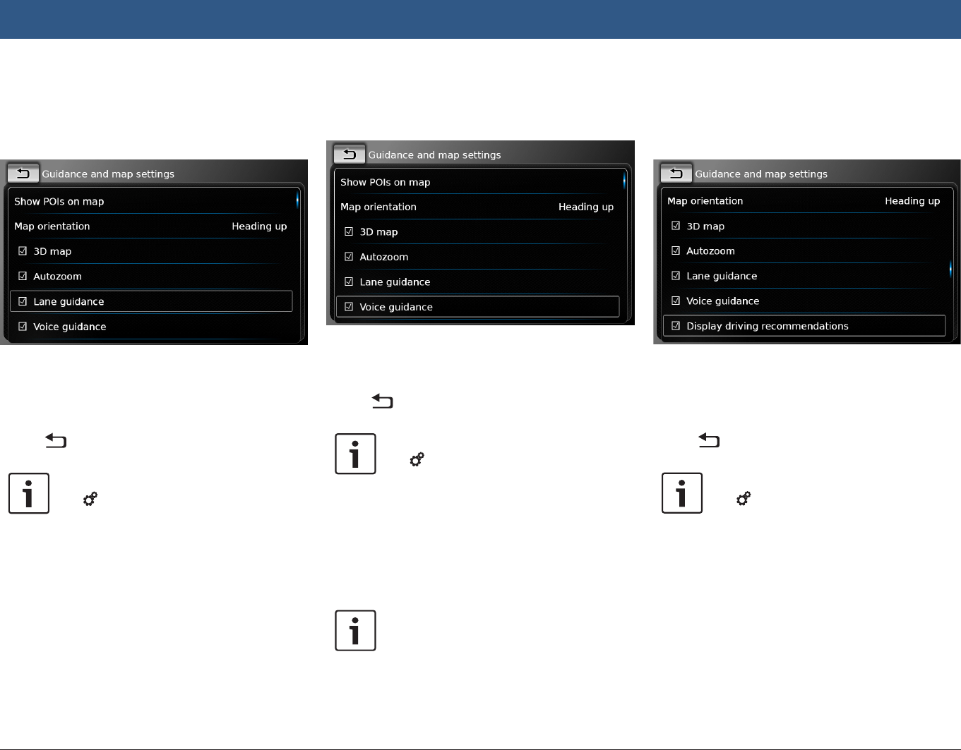
50 | en
8.9.6 Lane guidance – on/off
When lane guidance is enabled, the system
displays the appropriate lane on multi-lane
roads.
fTap Lane guidance.
Displaying of lane recommendations v is
enabled when the check mark is displayed in the
checkbox.
fTap .
Note:
Tap 6 to close the options display.
8.9.7 Voice guidance – on/off
You can enable/disable the driving recommen-
dation announcements that the system makes.
fTap Voice guidance.
Voice guidance is enabled when the check mark
is displayed in the checkbox.
fTap .
Note:
Tap 6 to close the options display.
8.9.8 Visual driving recommenda-
tions in other operating
modes– on/off
You can choose to have visual driving recom-
mendations in the map view y.
Note:
The visual driving recommendations
shown in the home menu are persis-
tent.
When you approach a driving manoeuvre, the
display will show the symbol for the driving
manoeuvre, the distance to the driving manoeu-
vre, and the name of the next road.
fTap Display driving recommendations.
Displaying of visual driving recommendations in
the map view is enabled when the check mark is
displayed in the checkbox.
fTap .
Note:
Tap 6 to close the options display.
8.9.9 Acoustical traffic information
You can enable/disable announcements about a
changed traffic situation ahead of you:
fIf a route guidance session is active: The
announcements focus on the calculated
route.
fIf no route guidance session is active: The
announcements focus on the area you will
Navigation
en | 51
most probably cross according to your previ-
ous route.
fTap Acoustical traffic information.
Acoustical traffic information is enabled when
the check mark is displayed in the checkbox.
fTap .
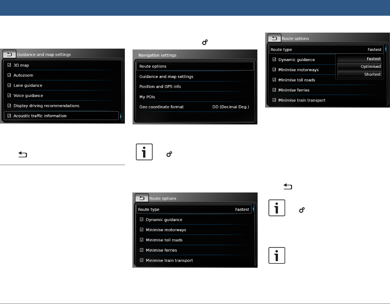
8.10 Specifying custom route
options
You can use custom route options to define your
requirements for the system’s choice of route.
The system takes these requirements into
account when calculating the route.
8.10.1 Opening the route options
fIn navigation mode, tap 6.
fTap Route options.
Note:
Tap 6 to close the options display.
8.10.2 Selecting the basic type of
route
You can set the basic type of route.
fTap Route type.
fTap the relevant option:
fFastest:
The journey time is minimised.
fOptimised:
Optimised combination of the shortest
and fastest route.
fShortest:
The distance is minimised.
fTap .
Note:
Tap 6 to close the options display.
8.10.3 Activating dynamic route
guidance with TMC
Note:
If TMC is not supported in your recep-
tion area or by the current station, you
will not be able to experience these
functions.
Navigation
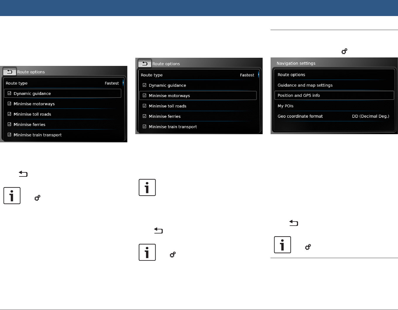
52 | en
When dynamic route guidance is activated, the
system takes the latest traffic announcements
into account and may automatically recalculate
the route during route guidance.
fTap Dynamic guidance.
Dynamic route guidance is enabled when the
check mark is displayed in the checkbox.
fTap .
Note:
Tap 6 to close the options display.
8.10.4 Avoiding certain types of
road and transport
You can select which types of road and trans-
port should, if possible, be avoided in the route
calculation:
fMotorways
fToll roads
fFerries
fTrain transport
fUnpaved roads
fSeasonal roads
fRestricted roads
fTap the relevant option.
The corresponding road and transport type is
avoided when the check mark is displayed in the
checkbox.
Note:
In some cases, the navigation system
may use a road or transport type that is
to be avoided in order to enable you to
reach your destination.
fTap .
Note:
Tap 6 to close the options display.
8.11 Displaying information on the
current position
fIn navigation mode, tap 6.
fTap Position and GPS info.
A map of the area around your position and the
following information are displayed:
fCurrent road
fCurrent city
fLongitude
fLatitude
fAltitude
fGPS information
fTap .
Note:
Tap 6 to close the options display.
8.12 Your own points of interest
In addition to the points of interest stored in the
navigation data, you can also store your own
Navigation
en | 53
points of interest and point of interest warnings
on the device.
Point of interest warnings may, for instance,
contain the location of sharp bends.
8.12.1 Data format
The file containing your own points of interest
must comply with the WGS84 standard.
The required file format is “.csv”.
Each line of the file may describe one point of
interest containing the following pieces of infor-
mation:
fLongitude
fLatitude
fName
fAddress (optional)
fTelephone number (optional)
A line of the file may look like this:
77.61,12.92,Park,Bangalore City,00917829
Notes:
fEnsure that no piece of information
contains a comma. Inside the file,
commas are exclusively used to
separate the different pieces of
information from one another.
fCoordinates of the southern and
western hemisphere have to be
specified by negative values.
The name of the csv file represents the name of
the point of interest category. When setting up a
csv file, be sure to insert only points of interest
that belong to the same category and use the
name of the category as the file name.
You may create up to four additional levels of
categories and subcategories if you create a
corresponding folder structure. The name of a
folder will be recognised as the name of the
corresponding category or subcategory.
Notes:
fThe csv file or the top-level folder
that represents a top-level category
must be stored inside a folder
named “myPOIs”. Place this folder
in the root directory of a USB stor-
age device.
fA csv file that contains POI warnings
must be stored inside the folder
“myPOIs” or any of its subfolders.
The name of this file must begin
with “myPOIWarnings_” and end
with “.csv” (for example: “myPOI-
Warnings_Curves.csv”). Otherwise
the POI warnings cannot be dis-
played.
8.12.2 Loading your own points of
interest onto the device
Note:
When you load a new file, any of your
own points of interest that are already
stored on the device will be deleted.
fSwitch to navigation mode.
fConnect the USB storage device containing
the file to the device.
The device detects the file automatically.
fTap Download to confirm that you want to
load the file.
The progress and completion of the loading
operation are indicated.
fConfirm by tapping .
8.12.3 Point of interest warnings
displayed during the journey
– on/off
When the displaying of point of interest warn-
ings is enabled, the system displays a warning
when you approach a point of interest warning’s
location.
Safety notice
The point of interest warnings stored
on the device may be incomplete or
outdated.
Therefore, please always ensure you
observe the actual road conditions and
the traffic regulations that are in force.
Navigation