HYUNDAI MOBIS AVN-200TFU AVN System User Manual AVN 200TFU IC ATT C E G H I
HYUNDAI MOBIS CO., LTD. AVN System AVN 200TFU IC ATT C E G H I
UserManual.wiki
>
HYUNDAI MOBIS
>
AVN-200TFU User Manual
>
user manual 2 of 7
Contents
1.
user manual 1 of 7
2.
user manual 2 of 7
3.
user manual 3 of 7
4.
user manual 4 of 7
5.
user manual 5 of 7
6.
user manual 6 of 7
7.
user manual 7 of 7
user manual 2 of 7
Navigation menu
Upload a User Manual
Namespaces
Wiki Guide
HTML
PDF
Info
Views
User Manual
Discussion / Help
Navigation
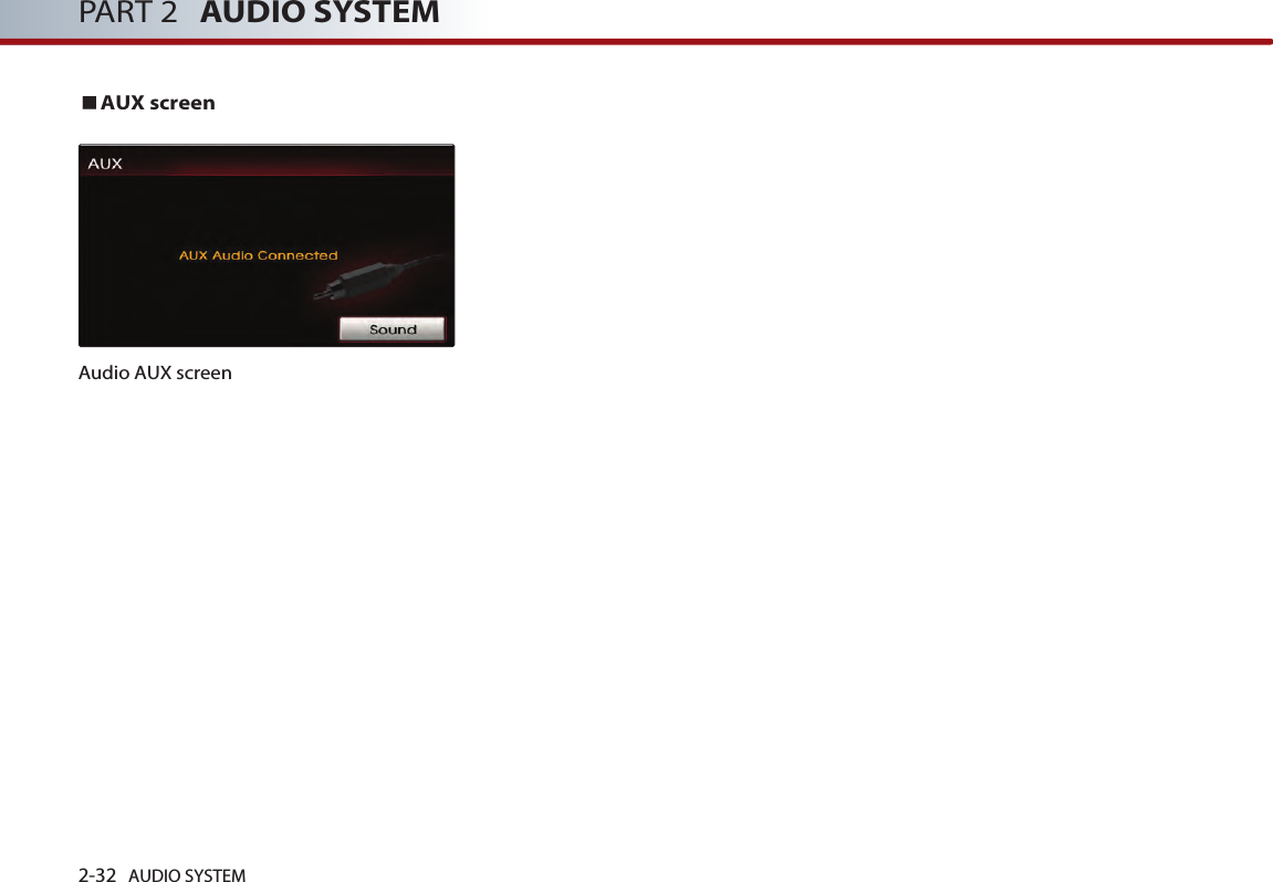
![2-30 AUDIO SYSTEM PART 2 AUDIO SYSTEMThe device may not support normaloperation if MP3 Players, cellular phones,digital cameras, or other electronicdevices (USB devices not recognized asportable disk drives) are connected to thedevice. The device may not support normaloperation when using a USB memorytype besides the Metal Cover Type USBMemory. The device may not support normaloperation when using formats such asHDD Type, CF, or SD Memory. The device will not support files locked byDRM (Digital Rights Management).The device may not support. Please makesure to use normal operation if the properconnection with the USB memory failsdue to vibrations caused by the vehicle. (i-stick type, etc.)Please avoid using USB memory productswhich can be used as key chains orcellular phone accessories as they couldcause damage to the USB jack. Please make certain only to use plug typeconnector products as shown below. Connecting the USB devicesConnect the USB as shown in the picture. Listening to USB musicConnect a USB or press the button on the control panel if the USB isalready connected.Select the desired file. [Selecting the MP3 file], page 2-21.INFORMATIONThe USB screen and operation method is thesame with MP3 mode. Please refer to the MP3 mode section formore information. CD/AUXiPlug Type Connector](https://usermanual.wiki/HYUNDAI-MOBIS/AVN-200TFU.user-manual-2-of-7/User-Guide-1264554-Page-1.png)


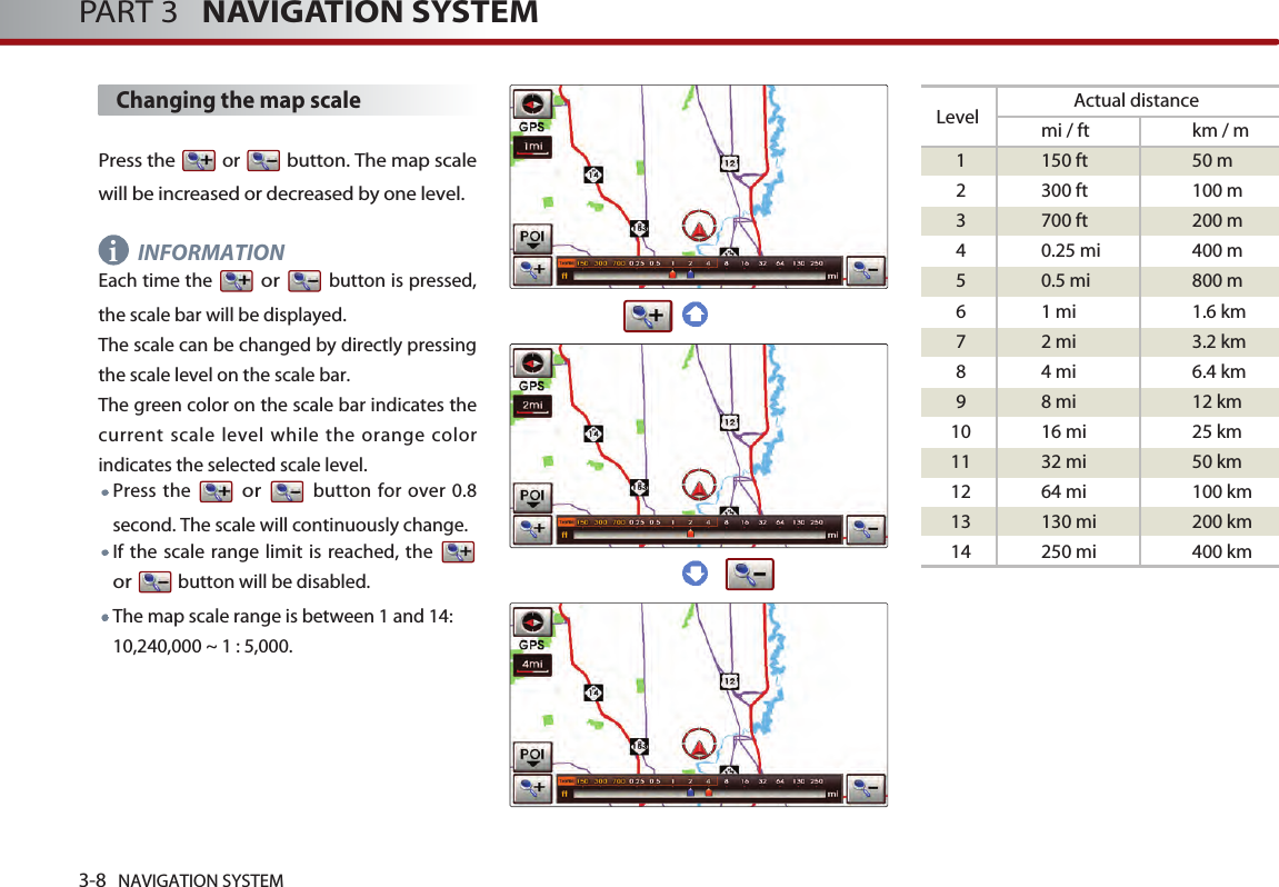
![NAVIGATION SYSTEM 3-5NAVIGATION SYSTEMStarting navigation system Press the Navigation mode key ( ,, , ). The Caution screenwill always be displayed when first enteringinto Navigation mode. Read the contents ofthe caution screen carefully and press thebutton.Map Functions Current position map screen(without route)Press the key on the controlpanel to display the map of current positionand the neighboring area.GPS signal state indicator : Displays thestate of GPS signal reception.[Viewing GPS signal state], page 3-7. Map scale level indicator : Displays thecurrent map scale.[Changing the map scale], page 3-8.Landmark icons : Landmark icons aredisplayed on the map when the mapscale level is set to under 300 ft (100mdepending on map data)[Appendix : Landmark icons], page 7-11.POI icons : POI icons are displayed onthe map when the map scale level is setto under 0.5 mi (800m).[Appendix : POI icons], page 7-8.Current vehicle position icon : Displaysthe current position of the vehicle.MAPVOICEAgreeSETUPROUTEDESTMAPVOICE](https://usermanual.wiki/HYUNDAI-MOBIS/AVN-200TFU.user-manual-2-of-7/User-Guide-1264554-Page-9.png)
![3-6 NAVIGATION SYSTEMPART 3 NAVIGATION SYSTEMNorth Up / Heading Up switch :Displays the current map mode and themap mode can be switched betweenNorth Up and Heading Up. [Switching map mode], page 3-6.POI : Displays or hides the POI icon onthe map.[Displaying/Hiding POI icons on themap], page 3-9.Map scale : Increases or decreases themap scale. [Changing the map scale], page 3-8.Switching map mode (North Up /Heading Up)Each time the compass button is pressed,the screen will switch in the order shownbelow. Heading Up North Up Heading UpINFORMATIONAll map screens (map screen after settingdestination & whole route display screen)except the current position screen will alwaysbe displayed in North Up mode. North Up : displays the map always facingthe North direction regardless of thedirection which the vehicle is traveling. The vehicle icon is displayed in the centerposition of the map. Heading Up : displays the map alwaysfacing the direction which the vehicle istraveling. The vehicle icon is displayed inthe lower center position of the map.Voice Command1. Press the key on the steering wheelremote controller.2. After the beep sound, say a command. "North Up""Heading Up"i](https://usermanual.wiki/HYUNDAI-MOBIS/AVN-200TFU.user-manual-2-of-7/User-Guide-1264554-Page-10.png)
![NAVIGATION SYSTEM 3-7NAVIGATION SYSTEMViewing GPS signal state The state of GPS signal reception isdisplayed as shown below.GPS (active) : GPS reception is satisfactory.GPS (inactive) : GPS reception is unsatisfactory.[System information and update], page3-51.INFORMATIONGPS (Global Position System) : GPS is asystem developed and operated by theUnited States which determines the currentlocation of the user (longitude, latitude, etc.)by generally using 4 or more satellites. Thissystem is used with related GPS information,various sensors, road map data, and othernavigation related information.GPS information may not operate under thefollowing conditions. - When buildings, tunnels, or otherobstructions block satellite signals. - When materials are placed above the GPSantenna and block satellite signals.- When the satellite does not transmitsignals (signal transmission is controlledby the satellite control center in theUnited States and may not transmit whenunder repair, modification, etc). - When a digital cellular phone (1.5GHz) isplaced near the GPS antenna.This system uses GPS information, varioussensors, road map data, and other relatedinformation to display the current position.Errors may occur if the satellite istransmitting inaccurate signals or if whichcan only two or less satellite signals can bereceived. Errors which occur in such conditionscannot be corrected. i](https://usermanual.wiki/HYUNDAI-MOBIS/AVN-200TFU.user-manual-2-of-7/User-Guide-1264554-Page-11.png)
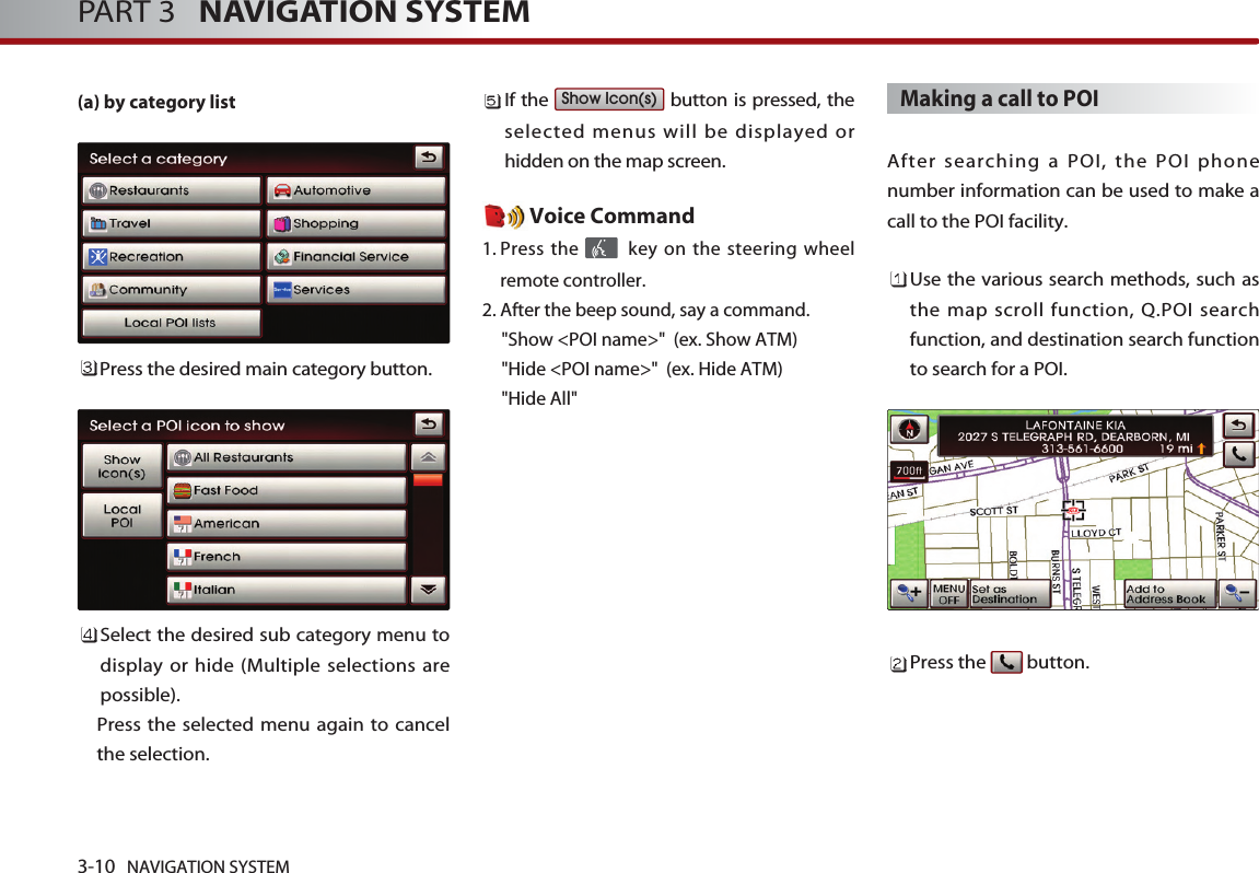
![NAVIGATION SYSTEM 3-9NAVIGATION SYSTEMVoice Command1. Press the key on the steering wheelremote controller.2. After the beep sound, say a command. "Zoom In""Zoom Out""Zoom Maximum""Zoom Minimum""Zoom level <1 to 14>""Zoom <actual distance>"" (ex. Zoom 700ft)"Displaying / Hiding POI icons onthe mapDisplaying/Hiding Q.POI iconsPress the button. Related menu buttons will be displayedat the bottom of the screen. INFORMATIONThe Q.POI icons are set to - Gas Station,- Parking, - Hotel, - Golf Course,- Bank, - Fast Food (6 icons) by default.This setting can be changed in SETUP. [Setting Q.POI icons], page 3-42.Press the icon buttons to display or hide.To turn off all POI icons displayed on themap, press the button. INFORMATIONThe current displayed POI icons arehighlighted while the icons not beingdisplayed are shown as normal buttons.If there are no POI icons being displayed,the button will be disabled. POI icons are displayed when the scale isunder 0.5 mi (800m). Displaying / Hiding icons otherthan Q.POI iconsPress the button. Related menu buttons will be displayedat the bottom of the screen. Press the button. INFORMATIONQ.POI stands for Quick POI and refers to thefunction which turns POI icon display on or offon the map. OthersPOI ALL OFFALL OFFPOI iii](https://usermanual.wiki/HYUNDAI-MOBIS/AVN-200TFU.user-manual-2-of-7/User-Guide-1264554-Page-13.png)
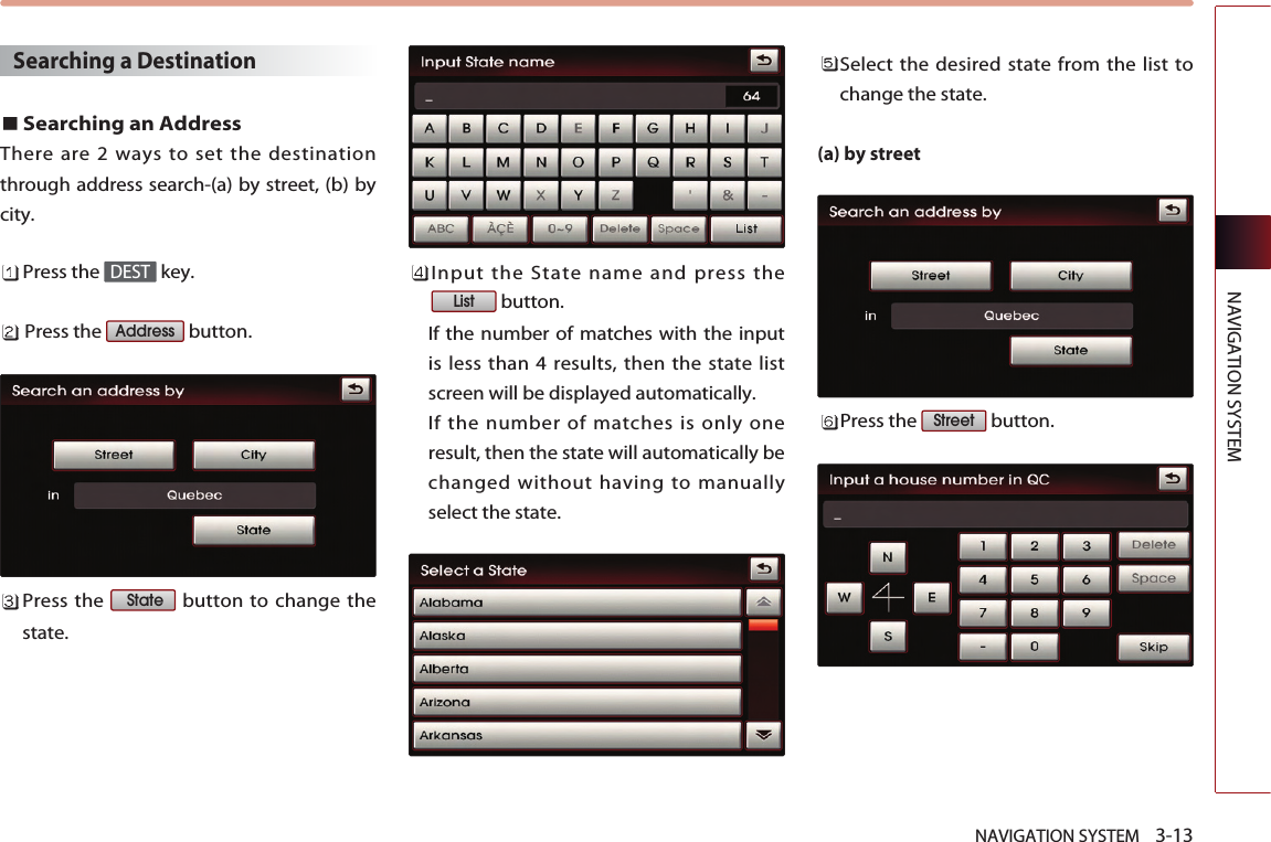
![NAVIGATION SYSTEM 3-11NAVIGATION SYSTEMBluetooth is used to make a call to thePOI facility.Once the call is ended, the map isrestored to the current vehicle location. INFORMATIONMaking a call is not possible if there is notelephone information for a POI or if there isno mobile phone connected throughBluetooth.For more information of mobile phoneauthentication through Bluetooth ordetailed information on conducting search,refer to [Pairing and connecting aBluetooth phone], page 5-4.Scrolling map Press the map area on the map screen. The selected point will be centered on thescreen and the scroll mark will be displayed.Information about the marked point andstraight line distance from the currentposition will be displayed at the top of thescreen. INFORMATIONIf a map area on the map screen is pressed,the map will continuously scroll in thecorresponding direction until the pressing isreleased. ii](https://usermanual.wiki/HYUNDAI-MOBIS/AVN-200TFU.user-manual-2-of-7/User-Guide-1264554-Page-15.png)
![3-12 NAVIGATION SYSTEMPART 3 NAVIGATION SYSTEMSetting a destination Destination menu screen andfunctionsPress the key on the control panel todisplay the destination menu screen. Address : Sets the destination throughaddress search. [Searching an Address], page 3-13.Previous Dest : Sets the destinationthrough the previous destination list. [Searching a Previous Destination],page 3-17 .Intersection : Sets the destinationthrough intersection search. [Searching an Intersection], page 3-17.POI Search : Sets the destination throughPOI Category search. [Searching a POI], page 3-20 .Address Book : Sets the destinationthrough address book search. [Searching from Address book], page3-24 .Emergency : Sets the destinationthrough emergency facilities search. [Searching for Emergency facilities],page 3-25 .HOME : Sets the stored HOME as thedestination. [Searching your Home], page 3-25 .Favorite place ~ : Sets the destination with one of thestored favorite places. [Searching favorite places], page 3-26 .51DEST](https://usermanual.wiki/HYUNDAI-MOBIS/AVN-200TFU.user-manual-2-of-7/User-Guide-1264554-Page-16.png)
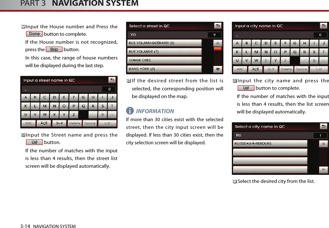
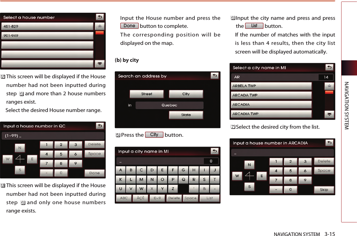
![3-16 NAVIGATION SYSTEMPART 3 NAVIGATION SYSTEMInput the house number and press thebutton to complete. If the House number is not recognized,press the button. In this case, the range of house numberswill be displayed during the last step.Input the Street name and press thebutton to complete. If the number of matches with the input isless than 4 results, then the street listscreen will be displayed automatically. Select the desired street from the list andthe corresponding position will bedisplayed on the map. This screen will be displayed if the Housenumber had not been inputted duringstep and more than 2 House numberranges exist. Select the desired House number range.This screen will be displayed if the Housenumber had not been inputted duringstep and only one House numberrange exists. Select the house number range and Pressthe button to complete. The corresponding position will bedisplayed on the map. Voice Command1. Press the key on the steering wheelremote controller.2. After the beep sound, say a command. "Find address" [Find address], page 4-19.DoneListSkipDone](https://usermanual.wiki/HYUNDAI-MOBIS/AVN-200TFU.user-manual-2-of-7/User-Guide-1264554-Page-20.png)
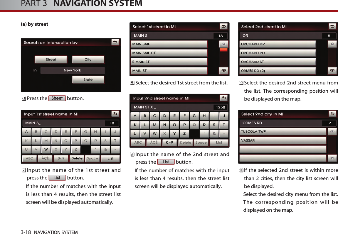
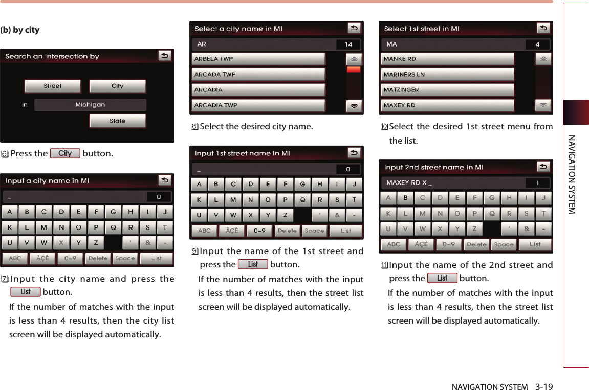
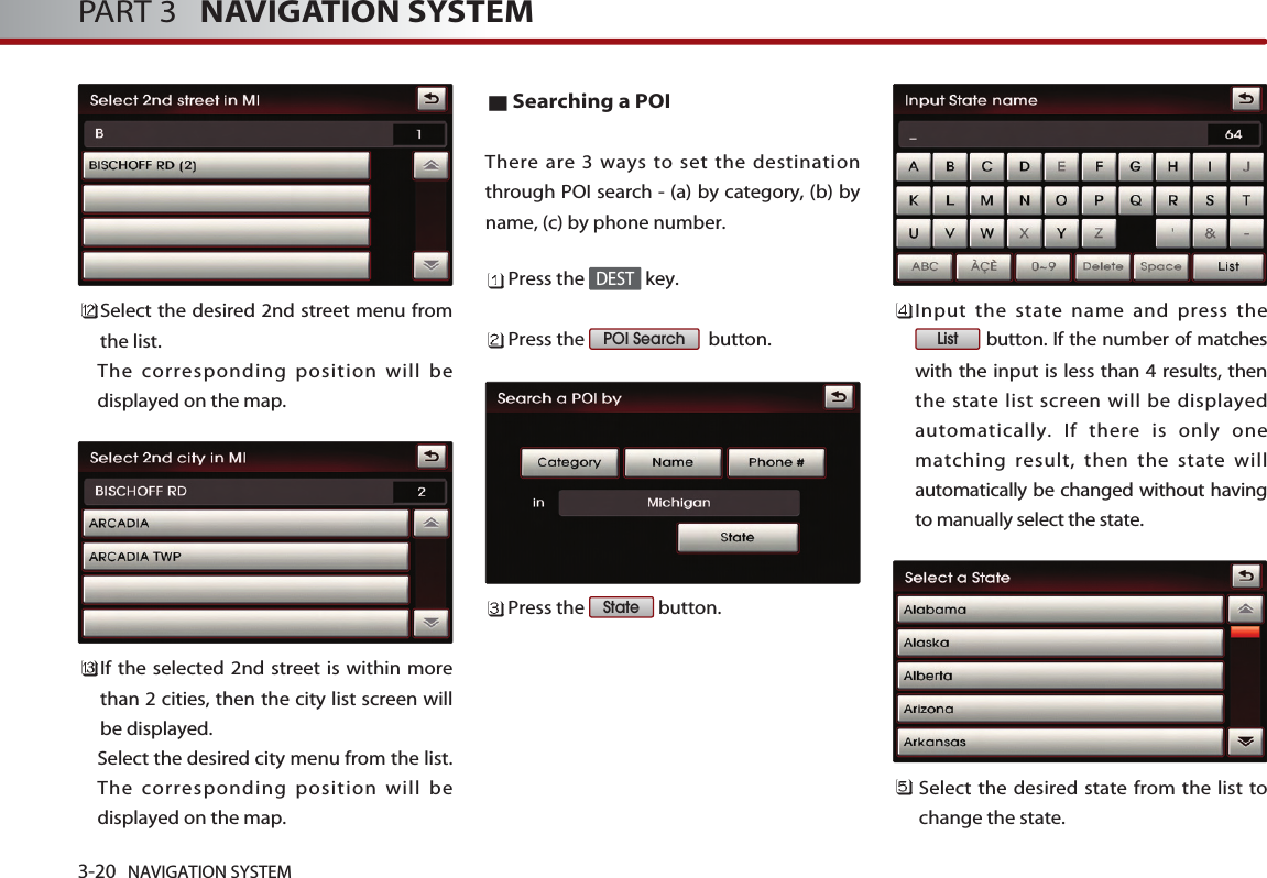
![NAVIGATION SYSTEM 3-17NAVIGATION SYSTEMSearching a Previous DestinationPress the key.Press the button.Select the desired previous destination.The corresponding position will bedisplayed on the map. Voice Command1. Press the key on the steering wheelremote controller.2. After the beep sound, say a command. "Previous destination"[Previous destination], page 4-24."Previous start point"[Previous start point], page 4-25.Searching an Intersection There are two ways to set the destinationthrough intersection search-(a) by street, (b)by city. Press the key.Press the button.Press the button to change thestate. Input the state name and press thebutton. If the number of matcheswith the input is less than 4 results, thenthe state list screen will be displayedautomatically. If the number of matches is only oneresult, then the state will automatically bechanged without having to manuallyselect the state.Select the desired state from the list tochange the state. ListStateIntersection DESTPrevious DestDEST](https://usermanual.wiki/HYUNDAI-MOBIS/AVN-200TFU.user-manual-2-of-7/User-Guide-1264554-Page-21.png)
![NAVIGATION SYSTEM 3-21NAVIGATION SYSTEM(a) By category Searches for facilities nearby the currentposition or from the city center.Press the button.Press the button tosearch for facilities nearby the currentposition, or press the button to search for facilities in the nearcity center. (a-1) Near current position Searches for facilities within a 30 mi (45km)radius of the current position. Press the desired main category menu. Voice Command1. Press the key on the steering wheelremote controller.2. After the beep sound, say a command. "Find nearest POI"[Find nearest POI], page 4-20.Press the desired sub category menu. Select the desired menu button. The corresponding position will bedisplayed on the map. Near city centerNear current positionCategory](https://usermanual.wiki/HYUNDAI-MOBIS/AVN-200TFU.user-manual-2-of-7/User-Guide-1264554-Page-25.png)