Furuno USA 9ZWRTR104 Transceiver for Radar Sensor DRS4DL User Manual
Furuno USA Inc Transceiver for Radar Sensor DRS4DL
Contents
- 1. User Manual I
- 2. User Manual II Part 1
- 3. User Manual II Part 2
- 4. User Manual II Part 3
- 5. User Manual II Part 4
- 6. User Manual II Part 5
- 7. User Manual II Part 6
- 8. User Manual II Part 7
- 9. User Manual II Part 8
- 10. User Manual II Part 9
- 11. User Manual II Part 10
- 12. User Manual II Part 11
- 13. User Manual II Part 12
User Manual II Part 6
4. POINTS
4-15
[ID]: Point no. in the route
[CTS]: Course to steer to go to waypoint
[SPEED]: Speed to use to go to waypoint
[DISTANCE]: Distance from preceding waypoint
[TOTAL]: Total distance from start to the waypoint
[TTG]: Time to go to the waypoint, using speed shown in [SPEED] column.
[TOTAL]: The time from start to the waypoint.
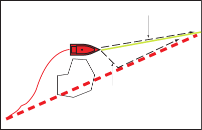
4.12 How to Restart or Cancel Navigation to a Point
4.12.1 How to restart navigation to a point
When you go to a point, you can restart
the navigation to the point from the cur-
rent location.
When you steer to keep away from an
obstruction or the ship drifts, you go off
course as shown in Line 1 in the figure.
If you do not need to return to the origi-
nal course, you can go to the point from
the current position as shown in Line 2 in
the figure.
1. Tap the red dashed line or the yellow line of the route to display the pop-up menu.
2. Tap [Restart]. The route start position for the route moves to the current position.
4.12.2 How to cancel navigation to a point
1. Tap any part of the route to display the pop-up menu.
2. Tap [Stop Nav].
The red dashed line, yellow line, XTE lines and arrival area circle are erased from the
screen.
Line 2
Line 1
Obstacle
Original course
4. POINTS
4-16
This page is intentionally left blank.

5-1
5. ROUTES
5.1 What is a Route?
A route is a series of route points entered in the order to use for navigation. A route
can contain up to a maximum of 500 route points, and this equipment stores 200
routes.
Note: When connecting NavNet 3D units on the LAN network, a route can contain up
to a maximum of 100 route points.
You create a route by selecting geographical positions on the screen. These positions
are marked with blue squares.
You can follow a route that you have created, with the [Go To] feature. When you fol-
low a route, the current leg is shown as a red dashed line and the previous leg is
shown as a light gray line.
The routes on the screen can be edited from the pop-up menu. With this pop-up menu,
you can
• Insert route points in a route
• Move route points in a route
• Delete route points from a route
• Extend a route
• Split routes
• Find information about a route
• Delete a route
• Set a route as destination
• Follow a route in the reverse direction
• Ignore a route point when following a route
Note: Active routes can be shared with other NavNet TZtouch2 units via LAN. Data is
shared automatically; no operation is required.
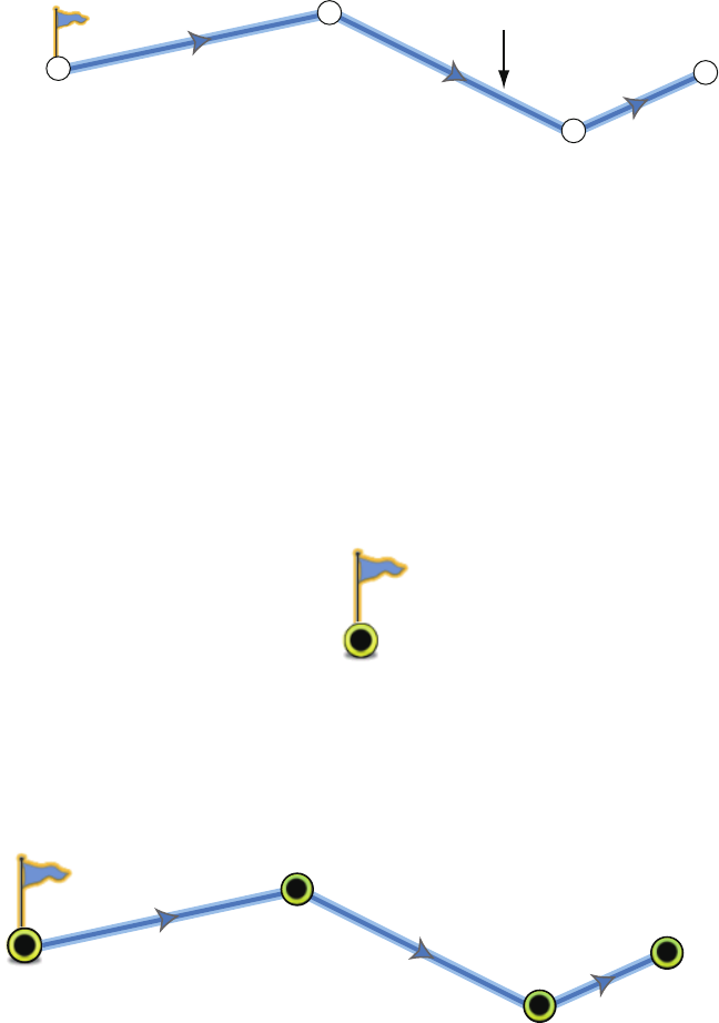
5.2 How to Create a Route
5.2.1 How to create a new route from the plotter screen
1. Tap a location on the screen for the 1st point in the route to display the pop-up
menu.
2. Tap [New Route]. The flag mark appears on the selected position.
3. Tap the next route point in the route. A light-blue line with arrow runs between the
previous route point and the next route point. The arrow points in the direction of
route flow.
5. ROUTES
5-2
4. Tap the next route point in the route.
Repeat this step to enter all route points. Each route point is numbered.
5. At the last route point, tap [End Route] at the top right-hand corner of the screen
to complete the route.
6. The window for entering route name appears. Enter route name then tap to con-
firm.
5.2.2 How to create a new route from a point
You can create a route from a point.
1. Tap a point to display the pop-up menu.
2. Tap [New Route]. The flag mark as below appears on the point.
3. Tap the next route point in the route. A light-blue line with arrow runs between the
previous point and the next route point. The arrow points in the direction of route
flow.
4. Tap the next route point in the route.
Repeat this step to enter all route points. Each route point is numbered.
5. At the last route point, tap [End Route] at the top right-hand corner of the screen
to complete the route.
6. The window for entering route name appears. Enter route name then tap to con-
firm.
5.2.3 How to create a route from the points list
Open the points list. Tap the point to be the first point in the route then tap [Add to
Route]. Repeat to add all required points. The route is drawn on the plotter display
screen, where you can select the route to name it.
1st route point (starting point)
2nd route point
3rd route point
4th route point
Route leg
1
1
2
2
3
3
4
4
Selected point (starting point)
2nd route point
3rd route point
4th route point
5. ROUTES
5-3
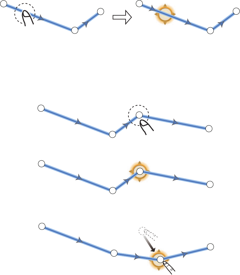
5.2.4 How to insert a route point on a route
You can insert a new route point on a route leg.
1. Tap a position on a route leg to insert a route point.
2. Tap [Insert] on the pop-up menu. The compass symbols marks the position se-
lected. The route point is numbered according to its position in the route, and the
succeeding route points are renumbered.
3. Tap [End Move] at the top right-hand corner of the screen.
5.2.5 How to move a route point on a route
You can move a route point on a route.
1. Tap a route point on a route to display the pop-up menu.
2. Tap [Move]. The selected route point is highlighted.
3. Move the route point to the new position by dragging the route point or tapping the
new position.
4. Tap [End Move] at the top right-hand corner of the screen.
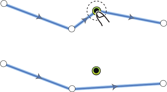
5.2.6 How to delete a point or route point on a route
You can delete a point or route point on a route.
1. Tap the point or route point to show the pop-up menu.
2. Tap [Delete]. The selected point or route point is deleted, and the succeeding
route points are renumbered.
2
2
1
1
3
3
2
2
1
1
3
3
2
2
1
1
3
3
4
4
2
2
1
1
3
3
4
4
2
2
1
1
3
3
4
4
5. ROUTES
5-4
5.2.7 How to remove a point from a route
You can remove a point from a route.
1. Tap the point to remove to show the pop-up menu.
2. Tap [Remove]. The selected point is removed from the route, and the succeeding
route points are renumbered.
5.2.8 How to extend a route
You can extend a route from the last route point on the route.
1. Tap a route leg to display the pop-up menu.
2. Tap [Extend].
3. Tap a position. A light-blue line with arrow runs from the last route point to the se-
lected position.
4. Repeat step 3 to enter more route points, if necessary.
5. At the last route point, tap [End Route] at the top right-hand corner of the screen
to complete the route and save the route to the routes list.
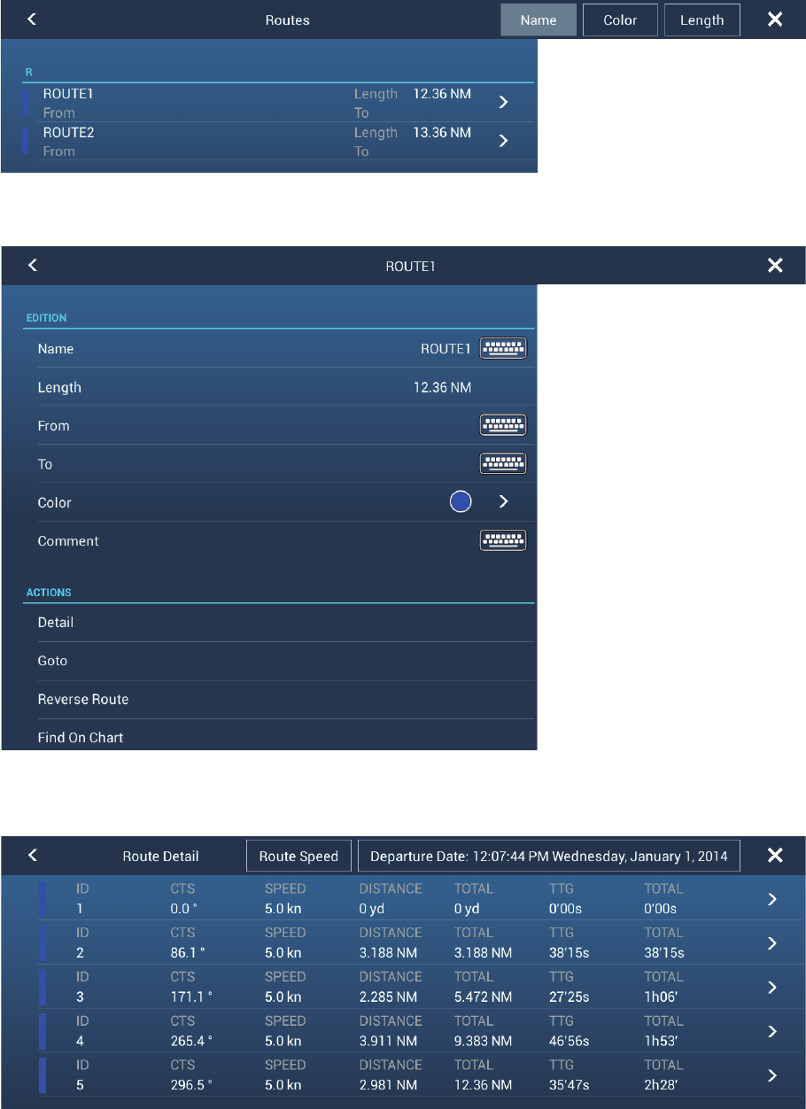
5.3 Routes List
The created routes are stored in the routes list, where you can edit or see the route
data. The list stores the following route data for each route (the number for each item
below has links to the number in the figure at step 3):
1) Name of route
2) Length of route
3) Names of starting route point and last route point (Enter them with the software
keyboard.)
4) Color of route
5) Comment for route
6) Each number of each route point
7) Bearing to steer
8) Planning route speed (see section 5.10)
9) Distance between legs and total distance
10)TTG between legs and total TTG
2
2
1
1
4
4
2
2
1
1
3
3
5. ROUTES
5-5
To open the routes list:
1. Open the home screen, then tap [List].
2. Tap [Routes] to open the routes list.
3. Tap the route to view. (You can sort the list by name, color or length, with the sim-
ilarly named buttons at the top right corner of the list.)
4. You can edit the name, from point, to point color and comment for the route.
5. To find details about the route, tap [Detail] to show the [Edit] screen.
The colored bar at the left side of the screen is the route color.
[ID]: Waypoint number
5. ROUTES
5-6
[CTS]: Course to steer to go a waypoint.
[SPEED]: The speed set with [Default Planning Route Speed] in the [Routes]
menu.
[DISTANCE]: Distance between adjacent waypoints.
[TOTAL]: Cumulative distance.
[TTG]: Time to go between adjacent waypoints.
[TOTAL]: Cumulative time in route.
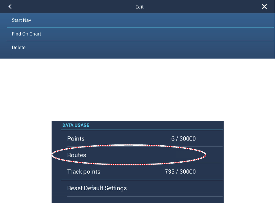
6. From the [Edit] screen, you can start navigating the route, find the route on the
chart, or delete the route. Tap a route waypoint to show the [Edit] screen. Tap
[Start Nav].
5.4 How to Find Number of Routes Created
Open the home screen, then tap [Settings] - [General]. Find [Routes] in the [DATA US-
AGE] section. In the example below. 3 routes out of 200 have been created.
5.5 How to Find a Route on the Chart
You can easily find the location of a route from the routes list. The selected route is
put at the center of the active plotter display.
1. Open the home screen, then tap [List].
2. Tap [Routes] to open the routes list.
3. Tap a route then tap [Find On Chart] from the options. The menu closes then the
selected route is put at the center of the plotter display.
3 / 200
5. ROUTES
5-7
5.6 How to Delete a Route
You can delete routes individually or collectively. An active route cannot be deleted.
5.6.1 How to delete a route on the screen
Tap a route leg of a route to delete to show the pop-up menu, then tap [Delete].
5.6.2 How to delete a route from the routes list
1. Open the home screen, then tap [List] - [Routes].
2. Tap the route to delete then tap [Delete]. The route disappears from both the
screen and the routes list.
3. Tap the close button to close the window.
5.6.3 How to delete all routes
1. Open the home screen, then tap [List] - [Routes].
2. Tap [Delete All Points & Routes] menu.
3. You are asked if you are sure to delete all routes (and points). Tap [OK].
4. Tap the close button to finish.
5.7 How to Show or Hide All Routes
All routes can be shown or hidden. An active route cannot be hidden from the screen
unless route following is stopped.
Open the [Layers] menu, the turn [Routes] on or off.
Note: Inactive routes can be placed at either the arrival or departure location. Open
the Layers menu, then activate [Departure] or [Arrival] (below the [Routes] flipswitch).
5. ROUTES
5-8
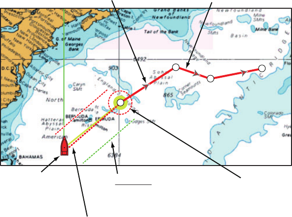
5.8 How to Follow a Route
Before you follow a route, make sure that the path to the route is clear. Make sure to
zoom your chart to check for hazards that do not appear on a smaller scale.
5.8.1 How to follow an on-screen route
1. Tap a route leg of the route to follow to show the pop-up menu.
2. Tap [Start Nav].
The following occurs:
• The line for the selected route turns red.
• The go to point (1st route point) is highlighted.
• A thick red dashed line and a yellow line run between the current position and the
1st route point of the selected route. The thick red dashed line is the course to follow
to get to the 1st route point. The yellow line is the shortest course from the current
position to the go to point.
• The go to point is numbered "1" and the position where the [Go To] function starts
is numbered "0".
• The arrival area marker appears if activated on the menu (see paragraph 5.9.5).
• The XTE lines, red for port side, green for starboard side, appear. You can show or
hide these lines and set their width with [Display XTE Lines] and [XTE Value] re-
spectively in [Routes] menu.
Note: If you want to be notified when you reach a go to point, turn on [Waypoint Cross-
ing Notification] on [Routes] of the menu (see paragraph 5.9.8). Then the message
"Waypoint Crossing" appears when you reach a go to point. For the arrival timing, see
paragraph 5.9.5.
Arrow points in direction to follow route Route leg (red line)
Course to 1st route point
(thick red dashed line)
Boat icon
(current position) Arrival area (appears when
you select [Circle and
Cross Line] or [Circle] in
the [Routes] - [Waypoint
Switching Mode].)
2
2
1
1
3
3
4
4
XTE line
Green: starboard
Red: port
5. ROUTES
5-9
5.8.2 How to follow a route selected from the routes list
1. Open the home screen, then tap [List] - [Routes].
2. Tap the route to follow then tap [Goto] from the options.
3. Tap the close button to finish.
The following occurs:
• The line for the selected route turns red.
• The go to point (1st route point) is highlighted.
• A thick red dashed line and a yellow line run between the current position and the
1st route point of the selected route. The thick red dashed line is the course to follow
to get to the 1st route point. The yellow line is the shortest course from the current
position to the go to point.
• The go to point is numbered "1" and the position where the [Go To] function starts
is numbered "0".
• The arrival area marker appears if activated on the menu (see paragraph 5.9.5).
• The XTE lines, red for port side, green for starboard side, appear. You can show or
hide these lines and set their width with [Display XTE Lines] and [XTE Value] re-
spectively in [Routes] menu.
Note: If you want to be notified when you reach a goto point, turn on [Waypoint Cross-
ing Notification] in the [Routes] menu (see paragraph 5.9.8). Then the message "Way-
point Crossing" appears when you reach a goto point. For the arrival timing, see
paragraph 5.9.5.
5.8.3 How to start navigation from a route point
Tap the route point of the route from where to start navigation, then tap [Start Nav] on
the pop-up menu.
In the above example, the following occurs:
• The route point "3" is selected to start navigation from, and is highlighted.
• The current position is numbered "2" and the numbers of the previous route points
decrease one by one.
• The line from "3" to the route point "5" for the selected route turns red and the legs
for "0" and "1" turn gray.
• A thick red dashed line and a yellow line run between the current position "2" and
the "3" route point. The thick red dashed line is the course to follow to get to the
route point "3". The yellow line is the shortest course from the current position to the
route point “3”.
• The arrival area marker appears if activated on the menu (see paragraph 5.9.5).
• The XTE lines, red for port side, green for starboard side, appear. You can show or
hide these lines with [Display XTE Lines] in the [Routes] menu.
Note: If you want to be notified when you reach a goto point, turn on [Waypoint Cross-
ing Notification] in the [Routes] menu (see paragraph 5.9.8). Then the message "Way-
point Crossing" appears when you reach a goto point. For the arrival timing, see
paragraph 5.9.5.
5. ROUTES
5-10
5.8.4 How to show the detailed information about a route
Tap a route leg of the route, then Tap [Detail] to show the [Route Detail] window.
5.9 Operations When You Follow a Route
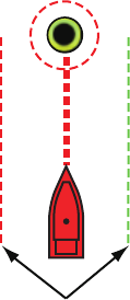
5.9.1 How to restart navigation
When you follow a route, you can re-
start the navigation to the next route
point on the route from current location.
When you steer to keep away from an
obstruction or the ship drifts, you go off
course as shown in Line 1 in the figure.
If you do not need to return to the origi-
nal course, you can go to the route point
from the current position as shown in
Line 2 in the figure.
Tap a route leg, the red dashed line or the yellow line of the route to display the pop-
up menu. Tap [Restart]. The route start position for the route moves to the current po-
sition.
5.9.2 How to follow a route in the reverse direction
You can follow a route in reverse order. This helps you return along the same path.
Note: This function is not available for an active route.
Tap a route leg to display the pop-up menu, then tap [Reverse]. The arrows on the
route legs are in reverse direction and the numbers of the route points are in reverse
order.
5.9.3 How to stop following a route
Tap a route leg, a route point or a thick red dashed line on an active route to display
the pop-up menu, then tap [Stop Nav]. The arrival area, XTE lines, set course (thick
red dashed line) and yellow line are erased from the screen. The red line for the route
turns the default color you set.
5.9.4 How to skip a go to point on a route
There are times when you do not need to follow all legs in an active route. You can
skip a go to point (highlighted) as shown in the procedure below. After you tap the
go to point to skip, the skipped route leg turns from red to gray.
• Tap the go to point of the active route: Tap [Skip] on the pop-up menu. The se-
lected go to point is skipped then the next route point is marked as the go to point.
• Tap a route leg of the active route: Tap [Skip Wpt] on the pop-up menu. The go
to point on the route is skipped then the next route point is marked as the go to point.
Line 2
Line 1
Obstacle
Original course
5. ROUTES
5-11
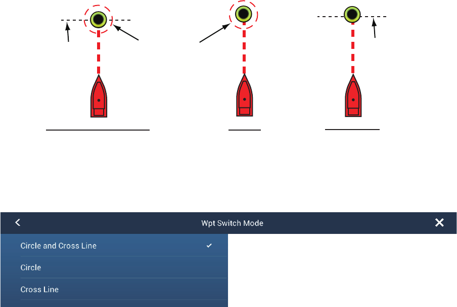
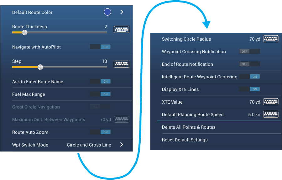
5.9.5 Waypoint switching mode
When you arrive to a route point, your unit automatically changes to the next route
point according to the waypoint switching mode selected on the menu.
[Cross Line]: Change the waypoint when the ship moves through an imaginary cross
line (vertical line) that passes through the center of the destination point.
[Circle]: Change the waypoint when the ship comes within the circle.
[Circle and Cross Line]: Change the waypoint when one of the above two conditions
is met.
A red dashed circle appears when you tap [Circle and Cross Line] or [Circle].
1. Open the home screen, then tap [Settings] - [Routes].
2. Tap [Wpt Switch Mode].
3. Tap [Circle and Cross Line], [Circle] or [Cross Line]. For [Circle and Cross Line] or
[Circle], go to the next step. For [Cross Line], go to step 6.
4. Tap [Switching Circle Radius] to display the software keyboard.
5. Set the arrival area (circle radius) then tap confirm.
6. Tap the close button to finish.
5.9.6 Route auto zoom
You can get automatic range change after you have moved past the go to point. Use
this feature to find the next go to point in the route when the next go to point is not
within the current display range.
1. Open the home screen, then tap [Settings] - [Routes].
2. Turn [Route Auto Zoom] on or off as required.
3. Tap the close button to finish.
[Circle and Cross Line]
Arrival area Cross line
[Circle] [Cross Line]
Cross line The value for the circle
radius is set in [Switching
Circle Radius].
5. ROUTES
5-12
5.9.7 XTE lines
The color of the XTE line is red for the port side, green for the
starboard side. You can show or hide these lines and set their
distance from own ship as follows.
1. Open the home screen, then tap [Settings] - [Routes].
2. Turn [Display XTE Lines] on or off as required. For [ON], go
to the next step. For [OFF], tap the close button to finish.
3. Tap [XTE Value] to display the software keyboard
4. Set the distance of the XTE lines from your ship then tap .
The XTE alarm sounds (if active) when your ship veers off
course by the amount set here.
5. Tap the close button to finish.
5.9.8 Waypoint arrival notification
The waypoint arrival notification feature releases audio and visual notifications when
your ship reaches a go to point. For the arrival timing, see paragraph 5.9.5. The noti-
fication message "Waypoint Crossing" appears. Activate or deactivate this feature as
follows.
1. Open the home screen, then tap [Settings] - [Routes].
2. Turn [Waypoint Crossing Notification] on or off as required.
3. Tap the close button to finish.
5.9.9 End of route notification
The end of route notification feature releases audio and visual notifications when your
ship reaches the end of a route. For the arrival timing, see paragraph 5.9.5. The noti-
fication message "End of Route" appears. Activate or deactivate this feature as fol-
lows.
1. Open the home screen, then tap [Settings] - [Routes].
2. Turn [End of Route Notification] on or off as required.
3. Tap the close button to finish.
XTE lines
(Red: port,
Green: starboard)
5. ROUTES
5-13
5.9.10 Steering a route with the NAVpilot
The NAVpilot can be used to steer a route, from the Navpilot control box in the data
area. The figure belows shows the Navpilot control box in the Nav and Auto modes.
See paragraph 4.11.4 for details.
AUTO/NAV
mode switch
GOTO waypoint
Mode
Heading
(digital)
Heading
(analog)
GOTO
waypoint
Course
to steer
Coarse adj. button*
Red: minus, Green: plus
Fine adj. button(1°)
Red: minus, Green: plus
Auto mode
Nav mode
5. ROUTES
5-14
5.10 Routes Menu
This section provides descriptions for the items in [Routes] menu not previously men-
tioned.
[Default Route Color]: Select the color of the routes. The options are red, blue,
green, yellow, magenta, orange, cyan, or black & white.
[Route Thickness]: Select the thickness of the routes.
[Ask to Enter Route Name]: Show the software keyboard to enter route name after
you create a route.
[Great Circle Navigation]: Great circle is the shortest line that joins two points on the
surface of the earth. Tap the [ON] icon to automatically enter the waypoint with great
circle line when you create the route.
[Maximum Dist. Between Waypoints]: Set the maximum distance between route
points when [Great Circle Navigation] is [ON].
[Intelligent Route Waypoint Centering]: When you create a route, center a route
point each time it is selected on the screen.
[Default Planning Route Speed]: Set the planning route speed (see section 5.3).
[Reset Default Settings]: Select this menu item to restore default settings for the
[Routes] menu.
6-1
6. RADAR
This chapter provides the information necessary for radar operation.
6.1 How to Transmit, Set the Radar in Stand-by
Tap the [TX] icon at the bottom right corner of the screen to put the radar in transmit
or standby state. The icon is filled in white when the radar is in transmit state. (Trans-
mit, standby can also be controlled from the pop-up menu with [TX/STBY].)
If you do not require the radar for some time, set the radar in stand-by to save the mag-
netron from unnecessary use.
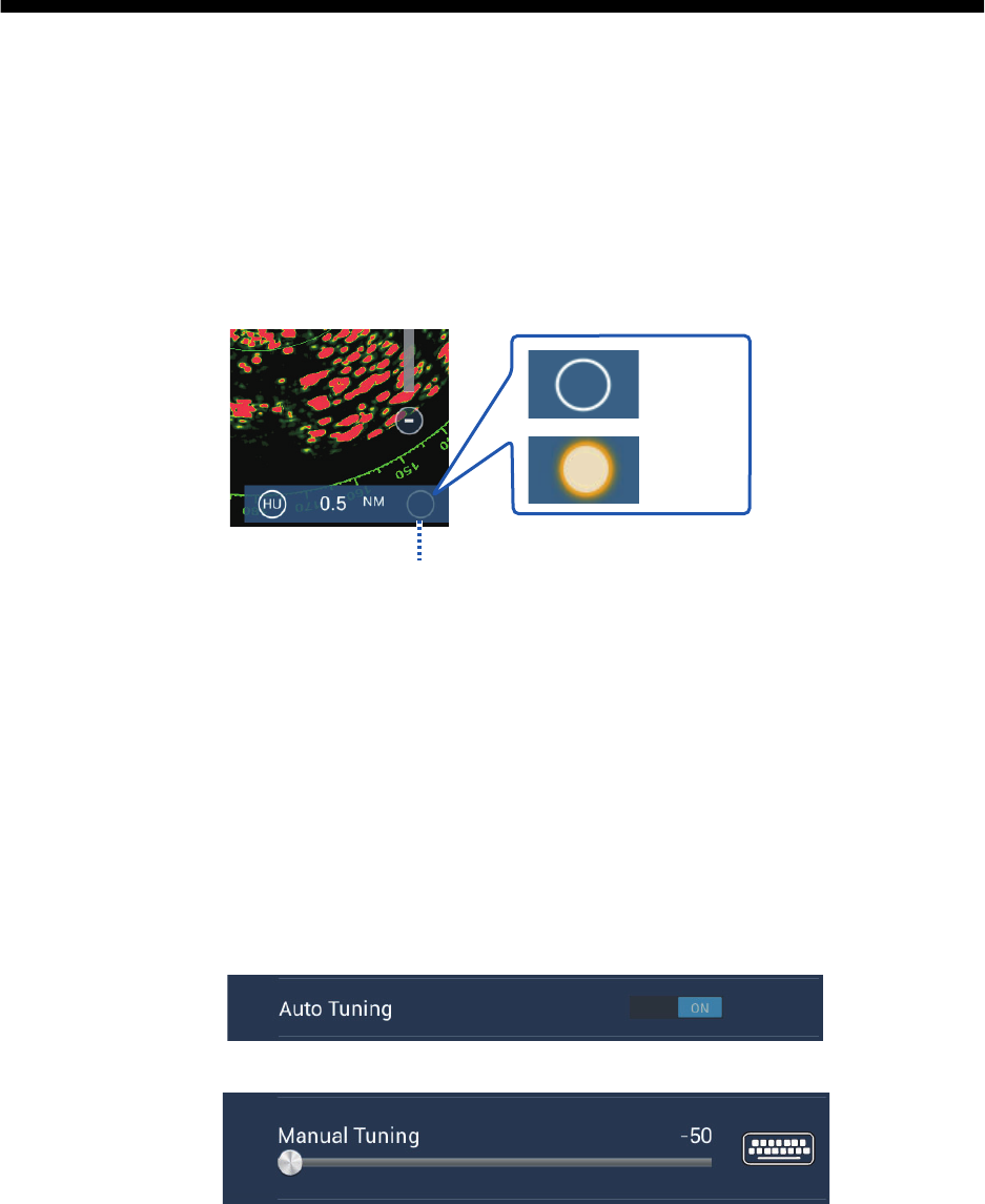
6.2 Tuning
In default, the radar receiver is tuned automatically after the radar is set to transmit. If
you require fine tuning, do the following to tune manually:
1. Open the home screen, then tap [Settings] - [Radar].
2. The default tuning method is automatic. Turn off [Auto Tuning] to enable manual
tuning.
3. Drag the slider at [Manual Tuning] to set the value.
4. Tap the close button to finish.
TX/Standby switch
: Standby
: TX
TX
TX
TX
6. RADAR
6-2
6.3 How to Adjust the Gain
You can adjust the gain (sensitivity) of the radar receiver. The correct setting shows
some background noise on the screen. If you do not use enough gain, weak echoes
are erased. If you use more gain than necessary, the background noise hides both
weak and strong targets.
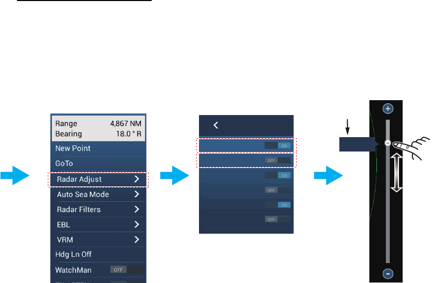
The gain can be adjusted from the data area or the pop-up menu.
Method 1: Pop-up menu
Tap the screen to show the pop-up menu then tap [Radar Adjust]. Turn [Auto Gain] on
for automatic adjustment.
For manual adjustment, turn off [Auto Gain], tap [Manual Gain] then adjust the gain
with the slider. Tap the screen to finish.
How to adjust the gain
Tap the screen
to show the
pop-up menu.
Tap [Radar Adjust].
Auto Gain
Manual Gain
Auto Sea
Manual Sea
Auto Rain
Manual Rain
Automatic: Turn [Auto Gain] ON.
Manual: Turn [Auto Gain] OFF.
Tap [Manual Gain].
Drag slider.
79
Manual
adjustment
Current
setting
6. RADAR
6-3
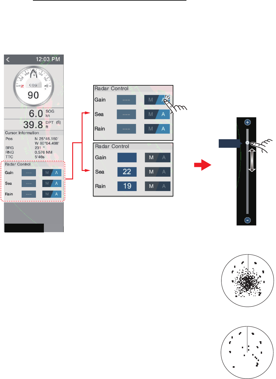
Method 2: Radar Control data box in data area
The gain can be adjusted from the data area if the Radar Control data box is available.
On the box, tap the [A] part of the [Gain] flipswitch to switch between manual and au-
tomatic adjustment. For manual adjustment, drag the slider to adjust. Tap the screen
to finish.
6.4 How to Reduce the Sea Clutter
The reflected echoes from waves appear at the central part
of the screen and have the name “sea clutter”. The sea clutter
increases in width as the height of waves and the height of
the antenna above the water increase. If the sea clutter is
strong, targets can be hidden inside the clutter, like in the left-
hand figure shown below.
When the sea clutter hides targets, adjust the sea control
(automatically or manually) to reduce the clutter. After the
sea clutter is gone, turn off the sea control to prevent the loss
of targets. Like with gain, sea clutter can be adjusted from the
pop-up menu or data area. See the procedures in section
6.3.
For automatic sea clutter suppression, there are two meth-
ods: [Advanced] and [Coastal]. [Advanced] provides for stan-
dard suppression of sea clutter and is intended for normal
use. [Coastal] suppresses sea clutter further than does [Advanced] and paints land
and target echoes thicker. Use [Coastal] when you are cruising along a coastline. To
select an automatic sea clutter suppression method, open the pop-up menu, tap [Auto
Sea Mode] then turn on [Advanced] or [Coastal].
Manual adjustment
Tap to alternate
between auto
and manual.
Drag
slider.
79
79
79
RADAR
DATA ROUTE
Sea clutter at
screen center
Sea control adjusted;
sea clutter suppressed