Koden Electronics RB719A Marine Radar RA55 User Manual C5 Chap4 1
Koden Electronics Co., Ltd Marine Radar RA55 C5 Chap4 1
Contents
C5
RA51/52/53/54/55 INSTRUCTION MANUAL – 05 23
CHAPTER 4. FUNCTIONS AND NAMES
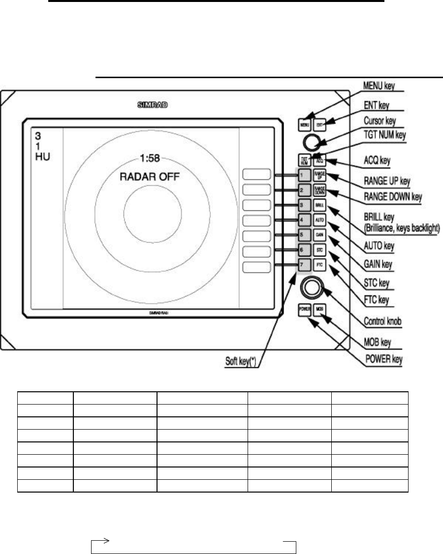
The RA51/52/53/54/55 radar consists of a display and a scanner. The display unit has
on its front panel eighteen push-button keys, one rotary control knob and one cursor control
touch pad.
4.1 Key layout ____________________________________________
Key No.
SET1 SET2 SET3 SET4
1 EBL1 EBL2 DATA PPI
2 VRM1 VRM2 DEL PPI/3D
3 VAR RNG FL EBL2 ALL DEL PPI/PPI
4 TRACK FL VRM2 TRACK PPI/NAV
5 TARGET GZ ZOOM ALL PPI
6 SEL WIN OFF-C PICTURE ALL PPI2
7 NEXT NEXT NEXT NEXT
Tab. 5 Function of soft key
*Every time the "NEXT" soft key is pressed, the soft key group changes as follows:
SET1
→
SET2
→
SET3
→
SET4
24 RA51/52/53/54/55 INSTRUCTION MANUAL – 05
4.2 Rear panel____________________________________________
• Power supply connector
The wires in the cable that attaches to this connector supply both power and NMEA interface
data. Refer to Section 3.7.4 “ Power Cables “ and Section 3.9 “Connecting External
Equipment to Display Unit “.
‚ Grounding terminal
Use this terminal to connect grounding wire. Refer to Section 3.7.3 “Grounding wire”.
ƒ Option connector
Connect an NMEA data source, an external monitor, external buzzer or GYRO I/F here
through an optional connector or using a junction box. Refer to Section 3.9 “Connecting
External Equipment to Display Unit”.
„ Scanner connector
This connector is for the cable that runs between the display and the scanner.
Refer to 3.7 “Connecting cable “.
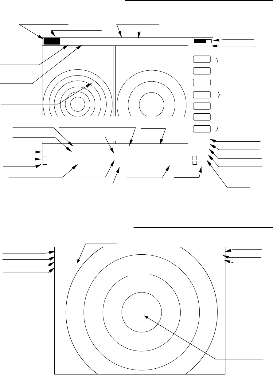
4.3 Radar screen (Single screen) ____________________________
Ship’s position
EBL2
VRM2
Indicate soft key
3
1
HU L
1:58
+
RADAR OFF
EBL1
VRM1
EBL2
VRM2
FL EBL2
FL VRM2
NEXT
A
HOLD
ZOOM
OFF-C
LAT/LON
35°08.42N
139°02.53E
2 129.8°
2 12.34NM
0.23NM
HDG
129.0 °T
SPD
12.0 KT
G 59
S AT
F AT
ST1
GZ IN
TK 15 S
WP
134.4 °
12.5NM
+LAT/LON
35°08.42N
139°02.53E
1 129.8°
1 12.3NM
Tune meter
Picture hold
Zoom
Off-center
Range
Range ring interval
Display mode
Heading angle
Cruising speed
Enlarging echo
Guard zone
Track
Way point
EBL1
VRM1
Pulse width
Course error
Gain
STC
FTC
Cross cursor
Cross cursor position
(LAT/LON or Distance/Bearing)
RA51/52/53/54/55 INSTRUCTION MANUAL – 05 25
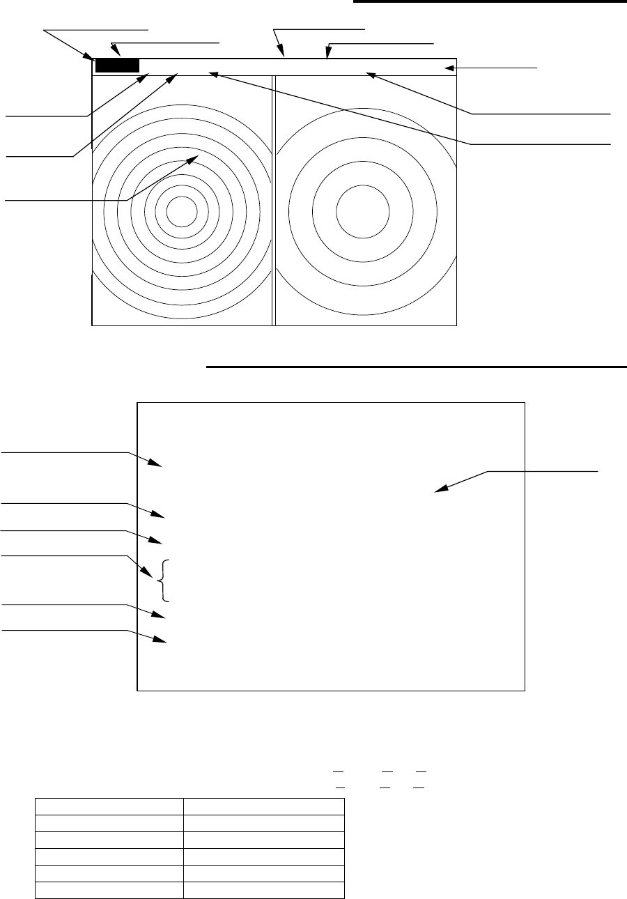
4.4 Radar screen (Dual screen)______________________________
Ex) PPI/PPI screen
4.5 Radar screen (All PPI screen) ____________________________
Tune meter
Picture hold
Indicate soft key
SPD 12.8KT GZ R IN WAY P 134.4°
HDG 129.2° GZ L IN 12.5NM
+MK 38.4° ST1 LAT 35°08.42N 2 129.8°
5.28 TK 15S LON 139°02.53E 2 3.62NM
6 1.0_ HU L .75 .25
EBL1
VRM1
EBL2
VRM2
FL EBL2
FL VRM2
NEXT
A
HOLD
0.23
XTE >>>
1 129.8°
1 12.34NM
AT1
G 59 / AT
S AT / AT
F AT / AT
Range(Left screen) Range(Right screen)
Range ring interval Range ring interval
(Left screen) (Right screen)
Display mode
Pulse width
Cross cursor
Course error
EBL1
VRM1
+
Cruising speed Guard zone(Right screen) Way point
Heading angle Guard zone(Left screen)
Cross cursor position Enlarging echo Ship’s position VRM2
(LAT/LON or Distance/Bearing) Track
EBL2
AUTO (Left/Right)
Gain (Left/Right)
STC (Left/Right)
FTC (Left/Right)
3
1
HU L
GZ IN 1:58
+
RADAR OFF
OFF-C
HOLD
ZOOM
Off-center
Picture
hold
Zoom
Range
Range ring interval
Display mode
Guard Zone
Pulse width
Cross cursor
26 RA51/52/53/54/55 INSTRUCTION MANUAL – 05
4.6 Radar screen (All PPI /PPI screen) ________________________
4.7 Navigation screen _____________________________________
To show the NAV display, you need to connect a GPS receiver to your radar. The NAV display
shows the position and cruising speed of your ship, seawater temperature, and other navigation
information.
Note: Heading angle will be displayed "COG" when Course Over Ground data is used.
Note: Cruising speed will be displayed "SOG" when Speed Over Ground data is used.
> Indicates course is starboard of
helm (steer right)
< Indicates course is port of helm
(steer left)
Picture hold
Gurad zone(Right screen)
Guard zone(Left screen)
6 1.0_ HU L GZ IN .75 .25 GZ IN HOLD
Range(Left screen) Range(Right screen)
Range ring interval Range ring interval
(Left screen) (Right screen)
+
Display mode
Pulse width
Cross cursor
NAV DISPLAY
WP 134.4° COURSE
12.5NM >>>
HDG 129.0° 0.23NM
SPD 12.8KT
LAT 35°08.42N
LON 139°02.53E
TEMP 20.5°C
DEPTH 93.2M ST’BY
Way point
Heading angle
Cruising speed
Current position
Sea water temperature
Depth of water
Course error
(XTE)
Deviation from
Indication mark
0.00
--
><
0.02
--
>
or
<
0.04
--
>>
or
<<
0.08
--
>>>
or
<<<
0.16
--
>>>>
or
<<<<
Tab.6 Indication of deviation from course